
Engine malfunction involving Airbus A330-202, VH-EBQ, 1,370 km west-south-west of Los Angeles International Airport, United States of America, on 4 December 2024
Summary
The ATSB is investigating an engine malfunction involving Airbus A330-202, VH-EBQ, 1,370 km west-south-west of Los Angeles International Airport, United States of America, on 4 December 2024.
During the cruise phase of flight, a report of sparks coming from the right engine was received by the flight crew, who elected to return to Los Angeles Airport. During the descent, ‘bangs’ were heard accompanied by indication of a right engine compressor stall. The flight crew operated the engine at idle for the rest of the descent and landing in Los Angeles.
The ATSB released a preliminary report, which details factual information established in the investigation’s early evidence collection phase, on 8 May 2025. See below.
The final report has been drafted and is undergoing internal review to ensure the report adequately and accurately reflects the evidence collected, analysis, and agreed findings.
The final report will be released at the conclusion of the investigation. Should a critical safety issue be identified during the course of the investigation, the ATSB will immediately notify relevant parties, so that appropriate safety action can be taken.
Last updated:
Preliminary report
Report release date: 08/05/2025
| This preliminary report details factual information established in the investigation’s early evidence collection phase, and has been prepared to provide timely information to the industry and public. Preliminary reports contain no analysis or findings, which will be detailed in the investigation’s final report. The information contained in this preliminary report is released in accordance with section 25 of the Transport Safety Investigation Act 2003. |
The occurrence
Overview
On 4 December 2024, the ATSB was notified of an air-return involving a Qantas Airbus A330 aircraft, registered VH‑EBQ, operating a scheduled passenger flight from Los Angeles, United States of America, to Brisbane, Australia. During the cruise, sparks were observed coming from the right engine and the flight crew initiated a turnback to Los Angeles Airport. During the descent to the airport, ‘bangs’ were heard accompanied by indication of a right engine compressor stall.[1] The flight crew operated the engine at idle for the rest of the descent and landing in Los Angeles.
The previous flight and turnaround maintenance
Prior to the incident flight, the aircraft was operated on a scheduled passenger flight between Brisbane and Los Angeles. On 4 December 2024, at around 0120 UTC[2] and shortly after top of descent, the flight crew observed a high N2[3] vibration advisory for the right engine on the electronic centralized aircraft monitor.[4] In response, the flight crew operated the right engine at idle for the remainder of the flight. The aircraft landed in Los Angeles at 0153.
In preparation for the return flight to Brisbane, a licenced aircraft maintenance engineer (LAME) and an aircraft maintenance engineer (AME) assisted with the turnaround of the aircraft. When visually inspecting the right engine exhaust, both the AME and the LAME observed particles. The LAME carried out troubleshooting steps related to the right engine N2 vibration issue, which included consultation with the Qantas maintenance operation centre.[5] The troubleshooting activities culminated in the application of a minimum equipment list (MEL)[6] item for the right engine N2 vibration sensor. This meant that the N2 vibration readings for the right engine would not be available for flight crew on subsequent flights, until the component was replaced. The LAME subsequently released the aircraft for service at 0358.
The incident flight
The flight crew for the next scheduled flight of VH-EBQ from Los Angeles for Brisbane, consisting of a captain, a first officer, and 2 second officers, familiarised themselves with the aircraft status and became aware of the reported N2 vibration issue. Preparations for the flight continued and the aircraft departed Los Angeles at 0458. The flight crew later reported to the ATSB that they were not aware of the particles observed in the exhaust.
The flight crew reported that the take-off and initial climb appeared normal. They received a clearance from air traffic control (ATC) to climb to flight level (FL)[7] 320, and upon reaching FL 200, the first officer and one of the second officers, second officer A, left the flight deck for their allocated crew rest.[8] The captain and the other second officer, second officer B, remained on the flight deck. The captain made regular written observations of engine parameters, including fuel flow and exhaust gas temperature, with the intent that the readings might aid in troubleshooting possible engine issues.
At about 0637, the remaining flight crew received further clearance from ATC to climb to FL 340. After top of climb, a passenger report of sparks emanating from the right engine was relayed to the flight crew by the cabin crew. Second officer B went to the passenger’s seat, observed the engine from the window, noted a couple of intermittent sparks, and returned to the flight deck to talk to the captain. The captain and second officer B also reviewed video footage of the sparks recorded by the passenger during the climb (Figure 1).
Figure 1: Still image from passenger video showing sparks from right engine

Source: Qantas passenger, provided by Qantas, annotated by the ATSB
In response to the engine situation, the captain and second officer B decided that continuing to their destination, Brisbane, was no longer acceptable and it would be necessary to divert. The resting flight crew were recalled to the flight deck and the first officer assessed that, at that time, the aircraft was about 30 minutes from the equal time point[9] between Los Angeles and Honolulu. The flight crew initiated a rotation of cabin crew members to be positioned in the passenger’s seat to monitor the engine for sparks for the remainder of the flight.
When considering which airport to divert to, the flight crew consulted with the Qantas maintenance operations centre, reviewed the weather and NOTAMS[10] for alternate airports, and continued to monitor right engine performance. Although the right engine exhibited greater fuel consumption and exhaust gas temperature than the left engine, all indications, excluding the N2 vibration, which was disconnected, were within the normal range. The flight crew considered reducing the thrust setting on the right engine, but as the parameters indicated it was stable, the setting was left unchanged. The flight crew decided the most suitable airport to divert to was Los Angeles and the first officer made a PAN PAN call[11] and requested a diversion to Los Angeles from ATC through the controller pilot data link communication system.[12]
The flight crew initiated the diversion at about 0732 and shortly after, they requested a descent to FL 310 to reduce the load on the engine. By the time the aircraft reached FL 310, the intermittent sparks were observed to have stopped.
Following a period of observation where the engine parameters were stable and no additional sparks were observed, the captain elected to take a crew rest, with the intent of managing fatigue for the descent and landing into Los Angeles. During this time, the flight continued uneventfully and the remaining flight crew prepared for the landing. Activities included an assessment of the runway options and availability, re-assessment of the alternate airports, reviewing updated weather observations, review of the overweight and single-engine landing procedures, and performance checks.
Based on the cockpit voice recording, the captain returned to the flight deck at about 0942, prior to commencing the descent at 1003. The other 3 pilots had noted weather reports of fog developing in Los Angeles and, as a result, consulted the low visibility landing checklist. The flight crew completed the approach checklist at about 1023 and the overweight landing checklist at about 1024. At around 1027, while the aircraft was passing about 7,000 ft, the flight crew heard 3 loud bangs, which they attributed to the right engine based on observation of engine parameters. In response, the captain brought the right engine thrust lever to idle. Second officer B called ‘stall’ (meaning an engine compressor stall), which was confirmed by the captain. At the direction of the captain, the first officer radioed ATC to report that they had an issue with the engine and to request aircraft rescue and firefighting services attendance on landing.
At about 1029, to aid with management of the situation, the first officer radioed ATC to cancel the approach and request vectors, which the controller provided. The flight crew commenced the engine stall checklist from the Quick Reference Handbook. The last action item in the checklist was to slowly move the thrust lever forward. The flight crew elected to leave the engine at idle to minimise the likelihood of more disruptions. At about 1039, the first officer informed ATC that they were ready for the approach. After an uneventful landing, the aircraft exited the runway and came to a stop on the taxiway to allow rescue and firefighting services to visually inspect the engine. The flight crew completed the after-landing procedures while the engine was inspected. After assurance that no leaks, smoke, or damage was observed, the flight crew taxied the aircraft to the gate, where a normal disembarkation took place.
Following post-flight inspections, the right engine was removed from the aircraft and sent to a GE (General Electric) Aerospace technical facility for further examination.
Post-flight inspection
After the aircraft was repositioned to a maintenance hangar, borescope[13] inspections of the engine were carried out that identified:
- metal debris in the exhaust
- one missing high-pressure compressor blade, liberated at its root
- one fractured high-pressure compressor blade, fractured about half-way up
- damage to several high-pressure compressor blade tips
- a stage 4 variable-stator-vane positioned 90° out of alignment
- a fractured stage 4 variable-stator-vane lever arm (corresponding to the misaligned vane).
The aircraft was subsequently grounded, and the engine replaced before return to service on 16 December 2024.
Context
Flight crew information
The captain, first officer and second officers all held valid air transport pilot licences (aeroplane) and aviation medical certificates, and were appropriately qualified for the flight. All flight crew reported feeling well rested and alert when commencing duty.
The captain had about 16,700 hours of total flight experience, of which about 6,700 hours were on the Airbus A330. In the previous 90 days, the captain had flown about 160 hours on the A330. The first officer had about 7,300 hours of flight experience, of which about 1,000 hours were on the A330, with 153 hours flown in the previous 90 days. Second officer A had about 6,720 hours of flight experience, of which about 4,050 hours were on the A330, with 116 hours flown in the previous 90 days. Second officer B had about 5,200 hours of flight experience, of which about 3,500 hours were on the A330, with 78 hours flown in the previous 90 days.
Aircraft information
General
The Airbus A330-202 is a wide-body, twin-engine, long range, air transport aircraft. VH-EBQ was manufactured in France in 2011 and registered in Australia in the same year. The right engine had accumulated about 15,497 hours since its last overhaul.
Engine information
The aircraft was powered by 2 General Electric CF6-80E1 high-bypass turbofan engines. Engine modules include the fan and low-pressure compressor, the high-pressure compressor, combustion section, the high-pressure turbine, and the low-pressure turbine. N1 refers to the rotational speed of the fan, the low-pressure compressor and associated shaft. N1 is the primary indication of engine thrust. The N2 refers to the rotational speed of the high-pressure compressor, the high-pressure turbine, and associated shaft.
Vibration monitoring was achieved by the engine’s engine interface and vibration monitoring system. This system processes signals from 2 accelerometers, the number 1 bearing vibration sensor and the compressor rear frame vibration sensor, to obtain 2 vibration values for each N1 and N2 shafts. N1 vibrations are measured as a displacement in 1/1000 of an inch (mils), while N2 vibrations are measured as a speed in inch per second (ips). The N2 vibrations are displayed to the flight crew as a value between 0 and 10 units, which corresponded to a vibration between 0 and 3 ips on a linear scale. The highest reading observed during the descent into Los Angeles was 9.2 units.
Maintenance actions
Maintenance for the General Electric CF6-80E1 engines was conducted in accordance with the Airbus A330 Aircraft Maintenance Manual and Troubleshooting Manual. The engineering staff in Los Angeles consulted the Troubleshooting Manual task 77-32-00-810-829-A N2 Vibration Above Advisory During Descent, Top of Descent Vibration when addressing the reported vibration associated with the inbound flight.
The certifying LAME wrote in their logbook entry relating to the application of the minimum equipment list item for the N2 vibration, that:
- on consultation with the inbound flight crew, they established that no physical vibration was felt in the airframe
- the right engine main chip detector, inlet, and exhaust were inspected and deemed ‘OK’
- the vibration readings were considered to be a faulty indication issue and not generated in response to genuine engine vibration
- minimum equipment list item 77-07-02-07C was applied
- Aircraft Maintenance Manual task 77-32-00-040-801-A to deactivate the remote charge converter was completed
- Qantas maintenance operation centre was notified.
Maintenance history
On 27 November 2024, the right engine of the aircraft had a compressor stall during descent into Los Angeles. A subsequent engineering investigation identified faults associated with the right engine electrical control unit. Following the replacement of faulty parts, engineering personnel conducted engine inspections and ground runs where no further faults were detected. The aircraft subsequently flew 3 uneventful routes before the high N2 vibration was reported on descent into Los Angeles on 4 December 2024.
Recorded data
The aircraft was equipped with a cockpit voice recorder, which recorded audio from the flight deck, and quick access recorder, which recorded aircraft and engine performance data. The altitude of the aircraft and the N1 speed for both engines was extracted from the quick access recorder (Figure 2). The data showed that the engine speed for the left and right engines was consistent up until the time of the ‘bangs’ and compressor stall, around 1027. After this, the right engine was brought back to idle and the N1 speed remained around 33%.
Figure 2: Altitude and N1 speed for the right and left engines

Source: Qantas, annotated by the ATSB
Further investigation
To date, the ATSB has:
- interviewed involved flight crew, maintenance engineers, and maintenance operation centre staff
- obtained operator and manufacturer engineering procedures
- obtained aircraft operating procedures
- gathered engine maintenance records
- collected recorded data, including from the cockpit voice recorder and quick access recorder
- collected ADS-B[14] data.
The investigation is continuing and will include further review and examination of:
- communications between involved personnel
- recorded data
- maintenance procedures and records
- material failure analysis conducted by GE Aerospace on relevant components of the engine.
A final report will be released at the conclusion of the investigation. Should a critical safety issue be identified during the course of the investigation, the ATSB will immediately notify relevant parties so appropriate and timely safety action can be taken.
Purpose of safety investigationsThe objective of a safety investigation is to enhance transport safety. This is done through:
It is not a function of the ATSB to apportion blame or provide a means for determining liability. At the same time, an investigation report must include factual material of sufficient weight to support the analysis and findings. At all times the ATSB endeavours to balance the use of material that could imply adverse comment with the need to properly explain what happened, and why, in a fair and unbiased manner. The ATSB does not investigate for the purpose of taking administrative, regulatory or criminal action. TerminologyAn explanation of terminology used in ATSB investigation reports is available here. This includes terms such as occurrence, contributing factor, other factor that increased risk, and safety issue. Publishing informationReleased in accordance with section 25 of the Transport Safety Investigation Act 2003 Published by: Australian Transport Safety Bureau © Commonwealth of Australia 2025 
Ownership of intellectual property rights in this publication Unless otherwise noted, copyright (and any other intellectual property rights, if any) in this report publication is owned by the Commonwealth of Australia. Creative Commons licence With the exception of the Commonwealth Coat of Arms, ATSB logo, and photos and graphics in which a third party holds copyright, this report is licensed under a Creative Commons Attribution 4.0 International licence. The CC BY 4.0 licence enables you to distribute, remix, adapt, and build upon our material in any medium or format, so long as attribution is given to the Australian Transport Safety Bureau. Copyright in material obtained from other agencies, private individuals or organisations, belongs to those agencies, individuals or organisations. Where you wish to use their material, you will need to contact them directly. |
[1] A stall in a turbine engine refers to a compressor stall. It is abnormal airflow resulting from the aerodynamic stall of aerofoils (compressor blades) within the compressor. Steady flow through the stages of a compressor occurs within a relatively narrow band of conditions. If the conditions inside a compressor go outside of this band due to an operating condition or a disturbance, the flow around the blades can break down in a manner known as a stall. In this instance, the blades would no longer effectively compress the air. If the breakdown of flow in a compressor stall is significant enough, the pressure change within the engine could be sufficient to reverse the flow through the compressor in a phenomenon known as a ‘surge’. A surge is often associated with a loud bang, or series of bangs, that can be heard in the aircraft.
[2] Coordinated Universal Time (UTC): the time zone used for aviation. Local time zones around the world can be expressed as positive or negative offsets from UTC. Los Angeles was UTC -8 hours meaning that 0120 UTC on 4 December 2024 was 1720 on 3 December 2024 Los Angeles time. Sydney was UTC +10 hours and Brisbane was UTC +11 hours.
[3] N2: N2 refers to the rotational speed of the engine’s high-speed spool, which consisted of the high-pressure compressor and the high‑pressure turbine.
[4] ECAM: Electronic centralized aircraft monitor (ECAM) is a system on Airbus aircraft for monitoring and displaying engine and aircraft system information to the pilots. In the event of a malfunction, it will display the fault and may also display the appropriate steps of the remedial action.
[5] The Qantas maintenance operation centre was a section of the Qantas integrated operations centre, which responded to services requests from all areas within the company and provided engineering information and support as required.
[6] The minimum equipment list (MEL) details the system, function, or equipment, which may be inoperative for flight and establishes limitations on the duration of, and conditions for, operation with an inoperative item. The application of an MEL to an item is the phraseology used when an aircraft is certified to fly with that item inoperative.
[7] Flight level: at altitudes above 10,000 ft in Australia, an aircraft’s height above mean sea level is referred to as a flight level (FL). FL 320 equates to 32,000 ft.
[8] Crew rest: All commercial flight crew have limits on how much they can work before taking time off. For long flights, the flight crew consists of more than 2 pilots allowing some pilots to rest mid-flight and the flight deck to remain fully staffed.
[9] The equal time point is when an aircraft is the same flying time from 2 potential en route diversion locations.
[10] NOTAMS: Notice to Airmen (NOTAM) is a notice filed with an aviation authority to alert pilots of potential hazards along a flight route or at a location that could affect the flight.
[11] PAN PAN: an internationally recognised radio call announcing an urgency condition which concerns the safety of an aircraft or its occupants but where the flight crew does not require immediate assistance.
[12] Controller pilot data link communication is a 2-way data-link system by which air traffic controllers can transmit non urgent strategic messages to an aircraft as an alternative to voice communications. The message is displayed on a flight deck visual display. The pilots are provided with the capability to respond to messages, to request/receive clearances and information, and to report information.
[13] A borescope is a slender optical periscope, usually incorporating illumination, capable of being inserted into narrow apertures to inspect interior of machinery.
[14] ADS-B is a system in which electronic equipment onboard an aircraft automatically broadcasts the precise location of the aircraft via a digital data link. The data can be used by other aircraft and air traffic control to show the aircraft’s position and altitude on display screens without the need for radar.
Occurrence summary
| Investigation number | AO-2024-063 |
|---|---|
| Occurrence date | 04/12/2024 |
| Occurrence time and timezone | 06:40 UTC |
| Location | 1,370 km west-south-west of Los Angeles International Airport, United States of America |
| State | International |
| Report release date | 08/05/2025 |
| Report status | Preliminary |
| Anticipated completion | Q3 2026 |
| Investigation level | Defined |
| Investigation type | Occurrence Investigation |
| Investigation phase | Final report: Internal review |
| Investigation status | Active |
| Mode of transport | Aviation |
| Aviation occurrence category | Diversion/return, Engine failure or malfunction |
| Occurrence class | Incident |
| Highest injury level | None |
Aircraft details
| Manufacturer | Airbus |
|---|---|
| Model | A330-202 |
| Registration | VH-EBQ |
| Serial number | 1198 |
| Aircraft operator | Qantas Airways Limited |
| Sector | Jet |
| Operation type | Part 121 Air transport operations - larger aeroplanes |
| Activity | Commercial air transport-Scheduled-International |
| Departure point | Los Angeles International Airport, United States of America |
| Destination | Brisbane Airport, Queensland |
| Injuries | None |
| Damage | Minor |
Collision with terrain involving Robinson R44 II, VH-XIX, 50 km east of Young Airport, New South Wales, on 4 December 2024
Summary
The ATSB is investigating a collision with terrain involving Robinson Helicopter Co R44 II, VH‑XIX, about 50 km east of Young Airport, New South Wales, on 4 December 2024.
During aerial spraying operations, the helicopter collided with terrain and was destroyed. The pilot sustained fatal injuries.
The final report has been drafted and is undergoing internal review to ensure the report adequately and accurately reflects the evidence collected, analysis, and agreed findings.
The final report will be released at the conclusion of the investigation. Should a critical safety issue be identified during the course of the investigation, the ATSB will immediately notify relevant parties, so that appropriate safety action can be taken.
Preliminary report
Report release date: 20/02/2025
| This preliminary report details factual information established in the investigation’s early evidence collection phase, and has been prepared to provide timely information to the industry and public. Preliminary reports contain no analysis or findings, which will be detailed in the investigation’s final report. The information contained in this preliminary report is released in accordance with section 25 of the Transport Safety Investigation Act 2003. |
The occurrence
On 4 December 2024, at about 0530 local time, a Robinson R44 Raven II helicopter, registered VH-XIX, departed from Griffith Regional Airport, New South Wales to conduct a ferry flight to a property approximately 50 km east of Young. Onboard were the operator’s Griffith base manager and a loader[1] (acting as pilot for the ferry flight). They arrived at a paddock on the farm at 0744, landing next to a chemical tank. They were met by the farm manager of the property, and the pilot for the day, who had arrived shortly before by motor vehicle from Crookwell. The tasking for the day was the aerial application of herbicide across 2 properties, to be conducted under Part 138 of the Civil Aviation Safety Regulations.
The base manager, pilot, loader and farm manager discussed the day’s work and then prepared the helicopter for spraying operations, including refuelling the helicopter, attaching the spray booms and mixing herbicide. At 0912, the pilot and base manager, who had sprayed the paddocks previously, flew the helicopter on a reconnaissance mission of the intended paddocks returning 5 minutes later.
The helicopter was loaded with herbicide and, at 0921, the pilot departed for application of the first load of the day. The pilot applied 10 loads consecutively. Each load took around 10 minutes to apply, with the pilot returning for the helicopter to be replenished with herbicide, and fuel as required, before immediately departing again.
Toward the end of this activity, the farm manager from an adjacent property arrived and discussed the task for the second property with the base manager. During this time, the pilot departed for the 11th and planned final load of the job on the first farm. After 15 minutes, the base manager realised the helicopter should have returned and tried, unsuccessfully, to contact the pilot via ultra‑high frequency radio in the work vehicle. The base manager then checked a flight tracking application on their mobile phone that showed the helicopter had not moved from its last indicated location for a couple of minutes. The base manager and second farm manager departed in the farmer’s vehicle toward the intended spray area, while the loader stayed to monitor the work vehicle’s radio.
Prior to the flight, high tension powerlines that ran through the middle of the intended spray area had been identified as a hazard to the operation. The base manager and farmer headed to a location near the powerlines but could not find the helicopter. After further searching, they located the wreckage of the helicopter in a gully. They made their way down to the helicopter and found the pilot had exited the helicopter and moved approximately 1 m away but was seriously injured. Emergency services attended, however, the pilot succumbed to their injuries.
Context
Pilot information
The pilot held a commercial pilot licence (helicopter) with a single-engine helicopter class rating. The pilot had 1,035 hours total aeronautical experience, of which 637 hours were on the R44 type. Most of the pilot’s recent flying had been on the R44. The pilot also held a gas turbine design feature endorsement, and numerous piston and turbine type ratings. In addition, the pilot held aerial application, low-level, and sling operational ratings. The pilot had spent approximately 3 years flying agricultural helicopters in New Zealand where they also obtained a mountain flying operational rating.[2]
The pilot held a valid class 1 aviation medical certificate and was reported as appearing well rested and fully alert for the flight.
Helicopter information
The Robinson R44 Raven II is a 4-seat helicopter, powered by a single Textron Lycoming IO‑540‑AE1A5 piston engine driving a 2 blade semi-rigid main rotor system and 2 blade tail rotor system. The helicopter was manufactured in the United States in 2003 and first registered in Australia in May 2003. It was issued with a special certificate of airworthiness in the restricted category in January 2017. The certificate permitted VH-XIX to be used in agricultural operations and aerial surveying, among other similar operations.
A periodic inspection and minor maintenance tasks were carried out on 30 October 2024. At the time of the accident, the helicopter had accumulated about 5,820 hours. The helicopter was configured with an agricultural spray system, which consisted of 2 fibreglass chemical tanks, a flexible hose and stainless-steel tubing distribution system, a petrol‑powered water pump, valving systems, and 2 cantilevered carbon fibre spray booms, one each on either side of the fuselage.
Meteorological information
The closest Bureau of Meteorology weather station was at Young Airport, 50 km to the west of the accident site, which reported winds of 7–8 kt from the north-west and a temperature of 28°C in 30‑minute windows around the time of the accident. Cloud cover[3] was measured as few at 3,500 ft and broken at 4,800 ft. Cowra weather station, 53 km to the north, reported winds of 4–7 kt varying between northerly and westerly and a temperature around 28–30°C. Cloud cover was not recorded.
Wunderground.com is a weather network designed to provide public access to community weather stations. A weather station at Boorowa, 14 km south-south-west of the accident site, reported wind, in 5-minute windows, of 6.8 km/h (3.6 kt) gusting to 7.3 km/h (3.9 kt), from the south‑south‑west and a temperature of 19°C around the time of the accident. Another weather station at Frogmore, 8 km to the north-east, reported wind of 0.9 km/h (0.5 kt) gusting to 1.9 km/h, (1.0 kt) from the north-north-west, with a temperature of 22°C.
Wreckage and impact information
The wreckage was located about 1,200 m south-south-east of the base of operations for that day, in a steep gully towards the southern end of the target spray area. The area was in hilly terrain and contained high dry grass with scattered large alive and dead eucalyptus trees.
The first items in the debris trail were the stabiliser assembly, right side carbon fibre spray boom and broken branches. These items were located next to a dead tree, with freshly broken branches on one side, near the top (Figure 1).
The helicopter was orientated on its left side and facing the direction of the travel. The main fuselage had sustained minor impact damage, with the exception of the cabin, which was significantly disrupted. Outboard sections of both main rotor blades had been liberated during the accident sequence. For the tail rotor assembly, one liberated tail rotor blade, and sections of the tailcone were scattered to the right of the ground path. Despite the disruption, all components of the helicopter were accounted for.
Two ground scars, consistent with the landing gear skids, were located between the tree and the wreckage in the gully. The ground marks were indicative of the upright helicopter sliding along the ground, prior to reaching the edge of the gully.
Figure 1: Wreckage site
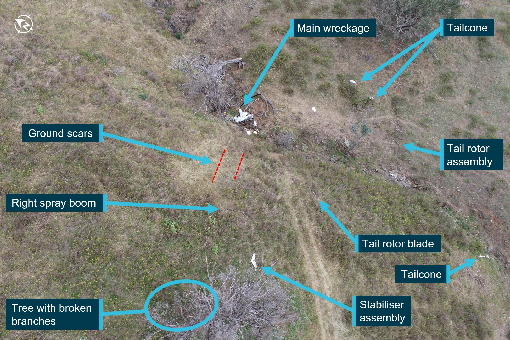
Note: Ground scars from the helicopter skids are highlighted red.
Source: ATSB
While the ATSB conducted a preliminary examination of the wreckage at the site, due to access restrictions, the wreckage was relocated to a secure facility for detailed examination. This further examination identified:
- no evidence of pre-impact defects with the flight controls or structure
- approximately 55 L of low-lead aviation fuel in the fuel system, which was visibly clear of contaminants and tested negative to the presence of water
- the engine was able to be rotated, contained oil and there were no obvious defects upon external examination
- the fuel gascolator, engine oil, hydraulic fluid, and intake air filters were clear of particles
- the air intake hose had no signs of collapse, delamination or restriction
- the main and tail rotor gearboxes contained oil, with no metal contamination on the respective chip detectors.[4]
Recorded data
The helicopter had analogue instrumentation and did not record any flight or engine parameters.
A SpotTrace device was carried inside the helicopter, which broadcast the device’s position every couple of minutes when movement was detected. Anybody with access rights could see the position of the tracking device using a computer or mobile phone application. The SpotTrace device broadcast the position of the helicopter from shortly after take‑off that morning, until the helicopter stopped moving, in a position coincident with the collision with terrain.
To assist with aerial application tasks, the helicopter was also fitted with a Tracmap GPS guidance device with recording capability. The flight tracks from the day of the accident were recorded and downloaded, including information about when the spray valve was open (Figure 2 in orange), up until a couple of minutes before the accident. Due to the sudden removal of power, some data collected towards the end of the flight was not able to be downloaded. A chip level recovery[5] was conducted from the device but it contained no further information.
Figure 2: Tracmap spray runs completed
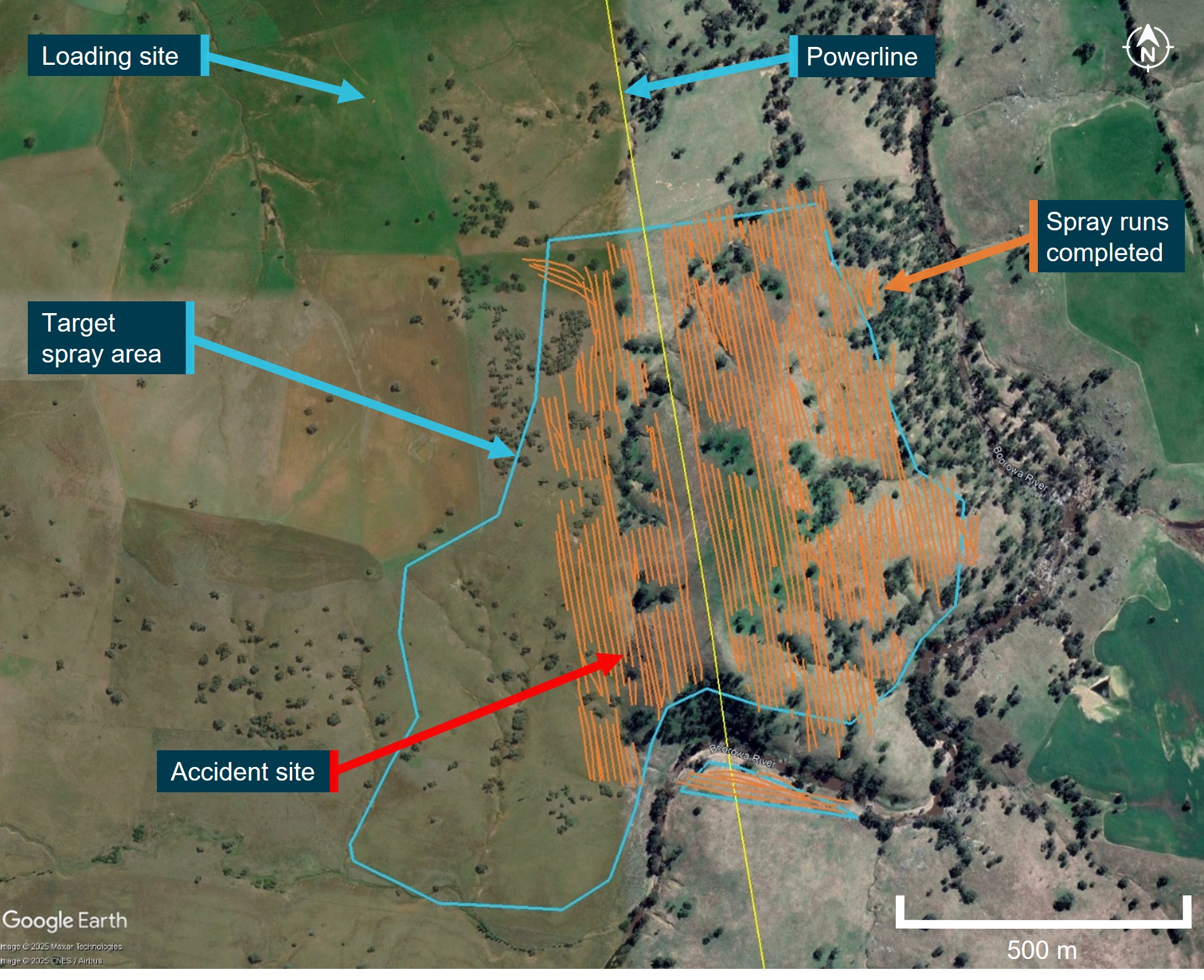
Note: The last few minutes of the flight and spray runs were not recorded.
Source: Google Earth Pro, annotated by the ATSB using operator and onboard data sources
Further investigation
To date, the ATSB has conducted witness interviews, collected documentation and recorded data, and examined the site and wreckage.
The investigation is continuing and will include review and examination of:
- witness accounts
- recorded data
- the wreckage
- helicopter documentation
- operational records
- pilot medical records, qualifications and experience.
A final report will be released at the conclusion of the investigation. Should a critical safety issue be identified during the course of the investigation, the ATSB will immediately notify relevant parties so appropriate and timely safety action can be taken.
Acknowledgements
The ATSB would like to acknowledge the assistance of the Young branch of the NSW Police Force during the onsite stages of the investigation.
Purpose of safety investigationsThe objective of a safety investigation is to enhance transport safety. This is done through:
It is not a function of the ATSB to apportion blame or provide a means for determining liability. At the same time, an investigation report must include factual material of sufficient weight to support the analysis and findings. At all times the ATSB endeavours to balance the use of material that could imply adverse comment with the need to properly explain what happened, and why, in a fair and unbiased manner. The ATSB does not investigate for the purpose of taking administrative, regulatory or criminal action. TerminologyAn explanation of terminology used in ATSB investigation reports is available here. This includes terms such as occurrence, contributing factor, other factor that increased risk, and safety issue. Publishing informationReleased in accordance with section 25 of the Transport Safety Investigation Act 2003 Published by: Australian Transport Safety Bureau © Commonwealth of Australia 2025 
Ownership of intellectual property rights in this publication Unless otherwise noted, copyright (and any other intellectual property rights, if any) in this report publication is owned by the Commonwealth of Australia. Creative Commons licence With the exception of the Commonwealth Coat of Arms, ATSB logo, and photos and graphics in which a third party holds copyright, this report is licensed under a Creative Commons Attribution 4.0 International licence. The CC BY 4.0 licence enables you to distribute, remix, adapt, and build upon our material in any medium or format, so long as attribution is given to the Australian Transport Safety Bureau. Copyright in material obtained from other agencies, private individuals or organisations, belongs to those agencies, individuals or organisations. Where you wish to use their material, you will need to contact them directly. |
[1] Loader: the term used to denote ground support personnel whose functions include assisting with mixing chemicals, loading and dispatching the aircraft.
[2] A mountain flying rating is not a rating classification available under the Civil Aviation Safety Regulations Part 61 licencing system but is a valid rating in some countries.
[3] Cloud cover: in aviation, cloud cover is reported using words that denote the extent of the cover – ‘few’ indicates that up to a quarter of the sky is covered, ‘scattered’ indicates that cloud is covering between a quarter and a half of the sky, ‘broken’ indicates that more than half to almost all the sky is covered, and ‘overcast’ indicates that all the sky is covered.
[4] Chip detector: a magnetic device used to gather chips of metal from engine or transmission oil to provide early warning to maintenance personnel of impending engine failure. Depending on the installation, it can be linked to an in-cockpit indicating light to provide immediate advice to aircrew.
[5] Chip level recovery: involves removing (desoldering) the memory integrated circuit (IC) package from the circuit board of the device and, using dedicated hardware and software tools, reading an image of the IC contents directly from the IC.
Occurrence summary
| Investigation number | AO-2024-062 |
|---|---|
| Occurrence date | 04/12/2024 |
| Occurrence time and timezone | 10:38 Australian Eastern Daylight Time |
| Location | 50 km east of Young Airport |
| State | New South Wales |
| Report release date | 20/02/2025 |
| Report status | Preliminary |
| Anticipated completion | Q2 2026 |
| Investigation level | Short |
| Investigation type | Occurrence Investigation |
| Investigation phase | Final report: Internal review |
| Investigation status | Active |
| Mode of transport | Aviation |
| Aviation occurrence category | Collision with terrain |
| Occurrence class | Accident |
| Highest injury level | Fatal |
Aircraft details
| Manufacturer | Robinson Helicopter Co |
|---|---|
| Model | R44 II |
| Registration | VH-XIX |
| Serial number | 10073 |
| Aircraft operator | Riverina Rotor Work Pty Ltd |
| Sector | Helicopter |
| Operation type | Part 138 Aerial work operations |
| Activity | General aviation / Recreational-Aerial work-Agricultural spreading / spraying |
| Injuries | Crew - 1 (fatal) |
| Damage | Destroyed |
Accredited Representative to the Transport Accident Investigation Commission investigation of an engine issue involving Airbus A320, ZK-NHA, between Wellington, New Zealand and Sydney, New South Wales, on 1 December 2024
Summary
The Transport Accident Investigation Commission (TAIC) in New Zealand has commenced an investigation into an engine issue on a flight between Wellington, New Zealand and Sydney, Australia involving an Airbus A320-271N, registration ZK-NHA, on 1 December 2024.
During the flight the aircraft experienced an engine malfunction, and the aircraft was diverted to Auckland, New Zealand, where it landed safely. No crew or passengers were reported to have been injured.
The TAIC has requested assistance and the appointment of an accredited representative from the ATSB. To facilitate this support and to provide the appropriate protections for the information, the ATSB appointed an accredited representative in accordance with paragraph 5.23 of Annex 13 to the Convention on International Civil Aviation and commenced an investigation under the Australian Transport Safety Investigation Act 2003.
TAIC is responsible for the investigation and release of the final investigation report regarding this accident. Any enquiries regarding the investigation should be addressed to TAIC.
Occurrence summary
| Investigation number | AA-2024-010 |
|---|---|
| Occurrence date | 01/12/2024 |
| Location | between Wellington and Sydney |
| State | International |
| Investigation type | Accredited Representative |
| Investigation status | Active |
| Mode of transport | Aviation |
Aircraft details
| Manufacturer | Airbus |
|---|---|
| Model | A320-271N |
| Registration | ZK-NHA |
| Serial number | 8715 |
| Aircraft operator | Air New Zealand |
| Sector | Jet |
| Departure point | Wellington, New Zealand |
| Destination | Sydney, New South Wales |