
The ATSB is investigating a midair collision between 2 light aircraft, a Jabiru and a Cessna 182, south-west of Sydney on 26 October 2024.
A team of transport safety investigators from the ATSB's Canberra office, with experience in aircraft operations and maintenance, was deployed to the accident sites of both aircraft to conduct evidence-collecting activities.
The ATSB has commenced the examination and analysis of the initial evidence collected. To date, the ATSB investigation has included:
- examined the wreckage
- collected surveillance data from Airservices Australia
- collected OzRunways data for relevant aircraft
- collected pilot and aircraft records
- conducted interviews with relevant parties
- examination of aircraft components and other items recovered from the accident site
- analysis of video recordings and radio transmissions
The continuing investigation will include consideration of the following:
- further review of aircraft, pilot, aerodrome and operator documentation
- analysis of aircraft flight paths
- a review of similar occurrences
- analysis of procedures at non-controlled aerodromes
- further review of communication, electronic conspicuity and surveillance equipment, and interviews with relevant parties
A preliminary report, which detailed factual information established during the evidence collection phase, was released on 20 December 2024 (see the adjacent tab).
A final report will be released at the conclusion of the investigation and will detail analysis and findings. Should a critical safety issue be identified during the course of the investigation, the ATSB will immediately notify relevant parties, so that appropriate safety action can be taken
This preliminary report details factual information established in the investigation’s early evidence collection phase and has been prepared to provide timely information to the industry and public. Preliminary reports contain no analysis or findings, which will be detailed in the investigation’s final report. The information contained in this preliminary report is released in accordance with section 25 of the Transport Safety Investigation Act 2003.
The occurrence
Overview
On the morning of 26 October 2024, a Commercial Pilot Licence (Aeroplane) (CPL(A)) flight test was being conducted in a Cessna 182 aircraft, registered VH-APN (APN), departing from Shellharbour Airport, New South Wales. On board APN were a pilot under examination (the CPL candidate) and a Civil Aviation Safety Authority (CASA) approved flight test examiner (the examiner).
On the same morning, a private flight was being conducted in a Jabiru UL 450 aircraft, registered 19-4079 (4079), departing from The Oaks aerodrome (The Oaks), New South Wales. Onboard 4079 was a pilot (the pilot of 4079), who was the sole occupant.
Around midday, APN and 4079 collided in flight and both aircraft impacted terrain. All occupants of both aircraft were fatally injured. The following describes the events that led up to the mid-air collision.
VH-APN pre-flight and departure from Shellharbour Airport
Three days earlier, on 23 October 2024, a ‘CPL task’ for the flight test and other instructions were sent by email from the examiner to the CPL candidate. The CPL task was a scenario that included instructions to plan and fly from Shellharbour Airport and land at Warnervale Airport flying via Macquarie Lighthouse for some aerial photography. The task then stipulated an onward flight from Warnervale Airport to land at Cessnock Airport, with a return leg to Shellharbour Airport via the most direct track. A map recovered from the accident site showed a red path drawn upon it, consistent with the CPL task. This map indicated that the Cessnock to Shellharbour leg was planned via an inland route passing over Prospect Reservoir and Campbelltown.
A witness account indicated that on 26 October 2024 the flight examiner and CPL candidate had planned to meet at a local bakery at around 0730 local time, prior to starting the ground component of the CPL flight test at Shellharbour Airport, at around 0800. National Airspace Information Planning System (NAIPS)[1] records indicated that the CPL candidate submitted a flight plan at about 1005. At 1018, a radio broadcast was recorded from APN on the Shellharbour Airport common traffic advisory frequency (CTAF),[2] indicating that APN was taxiing for runway 16 for a crosswind departure.
Flight data transmitted by the CPL candidate’s electronic flight bag (EFB)[3] device (APN flight data) indicated that at 1035, APN departed Shellharbour Airport, climbing to 1,500 ft above mean sea level.[4] At 1036, a radio call recorded on the CTAF stated that APN was departing crosswind and tracking north-east toward the sea cliff bridge, with the flight proceeding in this direction (Figure 1).
VH-APN flight along the coastline and diversion to Camden Airport
APN crossed the coastline near Wollongong beach, and subsequently descended to about 500 ft, following the coast toward Sydney and passing the sea cliff bridge at about 1047. At 1054, APN flight data showed the aircraft starting to track northbound along the visual flight rules route referred to as ‘Victor 1 South’ at about 500 ft (Figure 1). As APN approached Macquarie Lighthouse, flight data indicated that the aircraft tracked slightly further away from the coastline before conducting a large ‘S’ manoeuvre, consistent with the CPL aerial photography task planned prior to the flight. The flight continued tracking as planned until abeam Long Reef at 1106, APN started to track inland, consistent with a diversion from the planned route. The track followed published visual landmarks, intercepting and tracking in a south‑westerly direction toward Prospect Reservoir along the visual ‘lane of entry’ route for Bankstown Airport.
APN continued tracking in a south-westerly direction toward Bringelly township, an inbound reporting point for Camden Airport (Figure 1). At 1124, APN contacted Camden Tower air traffic control (ATC), requesting clearance for a touch-and-go and to conduct some circuits. ATC gave instructions to maintain 1,800 ft, join final for runway 24 and report when APN was 3 NM (5.6 km) from the runway threshold, with the aircraft starting to track toward this position. At 1128, APN reported being 2 NM (3.7 km) from runway 24 at about 1,700 ft, with Camden Tower ATC clearing APN for a visual approach. Shortly after, APN called the tower again requesting to remain at 1,800 ft for a practice glide approach to runway 24, which was approved.
At 1129, the APN flight data indicated that the aircraft had joined the crosswind leg for runway 24 at 1,800 ft, with APN being cleared for a visual approach by ATC about one minute later. APN flight data showed the aircraft descending and tracking consistent with a glide approach, with a clearance for a touch-and-go issued at 1131. The pilots of APN continued in 2-way communication with Camden Tower for another circuit, followed by a request for an upwind departure from runway 24, which was approved by ATC and acknowledged by APN. At 1141, APN touched down on runway 24 for the third time and started to climb to 1,300 ft while maintaining the runway direction. APN tracking data showed that the aircraft continued in this direction and altitude, departing the Camden Airport control zone to the west just after 1143.
Figure 1: Flight paths of VH-APN, 19-4079 and accident location
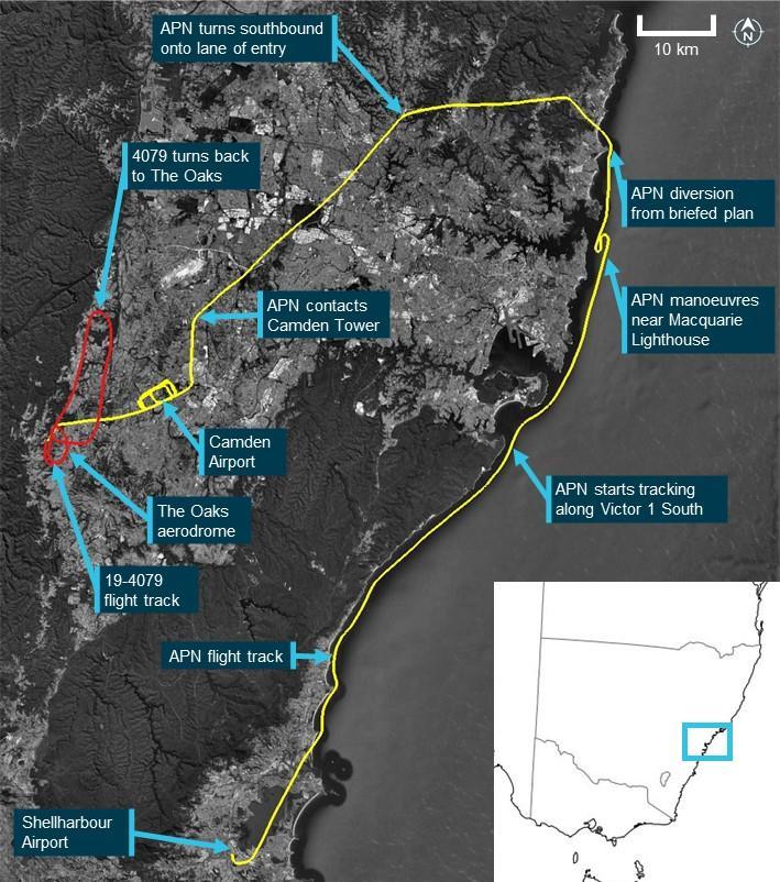
Source: Google Earth and Geoscience Australia, annotated by the ATSB
19-4079 planned flight and departure from The Oaks aerodrome
On the same morning, the pilot of 4079 was conducting a private flight departing from The Oaks. The purpose of the flight was a social event to travel to Cessnock Airport and meet with other pilots who were also flying from The Oaks. The flight was arranged using a group message that invited pilots to join. The message stated that the planned departure from The Oaks was between 1000 and 1030.
During the evening prior, a message was sent by the pilot of 4079 at 1954 confirming that they intended to join the group of pilots flying to Cessnock. The group consisted of 3 pilots, each with their own aircraft that comprised 2 Jabiru aircraft, 4079 and another which was an LSA variant registered 55-1837 (the other Jabiru), and a Sonex Legacy aircraft (the Sonex). All 3 aircraft travelling to Cessnock in the group were registered with Recreational Aviation Australia. The 2 other pilots flying to Cessnock recalled that prior to the flight, it was decided that the pilot of the Sonex, which was a faster aircraft, would wait about 10 minutes before departing so that all aircraft would arrive at Cessnock at about the same time.
At around the same time that APN approached Camden Airport, video onboard 4079 (the onboard video) showed 4079 rolling for take-off on runway 18 right (18R) from The Oaks. The other Jabiru pilot recalled hearing a ‘rolling’ radio call from the pilot of 4079 around this time. Tracking data from the other Jabiru showed that this aircraft had departed about 30 seconds prior to 4079. At 1125, automatic dependent surveillance broadcast (ADS-B) data from 4079 (4079 flight data) showed 4079 on an initial climb from runway 18 at The Oaks. The flight data showed that the flight path was consistent with 4079 flying a right circuit for runway 18 at The Oaks, and departing the aerodrome on the downwind leg in a northerly direction.
19-4079 return to The Oaks aerodrome
At interview with the ATSB, the pilot of the other Jabiru flying to Cessnock reported that they decided to turn back due to experiencing turbulence. This pilot reported broadcasting that they were turning back to The Oaks on 2 frequencies, one corresponding to The Oaks CTAF (126.70) (The Oaks radio frequency) and another frequency that was pre-arranged for en route chatter. Neither of the other pilots flying to Cessnock recalled hearing a broadcast from the pilot of 4079 in response. At 1133, the 4079 flight data showed that the aircraft started turning back towards The Oaks in a southerly direction. Due to the other Jabiru being further north, 4079 was ahead for the return to The Oaks.
During the return, the other Jabiru pilot recalled hearing the pilot of 4079 make a 7 NM (13.0 km) inbound call on The Oaks radio frequency. While inbound, this pilot also recalled hearing another call from an aircraft that was ‘really fuzzy’ and potentially related to another aerodrome. About 6 minutes after turning back, the flight data for 4079 showed that the aircraft had started a slow turn to the right to the west, and then tracked directly overhead The Oaks at about 1,800 ft. The other Jabiru pilot recalled hearing the pilot of 4079 broadcast that they were joining mid-field crosswind and observed the aircraft in that position. At this time, the other Jabiru pilot estimated that they were about 3 to 4 NM (5.6 to 7.4 km) behind 4079. At 1141, the ADS-B data from 4079 showed the aircraft crossing directly overhead The Oaks at about 1,900 ft before turning right and starting to descend.
The Sonex pilot reported hearing the pilot of 4079 broadcast that they were ‘established downwind for runway 18’. At 1142, the 4079 flight data and onboard video showed that the pilot of the aircraft conducted a descent toward runway 18 left (18L) at The Oaks. Around this time, the pilot of the other Jabiru recalled hearing the pilot of 4079 broadcast that they were on the base leg of the circuit. The track of 4079 was in a generally south-easterly direction toward the threshold of runway 18 left, however, instead of landing, the data showed the aircraft flying along the runway at about 100 ft.
Collision between VH-APN and 19-4079
At about 1143:30, shortly after APN departed the Camden Airport control zone, the onboard video and 4079 flight data indicated that the pilot of 4079 conducted a go-around from runway 18L at The Oaks. The onboard video showed that the pilot of 4079 was transmitting a radio communication on The Oaks radio frequency. The Sonex pilot reported that they heard the pilot of 4079 transmit that they were going around and observed 4079 from their position in the run-up bay for runway 36. Around this time, APN tracking data showed that this aircraft turned slightly right onto a track of 263°T while continuing to maintain about 1,200–1,300 ft (Figure 2).
At 1144:04, the 4079 flight data indicated that the aircraft had passed the end of the runway and was climbing. The Sonex pilot reported that as 4079 turned on to the crosswind leg of the circuit for runway 18, the pilot of 4079 called them on the radio, asking if it would be okay to land on runway 36. The Sonex pilot recalled broadcasting that the very light wind would allow 36 to be used, but that others (specifically the other Jabiru pilot) were using runway 18. The Sonex pilot also recalled that immediately after this radio exchange, the other Jabiru pilot broadcast that they were on base for a full stop landing on runway 18. At 1144:47, the tracking data for the other Jabiru showed this aircraft had turned right base, with a spacing of about 1.1 NM (2.0 km) north of the runway 18 threshold. Neither the Sonex or other Jabiru pilot reported hearing any radio transmissions from APN that morning.
At 1145:16, the 4079 flight data showed this aircraft in a right climbing turn at about 1,700 ft, and mid-way through an ovalised crosswind leg of the circuit for runway 18. Around this time, tracking data for APN indicated that this aircraft was about 1.1 NM (2.0 km) from the runway 18 threshold, continuing to track at 263°T at 1,200 ft. At 1145:34, as 4079 continued the right climbing turn, APN tracking data showed that a level left turn was conducted onto a heading of 209°T. Shortly after this turn was completed, at 1145:54, APN started a straight, steady climb from 1,300 ft.
At 1146:00, 4079 completed the right turn onto a northerly heading. At 1146:26, the onboard video and tracking data for 4079 showed this aircraft leveling out at 2,200 ft, and about 1.5 NM (2.8 km) from runway 18L. Around this time, the onboard video showed the pilot of 4079 looking outside and transmitting over the flight radio on The Oaks frequency. The pilot of the other Jabiru recalled that the pilot of 4079 broadcast that they had lost sight of the other Jabiru. Tracking data for the other Jabiru showed that this aircraft was close to the threshold of runway 18 at about this time, with the pilot recalling that they responded via radio to say that they were on short final (for runway 18).
After this time, APN and 4079 were on relatively constant flight path trajectories for about 8 seconds, with APN captured by the onboard video of 4079 in the lower right quadrant of the windscreen. The onboard video and tracking data showed that the collision between the aircraft occurred at 1146:34 on near reciprocal headings. Following the mid-air collision, the left wings of both aircraft separated, with closed-circuit television footage from a nearby residence showing both aircraft descending steeply. Both aircraft were destroyed in the subsequent collisions with terrain. All 3 pilots were fatally injured.
Figure 2: Flight paths and vertical profiles of VH-APN and 19-4079 prior to the accident
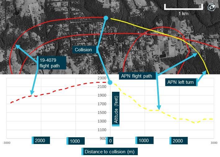
Source: Google Earth and Geoscience Australia, annotated by the ATSB
Context
Pilot information
The CPL candidate in APN held a Private Pilot Licence (Aeroplane). As part of the pilot’s pre‑licence test preparation, the pilot reported having a total of 237 flight hours. The pilot held a Class 1 Aviation Medical Certificate, with no restrictions, valid until 19 March 2025.
The flight test examiner in APN held an Air Transport Pilot Licence (Aeroplane) and a flight examiner rating for the Commercial Pilot Licence (Aeroplane). On 16 May 2024, as part of their aviation medical examination the pilot reported having a total of 25,214 flight hours. The pilot held a Class 1 Aviation Medical Certificate, with a requirement for reading correction to be available, which was valid until 16 November 2024.
The pilot of 19-4079 held a Recreational Aviation Australia (RAAus) pilot certificate,[5] with a cross‑country endorsement. On 4 April 2024, the pilot reported to RAAus having a total of 168 flight hours. The pilot had submitted a medical declaration to RAAus on 19 June 2022.[6]
Aircraft details
VH-APN
The Cessna Aircraft Company 182P is a 4-seat, high‑wing (strut-braced), single-engine aircraft equipped with fixed tricycle landing gear. It has a Teledyne Continental Motors O-470 engine and is fitted with a McCauley 2-blade, constant-speed propeller. APN was manufactured in the United States in 1976. It was placed on the Australian register that same year with a registration of VH‑RKC. The registration was changed to VH-APN in August 1996 and transferred to the current owner in 2021. APN was painted in a yellow (wings) and grey (fuselage) livery. Relevant surveillance and electronic conspicuity equipment:
- ADS-B not fitted
- mode A/C transponder.
19-4079
The Jabiru UL-450 is an amateur-built high-wing (strut-braced) light aircraft with fixed tricycle landing gear. It has a Jabiru 2200J, 4-cylinder engine. Construction of 4079 was completed in 2004 and it was placed on the RAAus aircraft register on 23 February 2004. The registration was transferred to the current owner in 2022. 4079 was painted white. Relevant surveillance and electronic conspicuity equipment:
- portable ADS-B transceiver
- transponder not fitted.
Wreckage and impact information
Wreckage location
The accident site was located about 2.7 km west of The Oaks aerodrome in heavily treed terrain. The 2 primary wreckage locations were approximately 520 m apart, with 4079 north of APN (018º True) (Figure 3). A debris field was located about halfway between the 2 main wreckage locations. Most wreckage items found in the central area were from the left wing of 4079, with a small number of components from APN. Most of the central wreckage was found within a radius of about 50 m.
Figure 3: Accident site location in relation to The Oaks
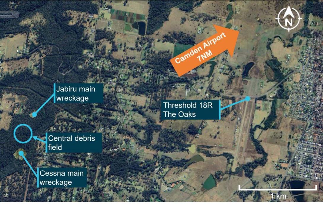
Source: Google Earth, annotated by the ATSB
Orientation of 4079 and APN during the collision
Yellow paint was found on portions of the left wing and left-wing strut of 4079, consistent with being transferred from APN. These areas of the left wing of 4079 also showed signs of leading‑edge penetration to about halfway through the wing chord, at about the mid-span position along the wing.
The left-wing strut of APN was found near the main wreckage of APN, consistent with being attached to this aircraft at the time of the collision with terrain. White paint was found in 2 places of this strut, with leading edge damage observed in these areas, consistent with being transferred from the left wing and left-wing strut of APN.
A relatively small dent with light coloured paint transfer was located on the leading edge of APN left wing, with a longitudinal light coloured paint transfer on the underside of the wing around this location. The upper vertical fin section of 4079 was not located. The relative orientation of the frontal left wing and left-wing strut damage on 4079 and left-wing strut damage on APN, was consistent with 4079 being upright during the collision. Based on the geometry of 4079, the coloured paint transfer on the underside of the left wing of APN was likely from the upper vertical fin section of 4079. This likely separated from the aircraft after being struck by the left wing of APN in the location of the light-coloured paint.
In summary, the paint transfer marks and damage observed onsite was consistent with APN and 4079 colliding on the left sides of each other on reciprocal headings. The left wing and left-wing strut of 4079 primarily impacted the left strut of APN, with the upper fin of 4079 striking the left-wing leading edge of APN.
19-4079 wreckage
Examination of the main wreckage site and surrounding broken tree branches for 4079 indicated that the aircraft had impacted the ground at a steep angle, with little forward movement, resulting in a localised wreckage field. The ATSB inspection found no evidence of pre-accident flight control damage.
All of the aircraft was accounted for, excluding a section of the outboard left wing, and the upper vertical fin. An aileron fitting for 4079 was co-located with the left wing of APN.
VH-APN wreckage
Witness marks in surrounding trees showed that APN impacted terrain in a steep nose down attitude. There was a significant post-impact fire at the primary wreckage site for APN, which limited the ability to examine the wreckage. The ATSB inspection of the available evidence did not identify any pre-accident flight control damage. The left wing of APN was located about 50 m from the main wreckage, consistent with this wing separating in flight.
Recorded data
Neither aircraft was equipped with a flight data recorder or cockpit voice recorder, nor were they required to be.
Transmitted and external data sources
The following recorded data has been gathered for this investigation:
- ADS-B data from 4079
- ATC audio data for APN
- CTAF audio data from Shellharbour Airport for APN
- closed-circuit television footage from a nearby residence showing post collision dynamics
- data transmitted/recorded from devices running electronic flight bag applications for APN, 4079 and 55-1837
- transponder data for APN.
19-4079 onboard camera
4079 was fitted with an onboard video camera that was attached to a roof panel inside the cabin. The ATSB recovered the camera at the accident site, which was downloaded at the ATSB’s technical facility in Canberra. Initial observations from the video include:
- 4079 had no evident technical problems during the flight
- the radio was selected to the frequency 126.7 at the time of the accident
- lights on the radio, along with the push-to-talk button indicated the pilot was transmitting and receiving radio calls during the flight
- 4079 and APN were both on relatively constant trajectories, with 4079 being straight and level and APN climbing at the time of the collision, with no avoiding action evident by either aircraft
- the aircraft were travelling on a generally reciprocal heading, impacting on the left side of each aircraft, with the fuselage of 4079 passing underneath the left wing of APN.
Aerodrome information
The Oaks aerodrome
The Oaks aerodrome was an aeroplane landing area,[7] located 7 NM (13.0 km) west-south-west of Camden Airport, New South Wales. It has an elevation of 880 ft above mean sea level and 2 parallel grass runways aligned in a north-south direction. Runway 18R/36L was 900 m long, while runway 18L/36R was 800 m. All circuits were conducted to the west of the aerodrome to avoid overflying the township of The Oaks. The Oaks utilised the shared CTAF designated radio frequency of 126.7.
The Oaks was a non-controlled aerodrome, where separation was maintained by ‘alerted see‑and-avoid’ principles guided by Civil Aviation Safety Authority advisory circulars AC 91‑10 Operations in the vicinity of non-controlled aerodromes and AC 91-14 Pilots’ responsibility for collision avoidance. These stated that pilots should broadcast position and intention information so that nearby traffic would have an awareness of the aircraft and be able to plan accordingly.
An icon and label for The Oaks aerodrome was published on all visual aeronautical charts.
Camden Airport
Camden Airport has an elevation of 230 ft above mean sea level. The main runway, 24/06, is paved. The airspace around Camden Airport was class D during towered hours when all aircraft were provided with an air traffic control service. During the accident flight the tower was active, with the tower communications on the radio frequency 120.1. The class D airspace extends in a 2 NM (3.7 km) radius around the airport.
Further investigation
- examined the wreckage
- collected surveillance data from Airservices Australia
- collected OzRunways data for relevant aircraft
- collected pilot and aircraft records
- conducted interviews with relevant parties
- liaised with the NSW Police Force.
The investigation is continuing and will include consideration of the following:
- examination of aircraft components and other items recovered from the accident site
- further review of aircraft, pilot, aerodrome and operator documentation
- further analysis of video recordings and radio transmissions
- analysis of aircraft flight paths
- a review of similar occurrences
- analysis of procedures at non-controlled aerodromes
- further review of communication, electronic conspicuity and surveillance equipment, and interviews with relevant parties.
A final report will be released at the conclusion of the investigation. Should a critical safety issue be identified during the course of the investigation, the ATSB will immediately notify relevant parties so appropriate and timely safety action can be taken.
The ATSB SafetyWatch highlights the broad safety concerns that come out of our investigation findings and from the occurrence data reported to us by industry. One of the safety concerns is Reducing the collision risk around non-towered airports | ATSB.

Acknowledgements
The ATSB would like to acknowledge the significant assistance provided during the initial investigation response by the NSW Police Force.
Purpose of safety investigationsThe objective of a safety investigation is to enhance transport safety. This is done through:
It is not a function of the ATSB to apportion blame or provide a means for determining liability. At the same time, an investigation report must include factual material of sufficient weight to support the analysis and findings. At all times the ATSB endeavours to balance the use of material that could imply adverse comment with the need to properly explain what happened, and why, in a fair and unbiased manner. The ATSB does not investigate for the purpose of taking administrative, regulatory or criminal action. TerminologyAn explanation of terminology used in ATSB investigation reports is available here. This includes terms such as occurrence, contributing factor, other factor that increased risk, and safety issue. Publishing informationReleased in accordance with section 25 of the Transport Safety Investigation Act 2003 Published by: Australian Transport Safety Bureau © Commonwealth of Australia 2024
Ownership of intellectual property rights in this publication Unless otherwise noted, copyright (and any other intellectual property rights, if any) in this report publication is owned by the Commonwealth of Australia. Creative Commons licence With the exception of the Commonwealth Coat of Arms, ATSB logo, and photos and graphics in which a third party holds copyright, this report is licensed under a Creative Commons Attribution 4.0 International licence. The CC BY 4.0 licence enables you to distribute, remix, adapt, and build upon our material in any medium or format, so long as attribution is given to the Australian Transport Safety Bureau. Copyright in material obtained from other agencies, private individuals or organisations, belongs to those agencies, individuals or organisations. Where you wish to use their material, you will need to contact them directly. |
[1] A multi-function, computerised, aeronautical information system that allows users, such as pilots, to obtain weather information and submit flight plans into the air traffic system.
[2] A common traffic advisory frequency is a designated frequency on which pilots make positional broadcasts when operating in the vicinity of a non-controlled airport, or within a broadcast area.
[3] An information system for flight crew members which allows storing, updating, delivering, displaying and/or computing digital data to support flight operations or duties.
[4] Above mean sea level (AMSL): All altitudes presented in this report are in AMSL unless otherwise specified.
[5] An authorisation for individuals to fly RAAus registered recreational aircraft in Australia.
[6] Applicants for an RAAus licence are required to have a health standard equivalent to that required for the issue of a private motor vehicle driver licence in Australia and may self-declare their medical status.
[7] An aeroplane landing area is an aerodrome that has not been certified by the Civil Aviation Safety Authority. These aerodromes are non-controlled, unregulated facilities. It is the responsibility of pilots and operators to determine whether these aerodromes are suitable for use.