Executive summary
What happened
On 31 March 2022, at about 0741 local time, 2 Microflite Airbus EC130 helicopters, registered VH‑WVV and VH-XWD, departed the Batman Park helicopter landing site in Melbourne, for the town of Ulupna, Victoria. The helicopters encountered instrument meteorological conditions (IMC) over Mount Disappointment and VH-WVV conducted a U-turn to avoid entering cloud. While also attempting to conduct a U-turn, VH-XWD entered cloud, developed a high rate of descent, and collided with terrain. The helicopter was destroyed and the 5 occupants were fatally injured.
What the ATSB found
The ATSB found that, while visual meteorological conditions (VMC) prevailed at the departure point, the pilots of the helicopters planned and commenced a route for which IMC was forecast. The pilots continued the flight as conditions deteriorated below VMC until a rapid change of course was required to avoid entering cloud. The accident pilot did not maintain adequate control of the pitch attitude during the attempted U-turn and a high rate of descent developed resulting in a collision with terrain. This pilot had no instrument flying experience, and the helicopter was not equipped with any form of artificial stabilisation, nor was either required by the regulations.
The operator had not mandated several of the risk controls available to them for their day visual flight rules pilots, which included inadvertent IMC recovery training and basic instrument flying competency checks during operator proficiency checks, nor were they required to by the regulations. The operator had also not introduced an inadvertent IMC recovery procedure for their air transport operations or a pre-flight risk assessment to trigger an escalation process for marginal weather conditions identified at the pre‑flight planning stage.
The operator had identified poor weather conditions as a risk. However, their management of that risk was limited to the regulatory requirements and did not consider an inadvertent IMC event. The Civil Aviation Safety Regulations Part 133 for rotorcraft air transport only required the risk of a visual flight rules inadvertent IMC event to be managed through avoidance. While important, avoidance of inadvertent IMC has and will fail on occasion, but Part 133 did not address the risk of recovery from such an event.
The ATSB also found that the standby artificial horizon in VH-XWD was not powered on during the flight and erroneously indicated an unusual attitude as the helicopter approached the cloud. The pilot was momentarily distracted by this indication immediately before executing the U-turn. In addition, the helicopter was scheduled to be modified with the latest service bulletins to prevent a turbine blade shedding event but they were not accomplished at the time of the accident. These 2 factors were not considered contributory but increased the risks of spatial disorientation and a post-impact fire respectively.
What has been done as a result
As a result of this accident, the operator has taken the following actions:
- drafted a dedicated risk assessment addressing visual flight rules into IMC
- upgrading their fleet of EC130 and AS350 helicopters with the Garmin G500H primary flight display and multifunction display incorporating synthetic vision and a terrain alerting functionality
- modifying their AS350 helicopters with the Garmin GFC 600H helicopter flight control system (approved data for the EC130 was not available at the time of the investigation)
- acquired ICARUS (instrument conditions awareness recognition and understanding system) instrument flying training hoods
- introduced basic instrument flying training and inadvertent IMC recovery training
- updated their operator proficiency check syllabus to include knowledge and practical skills checks for avoiding and recovering from inadvertent IMC
- added the Helicopter Association International online academy ‘56 Seconds to Live’ inadvertent IMC avoidance course to their pilot training program
- introduced a pre-flight risk assessment tool
- introduced a company ‘Task rejection’ policy statement into their operations manual
- obtained an Airbus Helicopter Training Centre approval.
The ATSB has issued a safety recommendation to the Civil Aviation Safety Authority to take further safety action to address the risk to rotorcraft air transport (Part 133) passenger safety from a visual flight rules inadvertent instrument meteorological conditions event.
Safety message
Helicopter inadvertent IMC occurrences result in a higher proportion of accidents and a similar proportion of fatal accidents as those involving aeroplanes. The ATSB encourages all pilots to develop the knowledge and skills required to manage the risk of inadvertent IMC, which can be assisted with educational material from regulators and industry bodies directed at flight planning and weather assessments. Decision-making in marginal weather conditions can be supported with the use of a pre-flight risk assessment tool.
At an organisational level, the risk of helicopter inadvertent IMC should be considered within the context of a company’s operations. The effective management of this risk relies on multiple layers of controls to reduce the risk of single-point of failure accidents. This includes training and procedures for avoidance and recovery, which can be enhanced with equipment, such as autopilots to reduce the risk of loss of control, and terrain awareness and warning systems to reduce the risk of controlled flight into terrain.
The occurrence
Overview
On 31 March 2022, 2 Airbus Helicopters EC130 T2 helicopters, registered VH-WVV (WVV) and VH-XWD (XWD), and operated by Microflite under the visual flight rules, departed the Batman Park helicopter landing site (HLS), Melbourne, Victoria, for the destination of Ulupna, Victoria. Each helicopter had a pilot and 4 passengers on board. While tracking overhead Mount Disappointment towards Ulupna, the pilots of both helicopters encountered instrument meteorological conditions. The pilot of WVV was in the lead and called for a U-turn and exited from the conditions. The pilot of XWD attempted to follow WVV with a U-turn but entered cloud and lost control of the helicopter, which resulted in a collision with terrain that fatally injured the 5 occupants and destroyed the helicopter.
Positioning flight to Batman Park helicopter landing site
At about 0709 local time, XWD departed Moorabbin Airport for Batman Park HLS about 10 seconds behind another company helicopter, WVV.[1] Their task was to transport a charter group from the Batman Park HLS in the city, north to Ulupna on the border with New South Wales.
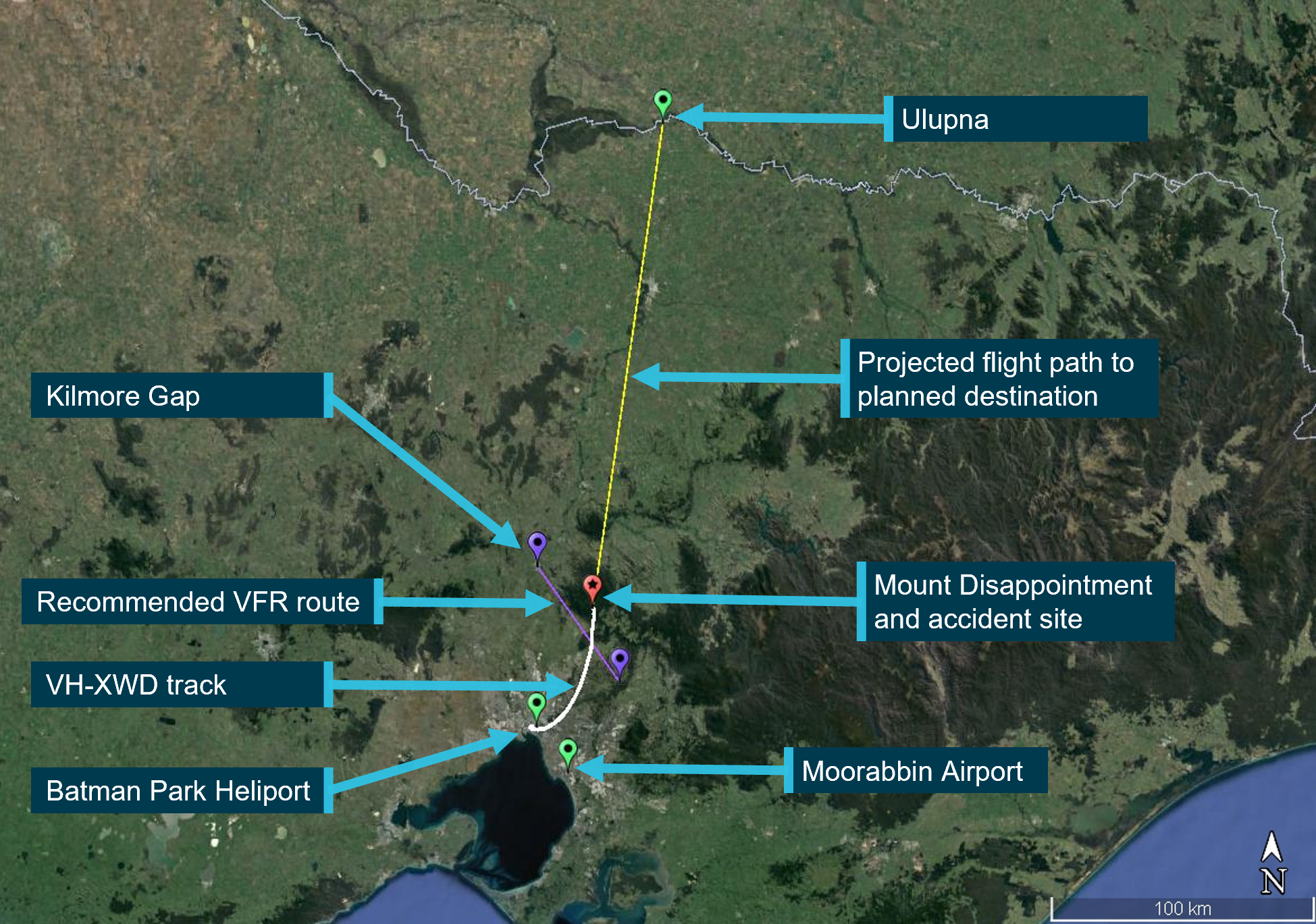
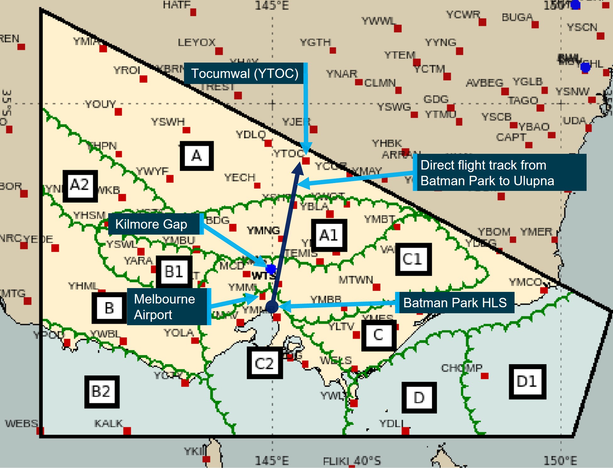
The pilot of WVV later recalled that the weather forecast had been a concern the night before and again on the morning of the accident as the forecast for Melbourne Airport included scattered[2] cloud at 1,500 ft above the aerodrome from 0700. This was 30 minutes before their scheduled departure time from Batman Park and indicated that they would not be able to transit through the ranges to the north below cloud. The recommended visual flight rules (VFR)[3] route, for a track north outside controlled airspace, was through Kilmore Gap, which had an elevation of 1,200 ft. The pilot of WVV believed the Melbourne Airport forecast would not allow them to maintain their minimum legal height if they attempted to track via Kilmore Gap below cloud. Therefore, they planned to take a more direct track to their destination, over Mount Disappointment (elevation of 2,605 ft), about 12 NM (22 km) to the east of Kilmore Gap. Figure 1 depicts the key locations.
Figure 1: XWD accident flight and key locations
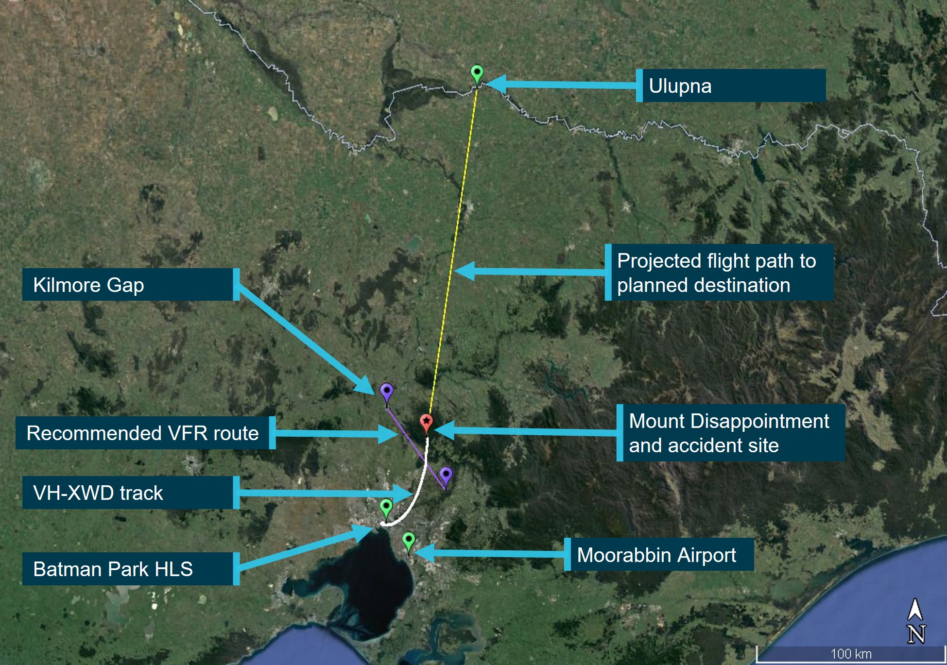
Note: The 2 purple pins depict the ends of the recommended VFR route.
Source: Google Earth and OzRunways, annotated by the ATSB
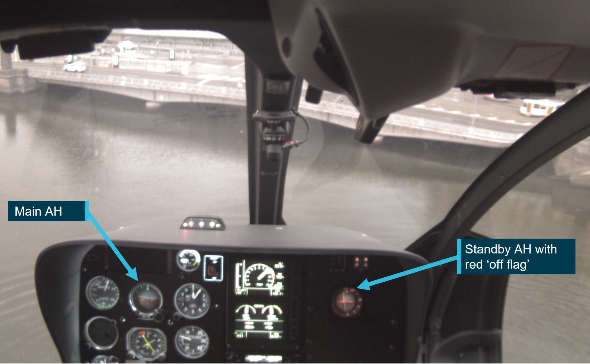
The recording from the Appareo[4] camera fitted onboard XWD showed that, after start at Moorabbin Airport, the pilot erected the main artificial horizon (AH)[5] on the helicopter’s instrument panel but did not turn on and erect the standby AH. Therefore, the standby AH presented the helicopter’s attitude as a 90° roll to the left with a red off flag in the top right corner.
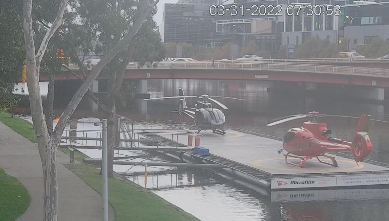
After take-off from Moorabbin, the pilots assessed the weather and observed the forecast cloud was not yet established over the ranges (refer to section titled Meteorological information). Therefore, they considered the route over Mount Disappointment would be suitable for the planned charter flights and continued to Batman Park to collect their passengers. At about 0717, the helicopters landed at Batman Park and were shut down (Figure 2). The pilots then proceeded to the operator’s HLS office to meet their charter group of 8 passengers for their business trip to Ulupna. They escorted the passengers to the helicopters where they were divided into 2 smaller groups of 4 passengers for each helicopter and provided a safety briefing.
Figure 2: XWD (left) and WVV (right) at Batman Park HLS

Source: Operator, through Victoria Police
Departure from Batman Park helicopter landing site
At about 0741, XWD departed from Batman Park 30 seconds behind WVV. The standby AH in XWD remained off and continued to indicate a 90° left roll attitude (Figure 3). Both helicopters were operating VFR outside controlled airspace without a flight plan.[6] The helicopters initially headed east to remain outside controlled airspace before turning north toward Ulupna. As they tracked east and then north, the lower limit of controlled airspace increased,[7] and the helicopters climbed from 1,500 ft above mean sea level to 2,500 ft and then to 3,500 ft. The pilots reportedly discussed the weather over the radio and noted the conditions to the west were consistent with the forecast, but that the conditions to the north had not deteriorated, and they continued to track northbound.
Figure 3: XWD take-off from Batman Park HLS
Source: ATSB (from the Appareo)
While tracking north towards Mount Disappointment, the helicopters climbed above a layer of scattered cloud that the pilot of WVV estimated to have a top of about 2,500-3,000 ft and below a layer of broken cloud with an estimated base of about 4,500 ft. The pilot of WVV later recalled that they could see areas of sunlight striking the ground ahead of them, and therefore considered the weather ahead suitable to climb on top of the scattered layer of cloud, rather than attempt to cross Mount Disappointment underneath the cloud layers.
As they approached Mount Disappointment, XWD was about 1.5 NM (3 km) behind WVV, and the helicopters were cruising at an altitude of about 3,500 ft with a 120 kt ground speed. At this time, the pilot of WVV noted the layer of scattered cloud below them was becoming broken, that the tops were rising, and that the base of the cloud above them appeared to be lowering, resulting in the 2 layers of cloud appearing to converge ahead of them. They tracked around a rising cloud top, that otherwise would have forced them to climb into controlled airspace. Once around that cloud top, the pilot of WVV could still see spots of sunlight striking the ground ahead. Therefore, they were confident to continue.
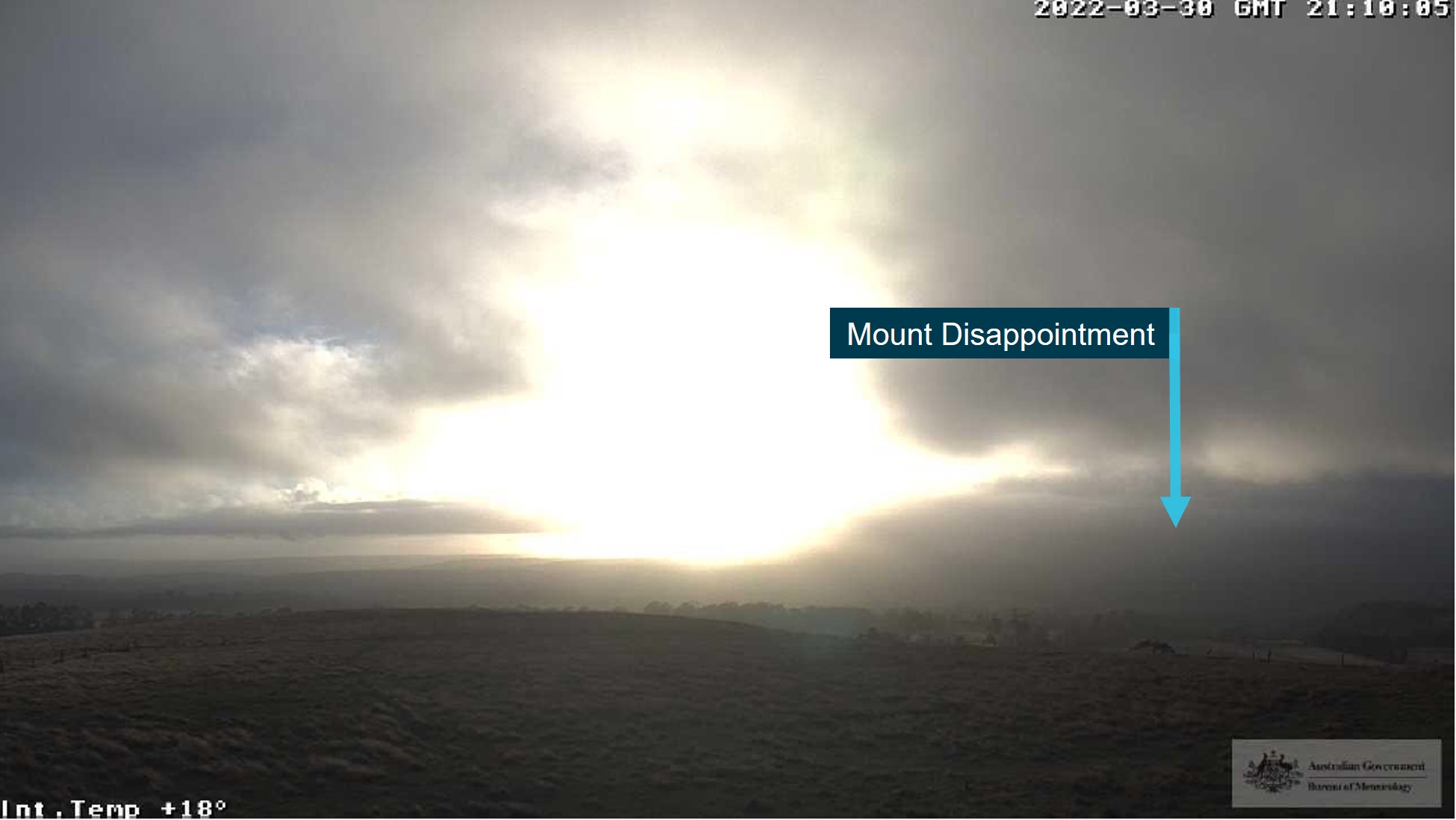
Mount Disappointment
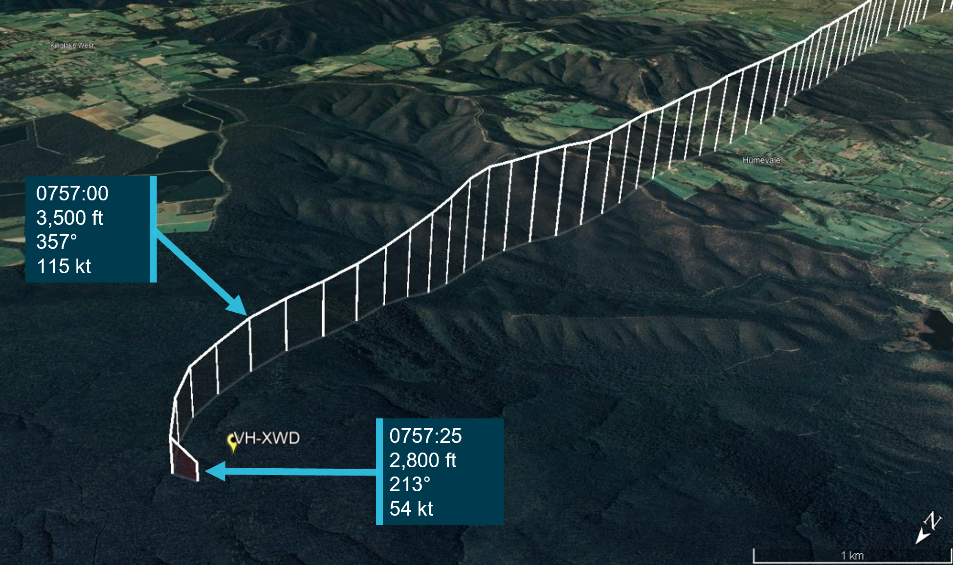
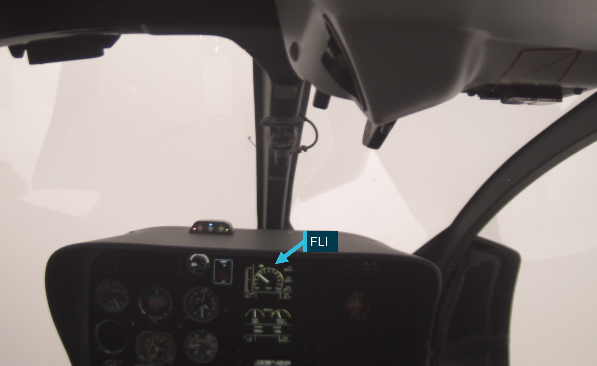
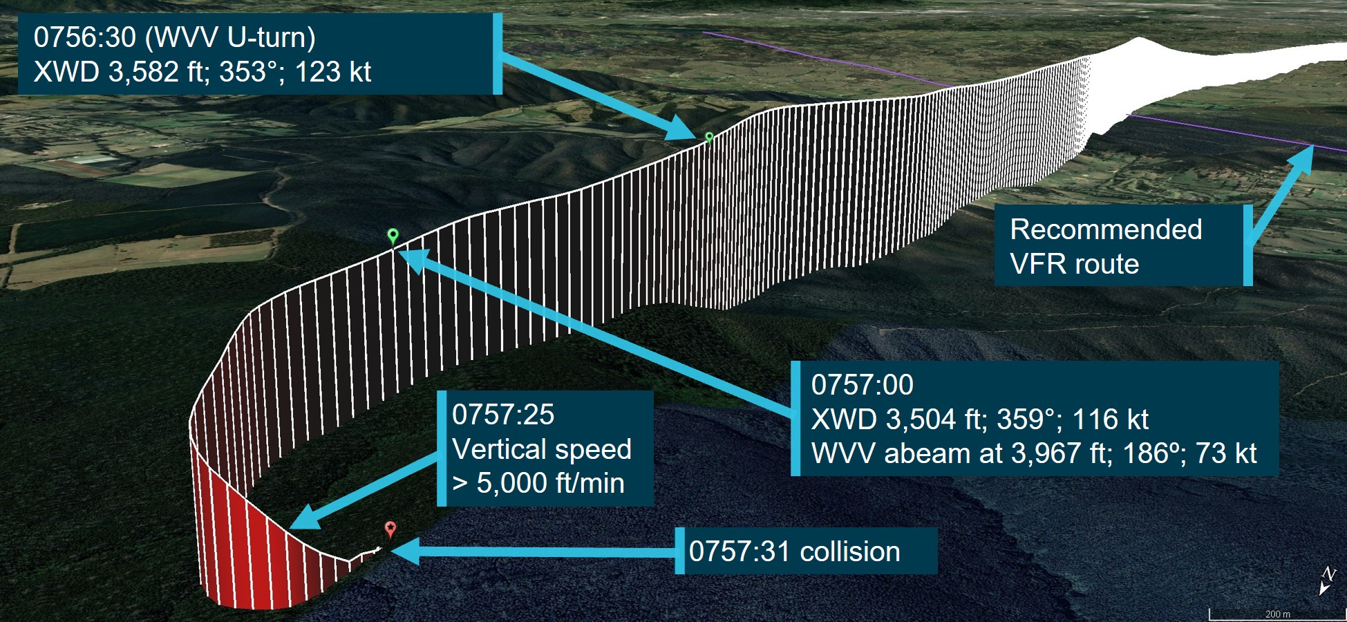
Before they crossed Mount Disappointment, the pilot of WVV was confronted with a ‘wall of cloud’ in front, and to the left and right of their intended track, and so broadcast to XWD their intention to turn around. The pilot of WVV knew that XWD was nearby and wanted to ensure that the pilot of XWD understood WVV would be making a U-turn. The pilot of WVV reported that the pilot of XWD was initially confused as to why WVV was turning around and might have thought the conditions were suitable to continue. The pilot of WVV then broadcast ‘U-turn, U-turn, U-turn’ to XWD. At 0756:30 (Figure 5), the pilot of WVV conducted a sharp left turn onto a southerly track at 3,635 ft. At that time, XWD was at 3,582 ft, with 100 kt indicated airspeed (KIAS), and a first limit indicator (FLI)[8] power setting of about 5.
At 0756:54, while maintaining 3,600 ft with FLI 5, the Appareo camera recording showed that the cloud through the windscreen of XWD appeared to change from broken to overcast. Over the next 5 seconds, the FLI reduced to 2 and XWD started to descend at about 500 ft/min.[9] The pilot also started actively scanning to the left and above.
At 0757:00, WVV had turned onto a southerly track (186°), climbed to 3,967 ft with a ground speed of 73 kt, and was close to passing abeam XWD, which was at 3,504 ft tracking north (359°), with a ground speed of 116 kt. The pilot and passengers onboard WVV sighted XWD when they passed above and abeam the left-side of XWD. This was the last visual contact with XWD. Figure 4 depicts the meteorological conditions from XWD shortly after the helicopters passed abeam each other at 0757:09.
Figure 4: Footage of weather conditions from XWD at 0757:09
Source: ATSB (from the Appareo)
At 0757:10, XWD briefly rolled left about 30° with a FLI indication of 2, before returning to a level attitude. Three seconds later, the pilot looked across to the right side of the instrument panel. At that time, the helicopter was pitched 10° nose down, wings level, at 70 KIAS and 3,500 ft, and with a FLI indication of 4. The pilot then reached across the instrument panel, grasped the standby AH knob momentarily and then released it, with no change to it indicating a 90° left roll with the off flag still visible in the top right corner.
At 0757:20, at an altitude of about 3,300 ft at 75 KIAS with a FLI indication of 1 and while descending at 1,300 ft/min, XWD rolled left to about 60° angle of bank with the nose pitched 5° down. One second later, the nose down attitude had reached 15°, the airspeed had reduced to about 70 KIAS, and the rate of descent increased to 1,400 ft/min with FLI 1.5. Within 3 seconds, the horizon disappeared off the top right corner of the main AH, such that only ground was visible on the instrument, with a 1,500 ft/min rate of descent and FLI 2.
At 0757:26, the vertical speed indicator reached the full-scale descent deflection of 3,000 ft/min. The main AH still displayed full ground nose down attitude, but the angle of bank had reduced to about 30° left. The airspeed was about 85 KIAS with a FLI indication of 1. The Appareo global positioning system data indicated the helicopter’s rate of descent exceeded 5,000 ft/min from 0757:23 to 0757:28 and peaked at about 5,700 ft/min at 0757:25 (Figure 5.).
At 0757:29, at an altitude of about 2,700 ft, with a low FLI setting and the vertical speed indicator still at full-scale deflection, trees became visible in the cloud. In the last second of footage, the helicopter pitched significantly nose up while the altimeter continued to decrease from 2,700 ft to 2,600 ft. The vertical speed indicator remained at full-scale deflection, the airspeed decayed by 20 KIAS, there was no significant change in the FLI indication, and the LIMIT[10] caution light activated twice. The Appareo cabin area microphone also detected the rotor overspeed warning activate and the sound of the rotor blades striking the trees. The collision with tree occurred at 0757:31. The flight track for XWD is presented in Figure 5.
Figure 5: XWD flight track and accident site
Source: Google Earth and OzRunways, annotated by the ATSB
After WVV completed the U-turn onto a southerly heading, the pilot found a clearing through the cloud and turned back northbound with a clearance from air traffic control to climb to not above 5,000 ft after reporting they were in instrument meteorological conditions. After a few minutes, the pilot and passengers onboard WVV attempted to contact the pilot and passengers onboard XWD, initially with the helicopter radio, then with their mobile phones, with no success. The pilot then contacted the Microflite operations manager, which started the search and rescue process. WVV diverted to Mangalore Airport and landed without further incident.
The emergency locator transmitter fitted to XWD did not activate after the accident and low cloud in the area initially hampered the search. The wreckage site was located at about midday at an elevation of 2,359 ft (719 m). The 5 occupants were fatally injured and the helicopter was destroyed.
VH-WVV passenger reports
The passenger in the front middle seat had flown regularly with the pilot of WVV and considered the pilot to be very cautious regarding the weather. The passenger recalled that, during the flight, the pilot radioed XWD about the approaching weather. A ‘wispy cloud then went past us, and it felt like a heavy white cloud came down and dumped on us’.
The passenger in the front right seat had flown in helicopters for about 30 years. The passenger recalled that, as they crossed Mount Disappointment, heavy cloud rolled in resulting in ‘a white‑out[11] with ground visibility no longer evident’. The pilot radioed XWD and said words to the effect of ‘U-turn, U-turn, U-turn’. Then the pilot of WVV immediately completed a U-turn. The pilot of XWD radioed back with words to the effect ‘aren’t we going to cut through?’ The passenger then saw XWD pass just below them.
The passenger seated behind the pilot had flown once previously with the pilot of WVV and found them to be very professional and relaxed. During the flight, the passenger was reading emails, but noted as they approached Mount Disappointment that the pilot’s body language had changed, which gave the passenger the feeling that something was not right. The passenger looked outside and saw cloud in front and to the left, and then heard the pilot announce they were going ‘hard left’. When the passenger next looked outside, they ‘could not see anything, it was like a white‑out’. The passenger then felt the helicopter in a hard left turn.
Context
Pilot information
Qualifications and experience
The pilot of VH-XWD (XWD) held a Commercial Pilot Licence (Helicopter) (CPL(H)), issued 22 February 2016, with a single-engine helicopter class rating and a Class 1 Aviation Medical Certificate with an expiry date of 28 February 2023. In addition, the pilot held an aerial application rating and a low-level rating with a sling endorsement. The Civil Aviation Safety Authority (CASA) had no record of the pilot holding a gas turbine endorsement[12] but noted that the pilot had conducted several flight reviews with an authorised instructor in turbine-powered helicopters since being issued with the CPL(H) in 2016.
The pilot was initially employed as a line pilot conducting scenic flights in the Northern Territory from March 2016 until April 2019. The pilot then moved to another employer in south-east Queensland from May 2019 before joining Microflite in December 2019.
The pilot received company approval by Microflite to conduct visual flight rules (VFR) charter operations on 22 December 2019. According to the operator’s records, the pilot had accumulated 3,005.8 flying hours on helicopters, which included 330.6 hours on the EC130, 2,507.3 hours total turbine, and 2,866.8 hours in command. Their records indicated the pilot had no instrument flying,[13] simulated instrument flying or night flying experience.
Since joining Microflite, the pilot had completed operator VFR proficiency checks[14] on 21 December 2019 (EC130), 21 April 2020 (EC120),[15] 14 October 2020 (AS350),[16] 25 May 2021 (EC120), and 31 October 2021 (AS350) to a pass standard with no remedial training required. According to the operator’s training manual, the proficiency checks included ‘flight planning, refuelling, aircraft weight and balance, passenger briefing, forced landings and all emergency operations.’ The instrument flying unit of competency was optional and not tested on any of the checks.
The pilot had completed the following ground school courses with Microflite:
- Microflite fatigue management policy questionnaire – 4 December 2019
- Controlled flight into terrain / Approach and landing accident reduction – 23 December 2019
- Wire and obstacle environment awareness – 10 July 2020
- Drug and alcohol management plan awareness – 12 August 2020
- Human factors training for helicopter flight crew – 5 September 2020
- Dangerous goods by air – 7 January 2022
- Pilot maintenance approval – 23 February 2022.
Flight and duty period limits
According to the Microflite operations manual, the company operated to Civil Aviation Order 48.1 Instrument 2019 (Appendix 4) for their air transport operations, which provided prescriptive flight and duty period limits. A review of the pilot’s flight and duty periods from 1 March 2022 up to, and inclusive of 30 March 2022, found the pilot recorded 169.2 hours of duty with 47.8 flight hours and had 11 rostered days off. In the previous 90 and 365 days, the pilot accumulated 108.5 and 274.5 flight hours respectively. On 30 March 2022, the day prior to the accident, the pilot was on duty from 1030 to 1825 (7.9 hours) and recorded 2.2 flight hours. On the day of the accident, the pilot’s duty started at 0630. There was no evidence to indicate that the pilot had exceeded any of the flight or duty period limits set in appendix 4.
Pilot of VH-WVV
The pilot of VH-WVV (WVV) was issued with a CPL(H) in 2016 and held a low-level rating. At the time of the accident, the pilot had reportedly accumulated about 2,500 hours, which included about 1,500 hours on the EC130, EC120 and AS350 single-engine turbine helicopters. The pilot joined Microflite as a day VFR line pilot in 2019 with about 3 years prior experience of charter operations in Victoria and Queensland and had no instrument or night flying experience. The pilot of WVV reportedly paired with the pilot of XWD about 10 times in the previous 2 years, noting that tasks for 2 helicopters were the exception and single helicopter taskings were the norm.
The chief pilot noted that while the pilot of XWD had slightly more flying hours experience and qualifications than the pilot of WVV, the pilot of WVV started with Microflite before the pilot of XWD. Therefore, the chief pilot considered the 2 pilots to be of equivalent experience for the task and there was no operator appointed hierarchy or ‘lead’.
Helicopter information
General information
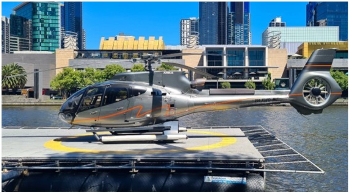
The accident helicopter was an Airbus Helicopters EC130 T2 manufactured in France in 2017 and equipped with a Safran Helicopter Engines Arriel 2D turboshaft engine, 3-bladed main rotor and Fenestron[17] tail rotor (Figure 6). The helicopter was registered VH-XWD in Australia in August 2019 in the night VFR operational category. At the time of the accident, XWD was owned by and registered to Asian Pacific Building Corporation Pty Ltd and operated by Microflite under a cross‑hire agreement. The helicopter was in a 7-seat configuration, with 3 seats in the front row and 4 seats in the rear row. Dual flight controls were fitted. The flight controls operated in the conventional sense with hydraulic assistance. No stability augmentation system or autopilot was fitted (refer to section titled The stabilisation problem).
Figure 6: VH-XWD
Source: Dylan Noveski
Instrumentation
The supporting Manual of Standards for the Civil Aviation Safety Regulations (CASR) Part 133 Air transport operations-rotorcraft stipulated that rotorcraft operating under VFR by day were required to be fitted with the following flight instruments: indicated airspeed, pressure altitude, magnetic heading, time, slip, and outside air temperature. Additional instruments such as attitude and standby attitude (artificial horizon (AH)) were required for night VFR and IFR operations. XWD was approved for night VFR operations.
The instrument panel had a conventional layout with analog flight instruments on the left, a vehicle and engine multi-function display (VEMD) in the middle, and a standby AH on the right. The pilot’s seat was on the left side and the centre console was fitted with a Garmin GTN 750 touch-screen global positioning system, which was used for navigation and communications.
The AHs were electrically powered. The main AH was powered on when the battery was turned on, but the red off flag would not clear until generator power (28 V) was supplied. After power on, the pilot was required to erect the gyro with a cage knob to align it with local gravity. The standby AH had a push-button switch located on the centre console to provide power. The red off flag would not clear unless it was powered on, at which stage the pilot could erect the gyro as per the main AH.
Setting each of the AHs after start for flight was not specifically stated in the checklist. There was a step for: ‘all necessary instruments…on – tested’ after engine start. Therefore, which instruments were set for flight would depend on the specific helicopter configuration, regulatory requirements, and pilot’s requirements for the planned role.
Weight and balance
The helicopter weight and balance were calculated for the accident flight at the time of take-off and at the top of the final descent, and it was determined to be within the published limits. Therefore, helicopter performance was not considered to be a factor in this accident.
Following a request from the ATSB to analyse the development of the nose low attitude in the final turn, Airbus Helicopters conducted an aerodynamic analysis of the helicopter’s response to lateral cyclic input for a 60° angle of bank turn to the left, and provided the following comments:
Emergency locator transmitter
The emergency locator transmitter (ELT) was a KANNAD 406 INTEGRA transmitter, factory fitted to a mounting bracket in the rear baggage bay, left side, aligned with the normal axis. It is set in the ARM position for flight so that the G-switch[20] will provide impact-activation. The G-switch orientation is 45° below the longitudinal axis, so that it will detect a component of longitudinal and normal accelerations. After the G-switch is activated, the ELT will conduct a self-test before the first transmission is made about 65 seconds after activation. If the ELT or its antennae connection are destroyed within the initial 65 second period, no signal will be transmitted. According to Airbus Helicopters, the shock accelerations qualification defined in the regulations (for ELT) are consistent with a survivable impact and typically different than cockpit voice and flight data recorder equipment, which is by design more robust to an impact. There was no ELT activation detected.
Engine overspeed protection
According to Safran Helicopter Engines, a power turbine overspeed[21] may occur if the engine is delivering power and there is a rupture in the power transmission chain at the reduction gearbox, or transmission shaft, or the engine to main gearbox driveshaft. To avoid a power turbine disc bursting from an overspeed condition, the engine incorporates a power turbine blade-shedding system. This is set by the design of the power turbine blades to occur below the disc burst speed with a safety margin. The engine is designed to contain the energy from blade-shedding, but not a disc burst. It is also a certification requirement for aircraft engines to prevent disc burst.
Safran published a service bulletin (SB 292 73 2210), applicable from January 2019, on the subject: Electronic Engine Control Unit (EECU). Modification of software (V603). Application of modification TU 210. The SB applied to the Arriel 2D engine and included the following warning:
The purpose of modification TU 210 was to modify the engine control software to:
- improve detection of a slow decrease in performance of the fuel low pressure pump
- signal a sudden interruption of the fuel supply at engine inlet
- limit damage associated with a power turbine overspeed.
According to the SB, if the engine speed exceeded 120%, the engine control system would send an activation command to the engine stop electro-valve. This would allow engine shut‑down provided the associated Airbus Helicopters hardware SB modification had been incorporated.
On 22 August 2019, the European Union Aviation Safety Agency issued safety information bulletin (SIB) 2019-10 on the subject: Power turbine over-speed protection on Arriel 2D engines. The SIB explained that the extra thermal energy released from the engine during blade-shedding was a potential source of ignition for a post-impact fire. While the ignition source for post-impact fires was not always determined, the introduction of an electronic overspeed protection (TU 210) aimed to limit blade-shedding and reduce the potential for post-impact fire.
At the time of the release of the SIB, the concern was not considered to warrant airworthiness directive action.[22] However, the SIB recommended operators incorporate the engine and helicopter modifications into their affected helicopters.
A review of the maintenance records for XWD revealed the EECU was manufactured, and software downloaded in May 2016. The EECU was installed in August 2016 and the records indicated there had been no modifications incorporated since manufacture. On review, Safran confirmed the TU 210 modification was not embodied in the accident EECU.
The operator reported that they had complied with the relevant SBs from Safran and Airbus Helicopters. The operator’s helicopters with a build date prior to 2019 received the EECU software update in May 2019 when a Safran technician attended their facility (the hardware and training required to comply with the SB was not available in Australia prior to the date of the accident). XWD was assembled in September 2019 and therefore not available for that modification at the time of the Safran visit but was scheduled for a later update within the compliance period for the Safran and Airbus SBs. Their helicopters with a build date from 2021 received the update in the factory.
Wreckage and impact information
Accident site
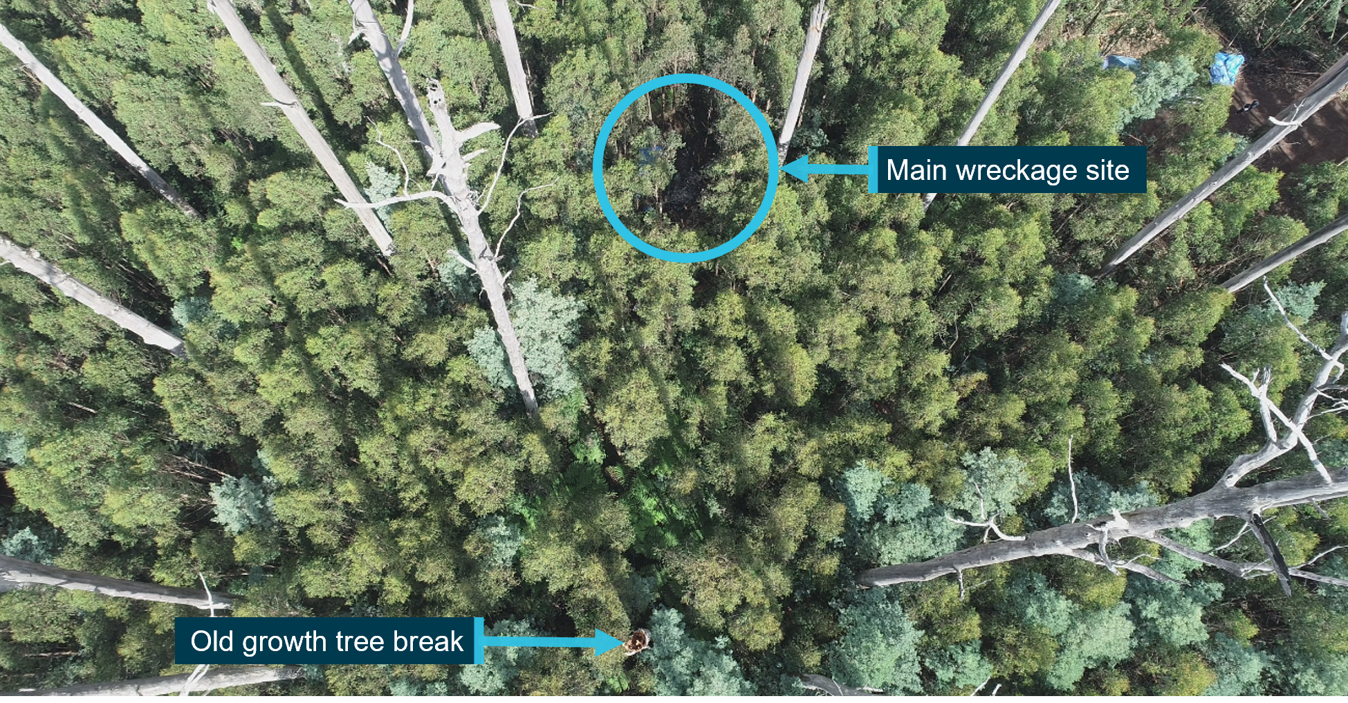
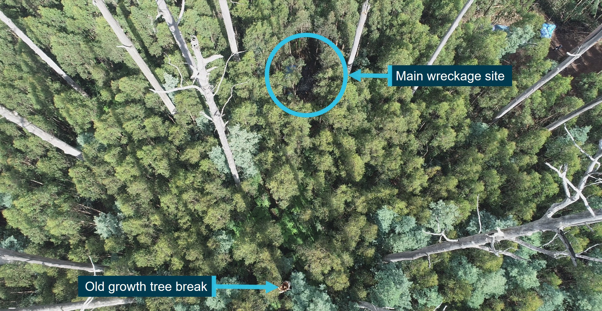
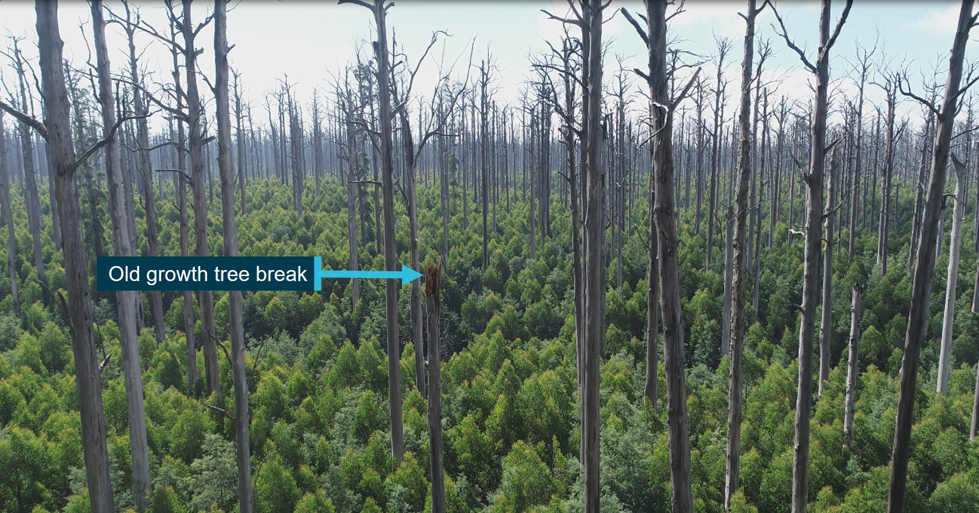
The ATSB’s site survey established that XWD had impacted a large old growth tree, which broke the upper tree trunk and significantly disrupted the cabin. Cabin debris, including the overhead panel with the rotor-brake handle, was littered around the base of this tree. The helicopter then descended at an angle of about 45° on a southerly trajectory to the ground. Figure 7 and Figure 8 depict the old growth tree break from overhead the main wreckage site.
Figure 7: Overhead view of old growth tree break and main wreckage site
Source: ATSB
Figure 8: View to the north of old growth tree break from overhead the main wreckage site
Source: ATSB
The vegetation surrounding the accident site comprised of 2 distinct levels of growth. A new growth canopy with a height of about 24 m, and old growth trees with a height of about 70 m, as measured by a remotely piloted aircraft system. The elevation of the base of the old growth tree was 718 m, which indicated that the elevation of the top of the tree was about 788 m. The tree break was 41 m above ground level at an elevation of 759 m. Therefore, the tree impact very likely occurred at an altitude of 2,490–2,585 ft (759–788 m).
General crash survival requirements include maintaining a liveable volume, keeping occupants restrained and the impact loads within human tolerance, and providing the means and time to escape (Fox, 1989). Given the breakup of the cabin on impact with the old growth tree and associated height above ground level, this was not considered to be a survivable accident.
Wreckage examination
The helicopter was subject to a post-impact fire, resulting in the destruction of some components. However, from the components available there was no evidence of any pre-existing defect that would have prevented normal operation.
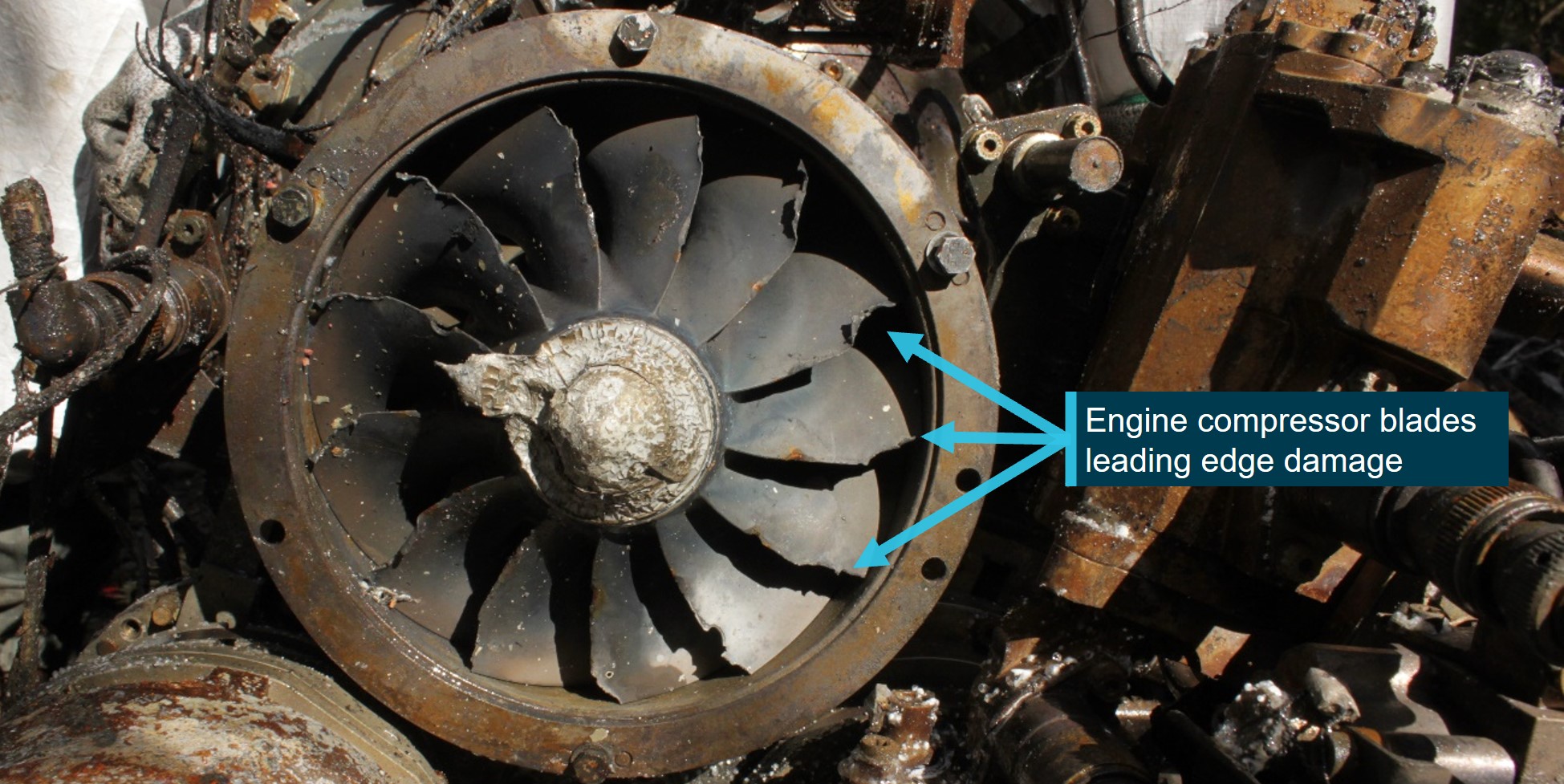
The engine had disconnected from both the main rotor and Fenestron driveshafts. The Fenestron driveshaft exhibited significant scoring damage, which indicated it was rotating at high speed during the accident sequence. Damage to the leading edges of the engine compressor blades was also characteristic of high-speed rotation (Figure 9) and the power turbine exhibited blade shedding. The rupture of the engine to main gearbox transmission drive shaft and flexible coupling,[23] with its screws sheared on the main gearbox side, was consistent with a sudden over‑torque. Overall, the damage observed indicated that the engine was producing power at the time of impact.
Figure 9: Damage to engine compressor blades
Source: ATSB
The centre console push-button switch for the standby AH was found in the off position (push‑button out). The other push-button switches on the same row as the standby AH were in the correct position for flight – off (out) for the fuel pump (the electric fuel pump is a booster pump for engine start and is switched off after start), off for the dome light, and on (in) for the avionics.
The ATSB retrieved the pilot’s electronic flight bag (iPad), an Appareo cabin-mounted camera, the vehicle and engine multi-function display (VEMD), a Garmin GTN 750 global positioning system, the EECU, and the central warning panel for further analysis. The engine data recorder was not able to be recovered due to fire damage.
Recorded information
The pilot’s iPad, Appareo camera and VEMD were successfully downloaded by the ATSB. The pilot’s iPad contained 1-second flightpath data and the Appareo memory included the positioning flight to the Batman Park HLS, the accident flight, and some footage of flights on the previous day. There were 2 audio channels on the Appareo for the intercom system and cabin area microphone. However, only the cabin area microphone successfully recorded.
A review of the available logs on the VEMD indicated there were no faults, failures or limits reached until the beginning of the impact sequence when a high rotor speed value of 410 rotor revolutions per minute was recorded, which was consistent with the Appareo download. The EECU and Garmin GTN750 global positioning system were not attempted to be downloaded due to significant fire damage and it was considered unlikely that they would have provided additional information. The central warning panel did not contain a memory module and did not provide any evidential data.
Medical and pathological information
A full post-mortem examination of the pilot was conducted. No soot was found in the airways and the cause of death was recorded as ‘Multiple injuries sustained in a helicopter incident (pilot)’. Further, the pilot’s toxicological results did not identify any substances that could have impaired their performance.
An external examination with computed tomography scan was performed on the passengers. The post-mortem reports for the passengers stated, ‘A reasonable cause of death would appear to be: Multiple injuries and effects of fire sustained in a helicopter incident (passenger)’. However, the forensic pathologist assisting the Victorian Coroner confirmed to the ATSB that the pilot’s cause of death, which did not include the effects of fire, was the most reliable indicator for all the occupants.
Meteorological information
Graphical area forecast
According to the Bureau of Meteorology, the graphical area forecast (GAF) is designed primarily to meet the needs of pilots flying in the airspace between the surface and 10,000 ft above mean sea level (AMSL). They provide information on weather, cloud, visibility, icing, turbulence, and freezing level in a graphical layout with supporting text.
The GAF for Victoria, current at the time of the departure from the Batman Park HLS, was issued at 0321 on the morning of 31 March 2022 and was valid from 0400-1000. The GAF divided the state into 4 areas, identified as A, B, C and D, with sub-divisions in areas A, B and C, separated by green scalloped lines (Figure 10). The flight was planned to start in area C2, transit area C1 (including Mount Disappointment), A1 and end in area A. The destination of Ulupna is located 8 NM (15 km) west of Tocumwal (YTOC in Figure 10).
Figure 10: GAF with direct track from Melbourne to Ulupna west of Tocumwal (YTOC)
Source: Bureau of Meteorology, annotated by ATSB
For the flight route, from departure to the planned destination, the GAF specifically stated that:
- All of area C was forecast to have a broken layer of stratus cloud from 2,000-3,000 ft and a broken layer of cumulus/stratocumulus cloud from 3,000-8,000 ft with visibility greater than 10 km. In addition, area C included scattered showers of rain with cloud tops up to 10,000 ft.
- Kilmore Gap, identified as a critical location on the GAF, was in area C1. The cloud forecast for Kilmore Gap was for a broken layer of cumulus/stratocumulus at 3,000 ft with TEMPO (temporary) conditions from 0600-1000 for a broken layer of stratus at 1,200 ft with the note ‘CLD ON GND’ [cloud on the ground].
- Area A was forecast to have few cumulus/stratocumulus cloud from 3,000-5,000 ft.
The grid point wind and temperature forecast, valid from 0500, indicated the wind was 13 kt from 180° at 2,000 ft and 32 kt from 140° at 5,000 ft.
Melbourne Airport forecast
Melbourne Airport was north of the departure point and nearby the intended route (Figure 10). It has an elevation of 434 ft, and as an international airport, it provides a 24-hour aerodrome forecast. An aerodrome forecast is valid for a radius of 5 NM (9 km) from the aerodrome reference point. It includes cloud bases, visibility, weather, and surface wind. However, it does not include the height of cloud tops.
The forecast valid for the departure of the accident flight included wind from 180º at 10 kt, visibility greater than 10 km, light showers of rain, scattered cloud with a base of 1,500 ft above the aerodrome and broken cloud with a base of 2,500 ft. The forecast scattered cloud base of 1,500 ft above the aerodrome was 1,934 ft AMSL. This was consistent with the 2,000 ft cloud base on the GAF. The forecast for broken cloud at 2,500 ft above the aerodrome (2,934 ft AMSL) was consistent with the 3,000 ft cloud base on the GAF.
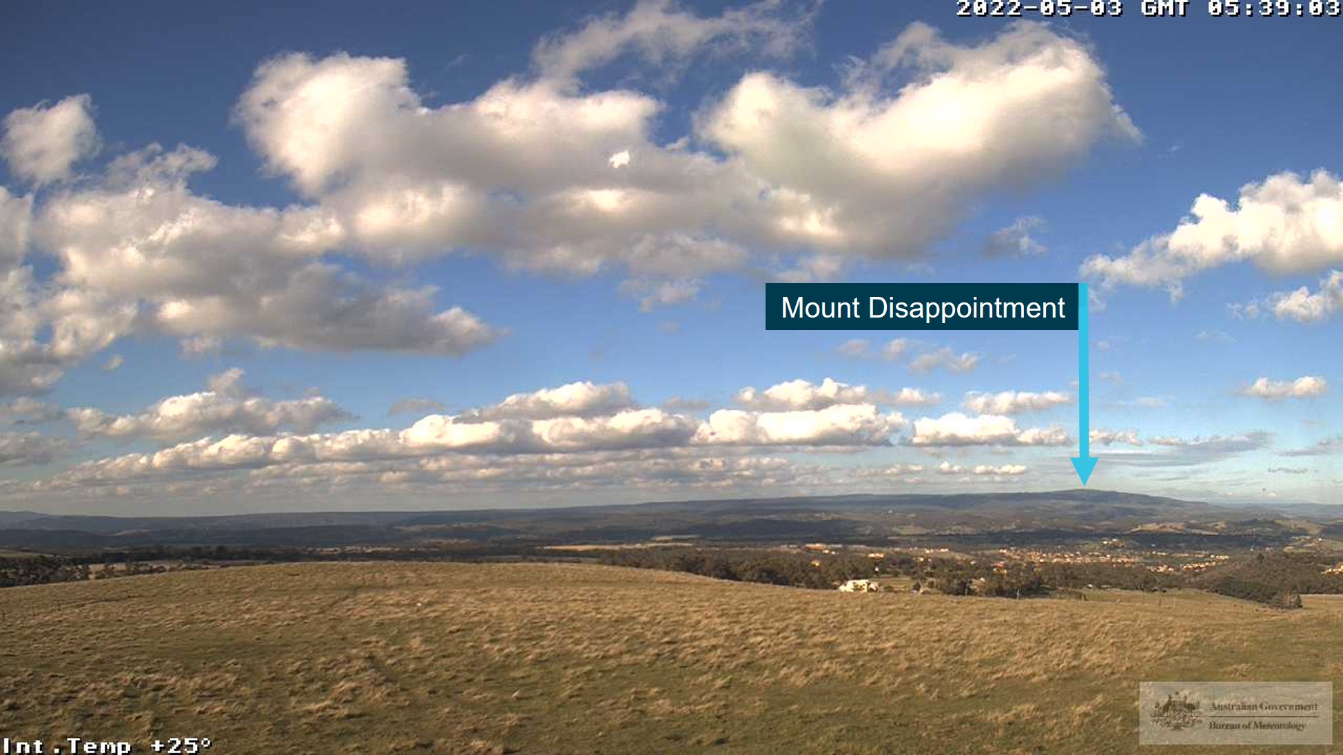
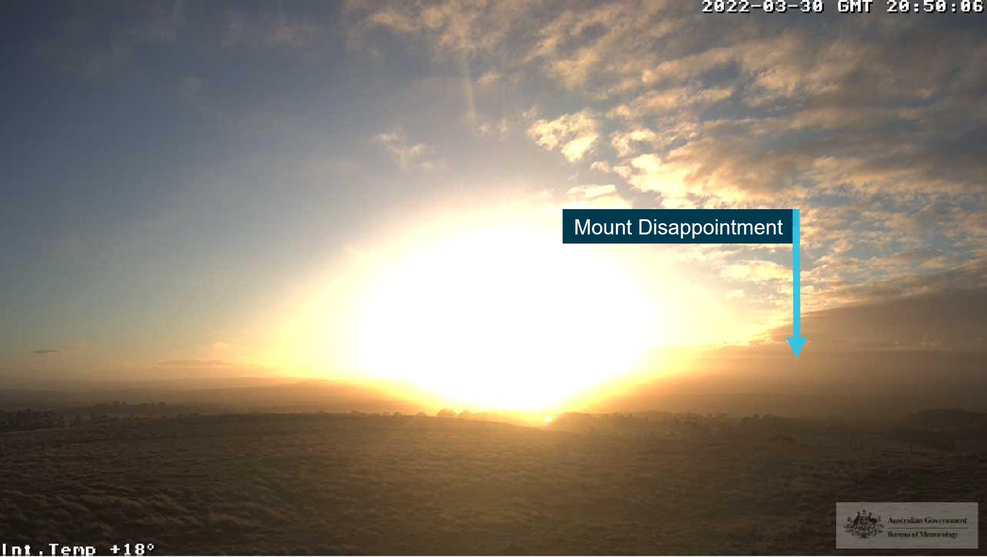
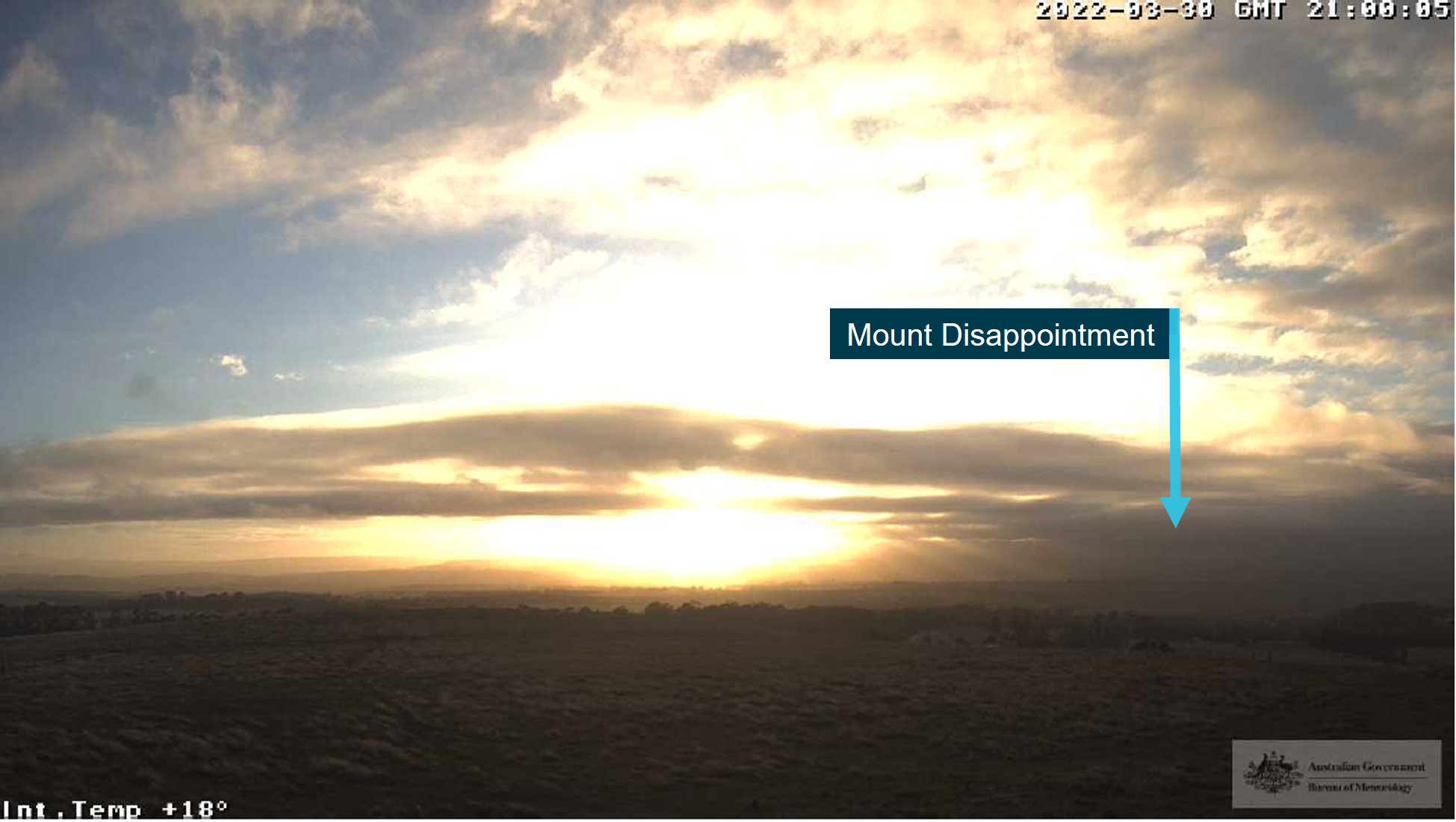
Kilmore Gap weather station and camera
The Bureau of Meteorology Kilmore Gap weather station and web camera was located 19 km west-north-west of the accident site (Figure 11). At 0750, 8 minutes prior to the accident, the camera depicted cloud overhead Mount Disappointment (Figure 12). Shortly after the accident, at 0800 and 0810, the camera showed extensive development of low cloud in the area (Figure 13 and Figure 14).
Figure 11: Kilmore Gap webcam view looking east on 3 May 2022
Source: Bureau of Meteorology, annotated by the ATSB
Figure 12: View towards Mount Disappointment at 0750 (8 minutes before the accident)
Source: Bureau of Meteorology, annotated by the ATSB
Figure 13: View towards Mount Disappointment at 0800 (2 minutes after the accident)
Source: Bureau of Meteorology, annotated by the ATSB
Figure 14: View towards Mount Disappointment at 0810 (12 minutes after the accident)
Source: Bureau of Meteorology, annotated by the ATSB
The weather station recorded a relative humidity of 93-95% from 0730-0830. From 0730 until 0741, the time the accident flight departed the Batman Park HLS, the lowest cloud at Kilmore Gap was 590 ft above ground level and the coverage was fluctuating between scattered and broken. At about 0758, the temperature and dewpoint were 9.7 °C and 8.9 °C respectively, and the wind was 17 kt from 171°. There was few cloud at 394 ft and broken cloud at 3,510 ft above ground level. At about 0811, 13 minutes after the accident, the cloud became broken at 394 ft and 3,510 ft. The cloud conditions continued to deteriorate through to 0830, at which time the cloud was broken at 295 ft.
Accessing weather forecasts
The National Aeronautical Information Processing System (NAIPS) is a multi-function, computerised, aeronautical information system that allows users, such as pilots, to obtain weather information and submit flight plans into the air traffic system. The pilots of XWD and WVV were using a NAIPS mobile app developed by OzRunways.[24] This app included a location briefing, area briefing and a chart selection icon. According to the app developer, only the first person to request a specific chart via the chart icon (such as the GAF) will be recorded by the NAIPS system as the requestor. The chart is then saved to cache memory on their server and all subsequent requests to view that chart via the app chart icon will result in retrieval of the chart from their server, rather than the NAIPS server. Therefore, while the submission of a location and/or area briefing request would be recorded on the NAIPS system, the selection of an area forecast via the chart icon would not necessarily be recorded on NAIPS.
Interpretation of the forecast
The pilot of WVV reported that the weather was a concern both the night before and in the morning. From the Melbourne Airport forecast, there was scattered cloud at 1,500 ft at 0700. As they were scheduled to depart 30 minutes after that, they were concerned that the weather was ‘already going to be established’ and they would not be able to get over the range. They elected to assess the actual conditions on their way to the Batman Park HLS.
The pilot further stated that the flight was planned as a VFR flight outside controlled airspace, which did not require a flight plan, and none was submitted. Consequently, they intended to remain below the controlled airspace steps that surrounded Melbourne Airport on their route from the HLS to Ulupna. The pilot of WVV also indicated that they were concerned about the cloud height above ground level at Kilmore Gap, where the terrain is at 1,200 ft AMSL. The forecast cloud at 1,500 ft indicated to the pilot that they would not be able to transit Kilmore Gap at their minimum height above ground of 500 ft.
Operational information
Visual meteorological conditions
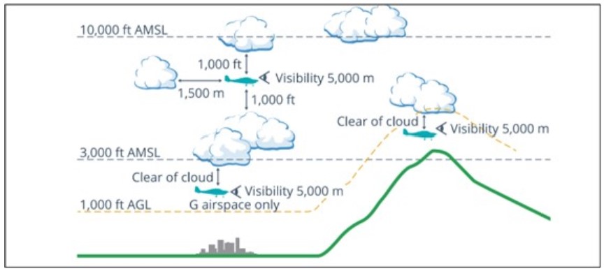
Visual meteorological conditions (VMC) are expressed in terms of flight visibility and distance from cloud (horizontal and vertical) and are prescribed in the Civil Aviation Safety Regulations (CASR) Part 91 (General Operating and Flight Rules) Manual of Standards 2020: 2.07 VMC criteria. In addition to visibility and distance from cloud, VMC may also be subject to operational requirements. There are a variety of criteria for the different altitudes and airspace that a VFR flight is operating in.
For aircraft operating below 10,000 ft in class G airspace (uncontrolled airspace), the VMC criteria were a minimum flight visibility of 5,000 m, horizontal distance from cloud of 1,500 m and vertical distance from cloud of 1,000 ft. For aircraft operating in class G airspace below 3,000 ft AMSL, or 1,000 ft above ground level, whichever is higher, the distance from cloud is reduced to ‘clear of cloud’, provided the aircraft is operated in sight of ground or water. For a helicopter operating below 700 ft above ground level, the visibility can be reduced to 800 m.
A VFR flight can be conducted above cloud provided VMC can be maintained for the entire flight, including climb, cruise, and descent.[25] The CASA Visual Flight Rules Guide included the following note for VFR flight above cloud:
The accident flight was conducted in class G airspace and climbed to about 3,500 ft AMSL, which was above 1,000 ft above ground level, before reaching Mount Disappointment. Therefore, while the minimum visibility remained at 5,000 m, the distance from cloud increased from ‘clear of cloud’ while they were below 3,000 ft and in sight of the ground, to 1,000 ft vertical and 1,500 m horizontal distance as soon as they climbed above 3,000 ft. Figure 15 provides a visual depiction of the VMC criteria below 10,000 ft (excludes helicopter VMC below 700 ft) from the CASA Visual Flight Rules Guide.
Figure 15: VMC criteria below 10,000 ft
Source: Civil Aviation Safety Authority
Flight planning
Regulatory requirements
According to CASR Part 91 (General Operating and Flight Rules) Manual of Standards 2020: 7.02 Forecasts for flight planning, an authorised weather forecast must cover the whole period of the flight, and include a wind and temperature forecast and, for a flight at or below 10,000 ft AMSL, a GAF or general aviation meteorological[26] area forecast. In addition, CASR Part 133 Air transport operations-rotorcraft, subpart 133.130: Flight preparation requirements, stated:
Microflite requirements
The Microflite operations manual section 2B1.1: Planning and briefing materials, detailed the pre‑flight requirements for a pilot in command, which included the following:
Section 2B1.7: Minimum safe altitudes / lowest safe altitude (LSALT), provided the following advice for their day VFR pilots:
Section 2C3.3 Diversions due weather, provided the following guidance for handling deteriorating weather in-flight:
Chief pilot’s expectation
The chief pilot reported that the pilots had a company issued iPad (electronic flight bag) that provided them with up‑to‑date access to the booking information on the company calendar. In addition, they were issued with a credit card, which could be used to purchase their flight planning apps subscriptions. The chief pilot provided the following explanation for the flight planning sequence:
The chief pilot acknowledged the client on board WVV was an important client, being a regular client, but that this should not have changed the conduct of the flight. The chief pilot also recognised that perceived pressure to deliver for a client was normal within the industry and it was not limited to charter, it could also occur in aerial work operations. However, from a company management perspective, they attempted to provide support for their pilots by not applying pressure to conduct a flight, using client services staff to liaise with clients, and organising alternate transport (road vehicles) for clients if a flight cannot proceed or a pilot decides their planned destination cannot be reached. The chief pilot had not flown with the client for the accident charter group, and therefore did not know the client as well as the pilot of WVV. From their own interactions with the client, they did not believe they would have pressured the pilots to proceed on the accident flight.
Accident pilot
The accident pilot accessed NAIPS on 30 March 2022 (the day prior to the accident flight) at 1506,[28] via the OzRunways app and requested meteorological and notice to airmen[29] information for Melbourne Airport. At this time, the pilot was at Warragul, from where a return flight was conducted to Moorabbin Airport via Lancefield and the Batman Park HLS. The request was limited to a location briefing for Melbourne Airport and did not include an area briefing (GAF) request. This was the only request recorded on NAIPS for the 24 hours prior to the accident.
The pilot did not submit any NAIPS location requests on 31 March 2022. Examination of the pilot’s iPad found that the OzRunways and WillyWeather[30] apps were running at the time of the accident. The pilot accessed the WillyWeather app at 0633 and it continued to run. The WillyWeather app support reported that they did not offer any features specific to aviation, but did offer most of the data required, such as cloud cover, wind, temperature, and predicted rainfall. When selecting a location, the app also provided a link to the nearest weather radar station feed.
In the week prior to the accident, the pilot submitted a location briefing request for Melbourne Airport at 2212:46 on 24 March 2022. The following day, the pilot conducted a passenger transport return flight in XWD between Moorabbin Airport and the Cathedral Lodge Golf Course, which is about 55 NM (102 km) north-east of Moorabbin and 32 NM (59 km) east-north-east of the accident site, on the north side of the ranges. The outbound flight was 0836-0910 and the return flight was 1612-1650. There was no record of a briefing request submitted either on the morning prior to departure, or in the afternoon prior to the return flight. However, as described earlier, it was possible the pilot viewed a GAF chart without it being recorded by the NAIPS system.
Pilot of VH-WVV
According to the pilot of WVV, the 2 pilots accessed the weather information independently on 30 and 31 March 2022, but then discussed it together. The pilot of WVV accessed NAIPS via OzRunways on 30 March 2022, the day before the accident, to submit a meteorological and notice to airmen request for the locations Moorabbin, Essendon, Melbourne, Avalon, and Coldstream. This occurred at 1103, 1111, 1118 and 1124, and they departed from Moorabbin Airport at about 1219 to collect their charter group from the Batman Park HLS. The same request was made at 1242 before departure from Batman Park, at 1506 before departure from Warragul, at 1602 and 1618 before departure from Lancefield, at 1751 before departure from Batman Park for the return flight to Moorabbin, and at 1950 after arrival.
On the morning of the accident, the pilot resubmitted the request for the locations Moorabbin, Essendon, Melbourne, Avalon, and Coldstream at 0545, 0559 and 0628. At interview, the pilot reported that they would have checked the GAF but not the grid-point wind and temperature chart, and demonstrated to the ATSB how they used their NAIPS app to check the current GAF.
The pilot stated that the Melbourne Airport forecast would be consulted the evening before a client services flight as it provided a 24-hour forecast, and therefore, provided an indicator of the potential conditions for the next day. Normally, the company operations staff would consult one of the pilots at about 1630 to check on the likelihood of weather cancellations the following day. If the weather looked unsuitable, then client services would contact the client and confirm if they wished to hold their booking, noting the risk that it could be cancelled, or arrange alternative transportation.
The pilot reported that the client on the day of the accident had never pressured them to conduct a flight in marginal weather and that there were numerous occasions when a service was cancelled due to weather. The pilot could not provide a specific example of a weather cancellation, but explained that, due to the elevation of Melbourne and the built-up area, they would cancel a client pick-up from the city [Batman Park HLS] if the cloud was forecast to be below 1,400 ft AMSL or there was reduced visibility, and that ‘it happens a lot’.
Former company pilot
The ATSB spoke to a former Microflite pilot during the investigation. This pilot provided similar information to that provided by the pilot of WVV and the company’s chief pilot. They reported that for flight planning, they would look at the Melbourne Airport forecast the night before to get an indication of the weather for the Melbourne Basin[31] the next day. The company operations staff might ask a pilot at the close of business if the weather was going to be acceptable the next day for client liaison purposes. For operations around the basin, the pilot would use the location forecasts and weather radar, but if they planned to fly over the ranges, then they would ‘get everything’ including location forecasts either side of the ranges, the GAF, grid point wind and temperature chart, and check the web cameras.
The pilot reported that, if conditions were marginal or even instrument meteorological conditions (IMC),[32] then pilots might take-off if the weather at Mangalore was clear. There were several areas that they would go to assess the actual weather and if it was possible to pass through the ranges, which included Kilmore Gap to the north.
The pilot confirmed that the company would stand between their pilots and the clients if required, provided they were aware of marginal weather the evening prior to the service. They reported that the company has clients whose businesses could be negatively impacted if they missed a meeting due to a flight cancellation, which is why the operations staff proactively checked the risk of a weather cancellation. The pilot was able to recall an instance of rejecting a task due to weather while working for the operator.
Weather cancellations
The operator provided a copy of their flight cancellation records for the period 1 January 2021 to 31 March 2022. There were 895 cancellations recorded and they reported that 1,917 flights were conducted. This indicated that 32% of their planned flights were cancelled during this period. Of these flights, 331 (37%) were cancelled for COVID-related reasons. A total of 145 flights (119 charter flights) were cancelled due to weather-related reasons, which was about 16% of all cancellations and 5% of the planned flights. However, it was noted that 20% of the cancellations did not have a code, and therefore, it was possible that the actual percentage of weather-related cancellations was higher than recorded.
Organisational information
Microflite
The operator, Microflite Pty Ltd, trading as Microflite Helicopter Services, was founded in 2000 and purchased by the current owners in 2004, with company headquarters at Moorabbin Airport. The company structure included a Chief Executive Officer, Executive General Manager, Head of Flying Operations (chief pilot), Head of Operations (chief flying instructor) and Head of Aircraft Airworthiness and Maintenance Control. They conducted flight training, passenger transport (charter), special aerial work operations and commercial freight operations with their fleet of 18 single and twin-engine turbine helicopters. Their operations included day and night VFR (including aided night VFR with night vision imaging system), and IFR. They were also an approved maintenance organisation.
Safety risk management
Microflite was re-issued with their Air Operator’s Certificate, that included charter operations, on 25 May 2020 with an expiry date of 31 May 2022. With the transition from Civil Aviation Regulations to the Civil Aviation Safety Regulations (CASR), helicopter charter operations became CASR Part 133–Australian air transport operations–rotorcraft, on 2 December 2021. While the Part 133 regulations did not require an operator to have a safety management system at the time of the accident, the Microflite manual suite included an Integrated Management System Manual, which contained the elements of safety and quality management. This included a section on risk management with the following introduction:
Risk management of adverse weather
On 1 September 2015, Microflite raised a risk assessment for air transport operations - Risks associated with general charter operations from Company known and frequently used locations. The risk assessment included the following weather threat:
The initial risk assessment, without controls, was assessed as ‘high’ risk. According to their manual, this level of risk was unacceptable and required a treatment plan to reduce it to at least a tolerable level (medium risk). It was treated with the following controls:
The controls were assessed as ‘effective’ and ‘fully implemented’, which reduced the likelihood of the risk to ‘rare’, thereby lowering the risk from ‘high’ to ‘low’. The result was an acceptable level of risk that required no further action from the management team. The consequence for this risk was ‘catastrophic’, which was consistent with a loss of VMC accident for a VFR pilot. However, the definition for ‘unlikely’ (one level above ‘rare’) included that it ‘has happened before in the industry’. Use of ‘unlikely’ would have elevated the risk from ‘low’ to ‘medium’ but would not have required any further action as the risk was assessed as low as reasonably practicable.
The ATSB found that the operator’s pilots were issued with iPads and each had a budget to purchase the flight planning app of their choice. In addition, the ATSB received evidence that flights were routinely cancelled due to weather and an instance when their helicopters could not proceed due to weather, landed out-field, and ground transport was arranged for their clients. This was consistent with their documented risk controls.
Their risk of ‘loss of VMC’ was managed by cancelling operations. While the controls did not refer to how this would be managed in-flight, the company had published several procedures in their manual suite relevant to this risk. They included controls that could mitigate the risk of ‘loss of VMC’ through prevention and recovery, such as section 2B1.7 Minimum Safe Altitudes / Lowest Safe Altitude (LSALT), section 2C3.3 Diversions due weather, and in their training and checking manual Inadvertent Entry into IMC Recovery Training:
The accident pilot and pilot of WVV had not conducted the Inadvertent Entry into IMC Recovery Training. In addition, the lowest safe altitude instructions for day VFR flights were published as a ‘should’ rather than a ‘shall’, indicating that it was not mandatory.
The Microflite operations manual volume 2C5: Adverse weather operations, did not include any reduced VMC operating procedures or inadvertent IMC recovery procedures. The company did have a procedure for inadvertent IMC under volume 2D1.18: Formation flying. The goal of this procedure was to ensure safe separation of the formation aircraft after an inadvertent IMC entry and was therefore not applicable as a risk control for their day VFR charter pilots.
Assessing pre-flight risk
The risk assessment performed at an operator’s management level is by design a high-level assessment that does not necessarily capture the circumstances for each particular flight. In a multi-crew airline environment, there are multiple checks in the system and the junior flight crewmembers will spend years learning decision-making from senior flight crewmembers before they progress to the role of pilot in command. This system of learning and oversight is generally not available in the single-pilot sector by the nature of the task. Consequently, there has been a growing adoption of easy-to-use pre-flight risk assessment tools, which can help inform pilots of the cumulative level of risk to their operation at the planning stage and can be employed in the commercial sector to escalate decision-making to management for oversight. In 2014, this was introduced by the United States Federal Aviation Administration (FAA) into their helicopter air ambulance regulations under Code of Federal Regulations 135.617: Pre-flight risk assessment. Later, in 2016, the FAA Safety Team released their flight risk assessment tool, based on scoring predefined criteria, with the introduction:
Civil Aviation Safety Authority requirements
The ATSB reviewed the CASR Part 133 and the corresponding Manual of Standards to determine the regulatory expectation on operators for managing the risk of VFR into IMC and any subsequent loss of control or controlled flight into terrain. While the ATSB was unable to identify any CASR Part 133 specific requirements for managing the risk of VFR into IMC that were additional to what would already be expected for all pilots under CASR Part 91, including private/pleasure flights, it was noted that CASA can stipulate additional conditions to manage specific risks through the safety regulations and standards. For example:
- CASR Part 133 required operators to include risk assessments in their expositions, for CASA approval, for any planned performance class 2 with exposure operation (a Category A rotorcraft flight where failure of an engine or system does not permit continued safe flight and does not ensure a forced landing into a suitable forced landing area).
- To reduce the risk of controlled flight into terrain, larger rotorcraft being operated on passenger or medical transport flights under IFR were required to be fitted with a terrain awareness and warning system.
- CASR Part 135 (air transport operations – smaller aeroplanes) operators were required to include procedures for low-visibility operations and stabilised approach criteria in their exposition to mitigate the risk of approach and landing accidents.
Civil Aviation Safety Authority oversight
In 2023, the ATSB requested a copy of the last 5 CASA surveillance activities of Microflite, which included a:
- September 2022 surveillance report for passenger and cargo air transport operations in single‑engine helicopters
- 29-30 March 2022 surveillance report for flight training operations
- November 2018 surveillance report for passenger handling at the Batman Park HLS
- March 2018 surveillance report for low flying operations
- 2017 investigation report for an alleged breach of low flying at a sport event.
There were no reports of ramp checks provided, which would have captured flight planning activities.
The November 2018 surveillance of passenger handling started as an unannounced event and the CASA inspector reported that all flying was initially cancelled due to the weather in the morning. When flying commenced, the inspector noted the operator maintained positive control of the passengers and positive separation between the helicopters. There was only one safety finding from the 4 surveillance reports, which was for training records. The September 2022 surveillance activity was a follow-up to this accident to determine if any changes had been made. The inspector recorded that the operator reported an increased focus on instrument flying during training and proficiency checks, and the implementation of a flight risk assessment tool.
Basic instrument flying standards
Microflite pilot proficiency checks
Proficiency checks are intended to assess a pilot’s flying skills and operational knowledge in carrying out normal, abnormal, and emergency procedures. This ensures the pilot is competent to conduct the flights the operator has assigned that pilot. According to the chief pilot, the accident pilot’s initial check to line as a charter pilot would have covered general handling, and emergency procedures for flying around Melbourne, Yarra Valley, and coastal scenic routes. The chief pilot reported that instrument flying would only be conducted during proficiency checks for night and instrument rated pilots, and that for their day VFR pilots, the flight review could be completed without an instrument flying component.
According to the pilot of WVV, the operator’s proficiency checks included a ground theory component, and they were required to obtain a detailed weather briefing, including location forecasts, GAF and grid-point wind and temperature forecasts. They were then checked to ensure they understood all the information they were presented with. The pilot of WVV and a former Microflite pilot both reported that they were never trained or checked for instrument flying because it was not a requirement.
The chief pilot reported that when the accident pilot’s aerial application rating for fire-fighting training was done in October 2021, they would have conducted training in the hills around Melbourne. This would have included dealing with mountain flying in adverse weather conditions. The chief pilot could not confirm if any specific exit manoeuvres for adverse weather were included and reported that they had discussions about the subject previously within the company but could not provide a specific procedure for all situations that might be encountered. They did not believe there was any ‘one-size-fits-all’ rule being taught by their instructor staff and that it was a matter of their pilots adapting to the circumstances and ensuring they always have an exit route.
International Civil Aviation Organization
The International Civil Aviation Organization’s (ICAO) Annex 1: Personnel Licensing foreword stated:
Section 2.4 described the general requirements for the issue of a commercial pilot licence. Under the specific requirements for the helicopter category, section 2.4.4.1.1.1 (c) stated the applicant shall have completed, in helicopters, not less than 10 hours of instrument instruction time of which not more than 5 hours may be instrument ground time. Section 2.4.4.2 stated the instructor shall ensure that the applicant has operational experience in at least the following areas to the level of performance required for the commercial pilot: (i) basic flight manoeuvres and recovery from unusual attitudes by reference solely to basic flight instruments.
ICAO Annex 6 Part III – International Operations – Helicopters (July 2016), section 7.4.3 Pilot proficiency checks stated:
Civil Aviation Safety Authority
Integrated and non-integrated training programs
There were two types of commercial pilot licence training courses:
- intensive integrated courses, through Part 142 flight training operators
- non-integrated courses, through Part 141 flight training operators.
The Integrated training meant an intensive course of training:
According to CASR Part 61(Flight crew licensing), instrument flying training is a requirement for a CPL(H) under an integrated training program. The aeronautical experience required under Part 61.595 (Aeronautical experience requirements for grant of commercial pilot licences—helicopter category) was 10 hours instrument time with a minimum of 5 hours instrument flight time in a helicopter. The instrument flight time included full panel (IFF)[33] and limited panel (IFL).[34] Both IFF and IFL included basic instrument flight manoeuvres and recovery from unusual attitudes and inadvertent IMC (IIMC). However, under a non‑integrated training program for a CPL(H), there was no instrument flying training required. Both IFF and IFL were required for an aeroplane CPL. In addition to recovering from unusual attitudes and IIMC, on 21 November 2023, in response to the draft report, CASA reported:
The pilot’s CPL(H) flight test report recorded the IFF and IFL units of competency as ‘not tested’ and CASA confirmed the flight test form indicated it was a non‑integrated training program. The pilot of WVV stated that they did not do any instrument flying training as it was not required for their licence. Another former Microflite pilot also reported that they did not do any instrument flying training, but that they were advised to complete the instrument rating theory examination after completing their CPL(H) training in case they ever had ambition to work in the offshore helicopter industry. That pilot completed their theory examination but no instrument flying.
Flight review[35]
The Part 61 Manual of Standards single-engine helicopter flight review competency standards indicated instrument flying was ‘optional’. In comparison, the flight review competency standards for single and multi-engine aeroplane, and multi-engine helicopter, all required basic instrument flying sequences. However, under CASR Part 133 Air transport operations-rotorcraft, subpart 133.370: Composition, number, qualifications and training, it stated the following:
In addition, according to CASR Part 133.370(4), the Part 133 standards may prescribe requirements related to training and checking that must be completed by a flight crew member for a flight. However, the Part 133 standards Chapter 12 – Flight crew member training and checking, did not require an operator’s proficiency check of a day VFR pilot to include any instrument flight or IIMC recovery exercises.
History of the integrated and non-integrated syllabi
With the commencement of CASR Part 61 – Flight Crew Licensing in 2014, CASA introduced a requirement for applicants of a CPL with a helicopter category rating, to complete flight training and basic instrument flight, to comply with the standards specified by ICAO Annex 1: Personnel licensing.
To give industry time to develop the capability to conduct such training, transitional regulation CASR 202.277B provided relief from the new requirements by continuing to recognise the previous requirements for the grant of a CPL(H) as specified under Civil Aviation Regulation 5.127. This did not require instrument flying training until 31 August 2017. A subsequent amendment to the CASR in 2017 extended the time for transition until the end of August 2018. The accident pilot’s training was completed prior to the end of this transition period.
Prior to the end of the transitional period, CASA undertook a review of the instrument flight time experience requirements, which resulted in an amendment to CASR Part 61 in 2018. The amendment to CASR 61.615 continued the previous requirements specified for the grant of a CPL(H). An explanation of that amendment was included in the Explanatory Statement associated with that amendment: Civil Aviation Safety Amendment (Flight Crew Licensing Measures No. 1) Regulations 2018 (legislation.gov.au)
The review undertaken by CASA included a survey of the helicopter industry. The Explanatory Statement rationale for making the instrument flight time experience requirements optional for a non-integrated training course was in response to the survey results and as follows:
ATSB review of CASA industry survey
The ATSB requested a copy of the 2018 helicopter industry survey responses and noted that 87% (55/63) of respondents opposed basic instrument flying training when asked about the introduction of this for ICAO compliance purposes. The reasons provided included the rationales listed in the following Table 1.
Table 1: Rationales for opposing basic instrument flying training
| Rationale | No. of respondents | Percentage of total |
| No requirement/not relevant | 20 | 32% |
| Inadequate flight instruments | 16 | 25% |
| No safety benefit | 11 | 18% |
| Could lead to overconfidence | 10 | 16% |
| Unnecessary financial burden on flight schools | 10 | 16% |
| Better to teach avoidance | 7 | 11% |
| Perishable skill | 7 | 11% |
| Won’t make the licence transferable | 7 | 11% |
| Excessive flying hours required for the training | 4 | 6% |
| Instructional staff not qualified | 3 | 5% |
Several respondents indicated that they did not believe CASA had made a safety case for the introduction of this requirement. Some supporters and opponents indicated that 2-3 hours of flying training to teach recovery from unusual attitudes should be sufficient. One opponent indicated that if the requirement was to teach recovery from unusual attitudes on instruments, instead of compliance with ICAO licencing requirements, they might have supported the proposal. One supporter of the requirement indicated that as the rules allow helicopter flight in visibility reduced to 800 m, some basic instrument flying skills are required.
In consideration of the industry objections published by CASA in their Explanatory Statement:
- The ATSB reviewed a manufacturer’s website for one of the most popular piston-engine training helicopters and noted they were offered for sale without an attitude indicator in their most basic configuration. This was consistent with 25% of respondents reporting that a lot of training helicopters in use at the flying schools were not fitted with the minimum instruments required to teach instrument flying.
- While 5% of respondents indicated there were insufficient instructional staff qualified to teach instrument flying, a 4-year transition period was provided to upgrade instructional staff.
- Throughout the course of this investigation, the ATSB found no research to demonstrate a link between basic instrument flying training and overconfidence resulting in VFR into IMC accidents.
Foreign jurisdictions
United States
The US Code of Federal Regulations, Part 61.129 prescribed the aeronautical experience required for a CPL. The instrument flying required for the helicopter rating under Part 61.129 (c)(3)(i) stated:
Commercial helicopter pilots, employed for commuter and on demand operations (CASR Part 133 equivalent), operate under Part 135. Subpart 135.293 initial and recurrent pilot testing requirements stated:
European Union and United Kingdom Civil Aviation Authority
The European Union Aviation Safety Agency and United Kingdom Civil Aviation Authority content for their skill test for the issue of a CPL(H) included instrument flying training. Their recurrent training and checking syllabus for operator proficiency checks in accordance with the Organisational Requirements for Air Operations – Flight Crew – ORO.FC.230 (b) Operator proficiency check, included ‘(1) Each flight crew member shall complete operator proficiency checks as part of the normal crew complement to demonstrate competence in carrying out normal, abnormal and emergency procedures.’ Their acceptable means of compliance (AMC1 ORO.FC.230) included (1) recovery from unusual attitudes, and (2) IMC autorotation[37] techniques.
Canada
The Transport Canada aviation regulations flight test requirements for issuing a CPL(H) (Schedule 6 of Standard 428) included instrument flying in the airwork section of the syllabus and minimum safe altitude operations in the navigation section. In addition, air taxi (Standard 723.28) and commuter (Standard 724.24) (CASR Part 133 equivalent) helicopter pilots who operated to the reduced VFR visibility limits in uncontrolled airspace were to receive initial and annual recurrent flight training in reduced visibility procedures specified in the company operations manual. The manual was to contain low visibility operational procedures and pilot decision-making considerations, which included weather and the potential for white-out. However, Transport Canada had not introduced basic instrument flight sequences into their flight review requirements.
Research into VFR into IMC accidents
Introduction
Accidents from VFR into IMC are normally the result of either controlled flight into terrain or loss of control. Loss of control events can be the result of spatial disorientation, which is the inability of a pilot to correctly interpret aircraft attitude, altitude, or airspeed in relation to the Earth or other points of reference. This can lead to a pilot making incorrect control inputs or responding incorrectly to attitude changes. If flight path information is available it may be possible to conclude whether the aircraft was on a controlled or erratic path prior to the accident, indicating either controlled flight into terrain or loss of control occurred, respectively. However, flight data information is generally required to determine if an aircraft attitude change either preceded or followed pilot input in a loss of control event.
United States Helicopter Safety Team
In 2021, the US Helicopter Safety Team published a study that examined 221 fatal helicopter accidents that occurred between 2009 and 2019 in the US. An analysis of these events found that unintentional IMC events were one of the top causes of fatal accidents. Notably, they determined that a helicopter pilot operating under VFR who unintentionally continued flight into IMC would very likely lose control and collide with terrain within an average of 56 seconds. They have also released a video showing how rapidly a pilot could lose control when attempting to continue visual flight into IMC. They have also developed a ‘56 Seconds to Live Course’, which provides pilots with scenario-based training designed to teach them to employ pre-flight risk assessments and en route weather minima decision points to reduce the chance of an inadvertent IMC accident.
Transportation Safety Board of Canada Aviation Safety Study 90-SP002
A 1990 Transportation Safety Board (TSB) of Canada safety study on VFR into adverse weather (report 90-SP002) was prompted by the disproportionately high number of fatalities each year from these accidents. Their study identified 352 accidents in Canada between 1976 and 1985, which accounted for 6% of the total number of recorded accidents, but 23% of all fatal accidents. While 12.7% of the total accidents in this period were fatal, VFR into IMC accounted for a significantly higher proportion of fatal accidents (50.2%). The TSB report noted that in uncontrolled airspace in Canada, reduced visibility of 1 statute mile (1,609 m) was allowed, which ‘implicitly assume that orientation by other than reference to a natural horizon may be required to maintain control during VFR flight’.
The report also explored VFR into IMC specifically for the category of commercial helicopter pilots. Of the 33 helicopter accidents, they found that 27 were the result of white-out conditions in which the pilots were unable to maintain visual reference to the ground. Only 1 of the pilots held an instrument rating, and of the remaining, only 2 had acquired some instrument flying experience, but this was less than 20 hours for each of them.
The report noted that, from July 1987, the commercial helicopter pilot licence required 20 hours of actual and simulated instrument flying training, but before this, no instrument flying training was required. Consequently, the accidents identified in the study involved pilots who were not required to have instrument training to have obtained their helicopter licence. Therefore, the lack of instrument flying experience among the general population of commercial helicopter pilots was ‘expected to lead to a continuation of weather-related accidents in whiteout conditions’. This was also evident in the comparison between Canadian and US pilots with the following finding:
In addition, at the time of the TSB (1990) report, there was no requirement for commercial helicopter pilots to conduct recurrent basic instrument flying training as a condition of their licence. Therefore, the TSB noted that recently licenced pilots ‘will find that their instrument flying skills will deteriorate if not practised.’ They concluded that an evaluation of basic instrument flying skills during a pilot’s annual proficiency check would ensure commercially-employed helicopter pilots demonstrated ‘proficiency in skills necessary for coping with the major cause of VFR helicopter accidents in adverse weather.’ Noting that the annual proficiency checks for commercially‑employed pilots focussed on aircraft handling skills and technical knowledge, the TSB made the following finding and recommendation:
They also recommended to the Canadian Department of Transportation that all commercially‑operated helicopters be equipped with appropriate instrumentation, specifically an attitude indicator, for the conduct of basic instrument flying.
United States National Transportation Safety Board SS-05/01
In 2005, the US National Transportation Safety Board published a safety study into the Risk factors associated with weather-related general aviation accidents, highlighting that:
The study examined 72 general aviation accidents that occurred between August 2003 and April 2004 (report NTSB/SS-05/01). When an accident occurred, they contacted pilots of flights operating in the vicinity at the same time as the accident, which added 135 non-accident flights to their study for statistical comparison. One of their findings was that not having an instrument rating was associated with significantly higher accident risk. Specifically, ‘pilots who did not hold an instrument rating were found to be 4.8 times more likely than instrument-rated pilots to be involved in a weather-related accident.’
The stabilisation problem
Introduction
The prevalence of loss of control helicopter accidents in degraded visual environments (DVE) has resulted in several research studies into helicopter handling qualities and the associated pilot effort and performance in DVE. They include the US FAA (Hoh, 1990), the United Kingdom Civil Aviation Authority (2007) and Crognale & Krebs (2011), detailed below. A helicopter cannot be certified for instrument flight rules unless it complies with the airworthiness stability criteria for helicopter instrument flight, which is generally achieved with a stability augmentation system (artificial stabilisation). The success of these certification standards and the continued loss of control accidents in the light helicopter sector led to the US Helicopter Safety Team publishing a white paper on this issue (Oltheten & Trang, 2021). For the purposes of this section, the tasks requiring pilot attention are divided into control (managing the attitude), guidance (managing the flight path), and navigation (managing the route).
The effects of degraded visual cueing and divided attention on obstruction avoidance in rotorcraft
Hoh (1990) reported that a deterioration in the effective rotorcraft flying qualities[39] occurred in DVE. The pilot workload in such conditions was observed to be very high for aircraft control. This left the pilot with very little excess attentional capacity to maintain situational awareness.[40] The US Army experiments reported by Hoh (1990) found that the addition of artificial stabilisation improved flying qualities in DVE, which increased the pilot’s available capacity to maintain situational awareness.
Helicopter flight in degraded visual conditions
The United Kingdom Civil Aviation Authority (2007) reported that the inherent instability of many small and some medium helicopters can rapidly lead to excessive pilot workload when attempting to fly in DVE. Their performance study found that a key factor was the division of attention between the guidance and stabilisation [control] tasks, and there was a strong interdependency between handling qualities and visual cues. They also established that ‘attitude command‑attitude hold’ stabilisation systems were essential for safer operations in DVE. Their conclusions from simulator trials included the following:
Performance of Helicopter Pilots During Inadvertent Flight Into Instrument Meteorological Conditions
Crognale & Krebs (2011) tested 20 commercial instrument rated helicopter pilots on a US FAA approved flight simulator running a program for a Bell 206 helicopter that they were all qualified to fly. Each participant conducted 5 runs at varying altitudes and speeds and their results depicted a distinct change in pilot control inputs when external visual references were lost, indicating an increase in pilot workload to maintain control of the helicopter. The only accident during the study was a controlled flight into terrain when one of the participants was given a simulated air traffic control radar vector towards a mountain.
Figure 16 depicts the raw data for bank angle (left panel) and lateral cyclic[43] control movements (right panel) for a participant with 7,600 hours experience on their first run. The arrows at the bottom of each panel in the figure indicate where the visibility was reduced to 1 mile and then zero to simulate entering cloud. The right panel depicts large changes in lateral cyclic control input when the visibility reduced to zero, with associated bank angle changes on the left panel.
Figure 16: Bank angle (left) and lateral cyclic movement (right)
Source: Crognale and Krebs (2011)
Loss‐of‐control in‐flight mitigation through installation of stability augmentation and autopilot systems in light helicopters
In 2021, Oltheten and Trang published their report for the US Helicopter Safety Team’s helicopter safety enhancement number 70, output number 3. The purpose of the report was to encourage the use of technologies to reduce the risk of fatal helicopter accidents.
The report specifically stated that helicopters are generally more susceptible to loss of control accidents than aeroplanes due to their inherent instability and lack of mechanical trim. The need for inherent stability and trim are not as essential when operating in VMC. However, as conditions deteriorate, this need becomes increasingly essential to assist pilots with maintaining positive control during a temporary loss of visual cues or if they become disorientated.
Therefore, many loss of control accidents could be avoided if all helicopters were designed to meet some of the instrument flight rules stability requirements. They noted that the systems used in the transport category[44] sector have proven their effectiveness and safety for flight in IMC over 30 years but most of them were too heavy or complex to integrate into light helicopters. However, emerging technologies reduce the weight, complexity, and cost of these systems, which are now available for the light helicopter industry. Therefore, their paper advocated for industry and the US FAA to encourage the development and installation of these systems in light helicopters.
Civil Aviation Safety Regulations Part 133
Under CASR Part 133 rotorcraft air transport, an automatic pilot or automatic stabilisation system was required for instrument flight rules or single pilot night VFR without external visual references. While the accident helicopter was not in the instrument flight rules category, Airbus Helicopters reported there was a stability augmentation and autopilot system available for the EC130 T2 helicopters, which provided attitude stabilisation, altitude hold and heading fly‑to and maintain capability.[45]
ATSB database review
Occurrence data
A review of the ATSB accident and incident (occurrence) database for the period 2008-2022 was conducted to identify helicopter VFR into IMC and engine failure or malfunction events. The category of ‘engine failure of malfunction’ was selected for comparison as managing engine failures is a licencing and flight review requirement for helicopter pilots. In contrast, recovery from VFR into IMC requires instrument flying skills that were not required under the previous Civil Aviation Regulation 5 and not required on the current non-integrated syllabus.
The results, provided in Table 2, were consistent with findings from other jurisdictions that helicopter accidents from VFR flight into adverse weather have a high proportion of fatalities. In this period, engine failures (13%) accounted for a greater proportion of the total helicopter accidents (all categories) compared with VFR into IMC (1.3%). However, there were nil fatal accidents for engine failure or malfunction. In contrast, most VFR into IMC accidents resulted in a fatal outcome (83%), accounting for 14% of all helicopter fatalities for this period. If VFR dark night collision with terrain accidents were included in the VFR into IMC category, together they would represent 3.2% of all helicopter accidents and 29% of all helicopter fatalities.
Table 2: ATSB database review, 2008-2022
| Category | Total occurrences | Accidents (N) | Accidents (%) | Fatalities (N) | Fatal accidents (N) | Fatal accidents (%) |
| All categories | 4,132 | 470 | 11 | 90 | 61 | 13 |
| VFR into IMC | 12 | 6 | 50 | 13 | 5 | 83 |
| Engine failure | 214 | 59 | 28 | 0 | 0 | 0 |
Another comparison (Table 3) was made between helicopter and aeroplane VFR into IMC accidents for the period 2008-2022. The comparison noted that the fatal outcome of a VFR into IMC accident was similar for both aircraft categories. However, of significance was that there was a notably lower percentage of VFR into IMC occurrences that resulted in an accident for aeroplanes, when compared with helicopters.
Table 3: VFR into IMC comparison between helicopters and aeroplanes
| Aircraft category | Total occurrences | Accidents (N) | Accidents (%) | Fatalities (N) | Fatal accidents (N) | Fatal accidents (%) |
| Helicopter | 12 | 6 | 50 | 13 | 5 | 83 |
| Aeroplane | 135 | 13 | 10 | 22 | 10 | 77 |
A Fisher’s exact test[46] was applied to the helicopter and aeroplane VFR into IMC occurrences for accident and non-accident outcomes. The association between the groups (helicopter and aeroplane) and their outcomes (accident and non-accident) was found to be statistically significant, which indicated the difference in the proportion of accident outcomes between these 2 groups was not due to chance.[47] The previously cited research indicated to the ATSB that the 2 main issues likely contributing to the difference between these groups, in their ability to recover from IIMC, were a lack of instrument flying training for helicopter pilots and the control difficulties associated with operating helicopters without stabilisation. As day VFR helicopters and aeroplanes are not required to be equipped with an artificial horizon, and they are not required to plan a lowest safe altitude, these were not identified as differences between the 2 groups.
Accident summaries
A more detailed breakdown of the 6 helicopter accidents is provided in Table 4.
Table 4: VFR into IMC helicopter accidents
| ATSB investigation | Activity type | Pilot licence | Pilot flying hours | Instrument training | Helicopter | Artificial horizon fitted |
| AO-2009-077 | Aerial work – fire support | CPL(H) | 4,082.3 | 10 hours, 18 months prior | Bell 206L-1 | Yes |
| AO-2010-076 | Commercial air transport | CPL(H) | 939.2 | None for previous 4 years | AS350B | Yes |
| AO-2011-085* | Private | CPL(H) | 4,600 | Night VFR 5 years prior | Bell 206L | No |
| AO-2015-131 | Private | PPL(H) | 2,654 | Night VFR 14 years prior, last night VFR flight 5 years prior | EC135 T1 | Yes + 3-axes autopilot (for instrument flight rules) |
| AO-2022-016 (this accident) | Commercial air transport | CPL(H) | 3,005.8 | Nil | EC130 T2 | Yes |
| AO-2022-017 | Private | PPL(H) | 837 | Nil | Bell 206L-4 | Yes + HeliSAS [[48]] |
* Although classified as a private flight, this was the transport of the helicopter owner by a pilot employee.
The pilot involved in AO-2009-077 survived the accident and stated that he did not consider using the flight instruments as a means of recovering from being in cloud as the pilot was a VFR pilot and did not feel adequately trained to use them. Following the accident, the New South Wales National Parks and Wildlife Service proposed introducing requirements for helicopters to be in the night VFR category, pilots to be night VFR rated, and for operators to demonstrate that they have provided guidance to pilots for ‘action to take if inadvertent instrument conditions are encountered’. However, at an industry forum held on 27 July 2010, ‘feedback was very negative and overwhelmingly indicated that this would not only be practically unachievable but would likely significantly decrease safety levels.’ Therefore, the proposal was not actively pursued.
Likewise, the pilot of AO-2010-076 survived the accident. The pilot reported that, after inadvertently entering IMC while attempting to turn away from the weather ‘he became spatially disoriented and attempted to level out and fly through the cloud with the aid of the helicopter’s flight instruments.’ The helicopter exited the base of the cloud with about 41° left wing-low and 4,300 ft/min rate of descent. The pilot had time to flare the helicopter and reduce airspeed before it collided with trees.
The pilot of AO-2011-085 overcontrolled the helicopter after inadvertent IMC, which resulted in loss of control and inflight break-up. The ATSB’s investigation report specifically noted that ‘...The pilot was not trained or qualified for instrument flight, nor was the helicopter equipped with the required instruments, such as an artificial horizon. In those circumstances the pilot probably became spatially disoriented, leading to inappropriate control inputs…’.
In AO-2015-131, there was no flight tracking data available immediately prior to the collision with terrain. Therefore, it could not be determined if it was a loss of control or a controlled flight into terrain event. However, the ATSB found that the pilot likely encountered reduced visibility conditions leading to loss of visual reference leading to the collision with terrain.
In AO-2022-017, the ATSB found that, having encountered forecast low cloud and reduced visibility conditions, the pilot landed the helicopter at an interim landing site. Later that day, the helicopter then departed into cloud and visibility conditions unsuitable for visual flight. During the flight, recorded data showed that the helicopter had commenced a rapid climb and shortly after, entered a left turn descent that exceeded 3,800 ft/min followed by a collision with terrain. It was highly likely the cloud and visibility conditions resulted in the pilot experiencing a loss of visual reference and probably becoming spatially disoriented.
Non-accident occurrences
The 6 non-accident occurrences were reviewed for how the pilots exited IMC. Two reported climbing above cloud and in one of those cases it was to the lowest safe altitude in accordance with the operator’s IIMC procedure. In three cases they reported a descent below the cloud, and in one of those cases the helicopter was VFR over the top of cloud and had to descend through the cloud layer that was overcast below them. The last occurrence received assistance from air traffic control but the reporter did not describe how the helicopter exited from IMC.
Geographical distribution
The geographical distribution of the accidents was consistent with the east coast ranges through Victoria and New South Wales. Orographic uplift cloud from a moist maritime airmass at these locations can produce cloud bases at or near ground level. The Appendix figures depict the geographical distribution of accidents and reported occurrences for helicopters and all aircraft types for the 15-year period 2008 to 2022.
Intervention strategies
Many recommendations have been made to reduce the risk of VFR into IMC accidents from various accident investigation, regulatory and industry bodies. This section presents 2 industry papers that capture a significant number of the recommendations, including the key historical themes for how to reduce the risk of an inadvertent IMC encounter and accident.
Helicopter pilots in inadvertent IMC situations
The International Helicopter Safety Team has published several fact sheets about IIMC that are available from the US Helicopter Safety Team website. Their fact sheet, Helicopter pilots in inadvertent IMC situations, acknowledges that these encounters are the ‘most demanding, disorienting, and dangerous conditions a pilot can experience’ and result in the highest percentage of fatal injuries from helicopter accidents. Therefore, the combined use of flight simulators and ground instruction to improve instrument flying skills and proficiency is emphasised. This provides an opportunity to apply policies and procedures, and practice IIMC recovery, noting that these skills are considered perishable.
The fact sheet explained the immediate actions required by pilots in IIMC stating that:
If IIMC occurs, helicopter pilots can follow the 4 ‘Cs’: control, climb, course, and communicate, which need to be immediate memory recall items for a pilot who encounters IIMC:
In addition to recovering from IIMC, their fact sheet provided the following preparations for avoiding IIMC:
Helicopter accident trends in 8 ISASI [International Society of Air Safety Investigators] countries and how we might improve the fatal accident even further
Matthews, Alexander, and Stone (2017) conducted an analysis of fatal helicopter accidents across 8 jurisdictions with large helicopter fleets for the period 2001 to 2015. Their analysis of VFR into IMC accidents included the following:
When discussing the importance of IIMC recovery training, the report emphasised that ‘one-off training efforts’ had little or no effect as instrument flying skills are perishable. Instead, to be effective, repeated training reflecting an operator’s procedures and risk assessments was required. Further, regulators can contribute by increasing their surveillance of an operator’s procedures or helping in the development of these procedures and risk assessment programs. Their paper concluded with a comprehensive list of recommended training, process, and technology interventions with an accompanying explanation for each.
Safety analysis
Introduction
On the morning of 31 March 2022, 2 Airbus Helicopters EC130 helicopters, operated by Microflite, commenced a passenger transport flight from the company’s Batman Park helicopter landing site in Melbourne to Ulupna on the northern border of Victoria. Recorded data and interviews established that the first helicopter, VH-WVV (WVV) performed a U-turn overhead Mount Disappointment to avoid entering cloud. The second helicopter, VH-XWD (XWD), entered a high rate of descent and collided with terrain while attempting to follow WVV with the U-turn. The 5 occupants were fatally injured and the helicopter was destroyed.
This analysis will discuss the circumstances leading to the collision with terrain, including the route planning, entry into cloud, loss of control, instrument flying experience of the pilot, benefits of autopilot and artificial stabilisation, and the state of the standby artificial horizon. It will also examine how the risk of an inadvertent instrument meteorological conditions (IIMC) encounter was being managed in terms of recovery training, proficiency checks, a pre-flight risk assessment, and the operator’s risk management approach to adverse weather. Further, it will discuss the need for the regulator to provide greater safety assurance for passengers in the rotorcraft air transport sector.
The terms ‘VFR into IMC’ and ‘IIMC’ are used interchangeably in the analysis to reflect the nomenclature used by the respective references.
Route planning
The weather forecast for the Mount Disappointment area indicated broken stratus cloud at 2,000‑3,000 ft above mean sea level (AMSL) and a mixture of broken cumulus/stratocumulus cloud at 3,000-8,000 ft. The peak of Mount Disappointment is 2,605 ft and the upper limit of uncontrolled airspace was 3,500-4,500 ft. This indicated that cloud was forecast to develop below visual meteorological conditions (VMC) from ground level up into controlled airspace. This made the route over Mount Disappointment under the controlled airspace steps unsuitable for visual flight rules (VFR) planning purposes. Further, there were scattered showers of rain with cloud up to 10,000 ft forecast over the ranges, but north of the ranges was forecast to be clear.
The forecast for Kilmore Gap, the recommended VFR route to the north, included broken cloud at 3,000 ft with temporary periods of cloud on the ground from 0600-1000. This indicated a route via Kilmore Gap was an option with the caveat that the forecast included periods that it could be impassable. This option would have kept the pilots in sight of ground, which would have provided them with visual references for a turn-back and potential emergency landing sites if they could not proceed or turn-back. However, it was the Melbourne Airport forecast of cloud at 1,500 ft above that aerodrome that resulted in the pilots’ assessment that they might not be able to transit through Kilmore Gap below cloud. Instead, they selected a more direct route over Mount Disappointment above the lower layer of cloud. This plan was confirmed during their flight into the city from Moorabbin where they observed that the forecast cloud was not established over the ranges.
From interviews, it was reported to be common practice to use the 24-hour forecast for Melbourne Airport to assess the suitability of conditions for the following day’s taskings. While this forecast was useful for the Melbourne basin, it did not provide the height of the cloud tops (as available on the graphical area forecast) and was not valid for a cross-country flight. Although the pilot of WVV reported that they would have checked the graphical area forecast, the information provided on the Melbourne Airport forecast was a deciding factor in the pilots’ route selection. The ATSB was unable to determine why the Melbourne Airport forecast was more influential than the graphical area forecast for their assessment of the Kilmore Gap route. The fact that the pilot of WVV had made multiple location requests for weather and had concerns regarding the Melbourne Airport forecast, and the accident pilot had the WillyWeather app running from 0633 indicated that both pilots were conscious of the weather but were not able to associate the risk of their plan with the forecast conditions.
Entry into cloud
After departing the Batman Park helicopter landing site, with WVV in lead and XWD in trail about 30 seconds behind, the pilot of WVV could see the ranges and sunlight striking the ground ahead, indicating to them the cloud cover ahead was scattered. Consequently, they elected to proceed over the top of the cloud rather than divert via the recommended VFR route. On reaching 3,500 ft, the cloud coverage below gradually increased from scattered to broken but the pilot could still see patches of sunlight striking the ground and continued. The pilot’s repeated references to sunlight striking the ground ahead as they approached Mount Disappointment suggested that this visual indicator supported their plan.
The increasing cloud cover was starting to concern the pilot of WVV as the layer below was starting to rise towards their upper limit of uncontrolled airspace at 3,500 ft. There was also a layer above at about 4,500 ft, and these 2 layers appeared to be converging ahead over Mount Disappointment. The Appareo footage from XWD was consistent with the description of the conditions provided by the pilot of WVV and the forecast for the Mount Disappointment area.
As the minimum vertical clearance from cloud had increased from ‘clear of cloud’ to 1,000 ft when the helicopters climbed to the 3,500 ft upper limit, it was likely shortly after this that they encroached the criteria for VMC. However, the changing conditions had not yet triggered a decision for the pilots to divert.
As the cloud ahead continued to deteriorate, the pilot of WVV was eventually confronted with a wall of cloud, consistent with the passenger observations of white-out conditions. As they could not manoeuvre around the cloud while remaining outside controlled airspace, they advised the pilot of XWD they were turning around. The query from the pilot of XWD about the need for a U‑turn suggested the conditions had also not yet triggered a decision for them to divert. The pilot of WVV broadcast the U-turn manoeuvre so that the pilot of XWD would know to do the same. However, the pilot of XWD started a descent and waited to visually sight WVV pass abeam before attempting the turn. It could not be determined why the pilot of XWD delayed the turn, but it was possible they were either concerned about a mid-air conflict or were waiting to follow WVV.
As the pilot and passengers onboard WVV reported that they sighted XWD after the U-turn, the helicopters were not in cloud at this stage. However, shortly after the helicopters passed abeam each other, the footage showed that the main artificial horizon (AH) on XWD started to wander 10º in pitch and 30º in roll, which indicated the pilot had very likely lost external visual references at this stage.
Loss of control
After WVV passed abeam XWD, the footage showed that the pilot of XWD encountered IIMC. For the U-turn, the pilot attempted a steep left turn at about 60° angle of bank with low power, as indicated by the low FLI setting. While a steep turn would have facilitated exiting the cloud conditions quicker, it also required more significant changes to the flight control inputs than a small angle of bank turn for the pilot to maintain control of the vertical profile (climb, descent or level as necessary). After rolling into the left turn, the nose down pitch attitude increased, such that the main AH indicated ground only. The rate of descent subsequently increased significantly with at least a 3,000 ft/min full scale deflection observed on the vertical speed indicator and a peak of about 5,700 ft/min from the global positioning system data. This was about 10 times the normal descent rate stipulated by the operator for passenger charter operations. The significant deviation of the pitch attitude during the turn was likely unintentional and the result of inadequate pilot control due to a lack of instrument flying training and artificial stabilisation.
The pilot’s setting of the main AH before take-off and control of the angle of bank to enter the final turn, during the turn and exit from the turn, indicated they had developed some ability to read the bank angle on the AH. However, the loss of control and high rate of descent was consistent with other helicopter VFR into IMC accidents.
The pilot reversed the roll to about 10º angle of bank to the right as the helicopter reached its reciprocal heading, at which point the trees became visible in the cloud. A significant pitch-up was applied but could not prevent the collision.
Instrument flying experience
An IIMC event presents the risk of either controlled flight into terrain or loss of control and collision with terrain. The goals of instrument flying training for day VFR pilots include recovering from unusual attitudes and recovering to visual conditions after an IIMC event. Their ability to do this is dependent on receiving initial and recurrent training.
As the pilot had completed the non-integrated Commercial Pilot’s Licence (Helicopter) (CPL(H)), they had not been trained in basic instrument flying, which was supported by their flight test report. Likewise, the operator’s copy of the pilot’s logbook showed that the pilot had accumulated about 3,000 hours total experience but had not recorded any actual or simulated instrument flying. This was consistent with the pilot’s operator proficiency checks, which indicated instrument flight sequences were not assessed, in-line with the operator’s requirements for the day VFR pilots. Consequently, there was no recorded evidence that the pilot had ever been trained to manage or demonstrated an ability to safely recover a helicopter from an IIMC event. The pilot of WVV and a former company pilot also reported no instrument flying experience and therefore this was not unique to the accident pilot.
Autopilot and stabilisation
The accident helicopter, XWD, was not equipped with an autopilot or stability augmentation system and had an excessive rate of descent during the attempted U-turn in cloud when the nose down pitch attitude increased significantly after the turn entry. As established through tests and research, the handling qualities of helicopters without artificial stabilisation deteriorated in degraded visual environments to the extent that the pilot’s full attentional resources were required to maintain control of the helicopter. Consequently, a pilot may not have spare attentional capacity for either the guidance (managing the flight path) or navigation (managing the route) of the helicopter in IMC. Conversely, if their attention is diverted to guidance, they may not have sufficient capacity to maintain control (managing the attitude).
Consequently, helicopter certification for instrument flight rules includes stability characteristics, which can be met with a stability augmentation system. In addition, the Civil Aviation Safety Regulations (CASR) Part 133 for rotorcraft air transport require either an autopilot or automatic stabilisation system for helicopters engaged in instrument flight rules or single-pilot night VFR operations without external visual references.
In this case, if the helicopter had been equipped with an autopilot or stability augmentation system, and the pilot was trained to use the equipment, the attitude control and guidance provided by these systems would have reduced the risk of the loss of control. As emphasised by Oltheten and Trang (2021), many loss of control accidents could have been avoided if the helicopters met some of the instrument flight rules stability requirements. Therefore, the ATSB encourages the adoption of these systems wherever feasible.
Standby artificial horizon
Video footage showed that the pilot erected the main artificial horizon (AH) on start up at Moorabbin Airport but did not erect the standby AH. Likewise, the footage showed that the standby AH remained off on departing the Batman Park Airport, which was consistent with the position of the corresponding push-button switch found in the wreckage.
Immediately after WVV had completed the U-turn due to the deteriorating weather conditions and passed abeam XWD, the pilot of XWD looked across the cockpit at the standby AH that had a red ‘OFF’ flag visible and was indicating a 90º roll to the left. The pilot reached across and attempted to erect the standby AH and then released it with no change in the indications. As the pilot had not switched the power on to the instrument, the AH could not be erected. Consequently, this would have presented conflicting attitude information to the pilot, which they were unable to correct at about the same time they lost external visual references. Conflicting attitude information increases the risk of a pilot experiencing spatial disorientation. However, while the pilot was temporarily distracted by the standby AH, as they did not appear to scan this instrument during the accident turn, it was not considered to be a contributing factor.
Engine service bulletin
In 2019, the European Union Aviation Safety Agency issued a safety information bulletin describing the blade shedding design of the Arriel 2D engine for preventing turbine disc burst from an overspeed condition. The purpose of the bulletin was to explain the risk of thermal energy being released during blade shedding potentially contributing to post-crash fires and that Safran Helicopter Engines and Airbus Helicopters were working on the introduction of a fuel shut-off modification to prevent blade shedding events. They had introduced service bulletins for the hardware (Airbus) and software (Safran) requirements.
At the time a representative from Safran attended the operator’s facility to incorporate the software modification for their fleet, XWD was not available. In addition, the Airbus hardware modification had not yet been embodied for their fleet. However, both modifications were scheduled to be embodied within their respective compliance periods. Consequently, blade shedding as the design control for overspeed conditions still applied to XWD. This likely occurred when the engine to main gearbox drive shaft ruptured during the collision. However, the accident was of a severity that was not considered survivable, and the damage associated with the tree and ground impacts suggested a fire was likely to occur irrespective of the blade shedding. Therefore, the absence of the service bulletin was not considered to be a contributing factor.
Inadvertent instrument meteorological conditions recovery procedure and training
The International Helicopter Safety Team fact sheet – Helicopter Pilots in Inadvertent IMC Situations explained that it is the immediate actions after an IIMC encounter that will usually determine the outcome of the event. Furthermore, this emphasised that ‘pilots who possess a plan of action prior to encountering it are more likely to experience a successful outcome than those who are less trained and less proficient in the recognition and recovery procedures.’ The 4 immediate actions they advocated were control, climb, course, and communicate.
These actions represent the emergency procedure steps required following an IIMC encounter, which need to be immediate memory recall items. Without a published procedure for passenger operations, Microflite was reliant on individual pilots to identify the need and develop their own procedure. In contrast, the operator had published an IIMC procedure for formation flying, which was part of their formation pre-flight briefing. This indicated that the operator recognised IIMC as a potential in-flight risk and that immediate memory recall was required to minimise the likelihood of it being mishandled during a formation flight.
The operator had also published in their training manual that IIMC recovery training was available and conducted in their simulator. However, it was only a recommended sequence and neither the pilot of XWD or WVV had undergone this training. Statistics have shown that a loss of control and collision with terrain from IIMC could occur in about 56 seconds. In this accident, the pilot rolled the helicopter to a 60° angle of bank after encountering IMC, followed by a significant nose down attitude and rate of descent. This resulted in a collision with terrain in less than 30 seconds.
Successful recovery from an emergency requires a pilot to recognise what the problem is and what decisions and actions are required in response. In the IIMC avoidance and recovery scenarios the pilot needs the recognition, decision-making and basic instrument flying skills to handle degraded visual conditions. As noted by the United States Helicopter Safety Team, having standardised procedures ensures an enhanced level of safety by providing structure and preparing pilots to respond to normal and abnormal situations.
While the operator had a system that could have delivered training to their pilots for IIMC avoidance and recovery in accordance with a published procedure, they had not developed a procedure or mandated the training. If the pilot had received the technical and procedural training to recover from IIMC, this would have reduced the risk of this accident.
Operator proficiency checks
The Civil Aviation Safety Authority CPL(H) was divided into 2 syllabi, identified as the integrated syllabus and the non-integrated syllabus of training. The non‑integrated syllabus did not require instrument flying training, as was required for an aeroplane licence. Therefore, while the flight review for the aeroplane licence required an assessment of instrument flying, this was only optional for a helicopter flight review. Consequently, the operator did not conduct any basic instrument flying skills checks on their pilots who were employed as day VFR charter pilots.
The first action required to recover from IIMC is to control the helicopter with reference to the flight instruments, which requires the pilot to transition from an external visual scan to an internal scan of the primary flight instruments. Initial training is required for the pilot to develop the understanding and skill for how to control the helicopter by sole reference to instruments. However, instrument flying skills, like engine failure handling skills, are perishable skills and therefore regular practice and competency checks are required to maintain and assure proficiency.
The 6 previous helicopter IIMC accidents reviewed in this investigation found none of the pilots were likely proficient in basic instrument flying, having had no recent experience or no experience at all. This was supported by the report from one pilot with basic instrument flying training 18 months prior to their accident that they did not feel adequately trained to use their flight instruments. Proficiency checks provide operators with the opportunity to assess if their pilots have the decision-making and handling skills to perform their normal and emergency procedures to the required standard. Likewise for the pilot under assessment, feedback from the assessor can confirm if their decision-making and actions were appropriate.
While the operator’s decision not to assess instrument flying skills was consistent with regulations and the helicopter industry’s historical opposition to basic instrument flying training, research into IIMC accidents has shown that these encounters often result in fatalities from a loss of control or controlled flight into terrain. Therefore, as noted by the International Helicopter Safety Team, those pilots who are trained and proficient in IIMC recognition and recovery procedures are more likely to experience a successful outcome. As the accident pilot had neither been trained or subjected to a basic instrument flying skills check, this increased the risk of a loss of control while attempting to recover from the IIMC encounter over Mount Disappointment.
Pre-flight risk assessment
As noted by Matthews, Alexander, and Stone (2017), VFR into IMC accidents can involve a lack of pre-flight planning and/or risk assessment. The accident flight was a Part 133 rotorcraft day VFR passenger air transport operation with the pilots conducting their flight planning and preparation independent of direct oversight. While neither of the pilots were inexperienced, this sector of the industry is predominantly a single-pilot operational environment (the pilot’s flying experience indicated about 95% of flight time as pilot in command). Therefore, pilots have significantly less opportunity to learn operational decision-making from more experienced pilots than they would in a multi-crew environment.
In the Transport Safety Board of Canada’s safety study of IIMC accidents, they noted that technical piloting skills were not found to be deficient in the history of accident pilots’ check flights. Rather, the problem was with their decision-making in situations not traditionally assessed. In this case, the accident pilot had passed several proficiency checks with the operator and expanded their technical flying skills and qualifications with a low-level rating with sling endorsement and an aerial application rating.
The single-pilot passenger transport environment poses the challenge to operators for how to manage the oversight of planning activities conducted by their line pilots and afford them the decision-making learning experience from senior pilots that is available in the multi-crew environment. A tool that can assist with this is a pre-flight risk assessment that provides an escalation process commensurate with the level of risk. Weather is one of the key elements of a pre-flight risk assessment and provided the tool is designed to trigger an escalation if conditions are marginal for a VFR flight, then it will provide an operator with a risk-based approach to oversight flight planning. This process has been extensively used throughout the helicopter emergency medical services sector.
The operator did not have a process in place for independent checks of their line pilots’ flight planning activities. However, an oversight process could be made available with the use of a fit‑for-purpose pre-flight risk assessment tool with the records saved for verification and validation purposes. In this case, if a conversation had taken place with a manager or instructor pilot prior to the accident flight there likely would have been more scrutiny of the graphical area forecast and the recognition that a route via the Kilmore Gap was a lower risk option.
Risk management of inadvertent instrument meteorological conditions
In 2015, the operator had raised a risk assessment for air transport operations for the purpose of identifying the risks associated with their general charter operations from company known and frequently used locations. This included the threat of poor weather conditions, such as the risk of loss of VMC. The controls associated with this threat were cancelling operations if the forecast weather was below company minima, the arrangement of ground transport, and that all their pilots were issued with an iPad to access and assess the weather. During the investigation, the ATSB found evidence that the operator’s controls for the threat of poor weather conditions were being practiced and that charter flights had been routinely cancelled due to weather. However, the risk assessment did not consider how this threat would be managed in-flight.
The ATSB identified several recommended controls in the operator’s manual suite that could have been employed to mitigate the in-flight risk of IIMC. These included the use of minimum safe altitudes and recovery training for IIMC. However, they were not mandatory and therefore they were not effective risk controls. The operator’s client services management process and procedure for diversions due to weather were also missing from their risk assessment. Combined, this indicated the loss of VMC preventive controls were incomplete.
Despite the published preventive controls, the accident flight was planned and continued along a route forecast to be below VMC. This highlighted that a pilot’s weather assessment and diversions would not necessarily prevent a route planning mistake escalating into IIMC. The various optional and existing controls indicated the operator understood the risk, but that the regulatory environment for day VFR helicopter pilots likely meant that no further action was considered necessary as their published risk controls were in accordance with these requirements.
The operator’s approach to the risk of IIMC was consistent with the 2018 CASA helicopter industry survey, where most respondents opposed basic instrument flying training. However, this did not recognise that air transport safety has built and relied on multiple layers of controls to reduce the risk of single-point of failure accidents.
Civil Aviation Safety Regulations Part 133
The day VFR helicopter and aeroplane industry sectors typically range from private flying, flying training, aerial work activities, to air transport operations, which includes scheduled and non‑scheduled passenger transport, scenic flights and medical transport. The regulatory framework and expectations of the level of safety across these categories is graduated with separate rule sets, which facilitates the development of regulations that can be tailored to each specific sector. In the passenger air transport sector, there is a public and industry expectation that the flights will be operated to a higher safety standard than other sectors of the aviation industry. However, this distinction is not always captured within the regulations and standards for known risks, such as VFR into IMC.
In terms of a comparison between aircraft categories, helicopters and aeroplanes both had a high percentage of fatal VFR into IMC accidents, consistent with other jurisdictions, but helicopters were more likely to be involved in an accident following a VFR into IMC occurrence. Despite this, there was a notable difference between helicopter and aeroplane licencing and training requirements. The aeroplane CPL syllabus included a requirement to teach basic instrument flying (as did the integrated CPL(H) syllabus), which included recovery from IIMC as one of the units of competency. These perishable skills were required to be checked on flight reviews for aeroplane pilots. In contrast, the training was optional for the non-integrated CPL(H) and consequently the instrument flying flight review requirements were optional for all CPL(H). As such, it was very likely that VFR pilots from the non-integrated syllabus conducting passenger air transport operations would not have been trained to recover from IIMC.
There is a variety of risk controls that could be implemented to reduce the risk of an IIMC accident. They include equipment, such as artificial stabilisation and autopilots, warning devices, such as terrain awareness and warning systems, IIMC recovery training, pre-flight risk assessments, flight plan reviews, minimum safe altitudes, and supporting procedures. Noting these risk controls and the training differences described above, the ATSB reviewed the regulations and standards to determine how the Civil Aviation Safety Regulations (CASR) Part 133 air transport passenger operators were expected to manage the risk of a day VFR pilot experiencing IIMC.
The CASR Part 133 (air transport operations - rotorcraft) and associated Part 133 Manual of Standards set the helicopter air transport specific requirements for operators to prepare their exposition, to demonstrate how they intend to comply with the legislative requirements and how they will manage safety. This may include risk assessments, procedures, and equipment for the various categories of flight. Therefore, while operational risk identification is traditionally the domain of the operator, CASA can require the assessment of specific risks through the safety regulations and then audit against them for safety assurance purposes.
Further, in terms of the primary flight instruments required for controlling an aircraft when experiencing IIMC, this would include instruments providing airspeed, altitude, and attitude information. The requirements stipulated in the Part 133 Manual of Standards for day VFR operations included flight instruments for indicated airspeed and pressure altitude, but there was no reference to having attitude (artificial horizon) or standby attitude instruments. Additional flight instruments were required for night VFR and instrument flight rules (IFR) operations.
Likewise, an autopilot or automatic stabilisation system that would assist with controlling the helicopter in normal flight and reduce the risk of loss of control in IIMC was only required for IFR and some night VFR operations. A terrain awareness and warning system, alerting pilots when in hazardous proximity to terrain to reduce the risk of controlled flight into terrain, was only required for larger rotorcraft conducting passenger flights or medical transport operations, both operating under IFR.
The ATSB often finds that optional risk controls related to the occurrence under investigation were not implemented at the time of the occurrence. The pilots involved in this accident completed the non-integrated syllabus and therefore optional basic instrument flying training was not done. The operator’s risk controls for loss of VMC met the regulatory requirements. Hence, their IIMC recovery training was optional, and the pilots involved had not done it.
Part 133 does include some procedural controls, such as fatigue management, minimum flight crew experience for the pilot in command and additional training and checking requirements that are in addition to the general requirements of Part 91. However, the investigation found that the controls being employed to manage the risk of IIMC within the context of a Part 133 operation were broadly aligned with the requirements of Part 91 for a weather assessment and compliance with VMC criteria and found no evidence of any stricter criteria for forecasts of marginal VMC or recovery controls from an IIMC event. Hence, the regulations for day VFR rotorcraft air transport did not offer a higher level of passenger safety than a private flight for this specific risk. While voluntary guidance and educational resources are useful for both private and commercial pilots, they will not provide assurance for passenger safety.
Findings
|
ATSB investigation report findings focus on safety factors (that is, events and conditions that increase risk). Safety factors include ‘contributing factors’ and ‘other factors that increased risk’ (that is, factors that did not meet the definition of a contributing factor for this occurrence but were still considered important to include in the report for the purpose of increasing awareness and enhancing safety). In addition ‘other findings’ may be included to provide important information about topics other than safety factors. Safety issues are highlighted in bold to emphasise their importance. A safety issue is a safety factor that (a) can reasonably be regarded as having the potential to adversely affect the safety of future operations, and (b) is a characteristic of an organisation or a system, rather than a characteristic of a specific individual, or characteristic of an operating environment at a specific point in time. These findings should not be read as apportioning blame or liability to any particular organisation or individual. |
From the evidence available, the following findings are made with respect to the VFR into IMC, loss of control and collision with terrain involving a Microflite Airbus Helicopters EC130 T2, registered VH-XWD, near Mount Disappointment, Victoria, on 31 March 2022.
Contributing factors
- The pilots of the two helicopters selected a route that was forecast to be unsuitable for visual flight. This was based on an incorrect assessment of the weather before and while in-flight.
- The pilots of both helicopters continued flight towards deteriorating cloud and into reduced visual cues, below the required visual meteorological conditions. These conditions were consistent with the area forecast for the Mount Disappointment area.
- While conducting a 180 degree turn without visual cues to exit from instrument meteorological conditions, the pilot could not maintain adequate control of the pitch attitude of the helicopter, which resulted in the development of a high rate of descent and collision with terrain.
- The pilot was not trained to fly the helicopter by sole reference to the instruments and almost certainly did not have any instrument flying experience, nor was it required by the regulations.
- The helicopter was not equipped with an autopilot or stability augmentation system, nor was it required to be. This equipment would have reduced the risk of a loss of control when the pilot attempted to exit from instrument meteorological conditions.
- Microflite had not published an inadvertent instrument meteorological conditions (IIMC) recovery procedure for their day visual flight rules pilots and their IIMC recovery training was not mandatory, nor were they required by the regulations. The provision of this procedure and training would have reduced the risk of a loss of attitude control following an IIMC encounter. (Safety issue)
- The Microflite Operator Proficiency Checks did not include a mandatory instrument flight component for their day visual flight rules pilots, nor was it required by the regulations. This would have reduced the risk of a loss of control event following an inadvertent instrument meteorological conditions encounter. (Safety issue)
- Microflite did not provide, nor require, their pilots to complete a pre-flight risk assessment for their taskings. A pre-flight risk assessment would have provided pre‑defined criteria to ensure consistent and objective decision-making and reduced the risk of them selecting an inappropriate route. (Safety issue)
- The Microflite air transport operations risk assessment for poor weather conditions did not consider the risk controls required for inadvertent instrument meteorological conditions. Rather, it relied on their pilots using the actual or forecast conditions to cancel their operations to manage the threat of poor weather. (Safety issue)
- The Civil Aviation Safety Authority's Part 133 (air transport - rotorcraft) exposition requirements did not adequately address the risk to passenger safety from a visual flight rules inadvertent instrument meteorological conditions event. (Safety issue)
Other factors that increased risk
- The standby artificial horizon was not turned on and presented conflicting information to the main artificial horizon. This resulted in a momentary distraction to the pilot when visual cues were reduced and increased the risk of spatial disorientation.
- The operator was in the process of modifying their fleet of helicopters in accordance with the service bulletins for overspeed protection to reduce the likelihood of blade shedding. However, this was not accomplished for the accident helicopter at the time of the accident, which increased the risk of a post-impact fire.
Safety issues and actions
|
Central to the ATSB’s investigation of transport safety matters is the early identification of safety issues. The ATSB expects relevant organisations will address all safety issues an investigation identifies. Depending on the level of risk of a safety issue, the extent of corrective action taken by the relevant organisation(s), or the desirability of directing a broad safety message to the aviation industry, the ATSB may issue a formal safety recommendation or safety advisory notice as part of the final report. All of the directly involved parties are invited to provide submissions to this draft report. As part of that process, each organisation is asked to communicate what safety actions, if any, they have carried out or are planning to carry out in relation to each safety issue relevant to their organisation. Descriptions of each safety issue, and any associated safety recommendations, are detailed below. Click the link to read the full safety issue description, including the issue status and any safety action/s taken. Safety issues and actions are updated on this website when safety issue owners provide further information concerning the implementation of safety action. |
Operator proficiency check requirements
Safety issue number: AO-2022-016-SI-01
Safety issue description: The Microflite Operator Proficiency Checks did not include a mandatory instrument flight component for their day visual flight rules pilots. This would have reduced the risk of a loss of control event following an inadvertent instrument meteorological conditions encounter.
Inadvertent instrument meteorological conditions recovery procedure and training
Safety issue number: AO-2022-016-SI-02
Safety issue description: Microflite had not published an inadvertent instrument meteorological conditions (IIMC) recovery procedure for their day visual flight rules pilots and their IIMC recovery training was not mandatory. The provision of this procedure and training would have reduced the risk of a loss of attitude control following an IIMC encounter.
Pre-flight risk assessment
Safety issue number: AO-2022-016-SI-03
Safety issue description: Microflite did not provide, nor require, their pilots to complete a pre-flight risk assessment for their taskings. A pre-flight risk assessment would have provided pre‑defined criteria to ensure consistent and objective decision-making and reduced the risk of them selecting an inappropriate route.
Risk management of inadvertent instrument meteorological conditions
Safety issue number: AO-2022-016-SI-04
Safety issue description: The Microflite air transport operations risk assessment for poor weather conditions did not consider the risk controls required for inadvertent instrument meteorological conditions. Rather, it relied on their pilots using the actual or forecast conditions to cancel their operations to manage the threat of poor weather.
Civil Aviation Safety Regulations Part 133 requirements
Safety issue number: AO-2022-016-SI-05
Safety issue description: The Civil Aviation Safety Authority's Part 133 (air transport - rotorcraft) exposition requirements did not adequately address the risk to passenger safety from a visual flight rules inadvertent instrument meteorological conditions event.
Safety recommendation description: The Australian Transport Safety Bureau recommends that the Civil Aviation Safety Authority takes safety action to further address the risk to rotorcraft air transport (Part 133) passenger safety from a visual flight rules inadvertent instrument meteorological conditions event.
Safety action not associated with an identified safety issue
| Whether or not the ATSB identifies safety issues in the course of an investigation, relevant organisations may proactively initiate safety action in order to reduce their safety risk. The ATSB has been advised of the following proactive safety action in response to this occurrence. |
Additional safety action by Microflite
During the investigation, Microflite advised the ATSB they had initiated the following proactive safety action.
Introduction of autopilots
Microflite are modifying their AS350 and EC130 helicopters with the Garmin GFC 600H helicopter flight control system. The AS350 has approved data for this modification but approval for the EC130 was not available at the time of the investigation.
Flight instrument upgrades to the fleet
Microflite are upgrading their fleet of EC130 and AS350 helicopters with the Garmin G500H primary flight display and multifunction display, incorporating synthetic vision and a terrain alerting functionality to improve pilot situational awareness in a degraded visual environment.
ICARUS flying hoods
Microflite has acquired 2 ICARUS (instrument conditions awareness recognition and understanding system) instrument flying training hoods, one for the left-seat of the EC130 and one for the right-seat of the AS350, to enhance the transition training from visual to instrument flight conditions.
Inadvertent instrument meteorological conditions avoidance training
Microflite required all their pilots to complete the Helicopter Association International online academy ’56 Seconds to Live’ training. The stated goal of this course was for pilots to ‘Recognize and avoid the trap of departing into, or continuing VFR flight into deteriorating weather conditions’.
Task rejection policy
Microflite introduced a company ‘Task rejection’ policy statement into their operations manual. The policy requires their pilots to cancel VFR flights if it is determined that VMC cannot be assured for the planned flight. It also provides management support to their pilots for cancelling their flights if the risk profile is deemed unsafe by the pilot in command.
Airbus helicopter training centre approval
Microflite obtained an Airbus Helicopter Training Centre approval. This approval provides them with greater access to the manufacturer’s technical resources for training their staff and operating and maintaining their helicopter fleet.
Glossary
| ACAH | Attitude command-attitude hold |
| AH | Artificial horizon |
| ATC | Air traffic control |
| CASA | Civil Aviation Safety Authority |
| CASR | Civil Aviation Safety Regulations |
| DVE | Degraded visual environment |
| EDP | Enroute decision point |
| EECU | Electronic engine control unit |
| ELT | Emergency locator transmitter |
| FAA | Federal Aviation Administration of the United States |
| HLS | Helicopter landing site |
| ICAO | International Civil Aviation Organization |
| ICARUS | Instrument conditions awareness recognition and understanding system |
| IIMC | Inadvertent IMC |
| IMC | Instrument meteorological conditions |
| ISASI | International Society of Air Safety Investigators |
| MVFR | Marginal VFR |
| NTSB | National Transportation Safety Board of the United States |
| SB | Service bulletin |
| SIB | Safety information bulletin |
| TSB | Transportation Safety Board of Canada |
| US | United States |
| VEMD | Vehicle engine multifunction display |
| VMC | Visual meteorological conditions |
| VFR | Visual flight rules |
Sources and submissions
Sources of information
The sources of information during the investigation included the:
- Bureau of Meteorology
- chief executive officer, chief pilot, head of training and checking and safety manager of Microflite
- pilot of VH-WVV
- Civil Aviation Safety Authority
- closed circuit television camera footage from Moorabbin and Batman Park HLS
- flight track data
- former company pilot
- French Bureau of Enquiry and Analysis for Civil Aviation Safety
- Airbus Helicopters
- Safran Helicopter Engines
- forensic pathologist assisting the Victorian Coroner
- recorded data from the helicopter’s Appareo camera and vehicle and engine multifunction display.
References
Australian Transport Safety Bureau (2022) VFR into IMC and collision with terrain involving Bell Helicopter 206L-4, VH-PRW 33 km north-west of Adaminaby, New South Wales, on 3 April 2022 (AO-2022-017). Retrieved from https://www.atsb.gov.au/publications/investigation_reports/2022/aair/ao-2022-017
Australian Transport Safety Bureau (2018) Collision with terrain involving Airbus Helicopters EC135 T1, VH-GKK, 10 km NNW Cooranbong, New South Wales, 7 November 2015 (AO-2015-131). Retrieved from https://www.atsb.gov.au/publications/investigation_reports/2015/aair/ao-2015-131
Australian Transport Safety Bureau (2012) VFR into IMC South Turramurra, New South Wales 22 July 2011 VH-CIV Bell 206L Helicopter (AO-2011-085). Retrieved from https://www.atsb.gov.au/publications/investigation_reports/2011/aair/ao-2011-085
Australian Transport Safety Bureau (2011) Visual flight into instrument meteorological conditions Dorrigo, New South Wales 9 December 2009 VH-MJO, Bell Helicopter Company 206L-1 LongRanger (AO-2009-077). Retrieved from https://www.atsb.gov.au/publications/investigation_reports/2009/aair/ao-2009-077
Australian Transport Safety Bureau (2011) Collision with terrain, VH-ROU 67 km west of Sydney Airport, New South Wales 10 October 2010 (AO-2010-076). Retrieved from https://www.atsb.gov.au/publications/investigation_reports/2010/aair/ao-2010-076
Crognale MA & Krebs WK 2011, ‘Performance of helicopter pilots during inadvertent flight into instrument meteorological conditions’, The International Journal of Aviation Psychology, 21:3, 235-253. Retrieved from https://www.researchgate.net/publication/233000179
European Union Aviation Safety Agency 2019, Power turbine over-speed protection on Arriel 2D engines (SIB 2019-10).
Fox RG 1989, Helicopter crashworthiness – part one, Report prepared for the Flight Safety Foundation’s Helicopter Safety Vol.15, No.6, November/December 1989. Retrieved from https://flightsafety.org/
Hoh RH 1990, The effects of degraded visual cueing and divided attention on obstruction avoidance in rotorcraft, Report prepared for the United States Federal Aviation Administration (DOT/FAA/RD-90/40). Retrieved from https://apps.dtic.mil/sti/citations/ADA380260
International Helicopter Safety Team (n.d.) Helicopter Facts – Follow the Four “C’s”: Helicopter Pilots in Inadvertent IMC Situations. Retrieved from https://ushst.org/iimc/
Matthews RC, Alexander R & Stone RB 2017, Helicopter accident trends in 8 ISASI countries and how we might improve the fatal accident even further. Technical paper prepared for the 2017 seminar of the International Society of Air Safety Investigators. Retrieved from https://www.isasi.org/Library/technical-papers
Oltheten E & Trang J 2021, Loss‐of‐control in‐flight mitigation through installation of stability augmentation and autopilot systems in light helicopters. Report prepared for the United States Helicopter Safety Team. Retrieved from https://ushst.org/h-se-details/
Transport Safety Board of Canada 1990, Aviation safety study: Report of a safety study on VFR flight into adverse weather (90-SP002). Retrieved from www.bst-tsb.gc.ca.
United Kingdom Civil Aviation Authority 2007, Helicopter flight in degraded visual conditions (Paper 2007/03). Retrieved from www.caa.co.uk.
United States National Transportation Safety Board 2005, Safety study: Risk factors associated with weather-related general aviation accidents (NTSB/SS-05/01). Retrieved from www.ntsb.gov.
Submissions
Under section 26 of the Transport Safety Investigation Act 2003, the ATSB may provide a draft report, on a confidential basis, to any person whom the ATSB considers appropriate. That section allows a person receiving a draft report to make submissions to the ATSB about the draft report.
A draft of this report was provided to the following directly involved parties:
- chief executive officer, chief pilot and head of training and checking of Microflite
- pilot of VH-WVV
- Civil Aviation Safety Authority
- former company pilot
- French Bureau of Enquiry and Analysis for Civil Aviation Safety
- Airbus Helicopters
- Safran Helicopter Engines
- forensic pathologist assisting the Victorian Coroner.
Submissions were received from the operator, Microflite, and the Civil Aviation Safety Authority, and, where considered appropriate, the text of the draft report was amended accordingly.
Appendix
Geographic distribution of VFR into IMC incidents and accidents
Figure 17: Helicopter VFR into IMC accidents, 2008-2022

Source: ATSB
Figure 18: Helicopter VFR into IMC reported occurrences (accidents in orange and incidents in blue), 2008-2022

Source: ATSB
Figure 19: VFR into IMC accidents for all aircraft types, 2008-2022
Source: ATSB
Figure 20: VFR into IMC reported occurrences for all aircraft types (accidents in orange and incidents in blue), 2008-2022
Source: ATSB
Purpose of safety investigationsThe objective of a safety investigation is to enhance transport safety. This is done through:
It is not a function of the ATSB to apportion blame or provide a means for determining liability. At the same time, an investigation report must include factual material of sufficient weight to support the analysis and findings. At all times the ATSB endeavours to balance the use of material that could imply adverse comment with the need to properly explain what happened, and why, in a fair and unbiased manner. The ATSB does not investigate for the purpose of taking administrative, regulatory or criminal action. TerminologyAn explanation of terminology used in ATSB investigation reports is available here. This includes terms such as occurrence, contributing factor, other factor that increased risk, and safety issue. Publishing informationReleased in accordance with section 25 of the Transport Safety Investigation Act 2003 Published by: Australian Transport Safety Bureau © Commonwealth of Australia 2024
Ownership of intellectual property rights in this publication Unless otherwise noted, copyright (and any other intellectual property rights, if any) in this report publication is owned by the Commonwealth of Australia. Creative Commons licence With the exception of the Coat of Arms, ATSB logo, and photos and graphics in which a third party holds copyright, this publication is licensed under a Creative Commons Attribution 3.0 Australia licence. Creative Commons Attribution 3.0 Australia Licence is a standard form licence agreement that allows you to copy, distribute, transmit and adapt this publication provided that you attribute the work. The ATSB’s preference is that you attribute this publication (and any material sourced from it) using the following wording: Source: Australian Transport Safety Bureau Copyright in material obtained from other agencies, private individuals or organisations, belongs to those agencies, individuals or organisations. Where you wish to use their material, you will need to contact them directly. |
[1] The flight data for VH-XWD was OzRunways, which provided data at 1-second intervals with the altitude rounded to the nearest 100 ft. The flight data for VH‑WVV was TracPlus, which provided data at 15-second intervals with the altitude to the nearest foot.
[2] Cloud cover: cloud cover is reported using words that denote the extent of the cover – ‘few’ indicates that cloud is covering less than a quarter of the sky, ‘scattered’ indicates that cloud is covering between a quarter and a half of the sky, ‘broken’ indicates that more than half to almost all the sky is covered, and ‘overcast’ indicates that all the sky is covered.
[3] Visual flight rules (VFR): a set of regulations that permit a pilot to operate an aircraft only in weather conditions generally clear enough to allow the pilot to see where the aircraft is going.
[4] The APPAREO Vision 1000 device is used to record video imagery and audio data from inside the aircraft cabin. The system also records global positioning system inertial and positioning data. The data from the camera fitted to WVV could not be retrieved due to a technical fault with the camera.
[5] A flight instrument that informs the pilot of the aircraft’s orientation relative to the Earth’s horizon. The miniature aircraft and horizon bar show the relationship of the aircraft relative to the actual horizon. It is a primary instrument for flight in instrument meteorological conditions.
[6] This was in accordance with their company operations manual, which stated: The primary method of flight following for company aircraft is through the TracPlus satellite tracking system. Alternatively, the pilot in command shall ensure that either a FLIGHT PLAN is submitted to Air Traffic Services, or a SARTIME is nominated to a Company representative and flight details are left with home base in the office.
[7] The lower limit of controlled airspace increased progressively along the planned track from 1,500 ft to 4,500 ft. The increase from 3,500-4,500 ft occurred in the vicinity of Mount Disappointment.
[8] On start-up, the multi-function display presents the engine temperature, torque, and gas generator speed. After start, these 3 parameters are combined into a single indicator called the FLI, which displays information relating to a value of a limiting parameter of the engine. The limiting parameter is the engine parameter that is the closest to its limit. Engine power output and the FLI reading are derived from the collective lever position. Therefore, changes to the FLI indirectly indicate movement of the collective lever – a lower FLI indicates the collective lever has been lowered.
[9] The Microflite operating procedures for flight planning and preparation (Flying Operations Manual, Volume 2, Aircraft Operations) stated that ‘Pilots on passenger charter operations are to plan for cabin descent rates of no more than 500 feet per minute’.
[10] The LIMIT caution light indicates excessive load factor and the Appareo recorded 3.63 G in the last second of data. (G load is the nominal value for acceleration. In-flight, g load represents the combined effects of flight manoeuvring loads and turbulence and can have a positive or negative value).
[11] External visibility totally obscured by environmental factors, in this instance by cloud.
[12] The ATSB considered this was likely an outstanding administrative error and not contributory.
[13] Flight by reference to the aircraft’s flight instruments.
[14] Proficiency checks are intended to assess a pilot’s flying skills and operational knowledge in carrying out normal, abnormal, and emergency procedures. This ensures the pilot is competent to conduct the flights the operator has assigned that pilot.
[15] Airbus Helicopters EC120.
[16] Airbus Helicopters AS350.
[17] A Fenestron is an enclosed helicopter tail rotor.
[18] Collective: a primary helicopter flight control that simultaneously affects the pitch of all blades of a lifting rotor. Collective input is the main control for vertical velocity.
[19] Cyclic: a primary helicopter flight control that is similar to an aircraft control column. Cyclic input tilts the main rotor disc, varying the attitude of the helicopter and hence the lateral direction.
[20] G load: the nominal value for acceleration. In flight, g load represents the combined effects of flight manoeuvring loads and turbulence and can have a positive or negative value.
[21] An exceedance of the maximum authorised speed of rotation.
[22] An airworthiness directive contains mandatory instructions to carry out work on an aircraft, engine, propeller or component in order to address an unsafe condition which exists, or is likely to exist, or could develop.
[23] The flexible couplings deform to absorb the small misalignments between the engine drive shaft and the main gearbox input pinion. They transmit the engine torque to the main gearbox and are subject to high loads.
[24] OzRunways is an electronic flight bag app that provides planning, briefing, flight plan filing and moving map navigation services.
[25] VFR flight above more than 4/8 cloud cover is known as ‘VFR over the top’, as the phrase ‘VFR on top’ is a clearance provided to an instrument flight rules flight to operate at a VFR level in visual conditions.
[26] General aviation meteorological (GAMET) area forecast: An area forecast in abbreviated plain language for low-level flights for a flight information region or sub-area thereof, prepared by the meteorological office designated by the meteorological authority concerned and exchanged with meteorological offices in adjacent flight information regions, as agreed between the meteorological authorities concerned.
[27] CASA AC 1-02 v3.2 Guide to the development of expositions and operations manuals, para 3.1.1 states: Fundamentally, the terms 'exposition' and 'operations manual' mean the same thing; that is, a means to describe how an organisation will comply with all applicable legislative requirements, and how they will manage the safety of their operations. This objective may be achieved with a single document, or a set of documents.
[28] All references to NAIPS access times were retrieved from NAIPS.
[29] A notice distributed by means of telecommunication containing information concerning the establishment, condition or change in any aeronautical facility, service, procedure or hazard, the timely knowledge of which is essential to personnel concerned with flight operations.
[30] The WillyWeather app was privately run and displayed information produced by external organisations including the Bureau of Meteorology and the National Oceanic and Atmospheric Administration.
[31] The Melbourne Basin is a 16,000 square kilometre area, which spans the Port Philip and Westernport region.
[32] Instrument meteorological conditions (IMC): weather conditions that require pilots to fly primarily by reference to instruments, and therefore under instrument flight rules (IFR), rather than by outside visual reference. Typically, this means flying in cloud or limited visibility.
[33] Full panel (IFF) is an exercise that does not simulate the failure of any flight instruments.
[34] Limited panel (IFL) is an exercise that simulates the failure of one or more flight instruments before or after inadvertently entering cloud.
[35] To exercise the privileges of a rating, a pilot must have completed a flight review for the rating within the last 2 years. Pilots conducting flights for an operator will likely be subject to operator proficiency checks (OPC) to determine their competency. While a flight review can incorporate training to achieve competency, the OPC does not include training and is conducted to a pass/fail standard. Completion of an OPC may satisfy the flight review if the OPC includes all the review requirements.
[36] Australia has filed a state difference with the ICAO Standards and Recommended Practices for licencing as follows: ‘Licences that are not compliant with Annex 1 paragraph 2.4.4.1.1.1 include an appropriate remark.’ The difference level is described as ‘Less protective or partially implemented not implemented’.
[37] Autorotation is a condition of descending flight where, following engine failure or deliberate disengagement, the rotor blades are driven solely by aerodynamic forces resulting from rate of descent airflow through the rotor. The rate of descent is determined mainly by airspeed.
[38] In the TSB study, about 35% of the accidents involved aircraft engaged in commercial operations, compared to about 23% in the US. About 15.5% of Canadian commercial pilot licence holders possessed instrument ratings, compared to about 83.3% in the US.
[39] The Cooper-Harper handling qualities rating and visual cue rating scale were used for the assessment. The Cooper‑Harper scale assesses the adequacy of the aircraft characteristics for a selected task or operation, which may be adequate, deficiencies warrant improvement, deficiencies require improvement or improvement mandatory. The visual cue scale was developed to quantify the ability of a pilot to make attitude and translational rate cues for stabilisation.
[40] Situational awareness was defined as awareness of the helicopter’s position and movement with respect to the ground or obstructions.
[41] Level 3 characteristics refers to the Cooper-Harper handling qualities ratings 7-9, which indicated ‘Major handling qualities deficiencies, adequate performance cannot be achieved with tolerable pilot workload.’
[42] The ‘Basic’ type referred to the helicopter model used without artificial stabilisation.
[43] Cyclic: a primary helicopter flight control that is similar to an aircraft control column. Cyclic input tilts the main rotor disc, varying the attitude of the helicopter and hence the lateral direction.
[44] Transport category: an airworthiness categorisation that applies to multi-engine aircraft primarily intended for regular public transport and/or cargo for hire or reward.
[45] This system had an advertised 2023 list pricing of $92,560 USD plus installation for the EC130 T2. The product is certified for a variety of small piston and turbine helicopters.
[46] Fisher's exact test is a statistical test used to determine if there are non-random associations between 2 categorical variables.
[47] The two-tailed P-value was 0.0012. A P-value of 0.05 or lower is generally considered statistically significant and a smaller P-value means that there is stronger evidence in favour of the alternative hypothesis.
[48] The HeliSAS unit provided a stability augmentation system for attitude control and autopilot for flight path guidance.
[49] En Route Decision Points are based on weather conditions.