Updated: 23 July 2013
At about 1350 Central Daylight-saving Time[1] on 17 March 2013, an amateur built, 80 per cent scale replica of the Supermarine Spitfire Mk XXVI, registered VH‑VSF (VSF), took off from runway 21R at Parafield Airport, South Australia. The pilot was participating in an air display held in support of a local aircraft museum. Over the following 7 minutes the pilot completed a handling display orientated along runway 21/03 that was described by witnesses as relatively sedate, with a few steep turns with bank angles up to 60°, but no aerobatics. The weather was clear with a gusty south-easterly wind of up to 20 kt (37 km/h).
At the completion of his routine the pilot completed a final pass of the crowd on a close right downwind leg for runway 21 at about 350 ft above ground level. The aircraft, which had been operated in the clean configuration and at speeds around 120‑150 kt, was slowed to about 80 kt and configured with the landing gear down and a stage of landing flap as it passed the spectators (Figure 1).
Figure 1: Photograph taken of the Spitfire shortly before the accident as it flew past the spectator area on a downwind position for runway 21 at about 350 ft
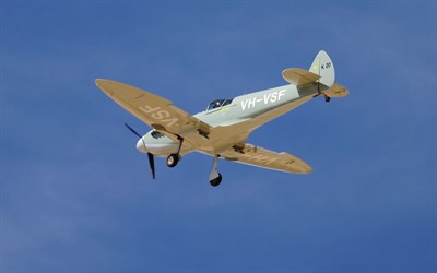
Source: Airshow spectator, reproduced with permission
On the downwind leg the pilot communicated his intention to land to the air traffic control tower and enquired whether the wind still favoured a landing on runway 21. The aerodrome controller informed the pilot that the crosswind component was 11 kt (20 km/h) on runway 21 and runway 08 and cleared the pilot to manoeuvre as required to final runway 21L.[2]
A significant number of witnesses, some with piloting experience, observed the aircraft turn right base for runway 21L. They recalled that the aircraft appeared to be flying very slowly prior to an abrupt left turn away from the runway. Their accounts described a loss of control that was consistent with an aerodynamic stall followed by a significant wing drop. The aircraft was then observed to descend steeply toward the ground with a degree of spiral evident along the descent path before being lost to sight behind trees and buildings.
The aerodrome controller witnessed the aircraft descending out of sight and immediately instigated the aerodrome emergency response. A short time later the wreckage of the aircraft was located by emergency services in a factory car park about 1.5 km north of the runway 21L threshold. The pilot sustained fatal injuries and the aircraft was substantially damaged by impact forces (Figure 2). There was no fire.
Figure 2: Aircraft wreckage
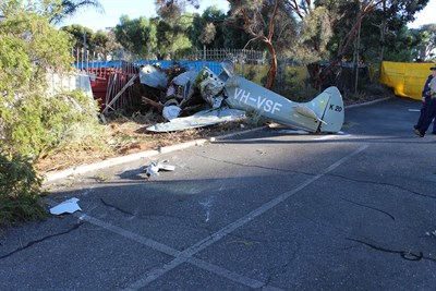
Source: ATSB
Damage to the aircraft was consistent with it descending steeply into terrain at a high rate of descent in a wings-level, nose-down attitude. There was no evidence of in-flight structural failure. All of the aircraft’s components were accounted for at the accident site, with no evidence of pre-impact damage. Continuity of the aircraft’s flight and engine control systems was established and on-site evidence indicated that the engine was producing power at ground impact. The fuel tank ruptured on impact with the result that no fuel was available for testing. Examination of the airframe found that the aircraft did not incorporate any stall warning system.
A number of components were recovered from the accident site for technical examination including a global positioning system (GPS) receiver. The wreckage was documented and transported to a secure location for further examination as required.
Australian Transport Safety Bureau technical specialists examined the GPS receiver. That examination found that track data was retained in the receiver’s non-volatile memory. The GPS data for the accident flight was downloaded and is depicted at Figure 3.
Figure 3: Accident flight data recovered from GPS receiver[3]
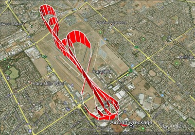
Source: Google earth
A review of the recorded GPS data indicated that the aircraft descended to about 350 ft above ground level and the groundspeed reduced to about 80 kt on the downwind leg. As the aircraft turned onto the base leg for runway 21L, a gradual increase in height to 485 ft and reduction in groundspeed to 55 kt was evident. The position of the aircraft in relation to the runway at this point indicates that a tight turn would most likely have been required to line up on the runway centreline. It is possible that the pilot made a deliberate left turn away from the runway at this stage to allow more room to manoeuvre for final.
The GPS-recorded path of the aircraft was consistent with witness observations and, in combination with recorded wind data from the automatic weather station at Parafield Airport, indicates that the aircraft’s airspeed was close to the stall speed on base leg and most likely below stall speed as it abruptly turned left away from the runway. The GPS recorded time interval from the commencement of the base turn until the collision with terrain was about 20 seconds.
The reduced scale replica Spitfire Mk XXVI is a conventionally–configured, low-wing cantilever monoplane that is manufactured in kit form for construction by owner‑builders. The pilot constructed VSF in 2006 and had maintained it in accordance with the Civil Aviation Regulations since that time.
The pilot held a Commercial Pilot (Aeroplane) Licence and his pilot’s logbook indicated he had 1,665 hours flight experience, 190 of which were on the kit-built Spitfire. The pilot was the sole pilot of the aircraft, held a Class 2 Medical Certificate and was reported to have been rested and in good health prior to the flight. He was described as being meticulous with his approach to flying and maintaining the aircraft.
The investigation is continuing and will include:
- further examination of recovered components
- analysis of aircraft performance during the flight
- review of operational factors and the recorded data.
The final investigation report is planned for release to the public during October 2013.
The information contained in this web update is released in accordance with section 25 of the Transport Safety Investigation Act 2003 and is derived from the initial investigation of the occurrence. Readers are cautioned that new evidence will become available as the investigation progresses that will enhance the ATSB's understanding of the accident as outlined in this web update. As such, no analysis or findings are included in this update.
[1] Central Daylight-saving Time (CDT) was Coordinated universal Time (UTC) + 10.5 hours.
[2] The available runways at Parafield are oriented east-to-west (runways 08/26) and north-north-east-to-south-south-west (runways 03/21). Runways left and right are available in each direction.
[3] The data is represented by a series of individual GPS-recorded track points that have been joined together using a series of straight lines.
