Background
At the request of the Malaysian Government, Australia is leading the search for missing Malaysia Airlines Flight MH370 in the Indian Ocean. The search is a complex operation that involves vast areas with only limited data and aircraft flight information available.
Over-water searches
Over-water aircraft accident locations are usually found by conducting a broad-area aerial search. The search area is generally determined by a combination of:
- Position information from ground-based radar systems (maximum range is generally 250 NM)
- Position information automatically transmitted from the aircraft at regular intervals
- Position reports from the crew
- Re-tracing the planned flight route
- Eye-witness reports (possibly located on the shore, on other aircraft or on ships)
Uncertainty in the position of an accident location increases with time from the aircraft’s last known position (fix) so the search area will expand accordingly as the position data becomes ‘stale’.
Once floating wreckage is observed, reverse-drift techniques can be used to help determine the aircraft impact location. Only a small-area underwater search is then required to locate the wreckage and map the wreckage field. This underwater search can be aided by the underwater locator beacons fitted to flight recorders. As the beacons have a limited duration of nominally 30 days and to minimise the inaccuracies of the reverse-drift calculations, it is important that an aerial search is commenced as soon as possible and the floating debris is found quickly.
In the case of MH370:
- The aircraft departed Kuala Lumpur at 1641 UTC
- The final automatically transmitted position from the aircraft occurred at 17:07 UTC
- No radio communications were received from the crew after 17:19 UTC
- The final ATC (secondary) radar fix occurred at 17:22 UTC
- At 17:25 UTC the aircraft deviated from the planned flight route
- The final primary radar fix occurred at 18:22 UTC
- The satellite communications log indicated the aircraft continued to fly for another 6 hours
- No confirmed eye-witness reports were received
- The search in the Australian search and rescue zone commenced on 18 March (10 days after the aircraft went missing)
As a result, the search area for MH370 has remained very large. A useful comparison is the search for Air France Flight 447 (AF477), which crashed in the Atlantic Ocean on 1 June 2009. The AF447 aircraft was programmed to send its position automatically every 10 minutes, there were a number of fault messages transmitted via satellite during the last few minutes of flight and it was following the planned flight route. The search for the aircraft began on 1 June and the first surface wreckage was discovered on 6 June, 5 days after the accident. Given the relative accuracy of the aircraft’s last known position, a circular search area of 40 NM was defined (17,240 km²). After a search effort involving five separate phases, the aircraft wreckage was located on the ocean floor almost two years later.
As none of the traditional sources of data could be used to locate the aircraft wreckage from MH370, it has been necessary to use novel sources of data and analysis techniques. This has led to a larger than typical search area; and there have been changes to its location as validation and calibration checks have been performed and the analysis is refined.
Determining the search area for MH370
The flight path of MH370 has three distinct sections; one under secondary radar in which the aircraft transponder was operational and ACARS messages were being transmitted, a primary radar section during which the aircraft was being tracked solely by air defence radar systems and the final stage for which the only information available was the satellite communications log data.
ACARS and radar data
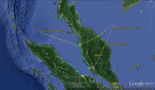
The final ACARS transmission was at 17:07 UTC and provided location reports from the initial stage of the flight as well as a recording of the aircraft fuel remaining. The final secondary radar point was at approximately 17:22 UTC. The final primary radar point was at 18:22 UTC. Figure 1 shows the first and second sections of the flight.
Figure 1: MH370 Flight path derived from Primary and Secondary radar data
Source: NTSB/Google
Satellite communications (SATCOM) data
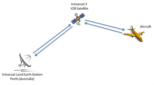
Following the loss of primary radar, the only available information was from satellite signalling messages, also referred to as ‘handshakes’, between the ground station, the satellite and the aircraft’s satellite communication system.
For each transmission to the aircraft, the ground station recorded the burst timing offset (BTO) and the burst frequency offset (BFO).
Figure 2: Satellite communications schematic
Source: Inmarsat
Burst Timing Offset (BTO)
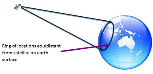
The BTO is a measure of the time taken for a transmission round trip (ground station to satellite to aircraft and back) and allows a calculation of the distance between the satellite and the aircraft. Based on this measure, a possible location ring can be mapped on the surface of the earth (Figure 3). An analysis of SATCOM system parameters showed that the accuracy of the rings was ± 10 km. This analysis was validated using recorded BTO values from the initial stage of the flight when the aircraft’s position was known.
Figure 3: Satellite ring derivation
Source: Inmarsat
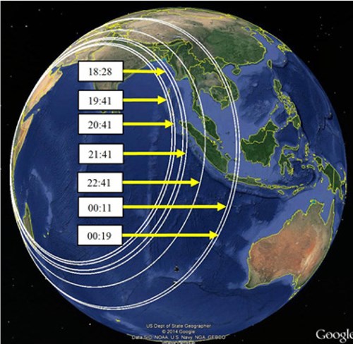
There were 7 handshakes between the ground station and the aircraft after the loss of primary radar data. The location rings calculated from the recorded BTO values are shown in figure 4.
Figure 4: MH370 timing (UTC) with corresponding rings arrowed 
Source: Inmarsat/Boeing /Google
The information from the BTO places the aircraft somewhere on each ring at the corresponding time. By taking the maximum speed of the aircraft into account, the rings can be reduced in length to arcs – there are some areas of the rings it simply could not have reached.
Burst Frequency Offset (BFO)
The BFO is the measure of the difference between the expected frequency of the transmission and the frequency received at the ground station. This difference is attributed to various sources including the Doppler Effect from the motion of the satellite and the aircraft, as well as some processing effects. Once the known components that contribute to the BFO are resolved, the remainder can be used to estimate the speed and direction of the aircraft. There are a large number of speeds and headings that can be consistent with a BFO recording. These are limited, however, by the operational constraints of the aircraft.
Candidate paths of different speeds were created which met the BTO ring location/time constraints and the predicted BFO values of these paths have been compared with the recorded values. The better the match, the higher the probability that the path was close to that of MH370.
Final handshake message at 00:19 (7th arc)
The 00:19 signalling message (7th arc) was a logon request from the aircraft. This is consistent with the satellite communication equipment on the aircraft powering up following a power interruption. The interruption in electrical supply may have been caused by fuel exhaustion.
Note on the satellite communication
The satellite’s normal function is essentially communication and it was never initially intended to have the capability to track an aircraft. Following the Air France 447 accident, Inmarsat engineers began recording the BTO in order to provide another potential means of geo-locating aircraft in the event of a similar accident.
Aircraft Performance Calculations
Estimates of fuel consumption were calculated from the time of the last recorded fuel quantity, using a range of flight paths and speeds. The results of these calculations were consistent with fuel exhaustion occurring close to the 7th arc.
Validation
Several teams independently provided both satellite communications and performance analysis as part of the validation process. The location of 9M-MRO on previous flights as well as the locations of other aircraft in the air at the same time were all used to validate the techniques.
Other information
Surface search
An international air and maritime force conducted a surface search of drifted regions along the 7th arc from 18 March to 28 April 2014. A drifted region is created by modelling the movement of an area of water over the time period when the surface search is conducted. During this time, no debris was identified to be likely from MH370.
Underwater search
Acoustic detections possibly related to underwater locator beacons were made by two vessels in the refined probability area from 5 - 8 April 2014. To further investigate these signals, a search of the ocean floor around the detections was performed by a number of vessels. To date no further sign of MH370 has been detected.
Hydrophones
Low frequency hydroacoustic signals present in the Indian Ocean are being examined to determine whether they can provide any information to help define the search area. These signals are recorded by hydrophones as part of the United Nations Comprehensive Nuclear-Test-Ban-Treaty Organisation (CTBTO) or the Integrated Marine Observing System (IMOS).
Use of waypoints
Comparison of possible flight paths with tracks using waypoints is also under consideration.
Air Routes
There is only one published north-south air route in the south-eastern Indian Ocean. Air route M641 connects Cocos Island to Perth and has four waypoints. The air route crosses the area where the four acoustic signals were detected.
Shape of the search area
At the time MH370 reached the 7th arc, the aircraft is considered to have been descending. A study completed after the Air France 447 accident concluded that the majority of aircraft in loss of control accidents were found within 20 nautical miles (32 km) of their last known position. This provides a reasonable limitation for the size of the search area across the arc.


