
Summary
The ATSB is investigating a collision with terrain involving an Air Tractor AT-802, registration VH‑ODX, 17 km north of Cummins Town aerodrome, South Australia, on 8 September 2025.
During aerial agricultural spraying operations, the aircraft collided with terrain resulting in substantial damage. The pilot was fatally injured.
The ATSB has completed the evidence collection and analysis phases of the investigation and is drafting the final report.
To date, the ATSB has examined the site and wreckage, conducted interviews, collected documentation, and recovered recorded data from the accident flight.
A preliminary report, which detailed factual information established during the evidence collection phase, was released on 23 October 2025 (see below).
The final report will be released at the conclusion of the investigation. Should a critical safety issue be identified during the course of the investigation, the ATSB will immediately notify relevant parties, so that appropriate safety action can be taken.
Last updated:
Preliminary report
Report release date: 23/10/2025
| This preliminary report details factual information established in the investigation’s early evidence collection phase, and has been prepared to provide timely information to the industry and public. Preliminary reports contain no analysis or findings, which will be detailed in the investigation’s final report. The information contained in this preliminary report is released in accordance with section 25 of the Transport Safety Investigation Act 2003. |
The occurrence
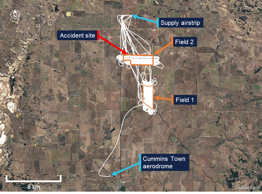
On 8 September 2025, at about 0937 local time, the pilot in command (and sole occupant) of an Air Tractor AT‑802A agricultural aircraft, registered VH‑ODX and operated by Aerotech Australasia,[1] departed from the Cummins Town aerodrome, South Australia. The pilot ferried the aircraft to a private airstrip approximately 22 km to the north that was to be used as a supply point for the day’s aerial spraying activities.
Having diverted slightly right of the direct track to overfly the first field to be sprayed that morning, the pilot arrived at the supply airstrip at 0946 where they were met by the loader.[2] The tasking for the day was the aerial application of 13 loads of fungicide and insecticide across 2 wheat fields (‘Field 1’ and ‘Field 2’ in Figure 1).
The aircraft was loaded with chemical and, at 1005, the flight departed for application of the first load in a field about 11 km to the south‑south‑east. Recorded data from the aircraft identified the field was sprayed in a north‑south racetrack pattern[3] until the hopper was emptied, before returning to the supply airstrip. This operation was repeated 3 times.
Electrical powerlines spanned the fields of the property being sprayed. The first field featured a 19 kV single‑wire earth return powerline crossing the southern section in an east‑west direction (Figure 1 and Figure 2). The data showed that the pilot flew mostly under this powerline but occasionally flew over it where there was a power pole, or, where the powerline merged close to the edge of the field.
Figure 1: Fields that were sprayed (outlined in orange) and the surrounding powerline network (yellow lines)
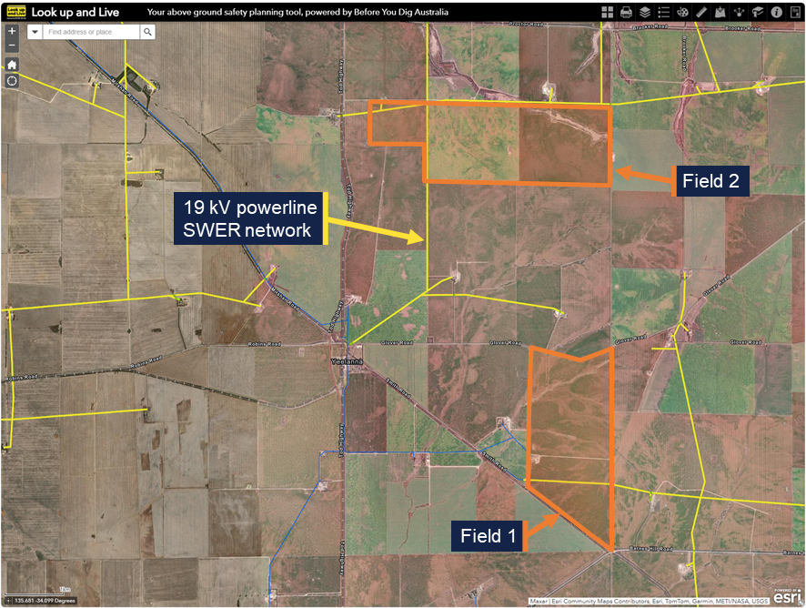
SWER – Single‑wire earth return. Source: Look up and Live website, annotated by the ATSB
Figure 2: 19 kV single-wire earth return powerline in one of the fields being sprayed
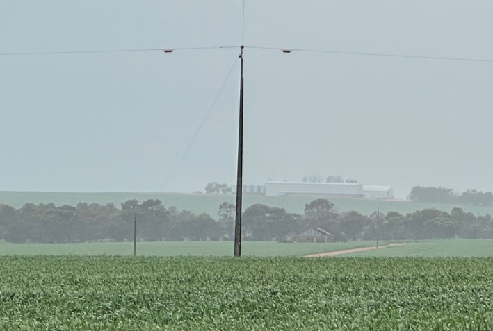
Source: ATSB
During the fourth run, the pilot completed spraying the first field, including a clean‑up run[4] along the south fence line. They then transited 5 km north and commenced spraying the second field in an east-west racetrack pattern. The pilot applied 2 loads of chemical (runs 5 and 6) to that field. Each run took between 19 minutes and 28 minutes to apply, with the pilot then returning to the supply airstrip for the aircraft to be replenished with chemical and fuel as required.
Two 19 kV single‑wire earth return powerlines were positioned in the second field and measured to be around 12 m above the ground. A north‑south powerline bisected the field, and the other powerline ran partially to the east along the northern border (Figure 3 in orange) of the field and partially to the west‑south‑west crossing the north‑west corner of the field. The recorded data showed the pilot mostly flew the aircraft under the north‑south powerline running perpendicular to the spray pass direction, except where the powerline ran adjacent to the edge of the field, where they flew over the powerline.
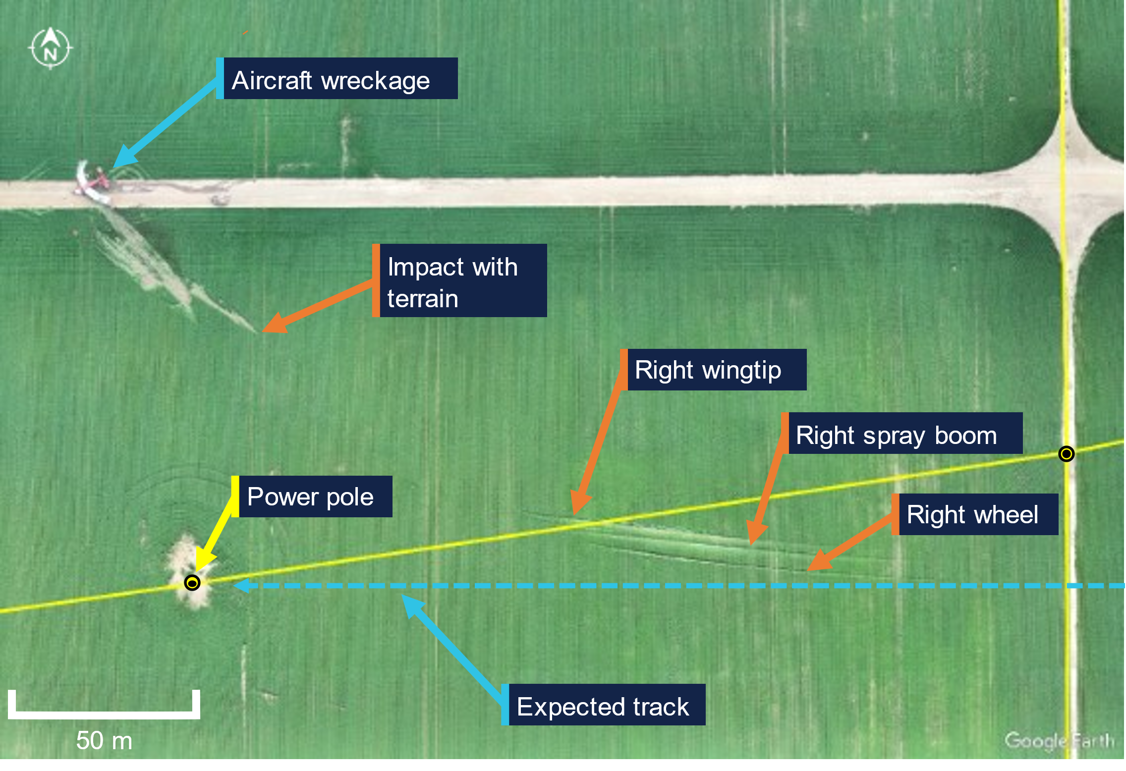
At about 1307, the pilot departed the supply point and continued spraying the second field. A further 9 passes were completed and approximately 16 minutes into the run, while heading west on pass 10, the pilot flew under the north‑south powerline. At this point, the west‑south‑west powerline crossed the north‑south powerline 40 m to the north (Figure 3). That spray run also aligned with a power pole on the west‑south‑west powerline, 240 m beyond the north‑south powerline. Recorded data showed the aircraft conducted a right turn underneath the second power line after which it collided with terrain at 1323. The aircraft wreckage came to rest on a farm road about 150 m beyond the second power line.
Figure 3: Final pass within field 2 showing the flight path (in blue) and accident site relative to the power lines and poles (the yellow lines and circles respectively)
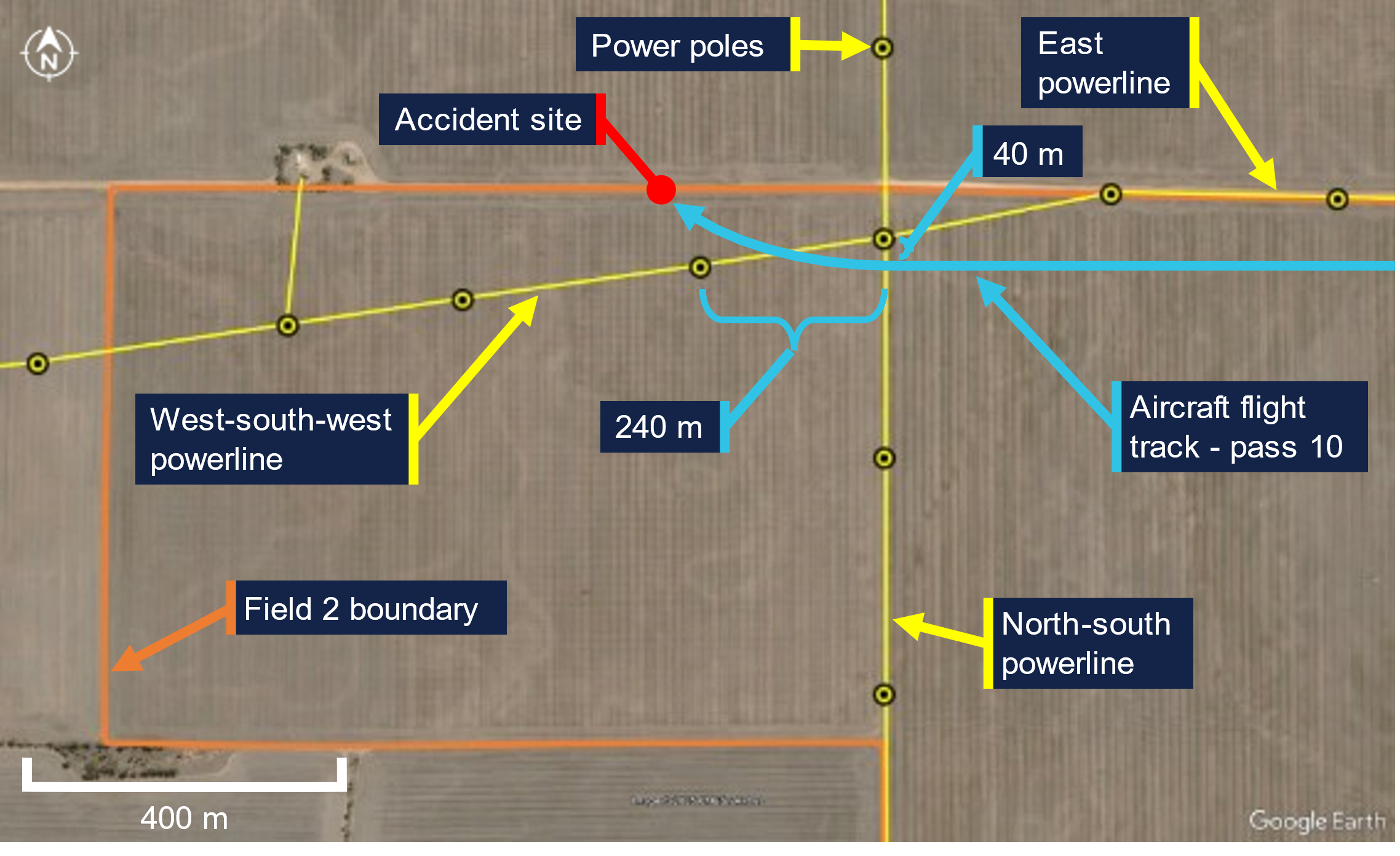
Source: Google Earth Pro, annotated by the ATSB
The emergency locator transmitter from the aircraft had activated, and the signal was received by the Joint Rescue Coordination Centre which contacted Airservices Australia and the operator. Call logs from the operator indicated that they were notified at 1328 by the coordination centre that the aircraft’s emergency locator transmitter had activated. Personnel from the operator and a local farm worker responded and found the aircraft wreckage at 1338. The pilot was fatally injured and the aircraft was substantially damaged. There was no fire. There were no known witnesses to the accident.
Context
Pilot information
The pilot held a Commercial Pilot (Aeroplane) Licence with a single-engine aeroplane class rating. The pilot had 3,623 hours total aeronautical experience, of which 1,243 hours were conducting agricultural aerial application and 941 hours were on the AT‑802 aircraft type. The pilot also held aerial application (with firefighting endorsement) and low-level ratings. In addition, the pilot held a gas turbine design feature endorsement, and numerous piston and turbine type ratings.
The pilot held a valid class 2 aviation medical certificate with their class 1 medical certificate not being renewed when it expired in November 2023. For the operation being conducted, only a class 2 medical certificate was required.[5] It was reported that the pilot appeared well rested and fully alert for the flight.
Aircraft information
VH-ODX was an Air Tractor Incorporated AT-802A single-seat low-wing tailwheel, fixed landing gear aircraft manufactured in the United States in 2006. It was powered by a Pratt & Whitney Canada PT6A-67AG turboprop engine. It was first registered in Australia in August 2006. The aircraft was configured for aerial spraying, with the spray boom fitted under each wing, aft of the trailing edge, and extending about three-quarters of the wingspan (exemplar shown in Figure 4).
Figure 4: Exemplar AT-802 showing spray boom installation
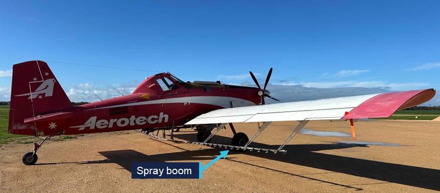
The above image has been modified to remove the registration and other markings. Source: ATSB
The current maintenance release was issued on 30 July 2025. On the day of the accident, the maintenance release indicated the aircraft had 5,595.4 hours recorded as the total time in service.
The aircraft was fuelled from 2 stainless steel transport tanks located on the loader’s truck, which included a single-point filter. A fuel sample, taken from the tanks at Cummins Town aerodrome on 10 September 2025, was observed to be free from water and contaminants.
Meteorological information
The Bureau of Meteorology operated a weather station at Cummins Town aerodrome, 17 km to the south of the accident site, which recorded wind and temperature at 30‑minute intervals. Around the time of the accident, the recorded winds were 11 kt from the west and the temperature was 19°C.
The loader reported the weather at the time of the accident to be clear and sunny with a light westerly breeze.
Wreckage and impact information
Witness marks matching the right wheel, right spray boom and right wingtip indicated they had passed through the approximately 0.5–1.0 m high wheat crop 260 m prior to the accident site, with the right wheel running along the ground for about 22 m (Figure 5). The crop markings started on a heading of 264° (magnetic) and finished just beyond the west‑south‑west powerline on a heading of 273° after about 125 m. The markings showed that the aircraft was in a significant right skid. Later in the crop markings, the right aileron also left a mark indicating a significant down (left roll) deflection.
Another crop and ground scar from the aircraft had been produced 88 m beyond the initial markings that continued to the wreckage (‘Impact with terrain’ to ‘Aircraft wreckage’ labels in Figure 5). Numerous indicators such as component locations in the debris field, orientation of wheat strands caught in the aircraft structure, and damage signatures to the airframe indicated the aircraft impacted terrain in an inverted orientation, left wing first at a near wings‑level and nose‑down attitude.
Figure 5: Crop witness marks at the accident site
Source: ATSB
All major aircraft components were accounted for at the accident site (Figure 6). There was no evidence of pre‑impact defects with the flight controls or aircraft structure. The propeller assembly separated from the engine during the impact sequence and was located on the farm road, about 18 m behind the front of the fuselage. Two propeller blades had ejected from the propeller hub and one blade had fractured mid‑length. The damage sustained to the propeller assembly was consistent with the engine operating at the time of the ground impact. The wing integral fuel tanks had ruptured during the accident sequence. A residual aroma from spilled fuel was detected at the accident site that persisted for several days.
Figure 6: VH-ODX wreckage
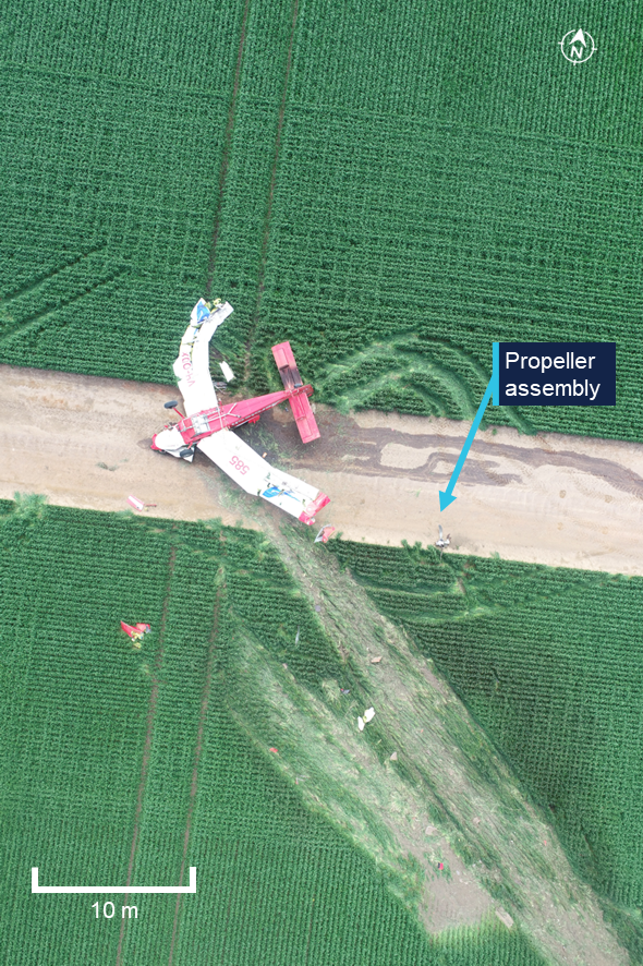
Source: ATSB
Recorded information
A TracPlus RockAIR portable tracking device had been fitted to the aircraft and was recovered from the accident site. The device was transferred to the ATSB’s technical facilities in Canberra, Australian Capital Territory, where it was interrogated. The recorded data provided the aircraft’s position, altitude, speed and track angle data at 1‑second intervals up until the time of the accident (Figure 7). The data showed the take‑off from Cummins Town aerodrome, the transit to and from the supply airstrip and the completed spray runs in fields 1 and 2. Location and time parameters from the flight data were correlated to identify that the accident occurred at 1323:40.
Figure 7: TracPlus RockAIR broadcast data for VH-ODX on 8 September 2025
Source: TracPlus RockAIR broadcast data on Google Earth Pro, annotated by the ATSB
To assist with aerial application tasks, a Tabula AirVision agricultural application system was fitted to the aircraft. The system had the capability to record parameters such as position and application information. It could also provide live fleet tracking. The unit was recovered from the aircraft and retained by the ATSB for further investigation.
A Perkins Data Acquisition Alarm Monitor was recovered from the aircraft and retained by the ATSB for further investigation. A Replay XD 1080 video camera mount in the cockpit was also recovered. Data extracted from unit contained about 30 GB of good quality video, however, the last recording was from 2016.
Further investigation
To date, the ATSB has examined the site and wreckage, conducted interviews, collected documentation, and recovered recorded data from the accident flight.
The investigation is continuing and will include review and analysis of the:
- recorded data
- aircraft documentation
- operational records
- pilot medical records, qualifications and their experience
- aerial application standard practices
- safety equipment.
A final report will be released at the conclusion of the investigation. Should a critical safety issue be identified during the course of the investigation, the ATSB will immediately notify relevant parties so appropriate and timely safety action can be taken.
Acknowledgements
The ATSB would like to acknowledge the assistance of the South Australia Police during the onsite stages of the investigation.
Purpose of safety investigationsThe objective of a safety investigation is to enhance transport safety. This is done through:
It is not a function of the ATSB to apportion blame or provide a means for determining liability. At the same time, an investigation report must include factual material of sufficient weight to support the analysis and findings. At all times the ATSB endeavours to balance the use of material that could imply adverse comment with the need to properly explain what happened, and why, in a fair and unbiased manner. The ATSB does not investigate for the purpose of taking administrative, regulatory or criminal action. About ATSB reportsATSB investigation reports are organised with regard to international standards or instruments, as applicable, and with ATSB procedures and guidelines. Reports must include factual material of sufficient weight to support the analysis and findings. At all times the ATSB endeavours to balance the use of material that could imply adverse comment with the need to properly explain what happened, and why, in a fair and unbiased manner. An explanation of terminology used in ATSB investigation reports is available here. This includes terms such as occurrence, contributing factor, other factor that increased risk, and safety issue. Publishing informationReleased in accordance with section 25 of the Transport Safety Investigation Act 2003 Published by: Australian Transport Safety Bureau © Commonwealth of Australia 2025 
Ownership of intellectual property rights in this publication Unless otherwise noted, copyright (and any other intellectual property rights, if any) in this report publication is owned by the Commonwealth of Australia. Creative Commons licence With the exception of the Commonwealth Coat of Arms, ATSB logo, and photos and graphics in which a third party holds copyright, this report is licensed under a Creative Commons Attribution 4.0 International licence. The CC BY 4.0 licence enables you to distribute, remix, adapt, and build upon our material in any medium or format, so long as attribution is given to the Australian Transport Safety Bureau. Copyright in material obtained from other agencies, private individuals or organisations, belongs to those agencies, individuals or organisations. Where you wish to use their material, you will need to contact them directly. |
[1] The flight was conducted under Part 137 of the Civil Aviation Safety Regulations (aerial application operations).
[2] Loader: the term used to denote ground support personnel whose functions include assisting with mixing chemicals, loading and dispatching the aircraft.
[3] Racetrack pattern: the application pattern that involves making successive overlapping loops across a field.
[4] Pilots delay the commencement of spraying and prematurely shut off spraying at the end of a field to ensure the chemical does not get applied to an adjacent field. A clean‑up run is a spray pass perpendicular to the predominant direction along the edge of a field to ensure crop near that fence line has appropriate coverage.
[5] Civil Aviation Safety Authority exemption EX28/23, in effect at the time of the accident, exempted the pilot from needing to hold a class 1 aviation medical certificate for aerial application flights such as the accident flight. The exemption was subject to the pilot holding a class 2 medical certificate.
Occurrence summary
| Investigation number | AO-2025-053 |
|---|---|
| Occurrence date | 08/09/2025 |
| Occurrence time and timezone | 13:23 Australian Central Standard Time |
| Location | 17 km north of Cummins Town Aerodrome |
| State | South Australia |
| Report release date | 23/10/2025 |
| Report status | Preliminary |
| Anticipated completion | Q3 2026 |
| Investigation level | Short |
| Investigation type | Occurrence Investigation |
| Investigation phase | Final report: Drafting |
| Investigation status | Active |
| Mode of transport | Aviation |
| Aviation occurrence category | Collision with terrain |
| Occurrence class | Accident |
| Highest injury level | Fatal |
Aircraft details
| Manufacturer | Air Tractor Inc |
|---|---|
| Model | AT-802A |
| Registration | VH-ODX |
| Serial number | 802A-0243 |
| Aircraft operator | Aerotech Australasia Pty Ltd |
| Sector | Turboprop |
| Operation type | Part 137 Aerial application operations |
| Activity | General aviation / Recreational-Aerial work-Agricultural spreading / spraying |
| Departure point | Cummins Town Aerodrome, South Australia |
| Destination | Cummins Town Aerodrome, South Australia |
| Injuries | Crew - 1 (fatal) |
| Damage | Substantial |