
Summary
The ATSB is investigating a mid-air collision between 2 light aircraft, a Jabiru and a Cessna 182, south-west of Sydney on 26 October 2024.
A team of transport safety investigators from the ATSB's Canberra office, with experience in aircraft operations and maintenance, was deployed to the accident sites of both aircraft to conduct evidence-collecting activities.
The evidence collection phase of the investigation involves interviewing witnesses and involved parties, site mapping, examination of the wreckage of both aircraft, and collect relevant recorded information including any air traffic control and flight tracking data, as well as pilot and aircraft maintenance records, and weather information.
The ATSB has commenced the examination and analysis of the initial evidence collected.
To date, the ATSB has:
- examined the wreckage
- examined aircraft components and other items recovered from the accident site
- collected surveillance data from Airservices Australia
- collected OzRunways data for relevant aircraft
- collected pilot and aircraft records
- conducted interviews with relevant parties
- conducted detailed analysis of video recordings and radio transmissions
- reviewed aircraft, pilot, aerodrome and operator documentation
- conducted detailed analysis of the aircraft flight paths
- reviewed procedures at non-controlled aerodromes
- liaised with the NSW Police Force.
The investigation is continuing and will include, further:
- analysis of video recordings
- review of similar occurrences
- review of previous flight tests conducted by the flight test examiner
- review of procedures and practices relating to the conduct of flight tests
- review of communication, electronic conspicuity and surveillance equipment, and interviews with relevant parties.
Preliminary and interim reports, which detail factual information established during the course of the investigation, have been released (see below).
A final report will be released at the conclusion of the investigation and will detail analysis and findings. Should a critical safety issue be identified during the course of the investigation, the ATSB will immediately notify relevant parties, so that appropriate safety action can be taken
Interim report
Report release date: 04/12/2025
| This interim report details information relating to this accident, and has been prepared to provide timely information to the industry and public. This report contains no findings, which will be detailed in the investigation’s final report. The information contained in this interim report is released in accordance with section 25 of the Transport Safety Investigation Act 2003. |
The occurrence
Overview
On the morning of 26 October 2024, a commercial pilot licence (Aeroplane) (CPL(A)) flight test was being conducted in a Cessna 182 aircraft, registered VH-APN (APN), departing from Shellharbour Airport, New South Wales. On board APN were a pilot under examination (the CPL candidate) and a Civil Aviation Safety Authority (CASA) approved flight test examiner (the examiner).
On the same morning, a private flight was being conducted in a Jabiru UL 450 aircraft, registered 19-4079 (4079), departing from The Oaks aerodrome (The Oaks), New South Wales. On board 4079 was a pilot (the pilot of 4079), who was the sole occupant.
Around midday, APN and 4079 collided in-flight and both aircraft impacted terrain. All occupants of both aircraft were fatally injured. The following describes the events that led up to the midair collision.
VH-APN pre-flight and departure from Shellharbour Airport
Three days earlier, on 23 October 2024, a ‘CPL task’ for the flight test and other instructions were sent by email from the examiner to the CPL candidate. The CPL task was a scenario that included instructions to plan and fly from Shellharbour Airport and land at Warnervale Airport flying via Macquarie Lighthouse for some aerial photography. The task then stipulated an onward flight from Warnervale Airport to land at Cessnock Airport, with a return leg to Shellharbour via the most direct track. A map recovered from the accident site showed a red path drawn upon it, consistent with the CPL task. This map indicated that the Cessnock to Shellharbour leg was planned via an inland route passing over Prospect Reservoir and Campbelltown.
A witness account indicated that, on 26 October 2024, the flight examiner and CPL candidate had planned to meet at a local bakery at around 0730 local time, prior to starting the ground component of the CPL flight test at Shellharbour Airport, at around 0800. National Airspace Information Planning System (NAIPS)[1] records indicated that the CPL candidate submitted a flight plan at about 1005. At 1018, a radio broadcast was recorded from APN on the Shellharbour Airport common traffic advisory frequency (CTAF),[2] indicating that APN was taxiing for runway 16 for a crosswind departure.
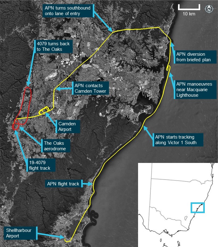
Flight data transmitted by the CPL candidate’s electronic flight bag (EFB)[3] device (APN flight data) indicated that at 1035, APN departed Shellharbour Airport, climbing to 1,500 ft above mean sea level.[4] At 1036, a radio call recorded on the CTAF stated that APN was departing crosswind and tracking north-east toward the sea cliff bridge, with the flight proceeding in this direction (Figure 1).
VH-APN flight along the coastline and diversion to Camden Airport
APN crossed the coastline near Wollongong beach, and subsequently descended to about 500 ft, following the coast toward Sydney and passing the sea cliff bridge at about 1047. At 1054, APN flight data showed the aircraft starting to track northbound along the visual flight rules route referred to as ‘Victor 1 South’ at about 500 ft (Figure 1). As APN approached Macquarie Lighthouse, flight data indicated that the aircraft tracked slightly further away from the coastline before conducting a large ‘S’ manoeuvre, consistent with the CPL aerial photography task planned prior to the flight. The flight continued tracking as planned until abeam Long Reef at 1106, APN started to track inland, consistent with a diversion from the planned route. The track followed published visual landmarks, intercepting and tracking in a south‑westerly direction toward Prospect Reservoir along the visual ‘lane of entry’[5] route for Bankstown Airport.
APN continued tracking in a south-westerly direction toward Bringelly township, an inbound reporting point for Camden Airport (Figure 1). At 1124, APN contacted Camden Tower air traffic control (ATC), requesting clearance for a touch-and-go and to conduct some circuits. ATC gave instructions to maintain 1,800 ft, join final for runway 24 and report when APN was 3 NM (5.6 km) from the runway threshold, with the aircraft starting to track toward this position. At 1128, APN reported being 2 NM (3.7 km) from runway 24, with Camden Tower ATC clearing APN for a visual approach. Shortly after, APN called ATC again requesting to remain at 1,800 ft for a practice glide approach to runway 24, which was approved.
At 1129, the APN flight data indicated that the aircraft had joined the crosswind leg for runway 24 at 1,800 ft, with APN being cleared for a visual approach by ATC about 1 minute later. APN descended and tracked consistent with a glide approach, with a clearance for a touch-and-go issued at 1131. The pilots of APN continued in 2-way communication with Camden Tower for another circuit, followed by a request for an upwind departure from runway 24, which was approved by ATC and acknowledged by APN. At 1141, APN touched down on runway 24 for the third time and started to climb to about 1,300 ft while maintaining the runway direction. Tracking data showed that APN continued in this direction and altitude, departing the Camden Airport control zone to the west just after 1143.
19-4079 planned flight and departure from The Oaks aerodrome
On the same morning, the pilot of 4079 was conducting a private flight departing from The Oaks. The purpose of the flight was a social event to travel to Cessnock Airport and meet with other pilots who were also flying from The Oaks. The flight was arranged using a group message that invited pilots to join. The message stated that the planned departure from The Oaks was between 1000 and 1030.
During the evening prior, a message was sent by the pilot of 4079 at 1954 confirming that they intended to join the group of pilots flying to Cessnock. The group consisted of 3 pilots, each with their own aircraft that comprised 2 Jabiru aircraft, 4079 and 55-1837 (the other Jabiru), and a Sonex Legacy aircraft registered 19-2041 (the Sonex). All 3 aircraft travelling to Cessnock in the group were registered with Recreational Aviation Australia. The 2 other pilots flying to Cessnock recalled that, prior to the flight, it was decided that the pilot of the Sonex, which was a faster aircraft, would wait about 10 minutes before departing so that all aircraft would arrive at Cessnock at about the same time.
At 1124, around the same time that APN approached an inbound point for Camden Airport, video on board 4079 showed the aircraft rolling for take-off on runway 18 right (18R)[6] from The Oaks. The other Jabiru pilot recalled hearing a ‘rolling’ radio call from the pilot of 4079 around this time. Tracking data from the other Jabiru showed that this aircraft had departed about 30 seconds prior to 4079. At 1125, automatic dependent surveillance broadcast (ADS-B)[7] flight data showed 4079 on an initial climb from runway 18R. The flight data showed that the flight path was consistent with 4079 flying a right circuit for runway 18R or 18L and departing the aerodrome on the downwind leg in a northerly direction.
Figure 1: Flight paths of VH-APN, 19-4079 and accident location
Source: Google Earth and Geoscience Australia, annotated by the ATSB
19-4079 return to The Oaks aerodrome
At interview with the ATSB, the pilot of the other Jabiru flying to Cessnock reported that they decided to turn back due to experiencing turbulence. This pilot reported broadcasting that they were turning back to The Oaks on 2 frequencies, one corresponding to The Oaks CTAF (126.70) (The Oaks radio frequency) and another frequency that was pre-arranged for en route group chatter. Neither of the other pilots flying to Cessnock recalled hearing a broadcast from the pilot of 4079 in response. At 1133, the 4079 flight data showed that the aircraft started turning back towards The Oaks in a southerly direction. Due to the other Jabiru being further north, 4079 was ahead for the return to The Oaks.
During the return, the other Jabiru pilot recalled hearing the pilot of 4079 make a 7 NM (13.0 km) inbound call on The Oaks radio frequency. While inbound, this pilot also recalled hearing another call from an aircraft that was ‘really fuzzy’ and potentially related to another aerodrome. About 6 minutes after turning back, the flight data for 4079 showed that the aircraft had started a slow right turn to the west, and then tracked directly overhead The Oaks at about 1,800 ft. The other Jabiru pilot recalled hearing the pilot of 4079 broadcast that they were joining mid-field crosswind and observed the aircraft in that position. At this time, the other Jabiru pilot estimated that they were about 3 to 4 NM (5.6 to 7.4 km) behind 4079. At 1141, the ADS-B data showed 4079 crossing directly overhead The Oaks at about 1,900 ft before turning right and starting to descend.
The Sonex pilot reported hearing the pilot of 4079 broadcast that they were ‘established downwind for runway 18’. At 1142, the 4079 flight data and onboard video showed that the aircraft descended toward runway 18 left (18L). Around this time, the pilot of the other Jabiru recalled hearing the pilot of 4079 broadcast that they were on the base leg of the circuit. The track of 4079 was in a generally south‑easterly direction toward the threshold of runway 18L, however, instead of landing, the data showed the aircraft flying along the runway at about 100 ft.
Collision between VH-APN and 19-4079
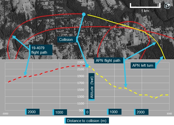
At about 1143:30, shortly after APN departed the Camden Airport control zone, the onboard video and 4079 flight data indicated that the pilot of 4079 conducted a go‑around from runway 18L at The Oaks. The onboard video showed that the pilot of 4079 was transmitting a radio communication on The Oaks radio frequency. The Sonex pilot, who was in the run-up bay for runway 36, reported that they heard the pilot of 4079 transmit they were going around and observed 4079 from their position. Around this time, APN tracking data showed that this aircraft turned slightly right onto a track of 263° (true) while continuing to maintain about 1,250–1,350 ft.
At 1144:47, the tracking data for the other Jabiru showed this aircraft had turned right base, with a spacing of about 1.1 NM (2.0 km) north of the runway 18R threshold. Neither the Sonex or other Jabiru pilot reported hearing any radio transmissions from APN that morning. At 1145:16, the 4079 flight data showed this aircraft in a right climbing turn at about 1,700 ft, and mid-way through an ovalised crosswind leg of the circuit for runway 18L or 18R. Around this time, tracking data for APN indicated that this aircraft was about 1.1 NM (2.0 km) from the runway 18R threshold, continuing to track at 263° at 1,250 ft. At 1145:34, as 4079 continued the right climbing turn, APN tracking data showed that a level left turn was conducted onto a heading of 209°. Shortly after this turn was completed, at 1145:54, APN started a straight, steady climb from 1,350 ft (Figure 2).
At 1146:00, 4079 completed the right turn onto a northerly heading. At 1146:26, the onboard video and tracking data showed 4079 leveling out at 2,200 ft, about 1.5 NM (2.8 km) from runway 18R. After this time, APN and 4079 were on relatively constant flight path trajectories for about 8 seconds, with APN captured by the onboard video of 4079 in the lower right quadrant of the windscreen.
The onboard video and tracking data showed that the aircraft collided at 1146:34 on near reciprocal headings. Following the midair collision, the left wings of both aircraft separated, with closed-circuit television footage from a nearby residence showing both aircraft descending steeply. Both aircraft were destroyed in the subsequent collisions with terrain. All 3 pilots were fatally injured.
Figure 2: Flight paths and vertical profiles of VH-APN and 19-4079 prior to the accident
Source: Google Earth and Geoscience Australia, annotated by the ATSB
Context
Pilot information
CPL candidate
The CPL candidate in APN held a private pilot licence (aeroplane) issued in 2021 and was issued a multi-engine class rating in May 2024. As part of the pilot’s pre‑licence test preparation, the pilot reported having a total of 237 flight hours. The pilot held a class 1 aviation medical certificate, with no restrictions, valid until 19 March 2025.
Flight test examiner
The flight test examiner in APN held an air transport pilot licence (aeroplane) issued in 1997 and a flight examiner rating for the commercial pilot licence (aeroplane). The examiner’s CASA record showed they had conducted a total of 868 flight examinations. Most of the examinations were multi‑engine instrument proficiency checks, with the first of these performed in June 2009. Notably, there were 14 examinations, for the issue of either commercial, private, or recreational flight crew licences. The examiner started conducting these tests in June 2018. Additionally, the examiner held a low-level rating (aeroplane) and low-level (aeroplane) training was included in their flight instructor rating.
On 16 May 2024, as part of their aviation medical examination, the pilot reported having a total of 25,214 flight hours. The pilot held a class 1 aviation medical certificate, with a requirement for reading correction to be available, valid until 16 November 2024.
Pilot of 19-4079
The pilot of 19-4079 held a Recreational Aviation Australia (RAAus) pilot certificate,[8] with a cross‑country endorsement issued in June 2023, which also satisfied the requirements of a biennial flight review. On 4 April 2024, the pilot reported to RAAus having a total of 168 flight hours. The pilot had submitted a medical declaration to RAAus on 19 June 2022.[9]
Aircraft information
VH-APN
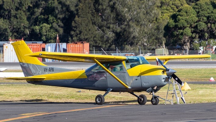
VH-APN (Figure 3) was a Cessna Aircraft Company 182P 4-seat, high‑wing (strut‑braced), single-engine aircraft equipped with a fixed tricycle landing gear. It had a Teledyne Continental Motors O-470 engine and was fitted with a McCauley 2-blade, constant‑speed propeller. APN was manufactured in the United States in 1976. It was placed on the Australian aircraft register that same year with a registration of VH‑RKC. The registration was changed to VH-APN in August 1996 and transferred to the current owner in 2021.
APN was painted in a yellow (wings) and grey (fuselage) livery. The aircraft was fitted with a mode A/C transponder and 2 very high frequency transceiver radios. It was not fitted with ADS-B, nor was this required.
Source: Supplied
19-4079
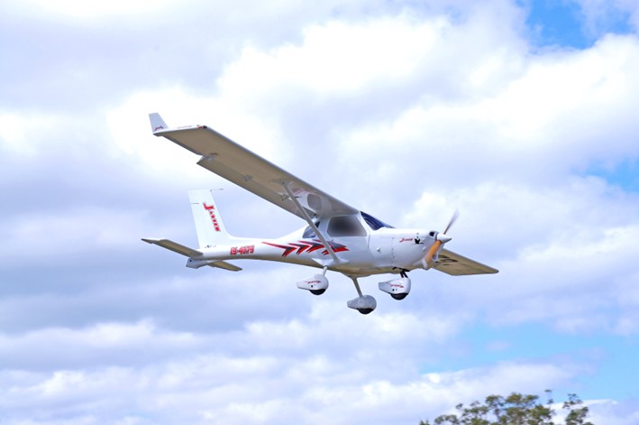
19-4079 (Figure 4) was a Jabiru UL 450 amateur-built high-wing (strut-braced) light aircraft with a fixed tricycle landing gear. It had a Jabiru 2200J, 4-cylinder engine. Construction of 4079 was completed in 2004 and it was placed on the RAAus aircraft register on 23 February 2004. The registration was transferred to the current owner in 2022. 4079 was painted white. The aircraft was fitted with one very high frequency radio and a SkyEcho II portable ADS-B transceiver.[10] It was not fitted with a transponder, nor was this required.
Source: Supplied
Meteorological information
The nearest available Bureau of Meteorology weather forecasts and observations to The Oaks was at Camden Airport.
At 1130, a routine report[11] of weather observations was issued for Camden Airport that reported light winds from a south-westerly direction (218° (magnetic) at 6 kt), with no cloud detected, visibility greater than 10 km, and the temperature was 18°C.
At 1154, following the accident, a special meteorological report[12] was published that showed light winds from the north-west (308° (magnetic) at 5 kt), visibility had reduced to 5 km in haze, no cloud was detected, and the temperature was 19°C.
The reported weather observations, which showed no cloud was detected, were consistent with the onboard video on 4079 (Figure 5). Additionally, at the time of the accident, the video did not show any notable reduction in visibility from any meteorological phenomena such as haze. Further, the Bureau of Meteorology weather observations at 1-minute intervals for Camden Airport showed that the visibility was greater than 10 km until shortly after the accident (at 1147) when it began slowly reducing.
The onboard video from 4079 also showed that, during the go-around on runway 18R at about 1143, the northern airport windsock was facing east indicating that there was minimal wind (Figure 5).
Figure 5: The Oaks windsock at 1143:28
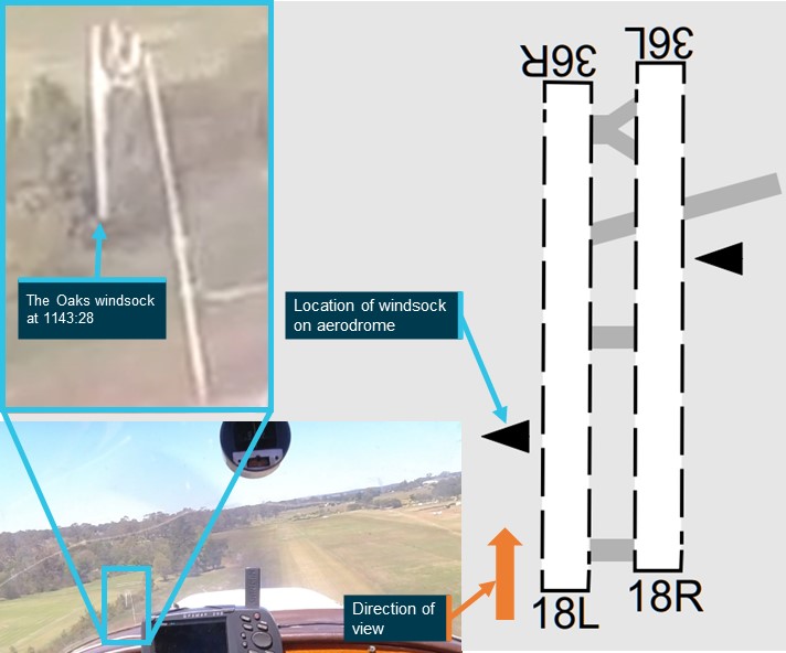
Source: Airservices Australia and ATSB
Aerodrome and airspace information
The Oaks aerodrome
The Oaks aerodrome was a non-controlled aeroplane landing area,[13] located 7 NM (13 km) west‑south-west of Camden Airport. It had an elevation of 880 ft above mean sea level and 2 parallel grass runways aligned in a north-south direction. Runway 18R/36L was 900 m long, while runway 18L/36R was 800 m. All circuits were conducted to the west of the aerodrome to avoid overflying the township of The Oaks. The Oaks utilised the shared CTAF designated radio frequency of 126.7.
An icon and label for The Oaks aerodrome was published on all visual aeronautical charts. Additionally, a caution label, surrounded by a red box adjacent to The Oaks on the visual terminal chart stated:
CAUTION YOAS CCT ALTITUDE A019 RECOMMEND OVERFLY NOT BELOW A025
The caution label indicated to pilots that the potential circuit altitude for aircraft flying at The Oaks was up to 1,900 ft above mean sea level and recommended that they overfly the aerodrome above 2,500 ft.
Figure 6 is an extract of the visual terminal chart for Sydney showing the relative locations of The Oaks aerodrome and Camden Airport, and the caution placard.
Camden Airport
Camden Airport was a certified aerodrome with an elevation of 230 ft above mean sea level. The main runway, 24/06, was paved. Camden Tower had a part time control tower providing an air traffic control service in the surrounding class D airspace during operating hours. During the accident flight, the tower was active, with communications on the radio frequency 120.1. The class D airspace extended in a 2 NM (3.7 km) radius around the airport, represented by the blue dashed circle on Figure 6.
Figure 6: Extract of Sydney visual terminal chart dated 13 June 2024 showing The Oaks aerodrome and Camden Airport
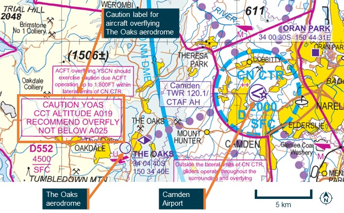
Source: Airservices Australia, annotated by the ATSB
Airspace information
The accident flights were mostly conducted outside controlled airspace, designated as class G airspace. APN also operated in class D airspace while the aircraft was within 2 NM (3.7 km) of Camden Airport.
Airservices Australia’s Aeronautical Information Publication (AIP) ENR 1.6 – 7.1.4 required civil aircraft flying in class D airspace to set their transponder code to 3000. When operating in class G airspace, the AIP required pilots to set their transponder code to 1200.
The area extending beyond 2 NM (3.7 km) from Camden in the direction of The Oaks aerodrome was class G airspace below 4,500 ft above mean sea level.[14]
After leaving controlled airspace, such as when APN departed Camden class D airspace, pilots need to decide what radio frequencies will be required for future transmissions and what frequencies they should maintain a listening watch on. One of the frequencies in the area between Camden and The Oaks was the Sydney Centre area very high frequency, 124.55. This frequency was used by Airservices Australia to provide air traffic services. Additionally, pilots may broadcast their intentions on this frequency to assist with maintaining traffic separation.
Recorded information
Data sources
Neither aircraft was equipped with a flight data recorder or cockpit voice recorder, nor were they required to be. Broadcasts made on The Oaks CTAF were not recorded. The following data sources have been used for this investigation:
- ADS-B data from 4079
- ATC audio data for APN
- CTAF audio data from Shellharbour Airport for APN
- closed-circuit television footage from a nearby residence showing post‑collision dynamics
- data transmitted/recorded from devices running electronic flight bag applications for APN, 4079 and 55-1837
- transponder data for APN.
Transponder data
Transponder data for APN showed that the code was changed from 1200 to 3000 when the aircraft was approaching the Camden class D control zone. The transponder code continued to transmit on code 3000 until the collision.
19-4079 onboard video camera
4079 was fitted with an onboard video camera that was attached to a roof panel inside the cabin. The ATSB recovered the camera at the accident site, which was downloaded at the ATSB’s technical facility in Canberra. Initial observations from the video included:
- the aircraft had no evident technical problems during the flight
- the radio was selected to the frequency 126.7 at the time of the accident
- lights on the radio, along with the push-to-talk button on the control yoke, indicated the pilot was transmitting and receiving radio calls during the flight
- 4079 and APN were both on relatively constant trajectories, with 4079 being straight and level and APN climbing at the time of the collision, with no avoiding action evident by either pilot
- the aircraft were travelling on a generally reciprocal heading, impacting on the left side of each aircraft, with the fuselage of 4079 passing underneath the left wing of APN.
Wreckage and impact information
Wreckage location
The accident site was located about 2.7 km west of The Oaks aerodrome in heavily treed terrain. The 2 primary wreckage locations were approximately 520 m apart, with 4079 north of APN (018º true) (Figure 7). A debris field was located about halfway between the 2 main wreckage locations. Most wreckage items found in the central area were from the left wing of 4079, with a small number of components from APN. Most of the central wreckage was found within a radius of about 50 m.
Figure 7: Accident site location in relation to The Oaks
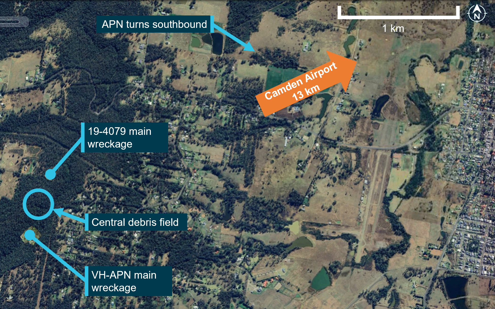
Source: Google Earth, annotated by the ATSB
Orientation of 19-4079 and VH-APN during the collision
Yellow paint was found on portions of the left wing and left-wing strut of 4079, consistent with being transferred from APN. These areas of the left wing of 4079 also showed signs of leading‑edge penetration to about halfway through the wing chord, at about the mid‑span position.
The left-wing strut of APN was found near the main wreckage of APN, consistent with being attached to this aircraft at the time of the collision with terrain. White paint was found in 2 places of this strut, with leading edge damage observed in these areas, consistent with being transferred from the left wing and left-wing strut of 4079.
A relatively small dent with light‑coloured paint transfer was located on the leading edge of APN’s left wing, with a longitudinal light-coloured paint transfer on the underside of the wing around this location. The relative orientation of the frontal left wing and left-wing strut damage on 4079 and left-wing strut damage on APN, was consistent with 4079 being upright during the collision. Based on the geometry of 4079, the coloured paint transfer on the underside of the left wing of APN was likely from the upper vertical fin section of 4079. The fin likely separated from the aircraft after being struck by the left wing of APN in the location of the light-coloured paint. The upper vertical fin section of 4079 was not located.
In summary, the paint transfer marks, and damage observed on site was consistent with APN and 4079 colliding on the left sides of each other on near reciprocal headings. The left wing and left-wing strut of 4079 primarily impacted the left strut of APN, and the upper fin of 4079 subsequently striking the left-wing leading edge of APN.
19-4079 wreckage
Examination of the main wreckage site and surrounding broken tree branches for 4079 indicated that the aircraft had impacted the ground at a steep angle, with little forward movement, resulting in a localised wreckage field. The ATSB inspection found no evidence of pre-accident flight control damage.
All of the aircraft was accounted for, excluding a section of the outboard left wing, and the upper vertical fin. An aileron fitting for 4079 was co-located with the left wing of APN.
VH-APN wreckage
Witness marks in surrounding trees showed that APN impacted terrain in a steep nose down attitude. There was a significant post-impact fire at the primary wreckage site, which limited the ATSB’s ability to examine the wreckage. The inspection of the available evidence did not identify any pre-accident flight control damage. The left wing of APN was located about 50 m from the main wreckage, consistent with this wing separating in‑flight during the accident sequence.
Operations around non-controlled aerodromes
See-and-avoid principles
The Oaks was a non-controlled aerodrome, where separation was maintained by ‘alerted see‑and-avoid’ principles guided by CASA advisory circulars AC 91‑10 Operations in the vicinity of non-controlled aerodromes and AC 91-14 Pilots’ responsibility for collision avoidance. These stated that pilots should broadcast position and intention information so that nearby traffic would have an awareness of the aircraft and be able to plan accordingly.
AC 91-14 also highlighted the ineffectiveness of pilots relying solely on visually detecting other aircraft that are on a conflicting flight path, referred to as ‘unalerted see-and-avoid’. It noted increased traffic density as one of the factors increasing the risk of collision, necessitating a pilot using ‘alerted see-and-avoid’ principles. Airspace in the vicinity of non-controlled aerodromes has a higher traffic density. The primary tool of alerted see‑and-avoid is radio communications that enhance pilot situational awareness.
Operations in the vicinity of non-controlled aerodromes
The AIP provided guidance for pilots flying in the vicinity of non-controlled aerodromes. The vicinity of non-controlled aerodromes was defined as a distance of 10 NM (19 km) horizontally and within a height above the aerodrome that could potentially result in conflict. It recommended that aircraft transiting in the vicinity should avoid flying over the aerodrome at an altitude that could result in conflict with operations, including the circuit area and the arrival and departure tracks.
Additionally, the CASA Civil Aviation Advisory Publication (CAAP) 166(3) outlined hazardous zones for operations near non-controlled aerodromes, including:
- The most hazardous area for collisions is within a space bounded by a cylinder of airspace 5 NM [9 km] in diameter and up to 3,000 ft above aerodrome elevation.
- Most collisions occur on downwind or on final approach. There are many distractions during this time, including configuring the aircraft, completing checklists, setting equipment and communicating...
When APN departed Camden controlled airspace, it was approximately 5 NM (9 km) from The Oaks aerodrome, already within the vicinity of the aerodrome and within the recommended 10 NM (19 km) inbound broadcast location.
Circuit pattern
A circuit is an established procedure for arriving and departing aerodromes. They assist pilots with configuring and positioning the aircraft to make a stabilised approach to the runway in use. A circuit when flown in its entirety includes upwind, crosswind, downwind, base, and final legs. When arriving and departing a non-controlled aerodrome, CASA recommended pilots join the circuit area via the methods highlighted in blue in Figure 8.
The key recommended methods to join the circuit depicted (Figure 8):
- Overflying the aerodrome more than 500 ft above the circuit height before descending on the side not being used and joining the circuit over the middle of the runway (midfield crosswind).
- Joining the circuit at circuit height on the downwind leg (including joining at 45° in the middle of the downwind leg).
CASA did not recommend joining the circuit on base or a 3 NM (5.6 km) straight in approach.
Figure 8: Circuit join methods with recommended circuit joins highlighted in blue
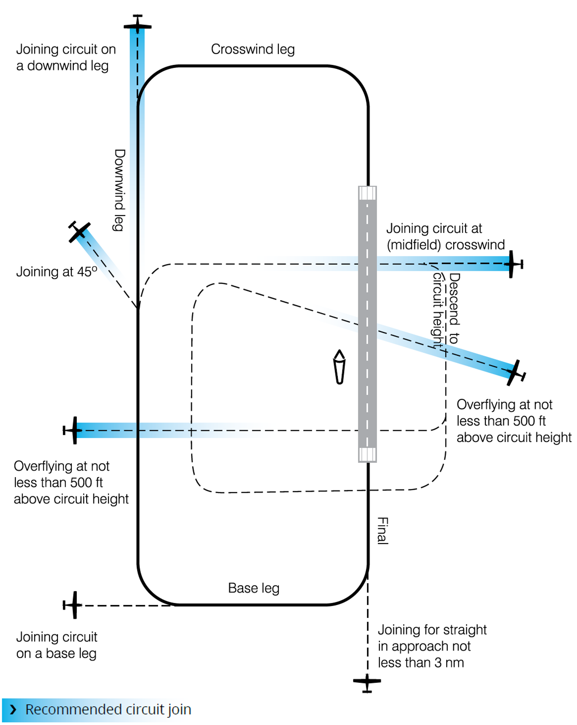
Source: Civil Aviation Safety Authority
Circuit procedures are well established, and pilots learn the circuit terminology during their early training. This allows them to know where to look when they hear a broadcast, which includes a certain leg of the circuit. Pilots should broadcast their position and intentions on the local radio frequency to assist other pilots with alerted searching.[15] Additionally, pilots can use the ‘look, talk, and turn’ strategy, which involves the pilot checking for traffic, making the broadcast and then carrying out the turn (AC 91-10). Other pilots in the area will hear the broadcast, know where to look, and will have an increased chance of visually acquiring the aircraft while it has the most surface area visible during a turn.
The CASA CAAP 166-2 Pilots’ responsibility for collision avoidance in the vicinity of non‑controlled aerodromes noted that variations in the recommended circuit join may increase the risk of collision. Additionally, climbing and descending in the circuit area was not recommended as visual acquisition of traffic could be difficult:
An aircraft (a small one in particular) will often be rendered difficult to see by the patterns in the surface of the earth when viewed from above, and particularly when over urban areas. Conversely, an aircraft when viewed from below can potentially be much more easily seen against a uniformly overcast cloud background or blue sky. All pilots would be aware of the difficulty seeing aircraft that have the sun directly behind them.
Circuit area
The size of a circuit area was not explicitly defined in Australian legislative instruments, procedures or guidance. However, various technical publications refer to distances from and heights above runways in certain operational circumstances. The Airservices Australia AIP stated that aircraft would normally be outside the circuit area when at least 3 NM (5.6 km) from the departure end of the runway, while the United States Federal Aviation Administration’s Airplane Flying Handbook defined the downwind leg of the circuit as a track approximately 1 NM (1.9 km) parallel to the intended landing runway.
Designated airspace in aeronautical charts showed airports with air traffic control towers had airspace reserved (control zones), to be used only by aircraft operating within the circuit. For Camden Airport, the control zone extended 2 NM (3.7 km) from the aerodrome reference point,[16] and is shown by the dashed-blue circle in Figure 6. In many other cases, control zones extended up to 3 NM (5.6 km) from the reference point.
The FAA’s Airplane Flying Handbook stated that, for a typical piston aircraft, a standard final approach would result in a 3° approach angle. Additionally, CASA required aircraft to be established on the final leg, no lower than 500 ft above ground level. To achieve a 3° approach angle, the aircraft would need to be positioned at 500 ft at approximately 1.5 NM (2.8 km) from the runway threshold. However, the AIP stated:
9.2.5 Pilots may vary the size of the circuit depending on:
(a) the performance of the aircraft;
(b) safety reasons; or
(c) in accordance with the Aircraft Flight Manual, Pilot’s Operating Handbook, or company Standard Operating Procedures.
The height at which the circuit legs are flown is dependent on aircraft performance. The AIP section 9.6.1 stated for medium performance aircraft, like APN and 4079, the standard circuit height was 1,000 ft above the aerodrome elevation. At The Oaks, this equated to 1,900 ft above mean sea level. As noted in the section ‘Circuit pattern’ above, aircraft may be joining the circuit at a height at least 500 ft above the circuit height. In this case, at The Oaks up to 2,400 ft above mean sea level. This is also highlighted in the caution label on the visual terminal chart for The Oaks (Figure 6), with a recommended minimum overfly height of 2,500 ft above mean sea level.
Based on this, the area where medium performance aircraft could be expected in The Oaks circuit ranged from overhead to a distance up to 3 NM (5.7 km) from the runway, and up to at least 1,500 ft above the aerodrome or 2,400 ft above mean sea level.
Circuit direction
A circuit is typically conducted to the left side of the runway in use and involves the aircraft making left turns (Figure 8), which assists the pilot who is normally sitting in the left seat to keep the runway in sight. However, some aerodromes such as The Oaks runway 18L and 18R had local procedures that required pilots to fly circuits to the right side of the runway in use and make right turns. Aerodromes where right circuits were required are listed in the En Route Supplement Australia.[17]
At non-controlled aerodromes, the runway in use was determined by pilots using the aerodrome. The runway selected should be the runway that was most closely aligned into wind and was serviceable. Pilots wishing to use a different runway for operational reasons were required to do so without conflicting with other aircraft using the most into wind runway.
At the time of the accident, the windsock at The Oaks was facing east and indicating minimal wind, so the wind direction did not favour any particular runway. Runways 18L and 18R were being used by 4079 and the other Jabiru.
Radio communications
Aircraft operating in the vicinity of a non-controlled aerodrome were required to make broadcasts on the aerodrome frequency whenever reasonably necessary to do so to avoid a collision (AIP 9.1.4). On receiving a broadcast of a potential conflict, a pilot was required to respond by transmitting their own callsign and, as appropriate, aircraft type, position, actual level and intentions. Additionally, when making a standard broadcast pilots should also address the station (location) being called.
While CASA did not require any additional broadcasts, the AIP did recommend pilots make broadcasts as detailed in Table 1.
Table 1: Recommended broadcasts at non-controlled aerodromes
Recommended calls in all circumstances | |
| Situation | Broadcast |
| The pilot intends to take-off | Immediately before, or during taxi |
| The pilot is inbound to an aerodrome | 10 NM [18.5 km] from the aerodrome or earlier, commensurate with aeroplane performance and pilot workload, with an estimated time of arrival (ETA) for the aerodrome |
| The pilot intends to fly through the vicinity of, but not land at a non-controlled aerodrome | 10 NM [18.5 km] from the aerodrome or earlier, commensurate with aeroplane performance and pilot workload, with an estimated time of arrival |
Recommended calls dependant on traffic | |
| The pilot intends to enter a runway | Immediately before entering a runway |
| The pilot is ready to join the circuit | Immediately before joining the circuit |
| The pilot indents to make a straight-in approach | On final approach at not less than 3 NM [5.6 km] from the threshold |
| The pilot intends to join base leg | Prior to joining on base |
Proximity between APN and the other Jabiru
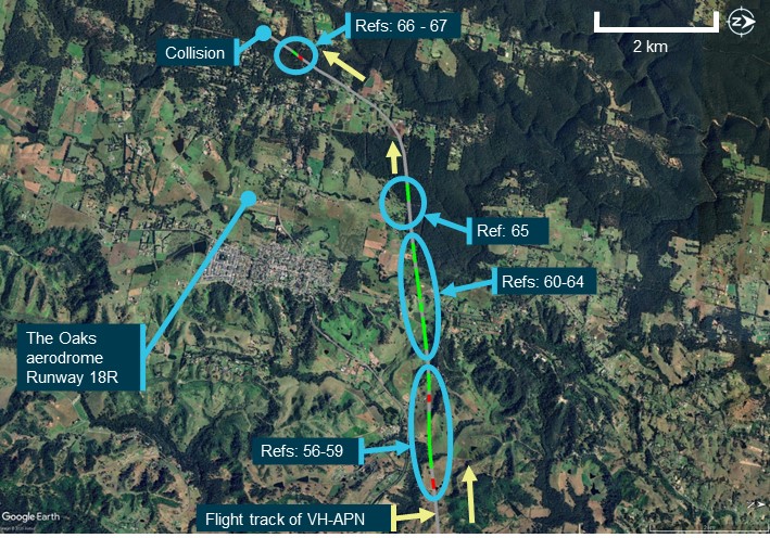
APN tracked from Camden in a westerly direction towards The Oaks and entered the circuit area of The Oaks at low level. At the time there were 2 aircraft conducting circuits to land, 4079 and the other Jabiru (55-1837).
At 1143:07, the other Jabiru passed overhead runway 18L, entering the circuit area at about 1,900 ft. At 1145:00, the other Jabiru had completed a right turn onto the base leg for runway 18R and was descending through about 1,800 ft to land, heading in an easterly direction. At the same time, tracking data showed APN at about 1,350 ft and tracking in a westerly direction, on a near-reciprocal heading to the other Jabiru. At 1145:17, tracking data indicated the other Jabiru passed 375 m in front of and about 400 ft above APN. The position of each aircraft at that time is shown in Figure 9.
The pilot of the other Jabiru stated they did not see APN nor were they aware APN was in the area until after the collision with 4079.
Figure 9: Flight tracks of VH-APN and the other Jabiru (55-1837)
Source: Google Earth and ATSB
Radio communications
Radio communications from several sources were evaluated and combined to produce a detailed timeline. These included witness statements, the onboard video recording from 19-4079, flight tracking data, and available CTAF and ATC recordings. This section reviews the recorded data and interview recollections relating to radio communications by the pilots of APN, 4079, the other Jabiru and the Sonex during the accident flights.
The purpose of this section is to provide context about the effectiveness of radio communications between each aircraft involved.
Overview of radio communications during flight of 19-4079
The ATSB evaluated the recollections of the other Jabiru and Sonex pilots who were operating in the vicinity of The Oaks during the flight of 4079. The accounts were largely consistent, although there were some differences in recollection of radio call sequences. For some parts of the flight, each pilot remembered different aspects, which is considered normal. Where there were discrepancies, these were considered in relation to each other and the recorded data to determine the likely order and content of transmissions.
The onboard video showed transmissions being made and received by 4079 throughout the flight on The Oaks radio frequency (CTAF) and the pre-arranged group chatter frequency. Both pilot witnesses reported hearing radio calls from the pilot of 4079 throughout the flight. The method to identify the type, frequency, time and duration of these transmissions is documented in Appendix – Radio transmissions captured by 19‑4079.
The flight track of 4079 was synchronised with the radio transmission data from the onboard video, and this is shown in (Figure 10). The red coloured parts of the track show the position of 4079 when the pilot was transmitting and the green shows the locations of 4079 when receiving radio calls. The grey parts of the track show the locations when no radio transmissions were made or received by 4079. For context, Figure 10 also contains labels for key parts of the flight for 4079 that are cross-referenced in figures for orientation and discussed in the text below.
Figure 10: Flight track showing the position of 19-4079 when no transmission was detected (grey lines), and when radio calls were transmitted (red lines) and received (green lines) by 19-4079 during the accident flight
Source: Google Earth and ATSB
19-4079 departure and return to The Oaks aerodrome
Turn back call
When the decision was made to return to The Oaks, the other Jabiru pilot reported broadcasting this intention on both the CTAF and group chatter frequency. However, neither the other Jabiru or Sonex pilots heard a response, or a similar call from the pilot of 4079. As such, the ATSB evaluated the most plausible reason why both pilot witnesses did not hear the pilot of 4079 respond to the other Jabiru pilot’s decision to turn back.
The evaluation of the video evidence showed the pilot of 4079 receiving a call on the CTAF frequency, which was likely the turn back discussion. After this, the pilot of 4079 broadcast a transmission on the group chatter frequency, which may not have been monitored by the other pilots at that time. The timing of this transmission also aligned with the turn back of 4079, as shown by the recorded data.
Inbound call
The onboard video and tracking data showed that the pilot of 4079 made a transmission when 7 NM (13 km) from The Oaks on the CTAF. This was consistent with the recollection of the other Jabiru pilot who recalled hearing 4079 make an inbound call on The Oaks frequency.
Unintelligible call
When they were about 3–4 NM (5.6–7.4 km) from The Oaks, the other Jabiru pilot reported hearing a ‘really fuzzy’ radio call on CTAF. This transmission was correlated on the video recording with a 10.6 second radio transmission that was received by 4079 on the CTAF. At the same time as this transmission, flight data indicated APN was on the base leg of a touch-and-go at Camden Airport. As APN would have been on the Camden Airport frequency, the fuzzy call on the CTAF was not likely to be APN.
Communications on The Oaks frequency prior to the collision
While the likely content of each transmission was evaluated for the entire flight of 4079, a particular focus was during the period from 4079 joining the circuit for runway 18L or runway 18R on a mid-field crosswind leg until the collision with APN. The results of this evaluation are detailed in Table 2, Figure 11, Figure 12 and Figure 13.
Table 2 details the time and duration of all radio transmissions received by 4079 based on the examination of the video, with the reference numbers correlating with reference numbers in Table A2 of the Appendix. The likely information communicated by each pilot on The Oaks frequency were estimated based on the combined analysis of the onboard video, tracking data and accounts from the 2 witness pilots. The results of this evaluation, including the relevant aircraft location are shown in the 2 right-most columns of Table 2.
The tracks of each aircraft in the circuit area of The Oaks with radio transmissions overlaid are shown in Figure 11 for 4079, Figure 12 for the other Jabiru and Figure 13 shows APN in proximity to the other Jabiru. These figures show the same type of information as Table 2, with colours of the tracks corresponding to transmissions by the pilot of 4079 in red, transmissions received in green, and no transmissions on frequency in grey. Transmissions are numbered sequentially in the direction of flight and correspond to rows in Table 2 and Table A2 of Appendix A. All transmissions during this phase of flight were on The Oaks frequency.
Table 2: Timing and duration of radio transmissions longer than 0.1 seconds, sent and received by the radio fitted to 19-4079 from when 19-4079 tracked west for a mid-field crosswind circuit join, combined with the likely content of transmissions
| Reference number | Time (local) (Duration in seconds) | Transmission type | Relevant aircraft location | Likely transmission content |
| 1140:15 | 19-4079 tracks west for a mid-field crosswind circuit join | |||
| 51[18] | 1140:22.1 (6.9) | Transmit | 4079 tracking west about 1 NM (1.9 km) from The Oaks | 4079: Midfield crosswind join |
| 52 | 1141:16.4 (5.3) | Transmit | Just prior to 4079 turning north
| 4079: Downwind call |
| 53 | 1141:57.5 (6.0) | Transmit | Just prior to 4079 starting to turn to the east | 4079: Base call |
| 54 | 1142:21.3 (6.0) | Receive | Other Jabiru turned west 1 NM (1.9 km) from The Oaks | Other Jabiru: Mid-field join |
| 1142:59 | VH-APN departs Camden airspace | |||
| 55 | 1143:20.5 (4.6) | Transmit | 4079 track aligned to runway 18L | 4079: Go-around call |
| 56 | 1144:09.7 (2.3) | Transmit | 4079 passed the end of the runway and was climbing | 4079 and Sonnex pilots discuss a possible runway change. The pilot of 4079 called them on the radio, asking if it would be okay to land on runway 36. The Sonex pilot recalled broadcasting that the very light wind would allow 36 to be used, but that others (specifically the other Jabiru pilot) were using runway 18. |
| 57 | 1144:14.7 (13.3) | Receive | 4079 beginning crosswind turn (other Jabiru on downwind) | |
| 58 | 1144:30.4 (1.8) | Transmit | 4079 crosswind (other Jabiru on downwind) | |
| 59 | 1144:33.1 (4.4) | Receive | Other Jabiru about to turn onto base | Other Jabiru: Base for a full stop landing on runway 18R. Exchange between the Sonex and other Jabiru pilots: Sonex pilot had both 19-4079 and other Jabiru in sight and that it would be safe for other Jabiru to land. (See section Evaluation of radio calls after go-around of 4079 for the assessment of calls references 59-64). |
| 60 | 1144:43.5 (8.0) | Receive | 4079 crosswind (Figure 11) Other Jabiru on base (Figure 12) Sonex on the ground APN tracking west between 1-2 NM (1.9-3.7 km) from The Oaks (Figure 13)
| |
| 61 | 1144:53.0 (2.2) | Receive | ||
| 62 | 1144:56.2 (8.1) | Receive | ||
| 63 | 1145:05.9 (2.2) | Receive | ||
| 64 | 1145:08.4 (2.4) | Receive | ||
| 65 | 1145:22.0 (4.5) | Receive | Other Jabiru turning onto final approach | Other Jabiru: Finals call for runway 18R |
| 66 | 1146:15.6 (1.5) | Transmit | 4079 mid-downwind Other Jabiru close to runway 18R threshold | 4079: Lost sight of the other Jabiru |
| 67 | 1146:17.8 (1.6) | Receive | Other Jabiru: On short final for runway 18R | |
| 1146:34.0 | Collision between VH-APN and 19-4079 | |||
Figure 11: Flight track showing the position of 19-4079 with no transmission was detected (grey lines), and when radio calls were transmitted (red lines) and received (green lines) by 19-4079 after returning to The Oaks to the collision
Source: Google Earth and ATSB
Figure 12: Flight track of the other Jabiru, showing positions with no transmissions detected (grey lines), and when signals were transmitted (red lines) and received (green lines) by 19-4079 after returning to The Oaks to the collision
Source: Google Earth and ATSB
Figure 13: Flight tracks of VH-APN and the other Jabiru, showing where no transmissions were detected (grey lines), and when signals were transmitted (red lines) and received (green lines) by 19-4079 after returning to The Oaks to the collision
Source: Google Earth and ATSB
Evaluation of radio calls after go-around of 4079
As 4079 was on the upwind and crosswind legs, 3 groups of transmissions occurred, with references 56–59, 60–64 and 65 in Table 2 and Table A2, and aircraft positions circled in Figure 11, Figure 12 and Figure 13. Around this time, the 2 pilot witnesses both recalled 3 communications exchanges, specifically:
- an exchange between the pilot of 4079 and the Sonex pilot about changing the runway direction
- a base turn call by the pilot of the other Jabiru
- an exchange between the Sonex pilot and the other Jabiru pilot about the separation between 4079 and the other Jabiru.
As these communications occurred shortly prior to the collision, each of the 3 recalled communications exchanges, and radio calls until the final transmission by the other Jabiru pilot are discussed below.
Broadcasts about changing the runway
At 1144:04, the 4079 flight data indicated that the aircraft had passed the end of the runway and was climbing following the go-around. Five seconds later, a short 2.3 second radio call was broadcast by the pilot of 4079, followed by a 13.3 second broadcast received and another 1.8 second transmission by the pilot of 4079, with about 2‑second gaps in between transmissions (Figure 11 and Table 2 references 56-58). This was consistent with the Sonex pilot reporting that, as 4079 turned onto the crosswind leg of the circuit for runway 18R, the pilot of 4079 called them on the radio asking if it would be okay to land on runway 36. The Sonex pilot recalled broadcasting that the very light wind would allow runway 36 to be used, but that others (specifically the other Jabiru pilot) were using runway 18. The Sonex pilot noted that this was their last interaction with the pilot of 4079.
Broadcast as the other Jabiru turned onto base
At 1144:33, flight tracking data showed that the other Jabiru had just started to turn onto the base leg for runway 18R. The Sonex pilot recalled that, immediately after the previous radio exchange with the pilot of 4079, the other Jabiru pilot broadcast that they were on base for a full stop landing on runway 18R. This account aligned with the onboard video, which showed a 4.4 second radio call made at this time (Table 2, Table A2 and Figure 12 reference 59),[19] which was about one second after the broadcast by the pilot of 4079, likely regarding a potential runway change (Table 2 reference 58) .
The pilot of the other Jabiru recalled that their call on base was prior to the discussion about changing runway, but noted that they were not ‘really paying attention’ due to them being confident that no conflict existed between them and 4079. However, flight tracking data showed that the other Jabiru was still on the downwind circuit leg during the first 3 calls in this group (references 56–58 in Figure 12). Additionally, the pilot of 4079 made the first transmission in this group (reference 56 in Table 2), very likely about the runway change. Therefore, based on the factors discussed, it was considered more likely that the base call by the other Jabiru pilot occurred after both transmissions from the pilot of 4079.
Broadcasts about separation between 19-4079 and the other Jabiru
At 1144:44, about 5 seconds after a previous transmission, another 5 radio calls were received on The Oaks frequency over the next 30 seconds, with 2 radio calls being about 8 seconds long and 3 under 2.5 seconds (Table 2 references 60-64). During this time, flight tracking data showed that 4079 was on an ovalised crosswind leg (Figure 11 references 60-64), and the other Jabiru was on the base leg (Figure 12 references 60‑64), both for runway 18L or runway 18R.
The flight tracking and radio transmission data was consistent with the account of the Sonex pilot who reported that, after the base call by the other Jabiru pilot, they responded over the radio saying that they still had 4079 in sight and that the other Jabiru pilot would be safe to land. The Sonex pilot recalled the last time they saw 4079 was climbing to the west as 4079 was on the crosswind leg.
The other Jabiru pilot also recalled the Sonex pilot broadcasting that they could see both the other Jabiru and 4079 and that they were well separated. In contrast, the other Jabiru pilot recalled this communication occurring when they were on short final. Based on the available evidence, it was considered more likely that the exchange over the radio between the Sonex pilot and the other Jabiru were communications with reference 60–64 as listed in Table 2. This was as the other Jabiru was on the base leg (Figure 12) and 4079 was still in sight of the Sonex pilot on the crosswind leg (Figure 11).
The other Jabiru turns onto final approach
Although not mentioned explicitly during interview, the other Jabiru pilot stated that at The Oaks, they mainly only make base and final calls, indicating that these calls were normally performed. This was consistent with a transmission received by 4079 as the other Jabiru started to turn onto final (Figure 12 and Table 2 reference 65).
Communication between 4079 and the other Jabiru on short final
The onboard video showed the pilot of 4079 looking outside forward and to the right while transmitting over the flight radio on The Oaks frequency (Table 2 reference 66). The pilot of the other Jabiru recalled that the pilot of 4079 broadcast that they had lost sight of the other Jabiru. Tracking data showed that the other Jabiru was close to the threshold of runway 18 and 4079 was in the mid-downwind position at this time, with the pilot recalling that they responded via radio to say that they were on short final (for runway 18) (Table 2 reference 67). The relative positions of 4079 and the other Jabiru during these radio calls (references 66 and 67) are shown in Figure 10 and Figure 11. Following this exchange, the pilot of 4079 tapped the broadcast button twice (less than 0.1 seconds), consistent with acknowledging the transmission by the other Jabiru pilot. This was the last radio communication captured by the onboard video.
Breaks in transmissions
Broadcasts on The Oaks frequency after APN departed from Camden were arranged in groups of calls when there was less than 3 seconds between transmissions. The purpose was to characterise notable periods without transmissions where there may have been an opportunity for radio calls to be made by other aircraft if they were on the CTAF. The results of this grouping are shown in Table 3.
There were 2 notable periods of more than 40 seconds where there were no recorded transmissions:
- Between the transmission coinciding with the go-around of 4079 and the subsequent transmission, starting at 1143:25.1 and shown by the grey track between references 55 and 56 in Figure 11, Figure 12 and Figure 13.
- Following a transmission coinciding with the other Jabiru turning onto final approach until the final transmission by 4079 when on mid-downwind (between references 65 and 66 in Figure 11, Figure 12 and Figure 13).
Table 3: Broadcast and non-broadcast periods captured by the onboard video on 4079 radio on The Oaks frequency between APN departing Camden airspace until the collision
| Start time (local) | Elapsed time (seconds) | Reference numbers | Transmissions received by 4079 | Transmissions sent by 4079 |
| 1142:59 | 21.5 | - | No transmissions (APN leaves Camden) | |
| 1143:20.5 | 4.6 | 55 | 0 | 1 |
| 1143:25.1 | 44.6 | - | No transmissions | |
| 1144:09.7 | 27.8 | 56-59 | 2 | 2 |
| 1144:37.5 | 6.0 | - | No transmissions | |
| 1144:43.5 | 27.3 | 60-64 | 5 | 0 |
| 1145:10.8 | 11.2 | - | No transmissions | |
| 1145:22.0 | 4.5 | 65 | 1 | 0 |
| 1145:26.5 | 49.1 | - | No transmissions | |
| 1146:15.6 | 3.8 | 66-67 | 1 | 1 |
| 1146:19.4 | 14.6 | - | No transmissions until collision | |
| 1146:34.0 | - | - | Collision | |
Radio communication information for VH-APN
This section examines recorded radio calls broadcast by APN from the initial contact with Camden Tower through to the collision. A total of 14 calls were recorded on the radio frequency for Camden Tower (120.10). No calls by APN were recorded after the aircraft departed Camden airspace on the Sydney area frequency (124.55), noting that transmissions were not recorded on The Oaks CTAF.
The last recorded transmission for APN occurred at 1138.36 with APN reading back the clearance for a touch-and-go on runway 24 for an upwind departure from Camden Airport.
The ATSB performed a qualitative assessment of the radio transmissions recorded for APN during the accident flight. The assessment was based on the ‘Plain-Language Radio Check Procedure Words’ (prowords) described in ACP 125(G).[20] An ATSB evaluation of the recorded radio transmissions made by APN indicated the signal strength was between good and loud and the signal readability was between readable and clear. This equated to a minimum score of 4 out of 5 on the assessment scales, with every recorded message able to be determined.
The ATSB also assessed the approximate range of APN from ground-based recording stations. The largest distance between APN and a ground-based station was at 1124:42, as APN approached Camden Airport. In the following 30 seconds, APN was transmitting and receiving radio calls to and from Camden Tower. The distance between APN and Camden Tower during this time was between 6 NM (11.1 km) and 7 NM (13.0 km). For these radio calls, the time between APN receiving a message from Camden Tower and responding was less than 1 second, with the readback of all instructions being accurate and correct. Therefore, from the available evidence, the radio fitted to APN was likely to be operational leading up to the accident.
Terrain shielding considerations
The ATSB examined the potential for high terrain to prevent radio signals being transmitted between 4079 and APN. A key time identified was during the go-around, when 4079 was about 100 ft above runway 18L, at a similar height to elevated terrain to the east and toward APN. At that time, there was very likely a direct line of sight between 4079 and APN. At all other times, 4079 was higher, meaning that there was clear line of sight between 4079 and APN until the collision.
The maximum distance between APN and 4079 after APN departed Camden airspace was about 4.5 NM (8.3 km) as APN departed Camden Airspace. This distance remained between 3 NM (5.6 km) and 4 NM (7.4 km) as APN approached The Oaks and 4079 was on the crosswind legs, before reducing to the collision. Therefore, based on the evidence available, it was considered likely that any transmission by APN on The Oaks frequency would have been detected by 4079 and have been visible in the onboard video.
During the same time, the other Jabiru and APN were also within line of sight. The other Jabiru was above the height of the surrounding terrain until on final approach, when APN had started to climb after remaining at about 1,250 ft above mean sea level since departing Camden. The distance between APN and the other Jabiru after transmission 56 by the pilot of 4079 and until the collision was less than 3.5 NM (6.5 km).
The ATSB identified that terrain shielding was possible between the Sonex and APN after APN departed Camden airspace. A notable period for potential shielding was around the time that APN turned left and started to climb, after radio call with reference 65 (Figure 13 and Table 2). The line of sight between the Sonex and APN has not been fully assessed. However, at the time of the radio calls with reference 60–64 (Figure 13 and Table 2), APN was likely in line of sight of the Sonex.
In conclusion, 4079 and the other Jabiru were likely within line of sight and range of APN for the entire period after APN departed Camden.
Safety action
| Whether or not the ATSB identifies safety issues in the course of an investigation, relevant organisations may proactively initiate safety action in order to reduce their safety risk. The ATSB has been advised of the following proactive safety action in response to this occurrence. |
Safety action by the owner of VH-APN
The owner of VH-APN reported that they have equipped one of their aircraft with an ADS-B transceiver. They also have plans to install 2 further ADS-B out units on 2 of their 3 other aircraft.
Further investigation
- examined the wreckage
- examined aircraft components and other items recovered from the accident site
- collected surveillance data from Airservices Australia
- collected OzRunways data for relevant aircraft
- collected pilot and aircraft records
- conducted interviews with relevant parties
- conducted detailed analysis of video recordings and radio transmissions
- reviewed aircraft, pilot, aerodrome and operator documentation
- conducted detailed analysis of the aircraft flight paths
- reviewed procedures at non-controlled aerodromes
- liaised with the NSW Police Force.
The investigation is continuing and will include, further:
- analysis of video recordings
- review of similar occurrences
- review of previous flight tests conducted by the flight test examiner
- review of procedures and practices relating to the conduct of flight tests
- review of communication, electronic conspicuity and surveillance equipment, and interviews with relevant parties.
A final report will be released at the conclusion of the investigation. Should a critical safety issue be identified during the course of the investigation, the ATSB will immediately notify relevant parties so appropriate and timely safety action can be taken.
Appendix – Radio transmissions captured by 19‑4079
Overview
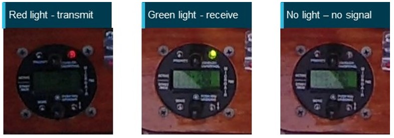
The ATSB performed measurements of the timing of radio transmissions sent and received by 19‑4079 during the accident flight. The measurements were performed using the onboard video fitted to 19-4079 that showed the 3 different states, based on a light fitted to the radio, where:
- a red light indicated transmissions were being sent by the pilot of 4079
- a green light indicated transmissions were being received by 4079
- no light indicated that no transmission was being received on the selected frequency.
An example of screen captures from the onboard video for these 3 states is shown in Figure A1.
Figure A1: Screen captures of the radio fitted to 19-4079 during send (red light), receive (green light) and no transmissions (no light)
Source: ATSB
The ATSB also recorded the frequency that was selected against each transmission and the timing of any frequency changes that occurred during the flight. The radio instrument fitted to 4079 is shown in Figure A2, with an exemplar image showing the active (upper) and standby (lower) frequency that can be toggled by the user.
Figure A2: Radio instrument model fitted to 19-4079
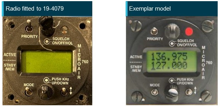
Source: ATSB (left) and Microair Avionics Pty Ltd (right)
Methods
Frame measurements
The ‘Syntheyes’ computer program[21] was used to identify the exact frame the light turned on and turned off, which was tabulated. The identified frames were converted to an elapsed time for the associated video using the video frame rate (29.97).
Frequency changes
The times when frequency changes were selected by the pilot were identified. This was achieved through the frequency change dial on the instrument or the frequency flip button on the control yolk. The frequencies identified are shown under the ‘Frequency’ columns of Table A1 and Table A2. Legible frames in these intervals were identified.
Synchronisation of onboard video with UTC[22] time
The onboard video on 4079 also showed a tablet fitted to the left side of the aircraft dashboard. An application being used by the pilot (OzRunways) showed the UTC time to the nearest minute (hh:mm) in the top information panel. Time was corrected to the nearest second using the frames in the video when the minute changes occurred.
The tablet was intermittently visible in the video due to the pilot covering it in frame. However, there were 2 instances where a change in minute occurred on the tablet that was captured between video frames on the onboard video. The elapsed time between these 2 instances was less than 0.2 seconds, indicating that the elapsed time in the onboard video and the tablet were in close agreement. The time recorded by the tablet was synchronised with the flight data at the time of collision. The video creation time was also examined, however, it was not in agreement with the flight data or the time shown on the tablet and was not used for further analysis.
Radio transmissions to and from 19-4079
Results from the measurements of the time and duration of radio calls sent and received by 19-4079 are shown for the accident flight between take-off up to the point where 4079 returned to The Oaks (Table A1), and from the return to the accident (Table A2). Measurements shorter than one-tenth of a second (0.1 seconds) were excluded. The reference number included was used in the main body of this report, with the frequency and transmission type (receive or transmit) recorded for each. The reported time was at the start of each transmission.
Table A1: Timing and duration of radio transmissions longer than 0.1 seconds, sent and received by the radio fitted to 19-4079 during the accident flight, from start of the flight to the return to The Oaks
| Reference number | Time (local) | Duration (seconds) | Frequency | Transmission type |
| 1 | 1120:56.3 | 7.6 | 126.70 | Receive |
| 2 | 1121:05.0 | 2.8 | 126.70 | Receive |
| 3 | 1121:57.2 | 4.6 | 126.70 | Receive |
| 4 | 1122:35.8 | 4.2 | 126.70 | Receive |
| 5 | 1122:41.7 | 3.9 | 126.70 | Receive |
| 6 | 1123:51.3 | 4.7 | 126.70 | Receive |
| 7 | 1124:01.8 | 7.3 | 126.70 | Transmit |
| 1124:11.0 | 19-4079 Take-off from The Oaks | |||
| 8 | 1124:23.9 | 2.0 | 126.70 | Receive |
| 9 | 1124:38.3 | 1.6 | 126.70 | Receive |
| 10 | 1125:23.7 | 0.2 | 126.70 | Receive |
| 11 | 1125:30.5 | 0.2 | 126.70 | Receive |
| 12 | 1126:06.2 | 0.3 | 126.70 | Receive |
| 13 | 1126:07.3 | 0.3 | 126.70 | Receive |
| 14 | 1126:08.0 | 0.2 | 126.70 | Receive |
| 15 | 1126:44.3 | 2.0 | 126.70 | Receive |
| 16 | 1126:58.5 | 2.0 | 126.70 | Receive |
| 17 | 1127:00.6 | 11.4 | 126.70 | Receive |
| 18 | 1127:32.2 | 7.5 | 126.70 | Receive |
| 19 | 1127:40.7 | 6.5 | 126.70 | Receive |
| 20 | 1127:57.3 | 0.4 | 126.70 | Receive |
| 21 | 1127:58.0 | 2.3 | 126.70 | Receive |
| 22 | 1128:02.5 | 0.2 | 126.70 | Receive |
| 23 | 1128:03.4 | 1.4 | 126.70 | Receive |
| 24 | 1128:05.0 | 1.9 | 126.70 | Receive |
| 25 | 1128:27.7 | 15.0 | 126.70 | Receive |
| 26 | 1128:57.5 | 7.8 | 126.70 | Transmit |
| 1129:00 | 19-4079 Outbound | |||
| 27 | 1130:28.9 | 0.7 | 126.70 | Receive |
| 28 | 1130:30.0 | 0.5 | 126.70 | Receive |
| 29 | 1130:31.9 | 0.4 | 126.70 | Receive |
| 30 | 1130:32.9 | 0.6 | 126.70 | Receive |
| 31 | 1130:33.9 | 0.6 | 126.70 | Receive |
| 32 | 1131:00.2 | 11.9 | 126.70 | Receive |
| 33 | 1131:14.5 | 5.2 | 126.70 | Receive |
| 34 | 1131:58.3 | 10.4 | XXX.70[23] | Receive |
| 35 | 1132:15.9 | 8.7 | 123.45 | Transmit |
| 36 | 1132:24.7 | 0.2 | 123.45 | Receive |
| 37 | 1132:31.5 | 1.3 | 123.45 | Transmit |
| 1133:12.0 | 19-4079 Starts returning to The Oaks | |||
| 38 | 1133:31.4 | 1.5 | 126.70 | Receive |
| 39 | 1133:37.3 | 3.7 | 123.45 | Transmit |
Table A2: Timing and duration of radio transmissions longer than 0.1 seconds, sent and received by the radio fitted to 19-4079 during the accident flight, after the return to The Oaks to the accident
| Reference number | Time (local) | Duration (seconds) | Frequency | Transmission type |
| 40 | 1134:43.7 | 4.4 | 126.70 | Receive |
| 41 | 1134:48.9 | 6.7 | 126.70 | Receive |
| 42 | 1134:57.4 | 6.3 | 126.70 | Receive |
| 43 | 1135:18.0 | 3.2 | 126.70 | Receive |
| 44 | 1135:23.8 | 6.6 | 126.70 | Transmit |
| 45 | 1135:31.9 | 2.0 | 126.70 | Receive |
| 46 | 1135:34.6 | 1.7 | 126.70 | Transmit |
| 47 | 1135:44.5 | 12.6 | 126.70 | Receive |
| 48 | 1136:59.9 | 7.6 | 126.70 | Receive |
| 49 | 1138:06.0 | 10.4 | 126.70 | Transmit |
| 50 | 1139:58.0 | 10.6 | 126.70 | Receive |
| 1140:15 | 19-4079 tracks west for mid-field crosswind circuit join | |||
| 51 | 1140:22.1 | 6.9 | 126.70 | Transmit |
| 52 | 1141:16.4 | 5.3 | 126.70 | Transmit |
| 53 | 1141:57.5 | 6.0 | 126.70 | Transmit |
| 54 | 1142:21.3 | 6.0 | 126.70 | Receive |
| 1142:59 | VH-APN departs Camden airspace | |||
| 55 | 1143:20.5 | 4.6 | 126.70 | Transmit |
| 56 | 1144:09.7 | 2.3 | 126.70 | Transmit |
| 57 | 1144:14.7 | 13.3 | 126.70 | Receive |
| 58 | 1144:30.4 | 1.8 | 126.70 | Transmit |
| 59 | 1144:33.1 | 4.4 | 126.70 | Receive |
| 60 | 1144:43.5 | 8.0 | 126.70 | Receive |
| 61 | 1144:53.0 | 2.2 | 126.70 | Receive |
| 62 | 1144:56.2 | 8.1 | 126.70 | Receive |
| 63 | 1145:05.9 | 2.2 | 126.70 | Receive |
| 64 | 1145:08.4 | 2.4 | 126.70 | Receive |
| 65 | 1145:22.0 | 4.5 | 126.70 | Receive |
| 66 | 1146:15.6 | 1.5 | 126.70 | Transmit |
| 67 | 1146:17.8 | 1.6 | 126.70 | Receive |
| 1146:34.0 | Collision between VH-APN and 19-4079 | |||
Purpose of safety investigationsThe objective of a safety investigation is to enhance transport safety. This is done through:
It is not a function of the ATSB to apportion blame or provide a means for determining liability. At the same time, an investigation report must include factual material of sufficient weight to support the analysis and findings. At all times the ATSB endeavours to balance the use of material that could imply adverse comment with the need to properly explain what happened, and why, in a fair and unbiased manner. The ATSB does not investigate for the purpose of taking administrative, regulatory or criminal action. About ATSB reportsATSB investigation reports are organised with regard to international standards or instruments, as applicable, and with ATSB procedures and guidelines. Reports must include factual material of sufficient weight to support the analysis and findings. At all times the ATSB endeavours to balance the use of material that could imply adverse comment with the need to properly explain what happened, and why, in a fair and unbiased manner. An explanation of terminology used in ATSB investigation reports is available here. This includes terms such as occurrence, contributing factor, other factor that increased risk, and safety issue. Publishing informationReleased in accordance with section 25 of the Transport Safety Investigation Act 2003 Published by: Australian Transport Safety Bureau © Commonwealth of Australia 2025 
Ownership of intellectual property rights in this publication Unless otherwise noted, copyright (and any other intellectual property rights, if any) in this report publication is owned by the Commonwealth of Australia. Creative Commons licence With the exception of the Commonwealth Coat of Arms, ATSB logo, and photos and graphics in which a third party holds copyright, this report is licensed under a Creative Commons Attribution 4.0 International licence. The CC BY 4.0 licence enables you to distribute, remix, adapt, and build upon our material in any medium or format, so long as attribution is given to the Australian Transport Safety Bureau. Copyright in material obtained from other agencies, private individuals or organisations, belongs to those agencies, individuals or organisations. Where you wish to use their material, you will need to contact them directly. |
[1] A multi-function, computerised, aeronautical information system that allows users, such as pilots, to obtain weather information and submit flight plans into the air traffic system.
[2] A common traffic advisory frequency is a designated frequency on which pilots make positional broadcasts when operating in the vicinity of a non-controlled airport, or within a broadcast area.
[3] An information system for flight crew members which allows storing, updating, delivering, displaying and/or computing digital data to support flight operations or duties.
[4] Above mean sea level (AMSL): all altitudes presented in this report are in AMSL unless otherwise specified.
[5] Lanes of entry are established to permit passage to and from a specific class D control zones without entering adjacent civil or military controlled airspace. The vertical limits of the lane provide separation from overflying control areas and military airspace. Class D zones are the controlled airspace that surrounds general aviation and regional airports equipped with a control tower.
[6] The Oaks aerodrome had 2 parallel runways oriented in a north-south direction, meaning that there were 2 runways available in the direction of take-off, runway 18 right (18R) and runway 18 left (18L).
[7] Automatic dependent surveillance-broadcast is a surveillance technology in which an aircraft determines its position via satellite navigation and periodically broadcasts it, enabling it to be tracked.
[8] An authorisation for individuals to fly RAAus registered recreational aircraft in Australia.
[9] Applicants for an RAAus licence are required to have a health standard equivalent to that required for the issue of a private motor vehicle driver licence in Australia and may self-declare their medical status.
[10] A transceiver is a radio device capable of transmitting and receiving signals, in this case ADS-B in and out.
[11] METAR: is a routine report of meteorological conditions at an aerodrome
[12] SPECI: is a special report of meteorological conditions, issued when one or more elements meet specified criteria significant to aviation. SPECI is also used to identify reports of observations recorded 10 minutes following an improvement (in visibility, weather or cloud) to above SPECI conditions.
[13] An aeroplane landing area is an aerodrome that has not been certified by CASA. These aerodromes are non‑controlled, unregulated facilities. It is the responsibility of pilots and operators to determine whether these aerodromes are suitable for use.
[14] To fly above 4,500 ft, a clearance from Sydney air traffic control was required until approximately 2 NM east of The Oaks, where flights up to 7,500 ft without a clearance was permitted.
[15] Alerted searching: an alerted search is visual scanning when air traffic information has been provided and a pilot knows where to look.
[16] Aerodrome reference point (ARP): the designated geographical location of an aerodrome.
[17] En Route Supplement Australia is an Airservices Australia publication, which provides information on all certified airports in Australia and limited information on some uncertified aerodromes such as The Oaks.
[18] References numbers are a continuation from the tabulation of all radio transmissions shown in Appendix A Table A1 and Table A2.
[19] This was also consistent with the relative position of the other Jabiru with the pilot broadcasting at the start of circuit turns during other radio broadcasts likely by them – Figure 12 reference 54 (crosswind join call) and reference 65 (finals call).
[20] ACP 125(G): Allied Communications Publication 125:Communications Instructions Radio Telephone Procedures, published by the Combined Communications Electronics Board on 28 November 2016.
[21] SynthEyes is a program for 3D camera tracking, also known as match-moving.
[22] Coordinated Universal Time (UTC): the time zone used for aviation. Local time zones around the world can be expressed as positive or negative offsets from UTC.
[23] The frequency for this transmission could not be determined due to the incoming call being received as the frequency dial was being adjusted and the dial and display being covered.
Preliminary report
Report release date: 20/12/2024
| This preliminary report details factual information established in the investigation’s early evidence collection phase and has been prepared to provide timely information to the industry and public. Preliminary reports contain no analysis or findings, which will be detailed in the investigation’s final report. The information contained in this preliminary report is released in accordance with section 25 of the Transport Safety Investigation Act 2003. |
The occurrence
Overview
On the morning of 26 October 2024, a Commercial Pilot Licence (Aeroplane) (CPL(A)) flight test was being conducted in a Cessna 182 aircraft, registered VH-APN (APN), departing from Shellharbour Airport, New South Wales. On board APN were a pilot under examination (the CPL candidate) and a Civil Aviation Safety Authority (CASA) approved flight test examiner (the examiner).
On the same morning, a private flight was being conducted in a Jabiru UL 450 aircraft, registered 19-4079 (4079), departing from The Oaks aerodrome (The Oaks), New South Wales. Onboard 4079 was a pilot (the pilot of 4079), who was the sole occupant.
Around midday, APN and 4079 collided in flight and both aircraft impacted terrain. All occupants of both aircraft were fatally injured. The following describes the events that led up to the mid-air collision.
VH-APN pre-flight and departure from Shellharbour Airport
Three days earlier, on 23 October 2024, a ‘CPL task’ for the flight test and other instructions were sent by email from the examiner to the CPL candidate. The CPL task was a scenario that included instructions to plan and fly from Shellharbour Airport and land at Warnervale Airport flying via Macquarie Lighthouse for some aerial photography. The task then stipulated an onward flight from Warnervale Airport to land at Cessnock Airport, with a return leg to Shellharbour Airport via the most direct track. A map recovered from the accident site showed a red path drawn upon it, consistent with the CPL task. This map indicated that the Cessnock to Shellharbour leg was planned via an inland route passing over Prospect Reservoir and Campbelltown.
A witness account indicated that on 26 October 2024 the flight examiner and CPL candidate had planned to meet at a local bakery at around 0730 local time, prior to starting the ground component of the CPL flight test at Shellharbour Airport, at around 0800. National Airspace Information Planning System (NAIPS)[1] records indicated that the CPL candidate submitted a flight plan at about 1005. At 1018, a radio broadcast was recorded from APN on the Shellharbour Airport common traffic advisory frequency (CTAF),[2] indicating that APN was taxiing for runway 16 for a crosswind departure.
Flight data transmitted by the CPL candidate’s electronic flight bag (EFB)[3] device (APN flight data) indicated that at 1035, APN departed Shellharbour Airport, climbing to 1,500 ft above mean sea level.[4] At 1036, a radio call recorded on the CTAF stated that APN was departing crosswind and tracking north-east toward the sea cliff bridge, with the flight proceeding in this direction (Figure 1).
VH-APN flight along the coastline and diversion to Camden Airport
APN crossed the coastline near Wollongong beach, and subsequently descended to about 500 ft, following the coast toward Sydney and passing the sea cliff bridge at about 1047. At 1054, APN flight data showed the aircraft starting to track northbound along the visual flight rules route referred to as ‘Victor 1 South’ at about 500 ft (Figure 1). As APN approached Macquarie Lighthouse, flight data indicated that the aircraft tracked slightly further away from the coastline before conducting a large ‘S’ manoeuvre, consistent with the CPL aerial photography task planned prior to the flight. The flight continued tracking as planned until abeam Long Reef at 1106, APN started to track inland, consistent with a diversion from the planned route. The track followed published visual landmarks, intercepting and tracking in a south‑westerly direction toward Prospect Reservoir along the visual ‘lane of entry’ route for Bankstown Airport.
APN continued tracking in a south-westerly direction toward Bringelly township, an inbound reporting point for Camden Airport (Figure 1). At 1124, APN contacted Camden Tower air traffic control (ATC), requesting clearance for a touch-and-go and to conduct some circuits. ATC gave instructions to maintain 1,800 ft, join final for runway 24 and report when APN was 3 NM (5.6 km) from the runway threshold, with the aircraft starting to track toward this position. At 1128, APN reported being 2 NM (3.7 km) from runway 24 at about 1,700 ft, with Camden Tower ATC clearing APN for a visual approach. Shortly after, APN called the tower again requesting to remain at 1,800 ft for a practice glide approach to runway 24, which was approved.
At 1129, the APN flight data indicated that the aircraft had joined the crosswind leg for runway 24 at 1,800 ft, with APN being cleared for a visual approach by ATC about one minute later. APN flight data showed the aircraft descending and tracking consistent with a glide approach, with a clearance for a touch-and-go issued at 1131. The pilots of APN continued in 2-way communication with Camden Tower for another circuit, followed by a request for an upwind departure from runway 24, which was approved by ATC and acknowledged by APN. At 1141, APN touched down on runway 24 for the third time and started to climb to 1,300 ft while maintaining the runway direction. APN tracking data showed that the aircraft continued in this direction and altitude, departing the Camden Airport control zone to the west just after 1143.
Figure 1: Flight paths of VH-APN, 19-4079 and accident location

Source: Google Earth and Geoscience Australia, annotated by the ATSB
19-4079 planned flight and departure from The Oaks aerodrome
On the same morning, the pilot of 4079 was conducting a private flight departing from The Oaks. The purpose of the flight was a social event to travel to Cessnock Airport and meet with other pilots who were also flying from The Oaks. The flight was arranged using a group message that invited pilots to join. The message stated that the planned departure from The Oaks was between 1000 and 1030.
During the evening prior, a message was sent by the pilot of 4079 at 1954 confirming that they intended to join the group of pilots flying to Cessnock. The group consisted of 3 pilots, each with their own aircraft that comprised 2 Jabiru aircraft, 4079 and another which was an LSA variant registered 55-1837 (the other Jabiru), and a Sonex Legacy aircraft (the Sonex). All 3 aircraft travelling to Cessnock in the group were registered with Recreational Aviation Australia. The 2 other pilots flying to Cessnock recalled that prior to the flight, it was decided that the pilot of the Sonex, which was a faster aircraft, would wait about 10 minutes before departing so that all aircraft would arrive at Cessnock at about the same time.
At around the same time that APN approached Camden Airport, video onboard 4079 (the onboard video) showed 4079 rolling for take-off on runway 18 right (18R) from The Oaks. The other Jabiru pilot recalled hearing a ‘rolling’ radio call from the pilot of 4079 around this time. Tracking data from the other Jabiru showed that this aircraft had departed about 30 seconds prior to 4079. At 1125, automatic dependent surveillance broadcast (ADS-B) data from 4079 (4079 flight data) showed 4079 on an initial climb from runway 18 at The Oaks. The flight data showed that the flight path was consistent with 4079 flying a right circuit for runway 18 at The Oaks, and departing the aerodrome on the downwind leg in a northerly direction.
19-4079 return to The Oaks aerodrome
At interview with the ATSB, the pilot of the other Jabiru flying to Cessnock reported that they decided to turn back due to experiencing turbulence. This pilot reported broadcasting that they were turning back to The Oaks on 2 frequencies, one corresponding to The Oaks CTAF (126.70) (The Oaks radio frequency) and another frequency that was pre-arranged for en route chatter. Neither of the other pilots flying to Cessnock recalled hearing a broadcast from the pilot of 4079 in response. At 1133, the 4079 flight data showed that the aircraft started turning back towards The Oaks in a southerly direction. Due to the other Jabiru being further north, 4079 was ahead for the return to The Oaks.
During the return, the other Jabiru pilot recalled hearing the pilot of 4079 make a 7 NM (13.0 km) inbound call on The Oaks radio frequency. While inbound, this pilot also recalled hearing another call from an aircraft that was ‘really fuzzy’ and potentially related to another aerodrome. About 6 minutes after turning back, the flight data for 4079 showed that the aircraft had started a slow turn to the right to the west, and then tracked directly overhead The Oaks at about 1,800 ft. The other Jabiru pilot recalled hearing the pilot of 4079 broadcast that they were joining mid-field crosswind and observed the aircraft in that position. At this time, the other Jabiru pilot estimated that they were about 3 to 4 NM (5.6 to 7.4 km) behind 4079. At 1141, the ADS-B data from 4079 showed the aircraft crossing directly overhead The Oaks at about 1,900 ft before turning right and starting to descend.
The Sonex pilot reported hearing the pilot of 4079 broadcast that they were ‘established downwind for runway 18’. At 1142, the 4079 flight data and onboard video showed that the pilot of the aircraft conducted a descent toward runway 18 left (18L) at The Oaks. Around this time, the pilot of the other Jabiru recalled hearing the pilot of 4079 broadcast that they were on the base leg of the circuit. The track of 4079 was in a generally south-easterly direction toward the threshold of runway 18 left, however, instead of landing, the data showed the aircraft flying along the runway at about 100 ft.
Collision between VH-APN and 19-4079
At about 1143:30, shortly after APN departed the Camden Airport control zone, the onboard video and 4079 flight data indicated that the pilot of 4079 conducted a go-around from runway 18L at The Oaks. The onboard video showed that the pilot of 4079 was transmitting a radio communication on The Oaks radio frequency. The Sonex pilot reported that they heard the pilot of 4079 transmit that they were going around and observed 4079 from their position in the run-up bay for runway 36. Around this time, APN tracking data showed that this aircraft turned slightly right onto a track of 263°T while continuing to maintain about 1,200–1,300 ft (Figure 2).
At 1144:04, the 4079 flight data indicated that the aircraft had passed the end of the runway and was climbing. The Sonex pilot reported that as 4079 turned on to the crosswind leg of the circuit for runway 18, the pilot of 4079 called them on the radio, asking if it would be okay to land on runway 36. The Sonex pilot recalled broadcasting that the very light wind would allow 36 to be used, but that others (specifically the other Jabiru pilot) were using runway 18. The Sonex pilot also recalled that immediately after this radio exchange, the other Jabiru pilot broadcast that they were on base for a full stop landing on runway 18. At 1144:47, the tracking data for the other Jabiru showed this aircraft had turned right base, with a spacing of about 1.1 NM (2.0 km) north of the runway 18 threshold. Neither the Sonex or other Jabiru pilot reported hearing any radio transmissions from APN that morning.
At 1145:16, the 4079 flight data showed this aircraft in a right climbing turn at about 1,700 ft, and mid-way through an ovalised crosswind leg of the circuit for runway 18. Around this time, tracking data for APN indicated that this aircraft was about 1.1 NM (2.0 km) from the runway 18 threshold, continuing to track at 263°T at 1,200 ft. At 1145:34, as 4079 continued the right climbing turn, APN tracking data showed that a level left turn was conducted onto a heading of 209°T. Shortly after this turn was completed, at 1145:54, APN started a straight, steady climb from 1,300 ft.
At 1146:00, 4079 completed the right turn onto a northerly heading. At 1146:26, the onboard video and tracking data for 4079 showed this aircraft leveling out at 2,200 ft, and about 1.5 NM (2.8 km) from runway 18L. Around this time, the onboard video showed the pilot of 4079 looking outside and transmitting over the flight radio on The Oaks frequency. The pilot of the other Jabiru recalled that the pilot of 4079 broadcast that they had lost sight of the other Jabiru. Tracking data for the other Jabiru showed that this aircraft was close to the threshold of runway 18 at about this time, with the pilot recalling that they responded via radio to say that they were on short final (for runway 18).
After this time, APN and 4079 were on relatively constant flight path trajectories for about 8 seconds, with APN captured by the onboard video of 4079 in the lower right quadrant of the windscreen. The onboard video and tracking data showed that the collision between the aircraft occurred at 1146:34 on near reciprocal headings. Following the mid-air collision, the left wings of both aircraft separated, with closed-circuit television footage from a nearby residence showing both aircraft descending steeply. Both aircraft were destroyed in the subsequent collisions with terrain. All 3 pilots were fatally injured.
Figure 2: Flight paths and vertical profiles of VH-APN and 19-4079 prior to the accident
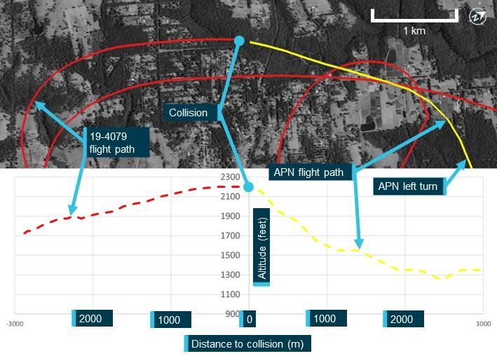
Source: Google Earth and Geoscience Australia, annotated by the ATSB
Context
Pilot information
The CPL candidate in APN held a Private Pilot Licence (Aeroplane). As part of the pilot’s pre‑licence test preparation, the pilot reported having a total of 237 flight hours. The pilot held a Class 1 Aviation Medical Certificate, with no restrictions, valid until 19 March 2025.
The flight test examiner in APN held an Air Transport Pilot Licence (Aeroplane) and a flight examiner rating for the Commercial Pilot Licence (Aeroplane). On 16 May 2024, as part of their aviation medical examination the pilot reported having a total of 25,214 flight hours. The pilot held a Class 1 Aviation Medical Certificate, with a requirement for reading correction to be available, which was valid until 16 November 2024.
The pilot of 19-4079 held a Recreational Aviation Australia (RAAus) pilot certificate,[5] with a cross‑country endorsement. On 4 April 2024, the pilot reported to RAAus having a total of 168 flight hours. The pilot had submitted a medical declaration to RAAus on 19 June 2022.[6]
Aircraft details
VH-APN
The Cessna Aircraft Company 182P is a 4-seat, high‑wing (strut-braced), single-engine aircraft equipped with fixed tricycle landing gear. It has a Teledyne Continental Motors O-470 engine and is fitted with a McCauley 2-blade, constant-speed propeller. APN was manufactured in the United States in 1976. It was placed on the Australian register that same year with a registration of VH‑RKC. The registration was changed to VH-APN in August 1996 and transferred to the current owner in 2021. APN was painted in a yellow (wings) and grey (fuselage) livery. Relevant surveillance and electronic conspicuity equipment:
- ADS-B not fitted
- mode A/C transponder.
19-4079
The Jabiru UL-450 is an amateur-built high-wing (strut-braced) light aircraft with fixed tricycle landing gear. It has a Jabiru 2200J, 4-cylinder engine. Construction of 4079 was completed in 2004 and it was placed on the RAAus aircraft register on 23 February 2004. The registration was transferred to the current owner in 2022. 4079 was painted white. Relevant surveillance and electronic conspicuity equipment:
- portable ADS-B transceiver
- transponder not fitted.
Wreckage and impact information
Wreckage location
The accident site was located about 2.7 km west of The Oaks aerodrome in heavily treed terrain. The 2 primary wreckage locations were approximately 520 m apart, with 4079 north of APN (018º True) (Figure 3). A debris field was located about halfway between the 2 main wreckage locations. Most wreckage items found in the central area were from the left wing of 4079, with a small number of components from APN. Most of the central wreckage was found within a radius of about 50 m.
Figure 3: Accident site location in relation to The Oaks
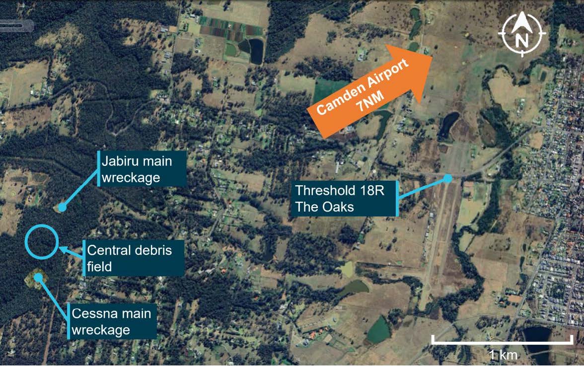
Source: Google Earth, annotated by the ATSB
Orientation of 4079 and APN during the collision
Yellow paint was found on portions of the left wing and left-wing strut of 4079, consistent with being transferred from APN. These areas of the left wing of 4079 also showed signs of leading‑edge penetration to about halfway through the wing chord, at about the mid-span position along the wing.
The left-wing strut of APN was found near the main wreckage of APN, consistent with being attached to this aircraft at the time of the collision with terrain. White paint was found in 2 places of this strut, with leading edge damage observed in these areas, consistent with being transferred from the left wing and left-wing strut of APN.
A relatively small dent with light coloured paint transfer was located on the leading edge of APN left wing, with a longitudinal light coloured paint transfer on the underside of the wing around this location. The upper vertical fin section of 4079 was not located. The relative orientation of the frontal left wing and left-wing strut damage on 4079 and left-wing strut damage on APN, was consistent with 4079 being upright during the collision. Based on the geometry of 4079, the coloured paint transfer on the underside of the left wing of APN was likely from the upper vertical fin section of 4079. This likely separated from the aircraft after being struck by the left wing of APN in the location of the light-coloured paint.
In summary, the paint transfer marks and damage observed onsite was consistent with APN and 4079 colliding on the left sides of each other on reciprocal headings. The left wing and left-wing strut of 4079 primarily impacted the left strut of APN, with the upper fin of 4079 striking the left-wing leading edge of APN.
19-4079 wreckage
Examination of the main wreckage site and surrounding broken tree branches for 4079 indicated that the aircraft had impacted the ground at a steep angle, with little forward movement, resulting in a localised wreckage field. The ATSB inspection found no evidence of pre-accident flight control damage.
All of the aircraft was accounted for, excluding a section of the outboard left wing, and the upper vertical fin. An aileron fitting for 4079 was co-located with the left wing of APN.
VH-APN wreckage
Witness marks in surrounding trees showed that APN impacted terrain in a steep nose down attitude. There was a significant post-impact fire at the primary wreckage site for APN, which limited the ability to examine the wreckage. The ATSB inspection of the available evidence did not identify any pre-accident flight control damage. The left wing of APN was located about 50 m from the main wreckage, consistent with this wing separating in flight.
Recorded data
Neither aircraft was equipped with a flight data recorder or cockpit voice recorder, nor were they required to be.
Transmitted and external data sources
The following recorded data has been gathered for this investigation:
- ADS-B data from 4079
- ATC audio data for APN
- CTAF audio data from Shellharbour Airport for APN
- closed-circuit television footage from a nearby residence showing post collision dynamics
- data transmitted/recorded from devices running electronic flight bag applications for APN, 4079 and 55-1837
- transponder data for APN.
19-4079 onboard camera
4079 was fitted with an onboard video camera that was attached to a roof panel inside the cabin. The ATSB recovered the camera at the accident site, which was downloaded at the ATSB’s technical facility in Canberra. Initial observations from the video include:
- 4079 had no evident technical problems during the flight
- the radio was selected to the frequency 126.7 at the time of the accident
- lights on the radio, along with the push-to-talk button indicated the pilot was transmitting and receiving radio calls during the flight
- 4079 and APN were both on relatively constant trajectories, with 4079 being straight and level and APN climbing at the time of the collision, with no avoiding action evident by either aircraft
- the aircraft were travelling on a generally reciprocal heading, impacting on the left side of each aircraft, with the fuselage of 4079 passing underneath the left wing of APN.
Aerodrome information
The Oaks aerodrome
The Oaks aerodrome was an aeroplane landing area,[7] located 7 NM (13.0 km) west-south-west of Camden Airport, New South Wales. It has an elevation of 880 ft above mean sea level and 2 parallel grass runways aligned in a north-south direction. Runway 18R/36L was 900 m long, while runway 18L/36R was 800 m. All circuits were conducted to the west of the aerodrome to avoid overflying the township of The Oaks. The Oaks utilised the shared CTAF designated radio frequency of 126.7.
The Oaks was a non-controlled aerodrome, where separation was maintained by ‘alerted see‑and-avoid’ principles guided by Civil Aviation Safety Authority advisory circulars AC 91‑10 Operations in the vicinity of non-controlled aerodromes and AC 91-14 Pilots’ responsibility for collision avoidance. These stated that pilots should broadcast position and intention information so that nearby traffic would have an awareness of the aircraft and be able to plan accordingly.
An icon and label for The Oaks aerodrome was published on all visual aeronautical charts.
Camden Airport
Camden Airport has an elevation of 230 ft above mean sea level. The main runway, 24/06, is paved. The airspace around Camden Airport was class D during towered hours when all aircraft were provided with an air traffic control service. During the accident flight the tower was active, with the tower communications on the radio frequency 120.1. The class D airspace extends in a 2 NM (3.7 km) radius around the airport.
Further investigation
To date, the ATSB has:
- examined the wreckage
- collected surveillance data from Airservices Australia
- collected OzRunways data for relevant aircraft
- collected pilot and aircraft records
- conducted interviews with relevant parties
- liaised with the NSW Police Force.
The investigation is continuing and will include consideration of the following:
- examination of aircraft components and other items recovered from the accident site
- further review of aircraft, pilot, aerodrome and operator documentation
- further analysis of video recordings and radio transmissions
- analysis of aircraft flight paths
- a review of similar occurrences
- analysis of procedures at non-controlled aerodromes
- further review of communication, electronic conspicuity and surveillance equipment, and interviews with relevant parties.
A final report will be released at the conclusion of the investigation. Should a critical safety issue be identified during the course of the investigation, the ATSB will immediately notify relevant parties so appropriate and timely safety action can be taken.

The ATSB SafetyWatch highlights the broad safety concerns that come out of our investigation findings and from the occurrence data reported to us by industry. One of the safety concerns is Reducing the collision risk around non-towered airports | ATSB.
Acknowledgements
The ATSB would like to acknowledge the significant assistance provided during the initial investigation response by the NSW Police Force.
Purpose of safety investigationsThe objective of a safety investigation is to enhance transport safety. This is done through:
It is not a function of the ATSB to apportion blame or provide a means for determining liability. At the same time, an investigation report must include factual material of sufficient weight to support the analysis and findings. At all times the ATSB endeavours to balance the use of material that could imply adverse comment with the need to properly explain what happened, and why, in a fair and unbiased manner. The ATSB does not investigate for the purpose of taking administrative, regulatory or criminal action. TerminologyAn explanation of terminology used in ATSB investigation reports is available here. This includes terms such as occurrence, contributing factor, other factor that increased risk, and safety issue. Publishing informationReleased in accordance with section 25 of the Transport Safety Investigation Act 2003 Published by: Australian Transport Safety Bureau © Commonwealth of Australia 2024 
Ownership of intellectual property rights in this publication Unless otherwise noted, copyright (and any other intellectual property rights, if any) in this report publication is owned by the Commonwealth of Australia. Creative Commons licence With the exception of the Commonwealth Coat of Arms, ATSB logo, and photos and graphics in which a third party holds copyright, this report is licensed under a Creative Commons Attribution 4.0 International licence. The CC BY 4.0 licence enables you to distribute, remix, adapt, and build upon our material in any medium or format, so long as attribution is given to the Australian Transport Safety Bureau. Copyright in material obtained from other agencies, private individuals or organisations, belongs to those agencies, individuals or organisations. Where you wish to use their material, you will need to contact them directly. |
[1] A multi-function, computerised, aeronautical information system that allows users, such as pilots, to obtain weather information and submit flight plans into the air traffic system.
[2] A common traffic advisory frequency is a designated frequency on which pilots make positional broadcasts when operating in the vicinity of a non-controlled airport, or within a broadcast area.
[3] An information system for flight crew members which allows storing, updating, delivering, displaying and/or computing digital data to support flight operations or duties.
[4] Above mean sea level (AMSL): All altitudes presented in this report are in AMSL unless otherwise specified.
[5] An authorisation for individuals to fly RAAus registered recreational aircraft in Australia.
[6] Applicants for an RAAus licence are required to have a health standard equivalent to that required for the issue of a private motor vehicle driver licence in Australia and may self-declare their medical status.
[7] An aeroplane landing area is an aerodrome that has not been certified by the Civil Aviation Safety Authority. These aerodromes are non-controlled, unregulated facilities. It is the responsibility of pilots and operators to determine whether these aerodromes are suitable for use.
Occurrence summary
| Investigation number | AO-2024-054 |
|---|---|
| Occurrence date | 26/10/2024 |
| Occurrence time and timezone | 11:46 Australian Eastern Daylight Time |
| Location | 2.7 km west of The Oaks |
| State | New South Wales |
| Report release date | 04/12/2025 |
| Report status | Interim |
| Anticipated completion | Q3 2026 |
| Investigation level | Defined |
| Investigation type | Occurrence Investigation |
| Investigation phase | Examination and analysis |
| Investigation status | Active |
| Mode of transport | Aviation |
| Aviation occurrence category | Collision |
| Occurrence class | Accident |
| Highest injury level | Fatal |
Aircraft details
| Manufacturer | Cessna Aircraft Company |
|---|---|
| Model | 182P |
| Registration | VH-APN |
| Serial number | 18264798 |
| Sector | Piston |
| Operation type | Part 91 General operating and flight rules |
| Activity | General aviation / Recreational-Instructional flying-Instructional flying - dual |
| Departure point | Shellharbour Airport, New South Wales |
| Destination | Shellharbour Airport, New South Wales |
| Injuries | Crew - 1 (fatal) |
| Damage | Destroyed |
Aircraft details
| Manufacturer | Jabiru Aircraft Pty Ltd |
|---|---|
| Model | UL 450 |
| Registration | 19-4079 |
| Serial number | 572 |
| Sector | Piston |
| Operation type | Part 103 Sport and recreational aircraft |
| Activity | General aviation / Recreational-Sport and pleasure flying |
| Departure point | The Oaks, New South Wales |
| Destination | Cessnock, New South Wales |
| Injuries | Crew - 1 (fatal) |
| Damage | Destroyed |