Preliminary report released 27 September 2024
This preliminary report details factual information established in the investigation’s early evidence collection phase, and has been prepared to provide timely information to the industry and public. Preliminary reports contain no analysis or findings, which will be detailed in the investigation’s final report. The information contained in this preliminary report is released in accordance with section 25 of the Transport Safety Investigation Act 2003.
The occurrence
On the morning of 25 July 2024, 4 Robinson Helicopter Company R22 Beta II aircraft were being operated at Mount Anderson Station, located about 51 km south-south-east of Curtin Airport, Western Australia. The helicopters were being used as part of a cattle mustering operation, which also included multiple land vehicles.
At about 0515 local time, a briefing was held by the lead pilot to cover the planned muster along a section of the Fitzroy River, a 10-minute flight to the west-north-west of the station homestead. This brief lasted around 15 minutes and was attended by the helicopter pilots and the head stockman, who provided input on where the ground crew would be located.
At about 0540, the pilots commenced their pre-flight preparations. VH-HQH (HQH) and VH-HYQ (HYQ) were parked in a grassed clearing behind the homestead and the other 2 helicopters, VH‑HMR (HMR) and VH-YKC (YKC), were parked about 400 m to the west. The helicopters were started just before 0600, and the pilots established communication with each other on a discreet company VHF radio frequency. The lead pilot in HQH radioed they were ready to depart and would lead the group out. This radio broadcast was acknowledged by the pilot of HYQ who replied that they would follow HQH.
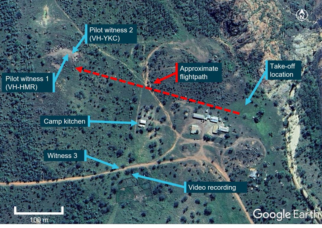
At 0603, HQH and HYQ departed the overnight parking area and flew west, to where the other 2 helicopters would join them (Figure 1). A witness (witness 3) located near the stockyards about 200 m to the south of the homestead watched the 2 helicopters accelerate away, climbing above the buildings and depart with HQH in front and HYQ following slightly lower and behind off to one side.
Figure 1: Witness locations
Source: Google Earth annotated by ATSB
The pilots in HMR and YKC saw both helicopters approach from above the tree line to the east at about 100 ft. The pilot of YKC, who was a few minutes behind in their own pre-flight preparations, recalled seeing the 2 helicopters flying together but did not detect a risk of collision at that point. They put on their helmet and checked their radio. The pilot in nearby HMR acknowledged the radio check and advised that they would lift into the hover. The pilots in HMR and YKC remembered hearing the lead pilot in HQH acknowledge this radio call with the reply “Yep, I see you there”. The pilot in HMR lifted into a low hover and the pilot of YKC turned their attention to their own machine when they heard the 2 aircraft collide.
Upon hearing the collision, the pilot of HMR looked up and saw that HQH was descending toward their location. Already established in the hover, the pilot manoeuvred the helicopter away to avoid being struck.
Following the mid-air collision, the pilots of HQH and HYQ were unable to maintain control and both helicopters collided with terrain and were destroyed. Both pilots sustained fatal injuries.
Context
Pilot information
Both pilots involved in the collision were authorised to conduct aerial mustering operations, and both held valid Class 1 aviation medical certificates with no restrictions.
The pilot of VH-HQH held a Commercial Pilot Licence (Helicopter) and low-level helicopter operational rating with an aerial mustering endorsement, 6 years of aerial mustering operation experience and had been with the operator for 4 years. They had about 4,750 total flight hours, with about 3,600 flight hours mustering, and about 4,250 flight hours in R22 helicopters. Their most recent flight review was a low-level single engine helicopter flight review on 1 April 2024.
The pilot of VH-HYQ held a Commercial Pilot Licence (Helicopter), low-level helicopter operational ratings with an aerial mustering endorsement, 4 years of aerial mustering operation experience and had been with the operator for 2 years. They had about 2,100 total flight hours, with about 1,350 flight hours mustering, and about 2,000 flight hours in R22 helicopters. They had conducted a low-level single engine helicopter flight review on 30 March 2024.
Aircraft information
The Robinson Helicopter Company R22 Beta II helicopter is powered by a 4‑cylinder carburetted piston engine. The R22 has 2 seats, with the pilot flying from the right seat, and each seat was fitted with a seatbelt and inertia reel shoulder strap, similar to those used in motor vehicles. The 2-blade main rotor assembly rotating counterclockwise when viewed from above.
Typical for mustering activities, the helicopters were being operated with both doors removed.
Figure 2: VH-HQH (left) and VH-HYQ (right)
Source: Helico
VH-HQH
VH-HQH, serial number 3936, was manufactured in the US in 2005 and first registered in Australia in September 2005 (Figure 2). The helicopter had undergone a periodic inspection along with a 2,200 hr / 12-year inspection/overhaul that was completed on 8 July 2024 at 6,087 hours total time-in-service. The current maintenance release was not located, however, the operator reported the helicopter had accrued about 60 hours since the rebuild.
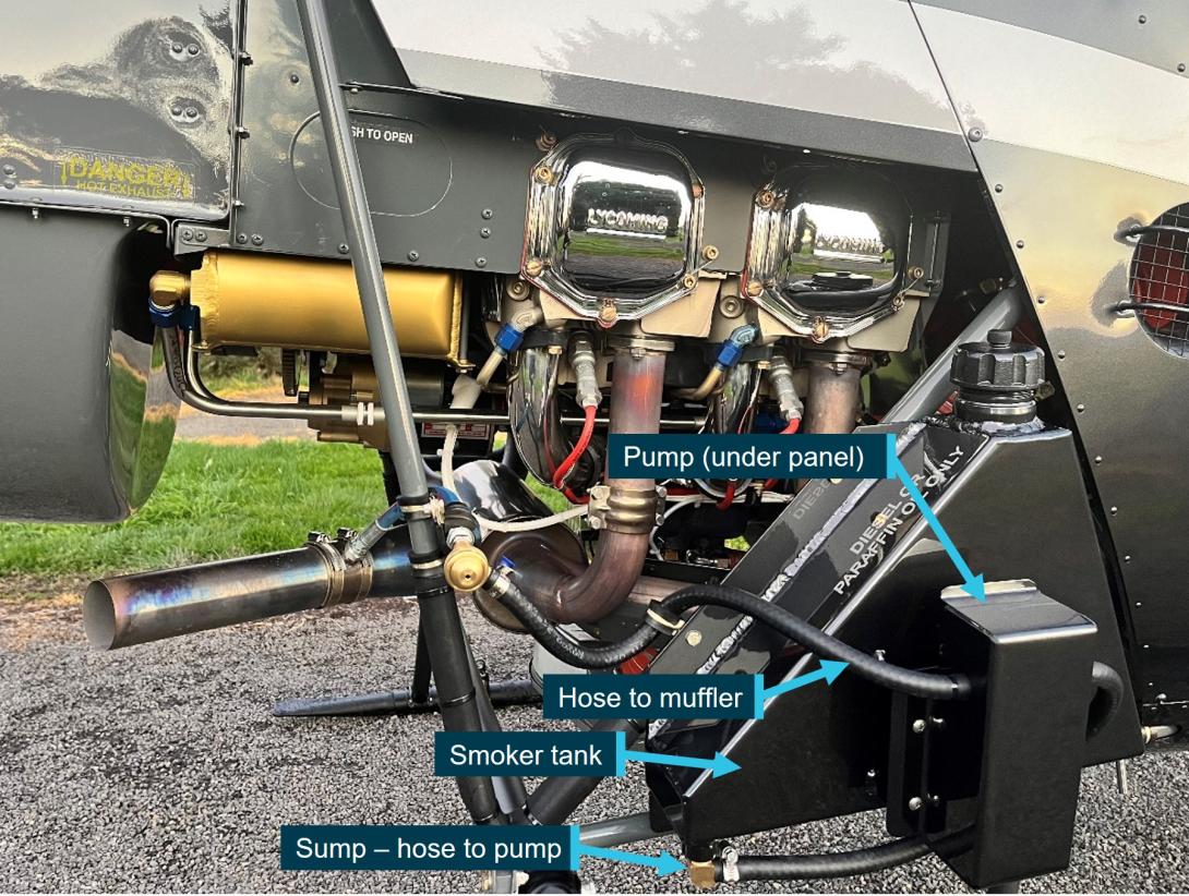
HQH was fitted with a smoker unit to aid in aerial mustering operations (Figure 3).[1] It consisted of a small tank (about 5 L capacity), that was filled with either diesel or paraffin oil and mounted on the right-side lower frame. A small integrated electrical pump activated by a trigger on the pilot’s controls would transfer the diesel from the tank into the exhaust outlet where it was vaporised by the exhaust heat creating a veil of smoke that was blown downward by the main rotor downwash.
Figure 3: VH-HQH smoker unit installation
Source: Helico, annotated by ATSB
VH-HYQ
VH-HYQ (HYQ), serial number 3835, was manufactured in the US in 2005 and first registered in Australia in May 2005 (Figure 2). A 2,200 hr / 12-year inspection/overhaul was completed in April 2023. The most recent periodic inspection, at 4,946 hours, was conducted on 19 July 2024. The current maintenance release was not located, however, the operator reported the helicopter had accrued about 40 hours since the last periodic inspection.
HYQ was not fitted with a smoker unit.
Meteorological information
Daylight
Geoscience Australia recorded the first light at Mount Anderson Homestead at 0551 and sunrise at 0614. This was consistent with witness reports and a video recording which confirmed that the collision (0603 local) occurred after first light but before sunrise.
Weather
Due to the remote location of the site, there were no official weather observations available. The nearest official data was obtained from Curtin Airport located 51 km to the north-west of Mount Anderson Station.
While the Graphical Area Forecast (GAF)[2] that covered Mount Anderson Station and was valid at the time of the accident included isolated fog, witnesses and the video indicated there was no fog at the station. The Terminal Forecast (TAF)[3] obtained for nearby Curtin Aerodrome indicated CAVOK[4] conditions with a southeast breeze (150°) around 8 kt.
Site and wreckage
The accident site was located about 300 m west-north-west of the historic Mt Anderson homestead (Figure 1). Power to the homestead buildings was produced via generator. There were some low power lines immediately above, and close to, the roof line but there were no power lines situated on the flight path. The local vegetation was dry, low open woodland. There was no evidence of any wildlife or tree strike in the vicinity of the start of the debris trail.
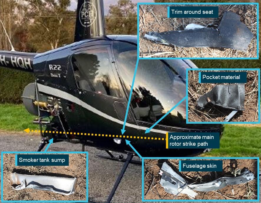
The first items in the debris field, about 300 m west-north-west of the take-off location, were consistent with a rotor blade strike to the right side of HQH (Figure 4), and consisted of:
- smoker unit pump cover panel
- smoker tank sump (separated horizontally from most of the upper portion of the tank)
- smoker unit lower (horizontal) mount
- fuselage skin from just forward of right position light
- right seat ‘pocket’ material section (located on forward panel of the pilot seat structure)
- trim from around the forward and right edges of pilot seat.
Figure 4: VH-HQH (pre-accident) showing approximate location of rotor strike location and locations of first items in debris field
Source: Helico and ATSB, annotated by ATSB
The debris trail then consisted of HQH components including tailcone, tail rotor driveshaft and tail rotor control tube sections, tail rotor gearbox and blades and stabiliser assembly. HYQ liberated components included the stabiliser assembly and section of one tail rotor blade.
Both helicopters’ masts fractured mid-length, and both main rotor head assemblies, with blades attached, were located about 10 m apart and about 70 m from the start of the debris trail. The fuselage of HQH was located 9 m west of its rotor head, lying on its right side on an approximate north-north-east orientation. The fuselage was destroyed by fire.
HYQ impacted terrain on its left side and slightly nose down. The impact site contained multiple pieces of windshield and other cabin components. The next ground scar, about 10 m further in a westerly direction, was consistent with the right skid. The helicopter came to rest upright, with the belly resting on top of a termite mound. The nose of the fuselage was about 1 m south of the skid ground scar and facing a north‑easterly orientation. The main fuel tank bladder was destroyed by impact forces. The auxiliary fuel tank assembly was ejected, likely at the second impact. Its outer structure was impact damaged, however, the bladder remained intact.
Wreckage examination of both helicopters identified all the major components were present at the accident site with no evidence of an in‑flight break-up prior to the mid-air collision. Flight control continuity of HYQ was established. The fire damage to HQH limited the extent to which the flight controls could be examined, however, where flight control tubes had been destroyed, security was established through control tube rod ends being secured to identified controls and bellcranks.
Samples of fuel taken from HYQ’s auxiliary tank and gascolator were visually examined and noted to be clean and clear of visible debris. The samples were also tested for the presence of water, with nil indication. Further, all 4 helicopters had been using the same bulk fuel with no quality issues reported.
Recorded data
Neither helicopter was equipped with a flight data recorder, tracking device or on board camera, nor were they required to be. Both aircraft were equipped with portable GPS units which were located onsite and taken to the ATSB’s technical facility in Canberra for further examination.
Video of livestock in a nearby yard was recorded at the time of the accident. While it did not contain any footage of the helicopters, it did capture audio of the departure and the collision.
A smart watch, which may contain additional information or data, was retained for further examination.
Safety action
Following the accident, the operator conducted a review of the operations manual and revised procedures for operations involving multiple aircraft and the operation in the vicinity of other aircraft. These changes were contained in a company notice to air crew (NOTAC) and all pilots were briefed on the changes prior to resuming flying operations.
Further investigation
To date, the ATSB has examined the accident site and wreckage, collected meteorological data from the Bureau of Meteorology, collected operator, pilot and aircraft related records, conducted interviews, and liaised with the Western Australia Police Force.
The investigation is continuing and will include further examination and analysis of:
- weather conditions at the time of the accident
- components retained from both helicopters
- witness information
- analysis of recorded audio
- download and analysis of the electronic items retrieved from the accident site
- pilot qualifications, experience and medical histories
- aircraft maintenance and operational records
- operational documentation and procedures
- visibility from both helicopters.
Should a critical safety issue be identified during the course of the investigation, the ATSB will immediately notify relevant parties so appropriate and timely safety action can be taken.
A final report will be released at the conclusion of the investigation.
Purpose of safety investigations
The objective of a safety investigation is to enhance transport safety. This is done through:
- identifying safety issues and facilitating safety action to address those issues
- providing information about occurrences and their associated safety factors to facilitate learning within the transport industry.
It is not a function of the ATSB to apportion blame or provide a means for determining liability. At the same time, an investigation report must include factual material of sufficient weight to support the analysis and findings. At all times the ATSB endeavours to balance the use of material that could imply adverse comment with the need to properly explain what happened, and why, in a fair and unbiased manner. The ATSB does not investigate for the purpose of taking administrative, regulatory or criminal action.
Terminology
An explanation of terminology used in ATSB investigation reports is available here. This includes terms such as occurrence, contributing factor, other factor that increased risk, and safety issue.
Publishing information
Released in accordance with section 25 of the Transport Safety Investigation Act 2003
Published by: Australian Transport Safety Bureau
© Commonwealth of Australia 2024

Ownership of intellectual property rights in this publication
Unless otherwise noted, copyright (and any other intellectual property rights, if any) in this report publication is owned by the Commonwealth of Australia.
Creative Commons licence
With the exception of the Coat of Arms, ATSB logo, and photos and graphics in which a third party holds copyright, this publication is licensed under a Creative Commons Attribution 3.0 Australia licence.
Creative Commons Attribution 3.0 Australia Licence is a standard form licence agreement that allows you to copy, distribute, transmit and adapt this publication provided that you attribute the work.
The ATSB’s preference is that you attribute this publication (and any material sourced from it) using the following wording: Source: Australian Transport Safety Bureau
Copyright in material obtained from other agencies, private individuals or organisations, belongs to those agencies, individuals or organisations. Where you wish to use their material, you will need to contact them directly.
|
[1] The smoker unit is used to direct cattle or to deter them from running back on the helicopter by creating a veil of smoke that is blown down below the helicopter.
[2] GAF (Graphical Area Forecast): provides information on weather, cloud, visibility, icing, turbulence and freezing level in a graphical layout with supporting text.
[3] TAF (Aerodrome Forecast): a statement of meteorological conditions expected for the specified period of time in the airspace within 5 NM (9 km) of the aerodrome reference point.
[4] Ceiling and visibility okay (CAVOK): visibility, cloud and present weather are better than prescribed conditions. For an aerodrome weather report, those conditions are visibility 10 km or more, no significant cloud below 5,000 ft, no cumulonimbus cloud and no other significant weather.


