
What happened
On 4 January 2015, the pilot of a Beechcraft 76 aircraft, registered VH-ZUA (ZUA), commenced a ferry flight from Archerfield to the Gold Coast, Queensland. The private flight was conducted under the visual flight rules (VFR), and the pilot was the sole person on board. The aircraft departed Archerfield at about 1200 Eastern Daylight Time (EDT), and climbed to a planned cruising level of 1,500 ft above mean sea level.
Figure 1: Gold Coast VTC
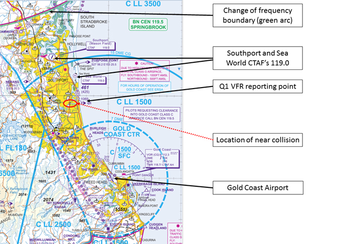
Source: Airservices Australia: Visual Terminal Chart modified by the ATSB
At about 1210, as ZUA approached the change of frequency boundary (Figure 1) just north of Dreamworld, the pilot changed to the area frequency (119.5 MHz) on COMM 1[1] with the Southport CTAF frequency (119.0 MHz) in the standby section of the Garmin 530. As he approached Southport airport, the pilot moved the standby frequency (119.0 MHz) into the active box and as required, broadcast the aircraft’s position and intentions. The CTAF frequency is common to both Southport Airport and the nearby Sea World helipad (Figure 1).
At about 1212, the pilot of an AS350 helicopter, registered VH-SWX (SWX) prepared to depart from Sea World, Queensland, for a 15 minute local commercial scenic flight. The first sector was from Sea World to overhead the Robina shopping centre (Figure 2). On board were the pilot and 5 passengers.
The pilot obtained the Gold Coast automatic terminal information service (ATIS) prior to becoming airborne at about 1215 and broadcasting his intentions on the Sea World CTAF frequency of 119.0 MHz (the same frequency as the Southport CTAF). As a small sector of the scenic flight was to be conducted in the Gold Coast control Zone, the pilot obtained a transponder code from Gold Coast Ground air traffic control soon after the helicopter had departed.
At about 1220, as ZUA neared the Q1 VFR reporting point (Figure 1), the pilot requested and obtained a clearance from the Gold Coast tower controller to enter the control zone. The pilot acknowledged and read back the clearance, which was to track from his present position direct to the Gold Coast airport at 1,500 ft. Soon after, the tower controller issued the pilot a Safety Alert, advising of traffic in his 10 o’clock position[2], 2 NM and tracking west (toward ZUA) at an unverified level of 1,400 ft (Table 1). The pilot acknowledged the Safety Alert, advising the tower controller that the traffic was in sight.
Figure 2: Approximate flight path of ZUA and SWX

Source: Airservices Visual Terminal Chart modified by ATSB
Table 1: Summary of radio communication by ZUA and SWX
| Time | Action | Frequency MHz | Content |
| 1215 | SWX departed helipad for a 15 minutes scenic flight | CTAF 112.3 CTAF 119.0GC Ground (SMC) 121.8 | COMM 2 (Obtained ATIS from Gold Coast)COMM 1 Airborne Sea World; on climb to 1,500 tracking for Robina.(COMM2 was tuned to Gold Coast Ground to obtain a transponder code for the sector of the flight which transited through controlled airspace). |
| 1219.58 | Approaching Q1, ZUA to TWR | 118.7 | Advised TWR that ZUA was approaching Q1, 1,500 inbound and in receipt of the current ATIS and requested a clearance to enter the Control Zone. |
| 1220.14 | Gold Coast TWR to ZUA | 118.7 | Cleared ZUA direct to the Gold Coast, 1,500 with an expectation for a straight in approach to RWY 14. |
| 1220.22 | ZUA to TWR | 118.7 | Pilot read back the clearance |
| 1220.28 | TWR to ZUA | 118.7 | Issued ZUA with a SAFETY ALERT for traffic in their 1000 position, 2 NM and tracking west unverified level 1,400 ft |
| 1220.51 | ZUA to TWR | PIC reported traffic sighted | |
| 1221.18 | Centre to ZUA | 119.5 | Issued ZUA with a SAFETY ALERT for traffic in their 10 o’clock position same level, and half a mile. Centre called twice but did not receive a response from the PIC of ZUA. |
| 1221.29 | Centre to TWR | Issued a SAFETY ALERT to TWR. TWR advised that the pilot of ZUA had been issued a SAFETY ALERT for traffic | |
| 1221.42 | Near Collision | ||
| 1221.57 | ZUA to TWR | 118.7 | Reported to TWR that he had just taken evasive action to avoid the helicopter, and was now tracking to the Gold Coast again |
| 1223.40 | SWX to TWR | 118.7 | PIC obtains clearance to enter the Gold Coast control zone and also requests further information about ZUA |
| 1224.00 | SWX to TWR | 118.7 | PIC advised TWR that a fixed wing aircraft [ZUA] had passed from behind about 30 ft over the top of the helicopter. He had made two calls on 119.0 to make contact with the pilot but had not received a reply |
Source: Airservices Australia
Also noticing the short-term conflict alert (STCA) (Figures 3 and 4) on the air situation display, the Brisbane Centre controller twice attempted to make contact with ZUA which was still in uncontrolled airspace; but there was no response. The controller then contacted the Gold Coast tower controller via the internal coordination line, to confirm that a safety alert had been issued. The tower controller advised the Brisbane Centre controller that a safety alert had already been issued and the situation was under control.
Soon after, while distracted by entering and changing frequencies on both COMM 1 and COMM 2, the pilot of ZUA had lost sight of SWX and turned his attention to visually re-acquire the helicopter. The pilot then realised that the helicopter was not flying parallel to his course as he had initially thought; but was on a collision course with ZUA and at a similar altitude. The pilot initiated a short climb and a steep right turn in ZUA. He did not see SWX during this evasive manoeuvre, so turned left and continued to the Gold Coast as cleared, and advised the tower controller of the conflict and subsequently landed.
Figures 3: Radar surveillance data

Time: 2.21.37 ZUA at 1,500 ft; SWX 1,500 ft; about 100 m horizontally
STCA – Short term conflict alert
Source: Airservices Australia
Figures 4: Radar surveillance data

Time: 2.21.42 Near collision
ZUA at 1,500 ft; SWX 1,500 ft; Nil horizontal distance showing on radar
Source: Airservices Australia
The traffic collision avoidance system (TCAS) on board the helicopter did not alert the pilot to the potential conflict, possibly because ZUA overflew the helicopter from behind, which may have shielded the TCAS aerial.
VH-ZUA radio equipment
ZUA had Garmin 530 and Garmin 430 units installed.
VH-SWX radio equipment
SWX had two communication navigation (COMM NAV) units installed, also allowing the pilot to have two active and two standby radio frequencies selected. SWX also had a terrain collision avoidance system (TCAS) fitted.
VH-ZUA pilot experience and comments
The pilot had around 270 hours total time, with about 38 hours on the B76 type aircraft. He had been undergoing training for a multi-engine command instrument rating (MECIR), and this positioning flight was his first solo flight in the aircraft.
He recalled being advised about conflicting traffic by the Gold Coast tower controller, and recalled having responded ‘traffic sighted’. He reported when he first sighted SWX, he incorrectly thought it was tracking parallel to ZUA, and did not appear to be getting any closer. Hence, he turned his attention to trying to reset the CTAF of 119.0 MHz on COMM1, to enable him to communicate with the helicopter. At this stage, he had changed the selected frequencies to having the Gold Coast tower frequency on COMM 1, and the ATIS and CTAF on COMM 2. Then he changed COMM 2 to have the Gold Coast Ground frequency selected in preparation for taxi after landing.
During the process of entering, changing and selecting frequencies on the two COMM sets, his attention had shifted from keeping the helicopter in sight, to attempting to communicate with it and arrange clearances.
He reported that at this stage SWX appeared to have ‘turned toward him’[3] and as he watched it he realised it was heading directly at ZUA. He commenced evasive action by initiating a brief climb and a steep turn to the right. His intention was to parallel the track of the helicopter and keep it in sight.
Additionally, he reported that his sleep the night before had been disturbed.
VH-SWX pilot experience and comments
The pilot held a Commercial licence (Helicopter) and had around 6,500 hours flying experience. The pilot commented that the first awareness of ZUA was when it passed over the helicopter from behind.
Safety message
This incident highlights the importance of having the correct radio frequencies planned and correctly set up prior to and during flight and the need for vigilance when keeping conflicting traffic in sight. Pre-flight preparation is an essential part of safe flying operations and can prevent a loss of situational awareness and avoid the pilot’s attention being focused for long periods inside the cockpit.
- CASA has developed the Look out! Situational awareness DVD for pilots to learn more about the safety-critical skills that makes up situational awareness. There is a strong emphasis on the need to prepare and plan for every flight. The DVD gives a definition of situational awareness of “what’s happened, what’s happening and what might happen”.
The CASA DVD is available from the CASA online store here: http://shop.casa.gov.au/products/look-out-situational-awareness-dvd
Aviation Short Investigations Bulletin - Issue 42
Purpose of safety investigationsThe objective of a safety investigation is to enhance transport safety. This is done through:
It is not a function of the ATSB to apportion blame or provide a means for determining liability. At the same time, an investigation report must include factual material of sufficient weight to support the analysis and findings. At all times the ATSB endeavours to balance the use of material that could imply adverse comment with the need to properly explain what happened, and why, in a fair and unbiased manner. The ATSB does not investigate for the purpose of taking administrative, regulatory or criminal action. TerminologyAn explanation of terminology used in ATSB investigation reports is available here. This includes terms such as occurrence, contributing factor, other factor that increased risk, and safety issue. Publishing informationReleased in accordance with section 25 of the Transport Safety Investigation Act 2003 Published by: Australian Transport Safety Bureau © Commonwealth of Australia 2015
Ownership of intellectual property rights in this publication Unless otherwise noted, copyright (and any other intellectual property rights, if any) in this report publication is owned by the Commonwealth of Australia. Creative Commons licence With the exception of the Coat of Arms, ATSB logo, and photos and graphics in which a third party holds copyright, this publication is licensed under a Creative Commons Attribution 3.0 Australia licence. Creative Commons Attribution 3.0 Australia Licence is a standard form licence agreement that allows you to copy, distribute, transmit and adapt this publication provided that you attribute the work. The ATSB’s preference is that you attribute this publication (and any material sourced from it) using the following wording: Source: Australian Transport Safety Bureau Copyright in material obtained from other agencies, private individuals or organisations, belongs to those agencies, individuals or organisations. Where you wish to use their material, you will need to contact them directly. |
__________
- COMM 1 (Garmin 530) COMM 2 (Garmin 430) were the very high frequency (VHF) radios fitted to the aircraft allowing an active and a standby frequency in each box
- The clock code is used to denote the direction of an aircraft or surface feature relative to the current heading of the observer’s aircraft, expressed in terms of position on an analogue clock face. Twelve o’clock is ahead while an aircraft observed abeam to the left would be said to be at 9 o’clock
- SWX was on a direct track to overhead Robina town centre. Hence the potential conflict and alert by ATC. The pilot of ZUA has incorrectly assessed the helicopter as previously paralleling ZUA’s track and then turning toward him.