An ATSB investigation has found irregular flight school practices likely contributed to a pilot’s inadequate understanding of stall conditions prior to a fatal light aircraft accident north of Sale, in Victoria’s east.
On 16 November 2024, an amateur-built experimental certificate Morgan Cougar Mk 1 light aircraft took off from West Sale Airport, in Victoria’s Gippsland region, for a local area flight, with a pilot and two passengers on board.
All three occupants were fatally injured when the aircraft collided with terrain in a paddock, 17 minutes later.
Witness statements, CCTV, flight data and site and wreckage examination led the ATSB to conclude the aircraft had entered an accelerated stall while in a steep turn.
“The stall occurred during the third orbit over the area, the lowest and slowest of the three,” Chief Commissioner Angus Mitchell explained.
“As the aircraft turned steeply to the left it entered a stall, at a height too low to recover.”
The ATSB’s final report notes the pilot held a valid pilot licence, granted by the Civil Aviation Safety Authority (CASA) three months before the accident, in recognition of the pilot already holding a recreational pilot certificate issued earlier by Recreational Aviation Australia (RAAus).
“During this investigation the ATSB interviewed several parties involved with the Adventure Flight Training school, where the pilot acquired their RAAus certificate,” Mr Mitchell said.
“These accounts, as well as an examination of available records, identified a series of irregularities with the way the school trained and examined its pilots for certification.”
A specific review of the pilot’s exam history revealed several errors about aerodynamic stalling in exams conducted during 2024, and it was concluded the pilot likely had inadequate knowledge of the relationship between angle of bank, load factor and stall speed.
“The pilot had a reported history of conducting low flying and slow steep turns,” Mr Mitchell said.
“In addition, the aircraft was newly acquired by the pilot, and they had not received transition training, so were likely unaware that, while the accelerated stall characteristics of the accident aircraft were unknown, there were indications that it would be abrupt.”
It was also found that the pilot had been counselled on several occasions about unsafe flying practices, but nothing was reported to any authorities, and therefore no official follow-up action was ever initiated.
“The investigation revealed a trend of risky flying behaviour by the accident pilot, which was likely compounded by inadequate knowledge from a flight training school that had developed irregular practices in the delivery of training and had inadequate supervision,” Mr Mitchell summarised.
“While many people knew of the pilot’s risky flying behaviour and had attempted to counsel them, there was no evidence that any of the incidents were reported to authorities, and the counselling efforts were ultimately unsuccessful.”
The ATSB has previously advocated for witnesses, particularly those within the aviation industry, to report any concerns regarding unsafe behaviours through mechanisms such as confidential reporting systems, and Mr Mitchell reiterated this message.
The ATSB’s investigation also noted that, as the approved self-administering organisation for recreational aviation, RAAus administered the examination system.
“The ATSB found RAAus had inadequate controls to mitigate the irregular examination practices identified at the flying training school,” Mr Mitchell said.
Prior to the accident in 2024, RAAus identified problems at Adventure Flight Training and issued a safety related suspension notice against its chief flying instructor, which resulted in cessation of flight school operations in August 2024, three months before the accident.
After the accident, RAAus issued another safety related suspension, this time against all Adventure Flight Training school graduates, for potential knowledge deficiencies.
However, when CASA was advised of this action, it did not follow up to verify if any of those graduates had, like the accident pilot, used their RAAus certificates to acquire a CASA licence.
“It was subsequently found that two more pilots held a CASA-issued licence, granted based on the RAAus certificates they had earned at the Adventure Flight Training school,” Mr Mitchell said.
RAAus has commenced a digital systems redevelopment project, which includes its learning management system, and incorporates the implementation of an online exam system.
CASA has implemented a more robust process to ensure that all reports received relating to suspensions, variations or cancellations of authorisations issued by an approved self‑administering organisation, such as RAAus, will trigger a review of CASA records.
Aircraft design deficiencies also identified
The ATSB investigation also identified the accident aircraft had design deficiencies, which contributed to the severity of the occupants’ injuries.
“These issues included a lack of energy attenuation in the landing gear and seating, and the installation of a fuel tank between the engine and instrument panel that ruptured and caused the post-crash fire,” Mr Mitchell said.
“Given the importance of energy attenuation for crashworthiness, and the susceptibility of aircraft fuel tanks to rupturing, the ATSB concluded that the amateur-built industry could benefit from additional guidance in these areas,” Mr Mitchell said.
However, the final report notes, CASA’s guidance material for amateur-built experimental aircraft does not recommend consideration of the crashworthiness of seating and fuel tank installation.
“These characteristics within the design of the aircraft, in this case, increased the risk of occupant injuries, and I would urge amateur builders and designers to consider these factors for their own aircraft,” Mr Mitchell concluded.
An E190 airliner had a slat failure on approach to Launceston, Tasmania, after a torque tube was incorrectly installed during recent maintenance, an ATSB investigation report details.
On 15 April 2025, the Alliance Airlines-operated Embraer E190 was commencing approach to Launceston when the flight crew observed multiple caution messages, including a slat failure.
After actioning relevant checklists, the flight crew opted to divert to Melbourne Airport, the longest available runway in the region, and conducted a flapless landing without further incident.
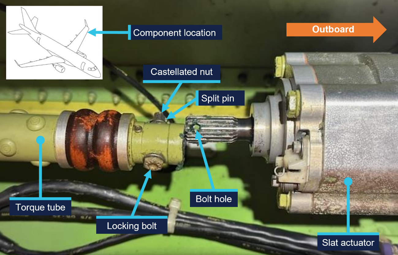
A post-flight inspection found one of the torque tubes in the left wing’s slat system had disconnected, because the locking bolt designed to secure it to the actuator had not been correctly fitted.
The error was tracked to a scheduled task carried out when the aircraft was under maintenance between November 2024 and March 2025. The aircraft flew 50 post-maintenance flights before the incident.
A similar occurrence involving another Alliance E190 was also identified, where a torque tube in the left wing’s flap drive system had disconnected after it was incorrectly assembled when it was last refitted.
“In both occurrences the locking bolts that secured the torque tubes to their actuators had not been fitted correctly into the holes of the splined shafts, since the torque tubes had been incorrectly positioned during installation,” ATSB Director of Transport Safety Dr Stuart Godley explained.
“In both occurrences, those carrying out and those certifying the torque tube installations did not identify that they had been incorrectly assembled before the aircraft were released back into service.”
Aircraft manufacturer Embraer reported five similar occurrences relating to incorrect torque tube installation involving E170, E175 and E190 aircraft (which share similar componentry) between 2005 and 2011.
Embraer subsequently made amendments to the aircraft maintenance manual to reduce the possibility of assembly errors, with changes communicated in multiple documents available to operators and maintainers of E190s.
“Historical occurrence and technical information provide an opportunity to review known errors prior to commencing particular maintenance activities,” Dr Godley said.
“Information on previous errors can be available from multiple sources including the manufacturer, national aviation authorities, accident investigation authorities, and within operators’ safety management systems.”
As a result of its two occurrences, Alliance Airlines issued a maintenance notice, detailing both incidents and reiterating the aircraft maintenance manual information for the correct installation of flap and slat torque tubes.
The maintenance organisation added an additional task card, which is automatically issued when work is scheduled on the E190 slat system torque tubes, to provide guidance in addition to the aircraft maintenance manual.
On 5 January 2026, a Helicorp Leonardo Helicopters AW139 with 4 crew on board departed from its Canberra base in the Australian Capital Territory on a medical transport task to the Snowy Mountains, New South Wales. The task was the retrieval of a sick/injured hiker. While in the hover, after commencing to winch the paramedic down to the hiker’s location, the main rotors struck a tree, which had been previously identified by the crew as the nearest obstacle to the helicopter.
What the ATSB found
The crew positioned the helicopter with the nearest obstacle (a tree) in the pilot's blind spot prior to the pilot assuming sole responsibility for clearances to allow the air crew officer and paramedic to prepare for winching. Subsequently, the helicopter started to drift to the left prior to the air crew officer resuming responsibility for clearances.
The pilot did not detect and correct the helicopter’s drift towards its nearest obstacle while in the hover, which resulted in the main rotor striking the tree.
What has been done as a result
Following this occurrence, the operator:
released an operations manual bulletin to provide additional guidance on helicopter clearance limits and included an increased minimum lateral clearance of 20 ft (6 m) for the main rotors under all conditions
initiated a working group with the tasking agency to improve their operations
undertook post-incident assurance activities with the flight crew prior to their return to operations
conducted an updated refresher session on verbal escalation during sterile cockpit procedures
included methods and terminology for escalation in its current human factors training program.
Safety message
Always consider and plan for escape path options in mountainous terrain wherever practicable. In preparation to conduct the winch, the crew positioned the helicopter facing downslope, in the opposite direction to the approach. This provided the pilot with an escape path option for the helicopter, which they used immediately after the main rotor strike occurred.
In addition, the use of minimum clearances in confined areas should be limited to those occasions when the nearest obstacle(s) can be actively monitored by appropriately trained crew. If this is not achievable, then use greater margins wherever practicable.
The investigation
The ATSB scopes its investigations based on many factors, including the level of safety benefit likely to be obtained from an investigation and the associated resources required. For this occurrence, the ATSB conducted a limited-scope investigation in order to produce a short investigation report and allow for greater industry awareness of findings that affect safety and potential learning opportunities.
The occurrence
On 5 January 2026, at 1616 local time, a Helicorp (Toll Helicopters) Leonardo Helicopters AW139 with 4 crew members on board departed from its Canberra base in the Australian Capital Territory on a medical transport task to the Snowy Mountains, New South Wales. The task was a likely winch retrieval of a sick/injured hiker. The crew consisted of the pilot in the front right seat, air crew officer (ACO) in the front left seat, paramedic in the forward right cabin seat, facing rearwards, and doctor in the forward left cabin seat, facing rearwards.
En route to the reported location, the pilot assessed the helicopter’s performance and estimated that they would be 200 kg overweight for a winching operation. Consequently, the crew decided to conduct a search first, to confirm the hiker’s location and burn fuel, before conducting a power check and deciding if the doctor could remain on board for the winching. About 30 minutes after take-off, the paramedic detached from their harness and transitioned to a wander lead1 to prepare for the winching. The pilot also cleared the ACO to transition from the front left seat to the cabin and onto a wander lead.
On approach to the reported location, the low flying checks were completed, and the ACO opened the right cabin door for the search. The pilot then saw a flare appear below them on the right side of the helicopter and the ACO identified the hiker near a waterfall in a re-entrant,2 which was the reported location. They assessed that the helicopter would need to be flown slowly up the re-entrant towards the waterfall and then turned around prior to winching, to provide an escape route down the valley.
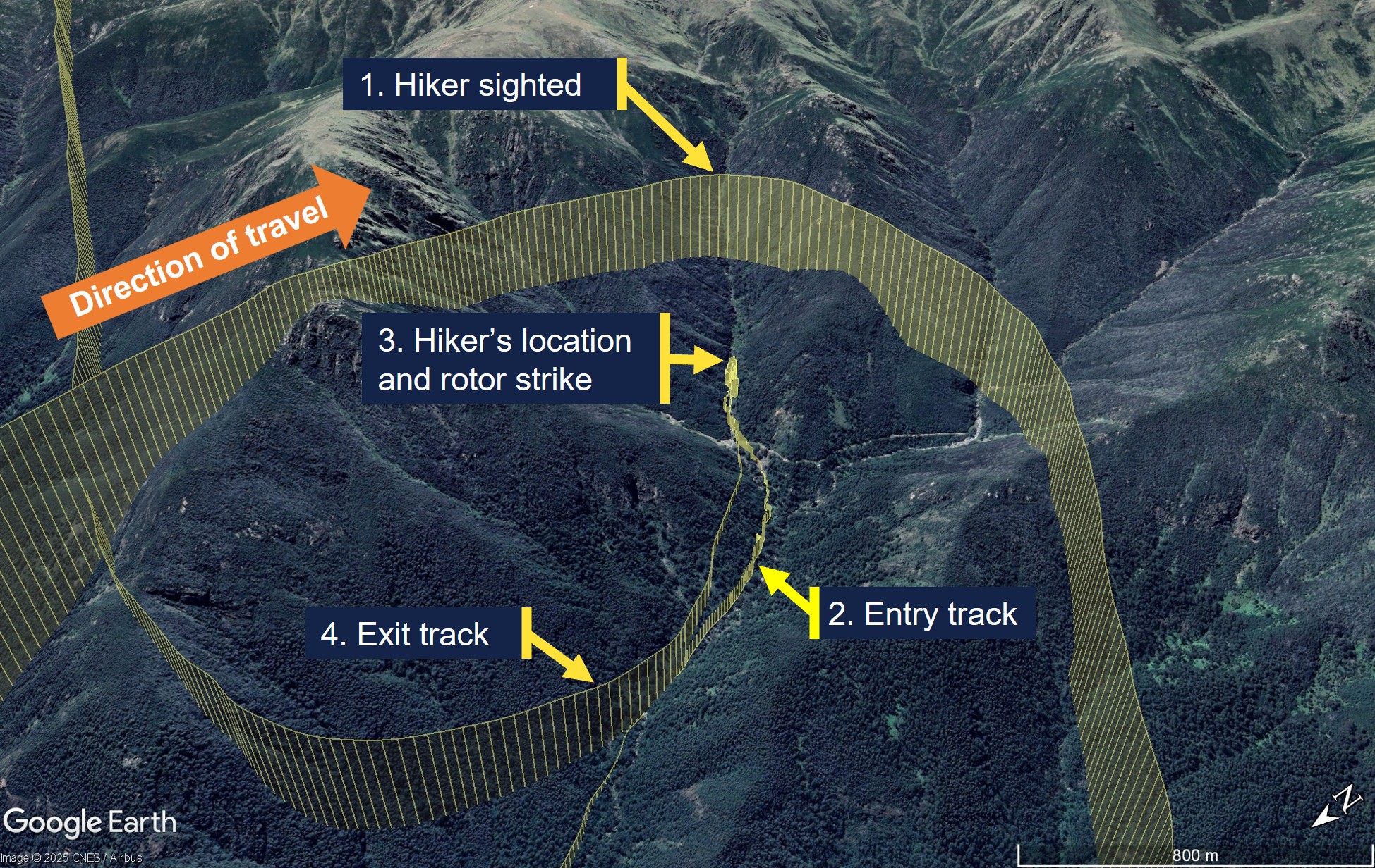
The crew conducted their winch checks and then the pilot conducted the power check and confirmed that the helicopter had sufficient power margin to keep the doctor on board for the winching. The helicopter then descended into the re-entrant and transited up the left side at slow speed (Figure 1). Before they reached the hiker’s location, the pilot momentarily stopped the transit as they experienced a ‘power-suck’3 and assessed that they had a tail wind. When the power stabilised, the pilot turned the helicopter around and reversed the helicopter into the re-entrant for the final 200 m to the hiker’s location.
Figure 1: Entry and exit tracks to the hiker’s location and rotor strike
Source: Toll Group and Google Earth, annotated by the ATSB
After turning the helicopter around, the left cabin door was opened to facilitate the ACO providing obstacle clearances to the pilot who reported that abort options were now down the valley. The crew took about 5 minutes to position the helicopter, assess the power and confirm that they were ready to winch. During this period, the ACO alternated between the open left and right cabin doors and announced clearances to the pilot, identifying the respective door from which they were provided.
The ACO briefed the pilot that the nearest obstacle was 20 ft away in the 8–9 o’clock position (left side) and directed the paramedic to the right cabin door to assess the ground below and plan the winching operation. The pilot subsequently asked if they could descend further and the ACO moved to the left door and instructed the pilot to descend 20 ft and move back 10 ft. This reduced the risk of a conical spin developing, due to the wind conditions in a narrow insertion point. After descending and backing further into the re-entrant, the pilot reported to the crew that they were starting to experience recirculation4, which was increasing the power requirements. Once all indications were normal and within limits, the pilot confirmed the winch operation could proceed. The paramedic and ACO then agreed on their winching location.
Prior to starting the winching, the left door was closed for cabin security. Before the ACO closed the left door, they briefed the pilot that the nearest obstacle was now a tree, 10 ft ‘above and to the left’ (this was 10 ft laterally in the 7–8 o’clock position and above the main rotor disk), and that there were also treetops about 35 ft below on the left. After the ACO closed the left cabin door, they pointed to the nearest obstacle through the window while instructing the doctor ‘that’s yours [name], keep an eye on that’, which the doctor acknowledged.
The ACO asked the pilot if they had a good hover reference, to which the pilot responded in the affirmative. The ACO then announced they were bringing the winch in to get the paramedic ready and that their ‘eyes are inside’, to which the pilot responded, ‘I’ve got the scan’. The ACO and paramedic conducted their pre-winch checks, and the paramedic was brought outside the right door on the winch, at which point the ACO confirmed with the pilot that they were clear to winch. However, before they started to winch, the ACO announced they needed to do the pre-winch brief and aircraft performance brief.
While the ACO was conducting the brief, the doctor was becoming concerned about the obstacle clearance on the left side but did not want to interrupt the ACO during safety‑critical checks. As soon as the ACO completed the briefs and started to winch the paramedic down, the doctor announced they had moved left ‘slightly’, and the ACO immediately cleared the pilot to move right ‘10’. This was followed by escalating calls from the ACO to the pilot to move right. As the pilot attempted to correct to the right, the main rotor struck the tree, and the calls from the ACO immediately changed to ‘move forward’. The pilot then transitioned the helicopter to forward flight while the ACO recovered the paramedic on the winch back into the cabin.
After the helicopter transitioned to forward flight, the pilot conducted a control check, and the ACO detected a clicking noise. The pilot announced that Perisher was the closest pad and requested confirmation of what struck the tree. The ACO and doctor confirmed it was the main rotor that struck the tree in the 7–8 o’clock position and not the tail rotor. The pilot made a PAN call to air traffic control, and the paramedic notified their base of the incident and that they would land at Perisher. The helicopter landed at Perisher at 1737 with minor damage. The hiker subsequently walked out and declined medical assistance.
Context
Personnel information
Pilot
The pilot spent 17 years in Army aviation as a line pilot and instructor. They held an Air Transport Pilot Licence (Helicopter), a class 1 medical certificate without restrictions, and had accumulated 6,880 hours flight experience, which included 2,065 hours on the AW139 with 84 hours in the previous 90 days. They joined the operator in 2016, completed the AW139 type rating in Italy, and started on the helicopter emergency medical service contract in 2017.
Air crew officer
The ACO spent 6 years in Army aviation before joining the operator about 4 years prior to the incident. They had accumulated about 1,700–1,800 hours flight experience, which included 800–900 hours on the AW139. The ACO’s 4 years with the operator included 1 year as a human factors instructor at their previous base.
Retrieval doctor
The doctor started with the emergency medical service 5 years prior to the incident as a registrar. They completed 1.5 weeks of aviation training with the operator, which included winch training and assessment. They conducted cyclic training 3 times per annum, which included human factors and safety management systems discussions with an incident case study. Crew resource management was incorporated in the human factors training.
The doctor reported that the incident flight was their first experience of being asked to monitor an obstacle in a confined area. They were not trained to provide clearances in their aviation training but were taught the safety call ‘climb, climb, climb’ if they had an immediate safety concern. Leading up to the main rotor strike they thought about the safety call but considered it was not appropriate with the obstacles above them and instead alerted the crew to the movement left.
Helicopter information
General information
The helicopter was a Leonardo Helicopters (formerly Agusta Westland) AW139, manufactured in Italy in 2015 and registered in Australia in December 2015. It was powered by 2 Pratt & Whitney Canada PT6C-67C gas turbine engines and fitted with 5 main rotor blades and 4 tail rotor blades.
To simplify the pilot’s instrument scan, a power index (PI) indicator is presented on the primary flight display for each engine. The PI combines the torque, temperature and gas generator speed instruments into a single indicator. While the PI is in the green range, no engine limits are exceeded. Above the green range, there is a yellow cautionary range, which indicates the take-off power range and above that, there are 2 red lines indicating maximum take-off PI and maximum transient PI.
Damage
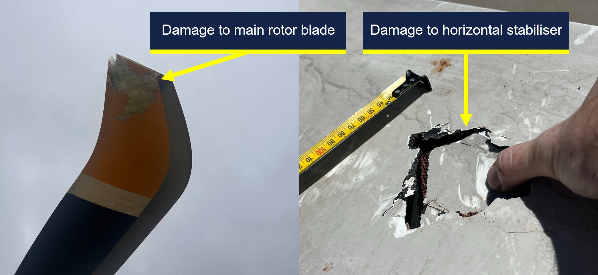
The operator reported minor repairable damage to 3 main rotor blade tips (Figure 2). In addition, there was minor damage to the horizontal stabiliser and tail boom, which were struck by debris from the tree struck by the main rotor.
Figure 2: Main rotor blade damage (left) and horizontal stabiliser damage (right)
Source: Toll Group, annotated by the ATSB
Recorded data
The aircraft was fitted with a Curtis-Wright Multi-Purpose Flight Recorder (MPFR), which contained the cockpit voice recorder and flight data recorder. The MPFR was provided to the ATSB and was successfully downloaded at the ATSB’s Canberra facilities on 7 January 2026. After download, the MPFR data was uploaded to the Flight Animation Software (FAS) program where the flight data and cockpit voice data were synchronised for analysis.
The FAS program revealed that the PI was fluctuating between the green and yellow ranges while the helicopter was in the hover in preparation for winching. However, the vertical speed was steady with only isolated momentary fluctuations of 50 ft/min rate of climb recorded.
When the ACO cleared the pilot to move right, away from their nearest obstacle, the helicopter rolled level from its left wing low hover attitude, the PI for both engines exceeded the maximum take-off PI red line momentarily and the vertical speed recorded a 100 ft/min rate of climb, followed by the main rotor strike.
The helicopter was also fitted with video-audio recording equipment in several locations, which included the cabin. A copy of the recordings for the accident flight were provided to the ATSB for review and analysis of the sequence of events in the cabin.
Operational information
Operations Manual Volume 2 – Rotary Wing
Volume 2 of the operator’s operations manual provided the rotor clearance requirement of 20 ft (6 m) horizontally from all obstacles. However, the manual also stated that by day only, and once established in the hover, the clearance could be reduced to 10 ft if it allowed for a more suitable winching position.
Operations Manual Volume 6 – Winching Operations
Volume 6 of the operations manual provided the following information for winching operations:
• Once established in the hover the PF [pilot flying] will normally be able to maintain position within the target area. However, there is often a requirement for minor repositioning whilst winching. During this precision manoeuvring the PF is relying on instruction from the ACO to accurately position the aircraft whilst remaining clear of any obstructions.
• A check of the left side of the aircraft must be conducted to identify the closest obstacle and ensure clearances are adequate. If the left door is opened to achieve this clearance, it must be closed prior to committing to the winch. At any time the ACO has their scan / eyes inside or checking the left, they are to advise this and receive acknowledgment from the PF.
• Once the ACO is back on the right side of the aircraft cabin, they are to ask the PF 'HOW IS YOUR HOVER REFERENCE?' If suitable references are available, the PF will respond with ‘HOVER REFERENCES ARE GOOD’ or request manoeuvring to improve references.
• WARNING: If suitable error tolerant hover references cannot be achieved by the PF, winching is not to be commenced.
The winching emergencies section of the manual included the emergency keywords ‘climb, climb, climb’ with the following caveat:
If not appropriate due to obstacles or terrain to call “CLIMB, CLIMB, CLIMB” a call for immediate aircraft movement is to be used in the required direction. For example: “LEFT, LEFT, LEFT”, “RIGHT, RIGHT, RIGHT” OR “MOVE FORWARD NOW.”
Safety analysis
The winch location was in a re-entrant near a waterfall, which required the pilot to turn and reverse the helicopter in for an assessment, before descending to a lower hover height for the planned winching operation. This provided the pilot with an escape route downslope and reduced the risk of a conical spin developing from a high winch but resulted in the nearest obstacle in the 7–8 o'clock position being in the pilot’s blind spot.
This obstacle was a tree with the nearest branch located above the main rotor disk and laterally clear of it by about 10 ft, which complied with the operator’s minimum clearance requirements. However, the proximity and height of the surrounding trees resulted in recirculation disturbing the helicopter from a stable hover position, which increased the control inputs required by the pilot compared with their initial higher hover height.
The ACO provided the pilot with obstacle clearances behind the helicopter until it was time to conduct their pre-winch checks with the paramedic, at which point nobody qualified was available to provide clearances to the rear of the helicopter. While the ACO and paramedic prepared for the winching, the doctor was monitoring their nearest obstacle to the rear left. When the ACO moved onto the pre-winch and aircraft performance briefs, the pilot was aware the ACO had returned to the right door, and the doctor started to sense the helicopter was drifting left towards their nearest obstacle. However, the ACO had not resumed providing clearances and the doctor’s training had reinforced the importance of not interrupting safety‑critical checks.
Due to the risk of a person descending on the winch snagging on the airframe, the ACO would not resume their scan to provide clearances until after the paramedic had descended below the airframe. However, when the ACO started their pre-winch brief at the right door, it was possible that either the pilot anticipated the ACO resuming their scanning role and relaxed their own scan, or that their attention was diverted from their external scan by the briefs, such that they did not detect and correct the helicopter’s drift.
The doctor alerted the crew to the fact that they appeared to be drifting to the left as soon as the ACO started to winch the paramedic down, which triggered a ‘move right’ call from the ACO to the pilot. In response, the pilot applied a small roll input to the right combined with a small increase in collective and the main rotors struck the nearby tree.
Findings
ATSB investigation report findings focus on safety factors (that is, events and conditions that increase risk). Safety factors include ‘contributing factors’ and ‘other factors that increased risk’ (that is, factors that did not meet the definition of a contributing factor for this occurrence but were still considered important to include in the report for the purpose of increasing awareness and enhancing safety). In addition, ‘other findings’ may be included to provide important information about topics other than safety factors.
These findings should not be read as apportioning blame or liability to any particular organisation or individual.
From the evidence available, the following findings are made with respect to the main rotor strike involving Leonardo Helicopters AW139, VH-TJF, 42 km south-east of Corryong Airport, New South Wales, on 5 January 2026.
Contributing factors
The crew positioned the helicopter with the nearest obstacle (a tree) in the pilot's blind spot prior to the pilot assuming sole responsibility for clearances to allow the air crew officer (ACO) and paramedic to prepare for winching. Subsequently, the helicopter started to drift prior to the ACO resuming responsibility for clearances.
The pilot did not detect and correct the helicopter’s drift towards its nearest obstacle while in the hover, which resulted in the main rotor striking a nearby tree.
Safety actions
Whether or not the ATSB identifies safety issues in the course of an investigation, relevant organisations may proactively initiate safety action in order to reduce their safety risk. The ATSB has been advised of the following proactive safety action in response to this occurrence.
Safety action by Helicorp
The operator released an Operations Manual Bulletin in response to the incident, which addressed the following points:
increased their rotor clearance limit to 20 ft (6 m) in all circumstances
provided additional guidance on determining spacing from overhanging obstacles
provided additional guidance on the requirements for error tolerant references
emphasised the need to prioritise error tolerant hover reference(s) selection over escape and downwash considerations.
A working group was initiated between the operator and tasking agency to improve interagency operations. Additionally, post-incident assurance activities were undertaken with the flight crew prior to their return to operations and an updated refresher session on verbal escalation during sterile cockpit procedures was conducted. Methods and terminology for escalation have also been included in their current human factors training program.
Sources and submissions
Sources of information
The sources of information during the investigation included the:
ACT Ambulance Service
cabin video footage and audio of the incident flight
operator, its head of aviation safety and quality, and its investigator
pilot, air crew officer and retrieval doctor of the incident flight
recorded data from the MPFR unit on the aircraft.
Submissions
Under section 26 of the Transport Safety Investigation Act 2003, the ATSB may provide a draft report, on a confidential basis, to any person whom the ATSB considers appropriate. That section allows a person receiving a draft report to make submissions to the ATSB about the draft report.
A draft of this report was provided to the following directly involved parties:
Agenzia Nazionale Per La Sicurezza Del Volo (ANSV, Italy)
air crew officer
Civil Aviation Safety Authority
Leonardo Helicopters
operator
pilot
retrieval doctor.
Submissions were received from:
air crew officer
Civil Aviation Safety Authority
operator
pilot.
The submissions were reviewed and, where considered appropriate, the text of the report was amended accordingly.
Purpose of safety investigations
The objective of a safety investigation is to enhance transport safety. This is done through:
identifying safety issues and facilitating safety action to address those issues
providing information about occurrences and their associated safety factors to facilitate learning within the transport industry.
It is not a function of the ATSB to apportion blame or provide a means for determining liability. At the same time, an investigation report must include factual material of sufficient weight to support the analysis and findings. At all times the ATSB endeavours to balance the use of material that could imply adverse comment with the need to properly explain what happened, and why, in a fair and unbiased manner. The ATSB does not investigate for the purpose of taking administrative, regulatory or criminal action.
About ATSB reports
ATSB investigation reports are organised with regard to international standards or instruments, as applicable, and with ATSB procedures and guidelines.
Reports must include factual material of sufficient weight to support the analysis and findings. At all times the ATSB endeavours to balance the use of material that could imply adverse comment with the need to properly explain what happened, and why, in a fair and unbiased manner.
An explanation of terminology used in ATSB investigation reports is available here. This includes terms such as occurrence, contributing factor, other factor that increased risk, and safety issue.
Publishing information
Released in accordance with section 25 of the Transport Safety Investigation Act 2003
Ownership of intellectual property rights in this publication
Unless otherwise noted, copyright (and any other intellectual property rights, if any) in this report publication is owned by the Commonwealth of Australia.
Creative Commons licence
With the exception of the Commonwealth Coat of Arms, ATSB logo, and photos and graphics in which a third party holds copyright, this report is licensed under a Creative Commons Attribution 4.0 International licence.
The CC BY 4.0 licence enables you to distribute, remix, adapt, and build upon our material in any medium or format, so long as attribution is given to the Australian Transport Safety Bureau.
Copyright in material obtained from other agencies, private individuals or organisations, belongs to those agencies, individuals or organisations. Where you wish to use their material, you will need to contact them directly.
1
^ A wander lead is a flexible safety tether used by crew members to maintain a secure connection to the aircraft while allowing them to move freely around the cabin.
2
^ A re-entrant appears on the map as a U or V shape in the contour lines, pointing back into a hillside rather than sticking out of the hill (as would a spur).
3
^ A sudden increase in the power required to maintain the desired flight path.
4
^ Recirculation is a condition in which a helicopter’s rotor system ingests its own downwash, reducing rotor efficiency and degrading lift and control response.
Occurrence summary
Investigation number
AO-2026-002
Occurrence date
05/01/2026
Occurrence time and timezone
17:25 Eastern Daylight-saving Time
Location
42 km south-east of Corryong Airport
State
New South Wales
Report release date
19/05/2026
Report status
Final
Investigation level
Short
Investigation type
Occurrence Investigation
Investigation phase
Final report: Dissemination
Investigation status
Completed
Mode of transport
Aviation
Aviation occurrence category
Controlled flight into terrain (CFIT), Forced/precautionary landing
Occurrence class
Serious Incident
Highest injury level
None
Aircraft details
Manufacturer
Leonardo Helicopters
Model
AW139
Registration
VH-TJF
Serial number
31710
Aircraft operator
Helicorp Pty Ltd
Sector
Helicopter
Operation type
Part 133 Air transport operations - rotorcraft
Activity
Commercial air transport-Non-scheduled-Medical transport
Departure point
Southcare Base Helicopter Landing Site, Australian Capital Territory
The ATSB is investigating a near collision during aerial firefighting operations involving a GippsAero GA8, registration VH-LVA, and a Lockheed C-130, registration N382CG, about 125 km north-north-east of Albany Airport, Western Australia, on 16 December 2025.
It was reported that the Lockheed C-130 came into close proximity with the GA8 on a reciprocal track. The crew of the GA8 received a traffic alert and manoeuvred to increase separation.
The ATSB has completed the evidence collection and analysis phases of the investigation and is drafting the final report.
The final report will be released at the conclusion of the investigation. Should a critical safety issue be identified during the course of the investigation, the ATSB will immediately notify relevant parties, so that appropriate safety action can be taken.
Last updated:
Occurrence summary
Investigation number
AO-2026-001
Occurrence date
16/12/2025
Occurrence time and timezone
08:07 UTC
Location
About 125 km north-north-east of Albany Airport
State
Western Australia
Report status
Pending
Anticipated completion
Q4 2026
Investigation level
Defined
Investigation type
Occurrence Investigation
Investigation phase
Final report: Drafting
Investigation status
Active
Mode of transport
Aviation
Aviation occurrence category
ACAS warning, Near collision
Occurrence class
Serious Incident
Highest injury level
None
Aircraft details
Manufacturer
Lockheed Martin
Model
C-130H
Registration
N382CG
Serial number
382-4336
Aircraft operator
Coulson Aviation
Sector
Turboprop
Operation type
Part 138 Aerial work operations
Activity
General aviation / Recreational-Aerial work-Firefighting
Departure point
Busselton Airport, Western Australia
Destination
Busselton Airport, Western Australia
Injuries
None
Damage
Nil
Aircraft details
Manufacturer
Gippsland Aeronautics Pty Ltd
Model
GA-8
Registration
VH-LVA
Serial number
GA8-05-079
Aircraft operator
Helicopter Logistics Pty Ltd
Sector
Piston
Operation type
Part 138 Aerial work operations
Activity
General aviation / Recreational-Aerial work-Firefighting
An Australian Transport Safety Bureau (ATSB) investigation is underway into the grounding of the Australian-registered cruise ship Coral Adventurer off the Finschaffen Coast, east of Lae, Papua New Guinea.
As reported to the ATSB, the ship grounded on a reef at around 0525 local time on 27 December 2025. The grounded ship was heeled over about 6 degrees to port.
Initial efforts were made to refloat the ship using its own engines, but these were unsuccessful. The ship’s operators later engaged a towage provider to assist refloating the ship. Refloating efforts are still underway.
No injuries have been reported to the ship’s 123 occupants (80 passengers and 43 crew). The extent of any damage to the ship’s hull is not known but water ingress is not reported.
The ATSB is not involved with the ship’s recovery operations but is continuing to monitor the situation as part of its investigation. The ATSB will attend the ship to conduct interviews and collect evidence and data once appropriate.
In the meantime, data from the ship’s voyage data recorder has been quarantined and investigators are collecting other relevant recorded information, including ship tracking data, weather information, and crew, operator and maintenance records.
The ATSB will provide a substantive update on the progress of the investigation when it releases a preliminary report in about two months.
The investigation’s findings will be contained in a final report to be released at the conclusion of the investigation. The final report will also detail the ATSB’s analysis of the evidence to support those findings.
However, should a critical safety issue be identified during the investigation, the ATSB will immediately notify relevant parties so safety action can be taken.
On the morning of 27 December 2025, while transiting towards Dregerhafen in Papua New Guinea, the 93.4 m passenger ship Coral Adventurer ran aground on a coral reef north of Nussing Island.
After an unsuccessful attempt to manoeuvre the ship off the reef using its propulsion at high tide on 27 December, the ship's operator engaged a towage provider to assist with refloating it.
The ATSB has commenced a safety investigation into this incident and is gathering evidence from relevant parties for analysis.
The ATSB released a preliminary report, which details factual information established in the investigation’s early evidence collection phase, on 12 March 2026. See below.
Should a critical safety issue be identified at any time during the investigation, the ATSB will immediately notify the operators of the ship, and other relevant parties so that appropriate and timely safety action can be taken.
A final report will be published at the conclusion of the investigation.
Preliminary report
Report release date: 12/03/2026
This preliminary report details factual information established in the investigation’s early evidence collection phase, and has been prepared to provide timely information to the industry and public. Preliminary reports contain no analysis or findings, which will be detailed in the investigation’s final report. The information contained in this preliminary report is released in accordance with section 25 of the Transport Safety Investigation Act 2003.
Summary video
The occurrence
Departure
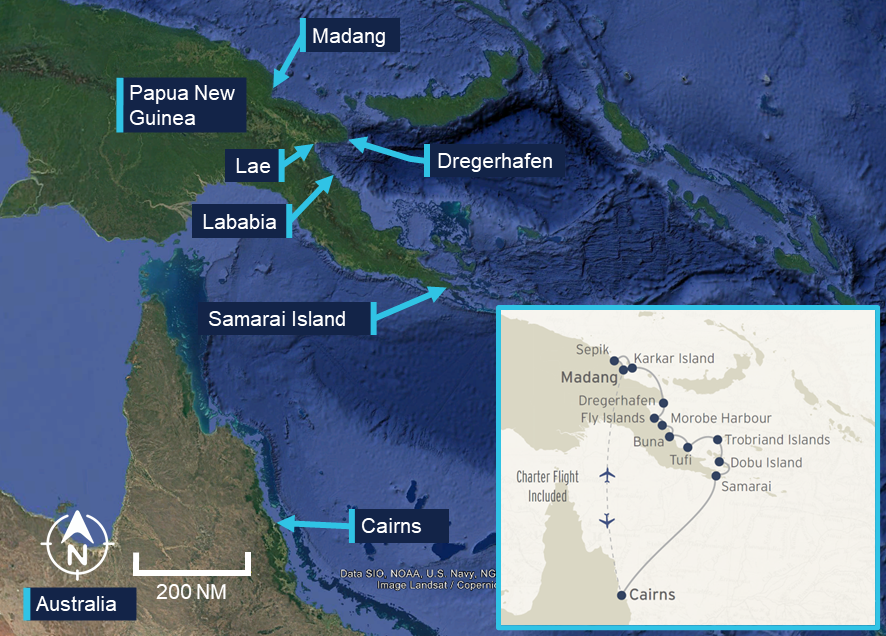
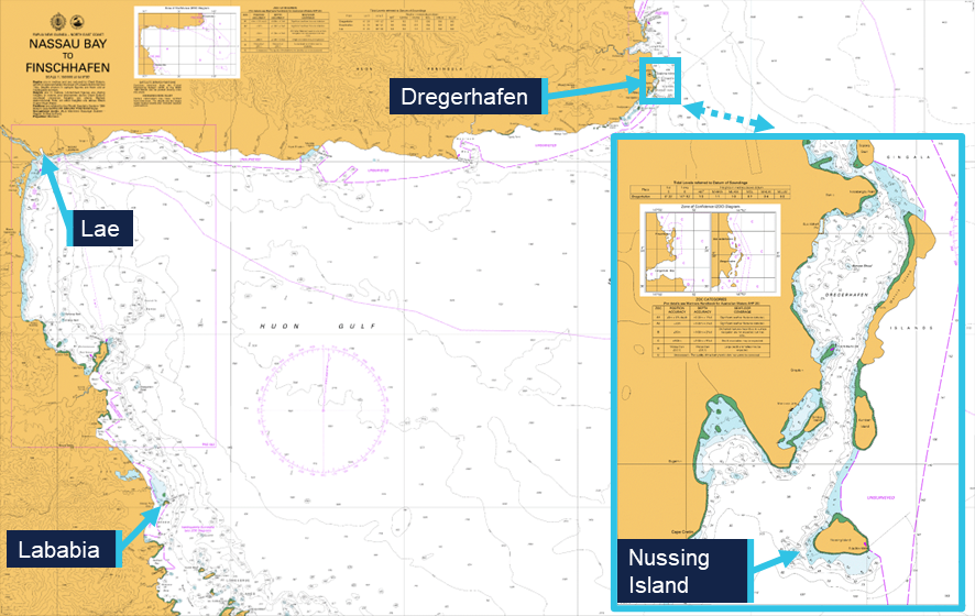
On 18 December 2025, the 93 m Coral Adventurer departed Cairns, Queensland, for a 12-night cruise visiting Papua New Guinea (PNG) with 80 passengers and 44 crew on board. The ship’s itinerary comprised 11 ports and anchorages on the north-east coast of PNG, concluding on 30 December in the port of Madang (Figure 1). The voyage included night sailings between locations, arriving at the next scheduled destination at about sunrise for daytime passenger expedition.
Figure 1: Coral Adventurer’s itinerary
Source: Google Earth, Coral Expeditions, annotated by the ATSB
On 26 December, the ship was at anchor off Lababia, approximately 60 km south‑south‑east of Lae. During the evening, the chief mate completed the departure checklist and, at 1918, the ship commenced its 63 mile[1] passage to Dregerhafen (Figure 2).
Figure 2: Lababia to Dregerhafen
Source: Australian Hydrographic Office, annotated by the ATSB
Grounding
At 0400 on 27 December, the chief mate took over the bridge watch from the second mate. During the watch handover, the second mate reported that the ship was encountering currents and was being set to starboard, steering a heading[2] of 358°, and making good a course[3] of 012° at 5.4 knots.[4] The ship had one generator providing electrical power and both Azipull propulsion thrusters running at 120 RPM. The ship’s estimated time of arrival (ETA) at Dregerhafen of 0530 was also discussed.
The second mate stayed on the bridge to complete administrative tasks, seated away from the bridge console on a couch aft of the chart table. At the same time, the lookout handed over the watch, with a trainee deck rating taking over.
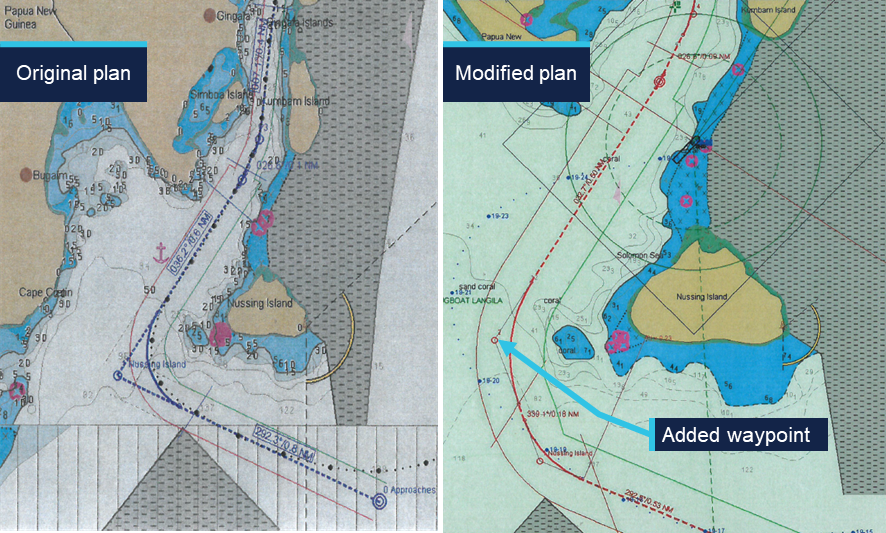
At 0407, the chief mate reviewed the route into Dregerhafen on the electronic chart display and information system (ECDIS). They then modified the route, moving the second waypoint and inserting an extra waypoint. This segmented the 100° turn around Nussing Island into 2 legs, while still closely following the original planned track (see the section titled Passage planning).
At about 0500, the chief mate instructed the lookout to remove the anchor lashings in preparation for the ship’s approach into Dregerhafen. The chief mate also contacted the duty engineer and requested a second generator, which was started and brought online shortly after. By 0510, both anchors had been cleared for use, and the lookout had returned to the bridge.
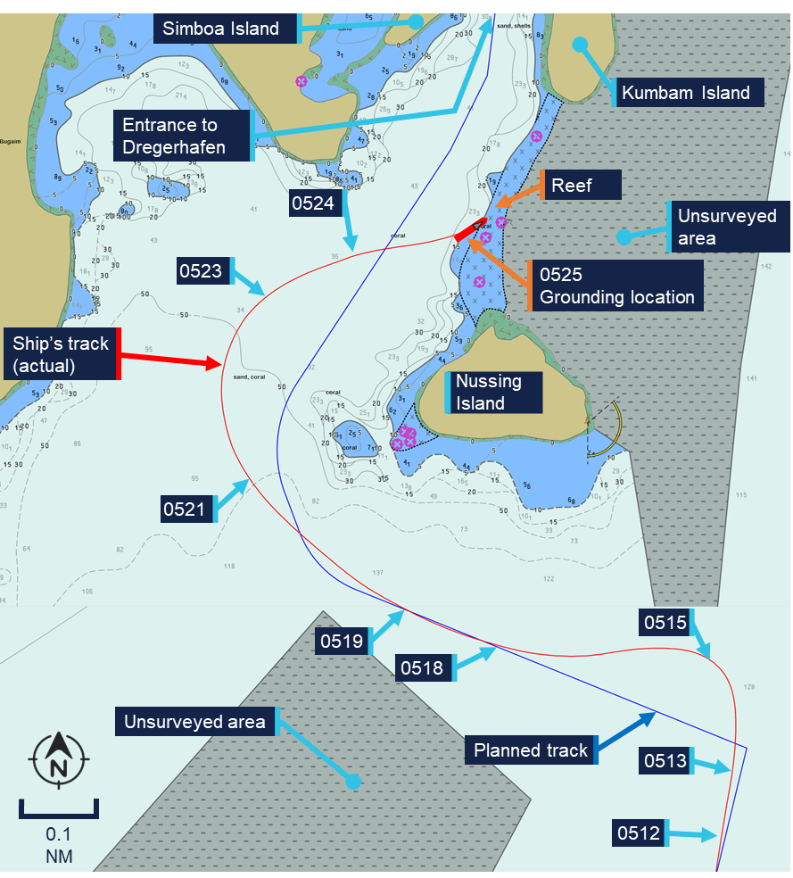
At 0512, the ship was in autopilot mode steering a heading of 357°. The ship was making good a course of 009° at a speed over ground of 5.6 knots while approaching the final waypoint of the route (Figure 3).
The chief mate then attempted switching the ECDIS monitored route to Route 2 – the track into Dregerhafen. However, as Route 2 had been modified, it failed to load as the active route. This caused a delay as the chief mate completed the required ECDIS ‘route check’ for Route 2, to allow it to be monitored as the active route.
Figure 3: Route 2 – entrance to Dregerhafen
Planned track (blue) and actual track (red) overlaid on vector chart in use on board Coral Adventurer at the time of the grounding. Source: Australian Hydrographic Office, modified and annotated by the ATSB
While the chief mate was conducting the ‘route check’, the ship passed the wheel over point[5] for the turn to the next course (293°). At 0512:26, with the ship heading towards unsurveyed waters to the north, the chief mate switched to manual steering in common mode[6] to facilitate a quicker turn and return to the planned track.
During the turn the ship slowed, and the chief mate perceived this was caused by a strong current. In response, at 0513:49, they increased the setting of both Azipull thrusters to 180 RPM to regain speed. Speed continued to reduce as the ship turned towards the planned track, reaching 3.8 knots at 1514:46 before starting to increase in response to the increased RPM setting (Table 1).
Approached end of Route 1 – south of Nussing Island
5.6
0512:26
Manual steering in common mode, port turn input
5.6
0513:49
Azipull thrusters increased to 180 RPM
5.2
0514:46
Continued turn to port, minimum recorded speed over ground
3.8
0518:43
Autopilot mode engaged
7.7
0519:10
Passed wheel over point
8.1
0521:00
Manual steering in common mode, starboard turn input
8.5
0523:30
Steady
7.4
0524:00
Master on the bridge
8.0
0525:00
Master noted shallow water ahead
8.3
0525:11
Port turn input
8.5
0525:17
Grounding noises
8.4
0525:30
Vessel stopped
0
0550
PA announcement to passengers
0
At about 0518, the ship returned to the planned track and on achieving a heading of 293°, the chief mate switched the steering back to autopilot mode.
At 0519:10, the ship arrived at the wheel over point for the next course of 339° at a speed of 8.1 knots. This route leg ran a distance of 0.18 mile between the modified waypoints. The chief mate planned to use the autopilot to execute a continuous turn to starboard onto the following charted course of 033°, which led to the entrance channel into Dregerhafen (see the section titled Passage planning). However, the ship did not respond as the chief mate expected and overshot the planned turn. At 0521, the chief mate switched to manual steering and increased the rate of turn to return to the planned track. By then the ship’s speed had increased to about 8.5 knots, which continued to take the ship further off course to the west.
The chief mate later reported that due to darkness[8] and the absence of navigational aids and lights ashore, they were unable to accurately identify the surrounding topography at the time. They were concentrating on the ECDIS, with efforts to return to the planned track of 033°.
They then continued the turn to starboard at a high rate of turn until 0523:30, when the ship was brought to a north-easterly heading. At 0524:00, the master arrived on the bridge and greeted the chief mate, who responded that they were experiencing ‘a strong current’.
The chief mate later also reported that they then shifted their focus from the ECDIS screen to outside where they could see silhouettes of the islands. They reported being ‘unable to correctly visually identify the entrance into Dregerhafen’ and ‘losing situational awareness’. Meanwhile, the ship continued across the planned track, heading towards the then visible opening between Nussing and Kumbam Islands (see the section titled Dregerhafen).
At 0525, the master (standing at the forward console) advised the chief mate that it appeared they were heading into shallow water and at 0525:11, the chief mate attempted a hard turn to port. At 0525:17, a loud noise could be heard as the ship grounded at a speed of 8.5 knots on the bank connecting Nussing and Kumbam Islands. The ship experienced a series of ‘shudders’, before coming to an abrupt halt at 0525:30.
In response, the master reduced the Azipull thrusters’ setting to zero and telephoned the chief engineer. The master informed the chief engineer that the ship had grounded and directed them to commence damage control actions. Other members of the ship’s crew were notified, and the master also reported the incident to the ship’s shore-based operator, Coral Expeditions. The ship’s crew then proceeded to check the integrity of the ship, sounding tanks and void spaces and taking soundings of the seabed around the hull.
At 0550, the master made the first announcement on the public address system (PA), informing passengers that the ship had grounded, but was safe. At 0620, the ship’s expedition leader made another PA announcement updating the passengers on the situation. The passengers were not mustered, and a (limited) part of the excursion program continued for their entertainment.
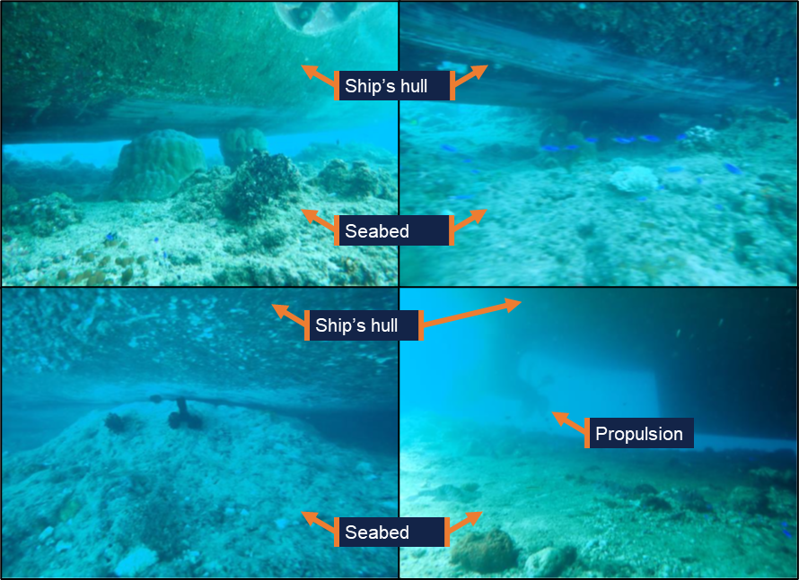
Expedition staff later completed dive inspections, which confirmed that the ship was resting on the seabed along its starboard side (Figure 4). The propulsion and steering were unaffected.
Figure 4: Underwater images taken during the dive inspection
Source: Coral Expeditions, annotated by the ATSB
Refloating
After an unsuccessful attempt by the ship’s crew to manoeuvre the ship off the reef at high water on 27 December, Coral Expeditions, engaged towing company Pacific Towage to assist with the refloating. On 28 December, Pacific Towing tasked the tug Macedon from Lae (100 km to the west), which arrived near the ship shortly after midday. After the initial toolbox meeting, the refloating attempt with Macedon commenced at about 1420. However, after half an hour, Macedon’s crew reported that the tug’s engines had overheated and the refloating was suspended. During refloating attempts, the passengers and hotel staff were landed ashore using the ship’s tenders to ensure their safety.
On 29 December, Pacific Towage engaged the more powerful tug Langila for another refloating attempt. However, due to administrative issues, no refloating was attempted on the day.
On 30 December, all passengers were disembarked from Coral Adventurer and were repatriated to Cairns via a charter flight from Lae. Coral Expeditions entered a salvage contract with Pacific Towing and the refloating attempt with Langila commenced at 1422.
By 1534, Coral Adventurer was successfully refloated. The ship was then navigated to a nearby safe anchorage, where it was anchored for further damage assessment and inspections by the ship’s classification society, DNV.
Context
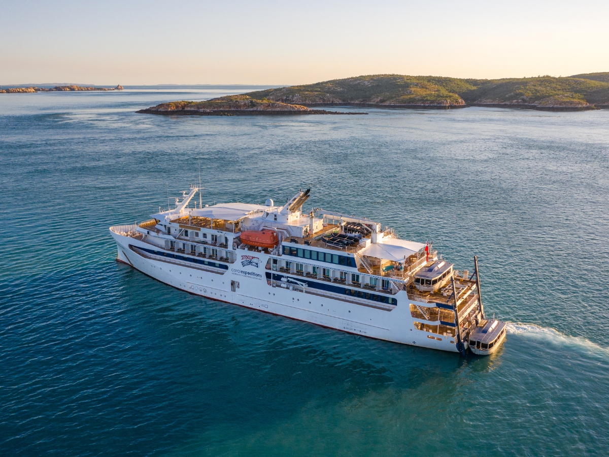
Coral Adventurer
Coral Adventurer (Figure 5) was built in 2019 by Vard Vung-Tau, Vietnam. It was registered in Australia and classed with DNV. It was owned by CPC Marine and managed by Coral Princess Cruises (NQ) in Cairns, which operated commercially as Coral Expeditions.
Figure 5: Coral Adventurer
Source: Coral Expeditions
Coral Adventurer had a length overall of 93.4 m, a moulded breadth of 17.2 m and a design draught of 4.4 m. It was certified and equipped to carry a total of 126 passengers in 63 cabins as well as a maximum crew complement of 42, for a total of 168 persons on board. The ship’s relatively small size and limited draught were a design choice to allow it to access remote locations away from port infrastructure for ‘expedition’ style cruises. To provide access ashore, it was equipped with 2 large tenders that could be lifted using a hydraulic platform at the stern. Additionally, the ship carried several inflatable boats that could be used for shore access as well as diving and snorkelling.
To comply with the SOLAS[9] requirement for the carriage of navigational information, Coral Adventurer was fitted with dual Transas 4000 electronic chart display and information systems (ECDIS). For operation in Australian and Papua New Guinean waters, the crew utilised official electronic navigational charts, published by the Australian Hydrographic Office. The ship was also fitted with a Danelec DM100 voyage data recorder.
Propulsion
Coral Adventurer was equipped with diesel-electric propulsion, with electrical power provided by two 1,432 kW Caterpillar 3512C and one 994 kW Caterpillar C32 generator sets. Propulsion and steering were provided by 2 electrically‑driven Rolls-Royce Azipull thrusters of 1,200 kW each. Additionally, an 800 kW tunnel thruster was fitted at the bow to provide transverse thrust while manoeuvring at low speed.
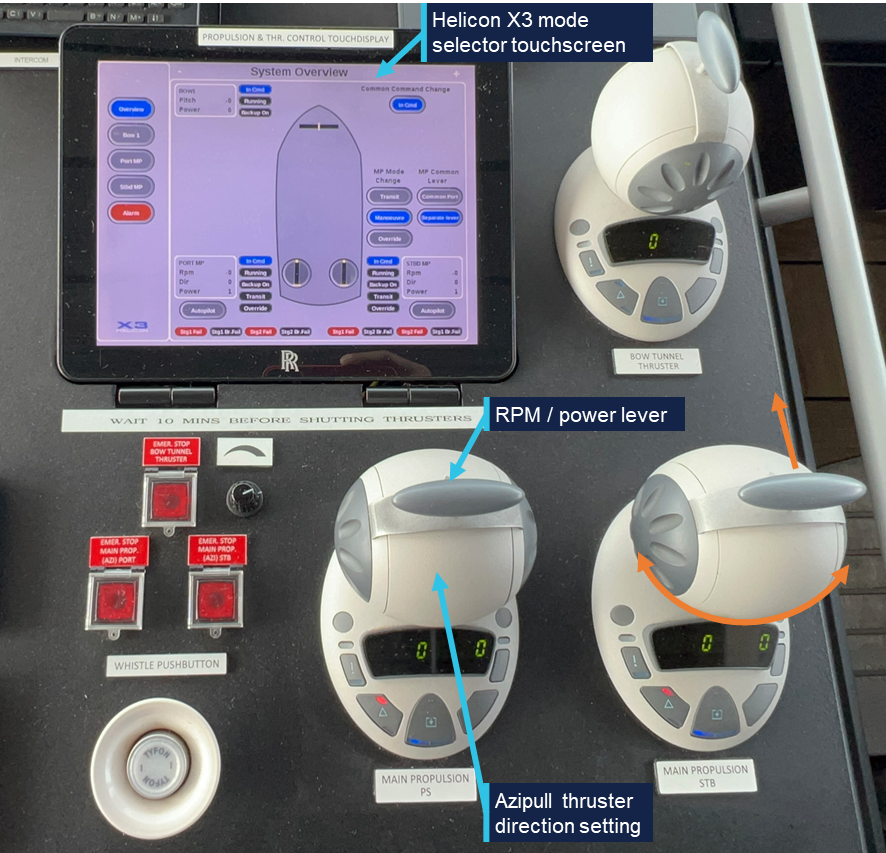
The Azipull units consisted of an electric drive motor fitted inside the hull with a gearbox driving a vertical shaft connected to the underwater thruster unit. The thruster units were fitted with fixed pitch pulling propellers and could be rotated trough 360°. This allowed the thrust vector of the main propulsion to be rotated through 360°, improving slow speed manoeuvring capabilities. The Azipull thrusters were controlled by a Helicon X3 remote control system. Normal control was through sets of ball-shaped controllers (Figure 6). One set was mounted in the centre of the bridge console and one set on each bridge wing control station.
Figure 6: Azipull thruster controls
Source: ATSB
Additionally, a push-button controlled non-follow up system was available in the centre console and another locally in the thruster room. In normal operation, several control modes were available and could be selected on the Helicon X3 touchscreen (Table 2).
Table 2: Steering modes
Steering mode
Explanation
Note
Transit mode
Azimuth angle limited to ±35°
Automatically selected over 10 knots
Manoeuvre mode
Azimuth angle free to rotate through 360°
Below 10 knots
Common mode
Single controller controls power/speed and direction for both thrusters
Separate lever
Individual thruster control by each controller
Autopilot
Control of thruster by autopilot system
Selected on one or both Azipull thrusters
While approaching Nussing Island, the chief mate was steering the ship on autopilot before switching to manual steering in common mode, controlling both Azipull thrusters with a single controller. This offered better steering control capability than autopilot mode but limited slow speed steering capability when compared to using separate controllers for individual thruster operation.
Crew
Coral Adventurer had a multi-national crew of 44. The marine crew consisted of 16 persons, split between deck and engine departments under the chief mate and chief engineer. This exceeded the requirements of its minimum safe manning document.
The cruise staff consisted of 6 expedition crew, led by the ‘expedition leader’ and 22 hotel and catering crew managed by the purser. While the expedition and hotel staff reported to their own department heads, the master was responsible for overall safety.
Master
The master had held an Australian unlimited master’s certificate of competency since 2019. They had seagoing experience as a watchkeeping officer in a variety of roles from 2011 on tankers and domestic commercial vessels (DCVs),[10] until accepting a shore‑based position in mid‑2023.
In May 2024, they completed a relief contract for Coral Expeditions as second mate on Coral Geographer before joining its sister ship, Coral Adventurer, as chief mate in September 2024. This was followed by a promotion to master in May 2025, after which they had sailed on a regular 3-week rotation.
Chief mate
The chief mate held an Australian certificate of competency as chief mate. They had worked on international cargo ships as a navigation officer since 2010 in a variety of roles, including as master, before joining Coral Expeditions as second mate in 2022. In August 2025, they had been promoted to chief mate on board another Coral Expeditions’ vessel, Coral Discoverer, before joining Coral Adventurer for the first time in Cairns on 18 December.
As head of the deck department, the chief mate was responsible for deck maintenance and keeping the 0400–0800 and 1600–2000 watches on the bridge.
Second mate
The second mate held an Australian certificate of competency as chief mate. They had worked at sea since 2009, including 7 years as second officer on international cargo ships before joining Coral Adventurer in September 2025. After completing one contract as third mate, they joined in Cairns on 18 December for their first voyage as second mate on board this ship.
The second mate was responsible for passage planning and the maintenance of nautical equipment and publications. They kept the 0000–0400 and 1200–1600 bridge watches.
Third mate
The third mate held an Australian certificate of competency as a chief mate. They had been working at sea since 2016 and, from 2021, as third mate on container ships. The third mate joined Coral Adventurer for the first time in Cairns on 18 December.
They kept the 0800–1200 and 2000–2400 bridge watches and were responsible for maintaining the ship’s safety and firefighting equipment.
Lookout
The lookout was rated as ‘trainee’ and held an Australian certificate of proficiency as navigational watch rating (NWR) since 2 December 2025. They had worked on DCVs before joining Coral Adventurer in November 2025. Though qualified to steer ships equipped with a conventional rudder as part of their NWR, the lookout was not trained to operate Coral Adventurer’s Azipull thrusters and thus could not act as helmsperson.
Coral Expeditions
Coral Expeditions was founded in 1983. The company initially operated small DCVs on voyages exploring Australia’s Kimberley region and other remote coastal areas.
At the time of the occurrence, the company operated 3 Australian-flagged passenger ships, Coral Adventurer, CoralGeographer and Coral Discoverer.
Safety management system
As required by the International Safety Management (ISM) Code, Coral Expeditions had implemented a safety management system (SMS) on board its vessels. A valid document of compliance (DOC) for operating passenger ships was issued to the company and a safety management certificate covering Coral Adventurer was in place, both issued by DNV.
Passage planning
Preparation for cruises started with the selection of the itinerary by Coral Expeditions based on previous experience, availability of shore excursions and capabilities of the ship. On board, the second mate completed the passage planning process, as per the procedure in the company’s SMS, using the passage planning checklist.
To streamline the passage planning process, the ship maintained a library of routes in the ECDIS, which had been approved by the ship’s master and used previously. These routes were marked ‘CA’ in the system and were required to be used wherever possible.
The routes were split into sectors, separating the confined water transits, such as harbour approaches or pilotage sections, from longer open water transits. This allowed routes between ports to be used in various combinations, including the incorporation of any new transit routes.
For the passage from Lababia to Dregerhafen, the passage plan included 2 ‘CA’ approved routes:
Route 1 – from the ship’s anchored position at Lababia to a position south of Nussing Island
Route 2 – from the position south of Nussing Island to the intended anchor position within Dregerhafen.
These routes had been programmed into the ECDIS, with Route 1 being actively monitored at the start of the passage and Route 2 in the monitoring queue. The passage plan (which included a reference to these routes) had been printed and was signed for approval by the master and countersigned by all watchkeepers. Based on the planned departure time of 1900 on 26 December, the ship’s estimated time of arrival (ETA) at Dregerhafen was 0600 on 27 December.
Before an ECDIS route could be actively monitored, a route safety check had to be conducted. The route safety check was a function of the ECDIS route editor, which checked the route for relevant dangers to navigation based on set parameters, such as the ship’s draught and speed. The operator then had to address any identified dangers before the ECDIS would allow the route to be loaded for monitoring. Any subsequent changes made to the route would invalidate the check and require a new route check to be completed.
On the incident voyage, both routes had been checked prior to departure. However, while transiting Route 1, the chief mate made changes to Route 2, adding an additional waypoint to the starboard turn around Nussing Island (Figure 7). This change invalidated the route check and meant that Route 2 could not be activated for monitoring without entering the route editor and conducting a new route check.
Figure 7: ECDIS courses showing the original and modified plan
Source: Coral Adventurer, annotated by the ATSB
Dregerhafen
Dregerhafen (or Dreger Harbour) is a sheltered bay located 100 km east of Lae on the Huon peninsula in Papua New Guinea’s Morobe province. It is the southernmost of 2 sheltered bays, which are protected from the sea by the Gingala Islands to the east. The Gingala Islands are connected to each other by shallow reefs. No bathymetry is available for the area to the east of the islands, which is marked as unsurveyed on the chart.
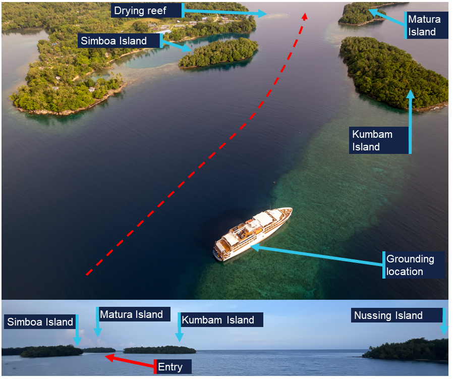
The only entry into Dregerhafen is deep but narrow, with a maximum navigable width of 120 m (Figure 8). It requires passing west of Nussing Island and entering the passage between Simboa Island and Kumbam Island, before passing between Matura Island and a drying reef off the town of Gingala. The reef was marked with a lighted beacon, though this was not visible from the location of the ship during the turn.
Pilotage was not available nor was it required by local regulations.
Figure 8: Entry channel views
Aerial view of the entry to Dregerhafen. Insert below shows the view from the approximate ship’s position 3 minutes before grounding, taken from the height of the bridge in daylight. Source: Sebastian Bang, annotated by the ATSB. Insert view, the ATSB.
Further investigation
To date, ATSB investigators have attended Coral Adventurer while at anchor near Nussing Island to collect relevant recorded data, documentary and electronic evidence. The master and officers as well as relevant marine and hotel crew were interviewed.
Collection of other relevant evidence is being progressed.
The investigation is continuing and will include the following subject areas:
verification, interpretation and analysis of voyage data recorder data
review and analysis of collected closed circuit television footage
analysis of relevant human factors
review of the ship and company’s passage planning and navigation procedures, including resource management
review of the ship’s emergency response procedures
review of overall safety oversight.
A final report will be released at the conclusion of the investigation. Should a critical safety issue be identified during the course of the investigation, the ATSB will immediately notify relevant parties so appropriate and timely safety action can be taken.
Acknowledgements
The ATSB would like to acknowledge the Papua New Guinea Accident Investigation Commission and National Maritime Safety Authority for their assistance in the deployment of its investigators.
Purpose of safety investigations
The objective of a safety investigation is to enhance transport safety. This is done through:
identifying safety issues and facilitating safety action to address those issues
providing information about occurrences and their associated safety factors to facilitate learning within the transport industry.
It is not a function of the ATSB to apportion blame or provide a means for determining liability. At the same time, an investigation report must include factual material of sufficient weight to support the analysis and findings. At all times the ATSB endeavours to balance the use of material that could imply adverse comment with the need to properly explain what happened, and why, in a fair and unbiased manner. The ATSB does not investigate for the purpose of taking administrative, regulatory or criminal action.
About ATSB reports
ATSB investigation reports are organised with regard to international standards or instruments, as applicable, and with ATSB procedures and guidelines.
Reports must include factual material of sufficient weight to support the analysis and findings. At all times the ATSB endeavours to balance the use of material that could imply adverse comment with the need to properly explain what happened, and why, in a fair and unbiased manner.
An explanation of terminology used in ATSB investigation reports is available here. This includes terms such as occurrence, contributing factor, other factor that increased risk, and safety issue.
Publishing information
Released in accordance with section 25 of the Transport Safety Investigation Act 2003
Ownership of intellectual property rights in this publication
Unless otherwise noted, copyright (and any other intellectual property rights, if any) in this report publication is owned by the Commonwealth of Australia.
Creative Commons licence
With the exception of the Commonwealth Coat of Arms, ATSB logo, and photos and graphics in which a third party holds copyright, this report is licensed under a Creative Commons Attribution 4.0 International licence.
The CC BY 4.0 licence enables you to distribute, remix, adapt, and build upon our material in any medium or format, so long as attribution is given to the Australian Transport Safety Bureau.
Copyright in material obtained from other agencies, private individuals or organisations, belongs to those agencies, individuals or organisations. Where you wish to use their material, you will need to contact them directly.
[2]All ship’s headings in the report are in degrees by gyro compass with negligible error.
[3]All courses in this report are expressed in degrees true unless otherwise stated.
[4]One knot, or one nautical mile per hour, equals 1.852 kilometres per hour.
[5]The wheel over point indicates on the chart where rudder should be applied to start a turn, taking into account the speed of the rudder movement and inertia of the ship.
[7]SOG: speed over ground, based on recorded data from the ship’s number one GNSS receiver.
[8]The approach was conducted in moonless conditions during nautical twilight, which is the period of time the geometric centre of the sun is between 6° and 12° below the horizon. In general, during nautical twilight, the horizon is visible and outlines of terrestrial objects may still be discernible but detailed outdoor activities are likely curtailed without artificial illumination.
[9]The International Convention for the Safety of Life at Sea, 1974, as amended.
[10]Domestic commercial vessels are regulated under the Marine Safety (Domestic Commercial Vessel) National Law Act 2012.
Occurrence summary
Investigation number
MO-2025-013
Occurrence date
27/12/2025
Occurrence time and timezone
19:25 UTC
Location
Nussing Island (100 km east of Lae), Papua New Guinea
The ATSB is investigating an uncommanded acceleration to full power and subsequent in-flight shutdown involving a Cessna 208 Caravan, VH-KSA, near Kalumburu Aerodrome, Western Australia, on 11 December 2025.
The pilot reduced engine power in a late downwind position on final approach to Kalumburu Aerodrome when the engine had an uncommanded rapid acceleration to full power with associated check torque and check temperature warnings on the master warning panel.
The pilot manipulated the power lever with no engine power response to inputs. The pilot elected to shut the engine down, feather the propeller and conduct a power off glide in landing. The landing was successfully completed without incident.
The evidence collection will include testing and examination of the engine, interviewing the flight crew, examination of flight data if available, operational records and the other records as required.
A final report will be released at the conclusion of the investigation. Should a critical safety issue be identified during the course of the investigation, the ATSB will immediately notify relevant parties, so that appropriate safety action can be taken.
Occurrence summary
Investigation number
AO-2025-075
Occurrence date
11/12/2025
Occurrence time and timezone
09:00 Western Australia Standard Time
Location
Near Kalumburu Aerodrome
State
Western Australia
Report status
Pending
Anticipated completion
Q3 2026
Investigation level
Short
Investigation type
Occurrence Investigation
Investigation phase
Evidence collection
Investigation status
Active
Mode of transport
Aviation
Aviation occurrence category
Abnormal engine indications, Engine failure or malfunction
Occurrence class
Serious Incident
Highest injury level
None
Aircraft details
Manufacturer
Cessna Aircraft Company
Model
208B
Registration
VH-KSA
Serial number
208B0516
Aircraft operator
Aviair Pty Ltd
Sector
Turboprop
Operation type
Part 135 Air transport operations - smaller aeroplanes
Activity
Commercial air transport-Non-scheduled-Passenger transport charters