

VFR into IMC involving a Van’s RV-7, Scone, New South Wales, on 11 January 2026
What happened
On 11 January 2026, a pilot, and sole occupant of a Van’s RV-7, was conducting a private flight from South East Queensland to Scone Airport, New South Wales, under the visual flight rules (VFR).[1]
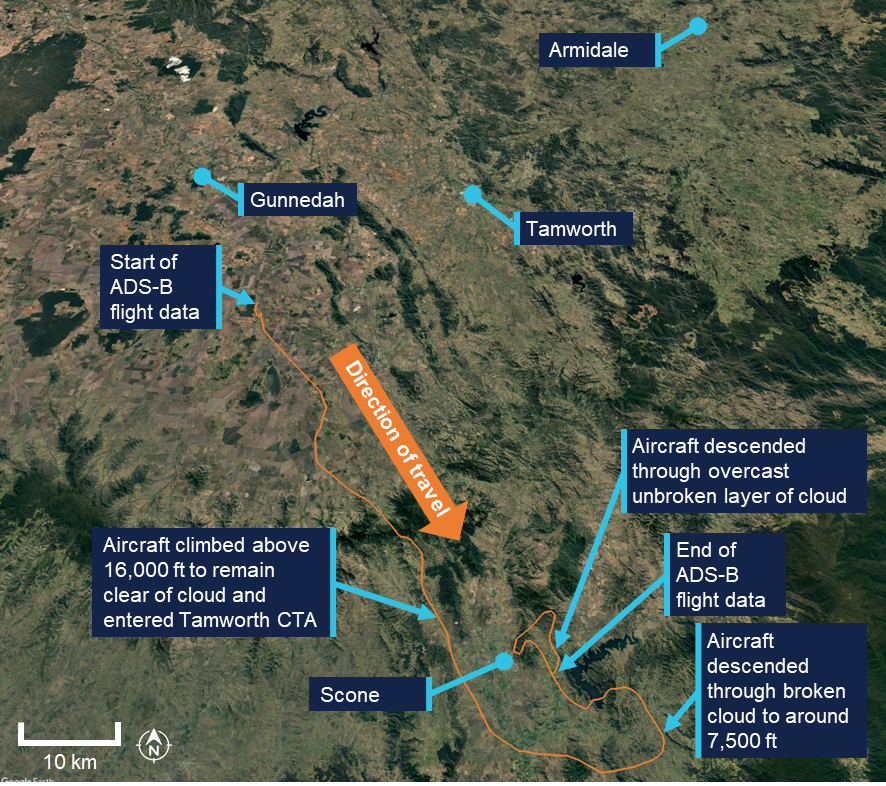
The aircraft departed in the mid-afternoon and the pilot reported that they initially landed at Armidale Airport for a break and to review the weather for the remainder of the flight. They advised that satellite imagery for the area indicated areas of cloud south of Armidale, breaking up to the west and further to the south, over Scone. As a consequence, the pilot elected to initially fly west towards Gunnedah before turning south (Figure 1).
Figure 1: Aircraft flight path
Source: Google Earth, annotated by the ATSB
After departing Armidale in the early evening, the pilot advised that the weather deteriorated behind them and so returning to the departure airport was no longer an option. As the flight progressed, after the pilot turned to fly southbound, they commenced a gradual climb to remain above the cloud layer. As they climbed above 10,000 ft, they commenced using supplemental oxygen.
Approaching Scone, the aircraft inadvertently entered the Tamworth Control Area (CTA) without a clearance. The pilot had intended to remain below the 15,500 ft CTA step, but climbed above 16,000 ft to remain clear of cloud.
At around 2008 local time, due to the aircraft’s altitude, air traffic control (ATC) questioned the pilot about their intentions. The pilot advised that they were flying above overcast cloud. As the pilot also advised ATC that they were not instrument rated[2] and did not have a night VFR rating,[3] the controller commenced an emergency response and contacted other aircraft in the area to get an appreciation of the weather. They then contacted Scone Airport to request that the runway lights be turned on. They also established that last light at Scone was 2034.
Approaching Scone, the pilot conducted a visual descent through broken cloud, however at around 7,500 ft they encountered an extensive, unbroken layer of cloud. At approximately 2025, with limited daylight remaining, the pilot elected to descend through the cloud rather than diverting to an alternate aerodrome at night in deteriorating weather. The aircraft exited cloud at approximately 3,000 ft above ground level and the pilot manoeuvred to join the downwind leg for runway 11 at Scone Airport. The aircraft landed at 2031.
The pilot later reported that there were several things that contributed to their decision‑making, including:
- complacency
- inexperience
- a desire to be at Scone in time for work the next morning
- a reluctance to leave the aircraft tied down outside at Armidale
- fatigue.
Safety message
Early decisions prevent last-minute emergencies. VFR pilots should avoid continuing flight into areas of deteriorating weather as pressing on in marginal conditions reduces available options and significantly increases the likelihood of entering IMC. Early and conservative decision‑making – such as diverting or turning back – is an effective defence.
As identified in a recent ATSB investigation concerning VFR into IMC (AO-2025-040), between 2015 and 2025 there were 116 VFR into IMC occurrences reported to the ATSB. Of these, 13 were fatal accidents resulting in 24 fatalities. Based on these figures, approximately 1 in every 9 reported VFR into IMC occurrences results in a fatality.
The ATSB booklet Accidents involving Visual Flight Rules pilots in Instrument Meteorological Conditions (AR-2011-050, revised 2019) provides guidance on avoiding adverse weather during VFR flights.
About this report
Decisions regarding whether to conduct an investigation, and the scope of an investigation, are based on many factors, including the level of safety benefit likely to be obtained from an investigation. For this occurrence, no investigation has been conducted and the ATSB did not verify the accuracy of the information. A brief description has been written using information supplied in the notification and any follow-up information in order to produce a short summary report, and allow for greater industry awareness of potential safety issues and possible safety actions.
[1] Visual flight rules (VFR): a set of regulations that permit a pilot to operate an aircraft only in weather conditions generally clear enough to allow the pilot to see where the aircraft is going.
[2] A licence endorsement that allows a pilot to legally fly under Instrument Flight Rules (IFR), a set of regulations that govern flying when outside visual meteorological conditions, relying on instruments for navigation and control.
[3] A licence endorsement that allows a pilot to fly at night without holding an IFR rating, provided the operation is conducted in visual meteorological conditions.
Occurrence summary
| Mode of transport | Aviation |
|---|---|
| Occurrence ID | AB-2026-007 |
| Occurrence date | 11/01/2026 |
| Location | Scone |
| State | New South Wales |
| Occurrence class | Serious Incident |
| Aviation occurrence category | Airspace infringement, VFR into IMC |
| Highest injury level | None |
| Brief release date | 27/02/2026 |
Aircraft details
| Manufacturer | Van's Aircraft |
|---|---|
| Model | RV-7 |
| Sector | Piston |
| Operation type | Part 91 General operating and flight rules |
| Departure point | Armidale Airport, New South Wales |
| Destination | Scone Airport, New South Wales |
| Damage | Nil |
Information Publication Scheme Agency Plan
This Plan is made for the purpose of the Information Publication Scheme required by the Freedom of Information Act 1982 (FOI Act).
Introduction
The Australian Transport Safety Bureau (ATSB) is an agency subject to the Freedom of Information Act 1982 (Cth)(Opens in a new tab/window) (FOI Act) and is required to comply with the Information Publication Scheme (IPS) requirements. The ATSB has prepared this agency plan (Agency Plan) in accordance with section 8(1) of the FOI Act.
Purpose
The purpose of the Agency Plan is to:
- assist the ATSB in planning and developing its contribution to the IPS; and
- show what information the ATSB proposes to publish (the IPS entry), how and to whom the information will be published, and how it will otherwise comply with the IPS requirements under section 8(1) of the FOI Act.
Objectives
The ATSB’s objectives are to outline appropriate mechanisms and procedures to:
- manage information captured by the IPS
- proactively identify and publish all information required to be published (section 8(2))
- proactively identify and publish any optional information to be published (section 8(4))
- review and ensure on a regular basis that information published under the IPS is accurate, up-to-date and complete (section 8B)
- ensure that information published under the IPS is easily discoverable, understandable, machine-readable, re-useable, accessible and transformable
- measure the success of the ATSB’s IPS contribution by reference to community feedback and compliance review process
- adopt best practice initiatives in implementing and administering the ATSB’s contribution to the IPS
- other specific agency objectives, addressed below.
Specific agency objectives
The ATSB’s function is to improve safety and public confidence in aviation, marine and rail modes of transport through excellence in:
- independent investigation of transport accidents and other safety occurrences;
- safety data recording, analysis and research; and
- fostering safety awareness, knowledge and action.
In discharging its functions, the ATSB recognises the importance of making as much information as possible available to industry and the travelling public. This commitment must be balanced with ensuring the protection of information that is covered by privacy legislation or by the restricted information provisions of the Transport Safety Investigation Act 2003 (TSI Act).
Establishing and administering the ATSB’s IPS entry
The ATSB’s Chief Executive Officer/Chief Commissioner is responsible for leading the agency’s work on implementing FOI reforms, including establishing and administering the IPS.
The ATSB has an existing Records and Information Management framework that it considers meets the requirements of the IPS. This framework is comprised of electronic and physical records of business in all ATSB repositories including its network drives, email systems and applications.
Through focused and targeted consultation, the ATSB has comprehensively reviewed its information and has identified the material that it is required to publish under section 8(2), information that may be published under section 8(4) and information that is made available other than by publication.
The ATSB will adhere to section 11C of the FOI Act by publishing decisions and documents released under the FOI Act, taking into consideration the guidelines issued by the Australian Information Commissioner.
Ongoing compliance with the IPS
The ATSB’s ongoing compliance with the IPS is coordinated by the ATSB’s Legal, Governance and Strategic Policy (LGSP) Team. The LGSP Team manages the ongoing administration of the IPS entry through the following measures:
- maintaining a robust information asset management framework
- publishing on an ongoing basis information to the public by maintaining an information register and disclosure log
- maintaining standard operating procedures for processing FOI requests including a prompt to ensure that the information released is reflected in the disclosure log
- identifying on an ongoing basis any information required to be published or optional to be published or is otherwise readily available
- reviewing on a half yearly basis whether all material has been captured and updating the ATSB website accordingly
- reviewing the Agency Plan on a yearly basis
- ensuring that the information published continues to be discoverable, accessible, useable, as well as accurate and up-to-date
- reviewing on a half yearly basis the information published to ensure all information is being captured
- ensuring the information about any charges to be imposed and how they will be calculated continues to be published.
The Communications and Media team, in liaison with the LGSP Team, is responsible for publishing the online content in accordance with government standards. The ATSB’s IPS entry will be maintained in accordance with the ATSB’s web guidelines, processes and procedures.
Ongoing review of the Agency Plan
The LGSP Team is also responsible for implementing, reviewing and revising the Agency Plan. The ATSB will monitor and review the Agency Plan whenever changes or additions are made to atsb.gov.au and will continually update and develop the Agency Plan by regularly reviewing the material published, and information produced to ensure capture.
Community engagement
The ATSB has introduced initiatives to engage with the community about the ATSB’s contribution to the IPS. These include:
- making IPS documents as easily discoverable, understandable and machine-readable as possible
- inviting members of the public to contact the FOI contact officer via the ATSB website with comments on the IPS information holdings, particularly where documents are found not to be discoverable, understandable or machine-readable
- including a feedback option on the IPS page of the ATSB website inviting users’ comments.
Structure of the IPS
The ATSB primarily publishes its IPS information holdings on the dedicated IPS page on its website, via links on its website or by advising how the information may be obtained.
The IPS information holdings that are available on the ATSB website are published under the following headings:
Required information
- Agency plan (ss 8(2)(a))
- Who we are (ss 8(2)(b) and 8(2)(d))
- What we do (ss 8(2)(c) and 8(2)(j))
- Our reports and responses to Parliament (ss 8(2)(e) and 8(2)(h))
- Routinely requested information and disclosure log (ss 8(2)(g) and 11C)
- Consultation arrangements (s 8(2)(f))
- Contact us (s 8(2)(i))
Other information
- Our priorities (s 8(4))
- Our finances (s 8(4))
- Our lists (s 8(4))
- Aviation Occurrence Database (s 8(4))
To ensure that the ATSB IPS entry (and individual IPS documents) are easily discoverable, understandable and machine-readable, the ATSB:
- publishes an IPS entry point on its website
- wherever possible, provides online content in a format that can be searched, copied and transformed
- publishes a sitemap of its website, to help individuals identify the location of information published under subsections 8(2) and 8(4)
- provides a search function for its website
- provides an alert service to notify subscribers of new publications under the IPS or other developments in relation to the ATSB’s contribution to the IPS
- has established links at directory.gov.au(Opens in a new tab/window)
- seeks and responds to community feedback about whether the IPS information holdings (and individual IPS documents) are easily discoverable, understandable and machine-readable.
The ATSB will, so far as possible, make its IPS information holdings available for reuse on open licensing terms.
Where the ATSB has deposited or published IPS documents under a scheme such as the Commonwealth Library Deposit and the National Sound and Film Archive, the ATSB will publish on its website information about the deposits (including links where available).
Accessibility under the IPS
The ATSB will ensure, to the extent possible, that all online information it is required to publish under the IPS (section 8(2)) and all optional information published on its website conforms with the Web Content Accessibility Guidelines version 2 Level AA (WCAG 2.0). Where a person requires an alternative accessible format of a document, it will be made available on request to ATSBinfo@atsb.gov.au.
The majority of documents listed on the IPS section of the ATSB website are published in HTML format to meet accessibility requirements. A small number of exceptions may apply to:
- Documents that are out of date, but that are provided for historical reference (these will be supplied in the formats in which they are currently available)
- PDFs made of images of scanned documents
- Some charts, tables and forms (these can usually be supplied in an accessible format upon request).
Information required to be published under the IPS
The ATSB will publish documents required to be published under the IPS (section 9(2)) on its website here.
Agency plan
- The Agency Plan
Who we are
- This will include the ATSB organisation chart and information about statutory appointments.
- The ATSB will also provide information about its portfolio budget statement and its international engagement.
What we do
This includes information about the functions of the ATSB and its decision-making powers. The ATSB will provide links to the different parts of the ATSB website where its functions, operations and powers are explained in greater depth.
Our reports and responses to Parliament
This will include links to the ATSB’s most recent annual reports.
Routinely requested information and disclosure log
This will include information in documents to which the ATSB routinely gives access in response to FOI requests, and information on documents in its disclosure log published under section 11C of the FOI Act.
Consultation arrangements
This will include information about how and to whom a comment may be submitted by members of the public, where the ATSB undertakes public consultation on a specific policy proposal.
Contact details
This will include the details of a contact officer who can be contacted about access to the ATSB’s information or to documents under the FOI Act.
Other information to be published under the IPS
The ATSB will publish on its IPS entry other information that it holds in addition to the information published under section 8(2), taking into account the objects of the FOI Act (section 8(4)).
The ATSB publishes optional information under the following headings:
Our priorities
This will include the Minister’s Statements of Expectations and the ATSB’s Statements of Intent to the Minister, as well as the ATSB’s Annual Plan.
Our finances
This will include information relating to pay and grading structures, procurement procedures, tendering and contracts, as applicable.
Our lists
This will include lists of files, agency contracts, grants and appointments, disclosure logs and data sets, as applicable.
IPS compliance review
The ATSB will review and revise the Agency Plan every 5 years.
The ATSB will review the operation of its IPS entry from time to time and at least every five years (per section 9(1) of the FOI Act), in accordance with the Australian Information Commissioner’s guidance.[1]
The ATSB will focus on the following key elements of IPS compliance measuring its success in complying with the IPS requirements:
- Agency plan — has the ATSB published a comprehensive plan for its IPS compliance?
- Governance and administration — does the ATSB have appropriate governance mechanisms in place to meet its IPS obligations, including an information management framework?
- IPS document holdings — has the ATSB reviewed its document holdings to decide what information must be published under section 8(2) and further information that can be published under section 8(4)? Is the ATSB IPS entry accurate, up-to-date and complete?
- Structure of the IPS — does the ATSB have a publication framework in place and has it taken the necessary steps to ensure that information in its IPS entry is easily discoverable and accessible to the Australian community?
- Agency compliance review — does the ATSB have appropriate processes, systems and resources in place to monitor and review its IPS compliance and to make necessary improvement in the agency’s IPS implementation?
[1] Australian Information Commissioner, Freedom of Information (FOI) Guidelines, Part 13 (13.163-13.168), available at https://www.oaic.gov.au/freedom-of-information/freedom-of-information-guidance-for-government-agencies/foi-guidelines/part-13-information-publication-scheme(Opens in a new tab/window).
Cirrus likely flew into cloud prior to collision with terrain
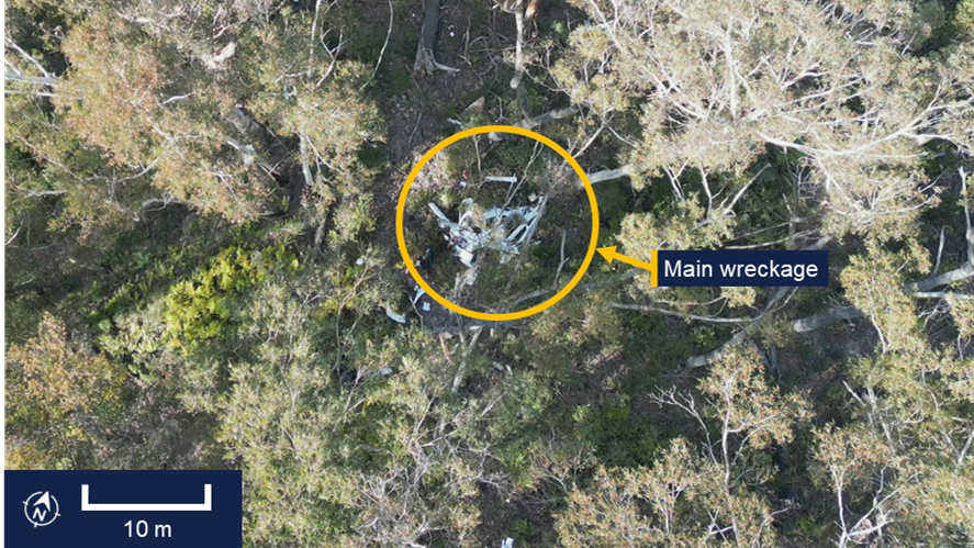
Consistent with an attempt to avoid cloud, a Cirrus SR20 reversed course at low altitude along a valley, before flying into densely forested terrain in Budawang National Park, on the NSW south coast, an ATSB investigation report details.
The accident, which destroyed the aircraft and fatally injured the pilot, occurred about 3 and a half hours into a private Visual Flight Rules (VFR) flight from Bankstown Airport, on the afternoon of 18 September 2025.
After taking off from Bankstown, the pilot had tracked south-west towards the Snowy Mountains, where they flew around Mount Kosciuszko, before flying to overhead Mallacoota Airport, Victoria, then turning back towards the north for a return to Bankstown.
After passing overhead Mallacoota, and with low cloud in the area ahead, recorded data indicated the pilot began to be presented with warnings about a high engine cylinder head temperature in cylinder 4.
“Perhaps because of this warning, or the low cloud ahead, or both, the pilot descended towards Moruya Airport, making a radio call that that they intended to land there,” ATSB Chief Commissioner Angus Mitchell explained.
There were no further radio calls from the pilot.
“Possibly influenced by the perceived presence of a completely clear area in the cloud layer ahead, instead of landing at Moruya the pilot pressed on, deviating from the initial planned track and toward higher terrain,” Mr Mitchell said.
“There was cloud over Moruya Airport and the pilot may have considered that maintaining visual flight throughout an approach and landing there might not have been feasible.”
The ATSB found that the cylinder head temperature warning was likely spurious, but would have presented an ongoing distraction.
“With limited prior experience in cross-country flights and facing deteriorating weather conditions, the pilot would have been less able to objectively weigh the cumulative hazards of continuing into adverse weather.”
Recorded data then showed the aircraft proceed into the mountainous area of the Great Dividing Range at an altitude between 2,000 and 2,700 ft. It then almost reversed course at low altitude along a valley, consistent with an attempt to avoid cloud.
“Once in the valley, it is likely the pilot was unable to find a way out while avoiding cloud,” Mr Mitchell said.
The ATSB found it was therefore likely the pilot inadvertently entered instrument meteorological conditions – which they were not trained or qualified to fly in – and became unable to regain visual references before the collision occurred.
Mr Mitchell said weather-related accidents are a persistent issue in general aviation.
“Investigations such as this highlight the importance of pilots always being prepared to make conservative decisions when operating under VFR,” Mr Mitchell said.
“As humans we are all prone to ‘get-there-itis': the pressure to push on to our planned destination.
“But pressing on – ‘scud running’ – in marginal weather in an attempt to maintain visual with the ground, carries with it a significant risk of flying into terrain, which, tragically, is almost never survivable.”
Mr Mitchell said that if visibility is reducing or the cloud base is lowering, pilots should strongly consider landing at the nearest suitable location rather than continuing into worsening conditions.
“Making an early decision to land, delay, or turn back can prevent a situation where safe flight cannot be maintained,” he said.
“And if VFR pilots do find themselves in marginal weather, they should seek whatever help is available, including contact with air traffic services, which has provided guidance in past occurrences, that has helped avert potential disaster.”
Read the final report: VFR into IMC and controlled flight into terrain involving Cirrus SR20, VH-TEL, 12 km east of Braidwood/Percheron aircraft landing area, New South Wales, on 18 September 2025
Read other recent VFR into IMC accident investigations:
- AO-2025-040 - VFR into IMC and collision with terrain involving Beechcraft 35-C33 Debonair, VH-KZK, 12 km east of Khancoban Airport, New South Wales, on 15 July 2025
- AO-2023-052 - VFR into IMC, loss of control and collision with terrain involving Socata TB‑20, VH-JTY, 65 km west of Mackay Airport, Queensland, on 28 October 2023
- AO-2022-016 - VFR into IMC, loss of control and collision with terrain involving Airbus Helicopters EC130 T2, VH-XWD, near Mount Disappointment, Victoria, on 31 March 2022
- AO 2021 017 - VFR into IMC and in-flight break-up involving Van's Aircraft RV-7A, VH-XWI, 90 km south of Charters Towers, Queensland, on 23 April 2021
Runway incursion and near collision involving a Boeing 737, ZK-TXB, and a ground vehicle, at Melbourne Airport, Victoria, on 17 February 2026
Summary
The ATSB is investigating a runway incursion and near collision involving a Boeing 737, registered ZK-TXB, and a ground vehicle at Melbourne Airport, Victoria, on 17 February 2026.
During the take-off on runway 34 at Melbourne Airport, the pilot of a Boeing 737 was alerted by ATC to a vehicle on the runway at the intersection of runway 09/27 and as a result conducted a high-speed rejected take-off.
In the course of the investigation, the ATSB considers there to be a reasonable likelihood of limitations in risk controls and organisational factors relevant to the occurrence. Examination of these factors represent a significant increase in the scope of this investigation, and it has been upgraded from Short to Defined as a result (the ATSB's different levels of investigation are detailed here).
The final report will be released at the conclusion of the investigation. Should a critical safety issue be identified during the course of the investigation, the ATSB will immediately notify relevant parties, so that appropriate safety action can be taken.
Last updated:
Occurrence summary
| Investigation number | AO-2026-061 |
|---|---|
| Occurrence date | 17/02/2026 |
| Occurrence time and timezone | 04:45 Australian Eastern Daylight Time |
| Location | Melbourne Airport |
| State | Victoria |
| Report status | Pending |
| Anticipated completion | Q1 2027 |
| Investigation level | Defined |
| Investigation type | Occurrence Investigation |
| Investigation phase | Final report: Drafting |
| Investigation status | Active |
| Mode of transport | Aviation |
| Aviation occurrence category | Near collision, Rejected take-off, Runway incursion |
| Occurrence class | Serious Incident |
| Highest injury level | None |
Aircraft details
| Manufacturer | The Boeing Company |
|---|---|
| Model | 737-8BK |
| Registration | ZK-TXB |
| Serial number | 29644 LN:2231 |
| Aircraft operator | Texel Air |
| Sector | Jet |
| Operation type | Part 129 Foreign air transport operators |
| Activity | Commercial air transport-Scheduled-Scheduled freight only |
| Departure point | Melbourne Airport, Victoria |
| Destination | Adelaide Airport, South Australia |
| Injuries | None |
| Damage | Nil |
Low rotor RPM and collision with terrain involving a Robinson R22 Beta II, 140 km north of Tennant Creek, Northern Territory, on 17 January 2026
What happened
On 17 January 2026, the pilot and sole occupant of a Robinson R22 Beta II helicopter was conducting contracted stock mustering operations at a station, about 140 km north of Tennant Creek, Northern Territory. At about 0900 local time, the pilot refuelled the helicopter, filling the tanks to their capacity. Shortly after, they became airborne to continue with the mustering operation.
At about 0910, the pilot reported that while moving cattle through a gate, they conducted a right turn at about 35 kt and 120 ft above ground level. About 3 seconds after completing the turn, the pilot recalled hearing an unusual noise and suspected a possible bird strike with the tail rotor, perceiving no response to their anti-torque pedal inputs.
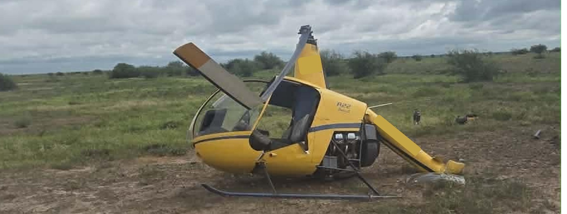
The pilot recalled that the low rotor RPM horn then sounded and the helicopter began to lose height. They reacted by lowering the collective in an attempt to regain the rotor RPM and attempted to gain forward airspeed. As the helicopter approached the ground the pilot flared and raised the collective[1] to reduce the rate of descent but the helicopter collided heavily with the terrain (Figure 1).
Figure 1: Occurrence helicopter
Source: Operator
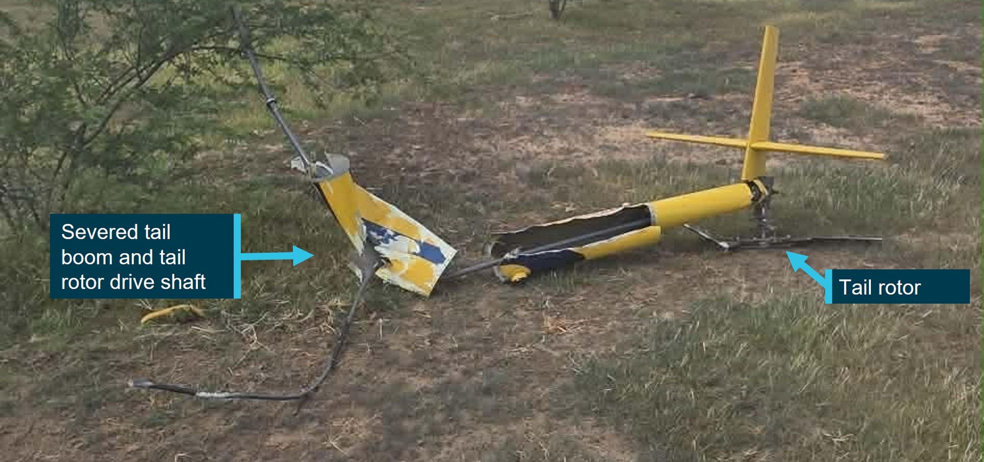
On contact with the ground, the helicopter’s main rotor blades flexed and contacted the tail boom causing it to separate. The tail boom, attached tail rotor gearbox and tail rotor were located about 30 m from the main wreckage (Figure 2).
Figure 2: Occurrence aircraft tail boom, and tail assembly
Source: Operator
The pilot wore a flight helmet and was restrained with a 3-point lap and sash harness and was able to free themselves from the wreckage uninjured. However, the helicopter was substantially damaged.
The operator conducted a post-accident engineering analysis of the wreckage and reported there were no indications of pre-impact defects or damage to the tail rotor flight control system that would have resulted in a loss of tail rotor control.
The operator advised that impact marks on the ground indicated that the helicopter was travelling in a west‑north-west direction when it impacted the ground and reported the wind direction at the time of the occurrence was 10–15 kt from the south-east, indicating that the helicopter was likely operating downwind when it impacted the terrain.
Following discussions with the pilot, the operator reported that additional weight after refuelling, combined with a loss of airspeed when turning downwind, likely led to the helicopter being overpitched. The operator considered that this likely caused a reduction in rotor RPM that was not immediately identified by the pilot. The loss of rotor RPM caused the helicopter to descend from a low height and the pilot was unable to recover the low rotor RPM or arrest the rate of descent prior to impacting the ground.
Additionally, the operator reported that the pilot had been listening to music during the low level operation, and identified that this may have reduced the pilot’s ability to aurally detect a reduction of the engine and rotor RPM prior to the low rotor RPM horn sounding. This may have reduced the pilot’s reaction and recovery time for a low rotor RPM condition. Robinson Helicopter’s Safety Notice 10 provides guidance on the recovery technique for low rotor RPM.
Safety action
The operator reported the following safety recommendations for company pilots:
- not to turn the helicopter downwind while at low altitude
- the importance of throttle control and to be aware of manually overriding the engine governor
- awareness of the helicopters engine RPM and listening for audible cues
- fuel load management and consideration given to all-up weight when conducting low-level flight.
Additionally, the operator advised that a notice was sent to all company pilots advising that listening to music while flying was not permitted, reiterating the importance of audible cues from the helicopter engine.
Safety message

The ATSB SafetyWatch highlights the broad safety concerns that come out of our investigation findings and from the occurrence data reported to us by industry. One of the safety concerns is Reducing the severity of injuries in accidents involving small aircraft | ATSB
The operator’s safe work method statements required company pilots to wear flight helmets when conducting mustering operations. The use of flight helmets reduces the risk and severity of head injuries, especially important when conducting low-level and other higher risk flight operations.
Flight at low level is a necessity during mustering operations and often involves abrupt manoeuvres with frequent power changes. Although the R22 engine is equipped with a governor to maintain constant engine RPM, large abrupt power changes can cause the governor to lag, reducing engine RPM and therefore rotor RPM. Pilots, especially during periods of high workload, have been known to grip the throttle control tightly, overriding the governor and preventing the governor from maintaining a constant engine RPM. Operators who routinely conduct low level flight are encouraged to review their training and checking regarding engine RPM management as well as the recovery techniques from a low rotor RPM condition.
About this report
Decisions regarding whether to conduct an investigation, and the scope of an investigation, are based on many factors, including the level of safety benefit likely to be obtained from an investigation. For this occurrence, no investigation has been conducted and the ATSB did not verify the accuracy of the information. A brief description has been written using information supplied in the notification and any follow-up information in order to produce a short summary report, and allow for greater industry awareness of potential safety issues and possible safety actions.
[1] The collective control changes the pitch angle of all main rotor blades.
Occurrence summary
| Mode of transport | Aviation |
|---|---|
| Occurrence ID | AB-2026-009 |
| Occurrence date | 17/01/2026 |
| Location | 140 km north of Tennant Creek |
| State | Northern Territory |
| Occurrence class | Accident |
| Aviation occurrence category | Collision with terrain, Control - Other, Loss of control |
| Highest injury level | None |
| Brief release date | 23/02/2026 |
Aircraft details
| Manufacturer | Robinson Helicopter Co |
|---|---|
| Model | R22 Beta II |
| Sector | Helicopter |
| Operation type | Part 138 Aerial work operations |
| Damage | Substantial |
Engine failure and attempted forced landing involving a Cessna U206F, 102 km east-north-east of Port Keats Aerodrome, Northern Territory, on 30 January 2026
Source: Operator
What happened
On 30 January 2026 at about 1205 local time, the pilot and sole occupant of a Cessna U206F departed from an Emu Point aircraft landing area, Northern Territory, en route to Darwin Airport.
Prior to departure the pilot conducted a pre-flight inspection and reported that the aircraft departed with 190 L of fuel. No abnormalities were observed during the take-off or the initial climb. The aircraft levelled off at about 2,000 ft above mean sea level (AMSL) and the pilot conducted the cruise checklist, with no issues identified. Shortly after this, the pilot observed an engine RPM overspeed. The pilot reduced the propellor pitch lever, but this had no effect, so they reduced the throttle to maintain an appropriate RPM.
Shortly after this, the engine began running rough, accompanied by increasing vibration and a reduction in engine power. Almost immediately, smoke began entering the cockpit via the cabin air vents, which the pilot closed. The engine performance continued to degrade to the extent that the aircraft was unable to maintain straight and level flight. The pilot observed smoke and oil spraying onto the airframe and windscreen, reducing forward visibility. They reported that the engine vibrations increased violently, to the point that the entire airframe was shaking.
The pilot selected an area of open grassland interspersed with trees and termite mounds beyond a heavily wooded area and prepared to conduct a forced landing.
Source: Operator, annotated by the ATSB
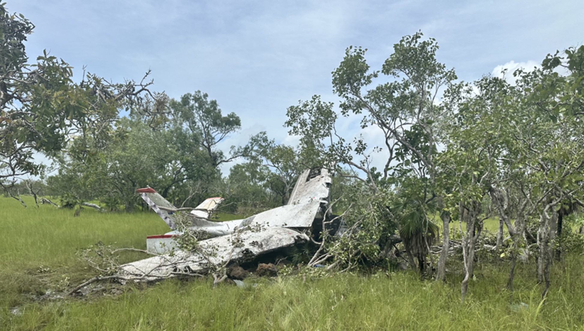
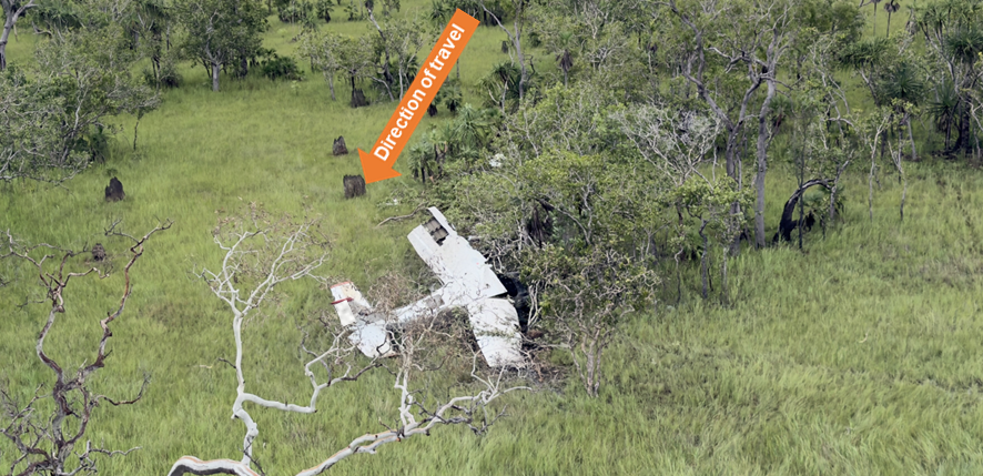
Prior to landing, the pilot conducted final checks, unlatched their door and maintained what power was available to assist in clearing the tree line. However, prior to touchdown, the aircraft collided with several trees before rotating left, impacting the ground heavily and coming to a stop (Figure 1).
The pilot reported a brief period of unconsciousness and after ‘coming to’, turned off the ignition and checked that the ELT[1] had activated. The pilot exited through the shattered cockpit windscreen and moved to a safe distance from the wreckage, returning briefly to retrieve a handheld VHF radio and a personal mobile phone. The pilot’s initial attempts to coordinate emergency assistance were unsuccessful. Shortly after, they established radio contact with another aircraft that relayed a MAYDAY call. A rescue aircraft with an emergency response team arrived about one hour later.
The pilot was medically assessed and later admitted to hospital with minor abrasions and a broken collarbone requiring surgery.
The aircraft was significantly damaged and, at the time of publishing, the remote location, terrain and weather conditions have prevented aircraft recovery. Consequently, the likely cause of the reported engine failure remains undetermined.
Safety message
In-flight engine failures and partial power loss in single-engine aircraft require pilots to exercise effective and timely decision-making to reduce the severity of injuries and damage. These events often result in the pilot experiencing high workload and time pressure, where preparedness is critical. Deciding on responses to a partial engine power loss before the flight will reduce your workload during the event and assist you in taking some form of considered action.
When experiencing a rough running engine, pilots should focus on flying the aircraft and continually assess landing options. The ‘aviate, navigate and communicate’ framework establishes a clear hierarchy of priorities, particularly during emergencies. Acting in the appropriate order of priority improves situation awareness and supports coordinated responses in a dynamic environment.
Guidance from ATSB publication
AR-2010-055
(7.03 MB)
AR-2010-055
(7.03 MB)
recommends that scanning the environment should take 85% of the time available, 10% on checking aircraft attitude including lookout, and 5% of the time scanning of the altitude and airspeed indications. About this report
Decisions regarding whether to conduct an investigation, and the scope of an investigation, are based on many factors, including the level of safety benefit likely to be obtained from an investigation. For this occurrence, no investigation has been conducted and the ATSB did not verify the accuracy of the information. A brief description has been written using information supplied in the notification and any follow-up information in order to produce a short summary report, and allow for greater industry awareness of potential safety issues and possible safety actions.
[1] Electronic Locator Transmitter (ELT): an aviation safety device installed in aircraft that automatically or manually transmits a distress signal via satellites.
Occurrence summary
| Mode of transport | Aviation |
|---|---|
| Occurrence ID | AB-2026-010 |
| Occurrence date | 30/01/2026 |
| Location | 102 km east-north-east of Port Keats Aerodrome |
| State | Northern Territory |
| Occurrence class | Accident |
| Aviation occurrence category | Collision with terrain, Engine failure or malfunction, Forced/precautionary landing, Smoke |
| Highest injury level | Serious |
| Brief release date | 20/02/2026 |
Aircraft details
| Manufacturer | Cessna Aircraft Company |
|---|---|
| Model | U206F |
| Sector | Piston |
| Operation type | Part 135 Air transport operations - smaller aeroplanes |
| Departure point | Emu Point Aircraft Landing Area, Northern Territory |
| Destination | Darwin Airport, Northern Territory |
| Damage | Destroyed |
Near collision involving Cessna 172S, VH-KOJ, and Cirrus SR22, VH-XC5, about 21 km south-south-east of Melbourne Airport, Victoria, on 22 January 2026
Final report
Report release date: 15/09/2026
Investigation summary
What happened
On the night of 22 January 2026, a Cessna 172 (172), VH-KOJ, was being operated on a training flight with a flight instructor and student on board. At the same time, a Cirrus SR22, VH-XC5, was undertaking a personal transport flight with a pilot and 3 passengers on board. Both aircraft were operating under the night visual flight rules.
The 172 and the SR22 had both received air traffic control (ATC) clearance to orbit the Melbourne central business district (CBD) at 2,100 ft. The SR22 pilot was instructed to follow the slower preceding 172. During communications with ATC, the SR22 pilot advised they had the 172 sighted and would slow down. However, the SR22’s indicated airspeed remained faster than the 172, resulting in a sustained reduction of lateral separation between the 2 aircraft. As the 172 departed the orbit, the aircrafts’ flight paths converged and the separation between the aircraft reduced to about 46 m laterally and 99 ft vertically.
What the ATSB found
The ATSB found that the SR22 pilot did not maintain adequate spacing to the slower preceding 172 while both aircraft were conducting orbits of the Melbourne CBD. Although the pilot of the SR22 was provided traffic information for the 172 by ATC, and their traffic advisory system, they did not reduce the aircraft’s indicated airspeed sufficiently to maintain adequate spacing. Instead, the pilot of the SR22 elected to widen their orbit, which resulted in the aircraft tracks converging shortly after the 172 departed the orbit.
What has been done as a result
The operator of VH-KOJ advised the ATSB that all company pilots were briefed on the occurrence for awareness, and that a review of procedures for orbits of the Melbourne central business district was conducted. The ATSB was also informed that the organisation was in the process of implementing electronic flight bags to provide automatic dependent surveillance–broadcast traffic information for aircraft that were not equipped with the Garmin traffic alert system.
Safety message
Air traffic control sequencing is critical to the safe separation of aircraft operating within the same airspace, and pilots must accurately interpret and adhere to ATC clearances. Pilots should continuously assess the relative proximity of nearby aircraft using all available sources of information. Where the developing traffic situation no longer matches the anticipated scenario, the timely reassessment and implementation of an alternative course of action is essential to restoring adequate separation and reducing the risk of collision.
The investigation
| The ATSB scopes its investigations based on many factors, including the level of safety benefit likely to be obtained from an investigation and the associated resources required. For this occurrence, the ATSB conducted a limited-scope investigation in order to produce a short investigation report, and allow for greater industry awareness of findings that affect safety and potential learning opportunities. |
The occurrence
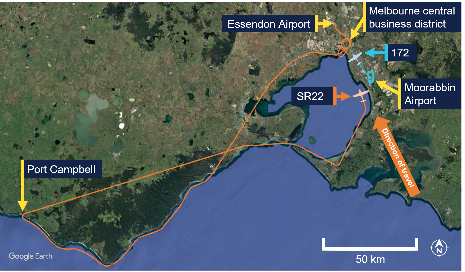
On the night of 22 January 2026, a Cessna 172 (172), registered VH-KOJ, was being operated on a training flight from Moorabbin Airport, Victoria, with a flight instructor and student on board. At the same time, a Cirrus SR22, registered VH-XC5, was returning to Essendon Airport, after undertaking a personal transport flight with a pilot and 3 passengers on board (Figure 1). Both aircraft were maintaining 2,100 ft and were being operated under night visual flight rules.1
Figure 1: Aircraft historical tracks and positions at 2142:19
At 2142:19 local time,2 the student on board the 172, who was the pilot flying, contacted Essendon Tower air traffic control (ATC) and requested approval to conduct one right‑hand orbit of the Melbourne central business district (CBD) (see Airspace information). This request was approved by ATC who issued a clearance for one right‑hand orbit at 2,100 ft.
At 2144:30, the pilot of the SR22 also contacted Essendon Tower ATC and requested approval to conduct 2 right-hand orbits of the CBD. ATC instructed the pilot they would be ‘number 2’3 for the orbits behind the 172 and cleared the SR22 for 2 right-hand orbits at 2,100 ft.
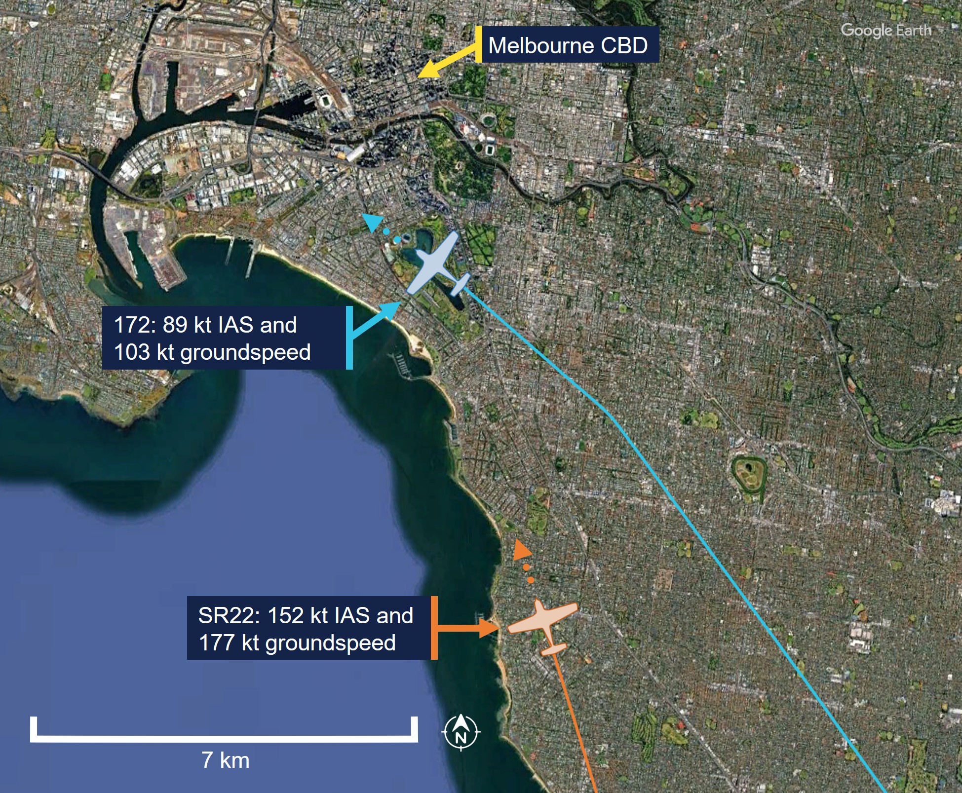
At 2145:02, the pilot of the SR22 advised ATC they had sighted the 172 on their traffic advisory system (TAS) (see Garmin traffic advisory system) and that they would follow the 172 and slow down. The SR22 pilot also had visual contact with the 172 and recalled that they could see the aircraft quite easily. Aviation routine weather report data for Essendon Airport from the Bureau of Meteorology issued at 2130 local time indicated the visibility was greater than 10 km with no cloud detected. At this time, the SR22 had an indicated airspeed (IAS)4 of 152 kt and a groundspeed5 of 177 kt, whereas the 172 had an IAS of 89 kt and a groundspeed of 103 kt. The distance between the 2 aircraft was 7 km (Figure 2). At that time, the SR22 and 172 were subjected to a tailwind component of 17 kt and 14 kt respectively. A short time later, the IAS of the SR22 began to decrease, although it remained faster than the 172 throughout the orbit.
Figure 2: Aircraft position and groundspeed at 2145:02
At 2145:37, ATC advised the student and instructor of the 172 that the SR22 would also be conducting right-hand orbits of the CBD at 2,100 ft and that the SR22 pilot had them in sight. This information was acknowledged by the student in the 172.
At 2145:47, the instructor of the 172 advised ATC they intended to exit the orbit via the south and, a short time later, ATC issued a clearance for the 172 to track to Williamstown from the Melbourne Cricket Ground (MCG) at 2,100 ft. The pilot of the SR22 heard these transmissions.
At 2148:16, ATC cleared the SR22 to proceed to Essendon Airport on completion of their orbits. At that time, the groundspeed of the SR22 was 55 kt faster than the 172 and the distance between the 2 aircraft had reduced to 1.9 km (Figure 3). The pilot of the SR22 recalled the 172 appeared to slow down to the east of the CBD. At that time, the 172 was experiencing a headwind component of 14 kt, while the SR22 was still experiencing a tailwind. In response, the SR22 pilot widened their orbit in an attempt to maintain separation.
Figure 3: Flight paths and lateral separation around the Melbourne CBD
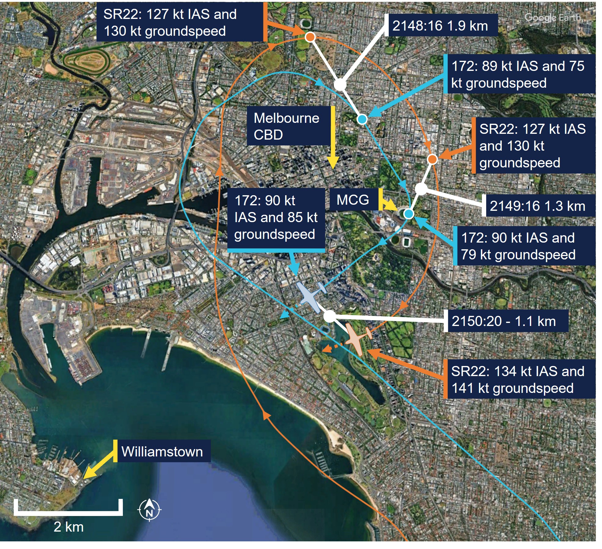
At 2149:16, the 172 overflew the MCG and turned onto a westerly heading towards Williamstown. At this time the distance between the 2 aircraft had reduced to 1.3 km. After the 172 overflew the MCG, the instructor and student observed a traffic advisory (TA) on their TAS. This alerted the pilots to traffic positioned behind the 172 on the left side at the same altitude, which they determined was the SR22 conducting CBD orbits. The instructor reported that they had previously observed TA’s while operating within an aerodrome circuit, which would prompt them to determine if a conflict risk existed.
On this occasion, they assessed that the position of the SR22 was consistent with their clearance and, although they could not see the SR22 behind their aircraft, they determined that no conflict existed. The pilot of the SR22 also recalled observing a TA, however they were focused on visually maintaining separation.
At 2150:20, the SR22 had a tailwind of 7 kt, while the 172 experienced a headwind of 5 kt. At that time, the SR22’s groundspeed was 56 kt faster than the 172 and the distance between the aircraft had reduced to 1.1 km. Around this time, the pilot of the SR22 recalled observing the relative position of the 172 moving to the right of their windshield. Both aircraft were located about 14 km to the south-south-east of Essendon Airport.
At 2150:36, the SR22 continued turning through a westerly heading with a groundspeed of 146 kt and encroached on the 172, which had a groundspeed of 86 kt, from behind the left wing. The student and instructor sighted the SR22 behind the left-wing strut heading directly towards the aircraft. The student recalled their initial reaction was to turn to the right. However, the instructor assumed control of the aircraft and recalled waiting to observe the avoiding action from the pilot of the SR22.
Around this time, the pilot of the SR22 recalled that the 172 became stationary in their windshield and assessed that the aircraft were on a collision course. At 2150:38, they pitched the aircraft down and descended from 2,100 ft shortly after. Having observed the SR22 descend, the instructor of the 172 then initiated a brief climb while maintaining a relatively consistent heading and IAS. At 2150:43, the SR22 passed 46 m behind and 99 ft below the 172 (Animation 1).
Animation 1: 172 and SR22 flight paths intersecting at 2150:43
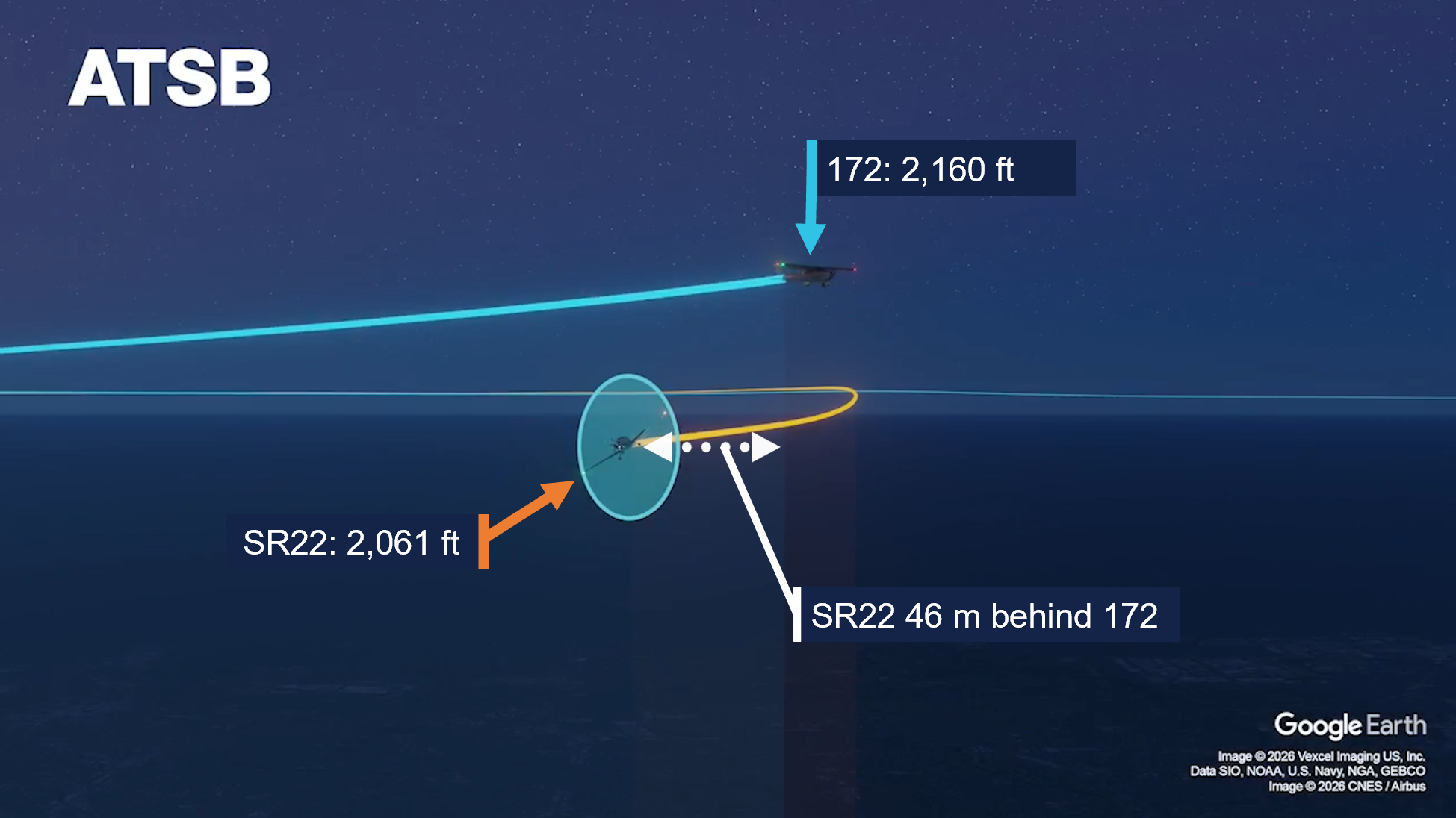
No radio communication between the 2 aircraft took place following the encounter, nor was the incident advised to ATC, who had no awareness of the near collision at that time (see Essendon Tower). The student and instructor of the 172 and the pilot of the SR22 both assessed there was no further risk of conflict after visually confirming that the respective traffic had passed clear. The student and instructor on board the 172 continued the training flight, while the SR22 pilot elected to return to Essendon Airport after the completion of the first orbit.
Context
Personnel information
The pilot of the Cirrus SR22 held a Private Pilot Licence (Aeroplane) with night visual flight rules (NVFR) rating and a class 2 aviation medical certificate. They had a total of 850 hours of flying experience, of which 820 were on the SR22, and had flown 40 hours in the previous 90 days. They reported obtaining 10 hours of sleep in the preceding 24 hours and had been awake for 9 hours at the time of the occurrence, which occurred about 2 hours after departing Essendon Airport.
The instructor and pilot in command of the Cessna 172 (172) held a Commercial Pilot Licence (Aeroplane) with instrument, instructor and NVFR training ratings and a class 1 aviation medical certificate. They had a total of 685 hours of flying experience, of which 640 were on the 172 and had flown 144 hours in the previous 90 days. They reported obtaining 10 hours of sleep in the preceding 24 hours and had been awake for 10 hours at the time of the occurrence, which occurred 6 hours after they had signed on for duty.
The student in the 172 held a Private Pilot Licence (Aeroplane) with a class 2 aviation medical certificate and was undergoing training to obtain their Commercial Pilot Licence (Aeroplane). They had a total of 85 hours of flying experience, of which 84 were on the 172 and had flown 50 hours in the previous 90 days. They reported obtaining 8 hours and 30 minutes of sleep in the preceding 24 hours and taking a 30‑minute nap about 10 hours prior to the occurrence. The student also reported arriving at Moorabbin Airport about 2 and a half hours prior to the occurrence.
All pilots reported being ‘fully alert’ during the occurrence and the ATSB did not consider that fatigue affected the performance of the pilots at the time of the occurrence.
Aircraft information
The Cirrus SR22 is a low wing, 5-seat, composite (primarily) construction aircraft with fixed landing gear. It is powered by a single piston engine, driving a constant speed propeller and had a normal operating indicated airspeed range of 74–176 kt with the flaps retracted.
The Cessna 172 is a high-wing, 4-seat, all-metal aircraft with fixed landing gear. It is powered by a single piston engine, driving a fixed-pitch propeller and had a normal operating indicated airspeed range6 of 48–129 kt with the flaps retracted.
Both aircraft were equipped with the Garmin G1000 avionics suite and traffic advisory system (TAS) (see Garmin traffic advisory system).
Airspace information
Overview
The airspace over the Melbourne central business district (CBD) was designated as ‘controlled airspace,’ which included the Melbourne control zone (CTR) extending upwards from Tullamarine Airport and the adjacent class C airspace step (Figure 4). Aircraft wishing to enter controlled airspace are required to obtain an airways clearance from air traffic control (ATC).
Figure 4: Melbourne controlled airspace dimensions
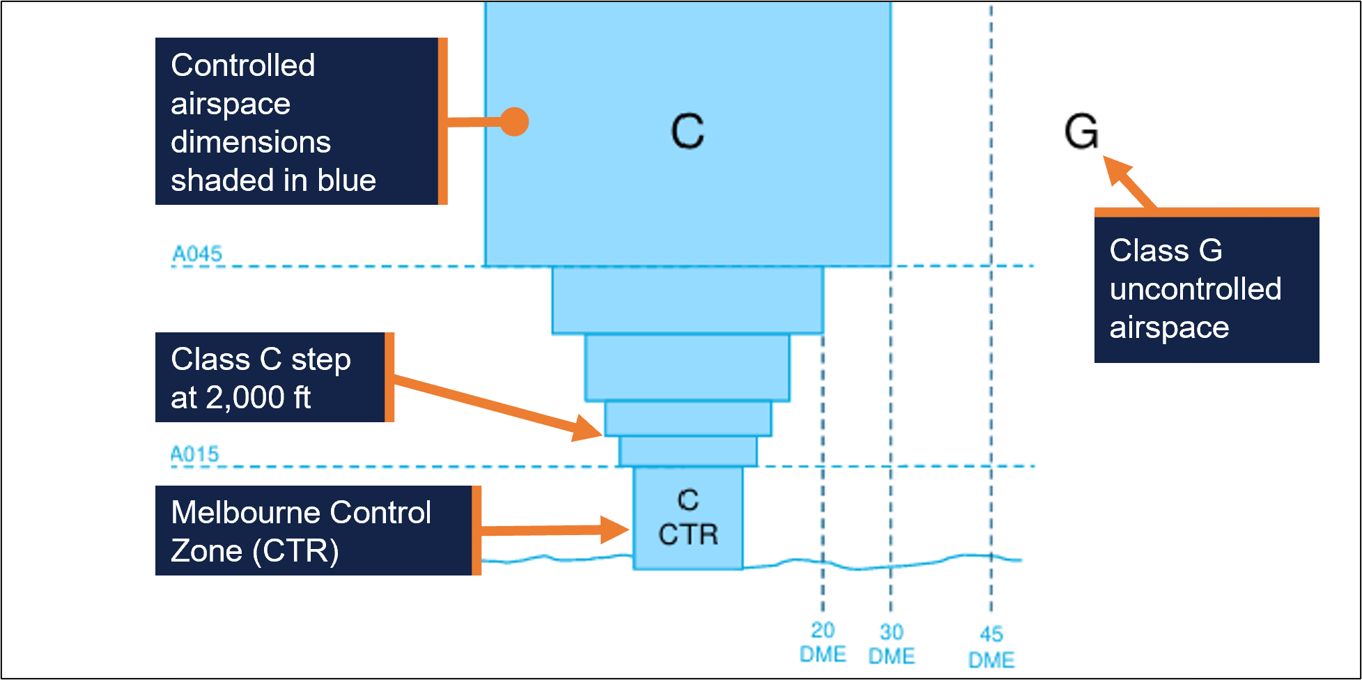
Within the Melbourne CTR and adjacent class C controlled airspace steps, class C procedures and services applied, which included separation between instrument flight rules (IFR) aircraft, and IFR and visual flight rules (VFR) aircraft.
ATC were not required to separate VFR aircraft within controlled airspace. However, VFR aircraft were provided with traffic information on other VFR aircraft and avoidance advice upon request.
Essendon tower
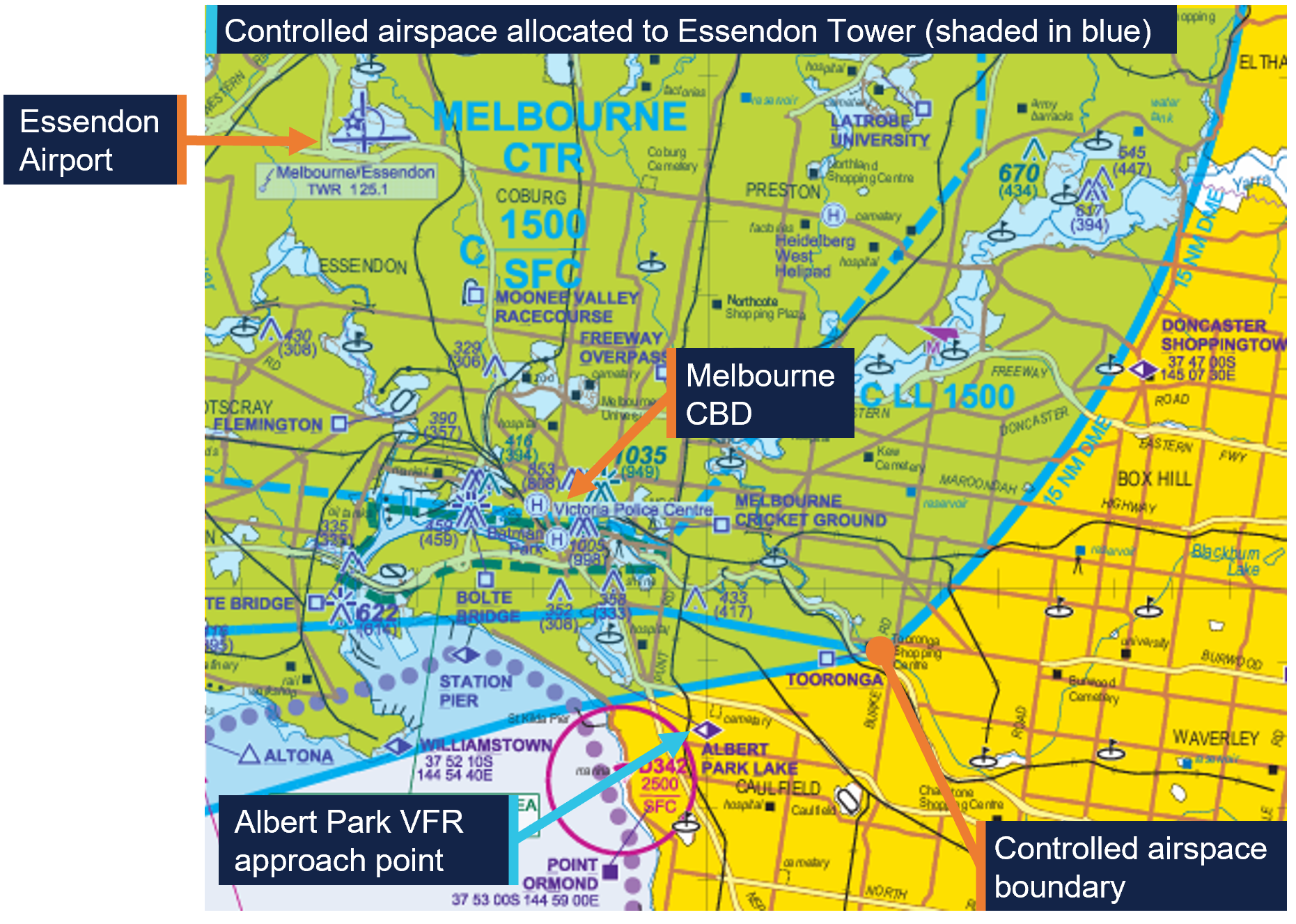
Tower controllers at Essendon Airport, located 11 km to the north-west of the Melbourne CBD, were responsible for managing the south‑eastern quadrant of the Melbourne CTR and the adjacent Class C steps up to and including 2,000 ft during the hours of operation.
All aircraft wishing to operate in this airspace were required to contact Essendon Tower (during the hours of operation) at the appropriate VFR approach point depicted on the Airservices Australia visual terminal chart (Figure 5).
Figure 5: Melbourne visual terminal chart
The controllers at Essendon tower relied primarily on visual observations to provide aerodrome control services within their allocated airspace. The Essendon tower was also fitted with a tower situation awareness display (TSAD), which was approved for the provision of surveillance system separation services and provided aircraft position information to enhance controller awareness.
The Airservices Australia Manual of Air Traffic Services7 stated that the TSAD may be used to assist controllers in meeting their responsibilities for the provision of aerodrome control services, traffic information, traffic sequencing and assistance to aircraft during an emergency. However, the system did not provide controllers with conflict alerting.
Rules of the air
The ‘right of way’ rules under part 91 of the Civil Aviation Safety Regulations (CASRs) (general operating and flight rules) stated that ‘a flight crew member must, during a flight, maintain vigilance, so far as weather conditions permit, to see and avoid other aircraft.’
Once an aircraft had been detected, part 91.330 of the CASRs described various circumstances and the applicable right of way rules which pilots must adhere to. The right of way rules applicable to the occurrence are listed in Table 1:
Table 1: Right of way rules
| Circumstance | Right-of-way rule |
|---|---|
Two aircraft are on converging headings at approximately the same altitude | The aircraft that has the other aircraft on its right must give way to the other aircraft. |
| If there is a collision risk | The aircraft that has the right of way to another aircraft must maintain the same heading and speed until there is no longer a risk of collision[1] |
| |
| Source: Civil Aviation Safety Authority, annotated and tabulated by the ATSB | |
See and avoid
In circumstances where aircraft are not provided with separation from other aircraft, as is the case for VFR aircraft operating in class C airspace, the primary method of separation is ‘see and avoid’ practices. This requires pilots to conduct a visual search to ‘see and avoid’ potentially conflicting traffic. The types of searches used to identify traffic are distinguished as either ‘unalerted’ or ‘alerted.’
An ‘unalerted’ search is one where reliance is entirely on the pilot searching for, and sighting, another aircraft without prior knowledge of its presence. On the other hand, an ‘alerted’ search is one where the pilot is alerted to another aircraft’s presence, typically via radio communications or aircraft based alerting systems. An alerted search is likely to be 8 times more effective than an unalerted search (Hobbs 1991).
While recent technological advances mean pilots can utilise electronic traffic alerting within the cockpit, it is critical that pilots sight other aircraft and maintain visual separation and not rely solely on the depiction of traffic on the device screen for traffic avoidance action (Civil Aviation Safety Authority, 2025).
Operational information
Garmin traffic advisory system
The Garmin traffic advisory system (TAS) fitted to both aircraft displayed traffic information for detected transponder-equipped aircraft to enhance crew situational awareness. Garmin documentation stated that the TAS was intended for ‘advisory use only to aid the pilot in visually acquiring traffic’.
The TAS incorporated audio and visual alerts for detected conflicting traffic. These alerts were provided as a traffic advisory (TA), which may be generated based on range and altitude closure rate (time until collision) or if the intruder aircraft encroaches within a minimum distance.
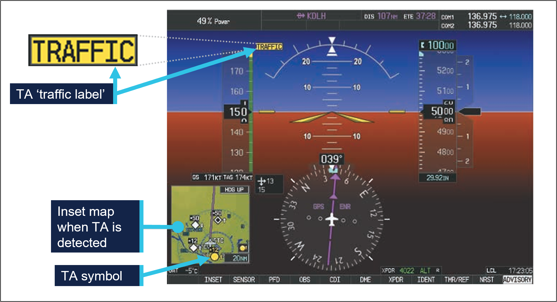
When a TA is triggered, a single ‘TRAFFIC’ voice alert is generated, which is accompanied by relative bearing expressed as a clock code,8 altitude and distance. Additionally, a traffic annunciation along with a TA symbol (yellow circle) is displayed on the primary flight display (Figure 6). Garmin documentation also stated:
No avoidance manoeuvres should be based solely upon traffic information. It is the responsibility of the pilot in command to see and manoeuvre to avoid traffic.
Figure 6: TA annunciation and symbol on primary flight display
Recorded information
Airservices Australia recorded data
Airservices Australia provided the ATSB with radar and audio recordings for the evening of 22 January 2026. These recordings documented the communication exchange between the pilots of both aircraft and the tower controller at Essendon Airport. The radar recording also documented the flight paths of both aircraft.
Garmin G1000 recorded data
The Garmin avionics suite installed in the SR22 and 172 included a flight data logging feature that automatically stored critical flight and engine data on a removable data card. The ATSB was provided with the flight logs obtained from data cards installed in both aircraft at the time of the occurrence.
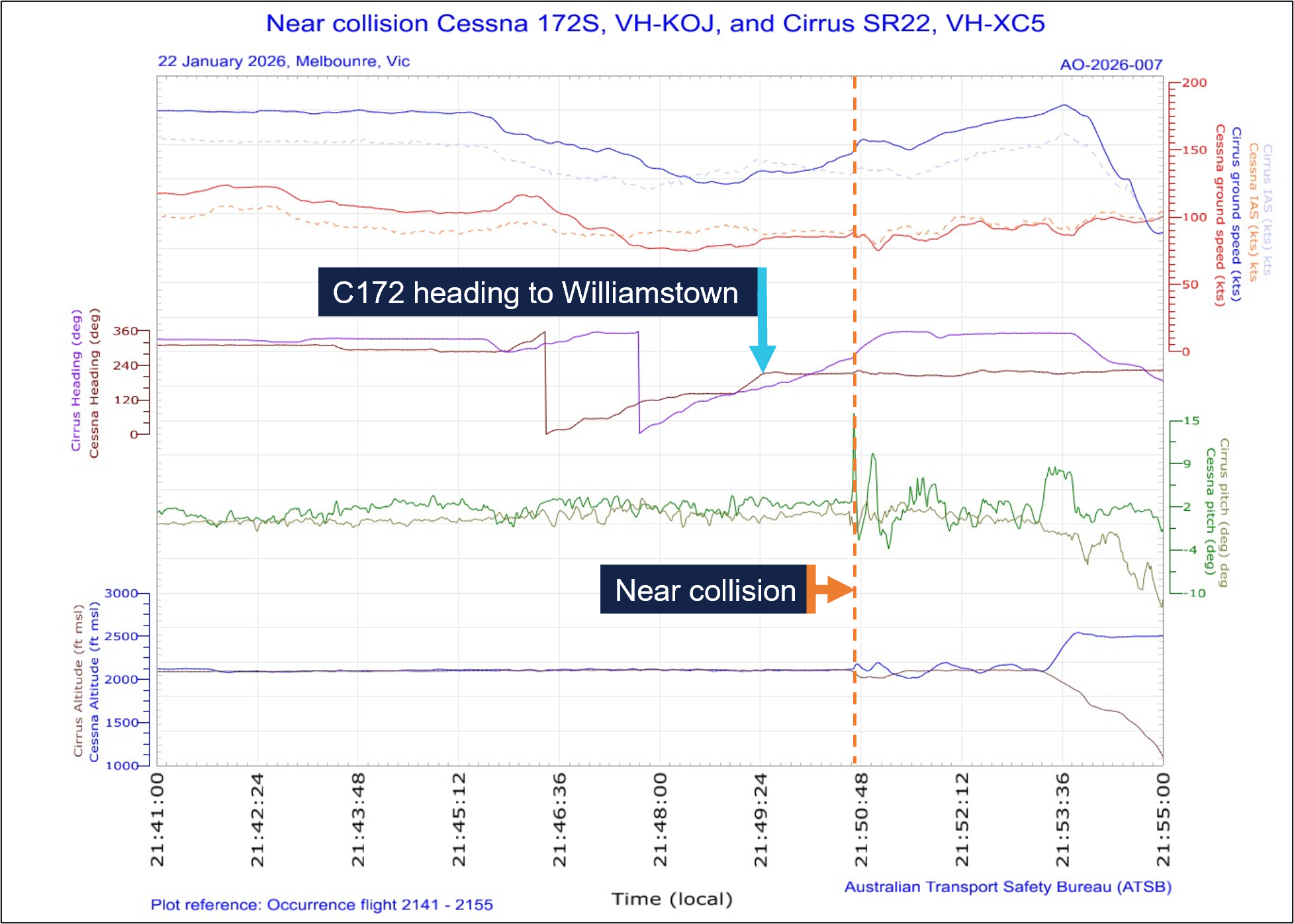
The recorded flight data captured parameters such as altitude, indicated airspeed, vertical speed, pitch attitude and bank angle Figure 7). This data enabled a detailed reconstruction of the flight, providing insights into the aircrafts’ flight paths and pilot actions during the occurrence.
Figure 7: Graphical representation of G1000 flight data from VH-KOJ and VH-XC5
Related occurrence
ATSB investigation AO-2025-033
On 12 June 2025, a student pilot conducting a solo navigation flight in a Piper PA‑44 was returning to Jandakot Airport, Western Australia, at the same time a Cessna 172 was approaching the airport from the training area. Air traffic control directed the pilot of the faster PA‑44 to overtake the 172 as they approached the circuit area. However, the PA‑44 did not pass the 172 prior to joining the circuit and, consequently, ATC amended the instruction to the pilot of the PA‑44 to ‘follow the Cessna’ and instructed the 172 pilot to join downwind and land first.
The ATSB found that the PA-44 pilot did not identify the final part of the amended instruction to ‘follow the Cessna’, likely due to receiving an unexpected cockpit traffic alert at the time the approach clearance was issued. Consequently, the PA‑44 pilot passed the 172 as per the original clearance, resulting in reduced separation between the 2 aircraft. The associated safety message highlighted the importance of aircraft sequencing, and the need for flight crew to seek confirmation from controllers if they are unsure of what is required of them or if the traffic scenario does not present as expected.
Safety analysis
Both the Cessna 172 (172) and Cirrus SR22 were operating under night visual flight rules (NVFR) in class C airspace while conducting orbits of the Melbourne central business district (CBD). A clearance from air traffic control (ATC) was required to undertake the orbits, but separation between NVFR traffic remained the responsibility of the pilot in command of each aircraft. While ATC was not responsible for providing separation, they did provide traffic information to both the pilot of the SR22 and the student and instructor on board the 172. Additionally, both aircraft were fitted with a traffic alerting system (TAS), which presented traffic information and further enhanced alerted see and avoid activities.
The pilot of the SR22 received an ATC clearance to orbit the CBD and follow the 172, which they understood. They advised ATC they would slow down to remain behind the 172, which they had on the TAS and visually acquired. However, although the indicated airspeed (IAS) of the SR22 reduced from 152 kt to 121 kt (momentarily) after obtaining the clearance to conduct the orbits, it remained significantly faster than the 172. During that time, the IAS of the 172 remained between 85–97 kt. While the SR22 had a higher normal operating airspeed than the 172, it was able to match the speed of the 172 during the orbit with flaps retracted. As the orbit progressed, both aircraft encountered a headwind and the SR22 pilot became aware that the 172 appeared to slow down relative to their own aircraft. In response, they elected to widen their orbit, however the separation between the 2 aircraft further reduced due to the higher groundspeed of the SR22.
The pilot of the SR22 then recalled hearing ATC issue a clearance to the 172 to track from overhead the Melbourne Cricket Ground (MCG) to Williamstown, which facilitated a southerly exit from the orbit. As the 172 overflew the MCG and turned towards Williamstown, the student and instructor on board the 172 received a traffic alert on their TAS. At that time the distance between the 2 aircraft had reduced to 1.3 km. The instructor determined that the traffic was the SR22, also conducting Melbourne CBD orbits, and assessed that no conflict existed. Given the traffic information for the SR22 provided by ATC, and the instructor’s previous experience with TAS, it was likely reasonable for the instructor to believe the SR22 was following ATC instructions and would remain behind the 172.
The SR22 pilot also received a traffic alert on their TAS, but at that time they had the 172 sighted and were attempting to understand the visual traffic picture. Had the pilot observed the relative position of the aircraft indicated on the TAS, this may have aided their situation awareness and provided an earlier indication of the relative positions of the aircraft and the reducing lateral spacing.
After the 172 began tracking towards Williamstown and the SR22 proceeded with the orbit to the south of the Melbourne CBD, the groundspeed differential between the 2 aircraft increased to 60 kt. This was a result of the relative airspeeds of the aircraft and the SR22 encountering a tailwind, while the 172 was still experiencing a headwind. The wide orbit of the SR22, in combination with the groundspeed differential and departure track of the 172, resulted in the flight paths converging.
Moments before the flight paths intersected, the student and instructor on board the 172 observed the SR22 behind the left-wing strut flying directly towards them. The pilot of the SR22 also observed that the 172 became stationary in their windshield, and they assessed that both aircraft were on a collision course.
In response, the pilot of the SR22 took avoiding action by initiating a descent while they continued turning right toward the north. Having observed the SR22 descending, the instructor in the 172 initiated a climb while maintaining a relatively consistent heading and IAS. In this instance, the 172 had the ‘right of way’, as it was positioned to the right of the SR22 prior to the flight paths intersecting, and the instructor’s actions were consistent with the right of way rules if there was a collision risk. The SR22 subsequently passed behind the 172 with 46 m horizontal and 99 ft vertical separation.
Although the traffic situation display used by Essendon Tower presented the radar positions of both aircraft, the system did not provide collision alerting. Additionally, both aircraft were located about 14 km away from the control tower at Essendon Airport, making it highly unlikely that the tower controller would have been able to visually detect the converging flight paths.
Contributing factor The Cirrus SR22 pilot did not maintain adequate spacing to the slower preceding Cessna 172 while both aircraft were conducting orbits at night over Melbourne, resulting in a near collision when the Cessna 172 departed the orbit and the flight paths intersected. |
Findings
ATSB investigation report findings focus on safety factors (that is, events and conditions that increase risk). Safety factors include ‘contributing factors’ and ‘other factors that increased risk’ (that is, factors that did not meet the definition of a contributing factor for this occurrence but were still considered important to include in the report for the purpose of increasing awareness and enhancing safety). In addition ‘other findings’ may be included to provide important information about topics other than safety factors. These findings should not be read as apportioning blame or liability to any particular organisation or individual. |
From the evidence available, the following findings are made with respect to the near collision involving Cessna 172S, VH-KOJ, and Cirrus SR22, VH-XC5, about 21 km south‑south‑east of Melbourne Airport, Victoria, on 22 January 2026.
Contributing factors
- The Cirrus SR22 pilot did not maintain adequate spacing to the slower preceding Cessna 172 while both aircraft were conducting orbits at night over Melbourne, resulting in a near collision when the Cessna 172 departed the orbit and the flight paths intersected.
Safety action
| Whether or not the ATSB identifies safety issues in the course of an investigation, relevant organisations may proactively initiate safety action in order to reduce their safety risk. The ATSB has been advised of the following proactive safety action in response to this occurrence. |
Safety action by the operator of VH-KOJ
The operator of VH-KOJ advised the ATSB that all company pilots were briefed on the occurrence for awareness, and that a review of procedures for orbits of the Melbourne central business district was conducted. The ATSB was also informed that the organisation was in the process of implementing electronic flight bags to provide automatic dependent surveillance-broadcast traffic information for aircraft that were not equipped with the Garmin traffic alert system.
Sources and submissions
Sources of information
The sources of information during the investigation included:
- the pilots of both aircraft
- the operator of VH-KOJ
- Civil Aviation Safety Authority
- Airservices Australia
- Bureau of Meteorology
- recorded data from the GPS unit on the aircraft.
References
Civil Aviation Safety Authority. (2025). Advisory Circular (AC) 92.3 v2.0 - ADS-B for enhancing situational awareness. Retrieved from https://www.casa.gov.au/ads-b-enhancing-situational-awareness
Federal Aviation Administration. (2016). Pilots’ Role in Collision Avoidance AC90-48D CHG 1. Retrieved from https://www.faa.gov/documentlibrary/media/advisory_circular/ac_90-48d_chg_1.pdf
Hobbs, A. (1991). Limitations of the see-and-avoid principle. Canberra: Australian Transport Safety Bureau. Retrieved from https://www.atsb.gov.au/sites/default/files/media/4050593/see_and_avoid_report_print.pdf
Submissions
Under section 26 of the Transport Safety Investigation Act 2003, the ATSB may provide a draft report, on a confidential basis, to any person whom the ATSB considers appropriate. That section allows a person receiving a draft report to make submissions to the ATSB about the draft report.
A draft of this report was provided to the following directly involved parties:
- the pilots of both aircraft
- the operator of VH-KOJ
- Civil Aviation Safety Authority
- Airservices Australia
- Bureau of Meteorology.
Submissions were received from:
- the pilot of VH-XC5
- the operator of VH-KOJ
- Civil Aviation Safety Authority
- Airservices Australia.
The submissions were reviewed and, where considered appropriate, the text of the report was amended accordingly.
Purpose of safety investigationsThe objective of an ATSB safety investigation is to improve transport safety through:
In accordance with the TSI Act, the ATSB does not investigate for the purpose of taking administrative, regulatory or criminal action, and cannot apportion blame, assist in determining liability, or, as a general rule, assist in court proceedings. About ATSB reportsATSB safety investigation reports are developed in accordance with ATSB procedures and guidelines, and with regard to applicable international standards and instruments. Reports must include factual material of sufficient weight to support the investigation’s analysis and findings. At all times the ATSB endeavours to balance the use of material that could imply adverse comment with the need to properly explain what happened, and why, in a fair and unbiased manner. An explanation of terminology used in ATSB investigation reports is available here. Publishing informationReleased in accordance with section 25 of the Transport Safety Investigation Act 2003 Published by: Australian Transport Safety Bureau © Commonwealth of Australia 2026 Ownership of intellectual property rights in this publication Unless otherwise noted, copyright (and any other intellectual property rights, if any) in this report publication is owned by the Commonwealth of Australia. Creative Commons licence 
With the exception of the Commonwealth Coat of Arms, ATSB logo, and photos and graphics in which a third party holds copyright, this report is licensed under a Creative Commons Attribution 4.0 International licence. The CC BY 4.0 licence enables you to distribute, remix, adapt, and build upon our material in any medium or format, so long as attribution is given to the Australian Transport Safety Bureau. Copyright in material obtained from other agencies, private individuals or organisations, belongs to those agencies, individuals or organisations. Where you wish to use their material, you will need to contact them directly. |
- ^ Visual flight rules (VFR): a set of regulations that permit a pilot to operate an aircraft only in weather conditions generally clear enough to allow the pilot to see where the aircraft is going.
- ^ Local time in Melbourne was Australian Eastern Daylight saving Time (AEDT), which is Coordinated Universal Time (UTC) +11 hours. Times in this report are AEDT unless otherwise noted.
- ^ When appropriate, air traffic control (ATC) will issue a sequencing instruction or sequence number. When issued with a sequencing instruction, a pilot must follow the preceding aircraft and continue to do so unless otherwise directed by ATC.
- ^ Indicated airspeed (IAS): indicated airspeed expressed in knots, used by pilots as a reference for all aircraft manoeuvres
- ^ Groundspeed: speed of the aircraft over the ground. This is the airspeed affected by the wind.
- ^ Lower limit is the maximum weight stall speed at the most forward centre of gravity with flaps retracted. Upper limit is the maximum structural cruising speed.
- ^ The Manual of Air Traffic Services is a joint document of Defence and Airservices and is based on the rules published in Civil Aviation Safety Regulations Part 172 – Manual of Standards and International Civil Aviation Organization standards and recommended practices, combined with rules specified by Airservices and Defence.
- ^ Used to denote the direction of an aircraft or surface feature relative to the current heading of the observer’s aircraft, expressed in terms of position on an analogue clock face. For example, 12 o’clock is ahead while an aircraft observed abeam to the left would be said to be at 9 o’clock.
Occurrence summary
| Investigation number | AO-2026-007 |
|---|---|
| Occurrence date | 22/01/2026 |
| Occurrence time and timezone | 2150 Australian Eastern Daylight saving Time |
| Location | About 21 km south-south-east of Melbourne Airport |
| State | Victoria |
| Report release date | 15/09/2026 |
| Report status | Final |
| Investigation level | Short |
| Investigation type | Occurrence Investigation |
| Investigation phase | Final report: Dissemination |
| Investigation status | Completed |
| Mode of transport | Aviation |
| Aviation occurrence category | Near collision |
| Occurrence class | Serious Incident |
| Highest injury level | None |
Aircraft details
| Manufacturer | Textron Aviation Inc. |
|---|---|
| Model | 172S |
| Registration | VH-KOJ |
| Serial number | 172S12147 |
| Aircraft operator | Oxford Aviation Academy (Australia) |
| Sector | Piston |
| Operation type | Part 141 Recreational, private and commercial pilot flight training |
| Activity | General aviation / Recreational-Instructional flying-Instructional flying - dual |
| Departure point | Moorabbin Airport, Victoria |
| Destination | Moorabbin Airport, Victoria |
| Injuries | None |
| Damage | Nil |
Aircraft details
| Manufacturer | Cirrus Design Corporation |
|---|---|
| Model | SR22 |
| Registration | VH-XC5 |
| Serial number | 9217 |
| Aircraft operator | Reserve Corporation Pty Ltd |
| Sector | Piston |
| Operation type | Part 91 General operating and flight rules |
| Activity | General aviation / Recreational-Sport and pleasure flying-Pleasure and personal transport |
| Departure point | Essendon Airport, Victoria |
| Destination | Essendon Airport, Victoria |
| Injuries | None |
| Damage | Nil |
Accredited Representative to the PNG AIC – Collision with terrain involving Cessna T188C, VH-SOY, 171 km east of Mount Hagen Airport, Papua New Guinea, on 23 April 2025
Summary
The Papua New Guinea Accident Investigation Commission (AIC) is conducting an investigation into a collision with terrain involving a Cessna T188C, registered VH-SOY, 171 km east of Mount Hagen Airport, Papua New Guinea, on 23 April 2025. The sole pilot was fatally injured.
The AIC has requested assistance and the appointment of an accredited representative from the ATSB. To facilitate this support and to provide the appropriate protections for the information, the ATSB appointed an accredited representative in accordance with paragraph 5.23 of Annex 13 to the Convention on International Civil Aviation and commenced an investigation under the Australian Transport Safety Investigation Act 2003.
Any enquires relating to the investigation should be directed to the Papua New Guinea Accident Investigation Commission at www.aic.gov.pg.
Occurrence summary
| Investigation number | AA-2026-001 |
|---|---|
| Occurrence date | 23/04/2025 |
| Location | 171 km east of Mount Hagen Airport, Papua New Guinea |
| State | International |
| Investigation type | Accredited Representative |
| Investigation status | Active |
| Mode of transport | Aviation |
| Aviation occurrence category | Collision with terrain |
| Occurrence class | Accident |
| Highest injury level | Fatal |
Aircraft details
| Manufacturer | Cessna Aircraft Company |
|---|---|
| Model | T188C |
| Registration | VH-SOY |
| Serial number | T18803847 |
| Aircraft operator | Liddle's Aerial Spraying Pty Ltd |
| Sector | Piston |
| Operation type | Part 138 Aerial work operations |
| Damage | Destroyed |
Collision with terrain involving a Cessna 172, Parafield Airport, South Australia, on 5 January 2026
What happened
On the afternoon of 5 January 2026 at Parafield Airport, a student was conducting a series of check flights and assessments with an instructor in a Cessna 172. After completing 2 dual training check flights, the instructor approved the student to conduct a solo circuit flight.
Prior to sending the student on the solo flight, the instructor assessed the student’s adherence to standardised approach criteria from the aircraft’s POH.[1] The instructor also assessed the student’s general and situational emergency competency.
On the day of the occurrence, the student was required to complete 1.0 hours of touch‑and‑go[2] training at the aerodrome in accordance with the flight training syllabus.
The student departed and flew a standard circuit. During landing, the aircraft bounced on the runway and the student applied full power to conduct a missed approach. The aircraft was at a low speed, and at approximately 10 ft above the runway, the student retracted 10° of flap and the left wing stalled. The aircraft entered a further developed left wing drop stall and collided with terrain to the left of the runway.
The student exited the aircraft with no injuries, and the engine cowling caught fire which ignited the surrounding grass. The aircraft was subsequently destroyed by the fire (Figure 1).
Figure 1: Aircraft wreckage

Source: Aerodrome operator, annotated by the ATSB
Safety action
The operator has conducted a thorough audit of internal training records and an organisational review of flight training. Changes have been implemented to the instructor standardisation proficiency reviews and the overall training syllabus (pending CASA approval). Some of these changes include:
- The operator’s current CASA Part 141 flight training approval contains an existing advanced stall training lesson which was approved and implemented by the company syllabus, to be conducted after the first solo; this is consistent with industry standard flight training. The operator has requested approval from CASA to reposition advanced stall training lessons to earlier in the syllabus. If approved, advanced stall training will be completed prior to the first solo check, ensuring fundamentals are better understood. Additionally, the operator will conduct a circuit emergencies lesson prior to the first solo check.
- Recovery from a missed approach and missed landing has been added to circuit consolidation lessons, in addition to the standard lessons within the existing CASA Part 141 flight training syllabus.
- Emergency procedures have been added to the internal student study guide and reinforced through structured briefings, in-flight practice, and post-flight debriefs.
- Standardisation and proficiency checks for flight instructors are mandatory, ensuring compliance with CASA Part 91. Following this occurrence, the operator has required all instructors to undergo immediate additional checks with an added focus on non‑technical skills, threat and error management, stall identification and recovery including advanced stalling. Further focus has been placed on instructors to be vigilant in assessing their students’ overall competency (particularly regarding recovery from missed approaches and emergency procedures).
Safety message
Pilots must ensure that they are continually assessing the aircraft’s airspeed throughout the landing and take-off phases of flight. If the aircraft does not meet the rotation speed outlined in the POH, the take-off roll should be continued until the appropriate rotation speed is reached. Equally, should the aircraft become unstable during approach, a missed approach should be conducted.
A supportive and encouraging environment is recommended for flight schools, especially during the early stages of training. Should students feel inadequate or not confident (despite their proven level of competency), flight instructors are reminded to promote a safety culture that enables self-assessment.
This occurrence also highlights the importance of monitoring and assessing students’ stall understanding and recovery ability prior to any solo flights being authorised and conducted. A thorough understanding of the missed approach procedure is also encouraged.
About this report
Decisions regarding whether to conduct an investigation, and the scope of an investigation, are based on many factors, including the level of safety benefit likely to be obtained from an investigation. For this occurrence, no investigation has been conducted and the ATSB did not verify the accuracy of the information. A brief description has been written using information supplied in the notification and any follow-up information in order to produce a short summary report, and allow for greater industry awareness of potential safety issues and possible safety actions.
Occurrence summary
| Mode of transport | Aviation |
|---|---|
| Occurrence ID | AB-2026-005 |
| Occurrence date | 05/01/2026 |
| Location | Parafield Airport |
| State | South Australia |
| Occurrence class | Accident |
| Aviation occurrence category | Collision with terrain |
| Highest injury level | None |
| Brief release date | 19/02/2026 |
Aircraft details
| Manufacturer | Cessna Aircraft Company |
|---|---|
| Model | 172M |
| Sector | Piston |
| Operation type | Part 141 Recreational, private and commercial pilot flight training |
| Damage | Destroyed |