VFR into IMC and controlled flight into terrain involving Cirrus SR20, VH-TEL, 12 km east of Braidwood/Percheron aircraft landing area, New South Wales, on 18 September 2025

Final report

Report release date: 24/02/2026

Investigation summary

What happened

On 18 September 2025, the pilot of a Cirrus SR20, registered VH-TEL, planned to conduct a personal flight under visual flight rules (VFR) from Bankstown Airport, New South Wales, to Mount Kosciuszko (without landing) and return. The pilot was the sole occupant on board.

The pilot took off from Bankstown Airport and flew south to, and then around, Mount Kosciuszko. The pilot then flew to Mallacoota Airport, Victoria, tracking overhead various aerodromes.

Once passing Mallacoota Airport the pilot began to descend while tracking north towards Merimbula Airport, New South Wales. Recorded data indicated that the pilot began to receive warnings about a high engine cylinder head temperature in cylinder 4. Additionally, there was low cloud in the area ahead.

While descending towards Moruya Airport, the pilot contacted Melbourne Centre air traffic control stating an intention to land. There were no further radio calls from the pilot. The pilot continued to track towards Moruya Airport before diverting to the west, continuing north-west towards the Great Dividing Range.

The pilot continued north-west for 13 minutes at 2,500 ft. For the remainder of the flight, the pilot maintained an altitude between 2,000 and 2,700 feet above mean sea level (AMSL), with intermittent climbs and descents. The mountainous area had fluctuating terrain heights, with a maximum terrain height of about 2,900 ft.

At 1458 the aircraft collided with terrain in dense forest in the Budawang National Park. The aircraft was destroyed, and the pilot was fatally injured.

What the ATSB found

The commencement of an approach to land at Moruya was not part of the flight plan and most likely the result of the warning and/or cloud ahead. It is unclear why the pilot made the decision to continue the flight rather than land at Moruya, as poor weather was present ahead of the aircraft and the pilot would have been seeing fluctuating cylinder temperature warnings. However, with limited prior experience in cross-country flights and facing deteriorating weather conditions, the pilot would have been less able to objectively weigh the cumulative hazards of continuing into adverse weather. 

The decision to deviate inland from the initial planned track and toward higher terrain was likely influenced by the perceived presence of a clear area ahead in the cloud layer. This gap, evident at the approximate time the aircraft passed to the west of Moruya Airport, would have presented a visually clearer path to the pilot. Furthermore, there was cloud over Moruya Airport and the pilot may have considered that maintaining VMC throughout an approach and landing there might not have been feasible. The cylinder head warnings were likely spurious but, even if the pilot had understood this, the warnings would have been an ongoing source of distraction.  

Following the decision to continue, tracking data showed the aircraft proceeding into the mountainous area of the Great Dividing Range, then almost reversing course at low altitude along a valley within the Great Dividing Range, consistent with an attempt to avoid cloud. Once in the valley, it is likely that the pilot did not know what direction to take away from the mountainous areas and cloud or, if they did, became trapped between the rising terrain and the low cloud base.

It is therefore likely that the pilot inadvertently entered instrument meteorological conditions (IMC) and became unable to regain visual references, which led to a loss of terrain awareness and the subsequent controlled flight into terrain.

Safety message

Research and investigations by the ATSB continue to show that weather‑related accidents remain one of the most persistent accident types in general aviation. When operating under visual flight rules (VFR), pilots must always be prepared to make conservative decisions when weather conditions begin to deteriorate. If visibility is reducing or the cloud base is lowering, pilots should strongly consider landing at the nearest suitable location rather than continuing into worsening conditions. Making an early decision to land, delay, or turn back can prevent a situation where safe flight cannot be maintained.

Attempts to maintain visual contact with the ground in marginal weather, commonly referred to as ‘scud running’, significantly increase the risk of controlled flight into terrain (CFIT). Reduced visibility, low cloud, and poor contrast can quickly lead to disorientation or collision with unseen obstacles or terrain. Continuing flight in these conditions often provides little margin for error, especially at low altitude.

Pilots are reminded to maintain situational awareness and resist the pressure to continue to a planned destination (commonly referred to as ‘get-there-itis’) when conditions no longer support safe visual flight. Additionally, if VFR pilots find themselves in marginal weather and becoming disoriented or lost, they should seek whatever help is available. Air Traffic Services (ATS) may be able to provide assistance, especially if the aircraft is in ATS surveillance coverage. There have been a number of reported occurrences where this simple action has averted potential disaster.


The investigation

The ATSB scopes its investigations based on many factors, including the level of safety benefit likely to be obtained from an investigation and the associated resources required. For this occurrence, the ATSB conducted a limited-scope investigation in order to produce a short investigation report, and allow for greater industry awareness of findings that affect safety and potential learning opportunities.

The occurrence

On 18 September 2025, the pilot of a Cirrus SR20, registered VH-TEL, planned to conduct a pleasure flight under visual flight rules (VFR)[1] from Bankstown Airport, New South Wales, to Mount Kosciuszko (without landing there) and return. The pilot would be the sole occupant.

The pilot arrived at Bankstown Flying School (BFS), from which the aircraft was being hired, at about 0900. The owner of the flying school recalled the pilot requested assistance in how to add locations with no designated waypoints (Mount Kosciuszko and Thredbo) into their flight plan. After assisting with their flight plan, the owner asked the pilot about the weather for their planned route and information about last light.[2] The pilot had reported the weather was good for the flight and that last light was at 1800, however they planned to be back by 1700. 

At 0910 the pilot took the aircraft out of the hangar and had it refuelled. The owner recalled the aircraft should have been filled to full prior to the flight.

At approximately 1113 local time, the pilot took off from Bankstown Airport. Recorded data from the onboard GPS showed that once airborne, the pilot tracked to waypoint CAMB (Campbelltown University), passing 2,500 ft above mean sea level (AMSL) at 1121. The aircraft continued climbing through 4,500 ft while passing waypoint PIC (Picton) and at 1131 the aircraft was levelled off at 6,500 ft (Figure 1).

At 1150 the pilot began climbing to 8,500 ft and levelled off just prior to flying over the former Braidwood aircraft landing area (ALA).[3] The pilot continued to fly to and then around Mount Kosciuszko before climbing again to 9,500 ft. The pilot then flew for approximately 40 minutes to (overhead) Mallacoota Airport, Victoria, tracking overhead various aerodromes.

Figure 1: Flight path overview

Flight path overview

Source: Google Earth, annotated by the ATSB

Once passing Mallacoota Airport at 1342, aircraft flight data showed the pilot began to descend while tracking towards Merimbula Airport, New South Wales, and then continued further north. 

At about 1426, the pilot contacted Melbourne Centre air traffic control (ATC) stating:

Moruya traffic Cirrus Tango Echo Lima is one zero miles south inbound with a straight in approach runway 36 thanks

There were no further radio calls from the pilot. The pilot continued to track towards Moruya Airport at 2,000 ft before diverting left and climbing to 2,500 ft passing the airport to the west at 1431 (Figure 2).

Figure 2: Diversion from Moruya Airport approach track
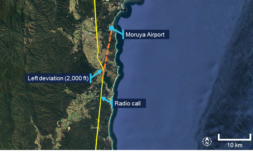
Diversion from Moruya Airport approach track

Source: Google Earth, annotated by the ATSB

The pilot continued north-west for 13 minutes at about 2,500 ft AMSL. For the remainder of the flight, the pilot maintained an altitude between 2,000 and 2,700 feet AMSL, with intermittent climbs and descents (Figure 3). The mountainous area had fluctuating terrain heights, with a maximum terrain height in the area of about 2,900 ft. 

Approximately one minute prior to the collision, the aircraft’s speed decreased to 69 kt before rapidly increasing to 101 kts just prior to the collision with terrain.

At 1454 the aircraft collided with terrain in dense forest in the Budawang National Park at 2,800 ft AMSL. The aircraft was destroyed, and the pilot was fatally injured. 

The aircraft’s emergency locator transmitter (ELT) activated in the accident, alerting the Australian Maritime Safety Authority (AMSA) Joint Rescue Coordination Centre (JRCC).

A rescue helicopter located the wreckage at about 1700 on 18 September, however rescue crews were unable to access the site due to the weather. The site was first accessed the following day by winch at about 1300. Rescue crew and police confirmed the occupant was deceased.

Figure 3: Flight path of the last 15 minutes of the flight
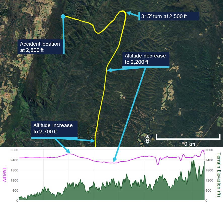
Flight path of the last 15 minutes of the flight

The lower plot does not show the point of impact, because the data recording ceased prior to that point. Source: Google Earth, annotated by the ATSB

Context

Pilot information

License and endorsements

The pilot held a Civil Aviation Safety Regulation Part 61 Private Pilot (Aeroplane) Licence, single-engine aeroplane class rating, night VFR rating for single-engine aeroplanes, and endorsements for manual propeller pitch control and retractable undercarriage. The pilot had held a licence since 1979. Their last flight review was on 2 November 2023 in VH-TEL and was valid until 30 November 2025. 

Flying history

The pilot ceased flying between mid-1988 and early 2008. Between January 2008 and February 2021, 6 flights were recorded, all conducted as in command under supervision (ICUS).

The pilot had accumulated 306.5 hours experience through to 10 February 2021. On 19 October 2021, the pilot commenced a PPL refresher course with BFS for the purpose of completing a flight review.

The pilot’s logbook indicated flights beginning in June 2024 and noted that their prior logbook had been stolen. It recorded that at the time of the accident the pilot had approximately 443.7 flight hours, including 4.5 hours in VH-TEL in the last 90 days. 

Additional flight data retrieved from the flying school on the pilot’s flight prior to June 2024 indicated that, at the time of the accident, the pilot had accumulated approximately 515 total flight hours.[4] Of these, approximately 60 hours were on the Cirrus SR20 aircraft since the pilot’s initial flight in the Cirrus in June 2023. All of these flights were conducted in VH-TEL.

Flight review and training

In October 2021 the pilot completed a training area flight and circuits flight. Additionally, the pilot completed 3 navigation flights in November 2021, January 2022 and February 2022 with a BFS Grade 2[5] flight instructor, in preparation for the pilot’s flight review for the PPL refresher course. On completion of the third navigation flight, the instructor recommended the pilot fly with a Grade 1 instructor to assess their ability relative to the flight review standards required. 

The Grade 1 instructor conducted 2 navigation flights with the pilot and reported the flight review was successfully completed after the second navigation flight with the remark that the pilot needs to ease back into flying. This flight review was completed on 18 May 2022, which was the signatory date for the pilot’s application to transfer their licence from Civil Aviation Regulations 1988 (CAR) Part 5 to Civil Aviation Safety Regulations 1998 (CASR) Part 61. The flight review had been conducted in a Piper PA‑28 Archer II (VH‑NRM).

The pilot enrolled in the Cirrus SR20 Perspective Transition (VFR) course[6] on 13 May 2023. The flights were conducted in June and July 2023, which was prior to the pilot’s flight review in VH-TEL on 2 November 2023. None of the 5 flight lessons included instrument meteorological conditions (IMC) [7] recovery as a task.

In addition to the flights, the pilot completed the Cirrus SR Series Manoeuvres Course, which was a series of videos, which included the following topics:

VFR into IMC

• Straight and Level

• Level Turns

• Climbs and Descents

• Find Your Way Out [of IMC]

• Flight Into IMC Demo.

Following the completion of their SR20 conversion training in November 2023, the pilot operated the SR20, specifically VH-TEL, on an average of 2 flights per month until March 2025. From March to June 2025, the pilot transitioned to flying the Piper PA-28 on a biweekly basis.

Due to the pilot’s recent absence from operating the SR20 during this timeframe, a currency flight was required in July 2025. This flight was conducted on 4 July 2025 in VH‑TEL, under the supervision of an instructor. The instructor recorded in the student progress record and advised the ATSB that several technique errors occurred during the flight, which resulted in the instructor assessing the pilot as not competent. The pilot returned to flying the PA-28, completing 2 flights in the Sydney area, both scenic.

On 6 August 2025, the pilot conducted a second currency flight in VH-TEL with a different flight instructor. This was a flight into the training area before returning for circuits. The instructor recorded on the progress record that the pilot’s groundwork was good, and radio calls were well executed. The departure was performed satisfactorily, the approach was adequate, and the landing was described as very good and smooth. The instructor noted that the pilot flew the aircraft satisfactorily but required further attention to airspace management. Following this flight, the pilot was assessed as competent to operate the SR20.

There was no record of the pilot having conducted or completing any other relevant instrument flying training or qualifications.

Medical information

The pilot held a valid class 2 aviation medical certificate which was approved in March 2025. The only limitation to the pilot’s medical certificate was for reading correction to be available while exercising the privileges of their licence.

The owner of BFS reported that the pilot looked healthy and displayed normal behaviour on the morning of the flight. 

Post-mortem examination and toxicology reports were not available to the ATSB at the time of publishing this report.

Aircraft information

The Cirrus SR20 is a low-wing general aviation aircraft with 5 seats. VH-TEL had a single, Continental IO-360-ES26B reciprocating piston engine driving a constant-speed propeller. The aircraft was certified for day and night VFR and instrument flight rules (IFR)[8] operations.

VH-TEL was manufactured in 2014 and was first registered in Australia on 5 September 2014. The aircraft had been registered with BFS since April 2020, and at the time of the accident had accumulated 1,725.8 hours total time in service.

The aircraft was fitted with the Cirrus airframe parachute system (CAPS). This was designed to lower the aircraft and its passengers to the ground in the event of a life‑threatening emergency and could be activated by the pilot. The CAPS system consisted of a parachute, a solid-propellant rocket used to deploy the parachute, an activation handle, and a parachute harness embedded within the fuselage structure.

Meteorological information

Bureau of Meteorology forecasts

The applicable graphical area forecasts (GAF) available to the pilot for the flight were both issued at 0804 local and valid for the periods 0900–1500 and 1500–2100. The location of the accident was in Area A on the GAF. Area A for the period 0900–1500 forecast broken cumulus/stratocumulus from 3,000–7,000 ft. 

The TAF[9] for Canberra was CAVOK[10] conditions. The TAF for Moruya[11] included light showers of rain and a broken cloud base at 3,000 ft AGL. The TAF for Jervis Bay was a broken cloud base at 1,600 ft AGL becoming scattered at 3,000 ft AGL from 1100–1300 but with TEMPO periods from 0700–1200 for visibility reduced to 4,000 m with a scattered cloud base at 600 ft AGL and a broken cloud base at 1,000 ft AGL. 

Bureau of Meteorology observations

At 1430, the meteorological aerodrome report (METAR)[12] for Moruya Airport reported wind from the east-north-east at 7 kt (60°), visibility greater than 10 km and cloud overcast at 4,900 ft AGL. The METAR at Jervis Bay Airfield reported wind from the west‑south-west at 8 kt (240°), visibility greater than 10 km and cloud scattered from 2,100 ft and overcast above 2,900 ft AGL.

At 1500, the cloud cover had changed at both locations (Table 1).

Table 1: Reported METAR/SPECI[13] cloud layers at nearest airports

Location

Time

1400 1430 1500 
Moruya AirportOVC 3,300ft AGL

SCT 3,600ft AGL

BKN 4,300ft AGL

OVC 4,900ft AGL

SCT 3,200ft AGL

BKN 4,700ft AGL

OVC 5,300ft AGL

Jervis Bay Airfield

OVC 2,100ft AGL

OVC 2,700ft AGL

SCT 2,100ft AGL

OVC 2,900ft AGL

FEW 3,100ft AGL

BKN 5,100ft AGL

BKN: broken; OVC: overcast; SCT: scattered

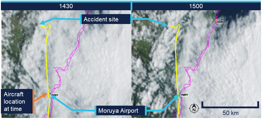
Bureau of Meteorology satellite images (Figure 4 – left) showed cloud covering the Budawang National Park mountains at 1430. At 1500 (Figure 4 – right) the satellite imagery indicated a reduction in cloud cover, with partial clearing evident and some breaks observed in the cloud layer. The images provided no information on cloud height, or density at a given height.

Figure 4: Satellite image showing cloud formation on 18 September at 1430 and 1500 local time
Satellite image showing cloud formation on 18 September at 1430 and 1500 local time

The flight path was overlaid on the satellite image to illustrate the route relative to the weather. The actual flight occurred below the cloud base. Source: Bureau of Meteorology, annotated by the ATSB

Witness observations of weather

A witness located approximately 3 km west of the accident site reported hearing the aircraft, however, was unable to locate it in the sky due to fog.[14] They reported that prior to the fog, low lying cloud had been covering the tops of the mountains in the area where the collision with terrain occurred from approximately 1130. 

Another witness who was in Wog Wog (10 km north of the accident site) stated that there had been low cloud and drizzle from 1100. They described the visibility to have been ‘okay’ at ground level but poor near the tops of the mountains. 

Additionally, the operator for the rescue helicopter reported they were unable to access the site due to low lying cloud (Figure 5).

Figure 5: Cloud over the accident site between 1640 and 1703 local time

Cloud over the accident site between 1640 and 1703 local time

Top left and top right: cloud coverage to the north of the accident site. Bottom left: overhead the accident. Bottom right: view of the accident site and surrounding weather from the east. Source: ACT Emergency Services Agency, annotated by the ATSB

Accident site and wreckage

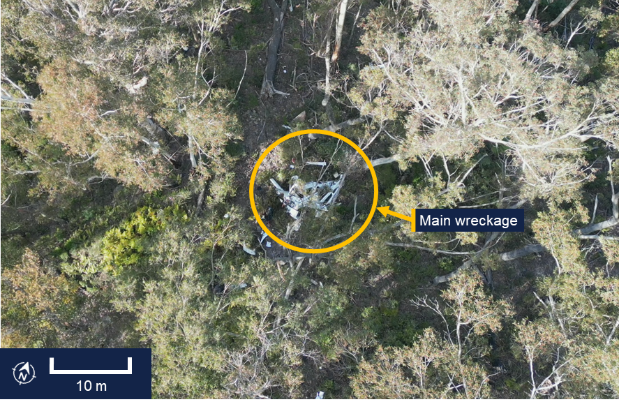
The aircraft wreckage was located in heavily vegetated, steep, mountainous terrain (Figure 6).

Figure 6: Overhead view of accident site
Overhead view of accident site

Source: ATSB

The ATSB conducted an examination of the accident site and wreckage on 21 September. The aircraft impacted the side of the mountain and slid backwards from the direction of travel until supported on the slope by some small trees. Ground impact marks and impact marks on the trees indicated the aircraft entered the trees with wings and fuselage almost level.

All of the flight controls and surfaces were accounted for on site and no evidence of in‑flight break‑up or pre-impact control issues was identified.

Onsite examination of the engine did not reveal any pre-impact mechanical issues. The propeller assembly had separated from the engine crankshaft, with propeller deformation consistent with the engine producing power at impact. The left- and right-wing fuel tanks had both been compromised and a fuel odour was present.

Data cards from a Garmin G1000 electronic flight instrument system and the aircraft’s data recovery module (RDM)[15] were recovered from the accident site (see Recorded data).

Cockpit assessment revealed the fuel selector was on the right tank, the flaps were set at 50%[16] and the fuel pump was off.[17]

The CAPS had not been activated.

Recorded data

Garmin 1000

The aircraft was fitted with a Garmin G1000 electronic flight instrument system consisting of one primary flight display and one multi-function display (MFD). The G1000 had a 58‑channel flight and engine parameter data logging capability at a rate of one data point per second. A memory card was retrieved from the device, which contained recorded data from multiple flights, including the accident flight. 

The final recorded data point was 2 seconds prior to impact and indicated that the engine was producing normal power until impact. Additionally, the data indicated there was sufficient fuel flow to the engine and there was approximately 10.8 US gallons in the left tank and 7.4 US gallons in the right tank of fuel remaining. This was consistent with ATSB estimates of fuel usage, which also indicated that the aircraft would have had about 48 minutes endurance on landing if the flight had been able to continue to Bankstown Airport with the same engine power applied.

Cylinder head temperature

Recorded engine data indicated the number 4 cylinder head temperature (CHT) increased from the normal operating range into the caution range when the aircraft was about 33 NM (61 km) south of Moruya Airport. Approximately one minute later, the temperature increased into the warning range.

The MFD installed in the cockpit displays CHT information and cautions/warnings. The MFD typically displays individual cylinder CHT as a vertical bar graph scaled from 100°F to 500°F in 100°F increments on the left-hand side of the MFD (Figure 7). Additionally, an engine information page can be selected by the pilot displaying individual cylinder CHT as a vertical bar graph with the current temperature value displayed numerically above the bar. An upward or downward trend arrow is shown below the numeric value to indicate whether the temperature is rising or falling. The G1000 did not record which pages were selected by the pilot at any given time.

Figure 7: MFD engine indication system (EIS) panel, showing the vertical coloured bars indicating a CHT warning state for engine cylinder 4 temperature

MFD engine indication system (EIS) panel, showing the vertical coloured bars indicating a CHT warning state for engine cylinder 4 temperature

Source: Garmin, annotated by the ATSB

The pilot operating handbook (POH) published limits for the CHT were as follows, with the bar graph coloured accordingly:

  • Normal range < 420°F (green)
  • Caution range 420–460°F (yellow)
  • Warning range > 460°F (red)

According to the POH:

In the event CHT exceeds 420°F, the MFD will display “Check CHT” in a yellow advisory box in the lower right corner of the MFD. In the event CHT exceeds 460°F, the MFD will display “Check CHT” in a red advisory box in the lower right corner of the MFD.

Figure 8: Exemplar window showing the crew alerting system (CAS) location and text for a CHT warning, the highlighted alerts softkey, and related alerts window text
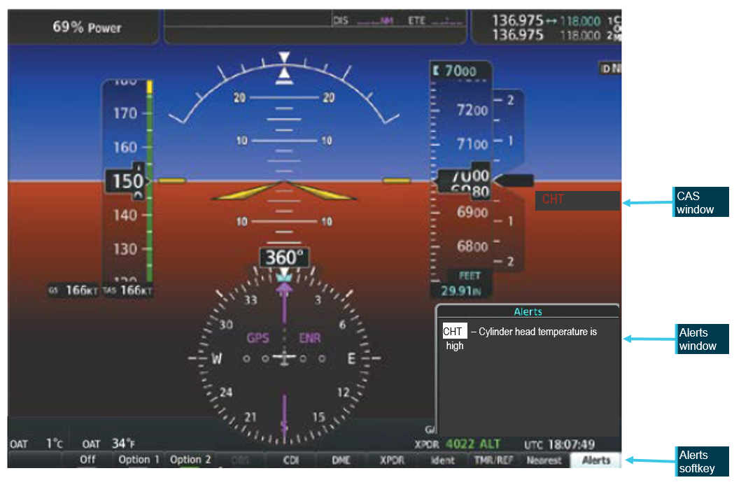
Exemplar window showing the crew alerting system (CAS) location and text for a CHT warning, the highlighted alerts softkey, and related alerts window text

Source: Garmin, annotated by the ATSB

The emergency procedure for a high cylinder head temperature from the Cirrus SR20 Airplane Flight Manual (AFM) indicated that if the CHT is in the caution range to land as soon as practical, and if it is in the warning range to land as soon as possible.[18]

For the remainder of the flight, the CHT of cylinder 4 continued to fluctuate, repeatedly moving between the normal (green), caution (yellow), and warning (red) ranges (Figure 9).

Following the initial rise in CHT into the warning range, the recorded engine data showed the pilot commanded a reduction in engine power over an approximately 30 second period, maintaining the reduced power for about one minute further. This is consistent with standard practice for managing elevated CHT. Approximately one minute after the power was reduced, as the CHT decreased and stabilised within the normal (green) operating range, and the data indicated the pilot then restored engine power to the previous level.

Figure 9: Number 4 cylinder head temperature readings throughout the last 1.5 hours of the flight
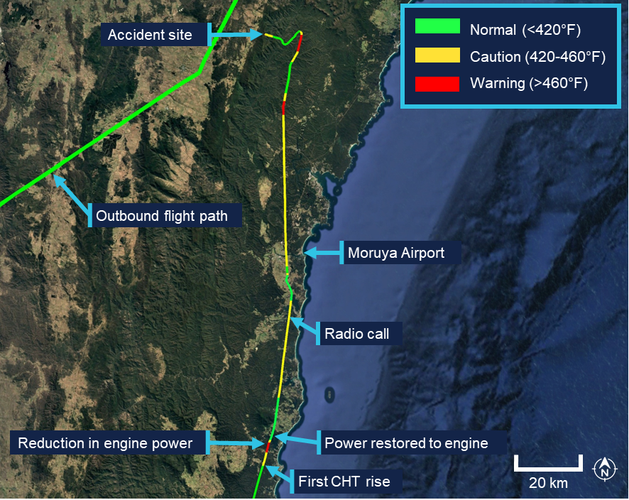
Number 4 cylinder head temperature readings throughout the last 1.5 hours of the flight

Source: Google Earth, annotated by the ATSB

The ATSB compared the recorded CHT and exhaust gas temperature (EGT) data for cylinder 4 in order to determine whether the observed high CHT indications were consistent with an overheating cylinder or were more likely the result of a faulty CHT probe. In normal engine operation, a genuine rise in cylinder head temperature is typically accompanied by a corresponding rise in EGT for the affected cylinder, as both parameters respond to increased combustion temperatures and heat rejection. Conversely, a significant increase in indicated CHT with little or no corresponding change in EGT is characteristic of a failing or erratic CHT sensor.

The analysis indicated that the EGT for cylinder 4 remained relatively stable and within normal operating limits throughout the period when CHT repeatedly entered the yellow and red advisory ranges. This suggested that the anomalies were most likely caused by a faulty cylinder 4 CHT probe. The ATSB presented this information to Cirrus Aircraft which agreed that ‘the CHT sensor was giving faulty information as there were no other indications that there was an engine issue in the data.’

Other recorded data
AvPlan

The pilot was using AvPlan electronic flight bag (EFB)[19] software for the flight. The EFB recorded flight data up until and after the collision with terrain. This flight path data was consistent with the data retrieved from the Garmin G1000. AvPlan uses a device built‑in GPS or an external Bluetooth/wi-fi GPS source for the aircraft position.

Flightradar24, FlightAware and ADS-B Exchange

The aircraft’s track was independently corroborated using data from FlightAware, Flightradar24 and ADS-B Exchange. All 3 services provided consistent position reports, derived from received ADS-B transmissions, for the duration of the flight until the aircraft reached the Budawang National Park.[20] After this point the tracks from the 3 providers began to diverge slightly, primarily due to differences in receiver coverage, data processing and extrapolation algorithms[21] when direct ADS-B signals were no longer received. None of the 3 services recorded any further validated ADS-B positions corresponding to the final portion of flight leading to the accident site.

Operational information

General

The owner of BFS reported that the pilot had intended to conduct a flight to Mount Kosciuszko approximately 6 weeks prior to the accident flight and several times afterwards. However, on each occasion the flight was planned, the pilot either rescheduled or cancelled due to adverse weather conditions. The owner stated that these cancellations were typically attributed to icing conditions in the vicinity of Mount Kosciuszko. The owner noted that the pilot demonstrated a high level of weather awareness.

Prior to the accident flight, the owner confirmed with the pilot that the pilot had checked the weather conditions. However, the owner did not independently verify the weather, as the flight was not a training operation, and they considered the pilot competent in assessing weather conditions.

Previous flights

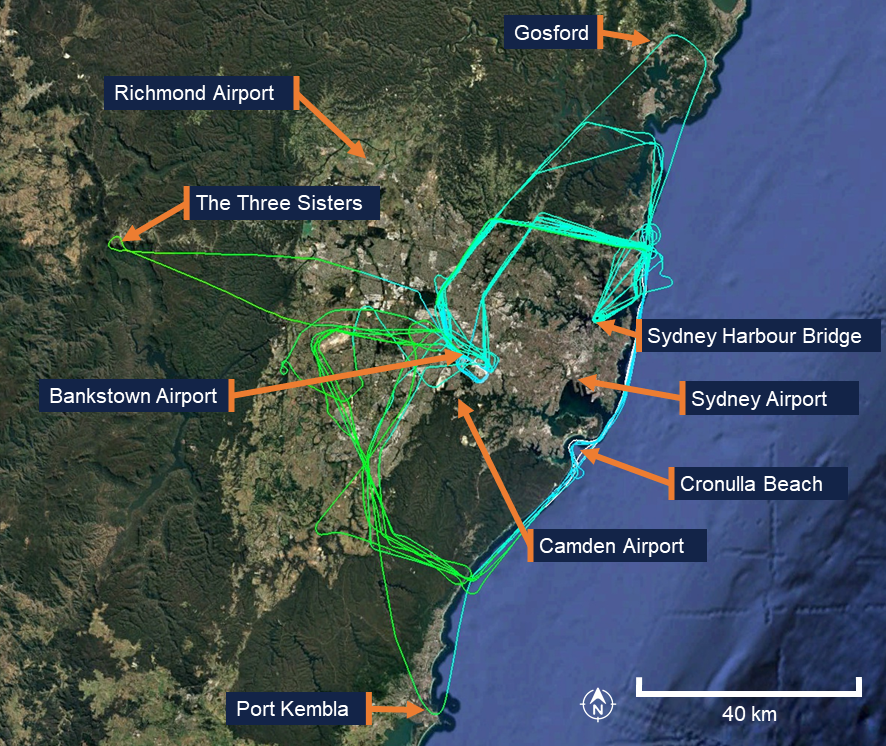
In the 12 months preceding the accident, the pilot had accumulated 31.9 hours of flight time between the Cirrus SR20 and the Piper PA-28 Cherokee. The pilot’s longest flight during this period was 1.9 hours in duration, with an average flight time of 1.4 hours. All flights were conducted within the Sydney area, with the furthest north being Gosford, the furthest south being Port Kembla, and the furthest west being the mountainous area around the Three Sisters landmark in the Blue Mountains (Figure 10). The accident flight was the pilot’s first flight of more than 4 hours since January 2023.

Figure 10: Previous flight data                                                                                 
Previous flight data

Source: Google Earth, annotated by the ATSB

Flight plan

Flight plans are only required for a VFR flight under certain conditions. One of the instructors recalled that the pilot would routinely submit a search and rescue time (SARTIME) and not file a flight plan. The instructor recalled they had discussed with the pilot the benefits of lodging a flight plan, including that in the event the aircraft became overdue, a flight plan would provide search and rescue authorities with valuable information to assist in determining the intended route and location to commence search efforts.

Under the Civil Aviation Safety Regulations (CASR) Part 91 General Operating and Flight Rules Manual of Standards (MOS) 2020: 9.02 Flight notification requirements, a pilot in command must ensure that one of the following has occurred if flying into a designated remote area:

• the submission of a flight plan;

• the nomination of a SARTIME for arrival;

• the leaving of a flight note with a responsible person.

For this flight, the pilot had filed a VFR flight plan via the National Aeronautical Information Processing System (NAIPS) prior to departure as the planned route transited a designated remote area of the Snowy Mountains. 

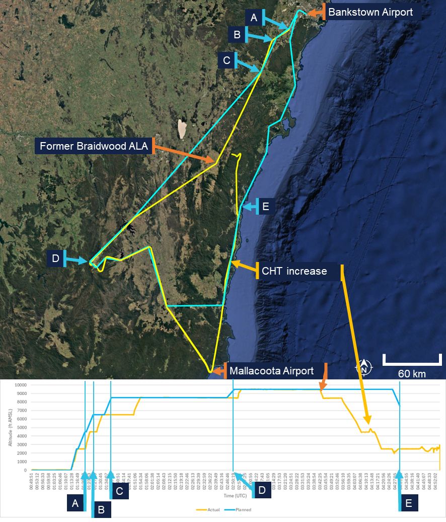
The flight plan indicated the pilot would fly south to Mount Kosciuszko before turning towards the coast to Merimbula Airport (Figure 11). The pilot would then head north through a VFR lane, using VFR waypoints, over the coastline (east of the Great Dividing Range) back to Bankstown Airport. When reaching Merimbula Airport the aircraft would be at an altitude of 9,500 ft AMSL and begin a decent to 7,500 ft AMSL reaching the altitude at Moruya Airport before further descending to 2,000 ft when reaching Ulladulla. Pilots are required to notify air traffic services (ATS) if the route, cruising level, or cruising speed changes from a submitted flight plan. Although the actual flight varied from the plan, the pilot did not notify ATS of the changes. 

When the pilot’s instructor was asked what pilots are taught in such circumstances, they stated that pilots are instructed to notify ATS of any change in plan or if they intend to deviate from their planned route. However, the instructor noted that the pilot had obtained their private pilot licence in the 1980s and was unsure whether this topic had been recently discussed with the pilot, as they had never observed the pilot submit a flight plan during their conversion training.

Figure 11: Planned flight (blue) comparison to actual flight (yellow)
Planned flight (blue) comparison to actual flight (yellow)

A. Bankstown Airport; B. Campbelltown University waypoint; C. Picton waypoint; D. pilot chosen waypoint using lat/long; E. Moruya Airport. Source: ATSB

Visual meteorological conditions

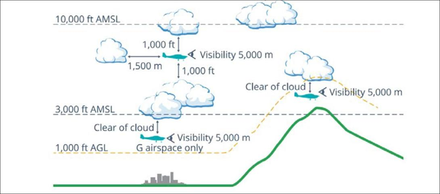
Visual meteorological conditions (VMC) are expressed in terms of in-flight visibility and distance from cloud (horizontal and vertical) as prescribed in the CASR Part 91 (General Operating and Flight Rules) Manual of Standards (MOS) 2020: 2.07 VMC criteria. These conditions allow pilots to operate the aircraft primarily by visual reference to the terrain and horizon, maintaining situational awareness and separation from other aircraft without reliance on instruments.

For flight below 10,000 ft AMSL, the Part 91 MOS prescribed that pilots maintain a minimum visibility of 5 km, and remain at least 1,000 ft vertically and 1,500 m horizontally clear of cloud. In areas below 3,000 ft AMSL or 1,000 ft above ground level (AGL), and within uncontrolled airspace, VFR flights may operate clear of cloud and in sight of the ground or water, provided visibility remains at or above the required minima. These criteria ensure that pilots have sufficient external visual references to maintain safe flight and effective traffic separation.

The CASA Visual Flight Rules Guide included the following notes for VFR flight:

Pilots should not initiate VFR flight on top of more than SCT [scattered] [22] cloud when weather conditions are marginal. Before committing to operate VFR flight on top of more than SCT cloud, pilots should be confident that meteorological information used is reliable and current, and clearly indicates that the entire flight will be able to be conducted in VMC.

and

Pilot decision-making, particularly regarding weather and flight, is often complex; however, the solution to avoiding VFR into IMC [instrument meteorological conditions] when weather is marginal before take-off is not to depart. During flight, it is to turn back or divert before it becomes impossible to do so.

Figure 12, taken from the CASA Visual Flight Rules Guide, provides a visual depiction of the VMC criteria for aeroplanes below 10,000 ft.

Figure 12: VMC criteria below 10,000 ft
VMC criteria below 10,000 ft

Source: Civil Aviation Safety Authority

Pilot response to weather

When questioned about how the pilot typically obtained weather information for the flight, the instructor stated that the weather would have been checked prior to departure using TAFs and GAFs. The instructor expected that the pilot would also have been monitoring the automatic terminal information service (ATIS) while en route.

The instructor further recalled a previous flight (in May 2022) with the pilot during which the pilot descended to avoid entering cloud. At that time, the instructor questioned the pilot on the VMC requirements for the flight. The pilot became overwhelmed and elected to return to the departure aerodrome. The instructor recalled that there were no subsequent discussions between them regarding operations in adverse weather, and none of the remaining training flights were conducted in cloudy conditions. The instructor noted that the pilot avoided flying into or near clouds and had previously cancelled multiple flights due to weather.

Pilots can confirm destination weather in flight using multiple approved sources. The aerodrome weather information service (AWIS) is available on a published VHF frequency or by telephone. Review of the aircraft data indicated the radios were not changed to published AWIS VHF frequencies at any stage of the flight, and the pilot was not carrying a mobile phone that could have been used to obtain an AWIS broadcast by telephone. 

Where fitted with ADS-B In and a suitable display (such as an EFB),[23] pilots may receive real-time weather data including METAR, TAF, airmen's meteorological information (AIRMET),[24] significant meteorological information (SIGMET),[25] and GAF forecasts within coverage. An approved EFB can also provide these products via internet or satellite subscription. The pilot carried an EFB running AvPlan, which was capable of displaying current meteorological information however, there was no recorded data to confirm whether the pilot accessed this information at any stage of the flight.

Communication

The aircraft was equipped with 2 independent VHF communication transceivers (COM 1 and COM 2). Each transceiver could display and store 1 active frequency and 1 standby frequency simultaneously, resulting in a total of 4 frequencies available to the pilot. The instructor stated that at BFS they teach students to use COM 1 as the primary radio used for monitoring towers and ATS and COM 2 is used for secondary frequencies such as the common traffic advisory frequency (CTAF) and ground frequencies.

The pilot had configured COM 1 as the active radio and COM 2 as standby. Prior to departure, COM 2 was set to the Bankstown Airport ground frequency and left on this frequency for the entirety of the flight. COM 1 was initially set to the Bankstown Airport tower/CTAF frequency and changed throughout the flight. When flying south-east near Braidwood, the pilot changed frequencies multiple times within 9 minutes. They first selected an unknown frequency (125 MHz), then Sydney Tower (120.5 MHz), and then a second unknown frequency (120.15 Mhz), before selecting Melbourne Centre (120.75 MHz). The pilot then maintained 120.75 MHz (Melbourne Centre) as the active frequency after passing Braidwood ALA and continued using this frequency for the remainder of the flight.

The only recorded inflight radio transmission was made on the Melbourne Centre frequency with the pilot indicating a decision to land at Moruya.

VFR into IMC research

The ATSB, in conjunction with research published by CASA, has identified that VFR pilots continuing flight into IMC remains one of the most consistently fatal types of general aviation occurrence. These events are characterised by a loss of visual reference resulting in spatial disorientation, loss of control, or controlled flight into terrain. The onset of IMC during VFR flight is often sudden, and pilots without instrument training or recent instrument experience typically have little time to recover once visual cues are lost.

ATSB occurrence data showed that many VFR into IMC accidents follow a consistent pattern of decision‑making and flight progression. Pilots often either depart into marginal weather conditions and/or continue as conditions deteriorate, influenced by a strong ‘press-on’ mindset to reach their destination. A 2005 ATSB research publication – General Aviation Pilot Behaviours in the Face of Adverse Weather (B2005/0127) – concluded that the likelihood of encountering IMC increases significantly during the final stages of flight, particularly within the last 20% of the planned route. 

CASA’s associated AvSafety - Flying into bad weather card[26] supports these findings, noting that poor weather-related decision-making and underestimation of meteorological risks remain persistent issues across the VFR pilot population. The education programs, including CASA’s online Pilot safety hub[27] encourage pilots to establish and adhere to personal weather minima, obtain updated forecasts before and during flight, and avoid reliance on visual cues when conditions are near or below VMC limits.

Related occurrences

Recent examples of VFR into IMC accidents are provided below.

Collision with terrain involving Beechcraft 35-C33 Debonair, VH-KZK, 12 km east of Khancoban, New South Wales, on 15 July 2025 (AO-2025-040)

On 15 July 2025, a Beechcraft 35-C33 Debonair, registered VH-KZK, departed Wangaratta Airport, Victoria, for a private flight under the visual flight rules (VFR) to Moruya Airport, New South Wales. Soon after entering the Snowy Mountains area, it is very likely that the pilot, who did not hold an aircraft instrument rating, experienced spatial disorientation after flying into instrument meteorological conditions. The aircraft entered a spiralling descent to the right that continued until the aircraft collided with terrain. The pilot was fatally injured, and the aircraft was destroyed.

VFR into IMC, loss of control and collision with terrain involving Socata TB‑20, VH-JTY, 65 km west of Mackay Airport, Queensland, on 28 October 2023 (AO‑2023-052)

On the morning of 28 October 2023, a SOCATA-Groupe Aerospatiale TB-20, registered, VH‑JTY, departed Montpelier aircraft landing area, Queensland, for a visual flight rules private flight to Palmyra aircraft landing area, Queensland. After encountering cloud en route, the pilot elected to continue along the intended flight path through cloud instead of diverting around or remaining on top of it. Shortly after, it is very likely the pilot entered weather conditions not suitable for visual navigation, leading to spatial disorientation and a descent into mountainous terrain. The aircraft was destroyed and both occupants received fatal injuries.

VFR into IMC, loss of control and collision with terrain involving Airbus Helicopters EC130 T2, VH-XWD, near Mount Disappointment, Victoria, on 31 March 2022 (AO-2022-016)

On 31 March 2022, at about 0741 local time, 2 Microflite Airbus EC130 helicopters, registered VH‑WVV and VH-XWD, departed the Batman Park helicopter landing site in Melbourne, for the town of Ulupna, Victoria. Both helicopters were operated in accordance with the VFR and departed in VMC conditions. Cloud was forecast along the route, but the pilots elected to continue to the destination. The helicopters encountered IMC over Mount Disappointment and VH-WVV conducted a U-turn to avoid entering cloud. While also attempting to conduct a U-turn, VH-XWD entered cloud, developed a high rate of descent, and collided with terrain. The helicopter was destroyed, and the 5 occupants were fatally injured.

VFR into IMC and in-flight break-up involving Van's Aircraft RV-7A, VH-XWI, 90 km south of Charters Towers, Queensland, on 23 April 2021 (AO‑2021‑017)

On 23 April 2021, a Van’s Aircraft RV-7A, registered VH-XWI, was being operated on a private flight under the VFR from Winton to Bowen, Queensland. During the flight, the pilot most likely entered IMC and lost control of the aircraft several times. This led to the airspeed limitations for the aircraft being exceeded and the aircraft sustained an in-flight break-up. The pilot was fatally injured, and the aircraft was destroyed.

Safety analysis

Examination of the wreckage and flight data indicated that the aircraft’s engine was producing power until impact. All major sections of the aircraft were located at the accident site, and there was no evidence of an in-flight break-up or structural failure. The flight data and the presence of all major components at the scene indicate that the aircraft did not experience a pre-impact mechanical or airframe issue that would have contributed to the collision with terrain.

The flap setting of 50% would be used in low and slow manoeuvring such as looking for a landing site under deteriorating weather or manoeuvring through valleys. Flying slower reduces the radius of turns and the use of the flap gives the aircraft a buffer to the stall speed. This setting might be considered a compromise configuration between flying clean and flying full flap, giving these advantages while retaining a greater capability to climb at short notice without the drag of a full flap.

Cylinder temperature fluctuations and cockpit distraction

When passing Mallacoota Airport, the pilot commenced a descent from about 9,000 ft above mean sea level (AMSL). At that time, the pilot would have seen low cloud ahead and probably descended in order to fly below it or in preparation for an approach and landing at one of the aerodromes along the planned flight route.

Flight data showed fluctuating temperature indications from the number 4 cylinder throughout the latter part of the flight. These temperature fluctuations would have generated warnings displayed to the pilot on the multi-function display, alerting them to a potential engine issue. 

The first indications of this fluctuation occurred prior to the initial approach to Moruya Airport. The recorded engine data showed that the CHT rose to the caution range and subsequently progressed to the warning range. There was a reduction in engine power over an approximately 30‑second period, before maintaining reduced power for about a minute further. This was likely to have been initiated by the pilot in response to the high CHT warnings and was consistent with the appropriate response to a genuine warning. The engine was then returned to normal power after the CHT levels dropped back into the normal range.

Shortly thereafter, the CHT again increased, entering the caution range for a second time. After an 8‑minute period with the CHT in the caution range the pilot radioed ATC with their intention to land at Moruya Airport. Given that a landing at Moruya was not planned, it is most likely that the pilot initiated the approach as a result of the warning and/or cloud ahead.

The ATSB assessed that these warnings were very likely spurious, and an attentive pilot with a good understanding of engines could doubt their validity based on the engine instruments. The pilot may have thought the warnings were genuine or spurious, and this understanding could have changed throughout the flight. 

In any case, the persistence of these warnings throughout the remainder of the flight would have been a continuing source of distraction, potentially increasing workload and reducing their capacity to monitor other operational factors such as navigation, weather conditions, and terrain clearance.

Decision to continue flight past Moruya Airport

After commencing an approach to Moruya Airport, and making a radio broadcast to that effect, the pilot discontinued the approach and continued the flight below the cloud base. Satellite and meteorological data indicated areas of low cloud around the Moruya area, with instrument meteorological conditions (IMC) present as the pilot approached the airport. Additionally, poor weather was observed along the planned route of flight (along the east coast) beyond Moruya. There were no further radio transmissions or position reports from the pilot following the initial call indicating their intention to land at Moruya. Given that poor weather was present ahead of the aircraft and the pilot would have been seeing fluctuating cylinder temperature warnings, it is unclear why the pilot made the apparent decision to continue the flight rather than land at Moruya.

This decision may have been influenced by the perceived presence of a completely clear area in the cloud layer ahead. Analysis of satellite imagery revealed a temporary gap or break in the extensive cloud cover extending from Moruya Airport towards the Great Dividing Range. This gap, evident at the approximate time the aircraft passed to the west of Moruya Airport, would have presented a visually clearer path to the pilot. There was cloud over Moruya Airport and the pilot may have considered that maintaining VMC throughout an approach and landing there might not have been feasible. 

In any case, the decision to deviate inland from the initial planned track and towards higher terrain was likely influenced by this break in cloud. Given previous observations from the instructor indicating an aversion to flight near conditions of reduced visibility, it is probable that the pilot elected to manoeuvre towards this apparent break in order to remain in VMC. However, this deviation towards rising terrain significantly increased the risk of controlled flight into terrain, particularly in the prevailing low-visibility environment where visual assessment of terrain clearance could not be assured.

The pilot may have elected to continue the flight partly due to ‘get-there-it is,’ which describes a mindset in which a pilot becomes fixated on reaching the destination, often disregarding deteriorating weather, aircraft anomalies, fatigue, or other risk factors (ATSB, 2011). This self-induced pressure can lead to continued operation into conditions that a more objective assessment would deem unsafe, as the perceived pressure to complete the trip overrides sound aeronautical decision‑making.

The pilot’s limited experience with long distance flights may have exacerbated the effects of this phenomenon. Having completed only the second flight of approximately 4 hours duration in their flying career, the pilot had minimal exposure to the progressive challenges associated with extended cross-country operations, including the management of fatigue and evolving weather systems over prolonged periods, and in‑flight technical anomalies. 

With limited prior experience in calibrating risk in deteriorating conditions, the pilot would have been less able to objectively weigh the cumulative hazards of continuing into adverse weather while managing the fluctuating indicated engine cylinder head temperature (or being distracted by the spurious warnings, depending on how the pilot understood them). This increased their susceptibility to get-there-itis, such that their established safety decision-making processes were outweighed by the perceived attainability of the destination.

Continued flight into poor weather

Following the decision to continue the flight, tracking data indicated that the aircraft proceeded into the mountainous area of the Great Dividing Range, then almost reversed course at low altitude along a valley, consistent with the pilot attempting to remain below the cloud base and/or avoid cloud ahead. It is therefore likely that the pilot misjudged the extent and density of the cloud or the height of the cloud base. While continuing at low level, with an altitude lower than the surrounding terrain, the aircraft likely entered IMC. The subsequent flight path was consistent with attempts to avoid cloud, and it is probable that the pilot did not know what direction to take away from the mountainous areas and cloud or, if they did, became trapped between the rising terrain and the low cloud base. 

Findings

ATSB investigation report findings focus on safety factors (that is, events and conditions that increase risk). Safety factors include ‘contributing factors’ and ‘other factors that increased risk’ (that is, factors that did not meet the definition of a contributing factor for this occurrence but were still considered important to include in the report for the purpose of increasing awareness and enhancing safety). In addition ‘other findings’ may be included to provide important information about topics other than safety factors. 

These findings should not be read as apportioning blame or liability to any particular organisation or individual.

From the evidence available, the following findings are made with respect to the VFR into IMC and controlled flight into terrain involving Cirrus SR20, VH-TEL,12 km east of Braidwood/Percheron aircraft landing area, New South Wales, on 18 September 2025.

Contributing factors

  • After commencing an unplanned approach to Moruya Airport, likely due to an engine warning and/or observed cloud ahead, the pilot discontinued the approach for undetermined reasons. The pilot, with limited cross-country experience, then continued the flight underneath the cloud base towards rising terrain.
  • The pilot very likely entered weather conditions not suitable for visual navigation, leading to a loss of situational awareness and collision with terrain.

Other factor that increased risk

  • The aircraft’s number 4 cylinder fluctuating temperature warnings, likely resulting from a faulty sensor probe, occurred prior to the pilot electing not to land and continued until the collision with terrain. The ongoing warnings likely distracted the pilot, increasing workload and reduced their capacity to monitor and respond to other operational factors.

Sources and submissions

Sources of information

The sources of information during the investigation included:

  • two instructors
  • Bankstown Flying School
  • Civil Aviation Safety Authority
  • New South Wales Police Force
  • maintenance organisation for VH-TEL
  • Airservices Australia
  • AvData
  • AvPlan
  • witnesses
  • Garmin G1000
  • Cirrus Aircraft. 

References

ATSB (2005). General Aviation Pilot Behaviours in the Face of Adverse Weather. Aviation Research Investigation Report B2005/0127. 

ATSB (2011). Accidents involving Visual Flight Rules pilots in Instrument Meteorological Conditions. Aviation Research Investigation Report AR-2011-050.

Submissions

Under section 26 of the Transport Safety Investigation Act 2003, the ATSB may provide a draft report, on a confidential basis, to any person whom the ATSB considers appropriate. That section allows a person receiving a draft report to make submissions to the ATSB about the draft report. 

A draft of this report was provided to the following directly involved parties:

  • Bankstown Flying School
  • Civil Aviation Safety Authority
  • Cirrus Aircraft
  • maintenance organisation for VH-TEL.

Submissions were received from:

  • Civil Aviation Safety Authority
  • Cirrus Aircraft.

The submissions were reviewed and, where considered appropriate, the text of the report was amended accordingly.

Purpose of safety investigations

The objective of a safety investigation is to enhance transport safety. This is done through: 

  • identifying safety issues and facilitating safety action to address those issues
  • providing information about occurrences and their associated safety factors to facilitate learning within the transport industry.

It is not a function of the ATSB to apportion blame or provide a means for determining liability. At the same time, an investigation report must include factual material of sufficient weight to support the analysis and findings. At all times the ATSB endeavours to balance the use of material that could imply adverse comment with the need to properly explain what happened, and why, in a fair and unbiased manner. The ATSB does not investigate for the purpose of taking administrative, regulatory or criminal action.

About ATSB reports

ATSB investigation reports are organised with regard to international standards or instruments, as applicable, and with ATSB procedures and guidelines.

Reports must include factual material of sufficient weight to support the analysis and findings. At all times the ATSB endeavours to balance the use of material that could imply adverse comment with the need to properly explain what happened, and why, in a fair and unbiased manner.

An explanation of terminology used in ATSB investigation reports is available here. This includes terms such as occurrence, contributing factor, other factor that increased risk, and safety issue.

Publishing information

Released in accordance with section 25 of the Transport Safety Investigation Act 2003

Published by: Australian Transport Safety Bureau

© Commonwealth of Australia 2026

Title: Creative Commons BY - Description: Creative Commons BY

Ownership of intellectual property rights in this publication

Unless otherwise noted, copyright (and any other intellectual property rights, if any) in this report publication is owned by the Commonwealth of Australia.

Creative Commons licence

With the exception of the Commonwealth Coat of Arms, ATSB logo, and photos and graphics in which a third party holds copyright, this report is licensed under a Creative Commons Attribution 4.0 International licence.

The CC BY 4.0 licence enables you to distribute, remix, adapt, and build upon our material in any medium or format, so long as attribution is given to the Australian Transport Safety Bureau. 

Copyright in material obtained from other agencies, private individuals or organisations, belongs to those agencies, individuals or organisations. Where you wish to use their material, you will need to contact them directly.

[1]     Visual flight rules (VFR): regulations that permit a pilot to operate an aircraft in conditions whereby navigation and orientation of the aircraft by visual reference is possible.

[2]     Day VFR flights may be conducted to the end of civil twilight, the point at which the sun is 6° below an ideal horizon.

[3]     The Braidwood ALA was operational until 2024 at its original location. The current Braidwood/Percheron ALA is located approximately 15 km north-east of the former ALA. 

[4]     The ATSB was unable to determine whether the pilot conducted any flights in aircraft not registered to the flight school.

[5]     A Grade 2 flight instructor is an intermediate-level qualification and is not able to approve a flight review, which requires a Grade 1 flight instructor. 

[6]     The course is an instructor-led course for non-instrument rated pilots who are new to flying a Cirrus and is intended to provide opportunities to enhance their flying skills while becoming familiar with the Cirrus.

[7]     Instrument meteorological conditions (IMC): weather conditions that require pilots to fly primarily by reference to instruments, and therefore under instrument flight rules (IFR), rather than by outside visual reference. Typically, this means flying in cloud or limited visibility.

[8]     Instrument flight rules (IFR): a set of regulations that permit the pilot to operate an aircraft in instrument meteorological conditions (IMC), which have much lower weather minimums than visual flight rules (VFR).

[9]     Aerodrome Forecast (TAF): a statement of meteorological conditions expected for a specific period of time in the airspace within a radius of 5 NM (9 km) of the aerodrome reference point.

[10]    Ceiling and visibility okay (CAVOK): visibility, cloud and present weather are better than prescribed conditions. For an aerodrome weather report, those conditions are visibility 10 km or more, no significant cloud below 5,000 ft, no cumulonimbus cloud and no other significant weather.

[11]    Moruya Airport and Jervis Bay Airfield are close to sea level.

[12]    METAR (Meteorological Aerodrome Report) is a routine aerodrome weather report issued at half hourly time intervals. The report ordinarily covers an area of 8 km radius from the aerodrome reference point.

[13]    SPECI is used to identify reports of observations when conditions are below specified levels of visibility and cloud base, when certain weather phenomena are present, and when the temperature, pressure or wind change by defined amounts. SPECI is also used to identify reports of observations recorded 10 minutes following an improvement in visibility, weather or cloud to METAR conditions.

[14]    Fog refers to cloud which is at ground level.

[15]    The RDM is designed to record flight data in a crash and fire-resistant housing. The unit records flight, engine, and autopilot parameters. Data is logged once per second and stored internally inside the crash-hardened enclosure. When the storage limit of the memory device is reached, the oldest recording is overwritten.

[16]    This level of flap would be expected when conducting a low and slow manoeuvring flight such as looking for a landing site under deteriorating weather or if manoeuvring in valleys.

[17]    The fuel pump is on for take‑off, landing, climb and when switching fuel tanks.

[18]    The general definition for land as soon as possible is to land at the nearest site that a safe landing can be made, whereas land as soon as practical means extended flight is not recommended but the landing site and duration of the flight are at the pilot’s discretion.

[19]    AvPlan is a tablet-based application for flight planning, navigation, and real-time situational awareness.

[20]    ADS-B data from public community-based networks (such as those used by FlightAware, Flightradar24 and ADS-B Exchange) may not have coverage at low altitudes or in areas distant from populated receiver locations.

[21]    In the absence of continued reception, some providers extrapolate or ’coast’ the last known position and speed for a limited period, while others cease plotting the aircraft entirely.

[22]    Cloud cover: in aviation, cloud cover is reported using words that denote the extent of the cover – ‘few’ indicates that up to a quarter of the sky is covered, ‘scattered’ (SCT) indicates that cloud is covering between a quarter and a half of the sky, ‘broken’ (BKN) indicates that more than half to almost all the sky is covered, and ‘overcast’ (OVC) indicates that all the sky is covered.

[23]    VH-TEL was not configured to show this information on the Garmin G-1000 display.

[24]    AIRMET information concerns the occurrence, or expected occurrence, of certain phenomena that have not been included in the graphical area forecast (GAF).

[25]    A SIGMET provides a concise description concerning the occurrence or expected occurrence, in areas over which meteorological watch is being maintained, of en route weather phenomena that are potentially hazardous to aircraft.

Occurrence summary

Investigation number AO-2025-056
Occurrence date 18/09/2025
Location 12 km east of Braidwood/Percheron aircraft landing area
State New South Wales
Report release date 24/02/2026
Report status Final
Investigation level Short
Investigation type Occurrence Investigation
Investigation status Completed
Mode of transport Aviation
Aviation occurrence category Controlled flight into terrain (CFIT), VFR into IMC
Occurrence class Accident
Highest injury level Fatal

Aircraft details

Manufacturer Cirrus Design Corporation
Model SR20
Registration VH-TEL
Serial number 2262
Aircraft operator Bankstown Flying School Pty Ltd
Sector Piston
Operation type Part 91 General operating and flight rules
Departure point Bankstown Airport, New South Wales
Destination Bankstown Airport, New South Wales
Damage Destroyed

Runway excursion and collision with terrain involving a Cessna 180, Borroloola Aerodrome, Northern Territory, on 19 August 2025

Occurrence Briefs are concise reports that detail the facts surrounding a transport safety occurrence, as received in the initial notification and any follow-up enquiries. They provide an opportunity to share safety messages in the absence of an investigation. Because occurrence briefs are not investigations under the Transport Safety Investigation Act 2003, the information in them is de-identified. 

What happened

On 19 August 2025, a Cessna 180 with a tailwheel landing gear was approaching runway 20 at Borroloola Aerodrome, Northern Territory, in variable, moderate crosswind conditions. There were 2 pilots and 1 passenger on board. Just after touchdown, the aircraft turned into the wind and started to veer left off the runway. The pilot in command initiated a go-around and as the aircraft began to lift off, it continued drifting off the runway. 

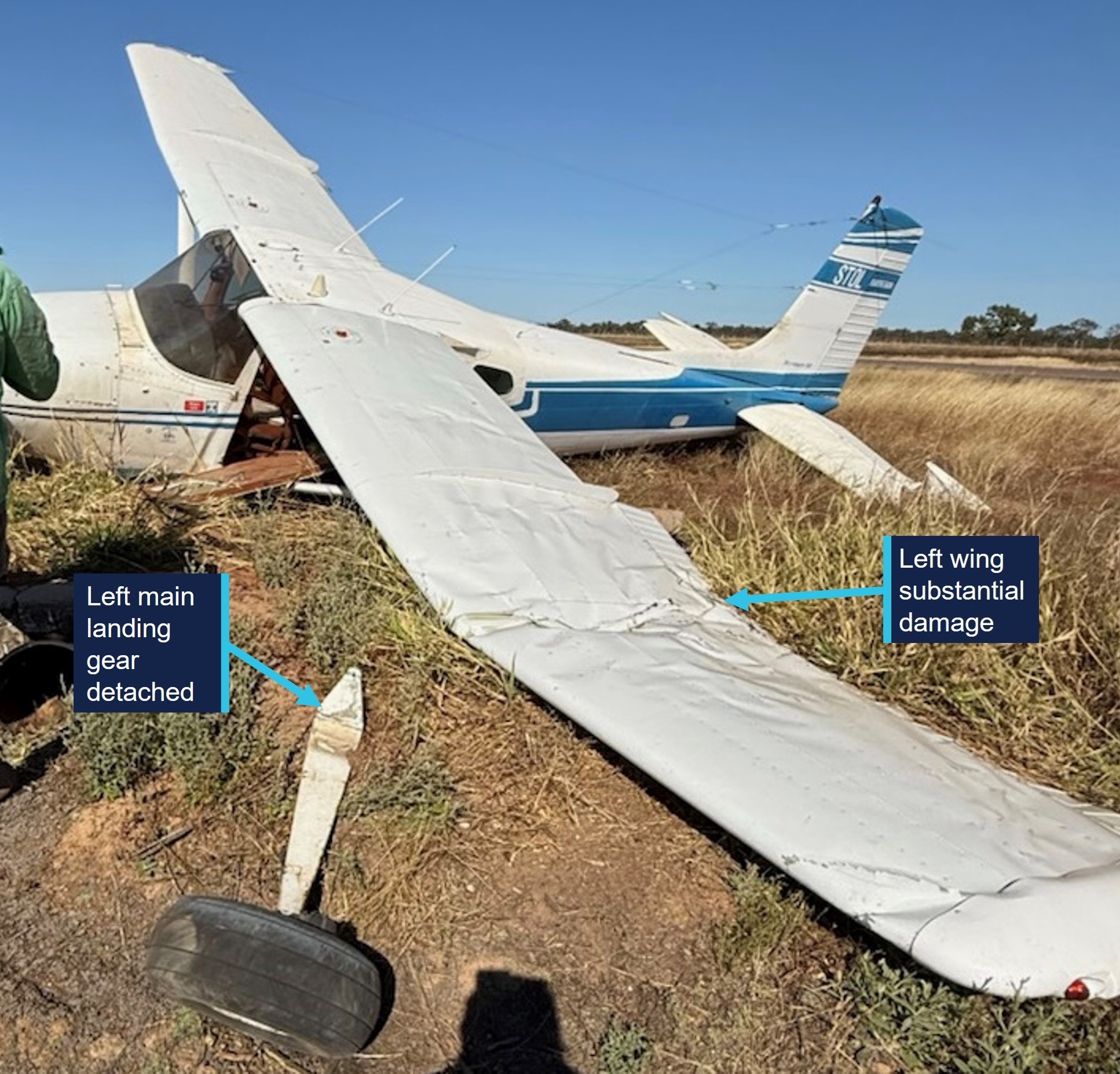
The left wheel struck a mound of dirt beside the runway and the wheel departed the aircraft, causing the aircraft to rotate, collide with the ground and skid sideways, subsequently striking a concrete culvert before coming to rest (Figure 1). The aircraft was substantially damaged during the accident, however the 3 people on board were uninjured.

Figure 1: Aircraft damage

Figure 1: Aircraft damage

Source: Borroloola Aerodrome operator

Safety message

This accident provides a reminder for pilots to be prepared to conduct a missed approach, particularly in tailwheel aircraft during crosswind conditions. Tailwheel aircraft have less directional stability on the ground due to the location of the centre of gravity behind the main wheels. They are more susceptible to the effects of crosswind and the tail can have a tendency to swing sideways on the ground. They require more active input to maintain directional control and any yaw needs to be corrected immediately as it can quickly lead to a large swing and potential loss of control. If conditions during approach are challenging, an early go-around can provide an opportunity to reassess the landing options and make a reasoned decision about whether to attempt another approach and plan for how to manage the conditions.

About this report

Decisions regarding whether to conduct an investigation, and the scope of an investigation, are based on many factors, including the level of safety benefit likely to be obtained from an investigation. For this occurrence, no investigation has been conducted and the ATSB did not verify the accuracy of the information. A brief description has been written using information supplied in the notification and any follow-up information in order to produce a short summary report, and allow for greater industry awareness of potential safety issues and possible safety actions.

Occurrence summary

Mode of transport Aviation
Occurrence ID AB-2025-042
Occurrence date 19/08/2025
Location Borroloola Aerodrome
State Northern Territory
Occurrence class Accident
Aviation occurrence category Collision with terrain, Runway excursion
Highest injury level None
Brief release date 22/09/2025

Aircraft details

Manufacturer Cessna Aircraft Company
Model 180J
Sector Piston
Operation type Part 91 General operating and flight rules
Departure point Wally’s Airstrip, Katherine, Northern Territory
Destination Borroloola Aerodrome, Northern Territory
Damage Substantial

Ditching involving a Just Aircraft SuperSTOL XL, 155 km north-west of Cooktown Airport, Queensland, on 14 August 2025

Occurrence Briefs are concise reports that detail the facts surrounding a transport safety occurrence, as received in the initial notification and any follow-up enquiries. They provide an opportunity to share safety messages in the absence of an investigation. Because occurrence briefs are not investigations under the Transport Safety Investigation Act 2003, the information in them is de-identified. 

What happened

On 14 August 2025, a Just Aircraft SuperSTOL XL amateur-built aircraft departed from Weipa, Queensland, for a flight to Cooktown. The pilot was the sole person on board and the flight was planned to proceed via Coen with a subsequent refuelling stop, if required, using fuel carried in a container on board the aircraft. After leaving Coen, the pilot determined that refuelling was required and selected an off-airfield landing location near Bathurst Bay where, after an aerial inspection of the selected area, the pilot made an uneventful landing at the mouth of a river.

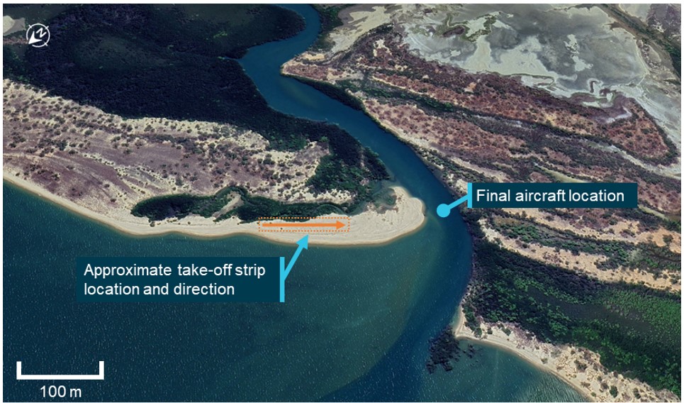
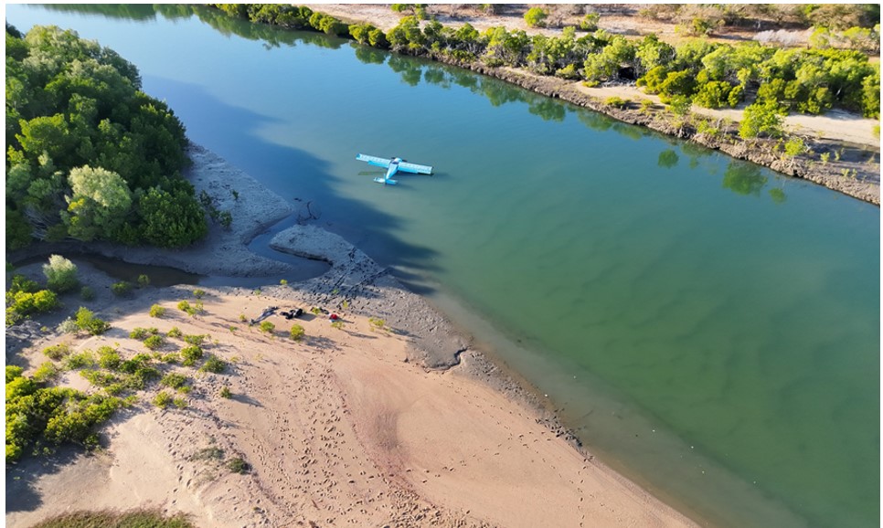
At around 1630, after refuelling and having inspected the intended take-off strip area for suitability, the pilot commenced the take-off. The pilot later reported that, shortly after clearing the ground, the aircraft encountered a strong crosswind gust from the left and the aircraft yawed forcefully into the wind. Directional control and climb performance of the aircraft was rapidly lost and the pilot ditched the aircraft in the shallow river to the left of the strip end (Figure 1). The pilot was uninjured and able to evacuate the aircraft and swim to the shore, however the aircraft became partially submerged (Figure 2) and was substantially damaged by water ingress.

Figure 1: Overview of take-off strip and accident location

Figure 1: Overview of take-off strip and accident location

Source: Google Earth, annotated by the ATSB

Figure 2: Aircraft final location after being moved by incoming tide, partially submerged 

Figure 2: Aircraft final location after being moved by incoming tide, partially submerged

Source: Pilot supplied

Safety message

Take-offs and landings away from established aerodromes and aircraft landing areas (ALAs) can present challenges and significantly increased risks for operating crew. In this instance, while the pilot was operating an aircraft designed and equipped for such off‑field work, the presence of obstacles and hazards close to the chosen strip reduced the options available to the pilot for a safe recovery or landing after the wind gusts and controllability issues were encountered. 

Pilots should also consider the shielding effects of any elevated terrain surrounding planned take-off areas and consider the potential effects of abrupt wind changes and windshear once the aircraft outclimbs the terrain.

About this report

Decisions regarding whether to conduct an investigation, and the scope of an investigation, are based on many factors, including the level of safety benefit likely to be obtained from an investigation. For this occurrence, no investigation has been conducted and the ATSB did not verify the accuracy of the information. A brief description has been written using information supplied in the notification and any follow-up information in order to produce a short summary report, and allow for greater industry awareness of potential safety issues and possible safety actions.

Occurrence summary

Mode of transport Aviation
Occurrence ID AB-2025-040
Occurrence date 14/08/2025
Location 155 km north-west of Cooktown Airport
State Queensland
Occurrence class Accident
Aviation occurrence category Collision with terrain, Loss of control, Weather - Other
Highest injury level None
Brief release date 19/09/2025

Aircraft details

Manufacturer Just Aircraft
Model SuperSTOL XL
Sector Piston
Operation type Part 91 General operating and flight rules
Departure point Bathurst Bay, Queensland
Destination Cooktown Airport, Queensland
Damage Substantial

Landing at a closed aerodrome involving a Diamond DA 40, Inglewood Aircraft Landing Area, Queensland, on 4 July 2025

Occurrence Briefs are concise reports that detail the facts surrounding a transport safety occurrence, as received in the initial notification and any follow-up enquiries. They provide an opportunity to share safety messages in the absence of an investigation. Because occurrence briefs are not investigations under the Transport Safety Investigation Act 2003, the information in them is de-identified. 

What happened

On the morning of 4 July 2025, a Diamond DA 40 aircraft with an instructor and student on board departed Brisbane West Wellcamp Airport, Queensland, for a navigational training flight to Inglewood Aircraft Landing Area. Upon arrival at Inglewood the aircraft, with the student as pilot in charge, joined the runway 23 circuit for a series of circuits with touch-and-go landings. 

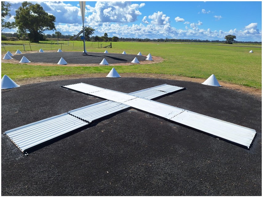
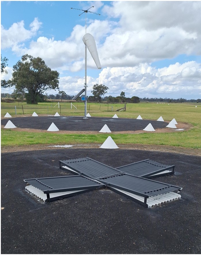
During the final approach into a touch-and-go, the aircraft became unstable, and the instructor took control of the aircraft. The instructor conducted a go-around before the final touch-and-go and noticed the presence of several workers outside of the runway gable markers. During the subsequent climb out, the instructor repositioned the aircraft for better visibility of the overall aerodrome and then observed an exposed white cross near the windsock, indicating that the aerodrome was closed (Figure 1). The instructor reported that no radio calls had been heard from the ground on the common traffic advisory frequency (CTAF) during the time the aircraft was operating from the aerodrome.

The aerodrome operator reported that the closure marking sign is set permanently on the ground next to the windsock, where it can be opened to reveal a white cross (indicating the aerodrome is closed), or folded shut for normal (open) operations (Figure 2).

Figure 1: Extended white cross indicating aerodrome closure

Figure 1: Extended white cross indicating aerodrome closure

Source: Aerodrome operator

Figure 2: Folded cross sign (black) indicating aerodrome open

Figure 2: Folded cross sign (black) indicating aerodrome open

Source: Aerodrome operator

Safety message

Crews of aircraft intending to operate from uncertified aerodromes without a Notice to Airmen (NOTAM) service available are reminded of the need to verify the availability of the aerodrome before undertaking flights to these locations. This can entail contacting the aerodrome operator directly and conducting an overfly of the aerodrome upon arrival to confirm aerodrome and runway serviceability. 

About this report

Decisions regarding whether to conduct an investigation, and the scope of an investigation, are based on many factors, including the level of safety benefit likely to be obtained from an investigation. For this occurrence, no investigation has been conducted and the ATSB did not verify the accuracy of the information. A brief description has been written using information supplied in the notification and any follow-up information in order to produce a short summary report, and allow for greater industry awareness of potential safety issues and possible safety actions.

Occurrence summary

Mode of transport Aviation
Occurrence ID AB-2025-038
Occurrence date 04/07/2025
Location Inglewood Aircraft Landing Area
State Queensland
Occurrence class Incident
Aviation occurrence category Depart/app/land wrong runway
Highest injury level None
Brief release date 18/09/2025

Aircraft details

Manufacturer Diamond Aircraft Industries
Model DA 40
Sector Piston
Operation type Part 141 Recreational, private and commercial pilot flight training
Departure point Brisbane West Wellcamp Airport, Queensland
Destination Inglewood Aircraft Landing Area, Queensland
Damage Nil

Descent below glidescope involving Boeing 767, VH-XQU, near Sydney Airport, New South Wales, on 10 September 2025

Final report

Report release date: 10/07/2026

Investigation summary

What happened

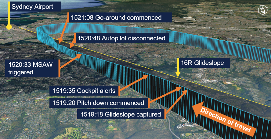
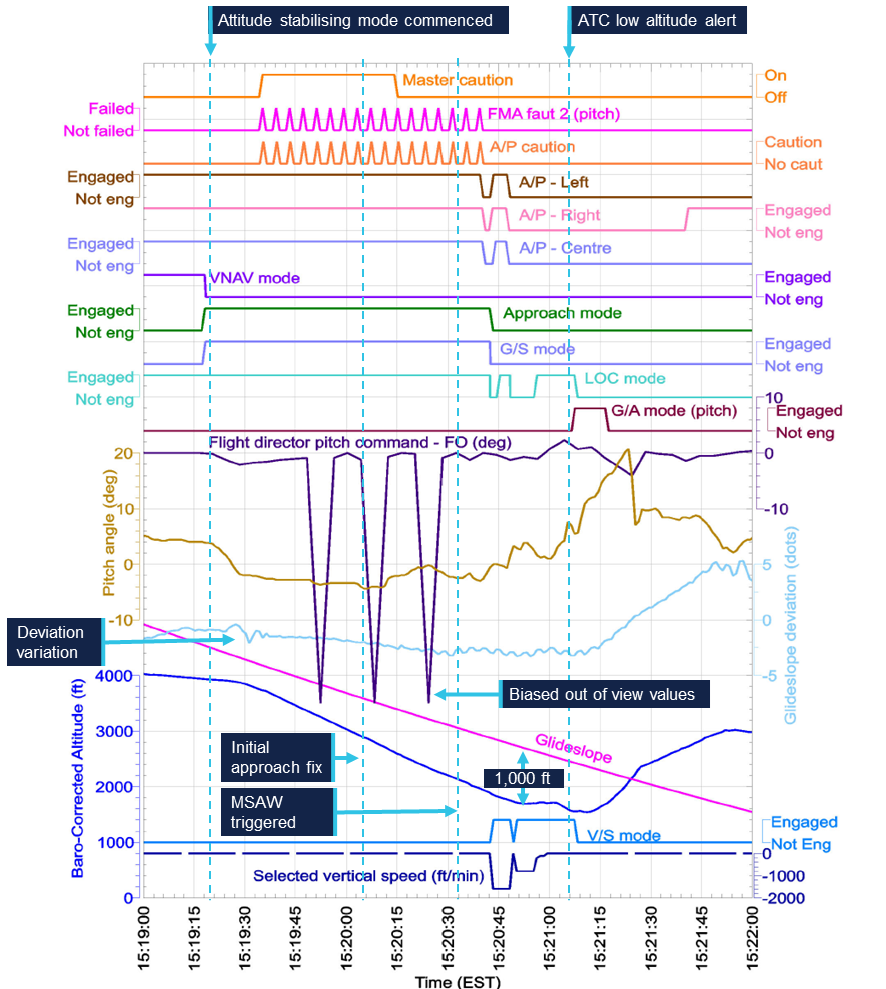
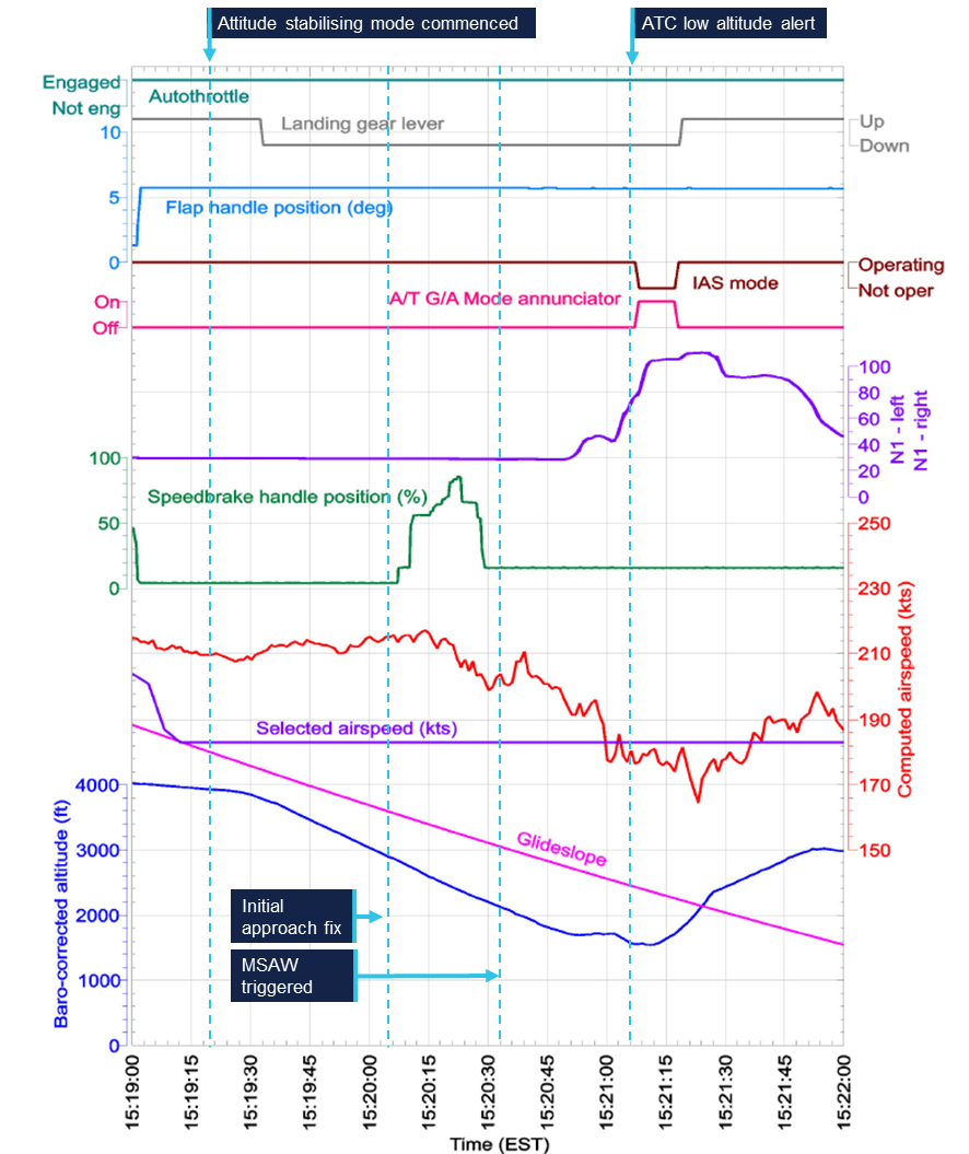
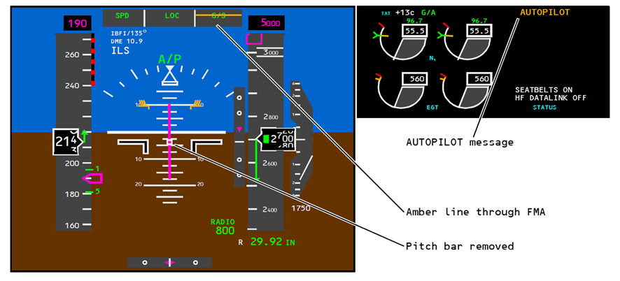
On the afternoon of 10 September 2025, a Tasman Cargo Airlines Boeing 767-300 (B767), registered VH-XQU and operating as Tasman 22, was approaching Sydney Airport, New South Wales, at the conclusion of an air transport freight‑only flight from Hong Kong International Airport, Hong Kong. While intercepting the glideslope for the instrument landing system approach for runway 16R, the aircraft’s autopilot pitched the nose down. Subsequently, the approach was conducted with a high rate of descent while descending away from the glideslope.

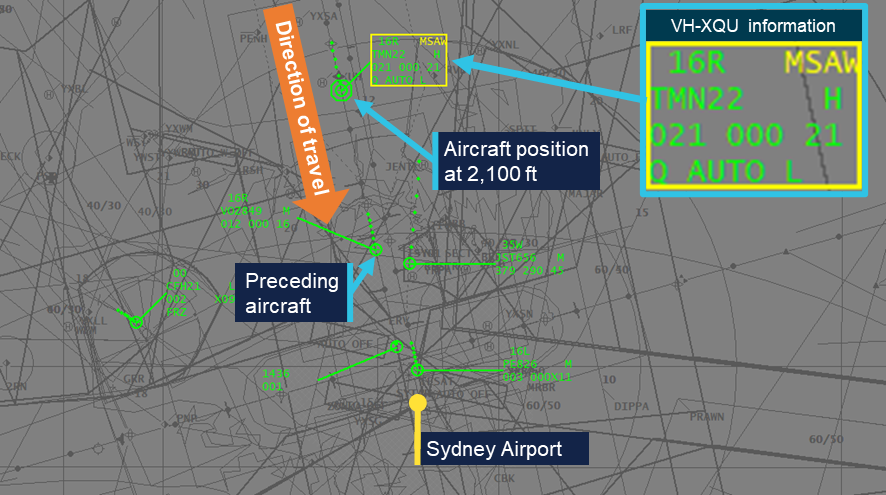
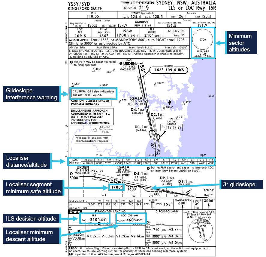
The descent triggered an air traffic control minimum safe altitude warning (MSAW) before the autopilot was disconnected and the aircraft levelled out at 1,700 ft, approximately 1,000 ft below the glideslope. It then descended a further 150 ft before a missed approach was commenced. On the subsequent approach, the crew elected to conduct a localiser approach and the aircraft landed without further incident.

What the ATSB found

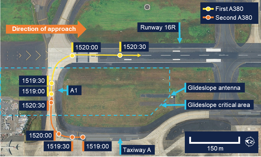
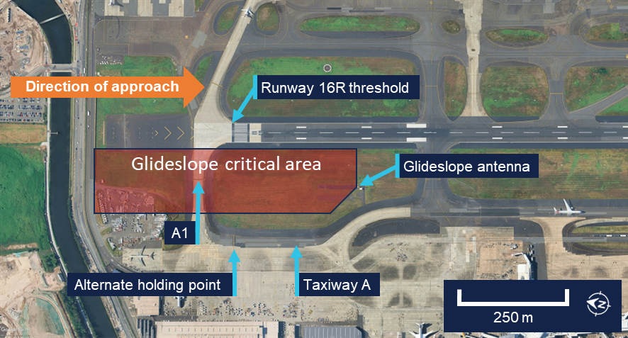
The ATSB found that 2 Airbus A380s on the ground at Sydney Airport taxied through the instrument landing system critical area and in front of the glideslope antenna, causing interference to the glideslope signal. As a result, after detecting the interference, the Boeing 767's autopilot established the aircraft on a flight path that deviated away from the glideslope, before alerting the crew that it was operating in a degraded mode.

It was also determined that the pilot flying continued the approach with the autopilot in a degraded mode. As a result, the aircraft’s high descent rate triggered an air traffic control minimum safe altitude warning. After disconnecting the autopilot, the pilot flying delayed the initiation of a missed approach and the aircraft descended below the localiser segment minimum safe altitude. In addition, the pilot monitoring did not effectively monitor the aircraft's flight path during the approach and did not call out deviations or advise the pilot flying to conduct a missed approach.

Furthermore, it was found that Tasman Cargo Airlines allowed the practice of flight crew exchanging flying and monitoring roles prior to 1,500 ft when conducting a practice autoland. It was also identified that Tasman Cargo's training did not inform flight crew of the conditions under which instrument landing system critical areas were protected. Consequently, the flight crew believed that the critical area was being protected, and the risk of glideslope interference had been mitigated.

What has been done as a result

Tasman Cargo Airlines has conducted the following proactive safety action:

  • Removed the ‘glideslope out’ procedure from its policy and procedures manual (PPM), replacing it with the requirement to conduct a missed approach and notify air traffic control.
  • Added a note in the PPM referencing the flight crew operating manual glideslope interference bulletin.
  • Published an operational alert regarding Sydney Airport runway 16R glideslope interference with guidance information.
  • Updated computer-based training materials to better highlight the ILS critical area and requirements during normal and low visibility operations.
  • Introduced a requirement for the pilot flying to take control of the aircraft prior to the commencement of the approach when conducting an autoland.

In addition, while not in direct response to this occurrence, Boeing advised it is in the process of updating the flight control software for B767 aircraft. Planned for release in 2027, the update will include the following changes:

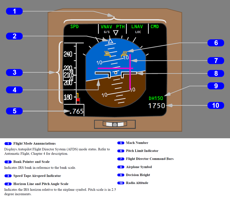
  • The flight director pitch bar will remain biased out of view if the autopilot is disconnected while in attitude stabilising mode.
  • Improved glideslope capture logic to reduce the occurrence of false captures leading to attitude stabilising mode.
  • Limiting the flight path angle while in attitude stabilising mode to be between 0‍–3.25° of descent.
  • Display of NO AUTOLAND after being in attitude stabilising mode for 15 seconds if the aircraft is still above alert height.
  • Automatic autopilot disconnect 10 seconds after the display of NO AUTOLAND if the aircraft is still above 500 ft AGL.

Safety message

Flight crew of Boeing 747-400, 747-8, 757, 767, 777 and 787 aircraft should familiarise themselves with their aircraft’s flight crew operating manual bulletin for ILS signal interference and be prepared to conduct prescribed procedures when encountering cockpit indications and autoflight behaviour consistent with the issue.

Automation can reduce pilot workload and enhance flight safety. However, it is critical that flight crew maintain constant awareness of the performance of the autoflight system. When under the control of automation, flight crew should monitor the flight path and verify that aircraft behaviour is consistent with the automation modes and parameters selected. If a discrepancy is identified, automation should be disconnected or the level of automation reduced until control is re-established.


The occurrence

On the afternoon of 10 September 2025, a Tasman Cargo Airlines Boeing 767-3JHF (B767), registered VH-XQU and operating as Tasman 22, was approaching Sydney Airport, New South Wales, at the conclusion of an air transport freight-only flight from Hong Kong International Airport, Hong Kong. On board were 3 flight crew, consisting of a captain, who occupied the left seat and was the pilot monitoring,1 a first officer who occupied the right seat and was the pilot flying, and a relief pilot who occupied a jump seat.

The crew planned to conduct a practice autoland approach (see the section titled Practice autoland) to perform a scheduled check of the aircraft’s systems. As company procedures required that the captain was the pilot flying for an autoland approach, the crew had briefed that the captain and first officer would exchange flying and monitoring roles at 1,500 ft above ground level (AGL). The first officer also recalled that the approach briefing conducted by the crew included items specific to an autoland (see the section titled Instrument approach briefing).

At 1454, when the aircraft was at its cruising level of flight level 350,2 the crew advised air traffic control (ATC) of their intention to conduct a practice autoland at Sydney, which the controller acknowledged. Shortly afterwards, the aircraft commenced descent. At 1510, the crew were transferred to the approach controller, who issued a clearance to continue descent. The crew read back the clearance and confirmed that the controller was aware they were conducting a practice autoland.

The approach controller subsequently advised the tower controller at Sydney Airport that the aircraft would be conducting a practice autoland, before transferring them to a second approach controller. At 1516, the aircraft was cleared to descend to an altitude of 3,000 ft and conduct the instrument landing system (ILS) approach for runway 16R.3 Two minutes later, at an altitude of 5,300 ft, the aircraft intercepted the localiser course for the approach. At the time, the autopilot was controlling the aircraft’s flight path and the autothrottle was engaged in speed mode (see the section titled Autoflight system).

Concurrently, on the ground at Sydney Airport, an Airbus A380 was awaiting departure at holding point A1, adjacent to runway 16R (see the section titled Glideslope critical area). A second A380 was also waiting for departure in sequence on taxiway A. At 1519, the first A380 was cleared to line up on runway 16R and began moving onto the runway (Figure 1). The second A380 followed in sequence to hold at A1.

Figure 1: Ground movement of A380s

Image depicting the positions of the 2 Airbus 380 aircraft at 30 second intervals between 1519 and 1520:30.
Source: Google Earth, overlaid with flight data, annotated by the ATSB

At 1519:18, when slightly below and flying to intercept the glideslope, the crew of VH‑XQU selected approach mode on the mode control panel and the autoflight system indicated that it had captured the glideslope (Figure 2). Two seconds later, the aircraft pitched down, adopting a nose down pitch of approximately 2°. As a result, the aircraft’s descent rate increased, and it began to diverge below the glideslope. At 1519:35, 15 seconds after the commencement of the pitch down and when the aircraft was descending through 3,730 ft, the crew were presented with several alerts in the cockpit:

  • a line through the pitch (G/S) flight mode annunciation (FMA)
  • removal of the flight director pitch bar from the primary flight display
  • an autopilot caution message.

Figure 2: Flight path relative to runway 16R glideslope

Image depicting the flight path relative to the runway 16R glidescope.
Source: Google Earth, overlaid with flight data annotated by the ATSB

The first officer recalled seeing the autopilot caution and associated alerts. They also reported that they recognised that the aircraft’s descent rate had increased and that it was no longer following the glideslope. The captain also recalled identifying that the aircraft increased its descent rate, however they believed that this occurred later in the approach and that initially the aircraft followed the glideslope. 

The aircraft continued to descend away from the glideslope, maintaining an average descent rate of 1,650 feet per minute (ft/min) for approximately another minute. During this time, the autopilot flight director system (AFDS) remained in approach mode with 3 autopilots engaged, and the alerts continued to be displayed to the crew. Both flight crew reported that, after being alerted, they discussed changing to conduct a localiser approach (see the section titled Instrument approach and landing chart). The first officer further recalled that, in addition, they began briefing and preparing for the change of approach. Both crew members advised that they considered they had time to have this discussion as the aircraft was still at a relatively high altitude and they had not yet passed the final approach point. The aircraft’s airspeed remained above the autothrottle selected airspeed, however the flight crew did not recall being required to manage excess airspeed during the approach.

The relief pilot, seated behind the captain and first officer, recalled that once the autopilot caution was observed, they assisted by calling out distances and required altitudes from the instrument approach chart (see the section titled Instrument approach and landing chart). The relief pilot further recalled that while doing this, they advised the other crew members that the aircraft was below the glideslope and called for them to slow the rate of descent. 

At 1520:33, ATC radar recorded the aircraft at an altitude of 2,200 ft with a descent rate of 1,731 ft/min approximately 10 NM (19 km) from the airport. This descent rate and low altitude triggered an ATC minimum safe altitude warning (MSAW),4 which was presented on the approach controller’s display (Figure 3). The approach controller had just instructed the flight crew to change radio frequency and contact the tower controller, therefore they asked the tower controller to issue a safety alert to the crew. Given the frequency change instruction had just been issued, the approach controller also attempted to contact the flight crew directly on the approach frequency. The crew responded they were still on that frequency. The approach controller gave the crew a low altitude alert, advising them to check their altitude and the crew responded that they were going around. 

Figure 3: Approach controller display at 1520:39

Image showing the approach controller's display at the time of the MSAW. The aircrafts position at an altitude of 2,100 ft is indicated with a preceding aircraft ahead on the approach. Information about the aircraft displayed to the controller is highlighted with a yellow border with warning text of MSAW.
Source: Airservices Australia, annotated by the ATSB

Just prior to the approach controller advising the crew of the low altitude warning, as the aircraft descended through 1,850 ft, the first officer disconnected the autopilot, re‑engaged the AFDS in vertical speed mode and raised the nose of the aircraft. As a result, the descent stopped at 1,700 ft, 8.6 NM (16 km) from the runway and approximately 1,000 ft below the glideslope. The aircraft then flew level for about 10 seconds before it began to descend again. At 1521:08, a go‑around was initiated from an altitude of 1,550 ft, as the low altitude alert was being given by ATC.

The aircraft climbed to 3,000 ft and was re-sequenced by ATC for another approach. This time, the crew elected to conduct a localiser approach, which they briefed while repositioning the aircraft to rejoin the approach. During this subsequent approach, the crew observed that the glideslope appeared to be functioning normally, and the aircraft landed without further incident.

After landing, the flight crew discussed the incident between themselves, and with the incoming crew for the next flight. They recalled that the B767 flight crew operations manual (FCOM) contained a bulletin that described the AFDS behaviour that was experienced (see the section titled Manufacturer signal interference bulletin) and concluded that glideslope interference had likely occurred.

Both the first officer and the relief pilot advised that they believed the glideslope critical area would have been protected because they were conducting an autoland; the captain also advised that they thought the glideslope critical area would have been protected, but due to the weather conditions at the time. The captain further reported that, after landing, they called ATC to enquire if there were any vehicles or aircraft that may have interfered with the glideslope signal and was advised that there were not. The aircraft’s ILS system was tested by maintenance personnel after landing and was assessed as serviceable.

Context

Pilot information

The captain held an Air Transport Pilot Licence (Aeroplane) and class 1 aviation medical certificate. They had 15,296 hours of flying experience, of which 2,567 were on the Boeing 767 (B767) aircraft type, with 102 hours accrued in the previous 90 days.

The first officer held a Commercial Pilot Licence (Aeroplane) and class 1 aviation medical certificate. They had 7,362 hours of flying experience, of which 440 were on the B767 aircraft type, with 84 hours accrued in the previous 90 days.

The relief pilot held an Air Transport Pilot Licence (Aeroplane) and class 1 aviation medical certificate. They had 20,599 hours of flying experience, of which 102 hours were on the B767 aircraft type, all accrued in the previous 90 days.

The flight crew had 2 days free of work prior to the flight and all pilots reported that they had slept adequately prior to, and had rested during, the flight.

Aircraft information

General information

VH-XQU was a Boeing 767-3JHF, manufactured in 2009 and first registered in Australia with the operator in 2022. The aircraft was fitted with 2 General Electric CF6‑80C2B7F turbofan engines and had accumulated 56,678 flight hours.

Autoflight system
Overview

The aircraft’s automatic-flight system consists of an autopilot flight director system (AFDS), and an autothrottle system. The AFDS provides pitch (vertical) and roll (lateral) guidance via flight director command bars overlaid on the attitude direction indicator (ADI) display (Figure 4).

Figure 4: Attitude director indicator display

Image showing attitude director indicator display for Boeing 767 aircraft. Top: 4 flight mode annunciations. Left: speed tape airspeed indicator and mach number. Centre: horizon line and pitch angle scale. Bottom right: decision height & radio altitude. The airplane symbol is superimposed relative to horizon line to indicate bank. At the top of the artificial horizon is the bank pointer and scale. Purple flight director command bars & and pitch limit bars are overlaid over the top of the horizon.
Source: The Boeing Company

Flight crew controlled the mode and associated flight parameters of the AFDS via the mode control panel. Available modes included:

  • Approach mode (APP): The flight director provided guidance to track the localiser laterally, and the glideslope vertically. This mode was used during an instrument landing system (ILS) approach.
  • Vertical speed mode (V/S): The flight director pitch bar indicated the aircraft pitch required to maintain the selected vertical speed. This speed was adjusted by flight crew using the vertical speed selector.

The aircraft was equipped with 3 autopilots. When engaged, each autopilot activated flight controls required for the aircraft to follow the flight director command bars. Only one autopilot was required to be engaged to provide autoflight capability, however multiple autopilots could be engaged to provide redundancy. This was required when conducting certain operations such as an autoland. When no autopilot was engaged the pilot flying was required to manually control the aircraft to follow the flight director.

Automatic control of engine thrust was provided by the aircraft’s autothrottle system. This system was also controlled via the mode control panel. When speed mode (SPD) was active, the autothrottle would control engine thrust, between idle and maximum thrust, to achieve the selected airspeed.

The flight mode annunciations (FMA) displayed (green) active and (white) armed modes of the AFDS and the (green) active mode of the autothrottle system to the flight crew. 

The flight crew operations manual (FCOM) contained information about engaging and disengaging the autoflight system and advised that:

After localizer and glideslope capture, the localizer and glideslope modes can only be deactivated by disengaging the autopilot and turning both flight directors off or by selecting GA [go-around] mode.

The FCOM also advised that:

If unwanted operation is noticed or when an autopilot failure is annunciated, the autopilot should be disconnected and the airplane flown manually.

Meteorology

The automatic terminal information service (ATIS)5 at Sydney Airport reported weather conditions at the time of the occurrence that included:

  • cloud layers of few at 500 ft, scattered at 1,000 ft and broken at 3,000 ft6
  • wind from 140° M at 15 kt
  • visibility of 5,000 m in rain
  • temperature of 16°C 
  • QNH7 of 1004
  • advice that turbulence was expected in the circuit area
  • an aerodrome warning that thunderstorms were expected from the west until 1845.

The flight crew advised that weather conditions were consistent with the ATIS, and that the aircraft was in instrument meteorological conditions8 throughout the approach and subsequent missed approach.

Recorded data

The ATSB was provided with data from the aircraft’s quick access recorder, which captured the incident flight. The data was also sent to the manufacturer for review (see the section titled Manufacturer review of recorded data). The cockpit voice recorder was not available due to the time that had elapsed since the occurrence. 

A review of the data identified that at 1519:00, the aircraft, with 3 autopilots engaged, was at an altitude of 4,000 ft with the localiser captured (LOC) and descending slightly while intercepting the glideslope from below (Figure 5). At 1519:18, the AFDS changed to approach mode and the associated FMA indicated that the glideslope mode (G/S) was active.

Two seconds later, the aircraft pitch lowered from 4° nose up to approximately 2° nose down, and away from the flight director pitch command bar. The glideslope deviation then recorded a period of variations inconsistent with the aircraft’s position relative to the glideslope. The aircraft’s descent rate subsequently increased, and it began descending away from the glideslope. 

Figure 5: Graphical representation of recorded flight modes and alerts

Graphical representation of recorded flight parameters. Significant events are annotated.
Note: Fight director pitch command – FO is the change in pitch angle the AFDS is commanding and reflects the difference between the required pitch attitude and the aircraft’s current pitch. A flight director pitch command of 0 indicates that the aircraft is at the desired pitch. Source: Quick access recorder data from VH-XQU, annotated by the ATSB

The data recorded the activation of a pitch fault FMA, an autopilot caution, and a master caution light at 1519:35. Approximately 15 seconds later, the flight director pitch command bar began showing values alternating between 0° and 45°, which the manufacturer advised was consistent with the flight director pitch bar being removed from the primary flight display (biased out of view).

Over the next minute, the aircraft maintained a descent rate of approximately 1,650 ft/min. During this time, the 3 autopilots remained engaged. Also during this time, the aircraft’s airspeed remained above the selected airspeed (Figure 6) while the engines remained at idle thrust. At 1520:05 the aircraft passed the initial approach fix at an altitude of approximately 2,900 ft, with the glideslope deviation at 2 dots, or full-scale deflection. From 1520:08, the speedbrake was deployed in varying positions, before being armed for landing at 1520:29.

Figure 6: Graphical representation of recorded airspeed and configuration

Graphical representation of recorded flight parameters related to aircraft airspeed and configuration. Significant events are annotated.
Note: N1 is the rotational speed of the low-pressure rotor and represents the level of engine thrust. Source: Quick access recorder data from VH-XQU, annotated by the ATSB

At 1520:42, the 3 autopilots were disconnected and the FMA fault indication and autopilot caution ceased. The data also recorded a change in AFDS mode from approach mode to vertical speed mode at this time, initially with a descent rate of 1,600 ft/min selected, consistent with the aircraft’s vertical speed at the time.9 At 1520:50, the aircraft’s altitude stabilised at 1,700 ft as the aircraft’s pitch raised to 5° nose up. The vertical speed selected was then reduced to −800 ft/min, then to 0.

At 1520:59, the flight director pitch command bar progressively raised over 7 seconds. The aircraft pitch also increased over this time. Also during this period, the airspeed decreased to the selected airspeed of 183 kt and engine thrust increased above idle. At 1521:08 go‑around mode was selected and the aircraft commenced a climb to 3,000 ft.

Instrument landing system

Overview

An instrument landing system (ILS) is an instrument approach that uses lateral (localiser) and vertical (glideslope) position information, using angular deviation signals from the localiser antennas (located past the upwind end of the runway) and the glideslope antennas (located to the side of the runway). Aircraft systems detect these radio signals and provide instrument indications that enable an aircraft to be manoeuvred along a precise final approach path.

Instrument approach and landing chart

The flight crew used a Jeppesen instrument approach and landing (IAL) chart to brief and conduct the approach (Figure 7). The chart contained information required to conduct either an ILS approach, with the glideslope providing vertical guidance, or a localiser approach that provided distance and altitude information for the flight crew to manage the vertical path, when vertical guidance from the glideslope was not available.

Figure 7: Instrument approach and landing chart runway 16R ILS/LOC

Jeppesen instrument approach and landing chart for runway 16R ILS and localiser approaches. Significant items are highlighted.
Source: Jeppesen, annotated by the ATSB

The chart specified the 25 NM (46 km) minimum sector altitude as 2,700 ft. This was the minimum altitude an aircraft could descend to while maintaining terrain and obstacle clearance when between 10–25 NM (19–46 km) of the airport and not in visual conditions or conducting an instrument approach. The minimum sector altitude reduced to 2,100 ft when within 10 NM (19 km) of the airport.

The chart also included a caution message that advised of the risk of glideslope interference (see the section titled Glideslope interference) stating that:

GP [glidepath] false indications due acft [aircraft] near Twy [taxiway] A1.

Information on the chart specific to conducting the localiser approach included a segment minimum safe altitude associated with each segment of the approach. Flight crew were required to ensure the aircraft remained at or above these altitudes when within the corresponding segment to maintain minimum obstacle and terrain clearance. The chart also included table of distance/altitude relationships to assist in maintaining a 3° descent profile when glideslope guidance was not available.

Missed approach requirements

The Aeronautical Information Package (AIP) stated that when conducting an ILS approach, a missed approach was required to be executed under certain conditions, including:

During an instrument approach and below MSA (as specified on the IAL chart) the performance of the radio aid becomes suspect, or the radio aid fails.

Glideslope interference

Glideslope critical area

Disturbances to the ILS glideslope signal may occur when vehicles or aircraft are operated near the antenna. For this reason, an ILS critical area is defined around the glideslope antenna location, within which aircraft and vehicle movement is restricted under certain conditions.

The glideslope critical area for runway 16R at Sydney Airport was an area 600 m long and 145 m wide and included the A1 holding point (Figure 8). When protection of this critical area was required, air traffic control (ATC) directed aircraft to hold at an alternate holding point on taxiway A, instead of A1.

Figure 8: Glideslope critical area for runway 16R

Approach end of runway 16R indicating the location of the glideslope antenna and the glideslope critical area.
Source: Google Earth, annotated by the ATSB

The conditions under which the ILS critical areas were required to be protected were defined in the Manual of Air Traffic Standards (MATS), which stated:

When the ceiling10 is at or below 600 ft or the visibility is 2000 m or less, ensure no aircraft enter the glide path or localiser critical areas when an arriving aircraft is within:
a) the outer marker; or
b) 4 NM from the threshold if no outer marker exists.

Manufacturer signal interference bulletin

The FCOM contained a bulletin, issued in November 2021 and titled Erroneous Autopilot Flight Director System (AFDS) Guidance when Instrument Landing System (ILS) Signal Interference Occurs. The bulletin stated that:

Boeing has received several reports of unexpected pitch guidance when capturing or tracking the glideslope during an instrument landing system (ILS) approach. In each event for which data was provided, Boeing has determined that glideslope signal interference occurred at the time of the unexpected pitch guidance and, in most of these events, the unexpected pitch guidance occurred during glideslope capture. ILS signal interference can occur when vehicles, aircraft, or other factors affect the localizer or glideslope signal.

The bulletin further stated that:

The AFDS can detect the degradation or instability of radio signals that support specific autopilot modes. When the AFDS detects a degraded or unstable signal during an ILS approach with the autopilot engaged, the affected AFDS mode changes to an attitude stabilizing mode based on inertial data at the time of the signal degradation or instability. The purpose of the attitude stabilizing mode is to prevent large and abrupt pitch and roll changes during short periods of localizer or glideslope signal interference. When the localizer or glideslope signal stabilizes and the airplane is within parameters for capture, the AFDS returns to tracking the localizer or glideslope. Alternatively, if the localizer or glideslope signal does not stabilize or the airplane is not within parameters for capture, the attitude stabilizing mode remains active. In this case, the AFDS continues to provide guidance in the attitude stabilizing mode, with possible high rates of descent and significant deviation from the localizer or glideslope.

The bulletin also advised that:

There is no direct indication to the pilot that the attitude stabilizing mode is active if the airplane is above 200 feet radio altitude and either:

• the localizer attitude stabilizing mode is active for less than 20 seconds or

• the glideslope attitude stabilizing mode is active for less than 15 seconds

If the airplane is above 200 feet radio altitude and the attitude stabilizing mode remains active for 20 seconds or more (for localizer) or 15 seconds or more (for glideslope):

• the AUTOPILOT message shows (if autopilot is engaged) (Figure 9) and

• the flight director roll or pitch bar is removed (if flight director is on) and

• an amber line shows through the affected flight mode annunciation (FMA)

Figure 9: Indications following extended time in attitude stabilising mode

Extract from the Boeing bulletin of the attitude direction indicator. Indicators expected following an extended time in attitude stabilising mode are annotated.
Figure shows indications on a typical aircraft model. Source: The Boeing Company  

Operating instructions were given for flight crew conducting an ILS approach, which advised that:

While on an ILS approach, monitor localizer and glideslope raw data and call out any significant deviations. Perform an immediate go-around if not within the criteria to continue the approach.

It is essential to crosscheck altitude at the FAF [final approach fix] and monitor pitch attitude and descent rate throughout the approach.

If a glideslope anomaly is suspected, an abnormal altitude range-distance relationship may exist. This can be identified by crosschecking distance to the runway with altitude or crosschecking the airplane position with waypoints indicated on the navigation display. The altitude should be approximately 300 feet height above touchdown per NM of distance to the runway for a 3° glideslope.

Manufacturer review of recorded data

At the request of the ATSB, the manufacturer reviewed the recorded data from the occurrence flight. The review included analysis of glideslope beam variation at the time of glideslope capture and throughout the approach. It identified that:

At a longitudinal distance of approximately 15.5 nautical miles [29 km] prior to the runway threshold, the observed glideslope beam began to diverge from the ideal beam, moving below the ideal beam. This deviation between the ideal and observed beam is characteristic of a beam anomaly.

The observed glideslope beam reached approximately 300 feet below the ideal beam. The divergence then began to decrease as the observed beam began to converge towards the ideal beam.

The observed glideslope beam diverged from the ideal beam again, varying by up to 350 feet below and then 400 feet above the ideal beam over the next 1.5 nautical miles.

A second period of divergence between the ideal and observed glideslope commenced at approximately the same time as the second A380 entered the critical area.

Based on this analysis, the manufacturer concluded that:

The airplane experienced a beam anomaly while attempting to capture the glideslope from below the beam. The observed glideslope beam diverged below the ideal 3-degree beam by a vertical offset of 300 feet, causing the airplane to attempt glideslope capture prematurely.

The review also referred to the FCOM bulletin for glideslope interference and advised that:

In this event, the airplane behaviour was consistent with a glideslope beam anomaly, causing the AFDS to enter attitude stabilizing mode. The airplane encountered a beam anomaly while intercepting the glideslope in G/S mode before entering into a steady descent with an average calculated vertical speed of approximately -1,700 feet per minute. The AFDS did not return to tracking the glideslope after the glideslope signal stabilized, probably because the glideslope deviation was no longer within the parameters for capture. For approximately the first 15 seconds, there were no indications in the QAR [quick access recorder] data that attitude stabilizing mode was active until the Autopilot Caution and FMA Pitch Fault activated. An additional 15 seconds passed before the flight director pitch guidance became BOV [biased out of view], consistent with the removal of the flight director pitch bar. This state remained until the flight crew switched the pitch mode to V/S.

Noting the operational guidance in the bulletin, the review concluded that:

Earlier recognition of the airplane state and degraded autopilot performance may have reduced the magnitude of the deviation below the glideslope.

The manufacturer also advised that there was no evidence to show whether the glideslope deviation pointer would have been displayed during the period that the alerts were active.

Practice autoland

Overview

An autoland approach is an approach during which the aircraft is fully controlled by the autoflight system through to landing. During an autoland, pilots assume a monitoring role and intervene only in the event of a system failure or other abnormal event. The procedure is primarily intended to be used in low-visibility conditions, however an autoland can also be conducted in better conditions to meet aircraft or flight crew recency and currency requirements. An autoland conducted under these conditions is termed a practice autoland.

Regulatory requirements and guidance

Flight crew were required to advise ATC of an intention to conduct a practice autoland when arriving at an aerodrome and the AIP stated that:

In weather conditions where the ceiling and/or visibility are above CAT I minima, pilots should inform ATC about any intention to conduct:

a. an approach with minima less than standard CAT I; or

b. an autoland procedure.

This information must not be taken as a request for or expectation of the protection of the ILS but to enable ATC to inform the flight crew of any known or anticipated disturbance.

The AIP also stated that when receiving this advice, and the ILS critical area was not protected, the controller was required to report ‘ILS critical area not protected’. Airservices Australia advised that only a tower controller provided advice of any known or anticipated disturbances. They also confirmed that an intention to conduct a practice autoland procedure did not change ATC’s requirements with regards to protecting the ILS critical areas.

The Civil Aviation Safety Authority published Advisory Circular (AC) 91‑12 Conduct of practice autoland operations. The AC described the problems and potential risks when conducting an autoland and stated:

Multiple factors may influence the accuracy of the ILS signal when the ILS autoland system is to be used:

• in conditions where ATC is not protecting ILS critical and/or sensitive areas.

These factors include:

• interference of the ILS signal due to an intrusion within the ILS critical and sensitive areas by:
  - taxiing aircraft
  - ground vehicles
  - over-flight of the ILS localiser.

The AC also identified a number of considerations, procedures and instructions when conducting practice autoland operations, which included:

ATC should be informed about the crew’s intention to conduct an autoland. Pilots should not expect the protection of the ILS, but on receiving advice from the crew of their intention to conduct a practice autoland, ATC may inform the flight crew of any known or anticipated disturbance.

Operator procedures and training

Flight crew roles and responsibilities

The operator’s policy and procedures manual (PPM) defined the roles of the pilot flying and the pilot monitoring as:

The PF [pilot flying] will control and monitor the aircraft, regardless of the level of automation being used. The duties of the PF are:

• flight control:
  - flight path and airspeed control
  - navigation
  - aircraft configuration

• conducting normal procedures in compliance with company manuals

• monitoring flight status and condition.

The PM [pilot monitoring] will monitor the aircraft and action of the PF. The duties of the PM are:

• general monitoring and crosschecking the procedures for all flight phases including take-off, cruise, approach and landing, aircraft system status, and condition

• make callouts to PF for any deviation from the flight path or system malfunction or failure

• give advice to the PF to execute a missed approach when the approach becomes unstable or unable to continue the approach safely

• ATC communications, checklist reading, FMS [flight management system] CDU [control display unit] operation

• complete the PF directions.

A callout must be made by the PM for the other crew if a deviation occurs from the normal procedures, or intended flight path (attitude, speed, altitude, and direction). If there is a failure for the PF to respond to callouts of the PM, appropriate corrective action shall be made for the safety of the flight including taking over the aircraft control.

The PPM defined tolerances for certain flight parameters, including a tolerance of one dot when tracking the glideslope, and advised that:

These parameters are to be observed and sustained flight should not be allowed to continue without corrective action by the flight crew. Any deviation outside of approach tolerances in IMC must result in a GA [go-around].

Use of automation

The PPM contained an automation policy which advised:

Automation is provided to enhance safety, reduce pilot workload and improve operational capabilities.

Automation can be as beneficial as mentioned above for flight operations, if automation is used appropriately. However, at the same time, if flight crew members fail to maintain proficiency in the use of automation or to properly correspond to recognised degradation of automation performance, it could be an obstruction for the flight safety.

In addition, over-reliance on automation system may lead to flight crews accepting whatever the aircraft was doing without proper monitoring or may result in deterioration of flight crew members’ manual flying skills. Therefore, for safe flight operation, proper use of automation system, maintaining manual flying skills, and practical use of CRM [crew resource management] skills are required.

Following elements are imperative to use automation at the most appropriate level:

• full understanding and knowledge of automation system

• proficiency in the use of all levels of automation

• monitoring and cross-check of automation

• skills to recognize degraded performance of automation system

• skills to shift between all levels of automation including manual flying.

The PPM also contained guidelines for flight crew when using automation, which included that:

• The flight crew must compare the performance of autoflight system (operation status) with the flight path of the aircraft.

• It is the responsibility of the flight crew to maintain flight mode awareness and control to ensure the flight director provides the guidance required.

• If any autoflight system is not operating as expected or any doubt exists, disengage it.

Instrument approach briefing

The PPM required flight crew to conduct a briefing of the threats, plans and considerations of the expected approach after the approach had been loaded. Considerations to be included in the brief were:

• approach title and chart effective date

• manual or AUTOLAND Landing

• nomination of required navigation aids

• approach entry/holding pattern

i• nitial approach altitude

• approach track(s)

• limiting and check altitudes

• CAT I, CAT II, CAT III MDA/DH [minimum descent altitude / decision height] and visibility minimum

• aerodrome elevation

• circling procedures (if applicable)

• significant terrain

• missed approach procedure

• monitoring of approach aids.

In addition, the crew were required to brief specific items prior to commencing an autoland approach which included the following non-normal situations:

• persistent localiser or glideslope deviation alert between 500 ft RA [radio altimeter] & 200 ft RA or any deviation alert below 200 ft RA

• ASA [autoland status annunciator] changes to NO AUTOLAND

• ILS Localiser and/or Glideslope Transmitter Failure

• autopilot disconnect.

Glideslope out procedure

The PPM contained procedures for when the glideslope failed during an ILS approach. The procedures stated that when in IMC:

If the glideslope fails when the aircraft is established on the ILS procedure (or being radar vectored) after the IAF [initial approach fix] ATC must be notified immediately.

An approach may be continued if the following items can be completed prior to FAF [final approach fix]:

• complete briefing for a LOC [localiser] (GS [glideslope] out) approach

• mode change and operation for LOC approach

• set the next fix altitude or MDA on altitude window

• barometric altimeter bug set

• completion of landing configuration and landing checklist

A missed approach must be conducted for the following situations

• failure to complete the steps above, prior to the FAF

• failure of situational awareness for the LOC (GS out) procedure

• when directed by ATC.

Low visibility operations
Autoland procedures

The PPM defined procedures for taxi, take-off and landing in conditions where visual reference was limited by weather. This included procedures for conducting a low visibility operations (LVO) approach and landing including an autoland. It was stated that:

LVO approach and landings shall be carried out using the highest level of automation available to an autoland.

The left seat pilot is PF and the right seat pilot is PM for the approach, landing or missed approach. 

In addition, crew responsibilities during an LVO landing were stated as:

Pilot Flying Duties

The PF shall guard the control column, rudder pedals and thrust levers throughout the approach, landing, or missed approach, make standard callouts and responses as per the LVO landing standard callouts and actions, and take manual control in the event of autopilot disconnect.

Pilot Monitoring Duties

The PM must monitor the aircraft flight path and flight instruments throughout the approach, landing and rollout, or missed approach. They are to remain ‘heads down’ and make no attempt to seek visual reference. Any deviation or system failure must be called to alert the PF.

Additionally, specific standard callouts (by the PM) and responses (by the PF) were required to be used when conducting an LVO landing. These specific callouts began at 1,500 ft AGL.

The PPM did not contain procedures specific to conducting a practice autoland. The operator later advised that when conducting LVO operations, the left seat pilot was required to be the pilot flying for the entire approach however, when conducting a practice autoland, the pilots could switch roles so long as the left seat pilot was the pilot flying prior to 1,500 ft AGL.

The PPM contained information about ILS critical areas that was relevant to the conduct of an autoland and advised that:

When the weather ceiling is above 600 ft and 2,000 m visibility the ILS critical and sensitive areas are not protected by ATC and a number of factors may influence the accuracy of the ILS signal.

These include intrusions of the ILS critical and sensitive areas by the following factors:

• taxiing aircraft

• ground vehicles

• over-flight of the ILS localiser.

The flight crew shall therefore notify ATC at the commencement of an autoland approach when the ceiling and visibility are above the parameters listed above. e.g. ‘We are conducting an autoland approach’.

When an approach condition develops where the glide slope or the localizer becomes unreliable, due to signal interference, the aircraft departs from the approach path, or for other causes where manual flying is required, the flight crew must transition to manual flying immediately.

Flight crew training

The operator provided training to flight crew for LVO via a combination of online computer-based training (CBT), in-person training and training and assessment in a flight simulator.

The CBT included information about the purpose of an ILS critical area, and of alternate holding point requirements when protection was in force. Presentation materials used during in-person training identified the loss of glideslope or localiser signal as a possible non-normal situation. The indications expected in this situation were:

• pointer disappears

• line through associated FMA

• FD [flight director] bar for failed mode is removed

• autopilot EICAS [Engine indicating and crew alerting system]

The operator advised that simulator training during both induction and ongoing training covered failures during approaches, including the glideslope. In addition, they advised this training covered the cockpit indications during a glideslope out scenario. They also advised that the FCOM signal interference bulletin was discussed during training with focus on the potential high rates of descent associated with the issue.

Reviewed training materials did not contain information about the conditions under which the ILS critical area would be protected.

Related occurrences

ATSB investigation AO-2015-144

The ATSB investigated a flight below minimum altitude of a Boeing 787 conducting an ILS approach to Perth Airport on 4 December 2015. It was found that interference to the glideslope signal likely occurred due to a Boeing 737 aircraft taxiing from the holding point to the runway at the time.

ATSB investigation AO-2017-023

The ATSB also investigated a descent below lowest safe altitude of a Boeing 747‑400 aircraft conducting an ILS approach to Sydney Airport’s runway 16R on 12 February 2017. It was found that glideslope interference likely occurred due to a Boeing 787 aircraft holding at A1 during the approach. The report also identified 2 similar occurrences in March 2017 of Boeing 747 aircraft experiencing high descent rates during an ILS approach. In both instances an Airbus A380 was occupying taxiway A1 at the time.

Other occurrences

The ATSB occurrence database did not contain any additional occurrences after 2017 that could be identified as glideslope interference. However, as glideslope interference is not a reportable matter under the Transport Safety Investigation Regulations, it is likely an occurrence would only be reported to the ATSB if a consequential event required it and may not include detail to identify glideslope interference.

Following a notice to flight crew to report instances of glideslope interference, the operator was subsequently made aware of 9 additional instances of suspected glideslope interference when approaching runway 16R at Sydney Airport. For each, the ATSB reviewed publicly available flight data and identified an aircraft positioned either at holding point A1 or moving from the holding point onto the runway at the time of the reported interference.

Table 1: Subsequent occurrences of glideslope interference reported to operator

DateAircraftAircraft type at A1
1 November 2025VH-FKX (B767)Boeing 787
2 November 2025VH-FKX (B767)Boeing 777
9 November 2025VH-EXZ (B767)Airbus A350
22 November 2025VH-EXZ (B767)Airbus A350
27 November 2025VH-XQU (B767)Boeing 787
28 December 2025VH-XQU (B767)Airbus A350
2 January 2026VH-EXZ (B767)Airbus A380
23 February 2026VH-XQU (B767)Boeing 787
13 March 2026VH-XQU (B767)Airbus A380

In response to a request for reports of glideslope interference at Sydney Airport, Airservices Australia advised that several of the subsequent events listed by the operator were received and reviewed by technical surveillance specialists. All events were determined to be due to aircraft in the glideslope critical area with the effect on the approaching aircraft as expected. No reports of glideslope interference were received from other operators between January 2025 and January 2026.

Safety analysis

Introduction

This analysis will discuss the factors leading to the performance of the autoflight system and the protection requirements of the instrument landing system critical area. In addition, it will examine the actions of the flight crew in response. Finally, the analysis will consider the operator’s procedures and training for conducting precision approaches, low visibility operations and practice autoland approaches.

Glideslope interference

As the aircraft was intercepting the glideslope prior to the commencement of a practice autoland approach, an A380 aircraft holding at A1, within the ILS critical area, began moving onto the runway. A second A380 then entered the critical area as the first vacated. The movements of both aircraft coincided with anomalies observed in the glideslope signal received by the aircraft.

The weather conditions at Sydney Airport at the time were better than those for which protection of the ILS critical area was required. Therefore, ATC was not required to protect the area for a practice autoland. Furthermore, while the tower controller was required to inform the flight crew that the ILS was not being protected, the flight crew had not yet transferred to this controller. Therefore, there was no opportunity for the flight crew to be given this advice.

After initially attempting to capture the glideslope from below, the aircraft's descent rate increased away from the flight director pitch guidance, and it began deviating away from the glideslope. As described in the flight crew operations manual (FCOM) bulletin for ILS signal interference, when the autopilot flight director system (AFDS) detected an unstable glideslope signal it changed to an attitude stabilising mode. Cockpit alerts were subsequently displayed to alert the flight crew to the degraded performance of the autopilot. These alerts were consistent with those expected when the AFDS had been in attitude stabilising mode for 15 seconds. Therefore, the movement of the first A380 through the ILS critical area caused an interference to the glideslope signal, which was subsequently detected by the AFDS. As a result, after attempting to capture the glideslope prematurely, the AFDS entered and remained in an attitude stabilising mode before alerting the crew. 

Contributing factor

Two Airbus A380s on the ground at Sydney Airport taxied through the instrument landing system critical area and in front of the glideslope antenna, causing interference to the glideslope signal. As a result, after detecting the interference, the Boeing 767's autopilot established the aircraft on a flight path that deviated away from the glideslope, before alerting the crew that it was operating in a degraded mode.

Descent below glideslope

Pilot flying

After the interference stopped, it is likely that the flight path deviation had increased beyond the threshold at which the AFDS could re-capture the glideslope. Therefore, the AFDS remained in attitude stabilising mode while the annunciations indicating the degraded performance of the autopilot continued to be displayed to the flight crew. 

The pilot flying recognised that the autopilot was no longer following the glideslope, and that the aircraft was descending at a high rate. However, believing that they had sufficient time and altitude, they did not disengage the autopilot and commenced discussion and preparation for a change to a localiser approach. Both operator and manufacturer procedures required that if automation was not operating as expected then it should be disengaged and the aircraft flown manually. However, the pilot flying allowed flight below the glideslope to continue beyond the initial approach fix and below the approach commencement altitude.

After the aircraft’s flight path triggered a minimum safe altitude warning (MSAW), but prior to receiving the corresponding low altitude alert from ATC, the pilot flying did disconnect the autopilot. By this time, the aircraft’s position was significantly below the minimum sector altitude, below which a missed approach was required to be conducted when experiencing a failure of the glideslope. Furthermore, the manufacturer’s procedure specific to glideslope interference required a missed approach to be conducted when corresponding failure annunciations were displayed. These annunciations were continuously displayed throughout the approach. Following the disconnection of the autopilot, the pilot further delayed the initiation of a missed approach. During this period of manual flight, the aircraft descended a further 150 ft and below the localiser segment minimum safe altitude before a missed approach was commenced.

The ATSB considered the extended time between the MSAW being triggered and the flight crew receiving a low altitude alert. As the MSAW coincided with an instruction to the crew to contact the tower controller, the low altitude alert could not be given immediately because the approach controller was required to establish which frequency the crew were listening on. However, as the crew had already disconnected the autopilot and arrested the initial descent, this was not considered to be contributory. 

Contributing factor

The pilot flying continued the approach with the autopilot in a degraded mode. As a result, the aircraft’s high descent rate triggered an air traffic control minimum safe altitude warning. After disconnecting the autopilot, the pilot flying delayed the initiation of a missed approach and the aircraft descended below the localiser segment minimum safe altitude.

Pilot monitoring

During the approach, the pilot monitoring was required to monitor the aircraft’s flight path and advise the pilot flying of any deviations. Specifically, when conducting an ILS approach, they were required to monitor the glideslope for deviation. If glideslope tracking deviated beyond one dot, a callout was required, and the flight path was required to be corrected by the pilot flying. When in instrument meteorological conditions (IMC) further deviation outside of this required a missed approach. At the commencement of the approach, the glideslope deviation was recorded as already at 2 dots (full scale) and remained so throughout the approach. However, both the pilot flying and the pilot monitoring could not recall that the glideslope deviation pointer was displayed after the autopilot alerts activated. Furthermore, the manufacturer could not determine whether the pointer was displayed to the flight crew after the AFDS entered attitude stabilising mode.

Notwithstanding this, other flight instruments were available to monitor the aircraft’s flight path. The aircraft’s pitch attitude was more nose down than expected during an ILS approach. In addition, the vertical speed indicator would have been indicating a descent rate greater than expected. The FCOM bulletin advised flight crew to monitor both pitch attitude and descent rate during an ILS approach. Furthermore, the relief pilot called out required altitudes and distances during the approach, providing additional information regarding the aircraft’s position below the glideslope. As no deviation calls or requests to conduct a missed approach were reported as being made by the pilot monitoring, it is likely that they were not effectively monitoring the aircraft’s flight path throughout the approach. 

Contributing factor

The pilot monitoring did not effectively monitor the aircraft's flight path during the approach and did not call out deviations or advise the pilot flying to conduct a missed approach.

Operator procedures and training

Glideslope out procedure

The operator had a ‘glideslope out’ procedure that allowed the crew the flexibility to transition to localiser approach provided specific preparatory actions were able to be completed prior to the final approach fix. Recognising that on this occasion the crew experienced glideslope interference rather than glideslope out, the cockpit indications were similar. As such, consideration of transitioning to a localiser approach was understandable.

However, given the significant deviation from the expected flightpath due to the aircraft’s sustained high rate of descent, safe transition to a localiser approach was considered highly unlikely on this occasion. This was ultimately recognised by the crew and a missed approach initiated.

The operator advised that the procedure allowing the transition from an instrument landing system approach to a localiser approach was withdrawn following this occurrence.

Practice autoland procedure

As approved by the operator, the flight crew briefed that while the first officer was initially the pilot flying, they would exchange flying and monitoring roles at 1,500 ft above ground level (AGL), after which point the captain would be the pilot flying. However, the operator’s procedures did not differentiate between a practice autoland and one conducted in low visibility conditions. Therefore, the captain was required to be the pilot flying from the commencement of the approach. 

In addition, while callouts required for an autoland did not commence until 1,500 ft AGL, there were specific responsibilities assigned to the flying and monitoring roles during an autoland approach that applied to the entire approach.

A practice autoland offered an opportunity to develop familiarity with, and proficiency in, those roles. Furthermore, the Civil Aviation Safety Authority guidance material highlighted the importance of flight crew responsibilities during transition to visual conditions, in deteriorating visibility or when failures occur. As such, exchanging roles introduced the potential for confusion or ambiguity as to the roles and responsibilities of each crew member during the approach, particularly if the handover coincided with a transition to visual conditions, or the need to respond to an abnormal event.

Other factor that increased risk

Tasman Cargo Airlines allowed the practice of flight crew exchanging flying and monitoring roles prior to 1,500 ft when conducting a practice autoland. This increased the risk of role confusion or ambiguity during a high workload activity.

Low visibility operations training

The operator provided training to flight crew for low visibility operations, which included information about the ILS critical area. However, the training did not include information about the conditions under which the critical area would be protected. In addition, while the operator's procedures informed flight crew that they should notify ATC of their intent to conduct a practice autoland, they did not specify that this notification did not change ATC protection requirements, implying that the notification would result in the critical area being protected.

The captain reported that they considered that the weather conditions would necessitate protection of the critical area. Additionally, both the first officer and the relief pilot reported that they thought the ILS was being protected as they had advised ATC of their intention to conduct an autoland. Therefore, while it likely did not influence the flight crew’s response to the glideslope interference, they mistakenly believed that the risk of such an event had been mitigated.

Other factor that increased risk

Tasman Cargo Airlines’ training did not inform flight crew of the conditions under which instrument landing system critical areas were protected. Consequently, the flight crew believed that the critical area was being protected, and the risk of glideslope interference had been mitigated.

Findings

ATSB investigation report findings focus on safety factors (that is, events and conditions that increase risk). Safety factors include ‘contributing factors’ and ‘other factors that increased risk’ (that is, factors that did not meet the definition of a contributing factor for this occurrence but were still considered important to include in the report for the purpose of increasing awareness and enhancing safety). In addition ‘other findings’ may be included to provide important information about topics other than safety factors. 

Safety issues are highlighted in bold to emphasise their importance. A safety issue is a safety factor that (a) can reasonably be regarded as having the potential to adversely affect the safety of future operations, and (b) is a characteristic of an organisation or a system, rather than a characteristic of a specific individual, or characteristic of an operating environment at a specific point in time.

These findings should not be read as apportioning blame or liability to any particular organisation or individual.

From the evidence available, the following findings are made with respect to the descent below glideslope involving Boeing 767, VH-XQU, near Sydney Airport, New South Wales, on 10 September 2025. 

Contributing factors

  • Two Airbus A380s on the ground at Sydney Airport taxied through the instrument landing system critical area and in front of the glideslope antenna, causing interference to the glideslope signal. As a result, after detecting the interference, the Boeing 767's autopilot established the aircraft on a flight path that deviated away from the glideslope, before alerting the crew that it was operating in a degraded mode.
  • The pilot flying continued the approach with the autopilot in a degraded mode. As a result, the aircraft’s high descent rate triggered an air traffic control minimum safe altitude warning. After disconnecting the autopilot, the pilot flying delayed the initiation of a missed approach and the aircraft descended below the localiser segment minimum safe altitude.
  • The pilot monitoring did not effectively monitor the aircraft's flight path during the approach and did not call out deviations or advise the pilot flying to conduct a missed approach.

Other factors that increased risk

  • Tasman Cargo Airlines allowed the practice of flight crew exchanging flying and monitoring roles prior to 1,500 ft when conducting a practice autoland. This increased the risk of role confusion or ambiguity during a high workload activity.
  • Tasman Cargo Airlines’ training did not inform flight crew of the conditions under which instrument landing system critical areas were protected. Consequently, the flight crew believed that the critical area was being protected, and the risk of glideslope interference had been mitigated.

Safety actions

Safety action not associated with an identified safety issue

Safety action by Tasman Cargo Airlines

Tasman Cargo Airlines has taken the following proactive safety action:

  • Removed the ‘glideslope out’ procedure from its policy and procedures manual (PPM), replacing it with the requirement to conduct a missed approach and notify air traffic control.
  • Added a note in the PPM referencing the glideslope interference bulletin from the flight crew operating manual.
  • Published an operational alert regarding Sydney Airport runway 16R glideslope interference with guidance information.
  • Updated computer-based training materials to better highlight the ILS critical area and requirements during normal and low visibility operations.
  • Introduced a requirement for the pilot flying to take control of the aircraft prior to the commencement of the approach when conducting an autoland.
Safety action by Boeing

While not in direct response to this occurrence, Boeing is in the process of updating the flight control software for B767 aircraft. Planned for release in 2027, the update will include the following changes:

  • The flight director pitch bar will remain biased out of view if the autopilot is disconnected while in attitude stabilising mode.
  • Improved glideslope capture logic to reduce the occurrence of false captures leading to attitude stabilising mode.
  • Limiting the flight path angle while in attitude stabilising mode to be between 0–3.25° of descent.
  • Display of NO AUTOLAND after being in attitude stabilising mode for 15 seconds if the aircraft is still above alert height.
  • Automatic autopilot disconnect 10 seconds after the display of NO AUTOLAND if the aircraft is still above 500 ft AGL.

Glossary

ACAdvisory circular
ADIAttitude direction indicator
AFDSAutopilot flight director system
AGLAbove ground level
AIPAeronautical Information Package
ATCAir traffic control
ATISAutomatic terminal information service
BOVBiased out of view
CBTComputer-based training
CDUControl display unit
DHDecision height
EICASEngine indicating and crew alerting system
FAFFinal approach fix
FCOMFlight crew operations manual
FLFlight level
FMAFlight mode annunciation
FMSFlight management system
GSGlideslope
IAFInitial approach fix
IALInstrument approach and landing
ILSInstrument landing system
IMCInstrument meteorological conditions
LOCLocaliser
LVOLow visibility operations
MATSManual of Air Traffic Standards
MDAMinimum descent altitude
MSAMinimum sector altitude
MSAWMinimum safe altitude warning
PFPilot flying
PMPilot monitoring
PPMPolicy and procedures manual
QARQuick access recorder
RARadio altimeter

Sources and submissions

Sources of information

The sources of information during the investigation included:

  • the flight crew
  • the operator
  • The Boeing Company
  • Airservices Australia
  • recorded data from the aircraft quick access recorder.

References

Civil Aviation Safety Authority (2024). Conduct of practice autoland operations (advisory circular AC 91-12 v1.1), https://www.casa.gov.au/sites/default/files/2021-12/advisory-circular-91-12-conduct-of-practice-autoland-operations.pdf, CASA, accessed 1 December 2025.

Submissions

Under section 26 of the Transport Safety Investigation Act 2003, the ATSB may provide a draft report, on a confidential basis, to any person whom the ATSB considers appropriate. That section allows a person receiving a draft report to make submissions to the ATSB about the draft report. 

A draft of this report was provided to the following directly involved parties:

  • the flight crew
  • the operator
  • The Boeing Company
  • Airservices Australia
  • Civil Aviation Safety Authority
  • United States National Transportation Safety Board.

Submissions were received from:

  • the operator
  • The Boeing Company
  • Civil Aviation Safety Authority.

The submissions were reviewed and, where considered appropriate, the text of the report was amended accordingly.

Purpose of safety investigations

The objective of a safety investigation is to enhance transport safety. This is done through: 

  • identifying safety issues and facilitating safety action to address those issues
  • providing information about occurrences and their associated safety factors to facilitate learning within the transport industry.

It is not a function of the ATSB to apportion blame or provide a means for determining liability. At the same time, an investigation report must include factual material of sufficient weight to support the analysis and findings. At all times the ATSB endeavours to balance the use of material that could imply adverse comment with the need to properly explain what happened, and why, in a fair and unbiased manner. The ATSB does not investigate for the purpose of taking administrative, regulatory or criminal action.

About ATSB reports

ATSB investigation reports are organised with regard to international standards or instruments, as applicable, and with ATSB procedures and guidelines.

Reports must include factual material of sufficient weight to support the analysis and findings. At all times the ATSB endeavours to balance the use of material that could imply adverse comment with the need to properly explain what happened, and why, in a fair and unbiased manner.

An explanation of terminology used in ATSB investigation reports is available here. This includes terms such as occurrence, contributing factor, other factor that increased risk, and safety issue.

Publishing information

Released in accordance with section 25 of the Transport Safety Investigation Act 2003

Published by: Australian Transport Safety Bureau

© Commonwealth of Australia 2026

CC BY logo

Ownership of intellectual property rights in this publication

Unless otherwise noted, copyright (and any other intellectual property rights, if any) in this report publication is owned by the Commonwealth of Australia.

Creative Commons licence

With the exception of the Commonwealth Coat of Arms, ATSB logo, and photos and graphics in which a third party holds copyright, this report is licensed under a Creative Commons Attribution 4.0 International licence.

The CC BY 4.0 licence enables you to distribute, remix, adapt, and build upon our material in any medium or format, so long as attribution is given to the Australian Transport Safety Bureau. 

Copyright in material obtained from other agencies, private individuals or organisations, belongs to those agencies, individuals or organisations. Where you wish to use their material, you will need to contact them directly.

  1. ^    Pilot flying (PF) and pilot monitoring (PM): procedurally assigned roles with specifically assigned duties at specific stages of a flight. The PF does most of the flying, except in defined circumstances, such as planning for descent, approach and landing. The PM carries out support duties and monitors the PF’s actions and the aircraft’s flight path.
  2. ^    Flight level: at altitudes above 10,000 ft in Australia, an aircraft’s height above mean sea level is referred to as a flight level (FL). FL 350 equates to 35,000 ft pressure altitude.
  3. ^    Runway number: the number represents the magnetic heading of the runway. The runway identification may include L, or R as required for left or right when there are parallel runways. 
  4. ^    Minimum safe altitude warning (MSAW): an automated warning for air traffic controllers to draw attention to an aircraft that at its current descent rate is projected to conflict with terrain.
  5. ^    Automatic terminal information service: the provision of current, routine information to arriving and departing aircraft by means of continuous and repetitive broadcasts. ATIS information is prefixed with a unique letter identifier and is updated either routinely or when there is a significant change to weather and/or operations. 
  6. ^    Cloud cover: in aviation, cloud cover is reported using words that denote the extent of the cover – ‘few’ indicates that up to a quarter of the sky is covered, ‘scattered’ indicates that cloud is covering between a quarter and a half of the sky, ‘broken’ indicates that more than half to almost all the sky is covered, and ‘overcast’ indicates that all the sky is covered. 
  7. ^    QNH: the altimeter barometric pressure subscale setting used to indicate the height above mean sea level.
  8. ^    Instrument meteorological conditions (IMC): weather conditions that require pilots to fly primarily by reference to instruments, and therefore under instrument flight rules (IFR), rather than by outside visual reference. Typically, this means flying in cloud or limited visibility. 
  9. ^    When vertical speed mode is engaged, it will initially target the vertical speed current at the time of engagement. 
  10. ^   Cloud ceiling: The height above the ground of the base of the lowest layer of cloud covering more than one-half the sky.

Occurrence summary

Investigation number AO-2025-055
Occurrence date 10/09/2025
Occurrence time and timezone 15:20 Australian Eastern Standard Time
Location Near Sydney Airport
State New South Wales
Report release date 10/07/2026
Report status Final
Investigation level Defined
Investigation type Occurrence Investigation
Investigation phase Final report: Dissemination
Investigation status Completed
Mode of transport Aviation
Aviation occurrence category Flight below minimum altitude, Missed approach, Unstable approach, Warning devices
Occurrence class Serious Incident
Highest injury level None

Aircraft details

Manufacturer The Boeing Company
Model 767-3JHF
Registration VH-XQU
Serial number 37806
Aircraft operator Tasman Cargo Airlines Pty Ltd
Sector Jet
Operation type Part 121 Air transport operations - larger aeroplanes
Activity Commercial air transport-Scheduled-Scheduled freight only
Departure point Hong Kong International Airport, Hong Kong
Destination Sydney Airport, New South Wales
Injuries None
Damage Nil