
Final report
Report release date: 24/02/2026
Investigation summary
What happened
On 18 September 2025, the pilot of a Cirrus SR20, registered VH-TEL, planned to conduct a personal flight under visual flight rules (VFR) from Bankstown Airport, New South Wales, to Mount Kosciuszko (without landing) and return. The pilot was the sole occupant on board.
The pilot took off from Bankstown Airport and flew south to, and then around, Mount Kosciuszko. The pilot then flew to Mallacoota Airport, Victoria, tracking overhead various aerodromes.
Once passing Mallacoota Airport the pilot began to descend while tracking north towards Merimbula Airport, New South Wales. Recorded data indicated that the pilot began to receive warnings about a high engine cylinder head temperature in cylinder 4. Additionally, there was low cloud in the area ahead.
While descending towards Moruya Airport, the pilot contacted Melbourne Centre air traffic control stating an intention to land. There were no further radio calls from the pilot. The pilot continued to track towards Moruya Airport before diverting to the west, continuing north-west towards the Great Dividing Range.
The pilot continued north-west for 13 minutes at 2,500 ft. For the remainder of the flight, the pilot maintained an altitude between 2,000 and 2,700 feet above mean sea level (AMSL), with intermittent climbs and descents. The mountainous area had fluctuating terrain heights, with a maximum terrain height of about 2,900 ft.
At 1458 the aircraft collided with terrain in dense forest in the Budawang National Park. The aircraft was destroyed, and the pilot was fatally injured.
What the ATSB found
The commencement of an approach to land at Moruya was not part of the flight plan and most likely the result of the warning and/or cloud ahead. It is unclear why the pilot made the decision to continue the flight rather than land at Moruya, as poor weather was present ahead of the aircraft and the pilot would have been seeing fluctuating cylinder temperature warnings. However, with limited prior experience in cross-country flights and facing deteriorating weather conditions, the pilot would have been less able to objectively weigh the cumulative hazards of continuing into adverse weather.
The decision to deviate inland from the initial planned track and toward higher terrain was likely influenced by the perceived presence of a clear area ahead in the cloud layer. This gap, evident at the approximate time the aircraft passed to the west of Moruya Airport, would have presented a visually clearer path to the pilot. Furthermore, there was cloud over Moruya Airport and the pilot may have considered that maintaining VMC throughout an approach and landing there might not have been feasible. The cylinder head warnings were likely spurious but, even if the pilot had understood this, the warnings would have been an ongoing source of distraction.
Following the decision to continue, tracking data showed the aircraft proceeding into the mountainous area of the Great Dividing Range, then almost reversing course at low altitude along a valley within the Great Dividing Range, consistent with an attempt to avoid cloud. Once in the valley, it is likely that the pilot did not know what direction to take away from the mountainous areas and cloud or, if they did, became trapped between the rising terrain and the low cloud base.
It is therefore likely that the pilot inadvertently entered instrument meteorological conditions (IMC) and became unable to regain visual references, which led to a loss of terrain awareness and the subsequent controlled flight into terrain.
Safety message
Research and investigations by the ATSB continue to show that weather‑related accidents remain one of the most persistent accident types in general aviation. When operating under visual flight rules (VFR), pilots must always be prepared to make conservative decisions when weather conditions begin to deteriorate. If visibility is reducing or the cloud base is lowering, pilots should strongly consider landing at the nearest suitable location rather than continuing into worsening conditions. Making an early decision to land, delay, or turn back can prevent a situation where safe flight cannot be maintained.
Attempts to maintain visual contact with the ground in marginal weather, commonly referred to as ‘scud running’, significantly increase the risk of controlled flight into terrain (CFIT). Reduced visibility, low cloud, and poor contrast can quickly lead to disorientation or collision with unseen obstacles or terrain. Continuing flight in these conditions often provides little margin for error, especially at low altitude.
Pilots are reminded to maintain situational awareness and resist the pressure to continue to a planned destination (commonly referred to as ‘get-there-itis’) when conditions no longer support safe visual flight. Additionally, if VFR pilots find themselves in marginal weather and becoming disoriented or lost, they should seek whatever help is available. Air Traffic Services (ATS) may be able to provide assistance, especially if the aircraft is in ATS surveillance coverage. There have been a number of reported occurrences where this simple action has averted potential disaster.
The investigation
The occurrence
On 18 September 2025, the pilot of a Cirrus SR20, registered VH-TEL, planned to conduct a pleasure flight under visual flight rules (VFR)[1] from Bankstown Airport, New South Wales, to Mount Kosciuszko (without landing there) and return. The pilot would be the sole occupant.
The pilot arrived at Bankstown Flying School (BFS), from which the aircraft was being hired, at about 0900. The owner of the flying school recalled the pilot requested assistance in how to add locations with no designated waypoints (Mount Kosciuszko and Thredbo) into their flight plan. After assisting with their flight plan, the owner asked the pilot about the weather for their planned route and information about last light.[2] The pilot had reported the weather was good for the flight and that last light was at 1800, however they planned to be back by 1700.
At 0910 the pilot took the aircraft out of the hangar and had it refuelled. The owner recalled the aircraft should have been filled to full prior to the flight.
At approximately 1113 local time, the pilot took off from Bankstown Airport. Recorded data from the onboard GPS showed that once airborne, the pilot tracked to waypoint CAMB (Campbelltown University), passing 2,500 ft above mean sea level (AMSL) at 1121. The aircraft continued climbing through 4,500 ft while passing waypoint PIC (Picton) and at 1131 the aircraft was levelled off at 6,500 ft (Figure 1).
At 1150 the pilot began climbing to 8,500 ft and levelled off just prior to flying over the former Braidwood aircraft landing area (ALA).[3] The pilot continued to fly to and then around Mount Kosciuszko before climbing again to 9,500 ft. The pilot then flew for approximately 40 minutes to (overhead) Mallacoota Airport, Victoria, tracking overhead various aerodromes.
Figure 1: Flight path overview

Source: Google Earth, annotated by the ATSB
Once passing Mallacoota Airport at 1342, aircraft flight data showed the pilot began to descend while tracking towards Merimbula Airport, New South Wales, and then continued further north.
At about 1426, the pilot contacted Melbourne Centre air traffic control (ATC) stating:
Moruya traffic Cirrus Tango Echo Lima is one zero miles south inbound with a straight in approach runway 36 thanks
There were no further radio calls from the pilot. The pilot continued to track towards Moruya Airport at 2,000 ft before diverting left and climbing to 2,500 ft passing the airport to the west at 1431 (Figure 2).
Figure 2: Diversion from Moruya Airport approach track
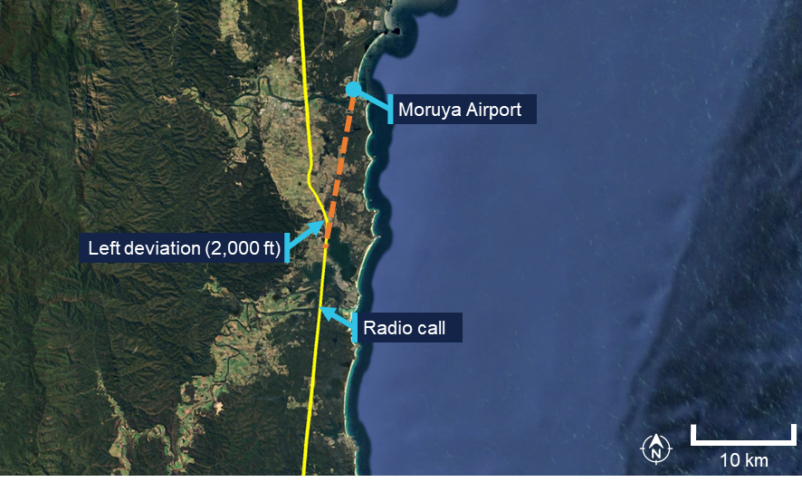
Source: Google Earth, annotated by the ATSB
The pilot continued north-west for 13 minutes at about 2,500 ft AMSL. For the remainder of the flight, the pilot maintained an altitude between 2,000 and 2,700 feet AMSL, with intermittent climbs and descents (Figure 3). The mountainous area had fluctuating terrain heights, with a maximum terrain height in the area of about 2,900 ft.
Approximately one minute prior to the collision, the aircraft’s speed decreased to 69 kt before rapidly increasing to 101 kts just prior to the collision with terrain.
At 1454 the aircraft collided with terrain in dense forest in the Budawang National Park at 2,800 ft AMSL. The aircraft was destroyed, and the pilot was fatally injured.
The aircraft’s emergency locator transmitter (ELT) activated in the accident, alerting the Australian Maritime Safety Authority (AMSA) Joint Rescue Coordination Centre (JRCC).
A rescue helicopter located the wreckage at about 1700 on 18 September, however rescue crews were unable to access the site due to the weather. The site was first accessed the following day by winch at about 1300. Rescue crew and police confirmed the occupant was deceased.
Figure 3: Flight path of the last 15 minutes of the flight
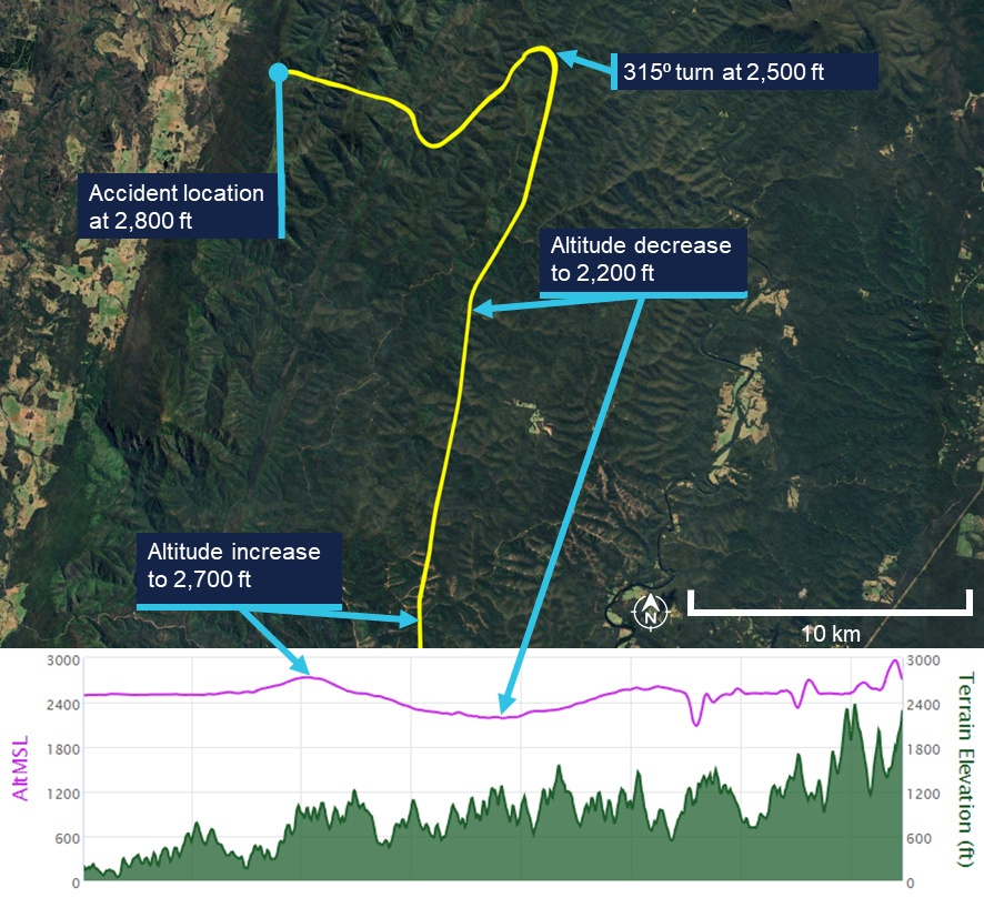
The lower plot does not show the point of impact, because the data recording ceased prior to that point. Source: Google Earth, annotated by the ATSB
Context
Pilot information
License and endorsements
The pilot held a Civil Aviation Safety Regulation Part 61 Private Pilot (Aeroplane) Licence, single-engine aeroplane class rating, night VFR rating for single-engine aeroplanes, and endorsements for manual propeller pitch control and retractable undercarriage. The pilot had held a licence since 1979. Their last flight review was on 2 November 2023 in VH-TEL and was valid until 30 November 2025.
Flying history
The pilot ceased flying between mid-1988 and early 2008. Between January 2008 and February 2021, 6 flights were recorded, all conducted as in command under supervision (ICUS).
The pilot had accumulated 306.5 hours experience through to 10 February 2021. On 19 October 2021, the pilot commenced a PPL refresher course with BFS for the purpose of completing a flight review.
The pilot’s logbook indicated flights beginning in June 2024 and noted that their prior logbook had been stolen. It recorded that at the time of the accident the pilot had approximately 443.7 flight hours, including 4.5 hours in VH-TEL in the last 90 days.
Additional flight data retrieved from the flying school on the pilot’s flight prior to June 2024 indicated that, at the time of the accident, the pilot had accumulated approximately 515 total flight hours.[4] Of these, approximately 60 hours were on the Cirrus SR20 aircraft since the pilot’s initial flight in the Cirrus in June 2023. All of these flights were conducted in VH-TEL.
Flight review and training
In October 2021 the pilot completed a training area flight and circuits flight. Additionally, the pilot completed 3 navigation flights in November 2021, January 2022 and February 2022 with a BFS Grade 2[5] flight instructor, in preparation for the pilot’s flight review for the PPL refresher course. On completion of the third navigation flight, the instructor recommended the pilot fly with a Grade 1 instructor to assess their ability relative to the flight review standards required.
The Grade 1 instructor conducted 2 navigation flights with the pilot and reported the flight review was successfully completed after the second navigation flight with the remark that the pilot needs to ease back into flying. This flight review was completed on 18 May 2022, which was the signatory date for the pilot’s application to transfer their licence from Civil Aviation Regulations 1988 (CAR) Part 5 to Civil Aviation Safety Regulations 1998 (CASR) Part 61. The flight review had been conducted in a Piper PA‑28 Archer II (VH‑NRM).
The pilot enrolled in the Cirrus SR20 Perspective Transition (VFR) course[6] on 13 May 2023. The flights were conducted in June and July 2023, which was prior to the pilot’s flight review in VH-TEL on 2 November 2023. None of the 5 flight lessons included instrument meteorological conditions (IMC) [7] recovery as a task.
In addition to the flights, the pilot completed the Cirrus SR Series Manoeuvres Course, which was a series of videos, which included the following topics:
• VFR into IMC
• Straight and Level
• Level Turns
• Climbs and Descents
• Find Your Way Out [of IMC]
• Flight Into IMC Demo.
Following the completion of their SR20 conversion training in November 2023, the pilot operated the SR20, specifically VH-TEL, on an average of 2 flights per month until March 2025. From March to June 2025, the pilot transitioned to flying the Piper PA-28 on a biweekly basis.
Due to the pilot’s recent absence from operating the SR20 during this timeframe, a currency flight was required in July 2025. This flight was conducted on 4 July 2025 in VH‑TEL, under the supervision of an instructor. The instructor recorded in the student progress record and advised the ATSB that several technique errors occurred during the flight, which resulted in the instructor assessing the pilot as not competent. The pilot returned to flying the PA-28, completing 2 flights in the Sydney area, both scenic.
On 6 August 2025, the pilot conducted a second currency flight in VH-TEL with a different flight instructor. This was a flight into the training area before returning for circuits. The instructor recorded on the progress record that the pilot’s groundwork was good, and radio calls were well executed. The departure was performed satisfactorily, the approach was adequate, and the landing was described as very good and smooth. The instructor noted that the pilot flew the aircraft satisfactorily but required further attention to airspace management. Following this flight, the pilot was assessed as competent to operate the SR20.
There was no record of the pilot having conducted or completing any other relevant instrument flying training or qualifications.
Medical information
The pilot held a valid class 2 aviation medical certificate which was approved in March 2025. The only limitation to the pilot’s medical certificate was for reading correction to be available while exercising the privileges of their licence.
The owner of BFS reported that the pilot looked healthy and displayed normal behaviour on the morning of the flight.
Post-mortem examination and toxicology reports were not available to the ATSB at the time of publishing this report.
Aircraft information
The Cirrus SR20 is a low-wing general aviation aircraft with 5 seats. VH-TEL had a single, Continental IO-360-ES26B reciprocating piston engine driving a constant-speed propeller. The aircraft was certified for day and night VFR and instrument flight rules (IFR)[8] operations.
VH-TEL was manufactured in 2014 and was first registered in Australia on 5 September 2014. The aircraft had been registered with BFS since April 2020, and at the time of the accident had accumulated 1,725.8 hours total time in service.
The aircraft was fitted with the Cirrus airframe parachute system (CAPS). This was designed to lower the aircraft and its passengers to the ground in the event of a life‑threatening emergency and could be activated by the pilot. The CAPS system consisted of a parachute, a solid-propellant rocket used to deploy the parachute, an activation handle, and a parachute harness embedded within the fuselage structure.
Meteorological information
Bureau of Meteorology forecasts
The applicable graphical area forecasts (GAF) available to the pilot for the flight were both issued at 0804 local and valid for the periods 0900–1500 and 1500–2100. The location of the accident was in Area A on the GAF. Area A for the period 0900–1500 forecast broken cumulus/stratocumulus from 3,000–7,000 ft.
The TAF[9] for Canberra was CAVOK[10] conditions. The TAF for Moruya[11] included light showers of rain and a broken cloud base at 3,000 ft AGL. The TAF for Jervis Bay was a broken cloud base at 1,600 ft AGL becoming scattered at 3,000 ft AGL from 1100–1300 but with TEMPO periods from 0700–1200 for visibility reduced to 4,000 m with a scattered cloud base at 600 ft AGL and a broken cloud base at 1,000 ft AGL.
Bureau of Meteorology observations
At 1430, the meteorological aerodrome report (METAR)[12] for Moruya Airport reported wind from the east-north-east at 7 kt (60°), visibility greater than 10 km and cloud overcast at 4,900 ft AGL. The METAR at Jervis Bay Airfield reported wind from the west‑south-west at 8 kt (240°), visibility greater than 10 km and cloud scattered from 2,100 ft and overcast above 2,900 ft AGL.
At 1500, the cloud cover had changed at both locations (Table 1).
Table 1: Reported METAR/SPECI[13] cloud layers at nearest airports
| Location | Time | ||
| 1400 | 1430 | 1500 | |
| Moruya Airport | OVC 3,300ft AGL | SCT 3,600ft AGL BKN 4,300ft AGL OVC 4,900ft AGL | SCT 3,200ft AGL BKN 4,700ft AGL OVC 5,300ft AGL |
| Jervis Bay Airfield | OVC 2,100ft AGL OVC 2,700ft AGL | SCT 2,100ft AGL OVC 2,900ft AGL | FEW 3,100ft AGL BKN 5,100ft AGL |
BKN: broken; OVC: overcast; SCT: scattered
Bureau of Meteorology satellite images (Figure 4 – left) showed cloud covering the Budawang National Park mountains at 1430. At 1500 (Figure 4 – right) the satellite imagery indicated a reduction in cloud cover, with partial clearing evident and some breaks observed in the cloud layer. The images provided no information on cloud height, or density at a given height.
Figure 4: Satellite image showing cloud formation on 18 September at 1430 and 1500 local time
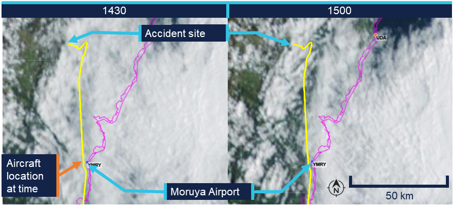
The flight path was overlaid on the satellite image to illustrate the route relative to the weather. The actual flight occurred below the cloud base. Source: Bureau of Meteorology, annotated by the ATSB
Witness observations of weather
A witness located approximately 3 km west of the accident site reported hearing the aircraft, however, was unable to locate it in the sky due to fog.[14] They reported that prior to the fog, low lying cloud had been covering the tops of the mountains in the area where the collision with terrain occurred from approximately 1130.
Another witness who was in Wog Wog (10 km north of the accident site) stated that there had been low cloud and drizzle from 1100. They described the visibility to have been ‘okay’ at ground level but poor near the tops of the mountains.
Additionally, the operator for the rescue helicopter reported they were unable to access the site due to low lying cloud (Figure 5).
Figure 5: Cloud over the accident site between 1640 and 1703 local time

Top left and top right: cloud coverage to the north of the accident site. Bottom left: overhead the accident. Bottom right: view of the accident site and surrounding weather from the east. Source: ACT Emergency Services Agency, annotated by the ATSB
Accident site and wreckage
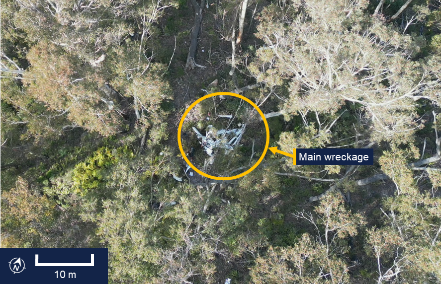
The aircraft wreckage was located in heavily vegetated, steep, mountainous terrain (Figure 6).
Figure 6: Overhead view of accident site
Source: ATSB
The ATSB conducted an examination of the accident site and wreckage on 21 September. The aircraft impacted the side of the mountain and slid backwards from the direction of travel until supported on the slope by some small trees. Ground impact marks and impact marks on the trees indicated the aircraft entered the trees with wings and fuselage almost level.
All of the flight controls and surfaces were accounted for on site and no evidence of in‑flight break‑up or pre-impact control issues was identified.
Onsite examination of the engine did not reveal any pre-impact mechanical issues. The propeller assembly had separated from the engine crankshaft, with propeller deformation consistent with the engine producing power at impact. The left- and right-wing fuel tanks had both been compromised and a fuel odour was present.
Data cards from a Garmin G1000 electronic flight instrument system and the aircraft’s data recovery module (RDM)[15] were recovered from the accident site (see Recorded data).
Cockpit assessment revealed the fuel selector was on the right tank, the flaps were set at 50%[16] and the fuel pump was off.[17]
The CAPS had not been activated.
Recorded data
Garmin 1000
The aircraft was fitted with a Garmin G1000 electronic flight instrument system consisting of one primary flight display and one multi-function display (MFD). The G1000 had a 58‑channel flight and engine parameter data logging capability at a rate of one data point per second. A memory card was retrieved from the device, which contained recorded data from multiple flights, including the accident flight.
The final recorded data point was 2 seconds prior to impact and indicated that the engine was producing normal power until impact. Additionally, the data indicated there was sufficient fuel flow to the engine and there was approximately 10.8 US gallons in the left tank and 7.4 US gallons in the right tank of fuel remaining. This was consistent with ATSB estimates of fuel usage, which also indicated that the aircraft would have had about 48 minutes endurance on landing if the flight had been able to continue to Bankstown Airport with the same engine power applied.
Cylinder head temperature
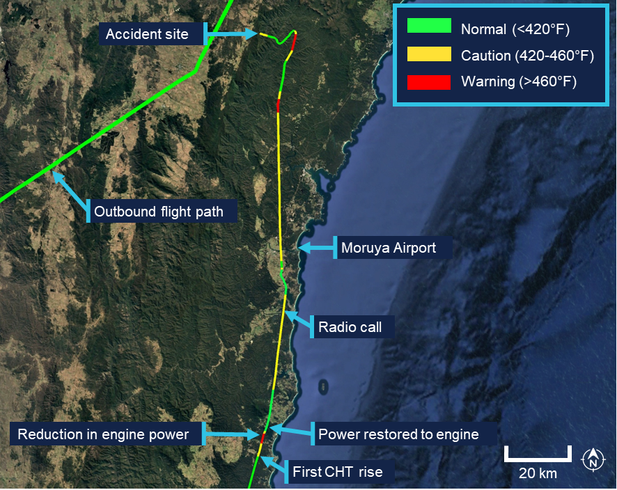
Recorded engine data indicated the number 4 cylinder head temperature (CHT) increased from the normal operating range into the caution range when the aircraft was about 33 NM (61 km) south of Moruya Airport. Approximately one minute later, the temperature increased into the warning range.
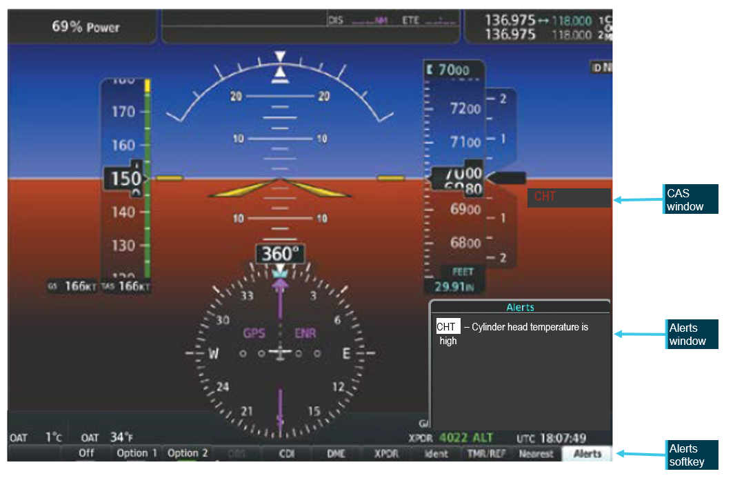
The MFD installed in the cockpit displays CHT information and cautions/warnings. The MFD typically displays individual cylinder CHT as a vertical bar graph scaled from 100°F to 500°F in 100°F increments on the left-hand side of the MFD (Figure 7). Additionally, an engine information page can be selected by the pilot displaying individual cylinder CHT as a vertical bar graph with the current temperature value displayed numerically above the bar. An upward or downward trend arrow is shown below the numeric value to indicate whether the temperature is rising or falling. The G1000 did not record which pages were selected by the pilot at any given time.
Figure 7: MFD engine indication system (EIS) panel, showing the vertical coloured bars indicating a CHT warning state for engine cylinder 4 temperature

Source: Garmin, annotated by the ATSB
The pilot operating handbook (POH) published limits for the CHT were as follows, with the bar graph coloured accordingly:
- Normal range < 420°F (green)
- Caution range 420–460°F (yellow)
- Warning range > 460°F (red)
According to the POH:
In the event CHT exceeds 420°F, the MFD will display “Check CHT” in a yellow advisory box in the lower right corner of the MFD. In the event CHT exceeds 460°F, the MFD will display “Check CHT” in a red advisory box in the lower right corner of the MFD.
Figure 8: Exemplar window showing the crew alerting system (CAS) location and text for a CHT warning, the highlighted alerts softkey, and related alerts window text
Source: Garmin, annotated by the ATSB
The emergency procedure for a high cylinder head temperature from the Cirrus SR20 Airplane Flight Manual (AFM) indicated that if the CHT is in the caution range to land as soon as practical, and if it is in the warning range to land as soon as possible.[18]
For the remainder of the flight, the CHT of cylinder 4 continued to fluctuate, repeatedly moving between the normal (green), caution (yellow), and warning (red) ranges (Figure 9).
Following the initial rise in CHT into the warning range, the recorded engine data showed the pilot commanded a reduction in engine power over an approximately 30 second period, maintaining the reduced power for about one minute further. This is consistent with standard practice for managing elevated CHT. Approximately one minute after the power was reduced, as the CHT decreased and stabilised within the normal (green) operating range, and the data indicated the pilot then restored engine power to the previous level.
Figure 9: Number 4 cylinder head temperature readings throughout the last 1.5 hours of the flight
Source: Google Earth, annotated by the ATSB
The ATSB compared the recorded CHT and exhaust gas temperature (EGT) data for cylinder 4 in order to determine whether the observed high CHT indications were consistent with an overheating cylinder or were more likely the result of a faulty CHT probe. In normal engine operation, a genuine rise in cylinder head temperature is typically accompanied by a corresponding rise in EGT for the affected cylinder, as both parameters respond to increased combustion temperatures and heat rejection. Conversely, a significant increase in indicated CHT with little or no corresponding change in EGT is characteristic of a failing or erratic CHT sensor.
The analysis indicated that the EGT for cylinder 4 remained relatively stable and within normal operating limits throughout the period when CHT repeatedly entered the yellow and red advisory ranges. This suggested that the anomalies were most likely caused by a faulty cylinder 4 CHT probe. The ATSB presented this information to Cirrus Aircraft which agreed that ‘the CHT sensor was giving faulty information as there were no other indications that there was an engine issue in the data.’
Other recorded data
AvPlan
The pilot was using AvPlan electronic flight bag (EFB)[19] software for the flight. The EFB recorded flight data up until and after the collision with terrain. This flight path data was consistent with the data retrieved from the Garmin G1000. AvPlan uses a device built‑in GPS or an external Bluetooth/wi-fi GPS source for the aircraft position.
Flightradar24, FlightAware and ADS-B Exchange
The aircraft’s track was independently corroborated using data from FlightAware, Flightradar24 and ADS-B Exchange. All 3 services provided consistent position reports, derived from received ADS-B transmissions, for the duration of the flight until the aircraft reached the Budawang National Park.[20] After this point the tracks from the 3 providers began to diverge slightly, primarily due to differences in receiver coverage, data processing and extrapolation algorithms[21] when direct ADS-B signals were no longer received. None of the 3 services recorded any further validated ADS-B positions corresponding to the final portion of flight leading to the accident site.
Operational information
General
The owner of BFS reported that the pilot had intended to conduct a flight to Mount Kosciuszko approximately 6 weeks prior to the accident flight and several times afterwards. However, on each occasion the flight was planned, the pilot either rescheduled or cancelled due to adverse weather conditions. The owner stated that these cancellations were typically attributed to icing conditions in the vicinity of Mount Kosciuszko. The owner noted that the pilot demonstrated a high level of weather awareness.
Prior to the accident flight, the owner confirmed with the pilot that the pilot had checked the weather conditions. However, the owner did not independently verify the weather, as the flight was not a training operation, and they considered the pilot competent in assessing weather conditions.
Previous flights
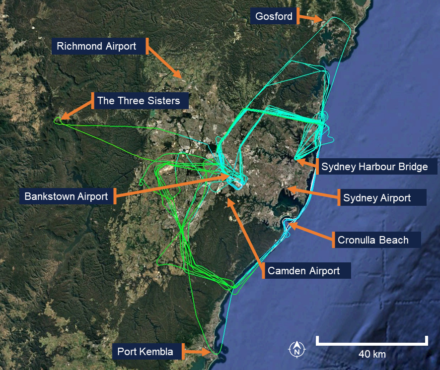
In the 12 months preceding the accident, the pilot had accumulated 31.9 hours of flight time between the Cirrus SR20 and the Piper PA-28 Cherokee. The pilot’s longest flight during this period was 1.9 hours in duration, with an average flight time of 1.4 hours. All flights were conducted within the Sydney area, with the furthest north being Gosford, the furthest south being Port Kembla, and the furthest west being the mountainous area around the Three Sisters landmark in the Blue Mountains (Figure 10). The accident flight was the pilot’s first flight of more than 4 hours since January 2023.
Figure 10: Previous flight data
Source: Google Earth, annotated by the ATSB
Flight plan
Flight plans are only required for a VFR flight under certain conditions. One of the instructors recalled that the pilot would routinely submit a search and rescue time (SARTIME) and not file a flight plan. The instructor recalled they had discussed with the pilot the benefits of lodging a flight plan, including that in the event the aircraft became overdue, a flight plan would provide search and rescue authorities with valuable information to assist in determining the intended route and location to commence search efforts.
Under the Civil Aviation Safety Regulations (CASR) Part 91 General Operating and Flight Rules Manual of Standards (MOS) 2020: 9.02 Flight notification requirements, a pilot in command must ensure that one of the following has occurred if flying into a designated remote area:
• the submission of a flight plan;
• the nomination of a SARTIME for arrival;
• the leaving of a flight note with a responsible person.
For this flight, the pilot had filed a VFR flight plan via the National Aeronautical Information Processing System (NAIPS) prior to departure as the planned route transited a designated remote area of the Snowy Mountains.
The flight plan indicated the pilot would fly south to Mount Kosciuszko before turning towards the coast to Merimbula Airport (Figure 11). The pilot would then head north through a VFR lane, using VFR waypoints, over the coastline (east of the Great Dividing Range) back to Bankstown Airport. When reaching Merimbula Airport the aircraft would be at an altitude of 9,500 ft AMSL and begin a decent to 7,500 ft AMSL reaching the altitude at Moruya Airport before further descending to 2,000 ft when reaching Ulladulla. Pilots are required to notify air traffic services (ATS) if the route, cruising level, or cruising speed changes from a submitted flight plan. Although the actual flight varied from the plan, the pilot did not notify ATS of the changes.
When the pilot’s instructor was asked what pilots are taught in such circumstances, they stated that pilots are instructed to notify ATS of any change in plan or if they intend to deviate from their planned route. However, the instructor noted that the pilot had obtained their private pilot licence in the 1980s and was unsure whether this topic had been recently discussed with the pilot, as they had never observed the pilot submit a flight plan during their conversion training.
Figure 11: Planned flight (blue) comparison to actual flight (yellow)
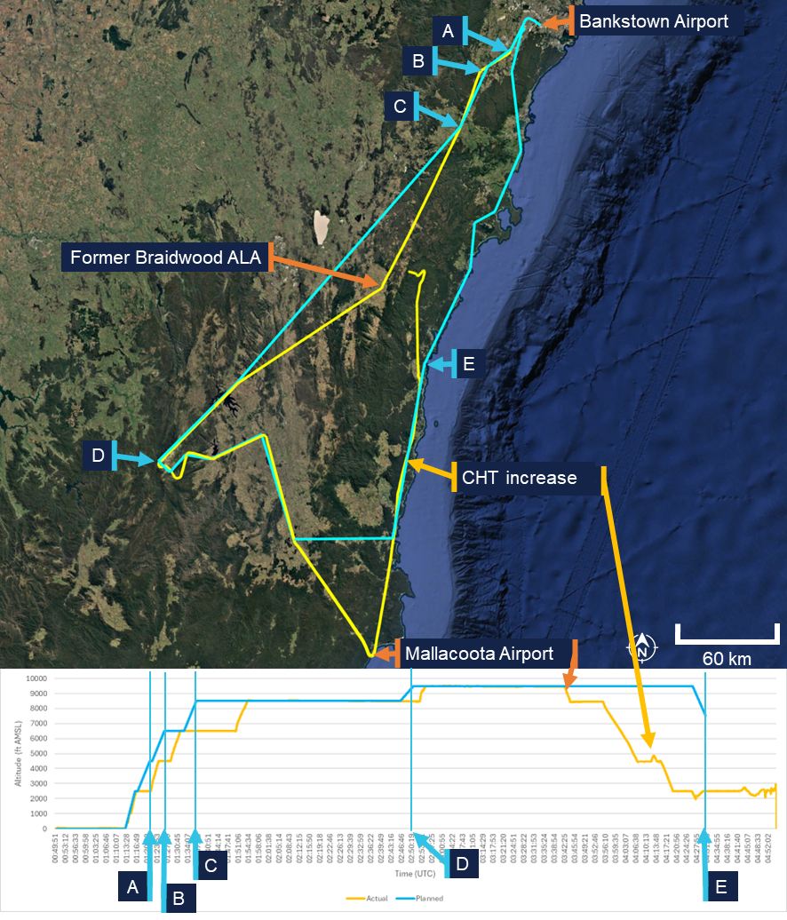
A. Bankstown Airport; B. Campbelltown University waypoint; C. Picton waypoint; D. pilot chosen waypoint using lat/long; E. Moruya Airport. Source: ATSB
Visual meteorological conditions
Visual meteorological conditions (VMC) are expressed in terms of in-flight visibility and distance from cloud (horizontal and vertical) as prescribed in the CASR Part 91 (General Operating and Flight Rules) Manual of Standards (MOS) 2020: 2.07 VMC criteria. These conditions allow pilots to operate the aircraft primarily by visual reference to the terrain and horizon, maintaining situational awareness and separation from other aircraft without reliance on instruments.
For flight below 10,000 ft AMSL, the Part 91 MOS prescribed that pilots maintain a minimum visibility of 5 km, and remain at least 1,000 ft vertically and 1,500 m horizontally clear of cloud. In areas below 3,000 ft AMSL or 1,000 ft above ground level (AGL), and within uncontrolled airspace, VFR flights may operate clear of cloud and in sight of the ground or water, provided visibility remains at or above the required minima. These criteria ensure that pilots have sufficient external visual references to maintain safe flight and effective traffic separation.
The CASA Visual Flight Rules Guide included the following notes for VFR flight:
Pilots should not initiate VFR flight on top of more than SCT [scattered] [22] cloud when weather conditions are marginal. Before committing to operate VFR flight on top of more than SCT cloud, pilots should be confident that meteorological information used is reliable and current, and clearly indicates that the entire flight will be able to be conducted in VMC.
and
Pilot decision-making, particularly regarding weather and flight, is often complex; however, the solution to avoiding VFR into IMC [instrument meteorological conditions] when weather is marginal before take-off is not to depart. During flight, it is to turn back or divert before it becomes impossible to do so.
Figure 12, taken from the CASA Visual Flight Rules Guide, provides a visual depiction of the VMC criteria for aeroplanes below 10,000 ft.
Figure 12: VMC criteria below 10,000 ft
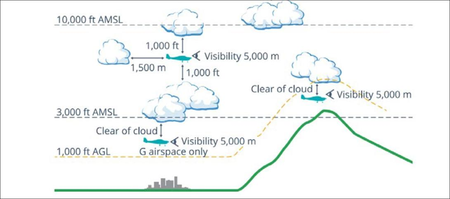
Source: Civil Aviation Safety Authority
Pilot response to weather
When questioned about how the pilot typically obtained weather information for the flight, the instructor stated that the weather would have been checked prior to departure using TAFs and GAFs. The instructor expected that the pilot would also have been monitoring the automatic terminal information service (ATIS) while en route.
The instructor further recalled a previous flight (in May 2022) with the pilot during which the pilot descended to avoid entering cloud. At that time, the instructor questioned the pilot on the VMC requirements for the flight. The pilot became overwhelmed and elected to return to the departure aerodrome. The instructor recalled that there were no subsequent discussions between them regarding operations in adverse weather, and none of the remaining training flights were conducted in cloudy conditions. The instructor noted that the pilot avoided flying into or near clouds and had previously cancelled multiple flights due to weather.
Pilots can confirm destination weather in flight using multiple approved sources. The aerodrome weather information service (AWIS) is available on a published VHF frequency or by telephone. Review of the aircraft data indicated the radios were not changed to published AWIS VHF frequencies at any stage of the flight, and the pilot was not carrying a mobile phone that could have been used to obtain an AWIS broadcast by telephone.
Where fitted with ADS-B In and a suitable display (such as an EFB),[23] pilots may receive real-time weather data including METAR, TAF, airmen's meteorological information (AIRMET),[24] significant meteorological information (SIGMET),[25] and GAF forecasts within coverage. An approved EFB can also provide these products via internet or satellite subscription. The pilot carried an EFB running AvPlan, which was capable of displaying current meteorological information however, there was no recorded data to confirm whether the pilot accessed this information at any stage of the flight.
Communication
The aircraft was equipped with 2 independent VHF communication transceivers (COM 1 and COM 2). Each transceiver could display and store 1 active frequency and 1 standby frequency simultaneously, resulting in a total of 4 frequencies available to the pilot. The instructor stated that at BFS they teach students to use COM 1 as the primary radio used for monitoring towers and ATS and COM 2 is used for secondary frequencies such as the common traffic advisory frequency (CTAF) and ground frequencies.
The pilot had configured COM 1 as the active radio and COM 2 as standby. Prior to departure, COM 2 was set to the Bankstown Airport ground frequency and left on this frequency for the entirety of the flight. COM 1 was initially set to the Bankstown Airport tower/CTAF frequency and changed throughout the flight. When flying south-east near Braidwood, the pilot changed frequencies multiple times within 9 minutes. They first selected an unknown frequency (125 MHz), then Sydney Tower (120.5 MHz), and then a second unknown frequency (120.15 Mhz), before selecting Melbourne Centre (120.75 MHz). The pilot then maintained 120.75 MHz (Melbourne Centre) as the active frequency after passing Braidwood ALA and continued using this frequency for the remainder of the flight.
The only recorded inflight radio transmission was made on the Melbourne Centre frequency with the pilot indicating a decision to land at Moruya.
VFR into IMC research
The ATSB, in conjunction with research published by CASA, has identified that VFR pilots continuing flight into IMC remains one of the most consistently fatal types of general aviation occurrence. These events are characterised by a loss of visual reference resulting in spatial disorientation, loss of control, or controlled flight into terrain. The onset of IMC during VFR flight is often sudden, and pilots without instrument training or recent instrument experience typically have little time to recover once visual cues are lost.
ATSB occurrence data showed that many VFR into IMC accidents follow a consistent pattern of decision‑making and flight progression. Pilots often either depart into marginal weather conditions and/or continue as conditions deteriorate, influenced by a strong ‘press-on’ mindset to reach their destination. A 2005 ATSB research publication – General Aviation Pilot Behaviours in the Face of Adverse Weather (B2005/0127) – concluded that the likelihood of encountering IMC increases significantly during the final stages of flight, particularly within the last 20% of the planned route.
CASA’s associated AvSafety - Flying into bad weather card[26] supports these findings, noting that poor weather-related decision-making and underestimation of meteorological risks remain persistent issues across the VFR pilot population. The education programs, including CASA’s online Pilot safety hub[27] encourage pilots to establish and adhere to personal weather minima, obtain updated forecasts before and during flight, and avoid reliance on visual cues when conditions are near or below VMC limits.
Related occurrences
Recent examples of VFR into IMC accidents are provided below.
Collision with terrain involving Beechcraft 35-C33 Debonair, VH-KZK, 12 km east of Khancoban, New South Wales, on 15 July 2025 (AO-2025-040)
On 15 July 2025, a Beechcraft 35-C33 Debonair, registered VH-KZK, departed Wangaratta Airport, Victoria, for a private flight under the visual flight rules (VFR) to Moruya Airport, New South Wales. Soon after entering the Snowy Mountains area, it is very likely that the pilot, who did not hold an aircraft instrument rating, experienced spatial disorientation after flying into instrument meteorological conditions. The aircraft entered a spiralling descent to the right that continued until the aircraft collided with terrain. The pilot was fatally injured, and the aircraft was destroyed.
VFR into IMC, loss of control and collision with terrain involving Socata TB‑20, VH-JTY, 65 km west of Mackay Airport, Queensland, on 28 October 2023 (AO‑2023-052)
On the morning of 28 October 2023, a SOCATA-Groupe Aerospatiale TB-20, registered, VH‑JTY, departed Montpelier aircraft landing area, Queensland, for a visual flight rules private flight to Palmyra aircraft landing area, Queensland. After encountering cloud en route, the pilot elected to continue along the intended flight path through cloud instead of diverting around or remaining on top of it. Shortly after, it is very likely the pilot entered weather conditions not suitable for visual navigation, leading to spatial disorientation and a descent into mountainous terrain. The aircraft was destroyed and both occupants received fatal injuries.
VFR into IMC, loss of control and collision with terrain involving Airbus Helicopters EC130 T2, VH-XWD, near Mount Disappointment, Victoria, on 31 March 2022 (AO-2022-016)
On 31 March 2022, at about 0741 local time, 2 Microflite Airbus EC130 helicopters, registered VH‑WVV and VH-XWD, departed the Batman Park helicopter landing site in Melbourne, for the town of Ulupna, Victoria. Both helicopters were operated in accordance with the VFR and departed in VMC conditions. Cloud was forecast along the route, but the pilots elected to continue to the destination. The helicopters encountered IMC over Mount Disappointment and VH-WVV conducted a U-turn to avoid entering cloud. While also attempting to conduct a U-turn, VH-XWD entered cloud, developed a high rate of descent, and collided with terrain. The helicopter was destroyed, and the 5 occupants were fatally injured.
VFR into IMC and in-flight break-up involving Van's Aircraft RV-7A, VH-XWI, 90 km south of Charters Towers, Queensland, on 23 April 2021 (AO‑2021‑017)
On 23 April 2021, a Van’s Aircraft RV-7A, registered VH-XWI, was being operated on a private flight under the VFR from Winton to Bowen, Queensland. During the flight, the pilot most likely entered IMC and lost control of the aircraft several times. This led to the airspeed limitations for the aircraft being exceeded and the aircraft sustained an in-flight break-up. The pilot was fatally injured, and the aircraft was destroyed.
Safety analysis
Examination of the wreckage and flight data indicated that the aircraft’s engine was producing power until impact. All major sections of the aircraft were located at the accident site, and there was no evidence of an in-flight break-up or structural failure. The flight data and the presence of all major components at the scene indicate that the aircraft did not experience a pre-impact mechanical or airframe issue that would have contributed to the collision with terrain.
The flap setting of 50% would be used in low and slow manoeuvring such as looking for a landing site under deteriorating weather or manoeuvring through valleys. Flying slower reduces the radius of turns and the use of the flap gives the aircraft a buffer to the stall speed. This setting might be considered a compromise configuration between flying clean and flying full flap, giving these advantages while retaining a greater capability to climb at short notice without the drag of a full flap.
Cylinder temperature fluctuations and cockpit distraction
When passing Mallacoota Airport, the pilot commenced a descent from about 9,000 ft above mean sea level (AMSL). At that time, the pilot would have seen low cloud ahead and probably descended in order to fly below it or in preparation for an approach and landing at one of the aerodromes along the planned flight route.
Flight data showed fluctuating temperature indications from the number 4 cylinder throughout the latter part of the flight. These temperature fluctuations would have generated warnings displayed to the pilot on the multi-function display, alerting them to a potential engine issue.
The first indications of this fluctuation occurred prior to the initial approach to Moruya Airport. The recorded engine data showed that the CHT rose to the caution range and subsequently progressed to the warning range. There was a reduction in engine power over an approximately 30‑second period, before maintaining reduced power for about a minute further. This was likely to have been initiated by the pilot in response to the high CHT warnings and was consistent with the appropriate response to a genuine warning. The engine was then returned to normal power after the CHT levels dropped back into the normal range.
Shortly thereafter, the CHT again increased, entering the caution range for a second time. After an 8‑minute period with the CHT in the caution range the pilot radioed ATC with their intention to land at Moruya Airport. Given that a landing at Moruya was not planned, it is most likely that the pilot initiated the approach as a result of the warning and/or cloud ahead.
The ATSB assessed that these warnings were very likely spurious, and an attentive pilot with a good understanding of engines could doubt their validity based on the engine instruments. The pilot may have thought the warnings were genuine or spurious, and this understanding could have changed throughout the flight.
In any case, the persistence of these warnings throughout the remainder of the flight would have been a continuing source of distraction, potentially increasing workload and reducing their capacity to monitor other operational factors such as navigation, weather conditions, and terrain clearance.
Decision to continue flight past Moruya Airport
After commencing an approach to Moruya Airport, and making a radio broadcast to that effect, the pilot discontinued the approach and continued the flight below the cloud base. Satellite and meteorological data indicated areas of low cloud around the Moruya area, with instrument meteorological conditions (IMC) present as the pilot approached the airport. Additionally, poor weather was observed along the planned route of flight (along the east coast) beyond Moruya. There were no further radio transmissions or position reports from the pilot following the initial call indicating their intention to land at Moruya. Given that poor weather was present ahead of the aircraft and the pilot would have been seeing fluctuating cylinder temperature warnings, it is unclear why the pilot made the apparent decision to continue the flight rather than land at Moruya.
This decision may have been influenced by the perceived presence of a completely clear area in the cloud layer ahead. Analysis of satellite imagery revealed a temporary gap or break in the extensive cloud cover extending from Moruya Airport towards the Great Dividing Range. This gap, evident at the approximate time the aircraft passed to the west of Moruya Airport, would have presented a visually clearer path to the pilot. There was cloud over Moruya Airport and the pilot may have considered that maintaining VMC throughout an approach and landing there might not have been feasible.
In any case, the decision to deviate inland from the initial planned track and towards higher terrain was likely influenced by this break in cloud. Given previous observations from the instructor indicating an aversion to flight near conditions of reduced visibility, it is probable that the pilot elected to manoeuvre towards this apparent break in order to remain in VMC. However, this deviation towards rising terrain significantly increased the risk of controlled flight into terrain, particularly in the prevailing low-visibility environment where visual assessment of terrain clearance could not be assured.
The pilot may have elected to continue the flight partly due to ‘get-there-it is,’ which describes a mindset in which a pilot becomes fixated on reaching the destination, often disregarding deteriorating weather, aircraft anomalies, fatigue, or other risk factors (ATSB, 2011). This self-induced pressure can lead to continued operation into conditions that a more objective assessment would deem unsafe, as the perceived pressure to complete the trip overrides sound aeronautical decision‑making.
The pilot’s limited experience with long distance flights may have exacerbated the effects of this phenomenon. Having completed only the second flight of approximately 4 hours duration in their flying career, the pilot had minimal exposure to the progressive challenges associated with extended cross-country operations, including the management of fatigue and evolving weather systems over prolonged periods, and in‑flight technical anomalies.
With limited prior experience in calibrating risk in deteriorating conditions, the pilot would have been less able to objectively weigh the cumulative hazards of continuing into adverse weather while managing the fluctuating indicated engine cylinder head temperature (or being distracted by the spurious warnings, depending on how the pilot understood them). This increased their susceptibility to get-there-itis, such that their established safety decision-making processes were outweighed by the perceived attainability of the destination.
Continued flight into poor weather
Following the decision to continue the flight, tracking data indicated that the aircraft proceeded into the mountainous area of the Great Dividing Range, then almost reversed course at low altitude along a valley, consistent with the pilot attempting to remain below the cloud base and/or avoid cloud ahead. It is therefore likely that the pilot misjudged the extent and density of the cloud or the height of the cloud base. While continuing at low level, with an altitude lower than the surrounding terrain, the aircraft likely entered IMC. The subsequent flight path was consistent with attempts to avoid cloud, and it is probable that the pilot did not know what direction to take away from the mountainous areas and cloud or, if they did, became trapped between the rising terrain and the low cloud base.
Findings
ATSB investigation report findings focus on safety factors (that is, events and conditions that increase risk). Safety factors include ‘contributing factors’ and ‘other factors that increased risk’ (that is, factors that did not meet the definition of a contributing factor for this occurrence but were still considered important to include in the report for the purpose of increasing awareness and enhancing safety). In addition ‘other findings’ may be included to provide important information about topics other than safety factors. These findings should not be read as apportioning blame or liability to any particular organisation or individual. |
From the evidence available, the following findings are made with respect to the VFR into IMC and controlled flight into terrain involving Cirrus SR20, VH-TEL,12 km east of Braidwood/Percheron aircraft landing area, New South Wales, on 18 September 2025.
Contributing factors
- After commencing an unplanned approach to Moruya Airport, likely due to an engine warning and/or observed cloud ahead, the pilot discontinued the approach for undetermined reasons. The pilot, with limited cross-country experience, then continued the flight underneath the cloud base towards rising terrain.
- The pilot very likely entered weather conditions not suitable for visual navigation, leading to a loss of situational awareness and collision with terrain.
Other factor that increased risk
- The aircraft’s number 4 cylinder fluctuating temperature warnings, likely resulting from a faulty sensor probe, occurred prior to the pilot electing not to land and continued until the collision with terrain. The ongoing warnings likely distracted the pilot, increasing workload and reduced their capacity to monitor and respond to other operational factors.
Sources and submissions
Sources of information
The sources of information during the investigation included:
- two instructors
- Bankstown Flying School
- Civil Aviation Safety Authority
- New South Wales Police Force
- maintenance organisation for VH-TEL
- Airservices Australia
- AvData
- AvPlan
- witnesses
- Garmin G1000
- Cirrus Aircraft.
References
ATSB (2005). General Aviation Pilot Behaviours in the Face of Adverse Weather. Aviation Research Investigation Report B2005/0127.
ATSB (2011). Accidents involving Visual Flight Rules pilots in Instrument Meteorological Conditions. Aviation Research Investigation Report AR-2011-050.
Submissions
Under section 26 of the Transport Safety Investigation Act 2003, the ATSB may provide a draft report, on a confidential basis, to any person whom the ATSB considers appropriate. That section allows a person receiving a draft report to make submissions to the ATSB about the draft report.
A draft of this report was provided to the following directly involved parties:
- Bankstown Flying School
- Civil Aviation Safety Authority
- Cirrus Aircraft
- maintenance organisation for VH-TEL.
Submissions were received from:
- Civil Aviation Safety Authority
- Cirrus Aircraft.
The submissions were reviewed and, where considered appropriate, the text of the report was amended accordingly.
Purpose of safety investigationsThe objective of a safety investigation is to enhance transport safety. This is done through:
It is not a function of the ATSB to apportion blame or provide a means for determining liability. At the same time, an investigation report must include factual material of sufficient weight to support the analysis and findings. At all times the ATSB endeavours to balance the use of material that could imply adverse comment with the need to properly explain what happened, and why, in a fair and unbiased manner. The ATSB does not investigate for the purpose of taking administrative, regulatory or criminal action. About ATSB reportsATSB investigation reports are organised with regard to international standards or instruments, as applicable, and with ATSB procedures and guidelines. Reports must include factual material of sufficient weight to support the analysis and findings. At all times the ATSB endeavours to balance the use of material that could imply adverse comment with the need to properly explain what happened, and why, in a fair and unbiased manner. An explanation of terminology used in ATSB investigation reports is available here. This includes terms such as occurrence, contributing factor, other factor that increased risk, and safety issue. Publishing informationReleased in accordance with section 25 of the Transport Safety Investigation Act 2003 Published by: Australian Transport Safety Bureau © Commonwealth of Australia 2026 
Ownership of intellectual property rights in this publication Unless otherwise noted, copyright (and any other intellectual property rights, if any) in this report publication is owned by the Commonwealth of Australia. Creative Commons licence With the exception of the Commonwealth Coat of Arms, ATSB logo, and photos and graphics in which a third party holds copyright, this report is licensed under a Creative Commons Attribution 4.0 International licence. The CC BY 4.0 licence enables you to distribute, remix, adapt, and build upon our material in any medium or format, so long as attribution is given to the Australian Transport Safety Bureau. Copyright in material obtained from other agencies, private individuals or organisations, belongs to those agencies, individuals or organisations. Where you wish to use their material, you will need to contact them directly. |
[1] Visual flight rules (VFR): regulations that permit a pilot to operate an aircraft in conditions whereby navigation and orientation of the aircraft by visual reference is possible.
[2] Day VFR flights may be conducted to the end of civil twilight, the point at which the sun is 6° below an ideal horizon.
[3] The Braidwood ALA was operational until 2024 at its original location. The current Braidwood/Percheron ALA is located approximately 15 km north-east of the former ALA.
[4] The ATSB was unable to determine whether the pilot conducted any flights in aircraft not registered to the flight school.
[5] A Grade 2 flight instructor is an intermediate-level qualification and is not able to approve a flight review, which requires a Grade 1 flight instructor.
[6] The course is an instructor-led course for non-instrument rated pilots who are new to flying a Cirrus and is intended to provide opportunities to enhance their flying skills while becoming familiar with the Cirrus.
[7] Instrument meteorological conditions (IMC): weather conditions that require pilots to fly primarily by reference to instruments, and therefore under instrument flight rules (IFR), rather than by outside visual reference. Typically, this means flying in cloud or limited visibility.
[8] Instrument flight rules (IFR): a set of regulations that permit the pilot to operate an aircraft in instrument meteorological conditions (IMC), which have much lower weather minimums than visual flight rules (VFR).
[9] Aerodrome Forecast (TAF): a statement of meteorological conditions expected for a specific period of time in the airspace within a radius of 5 NM (9 km) of the aerodrome reference point.
[10] Ceiling and visibility okay (CAVOK): visibility, cloud and present weather are better than prescribed conditions. For an aerodrome weather report, those conditions are visibility 10 km or more, no significant cloud below 5,000 ft, no cumulonimbus cloud and no other significant weather.
[11] Moruya Airport and Jervis Bay Airfield are close to sea level.
[12] METAR (Meteorological Aerodrome Report) is a routine aerodrome weather report issued at half hourly time intervals. The report ordinarily covers an area of 8 km radius from the aerodrome reference point.
[13] SPECI is used to identify reports of observations when conditions are below specified levels of visibility and cloud base, when certain weather phenomena are present, and when the temperature, pressure or wind change by defined amounts. SPECI is also used to identify reports of observations recorded 10 minutes following an improvement in visibility, weather or cloud to METAR conditions.
[14] Fog refers to cloud which is at ground level.
[15] The RDM is designed to record flight data in a crash and fire-resistant housing. The unit records flight, engine, and autopilot parameters. Data is logged once per second and stored internally inside the crash-hardened enclosure. When the storage limit of the memory device is reached, the oldest recording is overwritten.
[16] This level of flap would be expected when conducting a low and slow manoeuvring flight such as looking for a landing site under deteriorating weather or if manoeuvring in valleys.
[17] The fuel pump is on for take‑off, landing, climb and when switching fuel tanks.
[18] The general definition for land as soon as possible is to land at the nearest site that a safe landing can be made, whereas land as soon as practical means extended flight is not recommended but the landing site and duration of the flight are at the pilot’s discretion.
[19] AvPlan is a tablet-based application for flight planning, navigation, and real-time situational awareness.
[20] ADS-B data from public community-based networks (such as those used by FlightAware, Flightradar24 and ADS-B Exchange) may not have coverage at low altitudes or in areas distant from populated receiver locations.
[21] In the absence of continued reception, some providers extrapolate or ’coast’ the last known position and speed for a limited period, while others cease plotting the aircraft entirely.
[22] Cloud cover: in aviation, cloud cover is reported using words that denote the extent of the cover – ‘few’ indicates that up to a quarter of the sky is covered, ‘scattered’ (SCT) indicates that cloud is covering between a quarter and a half of the sky, ‘broken’ (BKN) indicates that more than half to almost all the sky is covered, and ‘overcast’ (OVC) indicates that all the sky is covered.
[23] VH-TEL was not configured to show this information on the Garmin G-1000 display.
[24] AIRMET information concerns the occurrence, or expected occurrence, of certain phenomena that have not been included in the graphical area forecast (GAF).
[25] A SIGMET provides a concise description concerning the occurrence or expected occurrence, in areas over which meteorological watch is being maintained, of en route weather phenomena that are potentially hazardous to aircraft.
Occurrence summary
| Investigation number | AO-2025-056 |
|---|---|
| Occurrence date | 18/09/2025 |
| Location | 12 km east of Braidwood/Percheron aircraft landing area |
| State | New South Wales |
| Report release date | 24/02/2026 |
| Report status | Final |
| Investigation level | Short |
| Investigation type | Occurrence Investigation |
| Investigation status | Completed |
| Mode of transport | Aviation |
| Aviation occurrence category | Controlled flight into terrain (CFIT), VFR into IMC |
| Occurrence class | Accident |
| Highest injury level | Fatal |
Aircraft details
| Manufacturer | Cirrus Design Corporation |
|---|---|
| Model | SR20 |
| Registration | VH-TEL |
| Serial number | 2262 |
| Aircraft operator | Bankstown Flying School Pty Ltd |
| Sector | Piston |
| Operation type | Part 91 General operating and flight rules |
| Departure point | Bankstown Airport, New South Wales |
| Destination | Bankstown Airport, New South Wales |
| Damage | Destroyed |