The ATSB is investigating an inadvertent restraint release involving Avions Mudry & Cie CAP 10B, VH-YAO, 29 km north-north-west of Edinburgh Airport, South Australia, on 4 February 2026.
During flight training with an instructor and a student, the instructor demonstrated a split S manoeuvre from inverted flight. At that time the instructor's centre harness buckle released unexpectedly. The instructor was lifted out of the seat and struck the overhead canopy.
This resulted in a brief release of the flight controls before the instructor regained control and recovered the aircraft. The aircraft sustained minor damage from cracking to the windscreen and partial detachment of the canopy. The aircraft landed without further incident. The student was uninjured and the instructor sustained minor injuries.
The ATSB has completed the evidence collection and analysis phases of the investigation and is drafting the final report.
The final report will be released at the conclusion of the investigation. Should a critical safety issue be identified during the course of the investigation, the ATSB will immediately notify relevant parties, so that appropriate safety action can be taken.
Occurrence summary
Investigation number
AO-2026-066
Occurrence date
04/02/2026
Occurrence time and timezone
19:34 Central Australia Daylight Time
Location
29 km north-north-west of Edinburgh Airport
State
South Australia
Report status
Pending
Anticipated completion
Q3 2026
Investigation level
Short
Investigation type
Occurrence Investigation
Investigation phase
Final report: Drafting
Investigation status
Active
Mode of transport
Aviation
Aviation occurrence category
Furnishings & fittings, Loss of control
Occurrence class
Serious Incident
Highest injury level
Minor
Aircraft details
Manufacturer
Avions Mudry & Cie
Model
CAP 10B
Registration
VH-YAO
Serial number
266
Aircraft operator
Flight Training Adelaide Pty Ltd
Sector
Piston
Operation type
Part 141 Recreational, private and commercial pilot flight training
Activity
General aviation / Recreational-Instructional flying-Instructional flying - dual
Occurrence Briefs are concise reports that detail the facts surrounding a transport safety occurrence, as received in the initial notification and any follow-up enquiries. They provide an opportunity to share safety messages in the absence of an investigation. Because occurrence briefs are not investigations under the Transport Safety Investigation Act 2003, the information in them is de-identified.
What happened
On 17 January 2026, the pilot and sole occupant of a Robinson R22 Beta II helicopter was conducting contracted stock mustering operations at a station, about 140 km north of Tennant Creek, Northern Territory. At about 0900 local time, the pilot refuelled the helicopter, filling the tanks to their capacity. Shortly after, they became airborne to continue with the mustering operation.
At about 0910, the pilot reported that while moving cattle through a gate, they conducted a right turn at about 35 kt and 120 ft above ground level. About 3 seconds after completing the turn, the pilot recalled hearing an unusual noise and suspected a possible bird strike with the tail rotor, perceiving no response to their anti-torque pedal inputs.
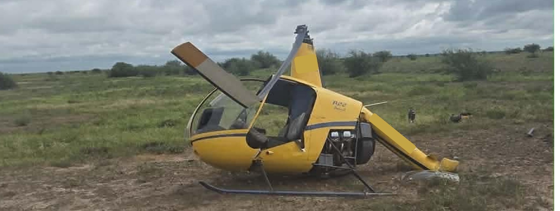
The pilot recalled that the low rotor RPM horn then sounded and the helicopter began to lose height. They reacted by lowering the collective in an attempt to regain the rotor RPM and attempted to gain forward airspeed. As the helicopter approached the ground the pilot flared and raised the collective[1] to reduce the rate of descent but the helicopter collided heavily with the terrain (Figure 1).
Figure 1: Occurrence helicopter
Source: Operator
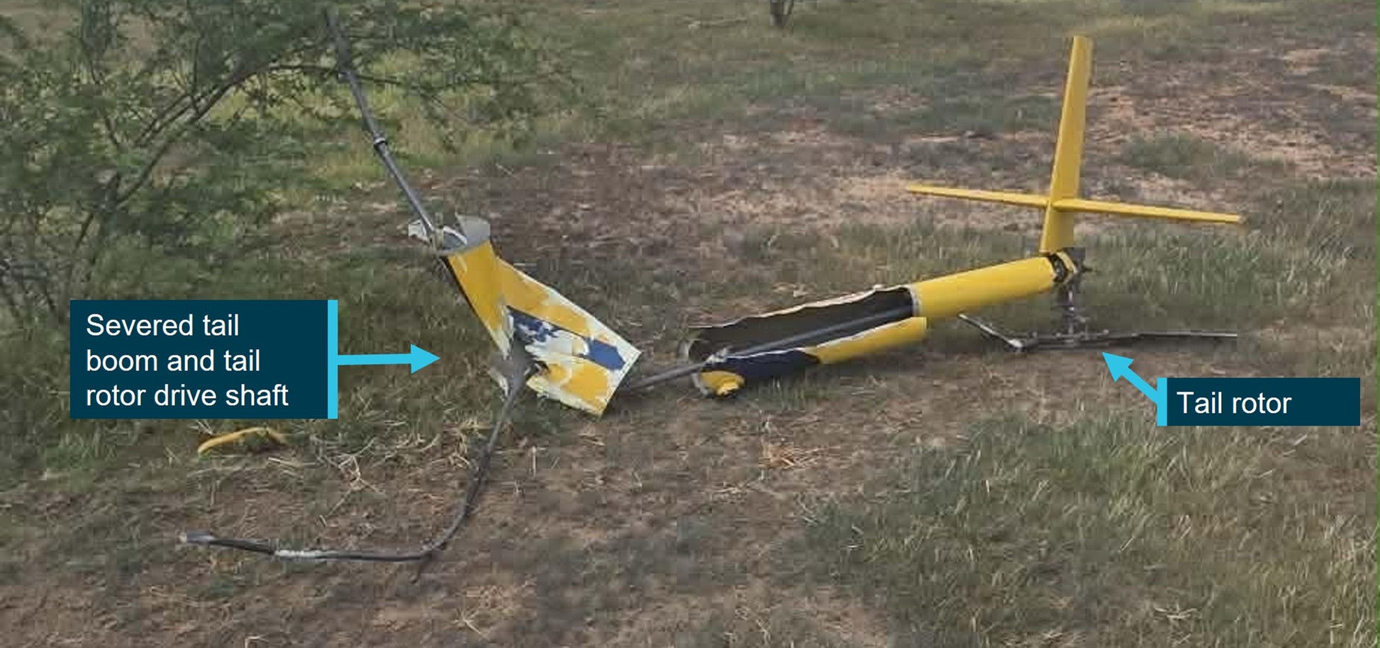
On contact with the ground, the helicopter’s main rotor blades flexed and contacted the tail boom causing it to separate. The tail boom, attached tail rotor gearbox and tail rotor were located about 30 m from the main wreckage (Figure 2).
Figure 2: Occurrence aircraft tail boom, and tail assembly
Source: Operator
The pilot wore a flight helmet and was restrained with a 3-point lap and sash harness and was able to free themselves from the wreckage uninjured. However, the helicopter was substantially damaged.
The operator conducted a post-accident engineering analysis of the wreckage and reported there were no indications of pre-impact defects or damage to the tail rotor flight control system that would have resulted in a loss of tail rotor control.
The operator advised that impact marks on the ground indicated that the helicopter was travelling in a west‑north-west direction when it impacted the ground and reported the wind direction at the time of the occurrence was 10–15 kt from the south-east, indicating that the helicopter was likely operating downwind when it impacted the terrain.
Following discussions with the pilot, the operator reported that additional weight after refuelling, combined with a loss of airspeed when turning downwind, likely led to the helicopter being overpitched. The operator considered that this likely caused a reduction in rotor RPM that was not immediately identified by the pilot. The loss of rotor RPM caused the helicopter to descend from a low height and the pilot was unable to recover the low rotor RPM or arrest the rate of descent prior to impacting the ground.
Additionally, the operator reported that the pilot had been listening to music during the low level operation, and identified that this may have reduced the pilot’s ability to aurally detect a reduction of the engine and rotor RPM prior to the low rotor RPM horn sounding. This may have reduced the pilot’s reaction and recovery time for a low rotor RPM condition. Robinson Helicopter’s Safety Notice 10 provides guidance on the recovery technique for low rotor RPM.
Safety action
The operator reported the following safety recommendations for company pilots:
not to turn the helicopter downwind while at low altitude
the importance of throttle control and to be aware of manually overriding the engine governor
awareness of the helicopters engine RPM and listening for audible cues
fuel load management and consideration given to all-up weight when conducting low-level flight.
Additionally, the operator advised that a notice was sent to all company pilots advising that listening to music while flying was not permitted, reiterating the importance of audible cues from the helicopter engine.
The operator’s safe work method statements required company pilots to wear flight helmets when conducting mustering operations. The use of flight helmets reduces the risk and severity of head injuries, especially important when conducting low-level and other higher risk flight operations.
Flight at low level is a necessity during mustering operations and often involves abrupt manoeuvres with frequent power changes. Although the R22 engine is equipped with a governor to maintain constant engine RPM, large abrupt power changes can cause the governor to lag, reducing engine RPM and therefore rotor RPM. Pilots, especially during periods of high workload, have been known to grip the throttle control tightly, overriding the governor and preventing the governor from maintaining a constant engine RPM. Operators who routinely conduct low level flight are encouraged to review their training and checking regarding engine RPM management as well as the recovery techniques from a low rotor RPM condition.
About this report
Decisions regarding whether to conduct an investigation, and the scope of an investigation, are based on many factors, including the level of safety benefit likely to be obtained from an investigation. For this occurrence, no investigation has been conducted and the ATSB did not verify the accuracy of the information. A brief description has been written using information supplied in the notification and any follow-up information in order to produce a short summary report, and allow for greater industry awareness of potential safety issues and possible safety actions.
[1]The collective control changes the pitch angle of all main rotor blades.
Occurrence summary
Mode of transport
Aviation
Occurrence ID
AB-2026-009
Occurrence date
17/01/2026
Location
140 km north of Tennant Creek
State
Northern Territory
Occurrence class
Accident
Aviation occurrence category
Collision with terrain, Control - Other, Loss of control
Occurrence Briefs are concise reports that detail the facts surrounding a transport safety occurrence, as received in the initial notification and any follow-up enquiries. They provide an opportunity to share safety messages in the absence of an investigation. Because occurrence briefs are not investigations under the Transport Safety Investigation Act 2003, the information in them is de-identified.
What happened
On the afternoon of 12 November 2025, an American Champion Aircraft Corp 7GCBC with a tailwheel landing gear was conducting a dual training flight with an instructor and a student on board. After completing air work at a different location, the aircraft approached runway 24 at Camden Airport, New South Wales, for circuit training.
During approach, instruction was provided to the student until the aircraft reached 600 ft, at which point the instructor then took over the controls. After conducting a standard approach, the pilot flared the aircraft as it reached the threshold. A gust of wind occurred just prior to contact with the runway resulting in the aircraft being pushed to the right.
One main wheel struck the runway and the instructor reported that it seemed to ‘dig in’, resulting in the aircraft turning to the right significantly. The right wheel contacted the grass next to the runway and the instructor attempted to return the aircraft to the centreline, however the aircraft swung to the left resulting in a ground loop on the runway.
The aircraft sustained substantial damage to the right wing, fuselage and landing gear.
Safety message
Tailwheel aircraft are more susceptible to the effects of wind gusts during landing and can be more difficult for pilots to maintain directional control. If environmental conditions during the approach become challenging or unfavourable, initiating an early go-around will allow time to plan for how to manage the landing conditions and reconfigure the aircraft for a second approach.
About this report
Decisions regarding whether to conduct an investigation, and the scope of an investigation, are based on many factors, including the level of safety benefit likely to be obtained from an investigation. For this occurrence, no investigation has been conducted and the ATSB did not verify the accuracy of the information. A brief description has been written using information supplied in the notification and any follow-up information in order to produce a short summary report, and allow for greater industry awareness of potential safety issues and possible safety actions.
Occurrence summary
Mode of transport
Aviation
Occurrence ID
AB-2025-059
Occurrence date
12/11/2025
Location
Camden Airport
State
New South Wales
Occurrence class
Accident
Aviation occurrence category
Hard landing, Loss of control, Runway excursion
Highest injury level
None
Brief release date
15/12/2025
Aircraft details
Manufacturer
American Aircraft Corp
Model
7GCBC
Sector
Piston
Operation type
Part 141 Recreational, private and commercial pilot flight training
Occurrence Briefs are concise reports that detail the facts surrounding a transport safety occurrence, as received in the initial notification and any follow-up enquiries. They provide an opportunity to share safety messages in the absence of an investigation. Because occurrence briefs are not investigations under the Transport Safety Investigation Act 2003, the information in them is de-identified.
What happened
On 30 October 2025, the owner of a De Havilland DH-82A Tiger Moth was conducting circuit operations with an instructor at an aircraft landing area in regional Victoria as part of an aircraft type familiarisation. The flight involved practice of the wheel landing technique,[1] as the owner advised their previous tailwheel aircraft experience was limited to three-point landings.[2]
The owner and instructor both reported that at the time of the occurrence, the weather conditions were clear with negligible wind.
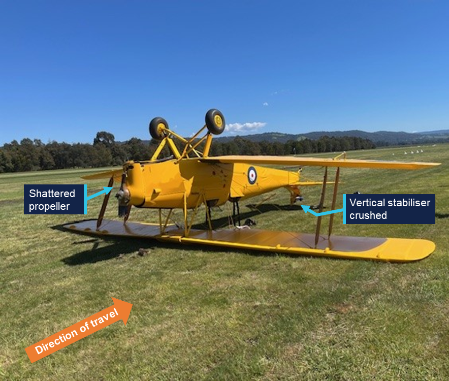
During the fourth touch-and-go, while in the ground-roll, the pilot flying (owner) abruptly applied full power and forward stick. The aircraft pitched forward, lifting the tail above the normal attitude for take-off and the propeller struck the ground. The aircraft subsequently nosed over, coming to a stop inverted. The instructor noted that they did not react quickly enough to arrest this movement as their attention was diverted to monitoring the pilot flying’s directional control during the landing and take-off sequence.
The aircraft sustained substantial damage to the vertical stabiliser, wings, fuel tank and fuselage (Figure 1), however, the occupants were uninjured.
Shortly after the occurrence, the pilot flying questioned the configuration of the DH-82A’s automatic slats at the time of the nose over. The instructor advised the ATSB that when the slats are in the unlocked position, the DH-82A can be more challenging to handle during wheel landings. Prior to the fourth touch-and-go, the slats had been configured in the locked position. However, during the final touch-and-go, the slats were unlocked, changing the handling characteristics. This change in slat configuration by the pilot flying had not been briefed prior to the flight.
Figure 1: Aircraft inverted post-occurrence
Source: Photo supplied by operator, annotated by the ATSB
Safety message
This occurrence highlights the challenges when operating tailwheel aircraft due to their unique handling characteristics. In particular, the typical placement of the main landing gear in front of the centre of gravity endows the aircraft with a sensitivity in pitch movement. This can result in pitch excursions and nose-over accidents during take-off or touch-and-go landings should pilots not remain fully cognisant of this behaviour.
These characteristics can be further exacerbated with the use of secondary flight controls such as wing flaps, slats and trim systems. Prior to training flights, pilots and instructors must brief the scope of the operation and discuss any changes that may be made, especially those that affect the flying characteristics of an aircraft.
It is also important for instructors conducting training and familiarisation flights to maintain effective awareness of the aircraft’s state and ensure they are prepared to rapidly intervene should the pilot flying experience control difficulties. This is particularly important during critical phases of flight such as the take-off.
About this report
Decisions regarding whether to conduct an investigation, and the scope of an investigation, are based on many factors, including the level of safety benefit likely to be obtained from an investigation. For this occurrence, no investigation has been conducted and the ATSB did not verify the accuracy of the information. A brief description has been written using information supplied in the notification and any follow-up information in order to produce a short summary report, and allow for greater industry awareness of potential safety issues and possible safety actions.
[1]Wheel landing: a technique where the aircraft touches down on the main landing gear first with the tail raised. It is the preferred technique in crosswind conditions as it improves the directional controllability while on the ground.
[2]Three-point landing: a technique where the aircraft touches down on the main landing gear and nose wheel simultaneously.
Occurrence Briefs are concise reports that detail the facts surrounding a transport safety occurrence, as received in the initial notification and any follow-up enquiries. They provide an opportunity to share safety messages in the absence of an investigation. Because occurrence briefs are not investigations under the Transport Safety Investigation Act 2003, the information in them is de-identified.
What happened
On 21 October 2025, a Robinson R22 helicopter with one pilot on board was conducting a private flight from Jimboomba to Southport, Queensland.
Prior to departure, the pilot loaded a box of freight, approximately 1,000 mm long, 350 mm wide and 400 mm deep, weighing 10 kg, onto the passenger seat and secured it by wrapping the seatbelt around the box. The flight departed Jimboomba at 1033 local time with a flight time of approximately 12 minutes.
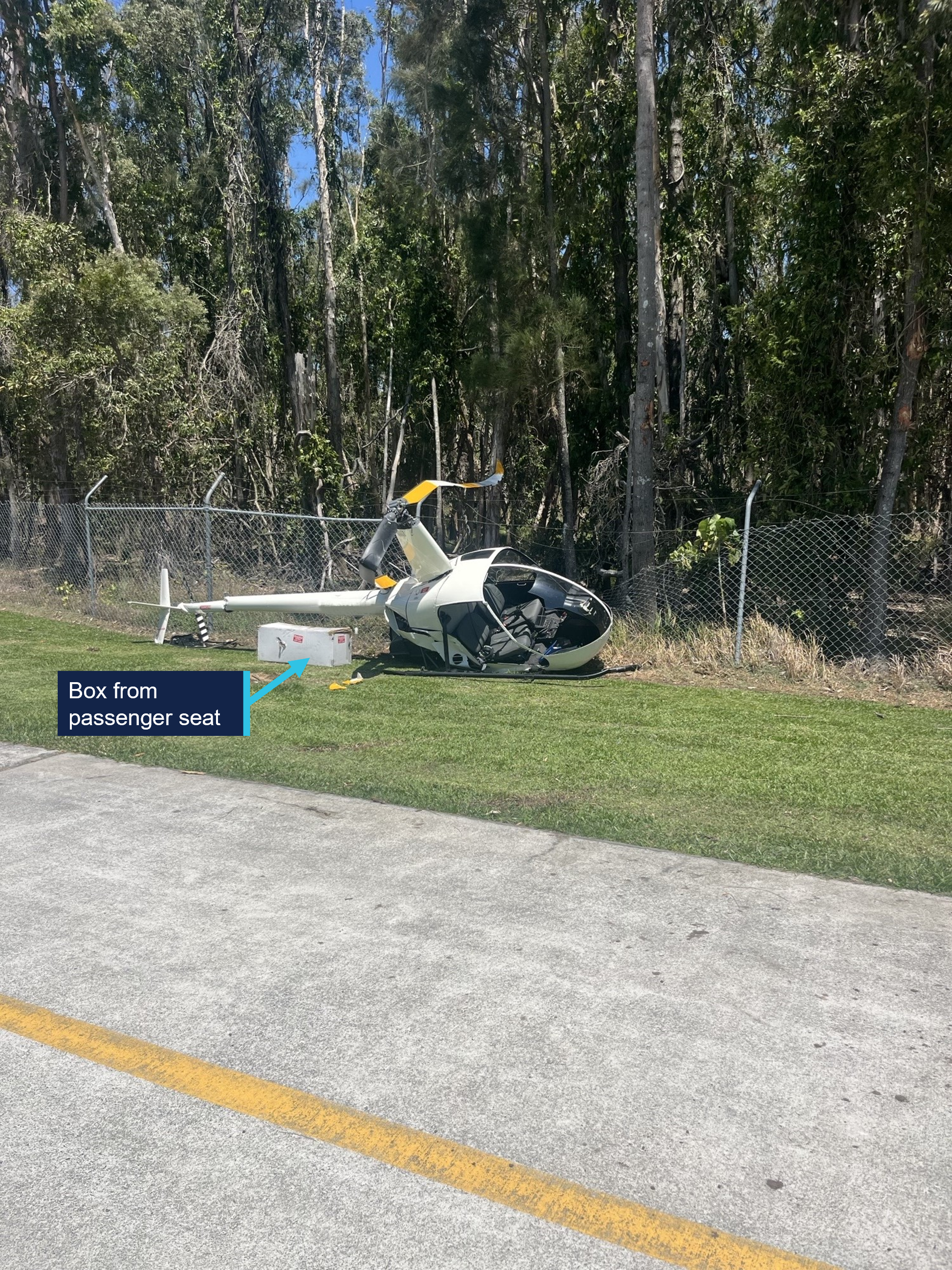
As the pilot turned onto the base leg for final approach to runway 01 at Southport, the box on the passenger seat shifted and interfered with the cyclic[1] control resulting in the helicopter being unable to turn left. The helicopter then veered to the right and as the pilot focused their attention on moving the box, they lost control of the helicopter which came into contact with trees before colliding with terrain, resulting in substantial damage (Figure 1). The pilot sustained serious injuries in the accident.
Figure 1: Post-impact damage
Source: Queensland Police, annotated by the ATSB
Safety message
Pilots must adhere to CASA Regulation 91.610 (2) (b) Carriage of cargo – unoccupied seats, which states that the cargo, and the means of restraint of the cargo, must not interfere with the safe operation of the aircraft.
The ATSB has had 3 occurrences reported in a 15-year period involving Robinson R22 helicopters carrying cargo on the passenger seat which has interfered with the helicopter’s flight controls. All 3 of these occurrences resulted in a collision with terrain and substantial damage.
About this report
Decisions regarding whether to conduct an investigation, and the scope of an investigation, are based on many factors, including the level of safety benefit likely to be obtained from an investigation. For this occurrence, no investigation has been conducted and the ATSB did not verify the accuracy of the information. A brief description has been written using information supplied in the notification and any follow-up information in order to produce a short summary report, and allow for greater industry awareness of potential safety issues and possible safety actions.
[1]Cyclic: a primary helicopter flight control that is similar to an aircraft control column. Cyclic input tilts the main rotor disc, varying the attitude of the helicopter and hence the lateral direction.
Occurrence summary
Mode of transport
Aviation
Occurrence ID
AB-2025-057
Occurrence date
21/10/2025
Location
Southport Aerodrome
State
Queensland
Occurrence class
Accident
Aviation occurrence category
Collision with terrain, Flight control systems, Loading related, Loss of control, Unrestrained occupants/objects
At around 0655 local time on 7 November 2025, a Cessna 172N, registered VH-SCU and operated by Consolidated Pastoral Company (CPC), departed Newcastle Waters Airport, Northern Territory, on a training flight. On board the aircraft were the pilot and an instructor. The pilot was being trained to fly at low level, with the intention of obtaining a low-level operational rating.
About one hour into the flight while flying at around 300 ft above the ground at an airspeed of 80 kts, and manoeuvring to follow a creek bed, the pilot initiated a steep turn to the right. During the turn, control of the aircraft was lost and it descended towards the ground. The instructor attempted to override the pilot’s control inputs but could not do so before the aircraft impacted terrain. The aircraft came to rest upright but was substantially damaged. The instructor received minor injuries, the pilot was uninjured.
What the ATSB found
The ATSB found that while conducting a steep turn at low level, excessive aft control input was applied which almost certainly caused the aircraft to enter an aerodynamic stall. Subsequently, inappropriate recovery control inputs by the pilot limited the instructor’s ability to intervene before the aircraft collided with the ground.
The initial excessive control input was likely a combined result of the pilot being focused on maintaining a track over the ground feature and their inexperience in handling the aircraft during low-level flight. The subsequent application of an inappropriate stall recovery technique was likely caused by the pilot reverting to instinctive rather than learned behaviour under stress.
The ATSB also found that the instructor's recovery control inputs likely prevented the aircraft from impacting terrain in a nose down attitude and reduced the severity of the collision.
What has been done as a result
The flight training provider undertook a critical review of its training practices and risk mitigation measures.
Safety message
This accident highlights the importance of understanding the relationship between the elevator control stick position and the aircraft’s angle of attack, to minimise the risk of an aerodynamic stall. The wing will stall when the control stick is moved beyond a fixed position, irrespective of airspeed and attitude. During steep turns at low airspeed, awareness of the stick position provides increased awareness of the aircraft’s performance relative to its limits. This is particularly important to consider when operating close to the ground, such as during take-off, landing, and when conducting low-level air work. Attention may become focused on positioning the aircraft relative to ground features rather than monitoring its aerodynamic performance, and the time available for recovery from an undesired state will be limited.
The investigation
The ATSB scopes its investigations based on many factors, including the level of safety benefit likely to be obtained from an investigation and the associated resources required. For this occurrence, the ATSB conducted a limited-scope investigation in order to produce a short investigation report, and allow for greater industry awareness of findings that affect safety and potential learning opportunities.
The occurrence
At around 0655 local time on 7 November 2025, a Cessna 172N, registered VH-SCU and operated by Consolidated Pastoral Company (CPC), departed Newcastle Waters Airport, Northern Territory, on a training flight. On board the aircraft were the pilot and an instructor. The pilot was being trained to fly at low level,1 with the intention of obtaining a low-level operational rating and had completed 6 training flights with the instructor over the previous 3 days. The purpose of this flight was to consolidate the earlier training and prepare for the low-level rating flight test.
The aircraft was initially climbed to an altitude of approximately 2,000 ft above ground level (AGL), where the pilot demonstrated a sequence of flight manoeuvres. These included left and right turns at angles of bank up to 60° and minimum radius turns at angles of bank up to 45° (see the section titled Minimum radius turns). The pilot also demonstrated their ability to identify and recover from a stall during a minimum radius turn.
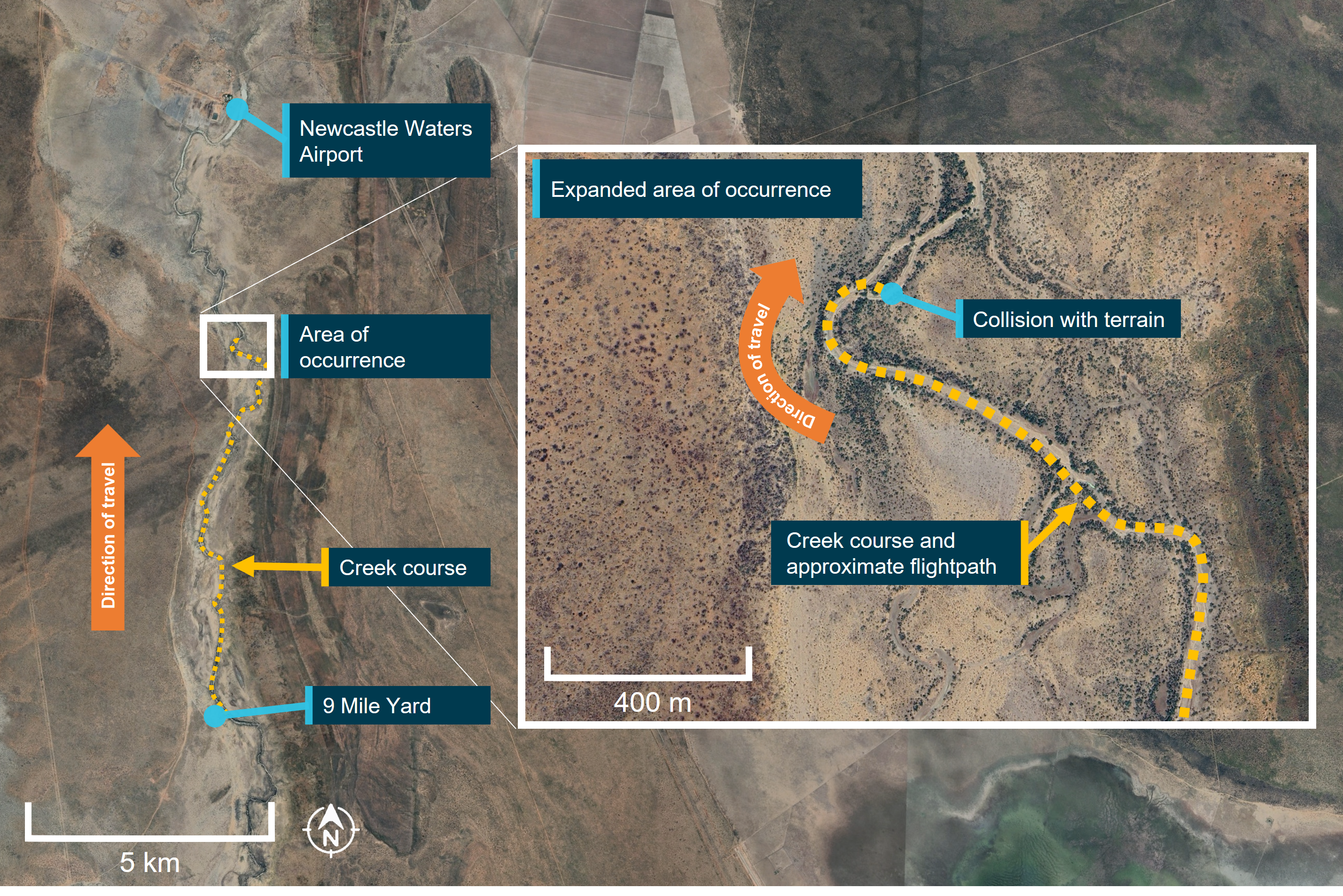
The pilot then proceeded to perform a pre-briefed low-level task, which simulated a typical airborne survey of station infrastructure. This task was flown at altitudes between 200 ft and 1,000 ft AGL and incorporated simulated contingencies such as system and engine failures. At the completion of this portion of the training flight, the aircraft was approximately 13 km south of Newcastle Waters Airport, just north of 9 Mile Yard (Figure 1).
The instructor then asked the pilot to return to the departure airport by following the Newcastle Waters Creek in a northerly direction, simulating a water course survey activity (Figure 1). The task commenced at an altitude of 300 ft and the pilot was reminded not to descend below the pre-briefed minimum altitude of 200 ft. At around 0750, a few minutes into the activity, the pilot observed that the creek bed ahead made a sharp turn to the right and they began to manoeuvre the aircraft to keep the ground feature directly below the aircraft. At the start of this manoeuvre, the aircraft was flying approximately 300 ft above the terrain at an airspeed of around 80 kt, with flaps retracted.
Figure 1: Low-level flightpath over the Newcastle Waters Creek and the location of the collision with terrain
Source: Google Earth, annotated by ATSB
The pilot rolled the aircraft right to a bank angle of around 45º. As the turn commenced, both the pilot and instructor noted that the aircraft’s nose was pitching down and the aircraft was beginning to descend. The instructor expected that the pilot would correct the pitch attitude by adding power, following the technique that had been taught and successfully demonstrated during the preceding training.
In addition to the observed descent, the pilot also noted that the aircraft was not turning quickly enough to remain above the ground feature, and in response they rapidly applied more aft control column input to tighten the turn, recalling that they also added a ‘smidge’ more power, however the instructor advised no power was added. In response, the aircraft rolled further to the right and continued to descend. Immediately, the pilot attempted to level the aircraft’s wings and arrest its descent by applying left roll control input, however they maintained aft control input. They stated they did not hear the stall warning horn activate throughout the manoeuvre.
The instructor could also not recall if they heard the stall warning, however they assessed that the aircraft was in an aerodynamic stall and attempted to intervene by making opposing corrective inputs through their own control column but they could not overcome the control forces being held by the pilot. They could not remember if they advised they were ‘taking over’ however, the pilot flying recalled that the instructor had announced that they were ‘taking over’ and they subsequently released the controls. The pilot advised that the aircraft was already below the tops of the trees before the instructor’s inputs could take effect.
The instructor stated that they judged that the aircraft would now almost certainly impact the terrain, and that the rudder pedals and throttle were the only effective control inputs available. They applied full power and right rudder with the aim of raising the aircraft’s nose and inducing further right yaw. The instructor’s intent was to prevent the aircraft from impacting terrain nose first and therefore improve the likelihood of survivability.
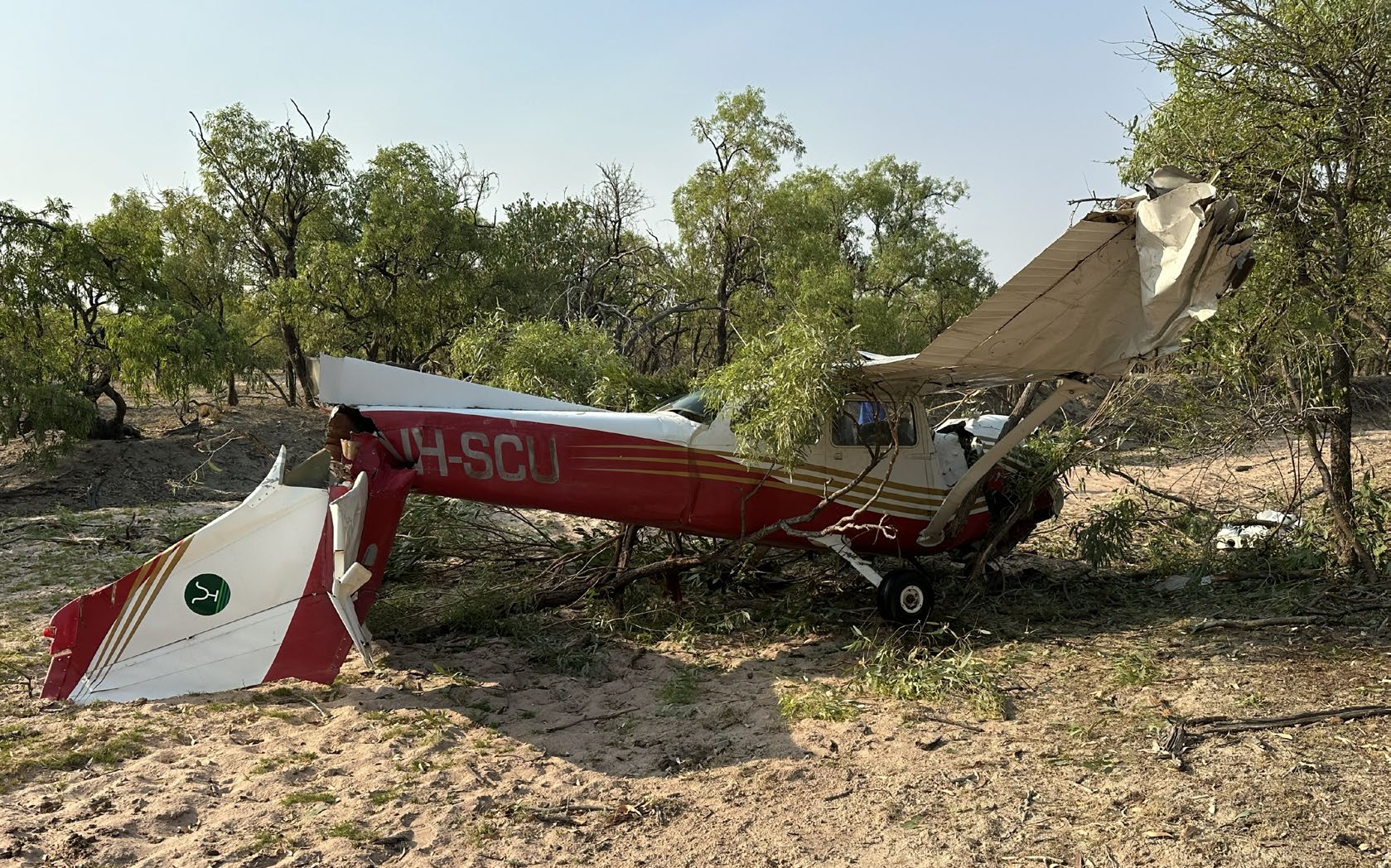
As the aircraft descended below the height of the treetops, its pitch attitude had almost levelled, its roll angle had reduced, and it was yawing to the right. The aircraft then impacted the trees, before coming to rest upright on its undercarriage, on relatively flat terrain. It had yawed during the impact sequence, such that it was facing back along its flightpath through the trees. The aircraft sustained extensive damage, particularly to its wings and tail section, with the latter being almost completely detached from the rear fuselage (Figure 2).
Figure 2: VH-SCU as it came to rest following impact with trees and terrain
Source: Supplied
Immediately after the aircraft came to rest, fuel began draining from a rupture in the right wing prompting the crew to exit the aircraft through the left door. During the impact, the instructor sustained minor injuries, while the pilot suffered no visible injuries but reported some neck pain.
The pilot used a mobile telephone to report the occurrence to the operator, and a ground vehicle was dispatched, which arrived at the accident site at around 0835 and subsequently transported both crew members back to the Newcastle Waters station. Following an initial examination by medical staff, both crew were conveyed to a medical clinic for treatment. The instructor was later discharged, while the pilot was transported to a hospital in Alice Springs for further assessment and monitoring. The pilot was discharged from hospital the following day.
Context
Flight crew
The pilot of VH-SCU held a Commercial Pilot Licence (Aeroplane) issued in 2024 and a class 1 aviation medical certificate. They had accumulated around 300 flight hours, mostly on single engine piston training aircraft, including the Cessna 172 and Diamond DA40. They had worked as a pilot on the station since October 2025.
The instructor held an Air Transport Pilot Licence (Aeroplane), a class 1 aviation medical, and a low-level rating, among other ratings and endorsements. They had accumulated a total of around 24,500 flying hours, with approximately 2,500 hours in the Cessna 172. They had flown 240 hours in the 90 days prior to the occurrence, with 25 of those in the Cessna 172.
Aircraft
VH-SCU was a Cessna Aircraft Company 172N manufactured in the United States in 1977 and assigned serial number 17268700. It was equipped with a Textron Lycoming O‑320‑H2AD piston engine, fixed pitch propeller, and fixed tricycle undercarriage. Maintenance records indicated that the airframe had accumulated a total flying time of 15,995 hours prior to the accident flight and the engine had 927.6 hours since overhaul. The aircraft was being maintained under the Civil Aviation Safety Authority Schedule 5 and had flown 45 hours since its most recent maintenance event, which was a 100-hour inspection performed on 23 August 2025.
The aircraft had no recording devices on board and nor was it required to.
Weather
No weather information was recorded for Newcastle Waters station, however the Bureau of Meteorology provided information for the nearest observation station at Daly Waters, approximately 123 km north. An observation issued at 0800 local time reported the temperature to be 29°, with a dew point of 21°, an atmospheric pressure of 1010 hectopascals, and a surface wind of between 8–10 kt from the north. This station did not provide a report of visibility or cloud cover.
Both flight crew provided consistent reports of the weather conditions at Newcastle Waters. They recalled a temperature of between 22–26°, winds of between 5–10 kt from the north-west, smooth air with no mechanical turbulence, and no cloud. There was light smoke haze but this did not significantly impair their visibility. The instructor estimated the density altitude2 to be approximately 3,000 ft.
Low-level training
The low-level flight training was being provided under the provisions of Part 141 of the Civil Aviation Safety Regulations (CASR). The instructor was qualified to deliver this training and had provided the same training to other pilots, employed at the station, on numerous occasions prior.
Part 61 of the CASR required an applicant for a low-level rating and aeroplane low-level endorsement to have, among other conditions:
• undertaken at least 5 hours of dual flight training in an aeroplane while receiving training in low level operations
• pass a flight test defined in the Part 61 manual of standards.
The Part 61 manual of standards prescribed a set of knowledge and flying competencies, which must be satisfactorily demonstrated during the low-level rating flight test. The specific activities and manoeuvres to be demonstrated during the flight test included:
• navigate at low-level
• conduct steep, max rate and min radius turns
• recover from approach to stalls – level and turning
• recover from unusual attitudes
• recover from wing drop at the stall
The training syllabus employed by the instructor planned for all airborne activities and manoeuvres to be taught over a period of 5 flying hours. The instructor reported that, in their experience, most students achieved competency within this period.
At the time of the accident, the pilot flying had undertaken 10.1 hours of low-level training. Training records indicated that additional flying hours were required at the start of the course for the student to demonstrate competency in some manoeuvres, including maintaining altitude during steep turns, stall recognition and recovery. However, during a period of upper air work conducted earlier in the accident flight, the student had successfully demonstrated competency in all these manoeuvres.
Aircraft stall behaviour
The angle of attack (AOA) is the angle at which the wing meets the relative airflow passing the aircraft. It is directly related to elevator position and therefore control stick position. The amount of lifting force produced by the wing increases with increasing AOA until a critical angle is reached. At the critical AOA (typically 16–18°), the wing aerodynamically stalls and lift production decreases abruptly. Recovering from a stall requires AOA be reduced below the critical angle by reducing aft control stick displacement.
Should the critical AOA be approached during a turn, using aileron to level the wings increases the AOA of the inside wing and may cause it to stall prior to the outside wing. This can result in the angle of bank rapidly increasing rather than decreasing. Instead, it is recommended that rudder is used to level the wings when a stall is encountered.
Minimum radius turns
A minimum radius turn achieves a change in aircraft direction over the smallest possible ground space. This technique is often used in low-flying operations where manoeuvring is made with respect to a ground feature and within confined terrain. Minimum radius turns are typically conducted at high angles of bank and lower airspeeds. Both conditions increase the AOA required to maintain level flight. The margin between required AOA and the critical (stalled) AOA is therefore reduced.
Adding additional aft control stick displacement during a minimum radius turn can quickly result in the wing exceeding the critical AOA and entering a stalled condition. For this reason, pilots are often instructed to correct low attitude during minimum radius turns through application of power, rather than additional aft control stick input.
Related occurrences
There have been a number of recent ATSB investigations into fatal accidents that resulted from a loss of control while manoeuvring during low-level flight.
On 27 June 2024, the pilot of a Cessna 172N, registered VH-SQO, was mustering sheep at Mulgathing Station, South Australia. The aircraft was observed to dive to an estimated height of about 50 ft above the ground before climbing rapidly, turning to the left and then descending towards the ground. The ATSB found that, while mustering without the appropriate endorsement, the pilot lost control of the aircraft leading to an aerodynamic stall and spin from an altitude that was not recoverable.
On 3 March 2022, the sole pilot of a Cessna U206G, registered VH-JVR, was conducting a low-level geophysical survey, about 120 km west of Norseman, Western Australia. At about 1430, the aircraft’s satellite tracking system stopped reporting its position. Wreckage was subsequently located 3.2 km west of the aircraft’s last recorded position. The ATSB found it was likely that, during a manoeuvre to intercept the next survey line, for undetermined reasons, control of the aircraft was lost at a height from which recovery was not possible.
On 13 April 2021, a Cessna R172K, registered VH-DLA, departed Canberra Airport, Australian Capital Territory, with a pilot and observer on board to conduct powerline survey work to the north of Sutton township, New South Wales. The aircraft was subsequently observed flying low above the trees before commencing a left turn that continued in to a steep descent and collision with terrain. The ATSB found that while manoeuvring to align the aircraft to inspect a powerline, the aircraft aerodynamically stalled and entered a spin at a height that was insufficient for recovery prior to the collision with terrain.
On 4 December 2021, the pilot of an Air Tractor AT-400 aircraft, registered VH-ACQ, was conducting aerial spraying operations on a property 75 km west-south-west of Moree, New South Wales. During a right procedure turn, the aircraft was observed to climb then descend rapidly and collide with terrain. The ATSB found that the aircraft was too close to the start of the spray run during the turn, which probably resulted in the pilot tightening the turn. This almost certainly resulted in an aerodynamic stall at a height too low to recover before colliding with the terrain.
Safety analysis
The pilot and instructor were conducting a low-level navigation exercise, tracking along a ground feature at approximately 300 ft AGL and 80 kt.
Accounts from both crew members indicated that while making a steep right turn to follow the ground feature, the aircraft’s nose dropped. Additionally, the pilot observed thatthe aircraft was not turning quickly enough to remain over the river. In response, they sharply increased their aft control stick input rather than increase the bank angle. This almost certainly placed the aircraft into an aerodynamically stalled condition rapidly increasing the rate of descent and further rolling to the right.
The pilot did not follow the recommended method to address the nose drop at low level - application of power rather than increasing pitch, which they had demonstrated successfully earlier in the flight. The ATSB could not determine why the correct recovery technique was not applied. However, human factors research (Martin, Murray, Bates and Lee 2013) noted that when faced with a sudden unexpected aircraft condition, pilots may experience a rapid increase in stress and revert to instinctive behaviour over trained behaviour.
After recognising that the pilot had applied inappropriate control inputs the instructor attempted to intervene. It is uncertain what verbal communication was made between the crew, but there was a period of confusion over who had control of the aircraft, and it is likely both crew members were making control inputs simultaneously resulting in the instructor being unable to override the control inputs of the pilot, delaying the effectiveness of the recovery actions. Due to the proximity to the ground, the aircraft descended into terrain before this confusion could be resolved. Despite this, the instructor’s inputs to the throttle and rudder likely prevented the aircraft from contacting the ground in a nose down attitude and reduced the severity of the impact.
Findings
ATSB investigation report findings focus on safety factors (that is, events and conditions that increase risk). Safety factors include ‘contributing factors’ and ‘other factors that increased risk’ (that is, factors that did not meet the definition of a contributing factor for this occurrence but were still considered important to include in the report for the purpose of increasing awareness and enhancing safety). In addition ‘other findings’ may be included to provide important information about topics other than safety factors.
These findings should not be read as apportioning blame or liability to any particular organisation or individual.
From the evidence available, the following findings are made with respect to the collision with terrain involving Cessna 172, VH-SCU, about 6 km south of Newcastle Waters, Northern Territory, on 7 November 2025.
Contributing factor
While training to follow a ground feature at low level, the pilot flying applied and held inappropriate control inputs, which led to an aerodynamic stall and limited the instructor’s ability to make corrective actions, resulting in the aircraft colliding with terrain.
Other finding
The instructor's control inputs likely prevented the aircraft from impacting terrain in a nose down attitude and reduced the severity of the collision.
Safety actions
Whether or not the ATSB identifies safety issues in the course of an investigation, relevant organisations may proactively initiate safety action in order to reduce their safety risk. The ATSB has been advised of the following proactive safety action in response to this occurrence.
Safety action by flight training provider
The flight training provider undertook a critical review of its training practices and risk mitigation measures.
Sources and submissions
Sources of information
The sources of information during the investigation included:
the pilot and instructor of the accident flight
Consolidated Pastoral Company
Bureau of Meteorology.
References
Martin, Murray, Bates, and Lee (2015) Fear-potentiated startle: A review from an aviation perspective. The International Journal of Aviation Psychology, 25(2), pp.97-107.
Submissions
Under section 26 of the Transport Safety Investigation Act 2003, the ATSB may provide a draft report, on a confidential basis, to any person whom the ATSB considers appropriate. That section allows a person receiving a draft report to make submissions to the ATSB about the draft report.
A draft of this report was provided to the following directly involved parties:
the pilot and instructor of the accident flight
Consolidated Pastoral Company
Civil Aviation Safety Authority.
Submissions were received from:
the pilot and instructor of the accident flight
Consolidated Pastoral Company.
The submissions were reviewed and, where considered appropriate, the text of the report was amended accordingly.
Purpose of safety investigations
The objective of a safety investigation is to enhance transport safety. This is done through:
identifying safety issues and facilitating safety action to address those issues
providing information about occurrences and their associated safety factors to facilitate learning within the transport industry.
It is not a function of the ATSB to apportion blame or provide a means for determining liability. At the same time, an investigation report must include factual material of sufficient weight to support the analysis and findings. At all times the ATSB endeavours to balance the use of material that could imply adverse comment with the need to properly explain what happened, and why, in a fair and unbiased manner. The ATSB does not investigate for the purpose of taking administrative, regulatory or criminal action.
About ATSB reports
ATSB investigation reports are organised with regard to international standards or instruments, as applicable, and with ATSB procedures and guidelines.
Reports must include factual material of sufficient weight to support the analysis and findings. At all times the ATSB endeavours to balance the use of material that could imply adverse comment with the need to properly explain what happened, and why, in a fair and unbiased manner.
An explanation of terminology used in ATSB investigation reports is available here. This includes terms such as occurrence, contributing factor, other factor that increased risk, and safety issue.
Publishing information
Released in accordance with section 25 of the Transport Safety Investigation Act 2003
Ownership of intellectual property rights in this publication
Unless otherwise noted, copyright (and any other intellectual property rights, if any) in this report publication is owned by the Commonwealth of Australia.
Creative Commons licence
With the exception of the Commonwealth Coat of Arms, ATSB logo, and photos and graphics in which a third party holds copyright, this report is licensed under a Creative Commons Attribution 4.0 International licence.
The CC BY 4.0 licence enables you to distribute, remix, adapt, and build upon our material in any medium or format, so long as attribution is given to the Australian Transport Safety Bureau.
Copyright in material obtained from other agencies, private individuals or organisations, belongs to those agencies, individuals or organisations. Where you wish to use their material, you will need to contact them directly.
^CASA defines low-level flight operation as any flying conducted below 500 ft above ground level (AGL), other than for the purpose of take-off or landing.
^Density altitude is the pressure altitude corrected for non-standard temperature. It is the altitude at which the aircraft ‘feels’ it is flying regardless of its actual height above sea level.
Occurrence summary
Investigation number
AO-2025-066
Occurrence date
07/11/2025
Occurrence time and timezone
07:50 Central Standard Time
Location
About 6 km south of Newcastle Waters
State
Northern Territory
Report release date
20/05/2026
Report status
Final
Investigation level
Short
Investigation type
Occurrence Investigation
Investigation phase
Final report: Dissemination
Investigation status
Completed
Mode of transport
Aviation
Aviation occurrence category
Collision with terrain, Loss of control
Occurrence class
Accident
Highest injury level
Minor
Aircraft details
Manufacturer
Cessna Aircraft Company
Model
172N
Registration
VH-SCU
Serial number
17268700
Aircraft operator
Consolidated Pastoral Company Pty Limited
Sector
Piston
Operation type
Part 141 Recreational, private and commercial pilot flight training
Activity
General aviation / Recreational-Instructional flying-Instructional flying - dual
Occurrence Briefs are concise reports that detail the facts surrounding a transport safety occurrence, as received in the initial notification and any follow-up enquiries. They provide an opportunity to share safety messages in the absence of an investigation. Because occurrence briefs are not investigations under the Transport Safety Investigation Act 2003, the information in them is de-identified.
What happened
On the afternoon of 23 September 2025, a Cessna 172 was conducting private runway inspections at multiple farms near Blackwater, Queensland.
During a low level overfly of one such runway strip at about 200 ft AGL, the aircraft began to lose height. When the pilot attempted to add power, the aircraft did not respond as anticipated, resulting in a loss of control. The aircraft collided with the ground, bounced and came to rest inverted, resulting in substantial damage to the propellor, main landing gear, right wing strut, engine cowl and vertical stabiliser (Figure 1).
The pilot reported that possible contributing factors to the accident included a crosswind from the south and the warmer weather, with the aircraft not having enough lift as power was applied.
Figure 1: Cessna 172H inverted after landing
Source: Operator
Safety message
This incident highlights that low-level flying operations have a lower margin for error with minimal time to recover the aircraft in the event of a loss of control.
Low-level flying, particularly at private and unregulated airstrips, is inherently high risk and therefore requires effective risk management. This should include a risk assessment to consider the hazards common to the type of operation, as well as specific to the location, to develop mitigations and reduce the chance of an accident occurring.
About this report
Decisions regarding whether to conduct an investigation, and the scope of an investigation, are based on many factors, including the level of safety benefit likely to be obtained from an investigation. For this occurrence, no investigation has been conducted and the ATSB did not verify the accuracy of the information. A brief description has been written using information supplied in the notification and any follow-up information in order to produce a short summary report, and allow for greater industry awareness of potential safety issues and possible safety actions.
The ATSB is investigating a collision with terrain involving a Pilatus Aircraft Ltd PC-6, registered VH-XAA, 2 km north of Moruya Airport, New South Wales, on 27 September 2025.
While returning to Moruya Airport following the completion of a skydiving drop, the aircraft collided with terrain. The pilot sustained fatal injuries.
The ATSB deployed a team of transport safety investigators to the accident site with experience in aircraft operations, maintenance and engineering.
As part of the evidence collection phase of the investigation, ATSB investigators will examine the aircraft wreckage and other information from the accident site, examine operator procedures, interview witnesses and any involved parties, and examine maintenance records and any recorded data.
The ATSB released a preliminary report, which details factual information established in the investigation’s early evidence collection phase, on 12 November 2025. See below.
A final report will be released at the conclusion of the investigation. Should a critical safety issue be identified during the course of the investigation, the ATSB will immediately notify relevant parties, so that appropriate safety action can be taken.
Preliminary report
Report release date: 12/11/2025
This preliminary report details factual information established in the investigation’s early evidence collection phase, and has been prepared to provide timely information to the industry and public. Preliminary reports contain no analysis or findings, which will be detailed in the investigation’s final report. The information contained in this preliminary report is released in accordance with section 25 of the Transport Safety Investigation Act 2003.
Summary video
The occurrence
On 27 September 2025, the pilot and owner of a Pilatus PC-6/B2-H4 aircraft, registered VH-XAA and operated by Jump Aviation for SKYONE Moruya Heads parachuting organisation, was conducting parachute operations over Moruya Airport, New South Wales. After conducting 8 successful parachute drops, at 1348:58 local time, the pilot broadcast on the common traffic advisory frequency (CTAF)[1] that they were taxiing for runway 04[2] to conduct the next flight. On board were 8 parachutists and the pilot. The pilot was wearing the fitted 4-point restraint and an emergency parachute in accordance with company procedures.
At 1351:08, the pilot broadcast that the aircraft was airborne off runway 04, for an upwind departure and on climb to flight levels (FL)[3] for parachute operations. During the climb to the planned drop between FL 140 and 150, several parachutists reported feeling a bump and hearing the stall warning[4] activate momentarily, passing about 10,000 ft.
At 1400:52, the pilot broadcast on the CTAF that they were 4 minutes to a parachute drop, then advised the same to Melbourne Centre air traffic control. Recorded data showed the ‘jump run’ tracked in a northerly direction about 2 km west of Moruya Airport runway 36, in a gradual descent between FL 150 and 140. The parachutists reported that the jump run was normal, and all the parachutists exited successfully. At 1406:15, the pilot broadcast that the parachutists had exited and the aircraft was on descent.
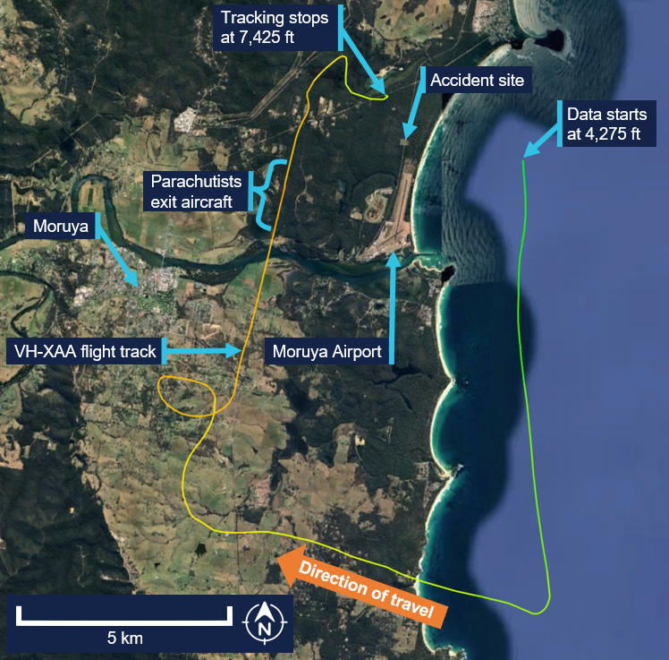
Several witnesses on the ground observed the aircraft enter a steep nose-down dive, rotating left before pitching[5] up and rolling[6] right. Recorded data showed the aircraft initially descended from FL 140 at about 5,000 fpm, but approaching FL 120, the descent rate increased significantly. The last recorded automatic dependent surveillance‑broadcast (ADS-B) data position was at 1407:26 and 7,425 ft, descending at about 15,000 fpm (Figure 1). The aircraft subsequently impacted trees and terrain about 2 km north of Moruya Airport. The pilot sustained fatal injuries, and the aircraft was destroyed.
Figure 1: VH-XAA flight track and accident site
Source: Google Earth, annotated by the ATSB
Context
Pilot
The pilot held a private pilot licence (aeroplane) with the last flight review conducted in August 2025, and a class 2 aviation medical certificate, valid until June 2027. The pilot held the appropriate ratings and endorsements for the flight. In addition, the pilot held aerobatics and spin endorsements and jump pilot authorisation. At the time of the accident, they had about 11,690 hours total aeronautical experience. In the previous 90 days, they had flown 135.2 hours, most of which were conducting parachuting operations in Cessna 206 and 208 aircraft.
The pilot’s logbook recorded an endorsement for the Pilatus PC-6 (required by the then Civil Aviation Regulations) in 1998. The ATSB was unable to access some of the pilot’s logbooks to confirm how many hours they had logged flying the Pilatus PC-6 prior to purchasing VH‑XAA from New Zealand (NZ). Between 22 and 24 August 2025, the pilot and an instructor flew the aircraft from Auckland, NZ, to Dubbo, New South Wales, logging 19.5 hours of flight time. The pilot then recorded 2 hours operating the aircraft to Moruya on 12 September 2025. From 20 to 24 September 2025 inclusive, the pilot recorded 9.7 hours in the aircraft conducting parachute operations. At the start of the accident morning, the pilot had logged 31.2 hours in VH-XAA.
The pilot was an experienced parachutist and had been a member of the Australian Parachute Federation (APF)[7] since 1987. On 30 June 2025, the pilot reported having conducted 17,000 jumps. The pilot held numerous parachuting qualifications including senior instructor and a Certificate F, which was the highest certificate issued by the APF. The pilot was the senior pilot of Jump Aviation and the chief parachute instructor of the parachuting operator SKYONE Moruya Heads – a group member of the APF.
Aircraft
General information
VH-XAA was a Pilatus Aircraft PC-6/B2-H4, short take-off and landing utility aeroplane with fixed landing gear (Figure 2). It was powered by a Pratt & Whitney Canada PT6A-27 turbine engine and a Hartzell Propellers HC-B3TN-3D 3-bladed propeller. The aircraft was not approved for aerobatic manoeuvres including spins.
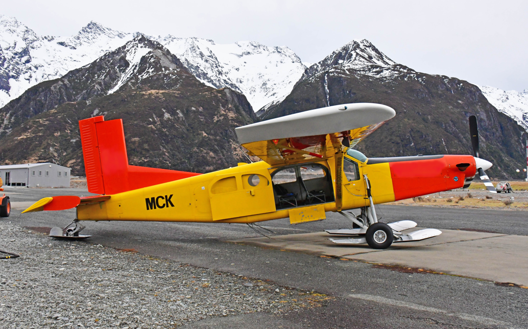
Figure 2: VH-XAA when operating in New Zealand as ZK-MCK
Source: Richard Currie, modified by the ATSB
It was manufactured in Switzerland in 1980 and issued serial number 809. The aircraft had been used for parachute operations in New Zealand (NZ) since 1982. As such, the passenger seats, copilot seat and copilot control stick had been removed. Additionally, a skydiving step and hand hold had been installed.
A 7,000 hour/14-year ‘complete overhaul’ maintenance activity was performed in NZ and finalised on 14 August 2025. During the maintenance activity, the horizontal stabiliser electric trim actuator was removed and overhauled by the manufacturer in the United States.
The aircraft was added to the Australian civil aircraft register on 15 August 2025, and a special flight permit[8] was issued to allow the aircraft to be flown from NZ to Australia. After the pilot ferried the aircraft to Australia, a certificate of airworthiness was issued for VH-XAA on 19 September 2025. At the time of the accident, VH-XAA had accrued 13,594.5 hours total time in service.
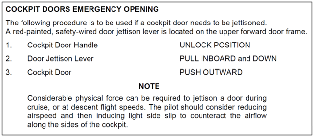
Doors
The aircraft had a door on each side of the cockpit for pilot and copilot access, which were fitted with a jettison system. Figure 3 shows the Pilatus PC-6 airplane flight manual[9] (AFM) procedure for emergency opening of the cockpit doors:
The aircraft cabin had a sliding door on the right side, which was used for parachutists to exit, and 2 hinged doors on the left side, which were fitted with an emergency jettison system. The sliding door had a mechanism to open it from inside the aircraft, but it could not be locked open. Parachutists reported that, on the day of the accident, the pilot had landed with the sliding door open on some flights and closed on others. Although it was not identified at the accident site, several parachutists reported that there was a fishing gaffer hook on a pole onboard the aircraft that the pilot used to close the sliding door in flight from the pilot’s seat.
stalling speeds at a gross weight of 2,800 kg, power off and 0° angle of bank including:
58 kt calibrated airspeed[12] (KCAS) with flap retracted
52 KCAS with landing flap extended.
Horizontal stabiliser electric trim system
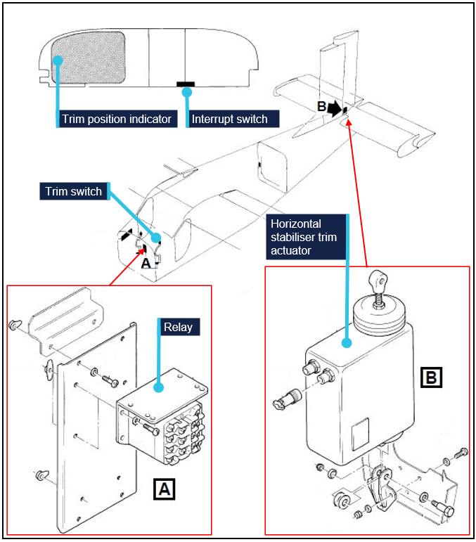
The aircraft was fitted with a horizontal stabiliser electric trim system, designed to move the entire horizontal stabiliser to adjust the pitch trim of the aircraft and balance the aerodynamic forces to reduce the pilot control forces on the elevator. The system (Figure 4), consisted of:
a dual motor (main and alternate motors) electrically‑operated linear trim actuator
a 3-position spring-loaded trim switch, located on the control column grip
a relay located on the firewall
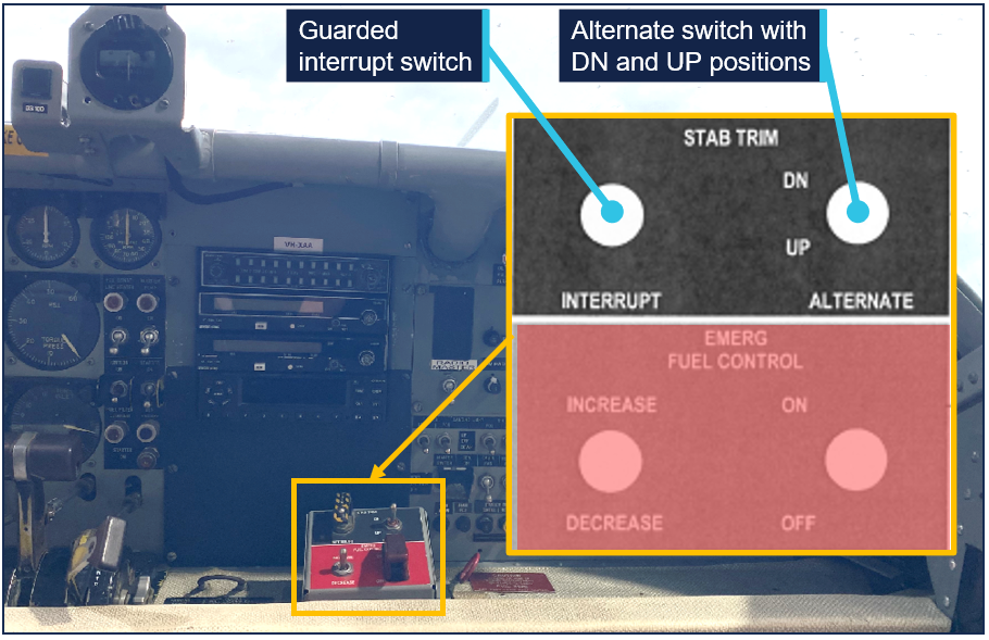
an interrupt system incorporating a guarded switch on the instrument panel shelf and an alternate trim control system with a 3-position spring-loaded trim switch (Figure 5)
an electrically‑operated trim position indicator on the upper left side of the instrument panel.
Figure 4: Schematic of horizontal stabiliser trim system
Source: Pilatus PC-6 Illustrated Parts Catalogue, modified and annotated by the ATSB
Figure 5: Instrument panel shelf horizontal stabiliser trim switches
Source: Supplied and Pilatus PC-6 AFM, annotated by the ATSB
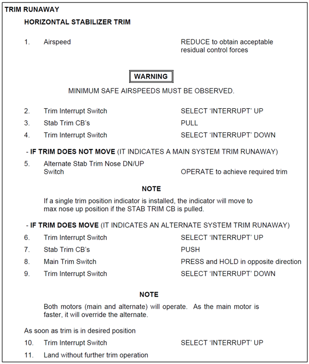
The AFM included the following procedure (Figure 6) in the event of a trim runaway:[13]
Figure 6: Horizontal stabiliser trim runaway emergency procedure
Source: Pilatus PC-6 airplane flight manual
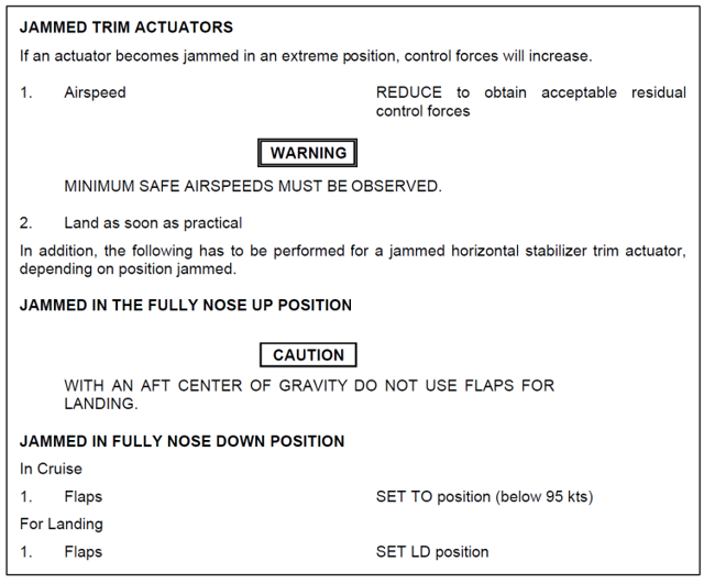
The AFM included the following procedure (Figure 7) for jammed trim actuators:
Figure 7: Jammed horizontal stabiliser trim actuator emergency procedure
Source: Pilatus PC-6 airplane flight manual
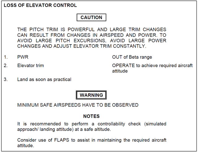
The AFM also included the following procedure (Figure 8) for loss of elevator control:
Figure 8: Loss of elevator control emergency procedure
Source: Pilatus PC-6 airplane flight manual
Beta mode
The AFM described beta mode as ‘operation of the propeller used in flight to achieve fast deceleration and high rates of descent’. The AFM stated:
In the beta range, the propeller blades are set at a low positive pitch angle to provide a braking effect for steep controlled descents. When operating in the beta mode, the propeller pitch angle is controlled by power lever movement between the lift detent and the point where constant speed operation becomes effective.
NOTE
BETA MODE is provided in descent at airspeeds below 100 KIAS [kt indicated airspeed] with the POWER lever near or at the detent. Only small movements of the POWER lever are necessary to change rate of descent or airspeed. Approaches in full BETA MODE (POWER lever at detent) are not permitted at airspeeds below 1.3 Vs.[14]
Meteorological information
The Bureau of Meteorology aerodrome forecast for Moruya Airport, issued at 1109 on 27 September 2025 included wind from 090° at 5 kt, which was expected to change to 310° and become gusty between 1200 and 1300. The grid point wind and temperature chart showed the forecast winds:
at 10,000 ft from 270° at 42 kt
at FL 140 from 270° at 51 kt.
The Bureau of Meteorology had also issued SIGMETs[15] for severe turbulence below 8,000 ft and mountain waves from 4,000 ft to FL 320 in an area that included Moruya Airport, between 1100 and 1500.
The conditions recorded in the METAR[16] at Moruya Airport at 1400 included wind from 130° at 6 kt, visibility greater than 10 km, temperature 22°C, and QNH[17] 1,007 hPa.
Recorded data
The ATSB conducted preliminary analysis of the aircraft’s 3-dimensional position information recorded in the ADS-B data for the 9 flights on 27 September 2025, the last of which was the accident flight. The positional data was interpolated between recorded positions and a trajectory analysis conducted to estimate other flight performance and handling parameters. The analysis was based on the forecast wind and an estimated aircraft weight of 1,587 kg (3,500 lb). For most of the flights, there was no recorded ADS‑B data below about 4,000 ft above mean sea level.
A comparison of the following key parameters for the 9 flights was conducted for the descent following parachute drop from about FL 140:
altitude
descent rate
estimated calibrated airspeed
estimated pitch and roll angles.
For flights 1–5, 7 and 8, the values of these parameters were similar. In those 7 flights, the descent commenced at an airspeed of about 55–70 KCAS, with an initial nose-down pitch of about 30° and either a right or left roll of about 30° (on flight 4 the roll angle was possibly up to 50°). The maximum descent rate for these 7 flights was between about 5,500 and 8,000 fpm.
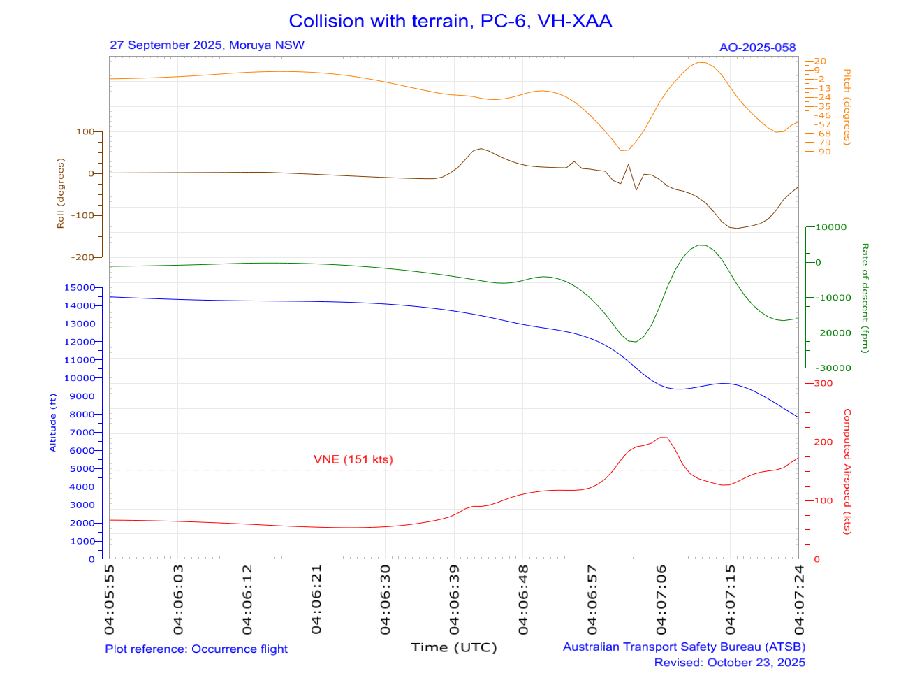
On flight 6, the descent was initiated slightly slower, at about 54 KCAS, which increased within 10 seconds to about 145 KCAS, coincident with a maximum momentary descent rate of about 14,000 fpm, a steep (70°) pitch down in conjunction with a substantial roll right.
The descent on the accident flight (flight 9) was initiated at about 53 KCAS from 14,200 ft to a nose-down pitch of about 25°, with a 60° right roll. The aircraft briefly reduced pitch slightly before nosing vertically down (about 90°) in a left roll, reaching a maximum descent rate of over 20,000 fpm. The aircraft then pitched up to a shallow climb and into a roll of more than 120°. From the data it could not be confirmed whether this manoeuvre was conducted upright or inverted. Passing about 9,600 ft, the airspeed reduced to 125–130 KCAS before increasing again. The last recorded position, passing about 8,000 ft indicated the aircraft had accelerated to 173 KCAS, with a final descent rate above 15,000 fpm (Figure 9).
Figure 9: Preliminary plot of key parameters from the accident flight descent
Due to the aircraft’s manoeuvring, the roll information may be inaccurate. Local time was UTC+10 hours. Source: ATSB
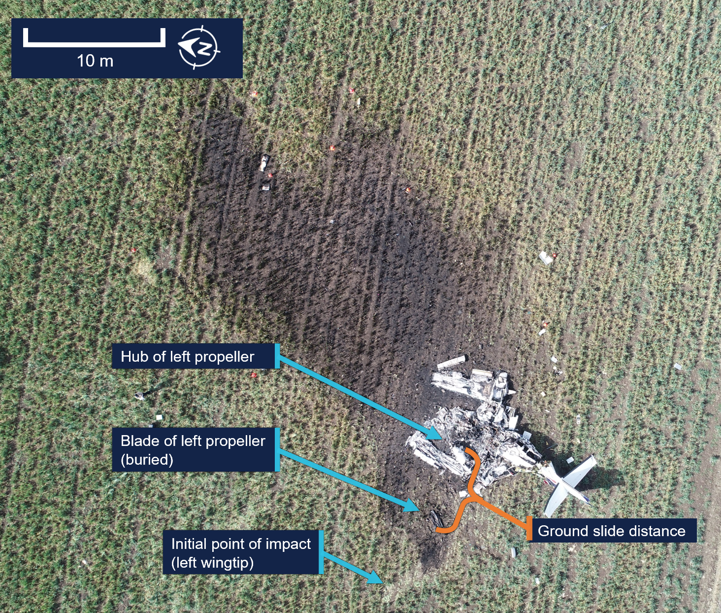
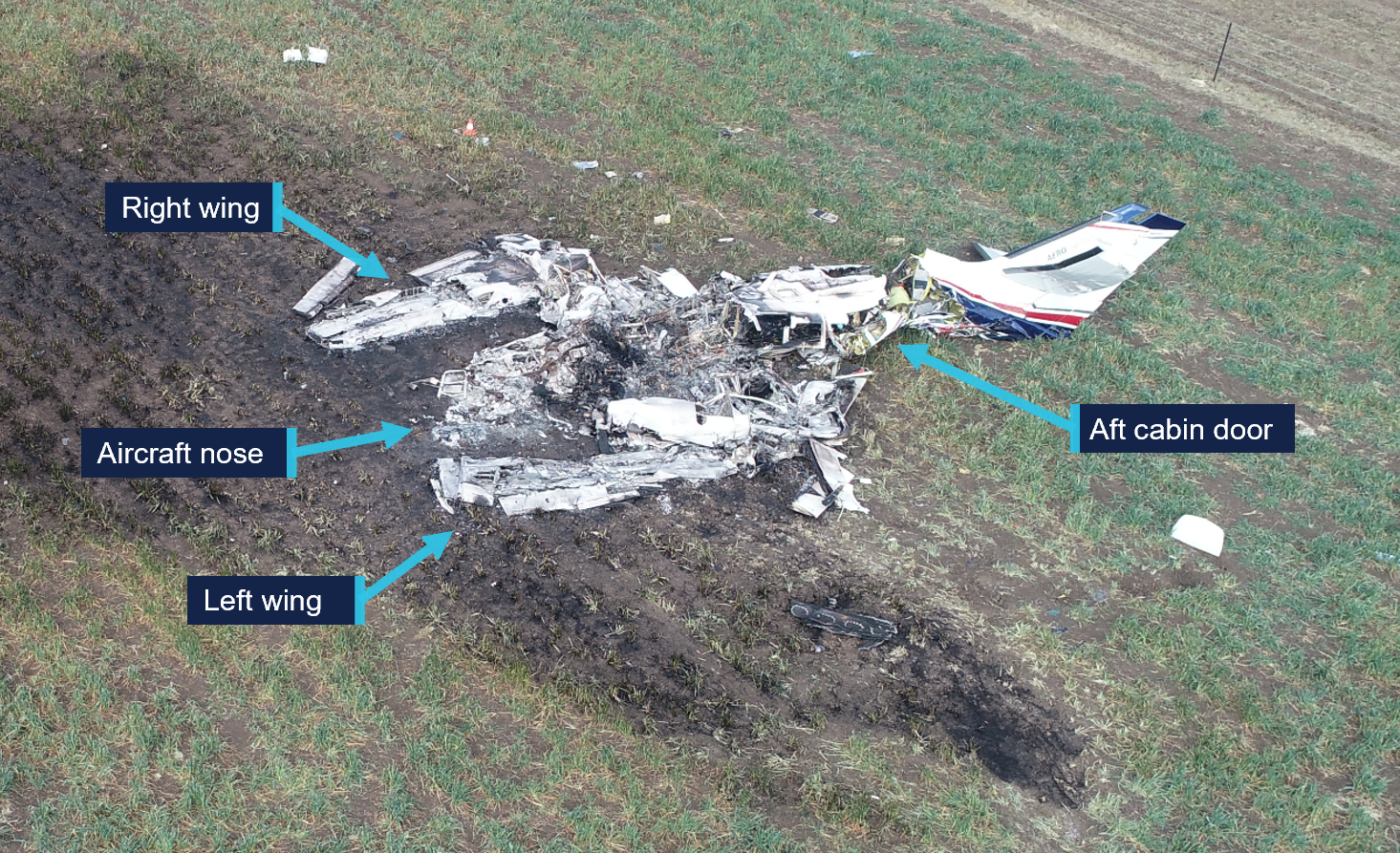
Site and wreckage
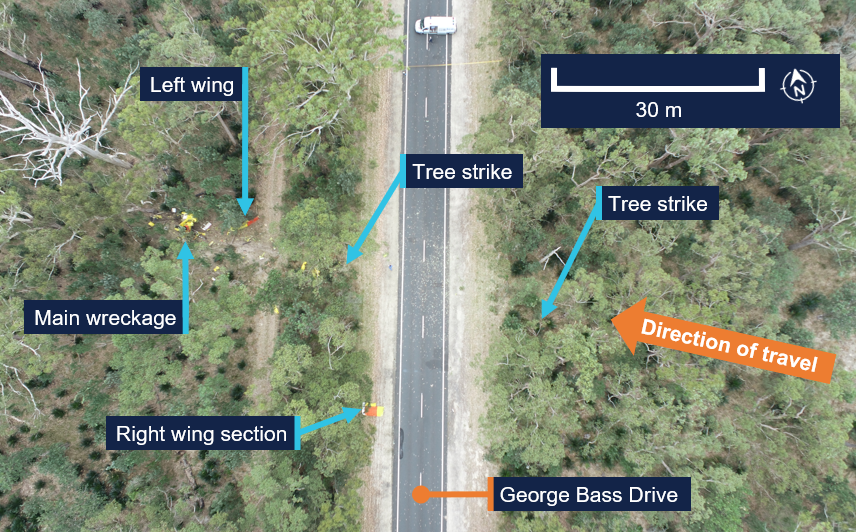
The wreckage site was about 2.5 km north (and slightly west) of the northern end of the Moruya Airport runway 36. ATSB examination showed that the right wing struck a tree on the eastern side of George Bass Drive and separated from the fuselage, before the aircraft collided with trees on the western side of the road and subsequently impacted terrain in a nose-down inverted attitude (Figure 10). The outer section of the right wing landed on the road but was moved clear by members of the public shortly after the accident.
Figure 10: Overview of VH-XAA accident site
Source: ATSB
The examination identified:
there was fuel remaining and no post-impact fire occurred
all major components of the aircraft were at the site, indicating there was no in-flight breakup
the propeller had indications that the engine was producing power at impact
there were no indications of any pre-impact mechanical anomalies that would have precluded normal engine operation
the pilot’s 4-point restraint was undone, and the pilot was almost certainly not in the pilot seat at the time of impact
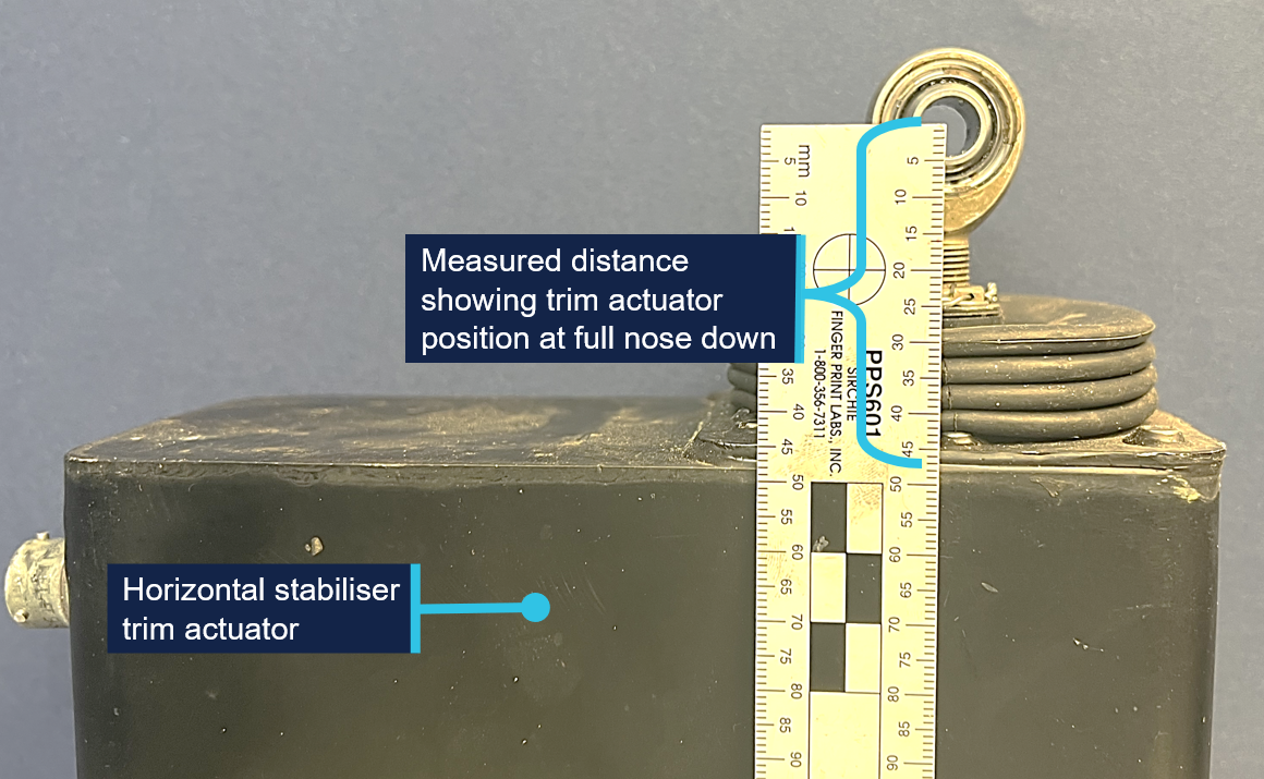
the horizontal stabiliser trim actuator was found in the full nose-down position (Figure 11).
Figure 11: Horizontal stabiliser trim actuator showing trim position
Source: ATSB
Further investigation
To date, the ATSB has:
interviewed witnesses and involved parties
obtained pilot and aircraft documentation
analysed recorded data
reviewed recorded audio transmissions
assessed the accident site and examined the aircraft wreckage.
The investigation is continuing and will include further examination of:
the horizontal stabiliser trim system
recorded flight data
aircraft configuration, maintenance and documentation
operational procedures and documentation
pilot training records
survivability and opportunity for egress
other similar occurrences.
A final report will be released at the conclusion of the investigation. Should a critical safety issue be identified during the course of the investigation, the ATSB will immediately notify relevant parties so appropriate and timely safety action can be taken.
Acknowledgements
The ATSB would like to acknowledge the assistance of the NSW Police Force, Fire and Rescue NSW, and first responders.
Purpose of safety investigations
The objective of a safety investigation is to enhance transport safety. This is done through:
identifying safety issues and facilitating safety action to address those issues
providing information about occurrences and their associated safety factors to facilitate learning within the transport industry.
It is not a function of the ATSB to apportion blame or provide a means for determining liability. At the same time, an investigation report must include factual material of sufficient weight to support the analysis and findings. At all times the ATSB endeavours to balance the use of material that could imply adverse comment with the need to properly explain what happened, and why, in a fair and unbiased manner. The ATSB does not investigate for the purpose of taking administrative, regulatory or criminal action.
About ATSB reports
ATSB investigation reports are organised with regard to international standards or instruments, as applicable, and with ATSB procedures and guidelines.
Reports must include factual material of sufficient weight to support the analysis and findings. At all times the ATSB endeavours to balance the use of material that could imply adverse comment with the need to properly explain what happened, and why, in a fair and unbiased manner.
An explanation of terminology used in ATSB investigation reports is available here. This includes terms such as occurrence, contributing factor, other factor that increased risk, and safety issue.
Publishing information
Released in accordance with section 25 of the Transport Safety Investigation Act 2003
Ownership of intellectual property rights in this publication
Unless otherwise noted, copyright (and any other intellectual property rights, if any) in this report publication is owned by the Commonwealth of Australia.
Creative Commons licence
With the exception of the Commonwealth Coat of Arms, ATSB logo, and photos and graphics in which a third party holds copyright, this report is licensed under a Creative Commons Attribution 4.0 International licence.
The CC BY 4.0 licence enables you to distribute, remix, adapt, and build upon our material in any medium or format, so long as attribution is given to the Australian Transport Safety Bureau.
Copyright in material obtained from other agencies, private individuals or organisations, belongs to those agencies, individuals or organisations. Where you wish to use their material, you will need to contact them directly.
[1]Common traffic advisory frequency (CTAF): a designated frequency on which pilots make positional broadcasts when operating in the vicinity of a non-controlled aerodrome or within a broadcast area.
[2]Moruya Airport had 2 sealed runways, 18/36 and 04/22. The runway number represents its magnetic heading.
[3]Flight level: at altitudes above 10,000 ft in Australia, an aircraft’s height above mean sea level is referred to as a flight level (FL). FL 140 equates to 14,000 ft.
[4]A stall warning system provides the pilot with advance warning of an impending aerodynamic stall.
[5]Pitching: the motion of an aircraft about its lateral (wingtip-to-wingtip) axis.
[6]Rolling: the movement of an aircraft about its longitudinal axis.
[7]The APF is the peak body for the administration and representation of Australian Sport Parachuting.
[8]Special Flight Permit (SFP): issued to allow the operation of an aircraft that does not meet its airworthiness requirements but under certain circumstances, and for a particular intended purpose, the aircraft may still be capable of safe flight.
[9]Airplane flight manual (AFM): a manual that is part of the certification basis of the aircraft, containing the operating limitations within which the aircraft is considered airworthy, and any other information required for the safe operation of the aircraft, including all amendments and supplements for that manual.
[10]Never exceed speed (VNE): the indicated airspeed which, if exceeded, may result in structural damage to the aircraft, normally represented by a red line on the airspeed indicator.
[11]Manoeuvring speed (VA): the maximum speed at which a pilot can make full or abrupt control movements without causing structural failure of the aircraft.
[12]Calibrated airspeed: indicated airspeed corrected for air speed indicator system errors.
[13]Pitch trim runaway is an uncontrolled movement of the aircraft’s trim system causing uncommanded nose-up or nose‑down pitch.
[14]Vs - Stall speed or minimum steady flight speed for which the aircraft is still controllable.
[15]SIGMET: a concise description of the occurrence or expected occurrence, in an area over which area meteorological watch is maintained, of specified phenomena which may affect the safety of aircraft operations.
[16]METAR: a routine report of meteorological conditions at an aerodrome. METAR are normally issued on the hour and half hour.
[17]QNH: the altimeter barometric pressure subscale setting used to indicate the height above mean seal level.
Occurrence summary
Investigation number
AO-2025-058
Occurrence date
27/09/2025
Occurrence time and timezone
14:00 Australian Eastern Standard Time
Location
2.5 km north of Moruya Airport
State
New South Wales
Report release date
12/11/2025
Report status
Preliminary
Anticipated completion
Q1 2026
Investigation level
Short
Investigation type
Occurrence Investigation
Investigation phase
Evidence collection
Investigation status
Active
Mode of transport
Aviation
Aviation occurrence category
Collision with terrain, Loss of control
Occurrence class
Accident
Highest injury level
Fatal
Aircraft details
Manufacturer
Pilatus Aircraft Ltd
Model
PC-6/B2-H4
Registration
VH-XAA
Serial number
809
Aircraft operator
Jump Aviation Pty Ltd
Sector
Turboprop
Operation type
Part 105 Parachuting
Activity
General aviation / Recreational-Sport and pleasure flying-Parachute dropping
Occurrence Briefs are concise reports that detail the facts surrounding a transport safety occurrence, as received in the initial notification and any follow-up enquiries. They provide an opportunity to share safety messages in the absence of an investigation. Because occurrence briefs are not investigations under the Transport Safety Investigation Act 2003, the information in them is de-identified.
What happened
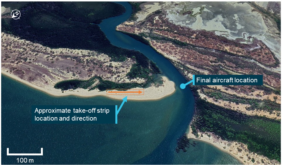
On 14 August 2025, a Just Aircraft SuperSTOL XL amateur-built aircraft departed from Weipa, Queensland, for a flight to Cooktown. The pilot was the sole person on board and the flight was planned to proceed via Coen with a subsequent refuelling stop, if required, using fuel carried in a container on board the aircraft. After leaving Coen, the pilot determined that refuelling was required and selected an off-airfield landing location near Bathurst Bay where, after an aerial inspection of the selected area, the pilot made an uneventful landing at the mouth of a river.
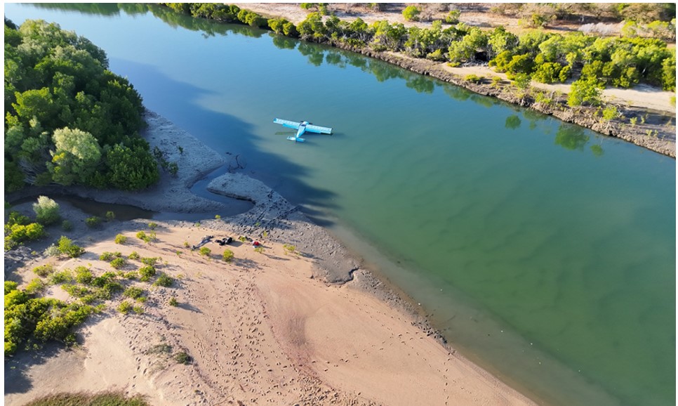
At around 1630, after refuelling and having inspected the intended take-off strip area for suitability, the pilot commenced the take-off. The pilot later reported that, shortly after clearing the ground, the aircraft encountered a strong crosswind gust from the left and the aircraft yawed forcefully into the wind. Directional control and climb performance of the aircraft was rapidly lost and the pilot ditched the aircraft in the shallow river to the left of the strip end (Figure 1). The pilot was uninjured and able to evacuate the aircraft and swim to the shore, however the aircraft became partially submerged (Figure 2) and was substantially damaged by water ingress.
Figure 1: Overview of take-off strip and accident location
Source: Google Earth, annotated by the ATSB
Figure 2: Aircraft final location after being moved by incoming tide, partially submerged
Source: Pilot supplied
Safety message
Take-offs and landings away from established aerodromes and aircraft landing areas (ALAs) can present challenges and significantly increased risks for operating crew. In this instance, while the pilot was operating an aircraft designed and equipped for such off‑field work, the presence of obstacles and hazards close to the chosen strip reduced the options available to the pilot for a safe recovery or landing after the wind gusts and controllability issues were encountered.
Pilots should also consider the shielding effects of any elevated terrain surrounding planned take-off areas and consider the potential effects of abrupt wind changes and windshear once the aircraft outclimbs the terrain.
About this report
Decisions regarding whether to conduct an investigation, and the scope of an investigation, are based on many factors, including the level of safety benefit likely to be obtained from an investigation. For this occurrence, no investigation has been conducted and the ATSB did not verify the accuracy of the information. A brief description has been written using information supplied in the notification and any follow-up information in order to produce a short summary report, and allow for greater industry awareness of potential safety issues and possible safety actions.
Occurrence summary
Mode of transport
Aviation
Occurrence ID
AB-2025-040
Occurrence date
14/08/2025
Location
155 km north-west of Cooktown Airport
State
Queensland
Occurrence class
Accident
Aviation occurrence category
Collision with terrain, Loss of control, Weather - Other
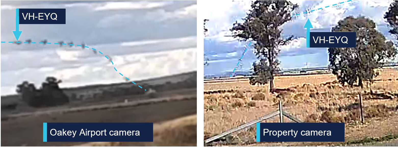
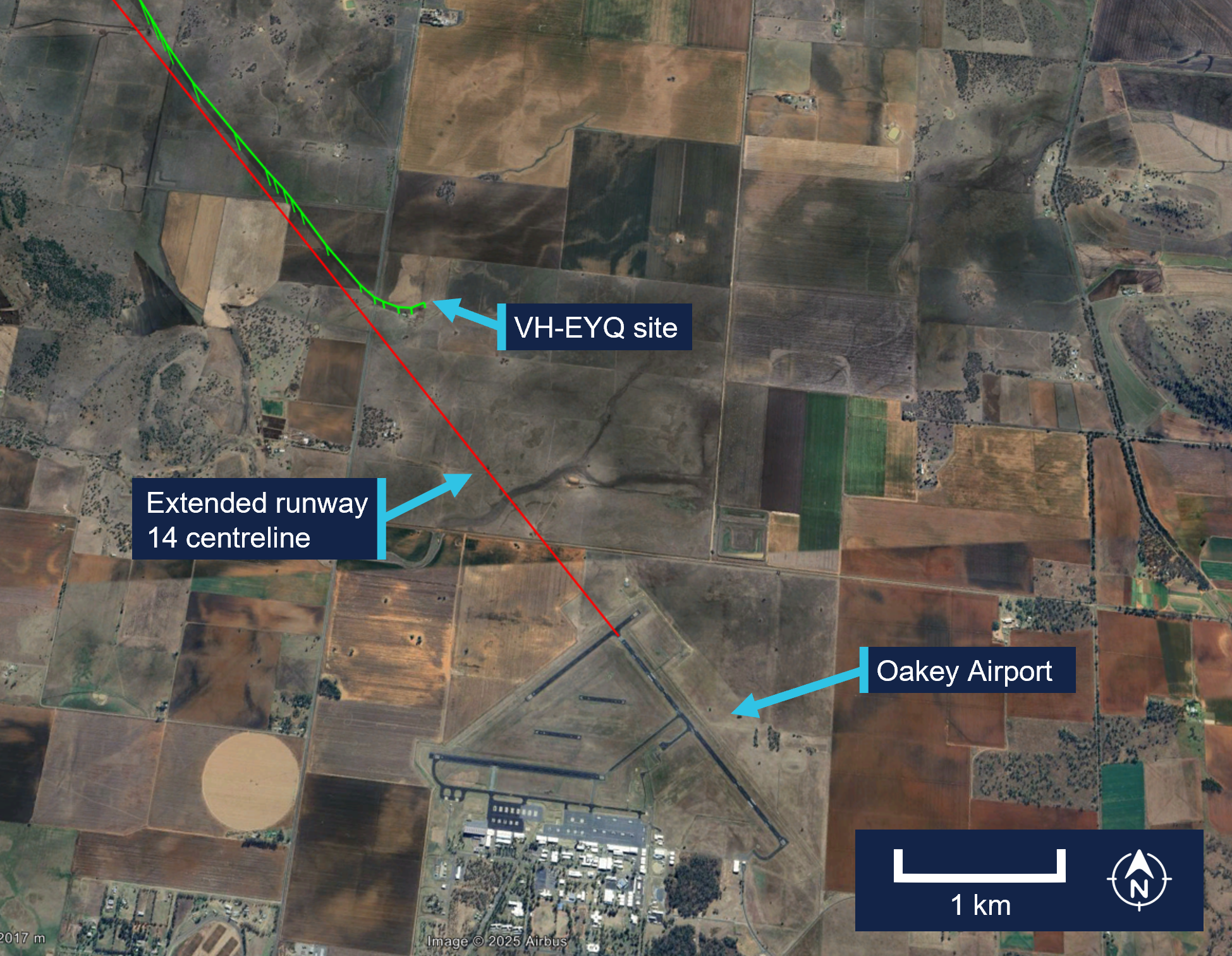
The ATSB is investigating a collision with terrain accident involving a Reims Cessna F406 aircraft, registered VH‑EYQ, near Oakey, Queensland, on 20 July 2025.
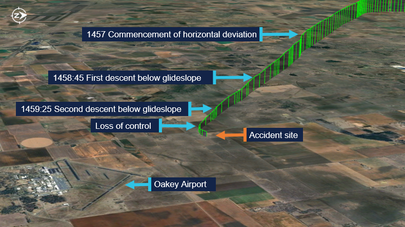
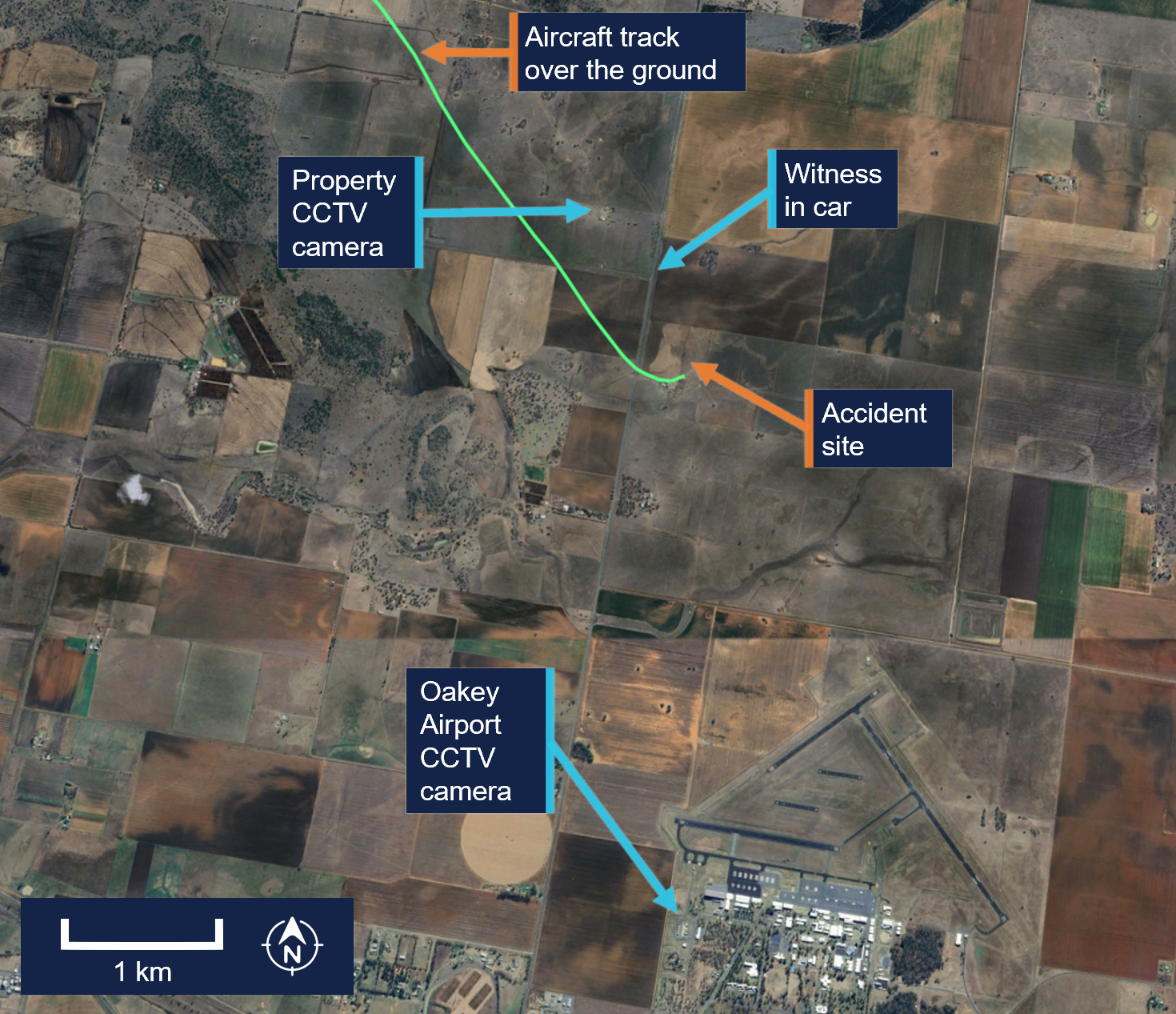
The aircraft was being used for a pilot check flight and was conducting an instrument approach to land at Oakey Army Aviation Centre when it collided with terrain in a field approximately 2 km from the runway. The 2 occupants on board, a pilot and a flight examiner, were fatally injured.
The ATSB has commenced the examination and analysis of the initial evidence collected.
To date, the ATSB has:
examined the wreckage and accident site
examined meteorological information
interviewed relevant parties
collected radio communication, aircraft traffic surveillance data, and navigational application data
collected aircraft, pilot, crew and operator documentation.
The investigation is continuing and will include review and examination of:
pilots’ recent history
propellers
maintenance records
pilot and crew training and medical records
operational procedures and documentation
further interviews with relevant parties
flight data and air traffic surveillance data
the requirements of conducting simulated one engine inoperative exercises at low heights.
A preliminary report, which detailed factual information established during the evidence collection phase, was released on 10 December 2025 (see below).
A final report will be released at the conclusion of the investigation. Should a critical safety issue be identified during the course of the investigation, the ATSB will immediately notify relevant parties, so that appropriate safety action can be taken.
Last updated:
Preliminary report
Report release date: 10/12/2025
This preliminary report details factual information established in the investigation’s early evidence collection phase, and has been prepared to provide timely information to the industry and public. Preliminary reports contain no analysis or findings, which will be detailed in the investigation’s final report. The information contained in this preliminary report is released in accordance with section 25 of the Transport Safety Investigation Act 2003.
Summary video
The occurrence
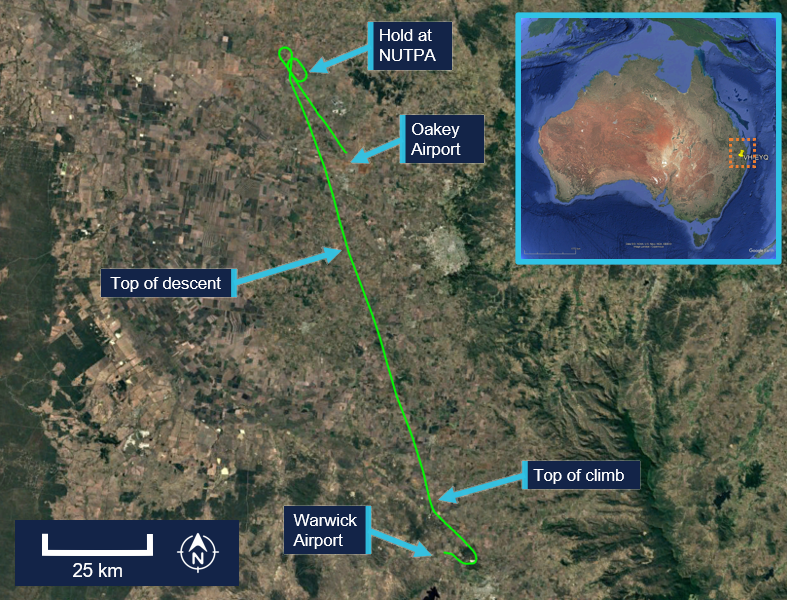
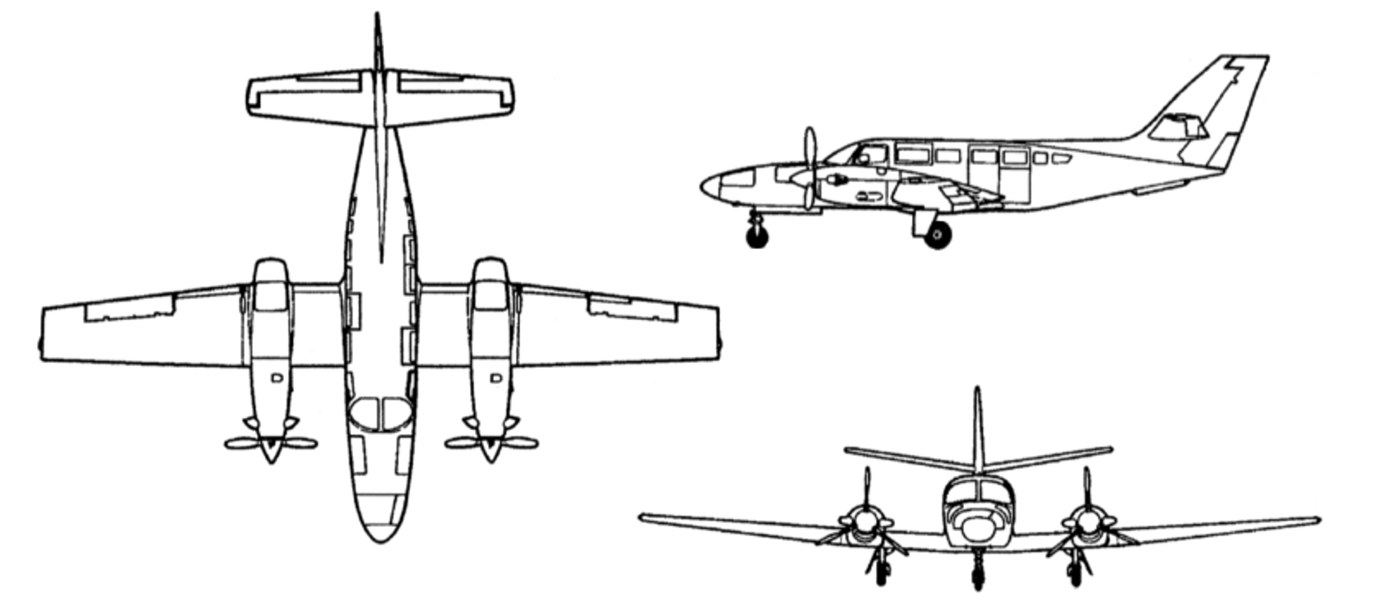
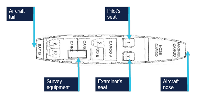
On 20 July 2025, a Reims Aviation F406 Caravan II, registered VH-EYQ, was being utilised for an instrument proficiency check (IPC)[1] with a pilot and a flight examiner on board. The flight was conducted under the instrument flight rules[2] and the planned route was from Warwick Airport to Oakey Airport, Queensland, later returning to Warwick Airport.
The IPC was the pilot’s third flight for the day. They had undertaken an aerial survey mission in VH-EYQ that morning for Aero Logistics, having departed Emerald Airport, Queensland, at 0747 and arrived at Archerfield Airport, Queensland, at 1208. The pilot refuelled the aircraft at Archerfield Airport and departed at 1308 for the flight to Warwick Airport for the purposes of undertaking the IPC.
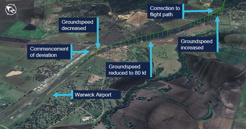
The pilot arrived at Warwick Airport at 1345 where they met the flight examiner. At 1426, the aircraft departed Warwick Airport. About 16 seconds after departure, the aircraft’s groundspeed began to decrease from 109 kt, and the aircraft stopped climbing and commenced a slow turn to the right (Figure 1). This turn was not consistent with the submitted flight plan. The aircraft’s groundspeed continued to reduce over a period of about one minute to 80 kt (see Recorded flight data). The aircraft then began to accelerate before turning left and commencing a climb to an altitude of 6,100 ft above mean sea level.
Figure 1: VH-EYQ departure from Warwick Airport
Source: Google Earth, annotated by the ATSB
At 1433, Brisbane Centre air traffic control (ATC) issued the pilot with a clearance to track directly to reporting point[3] NUTPA, which was the commencement point for the Oakey Airport runway 14 instrument landing system (ILS)[4] approach (Figure 2).
Figure 2: VH-EYQ flight overview
Source: Google Earth, annotated by the ATSB
At 1439, the pilot advised ATC that they would be conducting airwork in the Oakey area, not above an altitude of 4,000 ft, and they would contact ATC again on completion or by 1530. At that time, the Oakey Airport ATC tower was inactive. After commencing the descent for NUTPA at 1441, the pilot changed frequency to the common traffic advisory frequency (CTAF) in the Oakey Airport area, and all subsequent air-to-air communications took place on the CTAF. Between 1443 and 1454 the pilot made 5 transmissions on this frequency for traffic sequencing purposes.
At 1450, the aircraft passed overhead NUTPA and conducted one holding pattern. At 1456, the aircraft commenced a descent from 3,800 ft and the pilot made a radio broadcast to advise that the aircraft was established on the ILS.
At 1457, the aircraft began to deviate from the horizontal profile for the approach. The aircraft initially deviated right of the extended centreline and then to the left (Figure 3). Fluctuations in vertical speed also occurred during this period. The aircraft continued the approach slightly left of the extended centreline, but the vertical profile of the approach remained on the glideslope.[5] The wind conditions recorded at Oakey Airport at the time were a light breeze of 6 kt, with a mean direction of 190°M (see Meteorological information).
Figure 3: Final approach track
Source: Google Earth, annotated by the ATSB
At about 1458:45, and an altitude of 2,500 ft, the aircraft began to descend below the glideslope. This was initially corrected, and the aircraft flew level at about 2,200 ft for 30 seconds. At 1459:25, the aircraft descended below the glideslope again, and the descent continued to an altitude of about 1,700 ft, which equated to a height of between 300–400 ft above ground level (AGL). During this period the aircraft’s groundspeed began to decay. At 1459:39, the aircraft’s groundspeed had reduced to 85 kt (see Recorded flight data). At about 1459:53,[6] a 2‑second radio broadcast was made from the aircraft with an alarm sounding in the background.
A motorist travelling south observed the aircraft on approach and maintained visual contact with it for about 3 km (Figure 4). They observed the aircraft commence a flat turn and yaw[7] to the left at a height of about 300 ft AGL and pass above the road ahead of them. They recalled seeing the aircraft then roll to the left, pitch down, and impact the terrain.
Figure 4: Witness and closed-circuit television camera locations
Source: Google Earth, annotated by the ATSB
Closed-circuit television (CCTV) cameras located at a nearby property and Oakey Airport captured the aircraft commence a steep descent before colliding with terrain (Figure 5).
The aircraft was destroyed in a post-impact fire, and both occupants were fatally injured.
Figure 5: Composite images of recorded CCTV camera footage
Source: CCTV camera recordings
Context
Pilot information
Pilot experience
The pilot held a valid class 1 aviation medical certificate and an air transport pilot licence (ATPL) (aeroplane). Additionally, they held a grade 3 flight instructor rating with multi‑engine aeroplane training approval and design feature endorsements to operate VH-EYQ. The pilot held a valid multi-engine instrument rating with the previous instrument proficiency check (IPC) completed in August 2024.
At the time of the accident, the pilot had accumulated 5,767 hours total aeronautical experience. This included 4,170 flight hours as pilot in command with 3,514 hours in multi-engine aeroplanes and about 1,200 hours in command of a Reims F406. In the preceding 90 days they had flown 95 hours, including 54 hours in the Reims F406. They had worked for the aircraft operator since March 2017.
Known recent activity
The pilot’s work roster for the week prior to the accident (from 14 to 20 July 2025) is shown in Table 1. During this week, the pilot was based away from home and conducted multiple survey flights. The pilot’s duties for 20 July included the survey flight in the morning with no additional rostered flying.
Table 1: Pilot rostered duties, 14 to 20 July 2025
Date
Shift start-finish time
Total flight hours
14 July
OFF
0
15 July
0630-1430
1.5
16 July
0630-1430
2.1
17 July
0630-1430
1.8
18 July
0630-1430
2.4
19 July
OFF
0
20 July
0730-1500
5:31
A text message sent from the pilot the evening of 19 July indicated that the pilot had intended to conduct the IPC the following day. Additionally, the message indicated they had sleep opportunity from about 2130.
Flight examiner information
Flight examiner experience
The flight examiner held a valid class 1 aviation medical certificate and an ATPL (aeroplane). They also held grade 1 flight instructor and flight examiner operational ratings, with multi-engine aeroplane and instrument rating (aeroplane) training approval. Their flight instructor rating also had a spin endorsement, and they held design feature endorsements to operate VH-EYQ. The examiner held a valid multi-engine instrument rating with the previous IPC completed in October 2024.
The flight examiner’s logbook records were destroyed in the post-impact fire. Based on records of the pilot’s hours from January 2025, the flight examiner’s total aeronautical experience was in excess of 20,000 hrs. Additionally, they had flown 3 similar proficiency check flights for the aircraft operator in the previous 12 months, totalling 3.6 hours in the Reims F406. The flight examiner was external to the aircraft operator and was regularly hired to complete the IPC for their pilots.
Known recent activity
Along with their logbook, the flight examiner's work records were destroyed in the post‑impact fire.
A family member recalled that the flight examiner had returned from a chartered flight to western Queensland on Tuesday 15 July. During the week, they had spent a day providing aviation theory instruction to students but had no other work engagements. On the day of the accident, the flight examiner woke at their normal time. They were reported to have slept well and, when leaving home for the IPC flight, they appeared their normal self with no signs of fatigue.
Aircraft information
General information
The Reims Aviation F406 is a low wing, twin‑engine aircraft powered by 2 Pratt & Whitney Canada PT6A-112 turbine engines, each driving a 3-bladed McCauley constant speed, full-feathering propeller (Figure 6). The accident aircraft, serial number F406‑0047, was manufactured in France in 1990 and first registered in Australia as VH‑EYQ in 2012.
Figure 6: Reims F406
Source: ASI Aviation
Recent maintenance activity
The aircraft was to be maintained in accordance with the aircraft operator’s Civil Aviation Safety Authority (CASA) approved system of maintenance. This required a periodic inspection every 100 hours or 12 months, whichever came first. The system of maintenance allowed for periodic inspection intervals to be extended up to a maximum of 10 hours. The most recent periodic inspection was completed on 11 June 2025, at 17,376 hours in service. At the time of the accident, the aircraft had accumulated 17,475.6 hours total time in service.
Configuration
VH-EYQ was configured in a 5-seat survey layout. This comprised the pilot (left) and copilot (right) seats in the front row, followed by 1 passenger seat in row 3, and 2 passenger seats in row 5. The remaining passenger seats were removed from the cabin to accommodate the installation of aerial survey equipment (Figure 7). An electronic loading system had been generated for this configuration by an approved load controller, and records show that this was utilised by the pilot for previous flights.
Figure 7: VH-EYQ cabin configuration
Source: ASI Aviation, annotated by the ATSB
Weight and balance
Prior to its departure from Archerfield Airport, the aircraft was fuelled with 1,086 L of Jet A1 fuel. The aircraft operator advised that, based on this fuel uplift and the intended flying activity, it was very likely that the aircraft had full fuel on board for the flight to Warwick Airport. Fuel calculations based on flight times and expected consumption rates indicated that, at the time of the accident, the aircraft probably had about 1,280 L of fuel on board. This meant the aircraft weight at the time of the accident was about 600 kg below the aircraft’s maximum take-off weight. Based on the survey flying configuration and loading of the aircraft, the aircraft’s centre of gravity was calculated and assessed to be within prescribed limits.
Performance
The pilot operating handbook airplane flight manual (POH) provided applicable limitations which included:
a stall speed[8] of 75 KIAS[9] in the landing configuration (VSO), and 94 KIAS with flaps in the up position (VS)
an intentional one engine inoperative speed (VSSE)[10] of 98 KIAS
an air minimum control speed (VMCA)[11] of 90 KIAS
a one engine inoperative best rate-of-climb speed at sea level (VYSE) of 108 KIAS.
One engine inoperative procedures
The POH included recommended procedures in the event of an emergency. This included checklists for an engine failure in flight, and for the conduct of an approach and missed approach with one engine inoperative. The recommended approach speed with an engine inoperative was 110 KIAS reducing to 101 KIAS only once landing was assured.
Site and wreckage information
Accident site
The ATSB conducted an onsite examination of the aircraft wreckage, which was located in an open paddock about 2.6 km from the threshold of runway 14 at Oakey Airport (Figure 8).
Figure 8: Location of accident
Source: Google Earth, annotated by the ATSB
The wreckage was confined to a 30 m radius of the accident site. The impact marks and wreckage position indicated the aircraft impacted terrain left wing low with little forward momentum. Ground scars indicated the aircraft moved about 6 m after the initial impact. All components were upright.
The tail and aft cabin section showed signs of vertical compression. There was no fore or aft compression damage to the nose or wings. The left wing had separated from the aircraft just outboard of the left engine, and the right wing had separated just inboard of the right engine. Both wings had swung forward to lay parallel to the fuselage (Figure 9).
Figure 9: VH-EYQ accident site
Source: ATSB
All major aircraft components were accounted for at the point of impact. A post‑impact fire consumed the forward section of the aircraft to the aft cabin door (Figure 10). This damage limited the extent to which pre-impact defects could be identified.
Figure 10: VH-EYQ wreckage
Source: ATSB
Engines
Both engines were retained for further examination. This was conducted by ATSB investigators who were assisted by investigators from Pratt & Whitney Canada.[12] The engine examination determined:
there were no indications of pre-impact mechanical anomalies to any of the engine components that would have precluded normal engine operation
the left engine displayed indications that it was rotating at the time of impact
the right engine displayed characteristics that it was developing power at the time of impact.
Propellers
Both propellers showed indications that the engines were running at impact. The right propeller was determined to be in a fine pitch position[13] and exhibited bending in multiple directions.
Both propellers were retained, and an independent inspection was carried out at a propeller overhaul facility under the direction of ATSB investigators. Further analysis is required to determine the position of the left propeller at the time of impact.
Meteorological information
The Bureau of Meteorology (BoM) graphical area forecast valid at the time of the accident included the following conditions en route:
scattered cloud bases of 3,000 ft to 5,000 ft, extending up to 8,000 ft
isolated showers of rain with broken cloud from 1,000 ft to 2,000 ft and scattered cloud from 2,000 ft to above 10,000 ft.
At 1500, at about the same time the aircraft impacted terrain, the BoM issued a meteorological aerodrome report for Oakey Airport which reported the conditions at that time were:
a wind of 6 kt, with a mean direction of 190°M, varying between 160°M–220°M
Satellite images and CCTV footage captured areas of scattered cloud in the vicinity of the aerodrome at the time of the approach.
Flight activity
General
For a pilot to operate an aircraft under the instrument flight rules, they are required to hold an instrument rating. Pilots are also required to pass an annual instrument proficiency check (IPC) flight to ensure that they maintain the necessary skills and competency to operate safely. The purpose of the accident flight was for the pilot to complete their annual IPC.
An IPC can be completed by a flight examiner with an instrument rating, MPL[15] or ATPL (aeroplane) flight test endorsement, or by a person approved by CASA. While the aircraft operator had a training and checking system,[16] they scheduled IPC flights with external examiners and permitted the pilots to arrange their IPC flights privately. The head of flying operations (HOFO) of the aircraft operator recalled that the accident pilot had advised them that their IPC expiry date was approaching and requested the use of VH‑EYQ to complete the flight. In response, provisions were made by the HOFO and head of aircraft airworthiness and maintenance control delegate to make the aircraft available to the pilot for the purpose of conducting the IPC flight.
The pilot arranged the IPC with the external flight examiner and records show that the IPC was booked into the CASA flight test management system[17] by the flight examiner during the afternoon of 18 July and scheduled to take place on the afternoon of 20 July.
Instrument proficiency check assessment
During an IPC flight, a pilot’s competency is assessed in actual or simulated instrument meteorological conditions. During the flight, a pilot is required to meet specified standards for:
departure
en route skills
arrival
approach
missed approach
approach to land manoeuvres.
If the IPC is for multi-engine operations, the assessment also requires the satisfactory completion of a simulated one engine inoperative (OEI) departure and a simulated OEI approach.
The HOFO of the aircraft operator recalled that the external flight examiner had, in the past, typically conducted the simulated OEI departure after take-off from Warwick Airport and the simulated OEI approach at Oakey Airport.
Recorded information
Recorded flight data
The aircraft was not fitted with a flight data recorder or a cockpit voice recorder, nor was it required to be. During the accident flight, data was being transmitted by the aircraft’s automatic dependent surveillance broadcast (ADS-B) equipment. This data, recorded at 2–5 second intervals by amateur ground-based receivers, captured the aircraft’s position, altitude and groundspeed during the flight. Flight data was also being transmitted from a Spidertracks[18]tracking device fitted to the aircraft. This data, recorded at 15-second intervals, captured the aircraft’s position, altitude, groundspeed and heading during the flight.
The ADS-B altitude and groundspeed data for the aircraft’s departure from Warwick Airport is depicted in Figure 11.
Figure 11: VH-EYQ altitude and groundspeed during the Warwick Airport departure
Source: ATSB
The ADS-B altitude and groundspeed data for the aircraft’s ILS approach at Oakey Airport is depicted in Figure 12.
Figure 12: VH-EYQ altitude and groundspeed during the Oakey Airport approach
Source: ATSB
A Garmin GTN-650 global positioning system was also recovered from the accident site and transported to the ATSB’s Canberra technical facility for further examination. The unit showed signs of significant heat damage with melting and evidence of charring on the internal circuitry. The remains of 2 SD[19] cards were found within the unit, however, the post-impact fire had damaged the SD card memory chips to the point that data could not be extracted using normal recovery methods.
Record radio communications
All radio communications made and received by Airservices Australia throughout the entirety of VH-EYQ’s flight from Warwick Airport were recorded.
Recorded CCTV footage
Two CCTV cameras captured footage of the aircraft immediately prior to the collision with terrain. One camera was located on a property 1.4 km to the north-west of the accident and the second camera was located on Oakey Airport about 3 km south of the accident site.
The property CCTV footage was timestamped. The aircraft entered frame at 1459:53 and remained in frame for the duration of the recording which captured the collision with terrain at 1500:00.
The Oakey Airport CCTV footage did not contain a timestamp. The aircraft entered frame 1 second into the recording and remained in frame until the collision with terrain that occurred 7 seconds later.
Further investigation
To date, the ATSB has:
examined the wreckage and accident site
examined meteorological information
interviewed relevant parties
collected radio communication, aircraft traffic surveillance data, and navigational application data
collected aircraft, pilot, crew and operator documentation.
The investigation is continuing and will include review and examination of:
pilots’ recent history
propellers
maintenance records
pilot and crew training and medical records
operational procedures and documentation
further interviews with relevant parties
flight data and air traffic surveillance data
the requirements of conducting simulated one engine inoperative exercises at low heights.
A final report will be released at the conclusion of the investigation. Should a critical safety issue be identified during the course of the investigation, the ATSB will immediately notify relevant parties so appropriate and timely safety action can be taken.
Acknowledgements
The ATSB would like to acknowledge the assistance provided by the Australian Defence Force personnel at the Oakey Army Aviation Centre during the initial evidence collection activities.
Purpose of safety investigations
The objective of a safety investigation is to enhance transport safety. This is done through:
identifying safety issues and facilitating safety action to address those issues
providing information about occurrences and their associated safety factors to facilitate learning within the transport industry.
It is not a function of the ATSB to apportion blame or provide a means for determining liability. At the same time, an investigation report must include factual material of sufficient weight to support the analysis and findings. At all times the ATSB endeavours to balance the use of material that could imply adverse comment with the need to properly explain what happened, and why, in a fair and unbiased manner. The ATSB does not investigate for the purpose of taking administrative, regulatory or criminal action.
About ATSB reports
ATSB investigation reports are organised with regard to international standards or instruments, as applicable, and with ATSB procedures and guidelines.
Reports must include factual material of sufficient weight to support the analysis and findings. At all times the ATSB endeavours to balance the use of material that could imply adverse comment with the need to properly explain what happened, and why, in a fair and unbiased manner.
An explanation of terminology used in ATSB investigation reports is available here. This includes terms such as occurrence, contributing factor, other factor that increased risk, and safety issue.
Publishing information
Released in accordance with section 25 of the Transport Safety Investigation Act 2003
Ownership of intellectual property rights in this publication
Unless otherwise noted, copyright (and any other intellectual property rights, if any) in this report publication is owned by the Commonwealth of Australia.
Creative Commons licence
With the exception of the Commonwealth Coat of Arms, ATSB logo, and photos and graphics in which a third party holds copyright, this report is licensed under a Creative Commons Attribution 4.0 International licence.
The CC BY 4.0 licence enables you to distribute, remix, adapt, and build upon our material in any medium or format, so long as attribution is given to the Australian Transport Safety Bureau.
Copyright in material obtained from other agencies, private individuals or organisations, belongs to those agencies, individuals or organisations. Where you wish to use their material, you will need to contact them directly.
[1]Instrument proficiency check: an assessment of a pilot’s skills and operational knowledge required to exercise licence ratings and privileges when flying under the instrument flight rules.
[2]Instrument flight rules (IFR): a set of regulations that permit the pilot to operate an aircraft in instrument meteorological conditions (IMC), which have much lower weather minimums than visual flight rules (VFR).
[3]Reporting point: a specified geographical location in relation to which the position of an aircraft can be reported.
[4]Instrument landing system (ILS): a precision instrument approach system which normally consists of a VHF localiser providing horizontal guidance and a UHF glideslope providing vertical guidance.
[5]Glideslope: a component of the instrument landing system providing vertical (up/down) guidance toward the runway touchdown point, usually at a 3° slope.
[6]The provided CTAF recording was found to have a discrepancy that could not be resolved.
[7]Yaw: the motion of an aircraft about its vertical or normal axis.
[8]Aerodynamic stall: or stall, occurs when airflow separates from the wing’s upper surface and becomes turbulent. A stall occurs at high angles of attack, typically 16˚ to 18˚, and results in reduced lift.
[9]KIAS: indicated airspeed expressed in knots, used by pilots as a reference for all aircraft manoeuvres.
[10]The manufacturer’s minimum speed for rendering one engine inoperative in flight for pilot training.
[11]The minimum indicated airspeed at which the aircraft was laterally controllable with one engine inoperative and a 5° bank angle towards the operative engine.
[12]Pratt & Whitney Canada: engine manufacturer of the engines installed on VH-EYQ.
[13]Fine pitch: refers to a fine or low pitch angle which yields good low speed acceleration.
[14]QNH: the altimeter barometric pressure subscale setting used to indicate the height above mean seal level.
[16]Training and checking system: a training and checking system ensures that operational safety-critical personnel are proficient in the required competencies to support an operator's air operations.
[17]Flight test management system: online record system used to notify CASA of planned flight tests. Flight examiners also use the system to schedule and record the outcomes of flight tests and proficiency checks. The system is used by CASA to keep track of the flight testing process and analyse trends at industry level.
[18]Spidertracks: a satellite-based tracking system, combining satellite communication and GPS technology.
[19]Secure digital card (SD): a type of memory card typically used in portable devices.
Occurrence summary
Investigation number
AO-2025-042
Occurrence date
20/07/2025
Occurrence time and timezone
15:00 Australian Eastern Standard Time
Location
3.4 km north of Oakey Airport
State
Queensland
Report release date
10/12/2025
Report status
Preliminary
Anticipated completion
Q4 2026
Investigation level
Short
Investigation type
Occurrence Investigation
Investigation phase
Examination and analysis
Investigation status
Active
Mode of transport
Aviation
Aviation occurrence category
Collision with terrain, Loss of control
Occurrence class
Accident
Highest injury level
Fatal
Aircraft details
Manufacturer
Reims Aviation S.A.
Model
F406
Registration
VH-EYQ
Serial number
F406-0047
Aircraft operator
Bayswater Road Pty Ltd (trading as Aero Logistics)
Sector
Turboprop
Operation type
Part 91 General operating and flight rules
Activity
General aviation / Recreational-Instructional flying-Instructional flying - dual