
Summary
The ATSB is investigating a loss of control event involving a Bell 412EP, registered VH-VJF, 57 km north-east of Strahan Aerodrome, Tasmania, on 10 March 2025.
The helicopter was being operated by Coulson Aviation for firefighting operations using a sling‑loaded water bucket. While hovering to load the bucket from a river, the helicopter unexpectedly sank about 50 ft. In an attempt to recover, the pilot initiated forward flight but was unable to jettison the load before the longline became taut, causing a sudden stop and an abrupt tail-down motion. This resulted in the external hook and longline making contact with the lower fuselage.
The pilot flew back to the base at Zeehan where inspection identified damage to the helicopter’s fuselage, control tubes for both the engines and the tail rotor. Damage was also identified to the bucket and longline.
To date, the ATSB investigation has included:
- interviewing involved parties
- retrieving recorded data
- the collection of other relevant information
- reviewed recorded aircraft information
- reviewed the forecast and observed weather conditions
- reviewed maintenance documentation for VH-VJF
- analysed recorded helicopter information
- reviewed pilot training delivered by Coulson Aviation.
An interim report, which details factual information established during the course of the investigation, was released on 17 March 2026 (see below).
The continuing investigation will include:
- review of Coulson Aviation’s risk controls for bucketing operations in the Bell 412
- review of Coulson Aviation’s operational and reporting procedures
- review of Tasmanian Fire Service operational and reporting procedures.
In the course of the investigation, the ATSB has identified potential limitations in risk controls that are considered likely to have contributed to the occurrence. Examination of these factors represent a significant increase in the scope of this investigation, and it has been upgraded from Short to Defined as a result (the ATSB's different levels of investigation are detailed here).
The ATSB has completed the evidence collection and analysis phases of the investigation and is drafting the final report.
The final report will be released at the conclusion of the investigation. Should a critical safety issue be identified during the course of the investigation, the ATSB will immediately notify relevant parties, so that appropriate safety action can be taken.
Interim report
Report release date: 17/03/2026
| This interim report details factual information established in the investigation’s early evidence collection phase, and has been prepared to provide timely information to the industry and public. Interim reports contain no analysis or findings, which will be detailed in the investigation’s final report. The information contained in this interim report is released in accordance with section 25 of the Transport Safety Investigation Act 2003. |
The occurrence
Prior to the occurrence flight
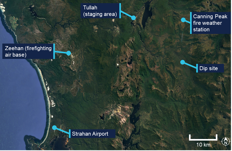
On 10 March 2025, a Bell 421EP, registered VH-VJF and operated by Coulson Aviation as HT204, was tasked with ground crew support operations on the Canning Peak fire, a sub‑fire of the West Coast fire complex in Tasmania.
At about 0830, the Tasmanian Fire Service briefed pilots on the weather and taskings for the day while at Strahan Airport. The Air Attack Supervisor (AAS) reported that the 2 Bell 412 helicopters were tasked with the insertion of crews into the fireground (HT201) and then firebombing[1] in support of those crews with a 150-ft longline and bucket[2] (HT204).
At about 0900, both helicopters departed Strahan Airport for Tullah, which was the designated staging area[3] for the activities. Approximately 25 minutes later both helicopters arrived at Tullah. The pilot of HT204 reported shutting down the helicopter and waiting until they were required for firebombing operations. The pilot of HT201 reported picking up a crew and completing an insertion into the fireground before returning to Tullah and remaining on standby in case an extraction was required.
First fuel cycle
At about 1215, HT204 was tasked with firebombing operations in direct support of ground crew who were undertaking hot and cold trailing.[4]
At 1226 local time the pilot departed Tullah for hotspots located west of the Murchison River on the south‑east end of the fire. The pilot was the only person on board. The pilot reported that the weather conditions on departure were calm, with a temperature of 22°C and light, variable winds.
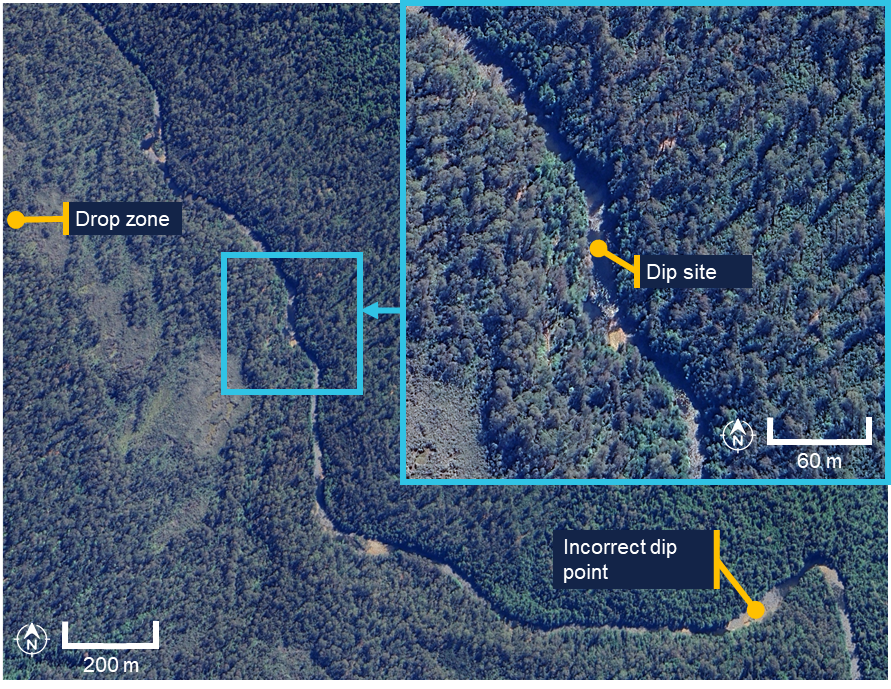
When reaching the dip site[5] the pilot completed one fuel cycle, approximately 10 bucket loads, under relatively stable conditions. The pilot described the dip site as a narrow section of river, approximately 50–60 m wide, with tall trees lining the bank (see also Dip site). The drop zone was located approximately 1 km west of the dip site.
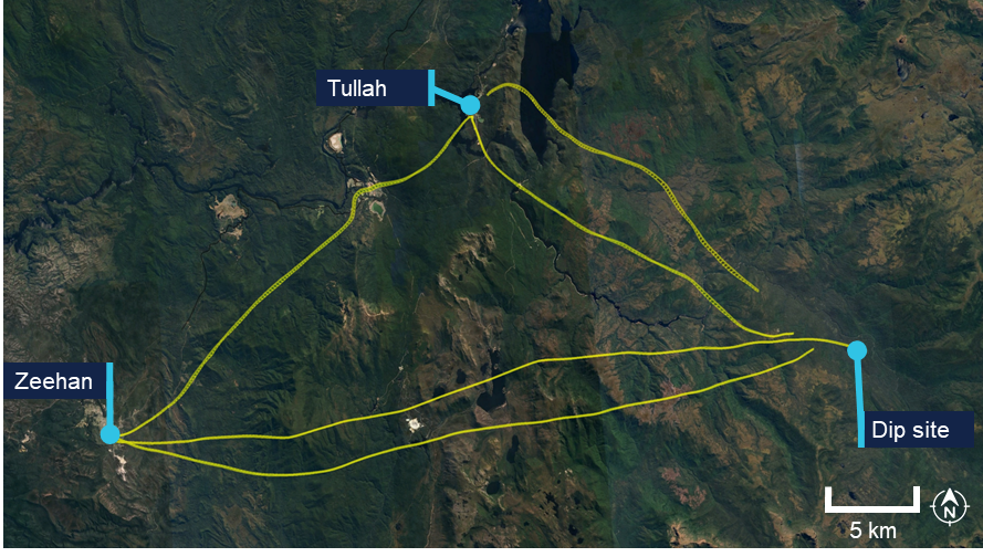
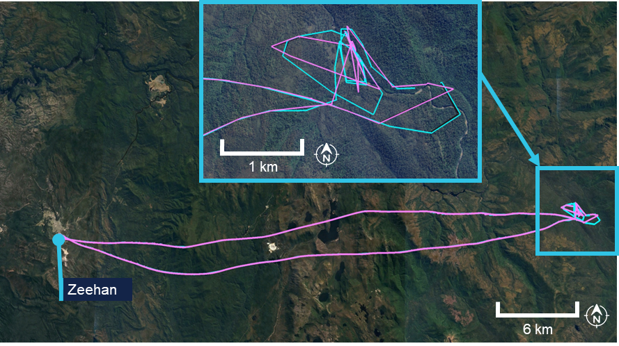
The pilot then returned to Tullah to pick up an air crew officer (ACO) at 1400 and continued onto the designated air base in Zeehan, which had a sports oval being used as a refuel base (Figure 1).
Figure 1: First fuel cycle and return to Tullah

White line: flight path of the first fuel cycle and return to Tullah. Purple line: flight path from Tullah to Zeehan. Source: Google Earth, annotated by the ATSB
Zeehan air base
During the approach to Zeehan, the pilot noted a significant weather change, with winds shifting to a westerly direction at approximately 30 knots.
While on the ground, the helicopter was refuelled for the next cycle. At about 1440 the pilot departed Zeehan and returned to the Canning Peak fireground.
Second fuel cycle and occurrence
The pilot recalled that various dip sites along the river looked similar. Flight data (Figure 2) indicated the pilot initially conducted a descent into an incorrect dip site. The pilot recognised this and undertook reconnaissance to find the intended dip site. Once reaching the dip site, the pilot resumed bucketing operations.
Figure 2: Second fuel cycle flight path

Source: Google Earth, annotated by the ATSB
The pilot reported that, at about 1525, while filling the third bucket load of water, the helicopter had been in a stable hover at about 150 ft above the water, when it unexpectedly sank. The pilot recalled the helicopter sinking approximately 50 ft. To recover control, the pilot applied forward cyclic and upward collective inputs to transition to forward flight and stabilise the helicopter, while aiming to avoid an over-torque event.
Prior to this manoeuvre, the pilot reported they were unable to jettison the longline, which they attributed to pressing on the button’s ring guard instead of its centre, and the longline subsequently became taut. The helicopter then came to an abrupt stop and the pilot heard a ‘loud clunking noise’. The pilot then recovered the helicopter to a stable hover approximately 30 ft above the water and initiated rearward flight to release the water and retrieve the bucket from the river. The pilot observed an engine torque split[6] and once the bucket and longline were recovered they initiated a climb to clear the surrounding trees.
The pilot reported that once they had cleared the trees, the torque split levelled back out. They conducted a range of tests to assess controllability and engine performance, including minor adjustments to engine torque. The pilot noted that the tail rotor control pedals felt stiff, however they continued to provide adequate input for sufficient helicopter control.
The pilot contacted the AAS on the fire common traffic advisory frequency (FCTAF) stating they had a bucket issue and a flight control issue.
The air attack pilot (who flew the helicopter with the AAS on board) oriented the helicopter to view HT204. The AAS recalled HT204 gaining altitude and tracking away from the Murchison River, over the fire, heading on a bearing south‑west uphill and back to Zeehan. They noted the helicopter was climbing slowly and appeared to be flying irregularly during this period. They reported they had not seen the occurrence as the dip site HT204 was using was beneath and behind the air attack helicopter.
The AAS contacted the pilot on the FCTAF. The pilot of HT204 reported issues with the helicopter pedals and when asked what their intention was, the pilot reported they were heading back to Zeehan. The AAS acknowledged this and reported they would follow HT204 back.
The pilot of HT204 assessed available landing options but elected to continue toward Zeehan rather than commit to an off-field landing. This decision was influenced by a previous experience where a potential landing site, assessed from approximately 500 ft, had appeared suitable but proved unsuitable upon reaching around 30 ft. The pilot considered that committing to a landing carried the risk of being unable to complete it safely.
The AAS and air attack pilot discussed possible landing options nearby. However, given the impaired controllability of HT204 and the smaller prepared landing areas on the fireground, they agreed the best action would be to return to Zeehan.
Return flight
The pilot of HT204 reported that, during the return flight to Zeehan, airspeed was maintained between 65 and 70 kt[7] due to the tail rotor pedals feeling stiff. This would reduce strain on the tail rotor by operating the helicopter at a lower power setting.
The pilot reported continuing the flight toward Zeehan with a plan that, should the situation deteriorate further, the flight would be changed to Strahan Airport as an alternative. Throughout the remainder of the flight, pedal inputs were minimised in an effort to avoid exacerbating the condition.
The AAS described the helicopter’s flight en route to Zeehan as appearing abnormal. In addition to the notably reduced speed, HT204 appeared to be yawing from side to side and maintained an unusually low height above ground. They reported that due to the pilot sounding stressed they did not contact the pilot further.
The AAS recalled contacting the air base manager at Strahan and the air operations manager and advised them of an unknown mechanical malfunction with HT204. They reported that the pilot was still in control, and that they were following HT204 back to Zeehan.
Landing at Zeehan
At about 1548, the pilot conducted a shallow approach to set up a vertical descent to the oval in Zeehan with the bucket and longline attached. During the landing sequence, the ACO secured the bucket and longline and moved it away and forward of the landing zone. The pilot then released the line and allowed the helicopter to sink, utilising available power, which resulted in what they stated ‘appeared to be a satisfactory landing with minimal pedal input required’.
After landing, during the shutdown procedure, the pilot was unable to roll the engine throttles back to idle. While disconnecting the longline from the hook, the ACO observed significant damage to the helicopter’s fuselage structure aft of the external hook.
The pilot of HT201 recalled that they landed and shut down their helicopter in Zeehan. They observed HT204 still running and the pilot underneath the helicopter assessing damage. They discussed the issue of not being able to roll the engines back and the pilot of HT201 suggested pulling the helicopter’s T-handles.[8] The T-handles were pulled to shut down the engines.
Context
Pilot information
The pilot held a Commercial Pilot (Helicopter) Licence, with a single engine class rating for helicopters. They held type ratings for the Bell 212, 412 and 427. The pilot’s total aeronautical experience was over 3,000 hours of which 120.6 hours were on the Bell 412. In the previous 90 days the pilot had flown 50.3 hours, all on the Bell 412.
The pilot was qualified to conduct helicopter firefighting operations and had low‑level and sling operation ratings.
The pilot last completed an aerial application proficiency check on 11 November 2024, which was valid for 12 months, and a low-level helicopter flight review on 4 December 2023.
The pilot held a valid Class 1 aviation medical certificate, valid to July 2025. The certificate specified that the pilot was to wear distance vision correction while flying, which was being worn on this occasion.
Helicopter information
General information
The Bell Helicopter Company 412EP is a medium‑lift[9] utility helicopter commonly used for firefighting, search and rescue and transport operations. The helicopter had a 4-blade main rotor and 2‑blade tail rotor and was powered by 2 Pratt & Whitney PT6T-3DF turboshaft engines. The helicopter was manufactured in Canada in 2004 and first registered in Australia in 2020. The helicopter was owned by NSW Rural Fire Service (RFS) and operated by Coulson Aviation Australia.
VH-VJF had accumulated about 4,819 flight hours total time in service and had a current certificate of airworthiness and registration. The helicopter’s technical log indicated no outstanding defects at the time of the accident.
The helicopter’s multi-role configuration enabled it to be utilised in a range of aerial firefighting tasks, including reconnaissance, winching operations and firebombing using either a belly tank or external bucket system (Figure 3).
Figure 3: NSW RFS Bell 412 EP VH-VJF

Source: Lesley de Robllard, annotated by the ATSB
On the day of the accident, the helicopter was configured for firebombing operations and was fitted with an external load system, a vertical reference door, and a 150‑ft longline attached to a Bambi bucket[10] (see Bucket and longline information). In addition to these items, the helicopter also had a forward looking infrared (FLIR) camera mounted on the left‑hand side of the helicopter above the skids.
External load system
VH-VJF was equipped with an Onboard Systems International cargo hook suspension system. The system attached to an existing Bell hard point and hung at approximately the centre of gravity. It extended through an opening in the lower fuselage, which was fitted with a protective rubber ring around the edge (Figure 4). This protective ring was used to reduce the risk of damage if the hook hit the edge of the opening.
Figure 4: Onboard Systems International cargo hook suspension system on the Bell 412
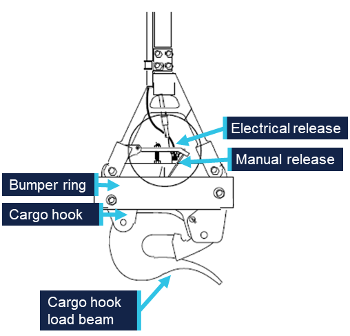
Source: Onboard Systems International, annotated by the ATSB
The release of the hook could be initiated electrically or mechanically. Normal release was completed by pilot actuation of a push button on the side of the cyclic (Figure 5, left). The button is guarded by a small ring to prevent inadvertent pilot activation. When this button is pressed the latch of the cargo hook is opened.
In addition to the electrical release, in an emergency a mechanical release can be completed by pushing a small pedal located between the 2 tail rotor pedals at the pilot’s feet (Figure 5, right). This activated a manual release cable attached to the cargo hook.
The cargo hook suspension system was required to be inspected annually or after 100 hours of external load operations, whichever came first. The system was last inspected on 20 February 2025.
Figure 5: Electrical and mechanical external load release systems

Left: the electrical release found on the cyclic grip. Right: mechanical release between the 2 pedals. Source: Coulson Aviation, annotated by the ATSB
Coulson Aviation required pilots to test the electrical and manual release system prior to conducting flights for the day. The pilot recalled testing both the electrical and mechanical release the morning of the accident. They stated that both systems were in working order. In addition to the tests, the pilot recalled that when landing at Zeehan after the accident, the electrical release was used to drop the longline and bucket without issue.
Coulson Aviation reported that both the electrical and mechanical releases of the hook were tested following the accident. Both were reported as serviceable.
Vertical reference door
The Bell 412EP helicopters are usually flown from the right-hand seat. This configuration is used when pilots are conducting either winching or reconnaissance operations. The helicopters can be modified to include a vertical reference door, which is designed to provide the pilot with a side bubble window and instruments for longline operations from the left-hand seat.
VH-VJF was modified with a vertical reference door in accordance with the Transwest vertical reference door supplement type certificate. This included a bubble window, viewing slot, and instruments and warning lights installed in the door (Figure 6).
Figure 6: Instruments and warning lights installed in the vertical reference door

Source: Coulson Aviation, annotated by the ATSB
In addition to the instruments and warning lights, the type certificate required the installation of several systems to be placed on the left side of the helicopter. This included:
- a force trim switch, cargo release switch and automatic flight control system (AFCS) release switch mounted on the left cyclic
- the torque meter and tachometer from the left-hand instrument panel moved to the vertical reference door
- an additional mechanical cargo release pedal between the left side pedals.
During the occurrence flight and other firebombing operations, the pilot was operating the helicopter from the left-hand seat, utilising the left cyclic and referencing the flight instruments through the vertical reference door. While conducting the water collection, the torque indicator was visible through the bubble window and could be monitored during the lift.
Bucket and longline information
The bucket and longline were attached to the external load system via a bow shackle (Figure 7, left).
The bucket was a Bambi Max bucket with a nominal capacity of 240 US gallons (910 L). The empty weight of the bucket was 137 lb (62 kg) and the maximum gross weight was 2,140 lbs (970 kg).
The collapsable bucket was equipped with multiple selectable drop valves. Pilots were able to use the bucket to split water loads into multiple drops (Figure 7, right) and had the capability to shed the load rapidly.
Figure 7: Longline attachment and Bambi Max bucket

Source: Coulson Aviation, annotated by the ATSB
The longline was constructed from high-strength synthetic fibre rope selected for its high tensile strength, low stretch characteristics, light weight, and resistance to heat and abrasion. The line incorporated an electrical cable along the line to control bucket release. The 150-ft length provided vertical separation between the helicopter and the load to reduce rotor downwash disturbance during water pick‑up.
Forward looking infrared (FLIR) camera
FLIR cameras are used on aerial firefighting aircraft to provide thermal imaging of fire grounds, enabling crews to detect heat sources through smoke, darkness, or challenging terrain. This capability allows operators to identify fire hotspots, monitor fire spread, and support decision-making for resource deployment and suppression strategies.
On the Bell 412s, the FLIR camera was mounted on the left side, just above the skids. Coulson Aviation stated that although the cameras could be removed, they would generally be kept on the helicopters throughout all operations, allowing the ability for the crews to be re-tasked for reconnaissance missions. Some pilots indicated to the ATSB that the camera could partially obscure visibility during bucketing.
Helicopter damage
The ATSB did not examine the helicopter or equipment. Coulson Aviation conducted an examination of the helicopter the morning after the occurrence. The following damage was identified:
- The #1 engine control tube had sheared at the lower tube end bell crank, resulting in a complete loss of pilot input to the engine.
- The #2 engine control tube bell crank attachment bracket had detached from the helicopter structure’s securing rib, restricting pilot control of the engine.
- The tail rotor control rod on the right-hand side of the external hook’s bell crank airframe attachment had broken away, with the primary structure also separated.
- The main transmission oil cooler pressure line exhibited significant contact damage, however, no splits or leaks were identified.
- The fuel tank interconnect braided hoses sustained minor contact damage.
- Multiple aft fuselage drain lines were damaged.
Images of the helicopter indicated that the structural fuselage honeycomb aluminium skin, adjacent to and aft of the external hook, was deformed and had separated from the primary structure (Figure 8).
Figure 8: Helicopter aluminium skin damage
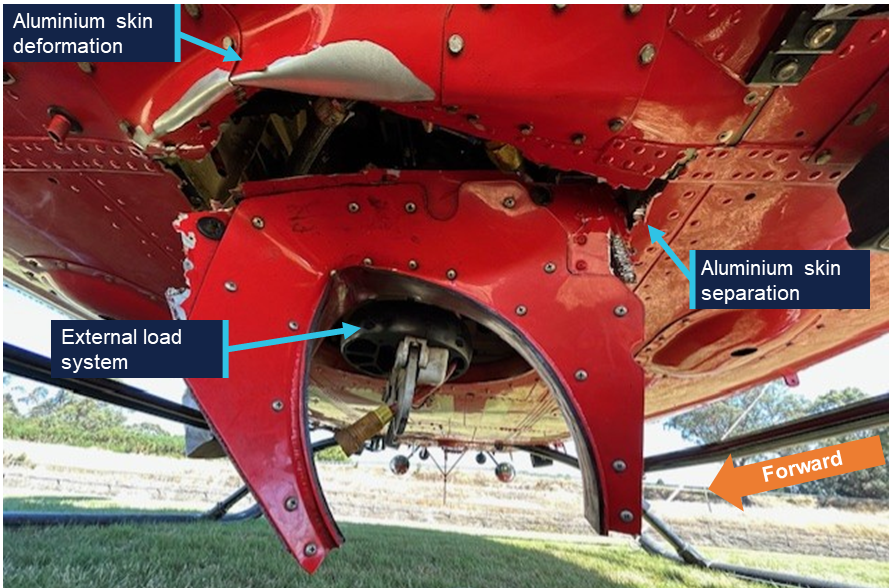
Source: Coulson Aviation, annotated by the ATSB
Images revealed indications consistent with contact between the longline and the rear cross tubes of the helicopter. In addition, inspection of the cargo hook and associated bumper stop components identified visible signs of impact damage (Figure 9).
Figure 9: External load system damage
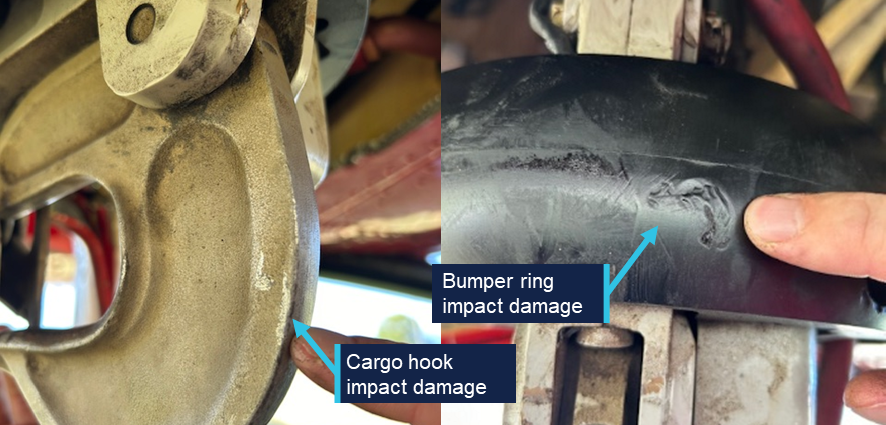
Source: Coulson Aviation, annotated by the ATSB
In addition, the ring in the middle of the Bambi bucket spoke assembly was fractured in 4 places (Figure 10).
Figure 10: Bambi Max damage to spoke assembly
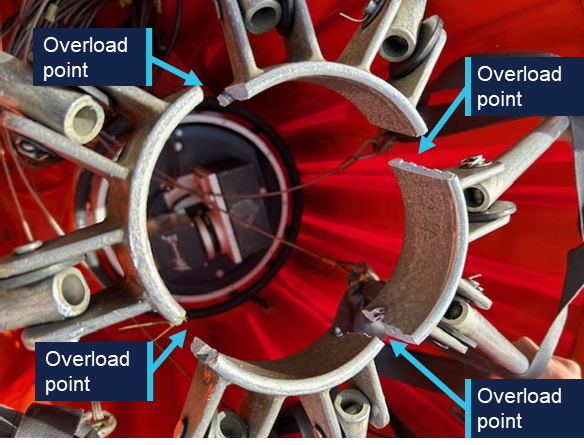
Source: Coulson Aviation, annotated by the ATSB
Multiple instances of cable bruising and stretching were reported to have been observed on the bucket cable wiring and attachment eye ends. The ATSB was unable to substantiate the presence of cable bruising and stretching based on the images provided of the cables.
Weather data
On departure from Strahan Airport, the meteorological aerodrome report (METAR)[11] reported wind west‑north-west at 6 kt, visibility greater than 10 km and no cloud cover.
The Tasmania Fire Service (TFS) incident action plan indicated that weather on the Canning Peak fire would change from north-westerly to west-south‑westerly by mid‑morning with winds reaching 10 kt by the afternoon (Table 1).
Table 1: Canning Peak fire forecast
| Local time | Temperature (°C) | Dew point (°C) | Wind direction | Wind speed (kt) | Wind gust (kt) |
| 0800 | 14 | 12 | N | 5 | 8 |
| 0900 | 17 | 13 | NNW | 8 | 10 |
| 1000 | 19 | 14 | NW | 8 | 14 |
| 1100 | 22 | 14 | WNW | 8 | 14 |
| 1200 | 23 | 14 | W | 10 | 16 |
| 1300 | 25 | 14 | W | 10 | 16 |
| 1400 | 26 | 13 | WSW | 10 | 16 |
| 1500 | 26 | 13 | WSW | 8 | 14 |
| 1600 | 26 | 13 | WSW | 8 | 10 |
The AAS reported that on the day of the accident the wind was calm, there was no turbulence and ‘great’ visibility. A change in wind direction was noted from mid-morning changing from northerly to south-westerly, however this was expected based on the forecast. They recalled the area in which the aircraft were working in was protected from south‑westerly winds due to the topography. They reported no feedback from pilots regarding the weather or any other environmental conditions on the day.
The pilot of HT201 reported there were blue skies and fairly light winds on the day of the accident. They recalled that although they were not bucketing on this day, during previous bucketing operations in the same valley, the wind conditions were variable and the wind would shift ‘back and forth’.
A weather station atop Mt Inglis, approximately 15 km north of the operating area (Figure 11), recorded south‑south-westerly winds at 5.7 kt gusting to 11.4 kt at the time of the accident.
Figure 11: Canning Peak weather station location to dip site
Source: Google Earth, annotated by the ATSB
Fireground information
The West Coast fire complex originated from 24 individual ignitions sparked by dry lightning strikes on 3 February 2025, across Tasmania’s remote western and north‑western regions. These separate fires were grouped into a single complex for coordinated management due to their proximity, shared weather influences, and overlapping spread patterns.
There were 4 primary firegrounds that accounted for the majority of the burnt area: the Canning Peak fireground, the Yellowband Plain fireground, the Mount Donaldson fireground, and the Corinna Road fireground. Each represented a distinct sector with unique terrain, vegetation types, and behavioural characteristics. These firegrounds collectively contributed to the complex’s total footprint of nearly 95,000 hectares.
Canning Peak fireground
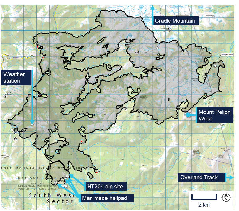
The Canning Peak fireground was located in a more elevated and vegetated zone close to the Cradle Mountain area and in proximity to sections of the Overland Track. This sector featured rugged alpine-influenced terrain that complicated direct ground access, leading to heavy reliance on aerial suppression tactics.
Figure 12: Canning Peak fireground
Black outline indicates area which has been burnt by fire. Source: Tasmania Parks and Wildlife Service, annotated by the ATSB
Day of accident
On the day of the accident HT201 was the designated winching helicopter and HT204 was part of the bucketing helicopters on the fireground. There were 6 helicopters (3 x AS350, 1 x Bell 412 (HT204), 1 x Bell 212, 1 x BK 117) bucketing within a 2 km proximity of each other intermittently. In addition, the air attack helicopter was on scene overhead.
The helicopters were distributed across 4 separate circuits, with 5 separate dip points, seperate individual and shared targets and some shared ground crew.
Dip site
The pilot reported that the general location for a dip site was provided prior to commencing operations on the fireground, with selection of the specific section of river within that area being at their discretion. The pilot advised that they chose this dip site location on the river as it was relatively wider than other areas and they had used this section as a dip site on the days preceding the accident.
HT204’s dip site was approximately 700 m from the next nearest dip site with working helicopters. The dip site was approximately 1 km south‑east of the drop zone, along the Murchison River. Google Earth images indicate the river width at the dip point was approximately 20 m (Figure 13).
Figure 13: Dip site location on Murchison River
Source: Google Earth, annotated by the ATSB
The pilot described the dip site as a narrow section of river, approximately 50–60 m wide, with tall trees lining the bank. They reported that there were limited locations deep enough to operate the bucket, which constrained where they could dip and they stated they had used the same dip point on the days prior.
In addition, the river contained very little water at the time, allowing clear visibility to the riverbed. They stated that they could not recall whether any tree branches or rocks were present in the riverbed during the operation. Despite the presence of tall trees, the pilot indicated that the area was accessible to the aircraft and considered it one of the better dip sites along the river. They also noted that the turnaround time from the dip point to the fireground was approximately one minute.
The AAS described the dip site as a section of river with trees approximately 30–60 m tall on either side. They recalled that the pilot was the only one using the dip point and the only helicopter in the circuit. In previous weeks, when different crews had flown the same helicopter on similar missions, no pilots had reported any problems with the dip point. Based on the dips that were observed, the occurrence pilot appeared to be performing them safely and adequately.
Recorded data
Multiple independent data sources, including TracPlus satellite-based tracking logs, FlightAware ADS-B derived positions, and OzRunways electronic flight bag recordings, were cross‑referenced and correlated to reconstruct the helicopter’s flights throughout the day and to approximate the entry and exit angles into and out of the bucketing site.
TracPlus
The helicopter was fitted with a TracPlus surveillance system, which provided real-time tracking through a satellite or mobile phone network. It reported position, altitude, and speed at set time periods, in this case every 15 seconds.
OzRunways
The OzRunways application recorded the helicopter’s position at regular intervals of approximately 5 seconds throughout the day, capturing parameters including latitude, longitude, groundspeed, track, and truncated altitude (in 100 ft increments) where connectivity permitted. However, no position data was recorded during the bucketing operations (Figure 14). This absence of recorded data was likely attributable to the helicopter operating at very low levels, down to around 150 ft above ground level, while conducting repeated drops in mountainous terrain.
Figure 14: OzRunways flight data
Source: Google Earth, annotated by the ATSB
FlightAware
The FlightAware flight tracking data captured the helicopter’s en route flight to the bucketing site, as well as the subsequent low-level manoeuvres involving repeated water dips and drops. Position reports were recorded at irregular intervals ranging between approximately 8 seconds and 40 seconds[12] during these operations.
In addition to the TracPlus data, FlightAware was incorporated into the data analysis. The differing sampling rates and coverage characteristics of the 2 systems together produced a more complete reconstruction of the helicopter’s flight circuit during the second fuel cycle (Figure 15).
Figure 15: Second fuel cycle data from TracPlus and FlightAware
Pink line: TracPlus data. Blue line: FlightAware data. Source: Google Earth, annotated by the ATSB
Further investigation
To date, the ATSB has conducted the following activities:
- interviewed the pilot and other Coulson Aviation personnel
- interviewed the air attack supervisor from Tasmania Parks and Wildlife Service
- reviewed recorded aircraft information
- reviewed the forecast and observed weather conditions
- reviewed maintenance documentation for VH-VJF
- analysed recorded helicopter information
- reviewed pilot training delivered by Coulson Aviation.
The investigation is continuing and includes:
- review of Coulson Aviation’s risk controls for bucketing operations in the Bell 412
- review of Coulson Aviation’s operational and reporting procedures
- review of Tasmanian Fire Service operational and reporting procedures.
A final report will be released at the conclusion of the investigation. Should a critical safety issue be identified during the course of the investigation, the ATSB will immediately notify relevant parties so appropriate and timely safety action can be taken.
Purpose of safety investigationsThe objective of a safety investigation is to enhance transport safety. This is done through:
It is not a function of the ATSB to apportion blame or provide a means for determining liability. At the same time, an investigation report must include factual material of sufficient weight to support the analysis and findings. At all times the ATSB endeavours to balance the use of material that could imply adverse comment with the need to properly explain what happened, and why, in a fair and unbiased manner. The ATSB does not investigate for the purpose of taking administrative, regulatory or criminal action. About ATSB reportsATSB investigation reports are organised with regard to international standards or instruments, as applicable, and with ATSB procedures and guidelines. Reports must include factual material of sufficient weight to support the analysis and findings. At all times the ATSB endeavours to balance the use of material that could imply adverse comment with the need to properly explain what happened, and why, in a fair and unbiased manner. An explanation of terminology used in ATSB investigation reports is available here. This includes terms such as occurrence, contributing factor, other factor that increased risk, and safety issue. Publishing informationReleased in accordance with section 25 of the Transport Safety Investigation Act 2003 Published by: Australian Transport Safety Bureau © Commonwealth of Australia 2026 
Ownership of intellectual property rights in this publication Unless otherwise noted, copyright (and any other intellectual property rights, if any) in this report publication is owned by the Commonwealth of Australia. Creative Commons licence With the exception of the Commonwealth Coat of Arms, ATSB logo, and photos and graphics in which a third party holds copyright, this report is licensed under a Creative Commons Attribution 4.0 International licence. The CC BY 4.0 licence enables you to distribute, remix, adapt, and build upon our material in any medium or format, so long as attribution is given to the Australian Transport Safety Bureau. Copyright in material obtained from other agencies, private individuals or organisations, belongs to those agencies, individuals or organisations. Where you wish to use their material, you will need to contact them directly. |
[1] Firebombing: The National Aerial Firefighting Centre states that firebombing is the dropping of fire suppressant or fire retardant from an aircraft to assist with the control or suppression of a fire.
[2] Firebombing with a bucket, often known as ‘bucketing’, requires filling the bucket by lowering it into a water source, and emptying it as required at the flame front.
[3] A staging area is a designated location where aircraft and crews temporarily assemble and wait for tasking to active fires.
[4] Hot and cold trailing is a task requiring identification of hotspots along the fire perimeter, opening these areas/smouldering ground fire up with hand tools and directing pilots to drop buckets atop the burning material to prevent further fire spread.
[5] A dip site is a designated water source where helicopters equipped with buckets can collect water for aerial firefighting. These sites can be natural bodies of water, such as lakes, rivers, or ponds, or artificial sources like reservoirs and water tanks. Their key requirements are sufficient water depth, accessibility, and proximity to the fire to maximise efficiency.
[6] Engine torque split in a multi-engine helicopter is where there is an unequal proportion of total main rotor torque shared between each engine through the gearbox.
[7] The Bell 412EP cruise speed is 122 kt.
[8] The T-handles are a red handle which pilots pull in an emergency to shut off fuel, hydraulics, and other systems to an engine while arming the fire extinguishing bottles.
[9] A medium-lift helicopter is one capable of carrying moderate loads, typically between 2,000 kg and 5,000 kg.
[10] A Bambi bucket is a collapsible water bucket suspended beneath a helicopter, used to collect and drop water during aerial firefighting operations.
[11] METAR (Meteorological Aerodrome Report) is a routine aerodrome weather report issued at half‑hourly intervals. The report ordinarily covers an area of 8 km radius from the aerodrome reference point.
[12] This update rate arises from the way FlightAware processes ADS-B data: although equipped aircraft transmit position messages nominally every second, the displayed track depends on signals received by a network of ground stations. In remote hilly terrain, at low altitudes down to around 150 ft AGL, terrain shadowing, ridges, valleys, and line-of-sight limitations can prevent some transmissions from being captured reliably. As a result, FlightAware relies on the most consistent available reports, leading to longer effective intervals of 25–40 seconds or more during intermittent low-level reception.
Occurrence summary
| Investigation number | AO-2025-013 |
|---|---|
| Occurrence date | 10/03/2025 |
| Occurrence time and timezone | 15:25 Australian Eastern Daylight Time |
| Location | 57 km north-east of Strahan Airport |
| State | Tasmania |
| Report release date | 17/03/2026 |
| Report status | Interim |
| Anticipated completion | Q3 2026 |
| Investigation level | Defined |
| Investigation type | Occurrence Investigation |
| Investigation phase | Final report: Drafting |
| Investigation status | Active |
| Mode of transport | Aviation |
| Aviation occurrence category | Collision with terrain, Control issues, Loss of control, Miscellaneous - Other |
| Occurrence class | Accident |
| Highest injury level | None |
Aircraft details
| Manufacturer | Bell Helicopter Co |
|---|---|
| Model | 412EP |
| Registration | VH-VJF |
| Serial number | 36329 |
| Aircraft operator | Coulson Aviation (Australia) Pty Ltd |
| Sector | Helicopter |
| Operation type | Part 138 Aerial work operations |
| Activity | General aviation / Recreational-Aerial work-Firefighting |
| Departure point | Tullah Helicopter Landing Site, Tasmania |
| Destination | Zeehan Aircraft Landing Area, Tasmania |
| Injuries | None |
| Damage | Substantial |