
Summary
The ATSB is investigating a collision with terrain accident involving a Reims Cessna F406 aircraft, registered VH‑EYQ, near Oakey, Queensland, on 20 July 2025.
The aircraft was being used for a pilot check flight and was conducting an instrument approach to land at Oakey Army Aviation Centre when it collided with terrain in a field approximately 2 km from the runway. The 2 occupants on board, a pilot and a flight examiner, were fatally injured.
The ATSB has commenced the examination and analysis of the initial evidence collected.
To date, the ATSB has:
- examined the wreckage and accident site
- examined meteorological information
- interviewed relevant parties
- collected radio communication, aircraft traffic surveillance data, and navigational
application data - collected aircraft, pilot, crew and operator documentation.
The investigation is continuing and will include review and examination of:
- pilots’ recent history
- propellers
- maintenance records
- pilot and crew training and medical records
- operational procedures and documentation
- further interviews with relevant parties
- flight data and air traffic surveillance data
- the requirements of conducting simulated one engine inoperative exercises at low heights.
A preliminary report, which detailed factual information established during the evidence collection phase, was released on 10 December 2025 (see below).
A final report will be released at the conclusion of the investigation. Should a critical safety issue be identified during the course of the investigation, the ATSB will immediately notify relevant parties, so that appropriate safety action can be taken.
Last updated:
Preliminary report
Report release date: 10/12/2025
| This preliminary report details factual information established in the investigation’s early evidence collection phase, and has been prepared to provide timely information to the industry and public. Preliminary reports contain no analysis or findings, which will be detailed in the investigation’s final report. The information contained in this preliminary report is released in accordance with section 25 of the Transport Safety Investigation Act 2003. |
Summary video
The occurrence
On 20 July 2025, a Reims Aviation F406 Caravan II, registered VH-EYQ, was being utilised for an instrument proficiency check (IPC)[1] with a pilot and a flight examiner on board. The flight was conducted under the instrument flight rules[2] and the planned route was from Warwick Airport to Oakey Airport, Queensland, later returning to Warwick Airport.
The IPC was the pilot’s third flight for the day. They had undertaken an aerial survey mission in VH-EYQ that morning for Aero Logistics, having departed Emerald Airport, Queensland, at 0747 and arrived at Archerfield Airport, Queensland, at 1208. The pilot refuelled the aircraft at Archerfield Airport and departed at 1308 for the flight to Warwick Airport for the purposes of undertaking the IPC.
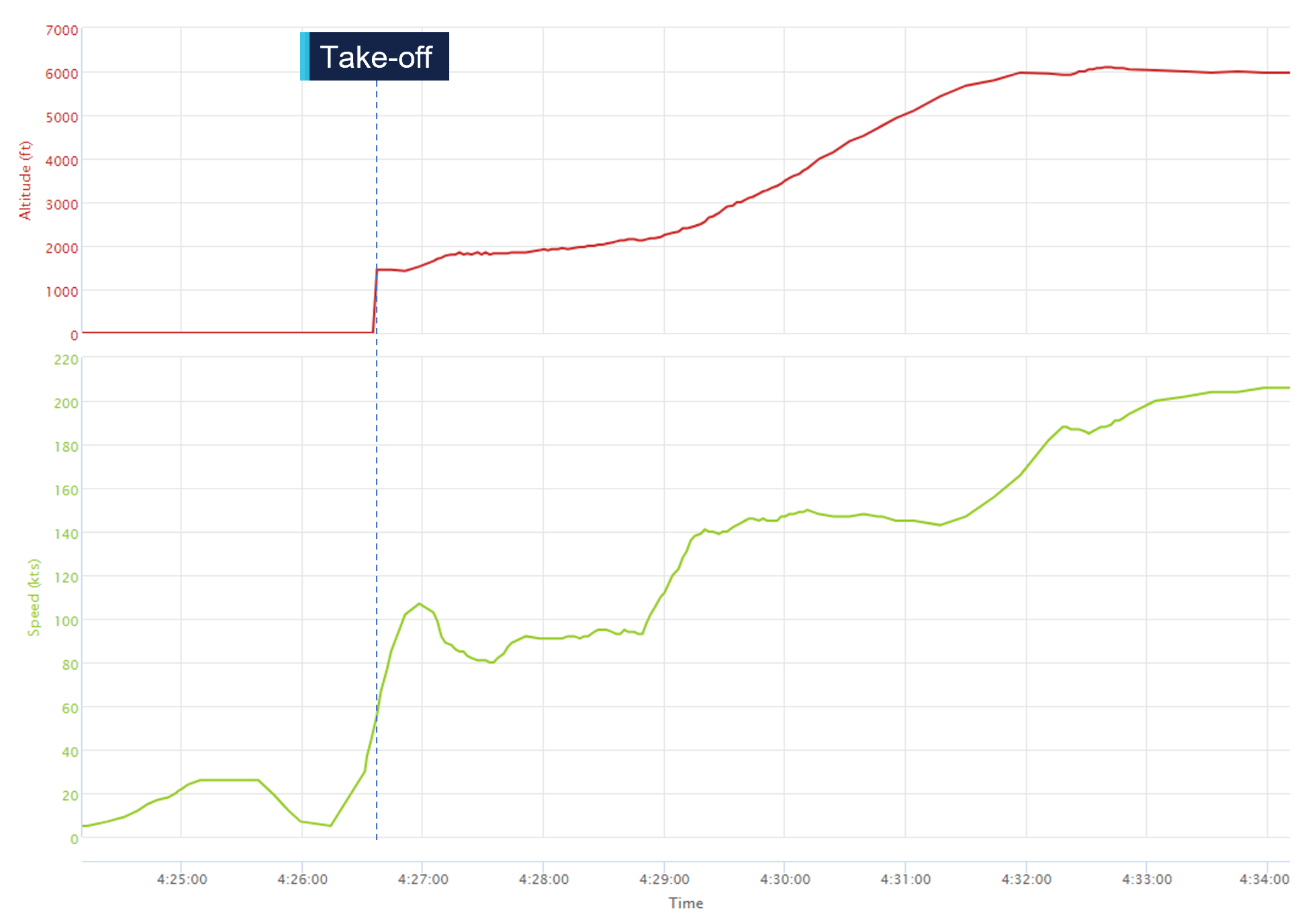
The pilot arrived at Warwick Airport at 1345 where they met the flight examiner. At 1426, the aircraft departed Warwick Airport. About 16 seconds after departure, the aircraft’s groundspeed began to decrease from 109 kt, and the aircraft stopped climbing and commenced a slow turn to the right (Figure 1). This turn was not consistent with the submitted flight plan. The aircraft’s groundspeed continued to reduce over a period of about one minute to 80 kt (see Recorded flight data). The aircraft then began to accelerate before turning left and commencing a climb to an altitude of 6,100 ft above mean sea level.
Figure 1: VH-EYQ departure from Warwick Airport
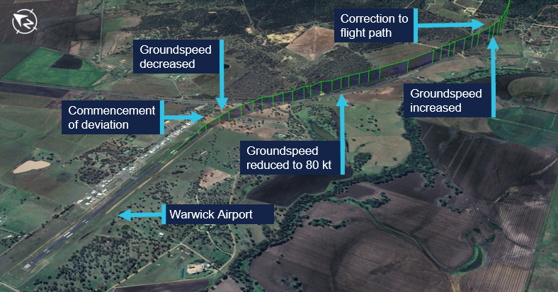
Source: Google Earth, annotated by the ATSB
At 1433, Brisbane Centre air traffic control (ATC) issued the pilot with a clearance to track directly to reporting point[3] NUTPA, which was the commencement point for the Oakey Airport runway 14 instrument landing system (ILS)[4] approach (Figure 2).
Figure 2: VH-EYQ flight overview
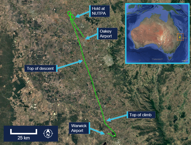
Source: Google Earth, annotated by the ATSB
At 1439, the pilot advised ATC that they would be conducting airwork in the Oakey area, not above an altitude of 4,000 ft, and they would contact ATC again on completion or by 1530. At that time, the Oakey Airport ATC tower was inactive. After commencing the descent for NUTPA at 1441, the pilot changed frequency to the common traffic advisory frequency (CTAF) in the Oakey Airport area, and all subsequent air-to-air communications took place on the CTAF. Between 1443 and 1454 the pilot made 5 transmissions on this frequency for traffic sequencing purposes.
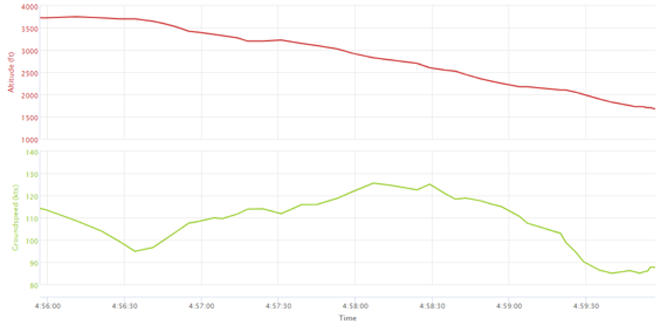
At 1450, the aircraft passed overhead NUTPA and conducted one holding pattern. At 1456, the aircraft commenced a descent from 3,800 ft and the pilot made a radio broadcast to advise that the aircraft was established on the ILS.
At 1457, the aircraft began to deviate from the horizontal profile for the approach. The aircraft initially deviated right of the extended centreline and then to the left (Figure 3). Fluctuations in vertical speed also occurred during this period. The aircraft continued the approach slightly left of the extended centreline, but the vertical profile of the approach remained on the glideslope.[5] The wind conditions recorded at Oakey Airport at the time were a light breeze of 6 kt, with a mean direction of 190°M (see Meteorological information).
Figure 3: Final approach track
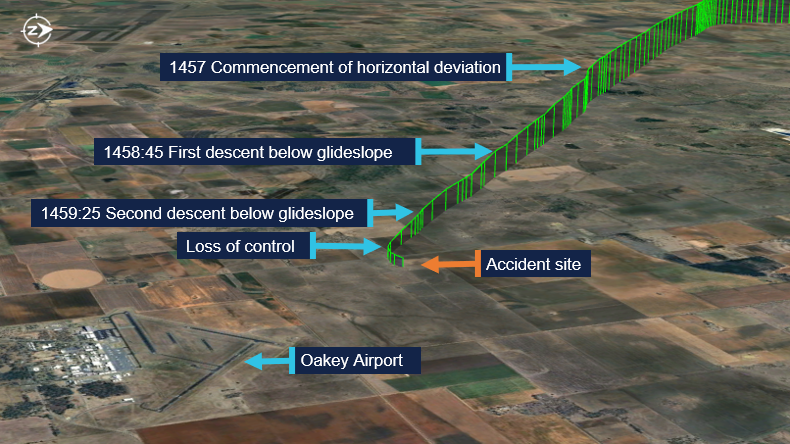
Source: Google Earth, annotated by the ATSB
At about 1458:45, and an altitude of 2,500 ft, the aircraft began to descend below the glideslope. This was initially corrected, and the aircraft flew level at about 2,200 ft for 30 seconds. At 1459:25, the aircraft descended below the glideslope again, and the descent continued to an altitude of about 1,700 ft, which equated to a height of between 300–400 ft above ground level (AGL). During this period the aircraft’s groundspeed began to decay. At 1459:39, the aircraft’s groundspeed had reduced to 85 kt (see Recorded flight data). At about 1459:53,[6] a 2‑second radio broadcast was made from the aircraft with an alarm sounding in the background.
A motorist travelling south observed the aircraft on approach and maintained visual contact with it for about 3 km (Figure 4). They observed the aircraft commence a flat turn and yaw[7] to the left at a height of about 300 ft AGL and pass above the road ahead of them. They recalled seeing the aircraft then roll to the left, pitch down, and impact the terrain.
Figure 4: Witness and closed-circuit television camera locations
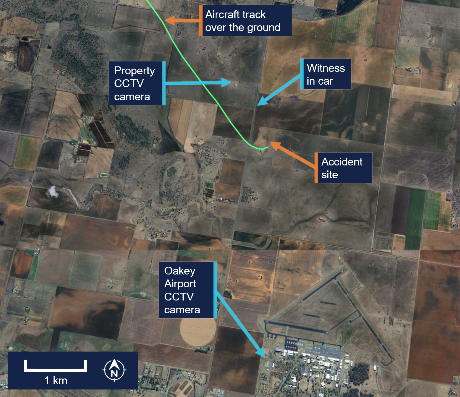
Source: Google Earth, annotated by the ATSB
Closed-circuit television (CCTV) cameras located at a nearby property and Oakey Airport captured the aircraft commence a steep descent before colliding with terrain (Figure 5).
The aircraft was destroyed in a post-impact fire, and both occupants were fatally injured.
Figure 5: Composite images of recorded CCTV camera footage
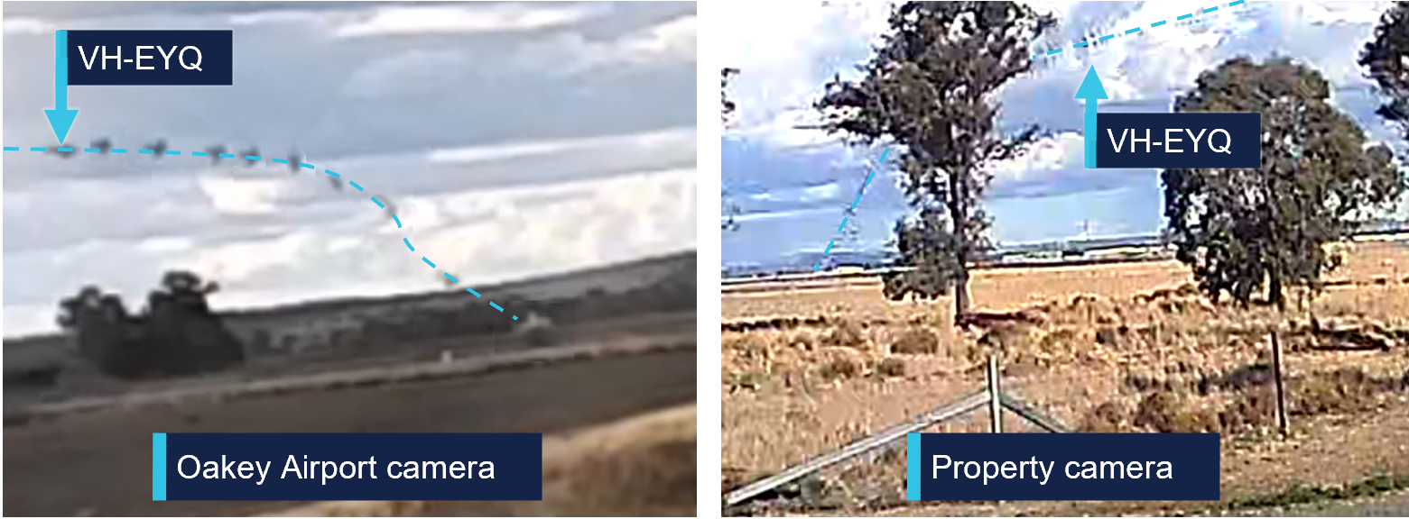
Source: CCTV camera recordings
Context
Pilot information
Pilot experience
The pilot held a valid class 1 aviation medical certificate and an air transport pilot licence (ATPL) (aeroplane). Additionally, they held a grade 3 flight instructor rating with multi‑engine aeroplane training approval and design feature endorsements to operate VH-EYQ. The pilot held a valid multi-engine instrument rating with the previous instrument proficiency check (IPC) completed in August 2024.
At the time of the accident, the pilot had accumulated 5,767 hours total aeronautical experience. This included 4,170 flight hours as pilot in command with 3,514 hours in multi-engine aeroplanes and about 1,200 hours in command of a Reims F406. In the preceding 90 days they had flown 95 hours, including 54 hours in the Reims F406. They had worked for the aircraft operator since March 2017.
Known recent activity
The pilot’s work roster for the week prior to the accident (from 14 to 20 July 2025) is shown in Table 1. During this week, the pilot was based away from home and conducted multiple survey flights. The pilot’s duties for 20 July included the survey flight in the morning with no additional rostered flying.
Table 1: Pilot rostered duties, 14 to 20 July 2025
| Date | Shift start-finish time | Total flight hours |
| 14 July | OFF | 0 |
| 15 July | 0630-1430 | 1.5 |
| 16 July | 0630-1430 | 2.1 |
| 17 July | 0630-1430 | 1.8 |
| 18 July | 0630-1430 | 2.4 |
| 19 July | OFF | 0 |
| 20 July | 0730-1500 | 5:31 |
A text message sent from the pilot the evening of 19 July indicated that the pilot had intended to conduct the IPC the following day. Additionally, the message indicated they had sleep opportunity from about 2130.
Flight examiner information
Flight examiner experience
The flight examiner held a valid class 1 aviation medical certificate and an ATPL (aeroplane). They also held grade 1 flight instructor and flight examiner operational ratings, with multi-engine aeroplane and instrument rating (aeroplane) training approval. Their flight instructor rating also had a spin endorsement, and they held design feature endorsements to operate VH-EYQ. The examiner held a valid multi-engine instrument rating with the previous IPC completed in October 2024.
The flight examiner’s logbook records were destroyed in the post-impact fire. Based on records of the pilot’s hours from January 2025, the flight examiner’s total aeronautical experience was in excess of 20,000 hrs. Additionally, they had flown 3 similar proficiency check flights for the aircraft operator in the previous 12 months, totalling 3.6 hours in the Reims F406. The flight examiner was external to the aircraft operator and was regularly hired to complete the IPC for their pilots.
Known recent activity
Along with their logbook, the flight examiner's work records were destroyed in the post‑impact fire.
A family member recalled that the flight examiner had returned from a chartered flight to western Queensland on Tuesday 15 July. During the week, they had spent a day providing aviation theory instruction to students but had no other work engagements. On the day of the accident, the flight examiner woke at their normal time. They were reported to have slept well and, when leaving home for the IPC flight, they appeared their normal self with no signs of fatigue.
Aircraft information
General information
The Reims Aviation F406 is a low wing, twin‑engine aircraft powered by 2 Pratt & Whitney Canada PT6A-112 turbine engines, each driving a 3-bladed McCauley constant speed, full-feathering propeller (Figure 6). The accident aircraft, serial number F406‑0047, was manufactured in France in 1990 and first registered in Australia as VH‑EYQ in 2012.
Figure 6: Reims F406
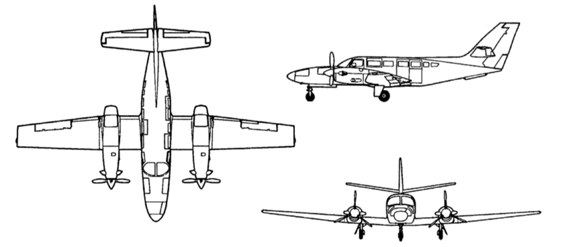
Source: ASI Aviation
Recent maintenance activity
The aircraft was to be maintained in accordance with the aircraft operator’s Civil Aviation Safety Authority (CASA) approved system of maintenance. This required a periodic inspection every 100 hours or 12 months, whichever came first. The system of maintenance allowed for periodic inspection intervals to be extended up to a maximum of 10 hours. The most recent periodic inspection was completed on 11 June 2025, at 17,376 hours in service. At the time of the accident, the aircraft had accumulated 17,475.6 hours total time in service.
Configuration
VH-EYQ was configured in a 5-seat survey layout. This comprised the pilot (left) and copilot (right) seats in the front row, followed by 1 passenger seat in row 3, and 2 passenger seats in row 5. The remaining passenger seats were removed from the cabin to accommodate the installation of aerial survey equipment (Figure 7). An electronic loading system had been generated for this configuration by an approved load controller, and records show that this was utilised by the pilot for previous flights.
Figure 7: VH-EYQ cabin configuration
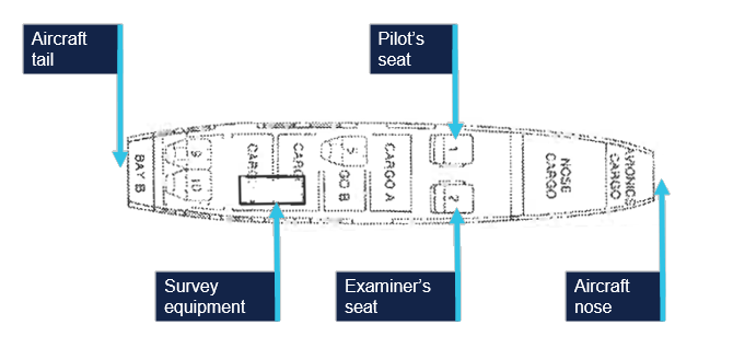
Source: ASI Aviation, annotated by the ATSB
Weight and balance
Prior to its departure from Archerfield Airport, the aircraft was fuelled with 1,086 L of Jet A1 fuel. The aircraft operator advised that, based on this fuel uplift and the intended flying activity, it was very likely that the aircraft had full fuel on board for the flight to Warwick Airport. Fuel calculations based on flight times and expected consumption rates indicated that, at the time of the accident, the aircraft probably had about 1,280 L of fuel on board. This meant the aircraft weight at the time of the accident was about 600 kg below the aircraft’s maximum take-off weight. Based on the survey flying configuration and loading of the aircraft, the aircraft’s centre of gravity was calculated and assessed to be within prescribed limits.
Performance
The pilot operating handbook airplane flight manual (POH) provided applicable limitations which included:
- a stall speed[8] of 75 KIAS[9] in the landing configuration (VSO), and 94 KIAS with flaps in the up position (VS)
- an intentional one engine inoperative speed (VSSE)[10] of 98 KIAS
- an air minimum control speed (VMCA)[11] of 90 KIAS
- a one engine inoperative best rate-of-climb speed at sea level (VYSE) of 108 KIAS.
One engine inoperative procedures
The POH included recommended procedures in the event of an emergency. This included checklists for an engine failure in flight, and for the conduct of an approach and missed approach with one engine inoperative. The recommended approach speed with an engine inoperative was 110 KIAS reducing to 101 KIAS only once landing was assured.
Site and wreckage information
Accident site
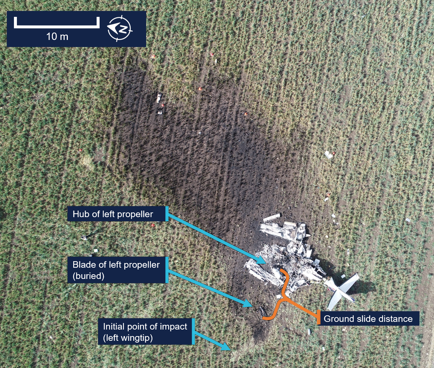
The ATSB conducted an onsite examination of the aircraft wreckage, which was located in an open paddock about 2.6 km from the threshold of runway 14 at Oakey Airport (Figure 8).
Figure 8: Location of accident
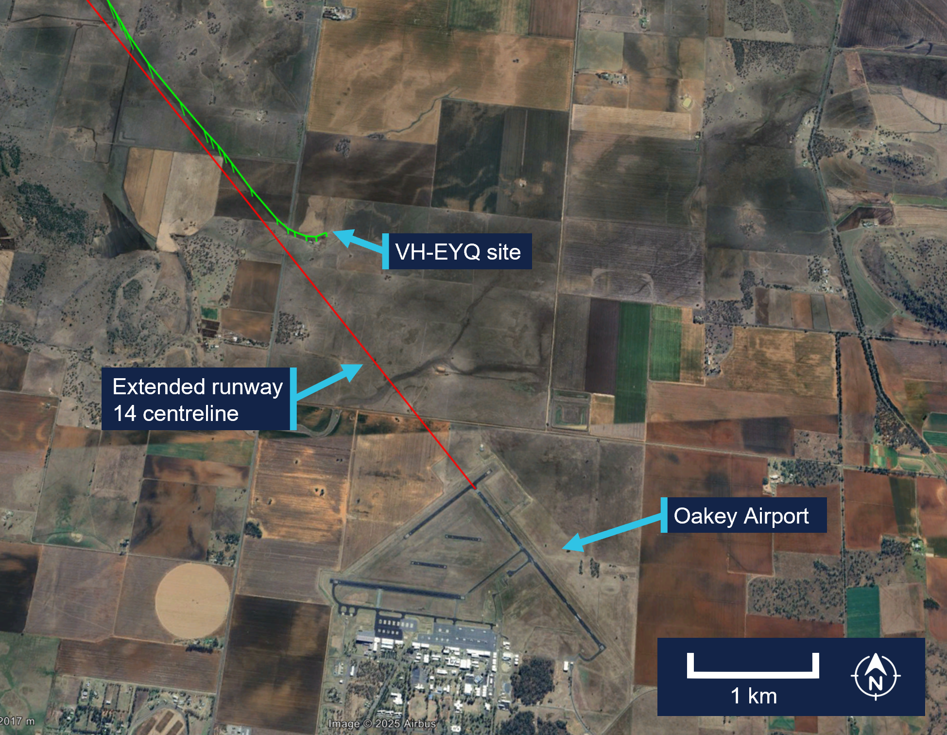
Source: Google Earth, annotated by the ATSB
The wreckage was confined to a 30 m radius of the accident site. The impact marks and wreckage position indicated the aircraft impacted terrain left wing low with little forward momentum. Ground scars indicated the aircraft moved about 6 m after the initial impact. All components were upright.
The tail and aft cabin section showed signs of vertical compression. There was no fore or aft compression damage to the nose or wings. The left wing had separated from the aircraft just outboard of the left engine, and the right wing had separated just inboard of the right engine. Both wings had swung forward to lay parallel to the fuselage (Figure 9).
Figure 9: VH-EYQ accident site
Source: ATSB
All major aircraft components were accounted for at the point of impact. A post‑impact fire consumed the forward section of the aircraft to the aft cabin door (Figure 10). This damage limited the extent to which pre-impact defects could be identified.
Figure 10: VH-EYQ wreckage
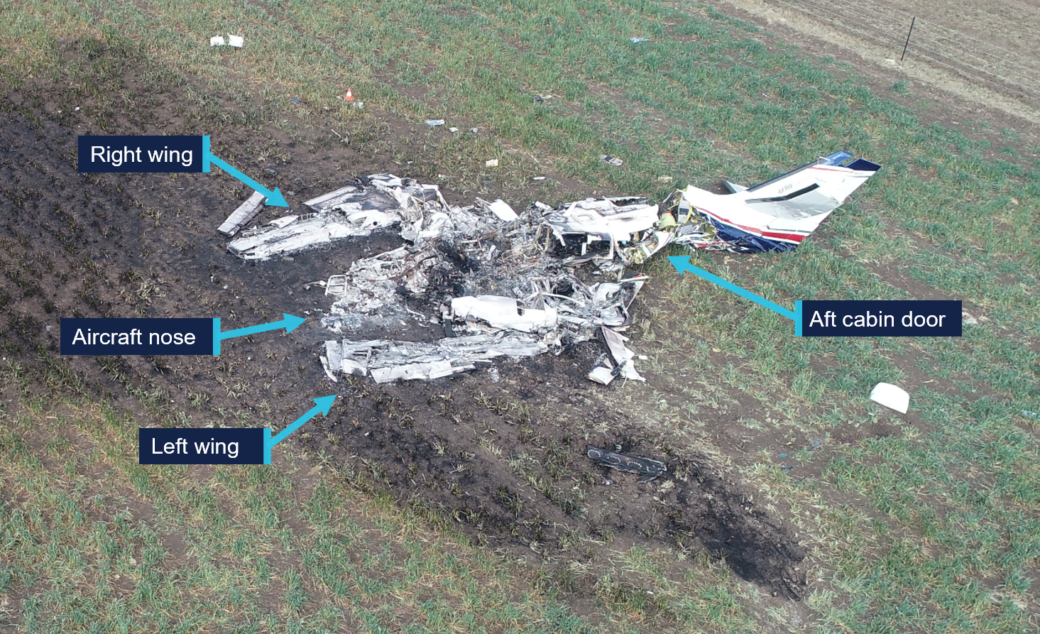
Source: ATSB
Engines
Both engines were retained for further examination. This was conducted by ATSB investigators who were assisted by investigators from Pratt & Whitney Canada.[12] The engine examination determined:
- there were no indications of pre-impact mechanical anomalies to any of the engine components that would have precluded normal engine operation
- the left engine displayed indications that it was rotating at the time of impact
- the right engine displayed characteristics that it was developing power at the time of impact.
Propellers
Both propellers showed indications that the engines were running at impact. The right propeller was determined to be in a fine pitch position[13] and exhibited bending in multiple directions.
Both propellers were retained, and an independent inspection was carried out at a propeller overhaul facility under the direction of ATSB investigators. Further analysis is required to determine the position of the left propeller at the time of impact.
Meteorological information
The Bureau of Meteorology (BoM) graphical area forecast valid at the time of the accident included the following conditions en route:
- scattered cloud bases of 3,000 ft to 5,000 ft, extending up to 8,000 ft
- isolated showers of rain with broken cloud from 1,000 ft to 2,000 ft and scattered cloud from 2,000 ft to above 10,000 ft.
At 1500, at about the same time the aircraft impacted terrain, the BoM issued a meteorological aerodrome report for Oakey Airport which reported the conditions at that time were:
- a wind of 6 kt, with a mean direction of 190°M, varying between 160°M–220°M
- visibility of 10 km or greater
- no cloud detected
- a temperature of 20°C and a dew point of 6°C
- a QNH[14] of 1,016 millibars
- no recorded rainfall since 0900.
Satellite images and CCTV footage captured areas of scattered cloud in the vicinity of the aerodrome at the time of the approach.
Flight activity
General
For a pilot to operate an aircraft under the instrument flight rules, they are required to hold an instrument rating. Pilots are also required to pass an annual instrument proficiency check (IPC) flight to ensure that they maintain the necessary skills and competency to operate safely. The purpose of the accident flight was for the pilot to complete their annual IPC.
An IPC can be completed by a flight examiner with an instrument rating, MPL[15] or ATPL (aeroplane) flight test endorsement, or by a person approved by CASA. While the aircraft operator had a training and checking system,[16] they scheduled IPC flights with external examiners and permitted the pilots to arrange their IPC flights privately. The head of flying operations (HOFO) of the aircraft operator recalled that the accident pilot had advised them that their IPC expiry date was approaching and requested the use of VH‑EYQ to complete the flight. In response, provisions were made by the HOFO and head of aircraft airworthiness and maintenance control delegate to make the aircraft available to the pilot for the purpose of conducting the IPC flight.
The pilot arranged the IPC with the external flight examiner and records show that the IPC was booked into the CASA flight test management system[17] by the flight examiner during the afternoon of 18 July and scheduled to take place on the afternoon of 20 July.
Instrument proficiency check assessment
During an IPC flight, a pilot’s competency is assessed in actual or simulated instrument meteorological conditions. During the flight, a pilot is required to meet specified standards for:
- departure
- en route skills
- arrival
- approach
- missed approach
- approach to land manoeuvres.
If the IPC is for multi-engine operations, the assessment also requires the satisfactory completion of a simulated one engine inoperative (OEI) departure and a simulated OEI approach.
The HOFO of the aircraft operator recalled that the external flight examiner had, in the past, typically conducted the simulated OEI departure after take-off from Warwick Airport and the simulated OEI approach at Oakey Airport.
Recorded information
Recorded flight data
The aircraft was not fitted with a flight data recorder or a cockpit voice recorder, nor was it required to be. During the accident flight, data was being transmitted by the aircraft’s automatic dependent surveillance broadcast (ADS-B) equipment. This data, recorded at 2–5 second intervals by amateur ground-based receivers, captured the aircraft’s position, altitude and groundspeed during the flight. Flight data was also being transmitted from a Spidertracks[18] tracking device fitted to the aircraft. This data, recorded at 15-second intervals, captured the aircraft’s position, altitude, groundspeed and heading during the flight.
The ADS-B altitude and groundspeed data for the aircraft’s departure from Warwick Airport is depicted in Figure 11.
Figure 11: VH-EYQ altitude and groundspeed during the Warwick Airport departure
Source: ATSB
The ADS-B altitude and groundspeed data for the aircraft’s ILS approach at Oakey Airport is depicted in Figure 12.
Figure 12: VH-EYQ altitude and groundspeed during the Oakey Airport approach
Source: ATSB
A Garmin GTN-650 global positioning system was also recovered from the accident site and transported to the ATSB’s Canberra technical facility for further examination. The unit showed signs of significant heat damage with melting and evidence of charring on the internal circuitry. The remains of 2 SD[19] cards were found within the unit, however, the post-impact fire had damaged the SD card memory chips to the point that data could not be extracted using normal recovery methods.
Record radio communications
All radio communications made and received by Airservices Australia throughout the entirety of VH-EYQ’s flight from Warwick Airport were recorded.
Recorded CCTV footage
Two CCTV cameras captured footage of the aircraft immediately prior to the collision with terrain. One camera was located on a property 1.4 km to the north-west of the accident and the second camera was located on Oakey Airport about 3 km south of the accident site.
The property CCTV footage was timestamped. The aircraft entered frame at 1459:53 and remained in frame for the duration of the recording which captured the collision with terrain at 1500:00.
The Oakey Airport CCTV footage did not contain a timestamp. The aircraft entered frame 1 second into the recording and remained in frame until the collision with terrain that occurred 7 seconds later.
Further investigation
To date, the ATSB has:
- examined the wreckage and accident site
- examined meteorological information
- interviewed relevant parties
- collected radio communication, aircraft traffic surveillance data, and navigational application data
- collected aircraft, pilot, crew and operator documentation.
The investigation is continuing and will include review and examination of:
- pilots’ recent history
- propellers
- maintenance records
- pilot and crew training and medical records
- operational procedures and documentation
- further interviews with relevant parties
- flight data and air traffic surveillance data
- the requirements of conducting simulated one engine inoperative exercises at low heights.
A final report will be released at the conclusion of the investigation. Should a critical safety issue be identified during the course of the investigation, the ATSB will immediately notify relevant parties so appropriate and timely safety action can be taken.
Acknowledgements
The ATSB would like to acknowledge the assistance provided by the Australian Defence Force personnel at the Oakey Army Aviation Centre during the initial evidence collection activities.
Purpose of safety investigationsThe objective of a safety investigation is to enhance transport safety. This is done through:
It is not a function of the ATSB to apportion blame or provide a means for determining liability. At the same time, an investigation report must include factual material of sufficient weight to support the analysis and findings. At all times the ATSB endeavours to balance the use of material that could imply adverse comment with the need to properly explain what happened, and why, in a fair and unbiased manner. The ATSB does not investigate for the purpose of taking administrative, regulatory or criminal action. About ATSB reportsATSB investigation reports are organised with regard to international standards or instruments, as applicable, and with ATSB procedures and guidelines. Reports must include factual material of sufficient weight to support the analysis and findings. At all times the ATSB endeavours to balance the use of material that could imply adverse comment with the need to properly explain what happened, and why, in a fair and unbiased manner. An explanation of terminology used in ATSB investigation reports is available here. This includes terms such as occurrence, contributing factor, other factor that increased risk, and safety issue. Publishing informationReleased in accordance with section 25 of the Transport Safety Investigation Act 2003 Published by: Australian Transport Safety Bureau © Commonwealth of Australia 2025 
Ownership of intellectual property rights in this publication Unless otherwise noted, copyright (and any other intellectual property rights, if any) in this report publication is owned by the Commonwealth of Australia. Creative Commons licence With the exception of the Commonwealth Coat of Arms, ATSB logo, and photos and graphics in which a third party holds copyright, this report is licensed under a Creative Commons Attribution 4.0 International licence. The CC BY 4.0 licence enables you to distribute, remix, adapt, and build upon our material in any medium or format, so long as attribution is given to the Australian Transport Safety Bureau. Copyright in material obtained from other agencies, private individuals or organisations, belongs to those agencies, individuals or organisations. Where you wish to use their material, you will need to contact them directly. |
[1] Instrument proficiency check: an assessment of a pilot’s skills and operational knowledge required to exercise licence ratings and privileges when flying under the instrument flight rules.
[2] Instrument flight rules (IFR): a set of regulations that permit the pilot to operate an aircraft in instrument meteorological conditions (IMC), which have much lower weather minimums than visual flight rules (VFR).
[3] Reporting point: a specified geographical location in relation to which the position of an aircraft can be reported.
[4] Instrument landing system (ILS): a precision instrument approach system which normally consists of a VHF localiser providing horizontal guidance and a UHF glideslope providing vertical guidance.
[5] Glideslope: a component of the instrument landing system providing vertical (up/down) guidance toward the runway touchdown point, usually at a 3° slope.
[6] The provided CTAF recording was found to have a discrepancy that could not be resolved.
[7] Yaw: the motion of an aircraft about its vertical or normal axis.
[8] Aerodynamic stall: or stall, occurs when airflow separates from the wing’s upper surface and becomes turbulent. A stall occurs at high angles of attack, typically 16˚ to 18˚, and results in reduced lift.
[9] KIAS: indicated airspeed expressed in knots, used by pilots as a reference for all aircraft manoeuvres.
[10] The manufacturer’s minimum speed for rendering one engine inoperative in flight for pilot training.
[11] The minimum indicated airspeed at which the aircraft was laterally controllable with one engine inoperative and a 5° bank angle towards the operative engine.
[12] Pratt & Whitney Canada: engine manufacturer of the engines installed on VH-EYQ.
[13] Fine pitch: refers to a fine or low pitch angle which yields good low speed acceleration.
[14] QNH: the altimeter barometric pressure subscale setting used to indicate the height above mean seal level.
[15] MPL: multi-crew pilot licence.
[16] Training and checking system: a training and checking system ensures that operational safety-critical personnel are proficient in the required competencies to support an operator's air operations.
[17] Flight test management system: online record system used to notify CASA of planned flight tests. Flight examiners also use the system to schedule and record the outcomes of flight tests and proficiency checks. The system is used by CASA to keep track of the flight testing process and analyse trends at industry level.
[18] Spidertracks: a satellite-based tracking system, combining satellite communication and GPS technology.
[19] Secure digital card (SD): a type of memory card typically used in portable devices.
Occurrence summary
| Investigation number | AO-2025-042 |
|---|---|
| Occurrence date | 20/07/2025 |
| Occurrence time and timezone | 15:00 Australian Eastern Standard Time |
| Location | 3.4 km north of Oakey Airport |
| State | Queensland |
| Report release date | 10/12/2025 |
| Report status | Preliminary |
| Anticipated completion | Q4 2026 |
| Investigation level | Short |
| Investigation type | Occurrence Investigation |
| Investigation phase | Examination and analysis |
| Investigation status | Active |
| Mode of transport | Aviation |
| Aviation occurrence category | Collision with terrain, Loss of control |
| Occurrence class | Accident |
| Highest injury level | Fatal |
Aircraft details
| Manufacturer | Reims Aviation S.A. |
|---|---|
| Model | F406 |
| Registration | VH-EYQ |
| Serial number | F406-0047 |
| Aircraft operator | Bayswater Road Pty Ltd (trading as Aero Logistics) |
| Sector | Turboprop |
| Operation type | Part 91 General operating and flight rules |
| Activity | General aviation / Recreational-Instructional flying-Instructional flying - dual |
| Departure point | Warwick Airport, Queensland |
| Destination | Warwick Airport, Queensland |
| Injuries | Crew - 2 (fatal) |
| Damage | Destroyed |