Wheels-up landing involving Beechcraft King Air B200, VH-XDV, Williamtown Airport, New South Wales, on 13 May 2024

Final report

Report release date: 13/11/2024

Executive summary

What happened

On the morning of 13 May 2024, a Beechcraft King Air B200, registered VH-XDV and operated by Eastern Air Services was being used for a passenger transport flight from Williamtown Airport to Lord Howe Island, New South Wales. On board the aircraft were the pilot and 2 passengers. Shortly after the aircraft departed Williamtown, the landing gear malfunctioned and jammed in a partially retracted position. The pilot was unable to extend the gear using the emergency procedures.

After approximately 4 hours of holding the pilot completed a wheels-up landing at Williamtown Airport with emergency services standing by. The aircraft sustained minor damage from the landing incident. The pilot and passengers were uninjured.

What the ATSB found

The ATSB identified that during either the take-off roll or landing gear retraction sequence the steering link fractured from a pre-existing fatigue crack, resulting in a mechanical disconnect within the nose landing gear steering system.

When the landing gear retracted, the fractured steering link allowed the nose gear shimmy damper to contact the side of the wheel well and jam the nose landing gear in a partially retracted position. This prevented extension of the landing gear using the published emergency procedure, necessitating a wheels-up landing.

A review of the ATSB database did not identify any similar previous occurrences and no other failures of this type were identified by the aircraft manufacturer.

What has been done as a result

Eastern Air Services reported that in the days following the incident it conducted a maintenance inspection of the landing gear system on the other King Air B200 aircraft (registered VH-MVP) within its fleet. No defects were found. On 28 August 2024, VH-MVP underwent a scheduled maintenance check, during which the nose gear steering link was removed for an additional non‑destructive dye-penetrant crack inspection. No defects were found in the steering system of that aircraft. 

The operator further advised that it is reviewing its B200 maintenance program to consider including a non-destructive inspection of the steering link, which would be additional to the manufacturer’s existing maintenance requirements.

Safety message

The ATSB advises King Air B200 operators and maintainers that in this incident, fatigue‑related fracture of a steering link in the nose landing gear system led to the landing gear becoming inoperative. Although scheduled maintenance inspections required general inspection of the nose steering parts, the inspections did not call for a detailed inspection for cracks. 

This incident also highlights the value of aircraft system knowledge and resource management in resolving malfunctions and in-flight emergencies. The pilot established that the available fuel endurance allowed time to carefully consider the circumstances and attempted to resolve the issue. They engaged company personnel to provide system troubleshooting information and sought the assistance of the air traffic control personnel to inspect the aircraft.

The pilot also liaised with emergency services and prepared the passengers for the wheels‑up landing. This minimised the risk of injury and ensured the evacuation was conducted safely.


The investigation

Decisions regarding the scope of an investigation are based on many factors, including the level of safety benefit likely to be obtained from an investigation and the associated resources required. For this occurrence, a limited-scope investigation was conducted in order to produce a short investigation report, and allow for greater industry awareness of findings that affect safety and potential learning opportunities.

The occurrence

On the morning of 13 May 2024, a Beechcraft King Air B200, registered VH-XDV and operated by Eastern Air Services, was being prepared for a multi-sector passenger transport flight from Williamtown Airport, New South Wales. The flight was to transport 2 passengers from Williamtown to Lord Howe Island, with an intermediate stop at Port Macquarie to collect an additional 6 passengers. 

Both passengers boarded at Williamtown and at about 0830 local time the pilot taxied the aircraft from the departure bay to runway 30. A passenger video recording captured the pilot’s actions and cockpit area throughout the departure. No problems were identified with the aircraft during taxi. The recording also identified that, as the pilot retracted the landing gear during the initial climb, mechanical crunching noises were audible. As the aircraft continued to climb, the pilot commenced a right turn and noted that the red indicator lights on the landing gear control handle remained illuminated, signifying that the landing gear remained in transit or was not locked. 

The pilot then contacted air traffic control (ATC) and reported a landing gear indication fault. The pilot then cancelled their airways clearance to Port Macquarie and requested clearance from ATC to remain in the Williamtown circuit to complete functional checks of the landing gear system. 

The pilot was directed to operate in a southern circuit so that the aircraft would remain visible to the tower controller. The controller visually identified that the landing gear was partially retracted, which they conveyed to the pilot. In response, the pilot declared PAN PAN[1] and the controller initiated the airport emergency plan.[2] Additional controllers were then called to the tower to help manage the emergency. 

Emergency management and response

While in the Williamtown circuit, the pilot consulted the abnormal procedures contained in the flight crew operating manual to manually extend the landing gear (see the section titled Landing gear system and nose wheel steering). Only 2 or 3 pumps of the alternate extension lever could be achieved before maximum resistance was encountered. The lever had no effect on moving the gear to the down and locked position, despite additional force applied by the pilot. The red indicator lights on the gear handle also remained illuminated, which provided further indication that a malfunctioned had occurred.

At about 0930, while the aircraft was still in the circuit, the pilot confirmed the problem with ATC and that a wheels-up landing would be required. ATC then upgraded its response to a Level-1 emergency and notified the civil emergency services of the situation. An image of the aircraft as it flew overhead Williamtown Airport was recorded by an observer, it showed the landing gear partially retracted and the nose wheel tilted to the left (Figure 1). 

Figure 1: VH-XDV with landing gear partially retracted as it overflew Williamtown Airport

Figure 1: VH-XDV with landing gear partially retracted as it overflew Williamtown Airport

During a normal retraction cycle of the landing gear the nose wheel automatically centres. Source: Department of Defence

The pilot maintained a holding pattern in the southern circuit over Williamtown Airport for approximately 3 hours and 17 minutes. With rain approaching from the south, and a lowering cloud base, the pilot’s desire to remain in visual meteorological conditions[3] and consume additional fuel prompted them to track along the coastline to the north-east while the weather passed (see Figure 2 and the section titled Pilot’s commentary of the emergency). Upon arrival over Hawks Nest, ATC advised the pilot that the Williamtown Airport weather conditions had improved.

While the pilot positioned the aircraft at the instrument approach waypoint[4] for Williamtown Airport, the weather conditions deteriorated and the aircraft entered cloud and heavy rain. During this period the pilot identified that on landing the fuel quantity onboard the aircraft may reduce below the required final reserve.[5] ATC tower recordings identified that the pilot declared a MAYDAY FUEL[6] at 1206.

At 1219 with the gear still jammed in the partially retracted position, the aircraft touched down on runway 30 and came to a sliding stop after about 20 seconds. Airport rescue and firefighting and other waiting services were then cleared to attend and entered the runway. 

No injuries were sustained by the pilot or passengers on board. The aircraft sustained minor damage from the landing incident and there was no fire.

Figure 2: VH-XDV completed numerous circuits at Williamtown before transiting to Hawks Nest, then returning to Williamtown

Figure 2: VH-XDV completed numerous circuits at Williamtown before transiting to Hawks Nest, then returning to Williamtown

The aircraft track was obtained from the automatic dependent surveillance-broadcast data transmitted from the aircraft. Source: Google Earth, annotated by the ATSB

Context

Aircraft information

The Beechcraft King Air B200 is a pressurised, low-wing, twin turbine-engine aircraft with retractable landing gear. The aircraft had a certified maximum take-off weight of 
5,670 kg and could be flown by a single pilot. The aircraft, serial number BB-1100, was manufactured in the United States in 1982 and subsequently registered in Australia in 2008. Eastern Air Services had been the registered operator of the aircraft since February 2018.

Operator’s examination of the aircraft

The operator’s post-incident examination of the aircraft identified that it had sustained minor damage during the landing. Both main landing gear, the radio antennas and the underside airframe panels had been abraded. Additionally, both propellors had sustained rotational contact damage from striking the runway. 

During their examination of the landing gear system, the operator identified that the shimmy damper that was attached to the nose gear leg had become bent and jammed against a door hinge within the wheel bay (Figure 3). A link in the nose steering system had also fractured, resulting in a disconnection between the pilots steering input and the nose landing gear (Figure 4). The steering barrel had bent where it connected to the steering link. The operator’s examination of the electrical system identified that a circuit breaker had opened during the incident flight. They commented that this had likely occurred automatically to prevent electrical overload of the landing gear system.

Following replacement of the fractured steering link, functional testing of the landing gear was completed as part of the operator’s fault-finding investigation. That testing showed that, under normal circumstances during a landing gear retraction sequence, the nose steering shimmy damper remained clear of all components of the wheel bay area. They further identified that the shimmy damper could only contact the wheel bay area if the nose wheel became mechanically disconnected from the steering system. That disconnection enabled the nose wheel to rotate left beyond its operational limit sufficiently for the shimmy damper to contact the undercarriage door bay area during the nose gear retraction sequence. 

The operator advised that there were no binding or other defects present in the remainder of the steering or landing gear components fitted to the aircraft. The operator also found that once the circuit breakers were reset, the landing gear system became electrically functional, allowing the gear to lower. One of those required circuit breakers was not accessible to the pilot in flight.

Figure 3: The nose landing gear tilted to the left with the shimmy damper jammed against a hinge in the undercarriage bay

Figure 3: The nose landing gear tilted to the left with the shimmy damper jammed against a hinge in the undercarriage bay

Source: Eastern Air Services, annotated by the ATSB

Figure 4: Damaged nose gear steering components

Figure 4: Damaged nose gear steering components

Source: Eastern Air Services, annotated by the ATSB

Landing gear system and nose wheel steering 

The aircraft has a mechanical landing gear system controlled through a landing gear control handle on the right side of the pilot’s centre panel. When the handle is positioned to either extend or retract the landing gear, an electric motor drives the landing gear gearbox assembly. The main landing gear actuators are driven by torque tubes from the gearbox. The nose gear is driven by a duplex chain from a sprocket on the gearbox torque shaft. Circuit breakers protect the system from electrical overload. 

Emergency manual extension of the landing gear is controlled by a floor‑mounted lever centrally located between the left and right pilot seats. When the lever is manually operated, the landing gear electric motor and gearbox drive mechanisms are overridden, allowing extension of the landing gear system. The following procedure for manual extension of the landing gear was listed in the King Air pilot operating handbook:

LANDING GEAR MANUAL EXTENSION (MECHANICAL SYSTEM)

1. Airspeed - ESTABLISH 130 KNOTS

2. Landing Gear Relay Circuit Breaker (Pilot's subpanel) - PULL

3. Landing Gear Control - DOWN

4. Alternate Engage Handle - LIFT AND TURN CLOCKWISE TO THE STOP TO ENGAGE.

5. Alternate Extension Handle - PUMP UP AND DOWN UNTIL THE THREE GREEN GEAR-DOWN ANNUNCIATORS ARE ILLUMINATED.

Note: Additional pumping when all three annunciators are illuminated could damage the drive mechanism and prevent subsequent electrical gear retraction.

If all three green gear-down annunciators are illuminated:

6. Alternate Extension Handle - DO NOT STOW (Proceed to step 8.)

Should the landing gear fail to extend, the next steps in the procedure stated:

If one or more green gear-down annunciators do not illuminate for any reason and a decision is made to land in this condition:

7. Alternate Extension Handle – CONTINUE PUMPING UNTIL MAXIMUM RESISTENCE IS FELT, EVEN THOUGH THIS MAY DAMAGE THE DRIVE MECHANISM

8. Landing Gear Controls – DO NOT ACTIVATE 

Nose wheel steering is through direct mechanical actuation of the linkages in the system from the rudder pedals that connect to an arm near the top of the nose gear shock strut (Figure 5). A spring mechanism in the steering barrel dampens the transmission of excessive shock loads to the rudder pedals. A strut-mounted roller engages with a centring ramp to automatically centre the nose wheel during retraction of the gear. 

Figure 5: King Air B200 nose steering system schematic 

Figure 5: King Air B200 nose steering system schematic

Source: Textron Aviation, annotated by the ATSB

Aircraft maintenance 

Scheduled maintenance for VH-XDV was based on a 200-hour phased inspection program, the details of which were specified by the aircraft manufacturer and contained within the King Air B200 maintenance manual. The operator’s maintenance records identified that a Phase-4 check was completed on 18 March 2024 at 18,298.4 hours. During that check the landing gear system was overhauled. Parts relating to the nose wheel steering were inspected but not replaced as their continued serviceability was based ‘on-condition’, rather than having a prescribed ‘life-limit’. On that basis the service life of the steering link was not required to be tracked and its service history was unable to be established. 

The Phase-4 inspection requirements listed in the maintenance manual for the nose gear components were non-specific and all parts were to be inspected for ‘wear damage and surface corrosion.’ For the steering linkage, it was required to be: 

STEERING LINKAGE - Inspect nose gear steering mechanism and attaching hardware for wear, damage and corrosion..

There was no specific requirement to inspect the steering link for cracks.

Pilot information 

The pilot held an air transport pilot licence (aeroplane), issued in September 2015, with a multi‑engine aeroplane instrument rating. In addition, they held a current grade 1 flight instructor rating and a multi-engine class flight test examiner rating. They reported approximately 8,500 hours total flying experience, of which 2,500 hours were accrued on the King Air B200. 

Pilot’s commentary of the emergency

After the pilot identified that the abnormal procedure for extending the landing gear was ineffective, they assessed that the fuel quantity on board the aircraft was sufficient to troubleshoot the malfunction and prepare for a wheels-up landing by completing or considering the following:

  • Throughout, the pilot remained focused on the aircraft fuel quantity and their intention was to land with about 600 lb of fuel remaining onboard. Their reasoning was that a significantly reduced fuel load would minimise the potential fire hazard on landing. They provided numerous status updates to ATC that included remaining fuel quantities.
  • They contacted the operator’s chief engineer on several occasions for technical advice and spoke with another pilot colleague to assist with planning the landing.
  • They relocated both passengers to the seats aft of the main spar nearer to the main cabin door then briefed them on its emergency operation.
  • They communicated with the airport fire and rescue personnel on the most suitable place on the runway to land the aircraft.
  • During the final approach to Williamtown Airport they configured the flaps to the approach setting and immediately prior to the aircraft contacting the runway surface, they depressurised the aircraft cabin, shut down both engines, set the propellors to fine pitch, and isolated the aircraft electrical system. Their reasoning was to minimise any potential for the aircraft to remain pressurised and reduce the likelihood of ignition of the fuel onboard after landing.
  • Upon tracking to the north-east to Hawks Nest, the pilot was cognisant that instrument meteorological conditions[7] might be entered during the approach back to Williamtown and requested an instrument approach for runway 30. The pilot recalled that the instrument approach required additional distance to be flown and estimated that it could result in the aircraft entering the 45-minute fixed reserve, which then prompted them to declare MAYDAY FUEL. 
Williamtown weather

When the aircraft was initially directed to the Williamtown southern circuit, the ATC controller estimated that the cloud base was between 2,000 ft and 2,500 ft AGL. Meteorological observations at Williamtown Airport identified that from 1130 through to 1400, rain showers and drizzle persisted. The ATC controller reported that during that period the cloud base began to lower, making it difficult to sight the aircraft.

In the minutes prior to the wheels-up landing, the meteorological observations indicated visibility greater than 10 km, drizzle in the vicinity of the airport, and a cloud amount of 1‍–‍2 oktas[8] at 1,300 ft AGL. 

Pilot guidance for wheels-up landing 

There was no specific guidance for a wheels-up landing published within the B200 operating handbook. The manufacturer advised that in this emergency situation, it would be expected that a pilot would use their aeronautical decision-making skills, training, knowledge of the aircraft, and knowledge of the situation to determine the best course of action.

The Airplane Flying Handbook produced by the United States Federal Aviation Administration (FAA) was intended to assist pilots to improve their flying proficiency and aeronautical knowledge. Chapter 18 of the Handbook, Emergency Procedures, provides generic advice to pilots for performing a gear up landing. The Handbook advised pilots to:

  • select an airport with fire and rescue facilities
  • request emergency equipment to stand by
  • select a smooth, hard runway surface rather than an unimproved grass strip
  • consider burning off excess fuel to reduce fire potential
  • consider that the safest course of action may be to land with all three gears in the retracted configuration.
ATSB component examination

The following parts of the damaged nose wheel steering system were removed from the aircraft by the operator and sent to the ATSB’s laboratory facilities in Canberra for metallurgical examination:

  • steering link
  • shimmy damper
  • steering barrel.

The ATSB’s visual examination of the shimmy damper identified that it had sustained bending of the centre shaft. The body of the shimmy damper also contained a significant gouge. The location of that damage was consistent with the operator’s reporting and the post‑occurrence photographs that the shimmy damper had become wedged against a door hinge in the nose wheel bay. 

The aircraft manufacturer indicated the steering link had been cast from an aluminium alloy, which was confirmed through chemical analysis of the part by the ATSB. General visual examination of the steering link fracture surfaces was followed by detailed high-magnification examination using a scanning electron microscope. A semi-circular feature was identified on the steering link fracture surface and its aspects were consistent with that of a pre-existing defect (Figure 6). Surface staining on the defect area was also consistent with the development of corrosion. 

High‑magnification imagery confirmed the presence of very fine crack progression striations throughout the defect area (Figure 7). The striations confirmed that a fatigue crack had progressed into the steering link prior to its complete fracture. 

The origin of the fatigue cracking was associated with a region of porosity at the component surface. The porosity was a manufacturing flaw that had been introduced during the casting process. The remainder of the fracture surface was comprised of brittle features produced during overstress of the steering link. 

Figure 6: A semi-circular pre-existing defect (labelled) was identified on both halves of the steering link fracture surface 

Figure 6: A semi-circular pre-existing defect (labelled) was identified on both halves of the steering link fracture surface

Source: ATSB

Figure 7: Microscopic striations (arrowed) were identified on the steering link fracture surface within the region of the pre-existing defect

Figure 7: Microscopic striations (arrowed) were identified on the steering link fracture surface within the region of the pre-existing defect

The above image was captured using a scanning electron microscope at x4,500 magnification. Source: ATSB

Other occurrences

The ATSB's aviation occurrence database was searched for landing gear malfunctions leading to a wheels-up landing involving King Air B200 aircraft between 2014‍–‍2024. No such instances were identified. There were, however, 130 records of a wheels-up landing for all aircraft types, none of which resulted in injuries or fire. 

The review of occurrence database records also identified 92 reports of 'gear unsafe' indications for the King Air B200. There was a broad range of reasons attributed for those indications, however, none of them led to a wheels-up landing. There were 12 instances where the emergency manual extension was required to be utilised and in each of those the landing gear was able to be extended. 

Additionally, the aircraft manufacturer (Textron Aviation) advised that it was not aware of other instances of this specific malfunction where the mechanical landing gear became jammed leading to a wheels-up landing. It was also unaware of other instances where fatigue cracks had been identified in steering links. 

Safety analysis

The ATSB identified that the aircraft was able to be steered by the pilot using the rudder pedals as it was taxied to the departure runway and during the take‑off roll. This indicated that the nose wheel steering system, including the steering linkage, was intact during the taxi and the initial stage of the take-off roll. 

ATSB’s laboratory examination of the steering components identified the presence of a fatigue crack on the fracture surfaces of the steering link that had initiated from a surface flaw. The pre‑existing, high-cycle fatigue crack was small in comparison to the overall steering link cross section, indicating that the final fracture likely occurred over a relatively short number of loading cycles.

The nature of the loading that resulted in the final fracture was not identified. However, casting alloys are generally regarded as having relatively low fracture toughness when compared with wrought alloys, predisposing them to brittle fracture. Additionally, it is generally the case that the increase in stress intensity from a pre-existing fatigue crack will lead to fracture at much lower stresses due to the inherently low fracture toughness of a casting alloy. 

As the pilot was able to conduct the take‑off without issue, the fracture of the steering link must have occurred either late in the take-off roll or as the gear was retracted. Once the steering link fractured, the nose wheel was able to rotate beyond its normal operational limits. In this instance, the nose wheel rotated significantly to the left. That movement led to the nose gear shimmy damper also rotating beyond normal limits sufficiently to become jammed against a door hinge within the nose wheel well. 

When the pilot consulted the procedures for a manual gear extension, their efforts were ineffectual because the shimmy damper had mechanically jammed the operation of that system. Despite numerous attempts, the pilot was subsequently unable to extend the landing gear using the published emergency extension procedure, necessitating a wheels‑up landing.

Findings

ATSB investigation report findings focus on safety factors (that is, events and conditions that increase risk). Safety factors include ‘contributing factors’ and ‘other factors that increased risk’ (that is, factors that did not meet the definition of a contributing factor for this occurrence but were still considered important to include in the report for the purpose of increasing awareness and enhancing safety). In addition ‘other findings’ may be included to provide important information about topics other than safety factors. 

These findings should not be read as apportioning blame or liability to any particular organisation or individual.

From the evidence available, the following findings are made with respect to the wheels-up landing involving a Beechcraft King Air B200, VH-XDV, at Williamtown Airport, New South Wales on 13 May 2024. 

Contributing factors
  • During the take-off roll or landing gear retraction sequence, the steering link fractured from a pre-existing fatigue crack, resulting in a mechanical disconnect within the nose landing gear steering system.
  • When the landing gear retracted, the fractured steering link allowed the nose gear shimmy damper to contact the side of the wheel well and jam the nose landing gear in a partially retracted position. This prevented extension of the landing gear using the published emergency procedure, necessitating a wheels-up landing.

Safety actions

Whether or not the ATSB identifies safety issues in the course of an investigation, relevant organisations may proactively initiate safety action in order to reduce their safety risk. All of the directly involved parties are invited to provide submissions to this draft report. As part of that process, each organisation is asked to communicate what safety actions, if any, they have carried out to reduce the risk associated with this type of occurrences in the future. The ATSB has so far been advised of the following proactive safety action in response to this occurrence. 
Safety action by Eastern Air Services

The operator reported that in the days following the incident, it conducted a maintenance inspection of the landing gear system on the other King Air B200 aircraft (registered VH‑MVP) within its fleet. No defects in the landing gear or steering system were found during that inspection. On 28 August 2024, further maintenance checks were completed on VH-MVP, including the removal of the nose gear steering link for non-destructive crack inspection. No defects were found. 

The operator further advised that it is reviewing its B200 maintenance program to consider including a non-destructive inspection of the steering link, which would be additional to the manufacturer’s existing maintenance requirements.

Sources and submissions

Sources of information

The sources of information during the investigation included:

  • the pilot of VH-XDV
  • Eastern Air Services
  • Bureau of Meteorology
  • Royal Australian Air Force – 453 Squadron
  • Textron Aviation
  • ADS-B data from the aircraft. 

References

United States Federal Aviation Administration, Airplane Flying Handbook FAA-H-8083-3C

Beechcraft King Air B200 Maintenance Manual

Beechcraft King Air B200 Pilot’s Operating Handbook

Submissions

Under section 26 of the Transport Safety Investigation Act 2003, the ATSB may provide a draft report, on a confidential basis, to any person whom the ATSB considers appropriate. That section allows a person receiving a draft report to make submissions to the ATSB about the draft report. 

A draft of this report was provided to the following directly involved parties:

  • the pilot of VH-XDV
  • Eastern Air Services
  • Royal Australian Air Force – 453 Squadron
  • Textron Aviation
  • Civil Aviation Safey Authority

Submissions were received from:

  • the pilot of VH-XDV
  • Eastern Air Services
  • Royal Australian Air Force – 453 Squadron

The submissions were reviewed and, where considered appropriate, the text of the report was amended accordingly.

Purpose of safety investigations

The objective of a safety investigation is to enhance transport safety. This is done through: 

  • identifying safety issues and facilitating safety action to address those issues
  • providing information about occurrences and their associated safety factors to facilitate learning within the transport industry.

It is not a function of the ATSB to apportion blame or provide a means for determining liability. At the same time, an investigation report must include factual material of sufficient weight to support the analysis and findings. At all times the ATSB endeavours to balance the use of material that could imply adverse comment with the need to properly explain what happened, and why, in a fair and unbiased manner. The ATSB does not investigate for the purpose of taking administrative, regulatory or criminal action.

Terminology

An explanation of terminology used in ATSB investigation reports is available here. This includes terms such as occurrence, contributing factor, other factor that increased risk, and safety issue.

Publishing information

Released in accordance with section 25 of the Transport Safety Investigation Act 2003

Published by: Australian Transport Safety Bureau

© Commonwealth of Australia 2024

Title: Creative Commons BY - Description: Creative Commons BY

Ownership of intellectual property rights in this publication

Unless otherwise noted, copyright (and any other intellectual property rights, if any) in this report publication is owned by the Commonwealth of Australia.

Creative Commons licence

With the exception of the Commonwealth Coat of Arms, ATSB logo, and photos and graphics in which a third party holds copyright, this report is licensed under a Creative Commons Attribution 4.0 International licence.

The CC BY 4.0 licence enables you to distribute, remix, adapt, and build upon our material in any medium or format, so long as attribution is given to the Australian Transport Safety Bureau. 

Copyright in material obtained from other agencies, private individuals or organisations, belongs to those agencies, individuals or organisations. Where you wish to use their material, you will need to contact them directly.

[1]     Alert phase: a situation where apprehension exists as to the safety of an aircraft and its occupants (this generally equates to a PAN PAN)

[2]     The Williamtown Airport emergency plan required on-base fire and ambulance services to respond within 30 seconds of the base alarm being raised.

[3]     Visual Meteorological Conditions (VMC): an aviation flight category in which visual flight rules (VFR) flight is permitted – that is, conditions in which pilots have sufficient visibility to fly the aircraft while maintaining visual separation from terrain and other aircraft.

[4]     AKLOL was an initial approach fix (waypoint) for instrument navigation to Williamtown Airport.

[5]     A turbine-engine aircraft that is operated under the instrument flight rules is required to carry 45 minutes of fuel to allow the aircraft to fly at holding speed, at 1,500 ft above the aerodrome elevation. This must be available at the completion of the flight.

[6]     The declaration of a FUEL MAYDAY is an internationally recognised procedure associated with the standards of the International Civil Aviation Organization and designed to assist in the management of aviation safety risks. As this is a distress message, the aircraft will be given priority to land. Where the PIC has calculated that the aircraft will land with less than the final reserve fuel, the flight crew must declare a situation of ‘emergency fuel’ by broadcasting MAYDAY MAYDAY MAYDAY FUEL.

[7]     Instrument meteorological conditions (IMC): weather conditions that require pilots to fly primarily by reference to instruments, and therefore under instrument flight rules (IFR), rather than by outside visual reference. Typically, this means flying in cloud or limited visibility.

[8]     Cloud amount is given in the international standard format. The terms used are FEW (few) to indicate 1‍–‍2 oktas, SCT (scattered) to indicate 3‍–‍4 oktas, BKN (broken) to indicate 5‍–‍7 oktas, OVC (overcast) to indicate 8 oktas.

Occurrence summary

Investigation number AO-2024-031
Occurrence date 13/05/2024
Location Williamtown Airport
State New South Wales
Report release date 13/11/2024
Report status Final
Investigation level Short
Investigation type Occurrence Investigation
Investigation status Completed
Mode of transport Aviation
Aviation occurrence category Landing gear/indication, Wheels up landing
Occurrence class Serious Incident
Highest injury level None

Aircraft details

Manufacturer Beech Aircraft Corp
Model B200
Registration VH-XDV
Serial number BB-1100
Aircraft operator Eastern Air Link Pty Ltd
Sector Turboprop
Operation type Part 135 Air transport operations - smaller aeroplanes
Departure point Williamtown Airport, NSW
Destination Port Macquarie Airport, NSW
Damage Substantial

Preliminary report into Barrier Highway level crossing accident

The Australian Transport Safety Bureau has provided an update on its ongoing investigation into the fatal collision between a truck and train at a level crossing near Broken Hill on New Year’s Eve.

A preliminary report notes the truck, configured as an A-double road-train, departed Yunta, South Australia, to travel along the Barrier Highway in the direction of Broken Hill, New South Wales, shortly after 9 am on 31 December 2023.

A short time later, following a crew change, a Pacific National freight train left Broken Hill, travelling in the direction of Yunta. 

At approximately 1015 the truck, travelling at about 90 km/h, entered the Barrier Highway level crossing near Cutana, South Australia, into the path of the train. The crossing did not have boom gates, but had active warning systems (lights and bells), which had activated. 

The train, travelling at about 84 km/h, collided with the trailers of the truck, resulting in the derailment of both locomotives and six multi-platform freight wagons. 

Both train drivers were fatally injured. No injuries were reported for the truck driver. A large amount of rollingstock and rail and level crossing infrastructure was destroyed or substantially damaged. 

“Today’s preliminary report includes evidence gathered so far on the sequence of events, the geometry of the level crossing itself, and the protections in place along the approach path taken by the truck prior to the collision,” Director Transport Safety Kerri Hughes said. 

“As our investigation progresses, it will include further examination of the road-rail interface infrastructure, and analysis of recorded data from the locomotive, the truck and network control.” 

The investigation will also consider similar occurrences, the operation of the truck and train, and safety interface agreements. 

The preliminary report notes, while the collision occurred at around 1015, the rail infrastructure manager’s network control officer was not aware a derailment or collision had occurred until emergency services received reports at around 1030. 

“Our ongoing investigation will review train emergency alerting and location systems, and will include an analysis of locomotive survivability aspects,” Ms Hughes added. 

A final report will be released at the conclusion of the investigation. 

“Should a critical safety issue be identified during the course of the investigation, the ATSB will immediately notify relevant parties so appropriate and timely safety action can be taken,” Ms Hughes concluded. 

Read the preliminary report: Level crossing collision between freight train 7SP5 and a truck at the Barrier Highway level crossing, near Cutana, South Australia, 31 December 2023

Level crossing collision between freight train 6839 and truck, Gooray Road, Gooray, Queensland, on 23 May 2024

Final report

Report release date: 19/12/2024

Executive summary

What happened

On the afternoon of 23 May 2024, loaded WATCO grain train 6839 was being operated between Thallon and Brisbane (Fisherman Island), Queensland. At 1325, the train was travelling through Gooray and approaching a passive level crossing with Gooray Road from the west at about 60 km/h, when the train crew sounded the horn about 440 m in advance of the crossing. 

At that time, a heavy vehicle consisting of a prime mover and low‑loader trailer carrying a skid steer was travelling southbound on Gooray Road at about 4060 km/h towards the level crossing. This vehicle had departed a farm in Gooray several minutes earlier. Prior to departure, the driver had conducted several tests to check whether the trailer was connected to the prime mover and whether the brakes were functioning on the consist. During these tests, the truck driver observed a potential problem with the brakes, but did not investigate this issue before departing.

The train and truck should have been visible to each other for about 1 km as both approached the level crossing, but they did not see each other before the sightlines between the road corridor and the rail corridor were impeded by vegetation. The train crew first saw the truck about 300 m before the crossing, and at that moment, they assessed it was not going to stop and applied the train’s emergency brakes and braced for impact. 

The truck driver did not see the train until about 50 m before the crossing, having cleared the vegetation. When the truck driver sighted the train, they attempted to brake but assessed they could not stop safely before the crossing. Instead, the truck driver attempted to veer slightly and accelerated through the crossing in front of the train. The prime mover was able to clear the railway line, but the trailer was still across the tracks when the train reached the crossing. 

The lead locomotive impacted the trailer, the second locomotive impacted the lead locomotive and 14 grain hoppers derailed. The prime mover, low-loader trailer, both locomotives and 12 grain hoppers were damaged beyond repair, while 2 other grain hoppers and the skid steer were substantially damaged. The train crew and truck driver sustained serious injuries.

What the ATSB found

The ATSB found that the truck driver did not stop prior to the level crossing as required by the road signage. Due to the infrequency of trains on that corridor, it is likely that the truck driver had not seen a train at the Gooray Road crossing on previous journeys. This created an expectation that there would be no conflicting rail traffic at the crossing, which probably reduced the effectiveness of the truck driver’s scan and led to them approaching the intersection at a speed too high to stop prior to the level crossing.

The ATSB also found that the configuration of the Gooray Road level crossing provided appropriate signage and stopping distance for a road vehicle driver to notice the passive level crossing controls and bring the vehicle to a controlled stop before the level crossing. Once stopped, there was adequate visibility for a driver to sight a train and give way.

What has been done as a result

Following the incident, Queensland Rail initiated an Australian Level Crossing Assessment Model (ALCAM) assessment and looked at road geometry, traffic volumes (road and rail), visibility and sighting distances, and the existing passive controls. The assessment determined that there were no obstacles to sighting distances or the visibility of signage, which, on the northern side of the crossing was deemed to be compliant. However, the Office of the National Rail Safety Regulator identified that the advance warning signs on the northern side of the crossing were in the incorrect order. Goondiwindi Regional Council advised that it would schedule works to alter the order of the signs. 

The ALCAM assessment also noted that sun glare could impact visibility for all drivers, although this was only relevant at dawn or dusk. Additionally, the assessment found that the approach from the southern side of the crossing lacked an additional advance warning sign, although this had no bearing on this accident. It also found that the stop lines on both sides of the crossing had become faded and scuffed, most likely through a combination of spillage and impact damage during the collision sequence, and vehicle movements and dirt transfer during recovery activities. Although the stop lines remained compliant and visible, it was recommended that these be repainted. Under the existing interface agreement, this work is the responsibility of Goondiwindi Regional Council, and it has been notified. 

Safety message

This accident highlights the risk of expectation bias in road users when negotiating passive level crossings. Passive controls are common at level crossings where road and rail traffic volumes are low, and it is unlikely that most road users will encounter a train at a level crossing. As road users become familiar with a level crossing, at which they have not previously encountered trains, they can unconsciously form an expectation that no trains will be present each time they approach the level crossing. Accordingly, road users can habituate to behaviours which influence their ability to scan for approaching trains, or detect and respond to relevant signage and road markings.

Passive controls cannot physically prevent vehicles from entering a crossing, and the onus is on road users to follow these controls. This makes passive level crossings particularly vulnerable to driver error (unintentional) or driver decisions (intentional), which can place road users at imminent risk of collision with rail traffic. Where stop signs are provided, the maximum sighting distance occurs when a vehicle is stopped at the stop line. When conducting a ‘rolling stop’ a road vehicle driver will spend less time scanning for oncoming trains, increasing the likelihood of an incorrect decision to proceed into the crossing when it is not safe to do so.

This incident also highlights, for truck drivers, the importance of completing preparatory checks and rectifying any problems which may be observed prior to moving their vehicle, as there is a significant risk of harm and damage when driving vehicles with mechanical issues. 


The investigation

Decisions regarding the scope of an investigation are based on many factors, including the level of safety benefit likely to be obtained from an investigation and the associated resources required. For this occurrence, a limited-scope investigation was conducted in order to produce a short investigation report, and allow for greater industry awareness of findings that affect safety and potential learning opportunities.

The occurrence

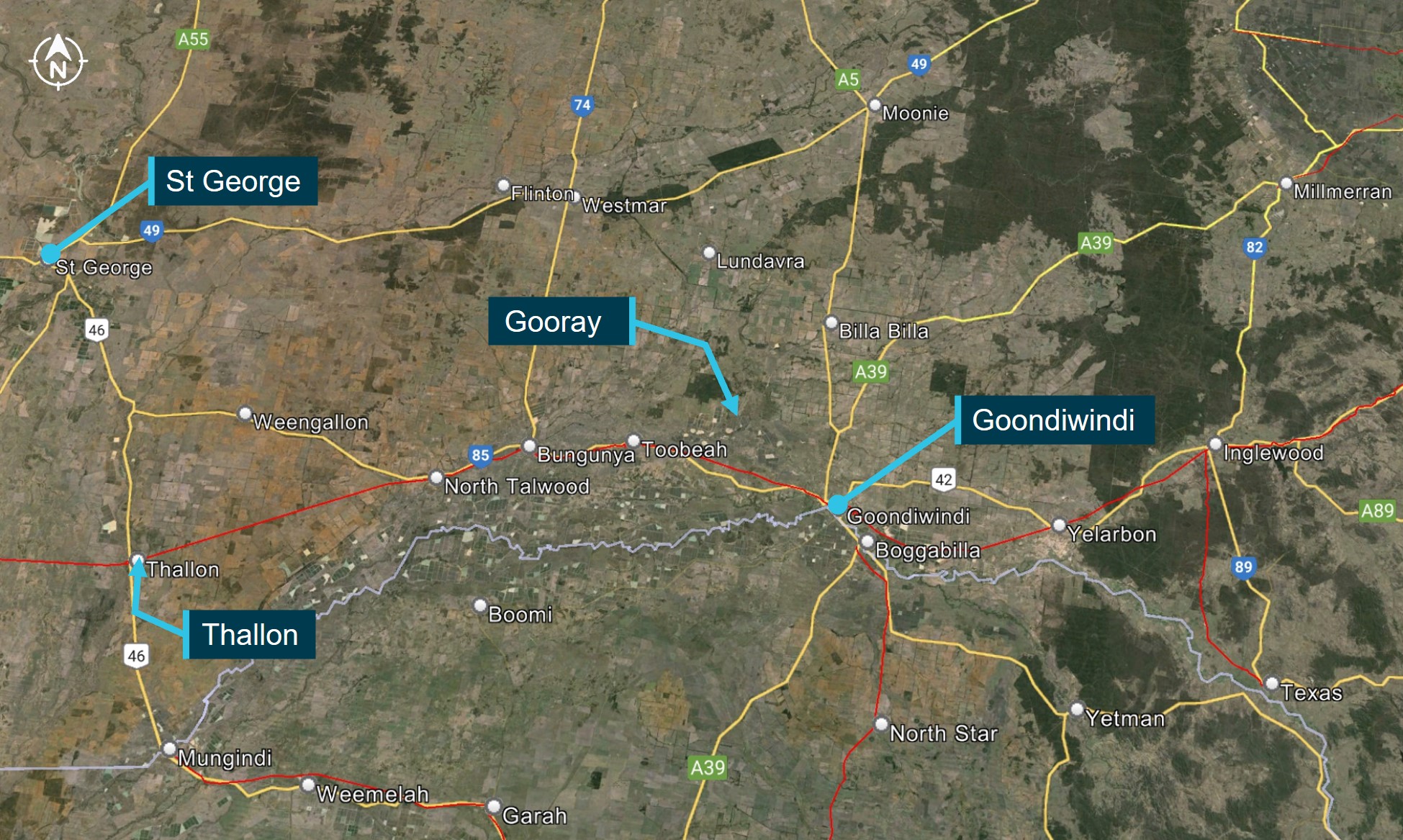
On 23 May 2024, loaded WATCO grain train 6839 was being operated between Thallon and Fisherman Island (Port of Brisbane), Queensland (Qld). This train was a regular scheduled grain‑haulage service operated by WATCO for GrainCorp, and Queensland Rail (QR) was the rail infrastructure manager (RIM).[1] Train 6839’s crew comprised one driver-in-control (DIC) and one driver-assisting (DA), who were rostered to drive the train from Thallon to Goondiwindi. The crew signed on at Goondiwindi station at 0600 local time, and drove a WATCO truck to Thallon. As the train crew were driving west to Thallon, a truck driver was preparing to take a prime mover and flat-top trailer from the St George area to a farm on Gooray Road, Gooray (Figure 1).

Figure 1: Geographic overview of area of operations for train 6839 and truck 

Figure 1: Geographic overview of area of operations for train 6839 and truck

Source: Google Earth, annotated by the ATSB

At about 0700, the truck driver hitched the trailer to the prime mover and found no brake or other mechanical issues with the heavy vehicle during their standard pre-departure tests. The truck driver then drove the heavy vehicle to the farm on Gooray Road and arrived several hours later. En route, the truck driver crossed the Gooray Road level crossing from the south, which they had done at least once before.

The train crew arrived at Thallon in the WATCO truck at about 0815 and conducted a handover with the outgoing crew as the train was still being loaded. Train 6839 finished loading at about 0945, but was then held for 45 minutes by network control to allow the operation of hi-rail vehicle ZE09. The hi-rail vehicle was a 4WD equipped to drive on railway tracks, and departed Thallon at 0932 on a regular track inspection patrol between Thallon and Goondiwindi. Although train 6839 was timetabled to depart Thallon at midday, the crew was granted a proceed authority[2] to depart at 1030.

Train 6839 arrived at Toobeah at around 1256, where it was held for several minutes while the hi‑rail vehicle entered Goondiwindi Yard. Train 6839 was then granted an extended limit of authority[3] to hold short of Signal GI28 on the outskirts of Goondiwindi. Train 6839 departed Toobeah at 1306, with a run time of around 18 minutes to Gooray and around 50 minutes to Goondiwindi. 

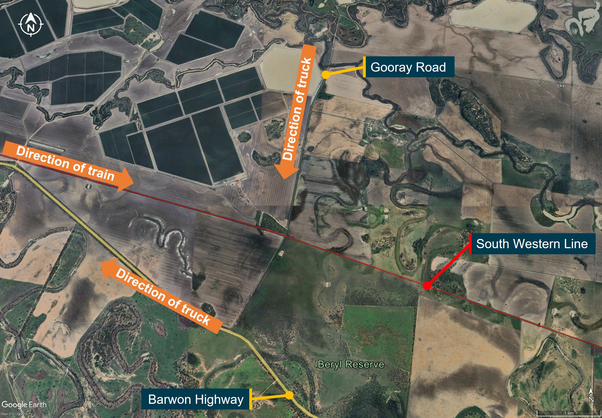
By the time train 6839 arrived at Toobeah, the truck driver had exchanged the flat-top trailer for a low-loader trailer at the farm on Gooray Road. The farm workers placed a bobcat or skid steer onto the low-loader, and the truck driver secured this equipment to the trailer. The truck driver intended to take this equipment back to the St George area via the Barwon Highway (Figure 2).

Figure 2: Direction of travel for the truck and train through Gooray

Figure 2: Direction of travel for the truck and train through Gooray

Source: Google Earth, annotated by the ATSB

Prior to departure, the truck driver reported having conducted their standard checks, including a tug test and checks of the lights, air hoses and brake lines. The truck driver reported that during the tug test, the trailer was moving and the wheels were turning, which should not occur when a trailer is hooked up and before the air hoses are connected.

At about 1320, the truck departed the farm and turned left onto Gooray Road, heading south towards the Barwon Highway. To reach the highway, the truck driver had to negotiate the passive level crossing they had crossed that morning, but this time from the north. As the truck and train converged on the crossing at about the same speed, neither vehicle’s driver sighted the other vehicle.

In the prevailing light and weather conditions, all advance warning signs, level crossing signage, and the crossing itself would have been visible to the truck driver from up to 400 m away. At the posted speed limit of 100 km/h, from 400 m, road vehicle drivers would have up to 15 seconds to react and slow in preparation to stop. However, the truck driver reported driving at around 40‍–‍60 km/h, which would have provided them at least 30 seconds to see and respond to the crossing or the signs once these became visible. 

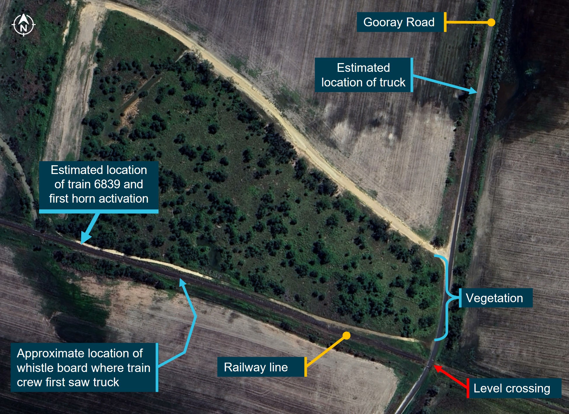
At about the same moment the crossing and warning signs would have come into the truck driver’s view, the train DIC first sounded the train horn. Train drivers were required to sound the horn at a whistle board located about 316 m from the crossing. However, the train DIC sounded the horn earlier, 442 m prior to the crossing, aware that trees immediately prior to the crossing prevented extended line of sight for drivers of vehicles and trains (Figure 3).

Figure 3: Location of train and truck 30 seconds prior to the collision

Figure 3: Location of train and truck 30 seconds prior to the collision

Source: Google Earth, annotated by the ATSB

As train 6839 passed the whistle board, the DIC first became aware of the truck and estimated the truck was doing at least 40 km/h and did not look like stopping. The train was 19 seconds from the crossing at that time, and the train crew sounded the horn almost continuously from this point.

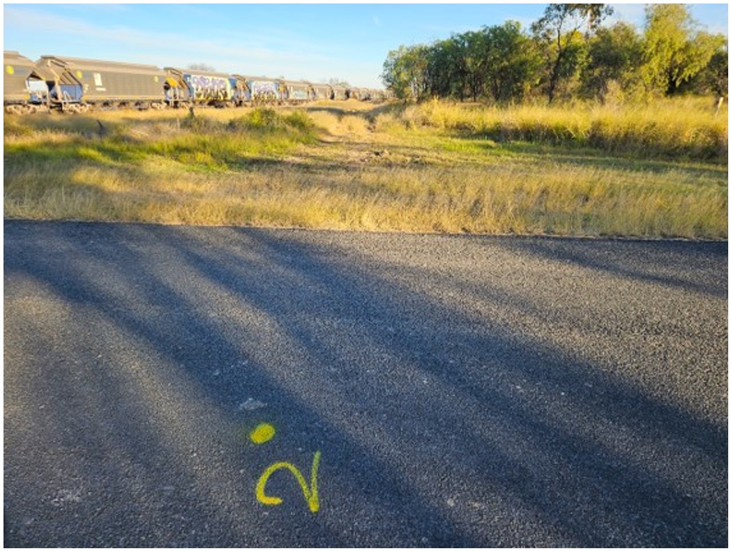
The truck was then about 210 m from the level crossing, and the truck driver recalled taking their foot off the accelerator. Aware they were approaching the rail corridor, the truck driver then coasted towards the level crossing where they were required to stop. However, the truck driver was not aware of the train until they passed the vegetation (Figure 4), but the truck driver reported that the train horn was audible from the roadway as the train and truck both approached the crossing.

Figure 4: View of railway line as the truck passed the vegetation

Figure 4: View of railway line as the truck passed the vegetation

Source: WATCO

As the truck driver passed the trees and rounded a slight bend in the road, they saw the train, which was just over 100 m from the crossing. At that point, the truck was around 50 m from the crossing and travelling at around 40 km/h. The truck driver reported that they started to brake but that it felt like the trailer was pushing the prime mover, and assessed that they did not have sufficient braking power to stop before the crossing. As a result, the truck driver decided to accelerate past the stop sign and across the railway line into the path of the train.

Simultaneously, the train crew assessed that the truck was not slowing down or under heavy braking action, as they did not see smoke, skidding, or locked tyres. The train DIC applied the emergency brakes, and both train crew braced against the control console, realising a collision was imminent. The DIC pressed the horn until their toggle broke, after which the DA sounded the horn until moments before impact. The prime mover of the truck cleared the tracks, but the low‑loader trailer was still across the tracks when train 6839 reached the crossing at around 1325.

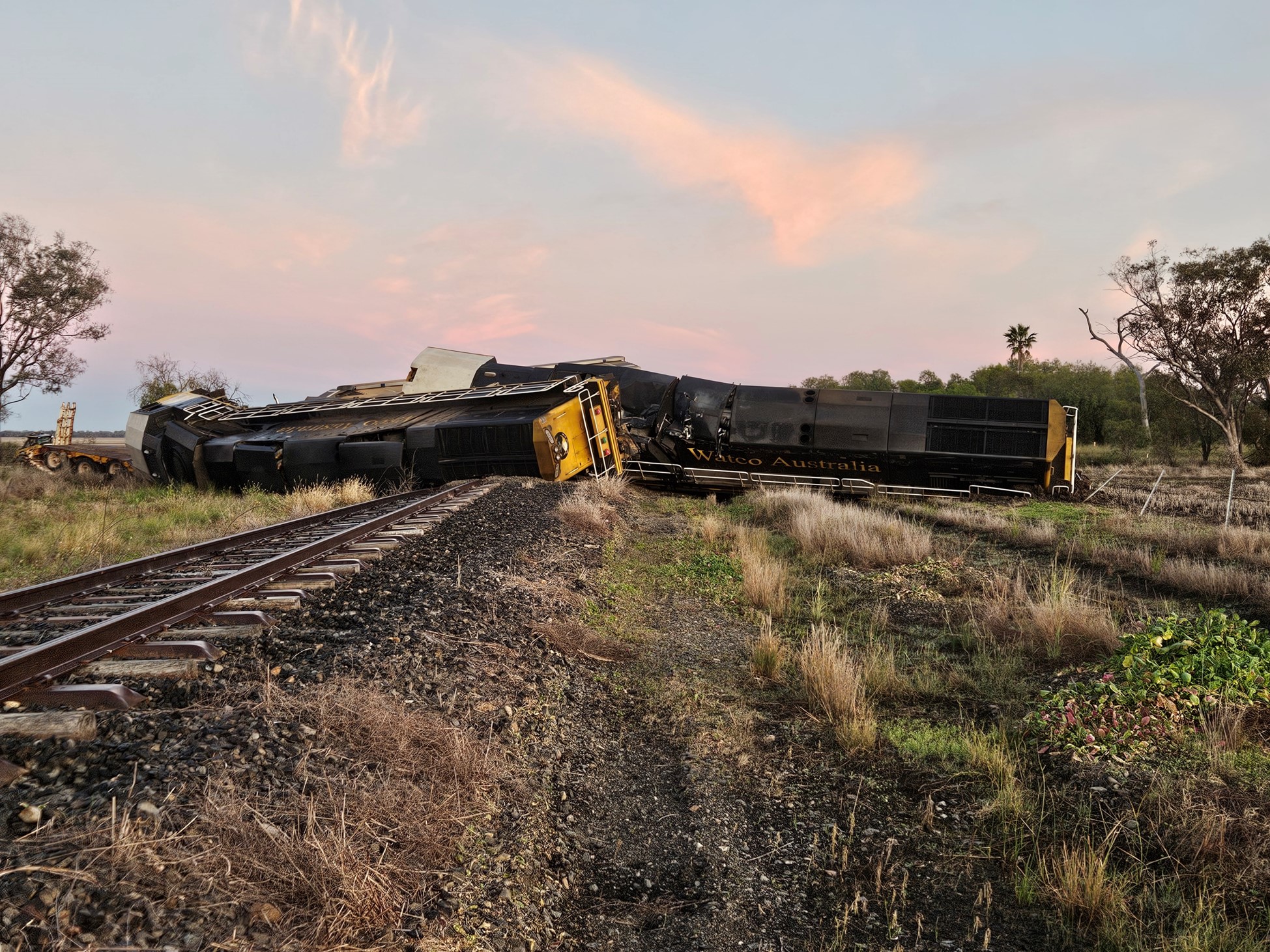
The lead locomotive of train 6839 hit the middle of the trailer. The locomotive body was sheared off the leading bogies and forced perpendicular to the track before coming to a rest on its side in muddy ground within the rail corridor. The trailing locomotive was also turned perpendicular to the track and impacted the lead locomotive during the collision sequence (Figure 5), and 14 grain hoppers derailed and bunched up in a concertina effect. The locomotives and a dozen grain hoppers were damaged beyond repair, and another 2 grain hoppers sustained substantial damage. 

Figure 5: The WRA-class locomotives, post-collision

Figure 5: The WRA-class locomotives, post-collision

Source: WATCO

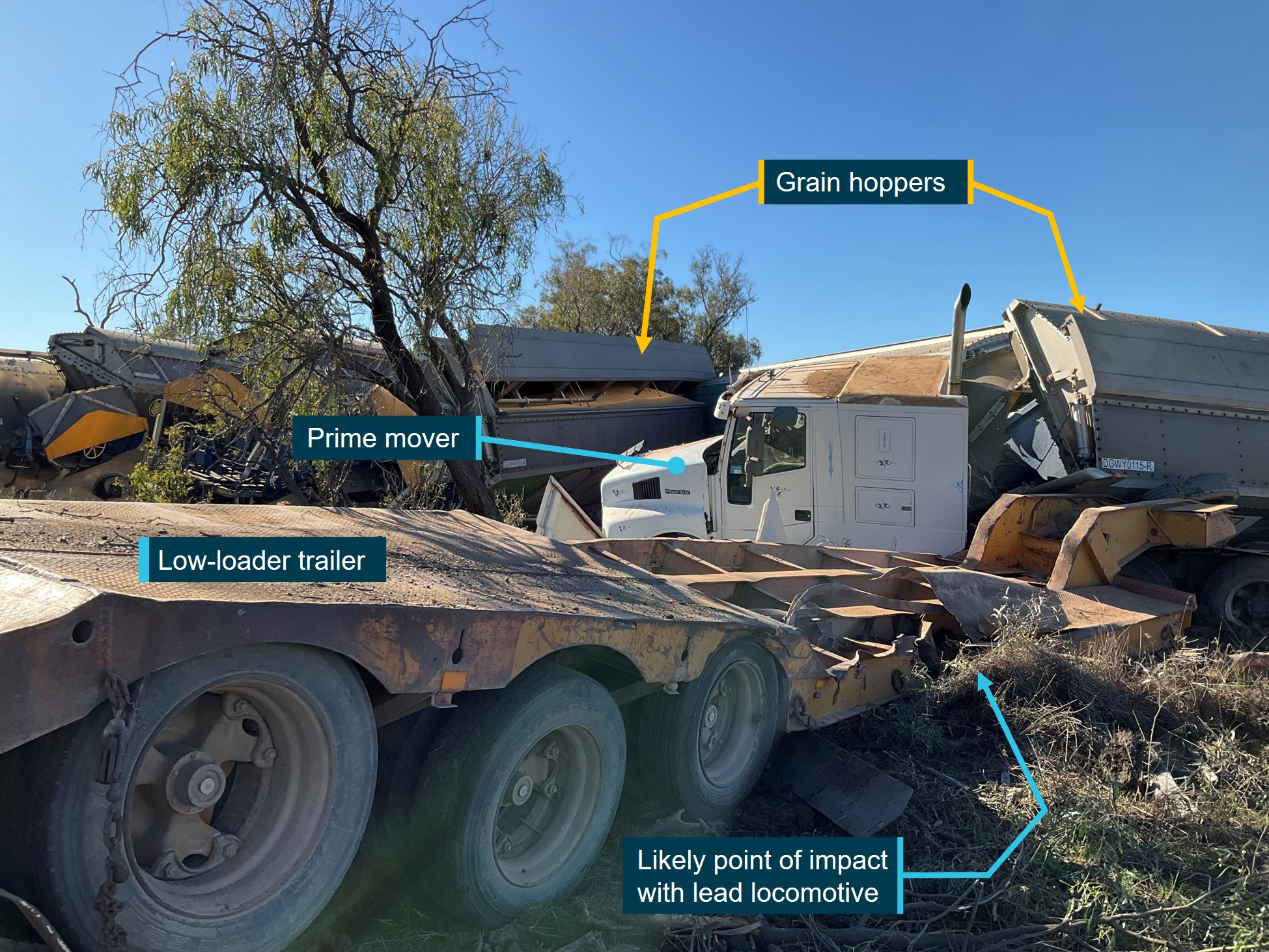
The prime mover experienced secondary impact damage most likely from the grain hoppers (Figure 6), and the bobcat on the trailer landed a short distance away. The prime mover and low‑loader trailer were damaged beyond repair and the bobcat was substantially damaged.

After the collision, the train crew radioed network control and requested emergency services. The truck driver escaped from the prime mover and assisted the train DA with removing the emergency exit window, through which the train crew subsequently evacuated. The train crew and truck driver sustained serious injuries.

Figure 6: Grain hoppers, prime mover, and low-loader trailer post-collision

Figure 6: Grain hoppers, prime mover, and low-loader trailer post-collision

Source: Queensland Police Service, annotated by the ATSB

Context

Train driver information

The DIC and DA were experienced train drivers who had worked for over 4 decades in several operational and front-line roles with multiple operators across Qld. They had both been driving trains on the South Western system since the early 2000s and had recently recommenced driving with WATCO after several months of inactivity due to the seasonal nature of the grain harvest.

Train information

Train 6839 consisted of 2 National Railway Equipment Company E2250CC (also known as WRA‑class) locomotives, followed by 40 DGWY-class loaded grain-hopper wagons. The total length of the train was around 600 m, which weighed around 2,500 tonnes prior to departure. 

The train crew reported that the train was operating normally throughout the journey prior to the collision. There were no warning lights, error messages, or known or observed mechanical problems with either the locomotives or the consist. 

Data from the locomotive event logger showed that the train was travelling at or below the speed limit of 60 km/h between Toobeah and the Gooray Road crossing. The event logger also showed that:

  • the train was maintaining a near-constant speed at a consistent throttle setting in the minutes immediately preceding the collision
  • activation and acknowledgement of the vigilance system[4] occurred at regular time intervals
  • there was no uncommanded decrease in brake pressures or degradation in brake performance
  • the status of headlights and ditch lights was high/bright and operational prior to collision
  • full service/emergency brakes activated seconds prior to collision
  • there was near-continuous sounding of the horn from before the whistle board to the crossing.

Truck information

The truck was an articulated heavy vehicle consisting of an Iveco Power Star prime mover, and a Drake low-loader trailer carrying a small CAT skid-steer bobcat. The truck driver reported that they had never towed that trailer before. The driver also reported that during their pre-departure checks, the trailer wheels were moving when they should have been fully locked. This should not have occurred as the air hoses had not been connected to the trailer to release the brakes and allow the wheels to move. 

Although the truck driver had observed this condition prior to departure, no further tests were conducted, and no mechanical repairs or brake adjustments were made to the trailer. The truck driver reported that the first time they attempted to apply the brakes was as they approached the level crossing. When the truck driver applied the brakes to come to a stop, they felt the trailer was pushing the prime mover to the extent that the cab would have been struck by the train. As a result, the driver assessed that their only option was to veer away from the train and accelerate through the crossing. 

After the collision, Queensland Police conducted a forensic examination of the prime mover, but did not examine the trailer. The investigator noted that they were ‘unable to make an accurate determination as to the overall mechanical condition of this vehicle due to the extent of impact damage sustained to the pneumatic braking and suspension systems’. It was also found that ‘the first drive axle left side brake servo exhibited a noticeable air leak with the brake pedal applied’. The police concluded that this condition was ‘unsatisfactory’ and could ‘decrease the overall braking efficiency of the prime mover if brake application was continuous’.

The forensic examination also assessed the condition of the tyres on the prime mover but were ‘unable to make an accurate determination as to the overall tyre condition due to the extent of incident damage and tyres not being located within the inspection site’. However, it also concluded that ‘all mounted tyres on the subject prime mover were of a satisfactory tread condition’.

Level crossing information

Gooray Road

Gooray Road was the main vehicle thoroughfare through Gooray. In the year to 26 May 2024, there were 152 recorded train movements through the Gooray Road level crossing (averaging 3 per week), but frequencies varied due to the nature of the grain harvest. QR advised that 3 train movements per week was standard for the month of May, and that this would increase to 1‍–‍3 trains per day through Gooray in peak grain season. Prior to the hi-rail vehicle, the last train went through Gooray 3 days before the collision.

The Gooray Road level crossing was a public crossing in a rural location surrounded by farmland which saw limited road and rail traffic throughout the year. The crossing had passive controls protecting both approaches on Gooray Road. Passive level crossing controls use signage and road markings to warn road users about an approaching level crossing, but do not activate or change when a train is approaching.

Advance warnings

Two advance warnings were provided on the northern approach to the Gooray Road crossing:

  • Stop Sign Ahead signage, with accompanying ‘RAIL’ block text painted on road surface (W3-1)
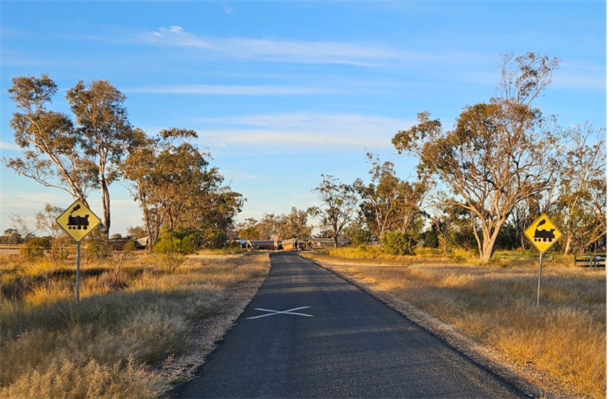
  • Rail Crossing Ahead signage, with accompanying ‘X’ painted on road surface (W7-7).

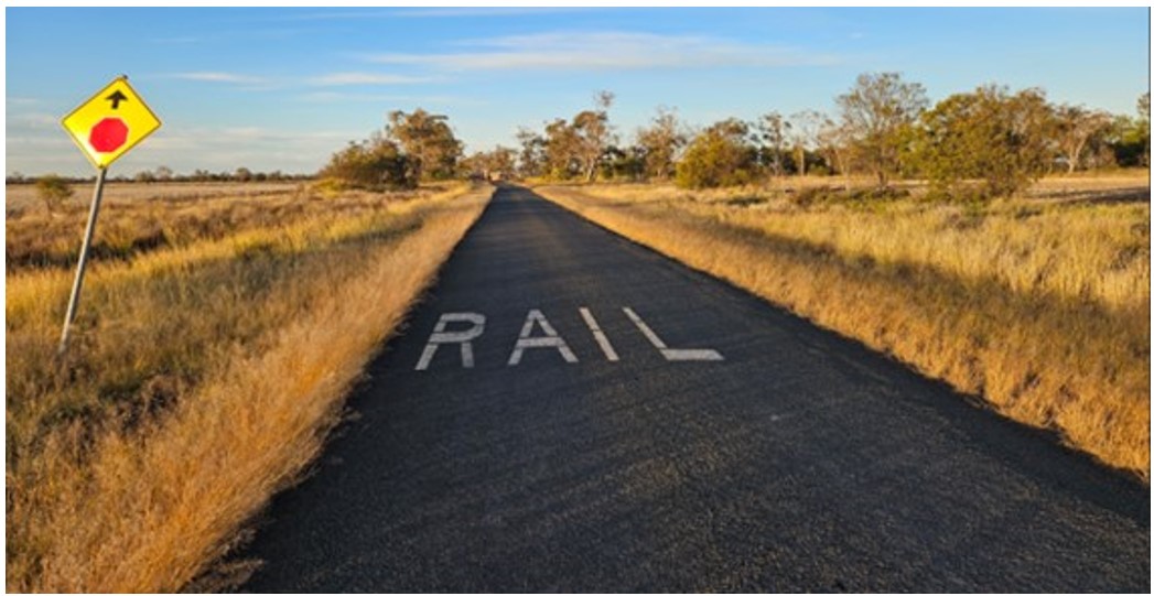
The first advance warning, about 270 m from the crossing, consisted of W3-1 Stop Sign Ahead signage, and a ‘RAIL’ marking on the road surface, which was required due to the high-speed approach (Figure 7). 

Figure 7: First advance warning, northern approach

Figure 7: First advance warning, northern approach

Source: WATCO

The second advance warning, about 180 m from the crossing, consisted of W7-7 Rail Crossing Ahead signage on both sides of the road and an ‘X’ marking on the road surface (Figure 8).

Figure 8: Second advance warning, northern approach

Figure 8: Second advance warning, northern approach

Source: WATCO

According to the Australian Standard,[5] the W3-1 Stop Sign Ahead sign was required to be placed 180–250 m before the stop sign at the crossing, and the W7-7 Rail Crossing Ahead sign was required to be placed 70 m before the W3-1 sign. The ‘RAIL’ and ‘X’ road markings were in the correct order, but the signs were in the reverse order. 

Passive controls at crossing

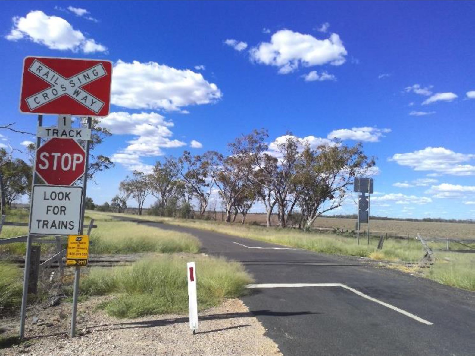
The passive control installed at the Gooray Road level crossing was an RX-2 Stop Sign Assembly, with an accompanying solid white block line painted on road surface. This sign had been installed in 2004 following an Australian Level Crossing Assessment Model (ALCAM) assessment, and the assembly consisted of 4 components and a QR incident plaque (Figure 9).

A white, unbroken stop line accompanied the Stop Sign Assembly. The stop line was required to be placed in a position that maximised sightlines for road traffic, 3.5 m from the nearest rail. A roadside white post with red reflective marker for night visibility next to the assembly was impacted during the collision sequence.

Figure 9: Stop sign assembly and stop line, northern approach

Figure 9: Stop sign assembly and stop line, northern approach

Source: Queensland Rail

Sightlines

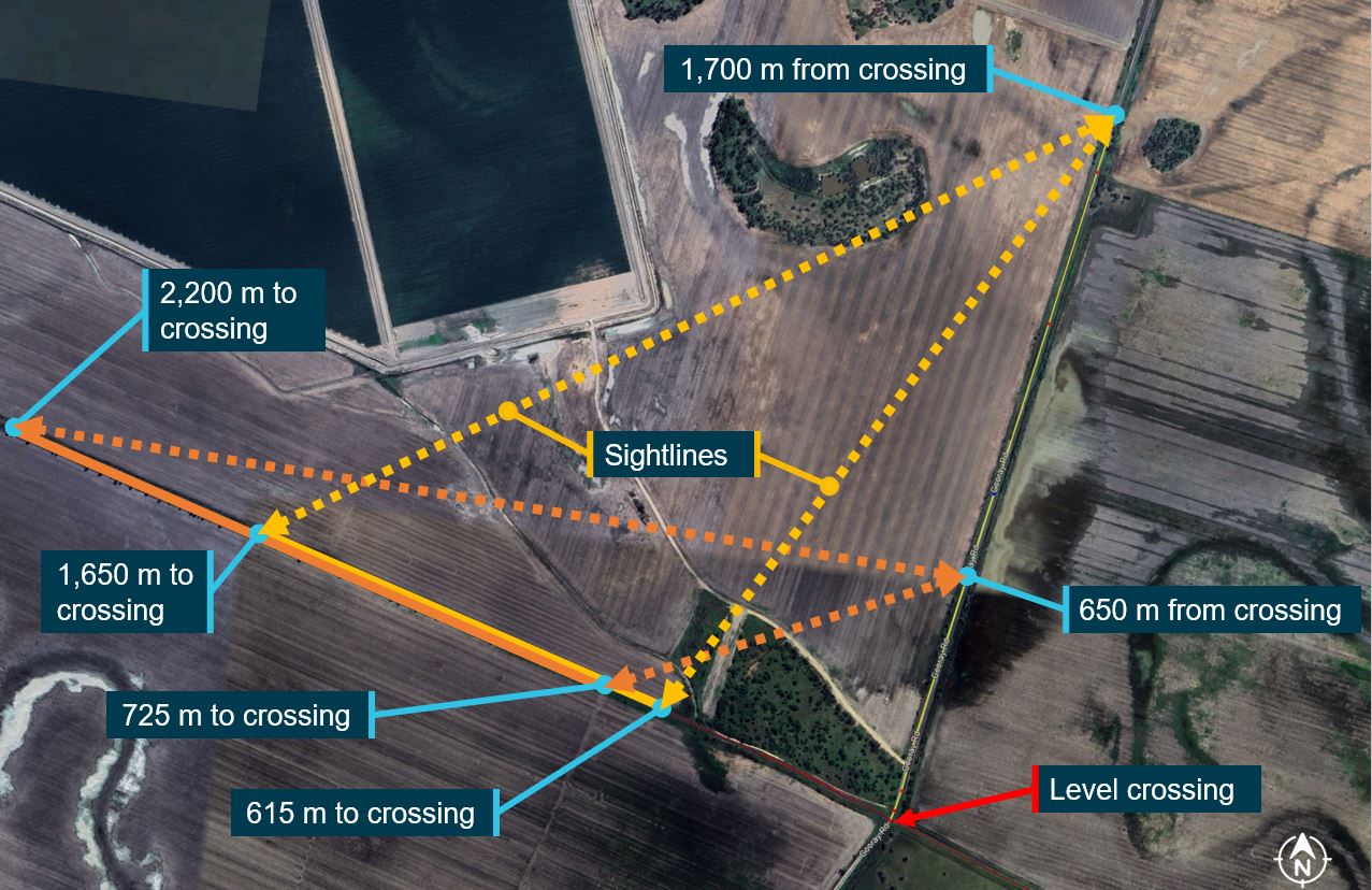
Queensland Police also found that road users approaching the crossing from the north had ‘clear, unobstructed views’ in an arc of 180° from 1,700 m before the crossing, including of the rail corridor. Further, at the truck’s reported speed, the truck driver had an opportunity of 60‍–‍75 seconds to see the train before the vegetation blocked their view.

Similarly, Gooray Road should have been visible to rail traffic from about 1,650 m before the crossing. These sightlines did not change greatly until about 650 m before the crossing, when the vegetation started to obstruct them (Figure 10). However, the train crew reported first seeing the truck about 320 m prior to the crossing and the truck driver first sighted the train after passing the end of the vegetation 20 m before the stop line.

Figure 10: Available sightlines as the train and truck approached the crossing

Figure 10: Available sightlines as the train and truck approached the crossing

Source: Google Earth, annotated by the ATSB

QR calculated that the sightlines down the rail corridor were at least 1 km at the Stop Sign Assembly in both directions. However, 120 m from the crossing, vegetation obstructed the view of the western side of the rail line from the northern approach on Gooray Road. The rail corridor was then not visible until about 20 m prior to the crossing where the vegetation cleared, after which the sighting distance increased exponentially to almost 1 km at the stop line. This vegetation was the primary factor for the installation of the Stop Sign Assembly in 2004. 

The railway line had a shallow right curve, which began at about the whistle board on the western side of the crossing, but this straightened out 130 m before the crossing. Outside of this curve, there was a straight of almost 9 km on the western side and a 7.5 km straight on the eastern side.

QR also assessed that approaching the crossing from the north, Gooray Road had a minor right curve about 50 m before the crossing, and a minor left curve about 150 m prior to the crossing. However, the road was straight for 2.3 km preceding these curves, and the road alignment maintained direct line-of-sight of the advanced warning signs, the stop sign assembly, and the level crossing from up to 400 m away in clear conditions. 

Road and rail corridor visibility

The truck driver reported that their in-cab visibility and sighting distance was not compromised by the prime mover cab design or any external structures or monuments around the road corridor. Post-incident photos and videos supported this recollection. The truck driver also reported that although there was a crack in the windscreen and a problem with a headlight switch, neither of these factors affected their ability to see the road, the signage, or the crossing. The truck driver also reported that about 1 minute before reaching the crossing, they looked in their side mirror and observed a loose chain on the trailer. However, the driver also reported not having been distracted by anything prior to the accident. 

The train crew reported that there were no impediments to in-cab visibility caused by locomotive cab design, windscreen deformities, or track grade and curvature. They also reported that there were no lineside structures, monuments, or foliage that could have prevented them from seeing the crossing or the whistle boards. Trackworkers on the hi-rail in front of train 6839 similarly did not record any obstructions or any limitations of visibility within the rail corridor prior to the incident. QR also noted that trackside fencing was in good condition and was not tall enough to obstruct visibility within the rail corridor. 

Track condition 

The South Western line through Gooray consisted of a single narrow gauge bi-directional track and used Direct Traffic Control[6] as the primary means of safeworking. Although the published speed limit was 70 km/h in this section, QR implemented a temporary limit of 60 km/h through a series of Train Notices to protect the track condition and structure. This preventative measure was first imposed in 2022 and remained in place at the time of the incident.

Although the track condition was reported as ‘good’, the train DA reported that drivers would travel below the speed limit in that section as it was ‘a smoother ride’. The grade was almost entirely flat between Toobeah and Goondiwindi, including through the Gooray Road crossing. 

Scheduled inspections

As the RIM, QR conducted regular inspections of all crossings between Thallon and Goondiwindi. This consisted of twice-weekly visual inspections from the rail corridor to monitor track condition and known defects, and an annual inspection from the road corridor to assess overall compliance. 

The most recent visual inspection of the Gooray Road crossing had been completed less than 30 minutes before the collision, by the hi-rail that train 6839 had been following since Thallon. The trackworkers onboard hi-rail ZE09 did not identify any track misalignment, defects, or faults at the Gooray Road level crossing on 23 May 2024. They also did not identify any observable issues with the road surface or the road/rail interface as the hi-rail passed through the crossing.

The annual inspection for compliance with civil engineering standards was conducted in February 2024. This inspection found that the road surface within the 10 m approaching the crossing was in average condition, and that the bitumen around the rails was also in average condition. It was also noted that the flangeway and guard rails were compliant and in good condition, as were the signs that formed the passive controls. The inspection further determined that vegetation did not impact visibility and sightlines of the rail corridor from the crossing to the whistle boards on both sides.

Interface agreement

An interface agreement was signed in August 2018 between the RIM (QR) and the Road Manager (Goondiwindi Regional Council), and this agreement remained current at the time of the collision. The agreement stated that ALCAM would be used to identify, monitor, and manage risk at all 42 level crossings in the area, including the one on Gooray Road. The interface agreement outlined the responsibilities that QR and Goondiwindi Regional Council each had for corridor maintenance as well as the provision and the upkeep of relevant signage and markings.

The interface agreement stipulated that all elements needed to follow the relevant Australian Standard[7] and responsibility for each individual aspect of the Gooray Road level crossing was allocated as shown in Table 1.

Table 1: Agreed division of responsibilities for the Gooray Road level crossing

Rail: Queensland RailRoad: Goondiwindi Regional Council

Responsible for:

  • Rail corridor whistle boards
  • Incident Reporting signage
  • Road surface condition between the rails and the outside of the outermost rail to a distance of 60cm
  • Sighting distance clearances

Responsible for:

  • Passive controls – RX-2 Stop Sign Assemblies
  • Advanced warning signage on Gooray Road
  • Road surface markings on approaches to crossing
  • Road surface condition on approaches to crossing
  • Vegetation clearance on approaches to crossing
Previous incidents at the Gooray Road level crossing

The train DA did not recall any near-collisions with vehicles, but the DIC reported several previous near-collisions on the South Western line. QR did not identify any previous incidents or collisions at the Gooray Road crossing, but reported that the hi-rail would slow down significantly at the Gooray Road crossing from their usual speed of between 20–40 km/h. This was a precaution as trackworkers had regularly observed vehicles cross in front of the hi-rail without stopping, and that this was particularly common on the northern approach to the level crossing. The train DIC attributed this behaviour to expectation bias caused by the infrequency of trains.

Environmental conditions

Gooray Road was sealed with rough bitumen, around 6 m in width, with a speed limit of 100 km/h. The truck driver described the road as narrow and rough. Photos and videos taken post-incident confirmed the absence of any environmental contamination or degradation of the road surface that could have impacted traction, braking, or steering.

The train crew did not identify any conditions affecting the rail head, or any issues with the grade and curvature of the track that could have influenced the operation of the train. Similarly, no such issues with track condition or weather conditions were reported by the trackworkers on the hi-rail that preceded train 6839. QR analysis and post-incident photos confirmed that weather conditions were sunny with partly cloudy skies and good ground visibility. The road surface and rail head were both dry with zero rainfall recorded, and the temperature was 24–27 °C, which reduced the risk of heat-related track deformities and operating restrictions.

The ATSB assessed whether sun glare may have affected visibility due to the north-south alignment of Gooray Road and east-west alignment of the railway line. However, the collision occurred at 1325 when the sun was at or near its zenith and directly above the vehicles. The truck driver and train drivers all confirmed sun glare was not present prior to the collision.

ATSB safety study

The ATSB safety study Review of level crossing collisions involving trains and heavy road vehicles in Australia (RS-2021-001) analysed collisions between trains and heavy vehicles at Australian level crossings between 1 July 2014 and 31 August 2022, in which 24 rail or road users were fatally or seriously injured. The aim of the study was to improve understanding of the risks associated with level crossing collisions involving heavy vehicles. Common factors identified that may have contributed to the actions of heavy vehicle drivers included the following:

  • In at least 12 collisions the heavy vehicle driver had regularly used the level crossing prior to the collision with the train. The drivers' previous experience at the level crossings may have led to a low expectancy for trains and contributed to them not detecting a requirement to stop and give way.
  • In at least 14 collisions, the heavy vehicle driver’s view of the track or level crossing protection equipment was obstructed by vegetation, the design of the heavy vehicle cab, poor crossing lighting, or sun glare.
  • Consistent with prior research showing that train horns have limited effectiveness for alerting road vehicle drivers approaching level crossings, in at least 25 accidents the horn was not effective at alerting the heavy vehicle driver to the presence of the train.

The report also described a ‘rolling stop’, which involves slowing a road vehicle until a decision is made to proceed into the crossing, without coming to a complete stop. When conducting a ‘rolling stop’ a road vehicle driver will spend less time at the stop point for a passive level crossing and therefore will probably employ less time scanning for oncoming trains. In turn, that increases the likelihood of an incorrect decision to proceed into the crossing when it is not safe.

Locomotive emergency windows

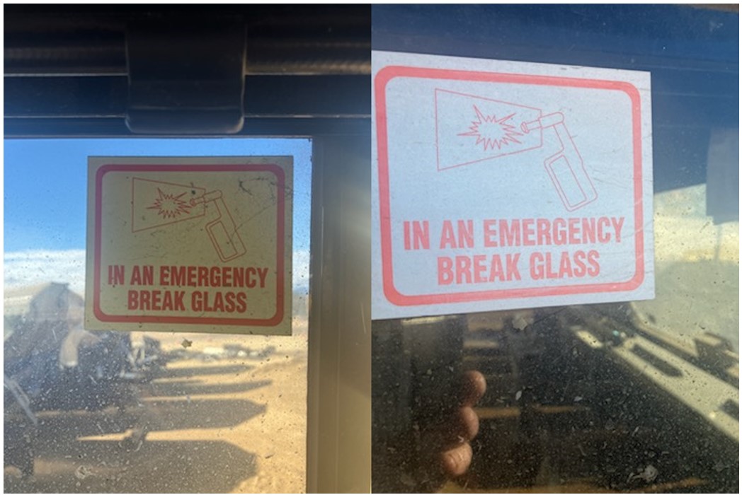
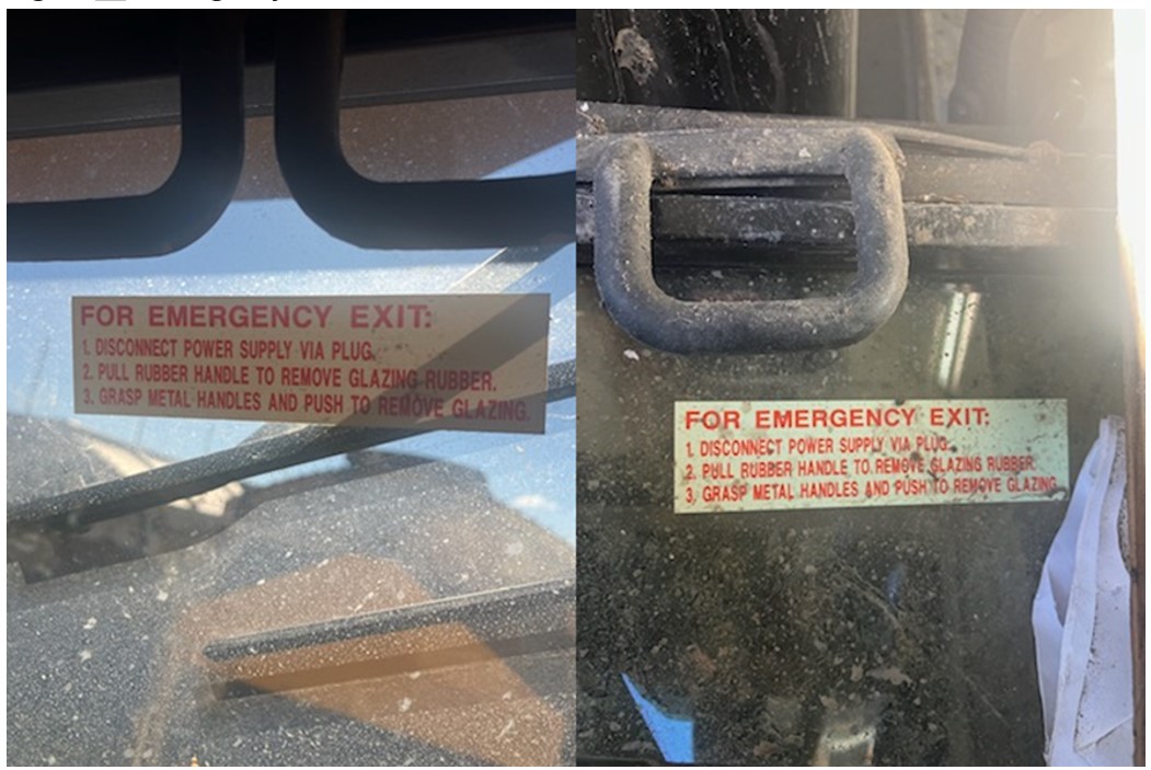
The WRA-class locomotives entered service in 2020 and had been designed so that the windscreen panels in the cabs could be used for emergency egress, unlike older locomotives, which did not have designated emergency exits. Inside the WRA-class cab, 2 stickers were fixed to the windscreen to assist emergency egress. The first sticker illustrated the use of a fire hammer to crack the glass and consisted of a graphic in the corner of the windscreen. This graphic was accompanied by block text which stated ‘In an emergency break glass’ (Figure 11).

Figure 11: Emergency exit sticker with illustration and block text

Figure 11: Emergency exit sticker with illustration and block text

Source: WATCO

The second sticker was affixed to the top of the windscreen under 2 black handles and listed a 3‑step process to remove the window. On the exterior of the cab, an identical sticker with these instructions enabled people outside to remove the glass (Figure 12).

Figure 12: Emergency exit sticker with written instructions

Figure 12: Emergency exit sticker with written instructions

Source: WATCO

WATCO did not have a specific training module for emergency egress, but drivers were told how to remove the windows as part of their overall ‘shed tuition’. Information about the windows was incorporated into the overall teaching of locomotive mechanical and electrical functionality and componentry. This was supported by the train DA, who explained that drivers had general awareness of the exit windshield, and that the relevant information would likely be in the locomotive manuals. The DIC reported that they had not been shown how to open the window in training but had read the instructions on previous journeys.

The train DIC reported that they had difficulty seeing and reading the instructions after the collision due to debris and dust inside the cab. They also noted that reading the instructions and escaping from the cab would be more difficult at night or in low-light conditions. However, the train DA and truck driver were able to follow the instructions and remove the glass, although the final position of the locomotive and the sticker location may have made it harder to do so. The train DA reported that the glass came out easily, and that the space and access available was sufficient to escape through the window despite the build-up of mud in the cab.

Although the train DIC suggested that training may have assisted in understanding how to use the emergency exit, the DA found the instructions were clear, and the exit was easy to manipulate despite the cab being compromised and the sustained injuries. 

Safety analysis

Passive level crossing

Although the Gooray Road level crossing and its associated infrastructure largely complied with the relevant standards, and the signs and road markings were visible, approaching from the north, vegetation obstructed the view of the rail corridor from the road from 650 m until 20 m before the stop line. There were minor curves on Gooray Road in advance of the crossing, there was sufficient sighting distance for a driver scanning for hazards along the road ahead to react and stop before the level crossing. At the stop line prior to the crossing, the truck driver would have had an unobstructed view of the train. 

The level crossing used passive controls and advance warnings to alert road users to stop and look for rail traffic. Although the advance warning signs were in the incorrect order according to the standard, this did not alter the overall meaning of the signs and road markings, and was unlikely to have influenced the ability of the driver to view, interpret, and respond to the warnings as they approached the crossing. 

The passive controls at the crossing were the primary risk control against collisions but did not activate or change to indicate the presence of a train or physically prevent road users from crossing in front of trains. Consequently, the onus was on road users to stop, sight, and remain clear of rail traffic.

Truck driver actions

As the truck and train converged on the level crossing at similar speeds, the truck driver did not see the train before vegetation blocked their view of the rail corridor. 

When the train crew sounded the horn approaching the Gooray Road level crossing, the truck was approaching the first of 2 advance warning signs at about 40–60 km/h. The truck driver could not see the train or hear the train horn at that distance, but the crossing and advance warnings would have been visible. Although at that point the truck driver had sufficient reaction time and braking distance to stop, they did not attempt to brake until they passed the vegetation just before the crossing and saw the train approaching.

By that time, it was too late for the truck to stop prior to the crossing. There was no evidence that the driver then braked heavily, and the prime mover and trailer brakes may have had reduced effectiveness. Given that the truck driver was aware that the trailer brakes may have been defective, it was likely that they had not slowed the truck sufficiently to stop safely prior to the level crossing. Assessing that the truck would not stop before entering the crossing in front of the train, the driver elected to accelerate to get the truck cab past the train, resulting in the locomotive impacting the trailer. 

Expectation bias 

Given the infrequency of rail movements at the Gooray Road level crossing and that the truck driver had not seen trains when crossing there on previous occasions, they likely did not expect to encounter a train. Research showed that drivers with a low expectancy of trains may be less likely to look for trains or respond appropriately to signage and road markings. The truck’s approach to the crossing was consistent with the driver conducting a rolling stop, in which they would proceed unless a train was sighted. In this case, that resulted in insufficient distance remaining to stop prior to the crossing.

Findings

ATSB investigation report findings focus on safety factors (that is, events and conditions that increase risk). Safety factors include ‘contributing factors’ and ‘other factors that increased risk’ (that is, factors that did not meet the definition of a contributing factor for this occurrence but were still considered important to include in the report for the purpose of increasing awareness and enhancing safety). In addition ‘other findings’ may be included to provide important information about topics other than safety factors. 

These findings should not be read as apportioning blame or liability to any particular organisation or individual.

From the evidence available, the following findings are made with respect to the Level crossing collision between freight train 6839 and truck at Gooray Road, Gooray, Queensland on 23 May 2024.

Contributing factors

  • The truck driver did not stop prior to the level crossing as required by the signage.
  • Due to the infrequency of trains on that corridor, it is likely that the truck driver had not seen a train at the Gooray Rd crossing on previous journeys. This created an expectation that there would be no conflicting rail traffic at the crossing, which probably reduced the effectiveness of the truck driver’s scan and led to them approaching the intersection at a speed too high to stop prior to the level crossing.

Other findings

  • The Gooray Road level crossing configuration provided appropriate signage and stopping distance for a road vehicle driver to notice the passive level crossing controls and bring the vehicle to a controlled stop before the level crossing. Once stopped, there was adequate visibility for a driver to sight a train and give way.

Safety actions

Whether or not the ATSB identifies safety issues in the course of an investigation, relevant organisations may proactively initiate safety action in order to reduce their safety risk. All of the directly involved parties are invited to provide submissions to this draft report. As part of that process, each organisation is asked to communicate what safety actions, if any, they have carried out to reduce the risk associated with this type of occurrences in the future. 

Safety action by Queensland Rail

On 12 June 2024, Queensland Rail initiated an ALCAM assessment and looked at road geometry, traffic volumes (road and rail), visibility and sighting distances, and the existing passive controls. The assessment determined that there were no obstacles to sighting distances or the visibility of signage. The ALCAM assessment deemed the northern side signage to be compliant, however, ONRSR subsequently identified that the advance warning signs were in the reverse order to the standard. It was noted that sun glare could impact visibility for all drivers, although this was only relevant at dawn and dusk.

The assessment found that the signage on the southern side of the crossing lacked an additional advance warning sign, although this had no bearing on this accident. It also found that the stop lines on both sides of the crossing had become faded and scuffed, most likely through a combination of spillage and impact damage during the collision sequence, and vehicle movements and dirt transfer during recovery activities. Although the stop lines remained compliant and visible, it was recommended that these be repainted. Under the existing interface agreement, this work is the responsibility of Goondiwindi Regional Council, and it has been notified.

Safety action by Goondiwindi Regional Council

On 6 December 2024, Goondiwindi Regional Council was advised that the advance warning signs on the northern side were in the reverse order to the standard. The council reported that it would alter the order of the signs on the northern approach to conform with the national standard, and that this rectification work would be scheduled.

Sources and submissions

Sources of information

The sources of information during the investigation included:

  • the train crew
  • the truck driver
  • Queensland Rail
  • Queensland Police
  • WATCO.

Submissions

Under section 26 of the Transport Safety Investigation Act 2003, the ATSB may provide a draft report, on a confidential basis, to any person whom the ATSB considers appropriate. That section allows a person receiving a draft report to make submissions to the ATSB about the draft report. 

A draft of this report was provided to the following directly involved parties:

  • the train crew
  • the truck driver
  • Queensland Rail
  • WATCO
  • ONRSR.

Submissions were received from:

  • ONRSR.

The submissions were reviewed and, where considered appropriate, the text of the report was amended accordingly.

Purpose of safety investigations

The objective of a safety investigation is to enhance transport safety. This is done through: 

  • identifying safety issues and facilitating safety action to address those issues
  • providing information about occurrences and their associated safety factors to facilitate learning within the transport industry.

It is not a function of the ATSB to apportion blame or provide a means for determining liability. At the same time, an investigation report must include factual material of sufficient weight to support the analysis and findings. At all times the ATSB endeavours to balance the use of material that could imply adverse comment with the need to properly explain what happened, and why, in a fair and unbiased manner. The ATSB does not investigate for the purpose of taking administrative, regulatory or criminal action.

Terminology

An explanation of terminology used in ATSB investigation reports is available here. This includes terms such as occurrence, contributing factor, other factor that increased risk, and safety issue.

Publishing information

Released in accordance with section 25 of the Transport Safety Investigation Act 2003

Published by: Australian Transport Safety Bureau

© Commonwealth of Australia 2024

Title: Creative Commons BY - Description: Creative Commons BY

Ownership of intellectual property rights in this publication

Unless otherwise noted, copyright (and any other intellectual property rights, if any) in this report publication is owned by the Commonwealth of Australia.

Creative Commons licence

With the exception of the Commonwealth Coat of Arms, ATSB logo, and photos and graphics in which a third party holds copyright, this report is licensed under a Creative Commons Attribution 4.0 International licence.

The CC BY 4.0 licence enables you to distribute, remix, adapt, and build upon our material in any medium or format, so long as attribution is given to the Australian Transport Safety Bureau. 

Copyright in material obtained from other agencies, private individuals or organisations, belongs to those agencies, individuals or organisations. Where you wish to use their material, you will need to contact them directly.

[1]      Rail Infrastructure Manager: The person or organisation which has effective control and management of the rail infrastructure, whether or not this person or organisation owns the rail infrastructure; or who has a statutory or contractual right to use the rail infrastructure or to control, or provide, access to it.

[2]      Proceed authority: Authorises rail traffic to enter and occupy section or block and proceed in the forward direction.

[3]      Limit of authority: The location to which rail traffic may travel under a Proceed Authority or the limits of a work on track authority, typically defined by a sign, a signal capable of displaying a STOP indication, or a specific kilometrage point.

[4]      Vigilance system: Also known as ‘dead man’s switches’, vigilance systems are safety systems which monitor driver activity and responsiveness, and will automatically apply emergency braking in order to stop the train if a control input or system acknowledgment from the driver is not received within a specified time increment.

[5]      AS 1742.7:2 16 'Manual of uniform traffic control devices - Part 7: Railway Crossings’

[6]      Direct Traffic Control: an absolute block safeworking system used to control the movement of trains in non-signalled territory. This prevents more than one train being authorised into a defined section or block at any one time.

[7]      AS 1742.7:2 16 'Manual of uniform traffic control devices - Part 7: Railway Crossings’

Occurrence summary

Investigation number RO-2024-004
Occurrence date 23/05/2024
Location Gooray Road level crossing, Gooray
State Queensland
Report release date 19/12/2024
Report status Final
Investigation level Short
Investigation type Occurrence Investigation
Investigation status Completed
Mode of transport Rail
Rail occurrence category Level Crossing
Occurrence class Accident
Highest injury level Serious

Train details

Train operator Watco
Train number 6839
Type of operation Freight
Rail vehicle sector Freight
Departure point Thallon Balloon Loop, Thallon, Queensland
Destination Fisherman Island (Port of Brisbane), Brisbane, Queensland
Train damage Substantial

Technical Assistance to Recreational Aviation Australia (RAAus) – Collision with terrain involving Aeropilot Legend 600, 24-8710, about 100 km south-south-west of Perth Airport, Western Australia, on 16 April 2024

Summary

On 16 April 2024, a pilot and passenger were conducting a private flight in an Aeropilot Legend 600 aircraft, south of Perth, Western Australia. During cruise, controllability issues were encountered which led the pilot to deploy the aircraft's emergency parachute. 

The aircraft collided with trees prior to impacting the ground near Preston Beach. The pilot and passenger received minor injuries. An inspection of the aircraft identified that the vertical stabiliser had detached from the tail section of the aircraft.

Recreational Aviation Australia (RAAus) commenced an investigation in response to this accident. RAAus requested technical assistance from the ATSB to examine components from the aircraft. To facilitate that request, an investigation under the Transport Safety Investigation Act (2003) has been commenced.

Any enquiries relating to the accident should be directed to RAAus.

Occurrence summary

Investigation number AE-2024-005
Occurrence date 16/04/2024
Location about 100 km south-south-west of Perth Airport
State Western Australia
Report status Pending
Investigation type External Investigation
Investigation status Active
Mode of transport Aviation
Aviation occurrence category Collision with terrain
Highest injury level Minor

Aircraft details

Model Legend 600
Registration 24-8710
Serial number 1527
Sector Piston
Operation type Part 103 Sport and recreational aircraft

Pilot likely forgot about powerline across runway approach

The pilot of a Cessna that struck a wire while on approach to land at their rural property likely lost awareness of and did not see the powerline, an ATSB investigation report details.

On the afternoon of 8 October 2023, the Cessna 172N had taken off from a property near Merriton, South Australia for a private flight with a pilot and passenger on board. Returning to the property later that afternoon, the aircraft struck the single-wire powerline during the approach to land.

The aircraft subsequently collided with the ground and an intense fuel-fed fire broke out. Both occupants were removed by rescuers, who sustained burns as a result. The passenger was fatally injured in the accident, and the pilot, who was the owner of the aircraft and the property, later succumbed to injuries.

The 700 m grass runway had been positioned in a paddock such that one end was near an oblique powerline. Landing to that end of the runway meant the powerline was in the path of approaching aircraft, unless aiming to land about halfway down the runway (well within the landing distance required for the aircraft). 

“The pilot likely lost awareness of the powerline, which was not marked in a manner sufficient to enhance visibility for pilots using the runway – nor was there a requirement to do so,” ATSB Chief Commissioner Angus Mitchell said.

“This highlights the importance that airstrips on rural properties should be well separated from powerlines, even when the strip is only intended for use by pilots familiar with the wires.”

Power and telecommunication companies in Australia can mark powerlines that are identified as a hazard for low-level flying operations, the investigation report notes.

“In South Australia, property owners can request a quote from SA Power Networks for the installation of powerline markers, while some power companies in Queensland and New South Wales have schemes to reduce the costs of markers to property owners,” Mr Mitchell noted.

“We urge all rural property owners to consider the hazards of powerlines near airstrips on their properties, and to ensure wires are properly marked.”

Separately, pilots flying in Queensland, New South Wales, Victoria and South Australia can make use of the Look up and live(Opens in a new tab/window) website or app to plan flying operations in proximity to powerlines.

In addition, an ATSB educational publication, developed in association with the Aerial Application Association of Australia – Wirestrikes involving known wires: A manageable aerial agriculture hazard – details numerous wirestrike accidents and the lessons that can be learned from them.

“Powerlines, especially single wires, are notoriously difficult to see from the air, and pose an on‑going hazard to aircraft, as this tragic accident shows,” Mr Mitchell said.

Read the final report: Wirestrike and collision with terrain involving Cessna 172N, VH-RSB, near Merriton, South Australia on 8 October 2023

R22 excessive teeter and mast bumping

The in-flight break-up of a Robinson R22 near Koorda, WA highlights the potentially catastrophic effects of low-g and/or low rotor RPM/rotor stall conditions in helicopters with semi-rigid rotor heads.

The two-seat Robinson R22 Beta II was conducting a private flight from Koorda to Jandakot on 2 October 2022 and broke-up in flight shortly after reaching cruise altitude, an ATSB investigation report details.

Recorded flight data showed that, during cruise, the helicopter’s altitude increased by about 100 ft and then rapidly descended, almost vertically. The helicopter collided with terrain inverted, on a dry salt flat, and the pilot and passenger were fatally injured.

ATSB examination of the accident site identified signatures consistent with the main rotor assembly being subject to excessive teeter and mast bumping – where the main rotor spindle impacts the mast.

“It was likely the helicopter entered either a low-g and/or a low rotor RPM/rotor stall condition, which, along with delayed and/or inappropriate control inputs, resulted in extreme teetering of the main rotor assembly, and the in-flight break-up,” ATSB Director Transport Safety Kerri Hughes said.

The ATSB explored multiple scenarios to determine the reason for the extreme teetering and mast bumping, and the investigation would have been considerably aided had the helicopter been fitted with an in-cockpit video recorder.

“Better understanding of the circumstances leading up to extreme teeter and in-flight break-up events such as in this accident will assist investigators in determining appropriate steps for ongoing safety improvement,” Ms Hughes said.

Robinson introduced cockpit video cameras as standard on new R66 and R44 helicopters from 2021 and 2022 respectively, and they are now also optional for new R22 helicopters. The manufacturer also offers a camera retrofit for in-service R44s and R66s and most R22s.

“While not required by regulations, we urge owners and operators to consider the benefits of installing cockpit video cameras, which not only aid safety investigations, but can also be used for flight instruction debriefing and as a maintenance tool,” Ms Hughes said.

The investigation report also noted that the helicopter was fitted with dual flight controls, and that Robinson recommends removing them if the passenger is not helicopter rated or under flight training instruction.

“When carrying passengers, the helicopter manufacturer recommends removing the passenger-side controls to avoid inadvertent bumping or interference,” Ms Hughes said.

Ms Hughes stressed there was insufficient evidence to determine if the passenger made an inadvertent control input or if they were operating any of the controls during the flight.

“Where dual controls cannot be removed, the passenger should be fully briefed to keep their hands and feet clear.”

Ms Hughes noted the accident demonstrates the catastrophic potential of low-g and low rotor RPM/rotor stall conditions in helicopters with semi-rigid rotor heads, such as the R22.

“A pilot’s ability to identify the developing condition and promptly apply the correct flight control inputs is vital to effective recovery and continued safe operation,” she concluded.

Read the final report: In-flight break-up involving Robinson R22 Beta II, VH-RAS, 13 km south-west of Koorda, Western Australia, on 2 October 2022

Unstable approach involving Embraer 190, VH-UZI, about 4 km north-east of Brisbane Airport, Queensland, on 9 May 2024

Final report

Report release date: 29/04/2025

Investigation summary

What happened

On 9 May 2024, an Embraer ERJ 190‑100 IGW aircraft, registered VH‑UZI and operated by Alliance Airlines, departed Cairns, Queensland (Qld) for Brisbane, Qld with 29 passengers and 2 flight crew on board. 

As the aircraft approached Brisbane in darkness, and with the autopilot engaged, air traffic control cleared the aircraft for the instrument landing system (ILS) approach to runway 19 left. The captain (pilot flying) disconnected the autopilot and enabled the flight path reference (FPR) line on their primary flight display to assist with manually flying the approach. The captain asked the first officer (pilot monitoring) to adjust the FPR line to the ILS glideslope angle for the runway (3.0°). Shortly after, the aircraft’s automated ILS flight mode unexpectedly disengaged. 

Over the next 10 seconds, and with the aircraft becoming unstable below 500 ft above aerodrome level, the flight crew focused on troubleshooting the unexpected change and recapturing the ILS flight director mode, rather than conducting a go‑around. During this time, the aircraft's glideslope deviation exceeded the stabilised approach criteria limit of 1.0 dot glideslope deviation. After recognising that the aircraft was low, the captain began to increase the aircraft pitch, and immediately after, the enhanced ground proximity warning system (EGPWS) generated a glideslope warning. The captain arrested the aircraft’s descent and re‑established the aircraft on the glidepath, before continuing the approach and landing. 

What the ATSB found

The ATSB found that, in response to a request from the captain to adjust the FPR line on their primary flight display, the first officer inadvertently pushed the flight path angle (FPA) button which selected the FPA mode and disengaged the aircraft’s ILS approach mode. The first officer’s action constituted a ‘slip’ type error where an individual’s understanding of the situation is correct, but the wrong action is performed.

Following the unexpected change to the aircraft’s flight modes, the flight crew diverted their attention to recapturing the ILS approach mode and did not effectively monitor the aircraft's flight path. Consequently, the aircraft exceeded the glideslope limit requirement of the stabilised approach criteria undetected by the flight crew. 

The aircraft continued to descend below the glideslope, resulting in the EGPWS glideslope alert activating. Subsequently, the flight crew did not perform the required terrain avoidance manoeuvre, and instead continued the approach.

What has been done as a result

 In response to the occurrence, Alliance Airlines has: 

  • added a discussion in the pre‑brief of the cyclic training program to include the EGPWS ‘glideslope’ activations and required procedures
  • issued an Operational Notice to remind crew of the stabilised approach criteria and go‑around requirements
  • conducted a thematic review of unstable approaches and analysed data for further review.

Safety message

When flight crew are faced with the unexpected, effective crew resource management, with each crewmember performing their procedurally assigned roles of flying and monitoring, is essential to ensuring the continued safety of flight while the disruption is investigated and managed. Additionally, in the case of aircraft equipped with auto flight systems, immediate reference to the flight mode annunciation display offers the best opportunity to promptly identify and resolve instances of inadvertent mode selection.  

This incident highlights how quickly a disruption can result in an aircraft transitioning from a stable to unstable approach. If the disruption results in the exceedance of stabilised approach criteria, early recognition of the situation and prompt execution of a go‑around, rather than continuing the approach, will significantly reduce the risk of approach and landing accidents. Furthermore, flight crew must execute the correct response to ground proximity warning systems glideslope alerts without hesitation to ensure obstacles or terrain are avoided.


The investigation

Decisions regarding the scope of an investigation are based on many factors, including the level of safety benefit likely to be obtained from an investigation and the associated resources required. For this occurrence, a limited-scope investigation was conducted in order to produce a short investigation report, and allow for greater industry awareness of findings that affect safety and potential learning opportunities.

The occurrence

On 9 May 2024 an Embraer ERJ 190‑100 IGW aircraft, registered VH‑UZI, was being operated by Alliance Airlines on flight[1] QF1887 from Cairns, Queensland (Qld) to Brisbane, Qld with 29 passengers and 2 flight crew on board. The captain was the pilot flying, and the first officer was the pilot monitoring.[2] 

The aircraft departed Cairns at 2101 local time. By about 2243, the aircraft was stabilised on the Brisbane runway 19L instrument landing system (ILS) approach, descending below 1,000 ft above aerodrome level (AAL) – 1,015 ft above mean sea level (AMSL) – in darkness and in visual meteorological conditions.[3] At 2243:49, air traffic control provided a landing clearance, and shortly after, the captain disengaged the autopilot to manually fly the approach.

To assist with following the approach glidepath, the captain enabled the flight path reference (FPR) line on their primary flight display (PFD) (see the section titled Flight guidance system and displays). The FPR displayed the aircraft’s flight path angle[4] reference line and digital readout on the PFD’s attitude indicator. The reference line was initially presented at 3.2° down, and the captain asked the first officer to adjust the line to present 3.0° (the ILS glideslope angle for Brisbane runway 19L). To do so, the first officer first needed to press the FPR button on their display controller panel to display the reference line on their attitude indicator, and then turn the flight path angle select (FPA SEL) knob to the requested value of 3.0°. At 2244:12, with the aircraft at about 460 ft AAL (475 ft AMSL), the first officer inadvertently pressed the flight path angle (FPA) button, which selected the FPA mode and changed the lateral and vertical navigation guidance for the flight director from localiser (LOC) and glideslope (GS) to aircraft roll angle (ROLL) and flight path angle (FPA). 

The captain reported that the mode change was unexpected for the flight crew, while the first officer reported experiencing ‘startle’.[5] After the mode change, the flight crew focused on troubleshooting the unexpected change and recapturing the ILS flight director modes. With the captain still manually flying, the aircraft’s pitch angle began to decrease, with an associated increase in the descent rate. A few seconds later, the captain selected the approach (APP) navigation mode which armed the ILS approach mode but did not capture the LOC or GS navigation modes. One second later, at 2244:16, the aircraft’s glideslope deviation reached 0.5 dot below the ILS glidepath, and a second later, the vertical rate of descent exceeded the operator’s stabilised approach criteria limit of 1,000 feet per minute, reaching a maximum of 1,139 feet per minute at about 300 ft AMSL. At 2244:19, 7 seconds after the FPA button was pressed, the glideslope deviation increased to about 1.0 dot below, which was the stabilised approach criteria limit, and the lateral guidance (LOC) for the ILS approach mode was captured. 

Over the next few seconds, as the aircraft descended to about 295 ft AAL (310 ft AMSL), the glideslope deviation increased to 1.5 dots. During this time, the captain felt that the aircraft’s nose was low and observed the low glideslope indications on their attitude indicator, as well as the precision approach path indicator (PAPI) system[6] showing 3 red lights, indicating the aircraft was below the glideslope. In response, the captain began to increase the aircraft pitch, and immediately after, with the aircraft still descending, the enhanced ground proximity warning system (EGPWS) generated a glideslope warning (see the section titled Enhanced ground proximity warning system (EGPWS)). The first officer reported calling out ‘slope’ at some point before the EGPWS activation (see the section titled Flight crew task sharing and standard calls). A maximum glideslope deviation of 1.8 dots was reached while the excessive descent rate was being arrested. 

As the aircraft descended to about 235 ft AAL (250 ft AMSL), the vertical guidance (GS) for the ILS approach mode was captured. A few seconds later, when the aircraft was about 1 dot below the glideslope, the descent rate reduced to less than 100 feet per minute. The aircraft then levelled at 233 ft AAL (248 ft AMSL) and the glideslope warning deactivated. Over the next 5 seconds, the captain re‑established the aircraft on the glidepath, and then continued the approach, with the aircraft subsequently landing within the touchdown zone[7] at an appropriate speed without further incident. The circumstances of this occurrence meant that there was no air traffic control alert issued to the flight crew for the glideslope deviation and excessive descent rate.

Context

Flight crew

The captain and first officer both held an air transport licence (aeroplane) and class 1 aviation medical certificates. The captain had over 12,100 hours of flying experience, of which 2,100 hours were on the E190 aircraft type, with 110 hours accrued in the previous 90 days. The first officer had almost 8,200 hours of flying experience, of which 975 hours were on the E190, with 154 hours accrued in the previous 90 days. 

Fatigue

At interview, both pilots reported that they obtained poor quality sleep the night before the day of the incident flight. While the captain was uncertain about why they slept poorly, the first officer reported that they went to sleep about 2.5 hours past their usual bedtime and generally did not sleep well outside of their usual pattern. The captain reported obtaining 8‍–‍9 hours of sleep in the previous 24 hours and 17.5‍–‍19.5 hours in the previous 48 hours while the first officer reported 5.5‍–‍6 hours and 13.5‍–‍14 hours respectively.

The crew also reported feeling ‘moderately’ tired towards the later stage of the flight and that flight crew fatigue was identified in the approach briefing as a threat to be managed. While the incident occurred during the approach, both crew remarked that it was not a high workload situation at the time.

The ATSB conducted an assessment of the flight crew’s sleep opportunity, actual sleep obtained, and quality of sleep leading up to the flight as well as other fatigue‑related factors, identifying that:

  • the flight crew had an adequate rest opportunity of about 14 hours before the incident flight
  • the rest opportunity was overnight which coincided with the circadian rhythm cycle and was unlikely to increase the risk of fatigue
  • although the flight crew reported poor sleep quality, the conditions at the hotel accommodation where they spent the night were suitable and therefore conducive to obtaining restful sleep
  • biomathematical modelling[8] of the flight crew’s roster data for the 2 weeks leading up to the flight indicated a low likelihood of fatigue.

In addition, research indicated that:

  • the crew’s reported hours of sleep in the previous 24 and 48 hours were within limits that were unlikely to increase the risk of fatigue
  • the time the flight crew had been on duty at the time of the incident was unlikely to have increased the risk of fatigue
  • the time the flight crew had been awake at the time of the incident was not associated with significant performance degradation
  • the time the incident occurred (2245 local time) would not have increased the risk of fatigue as it was outside the window of circadian low.[9]

The assessment concluded it was unlikely the flight crew were experiencing a level of fatigue known to adversely affect performance. 

Instrument landing system

An instrument landing system (ILS) is an instrument approach procedure that provides lateral (localiser) and vertical (glideslope) position information using angular deviation signals from the localiser antennas (located past the upwind end of the runway) and the glideslope antennas (located approximately 1,000 ft from the runway threshold). Aircraft systems detect these radio signals and provide instrument indications which, when utilised in conjunction with the flight instruments, enable an aircraft to be manoeuvred along a precise final approach path.

The Brisbane runway 19L ILS approach provided the typical 3° glideslope to the runway (Figure 1).

Figure 1: Brisbane runway 19L ILS approach chart

Figure 1: Brisbane runway 19L ILS approach chart

Source: Airservices Australia, annotated by the ATSB

Flight guidance system and displays

The E190 featured an integrated automatic flight control system (AFCS) that processed inputs from several aircraft systems and sensors. The AFCS supplied this processed data to the flight guidance control system (FGCS), which provided visual and aural information to the flight crew. 

The E190 FGCS also provided flight guidance information to the primary flight display (PFD) flight director (Figure 2) and the autopilot. The flight mode annunciation (FMA) display was located at the top of the PFD and displayed autothrottle, autopilot, approach status, and flight director lateral and vertical mode indications.

The attitude director indicator (ADI) was located below the FMA display on the PFD, and presented the following:

  • flight director represented by a magenta diamond providing lateral and vertical guidance
  • glideslope and localiser deviation pointers with scales (1 dot spacing), independent of flight director guidance
  • flight path angle symbol that showed the current flight path angle in reference to the horizon line
  • flight path reference line (FPR) and readout which indicated a manually selected flight path angle for reference.

Figure 2: E190 flight mode annunciation and attitude director indicator displays

Figure 2: E190 flight mode annunciation and attitude director indicator displays

Source: Alliance Airlines, annotated by the ATSB

The flight director provided guidance based on pilot selections on the guidance panel (Figure 3). When a mode change was selected by the flight crew, the selected mode was armed and, when certain conditions were met, became active. This active mode was displayed on the FMA display which temporarily flashed in reverse video (black text on green background) to highlight the change. 

Pressing the ‘APP’ button armed approach navigation modes, and when on an ILS approach, activated the ILS approach mode, providing vertical (glideslope) and lateral (localiser) flight director guidance. This navigation mode was displayed on the FMA as ‘LOC’ and ‘GS’. 

Figure 3: Guidance panel and display controller panel

AO-2024-030 Fig 3.png

Source: Alliance Airlines, annotated by the ATSB

Pressing the FPA button selected the flight path angle vertical mode and the aircraft roll hold (ROLL) lateral mode. When the FPA mode was active, it commanded the flight director to a flight path angle reference and the flight path reference (FPR) line was displayed as a solid line. The FPA SEL control knob was then used to manually select the desired flight path angle, represented by the FPR line. 

The FPR line feature could also be used by pilots to assist with flight path management when manually flying an ILS approach and was activated by pressing the FPR button located on the display controller panel. The FPR line was then presented as a dashed line when activated and adjusted using the same FPA SEL control knob on the guidance panel (Figure 3). When the FPR button was pressed, the line and numerical flight path angle value presented was that of the aircraft’s flight path angle at that time.

The first officer reported that they had previous experience using the FPR function, but it was not a feature commonly used by the operator’s flight crew. 

The aircraft manufacturer advised the ATSB that it had not received any previous flight crew reports of a similar inadvertent selection of FPA instead of FPR as occurred during this incident. 

Enhanced ground proximity warning system (EGPWS)

The aircraft was fitted with a Honeywell EGPWS, which used aircraft position and configuration information, along with a radio altimeter and a terrain database, to provide flight crew with increased awareness of the terrain along the projected flight path via aural and visual alerts and warnings. These included a mode that alerted pilots to excessive glideslope deviation during an ILS approach (Figure 4), and excessive descent rate (Figure 5).

When the aircraft descended more than 1.3 dots below the glideslope while at a radio altitude less than 1,000 ft, an aural ‘GLIDESLOPE’ would be generated and an amber ‘GND PROX’ alert displayed on each PFD (‘soft’ glideslope alert). If the descent continued to less than 300 ft and the glideslope deviation was 2 dots below, the ‘GLIDESLOPE’ aural alert would be louder and faster (‘hard’ glideslope alert). The aural and visual alerts continued until the aircraft exited the alert envelope.

Figure 4: EGPWS descent below glideslope alert

AO-2024-030 Fig 4.png

Source: Alliance Airlines

When the aircraft altitude was lower than 2,450 ft above ground level, aural and visual alerts were generated when the EGPWS calculated that the aircraft had an excessive descent rate towards terrain (Figure 5). When the outer limit of the descent rate envelope was breached, an aural ‘SINKRATE’ would be generated with an amber ‘GND PROX’ alert displayed on each PFD. If the inner limit was breached, a ‘PULL UP’ aural and visual alert was generated.

Figure 5: EGPWS excessive descent rate alert

AO-2024-030 Fig 5.png

Source: Alliance Airlines

Recorded data

The ATSB was notified of the incident 4 days after it had occurred. By this time, the cockpit voice recorder audio covering the time of the incident had been overwritten and was unavailable to the investigation. 

The flight data from the aircraft’s quick access recorder was analysed by the ATSB and the aircraft manufacturer, Embraer (Figure 6). The data showed that at 2243:57, the autopilot was disconnected, and the aircraft closely followed the glideslope until 2244:12, when the first officer inadvertently selected the FPA mode. At that time, the aircraft’s flight path angle was 3.3° down with a pitch angle of about 2.5° up. Over the next 10 seconds, the control column pitch up input reduced, with a subsequent reduction in aircraft pitch up angle, and the descent rate and deviation from the glideslope both increased.

Between 2244:18 and 2244:23, the descent rate exceeded 1,000 feet per minute, reaching a maximum of 1,139 feet per minute at about 300 ft above ground level. This was outside of the EGPWS excessive descent rate activation envelope and, therefore, no ‘SINKRATE’ alert was generated. At 2244:21, the glideslope deviation reached 1.0 dot, and 2 seconds later, the captain pitched the aircraft up, with the EGPWS ‘GLIDESLOPE’ alert activating immediately after. Three seconds later, a maximum glideslope deviation of 1.8 dot was recorded and the EGPWS alert deactivated after a further 5 seconds. The glideslope deviation reduced below 1.0 dot at 2244:31, and about 5 seconds later, the aircraft recaptured the glideslope at around the approach minima (220 ft AMSL). The maximum deviation below the glideslope was approximately 60‍–‍70 ft during the EGPWS activation.

Figure 6: VH-UZI recorded flight data during the approach

AO-2024-030 Fig 6.png

Source: ATSB

Operator procedures 

Approach briefing

The objective of an approach briefing is to ensure all flight crew understand and share a common mental model for the proposed plan of action. The approach briefing was normally performed by the pilot flying with the pilot monitoring reviewing and checking the information. 

The operator’s procedures required that the flight crew cover several topics during the briefing such as the expected manoeuvring to the initial approach fix, nomination of navigation aids required for the approach (for example, ILS), terrain, weather, obstacles, and any threats. 

The captain stated that the approach briefing for the occurrence flight was ‘normal’ other than fatigue being identified as a threat (see the section titled Fatigue). The captain stated that they did not brief the use of the FPR line feature during the approach briefing as they only decided to use it after the approach had already commenced and following the autopilot disconnection. 

Stabilised approach criteria

An approach is stable when all of the stabilisation criteria specified by the operator are met and an unstable approach is any approach which does not meet these criteria. According to an International Air Transport Association (IATA) report published in 2017, historical commercial aviation accident data indicated that many accidents occur during the approach and landing phase of flight, with frequent contributing factors being an unstable approach together with a subsequent failure to initiate a go‑around. Failure to maintain a stable approach could result in a landing that is too fast or too far down the runway, leading to a hard landing, runway excursion, loss of control, or collision with terrain. 

The operator’s standard operating procedures required all flights conducting instrument approaches to be stabilised by 1,000 ft above aerodrome level, and an immediate go‑around was required for any approach that did not meet the following stabilised approach criteria:

a) the correct flight path;

b) only small changes in heading/pitch are required to maintain the correct flight path;

c) the aircraft speed is not more than VAPP + 10 knots indicated airspeed and not less than VREF;

d) the aircraft is in the correct landing configuration;

e) sink rate is no greater than 1,000 feet per minute

f) thrust or power setting is appropriate for the aircraft configuration;

g) all briefings and checklists have been completed;

h) specific types of approached are stabilized if they also fulfil the following

i. instrument landing system (ILS) approaches must be flown within one dot of the glideslope and localizer

ii. a Category II or Category III ILS approach must be flown within the expanded localizer band

i) unique approach procedures or abnormal conditions requiring a deviation from the above elements of a stabilized approach require a special briefing to have been completed prior to beginning the approach.

Note 1: A momentary excursion is permitted for points (c) & (e). A momentary excursion is defined as a deviation lasting only a few seconds and where every indication is that it will return to the stabilised criteria as listed in points (c) & (e).

Note 2: Where the nominal descent path for a particular approach requires a descent rate greater than 1000 fpm. This is only permitted when expected rates of descent have been briefed prior to the approach being commenced.

Flight crew task sharing and standard calls

During a manually flown approach, the pilot flying was responsible for controlling the aircraft flight path. The pilot monitoring was responsible for performing actions requested by the captain and monitoring the aircraft status (for example, configuration, altitude, speed, and flight path). For precision approaches, such as an instrument approach, the pilot monitoring was required to call out flight path deviations, such as glideslope deviations, below the stabilisation height:

Any time the [pilot monitoring] calls deviations from 'on slope' the PF should make corrections to avoid flight path excursions towards full scale.

The [pilot monitoring] should continue slope deviation calls until the glideslope indicator stops moving toward full scale and whenever the indicator is at full scale.

Defined phraseology was used to standardise communication of critical items in high workload situations. Deviation calls were to be made if a deviation limit was exceeded, and no corrective action had been observed (Table 1).

Table 1: Relevant standard calls

Situation / DeviationPilot monitoringPilot flying
Glideslope 0.5 dot“SLOPE” “CHECKED”
Glideslope 1.0 dot“SLOPE LIMIT” “GO AROUND…”
Unstable approach “UNSTABLE”“GO AROUND…”
EGPWS

The operator’s E190 EGPWS policies and procedures required the crew to take the following action in response to an EGPWS alert:

If an EGPWS alert is associated with a PFD AMBER visual message of ‘GND PROX’, the EGPWS WARNING CORRECTIVE MANEUVER must be performed unless on daylight operations with clear visual conditions (not IMC), and a positive visual verification ensures that no obstacle or terrain hazards exist.

…During daylight in VMC, with terrain and obstacles clearly in sight, the alert may be considered cautionary. Take positive corrective action until the alert ceases or a safe trajectory is ensured. 

Perform the appropriate GPWS warning or alert procedure at all other times and climb the aircraft to the [lowest safe altitude] when enroute or to the [minimum safe altitude] when in the terminal area.

The ‘EGPWS WARNING CORRECTIVE MANEUVER’ required the pilot flying and pilot monitoring to perform various actions and callouts (Figure 7). 

Figure 7: EGPWS warning corrective manoeuvre

Figure 7: EGPWS warning corrective manoeuvre

[1] After stabilising, pitch may be increased above 20°, limited to pitch limit indicator.

Source: Alliance Airlines

The operator advised that flight crew received training on the EGPWS during initial type training and through recurrent cyclic simulator training sessions. The training involved different scenarios involving an EGPWS alert that required the corrective manoeuvre to be performed, with the training focus being on ensuring that the procedure was executed correctly. The operator advised that while EGPWS glideslope alerts were probably not simulated as frequently as other EGPWS alerts, the response to almost all EGPWS alerts, as specified in the operator’s procedures, was to perform the corrective manoeuvre. 

The captain reported being surprised when the EGPWS glideslope alert activated as they could see they were ‘very near the place they needed to be’ and assessed that the safest course of action was to continue the approach.

Safety analysis

Incorrect mode selection

While manually flying the Brisbane runway 19L instrument landing system (ILS) approach, the captain enabled the flight path reference (FPR) line function and requested the first officer adjust the FPR value to the runway ILS glideslope angle of 3.0°. This required the first officer to press the FPR button and then turn the FPA SEL knob to the requested value. Instead, the first officer inadvertently pressed the FPA button.

The first officer’s action constituted a ‘slip’ type error that is a failure of an execution of an action (Reason, 1990). Specifically, slips occur when an individual’s understanding of the situation is correct, but the wrong action is performed (Wickens et al, 2022). Characteristics of this error also occur when people accept a match for the proper object, something that looks like it, is in the expected location or does a similar job. Specifically, it can occur when some characteristics of either the stimulus environment or the action sequence itself are closely related to the wrong action. It occurs during well practiced tasks where the operator may not be carefully monitoring their own action selections (Salvendy and Karwowski, 2021).

The first officer’s prior intention was to press the FPR button, which was a routine action, but this did not go as planned. In addition, the FPA and FPR buttons were both used in conjunction with FPA SEL control knob, which the first officer would have needed to turn after pressing either button. The aircraft manufacturer reported they were unaware of any similar occurrences that would indicate that this was a significant ergonomic issue. 

The captain had not briefed the use of the FPR line function during the approach briefing and therefore the flight crew did not have a shared mental model regarding the use of this function during the approach. However, it was unlikely that this influenced the first officer’s ‘slip’ type error as the first officer knew, and intended to press, the correct button.

Pressing the FPA button disengaged the ILS approach mode and changed the active flight director modes from glideslope and localiser to flight path angle and roll mode on the flight mode annunciator display. As a result, the flight director moved to the aircraft’s flight path angle at the time of the button press (3.3° nose down), and the flight path reference line turned solid with the readout indicating 3.3°. Although the ILS approach can be flown without the flight director guidance, the change to the flight director mode was unexpected and resulted in the crew diverting their attention to correct the mode change.

Diversion of attention

Although the first officer reported being ‘startled’ when the flight director mode change occurred, they were more likely experiencing ‘surprise’, which is when a mismatch is detected between what is observed and what is expected (Rankin et al, 2013). Surprise can be described as a ‘… combination of physiological, cognitive, and behavioural responses, including increased heart rate, increased blood pressure, an inability to comprehend/analyse, not remembering appropriate operating standards, “freezing,” and loss of situation awareness’ (Rivera et al, 2014).

At the time, the flight crew did not expect a mode change and were surprised when it occurred. After the mode change, the flight crew diverted their attention from monitoring the flight path and became preoccupied with resolving the mode change and recapturing the ILS flight director modes. As a result, the aircraft descended below the glideslope and the approach became unstable with respect to glideslope deviation, which was not recognised by either flight crewmember. The descent rate also exceeded the stabilised approach criteria limit of 1,000 feet per minute for about 6 seconds, although the criteria allowed for ‘momentary excursions’ of this parameter.

The first officer reported calling out ‘slope’, however they did not make the ‘slope limit’ or ‘unstable’ call to indicate that a go‑around was required. Furthermore, the time of the ‘slope’ call in relation to the glideslope deviation could not be determined. However, if these calls were made, they were unlikely to have affected the outcome given that the captain began to recover the aircraft’s descent shortly after the 1.0 dot glideslope criteria was exceeded. 

Research has highlighted the difficulties in understanding the aircraft’s present state following a surprising event, which includes an inadvertent mode change (Rankin et al, 2016). As a result, there are also challenges in identifying which response is appropriate. In such circumstances, immediate reference to the flight mode annunciation display offers the best opportunity to promptly identify and resolve the situation. When focus is diverted to a primary task such as manual flying or emergency actions, attention narrows to that task, and so monitoring of other sources degrades (CAA, 2023). This degradation of monitoring often occurs without the flight crew realising it.

Response to ground proximity warning system alert

Shortly after the aircraft exceeded 1.0 dot glideslope deviation, the captain recognised that the aircraft was too low and initiated a pitch up manoeuvre to correct the deviation. Immediately after, the enhanced ground proximity warning system (EGPWS) glideslope alert activated, which was heard by the flight crew. As the alert occurred at night, procedures required that the EGPWS corrective manoeuvre be performed. The EGPWS glideslope alert also indirectly indicated to the flight crew that the aircraft had exceeded the stabilised approach criteria for glideslope deviation. However, the flight crew did not perform the required EGPWS corrective manoeuvre and continued the unstable approach until the aircraft landed. The decision not to perform the corrective manoeuvre and to continue the approach increased the risk of landing too fast or too far down the runway, which in turn increased the risk of a hard landing, runway excursion, loss of control, or collision with terrain.

Findings

ATSB investigation report findings focus on safety factors (that is, events and conditions that increase risk). Safety factors include ‘contributing factors’ and ‘other factors that increased risk’ (that is, factors that did not meet the definition of a contributing factor for this occurrence but were still considered important to include in the report for the purpose of increasing awareness and enhancing safety). In addition ‘other findings’ may be included to provide important information about topics other than safety factors. 

These findings should not be read as apportioning blame or liability to any particular organisation or individual.

From the evidence available, the following findings are made with respect to the unstable approach involving Embraer 190, VH‑UZI, about 4 km north‑east of Brisbane Airport, Queensland on 9 May 2024. 

Contributing factors

  • In response to a request from the pilot flying to adjust the flight path reference line on their primary flight display, the pilot monitoring inadvertently disengaged the aircraft’s instrument landing system approach mode by mis‑selecting the flight path angle mode.
  • Following the unexpected change to the aircraft’s flight modes, the flight crew diverted their attention to recapturing the instrument landing system approach mode and did not effectively monitor the aircraft's flight path. Consequently, the aircraft exceeded the glideslope limit requirement of the stabilised approach criteria undetected by the flight crew.
  • The aircraft continued to descend below the glideslope, resulting in the Enhanced Ground Proximity Warning System ‘GLIDESLOPE’ alert. Subsequently, the flight crew did not perform the required terrain avoidance manoeuvre, and instead continued the approach.

Safety actions

Whether or not the ATSB identifies safety issues in the course of an investigation, relevant organisations may proactively initiate safety action in order to reduce their safety risk. All of the directly involved parties are invited to provide submissions to this draft report. As part of that process, each organisation is asked to communicate what safety actions, if any, they have carried out to reduce the risk associated with this type of occurrences in the future. The ATSB has so far been advised of the following proactive safety action in response to this occurrence.

Safety action by Alliance Airlines

Following the occurrence, the operator conducted an internal review of the incident, including interviews with the flight crew and analysis of flight data to assess procedural adherence and identify contributing factors. 

In response to the occurrence, Alliance Airlines implemented the following to enhance safety and learning:

  • a discussion was added in the pre‑brief of the cyclic training program to include the EGPWS ‘glideslope’ activations (hard and soft) and required procedures
  • issued an Operational Notice to remind crew of the stabilised approach criteria and go‑around requirements
  • conducted a thematic review of unstable approaches and analysed data for further review.

Sources and submissions

Sources of information

The sources of information during the investigation included:

  • the flight crew
  • quick access recorder data
  • Alliance Airlines
  • the aircraft manufacturer (Embraer)
  • Airservices Australia.

References

Civil Aviation Authority (CAA) (2023) Flight-crew human factors handbook, Civil Aviation Authority, United Kingdom Government.

IATA (2017). Unstable Approaches – Risk, Mitigation Policies, Procedures and Best Practices (3rd ed.). Retrieved from https://www.iata.org/contentassets/7a5cd514de9c4c63ba0a7ac21547477a/iat….

Rankin A, Woltjer R, Field J and Woods D (25–27 June 2013) ‘Staying ahead of the aircraft’ and managing surprise in modern airliners [conference presentation], 5th Resilience Engineering Symposium, The Netherlands, accessed 16 October 2024.

Rankin A, Woltjer R and Field J (2016) ‘Sensemaking following surprise in the cockpit—a re-framing problem’, Cognition, Technology & Work, 18:623–642, doi: 10.1007/s10111-016-0390-2.

Reason J (1990) Human error, Cambridge University Press, Cambridge, United Kingdom. 

Rivera, J., Talone, A. B., Boesser, C. T., Jentsch, F., & Yeh, M. (2014). Startle and Surprise on the Flight Deck: Similarities, Differences, and Prevalence. Proceedings of the Human Factors and Ergonomics Society Annual Meeting, 58(1), 1047-1051. https://doi.org/10.1177/1541931214581219

Salvendy G and Karwowski W (2021) Handbook of human factors and ergonomics, 5th edn, John Wiley & Sons, New Jersey.

Wickens CD, Helton WS, Hollands JG and Banbury S (2022) Engineering psychology and human performance, 5th edn, Routledge, New York.

Submissions

Under section 26 of the Transport Safety Investigation Act 2003, the ATSB may provide a draft report, on a confidential basis, to any person whom the ATSB considers appropriate. That section allows a person receiving a draft report to make submissions to the ATSB about the draft report. 

A draft of this report was provided to the following directly involved parties:

  • the flight crew
  • Alliance Airlines
  • Qantas Airways
  • Embraer
  • United States National Transportation Safety Board
  • Brazilian Aeronautical Accidents Investigation and Prevention Center
  • Civil Aviation Safety Authority
  • Airservices Australia.

Submissions were received from:

  • Alliance Airlines
  • Civil Aviation Safety Authority.

The submissions were reviewed and, where considered appropriate, the text of the report was amended accordingly.

Purpose of safety investigations

The objective of a safety investigation is to enhance transport safety. This is done through: 

  • identifying safety issues and facilitating safety action to address those issues
  • providing information about occurrences and their associated safety factors to facilitate learning within the transport industry.

It is not a function of the ATSB to apportion blame or provide a means for determining liability. At the same time, an investigation report must include factual material of sufficient weight to support the analysis and findings. At all times the ATSB endeavours to balance the use of material that could imply adverse comment with the need to properly explain what happened, and why, in a fair and unbiased manner. The ATSB does not investigate for the purpose of taking administrative, regulatory or criminal action.

Terminology

An explanation of terminology used in ATSB investigation reports is available here. This includes terms such as occurrence, contributing factor, other factor that increased risk, and safety issue.

Publishing information

Released in accordance with section 25 of the Transport Safety Investigation Act 2003

Published by: Australian Transport Safety Bureau

© Commonwealth of Australia 2025

Title: Creative Commons BY - Description: Creative Commons BY

Ownership of intellectual property rights in this publication

Unless otherwise noted, copyright (and any other intellectual property rights, if any) in this report publication is owned by the Commonwealth of Australia.

Creative Commons licence

With the exception of the Commonwealth Coat of Arms, ATSB logo, and photos and graphics in which a third party holds copyright, this report is licensed under a Creative Commons Attribution 4.0 International licence.

The CC BY 4.0 licence enables you to distribute, remix, adapt, and build upon our material in any medium or format, so long as attribution is given to the Australian Transport Safety Bureau. 

Copyright in material obtained from other agencies, private individuals or organisations, belongs to those agencies, individuals or organisations. Where you wish to use their material, you will need to contact them directly.

[1]      The flight was operated under Civil Aviation Safety Regulations Part 121 (Air transport operations – larger aeroplanes)

[2]      Pilot Flying (PF) and Pilot Monitoring (PM): procedurally assigned roles with specifically assigned duties at specific stages of a flight. The PF does most of the flying, except in defined circumstances, such as planning for descent, approach and landing. The PM carries out support duties and monitors the PF’s actions and the aircraft’s flight path.

[3]      Visual meteorological conditions (VMC) are expressed in terms of inflight visibility and distance from cloud (horizontal and vertical) and are prescribed in the Civil Aviation Safety Regulations (CASR).

[4]      Flight path angle: the angle between the flight path vector (where the aircraft is going), and the horizon; the aircraft's climb/descent angle.

[5]      Startle is a stress response to a sudden intense event. It can cause involuntary reflex and cognitive impairment and can last from 0.3 seconds at the low end, to 1.5 seconds for a high intensity response (Rivera et al, 2014).

[6]      The PAPI is a system of lights on the side of an airport runway threshold that provides visual descent guidance information during final approach. 

[7]      Touchdown zone means the portion of a runway, beyond the threshold, where landing aeroplanes are to first contact the runway.

[8]      A biomathematical model of fatigue predicts the effect of different patterns of work on measures such as subjective fatigue, sleep, or the effectiveness of performing work, using mathematical algorithms. Each model uses different types of inputs and assumptions and produces different types of outputs, each having limitations. The ATSB used the biomathematical modelling software SAFTE-FAST and FAID Quantum for the analysis.

[9]      Window of circadian low (WOCL): Time in the circadian body clock cycle when fatigue and sleepiness are greatest and people are least able to do mental or physical work. The WOCL occurs around the time of the daily low point in core body temperature – usually around 0200‍–‍0600 when a person is fully adapted to the local time zone. However, there is individual variability in the exact timing of the WOCL.

Occurrence summary

Investigation number AO-2024-030
Occurrence date 09/05/2024
Location 4 km north-east of Brisbane Airport
State Queensland
Report release date 29/04/2025
Report status Final
Investigation level Short
Investigation type Occurrence Investigation
Investigation status Completed
Mode of transport Aviation
Aviation occurrence category E/GPWS warning, Incorrect configuration, Inter-crew communications, Unstable approach
Occurrence class Incident
Highest injury level None

Aircraft details

Manufacturer Embraer-Empresa Brasileira De Aeronautica
Model ERJ 190-100 IGW
Registration VH-UZI
Serial number 19000191
Aircraft operator Alliance Airlines Pty Limited
Sector Jet
Operation type Part 121 Air transport operations - larger aeroplanes
Departure point Cairns Airport, Queensland
Destination Brisbane Airport, Queensland
Damage Nil

Rail safe working incident preliminary report

A preliminary report details evidence gathered so far from an investigation into a safe working incident involving two passenger trains travelling in opposite directions on a single track section of Melbourne’s Belgrave line in February.

The investigation is being undertaken by Victoria’s Office of the Chief Investigator (OCI), which conducts rail investigations in Victoria on behalf of the Australian Transport Safety Bureau.

Prior to the occurrence, two Metro Trains Melbourne passenger trains were travelling east towards Belgrave on a section of bi-directional single track between Ferntree Gully and Upper Ferntree Gully stations on 25 February 2024.

The second of these trains was a non-revenue service, meaning it was not carrying passengers, and was not operating to the timetable.

After the first train departed Upper Ferntree Gully station, there was a third MTM train waiting there, preparing to travel through the single track section in the opposite direction.

“The driver of the train waiting to depart Upper Ferntree Gully was held by a stop indication on the platform’s departure home signal,” Chief Investigator Mark Smallwood explained.

The signaller based at Upper Ferntree Gully reported checking the signalling panel, and the train schedule, and then making an unsuccessful attempt to reset the signal.

“Believing there was a signalling system fault, the signaller contacted Metrol – the network’s central control centre – for permission to allow the train to enter the section under a caution order, and this permission was granted.”

The signaller subsequently gave the driver of the waiting train a caution order to proceed, and the train departed Upper Ferntree Gully under that caution order, which meant it was authorised to travel no faster than 25 km/h through the section.

“Meanwhile, the non-revenue train was stopped midway along the single section of track at another signal,” Mr Smallwood said.

Fortunately, as the westbound train travelled towards the stopped train, its driver heard the whistle of the stopped train, and immediately brought their train to a stop.

“Both trains were then at a stop, facing each other, about 300 m apart.” 

Mr Smallwood noted the preliminary report into the safe working incident does not contain analysis or findings, which will be detailed in a final report.

“To date in the OCI investigation, investigators have examined train operational information, interviewed several parties, inspected the Upper Ferntree Gully signal box and collected other relevant documentation,” he said.

“As the investigation progresses, we will review and examine train operations, the actions of signallers and train controllers, the operation of the signalling system, and safe working systems and risk controls.”

The incident occurred while a section of the Belgrave line was closed due to level crossing upgrade works, and Mr Smallwood noted the investigation would consider the management of train operations during these works.

“Should a critical safety issue be identified during the investigation, relevant parties will be immediately notified so appropriate and timely safety action can be taken,” he said.

A final report will be released at the conclusion of the investigation.

Read the preliminary report: Safe working incident involving MTM trains TD3148 and TD7255 at Ferntree Gully, Victoria, on 25 February 2024

Fumes event involving Cessna 404, VH-LAD, near Moranbah, Queensland, on 11 April 2024

Final report

Report release date: 24/10/2024

Executive summary

What happened

On 11 April 2024, a Cessna 404 Titan was being operated on an aerial survey flight north of Emerald, Queensland, with 3 crew members onboard. During the survey run, the crew was affected by fumes inside the cabin and chose to return to Emerald. At 1538, the aircraft landed successfully at Emerald Airport, where all 3 crew members received medical treatment for impairment symptoms. The aircraft was temporarily withdrawn from service for examination.

What the ATSB found

The ATSB found that operating crew members were all affected by fumes in the cabin and, possibly due to the associated impairment, the pilot returned the aircraft to Emerald rather than diverting and landing at a closer alternate airport. Despite extensive ground and in‑flight examination after the occurrence, the source of the fumes could not be established.

What has been done as a result

On 30 April 2024, the operator issued a mandatory requirement for all pilots on all flights – including those below flight levels – to secure the onboard oxygen equipment within seated reach of the pilot-in-command. As an additional risk control, the operator also required photographic evidence of this to be forwarded to the Head of Flight Operations (HOFO) prior to departure. 

On 2 May 2024, the operator issued guidance to all pilots via Notices to Aircrew (NOTACs) regarding the circumstances in which oxygen should be used in‑flight. The operator recommended that supplementary oxygen be used in the following circumstances:

  • discharge of a fire extinguisher in aircraft cabin
  • smoke or fumes in cabin
  • suspected CO in cabin
  • any other occasion where oxygen may assist the health or wellbeing of a crew member. 

Pilots were also advised to follow existing standard operating procedures and conduct a precautionary landing as soon as possible in the event of smoke, fumes, or gas in the cabin. This guidance was also incorporated into the operator’s emergency training modules.

Safety message

Fumes and airborne contaminants can result in the rapid onset of incapacitation that significantly affects crew decision‑making, communication and aircraft handling ability. The degree of physical or cognitive incapacitation can also vary widely between individuals, which may make it difficult to detect and respond to fume events.

Operating crews should therefore be alert to the potential hazards posed by odours and fumes and not hesitate to use supplemental oxygen and all other available means to ventilate the cabin. It is also important to be aware of alternate airports en route, and consider diverting to reduce the airborne exposure time. Crews should also communicate the presence of fumes, and any symptoms being experienced, to air traffic control at the first available opportunity as this will maximise the assistance available to crews both in the air and on the ground.


The investigation

Decisions regarding the scope of an investigation are based on many factors, including the level of safety benefit likely to be obtained from an investigation and the associated resources required. For this occurrence, a limited-scope investigation was conducted in order to produce a short investigation report, and allow for greater industry awareness of findings that affect safety and potential learning opportunities.

The occurrence

On 11 April 2024, a Cessna 404 Titan was being operated by Aero Logistics on an aerial survey flight north of Emerald, Queensland. The flight was being operated under visual flight rules,[1] with one pilot and 2 task specialists operating the survey equipment. At 1317 local time, the aircraft departed Emerald Airport to the north-east before turning towards Moranbah and climbing to an altitude of 5,000 ft (Figure 1).

Figure 1: Survey area location and recorded flight path between Emerald and Moranbah

Figure 1: Survey area location and recorded flight path between Emerald and Moranbah

Source: Google Earth and operator ADS-B data, annotated by the ATSB.

At around 1349, the aircraft approached the Moranbah area and was descended to 4,000 ft to begin the first survey run. This required the aircraft to maintain a constant altitude and speed while travelling along specific parallel ‘lines’ overhead the target area as instructed by the task specialists. Approximately 20 minutes into this run, all 3 crew members started to notice a sporadic smell in the cabin, although their recollection of the smell differed.

The pilot advised that, as the flight progressed, they noticed that they had increasing difficulty setting the aircraft up and aligning it correctly. One of the task specialists also began to feel affected by the fumes, and at 1449 the pilot cancelled the survey and commenced a return to Emerald Airport. The first task specialist moved to the rear of the aircraft due to the extent of their respiratory symptoms. The second task specialist was not experiencing any symptoms at this stage, and repositioned to the cockpit to assist the pilot if needed.

Return to Emerald

During the return to Emerald, the crew opened the windows, vents, and cabin door to ventilate the cabin. They also disconnected the survey equipment and checked several aircraft systems, including ensuring that the autopilot was selected off, in an attempt to control or reduce the fumes. None of these measures resulted in any improvement, and the pilot and task specialists reported experiencing worsening symptoms as the flight progressed, but the nature and extent of these symptoms varied between each person. Although several diversionary airports were available en route, the pilot chose to continue to the base at Emerald.

Approximately 15 minutes from Emerald, the pilot considered conducting a precautionary landing in a field, due to worsening symptoms. They initiated a descent, and made a broadcast to Brisbane Centre, advising they were ‘landing somewhere in a field hopefully’.

Recorded flight data showed that, during this descent, the aircraft reached a maximum descent rate of 2,664 ft/minute. The pilot levelled the aircraft off at around 2,200 ft, approximately 14.5 km north‑east of Capella Airport. However, the pilot did not consider a diversion to Capella at that time. The pilot advised that they had managed to get some fresh air and decided to continue.

Several minutes later the pilot observed that the trim wheel started what they assessed as an uncommanded nose down input, and that ‘the autopilot was actually now trying to push us into the ground.’ In response, the pilot asked the task specialist seated beside them to hold the trim wheel, which rectified the issue. The task specialist confirmed that the trim wheel was moving but that they did not require significant force to stop it. They also advised that it was possible the pilot accidently activated the electric trim switch on the control column.

Landing 

The pilot advised air traffic control that they were experiencing fumes in the cabin, but they did not mention any control issues with the aircraft. They declined an offer for emergency services on arrival, and no MAYDAY[2] or PAN PAN[3] calls were heard or recorded by air traffic controllers at any point during the flight. The pilot continued to Emerald where, after confirming the wind direction on their electronic flight bag, and informing other traffic of their intentions, tracked for a right base leg of the circuit for runway 24,[4] and landed at 1538.

Although the pilot had not requested emergency services, the Brisbane Centre controller called the aerodrome reporting officer (ARO) at Emerald Airport to advise them of the aircraft’s approach. The ARO then called emergency services at around 1530, and several Queensland Fire and Emergency Service (QFES) appliances were waiting at the parking bay when the aircraft landed. The crew was able to disembark unassisted, but one task specialist exited the aircraft and lay down on the grass next to the aircraft due to nausea. The second task specialist reported having a headache towards the end of the flight. 

The ARO did not detect any fumes or smoke when they opened the rear door of the aircraft. The operator’s chief engineer entered the aircraft and similarly could not identify any smells, fumes, or smoke inside the aircraft. QFES crews then attended the aircraft, conducting a thermal scan and gas sampling of the interior with nil results. All of the internal panels and the flooring were removed for inspection and the QFES crews did not detect any fluid leaks internally or externally, but the aircraft was isolated overnight as a precaution.

The crew was attended to by paramedics at the scene before being transported to Emerald Hospital. They were given several hours of high-flow oxygen as a standard treatment and cleared to leave hospital later that evening. Blood samples were not taken from the crew as Emerald Hospital did not have the equipment required for blood gas testing. The aircraft was temporarily withdrawn from service for additional examination and testing.

Context

Crew information

Pilot

The pilot was experienced with piston and turboprop aircraft, and possessed the relevant qualifications and competencies for the work being conducted. The pilot had several decades of experience conducting freight, passenger, and recreational flights with a number of operators across Australia and overseas. The pilot had recently joined the operator to operate their piston aircraft. The pilot had passed their most recent aviation medical examination in July 2023.

Task Specialist 1

Task specialist 1 (TS1) was experienced with aerial survey work, having worked for a number of years with the owner/operator of the aerial survey equipment installed on the aircraft. Most of their experience had been in Cessna 404 and 406 series aircraft, and they had not previously experienced fumes or smells inside the cabins of these aircraft.

Task Specialist 2

Task specialist 2 (TS2) had limited experience on the Cessna 404 and had spent most of their time on Cessna 406 and 441 series aircraft. At the time of the occurrence, they were in the process of obtaining an aeroplane pilot licence, with several hours of flight time already logged. TS2 had experienced fumes in another aircraft several years earlier caused by a fault in the air conditioning system, but had not encountered anything similar in the Cessna 404.

Response to fumes and symptoms

When the crew decided to cancel the survey run, the aircraft was around 37 km north‑west of Moranbah Airport and Emerald was around 200 km south. The pilot advised that they would have had to declare an emergency to land at Moranbah Airport, as it was a private airport, and at that stage they did not consider there was an emergency. They had also experienced a flap issue the day before with resultant fumes in the cockpit and they considered this to be a similar event.

The pilot had completed emergency response and hypoxia awareness training in November 2023 and had been issued a pulse oximeter as part of the operator’s standard induction process. The aircraft had oxygen equipment onboard and the pilot and both task specialists were trained in how to use this equipment. The task specialists confirmed that the pilot had given an emergency briefing prior to departure. They could not recall whether the onboard oxygen equipment had been mentioned specifically, however there had been no plan to fly above 10,000 ft. 

The crew confirmed that during the return to Emerald, they used a supplied pulse oximeter to assess the oxygen saturation levels in their blood several times – however, none of the crew considered using the onboard oxygen equipment. 

Aircraft information

The aircraft was a Cessna Aircraft Company 404 Titan, manufactured in 1978 and equipped with 2 Teledyne Continental GTSIO-520-M engines. It was one of 7 such aircraft in the operator’s fleet. The operator told the ATSB that these aircraft were not modified from the original Cessna 404 design apart from the floor cutouts for the survey equipment unit. This unit was placed above the fuselage cutout at the rear of the cabin and secured to the floor with the cameras and sensors facing downwards.

The survey operators would usually place aluminium tape or cardboard around the unit to seal any gaps between the unit and the cutout in the floor. The operator also confirmed that the cable routing and electrical harnesses for the equipment and aircraft systems had been arranged and routed in a standard configuration around the cutouts in the fuselage.

Maintenance information

On 10 April, the day prior to the incident, the same aircraft with the same crew was conducting similar survey runs north of Emerald. The pilot said that during this flight they experienced an uncommanded extension of the flaps to the full-down position after the flaps were extended to Flap 10. The pilot attempted to troubleshoot the problem by moving the flap lever back and forth, but the flaps did not respond to movements of the flap lever. The pilot also began to notice a smell in the cabin when the flap issue commenced, and that their airspeed was lower than expected. The pilot decided to return to Emerald, but did not advise the maintenance personnel of the presence of fumes.

An engineering inspection found that the wires on the micro-switch had detached from the flap select lever. The operator said that this inspection also found that ‘the wire hadn't touched any surrounding areas, hadn't tripped, hadn't burned or anything like that’. The wires were checked and reconnected on the morning of 11 April, and the flap lever was tested before the aircraft was released back into service that day. No flap issues were detected after this repair was made.

Following the incident flight, the operator undertook flight tests, scheduled maintenance, and strip‑down examinations of aircraft wiring and componentry, including inspections and testing of:

  • panels and flooring, which were removed to inspect for electrical wiring damage
  • the autopilot and electrical trim systems
  • around and underneath the cockpit dash and pilot side electrical panel and relay boxes
  • the battery and lighting systems
  • the heater and ventilation systems
  • the engines, including alternators and electrical looms
  • the hydraulic system
  • the nose and main landing gear bays and wiring
  • the tail interior and flight controls
  • the left and right inner wings
  • the flap coves and flight controls
  • the nose locker and wing lockers including interior lighting.

No mechanical or wiring issues that could have been related to fumes were detected. The survey operator found no wiring defects or component faults in their survey equipment unit, which was then reassembled and installed on a different aircraft. The operator also confirmed that there was a card-based carbon monoxide and a digital aural CO detector on the aircraft, and that neither of these detectors had activated during the incident flight or the test flights conducted after the occurrence. Additionally, neither the pilot nor task specialists recalled either CO monitor activating during the occurrence flight.

Environmental

Weather

Weather data was requested from the Bureau of Meteorology (BOM) for winds aloft and automated METARs[5] in the area between Emerald and Mackay. This data confirmed that visual meteorological weather conditions[6] existed, with temperatures around 25 ˚C and cloud cover[7] ranging between few and scattered up to altitudes of around 5,000 ft. These conditions were consistent for the duration of the flight. 

Bushfires and mining activity

The crew did not observe any blast fumes or mining activity in the Moranbah area during the incident flight. BOM data also confirmed no known plumes and smoke in the area. Queensland government data on mining activity and blast fumes was requested but this was not provided. The pilot did not indicate the presence of any bushfires or smoke that could have generated fumes, and TS2 stated that there were some minor grass fires in the area, but these were not in the immediate vicinity of the flight path.

The operator confirmed through post-flight testing that ground-based fumes and smells could ‘be picked up within the cabin with the environmental settings open in the venting configuration’. The operator also described a smoke smell in the cabin during the post-incident test flight when the aircraft flew directly overhead a local grass fire. However, this smell was only temporary and limited to the specific fire area and was markedly different to the smell described by the crew.

Safety analysis

During the return flight to Emerald following the onset of impairment symptoms, the crew could not identify the source of the fumes inside the cabin. Based on the available evidence, no definitive cause or source for the fumes could be established. There were no visible signs of smoke or leaks, and there were no environmental conditions that could have consistently generated fumes inside the cabin. The onboard CO detectors did not activate, and post-incident testing by QFES did not identify noxious gases or thermal hotspots. The operator was also unable to identify any faults or defects in the wiring or componentry of the onboard systems and could not replicate the fumes in test flights.

Although the decision to cancel the survey run was prudent, flying back to Emerald, rather than diverting to closer suitable airports exposed the crew to the fumes for longer than necessary and may have worsened the impact. However, this decision may have been influenced by the flap‑related incident on the previous day. In addition, although the crew was trained to use the supplemental oxygen equipment onboard, and repeatedly used the pulse oximeters, the crew did not consider using the available oxygen. 

It is probable that all the crew members were affected by the fumes, although these symptoms presented differently in each crew member. TS1, sitting at the rear of the aircraft, reported nausea and respiratory symptoms. TS2 reported experiencing a headache. The pilot did not experience any physical symptoms but may have been experiencing cognitive impairment in terms of their decision-making and aircraft handling, even though the pilot navigated and controlled the aircraft as per the established procedures and communicated effectively on the radio.

The pilot’s decision not to declare a MAYDAY or PAN PAN, or to have emergency services in attendance for the landing, may have been a result of their impaired decision‑making. Fortunately, the controller proactively initiated the emergency response by alerting the ARO.

Findings

ATSB investigation report findings focus on safety factors (that is, events and conditions that increase risk). Safety factors include ‘contributing factors’ and ‘other factors that increased risk’ (that is, factors that did not meet the definition of a contributing factor for this occurrence but were still considered important to include in the report for the purpose of increasing awareness and enhancing safety). In addition, ‘other findings’ may be included to provide important information about topics other than safety factors. 

These findings should not be read as apportioning blame or liability to any particular organisation or individual.

From the evidence available, the following findings are made with respect to the fumes event involving Cessna 404, VH-LAD, near Moranbah, Queensland on 11 April 2024.

Contributing factors

  • The operating crew was affected by fumes in the cabin and the pilot returned the aircraft to Emerald rather than landing at a closer suitable alternate airport.

Other findings

  • Despite extensive post‑occurrence ground and in‑flight examination, the source of the fumes could not be established.

Safety actions

Whether or not the ATSB identifies safety issues in the course of an investigation, relevant organisations may proactively initiate safety action in order to reduce their safety risk. The ATSB has been advised of the following proactive safety action in response to this occurrence.

Safety action by Aero Logistics

Prior to the commencement of the ATSB investigation, the operator proactively took several steps in response to the incident.

Placement of oxygen equipment

On 30 April 2024, the operator issued a mandatory requirement for all pilots on all flights – including those below flight levels – to secure the onboard oxygen equipment within seated reach of the pilot-in-command. As an additional risk control, the operator also required photographic evidence of this to be forwarded to the Head of Flight Operations (HOFO) prior to departure. 

Use of oxygen equipment

On 2 May 2024, the operator issued guidance to all pilots via Notices to Aircrew (NOTACs) regarding the circumstances in which oxygen should be used in‑flight. The operator recommended that supplementary oxygen be used in the following circumstances:

  • discharge of a fire extinguisher in aircraft cabin
  • smoke or fumes in cabin
  • suspected CO in cabin
  • any other occasion where oxygen may assist the health or wellbeing of a crew member. 

Pilots were also advised to follow existing standard operating procedures and conduct a precautionary landing as soon as possible in the event of smoke, fumes, or gases in the cabin. This guidance was also incorporated into the operator’s emergency training modules.

Sources and submissions

Sources of information

The sources of information during the investigation included:

  • the operating crew
  • Aero Logistics
  • Airservices Australia
  • Bureau of Meteorology
  • recorded data from the ADS-B unit on the aircraft. 

Submissions

Under section 26 of the Transport Safety Investigation Act 2003, the ATSB may provide a draft report, on a confidential basis, to any person whom the ATSB considers appropriate. That section allows a person receiving a draft report to make submissions to the ATSB about the draft report. 

A draft of this report was provided to the following directly involved parties:

  • the operating crew
  • Aero Logistics
  • the Civil Aviation Safety Authority.

No submissions were received.

Purpose of safety investigations

The objective of a safety investigation is to enhance transport safety. This is done through: 

  • identifying safety issues and facilitating safety action to address those issues
  • providing information about occurrences and their associated safety factors to facilitate learning within the transport industry.

It is not a function of the ATSB to apportion blame or provide a means for determining liability. At the same time, an investigation report must include factual material of sufficient weight to support the analysis and findings. At all times the ATSB endeavours to balance the use of material that could imply adverse comment with the need to properly explain what happened, and why, in a fair and unbiased manner. The ATSB does not investigate for the purpose of taking administrative, regulatory or criminal action.

Terminology

An explanation of terminology used in ATSB investigation reports is available here. This includes terms such as occurrence, contributing factor, other factor that increased risk, and safety issue.

Publishing information

Released in accordance with section 25 of the Transport Safety Investigation Act 2003

Published by: Australian Transport Safety Bureau

© Commonwealth of Australia 2024

Title: Creative Commons BY - Description: Creative Commons BY

Ownership of intellectual property rights in this publication

Unless otherwise noted, copyright (and any other intellectual property rights, if any) in this report publication is owned by the Commonwealth of Australia.

Creative Commons licence

With the exception of the Coat of Arms, ATSB logo, and photos and graphics in which a third party holds copyright, this publication is licensed under a Creative Commons Attribution 3.0 Australia licence.

Creative Commons Attribution 3.0 Australia Licence is a standard form licence agreement that allows you to copy, distribute, transmit and adapt this publication provided that you attribute the work.

The ATSB’s preference is that you attribute this publication (and any material sourced from it) using the following wording: Source: Australian Transport Safety Bureau

Copyright in material obtained from other agencies, private individuals or organisations, belongs to those agencies, individuals or organisations. Where you wish to use their material, you will need to contact them directly.

[1]     Visual flight rules (VFR): a set of regulations that permit a pilot to operate an aircraft only in weather conditions generally clear enough to allow the pilot to see where the aircraft is going.

[2]     MAYDAY: an internationally recognised radio call announcing a distress condition where an aircraft or its occupants are being threatened by serious and/or imminent danger and the flight crew require immediate assistance.

[3]     PAN PAN: an internationally recognised radio call announcing an urgency condition which concerns the safety of an aircraft or its occupants but where the flight crew does not require immediate assistance.

[4]     Runway number: the number represents the magnetic heading of the runway.

[5]     METAR: a routine report of meteorological conditions at an aerodrome. METAR are normally issued on the hour and half hour.

[6]     Visual Meteorological Conditions (VMC): an aviation flight category in which visual flight rules (VFR) flight is permitted – that is, conditions in which pilots have sufficient visibility to fly the aircraft while maintaining visual separation from terrain and other aircraft.

[7]     Cloud cover: in aviation, cloud cover is reported using words that denote the extent of the cover – ‘few’ indicates that up to a quarter of the sky is covered, ‘scattered’ indicates that cloud is covering between a quarter and a half of the sky.

Occurrence summary

Investigation number AO-2024-029
Occurrence date 11/04/2024
Location Near Moranbah
State Queensland
Report release date 24/10/2024
Report status Final
Investigation level Short
Investigation type Occurrence Investigation
Investigation status Completed
Mode of transport Aviation
Aviation occurrence category Cabin injuries, Diversion/return, Flight crew incapacitation, Fumes
Occurrence class Serious Incident
Highest injury level Minor

Aircraft details

Manufacturer Cessna Aircraft Company
Model 404
Registration VH-LAD
Serial number 4040224
Aircraft operator Aero Logistics Pty Ltd
Sector Piston
Operation type Part 138 Aerial work operations
Departure point Emerald Airport, Queensland
Destination Emerald Airport, Queensland
Damage Nil

Engine malfunction involving Bell Helicopter 47G-5A, 30 NM east-north-east of East Kimberley Regional Airport, Western Australia, on 8 February 2024

Occurrence Briefs are concise reports that detail the facts surrounding a transport safety occurrence, as received in the initial notification and any follow-up enquiries. They provide an opportunity to share safety messages in the absence of an investigation. Because occurrence briefs are not investigations under the Transport Safety Investigation Act 2003, the information in them is de-identified.

What happened

On 8 February 2024, a Bell Helicopter 47G-5A was being operated on a ferry flight between Katherine, Northern Territory, and Kununurra, Western Australia. The pilot was the sole person on board. At around 1545 local time, while in cruise approximately 30 NM (56 km) east‑north‑east of East Kimberley Regional Airport, the pilot noticed that the engine was running rough. 

A smell of hot oil entered the cockpit, and the pilot elected to make a precautionary landing even though the cockpit instruments indicated no problems ‑ the oil pressure, oil temperature, and cylinder head temperature all remained within normal operating limits. Having identified a small clearing in remote, undulating terrain, the pilot landed before securing and exiting the helicopter to inspect the engine. The pilot identified oil dripping onto the exhaust creating smoke and that part of the exhaust from the middle cylinder had broken off at the manifold.

Due to the remote location, the pilot had no mobile or radio reception with which to send and receive communications. Additionally, the Emergency Position Indicating Radio Beacon (EPIRB) had been removed from the incident helicopter several days earlier. However, the pilot had nominated a SARTIME[1] for their arrival at the East Kimberley Regional Airport and knew that if the helicopter had not arrived by that time, it would trigger a search and rescue (SAR) response. At the time, the pilot was unaware that the operator could also access their track on OzRunways, which would have given the pilot greater confidence in being found once the SARTIME had passed.

Consequently, the pilot decided to troubleshoot the engine to assess its airworthiness. The pilot checked the oil level and found no obvious source of the observed leak or a discernible reduction in quantity. They then restarted the helicopter’s engine, hovering at a height sufficient to stay out of ground effect,[2] to conduct a power test. Although the helicopter was relatively light, the pilot noted an RPM drop and vibration as the helicopter climbed and consequently chose to land and shut down the engine for a second time in the same location. Upon checking the oil levels again, the pilot did not identify any further loss of quantity.

At approximately 1615, the pilot marked their exact location in their OzRunways electronic flight bag and composed a message on the operator’s internal group chat on a messaging application on their mobile phone. They then left the landing site on foot to attempt to obtain mobile phone reception. The pilot anticipated that if they obtained reception while they were walking, the message would automatically send. However, despite climbing the surrounding ridge and walking along higher ground towards the closest town of Kununurra, they were unable to establish any connection to the local phone network and returned to the helicopter.

The pilot then made a series of MAYDAY broadcasts on 3 different frequencies hoping to contact an overflying aircraft or Brisbane. These radio calls elicited no response except for one unclear transmission, and the pilot became increasingly concerned with the situation. At this point, they decided to restart the helicopter to climb to a sufficient (albeit low) altitude from which radio communications could be re‑established.

Although the pilot was able to restart the engine and position the helicopter into a hover, they quickly realised the altitude could not be maintained and landed the helicopter a third time at around 1735. During this landing sequence, at approximately 2 ft off the ground, the pilot reported hearing a ‘pop’ sound from the engine and noticed an accompanying further loss of power. The helicopter was landed successfully and shutdown, with no reported injuries or damage to the helicopter.

With sunset expected at approximately 1915, the pilot secured the helicopter in expectation of staying overnight at that location, and continued to make Mayday calls on all 3 frequencies. Just after 1830, a Robinson R22 (R22) helicopter flew over the incident site. The pilot of the R22 sighted the helicopter and landed nearby. The pilot of the R22 then took off and remained overhead while directing a larger Robinson R44 (R44) to the site. The pilot of the Bell 47G boarded the R44 and was taken to East Kimberley Regional Airport, arriving at around 1915. 

Safety message

This incident highlights the importance of carrying appropriate communications equipment while conducting remote area operations. An Emergency Position Indicating Radio Beacon (EPIRB) is a device that can be activated to alert emergency services of the location of a person or vehicle in distress. Whether attached to the aircraft or carried by pilots, EPIRBs can enhance safety in remote operations.

A satellite phone also enables reliable communication with emergency services when pilots are operating in remote terrain. This can be particularly important in abnormal or emergency situations, as the geography of the landing area may block VHF transmissions (which operate largely on a line‑of‑sight basis) even if the aircraft radios are functioning and tuned to the appropriate local frequencies. In addition, mobile phones are generally reliant upon cellular network coverage, which may not sufficiently cover all remote areas. Of note, newer models of the iPhone from the iPhone 14 onwards now have an Emergency SOS via satellite feature that can connect users to emergency services via satellites when outside of cellular range.

About this report

Decisions regarding whether to conduct an investigation, and the scope of an investigation, are based on many factors, including the level of safety benefit likely to be obtained from an investigation. For this occurrence, no investigation has been conducted and the ATSB did not verify the accuracy of the information. A brief description has been written using information supplied in the notification and any follow-up information in order to produce a short summary report, and allow for greater industry awareness of potential safety issues and possible safety actions.

[1]   SARTIME is an abbreviation for ‘time search action required’. A SARTIME is the time nominated by a pilot for the initiation of Search and Rescue (SAR) action.

[2]   Out of ground effect: helicopters require less power to hover when in ‘ground effect’ then when out of ‘ground effect’ due to the cushioning effect created by the main rotor downwash striking the ground. The height of ‘ground effect’ is usually defined as more than one main rotor diameter above the surface.

Occurrence summary

Mode of transport Aviation
Occurrence ID AB-2024-003
Occurrence date 08/02/2024
Location 30 NM east north east of East Kimberley Regional Airport
State Western Australia
Occurrence class Serious Incident
Aviation occurrence category Engine failure or malfunction
Highest injury level None
Brief release date 16/05/2024

Aircraft details

Manufacturer Bell Helicopter Co
Model 47G-5A
Operation type Part 138 Aerial work operations
Departure point Tindal Airport, Northern Territory
Destination East Kimberley Regional Airport, Western Australia
Damage Nil