The Aviation Short Investigation Bulletin covers a range of the ATSB’s short investigations and highlights valuable safety lessons for pilots, operators and safety managers.
Released periodically, the Bulletin provides a summary of the less-complex factual investigation reports conducted by the ATSB. The results, based on information supplied by organisations or individuals involved in the occurrence, detail the facts behind the event, as well as any safety actions undertaken. The Bulletin also highlights important Safety Messages for the broader aviation community, drawing on earlier ATSB investigations and research.
Issue 41 of the Bulletin features 13 safety investigations:
When aviation safety incidents and accidents happen, they are reported to the ATSB. The most serious of these are investigated, but most reports are used to help the ATSB build a picture of how prevalent certain types of occurrences are in different types of aviation operations.
The ATSB uses this data to proactively look for emerging safety trends. By monitoring trends, issues of concern can be communicated and action taken to prevent accidents.
Proactive trend monitoring is a data-driven process, reviewing all occurrences to see if there are subtle changes that may point to a larger issue. Potential issues are then monitored by the ATSB, and shared with industry and other government agencies. Safety actions can then be taken by the most appropriate people to prevent these issues resulting in accidents. These trends can also point to the need for the ATSB to target particular types of occurrences for investigation.
This report summarises significant trends in Australian aviation from July to December 2014, and resultant safety action being taken to address these trends.
The Aviation Short Investigation Bulletin covers a range of the ATSB’s short investigations and highlights valuable safety lessons for pilots, operators and safety managers.
Released periodically, the Bulletin provides a summary of the less-complex factual investigation reports conducted by the ATSB. The results, based on information supplied by organisations or individuals involved in the occurrence, detail the facts behind the event, as well as any safety actions undertaken. The Bulletin also highlights important Safety Messages for the broader aviation community, drawing on earlier ATSB investigations and research.
Issue 39 of the Bulletin features 10 safety investigations:
Amended: 30 March 2017 This amended version corrects the previous version’s formatting errors.
__________________
Requests have been received from external interested parties to release any information from the SU logs (recorded at the ground earth station for the communications with the terminal on 9M-MRO) containing BTO and BFO values prior to those originally published. There are two logs that contain BTO and BFO data prior to 1600 UTC while 9M-MRO was powered-up at the gate in Kuala Lumpur. The two additional log messages have been incorporated into the first two lines of the table in the attached document. As the two messages are from Channel R600, a 4,600 microseconds calibration needs to be subtracted (19380 – 4600 = 14780) when comparing with subsequent R1200 messages. This is the same as applied for the messages at 18:25:27 and 00:19:29. The remainder of this document is as previously released by Malaysia in May 2014: Previous MH370 Data Communications logs(Opens in a new tab/window).
The Aviation Short Investigation Bulletin covers a range of the ATSB’s short investigations and highlights valuable safety lessons for pilots, operators and safety managers.
Released periodically, the Bulletin provides a summary of the less-complex factual investigation reports conducted by the ATSB. The results, based on information supplied by organisations or individuals involved in the occurrence, detail the facts behind the event, as well as any safety actions undertaken. The Bulletin also highlights important Safety Messages for the broader aviation community, drawing on earlier ATSB investigations and research.
Issue 38 of the Bulletin features 10 safety investigations:
The Aviation Short Investigation Bulletin covers a range of the ATSB’s short investigations and highlights valuable safety lessons for pilots, operators and safety managers.
Released periodically, the Bulletin provides a summary of the less-complex factual investigation reports conducted by the ATSB. The results, based on information supplied by organisations or individuals involved in the occurrence, detail the facts behind the event, as well as any safety actions undertaken. The Bulletin also highlights important Safety Messages for the broader aviation community, drawing on earlier ATSB investigations and research.
Issue 37 of the Bulletin features 9 safety investigations:
The Australian Transport Safety Bureau (ATSB) is leading the search for missing Malaysia Airlines Flight 370 in the southern Indian Ocean.
The most promising clues to the final location of the aircraft are satellite communication (SATCOM) signals between MH370, the Indian Ocean Region Inmarsat satellite, and the Inmarsat ground station in Perth, WA. Work by an international team of specialists using the Burst Timing Offset (BTO) identified the seventh arc as the likely final location of MH370. Further work has been done using the Burst Frequency Offset (BFO) to identify the priority search area along the seventh arc.
The ATSB has been asked to provide further technical information on the BTO jitter or variation characteristics. The ATSB has been approached with questions regarding an observed ‘jitter’ characteristic in the BTO signal and its relationship in determining the location of the 7th arc. This factsheet details work done to clarify and determine the source of the ‘jitter’. The presence of the jitter was taken into account during the original analysis and the location of the seventh arc and placement of the search area allow for any effect it might have on calculations.
Burst Timing Offset (BTO)
The Burst Timing Offset (BTO) as recorded on the Inmarsat Satellite Communications (SATCOM) log (released by Malaysia) is a measure of the time taken for a transmission round trip (ground station to satellite to aircraft and back) and allows a calculation of the distance between the satellite and the aircraft. Based on this measure, possible location rings were mapped on the surface of the earth. A validation determined that the tolerance of the rings was ± 10 km.
The ‘jitter’
The SATCOM system is a communications system designed to meet the Inmarsat specifications. It was not designed to be used as a positioning system so the accuracy of the BTO measurements was not explicitly known at the time of the accident flight. The ATSB sourced advice from the MH370 SATCOM working group[1] to provide the following information.
The jitter on the BTO is due to a number of components within the return path between the Ground Earth Station (GES) and the Airborne Earth Station (AES).
The noise in the AES receiver when detecting the time of the P-channel unique word.
The quantisation of the AES transceiver internal time reference.
The noise in the GES receiver when measuring the time of arrival of the AES transmission.
The quantisation of the BTO measurement.
Items 1 and 3 are similar processes. For item 1 the AES has the advantage of being able to track the P-channel unique word continuously and so it uses a much narrower bandwidth than the GES (which can only detect the unique word for a single reply). The dominant contribution is therefore from the GES measurement. An experiment was conducted to measure the effective contribution due to item 3.
Test 1. R1200, no noise, 1000 bursts Mean BTO: 0.00 µs Stdev BTO: 0.00 µs The above indicates no systematic bias or significant data dependency.
Test 2. R1200, 39 dBHz noise, 1000 bursts Mean BTO: -2.08 µs Stdev BTO: 17.10 µs
Item 2 comes from the way in which the AES transmits its signals. The AES receives the unique word in the P-channel and tracks this continuously so that it can determine the correct time to transmit when necessary. The system uses a reference/sample clock at 42KHz for the IQ samples resulting in an effective reference time captured with a resolution of ~24µs. Since the clocks are not synchronised and the satellite and AES are moving, the precise time of the unique word will drift through the reference clock cycles such that the reference time error will resemble a sawtooth stepping up or down according to the direction of drift. Since there are very infrequent samples of this error, we observe an error of +/-12µs with a truncated non-Gaussian distribution.
Item 4 arises because of the 20µs resolution of the GES BTO measurement.
The MH370 SATCOM working group undertook a number of steps to validate the accuracy of the available BTO measurements during the initial stages of their work. In particular, the group obtained data from a large number of flights where both BTO and ACARS position data were available. The results indicated that the BTO measurements were accurate to better than 50µs or approximately 10km on the ground.
The group also conducted experiments with a static AES in order to characterise its behaviour under a variety of scenarios. In the following analysis, data was collected between 16/09/2014 14:46 and 17/09/2014 09:13 with a regular transmission from the AES.
The following analysis represents the 1200 baud R channel data. Data from the 1200 baud T channel was also analysed with identical results.
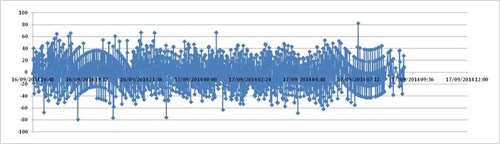
The BTO errors were calculated by subtracting the measured BTO from the calculated BTO of the path between the GES and AES. The location of the satellite was calculated from the Inmarsat ECEF data and interpolated for the exact measurement epoch of each measurement. Figure 1 below shows the measured BTO error for the period with zero representing the overall mean error (calibration) for the data set.
Figure 1: The measured BTO error for the period with zero representing the overall mean error (calibration) for the data set. Source: Satellite Working Group
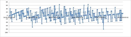
Figure 2 shows the first part in more detail.
Figure 2: Detailed breakdown. Source: Satellite Working Group
The effect from the motion of the satellite and also the 20µs BTO measurement quantisation can be clearly seen. These steps and arcs are then subject to the receiver noise contribution in the AES and GES.
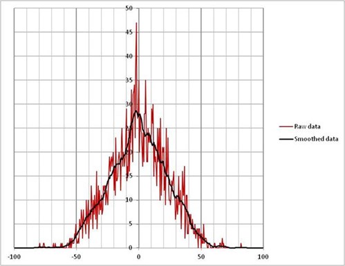
The following histogram (Figure 3) shows the distribution of the errors. The Y axis is Number and the X axis is Error in µs. The smoothed plot uses a simple rolling 19 bin filter to indicate the underlying shape which is clearly non-Gaussian as expected.
Figure 3: Histogram of BTO errors. Source: Satellite Working Group
The calculated statistics for this distribution are:
Statistics
µs
50%
15
95%
43
99%
53
These test results are in agreement with the understanding of the error components and the flight test experiments and supports the assertion of a 50µs effective accuracy. In the case of MH370, there are very few samples and so we cannot treat any particular measurement other than individually. Hence the assertion that a particular BTO has an accuracy of 50µs (at a 99% confidence level).
For reference, a 50µs error equates to a +/-7.5km error in satellite range. This equates to approximately +/-10km horizontal error on the Line of Position. This concurs with the reference flight measurement analysis.
More information
You can find more information on how the seventh arc and the priority search area were identified in the following publications:
[1] The SATCOM working group comprises specialists from the following organisations: UK Air Accidents Investigation Branch, US National Transportation Safety Board, Inmarsat, Thales, Boeing, Honeywell, SED Systems and Square Peg Communications.
Occurrences involving aircraft striking wildlife, particularly birds, are the most common aviation occurrence reported to the Australian Transport Safety Bureau (ATSB). Strikes with birds continue to be a significant economic risk for aerodrome and airline operators and a potential safety risk for pilots. The aim of the ATSB’s statistical report series is to give information back to pilots, aerodrome and airline operators, regulators, and other aviation industry participants to assist them with managing the risks associated with bird and animal strikes. This report updates the last edition published in 2012 with data from 2012-2013.
What the ATSB found
Between 2004 and 2013, there were 14,571 birdstrikes reported to the ATSB, most of which involved high-capacity air transport aircraft. Although the number of birdstrikes has continued to increase for all operation types, due to increasing aircraft movements, the rate per aircraft movement has actually decreased slightly in recent years. In the 2 years since 2011, the rates for seven of the ten major airports have reduced. Indeed, Adelaide, Melbourne, Perth and Sydney had lower rates in 2013 than in 2004. The largest increase in birdstrike rate was observed in Darwin, where the rate has more than doubled in the two years since 2011 and maintains the highest average birdstrike rate of all the major airports. Alice Springs Airport has shown the most significant reduction in rate.
Domestic high-capacity aircraft were those most often involved in birdstrikes, and the strike rate per aircraft movement for these aircraft was significantly higher than all other categories. The number of engine ingestions for high-capacity air transport operations had been increasing until 2011, but has since decreased to the lowest level in 10 years. Still, one in nine birdstrikes for turbofan aircraft involved an engine ingestion.
The four most commonly struck types of birds have not changed in the 2012 to 2013 period, those being kites, bats/flying foxes, lapwings/plovers and galahs. Kites had the most significant increase in the number of reported strikes per year in the last 2 years, with these species being involved in an average of 129 strikes per year for 2012 and 2013 compared with 84 per year on average across the entire 10-year reporting period. Galahs were more commonly involved in strikes of multiple birds, with more than 38 per cent of galah strikes involving more than one galah. However, larger birds were more likely to result in aircraft damage.
Historically, birdstrikes have not been a significant safety risk to civilian air travel in Australia. ATSB data dating back to 1969 show no civilian aviation fatalities attributed to birdstrikes. Additionally, the vast majority (98.7%) of birdstrikes over the 10 year study period were assessed using the ATSB event risk classification (ERC) framework as being low risk occurrences.
Compared to birdstrikes, animal strikes are relatively rare. The most common animals involved were hares and rabbits, kangaroos, dogs / foxes and wallabies. Damaging strikes mostly involved kangaroos, wallabies and livestock.
Safety message
Australian aviation wildlife strike statistics provide a reminder to everyone involved in the operation of aircraft and aerodromes to be aware of the hazards posed to aircraft by birds and non-flying animals. Timely and thorough reporting of birdstrikes is paramount. The growth of reporting to the ATSB that has been seen over the last 10 years has helped to better understand the nature of birdstrikes, and what and where the major safety risks lie. This helps everyone in the aviation industry to better manage their safety risk.
When aviation safety incidents and accidents happen, they are reported to the ATSB. The most serious of these are investigated, but most reports are used to help the ATSB build a picture of how prevalent certain types of occurrences are in different types of aviation operations.
The ATSB uses this data to proactively look for emerging safety trends. By monitoring trends, issues of concern can be communicated and action taken to prevent accidents.
Proactive trend monitoring is a data-driven process, reviewing all occurrences to see if there are subtle changes that may point to a larger issue. Potential issues are then monitored by the ATSB, and shared with industry and other government agencies. Safety actions can then be taken by the most appropriate people to prevent these issues resulting in accidents. These trends can also point to the need for the ATSB to target particular types of occurrences for investigation.
This report summarises significant trends in Australian aviation from January to June 2014, and resultant safety action being taken to address these trends.
The Aviation Short Investigation Bulletin covers a range of the ATSB’s short investigations and highlights valuable safety lessons for pilots, operators and safety managers.
Released periodically, the Bulletin provides a summary of the less-complex factual investigation reports conducted by the ATSB. The results, based on information supplied by organisations or individuals involved in the occurrence, detail the facts behind the event, as well as any safety actions undertaken. The Bulletin also highlights important Safety Messages for the broader aviation community, drawing on earlier ATSB investigations and research.
Issue 36 of the Bulletin features 10 safety investigations: