Collision with terrain

VFR into IMC and collision with trees involving Cessna 182T, VH-TSS, 57 km south-east of Mount Surprise, Queensland, on 16 June 2025

Final report

Report release date: 28/10/2025

Investigation summary

What happened

On the morning of 16 June 2025, a Cessna 182T departed a private aircraft landing area south of Emerald, Queensland, with a pilot and a passenger on board for a private flight to Atherton, Queensland.

Prior to their departure the pilot had obtained the weather conditions for Mareeba Airport, about 22 km to the north of their intended destination of Atherton, and assessed the conditions as acceptable for visual flight. 

When the aircraft was about 95 km north of Charters Towers, the pilot assessed they would be unable to continue their direct track towards Atherton due to the cloud height over the terrain ahead. The pilot diverted west to avoid higher terrain and planned to divert to Mareeba due to its lower elevation by approaching from the west. 

About 35 minutes after the diversion, the pilot descended the aircraft to about 500 ft above ground level, following a road. As they tracked towards rising terrain, their height reduced to about 200 ft above ground level. The pilot recalled that suddenly conditions ahead became a ‘white-out’ and they commenced a left turn and reduced the aircraft’s power in an attempt to avoid flying into the cloud. 

During the turn the aircraft entered cloud and the pilot lost visual reference with the ground. Recorded data indicated the aircraft conducted a 360° left turn with several changes in altitude and coming in close proximity to terrain before the pilot could engage the autopilot to attempt to stabilise the aircraft.

The pilot then commanded a 180° left turn using the autopilot, intending to return to visual meteorological conditions. However, as the aircraft climbed, the air speed reduced and the aircraft likely stalled, leading to a rapid descent.

The pilot received a terrain warning and immediately applied recovery actions; as they eased out of the dive, the pilot momentarily became visual with terrain before the aircraft contacted tree-tops but continued to remain airborne. 

The pilot was able to maintain control and became visual again on top of the cloud layer and, with the aircraft significantly damaged, diverted to Charters Towers Airport.

What the ATSB found

The pilot’s pre-flight planning was inadequate for the intended flight. The pilot had planned the second leg of the flight at a height that would not have allowed sufficient safe margin from terrain. While they obtained the forecast weather for a location close to their destination, which identified local conditions were suitable for visual flight, the pilot did not obtain the required graphical area forecast which indicated cloud height below terrain level on the flight planned track. Had the pilot obtained the area forecast this likely would have influenced their decision to commence the flight or plan an alternate route.

After encountering low cloud, the pilot continued flight towards the destination and into rising terrain, this forced them to descend below safe terrain clearance altitudes to a height of about 200 ft above ground level, rather than divert or return.

In an attempt to turn around, the aircraft entered cloud. The pilot was not rated for instrument flight, became spatially disorientated, resulting in a near collision with terrain.

While still in instrument meteorological conditions and disorientated, the pilot initiated a climbing turn and engaged the autopilot at reduced power. This resulted in the aircraft being unable to maintain airspeed and it likely entered a stall and rapidly lost height. During the recovery, the aircraft then impacted trees however continued to fly.

The pilot used the aircraft instruments to navigate out of cloud, regain visual reference to the ground and track south. Although the pilot was aware of the potential for damage sustained to the aircraft during the impact with the tree, they continued flight in the damaged aircraft for about 1.5 hours to Charters Towers (a familiar airport with a longer runway) rather than seek the nearest suitable landing area.

Safety message

Thorough information gathering is an essential part of a pilot’s pre-flight preparation. This is especially important in a single-engine aircraft and includes studying maps and routes to establish appropriate flight heights over terrain where forced landing areas may be limited. Weather conditions often vary over large distances and this is more likely over areas of elevated terrain. Although individual locations may indicate favourable conditions, other more widespread weather conditions, unsuitable for visual flight, may exist outside of the forecast location. Use of all available resources to ensure accurate knowledge of the expected conditions will assist pilots with informed decision‑making, both before and during flight.

It should be accepted that flying under visual flight rules will not always enable you to reach your planned destination. Making an early decision to land or divert and to resist the urge to ‘press on’ may prevent flight into marginal weather conditions and ultimately disaster.


The investigation

The ATSB scopes its investigations based on many factors, including the level of safety benefit likely to be obtained from an investigation and the associated resources required. For this occurrence, the ATSB conducted a limited-scope investigation in order to produce a short investigation report, and allow for greater industry awareness of findings that affect safety and potential learning opportunities.

The occurrence

On 16 June 2025, at 0634 local time, a Cessna 182T, registered VH-TSS, departed a private aircraft landing area (ALA) about 16 NM south‑south-east of Emerald, Queensland, for a private flight to Atherton, Queensland. On board the aircraft were the pilot and one passenger.

Electronic flight data showed the aircraft departed and climbed to 4,500 ft above mean sea level (AMSL) where it initially held a steady track towards Atherton (Figure 1).

Figure 1: VH-TSS flight track between 0828 and 1115
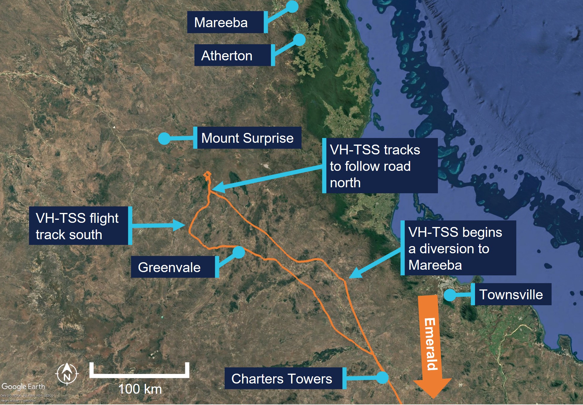
VH-TSS flight track North of Charters Towers

Source: Google Earth, overlaid electronic flight data, annotated by the ATSB

At 0848, the aircraft descended to 3,000 ft AMSL, about 35 NM north of Charters Towers. The pilot then assessed that cloud and reduced visibility would affect continued visual flight direct to Atherton. The pilot stated they elected to continue, however diverted around weather to Mareeba Airport which they had planned as an alternative destination due to the lower elevation. They stated that they were familiar with the area, having flown a similar route 7 or 8 times previously and reported that they assessed the weather for Mareeba several times during the flight. At 0855 the aircraft was about 50 NM north of Charters Towers at an altitude of about 2,900 ft AMSL, about 1,650 ft above ground level (AGL). 

The pilot recalled altering their heading to avoid weather and flying over higher terrain. The aircraft tracked generally in a north-west direction with numerous adjustments to the heading and altitude for about 35 minutes. 

At 0930 the aircraft was recorded at about 530 ft AGL. The pilot recalled following Kennedy Developmental Road to the north. They reported this decision was due to the low cloud ceiling and advised that, in their experience, the road usually avoided the areas of highest terrain.

At 0932, the aircraft was recorded at about 410 ft AGL and the pilot made several heading adjustments to maintain visual reference with the road due to reducing visibility under heavy cloud cover. 

At 0933 and about 90 NM south-west of Mareeba, the aircraft was recorded at about 240 ft AGL, with the pilot continuing to track following the road in a northerly direction.

About a minute later at about 200 ft AGL and 140 kt airspeed (Figure 2), the pilot recalled commencing a left turn and reduced the aircraft’s engine power to try to avoid flying into ‘white-out’ conditions ahead. However, during the turn, the pilot recalled that they entered cloud.

Figure 2: VH-TSS flight track between 0932 and 0946
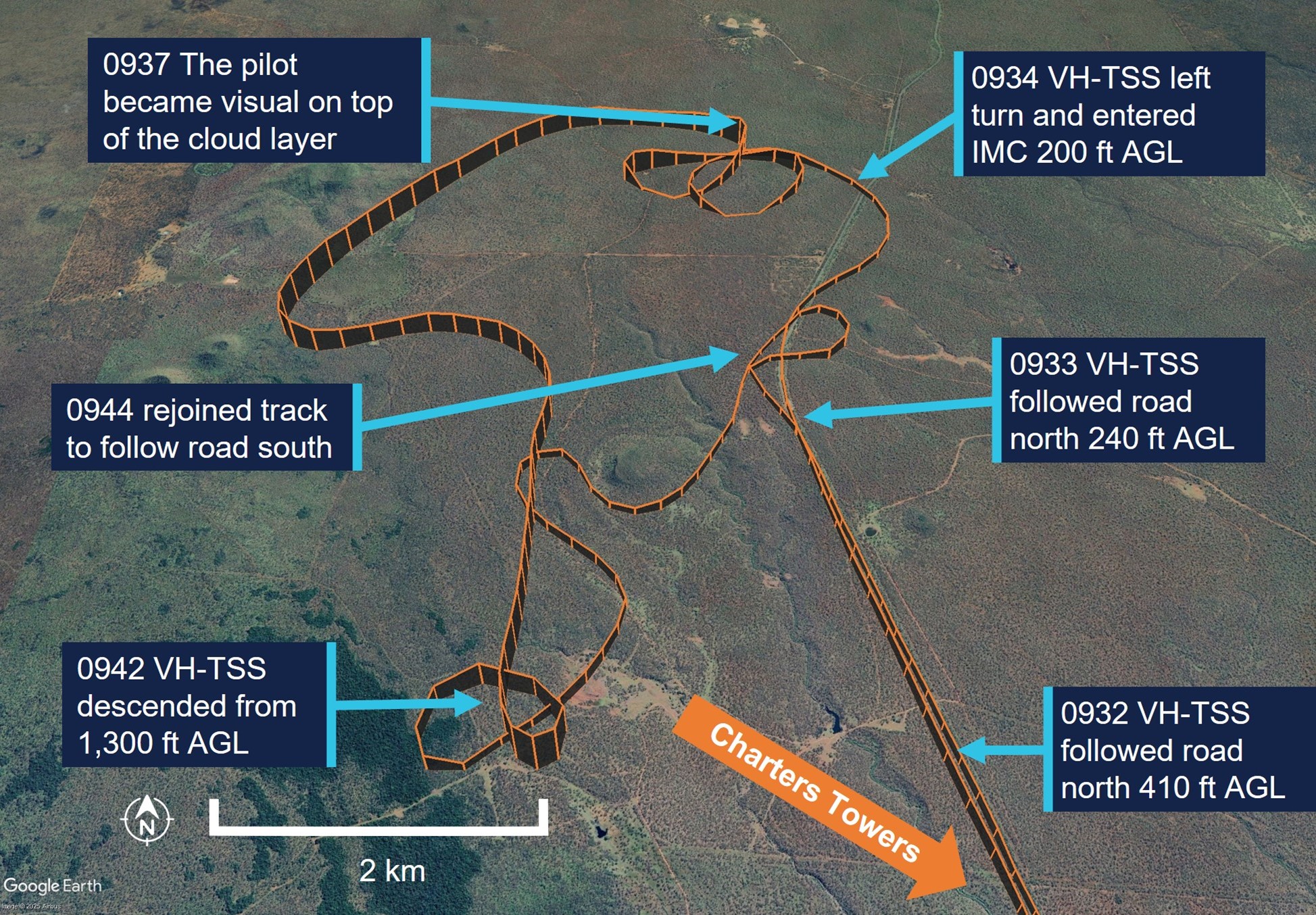
VH-TSS flight track between 0932 and 0946

Source: Google Earth, annotated by the ATSB

In the following minute, the aircraft continued a left turn and completed an orbit with several significant altitude changes, descending and climbing twice then descending again. The recorded altitude, which may not be an accurate representation of the aircraft’s actual altitude during manoeuvres, varied between 0 ft AGL on the second descent (the pilot did not report any impact occurring at this point) and 700 ft about 20 seconds later.

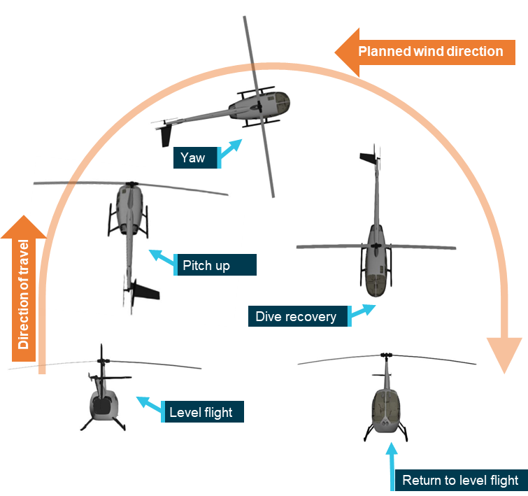
At 0936, having descended a third time to about 200 ft, the aircraft began to maintain a constant heading for about 20 seconds during which time it had a high rate of climb consistent with the engagement of the autopilot (see Autopilot). The aircraft climbed from about 200 ft to 700 ft AGL and reduced groundspeed to 54 kt. The pilot recalled they engaged the autopilot after entering cloud (this was likely after about 1–2 minutes after entering cloud) and then commanded a 180° left turn, in an attempt to reverse their track and navigate out of the instrument meteorological conditions (IMC) (Figure 3). During the next 10 seconds, the aircraft turned sharply left and descended rapidly. The pilot recalled the aircraft instrument panel went red and displayed a terrain warning and immediately applied right rudder and attempted to level the aircraft during the recovery, as it descended almost to ground level.

Figure 3: VH-TSS flight track between 0934 and 0938
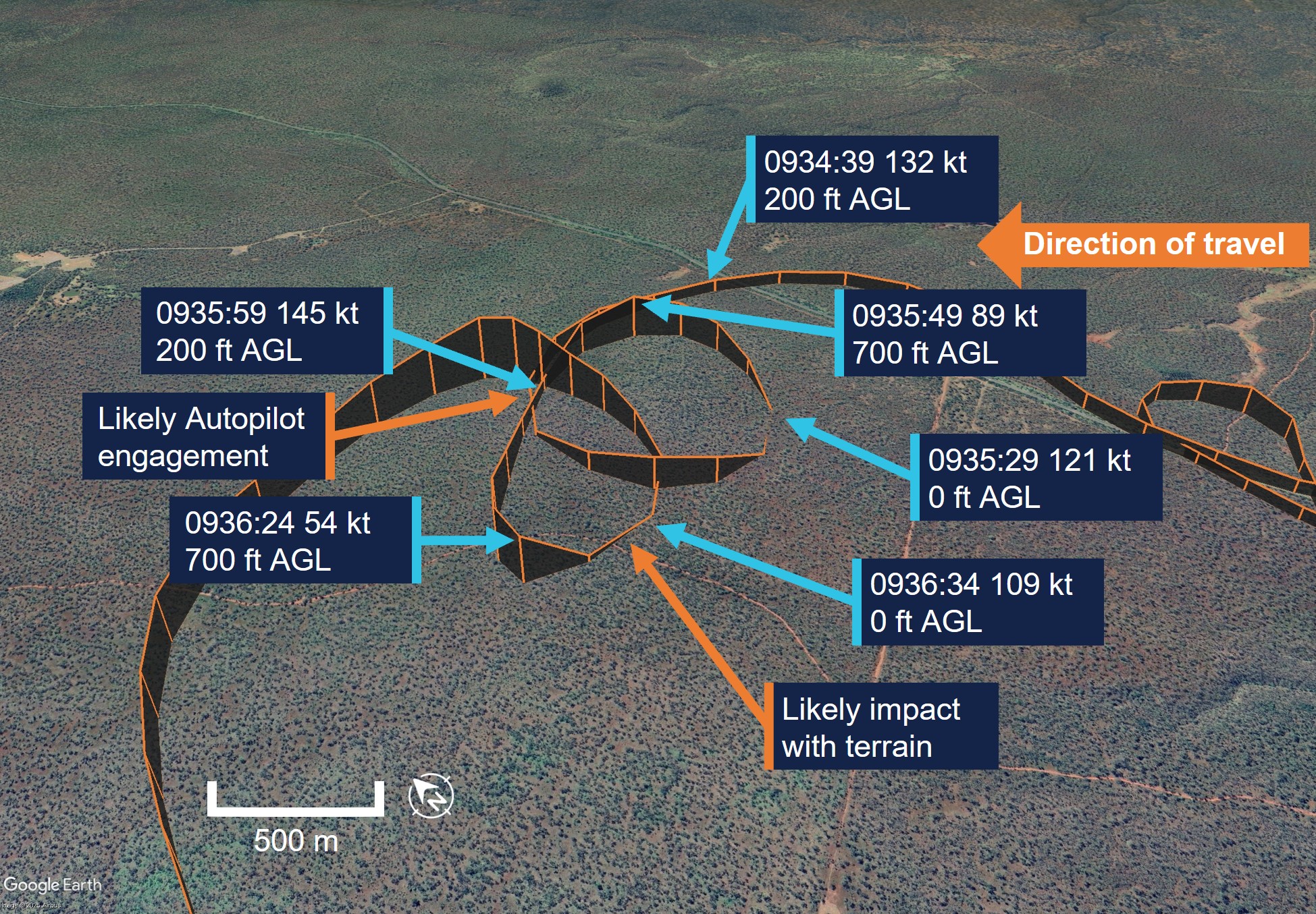
VH-TSS flight track from when the aircraft entered cloud

Source: Google Earth, annotated by the ATSB

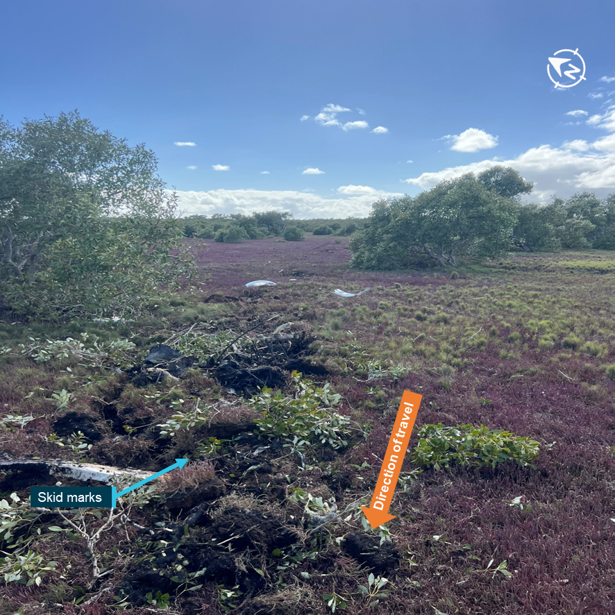
The pilot reported that they momentarily became visual and heard the aircraft impact trees. They pulled back on the control column and commenced a climb, entering IMC again. The pilot climbed to an altitude of about 1,000 ft AGL and was able to stabilise the aircraft and navigate out of IMC using the instruments. They became visual again once on top of the layer of cloud.

At 0942 the pilot descended from 1,000 ft to about 300 ft AGL. They then navigated back to Kennedy Developmental Road at a height of 200–350 ft AGL. 

The pilot reported that they were unable to see the leading edge of the wing and unaware of the extent of the damage to the aircraft after the collision, however recalled the aircraft required more right rudder application than usual and that this prevented autopilot engagement. As a precaution, the pilot chose to follow major roads so that they could land if required and navigated the aircraft back to Charters Towers due to the runway length and their familiarity with the airport. The aircraft landed safely at 1114 local time.

As a result of the impact with the tree, the aircraft sustained substantial damage to the left wing (Figure 4), with minor damage to the left wing strut and both landing gear struts. No injuries were reported by either occupant.
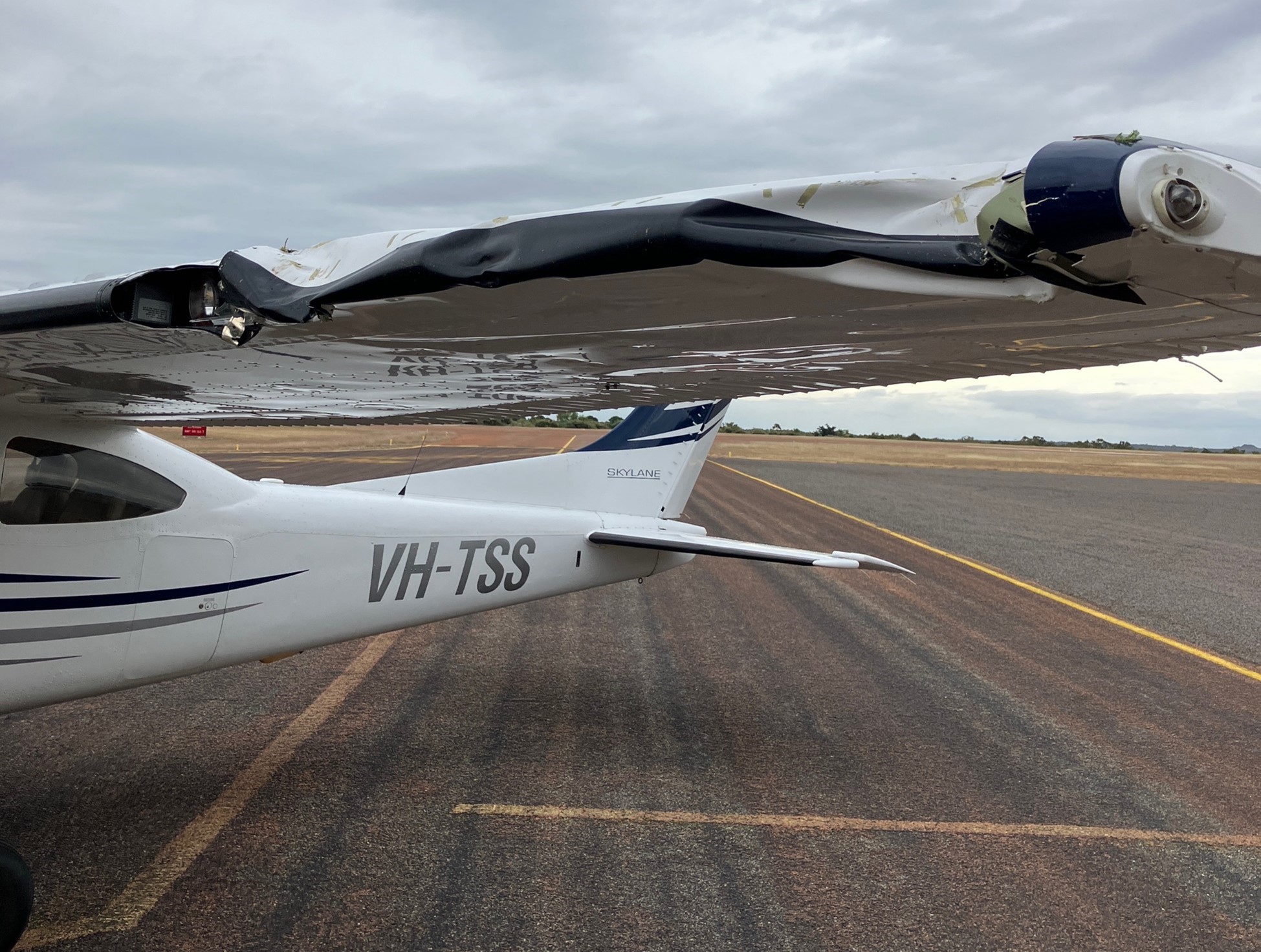
Figure 4: Left wing damage

VH-TSS left wing showing significant damage due to impact with the tree

Source: Pilot

Context

Pilot information

The pilot held a valid Private Pilot Licence (Aeroplane) with a single engine aircraft rating since 1992. Their last flight review was conducted on 30 June 2023 and was valid to 31 July 2025. At the time of the occurrence, the pilot had about 3,580 hours total aeronautical experience of which 3,340 hours were reported to be on the Cessna 182. The pilot also reported that they had flown 48.5 hours during the last 90 days. 

The pilot did not hold an instrument rating and was only rated to fly in visual meteorological conditions (VMC).[1] 

The pilot held a valid class 2 medical certificate that was issued on 3 November 2023 and was valid until 12 November 2025. The class 2 was issued with a restriction requiring that reading correction must be available in flight and that the pilot must not fly within 24 hours of medical therapy.

Fatigue

The pilot reported that at the time of the occurrence they felt fully alert and wide awake. They indicated that they had slept 8 hours in the last 24 hours and 17 hours in the last 48 hours prior to the occurrence.

The ATSB considered that fatigue was unlikely to have affected the pilot’s performance at the time of the occurrence.

Instrument flight

As part of the pilot’s initial flight training for their licence, they recalled conducting 2‍–‍3 hours instrument flying with no visual references. However, since that time, they reported that they had not conducted any further instrument flight since their initial training. 

Aircraft information

The Cessna 182T is a 4-seat, single engine, high-winged aircraft and is powered by a 6‑cylinder fuel-injected 235 hp (175 kW) Lycoming TIO-540-AK1A piston engine.

VH-TSS was manufactured in the United States in 2005 and was first registered in Australia to the pilot in April 2010. The aircraft was certified to be flown by day and night under visual flight rules (VFR)[2] and was only operated for private operations.

The pilot recorded the total time in service of the aircraft as 2,761.8 hours after arriving at Charters Towers. 

Cessna 182 stall speeds

The Cessna 182T pilot operating handbook (POH) indicated the following stall speeds for the aircraft.

 - flaps up, power idle 54 knots calibrated airspeed[3] (KCAS)

 - flaps full, power idle 49 KCAS

The POH indicated that 54 KCAS would show as 50 kt indicated airspeed (IAS) to the pilot with no flap selected.

The POH also stated the stall speeds at known angles of bank at the aircraft’s maximum all up weight of 1,406 kg. The POH indicated that the stall speeds increased as the aircraft’s angle of bank increased.

Garmin G1000 terrain proximity 

The aircraft instrument panel contained the Garmin G1000 display unit, which consisted of a primary flight display and multifunction display.

Colours are used to represent obstacles and aircraft altitude when the terrain proximity page is selected for display. Terrain proximity uses black, yellow, and red to represent terrain information relative to aircraft altitude. The colour of each obstacle is associated with the altitude of the aircraft (Figure 5):

  • black indicates terrain more than 1,000 ft below aircraft altitude
  • yellow indicates terrain between 100 ft and 1,000 ft below the aircraft altitude
  • red indicates terrain is above or within 100 ft below the aircraft altitude.

Figure 5: Garmin terrain proximity caution and warning 
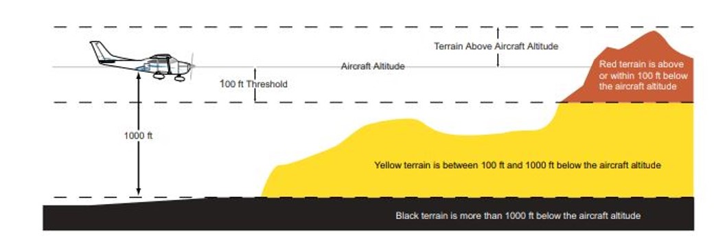
Indication of terrain display on the Garmin G1000

Source: Garmin G1000 pilot’s guide Cessna NAV III

Autopilot

VH-TSS was fitted with a KAP 140 2-axis autopilot system, which provided both lateral and vertical modes and allowed the pilot to preselect an altitude.

The KAP 140 manual stated that when the autopilot was initially engaged, it activated the basic roll mode which levelled the aircraft wings and also engaged the vertical speed hold mode. This would capture the aircraft’s current vertical speed at the time of the autopilot engagement.

The manual provided a warning on the use of vertical speed mode stating:

When operating at or near the best rate of climb airspeed, at climb power settings, and using vertical speed hold, it is easy to decelerate to an airspeed where continued decreases in airspeed will result in a reduced rate of climb. Continued operation in vertical speed mode can result in a stall.

The engagement of the heading button would arm the heading mode, which would command the aircraft to turn to and maintain the heading selected on either the horizontal situation indicator[4] (HSI) or the directional gyroscope.

Figure 6: KAP 140 autopilot control panel
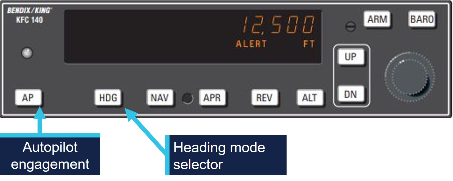
Control panel of the Bendix King KAP 140 Autopilot

Source: KAP 140 manual, annotated by the ATSB

The pilot identified a key safety message from CASA seminars on ‘VFR into IMC’ that they had attended was to use the autopilot if available in case of inadvertent entry to IMC. 

Meteorological information

The pilot had obtained the TAF[5] for Mareeba Airport, about 22 km north of Atherton Airport and elevation of 1,564 ft above mean sea level (AMSL). The TAF was issued at 0328 on 16 June and valid between 0500 and 1800 local time. The forecast indicated the wind at 150° at 10 kt, with visibility greater than 10 km and broken[6] cloud cover at 2,000 ft above airport elevation. From 1000, the wind was forecast to increase to 12 kt, with visibility greater than 10 km and scattered[7] cloud cover at about 2,500 ft.

The Bureau of Meteorology does not provide an aviation forecast or recordings for Atherton Airport. 

The pilot did not obtain a graphical area forecast (GAF) for the flight planned route (Appendix – Graphical Area Forecasts). The GAF for surface to 10,000 ft for the area in North Queensland was issued at 2013 on 15 June and was valid between 0300 and 0900 on 16 June. Cloud heights were forecast down to 1,500 ft AMSL with isolated fog reducing visibility to 500 m in areas along the pilot’s flight planned track.

A further GAF for the same area was issued at 0224 on 16 June, it was valid between 0900–1500 the same day and indicated broken cloud down to 2,000 ft AMSL and to 1,000 ft AMSL with isolated rain showers reducing visibility to 4,000 m. It also indicated broken cloud cover down to 2,500 ft, becoming scattered after 1000. The GAF covered both the flight planned track and the aircraft’s diversion track (See Appendix – Graphical Area Forecasts).

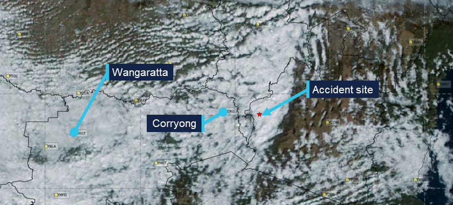
Satellite image taken at 0930 provided by the Bureau of Meteorology indicated cloud cover in the flight planned area and the area the pilot intended to use as a diversion (Figure 7).

Figure 7: Satellite image 0930 local time 
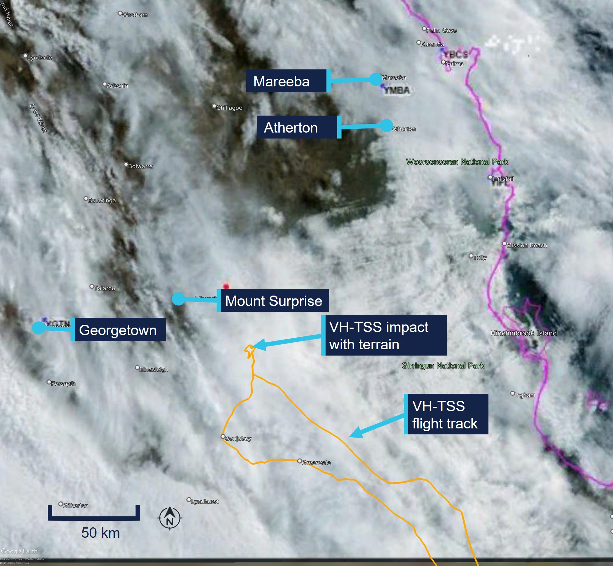
Satellite image of north Queensland showing cloud cover over VH-TSS flight track

Source: Bureau of Meteorology, annotated by the ATSB

The pilot recalled that when they reached Kennedy Developmental Road, the cloud ceiling height had reduced. The pilot estimated they had more than 10 km visibility and a ‘good horizon’ with a crosswind from the east of about 15–18 kt.

After following the road north for about 3.5 minutes the pilot recalled that a ‘white-out’ appeared ahead and, shortly after, they entered instrument meteorological conditions (IMC).

Recorded data

The pilot used a flight planning application on an iPad for en route flight planning, navigation and to obtain weather information.

The software provider was an approved source of electronic aeronautical charts, however the application could not be used as a primary means of GPS‑based navigation as the iPad GPS did not meet certification for aviation use. Additionally, there were limitations to the recorded data as altitude information had a resolution of 100 ft, and filtering applied to smooth the data can affect the accuracy of small sections of data.

The aircraft height was about 560 ft AGL when the aircraft began to track north along Kennedy Developmental Road which the pilot followed for about 3.5 minutes. At 0934 the aircraft began to deviate away from the road after an increase in altitude of about 500 ft, however due to the rising terrain was about 250 ft AGL (Figure 8).

Figure 8: VH-TSS height above terrain
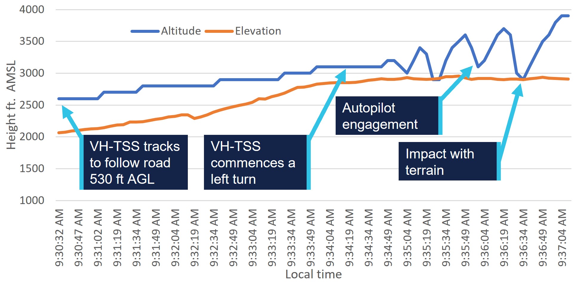
Graph indicating VH-TSS flight track from joining Kennedy Developmental Road. Graph indicates the flight rack and terrain height converging followed by erratic height changes after the aircraft entered IMC

Source: ATSB, data provided by OzRunways and Google Earth

After tracking away from Kennedy Developmental Road, the aircraft turned to the west about 100° in 30 seconds. The turn radius then tightened conducting a 360° left orbit in 65 seconds, during this time the aircraft recorded altitude fluctuated between about 0 ft and 700 ft AGL.

The aircraft then maintained a westerly heading while commencing a climb from about 200 ft AGL with a reducing ground speed to 54 kt over a 20 second period.

The data then recorded the aircraft conducting a left turn through about 70° with a reduction in altitude to the terrain height, in about 5 seconds. The aircraft then commenced a further climb to 1,000 ft AGL before stabilising its altitude over the following 4 minutes in a southerly direction.

At 0941 the aircraft commenced about one and a half descending left turns through about 470° and descended from 1,300 ft AGL to about 300 ft AGL. The flight track then followed a dirt track before tracking east to again intercept Kennedy Developmental Road.

The flight track remained in close proximity to Kennedy Developmental Road, tracking south, passing within 0.7 NM of Greenvale ALA at 1017. The pilot continued to track at about 1,000 ft AGL and followed main roads until it landed at Charters Towers Airport at 1114. 

Operational information

Visual meteorological conditions

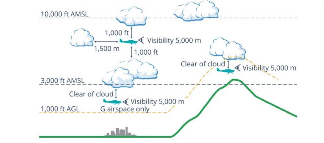
Visual meteorological conditions (VMC) are expressed in terms of in-flight visibility and distance from cloud (horizontal and vertical) and are prescribed in the Civil Aviation Safety Regulations (CASR) Part 91 (General Operating and Flight Rules) Manual of Standards 2020: 2.07 VMC criteria. For aircraft in class G[8] airspace (Figure 9) the following requirements apply at a height below whichever is the higher of 3,000 ft AMSL or 1,000 ft AGL:

 - a minimum of 5,000 m visibility

 - maintain flight clear of cloud

 - aircraft must be operated in sight of ground or water

Figure 9: Visual meteorological conditions criteria below 10,000 ft as illustrated in the CASA Visual Flight Rules Guide
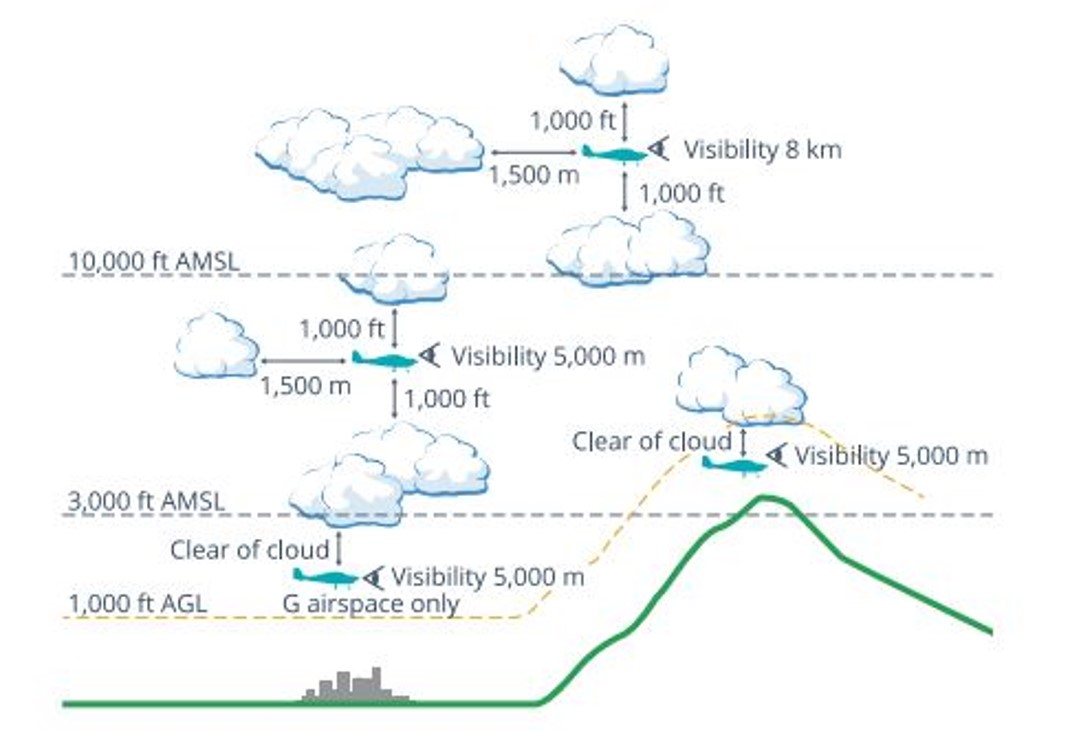
Visual meteorological conditions criteria. visual description of visibility and distance from cloud requirements in airspace classes

Source: Civil Aviation Safety Authority

Minimum height rules

CASR Part 91.267 (2) stated that for flight over non-populous areas: 

The pilot in command of an aircraft for a flight contravenes this subregulation if, during the flight:

 - the aircraft is flown below 500 ft above the highest feature or obstacle within a horizontal radius of 300 m of the point on the ground or water immediately below the aircraft 

 - is not taking off or landing or conducting a missed approach

 - is not carrying passengers and conducting practice forced landings with permission from the landowner.

The Civil Aviation Act,1998 section 30 also stated: 

 (1) In any proceedings for an offence against this Act or the regulations, it is a defence if the act or omission charged is established to have been due to extreme weather conditions or other unavoidable cause.

 (2) Any defence established under subsection (1) need only be established on the balance of probabilities.

Flight planning

The pilot submitted an online flight plan at 0544 that morning to Airservices Australia via the NAIPS[9] application and received notification that the plan had been accepted.

The flight was planned to depart from a private ALA at 0630, climb to 4,500 ft AMSL and to track direct to Charters Towers, before descending and tracking direct for Atherton at 2,500 ft AMSL. Flight plan distance was about 425 NM. 

Terrain heights on a direct track between Charters Towers and Atherton indicated terrain elevation consistently over 2,500 ft AMSL with areas above 4,000 ft AMSL.

The pilot reported that they had originally planned to fly on 17 June, however after reviewing the encroaching forecast weather conditions, planned the flight a day earlier.

CASR Part 91 (General Operating and Flight Rules) Manual of Standards 2020: 7.02 Forecasts for flight planning, described that a pilot in command must before commencing flight below 10,000 ft, study:

  • the authorised weather forecasts and authorised weather reports for the route being flown, departure aerodrome, planned destination, planned alternate aerodrome and any other reasonably available weather information that is relevant to the intended operation
  • the authorised weather forecast must include a wind and temperature forecast as well as either, a GAF, GAMET area forecast or a flight forecast
  • should the forecasts and reports be studied more than 1 hour before commencing the flight, the pilot in command must obtain, and review, an update to that information before the flight begins.

The pilot reported that they obtained the weather forecast for Mareeba the evening prior to their flight and again on the morning of their departure. They stated that they were aware of a frontal system that was due in the area later that day or evening. However, they had not obtained a GAF before their departure.

Alternative aircraft landing area 

On regaining visual reference with the ground after the collision with terrain, the pilot continued the flight for about 155 NM, and about 1.5 hours flying time. During the flight, the aircraft passed within a nautical mile of another suitable ALA as it returned to Charters Towers. 

The pilot stated they were aware of other aerodromes in the vicinity as they tracked towards Charters Towers and that although they were aware that the aircraft had sustained damaged during the collision, they were unaware of the extent and assessed that the aircraft was flying to an acceptable standard to continue the flight to Charters Towers Airport.

Other suitable airports or ALA in the area of the incident site included: 

  • Greenvale ALA 38 NM south (within 1 NM of return track)
  • Einasleigh Airport 36 NM west
  • Valley of Lagoons ALA 50 NM south-east
  • Georgetown Airport 68 NM west.

Human factors

Spatial disorientation

The ATSB publication Avoidable Accidents No. 4: Accidents involving Visual Flight Rules pilots in Instrument Meteorological Conditions(AR-2011-050) discusses the physiological limitations of the human body when trying to sense its orientation in space. 

In conditions where visual cues are poor or absent, such as in poor weather, up to 80 per cent of the normal orientation information is missing. Humans are then forced to rely on the remaining 20 per cent, which is split equally between the vestibular system and the somatic system. Both of these senses are prone to powerful illusions and misinterpretation in the absence of visual references, which can quickly become overpowering. 

Pilots can rapidly become spatially disoriented when they cannot see the horizon. The brain receives conflicting or ambiguous information from the sensory systems, resulting in a state of confusion that can rapidly lead to incorrect control inputs and resultant loss of aircraft control. 

As described in ATSB report AR-2011-050 statistics show non-instrument rated pilots may not be able to recover at all. Research has shown the pilots not proficient in maintaining control of an aircraft with sole reference to the flight instruments will typically become spatially disoriented and lose control of the aircraft within 1 to 3 minutes after visual cues are lost. 

ATSB report AR-2011-050 was updated in 2019 and identified that in the 10 years prior, there were 101 visual flight rules (VFR) into IMC occurrences in Australian airspace reported to the ATSB. Of these, 9 were accidents resulting in 21 fatalities. This details an almost 10% chance of a VFR into IMC encounter ending in a fatal accident. 

The ATSB Aviation Occurrence Database indicated that in the 10 years since 2015, there have been 108 VFR into IMC occurrences reported to the ATSB. Of these, 14 resulted in accidents with 23 fatalities. The dangers of spatial disorientation following a loss of visual cues remains one of the most significant causes of concern in aviation safety.

Decision‑making

The pilot explained they had not previously flown in poor conditions and had previously turned back when conditions were not suitable on many occasions. 

Flight under the VFR requires minimum conditions of visibility and distance from cloud (see Visual meteorological conditions). Variation from the expected weather conditions en route may prevent a pilot from reaching their destination under visual conditions. 

Flight into IMC can occur in any phase of flight. However, a 2005 ATSB research publication – General Aviation Pilot Behaviours in the Face of Adverse Weather (B2005/0127) – concluded that the chances of a VFR into IMC encounter increased as the flight progressed, with the maximum chance occurring during the final 20 per cent of the planned flight. It stated: 

This pattern suggests an increasing tendency on the part of pilots to ‘press on’ as they near their goal. To turn back or divert when the destination seemed ever closer became progressively more difficult.

Research conducted by (Orasanu and others, 1998) titled Errors in Aviation Decision Making contained the following:

Ambiguous cues and organisational and social factors may not in themselves be sufficient to cause decision errors. However, when the decision maker's cognitive limits are stressed, these factors may induce errors in certain contexts. Errors may be mediated by underestimation of the risk inherent in a situation, overconfidence in one's ability to cope with the situation, or failure to evaluate the consequences of planned actions.

Similar occurrences

ATSB investigation

VFR into IMC, loss of control and collision with terrain involving SOCATA-Groupe Aerospatiale TB-20, VH-JTY

On the morning of 28 October 2023, a SOCATA-Groupe Aerospatiale TB-20, registered, VH‑JTY, departed Montpelier aircraft landing area, Queensland, for a visual flight rules private flight to Palmyra aircraft landing area, Queensland. The flight was to be just over one hour duration and the pilot and their passenger were familiar with the route. 

Around 30 NM from the destination, shortly after commencing descent for the intended landing, the aircraft began a steep descending turn to the left towards mountainous terrain. During this descent, the aircraft exceeded the airframe’s designed maximum airspeed before pitching up and passing over the top of Bull Mountain. The aircraft then entered a second steep descending turn, this time to the right, before the recorded flight path data ceased. The aircraft collided with terrain, the aircraft was destroyed and both occupants received fatal injuries.

The ATSB found that, after encountering cloud en route, the pilot elected to continue along the intended flight path through cloud instead of diverting around or remaining on top of it. Shortly after, it is very likely the pilot entered weather conditions not suitable for visual navigation, leading to spatial disorientation and a descent into mountainous terrain.

ATSB investigation

VFR into IMC and in-flight break-up involving Van's Aircraft RV-7A, VH-XWI 90 km south of Charters Towers, Queensland, on 23 April 2021

On 23 April 2021, a Van’s Aircraft RV-7A, registered VH-XWI, was being operated on a private flight under the visual flight rules (VFR) from Winton to Bowen, Queensland. During the flight, the pilot most likely entered IMC and lost control of the aircraft several times. This led to the airspeed limitations for the aircraft being exceeded and the aircraft sustained an in-flight break-up. The pilot was fatally injured, and the aircraft was destroyed.

VFR into IMC resources 

The 2011 ATSB publication, Accidents involving Visual Flight Rules pilots in Instrument Meteorological Conditions (AR-2011-050), updated in 2019, includes a selection of weather‑related general aviation accidents and incidents that show weather alone is never the only factor affecting pilot decisions that result in inadvertent IMC encounters. The documented investigations consistently highlight that conducting thorough pre-flight planning is the best defence against flying into deteriorating weather. 

CASA also released a collection of resources related to this type of occurrence on its website titled Weather and forecasting. 

For more information on VFR into IMC occurrences, recognising inadvertent entry into IMC, and what to do to recover, refer to the following publications: 

Safety analysis

Pre-flight planning

The flight was planned to track from the departure aircraft landing area (ALA) direct to Charters Towers and then Atherton, a distance of about 425 NM. The flight north of Charters Towers was flight planned at 2,500 ft above mean sea level (AMSL), however terrain elevations on the planned route north of Charters Towers were consistently higher than 2,500 ft AMSL.

The pilot had obtained a weather forecast for Mareeba Airport (close to their intended destination), which indicated a cloud height of 2,000 ft above the airport elevation (1,564 ft), conditions that the pilot considered suitable for visual flight rules (VFR) flight.

An updated available graphical area forecast (GAF), issued about 4 hours prior to departure, indicated cloud heights were forecast to be about 2,000 ft AMSL at the time the aircraft had planned to be flying over areas of high terrain.

While the pilot was aware of encroaching weather and accelerated their planned flight to a day earlier to avoid the weather, the pilot’s pre-flight planning in respect to planned altitude north of Charters Towers and the weather conditions at the time of the flight was inadequate. Without the required aviation forecast, or appreciation of weather conditions en route, the pilot departed for their destination without the knowledge of expected cloud en route that was lower than terrain elevation and would likely have prevented visual flight.

Continued flight at low level

After assessing in flight that conditions were unsuitable for continued flight direct to Atherton due to the low cloud height, the pilot planned for an alternate airport of Mareeba, visually tracking west to avoid higher terrain.

About 35 minutes after the diversion, the pilot intercepted and began to track north following Kennedy Developmental Road towards rising terrain. 

The pilot described having visibility of greater than 10 km and a good horizon while tracking north following the road. As the terrain elevation increased about 900 ft during the few minutes of northerly flight along the road, the pilot was unable to maintain the minimum terrain clearance of 500 ft above ground level or the minimum 5 km visibility before entering instrument meteorological conditions (IMC).

The pilot stated that they had turned back several times on previous flights due to marginal weather conditions. The pilot and passenger were travelling on a private flight, it was unlikely that there was time pressure to arrive at the intended destination.

Consistent with other occurrences of visual flight rules (VFR) into IMC, the aircraft entered IMC conditions within the last 20% of the flight after continuing flight below the minimum required altitude. Although the pilot recalled initially having good visibility, they continued flight towards the destination below a safe altitude, this indicated a desire to ‘press on’ to the destination and increased the risk of unintended entry into IMC and collision with terrain.

Spatial disorientation

The pilot described being surprised how quickly they entered a ‘white-out’ that appeared in front of the aircraft. Likely as a result of attempting to avoid entering the cloud and losing visual reference, they instinctively reduced power and commenced a left turn. During the turn the aircraft entered cloud and the pilot described becoming ‘totally disorientated’ shortly thereafter. 

Data showed that the aircraft altitude began to fluctuate with several changes of up to 500 ft vertically in about a 60-second period. While in cloud the aircraft came close to impacting terrain on more than one occasion.

The instability of the flight path with numerous rates of climb and descent are commonly observed in spatial disorientation occurrences where pilots perceive a departure from stable flight and attempt to correct the unusual flight sensations without visual reference. 

Unable to reference the aircraft’s visual position or orientation to terrain after entering cloud, the pilot conducted a steep left turn and then engaged the autopilot with the intent to stabilise the aircraft. 

Autopilot engagement and aircraft stall

The engagement of the autopilot levelled the aircraft’s wings and held a constant heading. However, the aircraft became established in a climb due to the aircraft attitude when the autopilot was engaged, capturing a high rate of climb.

The pilot used the heading bug on the horizontal situation indicator to reverse their track 180° to try to fly out of cloud.

The aircraft airspeed was likely less than the recorded ground speed of 54 kt due to a tailwind and therefore most likely below the aircraft’s published stall speed.

The pilot’s decision to engage the autopilot stabilised the aircraft’s heading, however without adequate power, the autopilot maintained the captured rate of climb while the airspeed reduced. As the aircraft commenced the pilot‑commanded left turn, the increased angle of bank and slow speed likely resulted in the aircraft stalling and entering a rapid descent at low level. The pilot’s immediate reaction to the red terrain display instigated them applying stall recovery techniques that very likely prevented a more serious collision with terrain.

Flight past a suitable landing area with a damaged aircraft

The pilot was aware the aircraft had sustained damage during the collision with terrain, reporting that the aircraft required additional right rudder trim to maintain balanced flight due to the damage.

Once the pilot became visual with the ground and tracked to the south, rather than conduct a precautionary landing or divert to a nearby aerodrome, they maintained a track following major roads towards Charters Towers for an additional 1.5 hours.

Following the collision with terrain the pilot likely became focused on the recovery of the damaged aircraft from the remote area. During the return flight south to Charters Towers, the pilot flew within 1 NM of the Greenvale aircraft landing area (ALA) about 41 minutes after the tree collision, and there were 3 other potential landing areas that were closer than Charters Towers. Instead, the pilot continued flight in the damaged aircraft to Charters Towers, a familiar airport with a longer runway.

With known damage and the performance characteristics of the aircraft adversely affected, the pilot’s decision to continue the flight to Charters Towers (past a suitable ALA) rather than seek the nearest suitable landing area that provided an opportunity to properly assess the damage, placed additional risk on the occupants’ safety.

Use of aircraft instruments for navigation

Following the impact with the tree, the pilot flew the damaged aircraft using basic flight instruments until they became visual again above the cloud layer. 

Although the pilot had not recently practised instrument flight, their knowledge gained during their initial flight training, their familiarity with the aircraft systems and their use of the navigation instruments assisted to stabilise and manoeuvre the aircraft out of IMC conditions to regain visual reference and were then able to determine a track south away from cloud.

Findings

ATSB investigation report findings focus on safety factors (that is, events and conditions that increase risk). Safety factors include ‘contributing factors’ and ‘other factors that increased risk’ (that is, factors that did not meet the definition of a contributing factor for this occurrence but were still considered important to include in the report for the purpose of increasing awareness and enhancing safety). In addition ‘other findings’ may be included to provide important information about topics other than safety factors. 

These findings should not be read as apportioning blame or liability to any particular organisation or individual.

From the evidence available, the following findings are made with respect to the VFR into IMC and collision with trees involving Cessna 182T, VH‑TSS, 57 km south-east of Mount Surprise, Queensland, on 16 June 2025.

Contributing factors

  • During pre-flight planning, the pilot obtained weather for the destination, however, did not obtain weather for the flight planned track.
  • Although the pilot could not maintain 500 ft terrain clearance due to the low cloud base, they continued flight towards the destination rather than divert to a known area of higher terrain clearance.
  • The visual flight rules pilot entered instrument meteorological conditions at low level and reduced power when they became disorientated. This resulted in an unintentional turn and near collision with terrain.
  • While disorientated in IMC, the pilot initiated a climbing turn and engaged the autopilot at reduced power, resulting in the aircraft being unable to maintain airspeed and likely entering a stall and rapidly lost height. During the recovery, the aircraft impacted with trees but continued to fly.

Other factors that increased risk

  • While aware of damage and controllability issues, the pilot did not land at the closest suitable aerodrome and continued for 1.5 hours to a larger airport.

Other findings

  • The pilot was able to use the aircraft’s instruments to stabilise the damaged aircraft and navigate out of instrument meteorological conditions

Sources and submissions

Sources of information

The sources of information during the investigation included:

  • the pilot
  • Civil Aviation Safety Authority
  • Bureau of Meteorology
  • Ozrunways.

References

Australian Transport Safety Bureau. (2005). General Aviation Pilot Behaviours in the Face of Adverse Weather. Aviation Research Investigation Report B2005/0127.

Australian Transport Safety Bureau. (2011). Accidents involving Visual Flight Rules pilots in Instrument Meteorological Conditions.

Orasanu, J. L.-A. (1998). Errors in Aviation Decision Making: Bad Decision or Bad Luck.

Submissions

Under section 26 of the Transport Safety Investigation Act 2003, the ATSB may provide a draft report, on a confidential basis, to any person whom the ATSB considers appropriate. That section allows a person receiving a draft report to make submissions to the ATSB about the draft report. 

A draft of this report was provided to the following directly involved parties:

  • the pilot
  • Civil Aviation Safety Authority
  • the manufacturer
  • Bureau of Meteorology.

Submissions were received from the:

  • pilot
  • Civil Aviation Safety Authority
  • Bureau of Meteorology.

The submissions were reviewed and, where considered appropriate, the text of the report was amended accordingly.

Appendices

Appendix – Graphical area forecasts

Graphical area forecast issued 2013, 15 June
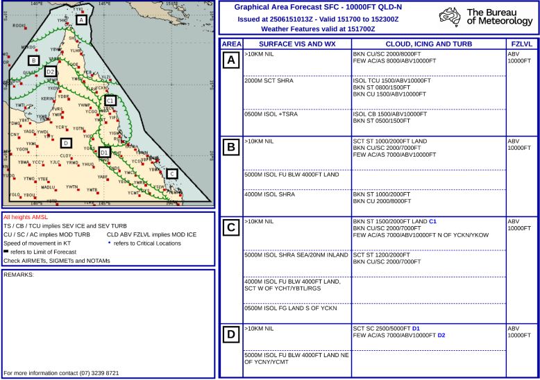
Graphical area forecast issued 2013, 15 June

Source: Bureau of Meteorology

Graphical area forecast issued 0224, 16 June 
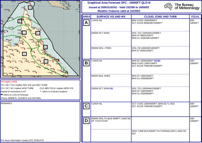
Graphical area forecast issued 0224, 16 June

Source: Bureau of Meteorology

Purpose of safety investigations

The objective of a safety investigation is to enhance transport safety. This is done through: 

  • identifying safety issues and facilitating safety action to address those issues
  • providing information about occurrences and their associated safety factors to facilitate learning within the transport industry.

It is not a function of the ATSB to apportion blame or provide a means for determining liability. At the same time, an investigation report must include factual material of sufficient weight to support the analysis and findings. At all times the ATSB endeavours to balance the use of material that could imply adverse comment with the need to properly explain what happened, and why, in a fair and unbiased manner. The ATSB does not investigate for the purpose of taking administrative, regulatory or criminal action.

About ATSB reports

ATSB investigation reports are organised with regard to international standards or instruments, as applicable, and with ATSB procedures and guidelines.

Reports must include factual material of sufficient weight to support the analysis and findings. At all times the ATSB endeavours to balance the use of material that could imply adverse comment with the need to properly explain what happened, and why, in a fair and unbiased manner.

An explanation of terminology used in ATSB investigation reports is available here. This includes terms such as occurrence, contributing factor, other factor that increased risk, and safety issue.

Publishing information

Released in accordance with section 25 of the Transport Safety Investigation Act 2003

Published by: Australian Transport Safety Bureau

© Commonwealth of Australia 2025

Title: Creative Commons BY - Description: Creative Commons BY

Ownership of intellectual property rights in this publication

Unless otherwise noted, copyright (and any other intellectual property rights, if any) in this report publication is owned by the Commonwealth of Australia.

Creative Commons licence

With the exception of the Commonwealth Coat of Arms, ATSB logo, and photos and graphics in which a third party holds copyright, this report is licensed under a Creative Commons Attribution 4.0 International licence.

The CC BY 4.0 licence enables you to distribute, remix, adapt, and build upon our material in any medium or format, so long as attribution is given to the Australian Transport Safety Bureau. 

Copyright in material obtained from other agencies, private individuals or organisations, belongs to those agencies, individuals or organisations. Where you wish to use their material, you will need to contact them directly.

[1]     Visual meteorological conditions (VMC): an aviation flight category in which visual flight rules (VFR) flight is permitted – that is, conditions in which pilots have sufficient visibility to fly the aircraft while maintaining visual separation from terrain and other aircraft.

[2]     Visual flight rules (VFR): a set of flight regulations that permit a pilot to operate an aircraft only in weather conditions generally clear enough to allow the pilot to see where the aircraft is going.

[3]     Calibrated airspeed: indicated airspeed corrected for position and instrument error and expressed in knots.

[4]     HSI: a flight navigation instrument that combines the heading indicator with a CDI (course deviation indicator), in order to provide the pilot with better situational awareness of location with respect to the courseline.

[5]     TAF- Aerodrome Forecast (TAF): a statement of meteorological conditions expected in the airspace within a radius of 8 km of the aerodrome reference point.

[6]     Broken cloud indicates that more than half to almost all the sky is covered, and ‘overcast’ indicates that all the sky is covered.

[7]     Scattered cloud indicates that cloud is covering between a quarter and a half of the sky.

[8]     Class G airspace is uncontrolled airspace. Both IFR and VFR aircraft are permitted and neither require ATC clearance.

[9]     NAIPS: National Aeronautical Information Processing System

Occurrence summary

Investigation number AO-2025-028
Occurrence date 16/06/2025
Location 57 km south-east of Mount Surprise
State Queensland
Report release date 28/10/2025
Report status Final
Investigation level Short
Investigation type Occurrence Investigation
Investigation status Completed
Mode of transport Aviation
Aviation occurrence category Collision with terrain, Diversion/return, VFR into IMC
Occurrence class Accident
Highest injury level None

Aircraft details

Manufacturer Cessna Aircraft Company
Model 182T
Registration VH-TSS
Serial number 18281601
Sector Piston
Operation type Part 91 General operating and flight rules
Departure point Private ALA near Gindie, Queensland
Destination Atherton Aerodrome, Queensland
Damage Substantial

Collision with terrain involving Reims Aviation F406, VH-EYQ, 3 km from Oakey Airport, Queensland, on 20 July 2025

Summary

The ATSB is investigating a collision with terrain accident involving a Reims Cessna F406 aircraft, registered VH‑EYQ, near Oakey, Queensland, on 20 July 2025.

The aircraft was being used for a pilot check flight and was conducting an instrument approach to land at Oakey Army Aviation Centre when it collided with terrain in a field approximately 2 km from the runway. The 2 occupants on board, a pilot and a flight examiner, were fatally injured.

The ATSB has commenced the examination and analysis of the initial evidence collected.

To date, the ATSB has:

  • examined the wreckage and accident site
  • examined meteorological information
  • interviewed relevant parties
  • collected radio communication, aircraft traffic surveillance data, and navigational 
    application data
  • collected aircraft, pilot, crew and operator documentation.

The investigation is continuing and will include review and examination of:

  • pilots’ recent history
  • propellers
  • maintenance records 
  • pilot and crew training and medical records
  • operational procedures and documentation
  • further interviews with relevant parties
  • flight data and air traffic surveillance data
  • the requirements of conducting simulated one engine inoperative exercises at low heights.

A preliminary report, which detailed factual information established during the evidence collection phase, was released on 10 December 2025 (see below).

A final report will be released at the conclusion of the investigation. Should a critical safety issue be identified during the course of the investigation, the ATSB will immediately notify relevant parties, so that appropriate safety action can be taken.

Last updated:

Preliminary report

Report release date: 10/12/2025

This preliminary report details factual information established in the investigation’s early evidence collection phase, and has been prepared to provide timely information to the industry and public. Preliminary reports contain no analysis or findings, which will be detailed in the investigation’s final report. The information contained in this preliminary report is released in accordance with section 25 of the Transport Safety Investigation Act 2003.

Summary video

The occurrence

On 20 July 2025, a Reims Aviation F406 Caravan II, registered VH-EYQ, was being utilised for an instrument proficiency check (IPC)[1] with a pilot and a flight examiner on board. The flight was conducted under the instrument flight rules[2] and the planned route was from Warwick Airport to Oakey Airport, Queensland, later returning to Warwick Airport. 

The IPC was the pilot’s third flight for the day. They had undertaken an aerial survey mission in VH-EYQ that morning for Aero Logistics, having departed Emerald Airport, Queensland, at 0747 and arrived at Archerfield Airport, Queensland, at 1208. The pilot refuelled the aircraft at Archerfield Airport and departed at 1308 for the flight to Warwick Airport for the purposes of undertaking the IPC. 

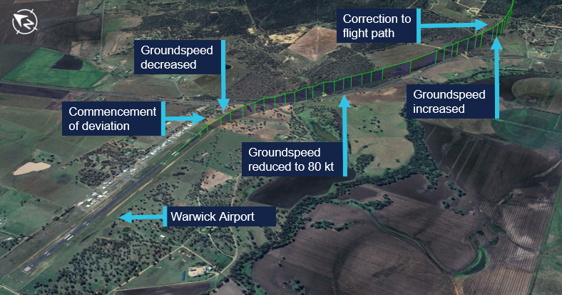
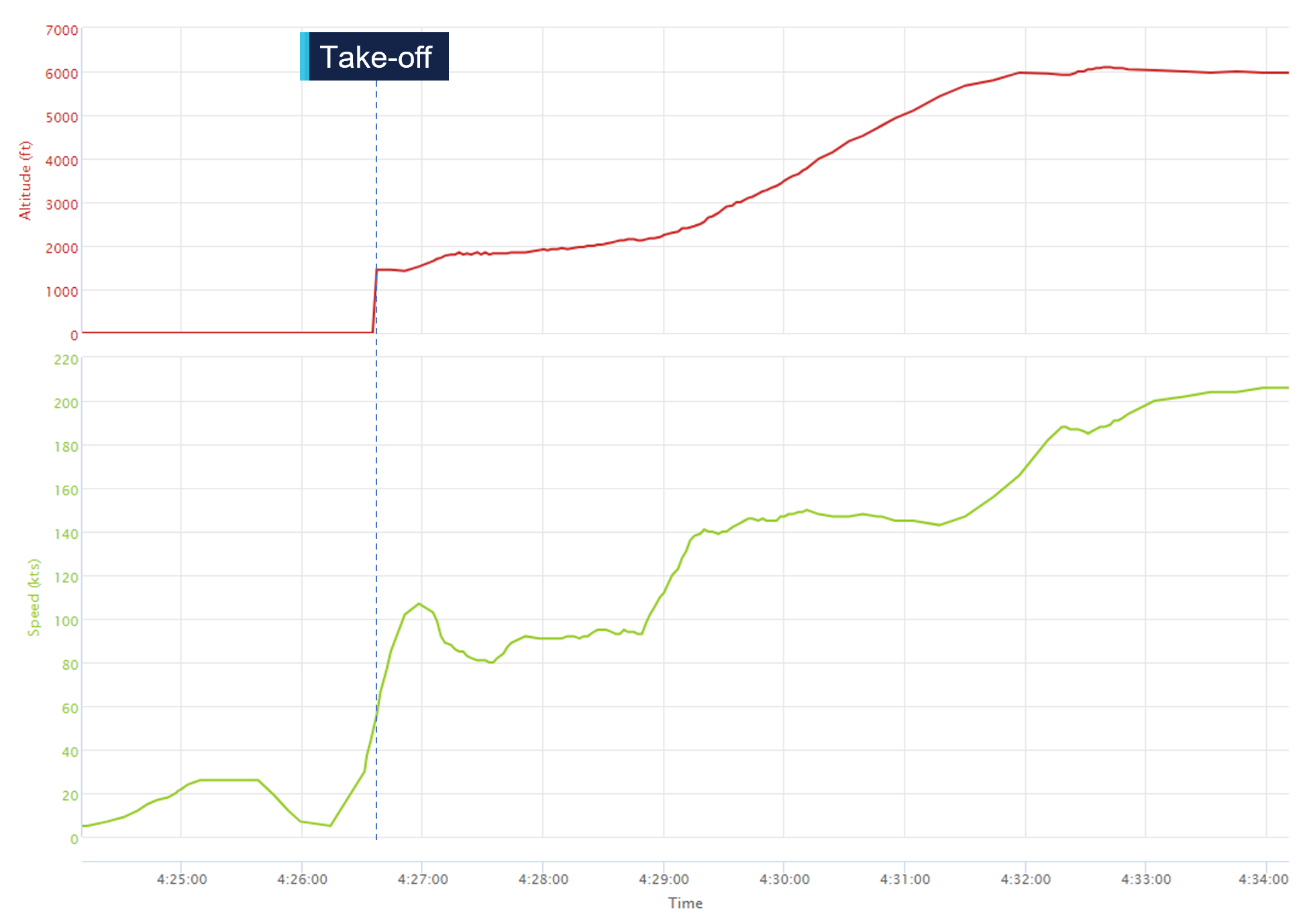
The pilot arrived at Warwick Airport at 1345 where they met the flight examiner. At 1426, the aircraft departed Warwick Airport. About 16 seconds after departure, the aircraft’s groundspeed began to decrease from 109 kt, and the aircraft stopped climbing and commenced a slow turn to the right (Figure 1). This turn was not consistent with the submitted flight plan. The aircraft’s groundspeed continued to reduce over a period of about one minute to 80 kt (see Recorded flight data). The aircraft then began to accelerate before turning left and commencing a climb to an altitude of 6,100 ft above mean sea level. 

Figure 1: VH-EYQ departure from Warwick Airport

VH-EYQ departure from Warwick Airport

Source: Google Earth, annotated by the ATSB

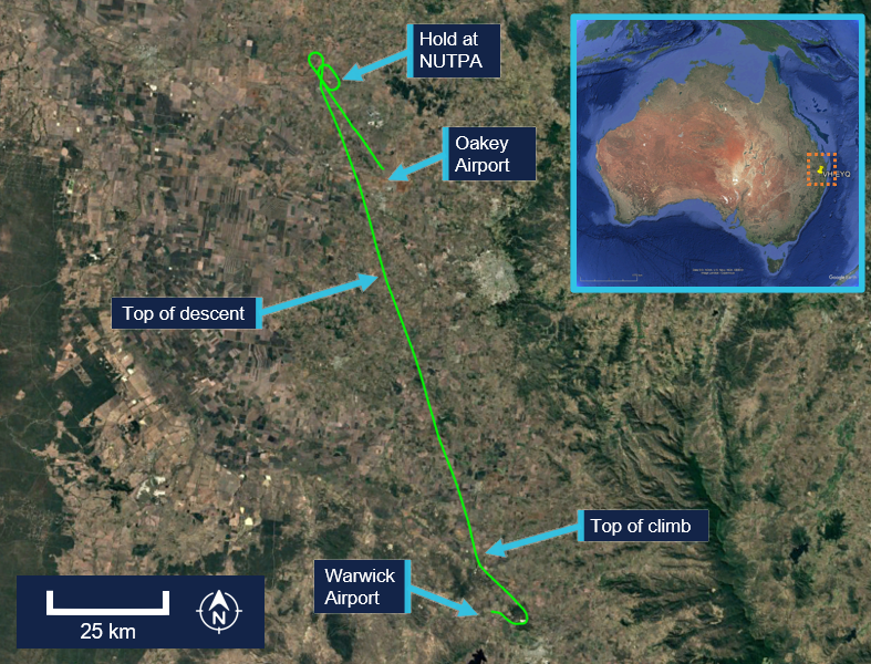
At 1433, Brisbane Centre air traffic control (ATC) issued the pilot with a clearance to track directly to reporting point[3] NUTPA, which was the commencement point for the Oakey Airport runway 14 instrument landing system (ILS)[4] approach (Figure 2).

Figure 2: VH-EYQ flight overview

VH-EYQ flight overview

Source: Google Earth, annotated by the ATSB

At 1439, the pilot advised ATC that they would be conducting airwork in the Oakey area, not above an altitude of 4,000 ft, and they would contact ATC again on completion or by 1530. At that time, the Oakey Airport ATC tower was inactive. After commencing the descent for NUTPA at 1441, the pilot changed frequency to the common traffic advisory frequency (CTAF) in the Oakey Airport area, and all subsequent air-to-air communications took place on the CTAF. Between 1443 and 1454 the pilot made 5 transmissions on this frequency for traffic sequencing purposes. 

At 1450, the aircraft passed overhead NUTPA and conducted one holding pattern. At 1456, the aircraft commenced a descent from 3,800 ft and the pilot made a radio broadcast to advise that the aircraft was established on the ILS. 

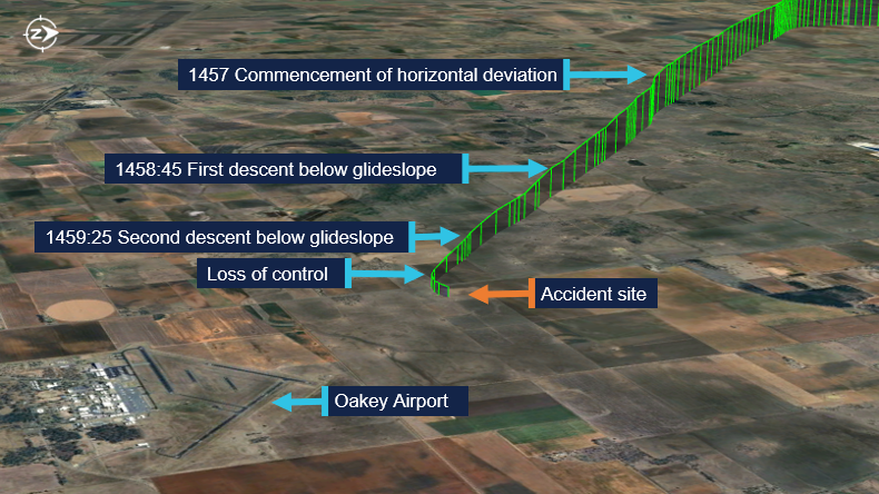
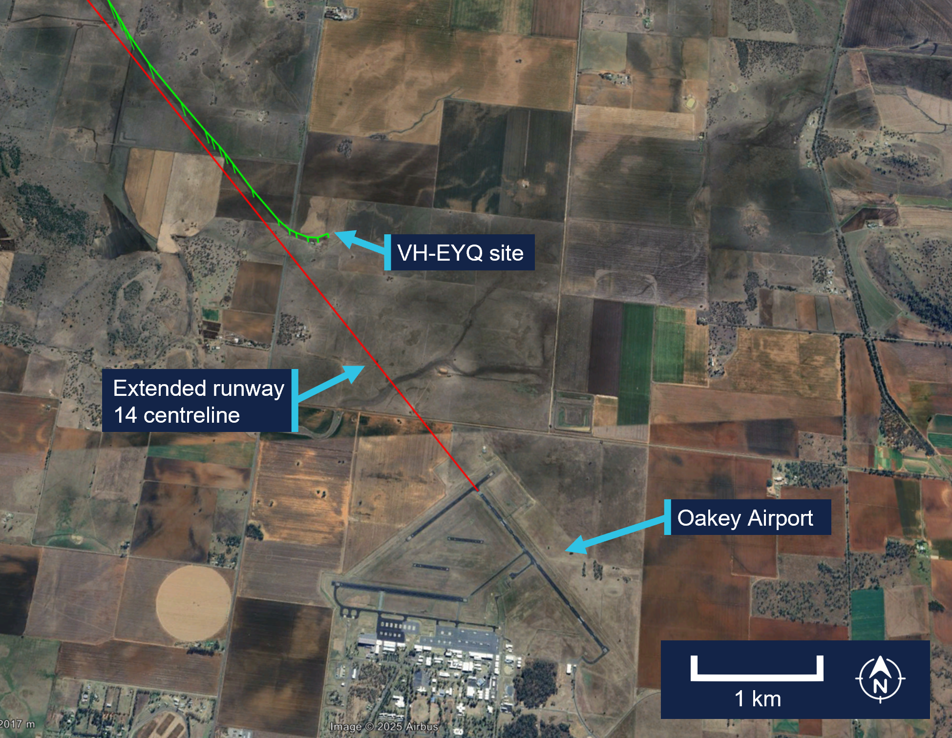
At 1457, the aircraft began to deviate from the horizontal profile for the approach. The aircraft initially deviated right of the extended centreline and then to the left (Figure 3). Fluctuations in vertical speed also occurred during this period. The aircraft continued the approach slightly left of the extended centreline, but the vertical profile of the approach remained on the glideslope.[5] The wind conditions recorded at Oakey Airport at the time were a light breeze of 6 kt, with a mean direction of 190°M (see Meteorological information).

Figure 3: Final approach track

VH-EYQ final approach track


Source: Google Earth, annotated by the ATSB

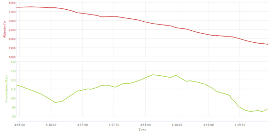
At about 1458:45, and an altitude of 2,500 ft, the aircraft began to descend below the glideslope. This was initially corrected, and the aircraft flew level at about 2,200 ft for 30 seconds. At 1459:25, the aircraft descended below the glideslope again, and the descent continued to an altitude of about 1,700 ft, which equated to a height of between 300–400 ft above ground level (AGL). During this period the aircraft’s groundspeed began to decay. At 1459:39, the aircraft’s groundspeed had reduced to 85 kt (see Recorded flight data). At about 1459:53,[6] a 2‑second radio broadcast was made from the aircraft with an alarm sounding in the background.

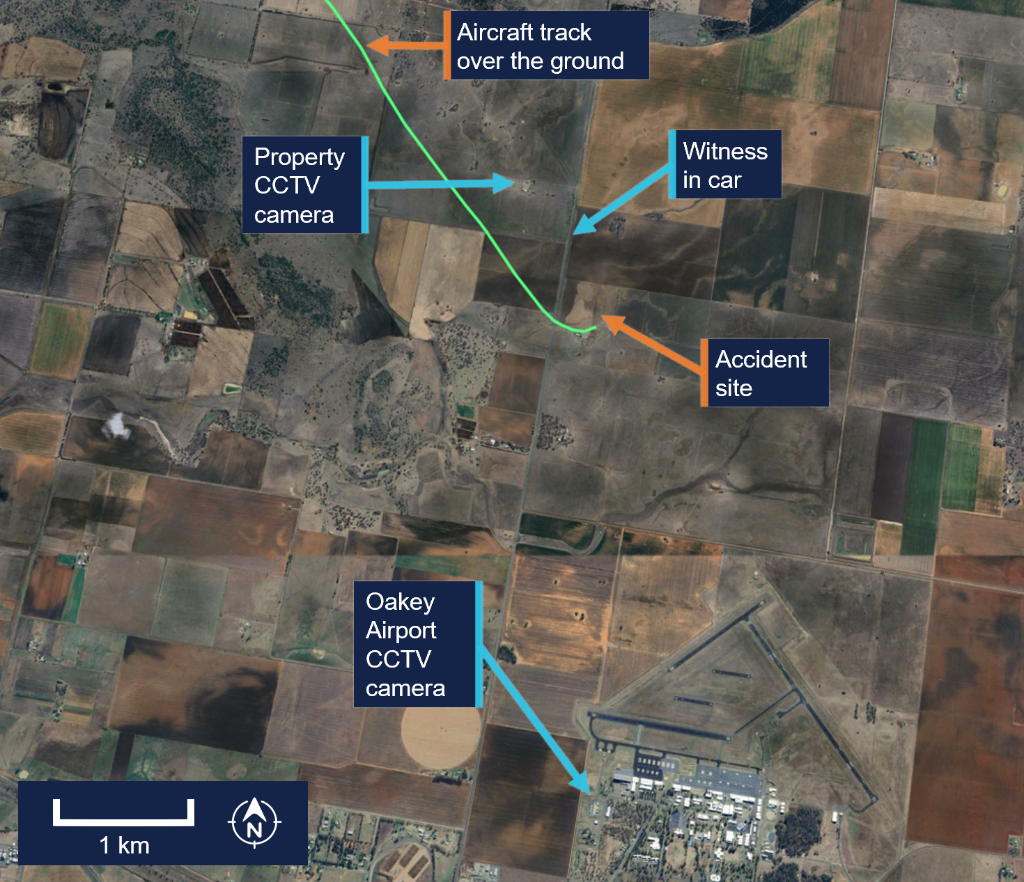
A motorist travelling south observed the aircraft on approach and maintained visual contact with it for about 3 km (Figure 4). They observed the aircraft commence a flat turn and yaw[7] to the left at a height of about 300 ft AGL and pass above the road ahead of them. They recalled seeing the aircraft then roll to the left, pitch down, and impact the terrain. 

Figure 4: Witness and closed-circuit television camera locations

Witness and CCTV camera locations

Source: Google Earth, annotated by the ATSB

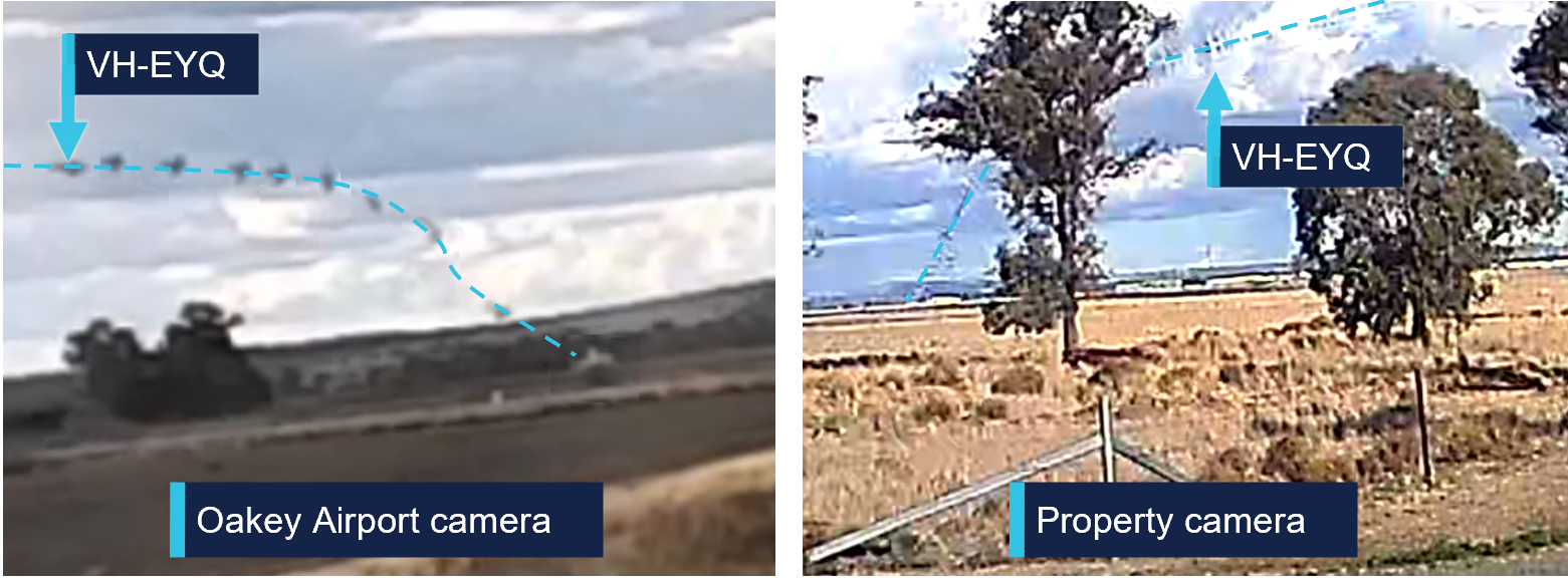
Closed-circuit television (CCTV) cameras located at a nearby property and Oakey Airport captured the aircraft commence a steep descent before colliding with terrain (Figure 5).

The aircraft was destroyed in a post-impact fire, and both occupants were fatally injured.

Figure 5: Composite images of recorded CCTV camera footage

Composite images of recorded CCTV camera footage

Source: CCTV camera recordings


Context

Pilot information

Pilot experience

The pilot held a valid class 1 aviation medical certificate and an air transport pilot licence (ATPL) (aeroplane). Additionally, they held a grade 3 flight instructor rating with multi‑engine aeroplane training approval and design feature endorsements to operate VH-EYQ. The pilot held a valid multi-engine instrument rating with the previous instrument proficiency check (IPC) completed in August 2024. 

At the time of the accident, the pilot had accumulated 5,767 hours total aeronautical experience. This included 4,170 flight hours as pilot in command with 3,514 hours in multi-engine aeroplanes and about 1,200 hours in command of a Reims F406. In the preceding 90 days they had flown 95 hours, including 54 hours in the Reims F406. They had worked for the aircraft operator since March 2017.

Known recent activity

The pilot’s work roster for the week prior to the accident (from 14 to 20 July 2025) is shown in Table 1. During this week, the pilot was based away from home and conducted multiple survey flights. The pilot’s duties for 20 July included the survey flight in the morning with no additional rostered flying.

Table 1: Pilot rostered duties, 14 to 20 July 2025

DateShift start-finish timeTotal flight hours
14 JulyOFF0
15 July0630-14301.5
16 July0630-14302.1
17 July0630-14301.8
18 July0630-14302.4
19 JulyOFF0
20 July0730-15005:31

A text message sent from the pilot the evening of 19 July indicated that the pilot had intended to conduct the IPC the following day. Additionally, the message indicated they had sleep opportunity from about 2130. 

Flight examiner information

Flight examiner experience

The flight examiner held a valid class 1 aviation medical certificate and an ATPL (aeroplane). They also held grade 1 flight instructor and flight examiner operational ratings, with multi-engine aeroplane and instrument rating (aeroplane) training approval. Their flight instructor rating also had a spin endorsement, and they held design feature endorsements to operate VH-EYQ. The examiner held a valid multi-engine instrument rating with the previous IPC completed in October 2024.

The flight examiner’s logbook records were destroyed in the post-impact fire. Based on records of the pilot’s hours from January 2025, the flight examiner’s total aeronautical experience was in excess of 20,000 hrs. Additionally, they had flown 3 similar proficiency check flights for the aircraft operator in the previous 12 months, totalling 3.6 hours in the Reims F406. The flight examiner was external to the aircraft operator and was regularly hired to complete the IPC for their pilots.

Known recent activity

Along with their logbook, the flight examiner's work records were destroyed in the post‑impact fire. 

A family member recalled that the flight examiner had returned from a chartered flight to western Queensland on Tuesday 15 July. During the week, they had spent a day providing aviation theory instruction to students but had no other work engagements. On the day of the accident, the flight examiner woke at their normal time. They were reported to have slept well and, when leaving home for the IPC flight, they appeared their normal self with no signs of fatigue.

Aircraft information

General information

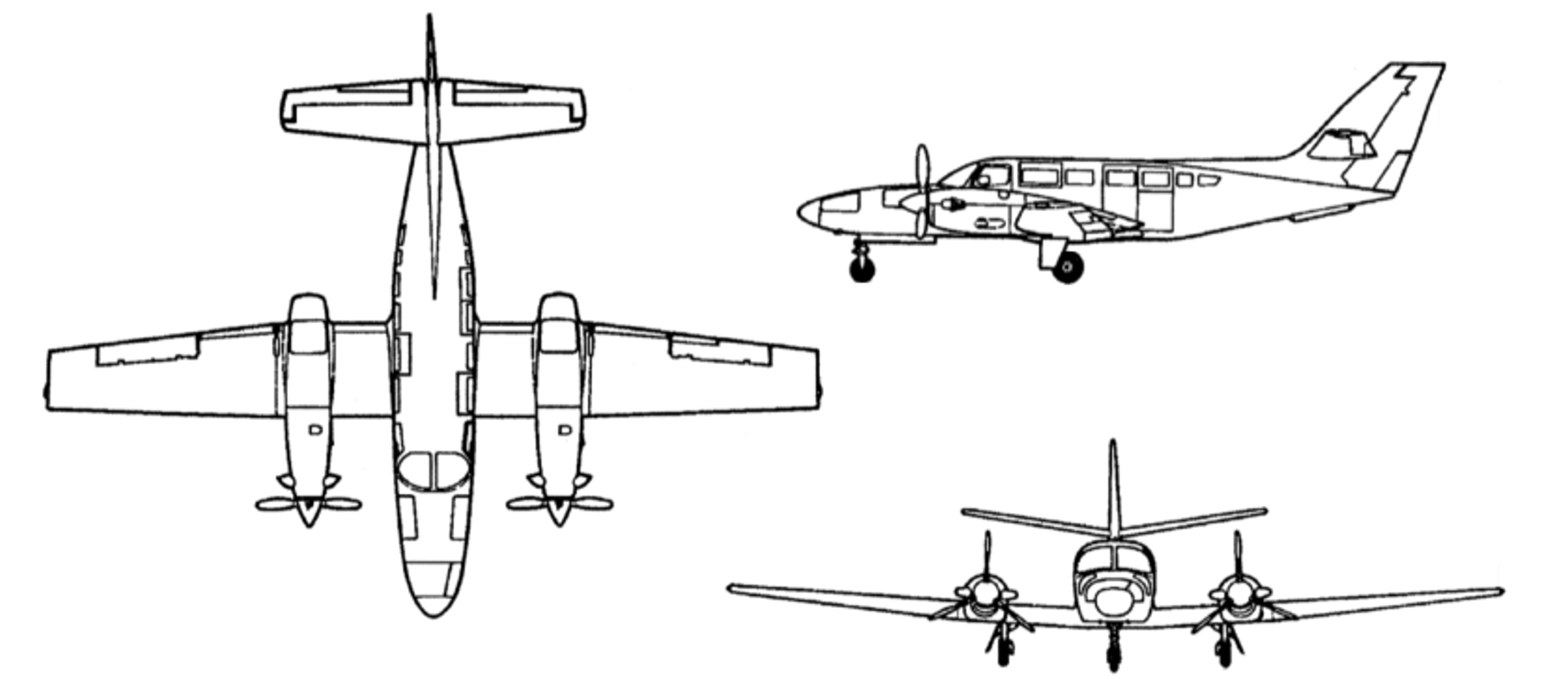
The Reims Aviation F406 is a low wing, twin‑engine aircraft powered by 2 Pratt & Whitney Canada PT6A-112 turbine engines, each driving a 3-bladed McCauley constant speed, full-feathering propeller (Figure 6). The accident aircraft, serial number F406‑0047, was manufactured in France in 1990 and first registered in Australia as VH‑EYQ in 2012. 

Figure 6: Reims F406

Three-view drawing of the Reims F406

Source: ASI Aviation

Recent maintenance activity

The aircraft was to be maintained in accordance with the aircraft operator’s Civil Aviation Safety Authority (CASA) approved system of maintenance. This required a periodic inspection every 100 hours or 12 months, whichever came first. The system of maintenance allowed for periodic inspection intervals to be extended up to a maximum of 10 hours. The most recent periodic inspection was completed on 11 June 2025, at 17,376 hours in service. At the time of the accident, the aircraft had accumulated 17,475.6 hours total time in service.

Configuration

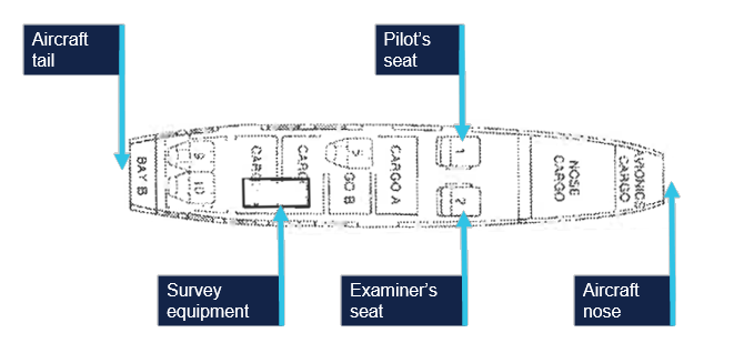
VH-EYQ was configured in a 5-seat survey layout. This comprised the pilot (left) and copilot (right) seats in the front row, followed by 1 passenger seat in row 3, and 2 passenger seats in row 5. The remaining passenger seats were removed from the cabin to accommodate the installation of aerial survey equipment (Figure 7). An electronic loading system had been generated for this configuration by an approved load controller, and records show that this was utilised by the pilot for previous flights.

Figure 7: VH-EYQ cabin configuration

VH-EYQ cabin configuration

Source: ASI Aviation, annotated by the ATSB

Weight and balance

Prior to its departure from Archerfield Airport, the aircraft was fuelled with 1,086 L of Jet A1 fuel. The aircraft operator advised that, based on this fuel uplift and the intended flying activity, it was very likely that the aircraft had full fuel on board for the flight to Warwick Airport. Fuel calculations based on flight times and expected consumption rates indicated that, at the time of the accident, the aircraft probably had about 1,280 L of fuel on board. This meant the aircraft weight at the time of the accident was about 600 kg below the aircraft’s maximum take-off weight. Based on the survey flying configuration and loading of the aircraft, the aircraft’s centre of gravity was calculated and assessed to be within prescribed limits.

Performance

The pilot operating handbook airplane flight manual (POH) provided applicable limitations which included:

  • a stall speed[8] of 75 KIAS[9] in the landing configuration (VSO), and 94 KIAS with flaps in the up position (VS)
  • an intentional one engine inoperative speed (VSSE)[10] of 98 KIAS
  • an air minimum control speed (VMCA)[11] of 90 KIAS
  • a one engine inoperative best rate-of-climb speed at sea level (VYSE) of 108 KIAS. 
One engine inoperative procedures

The POH included recommended procedures in the event of an emergency. This included checklists for an engine failure in flight, and for the conduct of an approach and missed approach with one engine inoperative. The recommended approach speed with an engine inoperative was 110 KIAS reducing to 101 KIAS only once landing was assured.

Site and wreckage information

Accident site

The ATSB conducted an onsite examination of the aircraft wreckage, which was located in an open paddock about 2.6 km from the threshold of runway 14 at Oakey Airport (Figure 8).

Figure 8: Location of accident

Location of accident

Source: Google Earth, annotated by the ATSB

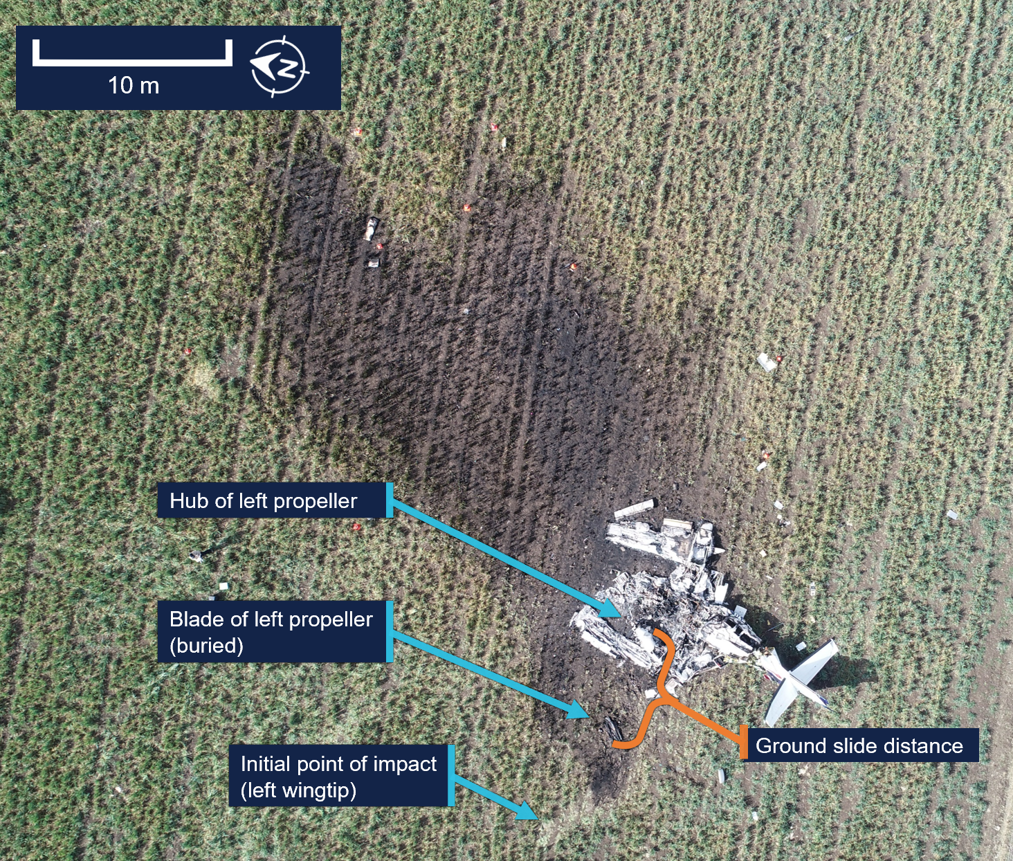
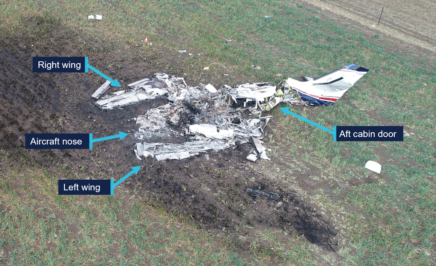
The wreckage was confined to a 30 m radius of the accident site. The impact marks and wreckage position indicated the aircraft impacted terrain left wing low with little forward momentum. Ground scars indicated the aircraft moved about 6 m after the initial impact. All components were upright.

The tail and aft cabin section showed signs of vertical compression. There was no fore or aft compression damage to the nose or wings. The left wing had separated from the aircraft just outboard of the left engine, and the right wing had separated just inboard of the right engine. Both wings had swung forward to lay parallel to the fuselage (Figure 9).

Figure 9: VH-EYQ accident site

VH-EYQ accident site

Source: ATSB

All major aircraft components were accounted for at the point of impact. A post‑impact fire consumed the forward section of the aircraft to the aft cabin door (Figure 10). This damage limited the extent to which pre-impact defects could be identified.

Figure 10: VH-EYQ wreckage

VH-EYQ wreckage

Source: ATSB 

Engines

Both engines were retained for further examination. This was conducted by ATSB investigators who were assisted by investigators from Pratt & Whitney Canada.[12] The engine examination determined: 

  • there were no indications of pre-impact mechanical anomalies to any of the engine components that would have precluded normal engine operation
  • the left engine displayed indications that it was rotating at the time of impact
  • the right engine displayed characteristics that it was developing power at the time of impact.
Propellers

Both propellers showed indications that the engines were running at impact. The right propeller was determined to be in a fine pitch position[13] and exhibited bending in multiple directions.

Both propellers were retained, and an independent inspection was carried out at a propeller overhaul facility under the direction of ATSB investigators. Further analysis is required to determine the position of the left propeller at the time of impact.  

Meteorological information

The Bureau of Meteorology (BoM) graphical area forecast valid at the time of the accident included the following conditions en route:

  • scattered cloud bases of 3,000 ft to 5,000 ft, extending up to 8,000 ft
  • isolated showers of rain with broken cloud from 1,000 ft to 2,000 ft and scattered cloud from 2,000 ft to above 10,000 ft.

At 1500, at about the same time the aircraft impacted terrain, the BoM issued a meteorological aerodrome report for Oakey Airport which reported the conditions at that time were:

  • a wind of 6 kt, with a mean direction of 190°M, varying between 160°M–220°M
  • visibility of 10 km or greater
  • no cloud detected
  • a temperature of 20°C and a dew point of 6°C
  • a QNH[14] of 1,016 millibars
  • no recorded rainfall since 0900.

Satellite images and CCTV footage captured areas of scattered cloud in the vicinity of the aerodrome at the time of the approach.

Flight activity

General

For a pilot to operate an aircraft under the instrument flight rules, they are required to hold an instrument rating. Pilots are also required to pass an annual instrument proficiency check (IPC) flight to ensure that they maintain the necessary skills and competency to operate safely. The purpose of the accident flight was for the pilot to complete their annual IPC. 

An IPC can be completed by a flight examiner with an instrument rating, MPL[15] or ATPL (aeroplane) flight test endorsement, or by a person approved by CASA. While the aircraft operator had a training and checking system,[16] they scheduled IPC flights with external examiners and permitted the pilots to arrange their IPC flights privately. The head of flying operations (HOFO) of the aircraft operator recalled that the accident pilot had advised them that their IPC expiry date was approaching and requested the use of VH‑EYQ to complete the flight. In response, provisions were made by the HOFO and head of aircraft airworthiness and maintenance control delegate to make the aircraft available to the pilot for the purpose of conducting the IPC flight. 

The pilot arranged the IPC with the external flight examiner and records show that the IPC was booked into the CASA flight test management system[17] by the flight examiner during the afternoon of 18 July and scheduled to take place on the afternoon of 20 July. 

Instrument proficiency check assessment

During an IPC flight, a pilot’s competency is assessed in actual or simulated instrument meteorological conditions. During the flight, a pilot is required to meet specified standards for:

  • departure
  • en route skills
  • arrival
  • approach
  • missed approach
  • approach to land manoeuvres.

If the IPC is for multi-engine operations, the assessment also requires the satisfactory completion of a simulated one engine inoperative (OEI) departure and a simulated OEI approach. 

The HOFO of the aircraft operator recalled that the external flight examiner had, in the past, typically conducted the simulated OEI departure after take-off from Warwick Airport and the simulated OEI approach at Oakey Airport. 

Recorded information

Recorded flight data

The aircraft was not fitted with a flight data recorder or a cockpit voice recorder, nor was it required to be. During the accident flight, data was being transmitted by the aircraft’s automatic dependent surveillance broadcast (ADS-B) equipment. This data, recorded at 2–5 second intervals by amateur ground-based receivers, captured the aircraft’s position, altitude and groundspeed during the flight. Flight data was also being transmitted from a Spidertracks[18] tracking device fitted to the aircraft. This data, recorded at 15-second intervals, captured the aircraft’s position, altitude, groundspeed and heading during the flight.

The ADS-B altitude and groundspeed data for the aircraft’s departure from Warwick Airport is depicted in Figure 11.

Figure 11: VH-EYQ altitude and groundspeed during the Warwick Airport departure

AO-2025-042 prelim Figure 11.png

Source: ATSB 

The ADS-B altitude and groundspeed data for the aircraft’s ILS approach at Oakey Airport is depicted in Figure 12.

Figure 12: VH-EYQ altitude and groundspeed during the Oakey Airport approach

VH-EYQ altitude and groundspeed during the Oakey Airport approach

Source: ATSB 

A Garmin GTN-650 global positioning system was also recovered from the accident site and transported to the ATSB’s Canberra technical facility for further examination. The unit showed signs of significant heat damage with melting and evidence of charring on the internal circuitry. The remains of 2 SD[19] cards were found within the unit, however, the post-impact fire had damaged the SD card memory chips to the point that data could not be extracted using normal recovery methods. 

Record radio communications

All radio communications made and received by Airservices Australia throughout the entirety of VH-EYQ’s flight from Warwick Airport were recorded.

Recorded CCTV footage

Two CCTV cameras captured footage of the aircraft immediately prior to the collision with terrain. One camera was located on a property 1.4 km to the north-west of the accident and the second camera was located on Oakey Airport about 3 km south of the accident site. 

The property CCTV footage was timestamped. The aircraft entered frame at 1459:53 and remained in frame for the duration of the recording which captured the collision with terrain at 1500:00.

The Oakey Airport CCTV footage did not contain a timestamp. The aircraft entered frame 1 second into the recording and remained in frame until the collision with terrain that occurred 7 seconds later.

Further investigation

To date, the ATSB has:

  • examined the wreckage and accident site
  • examined meteorological information
  • interviewed relevant parties
  • collected radio communication, aircraft traffic surveillance data, and navigational application data
  • collected aircraft, pilot, crew and operator documentation.

The investigation is continuing and will include review and examination of:

  • pilots’ recent history
  • propellers
  • maintenance records
  • pilot and crew training and medical records
  • operational procedures and documentation
  • further interviews with relevant parties
  • flight data and air traffic surveillance data
  • the requirements of conducting simulated one engine inoperative exercises at low heights.

A final report will be released at the conclusion of the investigation. Should a critical safety issue be identified during the course of the investigation, the ATSB will immediately notify relevant parties so appropriate and timely safety action can be taken. 

Acknowledgements

The ATSB would like to acknowledge the assistance provided by the Australian Defence Force personnel at the Oakey Army Aviation Centre during the initial evidence collection activities.

Purpose of safety investigations

The objective of a safety investigation is to enhance transport safety. This is done through: 

  • identifying safety issues and facilitating safety action to address those issues
  • providing information about occurrences and their associated safety factors to facilitate learning within the transport industry.

It is not a function of the ATSB to apportion blame or provide a means for determining liability. At the same time, an investigation report must include factual material of sufficient weight to support the analysis and findings. At all times the ATSB endeavours to balance the use of material that could imply adverse comment with the need to properly explain what happened, and why, in a fair and unbiased manner. The ATSB does not investigate for the purpose of taking administrative, regulatory or criminal action.

About ATSB reports

ATSB investigation reports are organised with regard to international standards or instruments, as applicable, and with ATSB procedures and guidelines.

Reports must include factual material of sufficient weight to support the analysis and findings. At all times the ATSB endeavours to balance the use of material that could imply adverse comment with the need to properly explain what happened, and why, in a fair and unbiased manner.

An explanation of terminology used in ATSB investigation reports is available here. This includes terms such as occurrence, contributing factor, other factor that increased risk, and safety issue.

Publishing information

Released in accordance with section 25 of the Transport Safety Investigation Act 2003

Published by: Australian Transport Safety Bureau

© Commonwealth of Australia 2025

Title: Creative Commons BY - Description: Creative Commons BY

Ownership of intellectual property rights in this publication

Unless otherwise noted, copyright (and any other intellectual property rights, if any) in this report publication is owned by the Commonwealth of Australia.

Creative Commons licence

With the exception of the Commonwealth Coat of Arms, ATSB logo, and photos and graphics in which a third party holds copyright, this report is licensed under a Creative Commons Attribution 4.0 International licence.

The CC BY 4.0 licence enables you to distribute, remix, adapt, and build upon our material in any medium or format, so long as attribution is given to the Australian Transport Safety Bureau. 

Copyright in material obtained from other agencies, private individuals or organisations, belongs to those agencies, individuals or organisations. Where you wish to use their material, you will need to contact them directly.

[1]     Instrument proficiency check: an assessment of a pilot’s skills and operational knowledge required to exercise licence ratings and privileges when flying under the instrument flight rules.

[2]     Instrument flight rules (IFR): a set of regulations that permit the pilot to operate an aircraft in instrument meteorological conditions (IMC), which have much lower weather minimums than visual flight rules (VFR).

[3]     Reporting point: a specified geographical location in relation to which the position of an aircraft can be reported.

[4]     Instrument landing system (ILS): a precision instrument approach system which normally consists of a VHF localiser providing horizontal guidance and a UHF glideslope providing vertical guidance.

[5]     Glideslope: a component of the instrument landing system providing vertical (up/down) guidance toward the runway touchdown point, usually at a 3° slope.

[6]     The provided CTAF recording was found to have a discrepancy that could not be resolved.

[7]     Yaw: the motion of an aircraft about its vertical or normal axis.

[8]     Aerodynamic stall: or stall, occurs when airflow separates from the wing’s upper surface and becomes turbulent. A stall occurs at high angles of attack, typically 16˚ to 18˚, and results in reduced lift.

[9]     KIAS: indicated airspeed expressed in knots, used by pilots as a reference for all aircraft manoeuvres.

[10]    The manufacturer’s minimum speed for rendering one engine inoperative in flight for pilot training.

[11]    The minimum indicated airspeed at which the aircraft was laterally controllable with one engine inoperative and a 5° bank angle towards the operative engine.

[12]    Pratt & Whitney Canada: engine manufacturer of the engines installed on VH-EYQ.

[13]    Fine pitch: refers to a fine or low pitch angle which yields good low speed acceleration.

[14]    QNH: the altimeter barometric pressure subscale setting used to indicate the height above mean seal level.

[15]    MPL: multi-crew pilot licence.

[16]    Training and checking system: a training and checking system ensures that operational safety-critical personnel are proficient in the required competencies to support an operator's air operations.

[17]    Flight test management system: online record system used to notify CASA of planned flight tests. Flight examiners also use the system to schedule and record the outcomes of flight tests and proficiency checks. The system is used by CASA to keep track of the flight testing process and analyse trends at industry level.

[18]    Spidertracks: a satellite-based tracking system, combining satellite communication and GPS technology.

[19]    Secure digital card (SD): a type of memory card typically used in portable devices.

Occurrence summary

Investigation number AO-2025-042
Occurrence date 20/07/2025
Occurrence time and timezone 15:00 Australian Eastern Standard Time
Location 3.4 km north of Oakey Airport
State Queensland
Report release date 10/12/2025
Report status Preliminary
Anticipated completion Q4 2026
Investigation level Short
Investigation type Occurrence Investigation
Investigation phase Examination and analysis
Investigation status Active
Mode of transport Aviation
Aviation occurrence category Collision with terrain, Loss of control
Occurrence class Accident
Highest injury level Fatal

Aircraft details

Manufacturer Reims Aviation S.A.
Model F406
Registration VH-EYQ
Serial number F406-0047
Aircraft operator Bayswater Road Pty Ltd (trading as Aero Logistics)
Sector Turboprop
Operation type Part 91 General operating and flight rules
Activity General aviation / Recreational-Instructional flying-Instructional flying - dual
Departure point Warwick Airport, Queensland
Destination Warwick Airport, Queensland
Injuries Crew - 2 (fatal)
Damage Destroyed

VFR into IMC and collision with terrain involving Beechcraft 35-C33 Debonair, VH-KZK, 12 km east of Khancoban Airport, New South Wales, on 15 July 2025

Final report

Report release date: 16/12/2025

Investigation summary

What happened

On 15 July 2025, a Beechcraft 35-C33 Debonair, registered VH-KZK, departed Wangaratta Airport, Victoria for a private flight under the visual flight rules (VFR) to Moruya Airport, New South Wales. 

Soon after entering the Snowy Mountains area, the aircraft made a 150° right turn, shortly followed by another long left turn. The aircraft entered a spiralling descent to the right that continued until the aircraft collided with terrain. The pilot was fatally injured and the aircraft was destroyed.

What the ATSB found

It is very likely that the pilot, who did not hold an aircraft instrument rating, experienced spatial disorientation after flying into instrument meteorological conditions (IMC). This subsequently resulted in the collision with terrain.

Based on the forecast cloud between Wangaratta and Moruya, completing such a flight while maintaining VFR was likely not feasible. The pilot held a recreational pilot licence that did not include a navigation endorsement. While the pilot had completed some of the training required to attain a navigation endorsement, it is possible that the pilot’s limited training and experience in this respect affected their decision to conduct or continue the flight into challenging weather conditions.

Safety message

One of the key risk controls for a VFR pilot to avoid entering IMC is appropriate pre-flight preparation and planning. Not only should pilots obtain up-to-date weather information before and during flight, they should plan an alternate landing point and be prepared to make necessary deviations from the planned route should actual weather conditions necessitate it.

Licence restrictions and endorsements are a critical aspect of flight safety. They ensure that pilots have been trained to an acceptable standard and that the appropriate experience has been attained. Studies show that pilots with less weather experience are more likely to engage in high-risk activities when dealing with weather. This accident is an important reminder to respect these restrictions and endorsements when planning a flight.


The investigation

The ATSB scopes its investigations based on many factors, including the level of safety benefit likely to be obtained from an investigation and the associated resources required. For this occurrence, the ATSB conducted a limited-scope investigation in order to produce a short investigation report, and allow for greater industry awareness of findings that affect safety and potential learning opportunities.

The occurrence

On 15 July 2025, the pilot and sole occupant of a Beechcraft 35-C33 Debonair, registered VH-KZK, was conducting a private flight under the visual flight rules (VFR)[1] from Wangaratta Airport, Victoria, to Moruya Airport, New South Wales. The pilot was returning to Moruya following the completion of routine maintenance on the aircraft.

It is not known what weather information was accessed by the pilot prior to departing Wangaratta, as no flight planning records were recovered. Text messages from the pilot at 0755 on the morning of the accident flight indicated that they were conducting flight planning and considering the weather on the morning of the accident flight, noting that ‘the sky outside is scattered clouds so we will see what the planning forecast is.’

A flight path recreated from automatic dependant surveillance broadcast (ADS-B) transmissions is shown in Figure 1. The pilot departed Wangaratta at 1302 and flew approximately east towards Moruya, 189 NM away, making occasional changes in heading. By 1315 the aircraft had climbed to an altitude of 4,500 ft above mean sea level (AMSL), where it remained until it approached the rising terrain of the Snowy Mountains, where the aircraft began climbing to 7,000 ft. The mountainous area along the aircraft’s flight path had varying terrain heights, with a maximum of approximately 6,000 ft AMSL.

Figure 1: Flight path of VH-KZK on 15 July 2025

The flight path of VH-KZK for the accident flight, shown as a line overlaid on a satellite map.

Source: Google Earth, annotated by the ATSB

The aircraft flew past a small aerodrome, Khancoban Airport,[2] at about 1339 at an altitude of about 6,400 ft AMSL (Figure 2). At 1340:15, the pilot commenced a rate 1 turn[3] to the right with minimal change in altitude. At 1341:18, after turning through 150°, there was a 20-second period where ADS-B transmissions were not received. The aircraft was subsequently detected in a left turn through 206°, also approximately rate 1. An airspeed of approximately 150 kt was maintained through these turns. 

Figure 2: Flight path prior to colliding with terrain

The last section of VH-KZK's flight path, showing the aircraft performing several turns before a spiral descent and collision with terrain.

Vertical lines are used to indicate the aircraft’s height above terrain. Each line represents a data point. Source: Google Earth, annotated by the ATSB

At approximately 1342:38, the aircraft entered another right turn and shortly after, began descending from 6,725 ft AMSL. From this point, the aircraft’s rate of turn, descent rate and groundspeed all steadily increased into a spiralling descent. The last ADS-B transmission was recorded 55 ft above ground level, with an estimated airspeed of 210 kt and a rate of descent above 4,000 ft/min. At 1343:40, the aircraft collided with terrain at an elevation of 4,830 ft AMSL. The pilot was fatally injured and the aircraft was destroyed. 

The pilot had lodged a search and rescue time (SARTIME) with Airservices Australia, and when this time elapsed the Joint Rescue Coordination Centre (JRCC) was notified and commenced a search. The aircraft was not fitted with an emergency locator transmitter (ELT), and poor weather conditions limited JRCC search capabilities. Visibility was affected by cloud, and in the early stages of the search, helicopters had limited access to the area where the aircraft was last detected on ADS-B. After an extended search by air, the aircraft was located on 17 July in steep, forested terrain with snow cover.

Context

Pilot information

General information

The pilot held a Recreational Pilot (Aeroplane) Licence (RPL) with a single engine aeroplane class rating and a flight radio endorsement. The RPL permitted private or training flights by day under VFR. The pilot was issued with a basic class 2 aviation medical certificate that was valid until February 2026. The basic class 2 medical certificate was an alternative to a full class 2 certificate for RPL and Private Pilot Licence (PPL) holders. It imposed additional operational restrictions, including that the pilot was not permitted to fly above 10,000 ft. 

The pilot’s next of kin reported no relevant medical conditions or medications. There was evidence that the pilot had up to about 9 hours sleep opportunity the night before the flight, but there was insufficient information available to assess fatigue.

Toxicology and pathology reports were not available at the time of publishing this report.

Training and experience

The ATSB estimated[4] the pilot had completed 142 hours total flight time, including 28 hours of solo flying. The pilot had an estimated 25 hours of flight experience in the Beechcraft 35-C33 Debonair, entirely in VH-KZK (which they owned), including 10 hours of solo flying.

The pilot did not have an RPL navigation endorsement, which meant they were restricted from flying beyond 25 NM of the departure aerodrome, unless it was to travel to a training area. Obtaining the navigation endorsement required completion of specific flying training and passing a written examination. The Civil Aviation Safety Authority (CASA) website stated that the examination covered a range of topics including:

• maps and charts properties

• forecast requirements and interpretation of forecasts, determination of alternate or holding requirements.

The pilot had received some navigation training, which included several navigation exercises, as well as a solo navigation flight. Including that flight, the pilot had completed 4 exercises within the standard PPL syllabus. Two additional dual exercises and 1 final long solo navigation exercise were required before an RPL navigation endorsement could be sought. During the training, with regard to flight planning, the pilot was assessed as having achieved ‘competency to the standard required for qualification issue’. Flight planning included the following elements:

• select a suitable route and altitude considering weather, terrain, airspace, NOTAMs[5] and alternate landing areas

• obtain and interpret meteorological forecasts, NOTAMs and operational information applicable to the planned flight

• determine whether the planned flight can be conducted under the applicable flight rules and taking account of the beginning and end of daylight times.

In total, the pilot had accrued 38.1 hours of navigation training, including 1.7 hours flying solo. The pilot had also received 1.0 hours of basic instrument flight training in 2021 on a different aircraft.

Recent flying

The pilot’s most recent formal navigation training was in March 2023. Between November 2023 and October 2024, the pilot undertook training in VH-KZK, having previously flown a Beechcraft C23 Sundowner. Following this training, ADS-B data showed VH-KZK flying (determined to be with this pilot in command) on 9 different occasions between November 2024 and May 2025. All of these flights took place along the New South Wales south coast between Moruya Airport, Merimbula Airport and Frog’s Hollow Airfield (Figure 3). Logbook entries for these flights were not found, but they were understood to be solo flights for pleasure and personal transport.

Figure 3: Aerodromes used by VH-KZK

A satellite photograph showing the different aerodromes used by VH-KZK and the distances between them.

Source: Google Earth, annotated by the ATSB

On the day before the accident, the pilot conducted a solo navigation flight from Frog’s Hollow to Wangaratta Airport where the aircraft was booked in for routine maintenance. Weather forecasts from the area predicted a cloud ceiling of 7,000 ft and scattered cloud. ADS-B data showed that the pilot conducted most of the flight at an altitude of 9,000 ft, above the forecast cloud tops. The flight appeared to be conducted without incident.

Aircraft information

The Beechcraft 35-C33 Debonair is a low-wing, 4-seat, all-metal aircraft with retractable tricycle landing gear. The Debonair, with a conventional vertical fin and tailplane, was a variant of the early Beechcraft Bonanza model, which had a distinctive V-tail. VH-KZK, serial number CD-985, was manufactured in 1967 in the United States and first registered in Australia in the same year. It was powered by a 6-cylinder Teledyne-Continental Motors IO-470-K engine driving a McCauley 2A36C23 constant-speed propeller. The aircraft was fitted with a pitot heat system.

The aircraft had been classified as capable of operating under the instrument flight rules (IFR) in September 2019. A review of the expired maintenance releases identified that the aircraft shifted between IFR and VFR categories, depending on IFR inspection status. The last IFR inspection recorded in the aircraft logbook was completed on 4 May 2023, with the maintenance release showing the IFR category selected. The current maintainer, who first inspected the aircraft in June 2024, reported that, due to uncertainty around the certification of the equipment, the IFR category was not indicated on the previous 2 maintenance releases.

The aircraft was being maintained in accordance with the standard CASA maintenance schedule (Schedule 5), which required a periodic inspection every 100 flight hours or 12 months, whichever came first. The most recent periodic inspection was completed on 15 July 2025, with the aircraft having accrued 17.5 hours in the previous 12 months. In addition to the periodic inspection requirements, the 2 main tyres were replaced. A new maintenance release was issued with the aircraft having accrued 3,279 hours total time in service.

Maintenance records indicated that an emergency locator transmitter (ELT) was removed from the aircraft in 2019. The maintainer confirmed that there was no ELT fitted to VH-KZK.

Wreckage and impact information

Access to the accident site was limited due to the terrain, snow and environmental conditions, and the ATSB did not attend the accident site. New South Wales Police Force personnel who winched to the site via helicopter to recover the pilot took photographs and collected physical evidence, including documentation and potential data recording devices, which were later examined by the ATSB. 

The aircraft was significantly disrupted (Figure 4), consistent with the estimated final aircraft speed of 210 kt and a vertical rate of descent of over 4,000 ft/min. The impact was not survivable. Accident site photographs indicated that the wreckage was relatively contained, rather than spread over a long wreckage trail. This was consistent with the steep descent indicated by the flight data. The engine had separated from the aircraft wreckage and was located 10–15 m away. From the photographs, it was not possible to determine conditions such as aircraft configuration, control cable continuity or the state of control surfaces. It also could not be determined whether all components remained attached up to the point of impact.

Figure 4: Wreckage of VH-KZK

An aerial photograph of the wreckage of VH-KZK

Source: New South Wales Police Force

Meteorological information

Aerodrome weather

The aerodromes closest to the accident site were Khancoban Airport and Corryong Airport (7 NM and 18 NM west of the accident site, respectively). Corryong did not provide meteorological observations and Khancoban had a non-aviation automatic weather station which did not report cloud or visibility. However, records for Albury Airport (Figure 3), which VH-KZK passed earlier in the flight, indicated that the following conditions existed at 1330:

  • visibility greater than 10 km
  • 9 kt westerly wind
  • no precipitation
  • broken cloud at 4,600 ft AGL (5,100 ft AMSL).
Weather forecasts

The Bureau of Meteorology (BoM) issued a set of graphical area forecasts (GAFs) at 0820 on the morning of the accident flight. Based on the flight data, the aircraft’s flight path would have passed through 3 areas with varying forecast conditions.

For the initial part of the flight, beginning at Wangaratta and approaching the Victoria/New South Wales border, the terrain elevation along the flight path varied between about 500 and 3,800 ft AMSL. On this segment the following conditions were forecast (all altitudes are AMSL):

  • a broken[6] cloud layer from 1,000–2,000 ft that was forecast to clear by about the aircraft’s departure time
  • broken cloud from 3,000–8,000 ft
  • isolated showers of rain, during which visibility would reduce to 4,000 m and cloud would extend from 800 ft to above 10,000 ft
  • isolated showers of snow above 4,000 ft during which visibility would reduce to 500 m and cloud would extend to 8,000 ft
  • freezing level above 4,500 ft.

After crossing into New South Wales and over the Snowy Mountains, just beyond Khancoban, the flight overflew mountainous terrain where the elevation increased to between 600 and 6,000 ft. In this region the forecast was for:

  • scattered[7] cloud from 1,500–3,000 ft and broken cloud from 3,000 ft to above 10,000 ft
  • scattered areas of drizzle with visibility reducing to 3,000 m and overcast conditions from 3,000 ft to 9,000 ft
  • isolated showers of snow above 4,000 ft with broken cloud from 4,000 ft to above 10,000 ft
  • freezing level above 4,500 ft.

The accident occurred within this region of the GAF. East of the highest terrain in the Snowy Mountains, conditions were forecast to improve slightly:

  • scattered cloud from 2,500–8,000 ft
  • broken cloud from 6,000 ft to above 10,000 ft.
Satellite imagery

A satellite photograph taken at 1340, less than 4 minutes before the aircraft collided with terrain, showed cloud cover in the vicinity of the accident site (Figure 5). However, the image provided no information on cloud height or density.

Figure 5: Satellite image from 1340 on 15 July

A satellite photograph showing the Victoria/New South Wales border region, with cloud cover over the accident site.

Source: Bureau of Meteorology, annotated by the ATSB.

Witness report

A witness with an aviation background was located near Khancoban Airport around the time of the occurrence. They reported hearing an aircraft in the area that they later believed to be VH-KZK. The witness could not see the aircraft due to cloud, but noted that it sounded as if it was heading towards the mountains east of Khancoban. The witness said the aircraft sounded like it was much lower than aircraft travelling over the mountains at this point would typically be (9,000 ft AMSL); the witness estimated the aircraft to be travelling at about 4,000 ft AMSL.

The witness observed the weather to be completely overcast. The cloud was low enough to be sitting on nearby hilltops, the peaks of which the witness believed to be between 2,500-3,000 ft AMSL.

Icing conditions

BoM forecasts note that flying in any cloud above the freezing level implies moderate icing conditions. The BoM publication titled Airframe Icing advises pilots on the effects that icing can have on an aircraft. It states that icing can:

  • alter the smooth flow of air over the aircraft
  • reduce pilot visibility
  • produce errors in instrument readings of air speed, altitude and vertical speed
  • increase the stall speed by increasing its weight and changing the aerodynamics of the wing and tail 
  • increase drag and decrease lift (tests have shown that icing no thicker or rougher than a piece of coarse sandpaper can reduce lift by 30% and increase drag by 40%)
  • make it almost impossible to operate control surfaces and landing gear
  • reduce thrust or cause engine failure.

Because VH-KZK was fitted with a pitot heat system, and a fuel-injected engine, the most likely adverse outcomes from icing involved ice forming on the exterior parts of the airframe. According to the BoM, this type of icing is caused by water droplets from cloud or precipitation striking the airframe at temperatures below the freezing level.

Operational information

Visual meteorological conditions

Visual meteorological conditions (VMC) are expressed in terms of in-flight visibility and distance from cloud (horizontal and vertical) as prescribed in the Civil Aviation Safety Regulations (CASR) Part 91 General Operating and Flight Rules. The accident flight was conducted entirely in uncontrolled (Class G) airspace. In order for the pilot to conduct such a flight under VFR while remaining below 10,000 ft (in accordance with licence requirements), the following VMC criteria needed to be maintained at all times:

  • 5,000 m visibility with 1,000 ft vertical and 1,500 m horizontal distance from cloud
  • When below the higher of 3,000 ft AMSL or 1,000 ft AGL and in sight of ground or water, the aircraft may be just clear of cloud. 

These criteria were illustrated in the CASA Visual Flight Rules Guide (Figure 6). Generally speaking, aircraft flying in conditions that do not meet these criteria are in instrument meteorological conditions (IMC). 

Figure 6: Visual meteorological conditions (VMC) criteria below 10,000 ft

Diagram showing VMC criteria for aeroplanes below 10,000 ft

Source: Civil Aviation Safety Authority

Flight planning requirements

Flight rules required that pilots study the appropriate authorised weather forecasts and reports in accordance with the CASR Part 91 Manual of Standards. This included authorised weather forecasts and reports for:

  • the route to be flown
  • the departure aerodrome, the planned destination aerodrome and any planned alternate aerodrome.
Improving the odds

In 2010 the ATSB published Improving the odds: Trends in fatal and non-fatal accidents in private flying operations (AR-2008-045), which found that assessing and planning problems contributed to 46% of fatal accidents involving Australian private flights between 1999 and 2008. The report stated that: 

Assessing and planning issues associated with collision with terrain and/or loss of control accidents mostly involved pilots failing to plan for the weather conditions, not properly assessing the weather during flight, or deciding to continue to fly in marginal weather.

The report provided extensive discussion (pages 16 through 21) on topics including ways of avoiding VFR into IMC accidents, such as through emphasising assessment of flight conditions (particularly weather conditions), evaluating effectiveness of plans, and setting personal minimums.

Spatial disorientation

The ATSB publication Accidents involving Visual Flight Rules pilots in Instrument Meteorological Conditions (AR-2011-050) discusses the physiological limitations of the human body when trying to sense its orientation in space:

In conditions where visual cues are poor or absent, such as in poor weather, up to 80 per cent of the normal orientation information is missing. Humans are then forced to rely on the remaining 20 per cent, which is split equally between the vestibular system and the somatic system. Both of these senses are prone to powerful illusions and misinterpretation in the absence of visual references, which can quickly become overpowering.

Pilots can rapidly become spatially disoriented when they cannot see the horizon. The brain receives conflicting or ambiguous information from the sensory systems, resulting in a state of confusion that can rapidly lead to incorrect control inputs and resultant loss of aircraft control.

The somatogyral illusion is one possible consequence of spatial disorientation, described in the ATSB publication Visual flight at night accidents: What you can’t see can still hurt you (

):

This illusion relates to a pilot’s incorrect understanding of an aircraft’s angle of bank. When the angle of bank is changed, the pilot’s vestibular system will register any angular acceleration above a threshold level of activation. Once the aircraft is in a constant turn, the pilot’s vestibular system will stop registering any input because there is no angular acceleration. In the absence of any other sensory information or vestibular input a pilot may experience a sensation that the aircraft is no longer turning.

The CASA publication titled Spatial disorientation was published in 2024 as part of the AvSafety program. This detailed several commonly observed illusions that pilots can experience as a result of spatial disorientation. The ‘Graveyard spiral’ described in the publication can occur as a result of the somatogyral illusion:

This can happen when an aircraft begins to bank in cloud or dark night conditions. A constant rate of bank will be undetectable by the vestibular apparatus in a pilot’s head, and unless the pilot is scanning the attitude indicator continuously there will be no visual clue. Rushing slipstream will indicate the increasing airspeed of a dive in what otherwise appears to be straight-and-level flight. Attempts to pull out of the dive often only tighten the unrecognised turn and can cause overstressing and failure of the aircraft structure.

For non-instrument rated pilots, entering IMC can quickly become fatal. Research has shown that pilots not proficient in instrument-only flight will typically become spatially disoriented and lose control of the aircraft within 1–3 minutes after visual cues are lost.

Additional details on spatial disorientation and illusions in low-visibility conditions are provided in the ATSB investigation report VFR flight into dark night involving Aérospatiale AS355F2 (Twin Squirrel), VH-NTV, 145 km north of Marree, South Australia, on 18 August 2011 (AO‑2011‑102).

Related occurrences

Between 2015 and 2025 there were 116 VFR into IMC occurrences in Australian airspace reported to the ATSB. Of these, 13 were fatal accidents resulting in 24 fatalities. Based on these figures, approximately 1 in every 9 reported VFR into IMC occurrences results in a fatality. 

Safety analysis

Spiral descent

The aircraft’s steadily increasing rate of descent and rate of turn in the period leading up to the impact with terrain were consistent with spatial disorientation, specifically, the somatogyral illusion and the ‘graveyard spiral’ described by CASA and others. 

Broken cloud was forecast in the mountains east of Khancoban between 3,000 ft AMSL to above 10,000 ft AMSL. There were also areas of drizzle with overcast conditions between 3,000 ft and 9,000 ft AMSL. The report from the witness near Khancoban airport indicated local conditions consistent with this forecast. Given the terrain elevation in the area, it is therefore almost certain that the aircraft encountered weather conditions making visibility marginal or worse, possibly for extended periods.

The aircraft’s increasing rate of descent and maximum allowable airspeed exceedance just before the collision with terrain indicated that the pilot was either not aware of the aircraft’s speed and attitude, or was not able to correct it during the descent. 

The pilot held a valid basic class 2 medical certificate and there was no available evidence to indicate any medical conditions likely to impact their flying ability, although an incapacitating medical event could not be entirely ruled out.

Prior to the spiral descent, the aircraft maintained a steady altitude and groundspeed, which did not indicate any engine or control issues to that point. An engine issue by itself should also not result in a high-speed, spiralling descent, unless there was also a control issue present. Control issues could not be entirely ruled out, since the wreckage was not examined, and photographs were insufficient to determine aspects such as control cable continuity or the presence of all control surfaces.

Aircraft icing was another possibility. It can affect a number of aspects relating to aircraft performance, handling or pilot visibility, and multiple control surfaces jammed by ice at the same time could result in an uncontrolled spiral flightpath. Structural icing would only be expected if the aircraft was in cloud or precipitation. In either case, based on the forecast, the aircraft would be in IMC where spatial disorientation would also be a concern. 

In either case, the aircraft’s flight path, including what appear to be 2 controlled turns beyond Khancoban, indicates that the aircraft remained controllable until at least the commencement of the spiral. The manoeuvres also indicate that the pilot deliberately left the planned flight route, and were consistent with attempts to navigate around cloud or showers and possibly find a landing area. For example, the first turn might have been an attempt to return to Khancoban or another airport such as Corryong or Wangaratta, and the second turn the result of cloud closing in behind the aircraft, preventing such a return. 

Considering the weather conditions on the day, the pilot’s limited training and experience, and the proven hazard of entering IMC as a VFR pilot, it is therefore very likely that the pilot experienced spatial disorientation in low-visibility conditions, leading to an undetected spiral descent. 

VFR into IMC

Just beyond Khancoban, the weather forecast indicated that broken cloud was expected from ground level (above 3,000 ft AMSL) up to above 10,000 ft AMSL. The vertical extent of the cloud would have made this particularly challenging for the pilot because it was probably not possible to fly above the broken cloud and remain under 10,000 ft in accordance with licence restrictions. 

Because there were no weather stations recording observations near the accident site, the actual weather conditions that the pilot encountered could not be determined beyond a single witness account (at ground level) and a satellite image that shows cloud in the area. While the conditions might have differed from the weather forecast, the forecast conditions indicated that a pilot would have no certainty of maintaining VFR. The pilot was not IFR rated and training records indicated that they had only flown 1 hour of instrument flight training. 

While the pilot had completed some navigation training including a solo navigation flight, they were yet to complete the training syllabus necessary to obtain a navigation endorsement for their recreational pilot licence. As such, they were not authorised to fly the 189 NM distance between Wangaratta and Moruya. Additionally, while the pilot had received training and been assessed as competent at reading weather forecasts in an aviation context, they likely had limited experience in this respect and had not been assessed on some relevant elements required for the PPL such as the more advanced interpretation of forecasts, and determination of alternate or holding requirements. This increased the likelihood of misinterpreting the forecast or underestimating the difficulty of navigating the forecast conditions.

There is limited information available to establish the extent or specifics of the pilot’s pre-flight planning. The exact weather scene presented to the pilot upon entering the mountains was not known, nor was the pilot’s decision-making regarding initiation and continuation of the flight. 

The number of reported VFR into IMC occurrences over the last 10 years indicates that many pilots, some likely with more experience, have found themselves in unsuitable weather situations yet continued the flight. However, studies have shown that pilots who do not accurately perceive the risks of adverse weather are more likely to engage in higher risk activities when dealing with weather (Cooper, 2003). The pilot’s limited training and experience with adverse weather conditions may therefore have contributed to their perception of risk and associated decision-making. 

Findings

ATSB investigation report findings focus on safety factors (that is, events and conditions that increase risk). Safety factors include ‘contributing factors’ and ‘other factors that increased risk’ (that is, factors that did not meet the definition of a contributing factor for this occurrence but were still considered important to include in the report for the purpose of increasing awareness and enhancing safety). In addition ‘other findings’ may be included to provide important information about topics other than safety factors. 

These findings should not be read as apportioning blame or liability to any particular organisation or individual.

From the evidence available, the following findings are made with respect to the VFR into IMC and collision with terrain involving Beechcraft 35-C33 Debonair VH-KZK, 12 km east of Khancoban, New South Wales on 15 July 2025. 

Contributing factors

  • The pilot very likely encountered instrument meteorological conditions, resulting in spatial disorientation and collision with terrain.
  • The pilot commenced a solo navigation flight, into areas with forecast instrument meteorological conditions, without having completed the required training and licensing for cross-country navigation.

Sources and submissions

Sources of information

The sources of information during the investigation included the:

  • Australian Maritime Safety Authority
  • Airservices Australia
  • Civil Aviation Safety Authority
  • New South Wales Police Force
  • pilot’s flight instructor
  • maintenance organisation for VH-KZK
  • witness to the flight
  • pilot's next of kin.

References

Australian Transport Safety Bureau. (2011). Accidents involving Visual Flight Rules pilots in Instrument Meteorological Conditions. Aviation Research Investigation Report AR-2011-050.

Bureau of Meteorology. (2025, June 4). Airframe icing. Australian Government. https://www.bom.gov.au/aviation/data/education/icing.pdf

Cooper D. (2003). Psychology, Risk and Safety: Understanding how personality & perception can influence risk taking. Professional Safety. Journal of the American Society of Safety Engineers, November 2003, 39-46.

Submissions

Under section 26 of the Transport Safety Investigation Act 2003, the ATSB may provide a draft report, on a confidential basis, to any person whom the ATSB considers appropriate. That section allows a person receiving a draft report to make submissions to the ATSB about the draft report. 

A draft of this report was provided to the following directly involved parties:

  • Civil Aviation Safety Authority
  • Australian Maritime Safety Authority
  • Bureau of Meteorology
  • the pilot’s flight instructor.

Submissions were received from:

  • Civil Aviation Safety Authority
  • Bureau of Meteorology
  • the pilot’s flight instructor.

The submissions were reviewed and, where considered appropriate, the text of the report was amended accordingly.

Purpose of safety investigations

The objective of a safety investigation is to enhance transport safety. This is done through: 

  • identifying safety issues and facilitating safety action to address those issues
  • providing information about occurrences and their associated safety factors to facilitate learning within the transport industry.

It is not a function of the ATSB to apportion blame or provide a means for determining liability. At the same time, an investigation report must include factual material of sufficient weight to support the analysis and findings. At all times the ATSB endeavours to balance the use of material that could imply adverse comment with the need to properly explain what happened, and why, in a fair and unbiased manner. The ATSB does not investigate for the purpose of taking administrative, regulatory or criminal action.

About ATSB reports

ATSB investigation reports are organised with regard to international standards or instruments, as applicable, and with ATSB procedures and guidelines.

Reports must include factual material of sufficient weight to support the analysis and findings. At all times the ATSB endeavours to balance the use of material that could imply adverse comment with the need to properly explain what happened, and why, in a fair and unbiased manner.

An explanation of terminology used in ATSB investigation reports is available here. This includes terms such as occurrence, contributing factor, other factor that increased risk, and safety issue.

Publishing information

Released in accordance with section 25 of the Transport Safety Investigation Act 2003

Published by: Australian Transport Safety Bureau

© Commonwealth of Australia 2025

Title: Creative Commons BY - Description: Creative Commons BY


Ownership of intellectual property rights in this publication

Unless otherwise noted, copyright (and any other intellectual property rights, if any) in this report publication is owned by the Commonwealth of Australia.

Creative Commons licence

With the exception of the Commonwealth Coat of Arms, ATSB logo, and photos and graphics in which a third party holds copyright, this report is licensed under a Creative Commons Attribution 4.0 International licence.

The CC BY 4.0 licence enables you to distribute, remix, adapt, and build upon our material in any medium or format, so long as attribution is given to the Australian Transport Safety Bureau. 

Copyright in material obtained from other agencies, private individuals or organisations, belongs to those agencies, individuals or organisations. Where you wish to use their material, you will need to contact them directly.

[1]     Visual flight rules (VFR): regulations that permit a pilot to operate an aircraft in conditions whereby navigation and orientation of the aircraft by visual reference is possible.

[2]     Khancoban Airport did not have an entry in the Airservices aeronautical information publication (AIP) en route supplement Australia (ERSA).

[3]     A rate 1 turn, also known as a standard rate turn, is turn rate of 3° per second.

[4]     The pilot’s logbook was not located. However, a copy of the pilot’s logbook with entries up until February 2023 was obtained. The ATSB also collated training records and publicly available flight data of the accident aircraft to estimate the pilot’s hours and experience.

[5]     Notice to airmen (NOTAM): A notice distributed by means of telecommunication containing information concerning the 

establishment, condition or change in any aeronautical facility, service, procedure or hazard, the timely knowledge of 

which is essential to personnel concerned with flight operations.

[6]     Broken cloud refers to cloud that covers between 5 to 7 oktas (eighths) of the sky.

[7]     Scattered cloud refers to cloud that covers between 3 to 4 oktas (eighths) of the sky.

Occurrence summary

Investigation number AO-2025-040
Occurrence date 15/07/2025
Location 12 km east of Khancoban
State New South Wales
Report release date 16/12/2025
Report status Final
Investigation level Short
Investigation type Occurrence Investigation
Investigation status Completed
Mode of transport Aviation
Aviation occurrence category Collision with terrain, VFR into IMC
Occurrence class Accident
Highest injury level Fatal

Aircraft details

Manufacturer Beech Aircraft Corp
Model 35-C33
Registration VH-KZK
Serial number CD-985
Sector Piston
Operation type Part 91 General operating and flight rules
Departure point Wangaratta Airport, Victoria
Destination Moruya Airport, New South Wales
Damage Destroyed

Collision with terrain involving a Robinson R22 Beta, 15 km east of Laura, Queensland, on 3 July 2025

Occurrence Briefs are concise reports that detail the facts surrounding a transport safety occurrence, as received in the initial notification and any follow-up enquiries. They provide an opportunity to share safety messages in the absence of an investigation. Because occurrence briefs are not investigations under the Transport Safety Investigation Act 2003, the information in them is de-identified. 

What happened

At about 1730 local time on 3 July 2025, after a repositioning ferry flight to Welcome Station, Queensland, for mustering operations the following day, the pilot and sole occupant of a Robinson R22 Beta helicopter made an approach to land next to a wooden pallet loaded with two 200 L drums of Avgas.[1] The pilot was likely unable to see the position of the left skid in relation to the pallet as they were seated on the right side of the helicopter. They reported that the left skid made contact with the pallet and caused the helicopter to bounce upwards. With no forward movement, the pilot reacted by quickly lowering the collective. They recalled hearing a bang and felt a ‘shimmy’ through the tail rotor pedal controls, which they suspected was the main rotor severing the tail boom. 

Figure 1: Helicopter accident site

Robinson R22 helicopter in a field. The image shows the windscreen is shattered, tail cone missing and damaged rotor blades.

 Source: Operator

The pilot recalled that the helicopter instantly began to rotate in a clockwise direction. The left skid impacted one of the fuel drums on the wooden pallet, and the helicopter rolled and impacted the ground, coming to a stop on its side about 15 m away from the pallet. 

ATSB review of images provided by the operator and similar occurrences that involved main rotor blade contact with the tail boom identified that the condition of the tail boom, damage to the tail rotor and vertical stabiliser were consistent with contact with terrain or an object, likely resulting in the tail boom separating from the helicopter. Consistent with the pilot’s recollection, this would result in the helicopter rotating in a clockwise direction.

Figure 2: Occurrence aircraft tail boom 

Robinson R22 Tail boom separated from the main fuselage of the helicopter. The images shows significant damage to the tail rotor and vertical stabiliser.

Source: Operator

The pilot extricated themselves from the wreckage and observed that fuel was leaking from the fuel cap. There were no reported injuries, and the pilot was assisted by 3 nearby colleagues to roll the substantially damaged helicopter upright to prevent further fuel spillage.

Safety action

The pilot had accumulated about 9,500 hours flying the R22 helicopter and was familiar with these types of operations. 

They reported they would take this opportunity to educate other pilots on the risks posed by objects in close proximity to the helicopter and how quickly an accident can develop when contact is made with a fixed object.

Safety message

This accident highlights the importance of clear visual lookout in respect to obstacles as the helicopter is approaching the ground. This is particularly significant when a pilot is required to land close to refuelling stations where ignition or explosion risks exist.

Pilots should always conduct a thorough reconnaissance of a landing area and, where possible, use ground marshallers to determine any potential hazards, assess the terrain, and identify a safe location to land the helicopter. 

About this report

Decisions regarding whether to conduct an investigation, and the scope of an investigation, are based on many factors, including the level of safety benefit likely to be obtained from an investigation. For this occurrence, no investigation has been conducted and the ATSB did not verify the accuracy of the information. A brief description has been written using information supplied in the notification and any follow-up information in order to produce a short summary report, and allow for greater industry awareness of potential safety issues and possible safety actions.

[1]     Avgas is an aviation fuel used in aircraft with spark-ignited internal combustion engines.

Occurrence summary

Mode of transport Aviation
Occurrence ID AB-2025-028
Occurrence date 03/07/2025
Location 15 km east of Laura
State Queensland
Occurrence class Accident
Aviation occurrence category Collision with terrain
Highest injury level None
Brief release date 24/07/2025

Aircraft details

Manufacturer Robinson Helicopter Co
Model R22 Beta
Sector Helicopter
Operation type Part 138 Aerial work operations
Departure point Unknown
Destination Welcome Station, Queensland
Damage Substantial

Tail rotor strike involving Robinson R22 Beta II, VH-HGE, 58 km north-west of Anthony Lagoon, Northern Territory, on 1 July 2025

Final report

Report release date: 21/11/2025

Investigation summary

What happened

On 1 July 2025, at about 1430, the pilot was the sole occupant of a Robinson R22 Beta II helicopter, being operated by North Australian Helicopters to conduct aerial mustering operations for a cattle station about 58 km north-west of Anthony Lagoon, Northern Territory.

Two R22’s provided by the operator were contracted by the cattle station owner and were assisted by stockmen on the ground. 

While working an animal towards a holding yard, the animal baulked when about 4 m from the aircraft and turned away from the mustered direction. The pilot flared the helicopter as a reaction to the animal’s movement to prevent the animal from escaping, but at the time was about 6 ft above the ground with a quartering tailwind. The helicopter descended tail-low during the flare and the tail rotor struck the ground. Subsequently, the helicopter began to rotate, completing 2 or 3 rotations before the pilot conducted the emergency procedure for a tail rotor failure. As the helicopter descended, still rotating, during the recovery the right skid impacted the ground and caused the helicopter to roll to the right. The main rotor blades then impacted the ground, and the helicopter came to a stop on its right side.

The uninjured pilot freed themselves from the wreckage, however the helicopter was substantially damaged.

What the ATSB found

After a successful day mustering prior to the accident, the pilot’s attention became increasingly focused on moving the last remaining animal through to the holding paddock while flying in close proximity to the ground.

The last animal baulked before the gate and the pilot attempted to stop it changing direction. With limited time to react due to their close proximity to the animal, they did not anticipate the additional power required to flare the helicopter with a tailwind. The helicopter descended during the flare and the tail rotor impacted terrain, and the damaged helicopter began rotating uncontrollably.

The pilot had conducted a recent proficiency check with the operator that included simulated tail rotor failures. The recency of this training likely allowed the pilot to react quickly with the correct emergency technique, helping prevent a more serious accident and injury.

What has been done as a result

The operator advised that following the occurrence, a check flight was completed with all company pilots. 

The operator also updated its collision with obstacles safe work method statement to include that pilots should prioritise flying the aircraft and if animals are unresponsive to the helicopter they should let the animal go.

Safety message

Mustering operations are a high-risk aviation activity, sometimes involving low flying in close proximity to terrain, obstacles, powerlines and stock. Any external distraction presents an increased risk of collision, especially when the aircraft is operated at low level, further reducing the margin of error. Operators are encouraged to identify and discuss the hazards involved in their low-level operations, including the risks of divided attention, with company pilots. 

The accident highlights the benefit of recent training, with the pilot able to execute the correct emergency procedure, reducing the severity of the helicopter’s rotation and likely preventing a more serious accident and injury. Operators are encouraged to review the cycle of their recency training and the benefit it may have during an emergency situation.

Furthermore, the operator required pilots to wear helmets when conducting mustering operations. The use of flight helmets as well as seatbelts can prevent and reduce injuries.


The investigation

The ATSB scopes its investigations based on many factors, including the level of safety benefit likely to be obtained from an investigation and the associated resources required. For this occurrence, the ATSB conducted a limited-scope investigation in order to produce a short investigation report, and allow for greater industry awareness of findings that affect safety and potential learning opportunities.

The occurrence

On 1 July 2025, the pilot and sole occupant of a Robinson R22 Beta II helicopter, registered VH-HGE and operated by North Australian Helicopters, was conducting contracted aerial cattle mustering operations about 58 km north-west of Anthony Lagoon, Northern Territory.

The muster commenced about 0730 local time to move stock to a cattle yarding area. North Australian Helicopters provided 2 Robinson R22 helicopters to assist the stockmen on the ground.

At about 1430, while being mustered into a holding paddock, a mob of 10–15 cattle broke away from the main group. The helicopters were sent to herd the stock back toward the holding paddock. Five animals[1] from the group again broke away and the helicopters successfully mustered 4 of the 5 back to the holding paddock. 

At about 1510, the pilot of VH-HGE was working the one remaining animal along a fence line (Figure 1) towards the gate of the holding paddock at about 6 ft above the ground. The pilot described that the animal baulked when approaching the gate about 4 m from the helicopter and attempted to run behind the helicopter. The pilot reported that they were highly motivated to complete the mustering operation and became increasingly focused on moving the animal.

Figure 1: VH-HGE accident location and cattle yards

Google Earth image indicating the location of the main mob of cattle, fence line, gate, wind direction and and accident location of VH-HGE

Source: Google Earth, annotated by the ATSB

Reacting to the animal’s movement, the pilot flared[2] the helicopter while travelling downwind in close proximity to the ground. During the flare, the pilot felt the helicopter sink more than expected and the tail rotor impacted the ground. This resulted in the tail rotor becoming ineffective. Without yaw[3] control, the helicopter rotated quickly to the right and the pilot assessed there was a tail rotor failure. The pilot reduced the throttle to decrease the torque and raised the collective to cushion the aircraft onto the ground. The pilot estimated that the helicopter had completed 2 or 3 full rotations, and still had some rotation when the right skid made contact with the ground, causing the helicopter to roll over to the right. The main rotor blades then impacted the ground and the helicopter came to a stop on its right side, resulting in substantial damage (Figure 2).

The pilot was restrained by their seatbelt and uninjured. They were able to free themselves from the wreckage, later stating that their use of a flight helmet had prevented a head impact during the accident sequence.

Figure 2: VH-HGE accident site

Robinson R22 VH-HGE on its right side with visible damage to the main rotor blades and windshield

Source: North Australian Helicopters

Context

Personnel information

The pilot held a commercial pilot licence (helicopter) issued on 7 August 2023 and had held a private pilot licence (helicopter) since 3 June 2020, with a class rating for single‑engine helicopters. They had held an aerial mustering rating since 9 March 2022 and a low-level operations rating that was valid until 7 May 2027. The pilot had accumulated about 1,970 total hours flying time.

They also held a class 1 medical certificate, valid until 20 August 2025 with no restrictions.

Training

The pilot completed their last helicopter flight review and operator proficiency check flight on 7 May 2025. An operator’s proficiency check was required every 12 months and included low-level operations and simulated emergency procedures relevant to mustering operations, such as managing the loss of tail rotor control in forward flight and during hover. The pilot recalled that about 30 minutes of the check flight was focused on tail rotor failures and jammed flight controls.

Additionally, about 2 weeks earlier, the pilot conducted a check flight with the operator’s chief pilot. The flight included mustering procedures and general flying. The chief pilot recorded that the pilot showed above satisfactory techniques during the check flight.

Following the tail rotor impact with the ground, the pilot recalled there was limited time to assess what had happened before the helicopter began to rapidly rotate and indicated that the recent training allowed them to quickly apply the correct recovery technique.

Fatigue

The pilot reported starting work at 0700 on the day of the occurrence, having obtained about 8 hours of sleep and recalled feeling alert at the time of the occurrence. 

Aircraft information

General information

The Robinson R22 is a single-engine, light utility and training helicopter with a semi-rigid, 2-bladed main rotor, a 2-bladed tail rotor and skid type landing gear. It has an enclosed cabin with 2 seats. The pilot sat on the right side, and extensive windows at the front of the helicopter generally afforded unrestricted visibility ahead. The accident helicopter was being flown without doors fitted, as is common in mustering operations.

The R22 Beta II is powered by a Lycoming O-360 4-cylinder piston engine that is derated to 131 hp (96 kW) for take-off and 124 hp (91 kW) for cruise at 2,652 RPM. 

VH-HGE was manufactured in the United States in 1996 as serial number 2574. North Australian Helicopters held the registration since July 2009. Its maintenance release was current until June 2026 and did not record any outstanding maintenance or defects.

Helicopter performance

The pilot described a south-easterly wind at about 15 kt; at the time of the accident it was a quartering tailwind from the left.

The New Zealand Civil Aviation Authority Good Aviation Practice: Helicopter Performance publication (2025) stated that:

Only a few knots of wind on the tail can make a big difference to the power required to satisfactorily control the rate of descent during an approach. 

In a helicopter, translational lift occurs when clear, undisturbed air flows through the rotor system, either from wind or directional flight improving rotor efficiency. As a helicopter’s airspeed increases the power required to maintain level flight decreases. (Wagtendonk, 2011).

To initiate a flare, the pilot is required to tilt the main rotor system of the helicopter rearwards, raising the nose so the downwash is angled in front of the helicopter, causing a reduction in forward airspeed. However, as the pilot tilts the rotor system, the thrust direction may no longer be vertical and therefore may require additional power to produce additional lift to maintain height. 

Tail rotor failure

A helicopter’s tail rotor provides anti-torque control, which counteracts the torque of the main rotor system. A tail rotor failure at low airspeed will result in the helicopter rotating immediately in the opposite direction to the rotation of the main rotor system. The severity of the rotation is directly proportional to the power being applied.

A potentially damaging situation exists when total tail rotor loss occurs unexpectedly at lower than cruising speeds. The fuselage will begin to rotate immediately and it will be difficult to regain directional control. (Wagtendonk, 2011) 

The Robinson R22 pilot operating handbook (POH) detailed the procedure for a loss of tail rotor thrust during a hover, stating:

Failure is usually indicated by nose right yaw which cannot be stopped by applying left pedal.

- Immediately roll throttle off into the overtravel spring and allow the aircraft to settle

- Raise collective just before touchdown to cushion landing. 

Meteorological information

The graphical area forecast for the Northern Territory, valid between 0830 and 1430 local time, indicated expected visibility in the area greater than 10 km, isolated areas of fumes (smoke) below 5,000 ft, moderate turbulence from the surface to 10,000 ft expected from dust devils[4] and thermals; neither pilot reported any concerns with visibility or other localised weather phenomena. The grid point wind temperature forecast for the Northern Territory, valid from 1230, indicated expected winds at 1,000 ft were about 130° at 15 kt and a forecast temperature of 19°C.

The pilot recalled conditions on the day as fine and sunny and estimated the temperature between 18–20°C with a south-easterly wind of about 15 kt. They reported no issues with visibility while operating at low level. The pilot of the second helicopter also recalled similar conditions at the time of the occurrence.

Aerial mustering guidance

Civil Aviation Safety Authority (CASA) sector risk profile for agricultural flying, published in 2025, indicated for the 10‑year period between 2014 and 2023 a total of 90 accidents and incidents while conducting aerial mustering. Of these occurrences, 71 were categorised as accidents including 7 fatalities. 

The sector risk profile also showed that collisions with terrain were the most common fatal and non-fatal accidents in the agricultural flying sector.

The mustering sector risk profile published in 2014 (now superseded by the current agricultural sector risk profile) advised: 

The aerial mustering sector is hazard rich due to the inherent characteristics of the operation, such as very low flying, high workload, negative effects from weather, obstacles such as power lines, trees and terrain, pilot distraction, small power margins, and extended time operating within the height/velocity diagram (‘deadmans curve’)….. Pilot training, supervision and mentoring play an important role in developing pilot skills to manage aerial mustering manoeuvres.   

North Australian Helicopters’ operations manual stated that the 4 main causes of accidents when conducting mustering operations are:

- turning downwind whilst reducing airspeed and then trying to arrest descent with more collective pitch rather than regaining airspeed

- tail rotor/main rotor strike

- poor recovery from partial power loss (e.g. stuck valve, magneto issues)

- lack of situational awareness due to focussing too much on the animals/job, and/or fatigue.

The operator’s safe work method statements highlighted inadvertent ground impact during low-level flying as a hazard during mustering operations. The assessment indicated a high risk level and the operator’s control for the hazard was instructing pilots that when tracking with a tailwind component to avoid bringing the aircraft into a hover (flaring). 

Further resources and guidance material for both pilots and operators within the aerial mustering industry include.

Divided attention

Humans attend selectively to information due to finite cognitive capacity, making it impossible to process all of the information in our environment at once. Conscious attention is also influenced by tasks that are prioritised (Wickens & McCarley, 2007). Attention directed to a primary task (flying), can quickly shift to a secondary task (mustering stock), at the expense of the primary task (Australian Transport Safety Bureau, 2005).

Task prioritisation is further influenced by motivation to complete a goal, such as an operational goal (Harris, Fein, & Machin, 2002), and pilots can be influenced to prioritise secondary goals (Bearman, Paletz, & Orasanu, 2009) intentionally or unintentionally. 

Recency training

The Federal Aviation Authority (FAA) aviation instructor’s handbook details the benefit of recent training:

The principle of recency states that things most recently learned are best remembered. Conversely, the further a learner is removed in time from a new fact or understanding, the more difficult it is to remember. For example, it is easy for a learner to recall a torque value used a few minutes earlier, but it is more difficult or even impossible to remember a value last studied or used further back in time [.…..] In SBT (skills based training), the closer the training or learning time is to the time of the actual scenario, the more apt the learner is to perform successfully. This law is most effectively addressed by making the training experience as much like the scenario as possible. 

Survivability

The helicopter was fitted with a lap and sash style seat belt which the pilot wore during the mustering operation.

The operator’s safe work method statements required pilots to wear helmets while conducting mustering operations. The pilot reported that they suspected their helmet probably prevented a head knock during the accident sequence. 

The Civil Aviation Safety Regulations did not require pilots to wear flight helmets at the time of the accident. However, the wearing of flight helmets was often required by aircraft operators for pilots engaged in aerial work and mustering operations, and was necessary to meet federal and state legislated workplace, health and safety requirements. 

Related occurrences

A search of the ATSB Aviation Occurrence Database showed that in the 5 years since 2020 there have been 7 occurrences that involved commercial mustering helicopters impacting the tail rotor with terrain or obstacles:   

  • Collision with terrain involving a Robinson R22, 202 km south-west of Winton, Qld, June 2022 (AB-2022-003): During low‑level mustering operations, the helicopter struck a motorcyclist while in the hover. The pilot lost directional control and the helicopter subsequently collided with terrain and was destroyed. The motorcycle rider sustained serious injuries.
  • Collision with terrain involving Robinson R22, 13 km south‑south-east of Fitzroy Crossing, WA, June 2023: During low‑level mustering operations, the pilot applied excessive pitch to manoeuvre clear of trees resulting in the tail rotor striking the ground. The helicopter subsequently collided with terrain and sustained substantial damage.
  • Collision with terrain involving a Robinson R22, 76 km west‑south-west of Halls Creek, WA, September 2023: During aerial mustering operations, the helicopter’s tail rotor struck a tree and subsequently collided with terrain. The pilot received serious injuries and the helicopter was destroyed by post-impact fire.
  • Collision with terrain involving Robinson R22, 26 km east of Broome, WA, April 2024: During aerial mustering operations at 6 ft, the pilot detected a jolt through the tail rotor pedals followed by severe vibration. The helicopter collided with terrain and was substantially damaged. The pilot received minor injuries.
  • Collision with terrain involving Robinson R22, near Mount Valley, NT, May 2024: During aerial mustering operations at 6 ft, the tail rotor struck the ground and the helicopter collided with terrain resulting in substantial damage.
  • Collision with terrain involving Robinson R22, 139 km south of Kununurra, WA, June 2024: During approach, the tail struck the ground resulting in minor damage to the tail boom.
  • Collision with terrain involving Robinson R22, at Rockhampton Downs, NT, June 2025: During aerial mustering operations, the helicopter's tail struck the ground and the helicopter collided with terrain, resulting in substantial damage.

Safety analysis

Introduction

In the final stages of the muster, one remaining animal baulked when approaching a gate. To prevent the animal from escaping, the pilot flared the helicopter while low to the ground with a quartering tailwind. During the flare, the helicopter descended, resulting in the tail rotor impacting the ground. The pilot lost yaw control and the right skid contacted the ground, causing the helicopter to roll over.

Divided attention

Having returned 4 out of the 5 stock to the yard, the pilot was highly motivated to complete the mustering operation and their attention became increasingly focused on moving the last remaining animal through to the holding paddock while flying in close proximity to the ground. Associated with this divided attention, the pilot likely had reduced awareness of the helicopter’s proximity to the last animal, the ground and the potential effect of the prevailing wind on the performance of the helicopter. 

The helicopter’s proximity to the animal and forward momentum reduced the pilot’s reaction time and options for recovery. 

Pilot reaction to baulking animal

The pilot estimated the helicopter was moving forward about 4 m behind the animal at about 6 ft above ground level when it baulked. The pilot likely judged their airspeed by visual reference to ground features and the tailwind likely gave them a sensation of a higher airspeed. With limited time to respond, the pilot likely flared the aircraft as an automatic reaction to the animal’s movement while in close proximity to the ground.

This resulted in the pilot not anticipating the additional power required during the flare, leading to the helicopter descending. This, combined with the change in pitch attitude, lowered the tail rotor closer to the ground. With minimal clearance between the helicopter and the ground, there was likely insufficient opportunity for the pilot to apply additional power to climb or arrest the descent before the tail rotor impacted the ground.

Pilot response to ground impact

Following the tail rotor impacting terrain the helicopter began to rapidly rotate to the right. The pilot assessed there was a tail rotor failure and reduced the throttle to decrease the torque and then increased the collective prior to impact to manage the rate of descent. This likely helped prevent a more serious accident and possible injury.

The operator had conducted a proficiency check flight with the pilot less than 2 months prior to the accident and included tail rotor failure simulations which were recognised by the operator as a common accident during mustering operations.

The recent emergency training likely helped the pilot to react to the tail rotor failure with the correct technique before the helicopter became uncontrollable.

Findings

ATSB investigation report findings focus on safety factors (that is, events and conditions that increase risk). Safety factors include ‘contributing factors’ and ‘other factors that increased risk’ (that is, factors that did not meet the definition of a contributing factor for this occurrence but were still considered important to include in the report for the purpose of increasing awareness and enhancing safety). In addition ‘other findings’ may be included to provide important information about topics other than safety factors. 

These findings should not be read as apportioning blame or liability to any particular organisation or individual.

From the evidence available, the following findings are made with respect to the tail rotor strike involving Robinson R22 Beta II, VH-HGE, 58 km north-west of Anthony Lagoon, Northern Territory on 1 July 2025. 

Contributing factors

  • Focusing their attention on moving stock during mustering operations, the pilot flew the helicopter in close proximity to the ground and one of the animals.
  • The pilot flared the helicopter in response to the animal baulking at a gate. The combination of the tail wind component and flare at low level led to the helicopter descending and the tail rotor impacting the ground. This resulted in the helicopter uncontrollably yawing to the right.

Other findings

  • Recent tail rotor failure training during an operator proficiency check ensured the pilot reacted to the emergency with the correct technique, which likely helped prevent injury and minimised damage.

Safety actions

Whether or not the ATSB identifies safety issues in the course of an investigation, relevant organisations may proactively initiate safety action in order to reduce their safety risk. The ATSB has been advised of the following proactive safety action in response to this occurrence.

North Australian Helicopters advised following the occurrence a check flight was conducted with each company pilot. 

North Australian Helicopters also advised the safe work method statements had been updated for collision with obstacles adding that pilots were to prioritise flying the aircraft over the movement of stock and if an animal was unresponsive to the helicopter, pilots were advised to let the animal go.

Sources and submissions

Sources of information

The sources of information during the investigation included the:

  • pilot of the accident flight and another pilot who conducted flights for the operator
  • Bureau of Meteorology
  • operator’s manuals
  • pilot logbooks and training history
  • Civil Aviation Safety Authority
  • aircraft maintenance release.

References

Australian Transport Safety Bureau. (2005). Dangerous Distraction An examination of accidents and incidents involving pilot distraction in Australia between 1997 and 2004. 

Bearman, C., Paletz, S. B., & Orasanu, J. (2009). Situational pressures on aviation decision making. Goal seduction and situation aversion. Aviation, Space, and Environmental Medicine, 80 (6), 556-560.

Harris, M. R., Fein, E. C., & Machin, M. A. (2002). A Systematic Review of Multilevel Influenced Risk-Taking in Helicopter and Small Airplane Normal Operations. Frontiers in Public Health.

New Zealand Civil Aviation Authority . (2025). Good aviation practise, Helicopter Performance.

Robinson Helicopter Co. (June, 1994). Safety Notice 9.

Wagtendonk, W. J. (2011). Principles of Helicopter flight. Newcastle, Washington: Aviation Supplies and Academics, Inc.

Wickens, C. D., & McCarley, J. S. (2007). Executive Control: Attention Switching, Interruptions and Task Management. In Applied Attention Theory. Chapman and Hall.

Submissions

Under section 26 of the Transport Safety Investigation Act 2003, the ATSB may provide a draft report, on a confidential basis, to any person whom the ATSB considers appropriate. That section allows a person receiving a draft report to make submissions to the ATSB about the draft report. 

A draft of this report was provided to the following directly involved parties:

  • pilot
  • North Australian Helicopters
  • Civil Aviation Safety Authority
  • United States National Transport Safety Board.

A submission was received from:

  • Civil Aviation Safety Authority.

The submission was reviewed and, where considered appropriate, the text of the report was amended accordingly.

Purpose of safety investigations

The objective of a safety investigation is to enhance transport safety. This is done through: 

  • identifying safety issues and facilitating safety action to address those issues
  • providing information about occurrences and their associated safety factors to facilitate learning within the transport industry.

It is not a function of the ATSB to apportion blame or provide a means for determining liability. At the same time, an investigation report must include factual material of sufficient weight to support the analysis and findings. At all times the ATSB endeavours to balance the use of material that could imply adverse comment with the need to properly explain what happened, and why, in a fair and unbiased manner. The ATSB does not investigate for the purpose of taking administrative, regulatory or criminal action.

About ATSB reports

ATSB investigation reports are organised with regard to international standards or instruments, as applicable, and with ATSB procedures and guidelines.

Reports must include factual material of sufficient weight to support the analysis and findings. At all times the ATSB endeavours to balance the use of material that could imply adverse comment with the need to properly explain what happened, and why, in a fair and unbiased manner.

An explanation of terminology used in ATSB investigation reports is available here. This includes terms such as occurrence, contributing factor, other factor that increased risk, and safety issue.

Publishing information

Released in accordance with section 25 of the Transport Safety Investigation Act 2003

Published by: Australian Transport Safety Bureau

© Commonwealth of Australia 2025

Title: Creative Commons BY - Description: Creative Commons BY

Ownership of intellectual property rights in this publication

Unless otherwise noted, copyright (and any other intellectual property rights, if any) in this report publication is owned by the Commonwealth of Australia.

Creative Commons licence

With the exception of the Commonwealth Coat of Arms, ATSB logo, and photos and graphics in which a third party holds copyright, this report is licensed under a Creative Commons Attribution 4.0 International licence.

The CC BY 4.0 licence enables you to distribute, remix, adapt, and build upon our material in any medium or format, so long as attribution is given to the Australian Transport Safety Bureau. 

Copyright in material obtained from other agencies, private individuals or organisations, belongs to those agencies, individuals or organisations. Where you wish to use their material, you will need to contact them directly.

[1]     The animal was a weaner, which are often more erratic in behaviour during a muster.

[2]     Flare: raising the nose of the helicopter to slow forward airspeed.

[3]     Yaw: sideways rotation around the yaw (vertical) axis.

[4]     Dust devils are dust-filled vortices, formed by strong surface heating, which are smaller and less intense than a tornado. 

Occurrence summary

Investigation number AO-2025-035
Occurrence date 01/07/2025
Location Near Anthony Lagoon
State Northern Territory
Report release date 21/11/2025
Report status Final
Investigation level Short
Investigation type Occurrence Investigation
Investigation status Completed
Mode of transport Aviation
Aviation occurrence category Collision with terrain
Occurrence class Accident
Highest injury level None

Aircraft details

Manufacturer Robinson Helicopter Co
Model R22 Beta II
Registration VH-HGE
Serial number 2574
Sector Helicopter
Operation type Part 138 Aerial work operations
Departure point Anthony Lagoon Aircraft Landing Area, Northern Territory
Destination Anthony Lagoon Aircraft Landing Area, Northern Territory
Damage Substantial

Collision with terrain involving Eurocopter EC120B, VH-JDZ, Porepunkah Aerodrome, Victoria, on 15 May 2025

Final report

Report release date: 06/11/2025

Investigation summary

What happened

On 15 May 2025, a Eurocopter EC120B helicopter, registered VH-JDZ, was operated at Porepunkah aerodrome, with a pilot and one passenger on board. While lifting into a hover, left yaw was allowed to develop without correction. After turning 180° the pilot attempted to arrest the yaw with right pedal input. However, the yaw continued and the helicopter began to rotate, entering an uncontrolled turn. After about three quarters of a revolution the right skid contacted the ground while the helicopter continued to rotate. The helicopter then rolled over, resulting in substantial damage to the aircraft. Neither the pilot nor the passenger sustained injury and safely exited the aircraft.

What the ATSB found

Adequate control of the left yaw after hover was not achieved due to the insufficient application of opposing right pedal input to the tail rotor. 

The pilot was highly experienced in rotary wing operations, though reported that they had not flown this type of helicopter (EC120B) for about 15 years. The EC120B is fitted with a Fenestron tail rotor which requires greater pedal response than conventional tail rotor helicopters to counter the torque effect. In this case the pilot had more recent experience flying helicopters with a conventional tail rotor system. Although they were a highly experienced helicopter pilot, the limited recent type-specific experience on the EC120B had degraded their ability to respond appropriately to the helicopter’s different pedal requirements.

Safety message

Maintaining recent type-specific flight experience is vital to prevent degraded performance when transitioning between aircraft with differing control characteristics. 

Understanding the aircraft’s characteristics is important for helicopter pilots so that they can anticipate its response when becoming airborne and are not surprised by events. Controlling yaw in helicopters with a Fenestron tail rotor, as in this case, is an essential consideration. Airbus Helicopters and the European Union Aviation Safety Agency (EASA) provide specific guidance relating to this issue to assist pilots.


The investigation

The ATSB scopes its investigations based on many factors, including the level of safety benefit likely to be obtained from an investigation and the associated resources required. For this occurrence, the ATSB conducted a limited-scope investigation in order to produce a short investigation report, and allow for greater industry awareness of findings that affect safety and potential learning opportunities.

The occurrence

On 15 May 2025, a Eurocopter[1] (Airbus Helicopters) EC120B helicopter, registered VH‑JDZ, was operated at Porepunkah aerodrome, Victoria, for planned private flight to Albury, about 38 NM to the north. On board were the pilot and a passenger, who was also licenced and qualified on the helicopter. 

On arrival at the aerodrome, the pilot and passenger prepared the helicopter by moving it out of the hangar and conducting a visual inspection in preparation for flight. At about 1300, the pilot commenced engine start and a short time later began the take-off sequence and brought the helicopter into a hover. The pilot reported that the helicopter was initially slow to lift off but then rapidly rose and began an uncommanded 90° left yaw.[2] The pilot stated that although the yaw was not commanded, they intended to turn in that direction anyway so allowed the yaw to continue and planned to arrest it after it turned 180°. 

The pilot then attempted to correct the left yaw with right pedal input while simultaneously pulling up the collective to gain more height. However, the yaw was not adequately countered and with additional torque, the left yaw increased. The helicopter then began to rotate and entered an uncontrolled turn. 

The pilot was unable to regain control and the helicopter completed about three quarters of a revolution before the right aft skid contacted the ground, leading to a further rotation on the ground and a dynamic rollover.[3]

The helicopter came to a rest on its right side and the pilot immediatley checked on the welfare of the passenger and turned off the fuel. Noticing smoke and mindful of the potential fire risk, the pilot gave instructions to evacuate immediately. 

With some difficulty, due to their wreckage position, both occupants removed their seat restraints, independently exited the helicopter and moved to an area a safe distance away from the wreckage. 

As a result of the impact, the aircraft was substantially damaged (Figure 1).

Aerodrome staff and an ambulance arrived at the site shortly after the incident and conducted a medical assessment. It was determined that neither occupant had sustained serious injury. 

Figure 1: VH-JDZ photographed after the dynamic rollover 

Photograph of the damaged helicopter wreckage after dynamic rollover.

Source: Owner

Context

Pilot information 

The pilot held a commercial pilot licence (CPL-H) helicopter issued in September 1994. At the time of the occurrence the pilot’s total flying experience was 11,257 flight hours and they were endorsed to fly the EC120B and had previously owned and operated a commercial helicopter business.

In the 12 months before the accident, the pilot had logged about 100 flight hours, primarily in a Robinson R44. They stated they had not flown an EC120B for about 15 years. 

The pilot held a Class 1 aviation medical certificate and reported having a regular sleep pattern of about 7.5–8 hours nightly and had no feeling of fatigue on the day of the incident.

To exercise the privileges of a flight crew licence, the regulations require the pilot to have a valid helicopter flight review (HFR). The pilot last completed this on 6 October 2024 in a Robinson R44 while obtaining a low-level endorsement on the same date.

Aircraft information 

The EC120B is a 5-seat, light utility helicopter, powered by a single turboshaft engine. It has a 3-blade main rotor head and a Fenestron anti-torque tail rotor (see Fenestron tail rotor).

The EC120B is powered by a Safran Helicopter engines Arrius 2F single gas turbine engine. VH-JDZ was manufactured in France in 2003 and was first registered in Australia on 24 June 2003. The current owner purchased the helicopter on 14 September 2021. 

The helicopter’s maintenance release showed the last daily inspection was completed on 2 May 2025 and showed the helicopter had accrued about 3,172 hours flight time.

Fuel, weight and balance 

The pilot reported that the helicopter was carrying a full fuel load. The maximum take of weight (MTOW) is 1,715 kg, of which the fuel capacity is about 410 litres (326 kg) of aviation turbine fuel. With the pilot and passenger on board and full fuel tanks, the helicopter weighed about 1,560 kg which was below the MTOW and within balance. 

Flight controls

The helicopter was fitted with standard primary flight controls: cyclic,[4] collective[5] and dual tail rotor anti-torque pedals. The pilot stated that the passenger (also a rated pilot) did not touch the controls. The aircraft was equipped with a single hydraulic system, which assisted main rotor control through 3 hydraulic servos. The tail rotor was not hydraulically assisted and dual controls were installed in the helicopter which are removable when not required. The pilot reported that they were not removed but had adjusted the pedals prior to flight on their side to suit their leg length.

Aircraft handling characteristics
Fenestron tail rotor

The EC120B is equipped with a Fenestron tail rotor or fan-in-fin system (Figure 2). The vertical fin or stabiliser was designed to provide aerodynamic directional stability in forward flight and is larger than those found on similar-sized helicopters with a conventional tail rotor (CTR). The fin was paired with a 0.75 m diameter, 8-bladed tail rotor. The tail rotor was mounted on stators[6] integrated into the vertical fin. 

These features combined to change the aerodynamics of the tail rotor, and the relative effectiveness of the anti-torque pedals for a given range of movement, when compared with helicopters with a CTR. Because the tail rotor blades are located within a circular duct, the Fenestron design is considered a safety feature, reducing the risk of contact with people or objects. 

Figure 2: Illustration of the design difference between the Fenestron tail rotor and a conventional tail rotor

Photo of a conventional tail rotor and a Fenestron tail pictured side by side.

Source: ATSB

Anti-torque pedals 

The main rotor on the EC120B rotated clockwise (as viewed from above). The main rotor is driven from a central point, resulting in a torque reaction which causes the fuselage of the helicopter to yaw in the opposite direction to the main rotor’s rotation (Figure 3). In the case of the EC120B, this torque reaction means the helicopter will yaw to the left when power is applied. The force to resist and balance the yaw is produced by the tail rotor and is controlled by the anti-torque pedals in the cockpit. Tail rotor thrust can be increased by pushing the right anti-torque pedal to force the nose to yaw to the right. When a pilot demands power from the engine to increase lift, or as a result of lifting the collective (increasing main rotor blade angle), the torque reaction and yaw to the left will increase. 

While both types of helicopters (Fenestron and CTR) may have the same methods of handling unanticipated yaw, the direction of rotation means that opposite pedal inputs are required and there are different requirements for the magnitude of pedal input and different expected performance (Airbus, 2020). 

Figure 3: Direction of main rotor rotation for the EC120B showing corresponding torque reaction

Image that shows the direction of main rotor rotation for the EC120B showing corresponding torque reaction.

Source: ATSB

Manufacturer’s guidance on unanticipated yaw 

Unanticipated yaw at low speed has previously been the subject of Safety Information Notices (SIN) published by Airbus Helicopters. In 2005, Eurocopter (prior to becoming part of the Airbus group) released Service Letter 1673-67-04 (Reminder concerning the YAW axis control for all helicopters in some situations). The service letter reminded pilots that Fenestron tail rotors required significantly more pedal travel than conventional tail rotors when transitioning from forward flight to a hover. 

Airbus Helicopters issued SIN 3297-S-00 Unanticipated left yaw (main rotor rotating clockwise), commonly referred to as LTE[7] in 2019. This notice outlined a detailed explanation of the phenomenon of unanticipated yaw due to insufficient pedal application. The full notice is provided in SIN 3297-S-00 and details of some related accidents are provided in Appendix A of ATSB report AO-2018-026. 

The Airbus notice defined unanticipated yaw as an ‘uncommanded rapid yaw rate which does not subside of its own accord’. The notice also stated: 

Unanticipated yaw is a flight characteristic to which all types of single rotor helicopter (regardless of anti-torque design) can be susceptible at low speed, often dependent on the direction and strength of the wind relative to the helicopter… 

…Where this type of unanticipated yaw situation is encountered, it may be rapid and most often will be in the opposite direction of the rotation of the main rotor blades (i.e. left yaw where the blades rotate clockwise). Swift corrective action is needed in response otherwise loss of control and possible accident may result. 

However, use of the rudder pedal in the first instance may not cause the yaw to immediately subside, thus causing the pilot to make inadequate use of the pedal to correct the situation because he suspects that it is ineffective when, in fact, thrust capability of the tail rotor available to him remains undiminished. "Loss of tail rotor effectiveness" is not, therefore, a most efficient description as it wrongly implies that tail rotor efficiency is reduced in certain conditions.

Related to SIN 3297-S-00 and superseding Service Letter 1673-67-04, Airbus issued SIN 3539-I-00 in 2020 (Fenestron versus Conventional Tail Rotor for helicopters equipped with a main rotor rotating clockwise when seen from above). This notice identified some specific characteristics of the Fenestron design, especially when transitioning from a helicopter equipped with a CTR. SIN 3529-I-00 showed graphically how the thrust varies with the pedal position on a Fenestron and on a CTR in hover conditions (Figure 4). The notice stated:

More negative thrust is required at 0% pedal position with a Fenestron to counterbalance the larger fin lateral lift in autorotation. The change of slope in the vicinity of zero thrust is more pronounced on the Fenestron curve than on the CTR curve. The CTR curve is more linear. The effect of a control input is almost constant in the whole pedal range, while it significantly varies for the Fenestron. The slope, and thus the perceived efficiency of the control, is much larger when coming close to full right pedal stop.

Figure 4: Comparison of Fenestron and conventional tail rotor in hover

A graph with a line showing the difference in pedal and thrust for a conventional helicopter tail rotor and a fenestron tail

Source: Airbus Helicopters

The pilot stated they were not aware of the information provided by Airbus, but were aware of the increased pedal input required to achieve tail rotor authority due to their previous flying experience on type.

Meteorological conditions 

Meteorological conditions were not recorded at Porepunkah aerodrome, however during interview, the pilot and the passenger reported that no adverse weather conditions had been forecast or were observed. The pilot identified that there was very little wind directly before the incident as indicated by the windsock at the aerodrome. They estimated the wind to be very light as the pilot reported the windsock appeared to be wrapped around the flagpole.

General competency requirements

The Civil Aviation Safety Authority (CASA) recognises that skill decay occurs over time, and that checks are an ongoing measure and ensure that the licence competencies specified in the Civil Aviation Safety Regulation (CASR) Part 61 Manual of Standards continue to be met. 

HFR is an opportunity for pilots to practise in-flight emergencies with an instructor and to demonstrate the required competence to safely operate a helicopter every 2 years. In discussing the aim of a flight review, CASA published Civil Aviation Advisory Publication (CAAP) 5.81-01 - Flight crew licensing flight reviews, which stated: 

...With the passage of time and lack of practice some skills and knowledge can degrade. A flight review affords the opportunity to restore these degraded skills and gain new knowledge. 

The flight review must be seen in the context of a broader aviation safety philosophy. The flight review, although important (and required by legislation), is one process that contributes to continuing pilot proficiency and consequently the safety of flight. A flight review every two years does not, in itself, ensure safety. Safety is achieved when each pilot takes responsibility for a continuing process of hazard identification and risk management for their own aviation activities. 

CASR Part 61.385 Limitations on exercise of privileges of pilots licences – general competency requirement states:

 - The holder of a pilot licence is authorised to exercise the privileges of the licence in an aircraft only if the holder is competent in operating the aircraft to the standards mentioned in the Part 61 Manual of Standards for the class or type to which the aircraft belongs… 

CASA recommends that pilots should refresh their knowledge before commencing their next flight. 

The guidance acknowledges that while a flight review can restore degraded skills it should be seen within the broader context of aviation safety. Regulations alone cannot guarantee safe outcomes and do not remove the need for pilots to monitor and maintain their own level of competency before flying.

Skill decay

Skill decay, sometimes termed as skill fade, is a recognised phenomenon in aviation particularly when pilots have not flown a specific aircraft type for some time. Arthur and others (1998) defined skill decay as ‘the loss or decay of trained or acquired skills (or knowledge) after periods of non-use’. Wang and others (2013) note several factors that influence skill decay such as retention interval, task type, conditions of retrieval, training methods, individual ability. 

Skill decay is particularly salient in situations where individuals receive training on information and skills that they may not be required to use for extended periods of time. Previous research identified that there is a negative relation between skill retention and the length of non-use, starting from the day of training, with participants showing a 92 per cent reduction in performance when more than 365 days elapse between training and performing the skill again (Arthur and others 1998). 

The pilot had logged nearly 12,000 hours on rotary aircraft but had not piloted an EC120B for over a decade. 

Related occurrences

There have been a considerable number of accidents resulting from unanticipated yaw in helicopters at low height and low airspeed, both nationally and internationally. This is illustrated in the following cases drawn from other investigation reports.

Accident involving EC130 at Mansfield, Victoria, on 19 January 2019

The helicopter rolled on its side during take-off, resulting in substantial damage to the helicopter and minor injuries to the pilot. The ATSB report 

AO-2019-005 (355.44 KB)

stated:

On the morning of 19 January 2019, a Eurocopter EC130 helicopter, registered VH-YHS, conducted a private flight from Moorabbin Airport to an authorised landing area (ALA) near Mansfield, Victoria with the pilot and two passengers on board. A return flight to Moorabbin was planned for later that afternoon. At about 1500… the pilot and passengers boarded the helicopter at the ALA for the return flight. The pilot prepared for take-off and lifted off the helicopter more rapidly than he normally did. As the helicopter became airborne, it began to rotate counterclockwise (yaw to the left). The pilot tried to control the yaw but the helicopter quickly turned through 360° and, unable to control it, he made a decision to land the helicopter. The left skid of the descending helicopter subsequently contacted the ground, resulting in a rolling movement that led to the main rotor blades striking the ground… The investigation did not identify any airworthiness issues with the helicopter and it was considered that the loss of control was not attributable to a mechanical issue. It was also determined that the prevailing light winds did not contribute to the loss of control. The pilot reported that he did not lift the helicopter into a balanced hover and tried controlling its yaw mainly with the cyclic control instead of through the full application of opposing right, tail rotor pedal. Management of unanticipated yaw in helicopters with shrouded tail rotors (Fenestron) is the subject of the manufacturer’s guidance and learnings from similar accidents.

The pilot had 315 total flight hours, including 227 hours on the EC130.

Accident involving EC120B at Ballina, New South Wales, on 8 December 2013

The EC120B helicopter rolled onto its side during landing, resulting in substantial damage to the helicopter. The ATSB 

AO-2018-026 (8.38 MB)

report stated:

On 8 December 2013, … [an EC120B] helicopter, registered VH-VMT, departed from a property 16 km north of the Ballina/Byron Gateway Airport, New South Wales for a local flight. On board the helicopter were the pilot and two passengers. At about 1555, the helicopter returned to the property from the north, overflew and approached to land on a heading of about 340º. The pilot reported that the wind was from the north, at about 20 kt. When about 3 ft above ground level, the pilot reported that he entered the hover with an airspeed of less than 10 kt and with full engine power selected. Immediately after, the helicopter began to yaw to the left. The pilot applied right anti-torque pedal to counteract the yaw and reduced the engine power to idle. The helicopter continued to yaw left and the pilot applied full right anti-torque pedal but was unable to arrest the rotation. The helicopter rotated left about 90° before the left skid lowered and contacted the ground. It continued to rotate and rolled onto its right side. The helicopter was substantially damaged and the pilot and passengers were able to evacuate uninjured…

The pilot had 550 total flight hours, including 280 hours on the EC120B. The pilot reported that they had recently been operating a Eurocopter AS350 helicopter, which required less anti-torque pedal input than the EC120B.

Accident involving EC130 at Deer Isle, United States, on 1 August 2009

The EC130 helicopter was substantially damaged during a forced landing. The NTSB report ERA09LA436 stated: 

The helicopter departed a private yacht and was flying along an island shoreline at approximately 400 feet above mean sea level when the pilot entered an out-of-ground effect hover and initiated a left pedal turn. The helicopter started turning faster than commanded, and the pilot was unable to regain control. The helicopter subsequently lost altitude and impacted the water. Prior to impacting the water, the pilot deployed the emergency skid mounted floats to prevent sinking. According to the pilot, "the accident was totally pilot error with no mechanical malfunction." Examination of the wreckage confirmed no evidence of any mechanical malfunction or failure… The National Transportation Safety Board determines the probable cause(s) of this accident to be: The pilot's loss of directional control during an out-of-ground-effect hover. 

The pilot had 680 total flight hours in rotorcraft, and 55 hours on the EC130.

Accident involving EC120B at Skogn Airport, Norway, on 25 May 2018

The EC120B helicopter rolled over during landing, resulting in substantial damage. The Accident Investigation Board Norway (AIBN) published an English summary, which stated: 

The helicopter came out of control in connection with landing. It rotated uncontrolled before it ended up on the side, after the left skid had first hit the ground. There were two people on board. The commander was uninjured while the passenger suffered minor cuts. The helicopter was substantially damaged. Examinations of the helicopter have not revealed technical findings that can explain the loss of control. The Accident Investigation Board Norway finds it probable that the phenomenon of Loss of Tail rotor effectiveness (LTE) may have occurred after the commander failed to correct the helicopter using the right pedal. The AIBN believes that the commander's low experience level contributed to the situation, which was not interrupted in time. 

Additional information from the full report (in Norwegian) included: 

  • The pilot had 143 total flight hours and 8 flight hours on the EC120B (3 hours in command). The pilot’s other experience was on the Robinson R44.
  • The pilot reported applying full right pedal input to oppose the left yaw and then lifted the collective, which required additional power and increased the yaw to the left.

Safety analysis

On 15 May 2025, an Airbus EC120B helicopter was operated at Porepunkah aerodrome, Victoria, for planned private flight to Albury with the pilot and one passenger on board. During take-off into a hover the helicopter entered a left yaw. Attempts by the pilot to correct the yaw with the right pedal were ineffective and the helicopter entered an uncontrolled spin. The right skid struck the ground leading to a dynamic rollover. Both occupants evacuated without serious injury. The following analysis examines how a limited recency on type and skill decay contributed to the loss of control during take-off.

Skill decay

Aircraft type specific handling skills can deteriorate after periods of non-use (Childs and others, 1986; Wang and others, 2013). This effect has been shown in studies conducted during the COVID 19 pandemic which found that pilots underestimated skill decline after a period of extended absence (Mizzi and others, 2024). A similar underestimation is likely to have influenced the pilot’s expectation of yaw response in the EC120B. 

In contrast to procedural skills for simple tasks, more complex tasks such as monitoring, detecting changes and predicting system behaviour typically take longer to acquire and may decay faster (Klostermann and others, 2022). The pilot reported completing a pre‑flight pedal check and was aware significant pedal input was required, however the pilot’s expectations of the aircraft yaw response were likely shaped by the handling characteristics of CTR aircraft, with lower anti-torque pedal demands. 

In response to the yaw, the pilot attempted to gain height and reported increasing the collective. This action led to a corresponding rise in engine power. The increased power output and increased main rotor blade angle amplified the reaction torque and therefore the rotation in yaw to the left. 

With more power to the main rotor, less was available to the tail rotor and therefore the effectiveness of the right pedal input was reduced, allowing the continued helicopter rotation that resulted in ground contact and dynamic rollover.

When the pilot increased the collective on the accident flight, it is almost certain that the range of pedal movement required to arrest the unanticipated yaw outpaced the pilot’s input.

Recency

Although the pilot had extensive helicopter flying experience and was licenced to operate the aircraft, the pilot had not flown an EC120B aircraft type for about 15 years. Having recency on the Robinson R44 helicopter, the yaw control characteristics of the EC120B were sufficiently different to produce effects in excess of the pilot’s expectations. The EC120B yawed to the left, rather than the right, on application of power and required a larger opposite pedal input to arrest the yaw. Being highly experienced in rotary wing operations, this likely increased the pilot’s perception of their ability to operate the helicopter type, even though they had not operated the aircraft type for several years. 

It is likely that the lack of recency on the EC120B led to a degradation in the skill required to counter unanticipated yaw in an aircraft, where the pedal input required was much greater due to the Fenestron design.

Findings

ATSB investigation report findings focus on safety factors (that is, events and conditions that increase risk). Safety factors include ‘contributing factors’ and ‘other factors that increased risk’ (that is, factors that did not meet the definition of a contributing factor for this occurrence but were still considered important to include in the report for the purpose of increasing awareness and enhancing safety). In addition ‘other findings’ may be included to provide important information about topics other than safety factors. 

These findings should not be read as apportioning blame or liability to any particular organisation or individual.

From the evidence available, the following findings are made with respect to the collision with terrain involving Eurocopter EC120B, VH-JDZ, at Porepunkah aerodrome, Victoria, on 15 May 2025.

Contributing factors

  • The pilot did not anticipate the performance of the design difference of the EC120B. Almost immediately after lifting off, the pilot was unable to counter the helicopter’s left yaw resulting in ground contact and dynamic rollover.
  • Limited recent flying experience on this helicopter type degraded the pilot’s ability to manage the controls effectively. The pilot was unaware that this lack of currency had diminished their competence to safely operate the aircraft type.

Sources and submissions

Sources of information

The sources of information during the investigation included the:

  • pilot of the accident flight
  • passenger on board at time of accident
  • Civil Aviation Safety Authority
  • aircraft manufacturer
  • maintenance organisation for VH-JDZ
  • Bureau of Meteorology.

References

Airbus (2020). Fenestron versus Conventional Tail Rotor (CTR) for helicopters equipped with a main rotor rotating clockwise when seen from above. (Safety Information Notice 3539-I-00). Airbus S.A.S. Retrieved from Microsoft Word - 3539-I-00-Rev-0-EN.doc

Arthur Jr, W., Bennett, J. W., & Stanush, P. .. (1998). Factors that influence skill decay and retention: A Quantitative Review and Analysis. Human Performance, 11(1) 57-101.

Childs, J., & Spears, W. D. (1986). Flight-skill decay and recurrent training. Perceptual and motor skills, 62(1), 235-242.

Klostermann, M. C., Conein, S., Felkl, T., & Kluge, A. (2022). Factors influencing attenuating skill decay in high-risk industries: a scoping review. Safety, 8(2), 22.

Mizzi, A. L. Lohmann, G., & Carim Junior, G. (2024). The role of self-study in addressing competency decline among airline pilots during the COVID-19 pandemic. Human Factors, 66(3), 807-817.

Wang, X. D. (2013). Factors influencing knowledge and skill decay after training: A meta-analysis. In Individual and team skill decay. Individual and team skill decay , 68-116.

Submissions

Under section 26 of the Transport Safety Investigation Act 2003, the ATSB may provide a draft report, on a confidential basis, to any person whom the ATSB considers appropriate. That section allows a person receiving a draft report to make submissions to the ATSB about the draft report. 

A draft of this report was provided to the following directly involved parties:

  • the pilot
  • the passenger
  • Bureau d'Enquêtes et d'Analyses pour la sécurité de l'aviation civile
  • Civil Aviation Safety Authority
  • Airbus. 

Submissions were received from:

  • the pilot
  • the passenger
  • Bureau d'Enquêtes et d'Analyses pour la sécurité de l'aviation civile.

The submissions were reviewed and, where considered appropriate, the text of the report was amended accordingly.

Purpose of safety investigations

The objective of a safety investigation is to enhance transport safety. This is done through: 

  • identifying safety issues and facilitating safety action to address those issues
  • providing information about occurrences and their associated safety factors to facilitate learning within the transport industry.

It is not a function of the ATSB to apportion blame or provide a means for determining liability. At the same time, an investigation report must include factual material of sufficient weight to support the analysis and findings. At all times the ATSB endeavours to balance the use of material that could imply adverse comment with the need to properly explain what happened, and why, in a fair and unbiased manner. The ATSB does not investigate for the purpose of taking administrative, regulatory or criminal action.

About ATSB reports

ATSB investigation reports are organised with regard to international standards or instruments, as applicable, and with ATSB procedures and guidelines.

Reports must include factual material of sufficient weight to support the analysis and findings. At all times the ATSB endeavours to balance the use of material that could imply adverse comment with the need to properly explain what happened, and why, in a fair and unbiased manner.

An explanation of terminology used in ATSB investigation reports is available here. This includes terms such as occurrence, contributing factor, other factor that increased risk, and safety issue.

Publishing information

Released in accordance with section 25 of the Transport Safety Investigation Act 2003

Published by: Australian Transport Safety Bureau

© Commonwealth of Australia 2025

Title: Creative Commons BY - Description: Creative Commons BY

Ownership of intellectual property rights in this publication

Unless otherwise noted, copyright (and any other intellectual property rights, if any) in this report publication is owned by the Commonwealth of Australia.

Creative Commons licence

With the exception of the Commonwealth Coat of Arms, ATSB logo, and photos and graphics in which a third party holds copyright, this report is licensed under a Creative Commons Attribution 4.0 International licence.

The CC BY 4.0 licence enables you to distribute, remix, adapt, and build upon our material in any medium or format, so long as attribution is given to the Australian Transport Safety Bureau. 

Copyright in material obtained from other agencies, private individuals or organisations, belongs to those agencies, individuals or organisations. Where you wish to use their material, you will need to contact them directly.

[1]     The EC120B Colibri was originally manufactured by Eurocopter in 1995. Eurocopter was purchased and became Airbus Helicopters in 2014. Airbus Helicopters ceased production of the EC120B in 2017.

[2]     Yaw: the motion of an aircraft about its vertical or normal axis.

[3]     Dynamic rollover: a helicopter is susceptible to a lateral rolling tendency. It begins when the helicopter starts to pivot laterally around its skid or wheel while in contact with the ground. Once the critical angle, typically around 5–8° is exceeded, the helicopter rolls over, often too quickly for any corrective pilot action.

[4]     Cyclic: a primary helicopter flight control that is similar to an aircraft control column. Cyclic input tilts the main rotor disc, varying the attitude of the helicopter and hence the lateral direction.

[5]     Collective: a primary helicopter flight control that simultaneously affects the pitch of all blades of a lifting rotor. Collective input is the main control for vertical velocity.

[6]     Stators are the ‘blades’ that you can see inside the Fenestron duct that never move and are designed to direct airflow.

[7]     Loss of tail rotor effectiveness (LTE).

Occurrence summary

Investigation number AO-2025-023
Occurrence date 15/05/2025
Location Porepunkah Aerodrome
State Victoria
Report release date 06/11/2025
Report status Final
Investigation level Short
Investigation type Occurrence Investigation
Investigation status Completed
Mode of transport Aviation
Aviation occurrence category Collision with terrain, Loss of control
Occurrence class Accident
Highest injury level None

Aircraft details

Manufacturer Eurocopter
Model EC120B
Registration VH-JDZ
Serial number 1352
Aircraft operator Dewpoint Investments Pty Ltd
Sector Helicopter
Operation type Part 91 General operating and flight rules
Departure point Porepunkah Aircraft Landing Area, Victoria
Destination Albury Airport, New South Wales
Damage Substantial

Collision with water involving Robinson R44, VH-CTT, 13 km east of Barwon Heads Airport, Victoria, on 2 May 2025

Summary

The ATSB is investigating a collision with water involving Robinson R44, VH-CTT, 13 km east of Barwon Heads Airport, Victoria, on 2 May 2025.

The draft report internal review process has been completed. The draft report has been distributed to directly involved parties (DIPs) to check factual accuracy and ensure natural justice. Any submissions from those parties will be reviewed and, where considered appropriate, the text of the draft report will be amended accordingly.

Following the external review process, the report is approved by management before being sent to the ATSB Commission for final approval. Once approved, the final report is prepared for publication and dissemination and released to DIPs prior to its public release. 

The final report will be released at the conclusion of the investigation. Should a critical safety issue be identified during the course of the investigation, the ATSB will immediately notify relevant parties, so that appropriate safety action can be taken.

Last updated:

Occurrence summary

Investigation number AO-2025-022
Occurrence date 02/05/2025
Occurrence time and timezone 1007 Australian Eastern Standard Time
Location 13 km east of Barwon Heads Airport
State Victoria
Report status Pending
Anticipated completion Q4 2026
Investigation level Short
Investigation type Occurrence Investigation
Investigation phase Final report: External review
Investigation status Active
Mode of transport Aviation
Aviation occurrence category Abnormal engine indications, Collision with terrain, Engine failure or malfunction, Loss of control
Occurrence class Accident
Highest injury level Serious

Aircraft details

Manufacturer Robinson Helicopter Co
Model R44 II
Registration VH-CTT
Serial number 12599
Aircraft operator Helicopter Adventures Pty Ltd
Sector Helicopter
Operation type Part 133 Air transport operations - rotorcraft
Activity Commercial air transport-Non-scheduled-Joyflights / sightseeing charters
Departure point Barwon Heads/Geelong Aircraft Landing Area, Victoria
Destination Barwon Heads/Geelong Aircraft Landing Area, Victoria
Injuries Crew - 1 (serious), Passengers - 2 (Serious)
Damage Destroyed

Collision with terrain involving Wolf Pitts S1-11X, VH-PVX, Avalon Airport, Victoria, on 28 March 2025

Last updated:

Final report

Report release date: 30/06/2026

Investigation summary

What happened

On 28 March 2025, the Sky Aces formation aerobatics team, which consisted of 4 Pitts‑type aircraft operated by Paul Bennet Airshows, was performing a display at the Avalon Australian International Airshow, at Avalon Airport, Victoria. A Pitts S1-11X, registered VH‑PVX, was one of the 4 aircraft. 

During the aerobatic display, the pilot of VH-PVX entered a triple avalanche manoeuvre, which is a loop with 3 snap rolls at the top. The pilot completed the snap rolls, then attempted to complete the loop. The aircraft collided with the ground resulting in substantial damage to the aircraft and serious injuries to the pilot.

What the ATSB found

The ATSB found that the aircraft had a lower nose attitude during the snap rolls, which was likely a result of starting the first half of the loop 100 ft lower than the previous commencement height of 200 ft. While the snap rolls were commenced at approximately 800 ft, which was similar to comparison flights, the low nose attitude limited the aircraft’s ability to climb and resulted in the pilot finishing the snap rolls at about 200 ft lower. From the lower height, the pilot then completed the final part of the loop, with insufficient height to safely recover from.

The ATSB also identified several factors that increased the emergency response times to reach the pilot. Although it was unlikely that this additional time affected the consequences of the pilot’s injuries, these factors could, however, affect survivability in a similar circumstance.

What has been done as a result

The event organiser is in the process of redesigning the pyrotechnic area for future airshows to provide clearly identified routes of entry for emergency services to safely access the pyrotechnic field if necessary. This will involve updating transport and emergency management plans, as well as providing briefings to all emergency services agencies and onsite personnel. The organiser will also adopt similar requirements for aerobatic displays to those instituted by the United Kingdom Civil Aviation Authority, with exceptions provided on a case-by-case approval. These include minimum height requirements based on aircraft performance and pilots having ‘gate’ parameters or check altitudes set for all critical junctures of an aerobatic manoeuvre. Further, the organiser is proposing to stage an ambulance with the Aviation Rescue Fire Fighting Services to reduce accident response times.

Safety message

The accident highlights that, although the nature of low-level aerobatics is a high-risk activity, those who participate in these activities can reduce risk by using personal minimum safe heights. This may include:

  • setting and adhering to minimum safe heights for the commencement of manoeuvres
  • confirming the aircraft’s height before commencing a manoeuvre 
  • confirming height prior to reaching a point of no return and having an exit strategy if the height is below the pilot’s minimum
  • undertaking regular reviews of your own and other team members’ in-flight video recordings and engaging in regular debriefing of these, particularly checking that selected minimum commencement height are adequate.

Additionally, any risks identified that may impact the emergency response, should have appropriate controls put in place to ensure responders can act quickly and effectively.


The investigation

The ATSB scopes its investigations based on many factors, including the level of safety benefit likely to be obtained from an investigation and the associated resources required. For this occurrence, the ATSB conducted a limited-scope investigation in order to produce a short investigation report, and allow for greater industry awareness of findings that affect safety and potential learning opportunities.

The occurrence

On the afternoon of 28 March 2025, the Sky Aces formation aerobatics team, which consisted of 4 Pitts‑type aircraft operated by Paul Bennet Airshows, were performing a display at the Avalon Australian International Airshow, at Avalon Airport, Victoria. The 4‑ship1 formation included the Pitts S1‑11X aircraft registered VH‑PVX.

VH-PVX and another aircraft became airborne at about 1710 local time. At about 1715, the pilot of VH‑PVX departed the formation, to start a solo routine. During this solo routine, the pilot planned to complete an aerobatic manoeuvre known as a triple avalanche. The triple avalanche was a combination of a loop with 3 snap rolls2 at the top (Figure 1). The snap rolls were entered and exited from an inverted position.

Figure 1: A successful triple avalanche manoeuvre performed by the pilot in VH‑PVX on 26 March 2025

Image shows a successful triple avalanche completed by VH-PVX at Avalon Airshow during the flight validation process. It is annotated to show what the manoeuvre should look like.

This is a still image extracted from a video recording of the validation flight (see Validation flight). Source: AMDA, annotated by the ATSB

The pilot entered the first half of the loop from approximately 100 ft above ground level (AGL) (see Recorded information). At the top of the loop, while in an inverted position, the altimeter showed that the aircraft was approximately 800 ft. The pilot then initiated 3 snap rolls, during which the aircraft drifted toward the show line (see Air display information). The pilot finished the snap rolls inverted with the aircraft banked away from the show line. They then began the descending part of the loop, however, they had insufficient height to recover. At about 1717, the aircraft collided with terrain, resulting in substantial damage to the aircraft (Figure 2).

The aircraft came to rest upright, west of runway 18/36, within an area that had been designated for fireworks and other pyrotechnics. The pyrotechnic team members were first to arrive at the accident site. They reported a strong smell of fuel and extricated the pilot from the aircraft. The Aviation Rescue Fire Fighting Service (ARFFS)3 arrived a short time later. The pilot was airlifted to hospital and sustained serious injuries. They reported that they had no recollection of conducting the accident manoeuvre.

Figure 2: Aircraft wreckage

VH-PVX at the accident site, the image shows the extent of the damage resulting from the collision with terrain.

Source: ATSB

Context

Pilot information

The pilot held a Commercial Pilot Licence (Aeroplane) issued in 1999, and a current class 2 aviation medical certificate, which was suitable for the operation type. They completed a single-engine private instrument rating in August 2023, which fulfilled the requirements of a single-engine flight review. The pilot’s logbook showed they had approximately 2,248 hours of total flight experience. 

The pilot had a formation aerobatics flight activity rating issued in 2015 and was approved to conduct aerobatics without an altitude restriction. They held design feature endorsements including tailwheel and manual propeller pitch control, which were required to operate the aircraft. 

The pilot had competed in aerobatic championships and reported that they had flown with the lead pilot since approximately 2002. More recently they had flown as a part‑time member of the Sky Aces aerobatic team.

Operator information

The operator, Paul Bennet Airshows, was a specialist in aerobatic flying and vintage aircraft displays. They were commonly invited to take part in airshows across Australia and internationally. The Sky Aces formation team had performed at multiple airshows prior to performing at Avalon. In preparation for the Avalon airshow, the Sky Ace formation group practised their routine and completed the flight validation required by the event organiser (see Validation flight).

Aircraft information

General 

The Pitts S1-11X aircraft was a single-seat aerobatic, amateur-built biplane, modified from the Pitts S1-11B, and constructed in Germany in 2010 by Wulf (Wolf) Aircraft. It was powered by a Ly-Con AEIO-540-EXP experimental engine and fitted with a 3-bladed, MTV-6 constant-speed propeller of laminated wood construction. The wings were predominantly made of timber with a fabric covering. They were externally braced against each other and the fuselage using a series of flying wires, landing wires, interplane struts, cabane struts4 and incidence wires. The aircraft type did not have wing flaps fitted and all wings had ailerons. The landing gear consisted of left and right forward main gear and a small tailwheel at the rear. The aircraft was a combination of fabric‑covered wood and metal, as well as composite materials, and was designed for unlimited aerobatics up to +/-10 g.5

VH-PVX (Figure 3) was first registered in Australia in 2015 and issued with a special certificate of airworthiness in the experimental category.6 It had been operated by Paul Bennet Airshows since that time. 

Figure 3: VH-PVX at Avalon Airshow prior to the accident

VH-PVX at Avalon Airshow before it was involved in the accident.

Source: Aircountry

Maintenance

The aircraft was maintained as per Civil Aviation Safety Authority Schedule 5 of the Civil Aviation Regulations and required a periodic inspection every 100 hours or 12 months, whichever came first. The most recent periodic inspection was conducted by an authorised maintenance organisation on 28 February 2025. At the time of the accident, the aircraft had accumulated 303 hours total time in service, about 5 hours of which were since the previous periodic inspection. There were no defects listed on the aircraft maintenance release.7

Altimeter accuracy

In February 2025 the aircraft’s altimeter accuracy was checked during a periodic inspection and found to be within allowable limits. Additionally, about 3 minutes before the accident, the onboard camera showed the aircraft’s altimeter reading approximately 1,200 ft, which was consistent with the automatic dependent surveillance‑broadcast8 (ADS‑B) altitude of 1,214 ft above mean sea level recorded for another of the formation aircraft operating at a similar altitude as VH‑PVX. Flight data was not available for VH‑PVX on this flight.9

Canopy

VH-PVX was fitted with a side‑opening canopy. There were no instructions for opening the canopy visible on the outside of the aircraft (Figure 4 top image). This was contrary to the Civil Aviation Safety Authority Civil Aviation Order 101.28 Airworthiness certification requirements – Amateur-built category aeroplanes, section 3.27 Markings and placards that stated markings were required: 

…on both the outside and inside of each exit door, hatch or canopy, indicating the position of the opening handles with locks fully engaged and also providing essential operating instructions for opening.

An example of such instructions on another aircraft is shown in Figure 4 (bottom image). 

Figure 4: Outside of canopy on VH-PVX (top image) compared with a different aircraft showing opening instructions (bottom image)

Outside of canopy on VH-PVX (top image) compared with a different aircraft showing opening instructions (bottom image)

Source: ATSB

The operator reported emergency services and pyrotechnicians were provided with extraction details prior to every airshow.

Meteorological information

The Bureau of Meteorology provided automated weather observations taken at 1-minute intervals at Avalon Airport during the aerobatic display. Between 1710 and 1717, the highest recorded windspeed was 5 kt with gusts up to 6 kt. The temperature was 30°C, visibility was greater than 10 km, and the atmospheric pressure ranged from 1015‍‍–‍1014 hPa for the period. 

Recorded information

Flight data was recovered from an onboard accelerometer unit fitted to the aircraft. The unit recorded elapsed time and acceleration g‑forces, but the data was inconsistent with the flight behaviour. Therefore, it was not used in the analysis. Various sources of video that captured the accident flight were available, so video analysis techniques were employed to generate flight path estimates of the aircraft during the accident manoeuvre.

The in-cockpit camera recording was found to be the most suitable source for the video analysis. It recorded a partial view of the instrument panel, the back of the pilot and view of the outside. Various features visible in the video with known locations were analysed using commercial camera tracking software10 to determine the path of the camera. Specifically, it produced information on the aircraft latitude, longitude and height above ground for each frame, which was used to create an estimated flight path.

The operator also provided the ATSB with 2 videos from the cockpit of VH-PVX that were recorded with the same pilot flying at a previous airshow. These videos were recorded on a GoPro camera in a similar, but not the same, position as the accident flight (over the pilot’s left shoulder). An analysis of these videos and the accident flight is discussed below. 

Aerobatic manoeuvre

Standard process

The pilot described the normal process they would use to complete the triple avalanche manoeuvre, which included the first half of a loop followed by 3 snap rolls and then the final part of the loop (Figure 1). They stated they would normally enter the loop pulling about 4–5 g, then gradually reduce the g toward the top of the loop to start the snap rolls with a slight nose up attitude. Through the process of completing the snap rolls, it was possible for the aircraft to laterally cross the intended show line (see Air display information). In this circumstance, the pilot reported they usually checked the ground position immediately following the completion of the snap rolls and made corrections if they were no longer aligned with the show line. The pilot indicated their personal minimum height for commencing the snap rolls was 1,000 ft AGL. 

Previous flights

In the 2 previous videos provided, the onboard altimeter showed that the pilot began the first half of the loop at 200 ft AGL, began the snap rolls at 800 ft, and finished the snap rolls at 1,200 ft in one instance and at 1,000 ft in the other. In both videos, the pilot completed the final half of the loop and recovered to straight and level flight above 200 ft.

Also, in the first video, the nose attitude of the aircraft appeared to be further above the horizon at the beginning of the snap rolls when compared with the second video. This resulted in more height gained during the snap rolls in the first video. Prior to commencing the snap rolls, the aircraft appeared to be in a nose up attitude. When the pilot commenced the snap rolls the aircraft continued along a similar trajectory in the direction the aircraft’s nose was pointing before the snap rolls were commenced. That is, when the aircraft nose was pointing above the horizon prior to the snap rolls, the aircraft continued in an upward direction while performing the snap rolls. 

Accident flight
Loop entry height

During the accident flight, the onboard altimeter was visible prior to commencing the snap rolls at 800 ft and just prior to the collision with terrain at 100 ft. However, it was not visible during the entry to the loop, or at the completion of the snap rolls.

Therefore, to establish the height the pilot entered the first half of the loop, the ATSB used a combination of the ATSB’s estimated flight path, the aircraft’s altimeter (when in view of the camera) and the height of the aircraft during other low-level passes throughout the display. Table 1 provides this information at various stages of the accident manoeuvre. Figure 5 is a simplified recreation of the path the aircraft flew on the accident flight and the comparison flights. 

Table 1: VH-PVX manoeuvre sequence

Sequence positionFigure 5 referenceAircraft altimeter reading (ft)Estimated height from ATSB flight path recreation (ft) [1]
Entry to first half of the loopANot visible32
Beginning snap rollsB800772
Finishing snap rollsCNot visible786
0.4 seconds prior to collision with terrainD10047
[1] Specific margins of error in this recreation are not known. To check the validity of the flight path, it was compared against the value seen on the altimeter, which was intermittently visible.

There were discrepancies between the estimated height and the onboard altimeter. Such as during the descent, at 0.4 seconds (Figure 5 D) before the collision with terrain, the altimeter showed 100 ft AGL. At that point, the ATSB estimated height was 47 ft. Although, it was possible that the altimeter was lagging the actual height of the aircraft for the short time it was visible due to the descent rate.

However, it was noted that the low-level passes performed during the display and when the altimeter was visible, the aircraft instrument indicated the pilot was flying at approximately 100 ft. Therefore, it was determined that the entry height to the first part of the loop was likely to be about 100 ft. This was 100 ft lower than seen in the comparison flights.

Figure 5: Comparison of the previous and accident flights, showing the nose attitude when reaching 800 ft when starting the first part of the loop at different heights

Comparison of the previous and accident flights, showing the nose attitude when reaching 800 ft when starting the first part of the loop at different heights

The reference points A, B, C, D refer to Table 1. Source: ATSB

Snap roll height gain

As seen in the previous flights, the aircraft gained approximately 200–400 ft during the snap rolls. This allowed the pilot to start the recovery (final part of the loop) from no lower than 1,000 ft. However, the estimated flight path showed that in the accident flight, this was not achieved.

While there was some margin of error due to the available data sources, the ATSB recreation of the flight path from the onboard video estimated that only around 14 ft of height was gained during the snap rolls.

Attitude comparison

The ATSB compared the aircraft’s nose attitude during the snap rolls in the accident flight with the comparison flights. As the exact position, orientation and settings of the cameras varied between the 3 videos, the ATSB was unable to make a quantitative assessment of the difference in attitude between each of the flights. However, a visual comparison of the videos indicated a noticeable difference in attitude between the accident and comparison flights (Figure 6, Figure 7). Additionally, when the pilot reviewed the onboard video recording of the accident flight with the ATSB, they identified that the nose was low on the first snap roll. 

Figure 6 shows the accident flight nose attitude is closer to the horizon when starting the snap rolls than seen in the comparison flight. Figure 7 shows that the accident flight finishes the snap rolls with a lower nose attitude than the comparison flight. Although, it is harder to make a comparison in this image due to the bank angle on the accident flight.

Figure 6: Aircraft’s nose attitude when starting the snap rolls for the accident flight (top image) and a comparison flight (bottom image)

Image at top is of VH-PVX nose attitude during the accident manoeuvre just prior to conducting the snap rolls. Image at bottom is VH-PVX on a different day at the same point in the same manoeuvre except that the nose attitude appears much higher above the horizon.

Source: Operator, annotated by the ATSB

Figure 7: Aircraft's nose attitude when finishing the snap rolls for the accident flight (top image) and a comparison flight (bottom image)

Image at top is of VH-PVX nose attitude during the accident manoeuvre just after conducting the snap rolls. Image at bottom is VH-PVX on a different day at the same point in the same manoeuvre except that the nose attitude appears much higher above the horizon.

Source: Operator, annotated by the ATSB

Final loop segment and recovery

To recover from the triple avalanche, the pilot needed to have sufficient height after the snap rolls to complete the final part of the loop without entering an aerodynamic stall or colliding with terrain. The comparison flights showed this height increase could be achieved during the snap rolls.

Summary of comparison flights 

Table 2 provides a summary of the comparisons made across the 3 videos supplied by the operator.

Table 2: Summary of comparison data

Sequence positionComparison flight 1Comparison flight 2Accident flight
Entry speed to first half of the loop165 kt160 kt>165 kt
Entry height to first half of loop200 ft200 ft100 ft[2]
Nose attitude commencing snap rollsHighest of the 3[2]Similar but lower than comparison 1[2]Lowest of the 3[2]
Beginning snap rolls height800 ft800 ft800 ft
Finishing snap rolls height1,200 ft1,000 ft814 ft[2]
[2] ATSB estimated values   

Wreckage and impact information 

The aircraft collided with terrain on a grassed area west of runway 18/36, in a location of the airport designated as the pyrotechnic box (seeAir display information). In this area, there were multiple pyrotechnics ready to be used in the Sky Aces show, along with many boxes of fuel that were planned to be ignited during the ‘wall of fire’ display later that evening.

A ground scar, approximately 95 m long, was on a south-south-west heading (Figure 8). The aircraft tumbled around the nose and came to rest upright and oriented toward north, almost opposite the direction of the impact sequence and debris trail. The initial impact point occurred about 10 m from the fuel boxes within the pyrotechnics (Figure 8).

Figure 8: Overview of pyrotechnics and point of VH-PVX collision with terrain

Overview of pyrotechnics and point of VH-PVX collision with terrain

Source: Royal Australian Air Force No 1 Security Forces Squadron, annotated by the ATSB

An image taken from the onboard camera showed that the aircraft was in close proximity to the pyrotechnics before (Figure 9) and at the point of the collision with terrain. 

Figure 9: VH-PVX just prior to collision with terrain showing proximity to pyrotechnics

The image shows VH-PVX just prior to the collision with terrain. It shows the aircraft's proximity to the pyrotechnics which were at the accident site.

Source: ATSB

The ATSB conducted a preliminary examination of the aircraft at the accident site, but due to access restrictions for the operational airport and airshow, the wreckage was then relocated to a secure facility for detailed examination. Examination of the wreckage identified:

  • There was no evidence of any defects or failures that may have been present before the impact, and which could have contributed to the development of the accident.
  • The uppermost section of the canopy windshield was fractured partly from the accident sequence and then from first responders accessing the cockpit.
  • The engine mounts had fractured, with the engine remaining tethered by the main fuel line, engine controls and wiring loom. 
  • The propeller hub remained attached to the engine and fragmentation of the propeller blades was indicative of the engine providing power at the time of the collision.
  • The forward main landing gear had permanently splayed outward, the tailwheel strut exhibited some upward deflection, the engine sump cover had fractured, and the lower fuselage section had sustained compression damage, consistent with a hard landing in an upright orientation.
  • The upper wings had separated from the aircraft, with the wing spars fracturing outboard of the cabane strut attachment. The lower wings sustained impact damage but remained secured to the fuselage.
  • The rigid lines between the fuel tanks and selector valve were fractured, resulting in post-accident leakage of fuel. However, the fuel tanks remained intact and there was no post-impact fire.

Air display information

General

Held every 2 years over 6 days, the Avalon Australian International Airshow combined Australia’s largest aviation, aerospace and defence industry trade exposition with a 3-day airshow. The event was organised by the AMDA Foundation (AMDA), which was the chosen name to reflect the consolidation of Aerospace Australia Limited and Industry Defence and Security Australia Limited.

AMDA provided a briefing on airshow operations and safety to all airshow pilots prior to the airshow. This included the expected timetable of display events, pilot responsibilities, display area information, manoeuvre limitations, minimum heights, minimum weather conditions and holding areas. It also included a brief of the emergency procedures and airshow terminology that would be used to terminate displays in the event of an emergency.

Event operations centre

AMDA had created an emergency response plan, which stated:

The priority of the EOC [event operations centre] Manager and Chief Warden in an emergency is to support the emergency control agency and provide clear communication to the Area Wardens within each event zone.

The emergency response plan defined a potential or declared emergency as:

An emergency is when there is a potential incident or incident that could be beyond the ability of the normal day to day management structure. An emergency is described as any incident that:

• Has the potential to cause or is causing loss of life and extensive damage to property, infrastructure or the environment.

• Has the potential to have or is having a significant adverse consequence for the Airshow event, guests, staff and aircrews.

• Requires the involvement of two or more emergency control agencies to respond to a class of emergency as defined in the Emergency Management Act 2013.

     - Class 1 Emergency

     - Class 2 Emergency

It further stated the roles and responsibilities of the event operations centre as follows:

The EOC Manager is required to monitor activity across the precinct and deploy additional resources to assist or deal with incidents as they are reported or identified through CCTV or the AMDA Call Centre.

These include managing critical security, medical or safety incidents which may require a higher level of resources, real time monitoring or a significant management focus. These incidents can occur multiple areas and require deployment of specialised or centrally managed resources.

The EOC Manager is responsible for delegating roles and responsibilities within the EOC to ensure appropriate resources are managing each incident and can escalate to Victoria Police as required.

Designated areas

Designated areas were mapped on Avalon Airport to assist in segregating the airshow from spectators. The airshow had several displays that used pyrotechnics, including the Sky Aces routine. The pyrotechnics detonation area was located to the west of runway 18/36 inside the flight display area. Show lines were created to assist aircraft with conducting displays at an appropriate distance from the crowd (150 m, 250 m, 350 m and 500 m). The show line to which a display could be performed to, was determined by the aircraft’s speed during the display. Cameras were placed on each show line and monitored to ensure aircraft were conducting their displays at a safe distance from the spectators (Figure 10).

Figure 10: Avalon Airport designated areas

Avalon Airport designated areas

Source: AMDA, annotated by the ATSB

The display pilot briefing provided by AMDA stated that aircraft with a maximum display speed between 101 kt and 200 kt could conduct their display as close to the crowd as the 150 m show line. At the time of the accident manoeuvre, the pilot was performing at about 160 kt and performing close to the 150 m show line.

During the snap rolls, the aircraft moved towards the 150 m show line. When the pilot reviewed the accident video, they believed they attempted to correct this, which was also evident from the show line video (Figure 11).

Figure 11: VH-PVX reference to 150 m show line, shows the aircraft moving towards the show line, then away from the line

The image is a recreation of several images which showed the flight path of VH-PVX during the accident manoeuvre. The view is from the 150m show line camera.

The image is made from several images overlaid on each other to show the sequence of VH-PVX. The VH-PVX label shows the first position of the aircraft in the manoeuvre sequence. Source: AMDA, annotated by the ATSB

Validation flight 

AMDA required that participants in the airshow successfully complete a validation flight prior to the public display. On 26 March 2025, the Sky Aces formation team satisfied this requirement, which involved the pilot completing their solo display including the accident manoeuvre in VH-PVX. The validation report had not noted any concerns about the routine or ability of those involved to successfully perform it on the day of the show. There was no comparison video available as evidence of the heights the manoeuvre was performed at during the validation flight.

Event risk assessment

AMDA conducted a risk assessment for the airshow and identified multiple hazards.  Some of the associated risks identified that were relevant to the accident included:

• pyrotechnic display operator injured/killed by aircraft wreckage and/or flare debris impact into pyrotechnic area during airshow

• aircraft/vehicle malfunction or crash during atypical flying display

• vehicle or aircraft transits across the pyro [pyrotechnic] box bursting or igniting flammable liquid explosives

• blocking ARFF [Aviation Rescue Fire Fighting Services] route out of the fire station (Figure 12) with resultant impact on ARFF emergency response times. 

Risk controls were implemented by AMDA to reduce either the likelihood or consequences of the identified hazards, which included:

  • pyrotechnics placed outside the runway strip
  • minimising pyrotechnician personnel in the pyrotechnic area during the airshow
  • a briefing provided to airshow pilots
  • having emergency services in attendance including ARFFS
  • AMDA’s emergency response plan
  • pilots flying in displays were experienced and were required to complete a validation flight.

To ensure taxiway Foxtrot (Figure 12) remained clear for ARFFS units leaving the southern fire station in an emergency, aircraft movements to/from the southern tarmac were controlled by Airservices Australia air traffic control.

Figure 12: Avalon Airport taxiway and ARFFS southern location 

Avalon Airport taxiway and ARFFS southern location

Source: Airservices Australia and Google Earth, annotated by the ATSB

Furthermore, Ambulance Victoria (AV) was contracted to attend the airshow to perform the following roles:

• to manage the pre-hospital impacts of the event through on-site AV resources and transport capability (if required)

• to mitigate the impact of the event on AV’s service delivery to the surrounding community; and

• to ensure that if an incident occurs at the event which evolves into a major emergency, there is an AV presence on-site to manage the pre-hospital response and emergency medical treatment as required, rapidly and effectively.

Survival aspects

Emergency response

An emergency response was activated at 1717 following the accident. Table 3 shows the sequence of events of the emergency response.

At 1718, the pyrotechnicians were first to arrive onsite. The pyrotechnicians were trained in first aid and were able to extricate the pilot from the aircraft, which they determined was necessary due to the strong smell of fuel and their assessment of a possible subsequent fire.

The pyrotechnicians reported having difficulties in opening the aircraft’s canopy, as the opening mechanism was not obvious from the outside. The onboard video showed that the pyrotechnicians took approximately 50 seconds to forcefully remove the canopy, which appeared to have already been damaged in the accident sequence.

At the same time, the ‘crash alarm’ was activated by the air traffic controller and the ARFFS dispatched 2 tenders11 from the southern fire station and one tender from a temporary northern dispatch area. The northern ARFFS response tender crew reported they were unable to use taxiway Bravo while trying to access the accident site as a departing air transport flight was obstructing the taxiway. Instead, the crew opted to use the airport perimeter track and reached the accident site at approximately the same time as the ARFFS tenders responding from the southern side. The ARFFS reported increased response times due to the accident occurring inside the pyrotechnics area and navigating the associated hazards to ensure the safety of the responders. 

When the accident occurred, AV ambulances were already on location at the airshow. However, AV reported that their response time was impacted due to the need to wait for an escort to the scene as the airport remained active to assist with landing of the other formation aircraft. Avalon Airport and AMDA reported the delay was due to the escort waiting for the ambulance to make safe access. The ATSB could not verify the difference in these accounts, but the first ambulance arrived onsite at 1731.

Table 3: Emergency response sequence

TimeResponse action
1717Accident occurred and event operations centre was advised 
1718Crash alarm activated by Airservices air traffic controllers
1718ARFFS dispatched
1718Pyrotechnicians arrived onsite
1719ARFFS stopped short of the pyrotechnic area and assessed the situation
1720Pilot extricated from the cockpit by pyrotechnicians
1721ARFFS arrived at the site
1729Ambulance escorted to accident site
1731First ambulance arrived onsite
1731Ambulance Victoria took control of the emergency response and requested helicopter emergency medical services (HEMS)
1736Second ambulance arrived onsite
1756HEMS dispatched from Essendon Airport (about 50 km away)
1801Ambulances relocated to helicopter extraction point
1822HEMS arrived at Avalon Airport
1906HEMS arrived at the hospital
Pilot injuries

The pilot sustained serious head, chest, abdominal, spinal and leg injuries requiring hospitalisation and long-term rehabilitation. The pilot was wearing a 5-point restraint and a cloth flying cap. 

ATSB analysis based on estimates of aircraft speed, impact angle, attitude, and energy absorption, indicated that the vertical acceleration experienced by the pilot would normally result in serious injuries, in addition to moderate to serious injuries from the horizontal component. 

The tail wheel was the initial impact point followed by the main landing gear, underside of the fuselage, fuel control unit and propeller. During that initial impact, the pilot’s seat crushed 5–8 cm into the fuselage, as the main landing gear spread, distorting the lower fuselage and fracturing the airframe. The pilot’s spinal injuries were almost certainly the result of the vertical impact forces. The gascolator (fuel strainer), located directly beneath the pilot’s seat, pierced the seat base and cushion, but its contribution to the pilot’s injuries could not be determined. 

The pilot’s left leg injury was consistent with crushing of the footwell during the impact sequence. 

After the initial impact, the aircraft tumbled around the nose (Figure 13), destroying the wings and propeller. The pilot was effectively retained in their seat by the 5-point restraint, minimising flail injuries, and the space around the pilot in the cockpit was retained. However, the canopy fractured and was associated with a superficial scalp injury. Had the pilot been wearing a hard-shell helmet, that injury would probably have been avoided, but it would unlikely have reduced the severity of other injuries. 

Figure 13: VH-PVX during the accident sequence

The image was captured during the accident sequence and shows a snap shot in time of VH-PVX.

Source: David Caird, Herald Sun

Safety analysis

Introduction

The pilot of VH-PVX was conducting low level aerobatics at the Avalon International Airshow when it collided with terrain, resulting in serious injuries to the pilot and substantial damage to the aircraft. 

This analysis will examine the accident flight manoeuvre compared with previous flights. Additionally, the ATSB also reviewed elements of the emergency response, which, although not contributing to the accident, could have resulted in increased severity of injuries in a similar occurrence.

Lower manoeuvre height

The accident pilot had previously completed the triple avalanche manoeuvre (the accident manoeuvre) in VH-PVX. Video evidence showed on at least 2 previous occasions the pilot began the manoeuvre at 200 ft above ground level (AGL), started the snap rolls at approximately 800 ft, gained height during the snap rolls and recovered the aircraft. Conversely, the combined analysis of the accident video and flight path estimated by the ATSB showed that the pilot likely began the manoeuvre at approximately 100 ft, started the snap rolls at about 800 ft, but did not gain height throughout the rolls. Although the pilot stated their minimum was 1,000 ft for starting the snap rolls, all 3 flights showed the manoeuvre starting at 800 ft.

A comparison across the 3 flights indicated that, throughout the snap rolls, the nose attitude was comparatively lower or flatter during the accident flight. This was supported by the pilot’s observations when watching the accident flight onboard video. The lower nose attitude was likely a result of starting the first half of the loop 100 ft lower than the previous commencement height of 200 ft. That is, the extra 100 ft available to the pilot in the first half of the loop meant that the aircraft would have been further through the loop by the time they had reached 800 ft and was therefore in a flatter trajectory. As a result, an estimated 14 ft of height was gained during the snap rolls rather than 200–400 ft as achieved for the previous flights with a higher nose attitude.

As the pilot was unable to recall the events of the accident, it was unclear if they were aware of the reduced height when entering the final part of the loop. However, the onboard video and subsequent collision with terrain showed that the pilot elected to continue the manoeuvre although the aircraft did not gain height during the snap rolls. Consequently, there was insufficient height remaining to complete the manoeuvre before colliding with terrain.

Emergency response

Given the location of the flight display area, it was likely that any accident involving a display aircraft operating to the 150 m, 250 m, or 350 m show lines would occur inside the pyrotechnics area. Therefore, due to the increased risk associated with the pyrotechnics, the emergency crew response times were increased as they navigated the dangerous area while operating on an active airport. 

For example, the Aviation Rescue Fire Fighting Service had to assess the hazards associated with the pyrotechnics to ensure the safety of their personnel and one tender had to use an alternative route to the accident site due to a departing aircraft. Likewise, although ambulances were already in attendance at the airshow, it took approximately 14 minutes for them to arrive at the accident site. Ambulance Victoria reported increased response times due to requiring escorts to reach the accident site, however, it was not clear how long ambulances were stationary waiting for an escort.

In addition, the aircraft did not have instructions on how to unlatch the cockpit canopy from the outside, as required for airworthiness certification. However, first responders managed to pull the canopy open in approximately 50 seconds after they arrived onsite. Instructions for opening the canopy may have reduced this time.

Some of these factors could have reduced the time taken to provide assistance to the pilot. However, on this occasion, the pyrotechnicians extracted the pilot from the cockpit, preventing injuries resulting from a possible fire and ARFFS attended to the pilot within 4 minutes of the accident. Therefore, it was unlikely that the severity of the pilot’s injuries were increased due to the location of the accident.

Findings

ATSB investigation report findings focus on safety factors (that is, events and conditions that increase risk). Safety factors include ‘contributing factors’ and ‘other factors that increased risk’ (that is, factors that did not meet the definition of a contributing factor for this occurrence but were still considered important to include in the report for the purpose of increasing awareness and enhancing safety). In addition ‘other findings’ may be included to provide important information about topics other than safety factors. 

These findings should not be read as apportioning blame or liability to any particular organisation or individual.

From the evidence available, the following findings are made with respect to the collision with terrain involving Wolf Pitts S1-11X, VH-PVX, Avalon Airport, Victoria, on 28 March 2025.

Contributing factors

  • The triple avalanche manoeuvre was likely initiated at a lower height than on previous occasions resulting in a lower nose attitude when commencing the snap rolls at 800 ft, which was also lower than the pilot’s designated height. As result, the aircraft did not gain sufficient height during the snap rolls to recover from the loop before colliding with terrain.

Other findings

  • While not likely contributing to the severity of the pilot’s injuries, several factors increased the time taken to respond to the accident, including:

- the co‑location of the flight display area with the pyrotechnic detonation area

- the Aviation Rescue Fire Fighting Service had to assess and then safely navigate the pyrotechnics area

- Ambulance Victoria had to wait for safe access to the accident site

- the aircraft did not have visible markings on the outside about how to open the canopy.

Safety actions

Whether or not the ATSB identifies safety issues in the course of an investigation, relevant organisations may proactively initiate safety action in order to reduce their safety risk. The ATSB has been advised of the following proactive safety action in response to this occurrence. 

Safety action taken by AMDA (the event organiser)

The event organiser reported pyrotechnic area locations that would be fit-for-purpose would still likely result in future possible airshow accidents occurring in the pyrotechnic area. However, it was in the process of redesigning the pyrotechnic area for future airshows to provide clearly identified routes of entry for emergency services to safely access the pyrotechnic field if necessary. This would involve updating transport and emergency management plans, as well as providing briefings to all emergency services agencies and onsite personnel.

The event organiser will adopt similar requirements for aerobatic displays to those instituted by the United Kingdom Civil Aviation Authority with exceptions provided on a case-by-case approval. These include minimum height requirements based on aircraft performance. Additionally, pilots will also be required to have ‘gate’ parameters or check altitudes set for all critical junctures of an aerobatic manoeuvre, such as the apex of a loop and before committing to ‘pulling through the vertical’ to continue the manoeuvre.

Further, AMDA is proposing to stage an ambulance with the ARFFS to reduce response times for any similar future accidents.

Sources and submissions

Sources of information

The sources of information during the investigation included:

  • the pilot of the accident aircraft
  • the lead pilot of the formation
  • the airshow event organiser
  • the maintenance organisation for VH-PVX
  • accident witnesses
  • video footage of the accident flight and other photographs and videos taken on the day of the accident 
  • Airservices Australia
  • Avalon Airport
  • Bureau of Meteorology
  • Civil Aviation Safety Authority
  • Ambulance Victoria.

References

Civil Aviation Safety Authority. (2004). Civil Aviation Orders 101.28 – Airworthiness certification requirements – Amateur-built category aeroplanes.  https://www.legislation.gov.au/F2005B00951/latest/text

Submissions

Under section 26 of the Transport Safety Investigation Act 2003, the ATSB may provide a draft report, on a confidential basis, to any person whom the ATSB considers appropriate. That section allows a person receiving a draft report to make submissions to the ATSB about the draft report. 

A draft of this report was provided to the following directly involved parties:

  • the pilot of the accident aircraft
  • the other pilots within the formation team
  • the airshow event organiser
  • Airservices Australia
  • Ambulance Victoria
  • Avalon Airport
  • Civil Aviation Safety Authority
  • the maintenance organisation. 

Submissions were received from:

  • another pilot in the formation team
  • airshow event organiser
  • Ambulance Victoria
  • Avalon Airport.

The submission were reviewed and, where considered appropriate, the text of the report was amended accordingly. 

Purpose of safety investigations

The objective of a safety investigation is to enhance transport safety. This is done through: 

  • identifying safety issues and facilitating safety action to address those issues
  • providing information about occurrences and their associated safety factors to facilitate learning within the transport industry.

It is not a function of the ATSB to apportion blame or provide a means for determining liability. At the same time, an investigation report must include factual material of sufficient weight to support the analysis and findings. At all times the ATSB endeavours to balance the use of material that could imply adverse comment with the need to properly explain what happened, and why, in a fair and unbiased manner. The ATSB does not investigate for the purpose of taking administrative, regulatory or criminal action.

About ATSB reports

ATSB investigation reports are organised with regard to international standards or instruments, as applicable, and with ATSB procedures and guidelines.

Reports must include factual material of sufficient weight to support the analysis and findings. At all times the ATSB endeavours to balance the use of material that could imply adverse comment with the need to properly explain what happened, and why, in a fair and unbiased manner.

An explanation of terminology used in ATSB investigation reports is available here. This includes terms such as occurrence, contributing factor, other factor that increased risk, and safety issue.

Publishing information

Released in accordance with section 25 of the Transport Safety Investigation Act 2003

Published by: Australian Transport Safety Bureau

© Commonwealth of Australia 2026

CC BY logo

Ownership of intellectual property rights in this publication

Unless otherwise noted, copyright (and any other intellectual property rights, if any) in this report publication is owned by the Commonwealth of Australia.

Creative Commons licence

With the exception of the Commonwealth Coat of Arms, ATSB logo, and photos and graphics in which a third party holds copyright, this report is licensed under a Creative Commons Attribution 4.0 International licence.

The CC BY 4.0 licence enables you to distribute, remix, adapt, and build upon our material in any medium or format, so long as attribution is given to the Australian Transport Safety Bureau. 

Copyright in material obtained from other agencies, private individuals or organisations, belongs to those agencies, individuals or organisations. Where you wish to use their material, you will need to contact them directly.

  1. ^    Ship: refers to multiple aircraft flying in formation together. The preceding number refers to the number of aircraft in the formation.
  2. ^    Snap roll: an aerobatic manoeuvre, which results in the aircraft making one revolution about its longitudinal axis with the aircraft aerodynamically stalled. An aerodynamic stall occurs when airflow separates from the wing’s upper surface and becomes turbulent. A stall occurs at high angles of attack, typically 16˚ to 18˚, and results in reduced lift.
  3. ^    ARFFS: Aviation Rescue Fire Fighting Service provides rescue and firefighting services at select airports within Australia.
  4. ^    The cabane struts connect the upper wings connection to the fuselage and form part of the overall bracing scheme.
  5. ^    ‘g’ is an abbreviation for the acceleration due to the earth’s gravity. A positive acceleration equal to 10 times the earth’s gravity is described as +10 g.
  6. ^    Experimental category: the Civil Aviation Safety Authority can issue experimental certificates to allow specific operations of aircraft, which are not by their nature type certificated or have modifications incorporated that are not yet approved.
  7. ^    Maintenance release: an official document, issued by an authorised person as described in Regulations, which is required to be carried on an aircraft as an ongoing record of its time in service and airworthiness status. Subject to conditions, a maintenance release is valid for a set period, nominally 100 hours time in service or 12 months from issue.
  8. ^    Automatic dependent surveillance‑broadcast equipment transmits real-time operational data from an aircraft’s global positioning system and pressure-sensitive altimeter, which enables air traffic service providers to track aircraft. Airservices Australia recorded the transmissions received by its network of ADS-B receivers. That data could also be received by privately-operated equipment used to feed information to flight tracking websites.
  9. ^    It is common practice during formation flying for only one aircraft to broadcast its position.
  10. ^   SynthEyes is a program for 3D camera tracking, also known as match-moving.
  11. ^   Airport tenders are specialised fire engines that carry large amounts of water, foam and other rescue equipment.

Preliminary report

Report release date: 09/07/2025

This preliminary report details factual information established in the investigation’s early evidence collection phase, and has been prepared to provide timely information to the industry and public. Preliminary reports contain no analysis or findings, which will be detailed in the investigation’s final report. The information contained in this preliminary report is released in accordance with section 25 of the Transport Safety Investigation Act 2003.

Summary video

The occurrence

On 28 March 2025, at about 1710 local time, the Sky Aces formation aerobatics team, which consisted of 4 Pitts type aircraft operated by Paul Bennet Airshows, became airborne to perform a display at the Australian International Airshow, Avalon Airport, Victoria. The 4 aircraft began their planned routine and flew several aerobatic manoeuvres in 2 and 4 ship[1] configurations. 

At about 1715, the pilot of VH-PVX departed the formation, as planned, and began a solo routine while the formation of the 3 remaining aircraft relocated to the south for their next manoeuvre. At about 1717, while conducting their solo routine, the pilot began a ‘triple avalanche’ manoeuvre[2] and entered the aircraft into a loop (example shown in Figure 1, 2 days prior using a smoke system). At the top of the loop and from an inverted position, the pilot performed 3 snap rolls[3] with one wing aerodynamically stalled.[4] The snap rolls were completed and the aircraft returned to stable flight while still inverted. It then entered the back half of the loop, however, the aircraft’s descent rate was unable to be arrested before it collided with terrain. The pilot was seriously injured.

Figure 1: A successful triple avalanche manoeuvre performed by the pilot in VH‑PVX 2 days prior to the accident 

Exemplar image of the accident manoeuvre (triple avalanche) which was successfully performed 2 days before the accident flight. It shows the aircraft inverted heading into the back half of the loop prior after completing the 3 snap rolls.

Note: This is a still image extracted from a video recording of the validation flight (refer to section titled Flight validation). Source: AMDA Foundation, annotated by the ATSB

Context

Pilot information

The pilot held a valid commercial pilot licence (aeroplane) and class 2 aviation medical certificate. They successfully completed a private instrument rating in August 2023, which satisfied the requirements of a flight review for single-engine aircraft. Additionally, they had the required flight activity and aircraft design feature endorsements to conduct a formation aerobatic display in the Pitts S1-11X aircraft without a minimum altitude limitation. Their formation aerobatics flight activity endorsement was issued in July 2015. 

The pilot’s logbook, which was completed up to 17 March 2025, showed a total flying experience of 2,248.6 hours. It recorded multiple aerobatic preparation flights in VH-PVX and evidence of participation in other airshows. The pilot had also conducted practice flights for the Avalon airshow between 17 March 2025 and the accident flight.

Aircraft information

The aircraft was a single-seat aerobatic Pitts S1-11X amateur-built biplane, modified from the Pitts S1-11B and constructed in Germany in 2010 by Wulf (Wolf) Aircraft. It was powered by a Ly-Con AEIO-540-EXP experimental engine and fitted with a 3-bladed, MTV-6 constant-speed propeller of laminated wood construction. The aircraft was a combination of fabric-covered wood and metal, and composite fibre structure and designed for unlimited aerobatics up to +/-10 G. 

The aircraft was first registered in Australia in 2015 and issued with a special certificate of airworthiness in the experimental category.[5] It had been operated by Paul Bennet Airshows since that time. The aircraft was to be maintained as per Civil Aviation Safety Authority Schedule 5 and required a periodic inspection every 100 hours or 12 months, whichever came first. The most recent periodic inspection was conducted by an authorised maintenance organisation on 28 February 2025. At the time of the accident the aircraft had accumulated 303 hours total time-in-service, about 5 hours since the previous periodic inspection. There were no defects listed on the aircraft maintenance release.[6]

Meteorological information  

The Bureau of Meteorology provided automated weather observations taken at 1-minute intervals at Avalon Airport during the aerobatic display. Between 1710­ and 1717, the highest recorded windspeed was 5 kt with gusts up to 6 kt. The temperature was 30°C, visibility greater than 10 km, and the atmospheric pressure ranged 1015­–1014 hPa for the period. 

Wreckage and impact information 

The aircraft collided with terrain on a grassed area west of runway 18/36,[7] in an area of the airport designated as the pyrotechnics box[8] (Figure 2) where multiple pyrotechnics were live and were planned to be used in the show. Additionally, there were many boxes of fuel positioned in the pyrotechnic box that were planned to be ignited during the ‘wall of fire’ display later that evening. 

Figure 2: Accident site location

A Google Earth image of Avalon airport. The image is annotated by the ATSB to show where the pyrotechnic box is and where the accident site was located.

Source: Google Earth, annotated by the ATSB

A ground scar, approximately 95 m long, was on a south-south-west heading (Figure 3). The aircraft came to rest upright and oriented toward north, almost opposite the direction of the impact sequence and debris trail. The initial impact point occurred several metres from the fuel boxes within the pyrotechnics array. 

While the ATSB conducted a preliminary examination of the accident site, due to access restrictions for the operational airport and airshow, the aircraft wreckage was relocated to a secure facility for detailed examination.

Figure 3: Accident site overview showing the location of the initial impact mark, pyrotechnics array, and the wreckage of VH-PVX

Accident site overview showing the impact mark and pyrotechnics. The image is a top down view of the accident site.

Source: No 1 Security Forces Squadron, annotated by the ATSB

The aircraft sustained substantial damage from the impact with terrain (Figure 4). Examination of the wreckage at a secure facility identified:

  • no evidence of pre-impact defects with the flight control system or fuselage structure to the extent that could be determined
  • the uppermost section of the canopy was fractured and parts of the airframe had departed the main structure
  • the engine had separated from the airframe
  • the propeller blades had fragmented, however, the propeller hub remained attached to the engine
  • the front landing gear was distorted
  • the upper and lower wings had separated, and the lower fuselage section had sustained compression damage
  • the rigid outlet lines from the fuel tanks were fractured resulting in post-accident leakage of fuel.

Figure 4: Aircraft wreckage at the accident site

VH-PVX post accident. The image shows the damage to the aircraft which was a result of the accident.

Source: ATSB

Aerobatic manoeuvre

Practice flights

A review of training videos showed that previous triple avalanche manoeuvres performed by the pilot in VH-PVX were started at approximately 200 ft above ground level (AGL)[9] and an airspeed of 165 kt. The recordings showed the aircraft would reach an altitude of approximately 800 ft prior to entering the snap rolls. The aircraft would climb during the rolls to about 1,100 ft before beginning the back half of the loop. After the accident, the pilot reported that their normal minimum altitude for commencing the snap rolls was 1,000 ft. 

Accident flight

The ATSB recovered a GoPro video camera from within the cockpit of the aircraft that was forward facing and operating during the accident flight. Flight instruments including the altimeter and airspeed gauges were visible in the recording. The recording identified that the pilot set the altimeter to 0 ft (runway reference height) prior to take-off, in accordance with their standard practice when conducting aerobatic manoeuvres.[10] 

During entry to the triple avalanche, the indicated airspeed was approximately 165 kt and the altitude was 100 ft. Just before the aircraft reached its peak altitude, the altimeter was showing 700–800 ft (Figure 5). After this point, the altimeter was blocked from the camera’s view by the pilot’s body position just prior to the collision with terrain.

Figure 5: Still image from the accident flight recording showing the altimeter just prior to the first snap roll during the triple avalanche manoeuvre 

A still image taken from the onboard camera. The image highlights the altitude indicator instrument showing 700–800 ft just prior to the snap rolls.

Source: ATSB

Figure 6 provides a representation of the triple avalanche manoeuvre, showing the loop with the 3 snap rolls (indicated by inverted triangles) and the approximate position where the image shown in Figure 5 was taken. 

Figure 6: Triple avalanche profile and the approximate position in the manoeuvre where the still image from Figure 5 (above) was taken

Triple avalanche profile and the approximate position in the manoeuvre where the still image from Figure 5 (above) was taken.

Source: ATSB

Flight validation

The event organiser required that participants in the airshow successfully complete a flight validation prior to the public display. On 26 March 2025, the formation group satisfied the flight validation requirement, which included the pilot completing the accident manoeuvre in VH-PVX. The event organiser validation report had not noted any concerns about the routine or ability of those involved to successfully perform it on the day of the show.

Emergency response                         

Due to the location of the accident, the pyrotechnicians were nearby and therefore were first to arrive at the aircraft wreckage and assist the pilot. The pyrotechnicians reported that the pilot was wearing a 5-point safety harness, and the cockpit canopy remained closed. They also reported difficulties opening the canopy as there was not an obvious mechanism or external signage on the aircraft to assist them. The first responders reported smelling fuel and observing it leaking from the aircraft, however, there was no post-impact fire.

The Aviation Rescue Fire Fighting (ARFF) service was notified of the accident at 1718 and arrived onsite at 1721. The ARFF provided 3 tenders, 2 responding from the main southern base and one from the northern temporary base. They reported their response times were increased as, while the pyrotechnicians were busy providing first aid to the pilot, they were unable to be safely guided by the technicians through the pyrotechnics area. Additionally, the northern ARFF response vehicle had to deviate around a passenger-carrying jet aircraft on the northern taxiway. ARFF responders took control of the scene and continued providing first aid to the pilot until an ambulance arrived at 1731. The pilot was subsequently transported to hospital by helicopter. 

Further investigation

To date, the ATSB has:

  • examined the accident site and aircraft wreckage
  • interviewed the pilot, operator, and first responders
  • reviewed the meteorological conditions during the display routine
  • reviewed accident and training video recordings.

The investigation is continuing and will include review of:

  • components recovered from the aircraft
  • the aircraft maintenance records
  • video recordings of the accident flight
  • the emergency response plan and actions of the responsible organisations
  • preparation for the display
  • survivability factors.

A final report will be released at the conclusion of the investigation. Should a critical safety issue be identified during the course of the investigation, the ATSB will immediately notify relevant parties so appropriate and timely safety action can be taken. 

Purpose of safety investigations

The objective of a safety investigation is to enhance transport safety. This is done through: 

  • identifying safety issues and facilitating safety action to address those issues
  • providing information about occurrences and their associated safety factors to facilitate learning within the transport industry.

It is not a function of the ATSB to apportion blame or provide a means for determining liability. At the same time, an investigation report must include factual material of sufficient weight to support the analysis and findings. At all times the ATSB endeavours to balance the use of material that could imply adverse comment with the need to properly explain what happened, and why, in a fair and unbiased manner. The ATSB does not investigate for the purpose of taking administrative, regulatory or criminal action.

About ATSB reports

ATSB investigation reports are organised with regard to international standards or instruments, as applicable, and with ATSB procedures and guidelines.

Reports must include factual material of sufficient weight to support the analysis and findings. At all times the ATSB endeavours to balance the use of material that could imply adverse comment with the need to properly explain what happened, and why, in a fair and unbiased manner.

An explanation of terminology used in ATSB investigation reports is available here. This includes terms such as occurrence, contributing factor, other factor that increased risk, and safety issue.

Publishing information

Released in accordance with section 25 of the Transport Safety Investigation Act 2003

Published by: Australian Transport Safety Bureau

© Commonwealth of Australia 2025

Title: Creative Commons BY - Description: Creative Commons BY

Ownership of intellectual property rights in this publication

Unless otherwise noted, copyright (and any other intellectual property rights, if any) in this report publication is owned by the Commonwealth of Australia.

Creative Commons licence

With the exception of the Commonwealth Coat of Arms, ATSB logo, and photos and graphics in which a third party holds copyright, this report is licensed under a Creative Commons Attribution 4.0 International licence.

The CC BY 4.0 licence enables you to distribute, remix, adapt, and build upon our material in any medium or format, so long as attribution is given to the Australian Transport Safety Bureau. 

Copyright in material obtained from other agencies, private individuals or organisations, belongs to those agencies, individuals or organisations. Where you wish to use their material, you will need to contact them directly.

[1]      Ship: refers to multiple aircraft flying in formation together. The preceding number refers to the number of aircraft in the formation.

[2]      The triple avalanche aerobatic manoeuvre is a basic loop with 3 snap rolls at the top of the loop. 

[3]      Snap roll: is similar to an accelerated horizontal spin and is essentially an autorotation with one wing stalled.

[4]      Aerodynamic stall: occurs when airflow separates from the wing’s upper surface and becomes turbulent. A stall occurs at high angles of attack, typically 16˚ to 18˚, and results in reduced lift.

[5]      Experimental category: the Civil Aviation Safety Authority can issue experimental certificates to allow specific operations of aircraft, which are not by their nature type certificated or have modifications incorporated that are not yet approved.

[6]      Maintenance release: an official document, issued by an authorised person as described in Regulations, which is required to be carried on an aircraft as an ongoing record of its time in service and airworthiness status. Subject to conditions, a maintenance release is valid for a set period, nominally 100 hours’ time in service or 12 months from issue.

[7]      Runway number: the number represents the magnetic heading of the runway – in this case, 176° and 356°. 

[8]      Pyrotechnics box: an area of the airport designated for pyrotechnics which were used during the airshow to be set-up and detonated.

[9]      Altitude above ground level: as the altimeter setting is set to 0 ft, the altitudes in this report are given above ground level unless otherwise stated.

[10]    Altimeter setting: setting the altimeter to 0 ft on the ground gives the pilot an accurate representation of their altitude above the ground level in that area. 

Occurrence summary

Investigation number AO-2025-017
Occurrence date 28/03/2025
Occurrence time and timezone 1717 Australian Eastern Daylight Time
Location Avalon Airport
State Victoria
Report release date 30/06/2026
Report status Final
Investigation level Short
Investigation type Occurrence Investigation
Investigation phase Final report: Dissemination
Investigation status Completed
Mode of transport Aviation
Aviation occurrence category Collision with terrain, Loss of control
Occurrence class Accident
Highest injury level Serious

Aircraft details

Manufacturer Amateur Built Aircraft
Model Wolf Pitts S1-11X
Registration VH-PVX
Serial number UB001
Aircraft operator Paul Bennet Airshows Pty Ltd
Sector Piston
Operation type Part 91 General operating and flight rules
Activity General aviation / Recreational-Sport and pleasure flying-Aerobatics
Departure point Avalon Airport, Victoria
Destination Avalon Airport, Victoria
Injuries Crew - 1 (serious)
Damage Substantial

Collision with terrain involving Cessna 150M, VH-WWU, 40 km north-west of Northampton, Western Australia, on 21 March 2025

Final report

Report release date: 14/10/2025

Investigation summary

What happened

On the morning of 21 March 2025, a pilot was ferrying a Cessna 150M aircraft, registered VH-WWU and operated by Norwest Air Work, from Geraldton Airport to Shark Bay Airport, Western Australia. 

Approximately 35 minutes into the flight, the aircraft entered a left turn that transitioned into a spiral dive. The aircraft collided with terrain, the pilot was fatally injured, and the aircraft was destroyed.

What the ATSB found

The ATSB found no evidence of any in-flight failure of the airframe structure or flight control system and the engine was producing power throughout the descent. Based on the pilot’s medical history and sequence of events, it was determined that the pilot likely experienced an incapacitating medical event of an undetermined nature, resulting in a deviation off track and the uncorrected spiral dive.

Safety message

The ATSB recommends that pilots conduct the IMSAFE checklist before every flight. The checklist prompts pilots to self-assess whether factors such as illness, stress or fatigue could affect their performance and compromise flight safety. 

The ATSB urges all pilots to integrate the IMSAFE checklist into their pre-flight routine, no matter how routine the flight may seem. Prioritising personal fitness for flight duty helps to reduce the risk not only to the pilot, but also to passengers, crew, and the public.

FAA IMSAFE Checklist


The investigation

The ATSB scopes its investigations based on many factors, including the level of safety benefit likely to be obtained from an investigation and the associated resources required. For this occurrence, the ATSB conducted a limited-scope investigation in order to produce a short investigation report, and allow for greater industry awareness of findings that affect safety and potential learning opportunities.

The occurrence

Overview

On the morning of 21 March 2025, a pilot was conducting 2 ferry flights of aircraft operated by Norwest Air Work. The plan was to fly from Shark Bay Airport to Geraldton Airport, Western Australia, in a Cessna 150M, registered VH‑TDZ. Once at Geraldton Airport, the pilot would swap aircraft at the maintenance hangar and fly back to Shark Bay Airport[1] in VH‑WWU, the operator’s other Cessna 150M, which had been released from maintenance on 18 March 2025. 

The pilot was the sole occupant on board both flights. The operator’s senior base pilot was holding SARTIME[2] for both flights. 

On the ground at Geraldton Airport

The pilot landed VH‑TDZ at 0914 local time and taxied the aircraft to the maintenance organisation’s parking bay. At 0922, the pilot sent a text message to the senior base pilot informing them of their arrival in Geraldton. 

Airport CCTV footage showed that between 0925 and 0931 the pilot manually manoeuvred VH‑WWU out of its parking bay and moved VH‑TDZ into it. Once completed, the pilot walked to the maintenance hangar (Figure 1). Witnesses at the airport reported that the pilot appeared unwell and had mentioned having had severe gastroenteritis in the preceding days. Witnesses did not report any apparent speech or physical impairment. The pilot did not appear to have any difficulty walking around or moving aircraft.

At 0946, the pilot left the maintenance hangar, walked to VH‑WWU, appeared to check the oil level and enter the aircraft. The aircraft had already been refuelled that morning by the airport refueller. At about 0947, the pilot started the engine and taxied the aircraft to the centre apron. 

Figure 1: Aircraft changeover

Image of the maintenance hangar and aircraft parking area from airport video footage.

Source: Geraldton Airport, annotated by the ATSB

Geraldton to Shark Bay

At 0956, the pilot broadcast on the local CTAF[3] that they were lining up and rolling on runway 08. The aircraft lifted off the runway 40 seconds later. At 0957 the pilot broadcast they had departed the runway and were tracking out to the north climbing to 2,500 ft through 600 ft. This was the last recorded call from VH‑WWU on the CTAF. 

Directly after take‑off, the pilot texted the senior base pilot with the estimated arrival time at Shark Bay of 1230. The aircraft’s flight path from Geraldton is shown in Figure 2.

At 1009, the pilot took a photo of the aircraft oil temperature gauges. Eight minutes later the pilot sent the photo to a staff member at the maintenance organisation with accompanying text stating ‘WWU flies beautiful, smooth, and tight. Oil temp a little high for a cool day so we might have to look at fitting those coolers back onto WWU. I’d hate to see the rings[4] suffer.’ The maintainer responded via text at 1018, and the message was recorded as delivered (indicating that the pilot’s phone was functional at that time). The oil temperature shown in the photo was towards the upper end of the normal range but below the 240°F maximum oil temperature limit.

Figure 2: Flight path overview

Overview of the entire flight path.

Source: Google Earth, annotated by the ATSB

At 1027:12, the aircraft crossed to the right of the direct track to Shark Bay (343°M), while maintaining a track of 347°M (Figure 3). At 1027:47, 25 seconds after crossing the direct track, the recorded data showed a right turn to a track of 011°M. 

At 1028:41, while maintaining a track of 011°M, the aircraft commenced a slight descent and 22 seconds later (at 1029:13) entered a shallow left turn. The aircraft then re‑acquired the previous track of 347°M which was maintained for 15 seconds. At 1029:28, another left turn occurred as the slight descent continued. This turn transitioned into a spiral dive with the descent steepening significantly at 1030:12. The spiral dive tightened and steepened until a collision with terrain at 1030:47. The pilot was fatally injured and the aircraft was destroyed.

Figure 3: Track deviation and spiral dive

Google Earth view of the last 3 minutes of the flight, including the left turn and transition to left spiral dive.

Source: Google Earth, annotated by the ATSB

At 1116:43, a call was placed to police by a member of the public stating they had come across aircraft wreckage by the side of a road as they were driving past. The wreckage was 84 km north‑west of Geraldton Airport and about 0.5 km right of the direct track. The member of the public stated that although they had been nearby, they had not seen or heard the aircraft or the impact.

Context

Pilot information

Aeronautical experience

The pilot held a commercial pilot licence (helicopter and aeroplane), with both single and multi‑engine class ratings for aeroplanes, and a single engine class rating for helicopters. They held low‑level operational ratings for sling, aerial mustering helicopter and aerial musting aeroplane operations. In addition, the pilot held a flight instructor rating with a low‑level operations training endorsement for both aeroplanes and helicopters.

The pilot most recently completed single engine aircraft and low‑level flight reviews on 12 February 2024.

The pilot’s total aeronautical experience was over 17,000 hours. In the previous 90 days the pilot had flown 28.3 hours (14.2 hours in the Cessna 172, 12.6 hours in the Cessna 206, and 1.5 hours in the Cessna 150).

Medical information

The pilot held a valid Class 1 aviation medical certificate that was revalidated in October 2024. The certificate specified that the pilot was to wear distance vision correction and a headset while flying. It also required reading vision correction to be available and no flying within 24 hours of certain types of medical treatment (which had not been recently provided in this case). 

General health

At the time of the accident, the pilot was taking medication for:

  • hypertension (high blood pressure) – Irbesartan
  • hypercholesterolaemia (high cholesterol) / hyperlipidaemia – Atorvastatin
  • gastroesophageal reflux disease, with Barret’s oesophagus – Omeprazole.[5]

All medications taken by the pilot were permissible for use by pilots in accordance with regulatory guidelines. The pilot’s designated aviation medical practitioner (DAME) and general practitioner (GP) both noted the pilot had haemochromatosis.[6]

The pilot last visited their DAME on 31 October 2024, to complete their aviation medical examination. 

On 15 January 2025 the pilot completed an exercise stress ECG test. This was triggered due to a raised cardiac risk index score, which takes into account the pilot’s sex, age, blood cholesterol, blood pressure, diabetes status, smoking status and ECG interpretation. The test was valid and was reported by the supervising cardiologist as: 

a normal exercise stress test with no significant ST depression during exercise and recovery.[7] Fair exercise tolerance for the patients age. Normal blood pressure at rest and normal blood pressure response to exercise.

On 25 February 2025, the pilot provided the results of a blood test for ferritin and HbA1c completed on 19 February 2025, in response to CASA letters requesting the below items for the pilot’s next medical renewal:

  • the result of an HbA1c test to monitor if they had progressed from impaired glucose tolerance to diabetes mellitus
  • the collated results of ferritin levels
  • other clinically indicated blood tests for the preceding 12 months.

There was no information provided regarding assessment for any other tests.

A colleague at the DAME’s medical practice conducted a tele-consult on 4 March 2025 to discuss slightly raised ferritin[8] from blood samples taken on 19 February 2025 and recommended that the pilot attend their GP to consider venesection.[9] On 4 March 2025, the GP received a letter from a colleague of the pilot’s DAME to consider the venesection. The GP posted the pilot a pathology request form for therapeutic venesection on 12 March 2025. There was no evidence that this venesection was actioned by the pilot before the accident.

The GP, DAME, and pilot’s family reported the pilot was an ex-smoker, however, multiple members of the aviation community who knew the pilot, reported the pilot still smoked. The ATSB was unable to confirm the frequency with which the pilot had been smoking, however the pilot’s smoking status did not change the requirement for or the interpretation of the cardiac risk assessment.

Health leading up to the accident

The pilot’s next of kin (NOK) recalled the pilot had contracted gastroenteritis 5 days prior to the accident. The NOK recalled the pilot stating that they were feeling better the day prior to the accident (20 March) and reminding the pilot to stay hydrated. 

The senior base pilot recalled that the pilot had planned to fly the same ferry route as the accident flight on 20 March. However, the pilot reported that they had gastroenteritis and were not well enough to fly.

On the day of the accident while at the maintenance facility in Geraldton, aircraft maintainers noted that the pilot’s skin appeared pale, the pilot had yellow, sunken eyes and appeared to have lost a significant amount of weight. They recalled the pilot stating they had gastroenteritis, had not been eating and had lost 4 kg of weight in the preceding days.

The pilot did not contact either their usual GP, DAME or CASA regarding the gastrointestinal illness. Symptoms usually start within 2–5 days of infection, with full recovery typically within 7–14 days. Symptoms can include diarrhoea, fever, stomach cramps, bloating, nausea and vomiting. Acute complications can include dehydration (signs include scant urine production, dark coloured or concentrated urine, dizziness or light-headedness, low blood pressure, thirst, dry mouth, loss of skin turgor, sunken eyes, acute weight loss).

Pilot health reporting requirements

CASA advised on its website[10] that if a pilot has a medically significant condition that impairs their ability to perform the duties authorised by their licence, they must ground themselves while the condition is present, and check with a DAME and/ or report the condition to CASA. These reporting requirements do not apply for ‘common medical ailments’ including gastroenteritis. It also states that if a medically significant condition lasts longer than 7 days (Class 1)[11], they must notify their DAME and ground themselves until notified by their DAME or CASA that they could continue their licenced duties.

Post-mortem examination and toxicology

Post-mortem examination of the pilot confirmed the presence of bacteria responsible for causing gastroenteritis.

Toxicology results received to date indicated nothing of concern, including that carbon monoxide levels were not significantly raised. 

The post-mortem examination was consistent with the pilot wearing the lap portion of the aircraft’s 3-point restraint (see Aircraft information), however it was unable to be determined if the pilot was wearing the upper torso restraint.

Aircraft information

The Cessna 150M is a high‑wing, all-metal, 2‑seat, unpressurised aircraft with a fixed landing gear. VH‑WWU was manufactured in 1976 and first registered in Australia in 1986. It was powered by a Continental O‑200‑A reciprocating piston engine, driving a fixed-pitch propeller. The aircraft was equipped with a 3-point occupant harness.[12] The aircraft was not equipped with an autopilot. 

The aircraft was operated until 2016 and then placed in storage. In January 2022, the aircraft was recommissioned which included replacement of the flight control cables and fitment of the engine, which had been overhauled. On 11 April 2024, the aircraft was issued with a maintenance release and commenced operations with Norwest Air Work. At the time, the aircraft had accrued about 13,910 hours total time in service.

A periodic and other scheduled inspections were carried out between 6‍–‍18 March 2025. The periodic inspection identified minor defects that were subsequently rectified. The aircraft’s engine reportedly had excessive oil consumption, which was addressed by honing[13] the cylinders and fitting new piston rings. Additionally, the engine ignition harness was replaced. The engine was tested by carrying out a ground run 3 days before the accident and found to be functioning correctly. At the commencement of the accident flight, the aircraft had accrued a total time in service of 14,208 hours.

Site and wreckage

The wreckage was located about 20 m south of an east‑west road. The wreckage trail extended in a north‑easterly direction, about 23 m from the initial impact point to where the main wreckage, including the wings, empennage, engine and propeller had come to rest (Figure 4). There was no fire. Fuel could be smelt in the area.

Figure 4: Overview of VH-WWU accident site

Top down view of the accident site.

Note: Some of the aircraft had been moved by the first responders at the time this image was captured. Source: ATSB 

Ground impact marks and damage to the airframe indicated that the aircraft impacted the terrain in a left wing‑low, steep, nose‑down attitude at high speed (Figure 4). All major aircraft components were accounted for at the accident site. Damage to and deformation of the propeller was consistent with the engine running at the time of impact. There were no identified pre-accident aircraft defects, although disruption to the airframe precluded a full assessment of the aircraft’s serviceability immediately prior to the accident and prevented the ability to measure remaining fuel on board. 

Meteorological information

The graphical area forecast for the accident region on 21 March had clear conditions for the flight with no cloud and visibility greater than 10 km.

At 1030, the Bureau of Meteorology (BoM) automatic weather station at Geraldton Airport, 85 km south of the accident location, recorded the wind as 5 kt from 121° magnetic. There was no recorded cloud, visibility was greater than 10 km and the temperature was 34°C. Figure 1 shows the clear conditions at Geraldton during the aircraft changeover.

Recorded data

Flight track

There was no available radar or ADS‑B recording of the flight. However, the ATSB recovered recorded data from a damaged Garmin 296 GPS which was fitted to the aircraft. 

From the departure at Geraldton at 0956 until 1027 the flight progressed without any significant events. The ground speeds calculated for this portion of the flight were consistent with normal cruise for a Cessna 150.

The calculated airspeed increased through the spiral dive and reached a maximum of 153 kt to the last recorded data point, which exceeded the aircraft Vne.[14] Analysis from the initial left turn until the collision with terrain indicated that the engine was producing power until impact.  

Video

The ATSB obtained video recordings from Geraldton Airport and 3 cameras within the maintainer’s hangar. 

The airport camera field of view (Figure 5) covered: 

  • both arrival (runway 14) and departure (runway 08) runways
  • the parking bay for both Cessna 150s
  • the maintenance hangar.

Figure 5: Geraldton Airport camera field of view

Geraldton Airport camera field of view diagram.

Source: Google Earth, annotated by the ATSB

Radio communication

Geraldton Airport recorded local area CTAF. At 0957:08 the pilot was heard broadcasting: 

Traffic Geraldton, ah, Whisky Whisky Uniform departed runway 08, through, ah, 600. Tracking out to the north, climbing, ah, 2,500. Geraldton traffic.

This was the last call recorded.

There was no mayday call recorded on the Geraldton CTAF or the Melbourne Centre frequencies. A local pilot flying in the area at the time of the accident, stated they heard other aircraft further north of the accident site making radio transmissions on the Geraldton CTAF, however they did not hear anything further from the pilot of VH-WWU. 

ATSB analysis of the radio propagation range concluded that, had the pilot made an emergency broadcast at the time of the flight path deviation, it would likely have been heard by nearby aircraft. 

Survivability

ATSB analysis indicated that the deceleration forces and aircraft disruption during the collision with terrain exceeded survivability limits.

Related occurrences

Collison with terrain involving Cessna 152, N89059, Tucson, Arizona, United States on 8 February 2013 (National Transportation Safety Board WPR13FA118)

While flying the airport circuit on the base leg (prior to turning and line up for landing), several motorists observed the Cessna 152 aircraft in a steep nose-down attitude and descending rapidly. The aircraft impacted flat terrain about 1.5 miles from the airport. Examination of the airframe and engine did not reveal any pre‑impact anomalies that would have precluded continued engine operation or flight. Review of the air traffic control radar tracking data did not reveal any abnormalities with the departure or flight. The track was observed to conduct a slight right turn before a left turn steepening until collision with terrain. 

The NTSB found that the probable cause was the pilot's incapacitation due to their pre‑existing cardiac disease, which resulted in degraded or complete loss of ability to control the aircraft.

Collision with terrain involving Cessna 152, N49278, Naple, Florida, United States on 13 December 1991 (National Transportation Safety Board MIA92FA045)

The Cessna 152 aircraft was observed flying westbound parallel to the runway in the opposite direction to landing. The aircraft suddenly nosed over, rotated to the left slightly, and impacted terrain in near vertical descent. There was no evidence of failure or malfunction of the aircraft structure, flight controls, or engine. The post‑mortem examination of the pilot indicated they had heart disease. 

The NTSB found that the probable cause was the pilot became incapacitated due to an undetermined cardiovascular event which resulted in uncontrolled descent into terrain. 

Safety analysis

Departure from level flight

Evidence from the accident site, aircraft wreckage, and flight path data identified that the aircraft collided steeply with terrain at high speed and that the accident was not survivable.

Analysis of the flight path data, combined with the aircraft’s recent release from maintenance, prompted examination of several possible factors. These included:

  • airworthiness related to the post maintenance condition of the aircraft
  • possibility of control jam affecting flight control functionality
  • spatial disorientation impacting the pilot
  • potential medical event.
Airworthiness

Examination of the aircraft’s propeller and analysis of the flight data and aircraft characteristics indicated that the aircraft’s engine was operating at the time of the accident. 

Had there been an airworthiness issue with the aircraft, it would have very likely been communicated by the pilot. However, no distress calls or Mayday transmissions were recorded on the common traffic advisory frequency (CTAF), or audible to other aircraft in the vicinity on the same frequency. Analysis of the radio propagation range confirmed that any distress call, if made, would have been within range of detection by nearby aircraft. 

The accident site was surrounded by expansive paddocks suitable for an emergency landing, which could have reasonably been utilised in the event of a mechanical or engine issue. The terrain was flat and largely unobstructed, providing viable options for a controlled landing. The absence of any attempt to divert to or land in these paddocks suggests that no mechanical or engine-related emergency necessitated such an action.

Control jam

A control jam in the aircraft would have limited the pilot’s ability to manoeuvre the aircraft. If a primary flight control surface, such as the ailerons, elevator, or rudder, becomes jammed or partially restricted, the pilot may have difficulty controlling the aircraft's attitude and direction. Depending on the severity and type of jam, the pilot may need to rely on secondary or alternative control methods, such as trim adjustments or differential power, to maintain control and safely land the aircraft.

However, the aircraft had been flying in level flight for over 30 minutes prior to the event, demonstrating that the controls were functioning properly during this period. Additionally, the aircraft was equipped with new control cables, and no recent maintenance had been performed on the control surfaces, significantly reducing the likelihood of errors such as improper setup or mechanical failure. 

The Cessna 150’s simple design includes backup systems to allows pilots to make adjustments to maintain control even in the event of partial system issues. Although the control continuity could not be fully established at the accident site, these points strongly suggest the accident was not due to a control problem.

Spatial disorientation

Spatial disorientation refers to situation when a pilot fails to correctly sense the position, motion or attitude of the aircraft relative to the ground or the gravitational vertical. This can be particularly hazardous to aviation safety and can be affected by cloud cover, changing weather or light conditions, flight profile (e.g. dynamic high-g manoeuvres or gradual sustained turns), distraction, fatigue and medical conditions.

However, the forecasted weather was for clear flight conditions, with no cloud and visibility greater than 10 km. These favourable conditions provide visual references to the horizon and surrounding terrain minimising the chances of special disorientation. 

Additionally, flight data analysis indicated the aircraft entered a left turn followed by a spiral dive, with no recorded corrective control inputs to recover from the manoeuvre. This indicates that the pilot maintained proper orientation, as disorientation typically leads to erratic or incorrect control inputs. 

While the pilot is likely to have been unwell, fatigued and distracted from their acute gastrointestinal illness, it is unlikely that these conditions caused spatial disorientation. 

Incapacitation event

As discussed above, the aircraft entered a left turn followed by a spiral dive with no corrective control inputs to recover. With the pilot’s significant experience, the lack of any attempt to counteract the spiral dive is highly unusual. As the aircraft was not fitted with an autopilot, no input from the pilot on the controls would likely cause the aircraft to start rolling to the left and the nose dropping causing a left turn with a possible spiral dive or spin. 

Further, the absence of response to the spiral dive, in addition to the lack of distress call, are consistent with what would occur if the pilot was incapacitated, preventing them from taking corrective action.

Additionally, the flight path was almost identical to the collision with terrain involving a Cessna 152 in Tucson, Arizona, United States, which concluded a probable cause as pilot's incapacitation due to their pre‑existing cardiac disease. 

Given the lack of other reasons, it is therefore likely the pilot was incapacitated.

In considering the likelihood of that incapacitating event being medically related, the ATSB engaged a medical professional to provide specialist analysis of the pilot’s medical history, specifically looking at:

  • hereditary haemochromatosis
  • cardiovascular
  • acute gastroenteritis.
Hereditary haemochromatosis

Haemochromatosis is an inherited genetic disorder in which excess iron builds up in the body. Over time, iron overload may cause symptoms that can be a hazard to flight safety and may cause organ damage. However, the genetic profile of haemochromatosis in this case is usually not associated with significant medical complications and is typically managed with regular blood tests to monitor ferritin levels, and regular clinical assessments to observe for any complications.

There was no indication that the requested venesection was actioned prior to the accident. However, it is noted that the pilot had moderately elevated ferritin results for a long period of time but did not report any signs or symptoms of iron overload. It was not possible to discern whether the pilot’s haemochromatosis condition had any material relevance to the accident. 

Cardiovascular

The pilot’s next-of-kin, general practitioner, and designated aviation medical practitioner (DAME), and the Civil Aviation Safety Authority (CASA) understood the pilot to be an ex‑smoker, however colleagues had observed the pilot smoking at times. Smoking is an independent risk factor for cancer, cardiovascular disease (higher blood pressure, heart attack, stroke), respiratory disease (chronic obstructive pulmonary disease) and other conditions which can impact fitness for flight (hypoxia, fatigue, reduced exercise tolerance, higher risk of sudden incapacitation).

The pilot’s hypertension and high cholesterol were also risk factors for cardiovascular disease. The elevated risk of major adverse cardiac event was assessed in accordance with CASA requirements (stress ECG) and the outcome was that there was no safety‑relevant coronary ischaemia detectable. The cardiac assessments do not entirely exclude coronary disease, particularly non-occlusive and non-calcified atheromatous plaque (Jennings et al 2021 and Gray et al, 2019), and it remains possible that this pilot experienced an acute cardiac ischaemic event (or other major adverse cardiovascular event) resulting in acute incapacitation. 

Acute gastroenteritis

The pilot’s physical appearance, as noted by the maintenance team, was consistent with the reports that the pilot was suffering from an acute gastrointestinal infection. The fact that the pilot self-excluded from the planned flight on the day prior to the accident, was testament to the extent to which they were afflicted by the illness.

While the pilot reported feeling better ahead of the accident flight, it was very likely that they remained unwell and symptomatic. Gastroenteritis by itself does not cause sudden incapacitation, however it would have reduced the pilot’s physiological reserves and exposed the pilot to the associated complications, including dehydration and electrolyte imbalance, and fatigue. The pilot’s yellow, sunken eyes, weight loss, and reduced food intake indicated it is very likely that the pilot was moderately dehydrated at the time of the accident flight.

There is no evidence that the pilot sought any health advice or treatment from a health care provider for their acute gastrointestinal symptoms. However, for the purposes of this analysis, it could be considered most likely that the pilot continued to take their usual medications (specifically irbesartan for hypertension).

Sudden incapacitation

Dehydration from 5 days of infective gastroenteritis would have increased the pilot’s risk of low blood pressure leading to a syncopal event (faint) and may have caused or contributed to electrolyte imbalances. Additionally, the continued usage of irbesartan would have also reduced blood pressure (van Dijk et al, 2021 and Taylor et al, 2025). While seated in an upright position, a syncopal event (faint) due to low blood pressure was the most likely cause of a rapid incapacitation in this occurrence, with no prospect for timely recovery. 

Alternatively, low blood pressure and electrolyte imbalances increase the risk of a major adverse cardiovascular event, such as myocardial infarction (commonly referred to as heart attack), cardiac arrhythmia or stroke, which may also cause a rapid incapacitation.

In conclusion, it is very likely that the pilot experienced an incapacitation event. However, from the evidence available, the exact nature of the incapacitation could not be determined. There were no other factors identified that were likely to have contributed to the accident.

Findings

ATSB investigation report findings focus on safety factors (that is, events and conditions that increase risk). Safety factors include ‘contributing factors’ and ‘other factors that increased risk’ (that is, factors that did not meet the definition of a contributing factor for this occurrence but were still considered important to include in the report for the purpose of increasing awareness and enhancing safety). In addition ‘other findings’ may be included to provide important information about topics other than safety factors. 

These findings should not be read as apportioning blame or liability to any particular organisation or individual.

From the evidence available, the following findings are made with respect to the collision with terrain involving Cessna 150M, VH-WWU, 40 km north-west of Northampton, Western Australia, on 21 March 2025.

Contributing factors

  • While in cruise, the pilot likely experienced an incapacitating medical event resulting in a deviation off track, a left-hand spiral dive and subsequent collision with terrain.
  • The pilot was acutely unwell in the days preceding the accident flight, and was very likely still symptomatic during the accident flight.

Sources and submissions

Sources of information

The sources of information during the investigation included:

  • Shark Bay Aviation
  • the next of kin
  • the senior base pilot of the operator
  • witnesses who saw the pilot prior to the flight
  • Civil Aviation Safety Authority
  • Western Australia Police Service
  • the maintenance organisation for VH-WWU
  • Textron Aviation
  • CCTV footage of the aircraft from Geraldton Airport
  • recorded data from the GPS unit on the aircraft
  • the pilot's designated aviation medical examiner
  • the pilot’s general practitioner
  • Royal Australian Air Force Institute of Aviation Medicine
  • ChemCentre Western Australia.

References

Gert van Dijk, J., van Rossum, I A., Roland, D. Thijs,The pathophysiology of vasovagal syncope: Novel insights. Autonomic Neuroscience, Volume 236, 2021 https://doi.org/10.1016/j.autneu.2021.102899.

Gray, G, Davenport, E, Bron, D et al The challenge of asymptomatic coronary artery disease in aircrew. Heart 2019; 105: s17-s24

Jennings, G., Audehm, R., Bishop, W., Chow, K., Liaw, S., Liew, D., and Linton, S. National Heart Foundation of Australia: position statement on coronary artery calcium scoring for the primary prevention of cardiovascular disease in Australia. Med J Aust 2021; 214 (9): 434-439. doi: 10.5694/mja2.51039

Neuvonen, P., Niemi, M., & Backman, J. (2006). Drug interactions with lipid-lowering drugs: Mechanisms and clinical relevance. Clinical Pharmacology & Therapeutics, 80(6), 565–581. https://doi.org/10.1016/j.clpt.2006.09.003

Taylor K, Tripathi AK. Adult Dehydration. [Updated 2025 Mar 5]. In: StatPearls [Internet]. Treasure Island (FL): StatPearls Publishing; 2025 Jan-. Available from: https://www.ncbi.nlm.nih.gov/books/NBK555956/

Submissions

Under section 26 of the Transport Safety Investigation Act 2003, the ATSB may provide a draft report, on a confidential basis, to any person whom the ATSB considers appropriate. That section allows a person receiving a draft report to make submissions to the ATSB about the draft report. 

A draft of this report was provided to the following directly involved parties:

  • Shark Bay Aviation
  • maintenance organisation for VH-WWU
  • Civil Aviation Safety Authority
  • Textron Aviation
  • Royal Australian Air Force Institute of Aviation Medicine
  • Western Australia Police Force.

Submissions were received from:

  • Civil Aviation Safety Authority
  • Royal Australian Air Force Institute of Aviation Medicine.

The submissions were reviewed and, where considered appropriate, the text of the report was amended accordingly.

Purpose of safety investigations

The objective of a safety investigation is to enhance transport safety. This is done through: 

  • identifying safety issues and facilitating safety action to address those issues
  • providing information about occurrences and their associated safety factors to facilitate learning within the transport industry.

It is not a function of the ATSB to apportion blame or provide a means for determining liability. At the same time, an investigation report must include factual material of sufficient weight to support the analysis and findings. At all times the ATSB endeavours to balance the use of material that could imply adverse comment with the need to properly explain what happened, and why, in a fair and unbiased manner. The ATSB does not investigate for the purpose of taking administrative, regulatory or criminal action.

About ATSB reports

ATSB investigation reports are organised with regard to international standards or instruments, as applicable, and with ATSB procedures and guidelines.

Reports must include factual material of sufficient weight to support the analysis and findings. At all times the ATSB endeavours to balance the use of material that could imply adverse comment with the need to properly explain what happened, and why, in a fair and unbiased manner.

An explanation of terminology used in ATSB investigation reports is available here. This includes terms such as occurrence, contributing factor, other factor that increased risk, and safety issue.

Publishing information

Released in accordance with section 25 of the Transport Safety Investigation Act 2003

Published by: Australian Transport Safety Bureau

© Commonwealth of Australia 2025

Title: Creative Commons BY - Description: Creative Commons BY

Ownership of intellectual property rights in this publication

Unless otherwise noted, copyright (and any other intellectual property rights, if any) in this report publication is owned by the Commonwealth of Australia.

Creative Commons licence

With the exception of the Commonwealth Coat of Arms, ATSB logo, and photos and graphics in which a third party holds copyright, this report is licensed under a Creative Commons Attribution 4.0 International licence.

The CC BY 4.0 licence enables you to distribute, remix, adapt, and build upon our material in any medium or format, so long as attribution is given to the Australian Transport Safety Bureau. 

Copyright in material obtained from other agencies, private individuals or organisations, belongs to those agencies, individuals or organisations. Where you wish to use their material, you will need to contact them directly.

[1]     Shark Bay is about 340 km north‑west from Geraldton.

[2]     SARTIME (time search action required): is the time nominated by a pilot for the initiation of search and rescue action.

[3]     CTAF (common traffic advisory frequency): a radio frequency used by pilots at non-towered airports to communicate with each other about their position and intentions, ensuring safe and orderly traffic flow.

[4]     Likely referring to piston rings, which wear somewhat more quickly at increased temperatures.

[5]     The pilot’s use of omeprazole and diagnosis with gastroesophageal reflux disease and Barrett’s oesophagus were medically significant and required ongoing surveillance as part of the medical assessment process, however they were not declared to CASA. The medication is subject to DAME approval, but must also be declared to CASA as part of the medical assessment process.

[6]     An inherited genetic disorder in which excess iron builds up in the body. Over time, iron overload may cause symptoms that can be a hazard to flight safety and may cause organ damage (e.g. liver, heart, kidneys).

[7]     No significant ECG changes during exercise and recovery.

[8]     Ferritin is a blood protein that contains iron.

[9]     Venesection, also known as therapeutic phlebotomy, is a medical procedure that involves the controlled removal of blood to reduce excess iron or red blood cells in conditions like hemochromatosis or polycythemia.

[11]    A Class 1 medical certificate is required to exercise the privileges of a commercial pilot licence.

[12]    A 3-point harness includes a lap belt and upper torso restraint (UTR).

[13]    Honing is a process that scratches a crisscrossed (crosshatched) pattern onto the inside of the cylinder. This pattern reduces cylinder wear by allowing oil to be retained in the scratches rather than be removed by the piston rings. 

[14]    The aircraft’s ‘never exceed speed’ (Vne) was 141 kt. Exceedance of this airspeed may result in structural damage to the aircraft.

Preliminary report

Report release date: 28/05/2025

This preliminary report details factual information established in the investigation’s early evidence collection phase, and has been prepared to provide timely information to the industry and public. Preliminary reports contain no analysis or findings, which will be detailed in the investigation’s final report. The information contained in this preliminary report is released in accordance with section 25 of the Transport Safety Investigation Act 2003.

The occurrence

Overview

On the morning of 21 March 2025, a pilot was conducting 2 ferry flights of Cessna 150 aircraft that were operated by Norwest Air Work. The first flight, from Shark Bay Airport to Geraldton Airport, Western Australia, involved a Cessna 150M, registered VH‑TDZ. Once at Geraldton Airport, the pilot was to swap aircraft at the maintenance hangar and fly back to Shark Bay Airport in VH‑WWU, the operator’s other Cessna 150M which had been released from maintenance on 18 March 2025. 

The pilot was the sole occupant on board both flights. The operator’s senior base pilot was holding SARTIME[1] for both flights. 

On the ground at Geraldton Airport

Closed-circuit television (CCTV) showed that the pilot landed VH‑TDZ at 0914:20 local time and taxied the aircraft to the maintenance organisation’s parking bay. At 0922, the pilot texted the senior base pilot informing them of their arrival in Geraldton. 

Between 0925 and 0931, the pilot manoeuvred VH‑WWU out of the parking bay and moved VH‑TDZ into it. Once completed, the pilot walked to the maintenance hangar (Figure 1). Witnesses at the airport reported that the pilot appeared unwell and had mentioned having had severe gastroenteritis in the preceding days. Witnesses did not report any apparent speech or physical impairment.

At 0945:15, the pilot left the maintenance hangar, walked to VH‑WWU and conducted a pre‑flight inspection. The aircraft had been refuelled on the morning by the airport refueller. Approximately 2 minutes later the pilot started the engine and taxied the aircraft to the centre apron. 

Figure 1: Aircraft changeover

Figure 1: Aircraft changeover

Source: Geraldton Airport, annotated by the ATSB

Geraldton to Shark Bay

At 0955:16, the pilot reported on the local CTAF[2] that they were lining up and rolling on runway 08. The aircraft lifted off the runway 40 seconds later. At 0957:08 the pilot reported they had departed the runway and were tracking out to the north climbing to 2,500 ft through 600 ft. This was the last recorded call from VH‑WWU on the CTAF. Shark Bay is about 340 km north‑west from Geraldton.

Directly after take‑off, the pilot texted the senior base pilot with the expected arrival time at Shark Bay, which was 1230.

At 1008:52, the pilot took a photo of the aircraft oil temperature gauges. Eight minutes later the pilot sent the photo to a staff member at the maintenance organisation with accompanying text stating ‘WWU flies beautiful, smooth, and tight. Oil temp a little high for a cool day so we might have to look at fitting those coolers back onto WWU. I’d hate to see the rings[3] suffer.’ The maintainer responded via text at 1018, and the message was recorded as delivered (indicating that the pilot’s phone was still functional at that time). The oil temperature shown in the photo was towards the upper end of the normal range but below the 240°F maximum oil temperature limit.

At 1116:43, a call was placed to police by a member of the public stating they had come across aircraft wreckage by the side of a road as they were driving past (Figure 2). The accident was 84 km north‑west of Geraldton Airport, and about 0.5 km right of the direct track. The member of the public stated that although they had been nearby, they had not seen or heard the aircraft or the impact.

Figure 2: Original final position of VH‑WWU at the accident site[4]

Figure 2: Original final position of VH‑WWU at the accident site[4]

Source: Western Australia Police Force

The aircraft was destroyed, and the pilot was fatally injured.

Context

Pilot information

The pilot held a commercial pilot licence (helicopter and aeroplane), with both single and multi‑engine class ratings for aeroplanes and a single engine class rating for helicopters. They held low‑level operational ratings for sling, aerial mustering helicopter and aerial musting aeroplane operations. In addition, the pilot held flight instructor ratings for low‑level flight tests in both aeroplanes and helicopters.

The pilot completed single engine aircraft and low‑level flight reviews on 12 February 2024.

The pilot held a valid class 1 aviation medical certificate which was approved in October 2024. This specified a requirement for the pilot to wear distance vision correction and a headset while flying. It also required reading vision correction to be available. 

The pilot logbooks were not available at the time of publication. 

Aircraft information

The Cessna 150M is a high‑wing, all metal, 2‑place, unpressurised aircraft with a fixed landing gear. VH‑WWU was manufactured in 1976 and was first registered in Australia on 5 May 1986. It had a single, Continental O‑200‑A reciprocating piston engine driving a fixed-pitch propeller. The aircraft was not equipped with an autopilot.

A periodic and other scheduled inspections were carried out between 6‍–‍18 March 2025. The periodic inspection identified minor defects that were subsequently rectified. The aircraft’s engine reportedly had excessive oil consumption, and to address the issue all 4 engine cylinders were removed, honed[5] and refitted along with new piston rings. Additionally, the engine ignition harness was replaced due to it being in poor condition. The engine was tested by carrying out a ground run 3 days before the accident and found to be functioning correctly. At the completion of maintenance, the aircraft had accrued a total time in service of 14,208 hours.

Site and wreckage

The wreckage was located about 20 m south of an east‑west road. The Western Australia Police Force and emergency services attended the site on the day of the accident.

The ATSB commenced the accident site examination on the following day, 22 March. The wreckage trail extended in a north‑easterly direction, about 23 m from the initial impact point to where the main wreckage, including the wings, empennage, engine and propeller had come to rest (Figure 3). There was no fire, and fuel could be smelt in the area. 

Figure 3: Overview of VH‑WWU accident site

Figure 3: Overview of VH‑WWU accident site

Source: ATSB

Ground impact marks and damage to the airframe indicated that the aircraft impacted the terrain in a left wing‑low, steep nose‑down attitude at high speed (Figure 3). All major aircraft components were accounted for at the accident site. The disruption to the airframe from the impact limited the extent to which the aircraft could be examined. Of the components that could be examined, no pre‑impact defects were identified. Bending and damage to the propeller was consistent with the engine running at the time of impact.

A damaged Garmin 296 GPS receiver was recovered from the accident site. There were no available radar or ADS‑B recordings of the flight.

Meteorological information

The graphical area forecast for the accident region forecasted clear conditions for the flight with no forecast cloud and visibility greater than 10 km.

At 1030, the Bureau of Meteorology (BoM) automatic weather station at Geraldton Airport, 85 km south of the accident location, recorded the wind as 5 kt from 121° magnetic. There was no recorded cloud, visibility was greater than 10 km and the temperature was 34°C.

Further investigation

To date, the ATSB has:

  • examined the wreckage and accident site
  • recovered the GPS for further examination
  • conducted interviews with witnesses and the maintenance organisation
  • collected aircraft, pilot and operator documentation
  • collected CCTV and CTAF recordings.

The investigation is continuing and will include:

  • review and examination of any recovered GPS data
  • collection and review of additional pilot medical information
  • examination of the aircraft maintenance history.

A final report will be released at the conclusion of the investigation. Should a critical safety issue be identified during the course of the investigation, the ATSB will immediately notify relevant parties so appropriate and timely safety action can be taken. 

Purpose of safety investigations

The objective of a safety investigation is to enhance transport safety. This is done through: 

  • identifying safety issues and facilitating safety action to address those issues
  • providing information about occurrences and their associated safety factors to facilitate learning within the transport industry.

It is not a function of the ATSB to apportion blame or provide a means for determining liability. At the same time, an investigation report must include factual material of sufficient weight to support the analysis and findings. At all times the ATSB endeavours to balance the use of material that could imply adverse comment with the need to properly explain what happened, and why, in a fair and unbiased manner. The ATSB does not investigate for the purpose of taking administrative, regulatory or criminal action.

Terminology

An explanation of terminology used in ATSB investigation reports is available here. This includes terms such as occurrence, contributing factor, other factor that increased risk, and safety issue.

Publishing information

Released in accordance with section 25 of the Transport Safety Investigation Act 2003

Published by: Australian Transport Safety Bureau

© Commonwealth of Australia 2025

Title: Creative Commons BY - Description: Creative Commons BY

Ownership of intellectual property rights in this publication

Unless otherwise noted, copyright (and any other intellectual property rights, if any) in this report publication is owned by the Commonwealth of Australia.

Creative Commons licence

With the exception of the Commonwealth Coat of Arms, ATSB logo, and photos and graphics in which a third party holds copyright, this report is licensed under a Creative Commons Attribution 4.0 International licence.

The CC BY 4.0 licence enables you to distribute, remix, adapt, and build upon our material in any medium or format, so long as attribution is given to the Australian Transport Safety Bureau. 

Copyright in material obtained from other agencies, private individuals or organisations, belongs to those agencies, individuals or organisations. Where you wish to use their material, you will need to contact them directly.

[1]      SARTIME ('time search action required'): is the time nominated by a pilot for the initiation of search and rescue action.

[2]      CTAF (common traffic advisory frequency): a radio frequency used by pilots at non-towered airports to communicate with each other about their position and intentions, ensuring safe and orderly traffic flow.

[3]      Likely referring to piston rings, which wear somewhat more quickly at increased temperatures.

[4]      Emergency services personnel moved main sections of the aircraft when removing the pilot.

[5]      Honing is a process that scratches a crisscrossed (crosshatched) pattern onto the inside of the cylinder. This pattern reduces cylinder wear by allowing oil to be retained in the scratches rather than be removed by the piston rings.

Occurrence summary

Investigation number AO-2025-014
Occurrence date 21/03/2025
Location 40 km north-west of Northampton
State Western Australia
Report release date 14/10/2025
Report status Final
Investigation level Short
Investigation type Occurrence Investigation
Investigation status Completed
Mode of transport Aviation
Aviation occurrence category Collision with terrain
Occurrence class Accident
Highest injury level Fatal

Aircraft details

Manufacturer Cessna Aircraft Company
Model 150M
Registration VH-WWU
Serial number 15077949
Aircraft operator Norwest Air Work Pty Ltd
Sector Piston
Operation type Part 91 General operating and flight rules
Departure point Geraldton Airport, Western Australia
Destination Shark Bay Airport, Western Australia
Damage Destroyed

Collision with terrain involving Robinson R22 Beta, VH-8BW, 29 km from Southport Aerodrome, Queensland, on 26 February 2025

Final report

Report release date: 04/11/2025

Investigation summary

What happened

On 26 February 2025, a Robinson Helicopter Company R22, with an instructor and a student on board, departed Archerfield Airport, Queensland, to conduct advanced emergency training at Pannikin Island in Moreton Bay, Queensland. 

After practising emergency procedures and low-level flying, the student pilot performed several low-level torque turns, a manoeuvre not originally included in the lesson plan. During the final turn, the helicopter entered a low nose attitude and descended rapidly. The instructor attempted to recover, but due to the low height, was unsuccessful. The helicopter impacted the ground and skidded for some distance before rolling and coming to rest on its left side. The instructor sustained serious injuries and the student sustained minor injuries. The helicopter was destroyed.

What the ATSB found

Low‑level torque turns that were not part of the lesson plan, nor a requirement for commercial licence training, were conducted by a student pilot without a formal pre-flight briefing or guidelines. As the manoeuvre fell outside of the syllabus the ad hoc nature of its inclusion and conduct at the end of the lesson relied on an inflight briefing by the instructor to prepare the student for the exercise. Beginning the low-level torque turn exercise at 50 ft AGL rather than starting higher and working down as the student’s capability improved increased operational risk. Due to the low-level conduct of the exercise, this reduced the available safety margin and placed reliance on the instructor as the only risk control to recover from any unexpected mishandling of the sequence. 

Although the instructor immediately identified that the helicopter was descending rapidly, and took the controls, their actions were unable to recover the helicopter before colliding with terrain. Environmental conditions may have further reduced the safety margin and complicated the low-level recovery.

The operator had no formal process for monitoring the return of training flights. This would likely delay any search and rescue response and reduce post-impact survivability of the helicopter occupants in the event of life-threatening injuries.

What has been done as a result

The operator reported that SARTIME procedures for the flying school have been revised.

Safety message

Ensuring and maintaining sufficient height for recovery is vital in a training environment when a student has limited experience to manage unexpected aircraft or helicopter behaviour. 

All aspects of the lesson should be clearly briefed before flight including planned sequence, risks and hazards to ensure an understanding between instructor and student.

Instructors must rely on conservative in-flight decision‑making to manage risk during flight training operations and to anticipate and be ready to intervene quickly, especially during low-level, or elevated risk manoeuvres.


The investigation

The ATSB scopes its investigations based on many factors, including the level of safety benefit likely to be obtained from an investigation and the associated resources required. For this occurrence, the ATSB conducted a limited-scope investigation in order to produce a short investigation report, and allow for greater industry awareness of findings that affect safety and potential learning opportunities.

The occurrence

On 26 February 2025, an instructor and a pilot under instruction (student) were conducting an advanced emergency training exercise in a Robinson Helicopter Company R22 (R22), registered VH-8BW, operated by Utility Helicopters, leased from Heliflite. The training commenced from the operator’s company base at Archerfield Airport, Queensland.

At about 0700, the student conducted a daily inspection of the helicopter under the supervision of the instructor. The intended training flight formed part of the requirements for a commercial helicopter pilot licence and the lesson plan intended to cover advanced emergency procedures. 

At about 0730 the helicopter, with the student flying, departed Archerfield Airport to the south‑east for a designated training area located in Moreton Bay. After reaching the uninhabited Pannikin Island training area, the emergency training commenced with autorotation[1] and tail rotor failure practise. After about 45 minutes, the student then commenced low-level flying practise, completing several clockwise laps around the island. These were completed between 50–100 ft above ground level (AGL) and at a speed of between 60–70 kt. 

Toward the end of the lesson, the instructor recalled that the student requested to practise some agricultural flying operations, which included torque turns.[2] These manoeuvres were not on the lesson plan for the flight, or part of the commercial flight training syllabus, and there had been no plan to conduct them until this point. The instructor demonstrated the manoeuvre before the student took control and successfully completed 4 torque turns. The instructor reported these were conducted at a height of about 50 ft AGL. 

The instructor stated that the low-level turns were conducted across the island roughly in an east–west direction. The exercise was conducted across the prevailing wind direction to avoid a downwind component on each low-level manoeuvre. Torque turns were performed on the eastern side of the island and procedural turns on the western side, with about 4 turns completed at each location. These were executed at a height of about 50 ft AGL. 

As the lesson neared completion, they elected to do one more torque turn before returning to base. The instructor recalled noticing the wind had increased a little and had started gusting but stated that these were not considered abnormal conditions and that both he and the student had flown in these conditions before.

The instructor described that at the top of the last torque turn, they were at a height of 100–150 ft AGL when they began to descend to build airspeed and return to level flight. During the recovery, the instructor noticed that the nose of the helicopter was pointing slightly down toward the ground at a height of about 20 ft. The instructor recalled that they were about to correct the student when a sudden gust of wind increased the rate of descent. Aware of the ground proximity,the instructor immediately took over the controls and recalled moving the cyclic[3] aft to arrest the rate of descent. The instructor reported the helicopter shuddering, shaking, and experiencing a jolt in the collective but was unable to prevent the helicopter impacting the ground. 

Both occupants recalled that everything happened quickly prior to ground contact and that the estimated speed at impact was about 60–70 kt. The instructor recalled that the helicopter impacted hard in a flared nose high attitude and that the stinger[4] contacted the ground first. The helicopter slid along the ground on its skids for about 40–50 m between mangrove bushes before the left skid dug into the muddy ground and dynamically rolled over.[5] The helicopter came to a stop on its left side after numerous rotations and was destroyed (Figure 1). The instructor recalled that the student remained in the helicopter momentarily after impact and then managed to exit and appeared to have had less injuries than themselves so was able to follow instructions to shut down the machine. 

Figure 1: Accident site

A helicopter that has crashed into a mangrove swamp

Source: Student

The student turned off the battery master and assisted the instructor to exit the helicopter. The instructor was unsure if any staff would be in the office and recalled asking the student to use their mobile phone to call for help. They stated that calling the office would not be as effective as calling their partner, as they were aware that several of the staff were away on business. The company was contacted and another helicopter from the base at Archerfield Airport was then dispatched to collect both occupants. About 25 minutes later they were rescued by a colleague who arrived in another helicopter. 

Emergency services were contacted, and an ambulance met the retrieval helicopter on arrival back at Archerfield Airport. Post-accident medical assessment determined that the instructor had sustained serious injuries and the student only minor injuries, both were taken to hospital for treatment.

Context

Aircraft information 

The Robinson R22 is a 2-seat, 2-bladed, single-engine, light utility helicopter manufactured by Robinson Helicopter Company in the United States. It has a maximum all up weight of 622 kg. The R22 is powered by a Lycoming O-360 4-cylinder piston engine that is derated to 131 horsepower for take-off and 124 horsepower for cruise at 2,652 RPM. The R22 is mostly used for private operations, rotary wing flight training and agricultural operations. 

The instructor reported that there were no mechanical issues identified with the helicopter during the daily inspection and pre-flight that would have precluded normal operation.

Flight controls 

The helicopter was fitted with conventional light helicopter flight controls, such as dual cyclic controls for each seat, and a centre‑mounted collective.[6] The engine throttle is connected to collective inputs through a mechanical linkage; when the collective is raised, the throttle is opened and when lowered, the throttle is closed.

Pilot information

Instructor 

The instructor held a commercial pilot licence (CPL-H) helicopter and had been an instructor with the operator for 3 years and 3 months. They began as a grade 3 instructor and progressed to a grade 1 instructor during their employment, logging about 2,800 flying hours. The instructor’s last proficiency check was 29 November 2024. The instructor obtained a low-level rating in 2021 and their low-level flight review for the R22 was valid until 13 November 2025. The instructor held a current Class 1 medical certificate.

Student pilot 

The student pilot had been conducting training with the operator for about 3.5 years. Initially training for a private pilot licence (PPL-H) helicopter, they had not finalised the required ground theory or conducted a flight test. Although they did not hold a PPL-H, they continued training to obtain the required flight hours for a CPL-H. 

Nearing completion of the commercial flight training, the student scheduled their lessons to coincide with their work commitments and they were not regular, but rather when time permitted. Their last lesson before the accident was conducted on 29 January 2025, about 4 weeks prior. They had previously completed advanced emergency training and the intention was to use the lesson as a refresher for CPL-H competency elements. The student reported they wanted to consolidate their low-level flying skills with a goal of working in the agricultural sector. 

At the time of the accident the student had accrued 89 hours of pilot training with the operator. The student reported that about two thirds of all the lessons had been taken with the instructor involved in the accident and the remainder with head of operations (HOO) and one other instructor. 

Meteorological information

Minute-by-minute wind data from the Bureau of Meteorology around the time of the accident indicated generally moderate winds with some directional variability.

Brisbane Airport observations recorded winds at 126°–143° with wind speeds of 9–13 kt, gusting to 18 kt. Similarly, Gold Coast Airport recorded winds at 150°– 208° with wind speeds of 9–14 kt, gusting to 18 kt. The accident site which was located between these two reporting stations (Figure 2) was likely subject to similar wind conditions.

Figure 2: Map showing location of weather stations and Pannikin Island

Map showing location of weather stations and Pannikin Island

Source: Google Earth, annotated by the ATSB

The instructor stated that they checked the weather conditions before departing, and that the wind direction indicated a south‑easterly wind at about 15 kt. On arrival at Pannikin Island, they recalled that the surface wind was observed to be more southerly in direction and felt slightly stronger than 15 kt. 

Downdraught 

Downdraught is a vertical atmospheric condition where a current of air sinks rapidly, leading to sudden changes in conditions at ground level and can produce strong surface winds. Downdraughts can pose a significant threat to rotary aircraft, particularly while manuevering at low level. The most common causes of downdraught experienced by helicopter pilots are due to irregular terrain when combined with strong surface winds, mechanical turbulence,[7] temperature inversions or thermal convection movements. 

Accident site and wreckage

The operator conducted training over Pannikin Island, a designated training area to the south-east of Archerfield Airport. The island is one of several uninhabited islands located in southern Moreton Bay, about 56 km south-east of Brisbane (Figure 3).

The instructor recalled that the Pannikin Island training area extended from sea level to 3,500 ft. The vegetation on the island is mainly mangrove shrubland, with no buildings or power lines in the vicinity, and for this reason was used for low-level training.

Figure 3: Google Earth image of location of Pannikin Island, Queensland

Google Earth image of location of Pannikin Island, Queensland

Source: Google Earth, annotated by the ATSB

The initial ground contact of the helicopter indicated a high‑speed, upright skid contact before further loss of directional control and impact (Figure 4). The student and instructor reported that the speed on touchdown of the helicopter was about 70 kt and was consistent with the skid mark length.

Figure 4: Photograph of impact site

Photograph of impact site

Source: Student

After further impacting mangrove trees, the tail rotor assembly, including tail rotor, gearbox vertical and horizontal stabiliser, separated from the cabin and was reported as being located about 15 m north of the wreckage (Figure 5) and was largely intact. 

Figure 5: Photograph of main and tail rotor wreckage at accident site

Wreckage of empennage and main cabin of helicopter in a mangrove swamp

Source: Student

Post-accident aircraft examination

The operator’s chief engineer carried out an inspection of the helicopter at the accident site before the wreckage was removed. The engineer reported that their examination found no evidence of mechanical issues that could have led to the accident. 

Recorded data

There was no onboard data recording on the helicopter to determine the flight control inputs and their effect on the helicopter during the accident. 

Recorded radar data was available of the helicopter in the training area, however due to the low-level nature of the operation, this was intermittent.

Helicopter exercises and operator’s procedures 

Helicopter pilots are taught a range of manoeuvres as part of their training and licensing requirements. These are typically categorised as either normal, advanced or emergency procedures and are detailed by the Civil Aviation Safety Authority (CASA) for different licence levels and ratings.

In addition to the standard syllabus for advanced emergencies (e.g. autorotation, tail rotor failure), advanced procedures that are not required for the CPL-H may be introduced by flight instructors to extend a student’s capability and confidence. The approved Civil Aviation Safety Regulation (CASR) Part 141 operator exposition did not include torque turns as a requirement to obtain a CPL-H.

Pre-flight briefing

Briefings prior to a flying lesson are an essential part of flight preparation and represent an opportunity to gather, mentally prepare and organise the structure of the upcoming training flight. It is also an opportunity to assess the potential risks and hazards that might arise during normal and emergency operations. Discussion on the procedures to be used in the case of unexpected events disrupting the planned flight operations are also covered, and this prepares and sets student expectations for the lesson.

While pre-flight briefings were normally conducted before each lesson covering the intended lesson sequences, on this occasion the instructor considered a detailed briefing was unnecessary due to the student’s previous experience. Before departure, the instructor and student recalled a brief discussion focused primarily on the weather, but this did not include a formal briefing covering the planned exercises and potential risks. 

The intent of the lesson was to consolidate the student’s prior training and both pilots recalled that the session was to refresh and consolidate advanced emergency procedures. 

Low-level operations 

A low-level operation is defined by regulation 61.010 of CASR as flight at a height lower than 500 ft AGL, other than when taking off or landing, and is not permitted unless the circumstances outlined in sub regulation 91.267(3) of CASR apply to the flight and the pilot is authorised under Part 61 to conduct the operation. Low‑level operations can introduce increased risk for all pilots as the proximity to terrain and reduced margin for recovery intensify the consequences of any deviation from the expected performance. There is also an increased susceptibility to adverse environmental conditions for students with less experience.

Torque turns 

A torque turn is an advanced manoeuvre to quickly complete a 180° change in direction of flight (Figure 6). The manoeuvre begins with a pitch upwards to reduce forward airspeed followed by an application of power to increase altitude. As airspeed decreases, aerodynamic stability is reduced and the increased torque induces yaw.[8] This yaw is used to initiate the turn which continues until the helicopter is facing the opposite direction. Once the turn is complete, the pilot regains airspeed, eases out of the dive and resumes level flight in the new direction. 

Figure 6: Helicopter torque turn flight sequence

Diagram of helicopter showing torque turn procedure.

Source: ATSB

The student reported that their request to conduct the torque turn training was driven by their desire to seek employment in the agricultural domain (aerial application and dispensing operations) after obtaining their commercial licence. They recalled completing several turns successfully before the accident turn. 

However, in response to the draft report, CASA stated that torque turns are not common and are actually avoided in rotorcraft aerial application and dispensing operations, in favour of accurately flown and coordinated procedure turns (see below).

No official height for conducting torque turns in training is provided by CASA, however general guidance provided for starting more advanced or complex manoeuvres is to begin at higher altitudes and reduce once competence is gained.

Procedure turns

A procedure turn is a standard course reversal manoeuvre used to change the helicopter’s direction. ICAO defines the manoeuvre as a turn made away from a designated track followed by a turn in the opposite direction to permit the aircraft to intercept and proceed along the reciprocal of the designated track. Procedure turns may be designated as being made either in level flight or while descending, according to the circumstances of each individual approach procedure. To commence the turn the aircraft would turn off track, maintain airspeed, conduct the turn and turn onto the reverse of the original course. They are sometimes referred to as ‘P turns’ as the flight track looks like a ‘P’ from above.

The Part 61 Manual of Standards competency standards for unit AA2 – Helicopter aerial application operation, specifically requires procedure turns in element AA2.6 – Manipulate helicopter at low level:

(a) manoeuvres helicopter at all speeds below 500 ft AGL, up to and not beyond the limits of the flight-manoeuvring envelope, without exceeding the operating limitations of the helicopter; 

(b) conducts coordinated, smooth procedure (P) turns with varying power settings.

Operator low-level training

In line with the CASA requirements, the operator’s exposition stated that procedure turns were required for advanced low-level training and detailed amongst other manoeuvres that the height range for the conduct of these was between 200 ft and 5 ft AGL. However, no specific minimum height was declared for procedure turns.

There was no reference for torque turns in the operator’s exposition.

Search and rescue

Search and rescue time (SARTIME) is the time nominated by a pilot for the initiation of search and rescue action. Any person deemed to be a responsible person can hold SARTIME for a pilot’s safe arrival. 

There was no regulatory requirement for the operator’s local training flights under CASR Part 91 for a SARTIME, however the absence of a formal flight following process during flight training may have implications for the operator’s duty of care during the operation.

The operator’s head of operations (HOO) reported that a range of tracking systems were used across the operator’s fleet, including satellite trackers and transponders. These devices allowed staff to monitor the location of helicopters during flight and, if a helicopter did not return within an expected time, its position could be quickly determined. A television screen located in the operator’s office displayed tracking data, however, no personnel were specifically assigned to monitor return times or to observe the radar feed.

Many of the flight training lessons were conducted from the operator’s base at Archerfield Airport, where staff could maintain direct visual oversight of helicopter movements. However, as the accident flight was early in the morning, there was only one other instructor conducting flight training and the office staff were not yet on duty.

Some helicopters in the fleet were fitted with electronic locator transmitters and others with personal locator beacons. Under CASR regulations these are mandated for flights greater than 50 NM from the departure aerodrome. The accident helicopter was fitted with a manually‑activated personal locator beacon, however the instructor reported that they were dazed immediately after the accident and did not prioritise the activation.

Safety analysis

Introduction

An instructor and a student were conducting advanced emergency training in a Robinson Helicopter Company R22 (R22) helicopter, registered VH-8BW, at Pannikin Island in Moreton Bay, Queensland. Near completion of the commercial helicopter pilot lesson, the instructor and student agreed to conduct torque turns, an advanced helicopter handling manoeuvre that was outside of the training syllabus. After conducting several torque turns, the helicopter entered an increased low nose attitude during recovery at low altitude which resulted in a collision with terrain and dynamic rollover. 

This analysis will consider decision‑making of the instructor and student and the instructor’s recovery as factors in the accident. 

Decision-making

Instructing is a complex task and flight instructors must balance the benefit to the student’s learning and experience with safe margins of operation in a dynamic and sometimes rapidly changing environment. 

The decision to conduct torque turns was only discussed between the instructor and the student during the flight.

Instructors consider several factors such as student performance, recent progress and training objectives when making in‑flight decisions to alter or vary the training flight plan. While instructors can adapt lessons to suit the student’s progress, deviations from planned activities should be underpinned by clear safety considerations, briefings and effective risk management. 

Effective instructional decision-making balances educational value with operational risk. The instructor assessed the student to be capable of performing the manoeuvres based on their recent progress and performance during the lesson and having completed many previous training hours together. However, this assessment was done during the training flight, limiting the time available for the instructor to fully consider the benefits and risks (including height to conduct the training – see below).   

The benefits of conducting a pre-flight brief of the lesson, especially where training operations are conducted in emergencies is well-established. Such a briefing reaffirms standard operating procedures, promotes predictable behaviour, and sets expectations (Sumwalt and others, 2010). 

The torque turns were not part of the syllabus and were not necessary for the lesson. However, if the decision to conduct them had been agreed before flight, this would have allowed for a full ground briefing to establish the torque turn procedures, discuss the conduct of the manoeuvre and ensure a common understanding of how the practise turns would be conducted. 

Manoeuvre height

Torque turns were outside of the advanced emergency lesson for the operator’s commercial pilot training syllabus and consequently no procedure was identified in the training materials for conducting them during training. The absence of a defined procedure places the reliance on the instructor to become the risk control. In this case there was an increase in risk as the manoeuvre was conducted at a height that reduced the available safety margin and limited the opportunity for recovery when the helicopter entered an undesired state. By contrast, if the manoeuvre had been initiated at a higher altitude, the increased height would have provided more time for the student and instructor to identify, intervene and recover from the undesired aircraft state. Increased altitude when practising a high-risk manoeuvre with a student would allow time for corrective control inputs from the instructor to avoid collision with terrain. 

Beginning the low-level torque turn exercise at 50 ft AGL, rather than starting higher and working down as the student’s capability improved, increased operational risk.

Instructor recovery

During the torque turn, the helicopter exited the manoeuvre in a lower than expected nose attitude. Instructor intervention is a critical control in flight training and is often the final opportunity to regain control of the helicopter. Although the instructor took over control as soon as they recognised the rapid descent rate, the low height on exiting the torque turn limited the time available to arrest the descent before ground contact occurred. Environmental conditions may have further reduced the safety margin and complicated the low-level recovery.

Due to the high speed of the helicopter and approaching vegetation, the instructor likely attempted to slow the helicopter using rear cyclic (as would be normal practice when airborne), however, after skid contact with the ground in an upright attitude, this likely resulted in the main rotor disk flexing and making contact with the tail boom. This resulted in the severing of the tail boom by the main rotor blades, loss of torque control and the front left skid digging into soft soil, leading to a dynamic rollover. 

SARTIME 

The operator had no formal process for monitoring the return of training flights. While many operations were conducted within line-of-sight or in close proximity to the operator’s base, this informal system provided limited assurance that an overdue returning training flight outside of the airport vicinity would be identified. In this case, had the crew been more seriously injured or rendered unconcious, the lack of formal SARTIME and flight following would likely have delayed the initiation of search and rescue efforts and substantially reduced survivability. 

Findings

ATSB investigation report findings focus on safety factors (that is, events and conditions that increase risk). Safety factors include ‘contributing factors’ and ‘other factors that increased risk’ (that is, factors that did not meet the definition of a contributing factor for this occurrence but were still considered important to include in the report for the purpose of increasing awareness and enhancing safety). In addition ‘other findings’ may be included to provide important information about topics other than safety factors. 

These findings should not be read as apportioning blame or liability to any particular organisation or individual.

From the evidence available, the following findings are made with respect to the collision with terrain involving Robinson R22 Beta, VH-8BW, 29 km north of Southport Aerodrome, Queensland, on 26 February 2025.

Contributing factors

  • While conducting commercial training consolidation for low‑level and emergency procedures, the instructor and student agreed to conduct torque turns, which were outside the lesson plan and training syllabus.
  • Without a procedure, the instructor conducted the exercise at an inappropriate low height, which increased risk and did not allow for a margin of error.
  • During the torque turn exercise the helicopter exited the turn in a lower than expected attitude. The instructor assumed control but was unable to prevent a collision with terrain.

Other findings

  • The operator had no formal process for monitoring the return of training flights. This would delay search and rescue response and reduces post-impact survivability of aircraft occupants in the event of life-threatening injuries.

Safety actions

Whether or not the ATSB identifies safety issues in the course of an investigation, relevant organisations may proactively initiate safety action in order to reduce their safety risk. All of the directly involved parties are invited to provide submissions to this draft report. As part of that process, each organisation is asked to communicate what safety actions, if any, they have carried out to reduce the risk associated with this type of occurrences in the future. The ATSB has so far been advised of the following proactive safety action in response to this occurrence. 

Safety action addressing SARTIME

The operator has implemented a SARTIME procedure using an application for shared messaging between instructors and staff. For each flight, the instructor records the helicopter registration, flight details and estimated time of arrival back at base. Any delays are communicated through the group and landings are confirmed upon arrival at base or the intended destination. The procedure is documented on the pre-flight board.

Sources and submissions

Sources of information

The sources of information during the investigation included the:

  • instructor of the accident flight
  • student pilot
  • operator CEO and HOO
  • Civil Aviation Safety Authority
  • Bureau of Meteorology.

References

Sumwalt, R. L. Lemos, K. A., & McKendrick, R. (2019). The accident investigator’s perspective. In Crew resource management (pp. 489-513). Academic Press.

Submissions

Under section 26 of the Transport Safety Investigation Act 2003, the ATSB may provide a draft report, on a confidential basis, to any person whom the ATSB considers appropriate. That section allows a person receiving a draft report to make submissions to the ATSB about the draft report. 

A draft of this report was provided to the following directly involved parties:

  • instructor of the accident flight
  • student pilot
  • operator CEO and HOO
  • Civil Aviation Safety Authority.

Submissions were received from:

  • instructor of the accident flight
  • operator CEO and HOO
  • Civil Aviation Safety Authority.

The submissions were reviewed and, where considered appropriate, the text of the report was amended accordingly.

Purpose of safety investigations

The objective of a safety investigation is to enhance transport safety. This is done through: 

  • identifying safety issues and facilitating safety action to address those issues
  • providing information about occurrences and their associated safety factors to facilitate learning within the transport industry.

It is not a function of the ATSB to apportion blame or provide a means for determining liability. At the same time, an investigation report must include factual material of sufficient weight to support the analysis and findings. At all times the ATSB endeavours to balance the use of material that could imply adverse comment with the need to properly explain what happened, and why, in a fair and unbiased manner. The ATSB does not investigate for the purpose of taking administrative, regulatory or criminal action.

About ATSB reports

ATSB investigation reports are organised with regard to international standards or instruments, as applicable, and with ATSB procedures and guidelines.

Reports must include factual material of sufficient weight to support the analysis and findings. At all times the ATSB endeavours to balance the use of material that could imply adverse comment with the need to properly explain what happened, and why, in a fair and unbiased manner.

An explanation of terminology used in ATSB investigation reports is available here. This includes terms such as occurrence, contributing factor, other factor that increased risk, and safety issue.

Publishing information

Released in accordance with section 25 of the Transport Safety Investigation Act 2003

Published by: Australian Transport Safety Bureau

© Commonwealth of Australia 2025

Title: Creative Commons BY - Description: Creative Commons BY

Ownership of intellectual property rights in this publication

Unless otherwise noted, copyright (and any other intellectual property rights, if any) in this report publication is owned by the Commonwealth of Australia.

Creative Commons licence

With the exception of the Commonwealth Coat of Arms, ATSB logo, and photos and graphics in which a third party holds copyright, this report is licensed under a Creative Commons Attribution 4.0 International licence.

The CC BY 4.0 licence enables you to distribute, remix, adapt, and build upon our material in any medium or format, so long as attribution is given to the Australian Transport Safety Bureau. 

Copyright in material obtained from other agencies, private individuals or organisations, belongs to those agencies, individuals or organisations. Where you wish to use their material, you will need to contact them directly.

[1]     Autorotation is a condition of descending flight where the main rotor of a helicopter is driven only by aerodynamic forces with no power from the engine due to engine failure or deliberate disengagement.

[2]     A torque turn is an advanced manoeuvre involving rapid yaw using engine torque to change direction.

[3]     Cyclic: a helicopter control used to tilt the rotor disc allowing the aircraft to move in a particular direction. 

[4]     A stinger, otherwise known as the tail skid, is a protrusion at the rear of a helicopter that is intended to protect the tail boom when landing.

[5]     Dynamic rollover: a helicopter is susceptible to a lateral rolling tendency. It begins when the helicopter starts to pivot laterally around its skid or wheel while in contact with the ground. Once the critical angle, typically around 5–8° is exceeded, the helicopter rolls over, often too quickly for any corrective pilot action.

[6]     Collective: a primary helicopter flight control that simultaneously affects the pitch of all blades of a lifting rotor. Collective input is the main control for vertical velocity. 

[7]     Mechanical turbulence occurs when wind flows over obstacles like mountains or buildings, disrupting smooth airflow and creating bumpy flight experiences. 

[8]     The motion of an aircraft about its vertical or normal axis.

Occurrence summary

Investigation number AO-2025-011
Occurrence date 26/02/2025
Location 29 km from Southport Aerodrome
State Queensland
Report release date 04/11/2025
Report status Final
Investigation level Short
Investigation type Occurrence Investigation
Investigation status Completed
Mode of transport Aviation
Aviation occurrence category Collision with terrain, Flight control systems, Loss of control, Weather - Other
Occurrence class Accident
Highest injury level Serious

Aircraft details

Manufacturer Robinson Helicopter Co
Model R22 Beta
Registration VH-8BW
Serial number 4200
Sector Helicopter
Operation type Part 141 Recreational, private and commercial pilot flight training
Departure point Archerfield Airport, Queensland
Destination Archerfield Airport, Queensland
Damage Destroyed