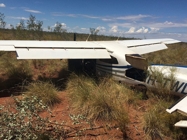
At about 1925 CDT[1] on 23 December 2014, GWA train 2AD1 derailed near Hugh River, Northern Territory. The derailment resulted from an axle bearing failure on wagon PTMY 6-T. The wagon, carrying distillate fuel, remained upright and there was some minor damage to the track (sleepers and rail clips). There were no injuries.
What the ATSB found
The ATSB found that the journal and bearing on wagon PTMY 6-T had seized and lost interference fit – generating high levels of frictional heating between the bearing and axle journal, and the subsequent torsional shearing failure of the axle (a ‘screwed journal’). The axle failure immediately caused the leading axle of the trailing bogie to derail.
On the balance of the available evidence, the ATSB concluded that a loss of lubrication or an internal bearing cage failure was the most likely contributor to the bearing breakdown and seizure. Evidence also suggested the breakdown developed relatively rapidly, given the absence of a positive fault detection from two bearing acoustic monitoring systems (RailBAM®) passed on the day of the occurrence.
Safety message
Bearing failures leading to derailment continue to occur within the Australian rail network. Rail operators must continue to be vigilant and ensure axle bearings, and in particular axle box type bearings, are correctly installed, maintained and monitored throughout their life.
At about 0123[2] on 23 December 2014, Genesee & Wyoming Australia Pty Ltd (GWA) train 2AD1 passed through a RailBAM®[3] sensor unit at Nectar Brook, SA without incident. Later that day 2AD1 passed through another RailBAM® site at Northgate, SA which, once again, did not record any adverse detections within the train consist.
Approximately 690 km past Northgate, the driver of 2AD1 noticed a reduction of brake pipe pressure and a subsequent automatic application of the train brakes. The crew then noticed a large amount of dust towards the rear of the train. Train 2AD1 was brought to a stand and the crew carried out an inspection of the train consist.
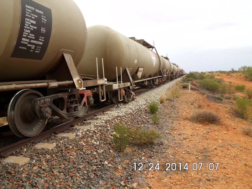
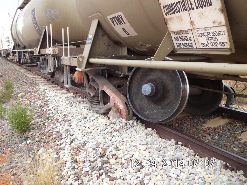
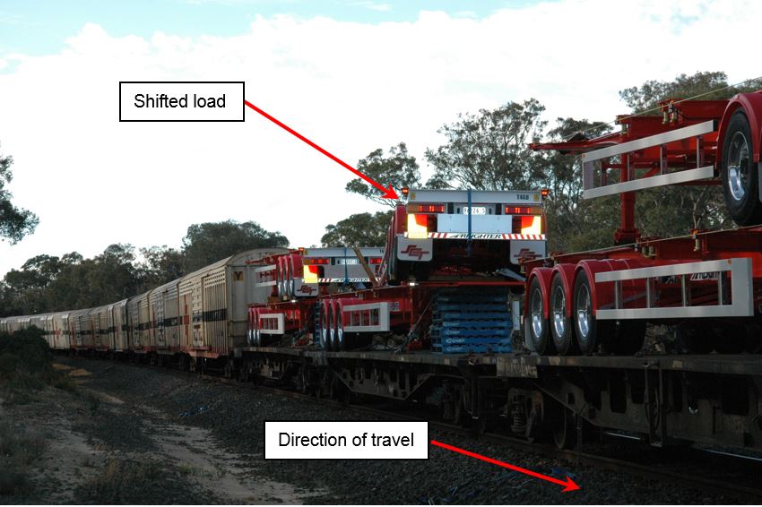
The crew found that wagon PTMY 6-T (distillate tank wagon) had derailed, with the leading axle of the trailing bogie completely separated from the right hand side axle box in a manner commonly known as a screwed journal (Figure 1). The bogie had collapsed and some minor damage had occurred to the body of the wagon. The derailment caused about 1,800 m of track damage – mostly cracked concrete sleepers and damage to rail fastenings. There was no spillage of distillate from the wagon.
Figure 1: Wagon PTMY 6-T derailed at 1201km
Source: Genesee Wyoming Australia Pty Ltd
The train crew contacted the GWA Network Controller around 1935 and advised them of the incident.
The following day, track and maintenance crews attended the derailment site. The distillate was decanted from PTMY 6-T and the wagon removed from track. At around 1245 on 24 December 2014, train 2AD1 continued towards Alice Springs, arriving at 1640.
Train 2AD1 was an intermodal freight service operated by Genesee & Wyoming Australia (GWA) between Adelaide and Darwin. On departure from Spencer Junction, Port Augusta SA, the train consisted of locomotives GWU 2 (leading) and ALF 18 (trailing) hauling 42 wagons for a total length of 1,496 m and gross mass of 3,684 t.
The 12th wagon in the consist was PTMY 6-T, a bogie tank wagon used to transport distillate fuels. The PTMY class wagons are rated at 26 t (tare), 76 t (gross) and operate at a maximum speed of 115 km/h. The wagons ride on three piece “Super ride control” bogies. Sabadin Petroleum (a subsidiary of Caltex Australia) owned the tank wagons, with maintenance contracted to Downer Rail.
At the time of the derailment PTMY 6-T weighed 73.4 t and the train was travelling at approximately 90 km/h.
Bearing examination
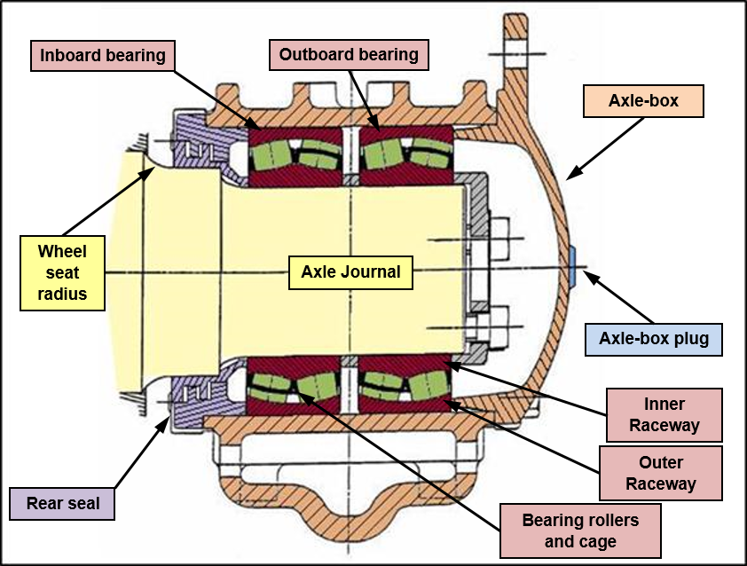
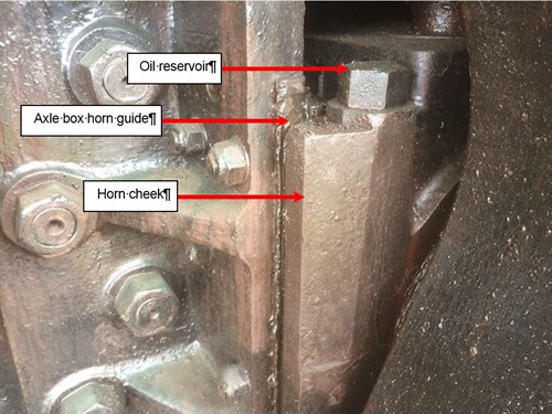
The bearings on wagon PTMY 6-T were of an axle box type, each axle box housing two spherical rolling element bearings (Figure 2).
Figure 2: Axle Box Bearing components
Schematic illustrating the components of an axle box bearing. Source: AS/RISSB 7516 Railway Rolling Stock - Axle Bearings coloured and annotated by ATSB
It was evident that a bearing on the wagon had failed and completely seized, causing the inner raceway to loose interference fit and spin on the axle journal. This generated and transferred sufficient heat into to the journal to reduce its strength, make it ‘plastic’ and cause it to torsionally separate from the axle (an event commonly referred to as a screwed journal).
Post-derailment observations found that the axle box lubrication plug was missing. Neither the plug, rear seal nor the stub end of the journal were found.
Bearing examination
GWA forwarded the recovered axle box components to Bureau Veritas for metallurgical examination.
The inboard bearing was manufactured by SKF (Sweden) and showed evidence of significant heat damage. The inboard bearing cage was manufactured from a bronze alloy and appeared to have been completely melted. There was no evidence of brinelling (impact), or spalling (flaking) damage to the rolling surfaces. The outboard bearing was manufactured by Koyo (Japan) and also showed evidence of significant heat damage. The steel cage was heavily deformed. There was no evidence of brinelling or spalling damage to the rolling surfaces of either bearing.
The investigation also examined the partner bearing from the opposite end of the axle. This bearing was found in good order, however the inboard bearing unit had significantly less grease present, when compared to the outboard unit.
Bearing failure
The failure process resulted in complete destruction of the bearing and much of the evidence that may have identified the cause of the failure. Consequently, the investigation looked at the common failure modes for railway bearings to identify the most probable cause.
The main contributors to rolling-stock axle bearing failure are:
Rolling surface damage
Rolling surface damage (spalling) is a contact-fatigue mechanism and can result from lubrication supply or effectiveness issues, contaminants carried in the lubricant, or indentations due to impact loading. Spalling is where the bearing surfaces or rollers begin to break up, or flake. The material that has broken away then moves around inside the bearing, causing further damage to the rolling surfaces.
Component failure
A common cause of bearing failure is failure of the cage. The cage maintains the roller bearings in the correct spacing and alignment. If the cage loses its ability to correctly align and guide the rollers, the resultant forces can lead to rapid deterioration and break-up of the cage. Under these conditions, broken cage material may become jammed in the rolling surfaces, with bearing seizure the likely result.
Lack of (or faulty) lubrication
The purpose of a lubricant is to reduce friction by separating the rolling surfaces at the points of high-pressure contact. Contamination of the lubricant by foreign materials such as metal flakes, filings and dirt reduces the effectiveness of the lubricant, and often causes accelerated wear of the components. A lack (or loss) of lubricant, through failed seals or poor maintenance, can result in elevated levels of frictional heating at the contact surfaces – leading to the eventual overheating of the bearing. This can cause components within the bearing to fail, such as the roller bearing cage.
The metallurgical examination found no evidence of rolling surface damage and concluded that the most likely contributor to the bearing failure was a lubrication supply issue. This may have been due to either seal failure or loss of the axle plug. While post-incident observation noted that the axle plug was missing, it could not be determined if the plug had dislodged prior the bearing failure, or because the bearing housing had dragged along the ballast after the journal separated from the axle. The axle box seal was not recovered so could not be examined to determine its condition and the possibility that it may have failed prior to the derailment. Failure of the bronze cage may have also contributed to the failure of the bearing, however the cage had completely melted away so this mode of failure could not be confirmed.
Maintenance
The Australian Rail Industry Safety and Standards Board (RISSB) is responsible for the development and management of rail industry standards, rules, codes of practice and guidelines, all of which have national application. Australian Standard AS7516 Railway Rolling Stock - Axle Bearings – Part 2: Freight Rolling Stock covers the maintenance of the various types of bearings used in the Australian railway industry, including axle box type bearings.
Section 4.1 of AS7516-2 requires operators to have in place a system for determining when re-lubrication of axle bearings is required. To assist maintenance personnel in identifying bearings requiring re-lubrication, Section 4.3 requires operators to paint the axle box covers in accordance with a nationally-recognised colour coding.
GWA maintenance instructions[4] require wagons with axle box bearings to have the bearings regreased every 2 calendar years, with a period of grace extending up to April 1 the following year. Maintenance of GWA’s rolling stock running gear[5] had been contracted to Downer Rail until June 2014, and has since been conducted in-house by GWA directly.
Records show the axle bearings on wagon PTMY 6-T received scheduled programmed maintenance on 13 December 2012. The axle box bearings were examined, lubricated, and the axle box plug seals replaced. In accordance with AS7516.2 Section 4.3, the axle box covers were painted orange, indicating the next service was due in 2014.
Wagon PMTY 6-T had travelled just over 100,000 km since servicing and had not exceeded the maintenance timeframes permitted in the instructions. The evidence suggests that the bearings on wagon PTMY 6-T had been adequately maintained in accordance with AS7516.2 and GWA instructions.
Preventative monitoring
The RailBAM® system is a predictive bearing condition monitoring system used throughout Australia. The system listens for unique acoustic signatures known to be associated with specific defect conditions in bearings, such as rolling surface faults and looseness / fretting faults.
Rather than identifying imminent failure of a component, RailBAM® facilitates the potential identification of defects as they develop. This is achieved through analysis of acoustic signature data and the identification of data trends from multiple passes. Rail vehicle operators may use this information for ongoing monitoring and/or scheduling for servicing and repairs.
RailBAM has proved reliable at detecting the acoustic signatures of developing surface faults such as spalling damage. However, it has proved more difficult to detect an acoustic signature that would suggest loss of lubrication.[6]
Train 2AD1 travelled past two RailBAM® sensor sites on 23 December; one at Nectar Brook and the second at Northgate. Neither RailBAM® site detected any potential faults with the bearings on wagon PTMY 6-T. Similarly, there was no historical evidence for wagon PTMY 6-T to suggest a developing trend towards a potential bearing failure.
The absence of indicative acoustic signatures on the day of the bearing failure suggests that the bearing condition on wagon PTMY 6-T deteriorated relatively quickly, resulting in catastrophic failure of the bearing with minimal (if any) warning signs.
Previous occurrences
In September 2008, a freight train derailed at Mt Christie, SA. The investigation found a bearing on wagon VQCY 0824U had failed, causing a loss of interference fit and a subsequent screwed journal. The damage to the railway infrastructure resulted in 13 wagons derailing.
Examination of the bearings suggested that inadequate lubrication had contributed to cage failure with the subsequent misalignment of the rollers and jamming of broken cage material in the rolling surfaces causing the bearing to seize[7].
In October 2010, 15 wagons on freight train 3PW4 derailed near Wodonga, Victoria. There were no injuries, however serious damage to rolling-stock and rail track (including a bridge structure) was sustained during the derailment.
The investigation concluded that an axle bearing on wagon RKWY-4125C had failed and completely seized, causing the inner rings to spin on the axle journal, generating and transmitting sufficient heat into to the journal to make it 'plastic' and causing it to separate from the axle[8].
In each case, there were limited pre-cursor warning signs of imminent bearing failure.
From the evidence available, the following findings are made with respect to the derailment of train 2AD1 near Hugh River on 23 December 2014. These findings should not be read as apportioning blame or liability to any particular organisation or individual.
Safety issues, or system problems, are highlighted in bold to emphasise their importance. A safety issue is an event or condition that increases safety risk and (a) can reasonably be regarded as having the potential to adversely affect the safety of future operations, and (b) is a characteristic of an organisation or a system, rather than a characteristic of a specific individual, or characteristic of an operating environment at a specific point in time.
Contributing factors
An axle bearing on PTMY 6-T failed and completely seized, causing the bearing journal to separate from the axle.
The most likely cause of bearing failure was a lack of lubrication and/or a short-term breakdown and failure of the bearing cage.
The bearing condition probably deteriorated relatively quickly, resulting in catastrophic failure of the bearing with minimal (if any) warning signs.
Other findings
The axle bearings on PTMY 6-T had been maintained in accordance with GWA and rail industry standards.
Additional safety action
Whether or not the ATSB identifies safety issues in the course of an investigation, relevant organisations may proactively initiate safety action in order to reduce their safety risk. The ATSB has been advised of the following proactive safety action in response to this occurrence.
Genesee Wyoming Australia
GWA have investigated and implemented the following actions:
A grease nipple will be added to all axle boxes. This would ensure both the inner and outer bearings receive a more even distribution of grease when axle boxes are regreased during scheduled servicing.
Bearings incorporating bronze cages will be progressively withdrawn from service and replaced with new steel-cage bearings.
The GWA Work Instructions associated with bearing overhaul and preventative maintenance/ inspection have been reviewed and updated to reflect the process changes.
The updated Work Instructions have been disseminated to all affected GWA rolling stock maintenance staff, and contracted bearing suppliers and maintainers.
Sources and submissions
Sources of information
The sources of information during the investigation included:
Genesee & Wyoming Australia (GWA)
The Australian Rail Track Corporation (ARTC)
Downer Rail
References
ATSB Transport Safety Report, Rail Occurrence Investigation RO-2008-010
ATSB Transport Safety Report, Rail Occurrence Investigation RO-2010-011
SKF, Product Information 401, Bearing failures and their causes 1994
Bureau Veritas, Bearing Report Rev 3, 1 April 2015
Submissions
Under Part 4, Division 2 (Investigation Reports), Section 26 of the Transport Safety Investigation Act 2003 (the Act), the Australian Transport Safety Bureau (ATSB) may provide a draft report, on a confidential basis, to any person whom the ATSB considers appropriate. Section 26 (1) (a) of the Act allows a person receiving a draft report to make submissions to the ATSB about the draft report.
A draft of this report was provided to Genesee Wyoming Australia, the drivers of train 2AD1 and the Office of the National Rail Safety Regulator.
Submissions were received from Genesee Wyoming Australia and the Office of the National Rail Safety Regulator. The submissions were reviewed and where considered appropriate, the text of the report was amended accordingly.
Purpose of safety investigations
The objective of a safety investigation is to enhance transport safety. This is done through:
identifying safety issues and facilitating safety action to address those issues
providing information about occurrences and their associated safety factors to facilitate learning within the transport industry.
It is not a function of the ATSB to apportion blame or provide a means for determining liability. At the same time, an investigation report must include factual material of sufficient weight to support the analysis and findings. At all times the ATSB endeavours to balance the use of material that could imply adverse comment with the need to properly explain what happened, and why, in a fair and unbiased manner. The ATSB does not investigate for the purpose of taking administrative, regulatory or criminal action.
Terminology
An explanation of terminology used in ATSB investigation reports is available here. This includes terms such as occurrence, contributing factor, other factor that increased risk, and safety issue.
Publishing information
Released in accordance with section 25 of the Transport Safety Investigation Act 2003
Ownership of intellectual property rights in this publication
Unless otherwise noted, copyright (and any other intellectual property rights, if any) in this report publication is owned by the Commonwealth of Australia.
Creative Commons licence
With the exception of the Coat of Arms, ATSB logo, and photos and graphics in which a third party holds copyright, this publication is licensed under a Creative Commons Attribution 3.0 Australia licence.
Creative Commons Attribution 3.0 Australia Licence is a standard form licence agreement that allows you to copy, distribute, transmit and adapt this publication provided that you attribute the work.
The ATSB’s preference is that you attribute this publication (and any material sourced from it) using the following wording: Source: Australian Transport Safety Bureau
Copyright in material obtained from other agencies, private individuals or organisations, belongs to those agencies, individuals or organisations. Where you wish to use their material, you will need to contact them directly.
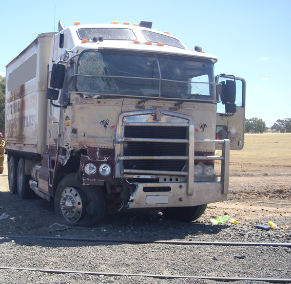
On 19 December 2014, a truck collided with the Swan Hill-to-Melbourne passenger train at a level crossing on Rileys Road, Woodvale, near Bendigo in central Victoria. Both occupants of the truck and one train passenger were conveyed to hospital with minor injuries. The truck sustained significant damage to its front, right-hand corner and there was significant side panel and underfloor damage to several passenger cars.
What the ATSB found
The ATSB found that the truck driver did not approach the level crossing with sufficient caution to be able to stop once he became aware of the approaching train. A road-user’s view of an approaching train was partially obscured due to lineside vegetation.
What's been done as a result
V/Line Pty Ltd has:
Advised that it has implemented vegetation control activities to maintain level crossing sight-lines.
Initiated a discussion with the City of Greater Bendigo around a reduction of road speeds to 60 km/h on the approach to railway level crossings. This has resulted in the commencement of a trial program on gravel and sealed roads.
Requestedthrough the Victorian Level Crossing Committeethat the Rileys Road level crossing be upgraded to active protection. This is scheduled for 2016/17, but may be delayed to 2017/18.
Safety message
This incident highlights the responsibility that rests upon road vehicle drivers to remain aware when approaching railway level crossings, especially those with passive protection. Road users who frequently use a level crossing that sees limited rail traffic should be alert to the potential of developing a sense of expectancy that trains will not be present. Drivers of heavy vehicles have a special responsibility to ensure they remain aware of the dangers of railway level crossings.
To ensure that road users can make a determination regarding crossing the track safely it is important that the track manager ensures that any lineside vegetation that might reduce the road-user’s distant view of the track approaches be kept to an effective minimum.
The occurrence
At about 1445 on 19 December 2014, a truck was travelling east along Rileys Road in central Victoriahaving just exited the Loddon Valley Highwayand was approaching a railway level crossing. The truck driver was accompanied by a family member.
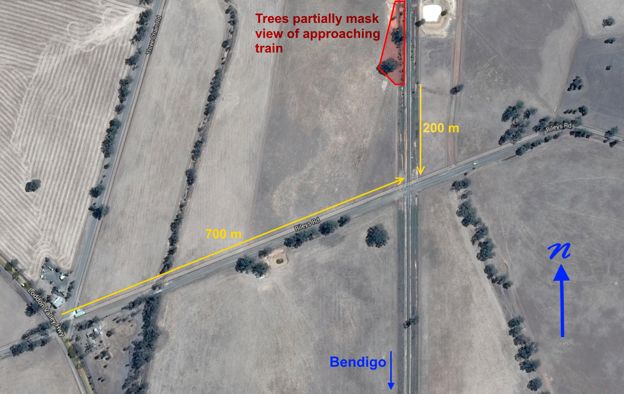
The eastward road approach to the level crossing was across open farmland with good visibility of the railway in the right-hand direction. The view of a train approaching from the left (the Swan Hill direction), however, was partially obscureduntil the train was about 200 m from the crossingby trees growing within the rail reserve.
Train No 8042, had departed Swan Hill at 1250 and at 1445 was approaching the Rileys Road level crossing at the track speed of 100 km/h with the locomotive driver having observed the truck approaching from the right. The locomotive event recorder indicated that the driver sounded the locomotive warning horn at about 400 m from the level crossing, in a manner consistent with normal operating requirements, and then again for approximately 5 seconds commencing when the train was about 200 m from the crossing.
Around this time the truck driver commenced to brake heavily. The truck then continued, leaving a predominantly single-tyre skid mark along the gravel surface for about 85 m.
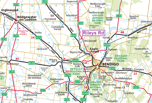
Figure 1: Location of incident
Source: Copyright, Google Maps. Annotated by Chief Investigator Transport Safety
Figure 2: The truck immediately after the collision
Source: VicPol
The truck was turned to the leftas the train occupied the crossingand collided with the adjacent level crossing signage and the train.
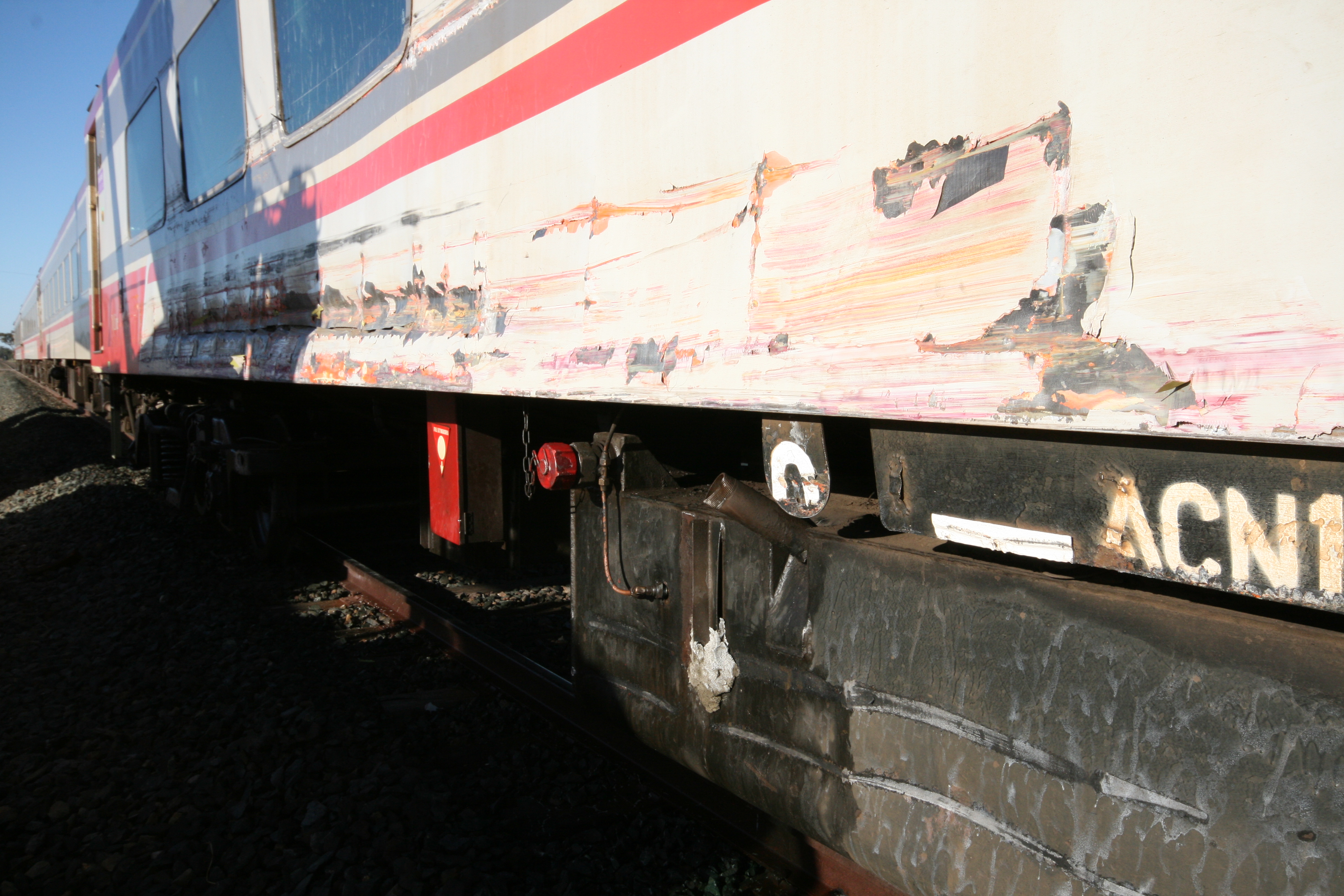
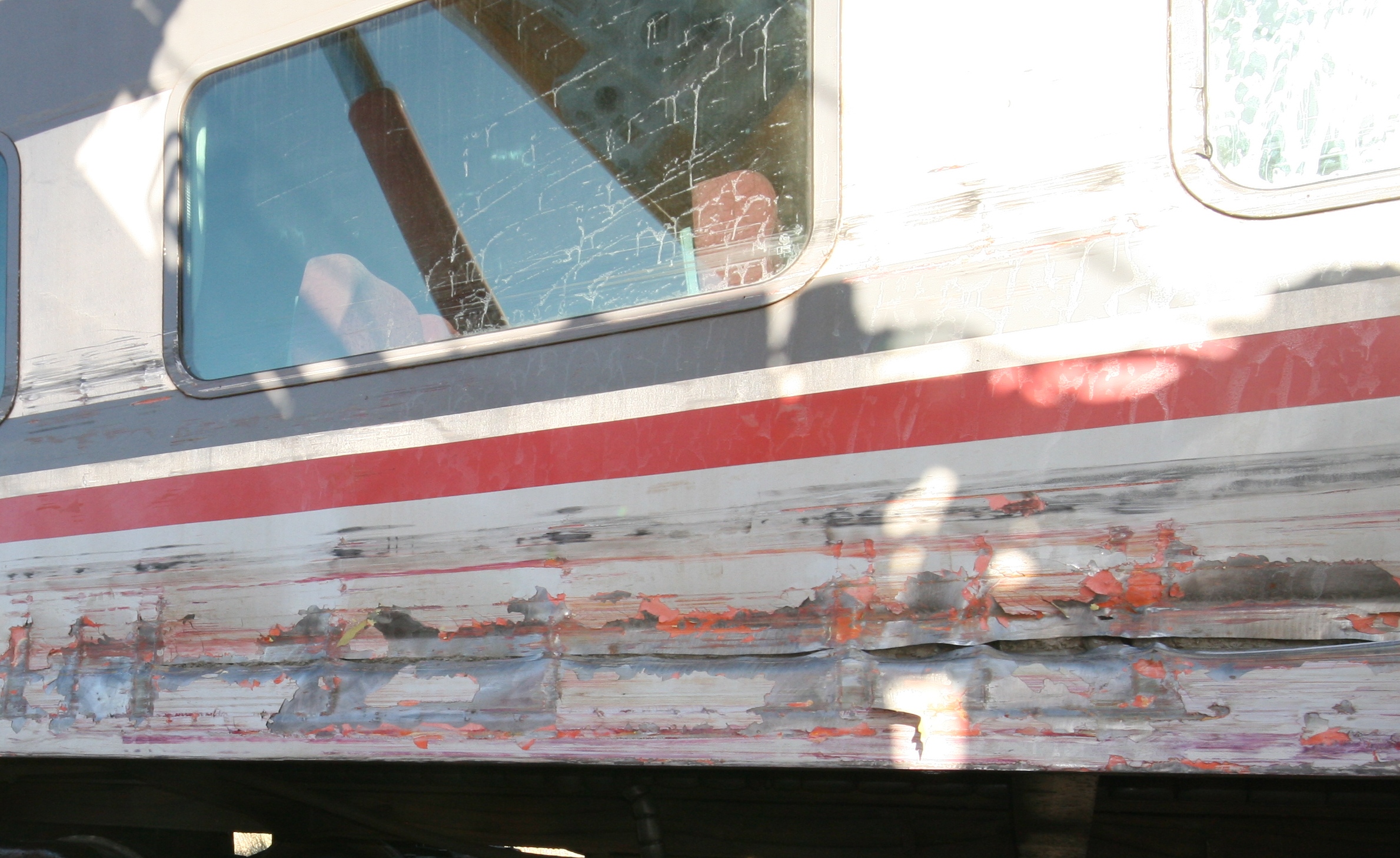
This last-second avoidance manoeuvre by the truck driver presented the front right-hand corner of the truck’s cab to the train. As the train passed in front of it, this corner of the cab and the roo-bar struck the side of the first passenger car. This impact caused the derailment of that car’s trailing bogie, inflicted deep impact scars to its side panels (Figure 3) and tore through its exterior skin over approximately a two-metre length (Figure 4).
The impact also breached the underslung diesel generator fuel tankprecipitating an outflow of fueland destroyed some bogie-mounted brake equipment. The train consist then continued to scrape along the right-hand corner of the truck’s cab causing abrasion damage to the side panelling of most of the cars. The locomotive was not impacted. Track damage caused by the derailed passenger car required V/Line to replace approximately 200 sleepers.
The service was terminated the passengers being conveyed by road coach for the remainder of their journey. One train passenger was hospitalised for observation and released the same day, and the truck driver and his passenger sustained minor injuries.
Figure 3: Damage sustained by the first car at the initial impact point
Source: Chief Investigator Transport Safety
Figure 4: Detail of intrusion into passenger car side panel – first car
Source: Chief Investigator Transport Safety
Context
Truck
The truck was a 4.5-tonne 1999-model Kenworth K-104 configured with a rigid, high-sided alloy tipping body used in the transportation of firewood. At the time of the incident it was travelling empty. The truck retained the branding of its previous owner.
The driverwho was correctly licencedowned and operated the vehicle and was familiar with this crossing. The Preliminary Breath Test of the driver conducted at the scene by police returned a ‘Negative’ result.
Train
The train consisted of locomotive N457 and four passenger cars. It was 110 m in length, had a mass of approximately 304 tonnes, and was travelling at the authorised track speed. In addition to the locomotive driver, there were 74 passengers plus two on-board crew members and a services manager travelling as a supernumerary.
The locomotive was being operated within the limits of V/Line requirements, and the locomotive driver possessed the requisite health and route competency credentials. The driver did not realise, until his train had passed completely over the crossing, that it had been struck. When he became awarefrom his rear-vision mirrorof a dust cloud rising from his train he made an Emergency air brake application and the train came to a stand 1100 m beyond the Rileys Road level crossing, and with its trailing end approximately 60 m past the next level crossing (Quinns Road).
Level crossing
Description
Rileys Road was a gravel-surfaced country road that intersected the railway at an angle of approximately 112 degrees to the left in the east-bound direction. This level crossing was approximately 700 m from the highway intersection. The crossing, which was protected by Give-Way signs, was situated on the V/Line Broad-Gauge network between Bendigo and Kerang, approximately 178 rail kilometres from Melbourne and 16 km from Bendigo Railway Station. The crossing is within the rail reserve leased by VicTrack to V/Line as part of intrastate rail network arrangements under which V/Line is responsible for maintenance of the reserve generally as well as for level crossings and for signage at crossings. Advance road warning signage is the responsibility of the applicable road authority, the City of Greater Bendigo. Rileys Roadwhich is approximately 2.1 km long and connects the Loddon Valley Highway with the Bendigo-Pyramid Roaddid not have sign-posted speed limits and therefore carried the same 100 km/h speed limit applicable to the two major roads with which it intersects.
Signage
Control signage installed at the crossing was in good condition and included the Give-Way (RX-1) and width marker (RX-9) assemblies as stipulated in AS 1742.7 Manual of uniform traffic control devices, Part 7: Railway crossings.
Advance warning signage was in place on both road approaches. This signage consisted of the Railway crossing ahead – Passive control sign W7-7 at 225 m from the level crossing, and the Railway crossing diagrammatic warning assembly RX-3-1 at 174.5 m. These distances vary slightlyalthough inconsequentiallyfrom those specified in the Australian Standard.
Lineside vegetation
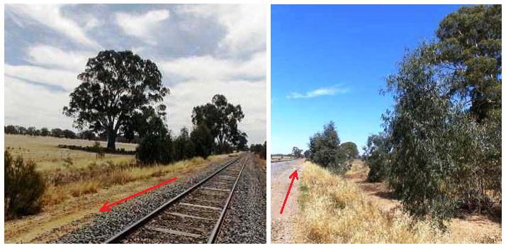
Several mature trees were growing near the railway fence line in the adjacent paddock to the north of Rileys Road, and a number of juvenile self-sown trees nearby were growing sporadically along a drainage ditch within the railway reserve. For the driver of a vehicle approaching the level crossing from the direction of the Loddon Valley Highway, this growth partially obscured from view a train approaching from the north until the train was about 200 m from the crossing.
Arboricultural advice was sought in relation to the trees growing in the rail reserve (Figure 5). The River Red Gum trees (eucalyptus camaldulensis) were in a group of around 40-50, growing in an area approximately 300 m long and 30 m wide. The stand of trees displayed height (1-9 m)[1] and ‘breast-height’[2] trunk diameter characteristics consistent with ages of between 1 and 8 years. Situated along a drainage line subject to areas of seasonal standing water, the trees were judged to be in good condition and displaying vigorous growth. Expected growth rates of juvenile-to-young (1-15 years) River Red Gum growing in an ideal situation with good conditions is 1 to 1.5 m per year, and in most conditions the annual juvenile height growth rate will slow as the tree matures. If left standing, the trees in their current position can be expected to thrive and add good annual diameter and height.
Figure 5: Lineside tree growth. Arrows show direction of train
Source: Chief Investigator, Transport Safety (Vic)
There was also a clump of flowering acacia (a plant that grows to between 2 and 3 m in height over about 15 years) on the opposite side of the track and now at fence height. This vegetation is a potential future obstruction against a view of the track for vehicles approaching the crossing from the opposite direction (that is to say, from Bendigo-Pyramid Road towards the Loddon Valley Highway).
Source: Image courtesy of Google Earth, annotated by Chief Investigator Transport Safety
Level crossing management of sighting
Australian Level Crossing Assessment Model (ALCAM) survey
ALCAM is the national model for assessing the vehicle safety risk at level crossings. Part of the assessment involves evaluating the required and actual sighting distances for road vehicles approaching the level crossing, with Australian Standard 1742.7 being used as the basis for this assessment. In Victoria, ALCAM crossing assessment and data collection is managed by VicTrack on behalf of Public Transport Victoria. As of the time of the incident, field assessments were being performed on a five-yearly basis. The most recent ALCAM assessment of the Rileys Road level crossing was conducted in October 2010.
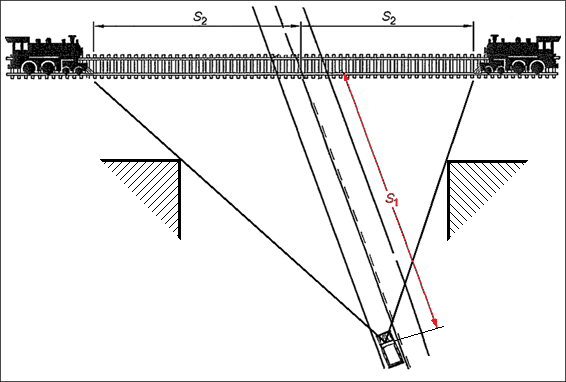
Values for S1 and S2 (Figure 7) were evaluated as part of this ALCAM assessment. S1 is defined as the minimum distance of an approaching road vehicle from the nearest rail at which the driver of that road vehicle must be able to see an approaching train in time to stop if necessary before reaching the crossing. S2 is defined as the minimum distance of a train from the crossing at which a road vehicle driver at distance S1 from the crossing can proceed and safely clear the crossing ahead of the train.
Source: AS1742.7 Manual of uniform traffic control devices, Part 7: Railway crossings.Adapted by Chief Investigator, Transport Safety
To evaluate sighting distances at the Rileys Road level crossing, the ALCAM assessment assumed a road vehicle approach speed[3] of 70 km/h. For a train approaching from the North (from the vehicle driver’s left – the train direction in this instance), the assessment provided a required S2 value (left-hand side) of 240 m. A field survey measurement taken in 2010 indicated that the vehicle driver’s view in this quadrant was unobstructed and this S2 value satisfied.
Considering a normal growth rate of 1 to 1½ m per year the taller of the self-seeded trees within the rail reserve would have been around 3 to 5 m (and therefore projecting from 1½ to 3 m above rail level) when the last ALCAM survey was conducted in October 2010. The trees would most likely, therefore, not have presented as a sighting obstruction at that time.
Other sighting inspections
V/Line procedure NIPR-2714 Inspection and Assessment of Level Crossings provides guidance for the inspection and assessment of sight lines at level crossings. The procedure concerns the management and maintenancewhere practicableof sight distances in accordance with AS 1742.7 – 2007. The procedure also specifies the recording of obstructions that might restrict the road vehicle driver’s view to the required sight distances.
Similar occurrence
This incident is similar to another[4] involving a heavy vehicle being driven up to a railway level crossing, where the driver observed the approaching passenger train too late to avoid a collision. In this latter incident, the manner of the impact was similar except that the truck intruded completely into the side of several passenger carriages with resultant multiple fatalities.
A number of potential truck speed and braking scenarios were considered based on the available evidence. It was estimated that the speed of the truck when braking commenced was probably around 80 km/h, assuming a deceleration distance of 85 m, a typical truck deceleration rate[5], and a truck speed at the point-of-impact of 10 km/h. Other scenarios were also considered assuming a higher rate of deceleration and a truck speed at impact of 20 km/h. These resulted in estimations of initial truck speed in the 80-90 km/h range, this being within the speed limit for the road.
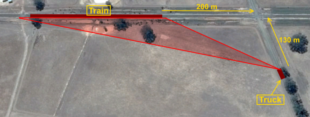
The reaction time for a vehicle driver upon perception of a threat is highly variable[6] and the reaction time in this instance was probably between one and three seconds. For the purpose of estimating the position of the locomotive when the train first became apparent to the truck driver, the elapsed time from the train being perceived and the truck’s brake application taking effect was assumed to be two seconds. This equates to the truck being approximately 130 m from the crossing when the train was first perceived, and the train being between 180 and 210 m from the crossing, considering a range of realistic scenarios.
Driver behaviour
Give-Way level crossing control places upon the road vehicle driver the responsibility to determine the presence of approaching rail traffic and to judge whether it is safe to proceed or whether to stop. The truck driver did not approach the level crossing with sufficient caution to be able to stop once he became aware of the approaching train.
Expectancy and familiarity
A study[7] of drivers involved in accidents at passive level crossings discovered that a significant factor influencing road users to look for trains was their expectation of encountering one. An individual’s perception of the probability of a particular event occurring is strongly influenced by past experience. The perception of road users that a train is unlikely to be present is reinforced every time they traverse the crossing and do not encounter a train. The study concludes that the frequency with which motorists encounter trains at level crossings will influence their likelihood of stopping at those crossings.
Another factor found to influence the behaviour of road users at a level crossing is their level of familiarity with that crossing[8]. A study involving passive level crossings[9] determined that level crossing familiarity combined with the expectation that a train won’t be present has the potential to lull road users into complacency.
Being a local road used frequently by the truck driverbut on which he might have rarely encountered trains due to the relatively limited frequency of train movements on this line[10]he may have become desensitised to warning signage and developed poor scanning habits at this crossing.
Vehicle driver’s view of approaching train
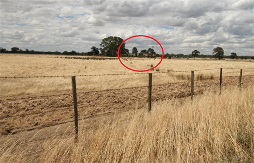
Drivers of vehicles approaching the Rileys Road level crossing from the direction of the Loddon Valley Highway had a clear northerly view across an adjacent paddock toward the railway line, however the conspicuity of rail traffic approaching from that direction was diminished due to it being partially obscured by the merging of lineside foliage as viewed at an angle from the road (Figures 8 and 9).
Figure 8: Vehicle driver’s field of view, through foliage, of the approaching train
Source: Google Earth, annotated by Chief Investigator, Transport Safety (Vic)
Figure 9: View of approaching train from the road 100 m back from the level crossing. Train is approximately 200 m from the crossing
Source: Chief Investigator, Transport Safety (Victoria)
Management of lineside foliage
V/Line has a range of inspection regimes specific to rail corridors and level crossings to ensure that the corridor and the assets within them, such as track and level crossings, are ‘safe and suitable for operations’. Sighting distances for passive level crossings are evaluated as part of an annual assessment undertaken at each level crossing. These inspections, though, concentrate on readily-visible elements of infrastructure, and the issue of the management of vegetation growing within the rail reserve is not explicitly discussed in the context of the risk it might pose to a road user obtaining a clear view of approaching trains.
A Level Crossing Sighting Distance Inspection pro-forma is used to record details and report the current state of the crossing with respect to ALCAM sighting parameters. The Sighting Distance Inspection reports for 2012 and 2014 both noted that the S2 sighting distance met requirements and both reports noted the presence of foliage. In neither case were these comments expanded-upon, nor any specific remedial suggestions provided. In neither case also, was there an identified requirement to clear foliage from within sight lines.
The ATSB inspection at the date of this incident identified that sight lines in the relevant direction were 40 m less than the required 240 as specified in the ALCAM assessment and used by V/Line. In October 2010, thoughwhen the most recent ALCAM survey of the Rileys Road level crossing was completedthe string of River Red Gum trees along the lineside ditch would not have been as high and would probably not have presented as a sighting obstruction.
From the evidence available, the following findings are made with respect to the level crossing collision that occurred on Rileys Road, Woodvale, 16 km north of Bendigo, Victoria, on 19 December 2014. These findings should not be read as apportioning blame or liability to any particular organisation or individual.
Safety issues, or system problems, are highlighted in bold to emphasise their importance. A safety issue is an event or condition that increases safety risk and (a) can reasonably be regarded as having the potential to adversely affect the safety of future operations, and (b) is a characteristic of an organisation or a system, rather than a characteristic of a specific individual, or characteristic of an operating environment at a specific point in time.
Contributing factors
The truck driver did not approach the level crossing with sufficient caution to be able to stop once he became aware of the approaching train.
Other factors that increased risk
A line of self-sown trees of varying heights were growing within the railway reserve. When viewed at an angle from the road this growth partially concealed the presence of an approaching train.
V/Line’s process for the inspection of level crossing sighting did not provide explicit instructions for the identification and removal of problem vegetation. [Safety issue]
Safety issues and actions
Depending on the level of risk of the safety issue, the extent of corrective action taken by the relevant organisation, or the desirability of directing a broad safety message to the rail industry, the ATSB may issue safety recommendations or safety advisory notices as part of the final report.
The safety issues identified during this investigation are listed in the Findings and Safety issues and actions sections of this report. The Australian Transport Safety Bureau (ATSB) expects that all safety issues identified by the investigation should be addressed by the relevant organisation(s). In addressing those issues, the ATSB prefers to encourage relevant organisation(s) to proactively initiate safety action, rather than to issue formal safety recommendations or safety advisory notices.
Management of lineside foliage
V/Line’s process for the inspection of level crossing sighting did not provide explicit instructions for the identification and removal of problem vegetation.
Initiated a discussion with the City of Greater Bendigo on the subject of a reduction to 60 km/h of road speed on the approach to railway level crossings. This has resulted in the commencement of a trial program on both gravel and sealed roads.
Requestedthrough the Victorian Level Crossing Committeethat the Rileys Road level crossing be upgraded to active protection. This is scheduled for 2016/17, but may be delayed to 2017/18.
Cleared trees and vegetation from the rail reserve.
Sources and submissions
Sources of information
The sources of information during the investigation included:
V/Line Pty Ltd
Victoria Police
References
Olson P L., Driver Perception Response Time, University of Michigan Transport Research Institute.
National Transportation Safety Board, Safety Study NTSB/SS-98/02, Safety at passive grade crossing; Volume1: Analysis.
Yeh M. and Multzer J. (2008), Driver Behaviour at Highway-Railroad Grade Crossings: A Literature Review from 1990-2006. Human Factors in Railroad Operations. United States Department of Transportation, Federal Railroad Administration.
Caird J.K., Creaser J.I., Edwards C.J., and Dewar R.E. (2002), Highway-Railway grade crossing research; A human factors analysis of highway-railway grade crossing accidents in Canada; TP 13938E.
V/Line procedure; NIPR-2606 Management of Inspection Outcomes (17/10/13, Rev 7).
V/Line procedure; NIPR-2714 Inspection and Assessment of Level Crossings (09/11/2010, v4).
Chief Investigator, Transport and Marine Safety Investigations, Rail Safety Investigation Report № 2007/09: Level Crossing Collision V/Line Passenger Train 8042 and a Truck near Kerang, Victoria, 5 June 2007.
Submissions
Under Part 4, Division 2 (Investigation Reports), Section 26 of the Transport Safety Investigation Act 2003 (the Act), the Australian Transport Safety Bureau (ATSB) may provide a draft report, on a confidential basis, to any person whom the ATSB considers appropriate. Section 26 (1) (a) of the Act allows a person receiving a draft report to make submissions to the ATSB about the draft report.
A draft of this report was provided to V/Line Pty Ltd, Victoria Police, and the truck driver. Any submissions from these parties will be reviewed and where considered appropriate, the text of the draft report will be amended accordingly.
Purpose of safety investigations
The objective of a safety investigation is to enhance transport safety. This is done through:
identifying safety issues and facilitating safety action to address those issues
providing information about occurrences and their associated safety factors to facilitate learning within the transport industry.
It is not a function of the ATSB to apportion blame or provide a means for determining liability. At the same time, an investigation report must include factual material of sufficient weight to support the analysis and findings. At all times the ATSB endeavours to balance the use of material that could imply adverse comment with the need to properly explain what happened, and why, in a fair and unbiased manner. The ATSB does not investigate for the purpose of taking administrative, regulatory or criminal action.
Terminology
An explanation of terminology used in ATSB investigation reports is available here. This includes terms such as occurrence, contributing factor, other factor that increased risk, and safety issue.
Publishing information
Released in accordance with section 25 of the Transport Safety Investigation Act 2003
Ownership of intellectual property rights in this publication
Unless otherwise noted, copyright (and any other intellectual property rights, if any) in this report publication is owned by the Commonwealth of Australia.
Creative Commons licence
With the exception of the Coat of Arms, ATSB logo, and photos and graphics in which a third party holds copyright, this publication is licensed under a Creative Commons Attribution 3.0 Australia licence.
Creative Commons Attribution 3.0 Australia Licence is a standard form licence agreement that allows you to copy, distribute, transmit and adapt this publication provided that you attribute the work.
The ATSB’s preference is that you attribute this publication (and any material sourced from it) using the following wording: Source: Australian Transport Safety Bureau
Copyright in material obtained from other agencies, private individuals or organisations, belongs to those agencies, individuals or organisations. Where you wish to use their material, you will need to contact them directly.
Section 21 (2) of the Transport Safety Investigation Act 2003 (TSI Act) empowers the Australian Transport Safety Bureau (ATSB) to discontinue an investigation into a transport safety matter at any time. Section 21 (3) of the TSI Act requires the ATSB to publish a statement setting out the reasons for discontinuing an investigation.
On 24 December 2011 an Agusta Westland AW139 helicopter departed Bankstown Airport to retrieve a seriously injured patient in the Budderoo National Park, about 16 km west-south-west of Wollongong Airport, New South Wales. During the retrieval, the patient and one of the paramedics hit rocks at the base of the waterfall. The paramedic died from the impact. The ATSB investigation (AO-2011-166) identified four safety issues, including the following:
The helicopter’s lighting set-up did not allow independent control of the searchlights by the pilot using the switches on the flight controls, as required by the operations manual and Civil Aviation Order [CAO] 29.11, and increased the risk of loss of hover reference and distraction in the case of a single light failure or switch miss-selection by a pilot.
The relevant section of the CAO 29.11 sub section 6.3 stated:
A helicopter shall not engage in winching and/or rappelling operations over the land at night unless it is equipped…
(b) as specified in Appendix V of section 20.18 with the addition of…
(ii) 2 white lights operable by the pilot and trainable in azimuth and elevation without removing his/her hands from the flying controls…
Note: A single white light having 2 separately energized filaments may be approved as meeting this requirement provided that the selection of the alternative light can be accomplished by the pilot without removing his/her hands from the flying controls.
In order to ascertain the extent of the lighting-related safety issue, on 1 May 2013 a safety issues investigation was commenced under the TSI Act. This included the development of a questionnaire that was sent to 10 helicopter operators who were capable of night winching operations. Those operators represented about two thirds of the night winch-capable operators throughout Australia with a combined total of 89 winch-capable helicopters of various types.
The answers to the survey from the 10 operators indicated that about 50 per cent fully complied with CAO 29.11. Of those who did not comply, most believed that they did comply due to their interpretation of the CAO. In all non-compliance situations the pilot had to move their hand from the collective in order to switch between light controls. From that point on the selected light could be controlled from the collective. All respondents believed that the lighting on their helicopters was adequate.
The Civil Aviation Safety Authority (CASA) was made aware of these findings. CASA advised that it realised it could be difficult to comply with the existing CAO 29.11 requirement and that it was proposing to modify the requirements of the CAO. This modification would require the helicopter to only be fitted with one light that could be operated by a pilot without removing their hands form the flying controls.[1]
The likelihood of a lighting failure leading to a substantial loss of hover reference during night winching operations, which are increasingly employing night vision devices, is very low. The ATSB also recognises that CAO 29.11 is being changed to make it easier to comply, and that forcing operators to comply with the existing requirement may introduce additional risks given the design difficulties involved.
Based on the feedback provided by night winch-capable helicopter operators and CASA, the ATSB assessed that the lighting issue did not appear to form a significant safety issue for ongoing helicopter night winching operations. On that basis, the ATSB has decided to discontinue its investigation.
[1] CASA had also previously proposed making this change in September 2000 and March 2003 as part of consultation documents for a new Part 133 of the Civil Aviation Safety Regulations for air transport and aerial work rotorcraft operations. The progress of Part 133 was subsequently changed to focus on air transport operations only and is still in progress.
On 18 December 2014, at about 0520 Eastern Daylight-saving Time, the pilot of an Air Tractor AT-502B aircraft, registered VH-PTF, commenced aerial agricultural spraying on a property about 45 km west of Moree, New South Wales.
The job consisted of spraying four fields and the two western-most fields were sprayed in a north-south direction. To avoid a property, the two remaining fields were sprayed in an east-west direction.
The pilot established a racetrack pattern at the southern end of the field and overflew a storage dam wall heading east. At that time, he observed the dam wall, and the sun was rising but obscured by cloud. The pilot then turned the aircraft towards the west and commenced the first spray run, again overflying the dam wall. After completing that spray run, the pilot turned the aircraft to the east again for the second spray run.
The sun was then above the cloud and directly in the pilot’s eyes obscuring his visibility ahead of the aircraft. As the pilot was about to commence a climb and turn at the end of the spray run, he extended the run to spray some weeds. The pilot then turned the spray off and commenced a climb. As the aircraft climbed to about 30 ft, the landing gear collided with the dam wall, about 60 cm below the top of the wall.
The pilot then dumped the chemical load and returned to the airstrip on the property about 4 km away. Both landing gear struts had been detached which had then broken off the right flap, damaged the left flap and ruptured both fuel tanks. During the landing the propeller was damaged. The pilot was not injured.
Following the incident, all company pilots will be reminded of the importance of identifying hazards as part of the pre-application checks.
On the evening of 4 December 2014, a Saab Aircraft Co. 340B aircraft, registered VH-ZRJ and operated by Regional Express, was on a scheduled passenger service from Sydney to Narrandera, New South Wales. After take-off from runway 34 Left the crew inadvertently did not retract the landing gear. The crew later identified this and instinctively retracted the gear whilst the aircraft was above the maximum landing gear retraction speed.
What the ATSB found
The ATSB found that at the time of the occurrence the first officer (FO) was experiencing a level of fatigue that affected performance. However, the FO’s ability to self-assess their level of fatigue was impeded by a lack of training and objective tools to determine their suitability to operate.
The ATSB also found that the FO did not recall hearing the captain’s ‘gear up’ call, which meant that the gear was inadvertently not retracted. The factors that influenced this omission and its non-detection included both crew focusing on departure procedures and the local weather, and the crew likely expecting that the landing gear was retracted as normal.
The crew detected the error when conducting the climb checklist. As this checklist was designed to confirm the configuration of the aircraft, the time that it was conducted coincided with a time when the aircraft’s speed was above the maximum gear retraction speed. Therefore, there was an increased risk that crew would react to the unexpected gear position before slowing the aircraft.
What's been done as a result
In March 2013, the Civil Aviation Safety Authority released new rules on fatigue management for flight crew. At the time of the occurrence, air operators that already held, or had applied for an air operator’s certificate after April 2013, had until April 2016 to transition to the new fatigue management rules. Consistent with this timeline, Regional Express was planning for their transition to meet those requirements at the time of the occurrence. In November 2015, this deadline was extended by the Civil Aviation Safety Authority to May 2017.
Safety message
This occurrence demonstrates some of the factors that increase the risk of making and not detecting errors of omission, particularly actions prompted by verbal cues. The use of a checklist helps identify errors, but they are most effective in this regard, if they are timed to be conducted before approaching aircraft limits.
Further, while this occurrence highlights the difficulties associated with assessing fatigue, operators and crew share responsibility for managing the risk of fatigue. Operators can reduce fatigue risk by providing crew with adequate rest opportunity, comprehensive training in fatigue management, and tools designed to support objective self-assessment of their alertness. Crew can then use the knowledge and tools to help identify when fatigue is present and may affect safety.
The occurrence
On the evening of 4 December 2014, a Saab Aircraft Co. 340B aircraft, registered VH-ZRJ (ZRJ) and operated by Regional Express as ‘Rex 473’, was on a scheduled passenger service from Sydney to Narrandera, New South Wales. The captain was designated as the pilot flying.[1]
At about 1712 Eastern Daylight-saving Time,[2] the crew received a clearance from the Sydney Tower controller to take off from runway 34 Left (34L)[3] on the SYDNEY SIX (RADAR) standard instrument departure. This departure required a turn at 600 ft onto the published heading of 230° and a subsequent climb to 3,000 ft above mean sea level (AMSL). Whilst taxiing, the crew discussed the significant weather observed in the region and the possible effect it may have on their route.
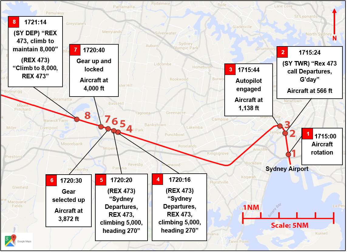
At about 1715, the aircraft departed from runway 34L (Figure 1). The captain reported that, after becoming airborne they[4] called ‘positive rate, gear up’. The captain expected that on this command the first officer (FO) would retract the landing gear, and so looked out to the left of the aircraft to observe the thunderstorms to the west and north of the airport. The FO did not recall hearing the captain’s call and the landing gear was not retracted, nor was the subsequent standard call ‘selected’ made by the FO. The FO reported also focusing on the weather in the area and, due to the FO’s relative unfamiliarity with Sydney departures, on the requirement to turn at 600 ft. The FO selected the yaw damper[5] ON and recorded data indicated that the flaps were selected to zero and the flight director engaged.
Shortly after, the aircraft reached an initial climb speed of 146 kt indicated airspeed. When climbing through about 600 ft, the crew initiated a left turn onto heading 230°. The tower controller then instructed the crew to contact the departures controller. Soon after, the FO engaged the autopilot.
At about 1716, the crew commenced the ‘climb scan-action flow’, which included setting climb power. The aircraft’s airspeed increased to 182 kt and soon after, the FO established contact with the departures controller.
Throughout the climb, the crew continued to focus on the weather to the west. They also recognised that the aircraft’s climb performance was slightly less than normal, but did not establish the reason for this. Neither recalled noticing anything else unusual.
Climbing through 3,800 ft, the captain called for the climb checklist and the FO read the first item, ‘gear’. At that time, the crew identified that the gear was still down. The captain started to respond by saying ‘up’, but immediately revised their words to ‘not up’. At the same time, the FO instinctively selected the gear up and then realised that the aircraft’s airspeed was above the maximum landing gear retraction speed of 150 kt. The crew reported that the gear retracted normally.
Information from the flight data recorder showed that the landing gear retracted and locked into position about 5 minutes after take-off while climbing through 4,000 ft. The airspeed at that time was 182 kt, 32 kt above the maximum landing gear retraction speed.
The departures controller then cleared the aircraft to climb to 8,000 ft and track to Katoomba. The remainder of the climb was uneventful.
The crew discussed the implications of retracting the landing gear above the maximum landing gear retraction speed and they elected to continue the flight based on the following considerations:
the gear had retracted normally
the aircraft’s airspeed was below the maximum landing gear extension speed of 200 kt at the time
maintenance facilities were available at Wagga Wagga, about 100 km east-south-east of Narrandera
the adverse weather conditions in the vicinity of Sydney
minimising the potential for passenger disruption.
On arrival at Narrandera, the landing gear extended as normal and the landing was uneventful. Engineers conducted a visual inspection of the landing gear as per maintenance requirements, with no damage identified. The aircraft was subsequently ferried with the landing gear extended to Wagga Wagga, where a more detailed inspection was performed and no defects were found.
Figure 1: ZRJ (REX473) departure track (in red) from Sydney towards Narrandera, with the key actions annotated
The captain held an Air Transport Pilot (Aeroplane) Licence and had a total flying experience of 12,810 hours, of which about 4,900 were on the Saab 340 aircraft. The captain commenced flying with Regional Express (Rex) on 19 August 2013 and was based in Sydney. Prior to this time, the captain was operating in Europe. The captain held a valid Class 1 Aviation Medical Certificate.
The captain completed a Sydney Airport route qualification check on 10 February 2014 and conducted human factors revalidation training on 26 November 2014.
First officer
The first officer (FO) held an Air Transport Pilot (Aeroplane) Licence and had a total flying experience of about 8,300 hours, of which about 4,800 were on the Saab 340 aircraft. The FO had been a training captain since August 2012 and was based in Melbourne, Victoria. The FO held a valid Class 1 Aviation Medical Certificate.
The FO obtained a right seat endorsement on 30 March 2012 and completed a Sydney Airport qualification check on 16 November 2011. The FO had operated from Sydney on eight occasions since June 2014. The FO indicated a relative level of unfamiliarity with operating to/from Sydney as compared to operations to/from Melbourne, and that they not done so ‘that often’.
The FO underwent human factors revalidation training on 17 September 2014.
Crew duty
Captain
On the day of the occurrence, the captain woke at about 0800 and commenced duty in Sydney at 1558. The captain reported feeling well rested. In the 2 days prior, the captain completed a line check, which included an overnight stop. The captain indicated having adequate sleep that night.
First officer
The FO reported usually obtaining about 8 hours of sleep a night between 2200 and 0600.The following outlines the FO’s sleep and work schedule leading up to and including the day of the occurrence:
2 December. The FO had a rostered day off and obtained between 2 and 4 hours sleep that night. The FO indicated that this was due to a line check that was scheduled for the next day, and that they tended to sleep poorly in the days leading up to a check.
3 December. The FO commenced duty for the line check at 1525. Landing back into Melbourne was delayed until 2013 due to in-flight weather diversions and the FO was recorded as signing off at 2058. After completing the line-check paperwork and an extended transit to the car park, the FO recalled leaving the airport at about 2200 on a 1-hour commute home.
4 December. After returning home from the previous nights’ flight, the FO went to bed between 0100 and 0200 and obtained a reported 2 hours of interrupted sleep (due to storms in the area) before waking at about 0600. The FO reported feeling tired after waking and, although initially considering calling in sick or fatigued, the FO instead decided that they were not fatigued and elected to remain on reserve duty. The FO reflected that it was difficult to self assess fatigue given its ‘insidious’ nature. The FO’s reserve duty commenced at 0700. Network Operations contacted the FO at about 1015 and asked the FO to operate an overnight flight from Sydney–Narrandera–Griffith. The FO accepted this requirement, travelled to the airport and signed on at 1330, before positioning on a commercial flight from Melbourne to Sydney that departed at 1400. The FO reported feeling: - drowsy and dozing off during that flight - ‘pretty tired’ prior to signing on for the occurrence flight at 1558.
Aircraft information
Landing gear system
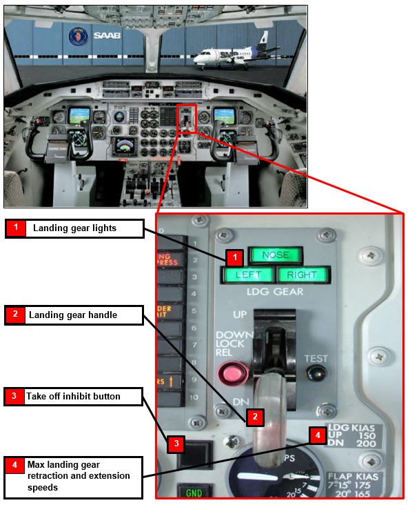
The aircraft is equipped with a retractable landing gear with the main and nose wheel gears retracting forward. The landing gear control panel is to the left of the FO (Figure 2). The panel incorporates three green indicator lights and the landing gear handle. When the landing gear is in the ‘down’ (DN) position, all three green down lock lights illuminate. The panel also displays the maximum landing gear retraction and extension speeds.
Figure 2: Photograph of the Saab 340 flight deck (with the landing gear panel emphasised) showing the gear indicator lights and handle, and position of the take-off inhibit button. Note that the placard to the right of the handle annotates the maximum landing gear retraction speed is 150 kt and the maximum landing gear extension speed of 200 kt
Prior to departure, the take-off inhibit button, which is located on the centre instrument panel is selected and illuminates blue to indicate its selection (Figure 2). This mode inhibits nonessential warnings and cautions during take-off. It also inhibits some lights, including illumination of the bleed valve push-button on the overhead panel.
Amongst other methods, the take-off inhibit mode is reset automatically when the landing gear is retracted. The crew then confirm that the take-off inhibit light is extinguished as part of the climb checklist. As the landing gear remained extended after take-off on the occurrence flight, the takeoff inhibit mode also remained active and the associated blue light illuminated.
Meteorological information
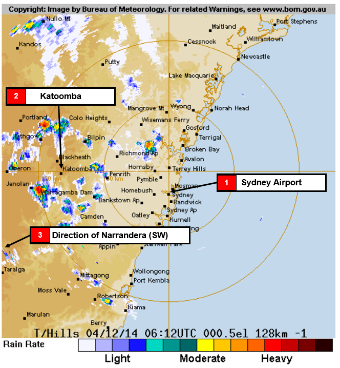
Sydney automatic terminal information service (ATIS)[6] ‘Alpha’, issued at 1634, indicated that thunderstorms with rain showers were present to the west and north-west of the airport. This was consistent with the Bureau of Meteorology radar image at 1712, which showed areas of light to heavy rain in the same area (Figure 3).
Figure 3: Bureau of Meteorology radar image at 1712 showing rain to the west and northwest of Sydney Airport
Source: Bureau of Meteorology, modified by the ATSB
Recorded data
A copy of the recorded flight data for the occurrence flight and six previous sectors (flown by other crew) was downloaded for subsequent examination. A review of the previous sectors, two of which included a departure from Sydney, showed that the crews generally retracted the landing gear about 7–8 seconds after becoming airborne, at airspeeds between 128–140 kt.
Take-off and climb procedures
Take-off sequence
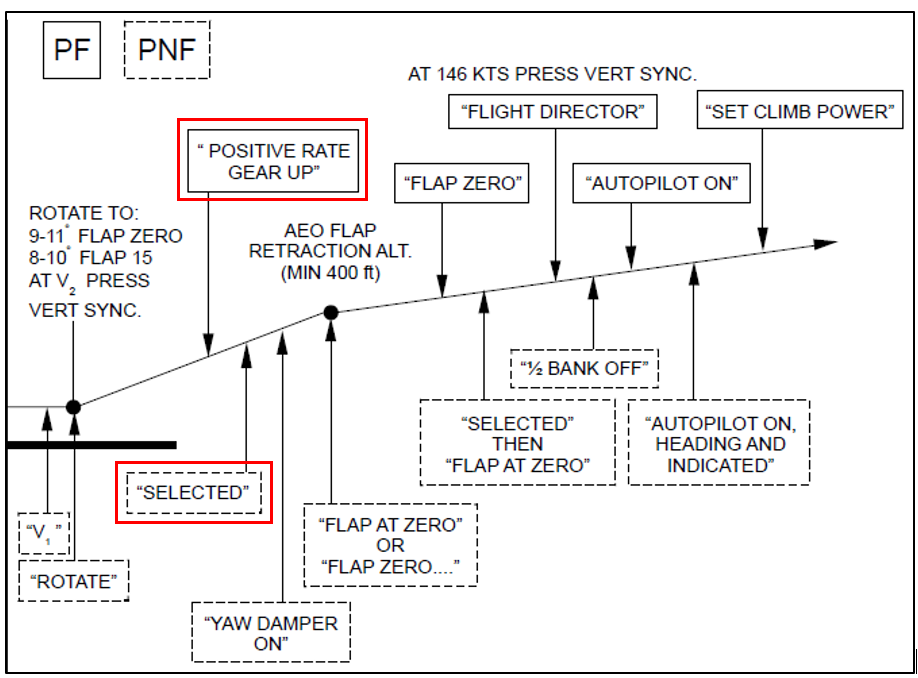
The Rex Flight Crew Operations Manual detailed the actions to be completed by the crew for a normal take-off sequence and climb (Figure 4). These actions included:
after rotation, when a positive rate of climb has been established, the pilot flying (PF) calls ‘positive rate, gear up’
the pilot not flying (PNF) confirms that the aircraft has a positive rate of climb and then selects the landing gear up and calls ‘selected’
when the landing gear transit light has extinguished, the PNF turns the yaw damper on and calls ‘yaw damper on’, before adjusting the heading bug if required
the crew complete a number of actions relating to the wing flaps, the flight director and autopilot.
On the occurrence flight, the captain reportedly made the call ‘positive rate, gear up’, but the FO reported not hearing it or recall calling ‘selected’. Through flight data and crew recollections, it appeared that all other calls and actions associated with the take-off sequence were completed. This included the retraction of the flaps, engaging the flight director and autopilot and setting climb power. The ATSB could not determine whether the call ‘yaw damper on’ was made or whether the heading bug was adjusted.
Figure 4: The Rex normal take-off profile showing the actions to be taken by the PF (shown in a solid-lined box) and the PNF (shown in a dash-lined box) The PF calls ‘positive rate, gear up’, followed by the PNF calling ‘selected’ once the gear is up (both calls outlined in red)
Source: Rex, modified by the ATSB
Climb scan-action flow
Not below 1,000 ft above ground level and the best gradient of climb speed outside icing conditions the PF calls ‘set climb power’. The PNF then commences the climb scan-action flow, which includes selecting the bleed valves to AUTO. However, as the take-off inhibit mode was still active, the bleed valve light would not have been illuminated at that time. The FO reported not noticing the absence of the bleed valve light.
Climb checklist
After completing the climb scan-action flow and a number of other criteria have been satisfied, the PF calls for the climb checklist. The first item on the checklist was to confirm that the landing gear was up and locked. The PF calls ‘gear’ and the PNF checks that the three green down lock lights have extinguished and responds with the call ‘up’. The climb checklist was the first time after the retraction of the landing gear where the crew confirmed its position. By this time, the aircraft’s airspeed is generally above the maximum landing gear retraction speed.
Referring to the aircraft’s airspeed prior to landing gear selection
Although the Rex Policies and Procedures Manual required crew to monitor the aircraft’s flight instruments in a positive manner, there was no documented requirement for the crew to reference, then call out, airspeed prior to retracting the landing gear. The FO reported that it was common, and usually their practice, for crew to place their hand on the gear lever, check the airspeed and then select the gear up. However, checking that there was a positive rate of climb took priority, especially as the aircraft’s airspeed was unlikely to be above 150 kt seconds after take-off.
Operator fatigue management processes and practices
Fatigue Management System
Rex had implemented fatigue management policies and procedures aligned with Civil Aviation Orders (CAO) Part 48 Flight Time Limitations. Under CAO 48.1 Instrument 2013, all Air Operator Certificate holders must transition to the new fatigue rules as detailed in that instrument by May 2017.
Civil Aviation Advisory Publication 48-1(1) Fatigue management for flight crew provides guidance on an operator’s responsibilities to manage fatigue. This includes that:
operators should be mindful of the requirement for crew to have prior sleep opportunity before undertaking a period of duty or standby
off-duty periods should include defined blocks of time where crew are not contacted
management should encourage crew to complete and submit fatigue occurrence forms after fatigue has or could impact on performance
staff in managerial and non-operational roles should be educated and aware of their contributions to fatigue management in operations
operators need to conduct initial and recurrent training and assessment in the nature of fatigue and sleep and fatigue countermeasures.
Individual assessment of fatigue
The Rex fatigue management policy stated that ‘a pilot will not carry out a rostered duty if the pilot is suffering from fatigue or illness which may affect judgement or performance to the extent that safety may be impaired.’ It was up to the individual crew to make this assessment prior to or during a duty period. At the time of the occurrence, Rex did not have specific tools or guidelines that might be expected to provide for a level of objectivity in crew assessments of their fatigue prior to a duty.
The FO recalled feeling ‘tired’ when commencing the reserve period on the morning of the occurrence, but did not think of it as being ‘fatigued’. The FO explained that it was difficult to self assess fatigue and that it was too ‘insidious’ to detect.
Crew declaring fatigued prior to or during a duty
The Rex Policies and Procedures Manual documented pilots’ responsibilities to ‘immediately report to Network Operations, prior to or during a duty period if they know or suspect they are suffering from fatigue’. If a crew member declared they were fatigued prior to sign on, at sign on or prior to completing the first sector, ‘Network Operations will allocate this as Sick Leave (SL).’ If a pilot declared they were fatigued after completing at least one sector, then Fatigue Leave was allocated (which did not affect leave accruals). If identified later that the pilot’s fatigue was due to ‘personal circumstances’ then the leave would be re-classified as sick leave.
The FO reported to have considered declaring fatigued to Network Operations, first on the evening of 3 December and then on the morning of 4 December. However, the FO concluded that their fatigue level was insufficient to trigger the declaration.
Crew rostering practices: rostered time off between duties
Rex managed its crew flight and duty times in accordance with section one of CAO 48 titled Flight Time Limitations – Pilots. These requirements stated that:
…a tour of duty or period of reserve time at home shall be preceded by a rest period on the ground of at least (a) 9 consecutive hours embracing the hours between 10pm and 6 am local time or (b) 10 consecutive hours.
The FO’s sign off time of 2058 on 3 December resulted in Network Operations delaying the commencement of the FO’s reserve duty the following day by 1 hour to 0700. The FO’s rest period between their duty on 3 December and the commencement of the reserve duty on 4 December complied with the existing CAO 48 requirements.
Fatigue training
Industry approach to fatigue management training
Over the past decade, the requirement for operators to manage fatigue more proactively gained momentum and the guidance material for designing, implementing and assessing this training became readily available. This included a focus on fatigue training for crew.
International Civil Aviation Organization (ICAO) Annex 6 to the Chicago Convention Operation of Aircraft advocated that operators implement ‘[fatigue] training programs to ensure competency commensurate with the roles and responsibilities of management, flight and cabin crew under the planned FRMS’. In addition, ICAO produced guidance material including the Fatigue Risk Management Systems: Implementation Guide for Operators (2011) that outlined suggested training content.
Locally, CASA also produced guidance material for the Australian aviation industry, including the release/publishing of:
In 2011, CAAP SMS-3(1) Non-Technical Skills Training and Assessment for Regular Public Transport Operations. This CAAP recommended specific nontechnical skills (NTS) training topics including fatigue management and methods to develop fatigue awareness, knowledge and skills for pilots.
In 2012, a suite of guidance material on fatigue management was released, including the Fatigue Management for the Australian Aviation Industry: A Training and Development Workbook. This workbook stated that ‘an important part of any system consists of training all employees about the safety hazards of fatigue and how effectively to manage them…beyond simply raising awareness.’
In 2013, CAAP 48-1(0) Fatigue Management for Flight Crew Members. This CAAP provided guidance for operators transitioning to the new fatigue rules. The CAAP included that, as part of crew fatigue training, flight crew should be made aware of the operator’s fatigue procedures, limits and all shared responsibilities. The CAAP outlined specific subject areas that should be part of a typical fatigue training program, including the consequences of fatigue on safety, fatigue in accidents and high-risk situations and a range of fatigue countermeasures.
Operator fatigue management training
At the time of the occurrence, Rex was required to comply with CAO Part 48 Section 48.1 Flight Time Limitations – Pilots. Under CAO 82.3 Conditions on air operators’ certificates authorising regular public transport operations in other than high-capacity aircraft, they were also required to implement and maintain a safety management system, and specifically a human factors/non technical skills (HF/NTS) training and assessment program.
Rex conducted compulsory initial and revalidation NTS courses for their flight crew. The initial course, ‘Introduction to Human Factors’ was of 2 days duration. The Regional Express HF/NTS Program Manual documented the program syllabus, which was based on 12 HF/NTS elements that determined training content. One of these elements was fatigue.
The initial course included ‘sleep and fatigue’ as one of the topics, which was delivered over a 45-minute period. The syllabus included the following topics:
requirements for effective sleep
the effects of fatigue on performance
identifying the signs of fatigue and how to counter its effects.
Flight crew completed a 1-day HF/NTS revalidation course every 12 months, with the course content designed to cycle through the 12 elements over a 3year period. The 2013 and 2015 NTS courses included fatigue. The revalidation course syllabus (including the course held in 2013) included:
the definition of fatigue
an introduction to fatigue management
examination of the legislative changes relating to fatigue management
examination of the fatigue precursors
examination of circadian rhythms.
The FO conducted a revalidation course on 4 October 2013, and recalled that fatigue was discussed during the day and that the facilitator showed participants an individual fatigue assessment tool used by another operator, although it was not utilised by Rex. The FO completed their initial NTS course in 2007, although it is not certain whether that initial training included an examination of fatigue and its effects.
Related occurrences
Landing gear retraction occurrences
A review of the ATSB occurrence database identified two other occurrences in the previous 5 years where the landing gear was not retracted as part of the aircraft’s published take-off sequence. These were:
During the take-off run and initial climb, the crew of the de-Havilland Canada Dash 8 were distracted and the gear-up call was missed. The landing gear was not retracted until after the transition altitude.[7]
During the take-off, the crew of the de-Havilland Canada Dash 8 were distracted by an auxiliary power unit warning and forgot to retract the landing gear, resulting in a landing gear overspeed.
Fatigue-related occurrences
In addition, a number of recent ATSB investigations have included an analysis of crew fatigue. Two are summarised below and available via the ATSB website.
The crew of an Embraer Regional Jet 170 were conducting a scheduled passenger service from Darwin to McArthur River Mine, Northern Territory. Shortly after passing navigational waypoint SNOOD, the aircraft’s flight path started diverging from the planned track. The problem was identified by air traffic control and the crew were advised. The ATSB found that, due to restricted sleep in the previous 24 hours, the crew were probably experiencing a level of fatigue known to have a demonstrated effect on performance. Although the operator’s rostering practices were consistent with the existing regulatory requirements, it had limited processes in place to ensure that fatigue risk due to restricted sleep was minimised.
The crew of a Boeing 777 aircraft were conducting an approach into Melbourne Airport. After passing waypoint SHEED, the aircraft descended below the approach path to about 500 ft above ground level. The crew recognised the error and re-intercepted the profile and continued the approach to land. The ATSB found that, due to extended wakefulness, the crew were probably experiencing fatigue at a level that has been demonstrated to affect performance, although fatigue could not be confirmed as contributing to the error in developing the approach profile.
During take-off, the crew unintentionally left the landing gear extended until this was identified in the climb checklist. The first officer (FO) reacted instinctively to retract the gear.
The following analysis examines the various human performance factors that influenced the crew’s actions and ability to detect and react to the landing gear inadvertently being left extended while above the maximum retraction speed.
Crew fatigue
The International Civil Aviation Organization (ICAO 2011) defined fatigue as:
A physiological state of reduced mental or physical performance capability resulting from sleep loss or extended wakefulness, circadian phase, or workload (mental and/or physical activity) that can impair a crew member’s alertness and ability to safely operate an aircraft or perform safety related duties.
Fatigue can have a range of adverse influences on human performance. These include:
slowed reaction time
increased variability in work performance
lapses or errors of omission (Battelle Memorial Institute 1998).
Sleep is vital for recovery from fatigue, with both the quantity and quality of sleep being important. It is generally agreed that most people need at least 7 to 8 hours of sleep each day to achieve maximum levels of alertness and performance. A review of relevant research (Dawson and McCulloch 2005) concluded:
…we can make broad assumptions from existing literature that obtaining less than 5 h [hours] sleep in the prior 24 h, and 12 h sleep in the prior 48 h would be inconsistent with a safe system of work.
Acute sleep disruptions are reductions in the quality or quantity of sleep that have occurred within the previous 3 days (Transportation Safety Board of Canada 2014). Losing as little as 2 hours of sleep will result in acute sleep loss, which will induce fatigue and degrade subsequent performance and alertness (Dinges and others 1996).
Other research has indicated that less than 6 hours sleep in the previous 24 hours can increase risk. Thomas and Ferguson (2010) examined the effects of different amounts of sleep on the performance of Australian airline flight crews. Crew error rates was higher during flights when the crew included a captain with less than 6 hours sleep or an FO with less than 5 hours sleep in the previous 24 hours.
The FO reported obtaining a total of between 4 and 6 hours sleep in the 48 hours prior to the occurrence. Accordingly, it is reasonable to conclude that the FO was experiencing a level of acute fatigue known to have at least a moderate effect on performance.
The types of errors made by the crew, including an error of omission that was not detected, are consistent with the effects of fatigue. However, as discussed in the following sections, there were other factors that could lead to the development and non-detection of such errors. While it is difficult to conclude that fatigue alone led to the FO’s errors on this occasion, it was considered contributory to the occurrence.
Omission of gear selection during the take-off sequence
During the take-off sequence, the FO unintentionally missed the step of selecting the landing gear up, and also missed making the subsequent associated call ‘selected’. The actions included in the take-off sequence immediately following this were completed. When considering how the call ‘positive rate, gear up’ was not perceived, or how the action was not otherwise recalled, the following are relevant:
Skill-based errors can occur when a pilot is undertaking highly-learned, well-developed behaviours that are essentially sub-conscious (Harris 2011). Retracting the landing gear was a frequent action for crew and therefore conducted automatically, with little conscious oversight.
Omitting a step in a task is one of the most common types of human error. A step is more likely to be omitted if the instructions are given verbally (Reason 2007). Raising the gear was triggered by a standard verbal cue (that is, ‘positive rate, gear up’), and not retracting it could be considered an error of omission. The risk of making errors of omission can increase when experiencing fatigue.
Reliance on predictable cues may make items more vulnerable to being forgotten when the cues are not available, or not perceived (Nowinski et al 2003). The verbal cue to raise the gear was not heard by the FO.
Additionally, given the FO was based in Melbourne, their relative familiarity with Sydney Airport operations had reduced due to the low frequency of rostered flights departing Sydney since June 2014. This required the FO to apply a high level of attention to the departure procedures for runway 34 Left.
Crew expectancy of the position of the landing gear during the climb
During the climb, the crew did not detect that the landing gear was still down. There were indicators that the gear remained extended, including:
the absence of the call ‘gear, selected’
the illumination of the green landing gear lights
the absence of the light on the bleed value push-button (due to the take-off inhibit mode still being active)
the partially-degraded climb performance.
The crew likely expected that the landing gear was retracted, reducing the chance that they would detect that it remained extended. This is due to human attention being guided by two factors: expectancy (an individual will look where they expect to find information) and relevance (an individual will look to information relevant to their important tasks and goals). At the same time, an individual’s attention is attracted by the salient events in their environment. The key factor is expectancy. It is well-demonstrated that people are more likely to detect targets when they are expected and less likely to detect targets when they are not expected (Wickens and McCarley, 2008). This lack of detection occurs even when targets are salient, important and in an area to which a person is looking (known as inattentional blindness) (Chabris and Simon 2010).
A range of conditions influenced the crew not detecting that the landing gear remained extended:
Errors of omission are often difficult to detect by the people who make them (Sarter and Alexander 2000).
The absence of something is more difficult to detect than the presence of something (Thomas and Wickens 2006), depending on its salience. In this case, the absence of certain illuminations as a result of the take-off inhibit mode being active were not likely to be identified.
Both crew had a lot of experience on the aircraft without making this error before, and probably had a high degree of expectancy that the gear was actually retracted.
The crew’s focus of attention during the climb was predominantly on the weather conditions in the region and other operational tasks.
The crew detected a degraded climb performance. However, its relevance was not recognised as there were other valid explanations.
The green landing gear ‘down’ lights were within the crew’s line of sight. It was likely the lights were not detected due to inattentional blindness arising from an assumption that the gear was up.
Instinctive retraction of the landing gear
The crew realised the landing gear remained extended when they conducted the climb checklist. The FO recalled instinctively reaching out to select the gear up. The FO usually referenced the aircraft’s airspeed before any configuration changes, but in this case, the FO’s action was in response to the surprise of discovering that the gear was still extended.
Surprise is a cognitive-emotional response to something unexpected. It results from a mismatch between one’s mental expectations and what actually happens around them. Experiencing surprise is a combination of physiological, cognitive and behavioural responses (Rivera and others 2014). If a pilot is not expecting things to go wrong, then the level of surprise can result in taking no action, or the wrong action (Martin 2012).
Operator fatigue management
Individual assessment of fatigue
Caldwell (2003) notes the difficulty with individuals knowing ‘…when the amount of fatigue has crossed the line from being simply an unpleasant feeling to being a hazard to safe flight…’.
It has been well demonstrated that ‘fatigued people are not very good judges of their own fatigue level or their ability to perform well’. They tend to overestimate their abilities, particularly if the fatigue levels experienced are anything other than approaching sleep at the time (Transportation Safety Board of Canada, 2014). Flin and others (2008) add that ‘subjective methods [such as] scales give a numerical measure of sleepiness…[although] people are not necessarily good at judging their levels of fatigue, and so subjective measures may underestimate levels of sleepiness.
It is for this reason that Civil Aviation Advisory Publication 48-1(1) Fatigue Management for Flight Crew Members advocates the use of individual fatigue assessment tools that take into account sleep history, behavioural indicators and nature of sleep to avoid crew relying only on their subjective assessment of how fatigued they feel. It encourages crew to ‘consider what factors are associated with the tasks allocated to them prior to presenting as fit for duty.’ The Regional Express (Rex) Policies and Procedures Manual outlined their approach to managing fatigue at the time. However, there were no specific guidance or tools to better facilitate crew recognising their own fatigue.
In this case, the FO relied upon their understanding of fatigue to determine whether they were fit for duty. This understanding did not take into account the inadequate amount of sleep they had obtained in the past 48 hours and their own feeling of being tired.
Fatigue training
The FO felt that being tired was not a sign of fatigue, nor recognised that obtaining between 4 and 8 hours of sleep over the previous two nights was an indication of a significantly increased risk of experiencing fatigue that would likely impair performance.
When comparing the operator’s syllabus and available training material to the recommended industry approach, it was identified that the initial human factors/non-technical training course included a discussion of factors that contribute to fatigue and some of the consequences. One topic in the syllabus was ‘identifying the signs of fatigue and how to counter its effects’, but this did not appear to be included in the presentation material for the course.
Overall, at the time of the occurrence the content of the provided fatigue training was limited to a general overview of fatigue, sleep and fatigue countermeasures which may not provide crew with an adequate opportunity to develop the skills or utilise tools that could best help them identify signs of fatigue in themselves or others. Noting that Rex was not required to comply with the new fatigue rules on training at the time of the occurrence, it could be expected that, as they work towards implementing those requirements by May 2017, the training content will be revised.
Crew rostering practices
It is widely acknowledged that minimising fatigue is a responsibility for both flight crew and operators, and that crew should ensure they use the rest periods provided to obtain adequate sleep where possible. Under the new fatigue rules, there is a greater requirement for the operator to tailor their rostering practices to manage fatigue risk with the nuances of their operational demands. In doing so, the operator should provide adequate time for crew to get the required sleep opportunity (8 hours), sufficient time for bodily functioning (eating, hygiene, and so on), and time to travel to and from the suitable sleeping accommodation (CAAP 48-1(1)). This advisory publication also recommends that operators take into account the impact on fatigue levels of training and checking requirements when designing and setting limits.
On 3 December, the FO signed off duty at 2058 then reportedly was only able to leave the airport at about 2200. To allow a flight crew to commute to and from an airport, deal with a range of personal requirements, and allow for an adequate sleep opportunity is very difficult with potentially only 9 hours time off duty. Additionally, the time between the commencement of the FO’s standby duty at 0700 and sign on at 1330 was also not likely a plausible opportunity to gain restorative sleep.
Rex managed its flight crews’ flight and duty times to comply with CAO 48 at the time of the occurrence. Although compliant with those requirements, Rex’s rostering processes did not wholly account for the:
potential for the conduct of the flight check to have impacted on the FO’s sleep preceding the check
unforeseen extension of the FO’s previous duty period and the associated time between sign off and being able to leave the airport.
Both of these factors influenced the adequacy of the FO’s sleep opportunity in the period before the occurrence.
Timing of the climb checklist
Checklists help crew detect the omission of an action (Nowinski and others 2003). In this case, the use of the climb checklist detected the unintended gear position. As the climb checklist is designed to confirm the configuration of the aircraft, there is the potential for its conduct at a time when the aircraft’s speed is above the maximum gear retraction speed. As in this case, this increases the risk of crew reacting to an unexpected gear position by retracting the landing gear before slowing the aircraft.
Findings
From the evidence available, the following findings are made with respect to the landing gear retraction overspeed involving Saab Aircraft Co. 340B, registered VH-ZRJ, which occurred near Sydney Airport, New South Wales on 4 December 2014. These findings should not be read as apportioning blame or liability to any particular organisation or individual.
Contributing factors
During the take-off sequence both crew were focused on the departure procedures and local weather that, combined with the effects of fatigue on the first officer, likely led to the landing gear not being retracted.
The first officer’s ability to assess their own level of fatigue was impeded by a lack of training and objective tools to do so, resulting in a decision to operate the flight instead of calling in fatigued.
During the climb, the crew likely expected that the landing gear was retracted, reducing the likelihood that they would detect the indicators that it was still extended.
When the crew identified that the landing gear was still extended, the first officer instinctively retracted the gear before identifying that the aircraft was above the maximum landing gear retraction speed.
Other factors that increase risk
Although compliant with applicable regulations, the Rex rostering processes did not wholly account for the unforeseen extension of the first officer’s previous duty period or the effects on performance of conducting a check flight, both of which impacted the adequacy of the first officer’s sleep opportunity on the evening before the occurrence.
The only checklist item to confirm that the gear was up was carried out when the aircraft’s airspeed was above the maximum landing gear retraction speed, increasing the risk that crew would retract the landing gear before slowing the aircraft.
Sources and submissions
Sources of information
The sources of information during the investigation included:
Regional Express
the crew of VH-ZRJ
the Bureau of Meteorology
the Civil Aviation Safety Authority
Airservices Australia.
References
Battelle Memorial Institute 1998, An Overview of the scientific literature concerning fatigue, sleep, and the circadian cycle, Report prepared for the Office of the Chief Scientific and Technical Advisor for Human Factors, US Federal Aviation Administration.
Caldwell, JA & Caldwell, LC 2003, Fatigue in Aviation: A Guide to Staying Awake at the Stick, Aldershot, United Kingdom, p.16.
Chabris, C.F. and Simons, D.J. (2010), The invisible gorilla and other ways our intuitions deceive us. Random House, New York, NY.
Dawson, D & McCulloch, K 2005, ‘Managing fatigue: It’s about sleep’, Sleep Medicine Reviews, vol. 9, pp. 365-380.
Dinges, DF, Graeber, RC, and Rosekind, MR, 1996, Principles and Guidelines for Duty and Rest Scheduling in Commercial Aviation, NASA Ames Research Centre, California, United States.
Flin, RH, O’Connor, P, and Chrichton, M 2008, Safety at the Sharp End, Ashgate Publishing Ltd, Aldershot, England
Harris, D. 2001, Human Performance on the Flight Deck, Ashgate Publishing Ltd, Surrey, England.
International Civil Aviation Organization 2011, Fatigue risk management systems (FRMS): Implementation guide for operators, 1st edition.
Martin, WL, Murray, PS, Bates, PR 2012, The Effect of Startle on Pilots During Critical Events: A Case Study Analysis, Proceedings of the 30th EAAP Conference: Aviation Psychology & Applied Human Factors, Sardinia, Italy, pp.388-394.
Nowinski, JL, Holbrook, JB, and Dismukes, RK. 2003, Human memory and cockpit operations: An ASRS study. In Proceedings of the 12th International Symposium on Aviation Psychology (pp. 888-893), Dayton, Ohio.
Reason, J 2002, 'Error management: Combating omission errors through task analysis and good reminders’, Quality and Safety in Health Care, vol. 11, pp. 40–44.
Rivera, JR, Talone, AB, Boesser, CT, Jentsch, F and Yeh, M 2014, Startle and Surprise on the Flight Deck: Similarities, Differences and Prevalence, Proceedings of the Human Factors and Ergonomics Society 58th Annual Meeting, Chicago, IL United States, pp.1047-1051.
Sarter, NB & Alexander, HM 2000, 'Error types and related error detection mechanisms in the aviation domain: An analysis of aviation safety reporting system incident reports', The International Journal of Aviation Psychology, vol. 10, pp.189- 206.
Thomas, MJW & Ferguson, SA 2010, ‘Prior sleep, prior wake, and crew performance during normal flight operations’, Aviation, Space, and Environmental Medicine, vol. 81, pp. 665-670.
Thomas, LC & Wickens, CD 2006, 'Effects of battlefield display frames of reference on navigation tasks, spatial judgements, and change detection', Ergonomics, vol. 49, pp. 1154-1173.
Transportation Safety Board of Canada 2014, Guide to Investigating Sleep-Related Fatigue.
Wickens, CD & McCarley, JS 2008, Applied Attention Theory, CRC Press, Florida, United States.
Submissions
Under Part 4, Division 2 (Investigation Reports), Section 26 of the Transport Safety Investigation Act 2003 (the Act), the ATSB may provide a draft report, on a confidential basis, to any person whom the ATSB considers appropriate. Section 26 (1) (a) of the Act allows a person receiving a draft report to make submissions to the ATSB about the draft report.
A draft of this report was provided to the crew of VH-ZRJ, Regional Express, the manufacturer and the Civil Aviation Safety Authority.
Submissions were received from the Civil Aviation Safety Authority and Regional Express. The submissions were reviewed and where considered appropriate, the text of the report was amended accordingly.
Purpose of safety investigations
The objective of a safety investigation is to enhance transport safety. This is done through:
identifying safety issues and facilitating safety action to address those issues
providing information about occurrences and their associated safety factors to facilitate learning within the transport industry.
It is not a function of the ATSB to apportion blame or provide a means for determining liability. At the same time, an investigation report must include factual material of sufficient weight to support the analysis and findings. At all times the ATSB endeavours to balance the use of material that could imply adverse comment with the need to properly explain what happened, and why, in a fair and unbiased manner. The ATSB does not investigate for the purpose of taking administrative, regulatory or criminal action.
Terminology
An explanation of terminology used in ATSB investigation reports is available here. This includes terms such as occurrence, contributing factor, other factor that increased risk, and safety issue.
Publishing information
Released in accordance with section 25 of the Transport Safety Investigation Act 2003
Ownership of intellectual property rights in this publication
Unless otherwise noted, copyright (and any other intellectual property rights, if any) in this report publication is owned by the Commonwealth of Australia.
Creative Commons licence
With the exception of the Coat of Arms, ATSB logo, and photos and graphics in which a third party holds copyright, this publication is licensed under a Creative Commons Attribution 3.0 Australia licence.
Creative Commons Attribution 3.0 Australia Licence is a standard form licence agreement that allows you to copy, distribute, transmit and adapt this publication provided that you attribute the work.
The ATSB’s preference is that you attribute this publication (and any material sourced from it) using the following wording: Source: Australian Transport Safety Bureau
Copyright in material obtained from other agencies, private individuals or organisations, belongs to those agencies, individuals or organisations. Where you wish to use their material, you will need to contact them directly.
On 10 November 2013, while conducting an approach to the Red Lake Airport, at Red Lake, Ontario, Canada, the crew of a Fairchild-Swearingen SA227AC (Metroliner) aircraft declared an emergency. Shortly after, the aircraft struck trees and a powerline before crashing south of the airport. The aircraft was destroyed by the impact and fire. The two crewmembers and three of the passengers sustained fatal injuries. The remaining two passengers escaped with non-life-threatening injuries.
An investigation into the circumstances of this accident is being carried out by the Transportation Safety Board (TSB) of Canada. The TSB investigation can be accessed at www.bst-tsb.gc.ca/eng/, reference A13C0150.
On 5 November 2014 the TSB requested Australian Transport Safety Bureau (ATSB) assistance in gathering information on two recent engine failures involving Australian‑registered Metroliner aircraft, with a view to identifying any commonality with the Red Lake accident. In accordance with paragraph 5.23 of Annex 13 to the Convention on International Civil Aviation Aircraft Accident and Incident Investigation, the ATSB appointed an accredited representative to the TSB investigation. To facilitate this support, the ATSB initiated an external investigation under the provisions of the Transport Safety Investigation Act 2003. The information gathered by the ATSB was provided to the TSB on 11 November 2014.
The TSB is responsible for, and will administer the release of the final investigation report into this accident. Any enquiries regarding the TSB investigation should, in the first instance, be directed to:
Director Investigations - Air Transportation Safety Board of Canada 200 Promenade du Portage Place du Centre, 4th floor Gatineau Québec, K1A 1K8
On 9 December 2014, diesel locomotive D2 (Drewry locomotive built 1953, weight 27 t, length 7.6 m) travelled from Regatta Point (Strahan) to Dubbil Barril, to collect an empty passenger carriage for transfer back to Regatta Point. This was in preparation for the recommencement of passenger services between Dubbil Barril and Regatta Point on 15 December 2014. The locomotive and empty carriage, with a crew of three (designated as train 71SG), departed Dubbil Barril at about 1136, bound for Regatta Point.
At about 1215, a radio message was received from the train crew advising that the locomotive had derailed all wheels. The trailing empty passenger carriage remained on track. The crew sustained minor injuries (bruising and stiffness).
What was found
West Coast Wilderness Railway (the operator) investigated the occurrence; the findings of which indicated the track condition and geometry was not a contributing factor. Mechanical examination of the locomotive found that the front right hand axle box horn guide had jammed due to a lack of lubrication (Figure 1). The jammed horn guide had restricted axle articulation while the locomotive was negotiating a slight left-hand curve, causing the leading wheel on the right side to climb the rail head and derail to the right.
A blanket speed restriction of 10 km/h existed for diesel locomotives travelling the section between Regatta Point and Dubbil Barril. Although the locomotive did not have a mechanism to display or record speed, individual crew member interviews and the damage sustained by the track infrastructure and rolling stock suggested that speed was not a factor in the derailment.
West Coast Wilderness Railway operates three diesel locomotives of this type – primarily for shunting and the occasional freight service. They are not normally used for passenger services. Although the locomotives receive regular inspections they can spend long periods idle, are often housed in the open and are subject to the harsh environment of Tasmania’s west coast.
A pre-departure inspection (A-exam) was conducted on the locomotive before operation, but the lack of adequate horn guide lubrication was not noted. The investigation found that the A-exam did not specify a requirement to check the axle box horn guide oil reservoir to ensure lubrication was being applied.
Figure 1: Axle box horn guide
Source: West Coast Wilderness Railway
Safety action
As a result of this occurrence, the West Coast Wilderness Railway has advised the ATSB that they are taking the following proactive safety action in order to reduce their safety risk:
Review locomotive AB examination recording sheet; making changes where needed and ensuring maintainers are advised of any changes made.
Review the daily locomotive A-exam to include the need for ensuring the oil reservoir above the axle box horn guide is clear, horn cheeks are showing signs of lubrication and checked for visual signs of binding, and ensure that locomotive crews are advised of the change.
Investigate the possibility of improving the lubrication delivery method.
Revisit and amend the risk register for rolling stock inspections.
Undertake a review of the rolling stock maintenance procedures manual.
ATSB comment
The ATSB noted that the risk exposure for derailment of passenger services is reduced due to the limited use and blanket speed restriction for these types of locomotives on the West Coast Wilderness Railway network. In addition, the ATSB noted that the actions taken by West Coast Wilderness Railway should further reduce the risk of future derailment.
Safety message
This incident highlights to operators and maintainers, the importance of continually monitoring and reassessing risks to the safe operation of rolling stock – particularly with respect to low utilisation operating scenarios.
Purpose of safety investigations
The objective of a safety investigation is to enhance transport safety. This is done through:
identifying safety issues and facilitating safety action to address those issues
providing information about occurrences and their associated safety factors to facilitate learning within the transport industry.
It is not a function of the ATSB to apportion blame or provide a means for determining liability. At the same time, an investigation report must include factual material of sufficient weight to support the analysis and findings. At all times the ATSB endeavours to balance the use of material that could imply adverse comment with the need to properly explain what happened, and why, in a fair and unbiased manner. The ATSB does not investigate for the purpose of taking administrative, regulatory or criminal action.
Terminology
An explanation of terminology used in ATSB investigation reports is available here. This includes terms such as occurrence, contributing factor, other factor that increased risk, and safety issue.
Publishing information
Released in accordance with section 25 of the Transport Safety Investigation Act 2003
Ownership of intellectual property rights in this publication
Unless otherwise noted, copyright (and any other intellectual property rights, if any) in this report publication is owned by the Commonwealth of Australia.
Creative Commons licence
With the exception of the Coat of Arms, ATSB logo, and photos and graphics in which a third party holds copyright, this publication is licensed under a Creative Commons Attribution 3.0 Australia licence.
Creative Commons Attribution 3.0 Australia Licence is a standard form licence agreement that allows you to copy, distribute, transmit and adapt this publication provided that you attribute the work.
The ATSB’s preference is that you attribute this publication (and any material sourced from it) using the following wording: Source: Australian Transport Safety Bureau
Copyright in material obtained from other agencies, private individuals or organisations, belongs to those agencies, individuals or organisations. Where you wish to use their material, you will need to contact them directly.
________________________
A limited-scope, fact-gathering investigation into this occurrence was conducted in order to produce this short summary report and allow for greater industry awareness of potential safety issues and possible safety actions.
On 12 December 2014, the pilot of a Cessna 310 aircraft registered VH-TBE (TBE) was completing a charter flight from Oenpelli to Jabiru, Northern Territory. On board were the pilot, two adults and three children.
During the short flight, one of the passengers coughed incessantly through the headset which distracted the pilot. Once he had the aircraft stable he reached over and unplugged the headset.
The pilot manoeuvred the aircraft to join a late downwind for runway 27 at Jabiru. He reported that, as he commenced the pre-landing checks and verbalised 'undercarriage down' but made a decision to defer the associated procedure. He elected to keep the aircraft speed slightly higher than normal and as per the company procedures kept a stable power setting and profile and only made adjustments when needed at around 300 ft. He was also mindful of a Cessna 210 aircraft close behind VH-TBE.
He then focussed on the passengers, and made sure that had their seatbelts correctly fastened prior to landing.
The pilot reported that he normally completed the remaining memory-recall PUFF (set Propeller pitch, Undercarriage down, and Flaps Full down) check on final approach, but on this occasion he did not.
As the pilot flared the aircraft for landing he became aware that the undercarriage was not down and the propellers contacted the ground.
This incident highlights the impact a combination of distractions can have on aircraft operations.
Further reading on distractions for flight crew is available at:
On Tuesday 9 December 2014, at about 0003 (EDT), the load on train 2MP9 struck a timber pylon of an over-rail bridge near Great Western, Victoria. The train was transporting a number of Maxitrans skeletal road trailers (in piggyback configuration). During the journey, one of the upper road trailers had shifted laterally by almost 2 m, striking the Paxton Street bridge as the train passed beneath. Authorities closed the bridge, assessed it for safety and cleared it for normal traffic some time later. After being alerted to the load shift and collision while stopped and waiting for a passing train, the rail operator made arrangements to remove the road trailer load. Train 2MP9 subsequently departed Great Western at 1205 and continued its journey to Perth.
What the ATSB found
The ATSB found that, based on recorded data from wayside monitoring systems and the condition of the wagon’s side bearers, it is likely that the wagon carrying the shifted load (PQMY4346V) was hunting. The hunting motion would be expected to increase the lateral forces on the load restraints. Compounding this, SCT’s freight loading procedures did not specifically provide for the effective restraint and securement of commercial road transport vehicles for transportation on rail vehicles. Terminal staff responsible for securing and checking the load were not fully aware of the load securement requirements documented in the Rail Industry Safety and Standards Board (RISSB) Code of Practice for the Loading of Rail Freight.
What's been done as a result
SCT Logistics have issued a safety alert to all SCT managers and supervisors, reminding them of the freight loading Code of Practice requirements and instructing that only qualified and/or experienced staff are to perform the loading task.
SCT also addressed the mandatory replacement of wagon side bearers in accordance with the manufacturer’s service bulletin.
Safety message
A shifted load during rail vehicle transit represents a significant risk to infrastructure, railway employees, passengers, and the general public. In light of this occurrence, all rail freight operators should consider the safety implications of inadequate load restraint within their own operations - taking action where opportunities exist for improvement and compliance with requirements.
The occurrence
On Monday 8 December 2014, a load of Maxitrans skeletal road trailers arrived at the Laverton freight terminal, Melbourne. The trailers arrived via road in a piggyback (stacked) configuration. During the day the trailers were loaded onto a flat container wagon to form part of train 2MP9 travelling to Perth, WA. Train 2MP9 departed Melbourne at about 2050 (EDT).
At some point in the journey, one of the skeletal road trailers moved, leading to the load protruding almost 2 m beyond the edges of the rail wagon (out-of-gauge) (Figure 1). An out-of-gauge load is a load that does not conform to a predefined loading outline.
At about 0003 on 9 December 2014, the out-of-gauge road trailer on the 33rd wagon struck the Paxton Street over-rail bridge. The 33rd wagon was about 956 m behind the lead locomotive and the train crew were unaware of the collision. The train continued about 6.7 km further into Great Western, Victoria where it waited on the main line to cross train 6PM6 travelling from Perth. Great Western is about 288 km North West from Melbourne.
As train 6PM6 travelled through Great Western on the loop line, the driver noticed that ‘something was hanging off’ the train on the main line. The driver stopped the train and reported the condition to train 2MP9’s crew.
Shortly thereafter, train 7768, following 2MP9, discovered the damage to the Paxton Street over-rail bridge. The crew reported the damage to the Australian Rail Track Corporation (ARTC) network control centre. The ARTC control centre subsequently coordinated a response to the incident. The response involved repositioning train 2MP9 on the main line and closing the over-rail bridge to both rail and road traffic. A crane removed the shifted trailer, after which the train continued its journey.
Figure 1: The shifted load
The top road trailer had shifted to the left-hand-side in direction of travel. The movement was enough to strike the bridge infrastructure. Source: SCT Logistics
An examination of the over-rail bridge established that a timber pylon had been struck and destroyed (Figure 2). Accordingly, the bridge was cleared for rail traffic but remained closed to road traffic pending a subsequent structural engineering examination.
There were no injuries resulting from the collision and the road trailers sustained only minor damage.
Figure 2: Paxton Street bridge damage
The shifted road trailer struck and destroyed the wooden pylon as indicated. Note however, the pylon was redundant due to an additional steel support structure installed at an earlier time. Source: SCT Logistics
Context
The location
The out-of-gauge load was detected while train 2MP9 was at Great Western, about 288 track kilometres from Melbourne on the interstate main line between Melbourne and Adelaide. It was evident that the load on train 2MP9 had shifted sideways at some stage prior to striking the Paxton Road Bridge; about 6.7 km before entering the loop.
A lateral force is usually required to initiate a sideways load shift. This could result from in-train forces while travelling, or from passage across a track geometry defect. Information provided by the drivers indicated that track leading up to the Paxton Road Bridge was fine, with no notable instances of rough-ride that could be associated with geometry defects. A section of track between Maroona and Ararat (about 30 km before Great Western) was noted as having track geometry issues, but a temporary speed restriction had been applied in this area, which would have served to reduce undesirable lateral forces.
There was no evidence available to determine at what point the load had shifted during the journey from Melbourne. Similarly, there was no evidence to suggest that a specific track geometry feature or defect may have initiated the load shift.
Trackside condition monitoring equipment
The ARTC have wayside hunting[1] detection equipment installed at Port Germein, South Australia. Motion measurements from passing trains are stored so that the operator can interrogate the data for developing trends. The data can only be accessed by the relevant rolling stock owner/operator and is used to predict maintenance issues with rolling stock.
The ATSB examined the recorded condition monitoring data relevant to wagon PQMY4346V. The data logged 166 journeys between 22 December 2012 and 24 November 2014. In that time, the wagon had registered five medium, three high, and two extreme indications. This would suggest a developing trend that may have required maintenance intervention.
Train information
Train 2MP9 was owned and operated by SCT Logistics, and crewed by Genesee and Wyoming Australia (GWA) under contract to SCT Logistics. The train consisted of three locomotives hauling 51 wagons, totalling a combined length of 1,378 m and a gross mass of 4,181 t.
There was no evidence to suggest the train had been operated inappropriately, and as such, train handling was not considered to have been a factor contributing to the load shift.
Wagon PQMY4346V condition and monitoring
Following the incident, wagon PQMY4346V was sent to the maintainer’s facility in Perth for an inspection, where it was identified as having a number of faults that could have contributed to hunting, including failed side bearers[2]. Should hunting have developed while in transit, the hunting motion could very likely have increased the lateral forces on the load restraints.
Loading of freight on rail vehicles
The Australian Rail Industry Safety and Standards Board (RISSB) Code of Practice for the Loading of Rail Freight (CoP) specifies the requirements for loading, restraint, and securement of freight on rail vehicles, and is the standard adopted by SCT Logistics. Appendix F.1 of the CoP provides specific guidance for the lashing and securing of commercial road transport vehicles, and states:
F.1.4 Lashing & Securement
(a) Trailers should be secured using transport chain fitted with load-binders or turnbuckles—
(i) Trailers should be chained diagonally at the front and rear to provide lateral and longitudinal restraint, using two chains at each end. Each chain is fixed to the trailer and to the flat car at the opposite side.
(ii) Additional chains should be used along the sides of the trailer for further longitudinal restraint. These chains should be fixed to the trailer and the flat car in opposing directions so that they provide restraint in both directions.
(b) For trailers up to 24 tonnes gross mass—
(i) The lashings should be 10mm chain with a minimum tensile strength of 10 tonnes.
(ii) They should be attached as follows—
a. Two (2) each end in diagonal configuration to provide lateral and longitudinal restraint.
b. Two (2) chains each side sloping away from each other to provide longitudinal restraint in both directions.
Figure 3: Lashing and securing typical arrangement
Source: RISSB Code of Practice Loading of Rail Freight, Appendix F
The RISSB CoP did not specifically provide for the double stacking of road vehicles. While SCT Logistics did not have any additional documented procedures addressing the securing and restraining of double stacking of road vehicles, it would be expected that the general principles of the CoP should still be applied.
Loading on Wagon PQMY4346V
The wagon upon which the load had shifted was located at the 33rd position in the train consist. Two other similar loads were located to either side of this wagon (Figure 4).
Figure 4: Trailer loading on train 2MP9
The shifted trailer (indicated) compared with similar loads on adjacent wagons. Source: SCT Logistics
The Maxitrans skeletal trailers arrived at the train loading depot already unitised in the piggyback configuration. These units were lifted and placed on top of the flat rail wagons. Wooden pallets were stacked under the fifth wheel position to support the lower trailer. The lower trailer was secured to the rail wagon (Figure 5 and Figure 6)
Figure 5: Securing of trailers on wagon PQMY4346V
Figure 5 illustrates the load and securing configuration for the double stacked road vehicles on the rail wagon. The red lines represent securing of the trailers to the wagon at the time of the incident. Source: ATSB
Figure 6: Securing of trailers
Figure 6 shows the securing chain unitising the two trailers together. Note the steel beam on which the trailer support stands sit. A similar beam was used as a wheel guide for the rear wheels. Source: SCT Logistics
The trailers were secured at the road wheels via their axles. Since the securing chains did not bridge the suspension elements, the vehicle suspension was unlikely to compromise the integrity of the securement system.
Wagon PQMY4346V was fitted with constant contact side bearers[3] manufactured by the A. Stucki Company. SCT maintenance procedures do not require replacement during inspections, unless worn. However, a Stucki service bulletin, circa 2011, states research showing the Stucki side bearer blocks have a useful life of 600,000 miles (about 1 million kilometres) or six years of service. Each Stucki side bearer is stamped with a date of manufacture, although the date of manufacture could not be identified on the failed side bearer from PQMY4346V. Based on maintenance records, it was likely that the side bearers from this wagon had not been replaced in at least seven years.
Wayside monitoring equipment at Port Germein, South Australia, identified a series of motion indications from wagon PQMY4346V. In particular, during the period from 5 November 2014 until the incident, there were five indications recorded – two medium, one high, and two extreme. Of note however, the ownership of wagon PQMY4346V had been recorded against another transport operator on the ARTC system. While this may have contributed to SCT not identifying the motion indications from the wagon, it was noted that SCT, as the operator of the wagon, could still have accessed this data against the wagon identification.
Based on the condition of the side bearers (post-incident examination) and the recorded trackside condition data, it is likely that wagon PQMY4346V was hunting during the journey from Melbourne on 8 December 2014. A hunting wagon would almost certainly have increased the lateral forces on the load restraints.
Loading of rail freight
The RISSB Code of Practice for the Loading of Rail Freight requires items transported via rail to be appropriately secured. The securement system’s function is to restrain the load (prevent relative movement between the load and the vehicle), retain the load on the vehicle during normal transit, and minimise the risk of separation from the vehicle in adverse conditions such as collisions or derailments.
Restraint systems should be selected and applied to prevent the load from moving relative to the vehicle, in the longitudinal (length-wise), lateral (sideways) and vertical planes. Surface grip (friction), the vehicle structure, specific attachments, or combinations of these can be employed as forms of restraint. While frictional forces between the load and the vehicle deck or floor can provide some resistance to horizontal movement, friction alone is generally insufficient to restrain a load under dynamic forces and needs to be supplemented by other means.
Retention devices generally retain the loading on the vehicle by preventing vertical movement and providing longitudinal and lateral restraint. The retention function may be incorporated into the restraint system.
Freight movement on 2MP9
In this occurrence, the methods used to secure the lower trailer to the wagon (Figure 5) had provided limited restraint against longitudinal, lateral, and vertical forces. Most significantly, the upper trailer had only been restrained on the vertical axis, relying on the downward clamping (frictional) forces provided by the two forward hold-down chains to restrain the load against lateral or longitudinal movement.
Neither trailer had been secured sufficiently to prevent movement relative to the rail vehicle, as required by the RISSB CoP. This allowed the upper trailer stands and/or support beams to move laterally and subsequently collapse downward (Figure 7). When the upper trailer collapsed, the restraint chains became ineffective at restraining lateral movement, allowing the trailer to move further out-of-gauge.
Figure 7: Collapsed trailer
Shows the collapsed upper trailer and support beam. Note the securing point of the two forward hold-down chains on a lateral beam of the lower trailer. In this configuration, the potential existed for the chains to move laterally along the beam, contributing further to the lack of lateral restraint. Source: SCT Logistics
Freight acceptance
There was no documented guidance specific to securing and restraining double stacked road vehicles for transportation on rail wagons. Given the stacked trailer securing arrangements evident on train 2MP9, it was likely that the loading handlers accepted the load of road trailers without adequate inspection of the securement system that had been employed. It was also evident from the inadequate load restraint configuration that the loading handlers were not aware of the general principles contained in the RISSB CoP regarding securing road vehicles onto rail wagons.
From the evidence available, the following findings are made with respect to the collision between loading on train 2MP9 and an over-rail road bridge near Great Western, Victoria, on 9 December 2014. These findings should not be read as apportioning blame or liability to any particular organisation or individual.
Safety issues, or system problems, are highlighted in bold to emphasise their importance. A safety issue is an event or condition that increases safety risk and (a) can reasonably be regarded as having the potential to adversely affect the safety of future operations, and (b) is a characteristic of an organisation or a system, rather than a characteristic of a specific individual, or characteristic of an operating environment at a specific point in time.
Contributing factors
Based on the condition of the side bearers and recorded data, it is likely that wagon PQMY4346V was hunting. The hunting motion increased the lateral forces on the load restraints.
SCT Logistics’ maintenance processes and systems did not detect the wagon’s side bearer faults or ensure that life-limited components were replaced in a timely manner.
SCT’s freight loading procedures did not specifically provide for the restraint and securement of double-stacked commercial road transport vehicles for transportation on rail vehicles.
The loading handlers did not apply the general principles of the RISSB Code of Practice for the Loading of Rail Freight when lashing and securing commercial road transport vehicles to rail vehicles.
Safety actions
Additional safety action
Whether or not the ATSB identifies safety issues in the course of an investigation, relevant organisations may proactively initiate safety action in order to reduce their safety risk. The ATSB has been advised of the following proactive safety action in response to this occurrence.
Additional safety action taken by SCT Logistics
On 15 December 2014, SCT Logistics issued a safety alert to State Managers, Operations Managers, and Rail Manager/Supervisors, instructing that:
Road vehicles are (to be) secured as described in the Australian Code of Practice – Loading of Rail Freight (Appendix F – Road Vehicles).
A copy of the Code of Practice MUST be available to all staff who are required to secure loading.
Loading should only be undertaken by trained and / or experienced staff.
On 2 November 2015, SCT also reviewed their procedures to ensure the mandatory replacement of Stucki side bearers after one million kilometres or six years of service.
Sources and submissions
Sources of information
The sources of information during the investigation included:
Australian Rail Track Corporation information
Rail Industry Safety and Standards Board Australia (RISSB) Code of Practice Loading of Rail Freight
Recorded data such as locomotive data logs
SCT Logistics information
Staff statements.
Submissions
Under Part 4, Division 2 (Investigation Reports), Section 26 of the Transport Safety Investigation Act 2003 (the Act), the Australian Transport Safety Bureau (ATSB) may provide a draft report, on a confidential basis, to any person whom the ATSB considers appropriate. Section 26 (1) (a) of the Act allows a person receiving a draft report to make submissions to the ATSB about the draft report.
A draft of this report was provided to SCT Logistics (SCT), Genesee & Wyoming Australia Pty Ltd (GWA), the Office of the National Rail Safety Regulator (ONRSR) and the Australian Rail Track Corporation (ARTC).
Submissions were received from SCT, GWA, ONRSR and ARTC. The submissions were reviewed and where considered appropriate, the text of the report was amended accordingly.
Purpose of safety investigations
The objective of a safety investigation is to enhance transport safety. This is done through:
identifying safety issues and facilitating safety action to address those issues
providing information about occurrences and their associated safety factors to facilitate learning within the transport industry.
It is not a function of the ATSB to apportion blame or provide a means for determining liability. At the same time, an investigation report must include factual material of sufficient weight to support the analysis and findings. At all times the ATSB endeavours to balance the use of material that could imply adverse comment with the need to properly explain what happened, and why, in a fair and unbiased manner. The ATSB does not investigate for the purpose of taking administrative, regulatory or criminal action.
Terminology
An explanation of terminology used in ATSB investigation reports is available here. This includes terms such as occurrence, contributing factor, other factor that increased risk, and safety issue.
Publishing information
Released in accordance with section 25 of the Transport Safety Investigation Act 2003
Ownership of intellectual property rights in this publication
Unless otherwise noted, copyright (and any other intellectual property rights, if any) in this report publication is owned by the Commonwealth of Australia.
Creative Commons licence
With the exception of the Coat of Arms, ATSB logo, and photos and graphics in which a third party holds copyright, this publication is licensed under a Creative Commons Attribution 3.0 Australia licence.
Creative Commons Attribution 3.0 Australia Licence is a standard form licence agreement that allows you to copy, distribute, transmit and adapt this publication provided that you attribute the work.
The ATSB’s preference is that you attribute this publication (and any material sourced from it) using the following wording: Source: Australian Transport Safety Bureau
Copyright in material obtained from other agencies, private individuals or organisations, belongs to those agencies, individuals or organisations. Where you wish to use their material, you will need to contact them directly.
On 28 November 2014, a Cessna 210 aircraft, registered VHTWD (TWD), was being operated on a charter flight from Broome, Western Australia. On board were the pilot and four passengers.
At about 1135 Western Standard Time, the aircraft landed at Fitzroy Crossing to refuel before continuing to Balgo Hill Western Australia, where three of the passengers disembarked (Figure 1).
At 1202, the aircraft departed Balgo Hill for the Ringer Soak aeroplane landing area (ALA) Western Australia, where the remaining passenger was due to disembark. About 25 NM from Ringer Soak, while cruising at 5,500 ft, the pilot noticed a low oil pressure indication. He reported that all other engine instruments were within normal parameters. As Ringer Soak was only a few minutes away, he elected to continue and assess the situation after landing.
Figure 1: TWD flight route
Source: Google earth
Shortly after, the pilot detected a burning smell in the cockpit, followed by a loud bang from the engine. The engine started to vibrate and make an abnormal sound, and a small amount of white smoke emanated from the front section. The pilot immediately commenced the memory items from the emergency checklist, but there was no response from the engine. After shutting down the engine, he pitched the aircraft up slightly to both gain some altitude and to allow the speed to decrease. After configuring the aircraft for the best glide speed of about 80 kt, and with one stage of flap selected, he searched for a suitable landing area amongst the predominantly thick scrub and trees in the surrounding area. He eventually located an area that was more open, and during this time he also completed the emergency checklist to cover any items he may have missed during his initial actions.
Due to the intermittent communication at low altitudes in remote locations, the pilot then broadcast MAYDAY[1] on the Brisbane Centre frequency, and then switched on the emergency locator transmitter. Brisbane Centre gave assistance to the pilot and initiated a search and rescue phase. The pilot then briefed his passenger on the emergency procedures, and prepared for a forced-landing. Due to the rough terrain, he elected to keep the landing gear retracted and unlatched both doors and briefly turned on the master switch to fully extend the flaps.
He prepared the aircraft for touchdown with the tail in a lower than normal position. The aircraft impacted the ground firmly and slid forward at least 20 m before it came to rest. The passenger immediately exited using the right door, and after checking all switches were off, the pilot exited the left door.
The passenger reported he had a minor head injury while the pilot was uninjured. The aircraft was substantially damaged (Figure 2).
Post-accident activities
After retrieving the first aid kit, emergency rations and the Global Positioning System from the aircraft, the pilot set up a temporary shelter under the aircraft wing, while they awaited rescue. He communicated via very high frequency (VHF) radio with three separate aircraft deployed at different times by Air Traffic Control to overhead the accident. This enabled messages to be relayed to and from Brisbane Centre and the pilot. He conserved the aircraft battery by only turning on the power to communicate briefly which each aircraft and at one hourly intervals. At about 1500, a helicopter arrived to retrieve the pilot and passenger and ferry them to Halls Creek.
Figure 2: VH-TWD after emergency equipment had been retrieved
Source: Pilot
Weather
The weather enroute was fine with scattered cloud at about 7,000 ft. It was the wet season in northern Australia, and was typically hot and humid, with a temperature in excess of 38°C.
The aircraft
In July 2013, TWD was fitted with a factory rebuilt Continental IO-550 engine. Since installation of the engine, the aircraft had completed 1,059.5 hours. During this time, the operator had observed an unusually high oil consumption.
On 19 November 2014, the aircraft used 7 quarts[2] of oil during a 4.7 hour flight. This resulted in the aircraft being taken out of service for maintenance. Engineers found that cylinders number 3, 4 and 5 had glazed walls; these were honed and replaced. The piston rings were also removed and replaced. After a test flight, the aircraft was returned to service. The accident flight was the aircraft’s first commercial flight since being returned to service.
The operator conducted a further trend analysis of the aircraft’s oil consumption. They found that TWD had flown 168.3 hours, and used 152 quarts of oil which was about twice the typical consumption rate of about 0.43 quarts per hour.
Pilot experience and comments
The pilot had accrued about 3,270 hours total flight time with about 967 hours on Cessna 210 aircraft.
On the day of the flight, he had conducted the aircraft pre-flight inspection and submitted a flight plan as normal. The pilot checked the oil quantity as part of the pre-flight inspection at Broome and noted it was 8.6 quarts. The normal oil quantity range for this aircraft was 8-10 quarts. Due to the high weight of the payload, and as per normal procedure, the aircraft had to depart with less than full fuel and refuel at planned stops throughout the flight.
Due to the late arrival of one of the passengers, the flight was delayed for about one and a half hours. The pilot felt some concern about trying to regain some of this lost time in order to provide a timely service. He also reported that the passenger for Ringer Soak was quite anxious to get to his destination.
Engine examination
The insurance assessor advised the ATSB that the engine has been relocated to Perth for further examination. At the time of publication of this report, the reason for the engine failure had not been determined.
Operator comments
The operator conducted an internal investigation into the accident, and provided their report to the ATSB, where they raised concerns about the reliability of the factory overhauled IO-550 engines that had been installed in two of their C210 aircraft.
Major points from the company report are listed below.
Although the pilot checked the fuel at every stop on the flight, he did not manually check the oil quantity. Due the late arrival of a passenger at Broome, the pilot had departed 1.5 hours behind schedule. It is likely this influenced the pilot’s decision not to spend time manually checking the oil quantity at each stop.
In hindsight, TWD may have been unsuitable for the long flights to/from the more remote ports. Even though the aircraft was considered serviceable it may have been more appropriate for TWD to remain on short flights to further analyse the oil usage rates.
CASA Comment
The ATSB raised the issue of IO-550 engine failures with the Civil Aviation Safety Authority (CASA).
CASA completed a review of their database, and although there had been several failures of this engine type, there have been a number of different causal factors. After examining the information, they determined that there was no increasing trend of failures in this engine type.
Engine manufacturer
The ATSB contacted the engine manufacturer and will continue to liaise with them in regard the IO-550 engine.
ATSB comment
In the past 12 months, the ATSB has investigated three accidents involving engine failures of factory re-built IO-550 engine. At this stage, it has not been possible to determine any links between the accidents.
Safety actions
Whether or not the ATSB identifies safety issues in the course of an investigation, relevant organisations may proactively initiate safety action in order to reduce their safety risk. The ATSB has been advised of the following proactive safety action in response to this occurrence.
The operator
As a result of this occurrence, the aircraft operator has advised the ATSB that they are taking several safety actions, some of which are listed below:
Flight restriction for other aircraft installed with a IO-550 engine
The company have placed a flight restriction on their other Cessna 210 aircraft fitted with an IO-550 engine. Until more trend data is available, they have restricted this aircraft to shorter, close to base flights.
Assistance from operations section
To promote better support from different sections of the company, the operations section will now assist flight crew when dealing with issues such as late passengers, loading and cargo problems and also to help determine a go-no-go time for delayed flights.
Maintenance controller
The maintenance controller is to more closely consider aircraft that have unusual, but acceptable usage of oil or other similar types of issues. These aircraft are to be flagged to the operations and safety section for closer trend monitoring, and also only utilised on shorter flights.
Chief pilot
The chief pilot will conduct flight crew refresher training on issues such as flight log and maintenance release entries, SARTIME and procedural requirements.
Chief engineer
The chief engineer will arrange for additional instruction to be available for engineers working on the IO-550 engine, and provide a go-to expert to contact for further information.
Company Procedures
The company noted that their operations manual detailing the correct operating procedures for the IO-550 engine contained some ambiguous instructions. The manual will be amended to better clarify the intent of its content.
Safety message
As was displayed in this instance, it is a timely reminder for pilots to be well rehearsed in both emergency procedures and to be pro-active in the post-accident survival phase, especially when operating in a remote area.
Section 5 – Emergency Procedures of the Visual Flight Rules (VFRG) guide gives an overview of planning for and dealing with emergency situations in aviation.
While no one ever plans to get into trouble, the possibility of an emergency situation should always be considered by all pilots before take-off. When faced with an engine failure in a remote area, there are extra survival considerations both prior to and immediately the aircraft has ‘landed’, as usually there will be an inevitable wait for assistance to arrive.
The Rescue Coordination Centre of the Australian Maritime Safety Authority (AMSA) produced a short booklet which highlights some of the considerations for preparedness for operations in remote areas.
Decisions regarding whether to conduct an investigation, and the scope of an investigation, are based on many factors, including the level of safety benefit likely to be obtained from an investigation. For this occurrence, a limited-scope, fact-gathering investigation was conducted in order to produce a short summary report, and allow for greater industry awareness of potential safety issues and possible safety actions.
Publishing information
Released in accordance with section 25 of the Transport Safety Investigation Act 2003
Ownership of intellectual property rights in this publication
Unless otherwise noted, copyright (and any other intellectual property rights, if any) in this report publication is owned by the Commonwealth of Australia.
Creative Commons licence
With the exception of the Coat of Arms, ATSB logo, and photos and graphics in which a third party holds copyright, this publication is licensed under a Creative Commons Attribution 3.0 Australia licence.
Creative Commons Attribution 3.0 Australia Licence is a standard form licence agreement that allows you to copy, distribute, transmit and adapt this publication provided that you attribute the work.
The ATSB’s preference is that you attribute this publication (and any material sourced from it) using the following wording: Source: Australian Transport Safety Bureau
Copyright in material obtained from other agencies, private individuals or organisations, belongs to those agencies, individuals or organisations. Where you wish to use their material, you will need to contact them directly.