Occurrence Briefs are concise reports that detail the facts surrounding a transport safety occurrence, as received in the initial notification and any follow-up enquiries. They provide an opportunity to share safety messages in the absence of an investigation. Because occurrence briefs are not investigations under the Transport Safety Investigation Act 2003, the information in them is de-identified.
What happened
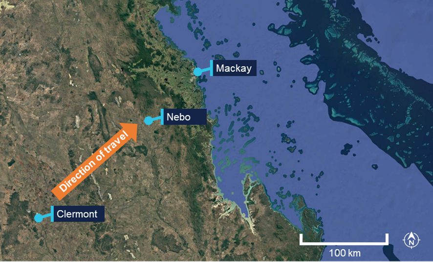
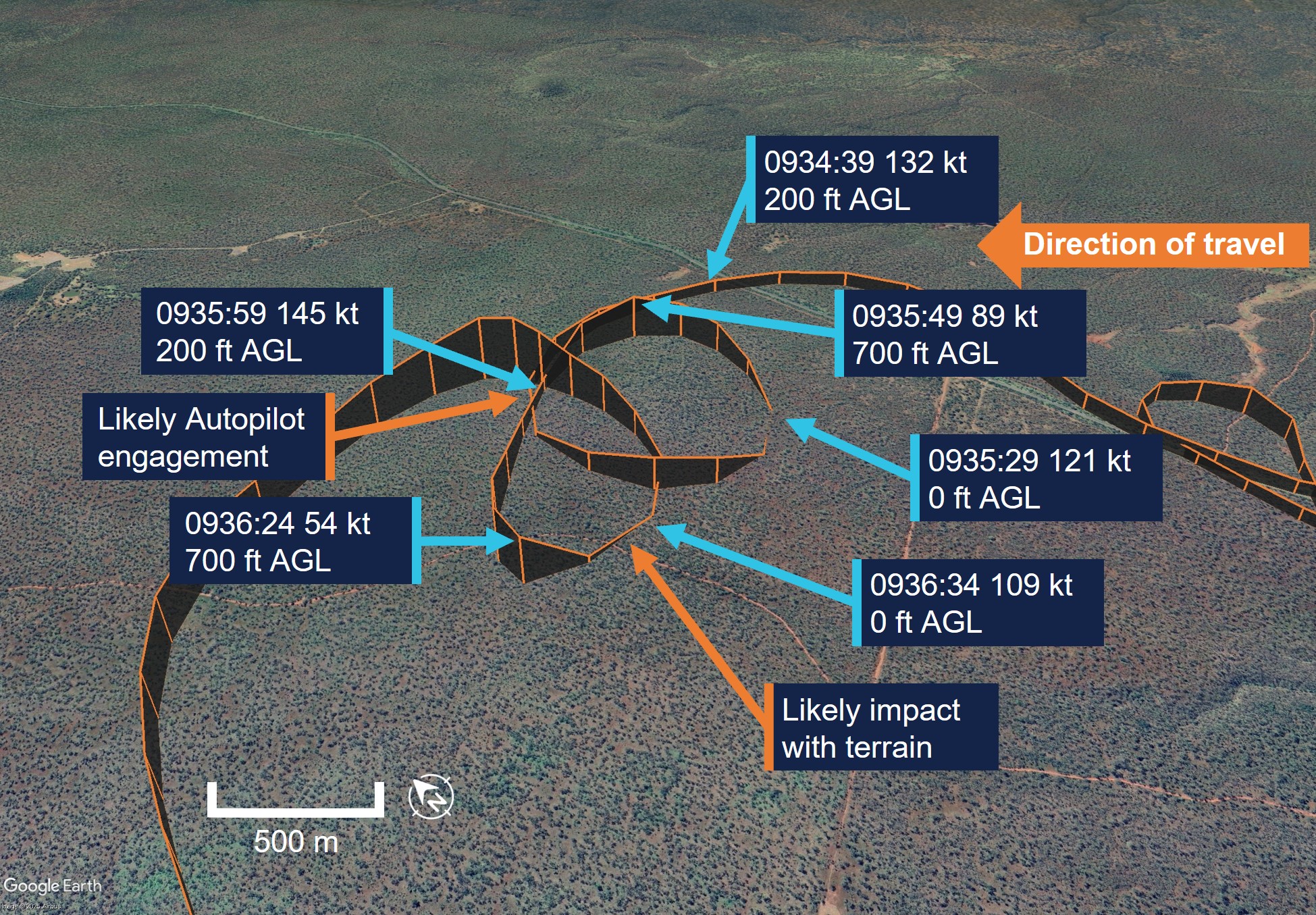
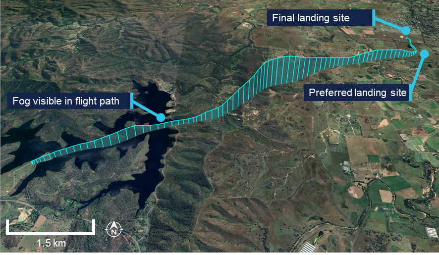
On 20 March 2026, the pilot of a Cessna 206H was conducting a private flight from a private property north-north-east of Clermont, to Mackay, Queensland (Figure 1). The flight was conducted under visual flight rules (VFR).[1]
Figure 1: Flight path direction
Source: Google Earth, annotated by the ATSB
Prior to departure, the pilot reviewed various aviation weather forecasts from the Bureau of Meteorology and the Windy.com application. The pilot also contacted air traffic control (ATC) at Mackay Tower via phone for the local weather. The controller stated that conditions to the south‑west of the field on the pilot’s planned track were not visual meteorological conditions (VMC)[2] and that the visibility was poor at Mackay.
The pilot reported they were unable to recall the specific details of the discussion, however noted that cloud and rain bands were passing through the area and had assessed the conditions as suitable for flight. The aircraft departed approximately 30 minutes later at 1722.
At approximately 1816, while on descent to Mackay, the pilot encountered a rain band and altered their track north in an attempt to maintain VMC. They considered turning back and diverting to their nominated alternate aerodrome, Nebo (Figure 1), however visibility continued to deteriorate, and the pilot was conscious of the elevated terrain in the area.
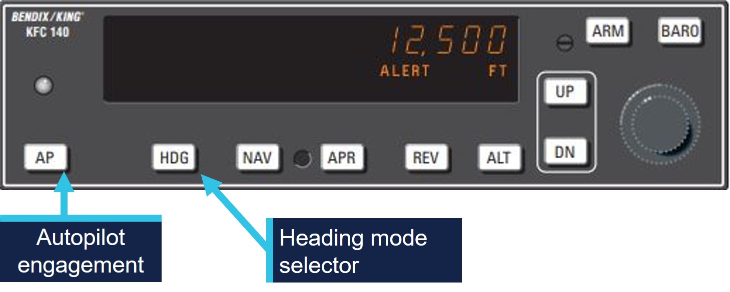
At this time, there was approximately 20 minutes of usable daylight remaining to maintain a discernible horizon and visual reference to the ground. The pilot initiated a climb, monitored the instruments, and activated the autopilot to keep the wings level as a precaution against spatial disorientation.
A tower controller at Mackay observed the aircraft on their tower situational awareness display (TSAD)[3] to the south‑west of the aerodrome, outside of controlled airspace and tracking for Mackay. The aircraft drew the controller’s attention as it was descending while changing track. The controller tried to contact the aircraft and established communication on the second attempt.
On initial contact, the controller confirmed that the aircraft was not operating in VMC, advised the pilot of the applicable minimum sector altitude (MSA),[4] and suggested the pilot climb to 5,000 ft to achieve a safe altitude. The pilot climbed and advised the controller that the autopilot was activated.
The tower controller then informed other parties of the aircraft inadvertently entering IMC,[5] including: the relevant approach controller, the Mackay Aviation Rescue Fire Fighting Service (ARFF), and the Mackay airport safety officer (ASO).
The tower controller established that the aircraft had one person on board and 5 hours of endurance. They suggested the pilot track to the east for Mackay once the aircraft reached 5,000 ft. During this time, the aircraft remained in IMC.
The aircraft was then transferred to the approach controller who provided assistance to the pilot to facilitate a safe descent. Once the pilot reported visual conditions, the aircraft was transferred back to the tower controller, who issued a visual approach and landing clearance. The aircraft landed without further incident at 1831, and all relevant parties were notified.
Safety message
The ATSB booklet Accidents involving Visual Flight Rules pilots in Instrument Meteorological Conditions (AR-2011-050, revised 2019) provides guidance on avoiding VFR into adverse weather. The booklet highlights that conducting thorough pre-flight planning is the best defence against flying into deteriorating weather. Pilots are encouraged to make conservative decisions when considering how forecast weather may affect their flight. Establishing a ‘personal minima’ can help to provide additional operational margins which account for factors such as weather, time of day, experience and recency. VFR flight into forecast or observed non-visual conditions exponentially increases the risk of a VFR into IMC scenario.
For pilots operating under VFR, inadvertent entry into IMC can be a disorienting experience due to the loss of external visual references required to maintain aircraft attitude and orientation. If a VFR pilot enters IMC, seeking assistance from ATC, where available, can support the pilot to manage the situation and achieve a safe outcome.
In addition, where fitted and the pilot is appropriately trained in its use, the autopilot can also assist in maintaining stable aircraft control following inadvertent entry into IMC. Pilots are encouraged to become familiar with the operation and limitations of installed autopilot systems to support effective use in such circumstances.
About this report
Decisions regarding whether to conduct an investigation, and the scope of an investigation, are based on many factors, including the level of safety benefit likely to be obtained from an investigation. For this occurrence, no investigation has been conducted and the ATSB did not verify the accuracy of the information. A brief description has been written using information supplied in the notification and any follow-up information in order to produce a short summary report, and allow for greater industry awareness of potential safety issues and possible safety actions.
[1]Visual flight rules (VFR): a set of regulations that permit a pilot to operate an aircraft only in weather conditions generally clear enough to allow the pilot to see where the aircraft is going.
[2]Visual Meteorological Conditions (VMC): an aviation flight category in which visual flight rules (VFR) flight is permitted – that is, conditions in which pilots have sufficient visibility to fly the aircraft while maintaining visual separation from terrain and other aircraft.
[3]A Tower Situational Awareness Display (TSAD) provides limited surveillance information to tower controllers.
[4]Minimum Sector Altitude (MSA) is the lowest altitude which may be used which will provide a minimum clearance of 1000 FT above all objects located in an area.
[5]Instrument meteorological conditions (IMC): weather conditions that require pilots to fly primarily by reference to instruments, and therefore under instrument flight rules (IFR), rather than by outside visual reference. Typically, this means flying in cloud or limited visibility.
Occurrence summary
Mode of transport
Aviation
Occurrence ID
AB-2026-022
Occurrence date
20/03/2026
Location
Near Mackay Airport
State
Queensland
Occurrence class
Serious Incident
Aviation occurrence category
VFR into IMC
Highest injury level
None
Aircraft details
Manufacturer
Cessna Aircraft Company
Model
206H
Sector
Piston
Operation type
Part 91 General operating and flight rules
Activity
General aviation / Recreational-Own business travel
At 0834 Australian Eastern Standard Time on 13 March 2026, a Robinson R44 II helicopter, registered VH-TCF, departed from Gold Coast, Queensland, for a private flight to Mudgee, New South Wales (NSW), with an intermediate stop at Armidale, NSW, to refuel.
The pilot’s iPhone crash alarm activated, 72 minutes after the aircraft departed, and the wreckage was located the following day in dense bushland, 46 km north-east of Tenterfield, NSW. The pilot sustained fatal injuries and the helicopter was destroyed.
What the ATSB found
The ATSB found that it was very likely the pilot entered weather conditions unsuitable for visual flight, resulting in a loss of control and subsequent collision with terrain.
Safety message
The ATSB encourages all pilots, no matter what their experience levels, to develop the knowledge and skills required to avoid unintentional operations in instrument meteorological conditions (IMC). This includes having alternate plans in case of unexpected changes in weather, and making timely decisions to land, turn back, divert or hold in an area of clear weather. The use of a ‘personal minimums’ checklist can also be a strong mitigator against the risk of flying into bad weather.
The Vertical Aviation Safety Team, formally known as the International Helicopter Safety Team, has published several fact sheets about inadvertent IMC (IIMC) that are available from their website. Their fact sheet, Inadvertent entry into instrument meteorological conditions (IIMC), acknowledges that these encounters are the ‘most demanding, disorienting, and dangerous conditions a pilot can experience’ and result in the highest percentage of fatal injuries from helicopter accidents.
The fact sheet explained the immediate actions required by pilots in IIMC stating that:
A pilot’s immediate actions after encountering inadvertent IMC will determine the outcome of the entire event. Pilots who possess a plan of action prior to encountering it are more likely to experience a successful outcome (staying alive) than those who are less trained and proficient in the recognition and recovery procedures.
In addition, their fact sheet stated that:
Comprehensive training on IIMC is necessary for all rotorcraft helicopter training. This training should include, but not limited to:
• Determination of enroute weather
• Avoidance of inadvertent flight into instrument meteorological conditions
• In-flight weather abort procedures
• Recovery from inadvertent flight into instrument meteorological conditions.
The ATSB booklet Accidents involving visual flight rules pilots in instrument meteorological conditions (AR-2011-050) provides guidance on avoiding flight into adverse weather. Further information specific to helicopter pilots is also available on the ATSB website.
The investigation
The ATSB scopes its investigations based on many factors, including the level of safety benefit likely to be obtained from an investigation and the associated resources required. For this occurrence, the ATSB conducted a limited-scope investigation in order to produce a short investigation report, and allow for greater industry awareness of findings that affect safety and potential learning opportunities.
The occurrence
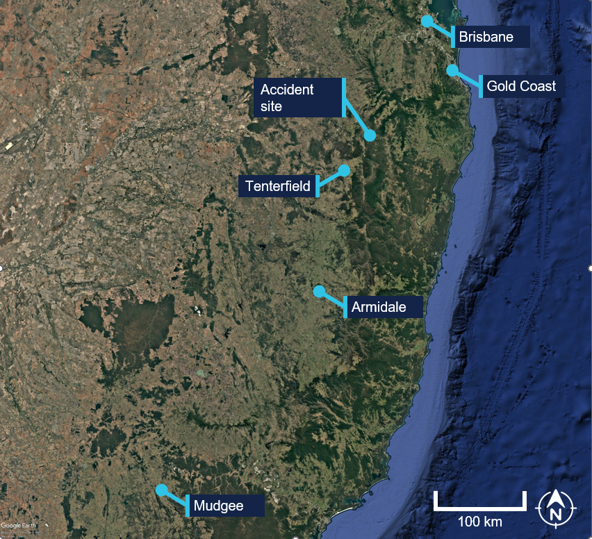
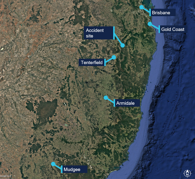
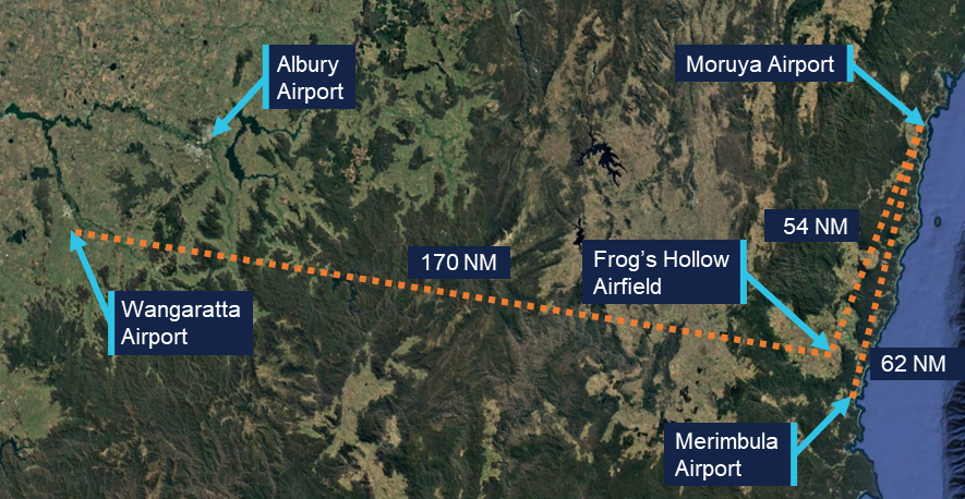
On 13 March 2026, the pilot and sole occupant of a Robinson R44 II helicopter, registered VH-TCF, planned to conduct a private flight under the visual flight rules (VFR),1 from Gold Coast, Queensland, to Mudgee, New South Wales (NSW), with an intermediate stop at Armidale, NSW, to refuel (Figure 1).
Figure 1: Map showing accident site and key locations
Source: Google Earth, annotated by the ATSB
The pilot was intending to travel over 3 days, to join a helicopter safari in southern Victoria with the intention of flying around Tasmania. A relative of the pilot reported that the pilot was ‘very excited about the trip’. They further advised that the pilot had been monitoring the weather in the days leading up to the departure and was expecting clear conditions for the flight.
At about 0834 Australian Eastern Standard Time (AEST),2 the helicopter departed from a private helipad, around 35 km from the Gold Coast Airport.
NSW Police advised that an automated emergency message associated with activation of the pilot’s iPhone crash alarm3 was received at 1046 Australian Eastern Daylight saving Time (AEDT),4 72 minutes after the aircraft departed. In response, a formal search was commenced by NSW Police.
The wreckage was located at 1113 AEDT on 14 March 2026, in dense bushland, 46 km north-east of Tenterfield, NSW. The pilot sustained fatal injuries and the helicopter was destroyed.
Context
Pilot information
Flight experience
The pilot held a Private Pilot Licence (Helicopter) and a single‑engine helicopter class rating. The pilot did not hold an instrument rating and had not logged any instrument flight time. As of 7 March 2026, the pilot’s logbook showed they had accrued about 1,262 hours total flight time, 84 of which were accrued on an R22. The remaining hours were obtained operating R44 helicopters, with all but 11.5 in VH-TCF. The pilot completed their last flight review on 21 September 2025. The instructor who conducted the review reported that it included ground theory training followed by a 1‑hour flight, and a second 1-hour flight the following day, consistent with entries in the pilot’s logbook. The instructor reported discussing interpretation of a weather forecast with the pilot, but did not require, or observe the pilot demonstrate, planning a flight based on the weather forecast. The instructor described the pilot as a ‘confident and comfortable’ pilot.
Medical information
At the time of the accident, the pilot was 77 years old. Their class 2 aviation medical certificate application was completed by a designated aviation medical examiner on 5 September 2025 and was valid to 5 September 2026. The certificate had the following limitations:
Must use [continuous positive airway pressure] CPAP in sleep period prior to exercising privileges of medical certificate.
Reading correction to be available whilst exercising the privileges of this licence.
Records obtained from the CPAP provider showed that the pilot was regularly using the CPAP machine as required.
The ATSB reviewed the pilot’s CASA aviation medical history since 2017. While the pilot had multiple conditions that increased the risk of medical incapacitation, these had been disclosed to CASA and were assessed as being adequately controlled.
The pilot was reported to have slept normally the night before the accident and had eaten breakfast before departing. There was no evidence to indicate the pilot was unwell, nor experiencing a level of fatigue known to affect performance.
The post-mortem did not identify any evidence of incapacitation, however, toxicology results were not available at the time of report writing.
Aircraft information
General information
The Robinson R44 II is a 4-seat helicopter, powered by a single Textron Lycoming IO‑540‑AE1A5 piston engine, driving a 2‑blade semi-rigid main rotor system and 2‑blade tail rotor system. VH-TCF, serial number 11912, was manufactured in the United States in 2007 and first registered in Australia in October 2007.
The helicopter was being maintained in accordance with the Robinson Helicopter R44 maintenance manual, the Lycoming IO-540 operator’s manual, supplemental type certificates and engineering orders. Its last periodic inspection was conducted on 13 February 2026 at 2,103.4 hours. Prior to the commencement of the accident flight, VH-TCF had accumulated 2,104.7 hours total time in service. It was equipped and maintained to a day visual flight rules standard, with the maintenance release reflecting this limitation.
The helicopter was equipped with lap sash seat belts and was being operated with the doors fitted.
Rotor system
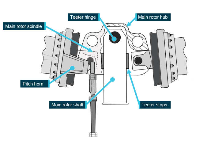
The Robinson R44 main rotor hub assembly is a semi-rigid rotor head, otherwise known as a teetering rotor head (Figure 2). Bolts secure the blades to the hub at the coning hinges. During stopping and starting of the main rotor, when RPM is low, blade tusks rest against droop stops, restricting teetering and preventing the blades from drooping. As the main rotor RPM increases, the blades straighten and become rigid due to rotational forces, and the tusks shift off the droop stops. During normal flight, the rotor is free to teeter and flap around its designed flight axis via the teeter hinge, while polyurethane teeter stops limit the degree of teetering.
Under certain flight conditions, semi-rigid rotor systems are susceptible to extreme teetering where the blades teeter beyond their normal operational range, resulting in what is commonly known as ‘mast bumping’ (see the following section titled Mast bumping).
Figure 2: Robinson main rotor hub assembly
Image modified to remove spindle tusk and droop stop bolt for clarity. Source: Robinson Helicopter Company, modified and annotated by the ATSB
Mast bumping
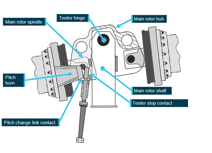
Mast bumping is the common term used to describe contact of the main rotor shaft, by the inboard main rotor spindle (Figure 3).
Mast bumping severity can generally be identified by extensive damage to, including destruction of, the teeter stops and varying degrees of damage to the main rotor shaft from direct impact.
Extreme teetering can also result in the pitch change links exceeding their maximum displacement and often results in failure of one or both pitch links, typically at the upper rod end thread. Failure of a pitch link will allow uncontrolled rotation of the blade about its pitch axis and at this point, control of the helicopter is no longer possible. As documented in many investigation reports worldwide, scenarios involving mast bumping have been attributed to inappropriate flight control inputs that permit the development of, and/or inappropriate response to, low g5 flight conditions.
Figure 3: Extreme mast bump
Image modified to remove spindle tusks and droop stop bolts for clarity. Source: Robinson Helicopter Company, annotated by the ATSB
Site and wreckage information
Accident site
The accident site was located about 46 km north-east of Tenterfield Airport in a densely vegetated area. It was situated on the southern side of a steep slope, at an elevation of about 900 m (2,950 ft).
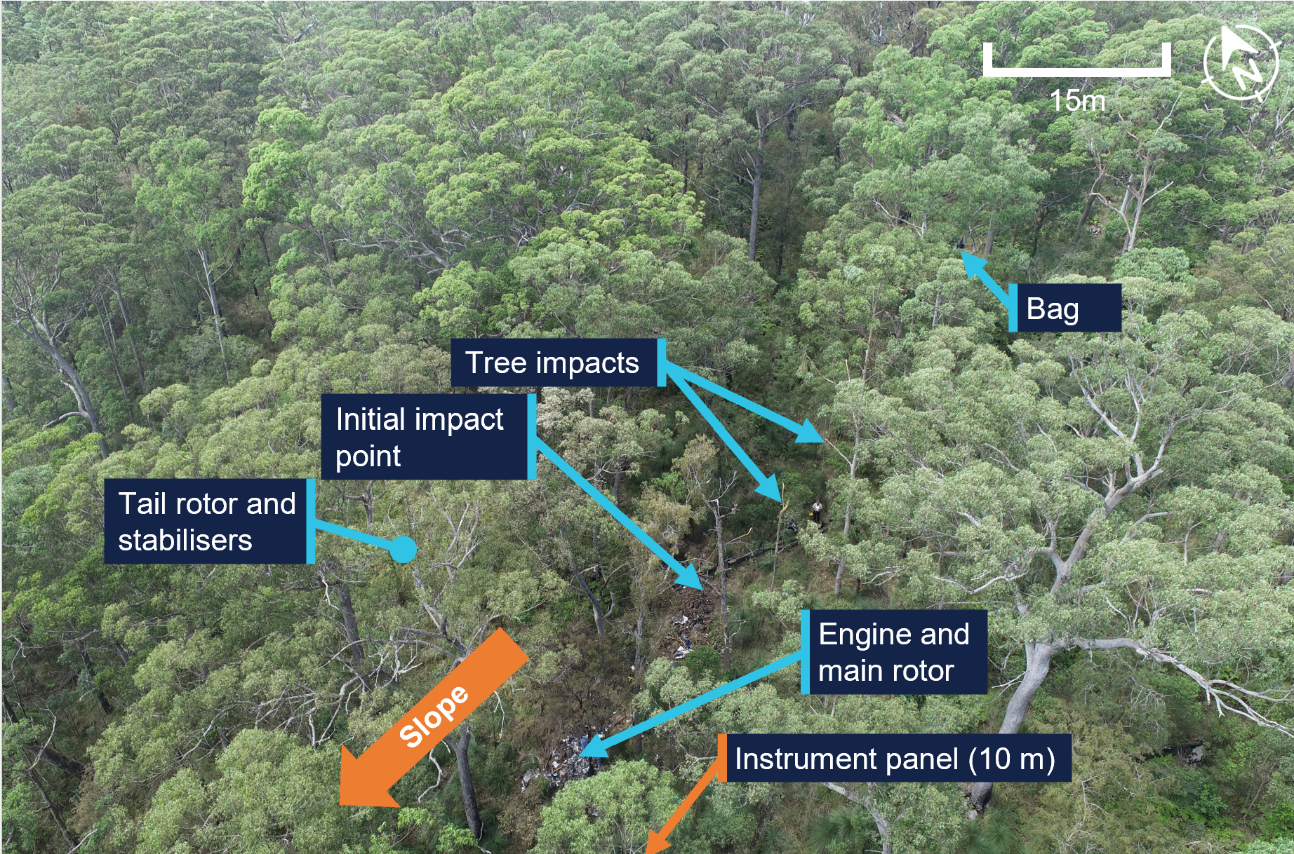
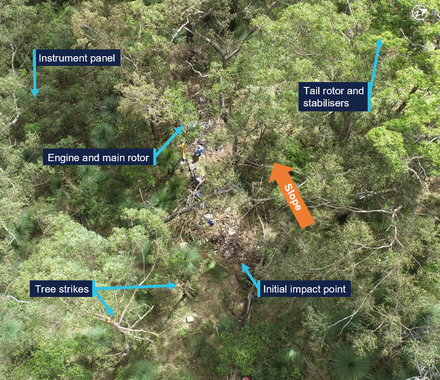
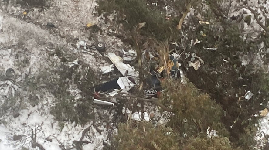
The wreckage trail was approximately 12 m long in a westerly direction (Figure 4). It consisted of an initial impact point, followed by a trail of debris down the slope leading to the fuselage, engine and main rotor, much of which were consumed by a post-impact fire. Damage was evident on 2 trees located near the initial impact point, indicating the helicopter had struck these trees in a near vertical descent.
Figure 4: Accident site
Source: ATSB
The aft section of the tailcone assembly, including the tail rotor and stabilisers, had separated from the fuselage and was located approximately 20 m from the fuselage across the slope through dense vegetation (Figure 4). A large, soft shell travel bag was located in the tree canopy (Figure 4), around 12 m upslope from the initial impact with the trees. Various other items from within the helicopter, such as a headset, were located between the bag and the initial impact site, indicating they had been liberated from the helicopter above the tree line, prior to the initial impact point.
The main instrument panel was located a further 10 m down the slope away from the fuselage.
Wreckage examination
Disruption to the helicopter and post-impact fire damage precluded a detailed examination of a significant proportion of the helicopter. This included testing of electrical and fuel system components and the determination of engine controls and instrument panel switch selections.
The intensity of the post-impact fire was indicative of a considerable amount of fuel on board the helicopter. A fuel jerry can, which had been filled at the helicopter’s departure location, was found on site. The contents were consistent with avgas, and testing showed no presence of water in the fuel.
Main rotor assembly
Examination of the main rotor components identified:
the main rotor hub was secure to the main rotor shaft, which was secure to the main rotor transmission
both main rotor blade tips were located within the accident site
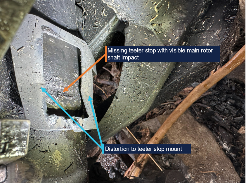
one teeter stop had fractured in the centre due to severe impact forces from the spindle, with the upper half liberated
the other teeter stop was not present (Figure 5)
both teeter stop stainless steel mounts exhibited distortion from spindle impact (Figure 5)
impact damage to the main rotor shaft at both teeter stop locations (Figure 5).
Figure 5: Example of damage to teeter stop and main rotor shaft on one side
Source: ATSB
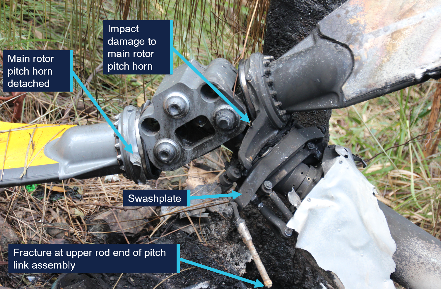
both main rotor pitch change links had fractured in overstress, at the upper rod end thread (Figure 6)
one pitch horn had detached, with the fracture surface consistent with overstress (Figure 6)
the other pitch horn was secured to the spindle and exhibited damage consistent with contact with the main rotor hub (Figure 6).
Figure 6: Main rotor hub
Source: ATSB
Tailcone separation
The aft section of the tailcone was located around 20 m to the right of the wreckage trail with limited damage to the structure. Signature marks where it had separated from the tail boom, the lack of structural damage and its location, were consistent with the tailcone likely separating above the trees during the accident sequence, rather than it being a precursor to the accident.
Other systems
Where flight control tubes had been destroyed by impact or fire, the integrity of the control system was limited to confirming the connection at their respective attachment points and for the presence of securing hardware. In that context, no defects were identified. Further, fracture surfaces of rod ends, and other flight control components were consistent with overstress failure.
The examination also identified the following:
all major components were identified at the site
damage to the cooling fan was indicative of the engine rotating at the time of impact
damage to, and location of, the instrument panel (Figure 4) was consistent with a high energy liberation event, possibly from a main rotor strike.
Recorded data
Although the pilot was reportedly using the OzRunways6 electronic flight bag software, which provided a map overlaying the helicopter’s GPS location to aid in navigation, no track data was transmitted to the service provider. There were no other recording devices on board the helicopter.
VH-TCF was identified on WebTrak7 around Gold Coast Airport. It showed the helicopter tracking roughly south-west at about 3,000 ft, before crossing the NSW border at 0854 AEST. This service then stopped recording the helicopter’s position.
Airservices’s secondary radar further detected unidentified aircraft returns in the vicinity of the accident site, however, these could not be confirmed as VH-TCF.
Weather information
Forecasts
The Bureau of Meteorology (BoM) terminal area forecast (TAF)8 issued at 0612 AEST on 13 March 2026 and valid from 0700 AEST for the Gold Coast Airport included:
visibility greater than 10 km with scattered cloud at 1,000 ft and broken9 cloud at 1,600 ft
from 0800 AEST, light showers of rain and broken cloud at 2,000 ft
a TEMPO10 between 0700–0900 AEST visibility greater than 10 km with broken cloud at 1,000 ft
a TEMPO between 0900–1800 AEST included visibility of 3,000 m, showers of rain and broken cloud at 1,000 ft and few towering cumulous at 2,000 ft
an INTER11 between 1800 AEST on 13 March and 0400 on 14 March included visibility of 4000 m, showers of rain and broken cloud cover at 1,200 ft
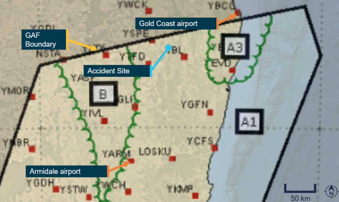
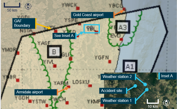
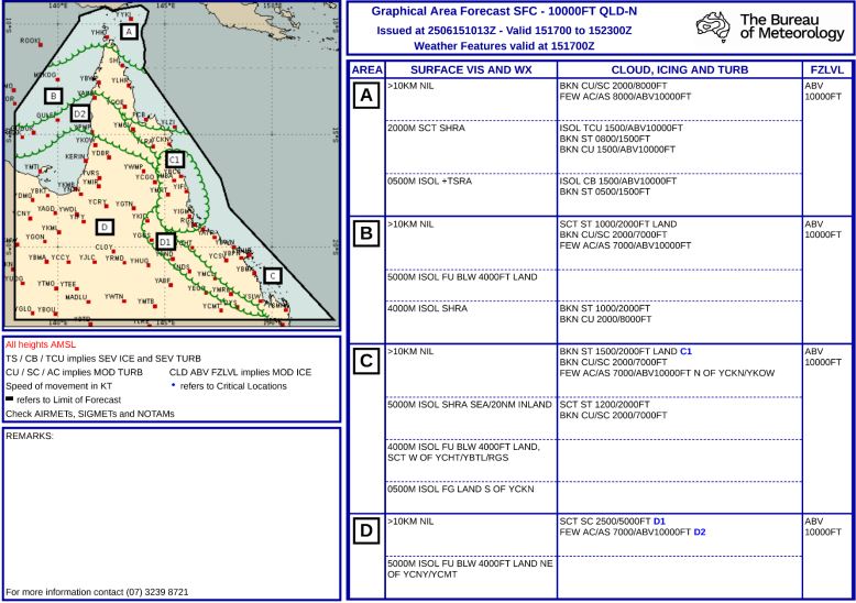
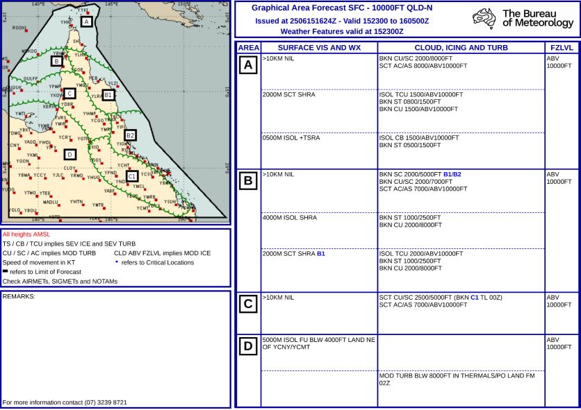
The BoM graphical area forecast (GAF),12 issued at 0809 AEST on 13 March 2026 for the area encompassing the flight path south of Gold Coast to the accident site (Figure 7) included:
visibility greater than 10 km with broken stratus with bases at 1,500 ft and tops at 2,000 ft and broken stratocumulus with bases at 2,000 ft and tops to 9,000 ft
visibility 4,000 m in isolated13 showers of rain with broken stratus with bases at 1,000 ft and tops at 2,000 ft, and broken cumulus/stratocumulus with bases at 2,000 ft and tops to 9,000 ft
visibility 3,000 m in isolated drizzle with broken stratus with bases at 800 ft and tops at 2,000 ft, and overcast stratocumulus with bases at 2,000 ft and tops to 9,000 ft
in a small coastal area just south of Gold Coast, isolated thunderstorms and rain were forecast, reducing visibility to 2,000 m with associated cumulonimbus with bases at 2,000 ft and tops above 10,000 ft, broken stratus with bases at 500 ft and tops at 2,000 ft, and broken cumulus/stratocumulus with bases at 2,000 ft and tops above 10,000 ft.
Figure 7: Geographical area forecast
Source: Bureau of Meteorology, annotated by the ATSB
The previous GAF issued at 0226 on the morning of 13 March reflected essentially the same expected weather conditions without the forecast small area of thunderstorms. An AIRMET14 valid from 0624 to 1024, was also issued for isolated thunderstorms in that area.
The aerodrome forecast (TAF) for the pilot’s first intended stop at Armidale Airport, NSW, issued at 0422 EDT and valid 0600–1900 on 13 March included:
wind from 080° at 8 kt
visibility greater than 10 km
cloud broken at 400 ft (TAF cloud heights are above aerodrome elevation).
During the period 0900–1100:
wind from 100° at 12 kt
visibility greater than 10 km
light showers of rain
scattered cloud at 3,000 ft
temperature 16°C at 0600 and 19°C at 0900
QNH 1,016 hPa at 0600 and 1,019 hPa at 0900.
Weather observations
The Gold Coast aerodrome observations (METAR)15 at 0830 AEST on the accident morning were:
wind from 170° at 9 kt
visibility greater than 10 km
few cloud at 1,500 ft (cloud heights above aerodrome elevation)
scattered cloud at 2,000 ft
broken cloud at 2,500 ft
temperature 27°C and dew point 24°C
QNH 1,013 hPa
Distant lightning strikes were reported at 0800 and 0930.
Satellite imagery
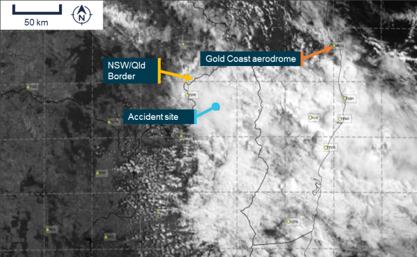
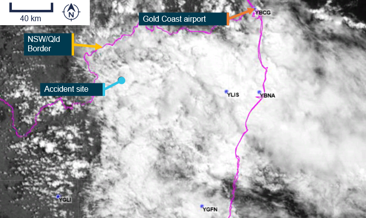
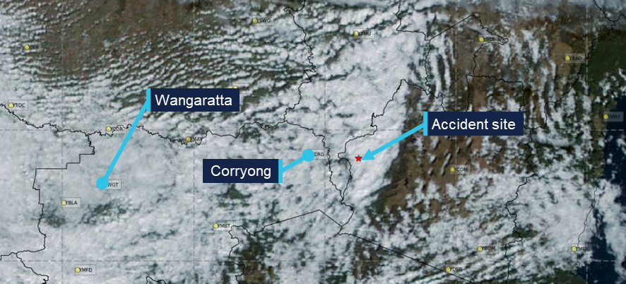
High resolution visible satellite imagery showed extensive cloud extending inland to the NSW/Queensland border, including at the accident site (Figure 8).
Figure 8: Satellite cloud imagery at 1040 AEST (6 minutes before the accident)
Source: Satellite image processed by the Bureau of Meteorology from the geostationary meteorological satellite Himawari-9, operated by the Japan Meteorological Agency, annotated by the ATSB
Witness reports
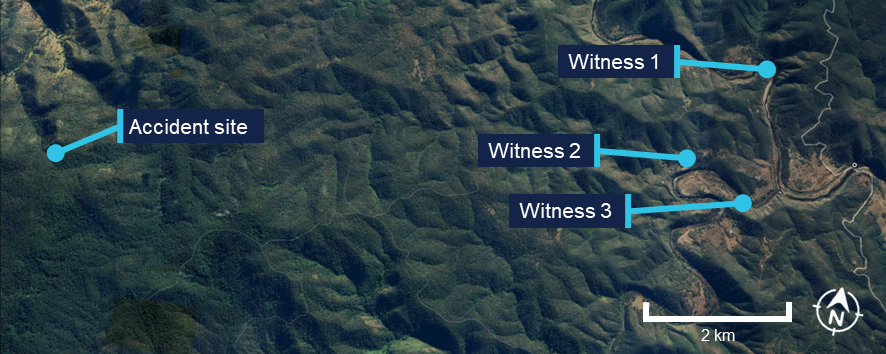
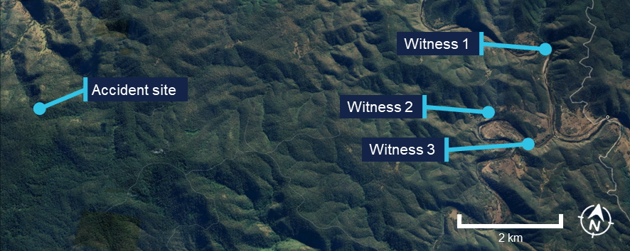
Several witnesses located near the accident site (Figure 9) reported very low cloud and drizzle on the morning of the accident. They stated that they observed a helicopter flying very low, ‘before lunchtime’ on the day. All witnesses reported that it was unusual to see a helicopter in the area, but this one was particularly unusual due to its low altitude.
In addition, one witness stated that the helicopter seemed to be stuck below cloud and remarked to their partner that it ‘looks like it’s trying to find a way out’. Another witness recalled waving at the helicopter and stated that it passed them twice before heading west.
Figure 9: Witness locations
Source: Google Earth, annotated by the ATSB
Operational information
Visual meteorological conditions
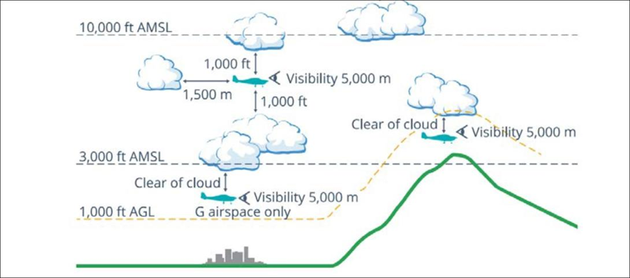
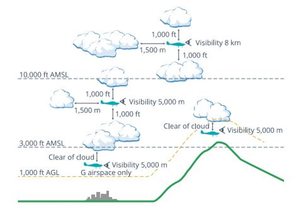
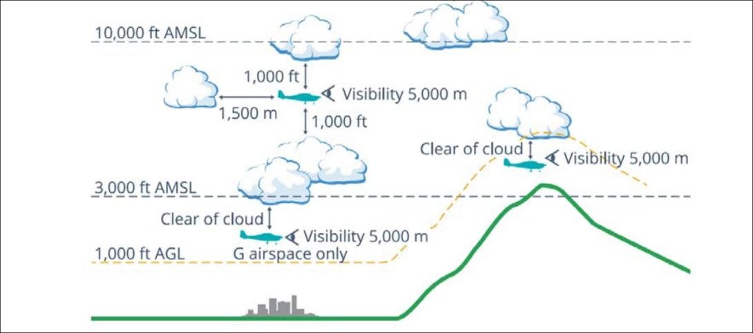
For flights under the VFR, the Civil Aviation Safety Regulations (CASR) Part 91 Manual of Standards (MOS) specified criteria for visual meteorological conditions (VMC)16 in terms of visibility and distance from cloud. The criteria for all aircraft operating in Class G (non‑controlled) airspace were:
At or below whichever is the higher of 3,000 ft AMSL and 1,000 ft above ground level (AGL):
visibility 5,000 m
clear of cloud
aircraft must be operated in sight of ground or water.
For helicopters (rotorcraft) operating below 700 ft over land in non‑controlled airspace (and not within 10 NM of an aerodrome with an instrument approach procedure), the criteria were:
flight visibility 800 m
clear of cloud
by day
at a speed that allows the pilot to see obstructions or other traffic in sufficient time to avoid a collision, and
if not more than 10 NM from an aerodrome with an IAP — in a way that ensures the flight maintains a separation of at least 500 ft vertically from any aircraft that is: less than 10 NM from the aerodrome; and conducting an IFR operation.
Flight planning requirements
Under section 7.02 Forecasts for flight planning, the MOS required that pilots study the appropriate authorised weather forecasts and reports. This included:
the route to be flown
the departure aerodrome, the planned destination aerodrome and any planned alternate aerodrome
any other reasonably available weather information that is relevant to the intended operation.
The pilot did not submit a flight plan and was not required to submit one for a private VFR flight in Class G airspace.
National aeronautical information processing system (NAIPS) records showed that weather information was accessed by the pilot’s account at 0740 and 0745 on 13 March 2026. The pilot had requested a location briefing for the Gold Coast aerodrome. In making this selection, a pilot may also select the graphical area forecast, however, the data did not record if this was requested, therefore the ATSB could not verify if the pilot had viewed this forecast.
The pilot did not request a location briefing for their first destination at Armidale. Although they requested a location briefing for Tenterfield, the Bureau of Meteorology did not issue aerodrome forecasts for Tenterfield Airport.
Spatial disorientation
Spatial disorientation occurs when a pilot does not correctly sense their aircraft’s attitude, airspeed, or altitude in relation to the earth’s surface. It is often described simply as the inability to determine ‘which way is up’, although the effects can often be more subtle than implied by that description.
Spatial disorientation occurs when the brain receives conflicting or ambiguous information from the sensory systems. It is likely to happen in conditions in which visual cues are poor or absent, such as in adverse weather or at night. It presents a danger to pilots, as the resulting confusion can often lead to incorrect control inputs and resultant loss of aircraft control. The flight control sensitivity and relative instability of helicopters compared to aeroplanes increases the risk of such a control loss.
VFR into IMC occurrences
Between 2015 and 2025 there were 116 VFR into instrument meteorological conditions (IMC)17 occurrences in Australian airspace reported to the ATSB. Of these, 13 were fatal accidents resulting in 24 fatalities. Based on these figures, approximately 1 in every 9 reported VFR into IMC occurrences results in a fatality.
For non-instrument rated pilots, entering IMC can quickly become fatal. Research has shown that pilots not proficient in instrument-only flight will typically become spatially disoriented and lose control of the aircraft within 1–3 minutes after visual cues are lost.
CASA’s flight safety article ‘Every which way but loose’ stated that:
the inherent instability of a helicopter means that even an [instrument flight rules] IFR-rated pilot who is proficient and enters cloud in a helicopter not designed for instrument flight will have difficulty maintaining control. Without the normal strong visual cues of a horizon, the pilot will quickly experience dynamic instability and be fighting the aircraft to maintain a stable altitude and airspeed.
Safety analysis
Prior to the flight, the pilot obtained a meteorological location briefing for the Gold Coast, which may have included a graphical area forecast. Although it was reported the pilot expected clear conditions for the flight to Armidale, there were several layers of cloud at Gold Coast Airport forecast at the time the pilot obtained the briefing, and at the time of departure. Further, the area forecast showed that there were likely to be extensive areas of low cloud, with low visibility along the flight path. This did not preclude the pilot from commencing the flight, but it did indicate a high likelihood of encountering conditions unsuitable for flight under the visual flight rules that would require a diversion or landing.
The available tracking data showed that the helicopter initially tracked south-west at around 3,000 ft, towards the NSW border. However, as the electronic flight bag software was not set to transmit the flight data, there was no further flight data available.
The graphical area forecast and satellite imagery was consistent with witness statements that there was thick cloud and precipitation in the area at the time of the accident. As such, it was very likely that the helicopter entered an area where there was low cloud and/or low visibility in precipitation.
While the ATSB could not rule out that the pilot applied a large control input due to avoiding a bird or terrain, it is very likely that without instrument training or an appropriately equipped aircraft, when they encountered low visibility conditions, they became spatially disorientated and applied inappropriate control inputs.
Consistent with this, the wreckage examination identified signatures of the main rotor assembly being subject to excessive teeter and mast bumping that resulted in both pitch links failing. Following this, the main rotor blades were free to rotate through various pitch angles, and the helicopter was no longer controllable.
The location of the bag and other items from inside the cabin at the accident site was indicative of main rotor contact with the cabin while airborne. In addition, the vertical path through the tree canopy was consistent with a complete loss of control prior to the collision with terrain.
While the evidence showed that the engine was operating when the accident occurred, a transient condition such as a partial or complete power loss could not be ruled out, although such an event should not have resulted in a loss of control. Further, there was no evidence to indicate that the pilot became incapacitated prior to the accident sequence due to a pre-existing medical condition.
Contributing factor
It was very likely that the pilot entered flight conditions unsuitable for visual flight, resulting in a loss of control and subsequent collision with terrain.
Findings
ATSB investigation report findings focus on safety factors (that is, events and conditions that increase risk). Safety factors include ‘contributing factors’ and ‘other factors that increased risk’ (that is, factors that did not meet the definition of a contributing factor for this occurrence but were still considered important to include in the report for the purpose of increasing awareness and enhancing safety). In addition ‘other findings’ may be included to provide important information about topics other than safety factors.
These findings should not be read as apportioning blame or liability to any particular organisation or individual.
From the evidence available, the following findings are made with respect to VFR into IMC and collision with terrain involving Robinson R44 II, VH-TCF, 46 km north-east of Tenterfield, New South Wales, on 13 March 2026.
Contributing factors
It was very likely that the pilot entered conditions unsuitable for visual flight, resulting in a loss of control and subsequent collision with terrain.
Sources and submissions
Sources of information
The sources of information during the investigation included:
a relative of the pilot
Civil Aviation Safety Authority
New South Wales Police Force
maintenance organisation for VH-TCF
accident witnesses
recorded data from Airservices Australia (WebTraks)
Civil Aviation Safety Regulations (2025), Part 91 Manual of Standards
Reinhardt, B. (2020), Every which way but loose, Flight Safety Australia, Civil Aviation Safety Authority
United States Helicopter Safety Team (2023), Training Fact Sheet – Inadvertent Entry into Instrument Meteorological Conditions (IIMC)
Submissions
Under section 26 of the Transport Safety Investigation Act 2003, the ATSB may provide a draft report, on a confidential basis, to any person whom the ATSB considers appropriate. That section allows a person receiving a draft report to make submissions to the ATSB about the draft report.
A draft of this report was provided to the following directly involved parties:
Civil Aviation Safety Authority
Robinson Helicopter Company
The United States National Transportation Safety Board.
A submission was received from the Civil Aviation Safety Authority. The submission was reviewed and, where considered appropriate, the text of the report was amended accordingly.
Purpose of safety investigations
The objective of an ATSB safety investigation is to improve transport safety through:
identifying safety issues for action by organisations with the responsibility for managing that safety risk
influencing safety action through engaging with stakeholders, communicating findings, and fostering awareness of safety issues and concerns.
In accordance with the TSI Act, the ATSB does not investigate for the purpose of taking administrative, regulatory or criminal action, and cannot apportion blame, assist in determining liability, or, as a general rule, assist in court proceedings.
About ATSB reports
ATSB safety investigation reports are developed in accordance with ATSB procedures and guidelines, and with regard to applicable international standards and instruments.
Reports must include factual material of sufficient weight to support the investigation’s analysis and findings. At all times the ATSB endeavours to balance the use of material that could imply adverse comment with the need to properly explain what happened, and why, in a fair and unbiased manner.
An explanation of terminology used in ATSB investigation reports is available here.
Publishing information
Released in accordance with section 25 of the Transport Safety Investigation Act 2003
Ownership of intellectual property rights in this publication
Unless otherwise noted, copyright (and any other intellectual property rights, if any) in this report publication is owned by the Commonwealth of Australia.
Creative Commons licence
With the exception of the Commonwealth Coat of Arms, ATSB logo, and photos and graphics in which a third party holds copyright, this report is licensed under a Creative Commons Attribution 4.0 International licence.
The CC BY 4.0 licence enables you to distribute, remix, adapt, and build upon our material in any medium or format, so long as attribution is given to the Australian Transport Safety Bureau.
Copyright in material obtained from other agencies, private individuals or organisations, belongs to those agencies, individuals or organisations. Where you wish to use their material, you will need to contact them directly.
^Visual flight rules (VFR): a set of regulations that permit a pilot to operate an aircraft only in weather conditions generally clear enough to allow the pilot to see where the aircraft is going.
^Australian Eastern Standard Time (AEST): Coordinated Universal Time (UTC) + 10 hours
^Apple iPhone Crash Detection is designed to detect severe car crashes — such as front-impact, side-impact and rear-end collisions, and rollovers. If the Apple device has satellite, mobile or Wi-Fi connection, it will automatically call emergency services after a 30-second countdown if the alert is not manually dismissed.
^Australian Eastern Daylight saving Time (AEDT): Coordinated Universal Time (UTC) + 11 hours
^g: an abbreviation for acceleration forces acting on a body with reference to earth’s gravity at sea level. 1 g = 9.8 m/s2.
^OzRunways is an electronic flight bag application that provides navigation, weather, area briefings and other flight
information. It provides the option for live flight tracking by transmitting the device’s position and altitude.
^WebTrak uses information from air traffic control secondary surveillance radars to display aircraft movements.
^A TAF is a statement of meteorological conditions expected for a specified period within a radius of 8 km of the aerodrome reference point.
^Cloud cover: in aviation, cloud cover is reported using words that denote the extent of the cover – ‘few’ indicates that up to a quarter of the sky is covered, ‘scattered’ indicates that cloud is covering between a quarter and a half of the sky, ‘broken’ indicates that more than half to almost all the sky is covered, and ‘overcast’ indicates that all the sky is covered.
^TEMPO: used to indicate significant temporary variations from the prevailing conditions previously given in the forecast. TEMPO is used for periods of 30 minutes or more but less than 60 minutes.
^INTER: used to indicate significant intermittent variations from the prevailing conditions previously given in the forecast. INTER is used for periods of less than 30 minutes.
^In a graphical area forecast (GAF), all cloud heights are above mean sea level (AMSL).
^Weather coverage is given as isolated if it consists of individual features which affect, or are forecast to affect, an area with a maximum spatial coverage of up to 50%.
^AIRMET provides information of certain meteorological phenomena that are not contained in the current area forecast.
^Visual Meteorological Conditions (VMC): an aviation flight category in which visual flight rules (VFR) flight is permitted – that is, conditions in which pilots have sufficient visibility to fly the aircraft while maintaining visual separation from terrain and other aircraft.
^Instrument meteorological conditions (IMC): weather conditions that require pilots to fly primarily by reference to instruments, and therefore under instrument flight rules (IFR), rather than by outside visual reference. Typically, this means flying in cloud or limited visibility.
Preliminary report
Report release date: 30/04/2026
This preliminary report details factual information established in the investigation’s early evidence collection phase, and has been prepared to provide timely information to the industry and public. Preliminary reports contain no analysis or findings, which will be detailed in the investigation’s final report. The information contained in this preliminary report is released in accordance with section 25 of the Transport Safety Investigation Act 2003.
The occurrence
On 13 March 2026, the pilot of a Robinson R44 II helicopter, registered VH-TCF, planned to conduct a private flight from Gold Coast, Queensland, to Mudgee, New South Wales (NSW), with an intermediate stop at Armidale, NSW, to refuel (Figure 1).
Figure 1: Map showing accident site and key locations
Source: Google Earth, annotated by the ATSB
At about 0834 Eastern Standard Time (EST),[1] the helicopter departed from a private helipad on the Gold Coast. The pilot was the sole occupant of the helicopter.
NSW Police advised that an automated emergency message associated with activation of the pilot’s iPhone crash alarm was received at 1046 Eastern Daylight-saving Time (EDT),[2] about an hour and a quarter after the aircraft departed. In response, a formal search was commenced by NSW Police.
The wreckage was located at 1113 EDT on 14 March 2026 in dense bushland near Paddy’s Flat, 46 km north-east of Tenterfield, NSW. The helicopter was destroyed and the pilot sustained fatal injuries.
Context
Pilot information
The pilot held a Private Pilot Licence (Helicopter) and a single‑engine helicopter class rating. The pilot also held a class 2 aviation medical certificate valid to 6 September 2026 with the following limitations:
Must use [continuous positive airway pressure] CPAP in sleep period prior to exercising privileges of medical certificate.
Reading correction to be available whilst exercising the privileges of this licence.
Records obtained from the CPAP provider showed that the pilot was regularly using the CPAP machine and that sleep apnoea was controlled.
As of 7 March 2026, the pilot’s logbook showed they had accrued 1,264.6 hours total flight time.
Aircraft information
VH-TCF was a Robinson R44 II helicopter, manufactured in the United States in 2007 as serial number 11912 and first registered in Australia in 2007. The helicopter was powered by a Textron Lycoming IO-540-AE1A5 engine. VH-TCF was being maintained in accordance with the Robinson R44 maintenance manual and the Lycoming IO-540 engine manual. According to the maintenance release, on the morning of 13 March 2026, the helicopter had a total time in service of 2,104.7 hours. There were no defects recorded.
Site and wreckage information
The accident site was located about 46 km north-east of Tenterfield Airport in a densely vegetated area to the west of Cataract National Park. It was situated on the southern side of a steep slope, at an elevation of about 870 m (2,850 ft).
The wreckage trail was approximately 12 m long in a westerly direction, across and down the slope as shown in Figure 2. It consisted of an initial impact point, followed by a trail of debris that led to the fuselage, engine and main rotors, much of which were consumed by a post-impact fire. The aft section of the tail cone assembly had separated from the fuselage and was located approximately 20 m from the fuselage across the slope.
Figure 2: Accident site
Source: ATSB
Significant damage was evident on 2 trees located near the initial impact point, indicating the helicopter had collided with trees in a near vertical descent. A bag found in the tree canopy, and various other parts from the helicopter, were located around 20 m up the slope from the initial impact site.
The instrument panel and other debris were found further down the slope away from the fuselage location. A fuel jerry can, which had been filled at the helicopter’s departure location, was found onsite. The contents were tested for presence of water, which returned a negative result.
Recorded data
Although the pilot was reportedly using the Oz Runways electronic flight bag software, no track data was transmitted to the service provider.
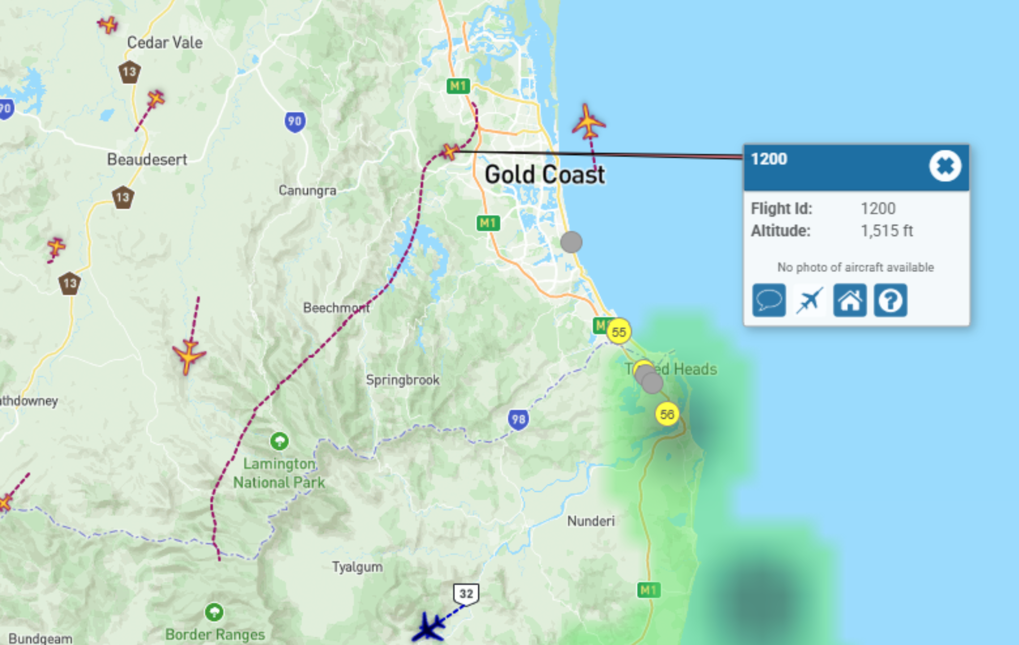
VH-TCF was identified on WebTrak[3] around Gold Coast Airport. It showed that the helicopter tracked roughly south-west before crossing the NSW border at 0854. This service then stopped recording the helicopter’s position (Figure 3).
Figure 3: Aircraft track from departure to the NSW border
Source: Airservices Australia WebTrak
National aeronautical information processing system (NAIPS) records showed that weather information was accessed by the pilot’s account at 0740 and 0745 on 13 March 2026. The requirements of the Aeronautical Information Publication (AIP) ENR 1.10 Flight Planning stated that a pilot must obtain current weather reports and forecasts for the route to be flown, then plan the flight having regard to that information.
Weather information
Forecasts
The Bureau of Meteorology graphical area forecast (GAF),[4] issued at 0809 EST on 13 March 2026 for the area encompassing the flight path south of Gold Coast to the accident site (Figure 4), included:
visibility greater than 10 km with broken[5] stratus with bases at 1,500 ft and tops at 2,000 ft and broken stratocumulus with bases at 2,000 ft tops to 9,000 ft
visibility 4,000 m in isolated[6] showers of rain with broken stratus with bases at 1,000 ft and tops at 2,000 ft, and broken cumulus/stratocumulus with bases at 2,000 ft and tops to 9,000 ft
visibility 3,000 m in isolated drizzle with broken stratus with bases at 800 ft and tops at 2,000 ft, and overcast stratocumulus with bases at 2,000 ft and tops to 9,000 ft
in a small coastal area just south of Gold Coast, isolated thunderstorms and rain were forecast, reducing visibility to 2,000 m with associated cumulonimbus with bases at 2,000 ft and tops above 10,000 ft, broken stratus with bases at 500 ft and tops at 2,000 ft, and broken cumulus/stratocumulus with bases at 2,000 ft and tops above 10,000 ft.
Figure 4: Geographical area forecast and additional weather stations
Source: Bureau of Meteorology and Google Earth, annotated by the ATSB
The previous GAF issued at 0226 on the morning of 13 March contained the same information without the forecast small area of thunderstorms. An AIRMET[7] valid from 0624 to 1024, was also issued for isolated thunderstorms in that area.
High resolution visible satellite imagery shows cloud extending inland to the NSW/Queensland border, including at the accident site (Figure 5).
Figure 5: Satellite cloud imagery at 1000 EST (14 minutes after the accident)
Source: Satellite image processed by the Bureau of Meteorology from the geostationary meteorological satellite Himawari-9, operated by the Japan Meteorological Agency, annotated by the ATSB
The aerodrome forecast (TAF)[8] for the pilot’s first intended stop at Armidale Airport, NSW, issued at 0422 EDT and valid 0600–1900 on 13 March included:
wind from 080° at 8 kt
visibility greater than 10 km
cloud broken at 400 ft (TAF cloud heights above aerodrome elevation).
During the period 0900–1100:
wind from 100°at 12 kt
visibility greater than 10 km
light showers of rain
scattered cloud at 3,000 ft
temperature 16°C at 0600 and 19°C at 0900
QNH 1,016 hPa at 0600 and 1,019 hPa at 0900.
Weather stations
The ATSB also obtained weather data from 2 Weather Underground[9] stations close to the accident site (inset Figure 2):
Site 1: 12.64 km 106° from the accident site at an elevation of about 530 m (Table 1)
Site 2: 10.67 km 084° from the accident site at an elevation of about 200 m (Table 2).
The ultraviolet (UV) index is a simple way of describing the level of UV radiation and can be affected by the amount of cloud cover. According to the Bureau of Meteorology, ‘thick unbroken clouds and rainfall can reduce UV, as thick clouds reflect and absorb more UV that thin cloud cover.’ The UV Index has 5 categories:
low (1–2)
moderate (3–5)
high (6–7)
very high (8–10)
extreme (11 and above).
The weather stations also measured solar irradiance, which is the power of electromagnetic radiation received from the sun, measured in watts per square metre. According to the National Environmental Satellite, Data and Information Service:[10]
When sunlight hits low clouds, a lot of that light – and heat – is reflected back into space. When sunlight hits clouds that are high in the atmosphere, those clouds reflect less sunlight energy. However, these high clouds also trap more heat.
The UV and solar irradiance[11] values from 13 March indicated that there was substantial cloud coverage at both locations on 13 March between 1004–1104 (Table 1 and Table 2). By comparison, on 15 March 2026, when the ATSB attended the accident site and observed a clear day, at 1119, the solar irradiance was recorded at 923 W/m2 and the UV index was 9.
Table 1: Five-minute weather data, site 1
Local time (EDT)
Temp (°C)
Dew point (°C)
Hum.
%
Wind dir.
Wind (kt)
Gust (kt)
Rain mm
Rain mm/hr
UV
Solar (W/m2)
1004
20.8
20.6
99
ENE
4.8
5.6
0
0
1
95.5
1009
20.9
20.7
99
E
3.1
4.5
0
0
1
94.4
1014
20.9
20.7
99
ESE
4.3
5.7
0
0
1
113.1
1018
20.9
20.7
99
E
3.5
4.8
0
0
1
136
1024
21.1
20.8
99
ESE
4.4
5.6
0
0
1
170
1029
21.1
20.8
99
ESE
3.9
5.0
0
0
1
131.6
1034
21.1
20.9
99
E
4.1
5.1
0
0
1
123.9
1039
21.1
20.9
99
E
4.3
4.9
0
0
1
121
1044
21.1
20.8
99
ESE
5.3
6.3
0
0
1
182.3
1049
21.1
20.8
99
ENE
3.0
4.6
0.05
1.27
1
94.3
1054
20.8
20.6
99
E
4.8
6.6
0.1
2.54
1
127.8
1059
20.8
20.6
99
ESE
3.3
5.0
0.1
2.54
1
102
1104
20.5
20.3
99
E
4.9
7.9
0.05
1.27
1
100.5
Table 2: Five-minute weather data, site 2
Local time (EDT
Temp (°C)
Dew point (°C)
Hum.
%
Wind dir.
Wind (kt)
Gust (kt)
Rain mm
Rain mm/hr
UV
Solar (W/m2)
1004
24.0
20.9
83
SSE
2.5
3.0
0
0
1
95.5
1009
23.8
20.9
84
WSW
1.8
2.4
0
0
1
94.4
1014
24.1
20.9
83
ENE
1.1
1.4
0
0
1
113.1
1019
24.3
20.9
82
NW
1.3
1.8
0
0
1
136
1023
24.5
21.0
81
ESE
2.1
3.1
0
0
2
170
1029
24.5
20.8
80
NNE
2.6
3.6
0
0
2
131.6
1034
24.8
20.9
79
ESE
2.0
2.9
0
0
2
123.9
1039
24.6
20.8
80
W
3.5
4.8
0
0
1
121
1044
25.3
21.1
78
NNE
1.7
2.3
0
0
2
182.3
1049
25.6
21.1
77
ENE
2.1
3.2
0
0
2
94.3
1054
25.4
21.1
77
NNW
2.3
3.0
0
0
2
127.8
1059
25.1
20.9
78
ENE
2.4
4.2
0
0
1
102
1104
24.7
21.1
81
ENE
1.9
3.4
0
0
1
100.5
Visual meteorological conditions
For flights under the visual flight rules (VFR),[12] the Civil Aviation Safety Regulations Part 91 Manual of Standards specified criteria for visual meteorological conditions (VMC)[13] in terms of visibility and distance from cloud. The criteria for all aircraft operating in Class G (non‑controlled) airspace were:
At or below whichever is the higher of 3,000 ft AMSL and 1,000 ft above ground level (AGL):
visibility 5,000 m
clear of cloud
aircraft must be operated in sight of ground or water.
For helicopters (rotorcraft) operating below 700 ft over land in non‑controlled airspace (and not within 10 NM of an aerodrome with an instrument approach procedure), the criteria were:
flight visibility 800 m
clear of cloud
by day
at a speed that allows the pilot to see obstructions in sufficient time to avoid a collision.
Witness information
Several witnesses located near the accident site (Figure 6) stated that they observed a helicopter flying very low, ‘before lunchtime’ on the day of the accident. All witnesses reported that it was unusual to see a helicopter in the area, but this one was particularly unusual due to its low altitude.
All witnesses reported very low cloud and drizzle on the morning of the accident. One witness stated that the helicopter seemed to be stuck below cloud and remarked to their partner that it ‘looks like it’s trying to find a way out’. Another witness recalled waving at the helicopter and stated that it passed them twice before heading west.
Figure 6: Witness locations
Source: Google Earth, annotated by the ATSB
Further investigation
To date, the ATSB has
examined the site and wreckage
retained drive shaft components and warning light bulbs for examination
interviewed witnesses and involved parties
obtained recorded flight data
obtained aircraft and operational information
obtained meteorological information.
The investigation is continuing and will include further review and examination of:
the mapped accident site and helicopter wreckage
aircraft and operational documentation
meteorological information.
A final report will be released at the conclusion of the investigation. Should a critical safety issue be identified during the course of the investigation, the ATSB will immediately notify relevant parties so appropriate and timely safety action can be taken.
Acknowledgements
The ATSB acknowledges the assistance of New South Wales Police, in particular the Lismore Search and Rescue unit.
Purpose of safety investigations
The objective of a safety investigation is to enhance transport safety. This is done through:
identifying safety issues and facilitating safety action to address those issues
providing information about occurrences and their associated safety factors to facilitate learning within the transport industry.
It is not a function of the ATSB to apportion blame or provide a means for determining liability. At the same time, an investigation report must include factual material of sufficient weight to support the analysis and findings. At all times the ATSB endeavours to balance the use of material that could imply adverse comment with the need to properly explain what happened, and why, in a fair and unbiased manner. The ATSB does not investigate for the purpose of taking administrative, regulatory or criminal action.
About ATSB reports
ATSB investigation reports are organised with regard to international standards or instruments, as applicable, and with ATSB procedures and guidelines.
Reports must include factual material of sufficient weight to support the analysis and findings. At all times the ATSB endeavours to balance the use of material that could imply adverse comment with the need to properly explain what happened, and why, in a fair and unbiased manner.
An explanation of terminology used in ATSB investigation reports is available here. This includes terms such as occurrence, contributing factor, other factor that increased risk, and safety issue.
Publishing information
Released in accordance with section 25 of the Transport Safety Investigation Act 2003
Ownership of intellectual property rights in this publication
Unless otherwise noted, copyright (and any other intellectual property rights, if any) in this report publication is owned by the Commonwealth of Australia.
Creative Commons licence
With the exception of the Commonwealth Coat of Arms, ATSB logo, and photos and graphics in which a third party holds copyright, this report is licensed under a Creative Commons Attribution 4.0 International licence.
The CC BY 4.0 licence enables you to distribute, remix, adapt, and build upon our material in any medium or format, so long as attribution is given to the Australian Transport Safety Bureau.
Copyright in material obtained from other agencies, private individuals or organisations, belongs to those agencies, individuals or organisations. Where you wish to use their material, you will need to contact them directly.
[1]Eastern Standard Time (EST): Coordinated Universal Time (UTC) + 10 hours
[2]Eastern Daylight-saving Time (EDT): Coordinated Universal Time (UTC) + 11 hours
[3]WebTrak uses information from air traffic control secondary surveillance radars to display aircraft movements.
[4]In a graphical area forecast (GAF), all cloud heights are above mean sea level (AMSL).
[5]Cloud cover: in aviation, cloud cover is reported using words that denote the extent of the cover – ‘few’ indicates that up to a quarter of the sky is covered, ‘scattered’ indicates that cloud is covering between a quarter and a half of the sky, ‘broken’ indicates that more than half to almost all the sky is covered, and ‘overcast’ indicates that all the sky is covered.
[6]Weather coverage is given as isolated if it consists of individual features which affect, or are forecast to affect, an area with a maximum spatial coverage of up to 50%.
[7]AIRMET provides information of certain meteorological phenomena that are not contained in the current area forecast.
[8]A TAF is a coded statement of meteorological conditions expected at an aerodrome and within a radius of 5 nautical miles of the aerodrome reference point.
[9]Weather Underground provides local and long-range weather forecasts, weather reports, maps and tropical weather conditions for locations worldwide.
[10]The National Environmental Satellite, Data, and Information Service (NESDIS) manages the United States environmental satellite programs, and manage the data gathered by the National Weather Service and other government agencies and departments.
[11]Solar irradiance is the power per unit area or electromagnetic radiation received from the sun, measured in Watts per square metre.
[12]Visual flight rules (VFR): a set of regulations that permit a pilot to operate an aircraft only in weather conditions generally clear enough to allow the pilot to see where the aircraft is going.
[13]Visual Meteorological Conditions (VMC): an aviation flight category in which visual flight rules (VFR) flight is permitted – that is, conditions in which pilots have sufficient visibility to fly the aircraft while maintaining visual separation from terrain and other aircraft.
Occurrence summary
Investigation number
AO-2026-067
Occurrence date
13/03/2026
Occurrence time and timezone
1046 Australian Eastern Daylight saving Time
Location
46 km north-east of Tenterfield
State
New South Wales
Report release date
24/09/2026
Report status
Final
Investigation level
Short
Investigation type
Occurrence Investigation
Investigation phase
Final report: Dissemination
Investigation status
Completed
Mode of transport
Aviation
Aviation occurrence category
Collision with terrain, In-flight break-up, Loss of control, VFR into IMC
Occurrence class
Accident
Highest injury level
Fatal
Aircraft details
Manufacturer
Robinson Helicopter Co
Model
R44 II
Registration
VH-TCF
Serial number
11912
Aircraft operator
Tasklake Pty Ltd
Sector
Helicopter
Operation type
Part 91 General operating and flight rules
Activity
General aviation / Sport and pleasure flying / Pleasure and personal transport
Occurrence Briefs are concise reports that detail the facts surrounding a transport safety occurrence, as received in the initial notification and any follow-up enquiries. They provide an opportunity to share safety messages in the absence of an investigation. Because occurrence briefs are not investigations under the Transport Safety Investigation Act 2003, the information in them is de-identified.
What happened
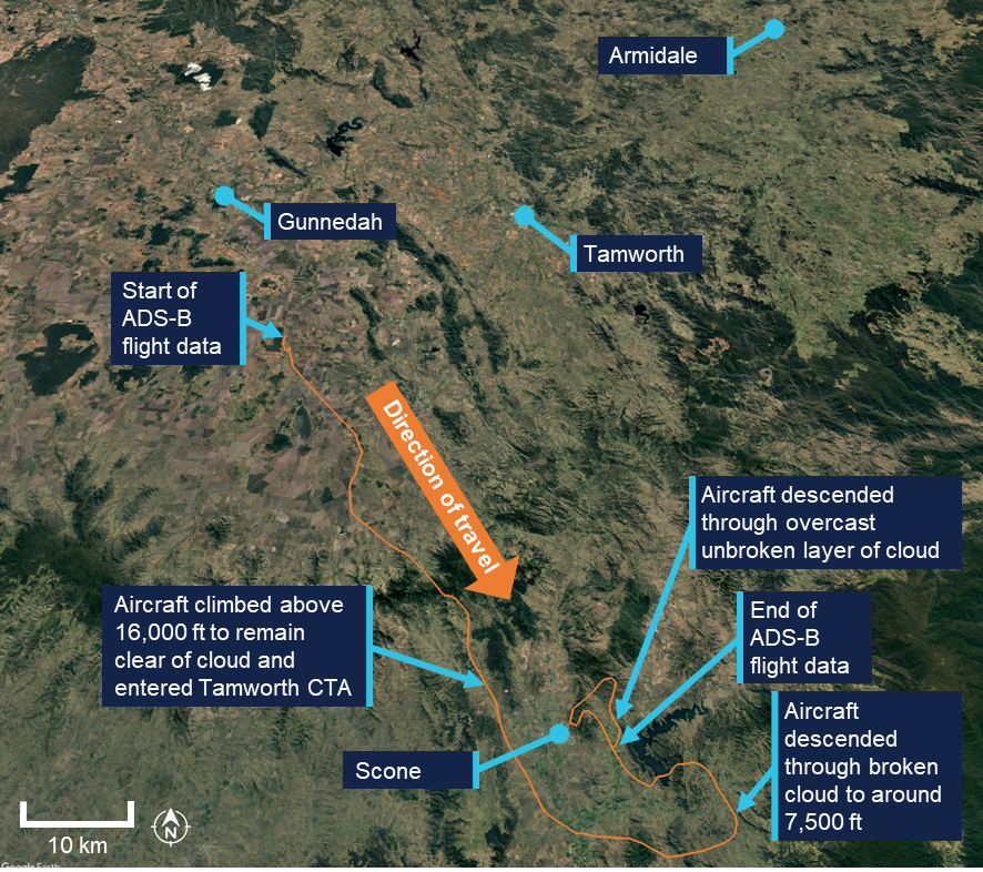
On 11 January 2026, a pilot, and sole occupant of a Van’s RV-7, was conducting a private flight from South East Queensland to Scone Airport, New South Wales, under the visual flight rules (VFR).[1]
The aircraft departed in the mid-afternoon and the pilot reported that they initially landed at Armidale Airport for a break and to review the weather for the remainder of the flight. They advised that satellite imagery for the area indicated areas of cloud south of Armidale, breaking up to the west and further to the south, over Scone. As a consequence, the pilot elected to initially fly west towards Gunnedah before turning south (Figure 1).
Figure 1: Aircraft flight path
Source: Google Earth, annotated by the ATSB
After departing Armidale in the early evening, the pilot advised that the weather deteriorated behind them and so returning to the departure airport was no longer an option. As the flight progressed, after the pilot turned to fly southbound, they commenced a gradual climb to remain above the cloud layer. As they climbed above 10,000 ft, they commenced using supplemental oxygen.
Approaching Scone, the aircraft inadvertently entered the Tamworth Control Area (CTA) without a clearance. The pilot had intended to remain below the 15,500 ft CTA step, but climbed above 16,000 ft to remain clear of cloud.
At around 2008 local time, due to the aircraft’s altitude, air traffic control (ATC) questioned the pilot about their intentions. The pilot advised that they were flying above overcast cloud. As the pilot also advised ATC that they were not instrument rated[2] and did not have a night VFR rating,[3] the controller commenced an emergency response and contacted other aircraft in the area to get an appreciation of the weather. They then contacted Scone Airport to request that the runway lights be turned on. They also established that last light at Scone was 2034.
Approaching Scone, the pilot conducted a visual descent through broken cloud, however at around 7,500 ft they encountered an extensive, unbroken layer of cloud. At approximately 2025, with limited daylight remaining, the pilot elected to descend through the cloud rather than diverting to an alternate aerodrome at night in deteriorating weather. The aircraft exited cloud at approximately 3,000 ft above ground level and the pilot manoeuvred to join the downwind leg for runway 11 at Scone Airport. The aircraft landed at 2031.
The pilot later reported that there were several things that contributed to their decision‑making, including:
complacency
inexperience
a desire to be at Scone in time for work the next morning
a reluctance to leave the aircraft tied down outside at Armidale
fatigue.
Safety message
Early decisions prevent last-minute emergencies. VFR pilots should avoid continuing flight into areas of deteriorating weather as pressing on in marginal conditions reduces available options and significantly increases the likelihood of entering IMC. Early and conservative decision‑making – such as diverting or turning back – is an effective defence.
As identified in a recent ATSB investigation concerning VFR into IMC (AO-2025-040), between 2015 and 2025 there were 116 VFR into IMC occurrences reported to the ATSB. Of these, 13 were fatal accidents resulting in 24 fatalities. Based on these figures, approximately 1 in every 9 reported VFR into IMC occurrences results in a fatality.
The ATSB booklet Accidents involving Visual Flight Rules pilots in Instrument Meteorological Conditions (AR-2011-050, revised 2019) provides guidance on avoiding adverse weather during VFR flights.
About this report
Decisions regarding whether to conduct an investigation, and the scope of an investigation, are based on many factors, including the level of safety benefit likely to be obtained from an investigation. For this occurrence, no investigation has been conducted and the ATSB did not verify the accuracy of the information. A brief description has been written using information supplied in the notification and any follow-up information in order to produce a short summary report, and allow for greater industry awareness of potential safety issues and possible safety actions.
[1]Visual flight rules (VFR): a set of regulations that permit a pilot to operate an aircraft only in weather conditions generally clear enough to allow the pilot to see where the aircraft is going.
[2]A licence endorsement that allows a pilot to legally fly under Instrument Flight Rules (IFR), a set of regulations that govern flying when outside visual meteorological conditions, relying on instruments for navigation and control.
[3]A licence endorsement that allows a pilot to fly at night without holding an IFR rating, provided the operation is conducted in visual meteorological conditions.
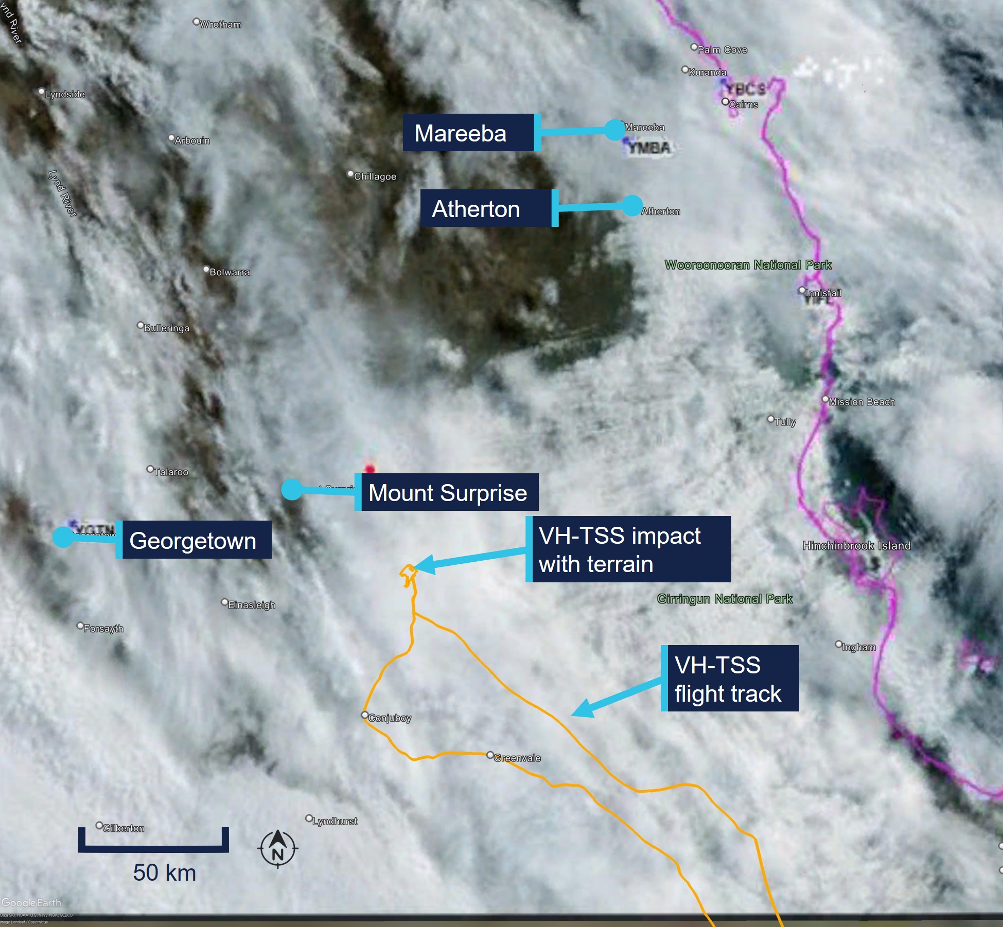
On 18 September 2025, the pilot of a Cirrus SR20, registered VH-TEL, planned to conduct a personal flight under visual flight rules (VFR) from Bankstown Airport, New South Wales, to Mount Kosciuszko (without landing) and return. The pilot was the sole occupant on board.
The pilot took off from Bankstown Airport and flew south to, and then around, Mount Kosciuszko. The pilot then flew to Mallacoota Airport, Victoria, tracking overhead various aerodromes.
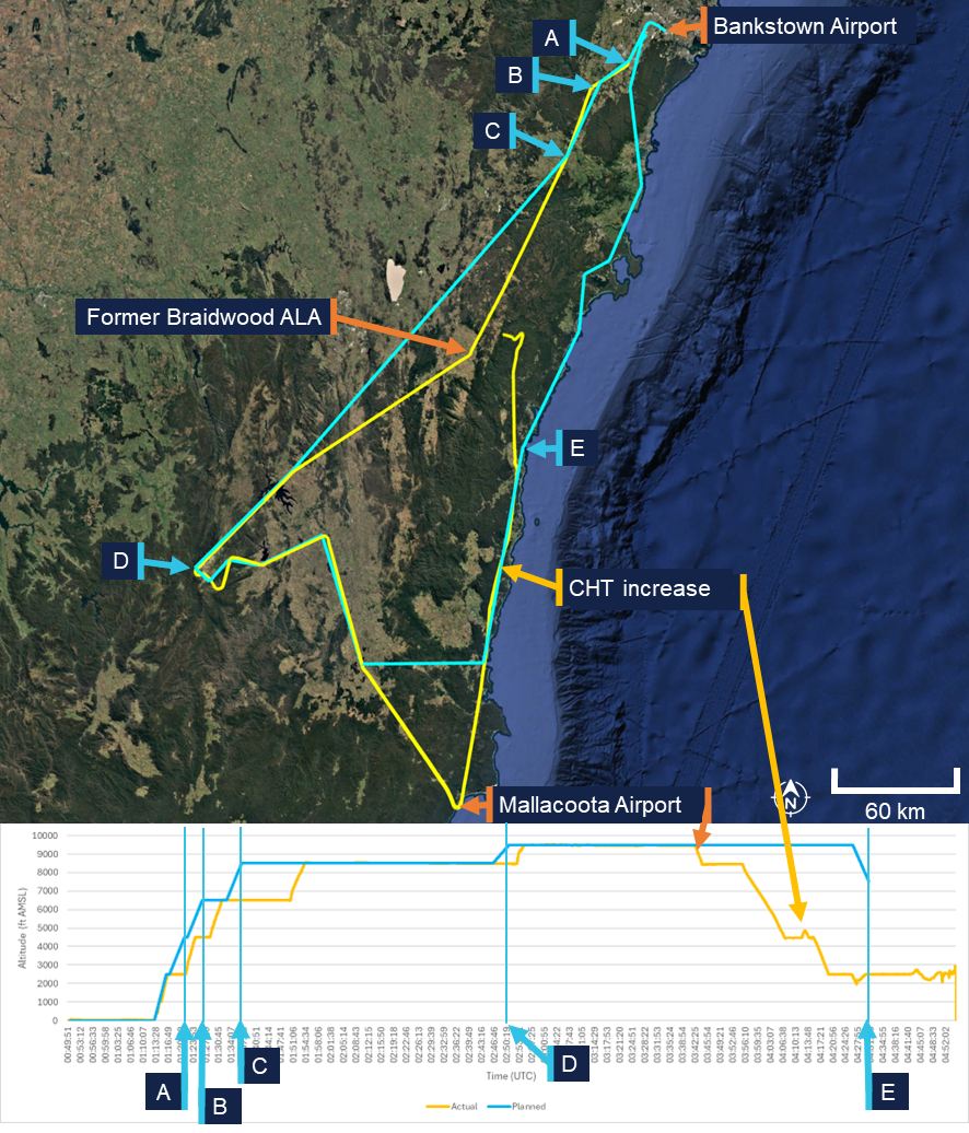
Once passing Mallacoota Airport the pilot began to descend while tracking north towards Merimbula Airport, New South Wales. Recorded data indicated that the pilot began to receive warnings about a high engine cylinder head temperature in cylinder 4. Additionally, there was low cloud in the area ahead.
While descending towards Moruya Airport, the pilot contacted Melbourne Centre air traffic control stating an intention to land. There were no further radio calls from the pilot. The pilot continued to track towards Moruya Airport before diverting to the west, continuing north-west towards the Great Dividing Range.
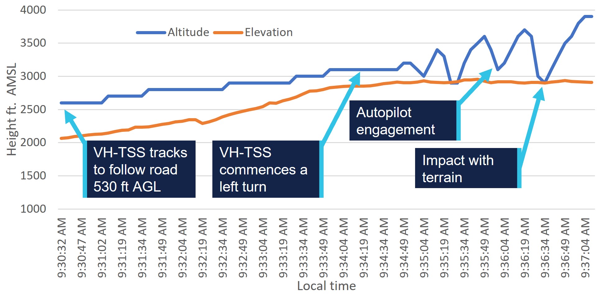
The pilot continued north-west for 13 minutes at 2,500 ft. For the remainder of the flight, the pilot maintained an altitude between 2,000 and 2,700 feet above mean sea level (AMSL), with intermittent climbs and descents. The mountainous area had fluctuating terrain heights, with a maximum terrain height of about 2,900 ft.
At 1458 the aircraft collided with terrain in dense forest in the Budawang National Park. The aircraft was destroyed, and the pilot was fatally injured.
What the ATSB found
The commencement of an approach to land at Moruya was not part of the flight plan and most likely the result of the warning and/or cloud ahead. It is unclear why the pilot made the decision to continue the flight rather than land at Moruya, as poor weather was present ahead of the aircraft and the pilot would have been seeing fluctuating cylinder temperature warnings. However, with limited prior experience in cross-country flights and facing deteriorating weather conditions, the pilot would have been less able to objectively weigh the cumulative hazards of continuing into adverse weather.
The decision to deviate inland from the initial planned track and toward higher terrain was likely influenced by the perceived presence of a clear area ahead in the cloud layer. This gap, evident at the approximate time the aircraft passed to the west of Moruya Airport, would have presented a visually clearer path to the pilot. Furthermore, there was cloud over Moruya Airport and the pilot may have considered that maintaining VMC throughout an approach and landing there might not have been feasible. The cylinder head warnings were likely spurious but, even if the pilot had understood this, the warnings would have been an ongoing source of distraction.
Following the decision to continue, tracking data showed the aircraft proceeding into the mountainous area of the Great Dividing Range, then almost reversing course at low altitude along a valley within the Great Dividing Range, consistent with an attempt to avoid cloud. Once in the valley, it is likely that the pilot did not know what direction to take away from the mountainous areas and cloud or, if they did, became trapped between the rising terrain and the low cloud base.
It is therefore likely that the pilot inadvertently entered instrument meteorological conditions (IMC) and became unable to regain visual references, which led to a loss of terrain awareness and the subsequent controlled flight into terrain.
Safety message
Research and investigations by the ATSB continue to show that weather‑related accidents remain one of the most persistent accident types in general aviation. When operating under visual flight rules (VFR), pilots must always be prepared to make conservative decisions when weather conditions begin to deteriorate. If visibility is reducing or the cloud base is lowering, pilots should strongly consider landing at the nearest suitable location rather than continuing into worsening conditions. Making an early decision to land, delay, or turn back can prevent a situation where safe flight cannot be maintained.
Attempts to maintain visual contact with the ground in marginal weather, commonly referred to as ‘scud running’, significantly increase the risk of controlled flight into terrain (CFIT). Reduced visibility, low cloud, and poor contrast can quickly lead to disorientation or collision with unseen obstacles or terrain. Continuing flight in these conditions often provides little margin for error, especially at low altitude.
Pilots are reminded to maintain situational awareness and resist the pressure to continue to a planned destination (commonly referred to as ‘get-there-itis’) when conditions no longer support safe visual flight. Additionally, if VFR pilots find themselves in marginal weather and becoming disoriented or lost, they should seek whatever help is available. Air Traffic Services (ATS) may be able to provide assistance, especially if the aircraft is in ATS surveillance coverage. There have been a number of reported occurrences where this simple action has averted potential disaster.
The investigation
The ATSB scopes its investigations based on many factors, including the level of safety benefit likely to be obtained from an investigation and the associated resources required. For this occurrence, the ATSB conducted a limited-scope investigation in order to produce a short investigation report, and allow for greater industry awareness of findings that affect safety and potential learning opportunities.
The occurrence
On 18 September 2025, the pilot of a Cirrus SR20, registered VH-TEL, planned to conduct a pleasure flight under visual flight rules (VFR)[1] from Bankstown Airport, New South Wales, to Mount Kosciuszko (without landing there) and return. The pilot would be the sole occupant.
The pilot arrived at Bankstown Flying School (BFS), from which the aircraft was being hired, at about 0900. The owner of the flying school recalled the pilot requested assistance in how to add locations with no designated waypoints (Mount Kosciuszko and Thredbo) into their flight plan. After assisting with their flight plan, the owner asked the pilot about the weather for their planned route and information about last light.[2] The pilot had reported the weather was good for the flight and that last light was at 1800, however they planned to be back by 1700.
At 0910 the pilot took the aircraft out of the hangar and had it refuelled. The owner recalled the aircraft should have been filled to full prior to the flight.
At approximately 1113 local time, the pilot took off from Bankstown Airport. Recorded data from the onboard GPS showed that once airborne, the pilot tracked to waypoint CAMB (Campbelltown University), passing 2,500 ft above mean sea level (AMSL) at 1121. The aircraft continued climbing through 4,500 ft while passing waypoint PIC (Picton) and at 1131 the aircraft was levelled off at 6,500 ft (Figure 1).
At 1150 the pilot began climbing to 8,500 ft and levelled off just prior to flying over the former Braidwood aircraft landing area (ALA).[3] The pilot continued to fly to and then around Mount Kosciuszko before climbing again to 9,500 ft. The pilot then flew for approximately 40 minutes to (overhead) Mallacoota Airport, Victoria, tracking overhead various aerodromes.
Figure 1: Flight path overview
Source: Google Earth, annotated by the ATSB
Once passing Mallacoota Airport at 1342, aircraft flight data showed the pilot began to descend while tracking towards Merimbula Airport, New South Wales, and then continued further north.
At about 1426, the pilot contacted Melbourne Centre air traffic control (ATC) stating:
Moruya traffic Cirrus Tango Echo Lima is one zero miles south inbound with a straight in approach runway 36 thanks
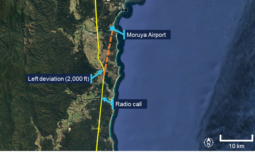
There were no further radio calls from the pilot. The pilot continued to track towards Moruya Airport at 2,000 ft before diverting left and climbing to 2,500 ft passing the airport to the west at 1431 (Figure 2).
Figure 2: Diversion from Moruya Airport approach track
Source: Google Earth, annotated by the ATSB
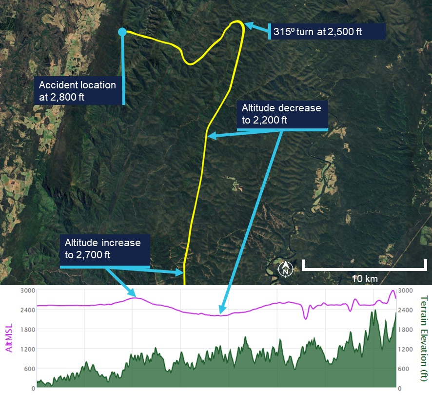
The pilot continued north-west for 13 minutes at about 2,500 ft AMSL. For the remainder of the flight, the pilot maintained an altitude between 2,000 and 2,700 feet AMSL, with intermittent climbs and descents (Figure 3). The mountainous area had fluctuating terrain heights, with a maximum terrain height in the area of about 2,900 ft.
Approximately one minute prior to the collision, the aircraft’s speed decreased to 69 kt before rapidly increasing to 101 kts just prior to the collision with terrain.
At 1454 the aircraft collided with terrain in dense forest in the Budawang National Park at 2,800 ft AMSL. The aircraft was destroyed, and the pilot was fatally injured.
The aircraft’s emergency locator transmitter (ELT) activated in the accident, alerting the Australian Maritime Safety Authority (AMSA) Joint Rescue Coordination Centre (JRCC).
A rescue helicopter located the wreckage at about 1700 on 18 September, however rescue crews were unable to access the site due to the weather. The site was first accessed the following day by winch at about 1300. Rescue crew and police confirmed the occupant was deceased.
Figure 3: Flight path of the last 15 minutes of the flight
The lower plot does not show the point of impact, because the data recording ceased prior to that point. Source: Google Earth, annotated by the ATSB
Context
Pilot information
License and endorsements
The pilot held a Civil Aviation Safety Regulation Part 61 Private Pilot (Aeroplane) Licence, single-engine aeroplane class rating, night VFR rating for single-engine aeroplanes, and endorsements for manual propeller pitch control and retractable undercarriage. The pilot had held a licence since 1979. Their last flight review was on 2 November 2023 in VH-TEL and was valid until 30 November 2025.
Flying history
The pilot ceased flying between mid-1988 and early 2008. Between January 2008 and February 2021, 6 flights were recorded, all conducted as in command under supervision (ICUS).
The pilot had accumulated 306.5 hours experience through to 10 February 2021. On 19 October 2021, the pilot commenced a PPL refresher course with BFS for the purpose of completing a flight review.
The pilot’s logbook indicated flights beginning in June 2024 and noted that their prior logbook had been stolen. It recorded that at the time of the accident the pilot had approximately 443.7 flight hours, including 4.5 hours in VH-TEL in the last 90 days.
Additional flight data retrieved from the flying school on the pilot’s flight prior to June 2024 indicated that, at the time of the accident, the pilot had accumulated approximately 515 total flight hours.[4] Of these, approximately 60 hours were on the Cirrus SR20 aircraft since the pilot’s initial flight in the Cirrus in June 2023. All of these flights were conducted in VH-TEL.
Flight review and training
In October 2021 the pilot completed a training area flight and circuits flight. Additionally, the pilot completed 3 navigation flights in November 2021, January 2022 and February 2022 with a BFS Grade 2[5] flight instructor, in preparation for the pilot’s flight review for the PPL refresher course. On completion of the third navigation flight, the instructor recommended the pilot fly with a Grade 1 instructor to assess their ability relative to the flight review standards required.
The Grade 1 instructor conducted 2 navigation flights with the pilot and reported the flight review was successfully completed after the second navigation flight with the remark that the pilot needs to ease back into flying. This flight review was completed on 18 May 2022, which was the signatory date for the pilot’s application to transfer their licence from Civil Aviation Regulations 1988 (CAR) Part 5 to Civil Aviation Safety Regulations 1998 (CASR) Part 61. The flight review had been conducted in a Piper PA‑28 Archer II (VH‑NRM).
The pilot enrolled in the CirrusSR20Perspective Transition (VFR) course[6] on 13 May 2023. The flights were conducted in June and July 2023, which was prior to the pilot’s flight review in VH-TEL on 2 November 2023. None of the 5 flight lessons included instrument meteorological conditions (IMC)[7] recovery as a task.
In addition to the flights, the pilot completed the Cirrus SR Series Manoeuvres Course, which was a series of videos, which included the following topics:
• VFR into IMC
• Straight and Level
• Level Turns
• Climbs and Descents
• Find Your Way Out [of IMC]
• Flight Into IMC Demo.
Following the completion of their SR20 conversion training in November 2023, the pilot operated the SR20, specifically VH-TEL, on an average of 2 flights per month until March 2025. From March to June 2025, the pilot transitioned to flying the Piper PA-28 on a biweekly basis.
Due to the pilot’s recent absence from operating the SR20 during this timeframe, a currency flight was required in July 2025. This flight was conducted on 4 July 2025 in VH‑TEL, under the supervision of an instructor. The instructor recorded in the student progress record and advised the ATSB that several technique errors occurred during the flight, which resulted in the instructor assessing the pilot as not competent. The pilot returned to flying the PA-28, completing 2 flights in the Sydney area, both scenic.
On 6 August 2025, the pilot conducted a second currency flight in VH-TEL with a different flight instructor. This was a flight into the training area before returning for circuits. The instructor recorded on the progress record that the pilot’s groundwork was good, and radio calls were well executed. The departure was performed satisfactorily, the approach was adequate, and the landing was described as very good and smooth. The instructor noted that the pilot flew the aircraft satisfactorily but required further attention to airspace management. Following this flight, the pilot was assessed as competent to operate the SR20.
There was no record of the pilot having conducted or completing any other relevant instrument flying training or qualifications.
Medical information
The pilot held a valid class 2 aviation medical certificate which was approved in March 2025. The only limitation to the pilot’s medical certificate was for reading correction to be available while exercising the privileges of their licence.
The owner of BFS reported that the pilot looked healthy and displayed normal behaviour on the morning of the flight.
Post-mortem examination and toxicology reports were not available to the ATSB at the time of publishing this report.
Aircraft information
The Cirrus SR20 is a low-wing general aviation aircraft with 5 seats. VH-TEL had a single, Continental IO-360-ES26B reciprocating piston engine driving a constant-speed propeller. The aircraft was certified for day and night VFR and instrument flight rules (IFR)[8] operations.
VH-TEL was manufactured in 2014 and was first registered in Australia on 5 September 2014. The aircraft had been registered with BFS since April 2020, and at the time of the accident had accumulated 1,725.8 hours total time in service.
The aircraft was fitted with the Cirrus airframe parachute system (CAPS). This was designed to lower the aircraft and its passengers to the ground in the event of a life‑threatening emergency and could be activated by the pilot. The CAPS system consisted of a parachute, a solid-propellant rocket used to deploy the parachute, an activation handle, and a parachute harness embedded within the fuselage structure.
Meteorological information
Bureau of Meteorology forecasts
The applicable graphical area forecasts (GAF) available to the pilot for the flight were both issued at 0804 local and valid for the periods 0900–1500 and 1500–2100. The location of the accident was in Area A on the GAF. Area A for the period 0900–1500 forecast broken cumulus/stratocumulus from 3,000–7,000 ft.
The TAF[9] for Canberra was CAVOK[10] conditions. The TAF for Moruya[11] included light showers of rain and a broken cloud base at 3,000 ft AGL. The TAF for Jervis Bay was a broken cloud base at 1,600 ft AGL becoming scattered at 3,000 ft AGL from 1100–1300 but with TEMPO periods from 0700–1200 for visibility reduced to 4,000 m with a scattered cloud base at 600 ft AGL and a broken cloud base at 1,000 ft AGL.
Bureau of Meteorology observations
At 1430, the meteorological aerodrome report (METAR)[12] for Moruya Airport reported wind from the east-north-east at 7 kt (60°), visibility greater than 10 km and cloud overcast at 4,900 ft AGL. The METAR at Jervis Bay Airfield reported wind from the west‑south-west at 8 kt (240°), visibility greater than 10 km and cloud scattered from 2,100 ft and overcast above 2,900 ft AGL.
At 1500, the cloud cover had changed at both locations (Table 1).
Table 1: Reported METAR/SPECI[13] cloud layers at nearest airports
Location
Time
1400
1430
1500
Moruya Airport
OVC 3,300ft AGL
SCT 3,600ft AGL
BKN 4,300ft AGL
OVC 4,900ft AGL
SCT 3,200ft AGL
BKN 4,700ft AGL
OVC 5,300ft AGL
Jervis Bay Airfield
OVC 2,100ft AGL
OVC 2,700ft AGL
SCT 2,100ft AGL
OVC 2,900ft AGL
FEW 3,100ft AGL
BKN 5,100ft AGL
BKN: broken; OVC: overcast; SCT: scattered
Bureau of Meteorology satellite images (Figure 4 – left) showed cloud covering the Budawang National Park mountains at 1430. At 1500 (Figure 4 – right) the satellite imagery indicated a reduction in cloud cover, with partial clearing evident and some breaks observed in the cloud layer. The images provided no information on cloud height, or density at a given height.
Figure 4: Satellite image showing cloud formation on 18 September at 1430 and 1500 local time
The flight path was overlaid on the satellite image to illustrate the route relative to the weather. The actual flight occurred below the cloud base. Source: Bureau of Meteorology, annotated by the ATSB
Witness observations of weather
A witness located approximately 3 km west of the accident site reported hearing the aircraft, however, was unable to locate it in the sky due to fog.[14] They reported that prior to the fog, low lying cloud had been covering the tops of the mountains in the area where the collision with terrain occurred from approximately 1130.
Another witness who was in Wog Wog (10 km north of the accident site) stated that there had been low cloud and drizzle from 1100. They described the visibility to have been ‘okay’ at ground level but poor near the tops of the mountains.
Additionally, the operator for the rescue helicopter reported they were unable to access the site due to low lying cloud (Figure 5).
Figure 5: Cloud over the accident site between 1640 and 1703 local time
Top left and top right: cloud coverage to the north of the accident site. Bottom left: overhead the accident. Bottom right: view of the accident site and surrounding weather from the east. Source: ACT Emergency Services Agency, annotated by the ATSB
Accident site and wreckage
The aircraft wreckage was located in heavily vegetated, steep, mountainous terrain (Figure 6).
Figure 6: Overhead view of accident site
Source: ATSB
The ATSB conducted an examination of the accident site and wreckage on 21 September. The aircraft impacted the side of the mountain and slid backwards from the direction of travel until supported on the slope by some small trees. Ground impact marks and impact marks on the trees indicated the aircraft entered the trees with wings and fuselage almost level.
All of the flight controls and surfaces were accounted for on site and no evidence of in‑flight break‑up or pre-impact control issues was identified.
Onsite examination of the engine did not reveal any pre-impact mechanical issues. The propeller assembly had separated from the engine crankshaft, with propeller deformation consistent with the engine producing power at impact. The left- and right-wing fuel tanks had both been compromised and a fuel odour was present.
Data cards from a Garmin G1000 electronic flight instrument system and the aircraft’s data recovery module (RDM)[15] were recovered from the accident site (see Recorded data).
Cockpit assessment revealed the fuel selector was on the right tank, the flaps were set at 50%[16] and the fuel pump was off.[17]
The CAPS had not been activated.
Recorded data
Garmin 1000
The aircraft was fitted with a Garmin G1000 electronic flight instrument system consisting of one primary flight display and one multi-function display (MFD). The G1000 had a 58‑channel flight and engine parameter data logging capability at a rate of one data point per second. A memory card was retrieved from the device, which contained recorded data from multiple flights, including the accident flight.
The final recorded data point was 2 seconds prior to impact and indicated that the engine was producing normal power until impact. Additionally, the data indicated there was sufficient fuel flow to the engine and there was approximately 10.8 US gallons in the left tank and 7.4 US gallons in the right tank of fuel remaining. This was consistent with ATSB estimates of fuel usage, which also indicated that the aircraft would have had about 48 minutes endurance on landing if the flight had been able to continue to Bankstown Airport with the same engine power applied.
Cylinder head temperature
Recorded engine data indicated the number 4 cylinder head temperature (CHT) increased from the normal operating range into the caution range when the aircraft was about 33 NM (61 km) south of Moruya Airport. Approximately one minute later, the temperature increased into the warning range.
The MFD installed in the cockpit displays CHT information and cautions/warnings. The MFD typically displays individual cylinder CHT as a vertical bar graph scaled from 100°F to 500°F in 100°F increments on the left-hand side of the MFD (Figure 7). Additionally, an engine information page can be selected by the pilot displaying individual cylinder CHT as a vertical bar graph with the current temperature value displayed numerically above the bar. An upward or downward trend arrow is shown below the numeric value to indicate whether the temperature is rising or falling. The G1000 did not record which pages were selected by the pilot at any given time.
Figure 7: MFD engine indication system (EIS) panel, showing the vertical coloured bars indicating a CHT warning state for engine cylinder 4 temperature
Source: Garmin, annotated by the ATSB
The pilot operating handbook (POH) published limits for the CHT were as follows, with the bar graph coloured accordingly:
Normal range < 420°F (green)
Caution range 420–460°F (yellow)
Warning range > 460°F (red)
According to the POH:
In the event CHT exceeds 420°F, the MFD will display “Check CHT” in a yellow advisory box in the lower right corner of the MFD. In the event CHT exceeds 460°F, the MFD will display “Check CHT” in a red advisory box in the lower right corner of the MFD.
Figure 8: Exemplar window showing the crew alerting system (CAS) location and text for a CHT warning, the highlighted alerts softkey, and related alerts window text
Source: Garmin, annotated by the ATSB
The emergency procedure for a high cylinder head temperature from the Cirrus SR20 Airplane Flight Manual (AFM) indicated that if the CHT is in the caution range to land as soon as practical, and if it is in the warning range to land as soon as possible.[18]
For the remainder of the flight, the CHT of cylinder 4 continued to fluctuate, repeatedly moving between the normal (green), caution (yellow), and warning (red) ranges (Figure 9).
Following the initial rise in CHT into the warning range, the recorded engine data showed the pilot commanded a reduction in engine power over an approximately 30 second period, maintaining the reduced power for about one minute further. This is consistent with standard practice for managing elevated CHT. Approximately one minute after the power was reduced, as the CHT decreased and stabilised within the normal (green) operating range, and the data indicated the pilot then restored engine power to the previous level.
Figure 9: Number 4 cylinder head temperature readings throughout the last 1.5 hours of the flight
Source: Google Earth, annotated by the ATSB
The ATSB compared the recorded CHT and exhaust gas temperature (EGT) data for cylinder 4 in order to determine whether the observed high CHT indications were consistent with an overheating cylinder or were more likely the result of a faulty CHT probe. In normal engine operation, a genuine rise in cylinder head temperature is typically accompanied by a corresponding rise in EGT for the affected cylinder, as both parameters respond to increased combustion temperatures and heat rejection. Conversely, a significant increase in indicated CHT with little or no corresponding change in EGT is characteristic of a failing or erratic CHT sensor.
The analysis indicated that the EGT for cylinder 4 remained relatively stable and within normal operating limits throughout the period when CHT repeatedly entered the yellow and red advisory ranges. This suggested that the anomalies were most likely caused by a faulty cylinder 4 CHT probe. The ATSB presented this information to Cirrus Aircraft which agreed that ‘the CHT sensor was giving faulty information as there were no other indications that there was an engine issue in the data.’
Other recorded data
AvPlan
The pilot was using AvPlan electronic flight bag (EFB)[19] software for the flight. The EFB recorded flight data up until and after the collision with terrain. This flight path data was consistent with the data retrieved from the Garmin G1000. AvPlan uses a device built‑in GPS or an external Bluetooth/wi-fi GPS source for the aircraft position.
Flightradar24, FlightAware and ADS-B Exchange
The aircraft’s track was independently corroborated using data from FlightAware, Flightradar24 and ADS-B Exchange. All 3 services provided consistent position reports, derived from received ADS-B transmissions, for the duration of the flight until the aircraft reached the Budawang National Park.[20] After this point the tracks from the 3 providers began to diverge slightly, primarily due to differences in receiver coverage, data processing and extrapolation algorithms[21] when direct ADS-B signals were no longer received. None of the 3 services recorded any further validated ADS-B positions corresponding to the final portion of flight leading to the accident site.
Operational information
General
The owner of BFS reported that the pilot had intended to conduct a flight to Mount Kosciuszko approximately 6 weeks prior to the accident flight and several times afterwards. However, on each occasion the flight was planned, the pilot either rescheduled or cancelled due to adverse weather conditions. The owner stated that these cancellations were typically attributed to icing conditions in the vicinity of Mount Kosciuszko. The owner noted that the pilot demonstrated a high level of weather awareness.
Prior to the accident flight, the owner confirmed with the pilot that the pilot had checked the weather conditions. However, the owner did not independently verify the weather, as the flight was not a training operation, and they considered the pilot competent in assessing weather conditions.
Previous flights
In the 12 months preceding the accident, the pilot had accumulated 31.9 hours of flight time between the Cirrus SR20 and the Piper PA-28 Cherokee. The pilot’s longest flight during this period was 1.9 hours in duration, with an average flight time of 1.4 hours. All flights were conducted within the Sydney area, with the furthest north being Gosford, the furthest south being Port Kembla, and the furthest west being the mountainous area around the Three Sisters landmark in the Blue Mountains (Figure 10). The accident flight was the pilot’s first flight of more than 4 hours since January 2023.
Figure 10: Previous flight data
Source: Google Earth, annotated by the ATSB
Flight plan
Flight plans are only required for a VFR flight under certain conditions. One of the instructors recalled that the pilot would routinely submit a search and rescue time (SARTIME) and not file a flight plan. The instructor recalled they had discussed with the pilot the benefits of lodging a flight plan, including that in the event the aircraft became overdue, a flight plan would provide search and rescue authorities with valuable information to assist in determining the intended route and location to commence search efforts.
Under the Civil Aviation Safety Regulations (CASR) Part 91 General Operating and Flight Rules Manual of Standards (MOS) 2020: 9.02 Flight notification requirements, a pilot in command must ensure that one of the following has occurred if flying into a designated remote area:
• the submission of a flight plan;
• the nomination of a SARTIME for arrival;
• the leaving of a flight note with a responsible person.
For this flight, the pilot had filed a VFR flight plan via the National Aeronautical Information Processing System (NAIPS) prior to departure as the planned route transited a designated remote area of the Snowy Mountains.
The flight plan indicated the pilot would fly south to Mount Kosciuszko before turning towards the coast to Merimbula Airport (Figure 11). The pilot would then head north through a VFR lane, using VFR waypoints, over the coastline (east of the Great Dividing Range) back to Bankstown Airport. When reaching Merimbula Airport the aircraft would be at an altitude of 9,500 ft AMSL and begin a decent to 7,500 ft AMSL reaching the altitude at Moruya Airport before further descending to 2,000 ft when reaching Ulladulla. Pilots are required to notify air traffic services (ATS) if the route, cruising level, or cruising speed changes from a submitted flight plan. Although the actual flight varied from the plan, the pilot did not notify ATS of the changes.
When the pilot’s instructor was asked what pilots are taught in such circumstances, they stated that pilots are instructed to notify ATS of any change in plan or if they intend to deviate from their planned route. However, the instructor noted that the pilot had obtained their private pilot licence in the 1980s and was unsure whether this topic had been recently discussed with the pilot, as they had never observed the pilot submit a flight plan during their conversion training.
Figure 11: Planned flight (blue) comparison to actual flight (yellow)
A. Bankstown Airport; B. Campbelltown University waypoint; C. Picton waypoint; D. pilot chosen waypoint using lat/long; E. Moruya Airport. Source: ATSB
Visual meteorological conditions
Visual meteorological conditions (VMC) are expressed in terms of in-flight visibility and distance from cloud (horizontal and vertical) as prescribed in the CASR Part 91 (General Operating and Flight Rules) Manual of Standards (MOS) 2020: 2.07 VMC criteria. These conditions allow pilots to operate the aircraft primarily by visual reference to the terrain and horizon, maintaining situational awareness and separation from other aircraft without reliance on instruments.
For flight below 10,000 ft AMSL, the Part 91 MOS prescribed that pilots maintain a minimum visibility of 5 km, and remain at least 1,000 ft vertically and 1,500 m horizontally clear of cloud. In areas below 3,000 ft AMSL or 1,000 ft above ground level (AGL), and within uncontrolled airspace, VFR flights may operate clear of cloud and in sight of the ground or water, provided visibility remains at or above the required minima. These criteria ensure that pilots have sufficient external visual references to maintain safe flight and effective traffic separation.
Pilots should not initiate VFR flight on top of more than SCT [scattered][22] cloud when weather conditions are marginal. Before committing to operate VFR flight on top of more than SCT cloud, pilots should be confident that meteorological information used is reliable and current, and clearly indicates that the entire flight will be able to be conducted in VMC.
and
Pilot decision-making, particularly regarding weather and flight, is often complex; however, the solution to avoiding VFR into IMC [instrument meteorological conditions] when weather is marginal before take-off is not to depart. During flight, it is to turn back or divert before it becomes impossible to do so.
Figure 12, taken from the CASA Visual Flight Rules Guide, provides a visual depiction of the VMC criteria for aeroplanes below 10,000 ft.
Figure 12: VMC criteria below 10,000 ft
Source: Civil Aviation Safety Authority
Pilot response to weather
When questioned about how the pilot typically obtained weather information for the flight, the instructor stated that the weather would have been checked prior to departure using TAFs and GAFs. The instructor expected that the pilot would also have been monitoring the automatic terminal information service (ATIS) while en route.
The instructor further recalled a previous flight (in May 2022) with the pilot during which the pilot descended to avoid entering cloud. At that time, the instructor questioned the pilot on the VMC requirements for the flight. The pilot became overwhelmed and elected to return to the departure aerodrome. The instructor recalled that there were no subsequent discussions between them regarding operations in adverse weather, and none of the remaining training flights were conducted in cloudy conditions. The instructor noted that the pilot avoided flying into or near clouds and had previously cancelled multiple flights due to weather.
Pilots can confirm destination weather in flight using multiple approved sources. The aerodrome weather information service (AWIS) is available on a published VHF frequency or by telephone. Review of the aircraft data indicated the radios were not changed to published AWIS VHF frequencies at any stage of the flight, and the pilot was not carrying a mobile phone that could have been used to obtain an AWIS broadcast by telephone.
Where fitted with ADS-B In and a suitable display (such as an EFB),[23] pilots may receive real-time weather data including METAR, TAF, airmen's meteorological information (AIRMET),[24] significant meteorological information (SIGMET),[25] and GAF forecasts within coverage. An approved EFB can also provide these products via internet or satellite subscription. The pilot carried an EFB running AvPlan, which was capable of displaying current meteorological information however, there was no recorded data to confirm whether the pilot accessed this information at any stage of the flight.
Communication
The aircraft was equipped with 2 independent VHF communication transceivers (COM 1 and COM 2). Each transceiver could display and store 1 active frequency and 1 standby frequency simultaneously, resulting in a total of 4 frequencies available to the pilot. The instructor stated that at BFS they teach students to use COM 1 as the primary radio used for monitoring towers and ATS and COM 2 is used for secondary frequencies such as the common traffic advisory frequency (CTAF) and ground frequencies.
The pilot had configured COM 1 as the active radio and COM 2 as standby. Prior to departure, COM 2 was set to the Bankstown Airport ground frequency and left on this frequency for the entirety of the flight. COM 1 was initially set to the Bankstown Airport tower/CTAF frequency and changed throughout the flight. When flying south-east near Braidwood, the pilot changed frequencies multiple times within 9 minutes. They first selected an unknown frequency (125 MHz), then Sydney Tower (120.5 MHz), and then a second unknown frequency (120.15 Mhz), before selecting Melbourne Centre (120.75 MHz). The pilot then maintained 120.75 MHz (Melbourne Centre) as the active frequency after passing Braidwood ALA and continued using this frequency for the remainder of the flight.
The only recorded inflight radio transmission was made on the Melbourne Centre frequency with the pilot indicating a decision to land at Moruya.
VFR into IMC research
The ATSB, in conjunction with research published by CASA, has identified that VFR pilots continuing flight into IMC remains one of the most consistently fatal types of general aviation occurrence. These events are characterised by a loss of visual reference resulting in spatial disorientation, loss of control, or controlled flight into terrain. The onset of IMC during VFR flight is often sudden, and pilots without instrument training or recent instrument experience typically have little time to recover once visual cues are lost.
ATSB occurrence data showed that many VFR into IMC accidents follow a consistent pattern of decision‑making and flight progression. Pilots often either depart into marginal weather conditions and/or continue as conditions deteriorate, influenced by a strong ‘press-on’ mindset to reach their destination. A 2005 ATSB research publication – General Aviation Pilot Behaviours in the Face of Adverse Weather (B2005/0127) – concluded that the likelihood of encountering IMC increases significantly during the final stages of flight, particularly within the last 20% of the planned route.
CASA’s associated AvSafety - Flying into bad weather card[26] supports these findings, noting that poor weather-related decision-making and underestimation of meteorological risks remain persistent issues across the VFR pilot population. The education programs, including CASA’s online Pilot safety hub[27] encourage pilots to establish and adhere to personal weather minima, obtain updated forecasts before and during flight, and avoid reliance on visual cues when conditions are near or below VMC limits.
Related occurrences
Recent examples of VFR into IMC accidents are provided below.
Collision with terrain involving Beechcraft 35-C33 Debonair, VH-KZK, 12 km east of Khancoban, New South Wales, on 15 July 2025 (AO-2025-040)
On 15 July 2025, a Beechcraft 35-C33 Debonair, registered VH-KZK, departed Wangaratta Airport, Victoria, for a private flight under the visual flight rules (VFR) to Moruya Airport, New South Wales. Soon after entering the Snowy Mountains area, itis very likely that the pilot, who did not hold an aircraft instrument rating, experienced spatial disorientation after flying into instrument meteorological conditions. The aircraft entered a spiralling descent to the right that continued until the aircraft collided with terrain. The pilot was fatally injured, and the aircraft was destroyed.
VFR into IMC, loss of control and collision with terrain involving Socata TB‑20, VH-JTY, 65 km west of Mackay Airport, Queensland, on 28 October 2023 (AO‑2023-052)
On the morning of 28 October 2023, a SOCATA-Groupe Aerospatiale TB-20, registered, VH‑JTY, departed Montpelier aircraft landing area, Queensland, for a visual flight rules private flight to Palmyra aircraft landing area, Queensland. After encountering cloud en route, the pilot elected to continue along the intended flight path through cloud instead of diverting around or remaining on top of it.Shortly after, it is very likely the pilot entered weather conditions not suitable for visual navigation, leading to spatial disorientation and a descent into mountainous terrain. The aircraft was destroyed and both occupants received fatal injuries.
VFR into IMC, loss of control and collision with terrain involving Airbus Helicopters EC130 T2, VH-XWD, near Mount Disappointment, Victoria, on 31 March 2022 (AO-2022-016)
On 31 March 2022, at about 0741 local time, 2 Microflite Airbus EC130 helicopters, registered VH‑WVV and VH-XWD, departed the Batman Park helicopter landing site in Melbourne, for the town of Ulupna, Victoria. Both helicopters were operated in accordance with the VFR and departed in VMC conditions. Cloud was forecast along the route, but the pilots elected to continue to the destination. The helicopters encountered IMC over Mount Disappointment and VH-WVV conducted a U-turn to avoid entering cloud. While also attempting to conduct a U-turn, VH-XWD entered cloud, developed a high rate of descent, and collided with terrain. The helicopter was destroyed, and the 5 occupants were fatally injured.
VFR into IMC and in-flight break-up involving Van's Aircraft RV-7A, VH-XWI, 90 km south of Charters Towers, Queensland, on 23 April 2021 (AO‑2021‑017)
On 23 April 2021, a Van’s Aircraft RV-7A, registered VH-XWI, was being operated on a private flight under the VFR from Winton to Bowen, Queensland. During the flight, the pilot most likely entered IMC and lost control of the aircraft several times. This led to the airspeed limitations for the aircraft being exceeded and the aircraft sustained an in-flight break-up. The pilot was fatally injured, and the aircraft was destroyed.
Safety analysis
Examination of the wreckage and flight data indicated that the aircraft’s engine was producing power until impact. All major sections of the aircraft were located at the accident site, and there was no evidence of an in-flight break-up or structural failure. The flight data and the presence of all major components at the scene indicate that the aircraft did not experience a pre-impact mechanical or airframe issue that would have contributed to the collision with terrain.
The flap setting of 50% would be used in low and slow manoeuvring such as looking for a landing site under deteriorating weather or manoeuvring through valleys. Flying slower reduces the radius of turns and the use of the flap gives the aircraft a buffer to the stall speed. This setting might be considered a compromise configuration between flying clean and flying full flap, giving these advantages while retaining a greater capability to climb at short notice without the drag of a full flap.
Cylinder temperature fluctuations and cockpit distraction
When passing Mallacoota Airport, the pilot commenced a descent from about 9,000 ft above mean sea level (AMSL). At that time, the pilot would have seen low cloud ahead and probably descended in order to fly below it or in preparation for an approach and landing at one of the aerodromes along the planned flight route.
Flight data showed fluctuating temperature indications from the number 4 cylinder throughout the latter part of the flight. These temperature fluctuations would have generated warnings displayed to the pilot on the multi-function display, alerting them to a potential engine issue.
The first indications of this fluctuation occurred prior to the initial approach to Moruya Airport. The recorded engine data showed that the CHT rose to the caution range and subsequently progressed to the warning range. There was a reduction in engine power over an approximately 30‑second period, before maintaining reduced power for about a minute further. This was likely to have been initiated by the pilot in response to the high CHT warnings and was consistent with the appropriate response to a genuine warning. The engine was then returned to normal power after the CHT levels dropped back into the normal range.
Shortly thereafter, the CHT again increased, entering the caution range for a second time. After an 8‑minute period with the CHT in the caution range the pilot radioed ATC with their intention to land at Moruya Airport. Given that a landing at Moruya was not planned, it is most likely that the pilot initiated the approach as a result of the warning and/or cloud ahead.
The ATSB assessed that these warnings were very likely spurious, and an attentive pilot with a good understanding of engines could doubt their validity based on the engine instruments. The pilot may have thought the warnings were genuine or spurious, and this understanding could have changed throughout the flight.
In any case, the persistence of these warnings throughout the remainder of the flight would have been a continuing source of distraction, potentially increasing workload and reducing their capacity to monitor other operational factors such as navigation, weather conditions, and terrain clearance.
Decision to continue flight past Moruya Airport
After commencing an approach to Moruya Airport, and making a radio broadcast to that effect, the pilot discontinued the approach and continued the flight below the cloud base. Satellite and meteorological data indicated areas of low cloud around the Moruya area, with instrument meteorological conditions (IMC) present as the pilot approached the airport. Additionally, poor weather was observed along the planned route of flight (along the east coast) beyond Moruya. There were no further radio transmissions or position reports from the pilot following the initial call indicating their intention to land at Moruya. Given that poor weather was present ahead of the aircraft and the pilot would have been seeing fluctuating cylinder temperature warnings, it is unclear why the pilot made the apparent decision to continue the flight rather than land at Moruya.
This decision may have been influenced by the perceived presence of a completely clear area in the cloud layer ahead. Analysis of satellite imagery revealed a temporary gap or break in the extensive cloud cover extending from Moruya Airport towards the Great Dividing Range. This gap, evident at the approximate time the aircraft passed to the west of Moruya Airport, would have presented a visually clearer path to the pilot. There was cloud over Moruya Airport and the pilot may have considered that maintaining VMC throughout an approach and landing there might not have been feasible.
In any case, the decision to deviate inland from the initial planned track and towards higher terrain was likely influenced by this break in cloud. Given previous observations from the instructor indicating an aversion to flight near conditions of reduced visibility, it is probable that the pilot elected to manoeuvre towards this apparent break in order to remain in VMC. However, this deviation towards rising terrain significantly increased the risk of controlled flight into terrain, particularly in the prevailing low-visibility environment where visual assessment of terrain clearance could not be assured.
The pilot may have elected to continue the flight partly due to ‘get-there-it is,’ which describes a mindset in which a pilot becomes fixated on reaching the destination, often disregarding deteriorating weather, aircraft anomalies, fatigue, or other risk factors (ATSB, 2011). This self-induced pressure can lead to continued operation into conditions that a more objective assessment would deem unsafe, as the perceived pressure to complete the trip overrides sound aeronautical decision‑making.
The pilot’s limited experience with long distance flights may have exacerbated the effects of this phenomenon. Having completed only the second flight of approximately 4 hours duration in their flying career, the pilot had minimal exposure to the progressive challenges associated with extended cross-country operations, including the management of fatigue and evolving weather systems over prolonged periods, and in‑flight technical anomalies.
With limited prior experience in calibrating risk in deteriorating conditions, the pilot would have been less able to objectively weigh the cumulative hazards of continuing into adverse weather while managing the fluctuating indicated engine cylinder head temperature (or being distracted by the spurious warnings, depending on how the pilot understood them). This increased their susceptibility to get-there-itis, such that their established safety decision-making processes were outweighed by the perceived attainability of the destination.
Continued flight into poor weather
Following the decision to continue the flight, tracking data indicated that the aircraft proceeded into the mountainous area of the Great Dividing Range, then almost reversed course at low altitude along a valley, consistent with the pilot attempting to remain below the cloud base and/or avoid cloud ahead. It is therefore likely that the pilot misjudged the extent and density of the cloud or the height of the cloud base. While continuing at low level, with an altitude lower than the surrounding terrain, the aircraft likely entered IMC. The subsequent flight path was consistent with attempts to avoid cloud, and it is probable that the pilot did not know what direction to take away from the mountainous areas and cloud or, if they did, became trapped between the rising terrain and the low cloud base.
Findings
ATSB investigation report findings focus on safety factors (that is, events and conditions that increase risk). Safety factors include ‘contributing factors’ and ‘other factors that increased risk’ (that is, factors that did not meet the definition of a contributing factor for this occurrence but were still considered important to include in the report for the purpose of increasing awareness and enhancing safety). In addition ‘other findings’ may be included to provide important information about topics other than safety factors.
These findings should not be read as apportioning blame or liability to any particular organisation or individual.
From the evidence available, the following findings are made with respect to the VFR into IMC and controlled flight into terrain involving Cirrus SR20, VH-TEL,12 km east of Braidwood/Percheron aircraft landing area, New South Wales, on 18 September 2025.
Contributing factors
After commencing an unplanned approach to Moruya Airport, likely due to an engine warning and/or observed cloud ahead, the pilot discontinued the approach for undetermined reasons. The pilot, with limited cross-country experience, then continued the flight underneath the cloud base towards rising terrain.
The pilot very likely entered weather conditions not suitable for visual navigation, leading to a loss of situational awareness and collision with terrain.
Other factor that increased risk
The aircraft’s number 4 cylinder fluctuating temperature warnings, likely resulting from a faulty sensor probe, occurred prior to the pilot electing not to land and continued until the collision with terrain. The ongoing warnings likely distracted the pilot, increasing workload and reduced their capacity to monitor and respond to other operational factors.
Sources and submissions
Sources of information
The sources of information during the investigation included:
Under section 26 of the Transport Safety Investigation Act 2003, the ATSB may provide a draft report, on a confidential basis, to any person whom the ATSB considers appropriate. That section allows a person receiving a draft report to make submissions to the ATSB about the draft report.
A draft of this report was provided to the following directly involved parties:
Bankstown Flying School
Civil Aviation Safety Authority
Cirrus Aircraft
maintenance organisation for VH-TEL.
Submissions were received from:
Civil Aviation Safety Authority
Cirrus Aircraft.
The submissions were reviewed and, where considered appropriate, the text of the report was amended accordingly.
Purpose of safety investigations
The objective of a safety investigation is to enhance transport safety. This is done through:
identifying safety issues and facilitating safety action to address those issues
providing information about occurrences and their associated safety factors to facilitate learning within the transport industry.
It is not a function of the ATSB to apportion blame or provide a means for determining liability. At the same time, an investigation report must include factual material of sufficient weight to support the analysis and findings. At all times the ATSB endeavours to balance the use of material that could imply adverse comment with the need to properly explain what happened, and why, in a fair and unbiased manner. The ATSB does not investigate for the purpose of taking administrative, regulatory or criminal action.
About ATSB reports
ATSB investigation reports are organised with regard to international standards or instruments, as applicable, and with ATSB procedures and guidelines.
Reports must include factual material of sufficient weight to support the analysis and findings. At all times the ATSB endeavours to balance the use of material that could imply adverse comment with the need to properly explain what happened, and why, in a fair and unbiased manner.
An explanation of terminology used in ATSB investigation reports is available here. This includes terms such as occurrence, contributing factor, other factor that increased risk, and safety issue.
Publishing information
Released in accordance with section 25 of the Transport Safety Investigation Act 2003
Ownership of intellectual property rights in this publication
Unless otherwise noted, copyright (and any other intellectual property rights, if any) in this report publication is owned by the Commonwealth of Australia.
Creative Commons licence
With the exception of the Commonwealth Coat of Arms, ATSB logo, and photos and graphics in which a third party holds copyright, this report is licensed under a Creative Commons Attribution 4.0 International licence.
The CC BY 4.0 licence enables you to distribute, remix, adapt, and build upon our material in any medium or format, so long as attribution is given to the Australian Transport Safety Bureau.
Copyright in material obtained from other agencies, private individuals or organisations, belongs to those agencies, individuals or organisations. Where you wish to use their material, you will need to contact them directly.
[1]Visual flight rules (VFR): regulations that permit a pilot to operate an aircraft in conditions whereby navigation and orientation of the aircraft by visual reference is possible.
[2]Day VFR flights may be conducted to the end of civil twilight, the point at which the sun is 6° below an ideal horizon.
[3]The Braidwood ALA was operational until 2024 at its original location. The current Braidwood/Percheron ALA is located approximately 15 km north-east of the former ALA.
[4]The ATSB was unable to determine whether the pilot conducted any flights in aircraft not registered to the flight school.
[5]A Grade 2 flight instructor is an intermediate-level qualification and is not able to approve a flight review, which requires a Grade 1 flight instructor.
[6]The course is an instructor-led course for non-instrument rated pilots who are new to flying a Cirrus and is intended to provide opportunities to enhance their flying skills while becoming familiar with the Cirrus.
[7]Instrument meteorological conditions (IMC): weather conditions that require pilots to fly primarily by reference to instruments, and therefore under instrument flight rules (IFR), rather than by outside visual reference. Typically, this means flying in cloud or limited visibility.
[8]Instrument flight rules (IFR): a set of regulations that permit the pilot to operate an aircraft in instrument meteorological conditions (IMC), which have much lower weather minimums than visual flight rules (VFR).
[9]Aerodrome Forecast (TAF): a statement of meteorological conditions expected for a specific period of time in the airspace within a radius of 5 NM (9 km) of the aerodrome reference point.
[10]Ceiling and visibility okay (CAVOK): visibility, cloud and present weather are better than prescribed conditions. For an aerodrome weather report, those conditions are visibility 10 km or more, no significant cloud below 5,000 ft, no cumulonimbus cloud and no other significant weather.
[11]Moruya Airport and Jervis Bay Airfield are close to sea level.
[12]METAR (Meteorological Aerodrome Report) is a routine aerodrome weather report issued at half hourly time intervals. The report ordinarily covers an area of 8 km radius from the aerodrome reference point.
[13]SPECI is used to identify reports of observations when conditions are below specified levels of visibility and cloud base, when certain weather phenomena are present, and when the temperature, pressure or wind change by defined amounts. SPECI is also used to identify reports of observations recorded 10 minutes following an improvement in visibility, weather or cloud to METAR conditions.
[15]The RDM is designed to record flight data in a crash and fire-resistant housing. The unit records flight, engine, and autopilot parameters. Data is logged once per second and stored internally inside the crash-hardened enclosure. When the storage limit of the memory device is reached, the oldest recording is overwritten.
[16]This level of flap would be expected when conducting a low and slow manoeuvring flight such as looking for a landing site under deteriorating weather or if manoeuvring in valleys.
[17]The fuel pump is on for take‑off, landing, climb and when switching fuel tanks.
[18]The general definition for land as soon as possible is to land at the nearest site that a safe landing can be made, whereas land as soon as practical means extended flight is not recommended but the landing site and duration of the flight are at the pilot’s discretion.
[19]AvPlan is a tablet-based application for flight planning, navigation, and real-time situational awareness.
[20]ADS-B data from public community-based networks (such as those used by FlightAware, Flightradar24 and ADS-B Exchange) may not have coverage at low altitudes or in areas distant from populated receiver locations.
[21]In the absence of continued reception, some providers extrapolate or ’coast’ the last known position and speed for a limited period, while others cease plotting the aircraft entirely.
[22]Cloud cover: in aviation, cloud cover is reported using words that denote the extent of the cover – ‘few’ indicates that up to a quarter of the sky is covered, ‘scattered’ (SCT) indicates that cloud is covering between a quarter and a half of the sky, ‘broken’ (BKN) indicates that more than half to almost all the sky is covered, and ‘overcast’ (OVC) indicates that all the sky is covered.
[23]VH-TEL was not configured to show this information on the Garmin G-1000 display.
[24]AIRMET information concerns the occurrence, or expected occurrence, of certain phenomena that have not been included in the graphical area forecast (GAF).
[25]A SIGMET provides a concise description concerning the occurrence or expected occurrence, in areas over which meteorological watch is being maintained, of en route weather phenomena that are potentially hazardous to aircraft.
Occurrence Briefs are concise reports that detail the facts surrounding a transport safety occurrence, as received in the initial notification and any follow-up enquiries. They provide an opportunity to share safety messages in the absence of an investigation. Because occurrence briefs are not investigations under the Transport Safety Investigation Act 2003, the information in them is de-identified.
What happened
On 8 July 2025, the pilot of a Piper PA-28R-180 was conducting a private flight between Busselton Airport and Jandakot Airport, Western Australia. The flight was conducted under visual flight rules (VFR)[1] and the pilot held a recreational pilot licence with a navigation endorsement and a controlled aerodrome and airspace endorsement.
Prior to departure the pilot reviewed various aviation weather forecasts, including the Bureau of Meteorology’s graphical and terminal forecasts for Jandakot Airport. For the planned flight, the forecast showed a cloud base no lower than 2,000 ft above mean sea level.
After departure, the pilot maintained a track to Jandakot at 1,300 ft outside of controlled airspace. Remaining clear of cloud, the pilot further assessed the weather by listening to the ATIS[2] for Jandakot prior to entry into controlled airspace at the Oakford reporting point.
When the aircraft then entered controlled airspace, air traffic control (ATC) instructed the pilot to maintain 1,000 ft and conduct orbits to the left of the airport until further specified. The pilot reported that they believed this was due to scheduled IFR arrivals. The aircraft completed 7 orbits to the west before being instructed by ATC to roll out and approach runway 06L.
As the aircraft was rolling out of the orbits, the pilot could see that there was significant low cloud approaching from the east and requested Special VFR from ATC for arrival. Special VFR is a clearance issued by ATC on request from flight crew allowing pilots to operate in weather conditions that are below the VFR minimum requirement. This clearance was granted and the aircraft approached the airport for an overfly of the field. Descending through 700 ft on final approach, the pilot lost sight of the runway and inadvertently entered IMC.[3] The pilot contacted ATC advising that the aircraft was no longer visual with the runway. With ATC assistance, the pilot continued the descent, and at 500 ft reported to the controller that the aircraft was clear of cloud and continued the approach to land on runway 06L. The pilot later reported that the communication with ATC greatly assisted them to feel safe during the inadvertent entry into IMC.
Safety message
VFR into inadvertent IMC is a serious safety issue, and one that is consistently ranked as a top contributor to aviation accidents. The ATSB encourages all pilots, no matter what their experience level, to develop the knowledge and skills required to avoid unintentional operations in IMC.
Flying into cloud is a very confronting experience for a VFR pilot who is relying on visual reference points to orientate their aircraft. If a VFR pilot does enter IMC, utilising resources such as ATC assistance, if available, can help to achieve a safe outcome.
The ATSB booklet Accidents involving Visual Flight Rules pilots in Instrument Meteorological Conditions (AR-2011-050, revised 2019) provides guidance on avoiding VFR into adverse weather.
About this report
Decisions regarding whether to conduct an investigation, and the scope of an investigation, are based on many factors, including the level of safety benefit likely to be obtained from an investigation. For this occurrence, no investigation has been conducted and the ATSB did not verify the accuracy of the information. A brief description has been written using information supplied in the notification and any follow-up information in order to produce a short summary report, and allow for greater industry awareness of potential safety issues and possible safety actions.
[1]Visual flight rules (VFR): a set of regulations that permit a pilot to operate an aircraft only in weather conditions generally clear enough to allow the pilot to see where the aircraft is going.
[2]Automatic Terminal Information Service (ATIS): an automated weather service that provides current airport weather information. The ATIS is obtained by flight crew prior to entering controlled airspace.
[3]Instrument meteorological conditions (IMC): weather conditions that require pilots to fly primarily by reference to instruments, and therefore under instrument flight rules, rather than by outside visual reference. Typically, this means flying in cloud or limited visibility.
On the morning of 16 June 2025, a Cessna 182T departed a private aircraft landing area south of Emerald, Queensland, with a pilot and a passenger on board for a private flight to Atherton, Queensland.
Prior to their departure the pilot had obtained the weather conditions for Mareeba Airport, about 22 km to the north of their intended destination of Atherton, and assessed the conditions as acceptable for visual flight.
When the aircraft was about 95 km north of Charters Towers, the pilot assessed they would be unable to continue their direct track towards Atherton due to the cloud height over the terrain ahead. The pilot diverted west to avoid higher terrain and planned to divert to Mareeba due to its lower elevation by approaching from the west.
About 35 minutes after the diversion, the pilot descended the aircraft to about 500 ft above ground level, following a road. As they tracked towards rising terrain, their height reduced to about 200 ft above ground level. The pilot recalled that suddenly conditions ahead became a ‘white-out’ and they commenced a left turn and reduced the aircraft’s power in an attempt to avoid flying into the cloud.
During the turn the aircraft entered cloud and the pilot lost visual reference with the ground. Recorded data indicated the aircraft conducted a 360° left turn with several changes in altitude and coming in close proximity to terrain before the pilot could engage the autopilot to attempt to stabilise the aircraft.
The pilot then commanded a 180° left turn using the autopilot, intending to return to visual meteorological conditions. However, as the aircraft climbed, the air speed reduced and the aircraft likely stalled, leading to a rapid descent.
The pilot received a terrain warning and immediately applied recovery actions; as they eased out of the dive, the pilot momentarily became visual with terrain before the aircraft contacted tree-tops but continued to remain airborne.
The pilot was able to maintain control and became visual again on top of the cloud layer and, with the aircraft significantly damaged, diverted to Charters Towers Airport.
What the ATSB found
The pilot’s pre-flight planning was inadequate for the intended flight. The pilot had planned the second leg of the flight at a height that would not have allowed sufficient safe margin from terrain. While they obtained the forecast weather for a location close to their destination, which identified local conditions were suitable for visual flight, the pilot did not obtain the required graphical area forecast which indicated cloud height below terrain level on the flight planned track. Had the pilot obtained the area forecast this likely would have influenced their decision to commence the flight or plan an alternate route.
After encountering low cloud, the pilot continued flight towards the destination and into rising terrain, this forced them to descend below safe terrain clearance altitudes to a height of about 200 ft above ground level, rather than divert or return.
In an attempt to turn around, the aircraft entered cloud. The pilot was not rated for instrument flight, became spatially disorientated, resulting in a near collision with terrain.
While still in instrument meteorological conditions and disorientated, the pilot initiated a climbing turn and engaged the autopilot at reduced power. This resulted in the aircraft being unable to maintain airspeed and it likely entered a stall and rapidly lost height. During the recovery, the aircraft then impacted trees however continued to fly.
The pilot used the aircraft instruments to navigate out of cloud, regain visual reference to the ground and track south. Although the pilot was aware of the potential for damage sustained to the aircraft during the impact with the tree, they continued flight in the damaged aircraft for about 1.5 hours to Charters Towers (a familiar airport with a longer runway) rather than seek the nearest suitable landing area.
Safety message
Thorough information gathering is an essential part of a pilot’s pre-flight preparation. This is especially important in a single-engine aircraft and includes studying maps and routes to establish appropriate flight heights over terrain where forced landing areas may be limited. Weather conditions often vary over large distances and this is more likely over areas of elevated terrain. Although individual locations may indicate favourable conditions, other more widespread weather conditions, unsuitable for visual flight, may exist outside of the forecast location. Use of all available resources to ensure accurate knowledge of the expected conditions will assist pilots with informed decision‑making, both before and during flight.
It should be accepted that flying under visual flight rules will not always enable you to reach your planned destination. Making an early decision to land or divert and to resist the urge to ‘press on’ may prevent flight into marginal weather conditions and ultimately disaster.
The investigation
The ATSB scopes its investigations based on many factors, including the level of safety benefit likely to be obtained from an investigation and the associated resources required. For this occurrence, the ATSB conducted a limited-scope investigation in order to produce a short investigation report, and allow for greater industry awareness of findings that affect safety and potential learning opportunities.
The occurrence
On 16 June 2025, at 0634 local time, a Cessna 182T, registered VH-TSS, departed a private aircraft landing area (ALA) about 16 NM south‑south-east of Emerald, Queensland, for a private flight to Atherton, Queensland. On board the aircraft were the pilot and one passenger.
Electronic flight data showed the aircraft departed and climbed to 4,500 ft above mean sea level (AMSL) where it initially held a steady track towards Atherton (Figure 1).
Figure 1: VH-TSS flight track between 0828 and 1115
Source: Google Earth, overlaid electronic flight data, annotated by the ATSB
At 0848, the aircraft descended to 3,000 ft AMSL, about 35 NM north of Charters Towers. The pilot then assessed that cloud and reduced visibility would affect continued visual flight direct to Atherton. The pilot stated they elected to continue, however diverted around weather to Mareeba Airport which they had planned as an alternative destination due to the lower elevation. They stated that they were familiar with the area, having flown a similar route 7 or 8 times previously and reported that they assessed the weather for Mareeba several times during the flight. At 0855 the aircraft was about 50 NM north of Charters Towers at an altitude of about 2,900 ft AMSL, about 1,650 ft above ground level (AGL).
The pilot recalled altering their heading to avoid weather and flying over higher terrain. The aircraft tracked generally in a north-west direction with numerous adjustments to the heading and altitude for about 35 minutes.
At 0930 the aircraft was recorded at about 530 ft AGL. The pilot recalled following Kennedy Developmental Road to the north. They reported this decision was due to the low cloud ceiling and advised that, in their experience, the road usually avoided the areas of highest terrain.
At 0932, the aircraft was recorded at about 410 ft AGL and the pilot made several heading adjustments to maintain visual reference with the road due to reducing visibility under heavy cloud cover.
At 0933 and about 90 NM south-west of Mareeba, the aircraft was recorded at about 240 ft AGL, with the pilot continuing to track following the road in a northerly direction.
About a minute later at about 200 ft AGL and 140 kt airspeed (Figure 2), the pilot recalled commencing a left turn and reduced the aircraft’s engine power to try to avoid flying into ‘white-out’ conditions ahead. However, during the turn, the pilot recalled that they entered cloud.
Figure 2: VH-TSS flight track between 0932 and 0946
Source: Google Earth, annotated by the ATSB
In the following minute, the aircraft continued a left turn and completed an orbit with several significant altitude changes, descending and climbing twice then descending again. The recorded altitude, which may not be an accurate representation of the aircraft’s actual altitude during manoeuvres, varied between 0 ft AGL on the second descent (the pilot did not report any impact occurring at this point) and 700 ft about 20 seconds later.
At 0936, having descended a third time to about 200 ft, the aircraft began to maintain a constant heading for about 20 seconds during which time it had a high rate of climb consistent with the engagement of the autopilot (see Autopilot). The aircraft climbed from about 200 ft to 700 ft AGL and reduced groundspeed to 54 kt. The pilot recalled they engaged the autopilot after entering cloud (this was likely after about 1–2 minutes after entering cloud) and then commanded a 180° left turn, in an attempt to reverse their track and navigate out of the instrument meteorological conditions (IMC) (Figure 3). During the next 10 seconds, the aircraft turned sharply left and descended rapidly. The pilot recalled the aircraft instrument panel went red and displayed a terrain warning and immediately applied right rudder and attempted to level the aircraft during the recovery, as it descended almost to ground level.
Figure 3: VH-TSS flight track between 0934 and 0938
Source: Google Earth, annotated by the ATSB
The pilot reported that they momentarily became visual and heard the aircraft impact trees. They pulled back on the control column and commenced a climb, entering IMC again. The pilot climbed to an altitude of about 1,000 ft AGL and was able to stabilise the aircraft and navigate out of IMC using the instruments. They became visual again once on top of the layer of cloud.
At 0942 the pilot descended from 1,000 ft to about 300 ft AGL. They then navigated back to Kennedy Developmental Road at a height of 200–350 ft AGL.
The pilot reported that they were unable to see the leading edge of the wing and unaware of the extent of the damage to the aircraft after the collision, however recalled the aircraft required more right rudder application than usual and that this prevented autopilot engagement. As a precaution, the pilot chose to follow major roads so that they could land if required and navigated the aircraft back to Charters Towers due to the runway length and their familiarity with the airport. The aircraft landed safely at 1114 local time.
As a result of the impact with the tree, the aircraft sustained substantial damage to the left wing (Figure 4), with minor damage to the left wing strut and both landing gear struts. No injuries were reported by either occupant.
Figure 4: Left wing damage
Source: Pilot
Context
Pilot information
The pilot held a valid Private Pilot Licence (Aeroplane) with a single engine aircraft rating since 1992. Their last flight review was conducted on 30 June 2023 and was valid to 31 July 2025. At the time of the occurrence, the pilot had about 3,580 hours total aeronautical experience of which 3,340 hours were reported to be on the Cessna 182. The pilot also reported that they had flown 48.5 hours during the last 90 days.
The pilot did not hold an instrument rating and was only rated to fly in visual meteorological conditions (VMC).[1]
The pilot held a valid class 2 medical certificate that was issued on 3 November 2023 and was valid until 12 November 2025. The class 2 was issued with a restriction requiring that reading correction must be available in flight and that the pilot must not fly within 24 hours of medical therapy.
Fatigue
The pilot reported that at the time of the occurrence they felt fully alert and wide awake. They indicated that they had slept 8 hours in the last 24 hours and 17 hours in the last 48 hours prior to the occurrence.
The ATSB considered that fatigue was unlikely to have affected the pilot’s performance at the time of the occurrence.
Instrument flight
As part of the pilot’s initial flight training for their licence, they recalled conducting 2–3 hours instrument flying with no visual references. However, since that time, they reported that they had not conducted any further instrument flight since their initial training.
Aircraft information
The Cessna 182T is a 4-seat, single engine, high-winged aircraft and is powered by a 6‑cylinder fuel-injected 235 hp (175 kW) Lycoming TIO-540-AK1A piston engine.
VH-TSS was manufactured in the United States in 2005 and was first registered in Australia to the pilot in April 2010. The aircraft was certified to be flown by day and night under visual flight rules (VFR)[2] and was only operated for private operations.
The pilot recorded the total time in service of the aircraft as 2,761.8 hours after arriving at Charters Towers.
Cessna 182 stall speeds
The Cessna 182T pilot operating handbook (POH) indicated the following stall speeds for the aircraft.
- flaps up, power idle 54 knots calibrated airspeed[3] (KCAS)
- flaps full, power idle 49 KCAS
The POH indicated that 54 KCAS would show as 50 kt indicated airspeed (IAS) to the pilot with no flap selected.
The POH also stated the stall speeds at known angles of bank at the aircraft’s maximum all up weight of 1,406 kg. The POH indicated that the stall speeds increased as the aircraft’s angle of bank increased.
Garmin G1000 terrain proximity
The aircraft instrument panel contained the Garmin G1000 display unit, which consisted of a primary flight display and multifunction display.
Colours are used to represent obstacles and aircraft altitude when the terrain proximity page is selected for display. Terrain proximity uses black, yellow, and red to represent terrain information relative to aircraft altitude. The colour of each obstacle is associated with the altitude of the aircraft (Figure 5):
black indicates terrain more than 1,000 ft below aircraft altitude
yellow indicates terrain between 100 ft and 1,000 ft below the aircraft altitude
red indicates terrain is above or within 100 ft below the aircraft altitude.
Figure 5: Garmin terrain proximity caution and warning
Source: Garmin G1000 pilot’s guide Cessna NAV III
Autopilot
VH-TSS was fitted with a KAP 140 2-axis autopilot system, which provided both lateral and vertical modes and allowed the pilot to preselect an altitude.
The KAP 140 manual stated that when the autopilot was initially engaged, it activated the basic roll mode which levelled the aircraft wings and also engaged the vertical speed hold mode. This would capture the aircraft’s current vertical speed at the time of the autopilot engagement.
The manual provided a warning on the use of vertical speed mode stating:
When operating at or near the best rate of climb airspeed, at climb power settings, and using vertical speed hold, it is easy to decelerate to an airspeed where continued decreases in airspeed will result in a reduced rate of climb. Continued operation in vertical speed mode can result in a stall.
The engagement of the heading button would arm the heading mode, which would command the aircraft to turn to and maintain the heading selected on either the horizontal situation indicator[4] (HSI) or the directional gyroscope.
Figure 6: KAP 140 autopilot control panel
Source: KAP 140 manual, annotated by the ATSB
The pilot identified a key safety message from CASA seminars on ‘VFR into IMC’ that they had attended was to use the autopilot if available in case of inadvertent entry to IMC.
Meteorological information
The pilot had obtained the TAF[5] for Mareeba Airport, about 22 km north of Atherton Airport and elevation of 1,564 ft above mean sea level (AMSL). The TAF was issued at 0328 on 16 June and valid between 0500 and 1800 local time. The forecast indicated the wind at 150° at 10 kt, with visibility greater than 10 km and broken[6] cloud cover at 2,000 ft above airport elevation. From 1000, the wind was forecast to increase to 12 kt, with visibility greater than 10 km and scattered[7] cloud cover at about 2,500 ft.
The Bureau of Meteorology does not provide an aviation forecast or recordings for Atherton Airport.
The pilot did not obtain a graphical area forecast (GAF) for the flight planned route (Appendix – Graphical Area Forecasts). The GAF for surface to 10,000 ft for the area in North Queensland was issued at 2013 on 15 June and was valid between 0300 and 0900 on 16 June. Cloud heights were forecast down to 1,500 ft AMSL with isolated fog reducing visibility to 500 m in areas along the pilot’s flight planned track.
A further GAF for the same area was issued at 0224 on 16 June, it wasvalid between 0900–1500 the same day and indicated broken cloud down to 2,000 ft AMSL and to 1,000 ft AMSL with isolated rain showers reducing visibility to 4,000 m. It also indicated broken cloud cover down to 2,500 ft, becoming scattered after 1000. The GAF covered both the flight planned track and the aircraft’s diversion track (See Appendix – Graphical Area Forecasts).
Satellite image taken at 0930 provided by the Bureau of Meteorology indicated cloud cover in the flight planned area and the area the pilot intended to use as a diversion (Figure 7).
Figure 7: Satellite image 0930 local time
Source: Bureau of Meteorology, annotated by the ATSB
The pilot recalled that when they reached Kennedy Developmental Road, the cloud ceiling height had reduced. The pilot estimated they had more than 10 km visibility and a ‘good horizon’ with a crosswind from the east of about 15–18 kt.
After following the road north for about 3.5 minutes the pilot recalled that a ‘white-out’ appeared ahead and, shortly after, they entered instrument meteorological conditions (IMC).
Recorded data
The pilot used a flight planning application on an iPad for en route flight planning, navigation and to obtain weather information.
The software provider was an approved source of electronic aeronautical charts, however the application could not be used as a primary means of GPS‑based navigation as the iPad GPS did not meet certification for aviation use. Additionally, there were limitations to the recorded data as altitude information had a resolution of 100 ft, and filtering applied to smooth the data can affect the accuracy of small sections of data.
The aircraft height was about 560 ft AGL when the aircraft began to track north along Kennedy Developmental Road which the pilot followed for about 3.5 minutes. At 0934 the aircraft began to deviate away from the road after an increase in altitude of about 500 ft, however due to the rising terrain was about 250 ft AGL (Figure 8).
Figure 8: VH-TSS height above terrain
Source: ATSB, data provided by OzRunways and Google Earth
After tracking away from Kennedy Developmental Road, the aircraft turned to the west about 100° in 30 seconds. The turn radius then tightened conducting a 360° left orbit in 65 seconds, during this time the aircraft recorded altitude fluctuated between about 0 ft and 700 ft AGL.
The aircraft then maintained a westerly heading while commencing a climb from about 200 ft AGL with a reducing ground speed to 54 kt over a 20 second period.
The data then recorded the aircraft conducting a left turn through about 70° with a reduction in altitude to the terrain height, in about 5 seconds. The aircraft then commenced a further climb to 1,000 ft AGL before stabilising its altitude over the following 4 minutes in a southerly direction.
At 0941 the aircraft commenced about one and a half descending left turns through about 470° and descended from 1,300 ft AGL to about 300 ft AGL. The flight track then followed a dirt track before tracking east to again intercept Kennedy Developmental Road.
The flight track remained in close proximity to Kennedy Developmental Road, tracking south, passing within 0.7 NM of Greenvale ALA at 1017. The pilot continued to track at about 1,000 ft AGL and followed main roads until it landed at Charters Towers Airport at 1114.
Operational information
Visual meteorological conditions
Visual meteorological conditions (VMC) are expressed in terms of in-flight visibility and distance from cloud (horizontal and vertical) and are prescribed in the Civil Aviation Safety Regulations (CASR) Part 91 (General Operating and Flight Rules) Manual of Standards 2020: 2.07 VMC criteria. For aircraft in class G[8] airspace (Figure 9) the following requirements apply at a height below whichever is the higher of 3,000 ft AMSL or 1,000 ft AGL:
- a minimum of 5,000 m visibility
- maintain flight clear of cloud
- aircraft must be operated in sight of ground or water
Figure 9: Visual meteorological conditions criteria below 10,000 ft as illustrated in the CASA Visual Flight Rules Guide
Source: Civil Aviation Safety Authority
Minimum height rules
CASR Part 91.267 (2) stated that for flight over non-populous areas:
The pilot in command of an aircraft for a flight contravenes this subregulation if, during the flight:
- the aircraft is flown below 500 ft above the highest feature or obstacle within a horizontal radius of 300 m of the point on the ground or water immediately below the aircraft
- is not taking off or landing or conducting a missed approach
- is not carrying passengers and conducting practice forced landings with permission from the landowner.
The Civil Aviation Act,1998 section 30 also stated:
(1) In any proceedings for an offence against this Act or the regulations, it is a defence if the act or omission charged is established to have been due to extreme weather conditions or other unavoidable cause.
(2) Any defence established under subsection (1) need only be established on the balance of probabilities.
Flight planning
The pilot submitted an online flight plan at 0544 that morning to Airservices Australia via the NAIPS[9] application and received notification that the plan had been accepted.
The flight was planned to depart from a private ALA at 0630, climb to 4,500 ft AMSL and to track direct to Charters Towers, before descending and tracking direct for Atherton at 2,500 ft AMSL. Flight plan distance was about 425 NM.
Terrain heights on a direct track between Charters Towers and Atherton indicated terrain elevation consistently over 2,500 ft AMSL with areas above 4,000 ft AMSL.
The pilot reported that they had originally planned to fly on 17 June, however after reviewing the encroaching forecast weather conditions, planned the flight a day earlier.
CASR Part 91 (General Operating and Flight Rules) Manual of Standards 2020: 7.02 Forecasts for flight planning, described that a pilot in command must before commencing flight below 10,000 ft, study:
the authorised weather forecasts and authorised weather reports for the route being flown, departure aerodrome, planned destination, planned alternate aerodrome and any other reasonably available weather information that is relevant to the intended operation
the authorised weather forecast must include a wind and temperature forecast as well as either, a GAF, GAMET area forecast or a flight forecast
should the forecasts and reports be studied more than 1 hour before commencing the flight, the pilot in command must obtain, and review, an update to that information before the flight begins.
The pilot reported that they obtained the weather forecast for Mareeba the evening prior to their flight and again on the morning of their departure. They stated that they were aware of a frontal system that was due in the area later that day or evening. However, they had not obtained a GAF before their departure.
Alternative aircraft landing area
On regaining visual reference with the ground after the collision with terrain, the pilot continued the flight for about 155 NM, and about 1.5 hours flying time. During the flight, the aircraft passed within a nautical mile of another suitable ALA as it returned to Charters Towers.
The pilot stated they were aware of other aerodromes in the vicinity as they tracked towards Charters Towers and that although they were aware that the aircraft had sustained damaged during the collision, they were unaware of the extent and assessed that the aircraft was flying to an acceptable standard to continue the flight to Charters Towers Airport.
Other suitable airports or ALA in the area of the incident site included:
Greenvale ALA 38 NM south (within 1 NM of return track)
Einasleigh Airport 36 NM west
Valley of Lagoons ALA 50 NM south-east
Georgetown Airport 68 NM west.
Human factors
Spatial disorientation
The ATSB publication Avoidable Accidents No. 4: Accidents involving Visual Flight Rules pilots in Instrument Meteorological Conditions(AR-2011-050) discusses the physiological limitations of the human body when trying to sense its orientation in space.
In conditions where visual cues are poor or absent, such as in poor weather, up to 80 per cent of the normal orientation information is missing. Humans are then forced to rely on the remaining 20 per cent, which is split equally between the vestibular system and the somatic system. Both of these senses are prone to powerful illusions and misinterpretation in the absence of visual references, which can quickly become overpowering.
Pilots can rapidly become spatially disoriented when they cannot see the horizon. The brain receives conflicting or ambiguous information from the sensory systems, resulting in a state of confusion that can rapidly lead to incorrect control inputs and resultant loss of aircraft control.
As described in ATSB report AR-2011-050 statistics show non-instrument rated pilots may not be able to recover at all. Research has shown the pilots not proficient in maintaining control of an aircraft with sole reference to the flight instruments will typically become spatially disoriented and lose control of the aircraft within 1 to 3 minutes after visual cues are lost.
ATSB report AR-2011-050 was updated in 2019 and identified that in the 10 years prior, there were 101 visual flight rules (VFR) into IMC occurrences in Australian airspace reported to the ATSB. Of these, 9 were accidents resulting in 21 fatalities. This details an almost 10% chance of a VFR into IMC encounter ending in a fatal accident.
The ATSB Aviation Occurrence Database indicated that in the 10 years since 2015, there have been 108 VFR into IMC occurrences reported to the ATSB. Of these, 14 resulted in accidents with 23 fatalities. The dangers of spatial disorientation following a loss of visual cues remains one of the most significant causes of concern in aviation safety.
Decision‑making
The pilot explained they had not previously flown in poor conditions and had previously turned back when conditions were not suitable on many occasions.
Flight under the VFR requires minimum conditions of visibility and distance from cloud (see Visual meteorological conditions). Variation from the expected weather conditions en route may prevent a pilot from reaching their destination under visual conditions.
Flight into IMC can occur in any phase of flight. However, a 2005 ATSB research publication – General Aviation Pilot Behaviours in the Face of AdverseWeather (B2005/0127)– concluded that the chances of a VFR into IMC encounter increased as the flight progressed, with the maximum chance occurring during the final 20 per cent of the planned flight. It stated:
This pattern suggests an increasing tendency on the part of pilots to ‘press on’ as they near their goal. To turn back or divert when the destination seemed ever closer became progressively more difficult.
Ambiguous cues and organisational and social factors may not in themselves be sufficient to cause decision errors. However, when the decision maker's cognitive limits are stressed, these factors may induce errors in certain contexts. Errors may be mediated by underestimation of the risk inherent in a situation, overconfidence in one's ability to cope with the situation, or failure to evaluate the consequences of planned actions.
VFR into IMC, loss of control and collision with terrain involving SOCATA-GroupeAerospatiale TB-20, VH-JTY
On the morning of 28 October 2023, a SOCATA-Groupe Aerospatiale TB-20, registered, VH‑JTY, departed Montpelier aircraft landing area, Queensland, for a visual flight rules private flight to Palmyra aircraft landing area, Queensland. The flight was to be just over one hour duration and the pilot and their passenger were familiar with the route.
Around 30 NM from the destination, shortly after commencing descent for the intended landing, the aircraft began a steep descending turn to the left towards mountainous terrain. During this descent, the aircraft exceeded the airframe’s designed maximum airspeed before pitching up and passing over the top of Bull Mountain. The aircraft then entered a second steep descending turn, this time to the right, before the recorded flight path data ceased. The aircraft collided with terrain, the aircraft was destroyed and both occupants received fatal injuries.
The ATSB found that, after encountering cloud en route, the pilot elected to continue along the intended flight path through cloud instead of diverting around or remaining on top of it. Shortly after, it is very likely the pilot entered weather conditions not suitable for visual navigation, leading to spatial disorientation and a descent into mountainous terrain.
VFR into IMC and in-flight break-up involving Van's Aircraft RV-7A, VH-XWI 90 km south of Charters Towers, Queensland, on 23 April 2021
On 23 April 2021, a Van’s Aircraft RV-7A, registered VH-XWI, was being operated on a private flight under the visual flight rules (VFR) from Winton to Bowen, Queensland. During the flight, the pilot most likely entered IMC and lost control of the aircraft several times. This led to the airspeed limitations for the aircraft being exceeded and the aircraft sustained an in-flight break-up. The pilot was fatally injured, and the aircraft was destroyed.
VFR into IMC resources
The 2011 ATSB publication, Accidents involving Visual Flight Rules pilots in Instrument Meteorological Conditions(AR-2011-050), updated in 2019, includes a selection of weather‑related general aviation accidents and incidents that show weather alone is never the only factor affecting pilot decisions that result in inadvertent IMC encounters. The documented investigations consistently highlight that conducting thorough pre-flight planning is the best defence against flying into deteriorating weather.
CASA also released a collection of resources related to this type of occurrence on its website titled Weather and forecasting.
For more information on VFR into IMC occurrences, recognising inadvertent entry into IMC, and what to do to recover, refer to the following publications:
United Kingdom Civil Aviation Authority: Safety sense booklet VFR flight into IMC
United States Aircraft Owners and Pilots Association: Encountering IMC.
Safety analysis
Pre-flight planning
The flight was planned to track from the departure aircraft landing area (ALA) direct to Charters Towers and then Atherton, a distance of about 425 NM. The flight north of Charters Towers was flight planned at 2,500 ft above mean sea level (AMSL), however terrain elevations on the planned route north of Charters Towers were consistently higher than 2,500 ft AMSL.
The pilot had obtained a weather forecast for Mareeba Airport (close to their intended destination), which indicated a cloud height of 2,000 ft above the airport elevation (1,564 ft), conditions that the pilot considered suitable for visual flight rules (VFR) flight.
An updated available graphical area forecast (GAF), issued about 4 hours prior to departure, indicated cloud heights were forecast to be about 2,000 ft AMSL at the time the aircraft had planned to be flying over areas of high terrain.
While the pilot was aware of encroaching weather and accelerated their planned flight to a day earlier to avoid the weather, the pilot’s pre-flight planning in respect to planned altitude north of Charters Towers and the weather conditions at the time of the flight was inadequate. Without the required aviation forecast, or appreciation of weather conditions en route, the pilot departed for their destination without the knowledge of expected cloud en route that was lower than terrain elevation and would likely have prevented visual flight.
Continued flight at low level
After assessing in flight that conditions were unsuitable for continued flight direct to Atherton due to the low cloud height, the pilot planned for an alternate airport of Mareeba, visually tracking west to avoid higher terrain.
About 35 minutes after the diversion, the pilot intercepted and began to track north following Kennedy Developmental Road towards rising terrain.
The pilot described having visibility of greater than 10 km and a good horizon while tracking north following the road. As the terrain elevation increased about 900 ft during the few minutes of northerly flight along the road, the pilot was unable to maintain the minimum terrain clearance of 500 ft above ground level or the minimum 5 km visibility before entering instrument meteorological conditions (IMC).
The pilot stated that they had turned back several times on previous flights due to marginal weather conditions. The pilot and passenger were travelling on a private flight, it was unlikely that there was time pressure to arrive at the intended destination.
Consistent with other occurrences of visual flight rules (VFR) into IMC, the aircraft entered IMC conditions within the last 20% of the flight after continuing flight below the minimum required altitude. Although the pilot recalled initially having good visibility, they continued flight towards the destination below a safe altitude, this indicated a desire to ‘press on’ to the destination and increased the risk of unintended entry into IMC and collision with terrain.
Spatial disorientation
The pilot described being surprised how quickly they entered a ‘white-out’ that appeared in front of the aircraft. Likely as a result of attempting to avoid entering the cloud and losing visual reference, they instinctively reduced power and commenced a left turn. During the turn the aircraft entered cloud and the pilot described becoming ‘totally disorientated’ shortly thereafter.
Data showed that the aircraft altitude began to fluctuate with several changes of up to 500 ft vertically in about a 60-second period. While in cloud the aircraft came close to impacting terrain on more than one occasion.
The instability of the flight path with numerous rates of climb and descent are commonly observed in spatial disorientation occurrences where pilots perceive a departure from stable flight and attempt to correct the unusual flight sensations without visual reference.
Unable to reference the aircraft’s visual position or orientation to terrain after entering cloud, the pilot conducted a steep left turn and then engaged the autopilot with the intent to stabilise the aircraft.
Autopilot engagement and aircraft stall
The engagement of the autopilot levelled the aircraft’s wings and held a constant heading. However, the aircraft became established in a climb due to the aircraft attitude when the autopilot was engaged, capturing a high rate of climb.
The pilot used the heading bug on the horizontal situation indicator to reverse their track 180° to try to fly out of cloud.
The aircraft airspeed was likely less than the recorded ground speed of 54 kt due to a tailwind and therefore most likely below the aircraft’s published stall speed.
The pilot’s decision to engage the autopilot stabilised the aircraft’s heading, however without adequate power, the autopilot maintained the captured rate of climb while the airspeed reduced. As the aircraft commenced the pilot‑commanded left turn, the increased angle of bank and slow speed likely resulted in the aircraft stalling and entering a rapid descent at low level. The pilot’s immediate reaction to the red terrain display instigated them applying stall recovery techniques that very likely prevented a more serious collision with terrain.
Flight past a suitable landing area with a damaged aircraft
The pilot was aware the aircraft had sustained damage during the collision with terrain, reporting that the aircraft required additional right rudder trim to maintain balanced flight due to the damage.
Once the pilot became visual with the ground and tracked to the south, rather than conduct a precautionary landing or divert to a nearby aerodrome, they maintained a track following major roads towards Charters Towers for an additional 1.5 hours.
Following the collision with terrain the pilot likely became focused on the recovery of the damaged aircraft from the remote area. During the return flight south to Charters Towers, the pilot flew within 1 NM of the Greenvale aircraft landing area (ALA) about 41 minutes after the tree collision, and there were 3 other potential landing areas that were closer than Charters Towers. Instead, the pilot continued flight in the damaged aircraft to Charters Towers, a familiar airport with a longer runway.
With known damage and the performance characteristics of the aircraft adversely affected, the pilot’s decision to continue the flight to Charters Towers (past a suitable ALA) rather than seek the nearest suitable landing area that provided an opportunity to properly assess the damage, placed additional risk on the occupants’ safety.
Use of aircraft instruments for navigation
Following the impact with the tree, the pilot flew the damaged aircraft using basic flight instruments until they became visual again above the cloud layer.
Although the pilot had not recently practised instrument flight, their knowledge gained during their initial flight training, their familiarity with the aircraft systems and their use of the navigation instruments assisted to stabilise and manoeuvre the aircraft out of IMC conditions to regain visual reference and were then able to determine a track south away from cloud.
Findings
ATSB investigation report findings focus on safety factors (that is, events and conditions that increase risk). Safety factors include ‘contributing factors’ and ‘other factors that increased risk’ (that is, factors that did not meet the definition of a contributing factor for this occurrence but were still considered important to include in the report for the purpose of increasing awareness and enhancing safety). In addition ‘other findings’ may be included to provide important information about topics other than safety factors.
These findings should not be read as apportioning blame or liability to any particular organisation or individual.
From the evidence available, the following findings are made with respect to the VFR into IMC and collision with trees involving Cessna 182T, VH‑TSS, 57 km south-east of Mount Surprise, Queensland, on 16 June 2025.
Contributing factors
During pre-flight planning, the pilot obtained weather for the destination, however, did not obtain weather for the flight planned track.
Although the pilot could not maintain 500 ft terrain clearance due to the low cloud base, they continued flight towards the destination rather than divert to a known area of higher terrain clearance.
The visual flight rules pilot entered instrument meteorological conditions at low level and reduced power when they became disorientated. This resulted in an unintentional turn and near collision with terrain.
While disorientated in IMC, the pilot initiated a climbing turn and engaged the autopilot at reduced power, resulting in the aircraft being unable to maintain airspeed and likely entering a stall and rapidly lost height. During the recovery, the aircraft impacted with trees but continued to fly.
Other factors that increased risk
While aware of damage and controllability issues, the pilot did not land at the closest suitable aerodrome and continued for 1.5 hours to a larger airport.
Other findings
The pilot was able to use the aircraft’s instruments to stabilise the damaged aircraft and navigate out of instrument meteorological conditions
Sources and submissions
Sources of information
The sources of information during the investigation included:
the pilot
Civil Aviation Safety Authority
Bureau of Meteorology
Ozrunways.
References
Australian Transport Safety Bureau. (2005). General Aviation Pilot Behaviours in the Face of Adverse Weather. Aviation Research Investigation Report B2005/0127.
Australian Transport Safety Bureau. (2011). Accidents involving Visual Flight Rules pilots in Instrument Meteorological Conditions.
Orasanu, J. L.-A. (1998). Errors in Aviation Decision Making: Bad Decision or Bad Luck.
Submissions
Under section 26 of the Transport Safety Investigation Act 2003, the ATSB may provide a draft report, on a confidential basis, to any person whom the ATSB considers appropriate. That section allows a person receiving a draft report to make submissions to the ATSB about the draft report.
A draft of this report was provided to the following directly involved parties:
the pilot
Civil Aviation Safety Authority
the manufacturer
Bureau of Meteorology.
Submissions were received from the:
pilot
Civil Aviation Safety Authority
Bureau of Meteorology.
The submissions were reviewed and, where considered appropriate, the text of the report was amended accordingly.
Appendices
Appendix – Graphical area forecasts
Graphical area forecast issued 2013, 15 June
Source: Bureau of Meteorology
Graphical area forecast issued 0224, 16 June
Source: Bureau of Meteorology
Purpose of safety investigations
The objective of a safety investigation is to enhance transport safety. This is done through:
identifying safety issues and facilitating safety action to address those issues
providing information about occurrences and their associated safety factors to facilitate learning within the transport industry.
It is not a function of the ATSB to apportion blame or provide a means for determining liability. At the same time, an investigation report must include factual material of sufficient weight to support the analysis and findings. At all times the ATSB endeavours to balance the use of material that could imply adverse comment with the need to properly explain what happened, and why, in a fair and unbiased manner. The ATSB does not investigate for the purpose of taking administrative, regulatory or criminal action.
About ATSB reports
ATSB investigation reports are organised with regard to international standards or instruments, as applicable, and with ATSB procedures and guidelines.
Reports must include factual material of sufficient weight to support the analysis and findings. At all times the ATSB endeavours to balance the use of material that could imply adverse comment with the need to properly explain what happened, and why, in a fair and unbiased manner.
An explanation of terminology used in ATSB investigation reports is available here. This includes terms such as occurrence, contributing factor, other factor that increased risk, and safety issue.
Publishing information
Released in accordance with section 25 of the Transport Safety Investigation Act 2003
Ownership of intellectual property rights in this publication
Unless otherwise noted, copyright (and any other intellectual property rights, if any) in this report publication is owned by the Commonwealth of Australia.
Creative Commons licence
With the exception of the Commonwealth Coat of Arms, ATSB logo, and photos and graphics in which a third party holds copyright, this report is licensed under a Creative Commons Attribution 4.0 International licence.
The CC BY 4.0 licence enables you to distribute, remix, adapt, and build upon our material in any medium or format, so long as attribution is given to the Australian Transport Safety Bureau.
Copyright in material obtained from other agencies, private individuals or organisations, belongs to those agencies, individuals or organisations. Where you wish to use their material, you will need to contact them directly.
[1]Visual meteorological conditions (VMC): an aviation flight category in which visual flight rules (VFR) flight is permitted – that is, conditions in which pilots have sufficient visibility to fly the aircraft while maintaining visual separation from terrain and other aircraft.
[2]Visual flight rules (VFR): a set of flight regulations that permit a pilot to operate an aircraft only in weather conditions generally clear enough to allow the pilot to see where the aircraft is going.
[3]Calibrated airspeed: indicated airspeed corrected for position and instrument error and expressed in knots.
[4]HSI: a flight navigation instrument that combines the heading indicator with a CDI (course deviation indicator), in order to provide the pilot with better situational awareness of location with respect to the courseline.
[5]TAF- Aerodrome Forecast (TAF): a statement of meteorological conditions expected in the airspace within a radius of 8 km of the aerodrome reference point.
[6]Broken cloud indicates that more than half to almost all the sky is covered, and ‘overcast’ indicates that all the sky is covered.
[7]Scattered cloud indicates that cloud is covering between a quarter and a half of the sky.
[8]Class G airspace is uncontrolled airspace. Both IFR and VFR aircraft are permitted and neither require ATC clearance.
[9]NAIPS: National Aeronautical Information Processing System
Occurrence summary
Investigation number
AO-2025-028
Occurrence date
16/06/2025
Location
57 km south-east of Mount Surprise
State
Queensland
Report release date
28/10/2025
Report status
Final
Investigation level
Short
Investigation type
Occurrence Investigation
Investigation status
Completed
Mode of transport
Aviation
Aviation occurrence category
Collision with terrain, Diversion/return, VFR into IMC
On 15 July 2025, a Beechcraft 35-C33 Debonair, registered VH-KZK, departed Wangaratta Airport, Victoria for a private flight under the visual flight rules (VFR) to Moruya Airport, New South Wales.
Soon after entering the Snowy Mountains area, the aircraft made a 150° right turn, shortly followed by another long left turn. The aircraft entered a spiralling descent to the right that continued until the aircraft collided with terrain. The pilot was fatally injured and the aircraft was destroyed.
What the ATSB found
It is very likely that the pilot, who did not hold an aircraft instrument rating, experienced spatial disorientation after flying into instrument meteorological conditions (IMC). This subsequently resulted in the collision with terrain.
Based on the forecast cloud between Wangaratta and Moruya, completing such a flight while maintaining VFR was likely not feasible. The pilot held a recreational pilot licence that did not include a navigation endorsement. While the pilot had completed some of the training required to attain a navigation endorsement, it is possible that the pilot’s limited training and experience in this respect affected their decision to conduct or continue the flight into challenging weather conditions.
Safety message
One of the key risk controls for a VFR pilot to avoid entering IMC is appropriate pre-flight preparation and planning. Not only should pilots obtain up-to-date weather information before and during flight, they should plan an alternate landing point and be prepared to make necessary deviations from the planned route should actual weather conditions necessitate it.
Licence restrictions and endorsements are a critical aspect of flight safety. They ensure that pilots have been trained to an acceptable standard and that the appropriate experience has been attained. Studies show that pilots with less weather experience are more likely to engage in high-risk activities when dealing with weather. This accident is an important reminder to respect these restrictions and endorsements when planning a flight.
The investigation
The ATSB scopes its investigations based on many factors, including the level of safety benefit likely to be obtained from an investigation and the associated resources required. For this occurrence, the ATSB conducted a limited-scope investigation in order to produce a short investigation report, and allow for greater industry awareness of findings that affect safety and potential learning opportunities.
The occurrence
On 15 July 2025, the pilot and sole occupant of a Beechcraft 35-C33 Debonair, registered VH-KZK, was conducting a private flight under the visual flight rules (VFR)[1] from Wangaratta Airport, Victoria, to Moruya Airport, New South Wales. The pilot was returning to Moruya following the completion of routine maintenance on the aircraft.
It is not known what weather information was accessed by the pilot prior to departing Wangaratta, as no flight planning records were recovered. Text messages from the pilot at 0755 on the morning of the accident flight indicated that they were conducting flight planning and considering the weather on the morning of the accident flight, noting that ‘the sky outside is scattered clouds so we will see what the planning forecast is.’
A flight path recreated from automatic dependant surveillance broadcast (ADS-B) transmissions is shown in Figure 1. The pilot departed Wangaratta at 1302 and flew approximately east towards Moruya, 189 NM away, making occasional changes in heading. By 1315 the aircraft had climbed to an altitude of 4,500 ft above mean sea level (AMSL), where it remained until it approached the rising terrain of the Snowy Mountains, where the aircraft began climbing to 7,000 ft. The mountainous area along the aircraft’s flight path had varying terrain heights, with a maximum of approximately 6,000 ft AMSL.
Figure 1: Flight path of VH-KZK on 15 July 2025
Source: Google Earth, annotated by the ATSB
The aircraft flew past a small aerodrome, Khancoban Airport,[2] at about 1339 at an altitude of about 6,400 ft AMSL (Figure 2). At 1340:15, the pilot commenced a rate 1 turn[3] to the right with minimal change in altitude. At 1341:18, after turning through 150°, there was a 20-second period where ADS-B transmissions were not received. The aircraft was subsequently detected in a left turn through 206°, also approximately rate 1. An airspeed of approximately 150 kt was maintained through these turns.
Figure 2: Flight path prior to colliding with terrain
Vertical lines are used to indicate the aircraft’s height above terrain. Each line represents a data point. Source: Google Earth, annotated by the ATSB
At approximately 1342:38, the aircraft entered another right turn and shortly after, began descending from 6,725 ft AMSL. From this point, the aircraft’s rate of turn, descent rate and groundspeed all steadily increased into a spiralling descent. The last ADS-B transmission was recorded 55 ft above ground level, with an estimated airspeed of 210 kt and a rate of descent above 4,000 ft/min. At 1343:40, the aircraft collided with terrain at an elevation of 4,830 ft AMSL. The pilot was fatally injured and the aircraft was destroyed.
The pilot had lodged a search and rescue time (SARTIME) with Airservices Australia, and when this time elapsed the Joint Rescue Coordination Centre (JRCC) was notified and commenced a search. The aircraft was not fitted with an emergency locator transmitter (ELT), and poor weather conditions limited JRCC search capabilities. Visibility was affected by cloud, and in the early stages of the search, helicopters had limited access to the area where the aircraft was last detected on ADS-B. After an extended search by air, the aircraft was located on 17 July in steep, forested terrain with snow cover.
Context
Pilot information
General information
The pilot held a Recreational Pilot (Aeroplane) Licence (RPL) with a single engine aeroplane class rating and a flight radio endorsement. The RPL permitted private or training flights by day under VFR. The pilot was issued with a basic class 2 aviation medical certificate that was valid until February 2026. The basic class 2 medical certificate was an alternative to a full class 2 certificate for RPL and Private Pilot Licence (PPL) holders. It imposed additional operational restrictions, including that the pilot was not permitted to fly above 10,000 ft.
The pilot’s next of kin reported no relevant medical conditions or medications. There was evidence that the pilot had up to about 9 hours sleep opportunity the night before the flight, but there was insufficient information available to assess fatigue.
Toxicology and pathology reports were not available at the time of publishing this report.
Training and experience
The ATSB estimated[4] the pilot had completed 142 hours total flight time, including 28 hours of solo flying. The pilot had an estimated 25 hours of flight experience in the Beechcraft 35-C33 Debonair, entirely in VH-KZK (which they owned), including 10 hours of solo flying.
The pilot did not have an RPL navigation endorsement, which meant they were restricted from flying beyond 25 NM of the departure aerodrome, unless it was to travel to a training area. Obtaining the navigation endorsement required completion of specific flying training and passing a written examination. The Civil Aviation Safety Authority (CASA) website stated that the examination covered a range of topics including:
• maps and charts properties
• forecast requirements and interpretation of forecasts, determination of alternate or holding requirements.
The pilot had received some navigation training, which included several navigation exercises, as well as a solo navigation flight. Including that flight, the pilot had completed 4 exercises within the standard PPL syllabus. Two additional dual exercises and 1 final long solo navigation exercise were required before an RPL navigation endorsement could be sought. During the training, with regard to flight planning, the pilot was assessed as having achieved ‘competency to the standard required for qualification issue’. Flight planning included the following elements:
• select a suitable route and altitude considering weather, terrain, airspace, NOTAMs[5] and alternate landing areas
• obtain and interpret meteorological forecasts, NOTAMs and operational information applicable to the planned flight
• determine whether the planned flight can be conducted under the applicable flight rules and taking account of the beginning and end of daylight times.
In total, the pilot had accrued 38.1 hours of navigation training, including 1.7 hours flying solo. The pilot had also received 1.0 hours of basic instrument flight training in 2021 on a different aircraft.
Recent flying
The pilot’s most recent formal navigation training was in March 2023. Between November 2023 and October 2024, the pilot undertook training in VH-KZK, having previously flown a Beechcraft C23 Sundowner. Following this training, ADS-B data showed VH-KZK flying (determined to be with this pilot in command) on 9 different occasions between November 2024 and May 2025. All of these flights took place along the New South Wales south coast between Moruya Airport, Merimbula Airport and Frog’s Hollow Airfield (Figure 3). Logbook entries for these flights were not found, but they were understood to be solo flights for pleasure and personal transport.
Figure 3: Aerodromes used by VH-KZK
Source: Google Earth, annotated by the ATSB
On the day before the accident, the pilot conducted a solo navigation flight from Frog’s Hollow to Wangaratta Airport where the aircraft was booked in for routine maintenance. Weather forecasts from the area predicted a cloud ceiling of 7,000 ft and scattered cloud. ADS-B data showed that the pilot conducted most of the flight at an altitude of 9,000 ft, above the forecast cloud tops. The flight appeared to be conducted without incident.
Aircraft information
The Beechcraft 35-C33 Debonair is a low-wing, 4-seat, all-metal aircraft with retractable tricycle landing gear. The Debonair, with a conventional vertical fin and tailplane, was a variant of the early Beechcraft Bonanza model, which had a distinctive V-tail. VH-KZK, serial number CD-985, was manufactured in 1967 in the United States and first registered in Australia in the same year. It was powered by a 6-cylinder Teledyne-Continental Motors IO-470-K engine driving a McCauley 2A36C23 constant-speed propeller. The aircraft was fitted with a pitot heat system.
The aircraft had been classified as capable of operating under the instrument flight rules (IFR) in September 2019. A review of the expired maintenance releases identified that the aircraft shifted between IFR and VFR categories, depending on IFR inspection status. The last IFR inspection recorded in the aircraft logbook was completed on 4 May 2023, with the maintenance release showing the IFR category selected. The current maintainer, who first inspected the aircraft in June 2024, reported that, due to uncertainty around the certification of the equipment, the IFR category was not indicated on the previous 2 maintenance releases.
The aircraft was being maintained in accordance with the standard CASA maintenance schedule (Schedule 5), which required a periodic inspection every 100 flight hours or 12 months, whichever came first. The most recent periodic inspection was completed on 15 July 2025, with the aircraft having accrued 17.5 hours in the previous 12 months. In addition to the periodic inspection requirements, the 2 main tyres were replaced. A new maintenance release was issued with the aircraft having accrued 3,279 hours total time in service.
Maintenance records indicated that an emergency locator transmitter (ELT) was removed from the aircraft in 2019. The maintainer confirmed that there was no ELT fitted to VH-KZK.
Wreckage and impact information
Access to the accident site was limited due to the terrain, snow and environmental conditions, and the ATSB did not attend the accident site. New South Wales Police Force personnel who winched to the site via helicopter to recover the pilot took photographs and collected physical evidence, including documentation and potential data recording devices, which were later examined by the ATSB.
The aircraft was significantly disrupted (Figure 4), consistent with the estimated final aircraft speed of 210 kt and a vertical rate of descent of over 4,000 ft/min. The impact was not survivable. Accident site photographs indicated that the wreckage was relatively contained, rather than spread over a long wreckage trail. This was consistent with the steep descent indicated by the flight data. The engine had separated from the aircraft wreckage and was located 10–15 m away. From the photographs, it was not possible to determine conditions such as aircraft configuration, control cable continuity or the state of control surfaces. It also could not be determined whether all components remained attached up to the point of impact.
Figure 4: Wreckage of VH-KZK
Source: New South Wales Police Force
Meteorological information
Aerodrome weather
The aerodromes closest to the accident site were Khancoban Airport and Corryong Airport (7 NM and 18 NM west of the accident site, respectively). Corryong did not provide meteorological observations and Khancoban had a non-aviation automatic weather station which did not report cloud or visibility. However, records for Albury Airport (Figure 3), which VH-KZK passed earlier in the flight, indicated that the following conditions existed at 1330:
visibility greater than 10 km
9 kt westerly wind
no precipitation
broken cloud at 4,600 ft AGL (5,100 ft AMSL).
Weather forecasts
The Bureau of Meteorology (BoM) issued a set of graphical area forecasts (GAFs) at 0820 on the morning of the accident flight. Based on the flight data, the aircraft’s flight path would have passed through 3 areas with varying forecast conditions.
For the initial part of the flight, beginning at Wangaratta and approaching the Victoria/New South Wales border, the terrain elevation along the flight path varied between about 500 and 3,800 ft AMSL. On this segment the following conditions were forecast (all altitudes are AMSL):
a broken[6] cloud layer from 1,000–2,000 ft that was forecast to clear by about the aircraft’s departure time
broken cloud from 3,000–8,000 ft
isolated showers of rain, during which visibility would reduce to 4,000 m and cloud would extend from 800 ft to above 10,000 ft
isolated showers of snow above 4,000 ft during which visibility would reduce to 500 m and cloud would extend to 8,000 ft
freezing level above 4,500 ft.
After crossing into New South Wales and over the Snowy Mountains, just beyond Khancoban, the flight overflew mountainous terrain where the elevation increased to between 600 and 6,000 ft. In this region the forecast was for:
scattered[7] cloud from 1,500–3,000 ft and broken cloud from 3,000 ft to above 10,000 ft
scattered areas of drizzle with visibility reducing to 3,000 m and overcast conditions from 3,000 ft to 9,000 ft
isolated showers of snow above 4,000 ft with broken cloud from 4,000 ft to above 10,000 ft
freezing level above 4,500 ft.
The accident occurred within this region of the GAF. East of the highest terrain in the Snowy Mountains, conditions were forecast to improve slightly:
scattered cloud from 2,500–8,000 ft
broken cloud from 6,000 ft to above 10,000 ft.
Satellite imagery
A satellite photograph taken at 1340, less than 4 minutes before the aircraft collided with terrain, showed cloud cover in the vicinity of the accident site (Figure 5). However, the image provided no information on cloud height or density.
Figure 5: Satellite image from 1340 on 15 July
Source: Bureau of Meteorology, annotated by the ATSB.
Witness report
A witness with an aviation background was located near Khancoban Airport around the time of the occurrence. They reported hearing an aircraft in the area that they later believed to be VH-KZK. The witness could not see the aircraft due to cloud, but noted that it sounded as if it was heading towards the mountains east of Khancoban. The witness said the aircraft sounded like it was much lower than aircraft travelling over the mountains at this point would typically be (9,000 ft AMSL); the witness estimated the aircraft to be travelling at about 4,000 ft AMSL.
The witness observed the weather to be completely overcast. The cloud was low enough to be sitting on nearby hilltops, the peaks of which the witness believed to be between 2,500-3,000 ft AMSL.
Icing conditions
BoM forecasts note that flying in any cloud above the freezing level implies moderate icing conditions. The BoM publication titled Airframe Icing advises pilots on the effects that icing can have on an aircraft. It states that icing can:
alter the smooth flow of air over the aircraft
reduce pilot visibility
produce errors in instrument readings of air speed, altitude and vertical speed
increase the stall speed by increasing its weight and changing the aerodynamics of the wing and tail
increase drag and decrease lift (tests have shown that icing no thicker or rougher than a piece of coarse sandpaper can reduce lift by 30% and increase drag by 40%)
make it almost impossible to operate control surfaces and landing gear
reduce thrust or cause engine failure.
Because VH-KZK was fitted with a pitot heat system, and a fuel-injected engine, the most likely adverse outcomes from icing involved ice forming on the exterior parts of the airframe. According to the BoM, this type of icing is caused by water droplets from cloud or precipitation striking the airframe at temperatures below the freezing level.
Operational information
Visual meteorological conditions
Visual meteorological conditions (VMC) are expressed in terms of in-flight visibility and distance from cloud (horizontal and vertical) as prescribed in the Civil Aviation Safety Regulations (CASR) Part 91 General Operating and Flight Rules. The accident flight was conducted entirely in uncontrolled (Class G) airspace. In order for the pilot to conduct such a flight under VFR while remaining below 10,000 ft (in accordance with licence requirements), the following VMC criteria needed to be maintained at all times:
5,000 m visibility with 1,000 ft vertical and 1,500 m horizontal distance from cloud
When below the higher of 3,000 ft AMSL or 1,000 ft AGL and in sight of ground or water, the aircraft may be just clear of cloud.
These criteria were illustrated in the CASA Visual Flight Rules Guide (Figure 6). Generally speaking, aircraft flying in conditions that do not meet these criteria are in instrument meteorological conditions (IMC).
Figure 6: Visual meteorological conditions (VMC) criteria below 10,000 ft
Source: Civil Aviation Safety Authority
Flight planning requirements
Flight rules required that pilots study the appropriate authorised weather forecasts and reports in accordance with the CASR Part 91 Manual of Standards. This included authorised weather forecasts and reports for:
the route to be flown
the departure aerodrome, the planned destination aerodrome and any planned alternate aerodrome.
Improving the odds
In 2010 the ATSB published Improving the odds: Trends in fatal and non-fatal accidents in private flying operations (AR-2008-045), which found that assessing and planning problems contributed to 46% of fatal accidents involving Australian private flights between 1999 and 2008. The report stated that:
Assessing and planning issues associated with collision with terrain and/or loss of control accidents mostly involved pilots failing to plan for the weather conditions, not properly assessing the weather during flight, or deciding to continue to fly in marginal weather.
The report provided extensive discussion (pages 16 through 21) on topics including ways of avoiding VFR into IMC accidents, such as through emphasising assessment of flight conditions (particularly weather conditions), evaluating effectiveness of plans, and setting personal minimums.
Spatial disorientation
The ATSB publication Accidents involving Visual Flight Rules pilots in Instrument Meteorological Conditions (AR-2011-050) discusses the physiological limitations of the human body when trying to sense its orientation in space:
In conditions where visual cues are poor or absent, such as in poor weather, up to 80 per cent of the normal orientation information is missing. Humans are then forced to rely on the remaining 20 per cent, which is split equally between the vestibular system and the somatic system. Both of these senses are prone to powerful illusions and misinterpretation in the absence of visual references, which can quickly become overpowering.
Pilots can rapidly become spatially disoriented when they cannot see the horizon. The brain receives conflicting or ambiguous information from the sensory systems, resulting in a state of confusion that can rapidly lead to incorrect control inputs and resultant loss of aircraft control.
The somatogyral illusion is one possible consequence of spatial disorientation, described in the ATSB publication Visual flight at night accidents: What you can’t see can still hurt you (
This illusion relates to a pilot’s incorrect understanding of an aircraft’s angle of bank. When the angle of bank is changed, the pilot’s vestibular system will register any angular acceleration above a threshold level of activation. Once the aircraft is in a constant turn, the pilot’s vestibular system will stop registering any input because there is no angular acceleration. In the absence of any other sensory information or vestibular input a pilot may experience a sensation that the aircraft is no longer turning.
The CASA publication titled Spatial disorientation was published in 2024 as part of the AvSafety program. This detailed several commonly observed illusions that pilots can experience as a result of spatial disorientation. The ‘Graveyard spiral’ described in the publication can occur as a result of the somatogyral illusion:
This can happen when an aircraft begins to bank in cloud or dark night conditions. A constant rate of bank will be undetectable by the vestibular apparatus in a pilot’s head, and unless the pilot is scanning the attitude indicator continuously there will be no visual clue. Rushing slipstream will indicate the increasing airspeed of a dive in what otherwise appears to be straight-and-level flight. Attempts to pull out of the dive often only tighten the unrecognised turn and can cause overstressing and failure of the aircraft structure.
For non-instrument rated pilots, entering IMC can quickly become fatal. Research has shown that pilots not proficient in instrument-only flight will typically become spatially disoriented and lose control of the aircraft within 1–3 minutes after visual cues are lost.
Between 2015 and 2025 there were 116 VFR into IMC occurrences in Australian airspace reported to the ATSB. Of these, 13 were fatal accidents resulting in 24 fatalities. Based on these figures, approximately 1 in every 9 reported VFR into IMC occurrences results in a fatality.
Safety analysis
Spiral descent
The aircraft’s steadily increasing rate of descent and rate of turn in the period leading up to the impact with terrain were consistent with spatial disorientation, specifically, the somatogyral illusion and the ‘graveyard spiral’ described by CASA and others.
Broken cloud was forecast in the mountains east of Khancoban between 3,000 ft AMSL to above 10,000 ft AMSL. There were also areas of drizzle with overcast conditions between 3,000 ft and 9,000 ft AMSL. The report from the witness near Khancoban airport indicated local conditions consistent with this forecast. Given the terrain elevation in the area, it is therefore almost certain that the aircraft encountered weather conditions making visibility marginal or worse, possibly for extended periods.
The aircraft’s increasing rate of descent and maximum allowable airspeed exceedance just before the collision with terrain indicated that the pilot was either not aware of the aircraft’s speed and attitude, or was not able to correct it during the descent.
The pilot held a valid basic class 2 medical certificate and there was no available evidence to indicate any medical conditions likely to impact their flying ability, although an incapacitating medical event could not be entirely ruled out.
Prior to the spiral descent, the aircraft maintained a steady altitude and groundspeed, which did not indicate any engine or control issues to that point. An engine issue by itself should also not result in a high-speed, spiralling descent, unless there was also a control issue present. Control issues could not be entirely ruled out, since the wreckage was not examined, and photographs were insufficient to determine aspects such as control cable continuity or the presence of all control surfaces.
Aircraft icing was another possibility. It can affect a number of aspects relating to aircraft performance, handling or pilot visibility, and multiple control surfaces jammed by ice at the same time could result in an uncontrolled spiral flightpath. Structural icing would only be expected if the aircraft was in cloud or precipitation. In either case, based on the forecast, the aircraft would be in IMC where spatial disorientation would also be a concern.
In either case, the aircraft’s flight path, including what appear to be 2 controlled turns beyond Khancoban, indicates that the aircraft remained controllable until at least the commencement of the spiral. The manoeuvres also indicate that the pilot deliberately left the planned flight route, and were consistent with attempts to navigate around cloud or showers and possibly find a landing area. For example, the first turn might have been an attempt to return to Khancoban or another airport such as Corryong or Wangaratta, and the second turn the result of cloud closing in behind the aircraft, preventing such a return.
Considering the weather conditions on the day, the pilot’s limited training and experience, and the proven hazard of entering IMC as a VFR pilot, it is therefore very likely that the pilot experienced spatial disorientation in low-visibility conditions, leading to an undetected spiral descent.
VFR into IMC
Just beyond Khancoban, the weather forecast indicated that broken cloud was expected from ground level (above 3,000 ft AMSL) up to above 10,000 ft AMSL. The vertical extent of the cloud would have made this particularly challenging for the pilot because it was probably not possible to fly above the broken cloud and remain under 10,000 ft in accordance with licence restrictions.
Because there were no weather stations recording observations near the accident site, the actual weather conditions that the pilot encountered could not be determined beyond a single witness account (at ground level) and a satellite image that shows cloud in the area. While the conditions might have differed from the weather forecast, the forecast conditions indicated that a pilot would have no certainty of maintaining VFR. The pilot was not IFR rated and training records indicated that they had only flown 1 hour of instrument flight training.
While the pilot had completed some navigation training including a solo navigation flight, they were yet to complete the training syllabus necessary to obtain a navigation endorsement for their recreational pilot licence. As such, they were not authorised to fly the 189 NM distance between Wangaratta and Moruya. Additionally, while the pilot had received training and been assessed as competent at reading weather forecasts in an aviation context, they likely had limited experience in this respect and had not been assessed on some relevant elements required for the PPL such as the more advanced interpretation of forecasts, and determination of alternate or holding requirements. This increased the likelihood of misinterpreting the forecast or underestimating the difficulty of navigating the forecast conditions.
There is limited information available to establish the extent or specifics of the pilot’s pre-flight planning. The exact weather scene presented to the pilot upon entering the mountains was not known, nor was the pilot’s decision-making regarding initiation and continuation of the flight.
The number of reported VFR into IMC occurrences over the last 10 years indicates that many pilots, some likely with more experience, have found themselves in unsuitable weather situations yet continued the flight. However, studies have shown that pilots who do not accurately perceive the risks of adverse weather are more likely to engage in higher risk activities when dealing with weather (Cooper, 2003). The pilot’s limited training and experience with adverse weather conditions may therefore have contributed to their perception of risk and associated decision-making.
Findings
ATSB investigation report findings focus on safety factors (that is, events and conditions that increase risk). Safety factors include ‘contributing factors’ and ‘other factors that increased risk’ (that is, factors that did not meet the definition of a contributing factor for this occurrence but were still considered important to include in the report for the purpose of increasing awareness and enhancing safety). In addition ‘other findings’ may be included to provide important information about topics other than safety factors.
These findings should not be read as apportioning blame or liability to any particular organisation or individual.
From the evidence available, the following findings are made with respect to the VFR into IMC and collision with terrain involving Beechcraft 35-C33 Debonair VH-KZK, 12 km east of Khancoban, New South Wales on 15 July 2025.
Contributing factors
The pilot very likely encountered instrument meteorological conditions, resulting in spatial disorientation and collision with terrain.
The pilot commenced a solo navigation flight, into areas with forecast instrument meteorological conditions, without having completed the required training and licensing for cross-country navigation.
Sources and submissions
Sources of information
The sources of information during the investigation included the:
Cooper D. (2003). Psychology, Risk and Safety: Understanding how personality & perception can influence risk taking. Professional Safety. Journal of the American Society of Safety Engineers, November 2003, 39-46.
Submissions
Under section 26 of the Transport Safety Investigation Act 2003, the ATSB may provide a draft report, on a confidential basis, to any person whom the ATSB considers appropriate. That section allows a person receiving a draft report to make submissions to the ATSB about the draft report.
A draft of this report was provided to the following directly involved parties:
Civil Aviation Safety Authority
Australian Maritime Safety Authority
Bureau of Meteorology
the pilot’s flight instructor.
Submissions were received from:
Civil Aviation Safety Authority
Bureau of Meteorology
the pilot’s flight instructor.
The submissions were reviewed and, where considered appropriate, the text of the report was amended accordingly.
Purpose of safety investigations
The objective of a safety investigation is to enhance transport safety. This is done through:
identifying safety issues and facilitating safety action to address those issues
providing information about occurrences and their associated safety factors to facilitate learning within the transport industry.
It is not a function of the ATSB to apportion blame or provide a means for determining liability. At the same time, an investigation report must include factual material of sufficient weight to support the analysis and findings. At all times the ATSB endeavours to balance the use of material that could imply adverse comment with the need to properly explain what happened, and why, in a fair and unbiased manner. The ATSB does not investigate for the purpose of taking administrative, regulatory or criminal action.
About ATSB reports
ATSB investigation reports are organised with regard to international standards or instruments, as applicable, and with ATSB procedures and guidelines.
Reports must include factual material of sufficient weight to support the analysis and findings. At all times the ATSB endeavours to balance the use of material that could imply adverse comment with the need to properly explain what happened, and why, in a fair and unbiased manner.
An explanation of terminology used in ATSB investigation reports is available here. This includes terms such as occurrence, contributing factor, other factor that increased risk, and safety issue.
Publishing information
Released in accordance with section 25 of the Transport Safety Investigation Act 2003
Ownership of intellectual property rights in this publication
Unless otherwise noted, copyright (and any other intellectual property rights, if any) in this report publication is owned by the Commonwealth of Australia.
Creative Commons licence
With the exception of the Commonwealth Coat of Arms, ATSB logo, and photos and graphics in which a third party holds copyright, this report is licensed under a Creative Commons Attribution 4.0 International licence.
The CC BY 4.0 licence enables you to distribute, remix, adapt, and build upon our material in any medium or format, so long as attribution is given to the Australian Transport Safety Bureau.
Copyright in material obtained from other agencies, private individuals or organisations, belongs to those agencies, individuals or organisations. Where you wish to use their material, you will need to contact them directly.
[1]Visual flight rules (VFR): regulations that permit a pilot to operate an aircraft in conditions whereby navigation and orientation of the aircraft by visual reference is possible.
[2]Khancoban Airport did not have an entry in the Airservices aeronautical information publication (AIP) en route supplement Australia (ERSA).
[3]A rate 1 turn, also known as a standard rate turn, is turn rate of 3° per second.
[4]The pilot’s logbook was not located. However, a copy of the pilot’s logbook with entries up until February 2023 was obtained. The ATSB also collated training records and publicly available flight data of the accident aircraft to estimate the pilot’s hours and experience.
[5]Notice to airmen (NOTAM): A notice distributed by means of telecommunication containing information concerning the
establishment, condition or change in any aeronautical facility, service, procedure or hazard, the timely knowledge of
which is essential to personnel concerned with flight operations.
[6]Broken cloud refers to cloud that covers between 5 to 7 oktas (eighths) of the sky.
[7]Scattered cloud refers to cloud that covers between 3 to 4 oktas (eighths) of the sky.
Occurrence Briefs are concise reports that detail the facts surrounding a transport safety occurrence, as received in the initial notification and any follow-up enquiries. They provide an opportunity to share safety messages in the absence of an investigation. Because occurrence briefs are not investigations under the Transport Safety Investigation Act 2003, the information in them is de-identified.
What happened
On 6 June 2025, the pilot of a Cirrus SR20 aircraft was conducting a private flight between Devonport Airport, Tasmania, and Moorabbin Airport, Victoria, under visual flight rules (VFR)[1] with the pilot and one passenger on board. The pilot held a private pilot licence (aeroplane).
Prior to the departure, the pilot stated that they reviewed the weather briefings accessed through an electronic flight bag application and obtained directly from the Bureau of Meteorology. After a discussion with their flight instructor, the pilot determined that forecast conditions were suitable to proceed with the flight across the Bass Strait under VFR to Moorabbin.
They also stated they made an informed decision to depart ‘as soon as possible’ due to forecast strong gusts in the vicinity of Moorabbin Airport and the end of evening civil twilight,[2] which occurred at 1736 local time.
After departing Devonport at 1459, the aircraft initially proceeded on a westerly heading to conduct a brief ‘scenic’ leg (Figure 1). The pilot then made a right turn in a northerly direction toward Moorabbin Airport and climbed to 4,500 ft above mean sea level, cruising below scattered[3] cloud observed at about 5,000 ft in the vicinity of the coastline to the west of Devonport Airport.
Figure 1: Aircraft flight path and key events
Source: Google Earth, annotated by the ATSB
At about 1530, they recalled a lowering of the cloud base accompanied with a reduction in forward visibility. The pilot descended to about 2,000 ft to remain clear of cloud and immediately advised ATC of the deteriorating weather conditions and that they anticipated entering instrument meteorological conditions[4] (IMC) imminently.
At 1540, the pilot subsequently recalled entering IMC but reported being able to see below the aircraft. They immediately advised ATC and descended to 1,500 ft, at which point they regained visual meteorological conditions[5] (VMC). At 1551, confident of remaining clear of cloud, the pilot climbed back to 2,000 ft and continued the flight to Moorabbin in VMC.
The pilot recalled the autopilot was utilised throughout the flight and that scheduled reporting times were implemented at 15‑minute intervals with ATC until 1644 when they were cancelled by the pilot. The aircraft landed at Moorabbin Airport at 1703.
Safety message
Pilots operating under visual flight rules are encouraged to make conservative decisions when considering how forecast weather may affect their flight. Establishing a ‘personal minima’ is recommended for pilots to provide additional operational margins which account for factors such as weather, experience and recency.
One of the key risk controls for a visual flight rules pilot to avoid entering instrument meteorological conditions is appropriate pre‑flight preparation and planning. Pilots should always obtain up‑to‑date weather information before and during flight. While forecasts will assist in selecting the route to be flown, pilots should plan an alternate or be prepared to make necessary deviations from the planned route should actual weather conditions indicate the possibility of not being able to comply with the VFR.
For a non-instrument rated pilot, even with basic attitude instrument flying proficiency, maintaining control of an aircraft in IMC by reference to the primary flight instruments alone entails a very high workload that can result in narrowing of attention and loss of situational awareness. If entering cloud becomes unavoidable, the use of an autopilot by a suitably trained pilot can assist with maintaining the desired flight path and remove inadvertent inputs. While autopilot can be used to reduce workload, it is not infallible and should not be relied upon or used by VFR pilots as a risk mitigator to decide to fly into unsuitable conditions.
Additionally, ATC services such as Flight Following,[6] can assist the pilot with managing workload and improving situational awareness. Subject to ATC workload, information derived from Bureau of Meteorology weather radar sites can also be provided to pilots.
ATSB booklet Accidents involving Visual Flight Rules pilots in Instrument Meteorological Conditions (AR-2011-050, revised 2019) provides for guidance on avoiding VFR into adverse weather. Further resources for preventing VFR into IMC can also be found on the Civil Aviation Safety Authority’s website.
About this report
Decisions regarding whether to conduct an investigation, and the scope of an investigation, are based on many factors, including the level of safety benefit likely to be obtained from an investigation. For this occurrence, no investigation has been conducted and the ATSB did not verify the accuracy of the information. A brief description has been written using information supplied in the notification and any follow-up information in order to produce a short summary report, and allow for greater industry awareness of potential safety issues and possible safety actions.
[1]Visual flight rules (VFR): a set of regulations that permit a pilot to operate an aircraft only in weather conditions generally clear enough to allow the pilot to see where the aircraft is going.
[2]Scattered cloud is a meteorological term used in aviation to describe cloud coverage that occupies 3 to 4 oktas (eighths) of the sky.
[3]Evening civil twilight begins at sunset and ends when the geometric centre of the sun is 6 degrees below the horizon.
[4]Instrument meteorological conditions (IMC): weather conditions that require pilots to fly primarily by reference to instruments, and therefore under instrument flight rules, rather than by outside visual reference. Typically, this means flying in cloud or limited visibility.
[5]Visual Meteorological Conditions (VMC): weather conditions expressed in terms of flight visibility and the horizontal and vertical distance from cloud for the application of VMC criteria in various airspace classifications.
[6]Flight Following: the provision of ongoing surveillance information service which is an on request service provided to assist pilots of VFR flight within ATS surveillance system coverage in Class E and Class G Airspace, to avoid other aircraft or to assist in navigation.
On 7 July 2025, a Kavanagh Balloons G-450, registered VH-FGC, was conducting a morning scenic flight near Beaudesert, Queensland, carrying 20 passengers and the pilot.
Shortly after launch when climbing above a ridge, the pilot identified a change in the expected wind direction and the presence of fog. The pilot considered the safest option available was to proceed to an alternate landing site in reduced visibility. However, on approach to land, a low-level wind shift changed the balloon direction. The pilot elected to conduct a landing at a different landing site rather than continue flight over populous areas.
On landing, the balloon basket was carried forward with momentum, it skipped several times before it came to a stop. However, the balloon envelope made contact with a dead tree, resulting in minor damage to the envelope. No injuries were reported.
What the ATSB found
The ATSB found that the pilot reassessed operational and safety decisions as unexpected weather impacted the flight (wind direction and fog). Ultimately the pilot was unable to avoid contact with a dead tree in the final stages of landing in reduced visibility.
However, comprehensive passenger safety briefings meant that passengers adopted brace positions prior to landing which likely prevented injury.
Safety message
The formation, movement and depth of fog is difficult to predict with accuracy, which can lead to pilots inadvertently flying into reduced visibility.
If contemplating ballooning operations in conditions conducive to fog development, even if it is not forecast, pilots are strongly encouraged to not only be aware of the possible formation of fog, but to plan for its likely effect on their flight.
This accident highlights the importance of effective safety briefings and how passengers adopting the correct body position during landing substantially reduces the likelihood and severity of injury. The pre-flight briefing is critical in ensuring passenger preparation, particularly as opportunities to reinforce this information during flight may be limited.
Pilots should use all available resources (such as passenger demonstrations and safety briefing cards) to ensure that each passenger understands the landing position and its importance.
The ATSB SafetyWatch highlights the broad safety concerns that come out of our investigation findings and from the occurrence data reported to us by industry. One of the safety concerns is Reducing passenger injuries in commercial ballooning operations.
The investigation
The ATSB scopes its investigations based on many factors, including the level of safety benefit likely to be obtained from an investigation and the associated resources required. For this occurrence, the ATSB conducted a limited-scope investigation in order to produce a short investigation report, and allow for greater industry awareness of findings that affect safety and potential learning opportunities.
The occurrence
On 7 July 2025, a Kavanagh Balloons G-450, registered VH-FGC, operated by Hot Air Pty Ltd was conducting a morning scenic flight near Beaudesert, Queensland.
The pilot conducted multiple weather assessments prior to the flight (see Pre-flight observations), and the balloon was set-up with the assistance of ground crew at The Overflow Estate (Figure 1).
At approximately 0623 local time, the balloon departed The Overflow Estate, at Wyaralong Dam in a north-easterly direction, carrying 20 passengers and one pilot. Based on their pre‑flight weather assessment, the pilot originally intended to land in a south-east landing site near Bromelton (Figure 1) and the ground crew had been instructed to make their way via car to assess the wind conditions near the intended landing site. However, after take‑off the balloon maintained a north-east flight path towards Woodhill and Cedar Grove.
Figure 1: Flight path overview
Source: Google Earth, annotated by the ATSB
About 13 minutes after launch, the balloon had passed over the dam when the pilot climbed the balloon over a ridge line. At about 500 ft above ground level (AGL), the pilot described encountering fog in the direction of travel (Figure 2). The pilot discounted nearby options for an early landing and considered that the safest option available, in the reduced visibility, was to select a new landing site clear of hazards in the north-east (Figure 3).
Figure 2: Fog visible after climbing a ridge at 0636
Source: Operator, annotated by the ATSB
Figure 3: Flight path details
Source: Google Earth, annotated by the ATSB
While en route to that preferred landing site, the fog thickened, before the pilot climbed the balloon above the fog (Figure 4).
Figure 4: Fog conditions below the balloon at 0640
Note: Two other balloons from a separate (unidentified) operator were visible above the fog at this time. Source: Operator
At about 0703, while on approach to the preferred landing site (Figure 3), the balloon encountered a low-level wind change at about 200 ft, increasing in strength from 4–6 kt. The wind change tracked the balloon 90 degrees left, and made landing unfeasible due to a dam and trees.
The wind shift was unexpected to the pilot as they described that surface conditions looked calm, with the fog not appearing to move. Due to ground crew traveling back from the first intended landing site, the pilot did not have information usually available via a surface wind assessment on the ground.
The pilot reconsidered the safest options available considering the reduced visibility and selected a different landing site further north, which was used infrequently by the operator, was closer to a populated area and isolated trees, but with no identified powerlines (Figure 3). The pilot burned[1] to lift the balloon over a wet area before descending towards the new landing site.
On approach, the pilot burned again to lift the balloon over a boundary fence (Figure 5) before they commenced deflation to descend for landing and instructed the passengers to adopt their pre-briefed brace positions. While approximately 5 m from the ground, the pilot visually detected a dead tree (Figure 5). In response they rapidly deflated the balloon in an attempt to stop short of the tree. The pilot further reinforced the brace instruction to the passengers. At 0709, the balloon basket touched down, however was carried forward with the balloon’s resultant air mass momentum. The basket skipped 4 times before it stopped moving (Figure 5), however the balloon envelope inertia continued until the envelope contacted a dead tree (to the left of the basket), resulting in minor damage.
Figure 5: Onboard video of the approach (left) and the final approach flight path (right)
Source: Operator and Google Earth, annotated by the ATSB
The pilot and passengers were uninjured, and due to the delayed arrival of the ground crew, the pilot sought the help of 3 volunteer passengers to recover the envelope from the tree. There was no resultant damage to the basket, however envelope damage included 15 large tears due to contact with the dead tree.
Context
Personnel information
The pilot held a commercial pilot licence (balloon), with 1,253.2 hours total flying time, of which 1,174 hours were flown as pilot in command. In the previous 90 days, the pilot had flown 40.2 hours as pilot in command, including 7.2 hours on the G-450.
The pilot held a current CASA class 2 aviation medical certificate with no conditions.
The pilot reported starting work at 0430 on the day of the occurrence, having obtained about 6 hours of sleep the night before, and an additional 30‑minute nap the previous morning. They recalled feeling fully alert at the time of the occurrence.
Aircraft information
VH-FGC was a Kavanagh Balloons G-450 manned free balloon, manufactured in 2017 by Kavanagh Balloons Australia Pty Ltd. The aircraft was certified in the manned free balloon category and operated with a valid certificate of airworthiness.
The G-450 balloon has an envelope capacity of 450,000 cubic feet and a maximum take‑off weight of 3,700 kg. At the time of the occurrence, the balloon envelope had accumulated a total time of 662.6 hours in service, while the basket had accumulated 1,614.1 hours. The basket was designed to carry a maximum of 24 passengers per basket (6 per passenger compartment).
The balloon was fuelled with 358 L of liquid petroleum gas propane at the start of the flight, with 135 L remaining at landing.
Operator information
Hot Air Pty Ltd operates in the Scenic Rim area of South East Queensland and also the Atherton Tablelands in north Queensland. The organisation has agreements in place with landowners to access several launch and landing locations in a circular pattern near Beaudesert, referred to as the operator’s flying area. The locations include private and commercial properties.
Recorded information
The balloon was equipped with the following equipment capable of recording:
a GPS which records the flight track
a ‘flight tablet’ which included an electronic Google Earth satellite map (Figure 6). The satellite map was overlaid with the operator’s flying map layer which was maintained/updated via an electronic register. The flying map included the following operational information:
launch and landing areas / property boundaries (dark blue)
sensitive zones (SZs), with restricted operation (red)
powerlines (yellow)
other relevant landowner information (white text).
An onboard camera recording the front facing view of the flight.
Figure 6: Operator flying map showing the balloon flight path
Note: Property names were blurred to maintain landowner privacy. Source: Operator, modified by the ATSB
The final landing site was designated an ‘emergency landings only’ area on the Operator flying map (Figure 6) in Woodhill. The operator occasionally used this site when necessary, but it was not used frequently.
Meteorological information
Observations for surrounding area
The Beaudesert automatic weather station (AWS) provided the air temperature (°C), dew point temperature (°C), and relative humidity (%) along with other information and showed conditions conducive to fog formation (Table 1), that is:
temperature and dew point less than 1°C difference
winds were calm
high relative humidity (above 95%)
no significant weather movement.
Table 1: Beaudesert AWS information for 7 July 2025
A local graphical area forecast was valid for a six-hour period from 0300–0900 which indicated visibility of about 300 m with scattered fog.
At 0503, the Bureau of Meteorology (BoM) issued an updated aerodrome forecast (TAF)[2] for Amberley, which indicated fog and reduced visibility of 500 m up until 0700 at which time the conditions could be expected to improve.
At 0607, the BoM issued a further update to the TAF, which forecast shallow fog with visibility of 8,000 m, and a 30% probability of fog reducing visibility to 800 m and scattered cloud at 200 ft, until 0900 that day.
Satellite imagery
Satellite imagery was obtained from the BoM, valid as of 0500. The imagery depicted areas of fog or low cloud around, but clear of the original intended area of balloon operation (see Appendix A – satellite images).
Pre-flight observations
The pilot also reviewed several sources of weather information in the preceding hours prior to launch, as required by the operator’s exposition[3] (Version 1, 11 November 2024) and CASR Part 131[4] (Table 2).
Table 2: Pilot weather observations
Approx. time
Location
Information source or method
Assessment
Previous night
Near Beaudesert
Windy.com application
Wind conditions suitable for flight.
0415
Near Beaudesert
Visibility by sight
BoM Brisbane (Mt Staplyton) Radar Loop
Visibility clear for flying area[1].
Rain showers would be clear by launch time (0623).
0430
Operator Base, Beaudesert
Visibility by sight
BoM Beaudesert AWS
BoM Brisbane (Mt Staplyton) Radar Loop
Windy.com application
NAIPS[2] account local GAF and surrounding aerodrome TAFs
Visibility clear for intended flight path.
Calm surface conditions with a temperature of 12°C.
Rain showers had cleared the flying area.
Light and variable surface winds, becoming south‑westerly 5 kt at 1000ft then westerly 16 kt at 3,000 ft.
Light winds at nearby stations, and most clear except for Amberley that indicated a chance of surface fog, however not operationally relevant being more than 48 km away from Beaudesert.
0445
Bromelton observation point
Visibility by sight
Pibal
Visibility clear for intended flight path. Fog present in the south of the flying area around Laravale, more than 14 km south of Beaudesert.
Very light southerly for 300 ft, then turning into a west‑north-westerly wind of approximately 6-8 kt before swinging back to a westerly wind of approximately 10–15 kt (as the Pibal climbed).
0530
Launch site at Wyaralong Dam
Visibility by sight
Pibal
Visibility clear for intended flight path.
No change to previous Pibal wind readings.
This location sits on elevated land and provides visibility of a proportion of the operator’s flying area.
Airservices NAIPS Internet Service (free registration required)
Based on the observations the pilot decided to depart from The Overflow Estate launch site (west of Beaudesert) with the plan to fly in a south-east direction back into their operational flying area (and towards Beaudesert).
Regulatory requirements and guidance
Balloon pilots and operators must also comply with Part 131 of the Civil Aviation Safety Regulations (CASR), pre-flight weather assessment rules in section 12.02 of the Part 131 Manual of Standards (MOS).[5]
Balloon operations can occur in Class G airspace with at least 100 m visibility below 500 ft AGL when outside 10 NM from an aerodrome (such as in the case of Beaudesert). However, CASA highly recommends that pilots and operators exercise this significant reduction in the visibility requirements with caution and only if sufficient flight preparation has taken place. Further balloon guidance is available at Advisory Circular 131-02 v4.0.
Survivability
Pre-flight passenger safety briefing
One consideration in balloon accidents is the basket tipping during landing, which can increase the risk of injury. Tipping is more likely if a basket contacts, or lands on, a tree or fence.
Passengers were provided with safety briefings and instructions prior to boarding as required by the operator’s exposition. These included:
entry/exit to the basket
remaining in the basket until instructed by crew
securing and stowing personal items
prohibited dangerous goods
use of rope handles
landing/brace positions (for normal/upright landing and emergency/hard landing).
The passengers included several foreign tourists from non-English speaking backgrounds. Verbal information was supported by physical demonstrations (of the required landing position) and graphical briefing cards with basic diagrams and translations in simplified Chinese, Japanese, Korean, and German.
One passenger reported receiving pre-flight safety information via email at multiple points leading up to the flight, which was then supported by the safety demonstration on the day of the flight.
Related occurrences
A search of the ATSB occurrence database found that in the 10 years to July 2025 there were 37 balloon hard landings, ground strikes, or collisions with terrain in Australia, resulting in 17 injuries. Of these, 13 occurrences involved contact/collision with trees.
Further information on some of these occurrences can be found in Appendix B – Related occurrences.
Safety analysis
As is often required in balloon operations, the pilot was required to reassess operational and safety decisions at multiple points before and during the flight.
This analysis will explore the assessment of weather, launch location, contingency options, and landings in reduced visibility.
Fog encountered in flight
Fog was forecast for a wide area that included the operator’s flying area and the local conditions were conducive to fog. Satellite images support the pilot’s report by confirming that fog was likely not visible in the immediate flying area when the pilot travelled to the launch site before the flight. Based on their visibility assessment and pre-flight observations, the pilot determined it was safe to fly.
However, after take-off and on climbing above the ridge line over the dam, the pilot identified fog in the direction of flight, and the balloon subsequently entered fog.
Approach to land
Once lined up and on approach to land at the preferred landing site, the balloon was affected by an unexpected low-level wind shift and tracked about 90 degrees to the left.
Subsequently, the pilot considered other landing locations and associated risks, and selected an emergency landing site, used infrequently by the operator.
Reduced visibility
Once committed to landing in the final landing area in significantly reduced visibility, the pilot visually detected a tree through the fog in front of the balloon. In an attempt to take avoiding action, they rapidly deflated the envelope to land the balloon, however due to inertia, the balloon envelope made contact with the tree and was damaged.
Comprehensive safety briefings
The passengers were provided with comprehensive safety information leading up to, and before the flight. The ground crew and pilot also ensured understanding of the brace positions prior to launch.
As a result of the proper brace position, effective briefing and re-enforced communication during landing, no injuries were sustained.
Findings
ATSB investigation report findings focus on safety factors (that is, events and conditions that increase risk). Safety factors include ‘contributing factors’ and ‘other factors that increased risk’ (that is, factors that did not meet the definition of a contributing factor for this occurrence but were still considered important to include in the report for the purpose of increasing awareness and enhancing safety). In addition ‘other findings’ may be included to provide important information about topics other than safety factors.
These findings should not be read as apportioning blame or liability to any particular organisation or individual.
From the evidence available, the following findings are made with respect to the controlled flight into terrain involving Kavanagh Balloons G-450, registration VH-FGC, 12 km north‑north-west of Beaudesert, Queensland, on 7 July 2025.
Contributing factors
After clearing a ridge line, fog was encountered in the direction of the flight path.
During the approach to land in low visibility, an unexpected low-level wind shift diverted the balloon away from the preferred clear landing area, and required the pilot to select an alternate unplanned landing site in the final stages of landing.
Due to reduced visibility, the pilot was unable to see hazardous obstacles in the final landing area and therefore unable to take timely avoiding action.
Other findings
Comprehensive passenger safety briefings meant passengers adopted brace positions prior to landing which likely prevented injury.
Sources and submissions
Sources of information
The sources of information during the investigation included:
the pilot of the accident flight
the chief pilot of the operator
Civil Aviation Safety Authority
Bureau of Meteorology
accident witnesses
video footage of the accident flight and other photographs and videos taken on the day of the accident
recorded data from the GPS unit on the aircraft.
References
CASA (Civil Aviation Safety Authority), (2025), Part 131 Aircraft – Operations, Advisory Circular AC 131-02v4.0, CASA
CASA (Civil Aviation Safety Authority), (2025), CASR Part 131 – Guide for balloons and hot air airships, v1.2, CASA
Submissions
Under section 26 of the Transport Safety Investigation Act 2003, the ATSB may provide a draft report, on a confidential basis, to any person whom the ATSB considers appropriate. That section allows a person receiving a draft report to make submissions to the ATSB about the draft report.
A draft of this report was provided to the following directly involved parties:
the pilot
the operator
Civil Aviation Safety Authority
Bureau of Meteorology.
Submissions were received from:
Civil Aviation Safety Authority
Bureau of Meteorology.
The submissions were reviewed and, where considered appropriate, the text of the report was amended accordingly.
Appendices
Appendix A – satellite images
High resolution visible satellite imagery
Satellite imagery was obtained from the Bureau of Meteorology and was valid at 0500 (Figure A1) showing fog/low cloud as light blue areas.
Figure A1: High resolution visible satellite imagery from 0500
Note: This imagery was not available to the pilot at the time of the event. Source: The Bureau of Meteorology, annotated by the ATSB
Appendix B – Related occurrences
Hard landing involving balloon, VH-EUA, near Yarra Glen, 8 February 2018 (AO-2018-016)
On 8 February 2018, a Kavanagh B-350 hot-air balloon, registration VH-EUA, departed Glenburn, Victoria, for a scenic charter flight with a pilot and 15 passengers on board. About 45 minutes into the flight, over the Yarra Valley, the balloon experienced a sudden wind change with associated turbulence. The pilot decided to land immediately rather than continue over rising and heavily vegetated terrain. The resulting landing was hard and fast and 11 passengers were injured, with 4 of them receiving serious injuries.
Collision with terrain involving Kavanagh E-240 Balloon, VH-LUD, near Yamanto, Queensland, on 8 October 2021 (AO-2021-042)
On 8 October 2021, a Kavanagh Balloons E-240 balloon, registered VH-LUD and operated by Floating Images Aust. Pty Ltd was conducting a morning scenic flight about 45 km south‑west of Brisbane, Queensland. On board were a pilot and 9 passengers. About 55 minutes into the flight, the pilot commenced a descent to locate a suitable landing area. During the descent, the balloon entered an area of localised fog where visibility reduced to 10 m.
The pilot continued the descent into the fog until a tree was observed in the path of the balloon. The pilot attempted to avoid the tree by initiating a climb, but the balloon collided with, and came to rest on the side of, the tree, damaging the lower part of the balloon envelope. The pilot subsequently climbed the balloon off the tree and above the fog. The flight continued to an uneventful landing in a nearby paddock that was clear of fog. There were no injuries.
Controlled flight into terrain involving Kavanagh Balloons G-525, VH-HVW, Pokolbin, New South Wales, on 30 March (AO-2018-027)
At about 0710 Eastern Daylight-saving time on 30 March 2018, a Kavanagh Balloons G‑525 balloon, registered VH-HVW (HVW) and operated by The International Balloon Flight Company (Australia), launched from a site near Pokolbin, New South Wales, for a planned 1-hour scenic flight. HVW was one of three balloons launched by the company from the same site. After climbing through fog to about 2,000 ft and realising how far the fog layer extended, the pilot of HVW, along with the other 2 pilots, decided to abort the flight and descend for a landing at the nearest suitable site. On approach to land in low‑visibility conditions, HVW collided with trees, which caused the basket to rotate 180 degrees. It then landed heavily, resulting in injuries to 16 of the 24 passengers, 3 of them serious. The pilot was uninjured and 74 of the balloon’s panels required patching or repair.
Purpose of safety investigations
The objective of a safety investigation is to enhance transport safety. This is done through:
identifying safety issues and facilitating safety action to address those issues
providing information about occurrences and their associated safety factors to facilitate learning within the transport industry.
It is not a function of the ATSB to apportion blame or provide a means for determining liability. At the same time, an investigation report must include factual material of sufficient weight to support the analysis and findings. At all times the ATSB endeavours to balance the use of material that could imply adverse comment with the need to properly explain what happened, and why, in a fair and unbiased manner. The ATSB does not investigate for the purpose of taking administrative, regulatory or criminal action.
About ATSB reports
ATSB investigation reports are organised with regard to international standards or instruments, as applicable, and with ATSB procedures and guidelines.
Reports must include factual material of sufficient weight to support the analysis and findings. At all times the ATSB endeavours to balance the use of material that could imply adverse comment with the need to properly explain what happened, and why, in a fair and unbiased manner.
An explanation of terminology used in ATSB investigation reports is available here. This includes terms such as occurrence, contributing factor, other factor that increased risk, and safety issue.
Publishing information
Released in accordance with section 25 of the Transport Safety Investigation Act 2003
Ownership of intellectual property rights in this publication
Unless otherwise noted, copyright (and any other intellectual property rights, if any) in this report publication is owned by the Commonwealth of Australia.
Creative Commons licence
With the exception of the Commonwealth Coat of Arms, ATSB logo, and photos and graphics in which a third party holds copyright, this report is licensed under a Creative Commons Attribution 4.0 International licence.
The CC BY 4.0 licence enables you to distribute, remix, adapt, and build upon our material in any medium or format, so long as attribution is given to the Australian Transport Safety Bureau.
Copyright in material obtained from other agencies, private individuals or organisations, belongs to those agencies, individuals or organisations. Where you wish to use their material, you will need to contact them directly.
[1]The action of activating the burner to heat the air within the balloon, increasing internal temperature and causing the balloon to rise or maintain altitude.
[2]Aerodrome forecasts are a statement of meteorological conditions expected for a specific period of time, in the
airspace within a radius of 5 NM (9 km) of the aerodrome.
[3]A CASR Part 131 Balloon Transport Operation Exposition, also known as an ‘Operations Manual’.
[4]CASR Part 131 requires balloon operators to obtain a weather forecast from an authorised source, such as the Bureau of Meteorology, valid for a period extending 2 hours beyond their landing time.
[5]The Part 131 Manual of Standards (MOS) outlines the operational standards and requirements for operators of balloons and hot air airships in Australia to ensure safety and compliance with aviation regulations.
Occurrence summary
Investigation number
AO-2025-037
Occurrence date
07/07/2025
Location
12 km north-north-west of Beaudesert
State
Queensland
Report release date
26/11/2025
Report status
Final
Investigation level
Short
Investigation type
Occurrence Investigation
Investigation status
Completed
Mode of transport
Aviation
Aviation occurrence category
Controlled flight into terrain (CFIT), VFR into IMC
Occurrence Briefs are concise reports that detail the facts surrounding a transport safety occurrence, as received in the initial notification and any follow-up enquiries. They provide an opportunity to share safety messages in the absence of an investigation. Because occurrence briefs are not investigations under the Transport Safety Investigation Act 2003, the information in them is de-identified.
What happened
On 24 January 2025, the pilot of a Piper PA-28-181 aircraft was conducting a flight between Bankstown Airport and Mudgee Airport, New South Wales, under visual flight rules.[1] The pilot held a private pilot licence (aeroplane) and was conducting the flight for the purpose of building the command flight experience required for a commercial pilot licence (aeroplane).
Prior to departure, the pilot and a senior flight instructor reviewed the Bureau of Meteorology graphical area forecast, which was valid between 0400 and 1000 local time. For the planned flight, the forecast showed cloud between 1,500 ft and 10,000 ft above mean sea level.
After departing, the pilot received a clearance from air traffic control (controller) to climb to 6,500 ft, in controlled airspace, while maintaining their track to Mudgee. At approximately 0922 local time, the pilot requested a deviation to avoid cloud, and the controller asked the pilot to standby. Fourteen seconds later, the pilot informed the controller they no longer required the deviation and were clear of cloud. The aircraft did not enter cloud during this stage of the flight.
The pilot later reported to the ATSB that, while climbing, they observed a thin layer of stratus cloud ahead of the aircraft track. They believed they could avoid the cloud by climbing above it. However, as they flew over the top of the initial layer, a thicker and taller cloud was hidden above, which they were unable to avoid.
At approximately 0923, while passing 4,800 ft, the aircraft deviated from its flight plan track and began a right turn. The controller advised the pilot that they appeared to be in a right turn and the pilot informed the controller they had entered cloud (instrument meteorological conditions).[2]
The pilot’s initial instinct was to pitch up to increase their climb, which reduced the aircraft’s airspeed to approximately 65 kt and inadvertently started the right turn. After their initial reaction, the pilot focused on scanning their instruments and levelled the aircraft wings. At 0925, passing 5,200 ft, the pilot reported to the controller they were again clear of cloud, and the flight continued to Mudgee Airport.
Although the aircraft was equipped with a serviceable autopilot, the pilot had not received training in its use. Therefore, they were unable to use its functionality to reduce their workload, maintain desired attitude and heading, or maintain their cleared track through controlled airspace while in cloud.
Safety message
When flying under the visual flight rules, pilots should maintain a safe distance from cloud in accordance with their altitude and airspace type. When flying in controlled airspace, requesting deviations around cloud from air traffic control early will assist in avoiding cloud and maintaining separation with other traffic. If entering cloud becomes unavoidable, the use of an autopilot by a suitably trained pilot can assist with maintaining the desired flight path and remove inadvertent inputs.
ATSB booklet Accidents involving Visual Flight Rules pilots in Instrument Meteorological Conditions (AR-2011-050, revised 2019) provides for guidance on avoiding VFR into adverse weather. Further resources for preventing VFR into IMC can also be found on the Civil Aviation Safety Authority’s website.
About this report
Decisions regarding whether to conduct an investigation, and the scope of an investigation, are based on many factors, including the level of safety benefit likely to be obtained from an investigation. For this occurrence, no investigation has been conducted and the ATSB did not verify the accuracy of the information. A brief description has been written using information supplied in the notification and any follow-up information in order to produce a short summary report, and allow for greater industry awareness of potential safety issues and possible safety actions.
[1]Visual flight rules (VFR): a set of regulations that permit a pilot to operate an aircraft only in weather conditions generally clear enough to allow the pilot to see where the aircraft is going.
[2]Instrument meteorological conditions (IMC): weather conditions that require pilots to fly primarily by reference to instruments, and therefore under instrument flight rules, rather than by outside visual reference. Typically, this means flying in cloud or limited visibility.
Occurrence summary
Mode of transport
Aviation
Occurrence ID
AB-2025-007
Occurrence date
24/01/2025
Location
16.4 km south-south-east of Richmond Airport
State
New South Wales
Occurrence class
Serious Incident
Aviation occurrence category
VFR into IMC
Highest injury level
None
Brief release date
21/03/2025
Aircraft details
Manufacturer
Piper Aircraft Corp
Model
PA-28-181
Sector
Piston
Operation type
Part 141 Recreational, private and commercial pilot flight training