
Final report
Report release date: 26/11/2025
Investigation summary
What happened
On 7 July 2025, a Kavanagh Balloons G-450, registered VH-FGC, was conducting a morning scenic flight near Beaudesert, Queensland, carrying 20 passengers and the pilot.
Shortly after launch when climbing above a ridge, the pilot identified a change in the expected wind direction and the presence of fog. The pilot considered the safest option available was to proceed to an alternate landing site in reduced visibility. However, on approach to land, a low-level wind shift changed the balloon direction. The pilot elected to conduct a landing at a different landing site rather than continue flight over populous areas.
On landing, the balloon basket was carried forward with momentum, it skipped several times before it came to a stop. However, the balloon envelope made contact with a dead tree, resulting in minor damage to the envelope. No injuries were reported.
What the ATSB found
The ATSB found that the pilot reassessed operational and safety decisions as unexpected weather impacted the flight (wind direction and fog). Ultimately the pilot was unable to avoid contact with a dead tree in the final stages of landing in reduced visibility.
However, comprehensive passenger safety briefings meant that passengers adopted brace positions prior to landing which likely prevented injury.
Safety message
The formation, movement and depth of fog is difficult to predict with accuracy, which can lead to pilots inadvertently flying into reduced visibility.
If contemplating ballooning operations in conditions conducive to fog development, even if it is not forecast, pilots are strongly encouraged to not only be aware of the possible formation of fog, but to plan for its likely effect on their flight.
This accident highlights the importance of effective safety briefings and how passengers adopting the correct body position during landing substantially reduces the likelihood and severity of injury. The pre-flight briefing is critical in ensuring passenger preparation, particularly as opportunities to reinforce this information during flight may be limited.
Pilots should use all available resources (such as passenger demonstrations and safety briefing cards) to ensure that each passenger understands the landing position and its importance.

The ATSB SafetyWatch highlights the broad safety concerns that come out of our investigation findings and from the occurrence data reported to us by industry. One of the safety concerns is Reducing passenger injuries in commercial ballooning operations.
The investigation
The occurrence
On 7 July 2025, a Kavanagh Balloons G-450, registered VH-FGC, operated by Hot Air Pty Ltd was conducting a morning scenic flight near Beaudesert, Queensland.
The pilot conducted multiple weather assessments prior to the flight (see Pre-flight observations), and the balloon was set-up with the assistance of ground crew at The Overflow Estate (Figure 1).
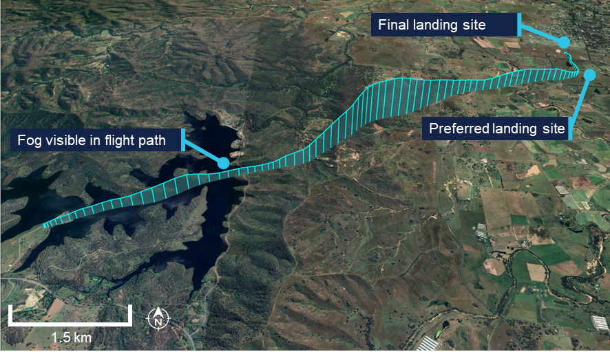
At approximately 0623 local time, the balloon departed The Overflow Estate, at Wyaralong Dam in a north-easterly direction, carrying 20 passengers and one pilot. Based on their pre‑flight weather assessment, the pilot originally intended to land in a south-east landing site near Bromelton (Figure 1) and the ground crew had been instructed to make their way via car to assess the wind conditions near the intended landing site. However, after take‑off the balloon maintained a north-east flight path towards Woodhill and Cedar Grove.
Figure 1: Flight path overview

Source: Google Earth, annotated by the ATSB
About 13 minutes after launch, the balloon had passed over the dam when the pilot climbed the balloon over a ridge line. At about 500 ft above ground level (AGL), the pilot described encountering fog in the direction of travel (Figure 2). The pilot discounted nearby options for an early landing and considered that the safest option available, in the reduced visibility, was to select a new landing site clear of hazards in the north-east (Figure 3).
Figure 2: Fog visible after climbing a ridge at 0636
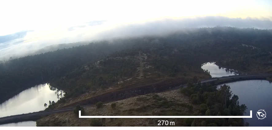
Source: Operator, annotated by the ATSB
Source: Google Earth, annotated by the ATSB
While en route to that preferred landing site, the fog thickened, before the pilot climbed the balloon above the fog (Figure 4).
Figure 4: Fog conditions below the balloon at 0640
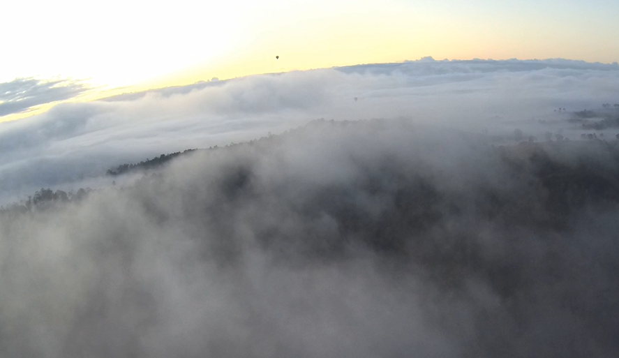
Note: Two other balloons from a separate (unidentified) operator were visible above the fog at this time. Source: Operator
At about 0703, while on approach to the preferred landing site (Figure 3), the balloon encountered a low-level wind change at about 200 ft, increasing in strength from 4–6 kt. The wind change tracked the balloon 90 degrees left, and made landing unfeasible due to a dam and trees.
The wind shift was unexpected to the pilot as they described that surface conditions looked calm, with the fog not appearing to move. Due to ground crew traveling back from the first intended landing site, the pilot did not have information usually available via a surface wind assessment on the ground.
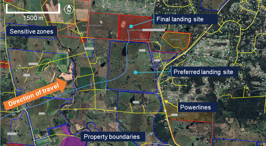
The pilot reconsidered the safest options available considering the reduced visibility and selected a different landing site further north, which was used infrequently by the operator, was closer to a populated area and isolated trees, but with no identified powerlines (Figure 3). The pilot burned[1] to lift the balloon over a wet area before descending towards the new landing site.
On approach, the pilot burned again to lift the balloon over a boundary fence (Figure 5) before they commenced deflation to descend for landing and instructed the passengers to adopt their pre-briefed brace positions. While approximately 5 m from the ground, the pilot visually detected a dead tree (Figure 5). In response they rapidly deflated the balloon in an attempt to stop short of the tree. The pilot further reinforced the brace instruction to the passengers. At 0709, the balloon basket touched down, however was carried forward with the balloon’s resultant air mass momentum. The basket skipped 4 times before it stopped moving (Figure 5), however the balloon envelope inertia continued until the envelope contacted a dead tree (to the left of the basket), resulting in minor damage.
Figure 5: Onboard video of the approach (left) and the final approach flight path (right)

Source: Operator and Google Earth, annotated by the ATSB
The pilot and passengers were uninjured, and due to the delayed arrival of the ground crew, the pilot sought the help of 3 volunteer passengers to recover the envelope from the tree. There was no resultant damage to the basket, however envelope damage included 15 large tears due to contact with the dead tree.
Context
Personnel information
The pilot held a commercial pilot licence (balloon), with 1,253.2 hours total flying time, of which 1,174 hours were flown as pilot in command. In the previous 90 days, the pilot had flown 40.2 hours as pilot in command, including 7.2 hours on the G-450.
The pilot held a current CASA class 2 aviation medical certificate with no conditions.
The pilot reported starting work at 0430 on the day of the occurrence, having obtained about 6 hours of sleep the night before, and an additional 30‑minute nap the previous morning. They recalled feeling fully alert at the time of the occurrence.
Aircraft information
VH-FGC was a Kavanagh Balloons G-450 manned free balloon, manufactured in 2017 by Kavanagh Balloons Australia Pty Ltd. The aircraft was certified in the manned free balloon category and operated with a valid certificate of airworthiness.
The G-450 balloon has an envelope capacity of 450,000 cubic feet and a maximum take‑off weight of 3,700 kg. At the time of the occurrence, the balloon envelope had accumulated a total time of 662.6 hours in service, while the basket had accumulated 1,614.1 hours. The basket was designed to carry a maximum of 24 passengers per basket (6 per passenger compartment).
The balloon was fuelled with 358 L of liquid petroleum gas propane at the start of the flight, with 135 L remaining at landing.
Operator information
Hot Air Pty Ltd operates in the Scenic Rim area of South East Queensland and also the Atherton Tablelands in north Queensland. The organisation has agreements in place with landowners to access several launch and landing locations in a circular pattern near Beaudesert, referred to as the operator’s flying area. The locations include private and commercial properties.
Recorded information
The balloon was equipped with the following equipment capable of recording:
- a GPS which records the flight track
- a ‘flight tablet’ which included an electronic Google Earth satellite map (Figure 6). The satellite map was overlaid with the operator’s flying map layer which was maintained/updated via an electronic register. The flying map included the following operational information:
- launch and landing areas / property boundaries (dark blue)
- sensitive zones (SZs), with restricted operation (red)
- powerlines (yellow)
- other relevant landowner information (white text).
- An onboard camera recording the front facing view of the flight.
Figure 6: Operator flying map showing the balloon flight path
Note: Property names were blurred to maintain landowner privacy. Source: Operator, modified by the ATSB
The final landing site was designated an ‘emergency landings only’ area on the Operator flying map (Figure 6) in Woodhill. The operator occasionally used this site when necessary, but it was not used frequently.
Meteorological information
Observations for surrounding area
The Beaudesert automatic weather station (AWS) provided the air temperature (°C), dew point temperature (°C), and relative humidity (%) along with other information and showed conditions conducive to fog formation (Table 1), that is:
- temperature and dew point less than 1°C difference
- winds were calm
- high relative humidity (above 95%)
- no significant weather movement.
Table 1: Beaudesert AWS information for 7 July 2025
| Time | Air temperature (°C) | Dew point temperature (°C) | Relative humidity (%) | Wind speed in knots |
| 0400 | 12.8 | 12.1 | 96 | 0 |
| 0430 | 13.3 | 12.6 | 96 | 2 |
| 0500 | 12.9 | 12.2 | 96 | 1 |
| 0530 | 12.7 | 12.0 | 96 | 0 |
| 0600 | 12.2 | 11.5 | 96 | 0 |
| 0630[1] | 13.0 | 12.5 | 97 | 0 |
| 0700[2] | 13.3 | 12.8 | 97 | 0 |
| 0730 | 13.8 | 13.4 | 98 | 0 |
Source: BoM website: Latest Weather Observations Beaudesert AWS
| ||||
Forecast for surrounding area
A local graphical area forecast was valid for a six-hour period from 0300–0900 which indicated visibility of about 300 m with scattered fog.
At 0503, the Bureau of Meteorology (BoM) issued an updated aerodrome forecast (TAF)[2] for Amberley, which indicated fog and reduced visibility of 500 m up until 0700 at which time the conditions could be expected to improve.
At 0607, the BoM issued a further update to the TAF, which forecast shallow fog with visibility of 8,000 m, and a 30% probability of fog reducing visibility to 800 m and scattered cloud at 200 ft, until 0900 that day.
Satellite imagery
Satellite imagery was obtained from the BoM, valid as of 0500. The imagery depicted areas of fog or low cloud around, but clear of the original intended area of balloon operation (see Appendix A – satellite images).
Pre-flight observations
The pilot also reviewed several sources of weather information in the preceding hours prior to launch, as required by the operator’s exposition[3] (Version 1, 11 November 2024) and CASR Part 131[4] (Table 2).
Table 2: Pilot weather observations
| Approx. time | Location | Information source or method | Assessment |
| Previous night | Near Beaudesert | Windy.com application | Wind conditions suitable for flight. |
| 0415 | Near Beaudesert | Visibility by sight BoM Brisbane (Mt Staplyton) Radar Loop | Visibility clear for flying area[1]. Rain showers would be clear by launch time (0623). |
| 0430 | Operator Base, Beaudesert | Visibility by sight BoM Beaudesert AWS BoM Brisbane (Mt Staplyton) Radar Loop Windy.com application NAIPS[2] account local GAF and surrounding aerodrome TAFs | Visibility clear for intended flight path. Calm surface conditions with a temperature of 12°C. Rain showers had cleared the flying area. Light and variable surface winds, becoming south‑westerly 5 kt at 1000ft then westerly 16 kt at 3,000 ft. Light winds at nearby stations, and most clear except for Amberley that indicated a chance of surface fog, however not operationally relevant being more than 48 km away from Beaudesert. |
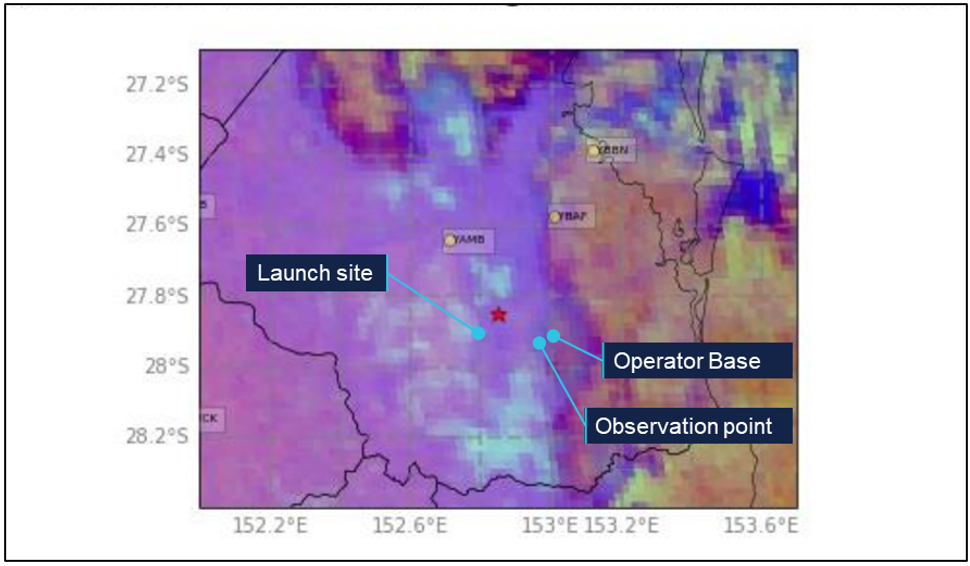
| 0445 | Bromelton observation point | Visibility by sight Pibal | Visibility clear for intended flight path. Fog present in the south of the flying area around Laravale, more than 14 km south of Beaudesert. Very light southerly for 300 ft, then turning into a west‑north-westerly wind of approximately 6-8 kt before swinging back to a westerly wind of approximately 10–15 kt (as the Pibal climbed). |
| 0530 | Launch site at Wyaralong Dam | Visibility by sight Pibal | Visibility clear for intended flight path. No change to previous Pibal wind readings. |
| |||
Based on the observations the pilot decided to depart from The Overflow Estate launch site (west of Beaudesert) with the plan to fly in a south-east direction back into their operational flying area (and towards Beaudesert).
Regulatory requirements and guidance
Balloon pilots and operators must also comply with Part 131 of the Civil Aviation Safety Regulations (CASR), pre-flight weather assessment rules in section 12.02 of the Part 131 Manual of Standards (MOS).[5]
Balloon operations can occur in Class G airspace with at least 100 m visibility below 500 ft AGL when outside 10 NM from an aerodrome (such as in the case of Beaudesert). However, CASA highly recommends that pilots and operators exercise this significant reduction in the visibility requirements with caution and only if sufficient flight preparation has taken place. Further balloon guidance is available at Advisory Circular 131-02 v4.0.
Survivability
Pre-flight passenger safety briefing
One consideration in balloon accidents is the basket tipping during landing, which can increase the risk of injury. Tipping is more likely if a basket contacts, or lands on, a tree or fence.
Passengers were provided with safety briefings and instructions prior to boarding as required by the operator’s exposition. These included:
- entry/exit to the basket
- remaining in the basket until instructed by crew
- securing and stowing personal items
- prohibited dangerous goods
- use of rope handles
- landing/brace positions (for normal/upright landing and emergency/hard landing).
The passengers included several foreign tourists from non-English speaking backgrounds. Verbal information was supported by physical demonstrations (of the required landing position) and graphical briefing cards with basic diagrams and translations in simplified Chinese, Japanese, Korean, and German.
One passenger reported receiving pre-flight safety information via email at multiple points leading up to the flight, which was then supported by the safety demonstration on the day of the flight.
Related occurrences
A search of the ATSB occurrence database found that in the 10 years to July 2025 there were 37 balloon hard landings, ground strikes, or collisions with terrain in Australia, resulting in 17 injuries. Of these, 13 occurrences involved contact/collision with trees.
Further information on some of these occurrences can be found in Appendix B – Related occurrences.
Safety analysis
As is often required in balloon operations, the pilot was required to reassess operational and safety decisions at multiple points before and during the flight.
This analysis will explore the assessment of weather, launch location, contingency options, and landings in reduced visibility.
Fog encountered in flight
Fog was forecast for a wide area that included the operator’s flying area and the local conditions were conducive to fog. Satellite images support the pilot’s report by confirming that fog was likely not visible in the immediate flying area when the pilot travelled to the launch site before the flight. Based on their visibility assessment and pre-flight observations, the pilot determined it was safe to fly.
However, after take-off and on climbing above the ridge line over the dam, the pilot identified fog in the direction of flight, and the balloon subsequently entered fog.
Approach to land
Once lined up and on approach to land at the preferred landing site, the balloon was affected by an unexpected low-level wind shift and tracked about 90 degrees to the left.
Subsequently, the pilot considered other landing locations and associated risks, and selected an emergency landing site, used infrequently by the operator.
Reduced visibility
Once committed to landing in the final landing area in significantly reduced visibility, the pilot visually detected a tree through the fog in front of the balloon. In an attempt to take avoiding action, they rapidly deflated the envelope to land the balloon, however due to inertia, the balloon envelope made contact with the tree and was damaged.
Comprehensive safety briefings
The passengers were provided with comprehensive safety information leading up to, and before the flight. The ground crew and pilot also ensured understanding of the brace positions prior to launch.
As a result of the proper brace position, effective briefing and re-enforced communication during landing, no injuries were sustained.
Findings
ATSB investigation report findings focus on safety factors (that is, events and conditions that increase risk). Safety factors include ‘contributing factors’ and ‘other factors that increased risk’ (that is, factors that did not meet the definition of a contributing factor for this occurrence but were still considered important to include in the report for the purpose of increasing awareness and enhancing safety). In addition ‘other findings’ may be included to provide important information about topics other than safety factors. These findings should not be read as apportioning blame or liability to any particular organisation or individual. |
From the evidence available, the following findings are made with respect to the controlled flight into terrain involving Kavanagh Balloons G-450, registration VH-FGC, 12 km north‑north-west of Beaudesert, Queensland, on 7 July 2025.
Contributing factors
- After clearing a ridge line, fog was encountered in the direction of the flight path.
- During the approach to land in low visibility, an unexpected low-level wind shift diverted the balloon away from the preferred clear landing area, and required the pilot to select an alternate unplanned landing site in the final stages of landing.
- Due to reduced visibility, the pilot was unable to see hazardous obstacles in the final landing area and therefore unable to take timely avoiding action.
Other findings
- Comprehensive passenger safety briefings meant passengers adopted brace positions prior to landing which likely prevented injury.
Sources and submissions
Sources of information
The sources of information during the investigation included:
- the pilot of the accident flight
- the chief pilot of the operator
- Civil Aviation Safety Authority
- Bureau of Meteorology
- accident witnesses
- video footage of the accident flight and other photographs and videos taken on the day of the accident
- recorded data from the GPS unit on the aircraft.
References
CASA (Civil Aviation Safety Authority), (2025), Part 131 Aircraft – Operations, Advisory Circular AC 131-02v4.0, CASA
CASA (Civil Aviation Safety Authority), (2025), CASR Part 131 – Guide for balloons and hot air airships, v1.2, CASA
Submissions
Under section 26 of the Transport Safety Investigation Act 2003, the ATSB may provide a draft report, on a confidential basis, to any person whom the ATSB considers appropriate. That section allows a person receiving a draft report to make submissions to the ATSB about the draft report.
A draft of this report was provided to the following directly involved parties:
- the pilot
- the operator
- Civil Aviation Safety Authority
- Bureau of Meteorology.
Submissions were received from:
- Civil Aviation Safety Authority
- Bureau of Meteorology.
The submissions were reviewed and, where considered appropriate, the text of the report was amended accordingly.
Appendices
Appendix A – satellite images
High resolution visible satellite imagery
Satellite imagery was obtained from the Bureau of Meteorology and was valid at 0500 (Figure A1) showing fog/low cloud as light blue areas.
Figure A1: High resolution visible satellite imagery from 0500
Note: This imagery was not available to the pilot at the time of the event. Source: The Bureau of Meteorology, annotated by the ATSB
Appendix B – Related occurrences
Hard landing involving balloon, VH-EUA, near Yarra Glen, 8 February 2018 (AO-2018-016)
On 8 February 2018, a Kavanagh B-350 hot-air balloon, registration VH-EUA, departed Glenburn, Victoria, for a scenic charter flight with a pilot and 15 passengers on board. About 45 minutes into the flight, over the Yarra Valley, the balloon experienced a sudden wind change with associated turbulence. The pilot decided to land immediately rather than continue over rising and heavily vegetated terrain. The resulting landing was hard and fast and 11 passengers were injured, with 4 of them receiving serious injuries.
Collision with terrain involving Kavanagh E-240 Balloon, VH-LUD, near Yamanto, Queensland, on 8 October 2021 (AO-2021-042)
On 8 October 2021, a Kavanagh Balloons E-240 balloon, registered VH-LUD and operated by Floating Images Aust. Pty Ltd was conducting a morning scenic flight about 45 km south‑west of Brisbane, Queensland. On board were a pilot and 9 passengers. About 55 minutes into the flight, the pilot commenced a descent to locate a suitable landing area. During the descent, the balloon entered an area of localised fog where visibility reduced to 10 m.
The pilot continued the descent into the fog until a tree was observed in the path of the balloon. The pilot attempted to avoid the tree by initiating a climb, but the balloon collided with, and came to rest on the side of, the tree, damaging the lower part of the balloon envelope. The pilot subsequently climbed the balloon off the tree and above the fog. The flight continued to an uneventful landing in a nearby paddock that was clear of fog. There were no injuries.
Controlled flight into terrain involving Kavanagh Balloons G-525, VH-HVW, Pokolbin, New South Wales, on 30 March (AO-2018-027)
At about 0710 Eastern Daylight-saving time on 30 March 2018, a Kavanagh Balloons G‑525 balloon, registered VH-HVW (HVW) and operated by The International Balloon Flight Company (Australia), launched from a site near Pokolbin, New South Wales, for a planned 1-hour scenic flight. HVW was one of three balloons launched by the company from the same site. After climbing through fog to about 2,000 ft and realising how far the fog layer extended, the pilot of HVW, along with the other 2 pilots, decided to abort the flight and descend for a landing at the nearest suitable site. On approach to land in low‑visibility conditions, HVW collided with trees, which caused the basket to rotate 180 degrees. It then landed heavily, resulting in injuries to 16 of the 24 passengers, 3 of them serious. The pilot was uninjured and 74 of the balloon’s panels required patching or repair.
Purpose of safety investigationsThe objective of a safety investigation is to enhance transport safety. This is done through:
It is not a function of the ATSB to apportion blame or provide a means for determining liability. At the same time, an investigation report must include factual material of sufficient weight to support the analysis and findings. At all times the ATSB endeavours to balance the use of material that could imply adverse comment with the need to properly explain what happened, and why, in a fair and unbiased manner. The ATSB does not investigate for the purpose of taking administrative, regulatory or criminal action. About ATSB reportsATSB investigation reports are organised with regard to international standards or instruments, as applicable, and with ATSB procedures and guidelines. Reports must include factual material of sufficient weight to support the analysis and findings. At all times the ATSB endeavours to balance the use of material that could imply adverse comment with the need to properly explain what happened, and why, in a fair and unbiased manner. An explanation of terminology used in ATSB investigation reports is available here. This includes terms such as occurrence, contributing factor, other factor that increased risk, and safety issue. Publishing informationReleased in accordance with section 25 of the Transport Safety Investigation Act 2003 Published by: Australian Transport Safety Bureau © Commonwealth of Australia 2025 
Ownership of intellectual property rights in this publication Unless otherwise noted, copyright (and any other intellectual property rights, if any) in this report publication is owned by the Commonwealth of Australia. Creative Commons licence With the exception of the Commonwealth Coat of Arms, ATSB logo, and photos and graphics in which a third party holds copyright, this report is licensed under a Creative Commons Attribution 4.0 International licence. The CC BY 4.0 licence enables you to distribute, remix, adapt, and build upon our material in any medium or format, so long as attribution is given to the Australian Transport Safety Bureau. Copyright in material obtained from other agencies, private individuals or organisations, belongs to those agencies, individuals or organisations. Where you wish to use their material, you will need to contact them directly. |
[1] The action of activating the burner to heat the air within the balloon, increasing internal temperature and causing the balloon to rise or maintain altitude.
[2] Aerodrome forecasts are a statement of meteorological conditions expected for a specific period of time, in the
airspace within a radius of 5 NM (9 km) of the aerodrome.
[3] A CASR Part 131 Balloon Transport Operation Exposition, also known as an ‘Operations Manual’.
[4] CASR Part 131 requires balloon operators to obtain a weather forecast from an authorised source, such as the Bureau of Meteorology, valid for a period extending 2 hours beyond their landing time.
[5] The Part 131 Manual of Standards (MOS) outlines the operational standards and requirements for operators of balloons and hot air airships in Australia to ensure safety and compliance with aviation regulations.
Occurrence summary
| Investigation number | AO-2025-037 |
|---|---|
| Occurrence date | 07/07/2025 |
| Location | 12 km north-north-west of Beaudesert |
| State | Queensland |
| Report release date | 26/11/2025 |
| Report status | Final |
| Investigation level | Short |
| Investigation type | Occurrence Investigation |
| Investigation status | Completed |
| Mode of transport | Aviation |
| Aviation occurrence category | Controlled flight into terrain (CFIT), VFR into IMC |
| Occurrence class | Serious Incident |
| Highest injury level | None |
Aircraft details
| Manufacturer | Kavanagh Balloons |
|---|---|
| Model | G-450 |
| Registration | VH-FGC |
| Serial number | G450-538 |
| Aircraft operator | Hot Air Pty Ltd |
| Sector | Balloon |
| Operation type | Part 131 Balloons and hot air airships |
| Departure point | The Overflow Estate, Wyaralong, Queensland |
| Destination | Beaudesert Boonah Road, Bromelton, Queensland |
| Damage | Minor |