
Final report
Report release date: 16/12/2025
Investigation summary
What happened
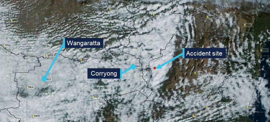
On 15 July 2025, a Beechcraft 35-C33 Debonair, registered VH-KZK, departed Wangaratta Airport, Victoria for a private flight under the visual flight rules (VFR) to Moruya Airport, New South Wales.
Soon after entering the Snowy Mountains area, the aircraft made a 150° right turn, shortly followed by another long left turn. The aircraft entered a spiralling descent to the right that continued until the aircraft collided with terrain. The pilot was fatally injured and the aircraft was destroyed.
What the ATSB found
It is very likely that the pilot, who did not hold an aircraft instrument rating, experienced spatial disorientation after flying into instrument meteorological conditions (IMC). This subsequently resulted in the collision with terrain.
Based on the forecast cloud between Wangaratta and Moruya, completing such a flight while maintaining VFR was likely not feasible. The pilot held a recreational pilot licence that did not include a navigation endorsement. While the pilot had completed some of the training required to attain a navigation endorsement, it is possible that the pilot’s limited training and experience in this respect affected their decision to conduct or continue the flight into challenging weather conditions.
Safety message
One of the key risk controls for a VFR pilot to avoid entering IMC is appropriate pre-flight preparation and planning. Not only should pilots obtain up-to-date weather information before and during flight, they should plan an alternate landing point and be prepared to make necessary deviations from the planned route should actual weather conditions necessitate it.
Licence restrictions and endorsements are a critical aspect of flight safety. They ensure that pilots have been trained to an acceptable standard and that the appropriate experience has been attained. Studies show that pilots with less weather experience are more likely to engage in high-risk activities when dealing with weather. This accident is an important reminder to respect these restrictions and endorsements when planning a flight.
The investigation
The occurrence
On 15 July 2025, the pilot and sole occupant of a Beechcraft 35-C33 Debonair, registered VH-KZK, was conducting a private flight under the visual flight rules (VFR)[1] from Wangaratta Airport, Victoria, to Moruya Airport, New South Wales. The pilot was returning to Moruya following the completion of routine maintenance on the aircraft.
It is not known what weather information was accessed by the pilot prior to departing Wangaratta, as no flight planning records were recovered. Text messages from the pilot at 0755 on the morning of the accident flight indicated that they were conducting flight planning and considering the weather on the morning of the accident flight, noting that ‘the sky outside is scattered clouds so we will see what the planning forecast is.’
A flight path recreated from automatic dependant surveillance broadcast (ADS-B) transmissions is shown in Figure 1. The pilot departed Wangaratta at 1302 and flew approximately east towards Moruya, 189 NM away, making occasional changes in heading. By 1315 the aircraft had climbed to an altitude of 4,500 ft above mean sea level (AMSL), where it remained until it approached the rising terrain of the Snowy Mountains, where the aircraft began climbing to 7,000 ft. The mountainous area along the aircraft’s flight path had varying terrain heights, with a maximum of approximately 6,000 ft AMSL.
Figure 1: Flight path of VH-KZK on 15 July 2025
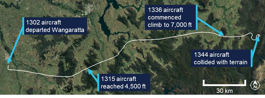
Source: Google Earth, annotated by the ATSB
The aircraft flew past a small aerodrome, Khancoban Airport,[2] at about 1339 at an altitude of about 6,400 ft AMSL (Figure 2). At 1340:15, the pilot commenced a rate 1 turn[3] to the right with minimal change in altitude. At 1341:18, after turning through 150°, there was a 20-second period where ADS-B transmissions were not received. The aircraft was subsequently detected in a left turn through 206°, also approximately rate 1. An airspeed of approximately 150 kt was maintained through these turns.
Figure 2: Flight path prior to colliding with terrain
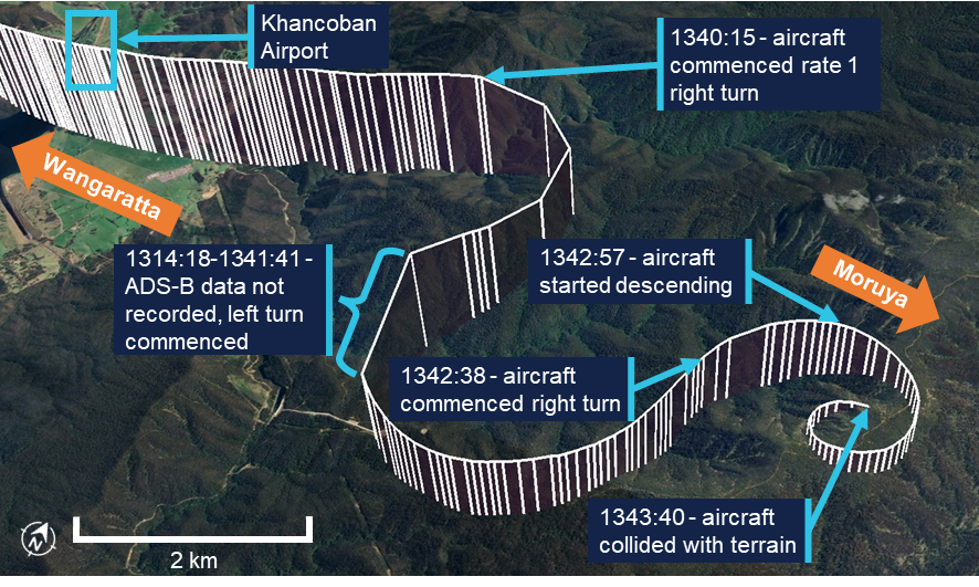
Vertical lines are used to indicate the aircraft’s height above terrain. Each line represents a data point. Source: Google Earth, annotated by the ATSB
At approximately 1342:38, the aircraft entered another right turn and shortly after, began descending from 6,725 ft AMSL. From this point, the aircraft’s rate of turn, descent rate and groundspeed all steadily increased into a spiralling descent. The last ADS-B transmission was recorded 55 ft above ground level, with an estimated airspeed of 210 kt and a rate of descent above 4,000 ft/min. At 1343:40, the aircraft collided with terrain at an elevation of 4,830 ft AMSL. The pilot was fatally injured and the aircraft was destroyed.
The pilot had lodged a search and rescue time (SARTIME) with Airservices Australia, and when this time elapsed the Joint Rescue Coordination Centre (JRCC) was notified and commenced a search. The aircraft was not fitted with an emergency locator transmitter (ELT), and poor weather conditions limited JRCC search capabilities. Visibility was affected by cloud, and in the early stages of the search, helicopters had limited access to the area where the aircraft was last detected on ADS-B. After an extended search by air, the aircraft was located on 17 July in steep, forested terrain with snow cover.
Context
Pilot information
General information
The pilot held a Recreational Pilot (Aeroplane) Licence (RPL) with a single engine aeroplane class rating and a flight radio endorsement. The RPL permitted private or training flights by day under VFR. The pilot was issued with a basic class 2 aviation medical certificate that was valid until February 2026. The basic class 2 medical certificate was an alternative to a full class 2 certificate for RPL and Private Pilot Licence (PPL) holders. It imposed additional operational restrictions, including that the pilot was not permitted to fly above 10,000 ft.
The pilot’s next of kin reported no relevant medical conditions or medications. There was evidence that the pilot had up to about 9 hours sleep opportunity the night before the flight, but there was insufficient information available to assess fatigue.
Toxicology and pathology reports were not available at the time of publishing this report.
Training and experience
The ATSB estimated[4] the pilot had completed 142 hours total flight time, including 28 hours of solo flying. The pilot had an estimated 25 hours of flight experience in the Beechcraft 35-C33 Debonair, entirely in VH-KZK (which they owned), including 10 hours of solo flying.
The pilot did not have an RPL navigation endorsement, which meant they were restricted from flying beyond 25 NM of the departure aerodrome, unless it was to travel to a training area. Obtaining the navigation endorsement required completion of specific flying training and passing a written examination. The Civil Aviation Safety Authority (CASA) website stated that the examination covered a range of topics including:
• maps and charts properties
• forecast requirements and interpretation of forecasts, determination of alternate or holding requirements.
The pilot had received some navigation training, which included several navigation exercises, as well as a solo navigation flight. Including that flight, the pilot had completed 4 exercises within the standard PPL syllabus. Two additional dual exercises and 1 final long solo navigation exercise were required before an RPL navigation endorsement could be sought. During the training, with regard to flight planning, the pilot was assessed as having achieved ‘competency to the standard required for qualification issue’. Flight planning included the following elements:
• select a suitable route and altitude considering weather, terrain, airspace, NOTAMs[5] and alternate landing areas
• obtain and interpret meteorological forecasts, NOTAMs and operational information applicable to the planned flight
• determine whether the planned flight can be conducted under the applicable flight rules and taking account of the beginning and end of daylight times.
In total, the pilot had accrued 38.1 hours of navigation training, including 1.7 hours flying solo. The pilot had also received 1.0 hours of basic instrument flight training in 2021 on a different aircraft.
Recent flying
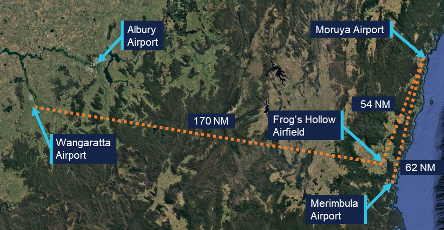
The pilot’s most recent formal navigation training was in March 2023. Between November 2023 and October 2024, the pilot undertook training in VH-KZK, having previously flown a Beechcraft C23 Sundowner. Following this training, ADS-B data showed VH-KZK flying (determined to be with this pilot in command) on 9 different occasions between November 2024 and May 2025. All of these flights took place along the New South Wales south coast between Moruya Airport, Merimbula Airport and Frog’s Hollow Airfield (Figure 3). Logbook entries for these flights were not found, but they were understood to be solo flights for pleasure and personal transport.
Figure 3: Aerodromes used by VH-KZK
Source: Google Earth, annotated by the ATSB
On the day before the accident, the pilot conducted a solo navigation flight from Frog’s Hollow to Wangaratta Airport where the aircraft was booked in for routine maintenance. Weather forecasts from the area predicted a cloud ceiling of 7,000 ft and scattered cloud. ADS-B data showed that the pilot conducted most of the flight at an altitude of 9,000 ft, above the forecast cloud tops. The flight appeared to be conducted without incident.
Aircraft information
The Beechcraft 35-C33 Debonair is a low-wing, 4-seat, all-metal aircraft with retractable tricycle landing gear. The Debonair, with a conventional vertical fin and tailplane, was a variant of the early Beechcraft Bonanza model, which had a distinctive V-tail. VH-KZK, serial number CD-985, was manufactured in 1967 in the United States and first registered in Australia in the same year. It was powered by a 6-cylinder Teledyne-Continental Motors IO-470-K engine driving a McCauley 2A36C23 constant-speed propeller. The aircraft was fitted with a pitot heat system.
The aircraft had been classified as capable of operating under the instrument flight rules (IFR) in September 2019. A review of the expired maintenance releases identified that the aircraft shifted between IFR and VFR categories, depending on IFR inspection status. The last IFR inspection recorded in the aircraft logbook was completed on 4 May 2023, with the maintenance release showing the IFR category selected. The current maintainer, who first inspected the aircraft in June 2024, reported that, due to uncertainty around the certification of the equipment, the IFR category was not indicated on the previous 2 maintenance releases.
The aircraft was being maintained in accordance with the standard CASA maintenance schedule (Schedule 5), which required a periodic inspection every 100 flight hours or 12 months, whichever came first. The most recent periodic inspection was completed on 15 July 2025, with the aircraft having accrued 17.5 hours in the previous 12 months. In addition to the periodic inspection requirements, the 2 main tyres were replaced. A new maintenance release was issued with the aircraft having accrued 3,279 hours total time in service.
Maintenance records indicated that an emergency locator transmitter (ELT) was removed from the aircraft in 2019. The maintainer confirmed that there was no ELT fitted to VH-KZK.
Wreckage and impact information
Access to the accident site was limited due to the terrain, snow and environmental conditions, and the ATSB did not attend the accident site. New South Wales Police Force personnel who winched to the site via helicopter to recover the pilot took photographs and collected physical evidence, including documentation and potential data recording devices, which were later examined by the ATSB.
The aircraft was significantly disrupted (Figure 4), consistent with the estimated final aircraft speed of 210 kt and a vertical rate of descent of over 4,000 ft/min. The impact was not survivable. Accident site photographs indicated that the wreckage was relatively contained, rather than spread over a long wreckage trail. This was consistent with the steep descent indicated by the flight data. The engine had separated from the aircraft wreckage and was located 10–15 m away. From the photographs, it was not possible to determine conditions such as aircraft configuration, control cable continuity or the state of control surfaces. It also could not be determined whether all components remained attached up to the point of impact.
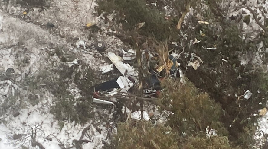
Source: New South Wales Police Force
Meteorological information
Aerodrome weather
The aerodromes closest to the accident site were Khancoban Airport and Corryong Airport (7 NM and 18 NM west of the accident site, respectively). Corryong did not provide meteorological observations and Khancoban had a non-aviation automatic weather station which did not report cloud or visibility. However, records for Albury Airport (Figure 3), which VH-KZK passed earlier in the flight, indicated that the following conditions existed at 1330:
- visibility greater than 10 km
- 9 kt westerly wind
- no precipitation
- broken cloud at 4,600 ft AGL (5,100 ft AMSL).
Weather forecasts
The Bureau of Meteorology (BoM) issued a set of graphical area forecasts (GAFs) at 0820 on the morning of the accident flight. Based on the flight data, the aircraft’s flight path would have passed through 3 areas with varying forecast conditions.
For the initial part of the flight, beginning at Wangaratta and approaching the Victoria/New South Wales border, the terrain elevation along the flight path varied between about 500 and 3,800 ft AMSL. On this segment the following conditions were forecast (all altitudes are AMSL):
- a broken[6] cloud layer from 1,000–2,000 ft that was forecast to clear by about the aircraft’s departure time
- broken cloud from 3,000–8,000 ft
- isolated showers of rain, during which visibility would reduce to 4,000 m and cloud would extend from 800 ft to above 10,000 ft
- isolated showers of snow above 4,000 ft during which visibility would reduce to 500 m and cloud would extend to 8,000 ft
- freezing level above 4,500 ft.
After crossing into New South Wales and over the Snowy Mountains, just beyond Khancoban, the flight overflew mountainous terrain where the elevation increased to between 600 and 6,000 ft. In this region the forecast was for:
- scattered[7] cloud from 1,500–3,000 ft and broken cloud from 3,000 ft to above 10,000 ft
- scattered areas of drizzle with visibility reducing to 3,000 m and overcast conditions from 3,000 ft to 9,000 ft
- isolated showers of snow above 4,000 ft with broken cloud from 4,000 ft to above 10,000 ft
- freezing level above 4,500 ft.
The accident occurred within this region of the GAF. East of the highest terrain in the Snowy Mountains, conditions were forecast to improve slightly:
- scattered cloud from 2,500–8,000 ft
- broken cloud from 6,000 ft to above 10,000 ft.
Satellite imagery
A satellite photograph taken at 1340, less than 4 minutes before the aircraft collided with terrain, showed cloud cover in the vicinity of the accident site (Figure 5). However, the image provided no information on cloud height or density.
Figure 5: Satellite image from 1340 on 15 July
Source: Bureau of Meteorology, annotated by the ATSB.
Witness report
A witness with an aviation background was located near Khancoban Airport around the time of the occurrence. They reported hearing an aircraft in the area that they later believed to be VH-KZK. The witness could not see the aircraft due to cloud, but noted that it sounded as if it was heading towards the mountains east of Khancoban. The witness said the aircraft sounded like it was much lower than aircraft travelling over the mountains at this point would typically be (9,000 ft AMSL); the witness estimated the aircraft to be travelling at about 4,000 ft AMSL.
The witness observed the weather to be completely overcast. The cloud was low enough to be sitting on nearby hilltops, the peaks of which the witness believed to be between 2,500-3,000 ft AMSL.
Icing conditions
BoM forecasts note that flying in any cloud above the freezing level implies moderate icing conditions. The BoM publication titled Airframe Icing advises pilots on the effects that icing can have on an aircraft. It states that icing can:
- alter the smooth flow of air over the aircraft
- reduce pilot visibility
- produce errors in instrument readings of air speed, altitude and vertical speed
- increase the stall speed by increasing its weight and changing the aerodynamics of the wing and tail
- increase drag and decrease lift (tests have shown that icing no thicker or rougher than a piece of coarse sandpaper can reduce lift by 30% and increase drag by 40%)
- make it almost impossible to operate control surfaces and landing gear
- reduce thrust or cause engine failure.
Because VH-KZK was fitted with a pitot heat system, and a fuel-injected engine, the most likely adverse outcomes from icing involved ice forming on the exterior parts of the airframe. According to the BoM, this type of icing is caused by water droplets from cloud or precipitation striking the airframe at temperatures below the freezing level.
Operational information
Visual meteorological conditions
Visual meteorological conditions (VMC) are expressed in terms of in-flight visibility and distance from cloud (horizontal and vertical) as prescribed in the Civil Aviation Safety Regulations (CASR) Part 91 General Operating and Flight Rules. The accident flight was conducted entirely in uncontrolled (Class G) airspace. In order for the pilot to conduct such a flight under VFR while remaining below 10,000 ft (in accordance with licence requirements), the following VMC criteria needed to be maintained at all times:
- 5,000 m visibility with 1,000 ft vertical and 1,500 m horizontal distance from cloud
- When below the higher of 3,000 ft AMSL or 1,000 ft AGL and in sight of ground or water, the aircraft may be just clear of cloud.
These criteria were illustrated in the CASA Visual Flight Rules Guide (Figure 6). Generally speaking, aircraft flying in conditions that do not meet these criteria are in instrument meteorological conditions (IMC).
Figure 6: Visual meteorological conditions (VMC) criteria below 10,000 ft
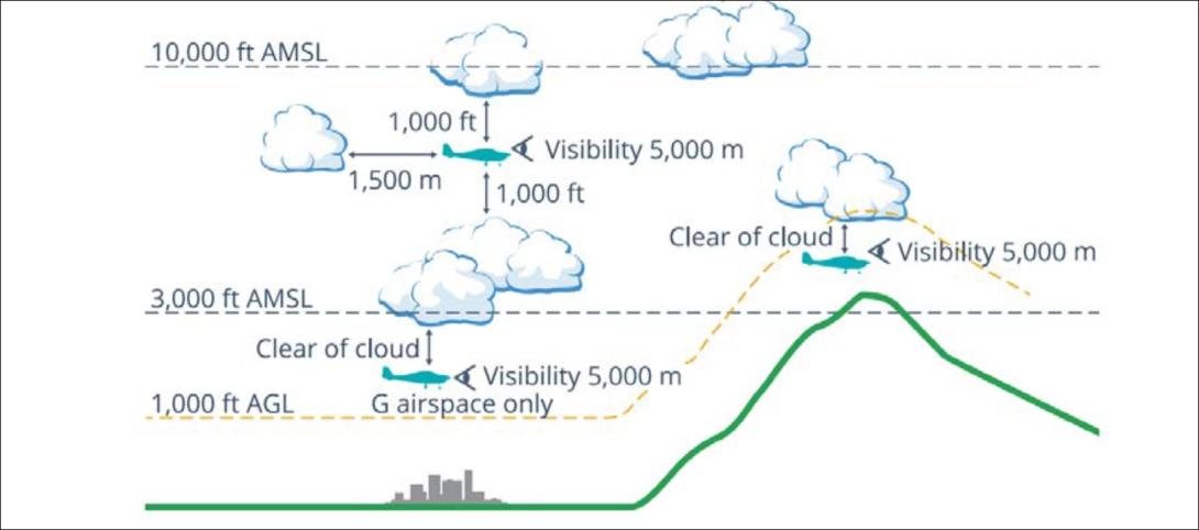
Source: Civil Aviation Safety Authority
Flight planning requirements
Flight rules required that pilots study the appropriate authorised weather forecasts and reports in accordance with the CASR Part 91 Manual of Standards. This included authorised weather forecasts and reports for:
- the route to be flown
- the departure aerodrome, the planned destination aerodrome and any planned alternate aerodrome.
Improving the odds
In 2010 the ATSB published Improving the odds: Trends in fatal and non-fatal accidents in private flying operations (AR-2008-045), which found that assessing and planning problems contributed to 46% of fatal accidents involving Australian private flights between 1999 and 2008. The report stated that:
Assessing and planning issues associated with collision with terrain and/or loss of control accidents mostly involved pilots failing to plan for the weather conditions, not properly assessing the weather during flight, or deciding to continue to fly in marginal weather.
The report provided extensive discussion (pages 16 through 21) on topics including ways of avoiding VFR into IMC accidents, such as through emphasising assessment of flight conditions (particularly weather conditions), evaluating effectiveness of plans, and setting personal minimums.
Spatial disorientation
The ATSB publication Accidents involving Visual Flight Rules pilots in Instrument Meteorological Conditions (AR-2011-050) discusses the physiological limitations of the human body when trying to sense its orientation in space:
In conditions where visual cues are poor or absent, such as in poor weather, up to 80 per cent of the normal orientation information is missing. Humans are then forced to rely on the remaining 20 per cent, which is split equally between the vestibular system and the somatic system. Both of these senses are prone to powerful illusions and misinterpretation in the absence of visual references, which can quickly become overpowering.
Pilots can rapidly become spatially disoriented when they cannot see the horizon. The brain receives conflicting or ambiguous information from the sensory systems, resulting in a state of confusion that can rapidly lead to incorrect control inputs and resultant loss of aircraft control.
The somatogyral illusion is one possible consequence of spatial disorientation, described in the ATSB publication Visual flight at night accidents: What you can’t see can still hurt you (
):
This illusion relates to a pilot’s incorrect understanding of an aircraft’s angle of bank. When the angle of bank is changed, the pilot’s vestibular system will register any angular acceleration above a threshold level of activation. Once the aircraft is in a constant turn, the pilot’s vestibular system will stop registering any input because there is no angular acceleration. In the absence of any other sensory information or vestibular input a pilot may experience a sensation that the aircraft is no longer turning.
The CASA publication titled Spatial disorientation was published in 2024 as part of the AvSafety program. This detailed several commonly observed illusions that pilots can experience as a result of spatial disorientation. The ‘Graveyard spiral’ described in the publication can occur as a result of the somatogyral illusion:
This can happen when an aircraft begins to bank in cloud or dark night conditions. A constant rate of bank will be undetectable by the vestibular apparatus in a pilot’s head, and unless the pilot is scanning the attitude indicator continuously there will be no visual clue. Rushing slipstream will indicate the increasing airspeed of a dive in what otherwise appears to be straight-and-level flight. Attempts to pull out of the dive often only tighten the unrecognised turn and can cause overstressing and failure of the aircraft structure.
For non-instrument rated pilots, entering IMC can quickly become fatal. Research has shown that pilots not proficient in instrument-only flight will typically become spatially disoriented and lose control of the aircraft within 1–3 minutes after visual cues are lost.
Additional details on spatial disorientation and illusions in low-visibility conditions are provided in the ATSB investigation report VFR flight into dark night involving Aérospatiale AS355F2 (Twin Squirrel), VH-NTV, 145 km north of Marree, South Australia, on 18 August 2011 (AO‑2011‑102).
Related occurrences
Between 2015 and 2025 there were 116 VFR into IMC occurrences in Australian airspace reported to the ATSB. Of these, 13 were fatal accidents resulting in 24 fatalities. Based on these figures, approximately 1 in every 9 reported VFR into IMC occurrences results in a fatality.
Safety analysis
Spiral descent
The aircraft’s steadily increasing rate of descent and rate of turn in the period leading up to the impact with terrain were consistent with spatial disorientation, specifically, the somatogyral illusion and the ‘graveyard spiral’ described by CASA and others.
Broken cloud was forecast in the mountains east of Khancoban between 3,000 ft AMSL to above 10,000 ft AMSL. There were also areas of drizzle with overcast conditions between 3,000 ft and 9,000 ft AMSL. The report from the witness near Khancoban airport indicated local conditions consistent with this forecast. Given the terrain elevation in the area, it is therefore almost certain that the aircraft encountered weather conditions making visibility marginal or worse, possibly for extended periods.
The aircraft’s increasing rate of descent and maximum allowable airspeed exceedance just before the collision with terrain indicated that the pilot was either not aware of the aircraft’s speed and attitude, or was not able to correct it during the descent.
The pilot held a valid basic class 2 medical certificate and there was no available evidence to indicate any medical conditions likely to impact their flying ability, although an incapacitating medical event could not be entirely ruled out.
Prior to the spiral descent, the aircraft maintained a steady altitude and groundspeed, which did not indicate any engine or control issues to that point. An engine issue by itself should also not result in a high-speed, spiralling descent, unless there was also a control issue present. Control issues could not be entirely ruled out, since the wreckage was not examined, and photographs were insufficient to determine aspects such as control cable continuity or the presence of all control surfaces.
Aircraft icing was another possibility. It can affect a number of aspects relating to aircraft performance, handling or pilot visibility, and multiple control surfaces jammed by ice at the same time could result in an uncontrolled spiral flightpath. Structural icing would only be expected if the aircraft was in cloud or precipitation. In either case, based on the forecast, the aircraft would be in IMC where spatial disorientation would also be a concern.
In either case, the aircraft’s flight path, including what appear to be 2 controlled turns beyond Khancoban, indicates that the aircraft remained controllable until at least the commencement of the spiral. The manoeuvres also indicate that the pilot deliberately left the planned flight route, and were consistent with attempts to navigate around cloud or showers and possibly find a landing area. For example, the first turn might have been an attempt to return to Khancoban or another airport such as Corryong or Wangaratta, and the second turn the result of cloud closing in behind the aircraft, preventing such a return.
Considering the weather conditions on the day, the pilot’s limited training and experience, and the proven hazard of entering IMC as a VFR pilot, it is therefore very likely that the pilot experienced spatial disorientation in low-visibility conditions, leading to an undetected spiral descent.
VFR into IMC
Just beyond Khancoban, the weather forecast indicated that broken cloud was expected from ground level (above 3,000 ft AMSL) up to above 10,000 ft AMSL. The vertical extent of the cloud would have made this particularly challenging for the pilot because it was probably not possible to fly above the broken cloud and remain under 10,000 ft in accordance with licence restrictions.
Because there were no weather stations recording observations near the accident site, the actual weather conditions that the pilot encountered could not be determined beyond a single witness account (at ground level) and a satellite image that shows cloud in the area. While the conditions might have differed from the weather forecast, the forecast conditions indicated that a pilot would have no certainty of maintaining VFR. The pilot was not IFR rated and training records indicated that they had only flown 1 hour of instrument flight training.
While the pilot had completed some navigation training including a solo navigation flight, they were yet to complete the training syllabus necessary to obtain a navigation endorsement for their recreational pilot licence. As such, they were not authorised to fly the 189 NM distance between Wangaratta and Moruya. Additionally, while the pilot had received training and been assessed as competent at reading weather forecasts in an aviation context, they likely had limited experience in this respect and had not been assessed on some relevant elements required for the PPL such as the more advanced interpretation of forecasts, and determination of alternate or holding requirements. This increased the likelihood of misinterpreting the forecast or underestimating the difficulty of navigating the forecast conditions.
There is limited information available to establish the extent or specifics of the pilot’s pre-flight planning. The exact weather scene presented to the pilot upon entering the mountains was not known, nor was the pilot’s decision-making regarding initiation and continuation of the flight.
The number of reported VFR into IMC occurrences over the last 10 years indicates that many pilots, some likely with more experience, have found themselves in unsuitable weather situations yet continued the flight. However, studies have shown that pilots who do not accurately perceive the risks of adverse weather are more likely to engage in higher risk activities when dealing with weather (Cooper, 2003). The pilot’s limited training and experience with adverse weather conditions may therefore have contributed to their perception of risk and associated decision-making.
Findings
ATSB investigation report findings focus on safety factors (that is, events and conditions that increase risk). Safety factors include ‘contributing factors’ and ‘other factors that increased risk’ (that is, factors that did not meet the definition of a contributing factor for this occurrence but were still considered important to include in the report for the purpose of increasing awareness and enhancing safety). In addition ‘other findings’ may be included to provide important information about topics other than safety factors. These findings should not be read as apportioning blame or liability to any particular organisation or individual. |
From the evidence available, the following findings are made with respect to the VFR into IMC and collision with terrain involving Beechcraft 35-C33 Debonair VH-KZK, 12 km east of Khancoban, New South Wales on 15 July 2025.
Contributing factors
- The pilot very likely encountered instrument meteorological conditions, resulting in spatial disorientation and collision with terrain.
- The pilot commenced a solo navigation flight, into areas with forecast instrument meteorological conditions, without having completed the required training and licensing for cross-country navigation.
Sources and submissions
Sources of information
The sources of information during the investigation included the:
- Australian Maritime Safety Authority
- Airservices Australia
- Civil Aviation Safety Authority
- New South Wales Police Force
- pilot’s flight instructor
- maintenance organisation for VH-KZK
- witness to the flight
- pilot's next of kin.
References
Australian Transport Safety Bureau. (2011). Accidents involving Visual Flight Rules pilots in Instrument Meteorological Conditions. Aviation Research Investigation Report AR-2011-050.
Bureau of Meteorology. (2025, June 4). Airframe icing. Australian Government. https://www.bom.gov.au/aviation/data/education/icing.pdf
Cooper D. (2003). Psychology, Risk and Safety: Understanding how personality & perception can influence risk taking. Professional Safety. Journal of the American Society of Safety Engineers, November 2003, 39-46.
Submissions
Under section 26 of the Transport Safety Investigation Act 2003, the ATSB may provide a draft report, on a confidential basis, to any person whom the ATSB considers appropriate. That section allows a person receiving a draft report to make submissions to the ATSB about the draft report.
A draft of this report was provided to the following directly involved parties:
- Civil Aviation Safety Authority
- Australian Maritime Safety Authority
- Bureau of Meteorology
- the pilot’s flight instructor.
Submissions were received from:
- Civil Aviation Safety Authority
- Bureau of Meteorology
- the pilot’s flight instructor.
The submissions were reviewed and, where considered appropriate, the text of the report was amended accordingly.
Purpose of safety investigationsThe objective of a safety investigation is to enhance transport safety. This is done through:
It is not a function of the ATSB to apportion blame or provide a means for determining liability. At the same time, an investigation report must include factual material of sufficient weight to support the analysis and findings. At all times the ATSB endeavours to balance the use of material that could imply adverse comment with the need to properly explain what happened, and why, in a fair and unbiased manner. The ATSB does not investigate for the purpose of taking administrative, regulatory or criminal action. About ATSB reportsATSB investigation reports are organised with regard to international standards or instruments, as applicable, and with ATSB procedures and guidelines. Reports must include factual material of sufficient weight to support the analysis and findings. At all times the ATSB endeavours to balance the use of material that could imply adverse comment with the need to properly explain what happened, and why, in a fair and unbiased manner. An explanation of terminology used in ATSB investigation reports is available here. This includes terms such as occurrence, contributing factor, other factor that increased risk, and safety issue. Publishing informationReleased in accordance with section 25 of the Transport Safety Investigation Act 2003 Published by: Australian Transport Safety Bureau © Commonwealth of Australia 2025 
Ownership of intellectual property rights in this publication Unless otherwise noted, copyright (and any other intellectual property rights, if any) in this report publication is owned by the Commonwealth of Australia. Creative Commons licence With the exception of the Commonwealth Coat of Arms, ATSB logo, and photos and graphics in which a third party holds copyright, this report is licensed under a Creative Commons Attribution 4.0 International licence. The CC BY 4.0 licence enables you to distribute, remix, adapt, and build upon our material in any medium or format, so long as attribution is given to the Australian Transport Safety Bureau. Copyright in material obtained from other agencies, private individuals or organisations, belongs to those agencies, individuals or organisations. Where you wish to use their material, you will need to contact them directly. |
[1] Visual flight rules (VFR): regulations that permit a pilot to operate an aircraft in conditions whereby navigation and orientation of the aircraft by visual reference is possible.
[2] Khancoban Airport did not have an entry in the Airservices aeronautical information publication (AIP) en route supplement Australia (ERSA).
[3] A rate 1 turn, also known as a standard rate turn, is turn rate of 3° per second.
[4] The pilot’s logbook was not located. However, a copy of the pilot’s logbook with entries up until February 2023 was obtained. The ATSB also collated training records and publicly available flight data of the accident aircraft to estimate the pilot’s hours and experience.
[5] Notice to airmen (NOTAM): A notice distributed by means of telecommunication containing information concerning the
establishment, condition or change in any aeronautical facility, service, procedure or hazard, the timely knowledge of
which is essential to personnel concerned with flight operations.
[6] Broken cloud refers to cloud that covers between 5 to 7 oktas (eighths) of the sky.
[7] Scattered cloud refers to cloud that covers between 3 to 4 oktas (eighths) of the sky.
Occurrence summary
| Investigation number | AO-2025-040 |
|---|---|
| Occurrence date | 15/07/2025 |
| Location | 12 km east of Khancoban |
| State | New South Wales |
| Report release date | 16/12/2025 |
| Report status | Final |
| Investigation level | Short |
| Investigation type | Occurrence Investigation |
| Investigation status | Completed |
| Mode of transport | Aviation |
| Aviation occurrence category | Collision with terrain, VFR into IMC |
| Occurrence class | Accident |
| Highest injury level | Fatal |
Aircraft details
| Manufacturer | Beech Aircraft Corp |
|---|---|
| Model | 35-C33 |
| Registration | VH-KZK |
| Serial number | CD-985 |
| Sector | Piston |
| Operation type | Part 91 General operating and flight rules |
| Departure point | Wangaratta Airport, Victoria |
| Destination | Moruya Airport, New South Wales |
| Damage | Destroyed |