
Final report
Report release date: 28/10/2025
Investigation summary
What happened
On the morning of 16 June 2025, a Cessna 182T departed a private aircraft landing area south of Emerald, Queensland, with a pilot and a passenger on board for a private flight to Atherton, Queensland.
Prior to their departure the pilot had obtained the weather conditions for Mareeba Airport, about 22 km to the north of their intended destination of Atherton, and assessed the conditions as acceptable for visual flight.
When the aircraft was about 95 km north of Charters Towers, the pilot assessed they would be unable to continue their direct track towards Atherton due to the cloud height over the terrain ahead. The pilot diverted west to avoid higher terrain and planned to divert to Mareeba due to its lower elevation by approaching from the west.
About 35 minutes after the diversion, the pilot descended the aircraft to about 500 ft above ground level, following a road. As they tracked towards rising terrain, their height reduced to about 200 ft above ground level. The pilot recalled that suddenly conditions ahead became a ‘white-out’ and they commenced a left turn and reduced the aircraft’s power in an attempt to avoid flying into the cloud.
During the turn the aircraft entered cloud and the pilot lost visual reference with the ground. Recorded data indicated the aircraft conducted a 360° left turn with several changes in altitude and coming in close proximity to terrain before the pilot could engage the autopilot to attempt to stabilise the aircraft.
The pilot then commanded a 180° left turn using the autopilot, intending to return to visual meteorological conditions. However, as the aircraft climbed, the air speed reduced and the aircraft likely stalled, leading to a rapid descent.
The pilot received a terrain warning and immediately applied recovery actions; as they eased out of the dive, the pilot momentarily became visual with terrain before the aircraft contacted tree-tops but continued to remain airborne.
The pilot was able to maintain control and became visual again on top of the cloud layer and, with the aircraft significantly damaged, diverted to Charters Towers Airport.
What the ATSB found
The pilot’s pre-flight planning was inadequate for the intended flight. The pilot had planned the second leg of the flight at a height that would not have allowed sufficient safe margin from terrain. While they obtained the forecast weather for a location close to their destination, which identified local conditions were suitable for visual flight, the pilot did not obtain the required graphical area forecast which indicated cloud height below terrain level on the flight planned track. Had the pilot obtained the area forecast this likely would have influenced their decision to commence the flight or plan an alternate route.
After encountering low cloud, the pilot continued flight towards the destination and into rising terrain, this forced them to descend below safe terrain clearance altitudes to a height of about 200 ft above ground level, rather than divert or return.
In an attempt to turn around, the aircraft entered cloud. The pilot was not rated for instrument flight, became spatially disorientated, resulting in a near collision with terrain.
While still in instrument meteorological conditions and disorientated, the pilot initiated a climbing turn and engaged the autopilot at reduced power. This resulted in the aircraft being unable to maintain airspeed and it likely entered a stall and rapidly lost height. During the recovery, the aircraft then impacted trees however continued to fly.
The pilot used the aircraft instruments to navigate out of cloud, regain visual reference to the ground and track south. Although the pilot was aware of the potential for damage sustained to the aircraft during the impact with the tree, they continued flight in the damaged aircraft for about 1.5 hours to Charters Towers (a familiar airport with a longer runway) rather than seek the nearest suitable landing area.
Safety message
Thorough information gathering is an essential part of a pilot’s pre-flight preparation. This is especially important in a single-engine aircraft and includes studying maps and routes to establish appropriate flight heights over terrain where forced landing areas may be limited. Weather conditions often vary over large distances and this is more likely over areas of elevated terrain. Although individual locations may indicate favourable conditions, other more widespread weather conditions, unsuitable for visual flight, may exist outside of the forecast location. Use of all available resources to ensure accurate knowledge of the expected conditions will assist pilots with informed decision‑making, both before and during flight.
It should be accepted that flying under visual flight rules will not always enable you to reach your planned destination. Making an early decision to land or divert and to resist the urge to ‘press on’ may prevent flight into marginal weather conditions and ultimately disaster.
The investigation
The occurrence
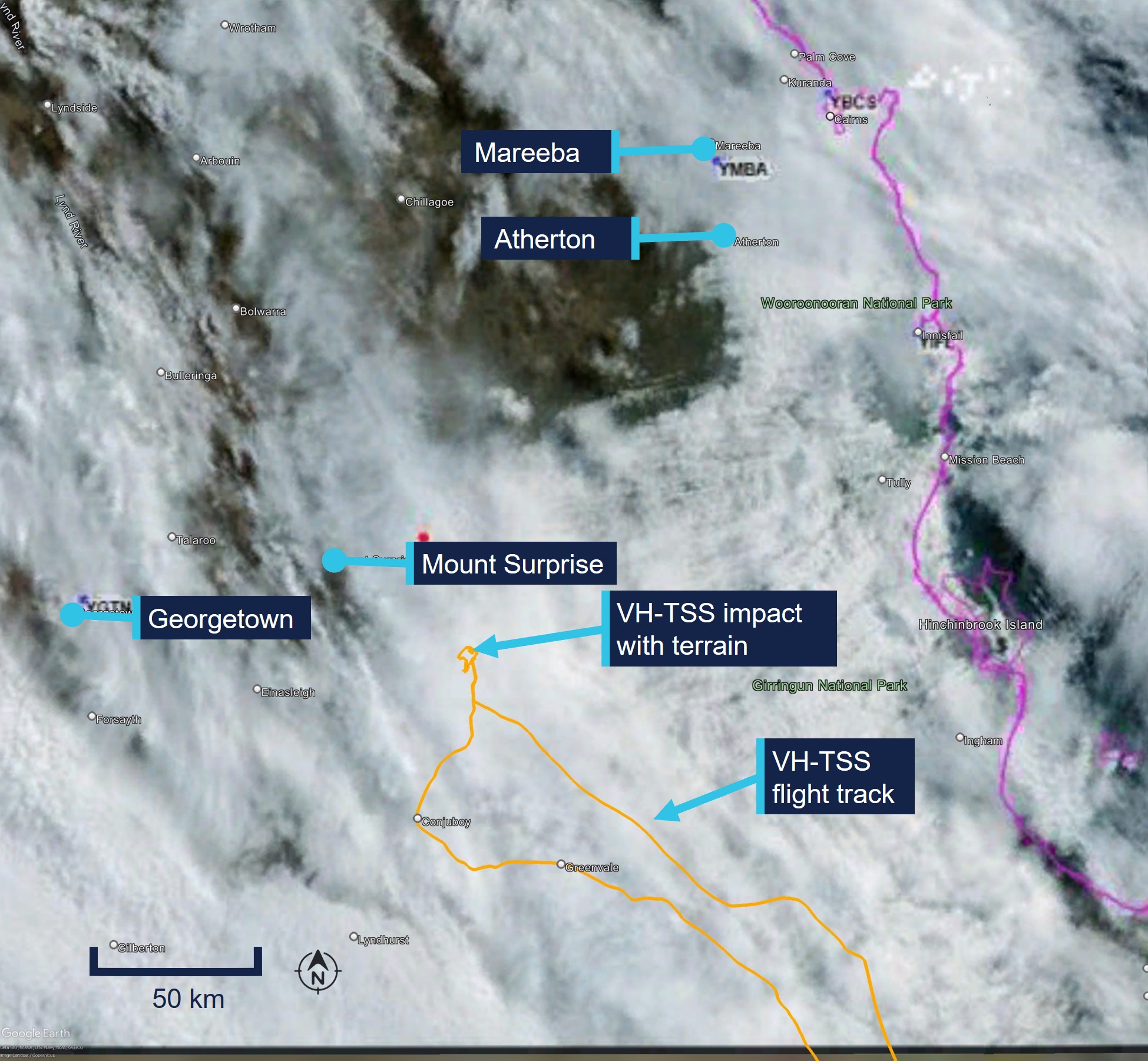
On 16 June 2025, at 0634 local time, a Cessna 182T, registered VH-TSS, departed a private aircraft landing area (ALA) about 16 NM south‑south-east of Emerald, Queensland, for a private flight to Atherton, Queensland. On board the aircraft were the pilot and one passenger.
Electronic flight data showed the aircraft departed and climbed to 4,500 ft above mean sea level (AMSL) where it initially held a steady track towards Atherton (Figure 1).
Figure 1: VH-TSS flight track between 0828 and 1115
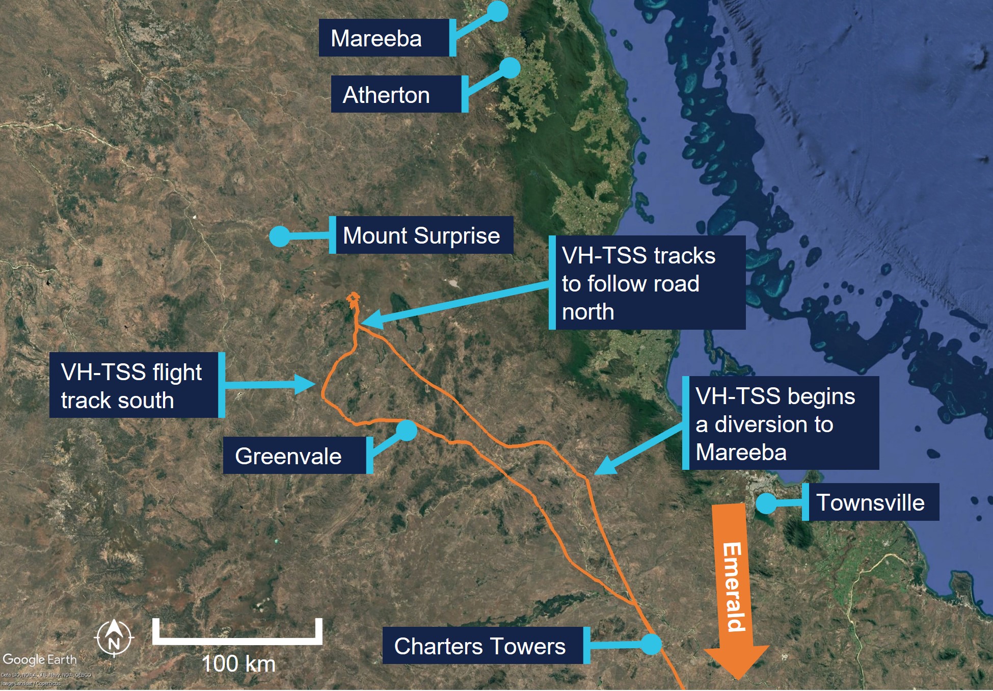
Source: Google Earth, overlaid electronic flight data, annotated by the ATSB
At 0848, the aircraft descended to 3,000 ft AMSL, about 35 NM north of Charters Towers. The pilot then assessed that cloud and reduced visibility would affect continued visual flight direct to Atherton. The pilot stated they elected to continue, however diverted around weather to Mareeba Airport which they had planned as an alternative destination due to the lower elevation. They stated that they were familiar with the area, having flown a similar route 7 or 8 times previously and reported that they assessed the weather for Mareeba several times during the flight. At 0855 the aircraft was about 50 NM north of Charters Towers at an altitude of about 2,900 ft AMSL, about 1,650 ft above ground level (AGL).
The pilot recalled altering their heading to avoid weather and flying over higher terrain. The aircraft tracked generally in a north-west direction with numerous adjustments to the heading and altitude for about 35 minutes.
At 0930 the aircraft was recorded at about 530 ft AGL. The pilot recalled following Kennedy Developmental Road to the north. They reported this decision was due to the low cloud ceiling and advised that, in their experience, the road usually avoided the areas of highest terrain.
At 0932, the aircraft was recorded at about 410 ft AGL and the pilot made several heading adjustments to maintain visual reference with the road due to reducing visibility under heavy cloud cover.
At 0933 and about 90 NM south-west of Mareeba, the aircraft was recorded at about 240 ft AGL, with the pilot continuing to track following the road in a northerly direction.
About a minute later at about 200 ft AGL and 140 kt airspeed (Figure 2), the pilot recalled commencing a left turn and reduced the aircraft’s engine power to try to avoid flying into ‘white-out’ conditions ahead. However, during the turn, the pilot recalled that they entered cloud.
Figure 2: VH-TSS flight track between 0932 and 0946
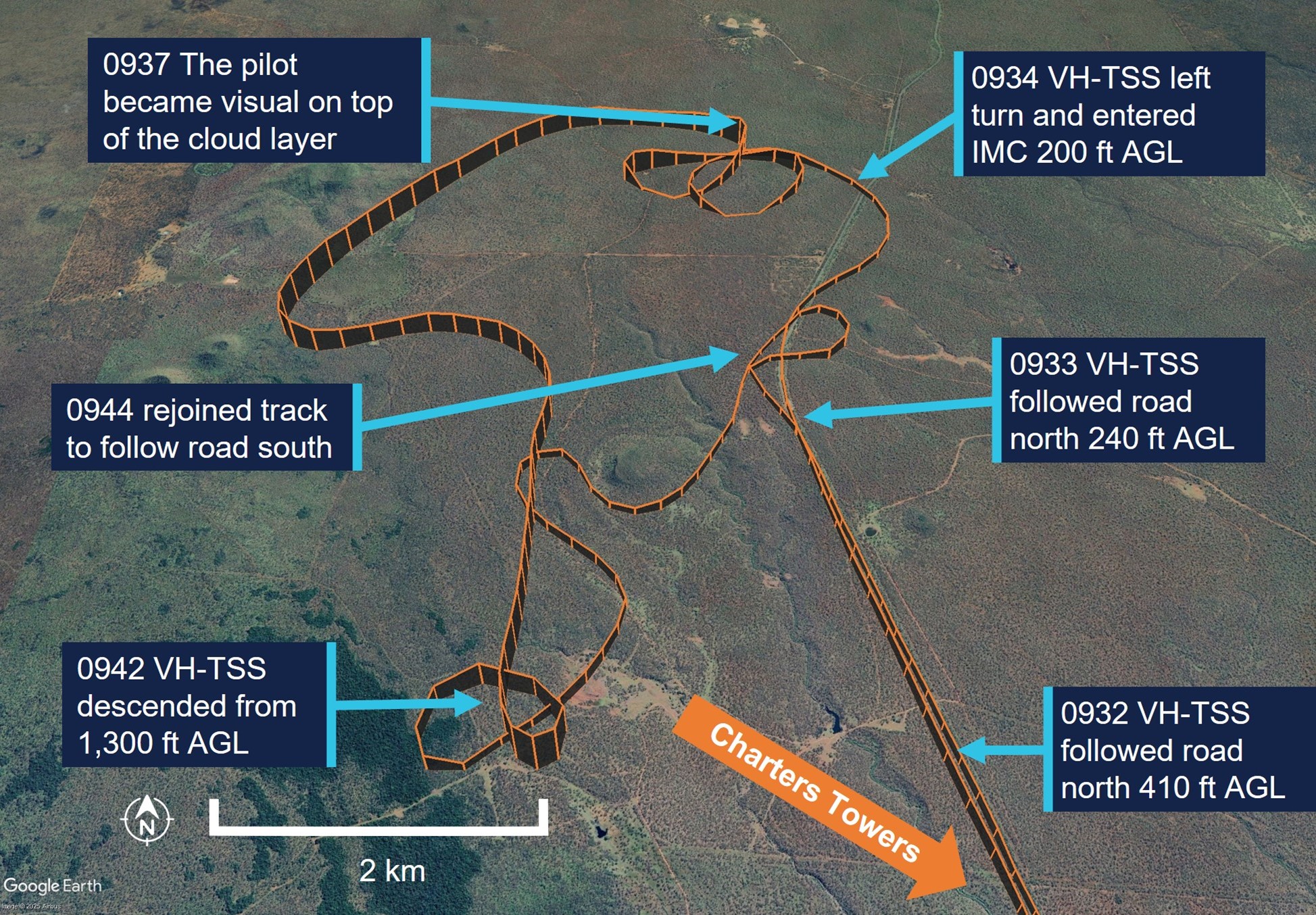
Source: Google Earth, annotated by the ATSB
In the following minute, the aircraft continued a left turn and completed an orbit with several significant altitude changes, descending and climbing twice then descending again. The recorded altitude, which may not be an accurate representation of the aircraft’s actual altitude during manoeuvres, varied between 0 ft AGL on the second descent (the pilot did not report any impact occurring at this point) and 700 ft about 20 seconds later.
At 0936, having descended a third time to about 200 ft, the aircraft began to maintain a constant heading for about 20 seconds during which time it had a high rate of climb consistent with the engagement of the autopilot (see Autopilot). The aircraft climbed from about 200 ft to 700 ft AGL and reduced groundspeed to 54 kt. The pilot recalled they engaged the autopilot after entering cloud (this was likely after about 1–2 minutes after entering cloud) and then commanded a 180° left turn, in an attempt to reverse their track and navigate out of the instrument meteorological conditions (IMC) (Figure 3). During the next 10 seconds, the aircraft turned sharply left and descended rapidly. The pilot recalled the aircraft instrument panel went red and displayed a terrain warning and immediately applied right rudder and attempted to level the aircraft during the recovery, as it descended almost to ground level.
Figure 3: VH-TSS flight track between 0934 and 0938
Source: Google Earth, annotated by the ATSB
The pilot reported that they momentarily became visual and heard the aircraft impact trees. They pulled back on the control column and commenced a climb, entering IMC again. The pilot climbed to an altitude of about 1,000 ft AGL and was able to stabilise the aircraft and navigate out of IMC using the instruments. They became visual again once on top of the layer of cloud.
At 0942 the pilot descended from 1,000 ft to about 300 ft AGL. They then navigated back to Kennedy Developmental Road at a height of 200–350 ft AGL.
The pilot reported that they were unable to see the leading edge of the wing and unaware of the extent of the damage to the aircraft after the collision, however recalled the aircraft required more right rudder application than usual and that this prevented autopilot engagement. As a precaution, the pilot chose to follow major roads so that they could land if required and navigated the aircraft back to Charters Towers due to the runway length and their familiarity with the airport. The aircraft landed safely at 1114 local time.
As a result of the impact with the tree, the aircraft sustained substantial damage to the left wing (Figure 4), with minor damage to the left wing strut and both landing gear struts. No injuries were reported by either occupant.
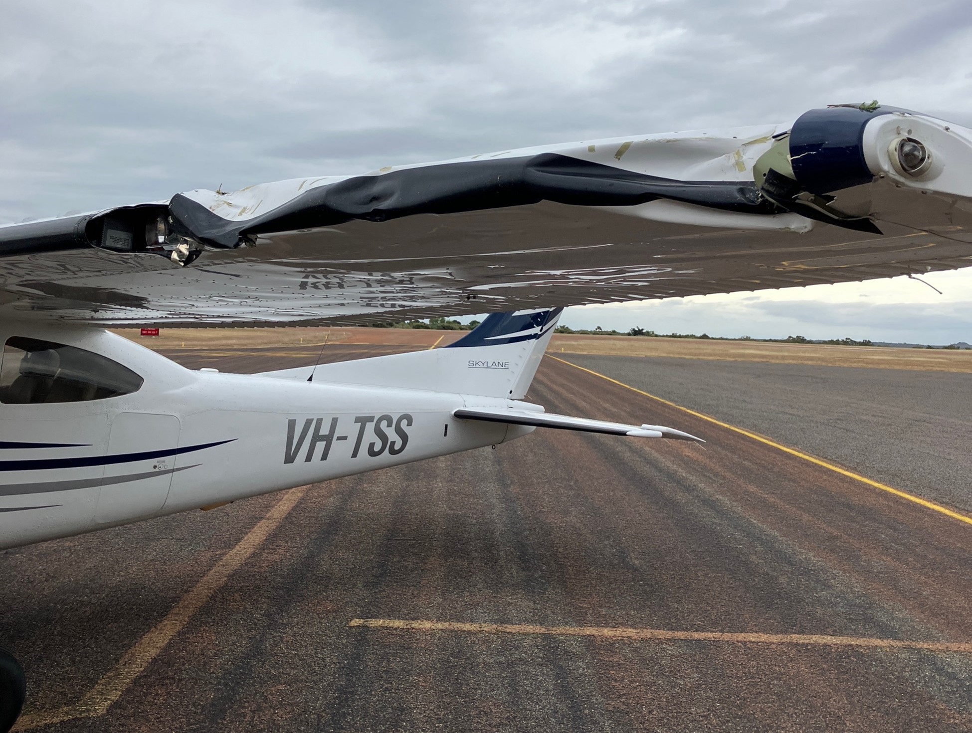
Source: Pilot
Context
Pilot information
The pilot held a valid Private Pilot Licence (Aeroplane) with a single engine aircraft rating since 1992. Their last flight review was conducted on 30 June 2023 and was valid to 31 July 2025. At the time of the occurrence, the pilot had about 3,580 hours total aeronautical experience of which 3,340 hours were reported to be on the Cessna 182. The pilot also reported that they had flown 48.5 hours during the last 90 days.
The pilot did not hold an instrument rating and was only rated to fly in visual meteorological conditions (VMC).[1]
The pilot held a valid class 2 medical certificate that was issued on 3 November 2023 and was valid until 12 November 2025. The class 2 was issued with a restriction requiring that reading correction must be available in flight and that the pilot must not fly within 24 hours of medical therapy.
Fatigue
The pilot reported that at the time of the occurrence they felt fully alert and wide awake. They indicated that they had slept 8 hours in the last 24 hours and 17 hours in the last 48 hours prior to the occurrence.
The ATSB considered that fatigue was unlikely to have affected the pilot’s performance at the time of the occurrence.
Instrument flight
As part of the pilot’s initial flight training for their licence, they recalled conducting 2–3 hours instrument flying with no visual references. However, since that time, they reported that they had not conducted any further instrument flight since their initial training.
Aircraft information
The Cessna 182T is a 4-seat, single engine, high-winged aircraft and is powered by a 6‑cylinder fuel-injected 235 hp (175 kW) Lycoming TIO-540-AK1A piston engine.
VH-TSS was manufactured in the United States in 2005 and was first registered in Australia to the pilot in April 2010. The aircraft was certified to be flown by day and night under visual flight rules (VFR)[2] and was only operated for private operations.
The pilot recorded the total time in service of the aircraft as 2,761.8 hours after arriving at Charters Towers.
Cessna 182 stall speeds
The Cessna 182T pilot operating handbook (POH) indicated the following stall speeds for the aircraft.
- flaps up, power idle 54 knots calibrated airspeed[3] (KCAS)
- flaps full, power idle 49 KCAS
The POH indicated that 54 KCAS would show as 50 kt indicated airspeed (IAS) to the pilot with no flap selected.
The POH also stated the stall speeds at known angles of bank at the aircraft’s maximum all up weight of 1,406 kg. The POH indicated that the stall speeds increased as the aircraft’s angle of bank increased.
Garmin G1000 terrain proximity
The aircraft instrument panel contained the Garmin G1000 display unit, which consisted of a primary flight display and multifunction display.
Colours are used to represent obstacles and aircraft altitude when the terrain proximity page is selected for display. Terrain proximity uses black, yellow, and red to represent terrain information relative to aircraft altitude. The colour of each obstacle is associated with the altitude of the aircraft (Figure 5):
- black indicates terrain more than 1,000 ft below aircraft altitude
- yellow indicates terrain between 100 ft and 1,000 ft below the aircraft altitude
- red indicates terrain is above or within 100 ft below the aircraft altitude.
Figure 5: Garmin terrain proximity caution and warning
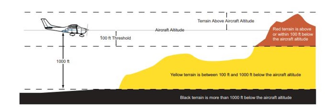
Source: Garmin G1000 pilot’s guide Cessna NAV III
Autopilot
VH-TSS was fitted with a KAP 140 2-axis autopilot system, which provided both lateral and vertical modes and allowed the pilot to preselect an altitude.
The KAP 140 manual stated that when the autopilot was initially engaged, it activated the basic roll mode which levelled the aircraft wings and also engaged the vertical speed hold mode. This would capture the aircraft’s current vertical speed at the time of the autopilot engagement.
The manual provided a warning on the use of vertical speed mode stating:
When operating at or near the best rate of climb airspeed, at climb power settings, and using vertical speed hold, it is easy to decelerate to an airspeed where continued decreases in airspeed will result in a reduced rate of climb. Continued operation in vertical speed mode can result in a stall.
The engagement of the heading button would arm the heading mode, which would command the aircraft to turn to and maintain the heading selected on either the horizontal situation indicator[4] (HSI) or the directional gyroscope.
Figure 6: KAP 140 autopilot control panel
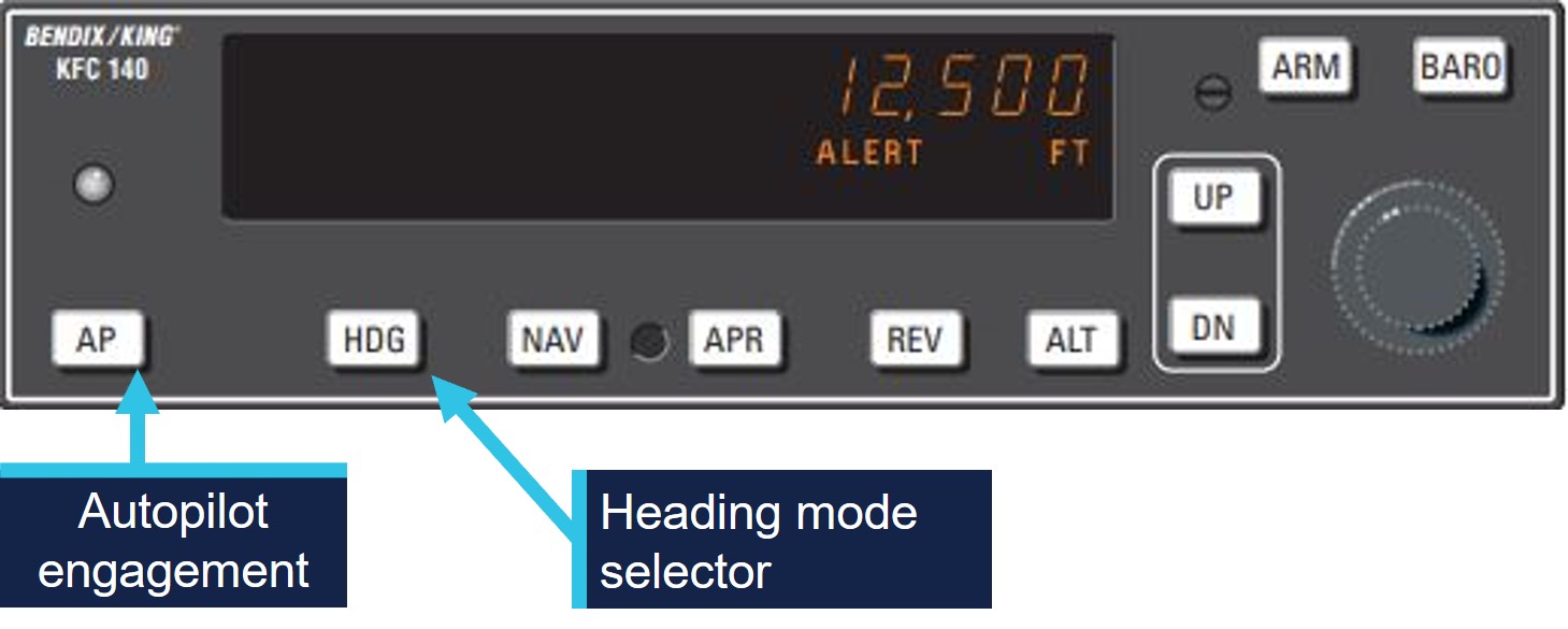
Source: KAP 140 manual, annotated by the ATSB
The pilot identified a key safety message from CASA seminars on ‘VFR into IMC’ that they had attended was to use the autopilot if available in case of inadvertent entry to IMC.
Meteorological information
The pilot had obtained the TAF[5] for Mareeba Airport, about 22 km north of Atherton Airport and elevation of 1,564 ft above mean sea level (AMSL). The TAF was issued at 0328 on 16 June and valid between 0500 and 1800 local time. The forecast indicated the wind at 150° at 10 kt, with visibility greater than 10 km and broken[6] cloud cover at 2,000 ft above airport elevation. From 1000, the wind was forecast to increase to 12 kt, with visibility greater than 10 km and scattered[7] cloud cover at about 2,500 ft.
The Bureau of Meteorology does not provide an aviation forecast or recordings for Atherton Airport.
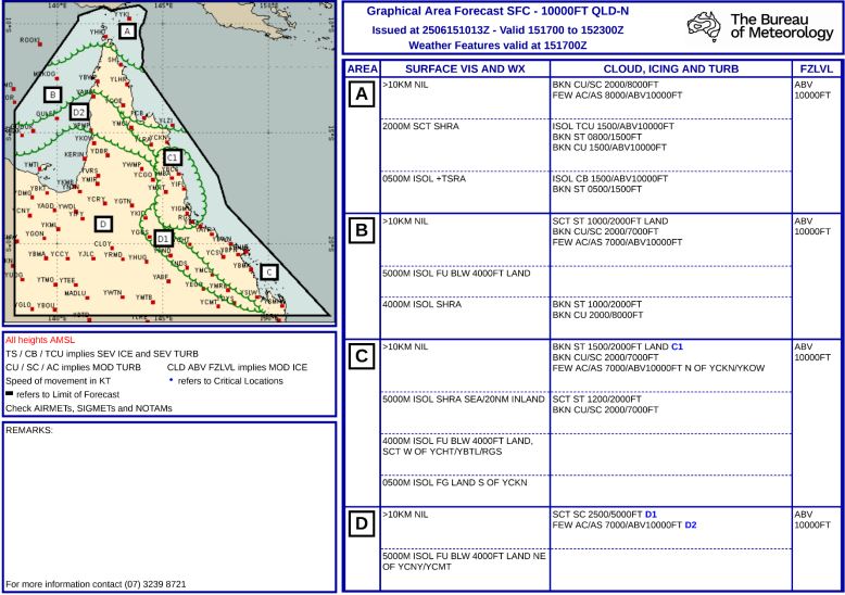
The pilot did not obtain a graphical area forecast (GAF) for the flight planned route (Appendix – Graphical Area Forecasts). The GAF for surface to 10,000 ft for the area in North Queensland was issued at 2013 on 15 June and was valid between 0300 and 0900 on 16 June. Cloud heights were forecast down to 1,500 ft AMSL with isolated fog reducing visibility to 500 m in areas along the pilot’s flight planned track.
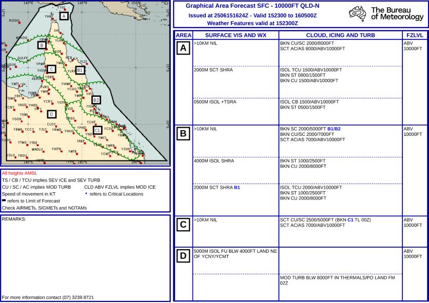
A further GAF for the same area was issued at 0224 on 16 June, it was valid between 0900–1500 the same day and indicated broken cloud down to 2,000 ft AMSL and to 1,000 ft AMSL with isolated rain showers reducing visibility to 4,000 m. It also indicated broken cloud cover down to 2,500 ft, becoming scattered after 1000. The GAF covered both the flight planned track and the aircraft’s diversion track (See Appendix – Graphical Area Forecasts).
Satellite image taken at 0930 provided by the Bureau of Meteorology indicated cloud cover in the flight planned area and the area the pilot intended to use as a diversion (Figure 7).
Figure 7: Satellite image 0930 local time
Source: Bureau of Meteorology, annotated by the ATSB
The pilot recalled that when they reached Kennedy Developmental Road, the cloud ceiling height had reduced. The pilot estimated they had more than 10 km visibility and a ‘good horizon’ with a crosswind from the east of about 15–18 kt.
After following the road north for about 3.5 minutes the pilot recalled that a ‘white-out’ appeared ahead and, shortly after, they entered instrument meteorological conditions (IMC).
Recorded data
The pilot used a flight planning application on an iPad for en route flight planning, navigation and to obtain weather information.
The software provider was an approved source of electronic aeronautical charts, however the application could not be used as a primary means of GPS‑based navigation as the iPad GPS did not meet certification for aviation use. Additionally, there were limitations to the recorded data as altitude information had a resolution of 100 ft, and filtering applied to smooth the data can affect the accuracy of small sections of data.
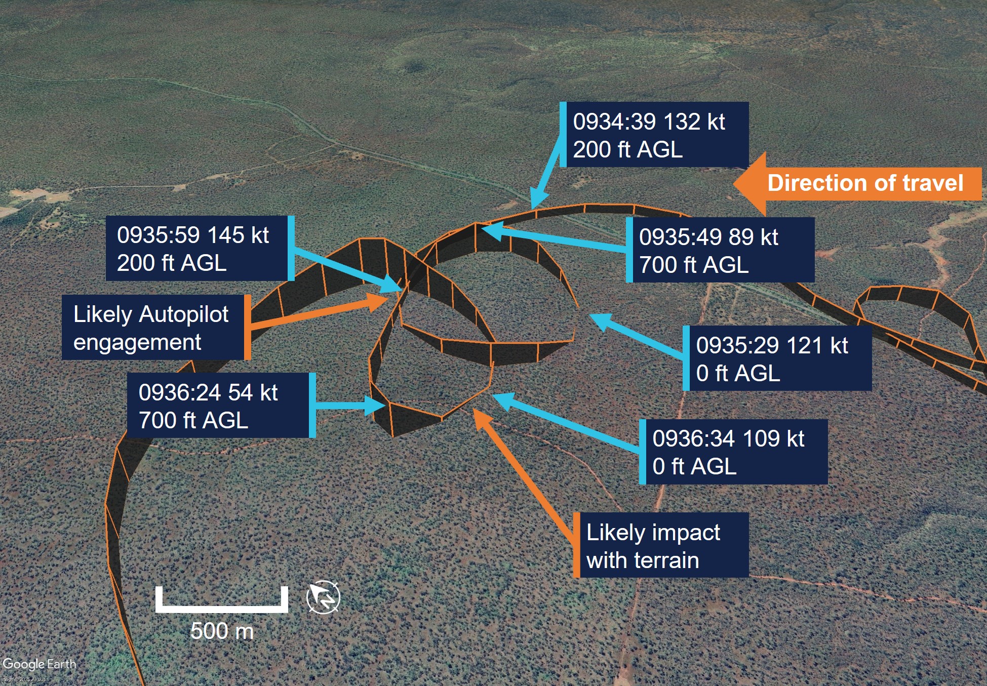
The aircraft height was about 560 ft AGL when the aircraft began to track north along Kennedy Developmental Road which the pilot followed for about 3.5 minutes. At 0934 the aircraft began to deviate away from the road after an increase in altitude of about 500 ft, however due to the rising terrain was about 250 ft AGL (Figure 8).
Figure 8: VH-TSS height above terrain
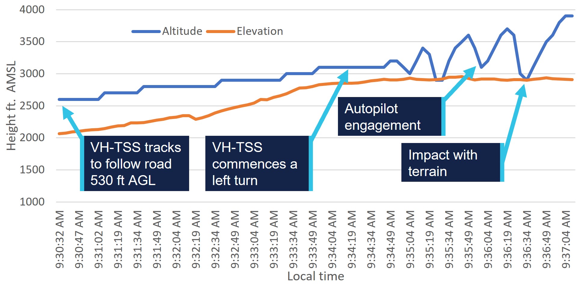
Source: ATSB, data provided by OzRunways and Google Earth
After tracking away from Kennedy Developmental Road, the aircraft turned to the west about 100° in 30 seconds. The turn radius then tightened conducting a 360° left orbit in 65 seconds, during this time the aircraft recorded altitude fluctuated between about 0 ft and 700 ft AGL.
The aircraft then maintained a westerly heading while commencing a climb from about 200 ft AGL with a reducing ground speed to 54 kt over a 20 second period.
The data then recorded the aircraft conducting a left turn through about 70° with a reduction in altitude to the terrain height, in about 5 seconds. The aircraft then commenced a further climb to 1,000 ft AGL before stabilising its altitude over the following 4 minutes in a southerly direction.
At 0941 the aircraft commenced about one and a half descending left turns through about 470° and descended from 1,300 ft AGL to about 300 ft AGL. The flight track then followed a dirt track before tracking east to again intercept Kennedy Developmental Road.
The flight track remained in close proximity to Kennedy Developmental Road, tracking south, passing within 0.7 NM of Greenvale ALA at 1017. The pilot continued to track at about 1,000 ft AGL and followed main roads until it landed at Charters Towers Airport at 1114.
Operational information
Visual meteorological conditions
Visual meteorological conditions (VMC) are expressed in terms of in-flight visibility and distance from cloud (horizontal and vertical) and are prescribed in the Civil Aviation Safety Regulations (CASR) Part 91 (General Operating and Flight Rules) Manual of Standards 2020: 2.07 VMC criteria. For aircraft in class G[8] airspace (Figure 9) the following requirements apply at a height below whichever is the higher of 3,000 ft AMSL or 1,000 ft AGL:
- a minimum of 5,000 m visibility
- maintain flight clear of cloud
- aircraft must be operated in sight of ground or water
Figure 9: Visual meteorological conditions criteria below 10,000 ft as illustrated in the CASA Visual Flight Rules Guide
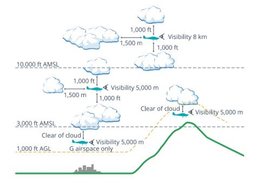
Source: Civil Aviation Safety Authority
Minimum height rules
CASR Part 91.267 (2) stated that for flight over non-populous areas:
The pilot in command of an aircraft for a flight contravenes this subregulation if, during the flight:
- the aircraft is flown below 500 ft above the highest feature or obstacle within a horizontal radius of 300 m of the point on the ground or water immediately below the aircraft
- is not taking off or landing or conducting a missed approach
- is not carrying passengers and conducting practice forced landings with permission from the landowner.
The Civil Aviation Act,1998 section 30 also stated:
(1) In any proceedings for an offence against this Act or the regulations, it is a defence if the act or omission charged is established to have been due to extreme weather conditions or other unavoidable cause.
(2) Any defence established under subsection (1) need only be established on the balance of probabilities.
Flight planning
The pilot submitted an online flight plan at 0544 that morning to Airservices Australia via the NAIPS[9] application and received notification that the plan had been accepted.
The flight was planned to depart from a private ALA at 0630, climb to 4,500 ft AMSL and to track direct to Charters Towers, before descending and tracking direct for Atherton at 2,500 ft AMSL. Flight plan distance was about 425 NM.
Terrain heights on a direct track between Charters Towers and Atherton indicated terrain elevation consistently over 2,500 ft AMSL with areas above 4,000 ft AMSL.
The pilot reported that they had originally planned to fly on 17 June, however after reviewing the encroaching forecast weather conditions, planned the flight a day earlier.
CASR Part 91 (General Operating and Flight Rules) Manual of Standards 2020: 7.02 Forecasts for flight planning, described that a pilot in command must before commencing flight below 10,000 ft, study:
- the authorised weather forecasts and authorised weather reports for the route being flown, departure aerodrome, planned destination, planned alternate aerodrome and any other reasonably available weather information that is relevant to the intended operation
- the authorised weather forecast must include a wind and temperature forecast as well as either, a GAF, GAMET area forecast or a flight forecast
- should the forecasts and reports be studied more than 1 hour before commencing the flight, the pilot in command must obtain, and review, an update to that information before the flight begins.
The pilot reported that they obtained the weather forecast for Mareeba the evening prior to their flight and again on the morning of their departure. They stated that they were aware of a frontal system that was due in the area later that day or evening. However, they had not obtained a GAF before their departure.
Alternative aircraft landing area
On regaining visual reference with the ground after the collision with terrain, the pilot continued the flight for about 155 NM, and about 1.5 hours flying time. During the flight, the aircraft passed within a nautical mile of another suitable ALA as it returned to Charters Towers.
The pilot stated they were aware of other aerodromes in the vicinity as they tracked towards Charters Towers and that although they were aware that the aircraft had sustained damaged during the collision, they were unaware of the extent and assessed that the aircraft was flying to an acceptable standard to continue the flight to Charters Towers Airport.
Other suitable airports or ALA in the area of the incident site included:
- Greenvale ALA 38 NM south (within 1 NM of return track)
- Einasleigh Airport 36 NM west
- Valley of Lagoons ALA 50 NM south-east
- Georgetown Airport 68 NM west.
Human factors
Spatial disorientation
The ATSB publication Avoidable Accidents No. 4: Accidents involving Visual Flight Rules pilots in Instrument Meteorological Conditions(AR-2011-050) discusses the physiological limitations of the human body when trying to sense its orientation in space.
In conditions where visual cues are poor or absent, such as in poor weather, up to 80 per cent of the normal orientation information is missing. Humans are then forced to rely on the remaining 20 per cent, which is split equally between the vestibular system and the somatic system. Both of these senses are prone to powerful illusions and misinterpretation in the absence of visual references, which can quickly become overpowering.
Pilots can rapidly become spatially disoriented when they cannot see the horizon. The brain receives conflicting or ambiguous information from the sensory systems, resulting in a state of confusion that can rapidly lead to incorrect control inputs and resultant loss of aircraft control.
As described in ATSB report AR-2011-050 statistics show non-instrument rated pilots may not be able to recover at all. Research has shown the pilots not proficient in maintaining control of an aircraft with sole reference to the flight instruments will typically become spatially disoriented and lose control of the aircraft within 1 to 3 minutes after visual cues are lost.
ATSB report AR-2011-050 was updated in 2019 and identified that in the 10 years prior, there were 101 visual flight rules (VFR) into IMC occurrences in Australian airspace reported to the ATSB. Of these, 9 were accidents resulting in 21 fatalities. This details an almost 10% chance of a VFR into IMC encounter ending in a fatal accident.
The ATSB Aviation Occurrence Database indicated that in the 10 years since 2015, there have been 108 VFR into IMC occurrences reported to the ATSB. Of these, 14 resulted in accidents with 23 fatalities. The dangers of spatial disorientation following a loss of visual cues remains one of the most significant causes of concern in aviation safety.
Decision‑making
The pilot explained they had not previously flown in poor conditions and had previously turned back when conditions were not suitable on many occasions.
Flight under the VFR requires minimum conditions of visibility and distance from cloud (see Visual meteorological conditions). Variation from the expected weather conditions en route may prevent a pilot from reaching their destination under visual conditions.
Flight into IMC can occur in any phase of flight. However, a 2005 ATSB research publication – General Aviation Pilot Behaviours in the Face of Adverse Weather (B2005/0127) – concluded that the chances of a VFR into IMC encounter increased as the flight progressed, with the maximum chance occurring during the final 20 per cent of the planned flight. It stated:
This pattern suggests an increasing tendency on the part of pilots to ‘press on’ as they near their goal. To turn back or divert when the destination seemed ever closer became progressively more difficult.
Research conducted by (Orasanu and others, 1998) titled Errors in Aviation Decision Making contained the following:
Ambiguous cues and organisational and social factors may not in themselves be sufficient to cause decision errors. However, when the decision maker's cognitive limits are stressed, these factors may induce errors in certain contexts. Errors may be mediated by underestimation of the risk inherent in a situation, overconfidence in one's ability to cope with the situation, or failure to evaluate the consequences of planned actions.
Similar occurrences
ATSB investigation
VFR into IMC, loss of control and collision with terrain involving SOCATA-Groupe Aerospatiale TB-20, VH-JTY
On the morning of 28 October 2023, a SOCATA-Groupe Aerospatiale TB-20, registered, VH‑JTY, departed Montpelier aircraft landing area, Queensland, for a visual flight rules private flight to Palmyra aircraft landing area, Queensland. The flight was to be just over one hour duration and the pilot and their passenger were familiar with the route.
Around 30 NM from the destination, shortly after commencing descent for the intended landing, the aircraft began a steep descending turn to the left towards mountainous terrain. During this descent, the aircraft exceeded the airframe’s designed maximum airspeed before pitching up and passing over the top of Bull Mountain. The aircraft then entered a second steep descending turn, this time to the right, before the recorded flight path data ceased. The aircraft collided with terrain, the aircraft was destroyed and both occupants received fatal injuries.
The ATSB found that, after encountering cloud en route, the pilot elected to continue along the intended flight path through cloud instead of diverting around or remaining on top of it. Shortly after, it is very likely the pilot entered weather conditions not suitable for visual navigation, leading to spatial disorientation and a descent into mountainous terrain.
ATSB investigation
VFR into IMC and in-flight break-up involving Van's Aircraft RV-7A, VH-XWI 90 km south of Charters Towers, Queensland, on 23 April 2021
On 23 April 2021, a Van’s Aircraft RV-7A, registered VH-XWI, was being operated on a private flight under the visual flight rules (VFR) from Winton to Bowen, Queensland. During the flight, the pilot most likely entered IMC and lost control of the aircraft several times. This led to the airspeed limitations for the aircraft being exceeded and the aircraft sustained an in-flight break-up. The pilot was fatally injured, and the aircraft was destroyed.
VFR into IMC resources
The 2011 ATSB publication, Accidents involving Visual Flight Rules pilots in Instrument Meteorological Conditions (AR-2011-050), updated in 2019, includes a selection of weather‑related general aviation accidents and incidents that show weather alone is never the only factor affecting pilot decisions that result in inadvertent IMC encounters. The documented investigations consistently highlight that conducting thorough pre-flight planning is the best defence against flying into deteriorating weather.
CASA also released a collection of resources related to this type of occurrence on its website titled Weather and forecasting.
For more information on VFR into IMC occurrences, recognising inadvertent entry into IMC, and what to do to recover, refer to the following publications:
- United Kingdom Civil Aviation Authority: Safety sense booklet VFR flight into IMC
- United States Aircraft Owners and Pilots Association: Encountering IMC.
Safety analysis
Pre-flight planning
The flight was planned to track from the departure aircraft landing area (ALA) direct to Charters Towers and then Atherton, a distance of about 425 NM. The flight north of Charters Towers was flight planned at 2,500 ft above mean sea level (AMSL), however terrain elevations on the planned route north of Charters Towers were consistently higher than 2,500 ft AMSL.
The pilot had obtained a weather forecast for Mareeba Airport (close to their intended destination), which indicated a cloud height of 2,000 ft above the airport elevation (1,564 ft), conditions that the pilot considered suitable for visual flight rules (VFR) flight.
An updated available graphical area forecast (GAF), issued about 4 hours prior to departure, indicated cloud heights were forecast to be about 2,000 ft AMSL at the time the aircraft had planned to be flying over areas of high terrain.
While the pilot was aware of encroaching weather and accelerated their planned flight to a day earlier to avoid the weather, the pilot’s pre-flight planning in respect to planned altitude north of Charters Towers and the weather conditions at the time of the flight was inadequate. Without the required aviation forecast, or appreciation of weather conditions en route, the pilot departed for their destination without the knowledge of expected cloud en route that was lower than terrain elevation and would likely have prevented visual flight.
Continued flight at low level
After assessing in flight that conditions were unsuitable for continued flight direct to Atherton due to the low cloud height, the pilot planned for an alternate airport of Mareeba, visually tracking west to avoid higher terrain.
About 35 minutes after the diversion, the pilot intercepted and began to track north following Kennedy Developmental Road towards rising terrain.
The pilot described having visibility of greater than 10 km and a good horizon while tracking north following the road. As the terrain elevation increased about 900 ft during the few minutes of northerly flight along the road, the pilot was unable to maintain the minimum terrain clearance of 500 ft above ground level or the minimum 5 km visibility before entering instrument meteorological conditions (IMC).
The pilot stated that they had turned back several times on previous flights due to marginal weather conditions. The pilot and passenger were travelling on a private flight, it was unlikely that there was time pressure to arrive at the intended destination.
Consistent with other occurrences of visual flight rules (VFR) into IMC, the aircraft entered IMC conditions within the last 20% of the flight after continuing flight below the minimum required altitude. Although the pilot recalled initially having good visibility, they continued flight towards the destination below a safe altitude, this indicated a desire to ‘press on’ to the destination and increased the risk of unintended entry into IMC and collision with terrain.
Spatial disorientation
The pilot described being surprised how quickly they entered a ‘white-out’ that appeared in front of the aircraft. Likely as a result of attempting to avoid entering the cloud and losing visual reference, they instinctively reduced power and commenced a left turn. During the turn the aircraft entered cloud and the pilot described becoming ‘totally disorientated’ shortly thereafter.
Data showed that the aircraft altitude began to fluctuate with several changes of up to 500 ft vertically in about a 60-second period. While in cloud the aircraft came close to impacting terrain on more than one occasion.
The instability of the flight path with numerous rates of climb and descent are commonly observed in spatial disorientation occurrences where pilots perceive a departure from stable flight and attempt to correct the unusual flight sensations without visual reference.
Unable to reference the aircraft’s visual position or orientation to terrain after entering cloud, the pilot conducted a steep left turn and then engaged the autopilot with the intent to stabilise the aircraft.
Autopilot engagement and aircraft stall
The engagement of the autopilot levelled the aircraft’s wings and held a constant heading. However, the aircraft became established in a climb due to the aircraft attitude when the autopilot was engaged, capturing a high rate of climb.
The pilot used the heading bug on the horizontal situation indicator to reverse their track 180° to try to fly out of cloud.
The aircraft airspeed was likely less than the recorded ground speed of 54 kt due to a tailwind and therefore most likely below the aircraft’s published stall speed.
The pilot’s decision to engage the autopilot stabilised the aircraft’s heading, however without adequate power, the autopilot maintained the captured rate of climb while the airspeed reduced. As the aircraft commenced the pilot‑commanded left turn, the increased angle of bank and slow speed likely resulted in the aircraft stalling and entering a rapid descent at low level. The pilot’s immediate reaction to the red terrain display instigated them applying stall recovery techniques that very likely prevented a more serious collision with terrain.
Flight past a suitable landing area with a damaged aircraft
The pilot was aware the aircraft had sustained damage during the collision with terrain, reporting that the aircraft required additional right rudder trim to maintain balanced flight due to the damage.
Once the pilot became visual with the ground and tracked to the south, rather than conduct a precautionary landing or divert to a nearby aerodrome, they maintained a track following major roads towards Charters Towers for an additional 1.5 hours.
Following the collision with terrain the pilot likely became focused on the recovery of the damaged aircraft from the remote area. During the return flight south to Charters Towers, the pilot flew within 1 NM of the Greenvale aircraft landing area (ALA) about 41 minutes after the tree collision, and there were 3 other potential landing areas that were closer than Charters Towers. Instead, the pilot continued flight in the damaged aircraft to Charters Towers, a familiar airport with a longer runway.
With known damage and the performance characteristics of the aircraft adversely affected, the pilot’s decision to continue the flight to Charters Towers (past a suitable ALA) rather than seek the nearest suitable landing area that provided an opportunity to properly assess the damage, placed additional risk on the occupants’ safety.
Use of aircraft instruments for navigation
Following the impact with the tree, the pilot flew the damaged aircraft using basic flight instruments until they became visual again above the cloud layer.
Although the pilot had not recently practised instrument flight, their knowledge gained during their initial flight training, their familiarity with the aircraft systems and their use of the navigation instruments assisted to stabilise and manoeuvre the aircraft out of IMC conditions to regain visual reference and were then able to determine a track south away from cloud.
Findings
From the evidence available, the following findings are made with respect to the VFR into IMC and collision with trees involving Cessna 182T, VH‑TSS, 57 km south-east of Mount Surprise, Queensland, on 16 June 2025.
Contributing factors
- During pre-flight planning, the pilot obtained weather for the destination, however, did not obtain weather for the flight planned track.
- Although the pilot could not maintain 500 ft terrain clearance due to the low cloud base, they continued flight towards the destination rather than divert to a known area of higher terrain clearance.
- The visual flight rules pilot entered instrument meteorological conditions at low level and reduced power when they became disorientated. This resulted in an unintentional turn and near collision with terrain.
- While disorientated in IMC, the pilot initiated a climbing turn and engaged the autopilot at reduced power, resulting in the aircraft being unable to maintain airspeed and likely entering a stall and rapidly lost height. During the recovery, the aircraft impacted with trees but continued to fly.
Other factors that increased risk
- While aware of damage and controllability issues, the pilot did not land at the closest suitable aerodrome and continued for 1.5 hours to a larger airport.
Other findings
- The pilot was able to use the aircraft’s instruments to stabilise the damaged aircraft and navigate out of instrument meteorological conditions
Sources and submissions
Sources of information
The sources of information during the investigation included:
- the pilot
- Civil Aviation Safety Authority
- Bureau of Meteorology
- Ozrunways.
References
Australian Transport Safety Bureau. (2005). General Aviation Pilot Behaviours in the Face of Adverse Weather. Aviation Research Investigation Report B2005/0127.
Australian Transport Safety Bureau. (2011). Accidents involving Visual Flight Rules pilots in Instrument Meteorological Conditions.
Orasanu, J. L.-A. (1998). Errors in Aviation Decision Making: Bad Decision or Bad Luck.
Submissions
Under section 26 of the Transport Safety Investigation Act 2003, the ATSB may provide a draft report, on a confidential basis, to any person whom the ATSB considers appropriate. That section allows a person receiving a draft report to make submissions to the ATSB about the draft report.
A draft of this report was provided to the following directly involved parties:
- the pilot
- Civil Aviation Safety Authority
- the manufacturer
- Bureau of Meteorology.
Submissions were received from the:
- pilot
- Civil Aviation Safety Authority
- Bureau of Meteorology.
The submissions were reviewed and, where considered appropriate, the text of the report was amended accordingly.
Appendices
Appendix – Graphical area forecasts
Graphical area forecast issued 2013, 15 June
Source: Bureau of Meteorology
Graphical area forecast issued 0224, 16 June
Source: Bureau of Meteorology
Purpose of safety investigationsThe objective of a safety investigation is to enhance transport safety. This is done through:
It is not a function of the ATSB to apportion blame or provide a means for determining liability. At the same time, an investigation report must include factual material of sufficient weight to support the analysis and findings. At all times the ATSB endeavours to balance the use of material that could imply adverse comment with the need to properly explain what happened, and why, in a fair and unbiased manner. The ATSB does not investigate for the purpose of taking administrative, regulatory or criminal action. About ATSB reportsATSB investigation reports are organised with regard to international standards or instruments, as applicable, and with ATSB procedures and guidelines. Reports must include factual material of sufficient weight to support the analysis and findings. At all times the ATSB endeavours to balance the use of material that could imply adverse comment with the need to properly explain what happened, and why, in a fair and unbiased manner. An explanation of terminology used in ATSB investigation reports is available here. This includes terms such as occurrence, contributing factor, other factor that increased risk, and safety issue. Publishing informationReleased in accordance with section 25 of the Transport Safety Investigation Act 2003 Published by: Australian Transport Safety Bureau © Commonwealth of Australia 2025 
Ownership of intellectual property rights in this publication Unless otherwise noted, copyright (and any other intellectual property rights, if any) in this report publication is owned by the Commonwealth of Australia. Creative Commons licence With the exception of the Commonwealth Coat of Arms, ATSB logo, and photos and graphics in which a third party holds copyright, this report is licensed under a Creative Commons Attribution 4.0 International licence. The CC BY 4.0 licence enables you to distribute, remix, adapt, and build upon our material in any medium or format, so long as attribution is given to the Australian Transport Safety Bureau. Copyright in material obtained from other agencies, private individuals or organisations, belongs to those agencies, individuals or organisations. Where you wish to use their material, you will need to contact them directly. |
[1] Visual meteorological conditions (VMC): an aviation flight category in which visual flight rules (VFR) flight is permitted – that is, conditions in which pilots have sufficient visibility to fly the aircraft while maintaining visual separation from terrain and other aircraft.
[2] Visual flight rules (VFR): a set of flight regulations that permit a pilot to operate an aircraft only in weather conditions generally clear enough to allow the pilot to see where the aircraft is going.
[3] Calibrated airspeed: indicated airspeed corrected for position and instrument error and expressed in knots.
[4] HSI: a flight navigation instrument that combines the heading indicator with a CDI (course deviation indicator), in order to provide the pilot with better situational awareness of location with respect to the courseline.
[5] TAF- Aerodrome Forecast (TAF): a statement of meteorological conditions expected in the airspace within a radius of 8 km of the aerodrome reference point.
[6] Broken cloud indicates that more than half to almost all the sky is covered, and ‘overcast’ indicates that all the sky is covered.
[7] Scattered cloud indicates that cloud is covering between a quarter and a half of the sky.
[8] Class G airspace is uncontrolled airspace. Both IFR and VFR aircraft are permitted and neither require ATC clearance.
[9] NAIPS: National Aeronautical Information Processing System
Occurrence summary
| Investigation number | AO-2025-028 |
|---|---|
| Occurrence date | 16/06/2025 |
| Location | 57 km south-east of Mount Surprise |
| State | Queensland |
| Report release date | 28/10/2025 |
| Report status | Final |
| Investigation level | Short |
| Investigation type | Occurrence Investigation |
| Investigation status | Completed |
| Mode of transport | Aviation |
| Aviation occurrence category | Collision with terrain, Diversion/return, VFR into IMC |
| Occurrence class | Accident |
| Highest injury level | None |
Aircraft details
| Manufacturer | Cessna Aircraft Company |
|---|---|
| Model | 182T |
| Registration | VH-TSS |
| Serial number | 18281601 |
| Sector | Piston |
| Operation type | Part 91 General operating and flight rules |
| Departure point | Private ALA near Gindie, Queensland |
| Destination | Atherton Aerodrome, Queensland |
| Damage | Substantial |