This Corporate Plan sets out the ATSB’s purpose, its strategies for achieving that purpose and how the effect of the strategies and the attainment of the ATSB’s purpose will be measured. It has been prepared in accordance with paragraph 35(1)(b) of the Public Governance, Performance and Accountability Act 2013. The Plan takes account of the relevant provisions of the Transport Safety Investigation Act 2003 (the TSI Act), which establishes the ATSB. It also has regard to the views of the Minister for Infrastructure and Regional Development on the ATSB’s strategic direction as notified under Section 12AE of the TSI Act.
The TSI Act provides that the ATSB’s primary purpose is to improve the safety of aviation, rail and marine transport through accident investigation, data analysis and safety education. It must do so independently, but in cooperation with the other organisations that share responsibility for transport safety, including counterpart organisations in other countries. Successive governments, including the current one, have indicated that, in carrying out its role, the ATSB should give priority to the safety of the travelling public.
The ATSB is required to maintain the people, information and systems to be a world leader in its field. This includes the standing capability to respond immediately to a significant transport safety event, whether it be a major accident or, as is the current case, to undertake a major safety project such as the search for the missing Malaysia Airlines flight MH370. This plan sets out its strategies for doing so in an environment of fast technological advances, constrained resources and significant demographic change in its workforce.
The ATSB has consistently proven itself to be at the forefront internationally in its capability and in its results. I look forward to continuing that achievement as the ATSB implements this Corporate Plan.
These videos illustrate different aspects of the search for MH370. You may use this material under a creative commons license(Opens in a new tab/window). That license allows you to copy, distribute, transmit and adapt this publication provided that you attribute the work.
At the request of the Malaysian Government, Australia accepted responsibility for the search for missing Malaysia Airlines Flight MH370. After the conclusion of the surface search, the Australian Transport Safety Bureau (ATSB) led the underwater search for MH370 in the southern Indian Ocean.
Each week, from 10 September 2014 to 11 January 2017, an operational update was published, tracking the progress of the search effort and identifying noteworthy developments.
At a meeting of Ministers from Malaysia, Australia and the People’s Republic of China held on 22 July 2016, it was agreed that should the aircraft not be located in the current search area, and in the absence of credible new evidence leading to the identification of a specific location of the aircraft, the search would be suspended upon completion of the current search area.
As such, the search for MH370 was suspended on 17 January 2017.
On 8 March 2014, a Boeing 777 aircraft, operated as Malaysia Airlines flight 370 (MH370), was lost during a flight from Kuala Lumpur in Malaysia to Beijing in the People’s Republic of China, carrying 12 crew and 227 passengers.
Under Annex 13 to the Convention on International Civil Aviation “Aircraft Accident and Incident Investigation”, Malaysia, as the state of registry and operation of MH370, had investigative responsibility for the missing aircraft. At the request of the Malaysian Government, the Australian Government accepted responsibility for initial search and recovery operations in the southern part of the Indian Ocean on 17 March 2014.
In accordance with paragraphs 5.23 and 5.24 of Annex 13, on 1 April 2014, the ATSB appointed an accredited representative to the investigation, along with a number of advisors (ATSB investigators). These investigators’ work was undertaken as part of an External Investigation (AE-2014-054) under the provisions of the Australian Transport Safety Investigation Act 2003. The ATSB accredited representative and advisors provided support to the Malaysian ICAO Annex 13 Safety Investigation Team for MH370 (MIASIT).
On 31 March 2014, the Malaysian Government accepted the Government of Australia’s offer to lead the search and recovery operation in the southern Indian Ocean in support of the Malaysian accident investigation. On 28 April 2014, the surface search for MH370 coordinated by the Australian Maritime Safety Authority (AMSA) was concluded and the Australian Transport Safety Bureau (ATSB) assumed responsibility for conducting the underwater search for the aircraft.
ATSB assistance and expertise was provided through the accredited representative mechanism of Annex 13, under AE-2014-054.On 2 July 2018, the MIASIT submitted its investigation report to the Malaysian Ministry of Transport (MOT). It was released on 30 July 2018, at which point the ATSB’s work in support of Malaysia’s Annex 13 investigation was finalised.
On 8 March 2014, a Boeing 777 aircraft operated as Malaysia Airlines flight 370 (MH370) was lost during a flight from Kuala Lumpur in Malaysia to Beijing in the People’s Republic of China carrying 12 crew and 227 passengers. The search for the missing aircraft commenced on 8 March 2014 and continued for 1,046 days until 17 January 2017 when it was suspended in accordance with a decision made by a tripartite of Governments, being Malaysia, Australia and the People’s Republic of China. [
CSIRO: The search for MH370 and ocean surface drift – Part IV
This short report re-examines the question of how effective the March-April surface search was for ‘ruling out’ segments of the 7th arc as being the location of MH370. [
CSIRO: The search for MH370 and ocean surface drift – Part III
This is the CSIRO's third report describing oceanographic drift modelling work done in aid of the search for 9M-MRO (the Boeing 777 aircraft flying Malaysia Airlines service MH370 on 8 March 2014). [
CSIRO: The search for MH370 and ocean surface drift – Part II
This report explores the possibility that an improved ability to simulate the path taken by the flaperon across the Indian Ocean might yield an improved estimate of the location of the remains of the aircraft on the sea floor. [
CSIRO: The search for MH370 and ocean surface drift – Part I
This report details the results of a comprehensive attempt to use drift modelling to inform efforts to locate the missing Malaysia Airlines flight MH370 (registered 9M-MRO). It differs from earlier attempts to do this in several important ways, which, along with other developments, have enabled it to come up with a location of the aircraft that is much more precise than we thought was possible. [
Geoscience: Summary of imagery analyses for non-natural objects in support of the search for Flight MH370
Geoscience Australia (GA) was asked to assist the Australian Transport Safety Authority (ATSB) in the analysis of a set of four Airbus PLEIADES 1A images. GA received these images for analysis on the 23rd March 2017. [
This report documents the proceedings and outcomes of the First Principles Review meeting on the search for missing Malaysia Airlines flight MH370 held in Canberra from 2 to 4 November 2016. Participants consisted of experts in data processing, satellite communications, accident investigation, aircraft performance, flight operations, sonar data, acoustic data and oceanography. The purpose of the meeting was to reassess and validate existing evidence and to identify any new analysis that may assist in identifying the location of the missing aircraft. [
The MH370 Search and debris examination update provides an update to the MH370 search area definition described in previous ATSB reports. It comprises further analysis of satellite data, additional end of flight simulations, a summary of the analysis of the right outboard wing flap, and preliminary results from the enhanced debris drift modelling. [
Debris examination reports including the identification of items recovered from beaches in South Africa, Mauritius and the Tanzanian coastcan be found in the 'Debris reports' tab within the scrolling ribbon navigation towards the top of this page.
Definition of Underwater Search Areas
The MH370 Search Strategy Working Group conducted ongoing analysis of data to glean any information that might assist in locating the aircraft. To this end, the ATSB engaged the Defence Science and Technology Group (DSTG) to provide expert analysis of available data relating to MH370. The analysis used models of the Inmarsat satellite communications data, aircraft dynamics and meteorological data to determine likely flight paths which were in turn subject to validation experiments to ensure they aligned with actual flight data. [
An updated version of the ATSB report was released on 10 December 2015 to clarify that the ‘power loss’ mentioned on page 9 occurring between 17:07:48 and 18:03:41 was referring to the Satellite Data Unit (SDU) only. The SDU did not respond to an automatic interrogation from the Ground Earth System (GES) at 18:03:41 UTC, although it resumed working at 18:25:27.
Definition of Underwater Search Areas
The location of the search areas was guided by continuing and innovative analysis by a Joint Investigation Team of the flight and satellite-communications data. This analysis was supplemented by other information provided to ATSB during this period. This included possible underwater locator beacon and hydrophone acoustic detections.[
Refinements to the analysis of the flight and satellite-communications data gave greater certainty about when the aircraft turned south into the Indian Ocean. This analysis was published to supplement the previously released report MH370 – Definition of Underwater Search Areas. [
Creative Commons Attribution 4.0 Australia Licence is a standard form license agreement that allows you to copy, distribute, transmit and adapt this publication provided that you attribute the work.
You should attribute the image using the text in each image’s caption.
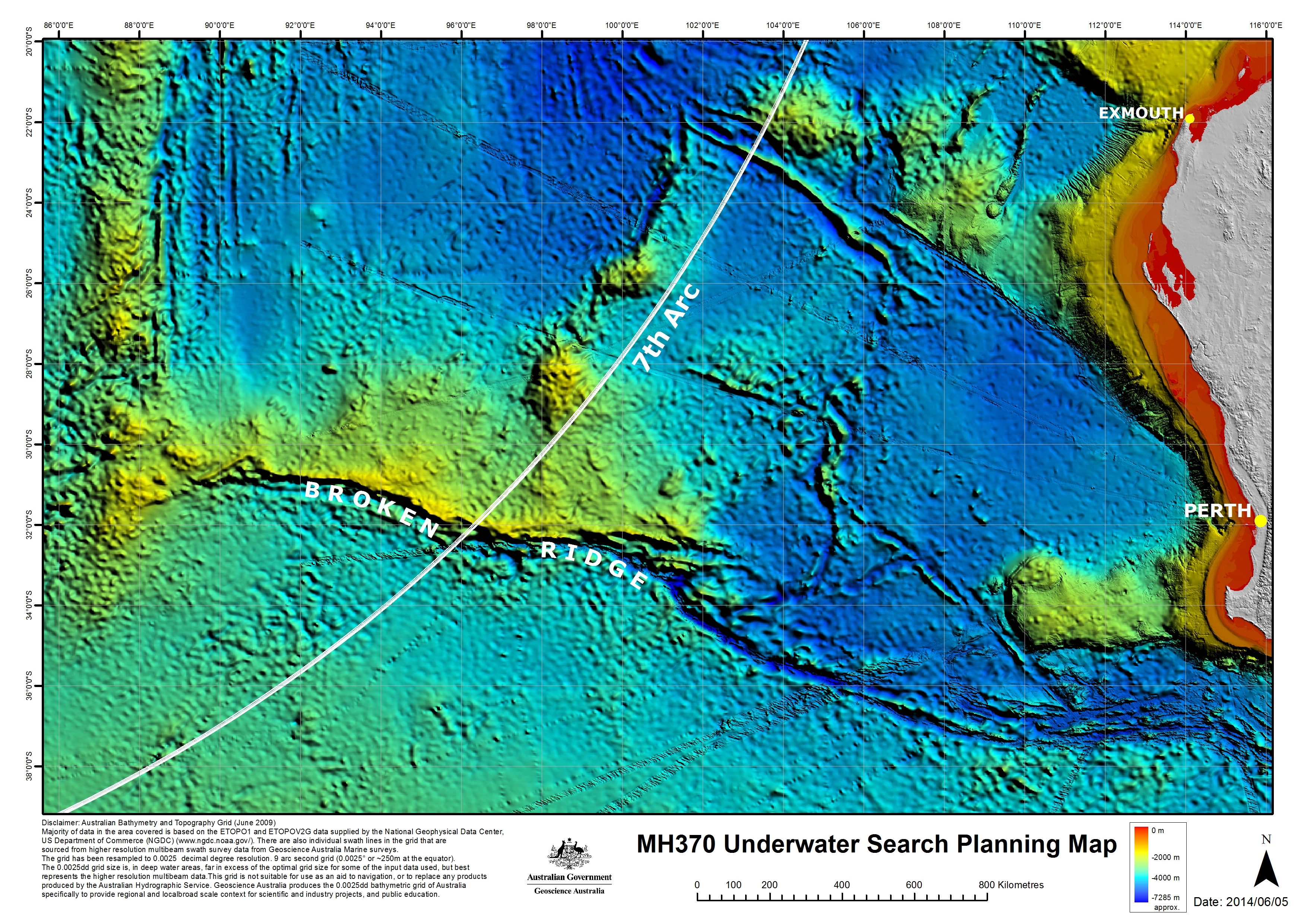
Information and analysis of satellite data and drift modelling identified an area set out in the map and labelled as the 7th arc. At the time MH370 reached this arc, the aircraft is considered to have exhausted its fuel and to have been descending. As a result, it was determined that the aircraft was unlikely to be more than 27.5 NM (51 km) to the west or 25 NM (46 km) to the east of the arc.
Based on all the independent analysis of satellite communications and aircraft performance, the total extent of the 7th arc reaches from latitude 20 degrees S to 40 degrees S.
Click map to enlarge
Bathymetric Survey
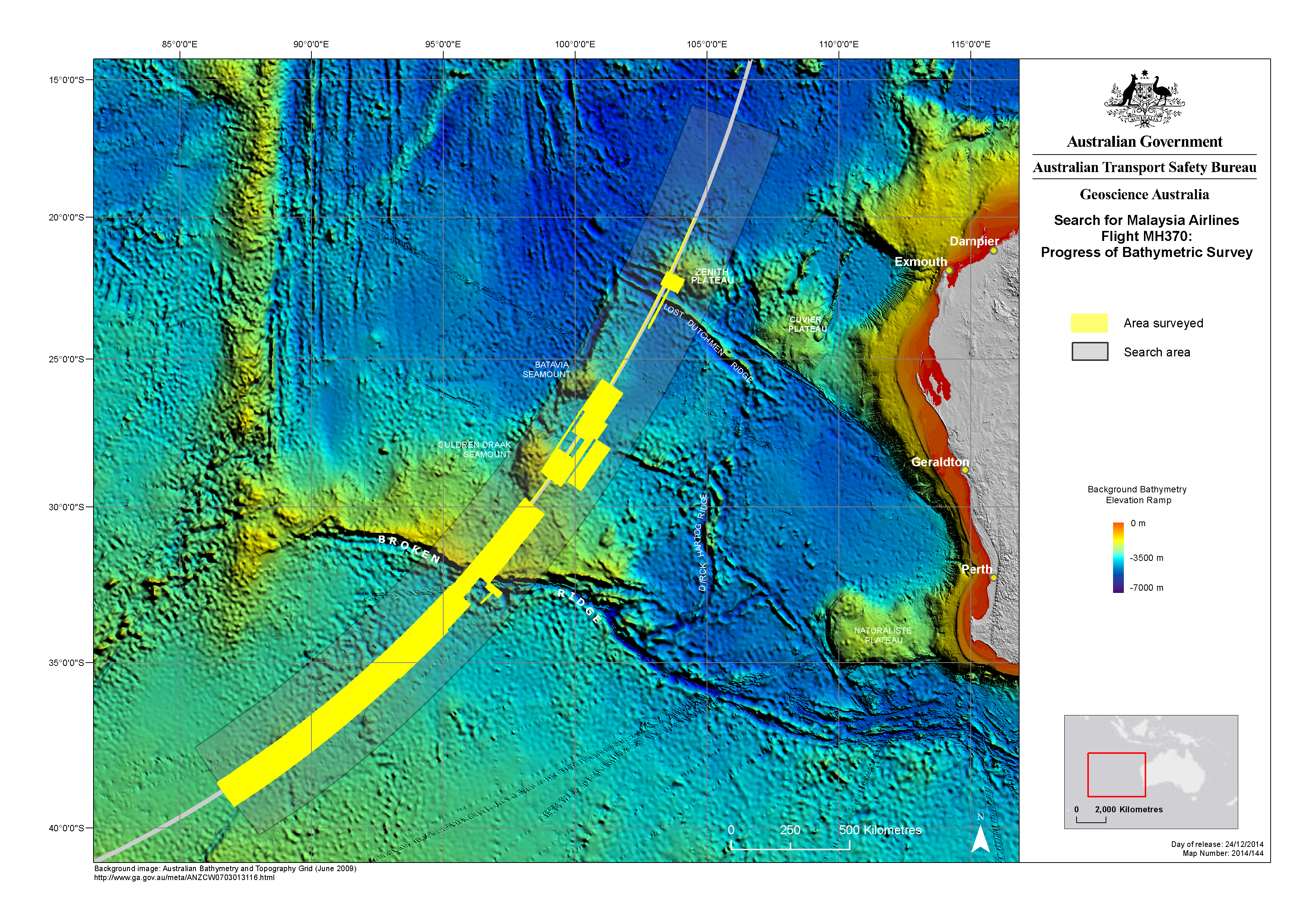
Before the underwater search for MH370 could begin, it was necessary to accurately map the seafloor to ensure that the search is undertaken safely and effectively. Bathymetric survey vessels spent months at sea, scanning the seafloor with multibeam sonar to gather detailed, high-resolution data. The data revealed many seabed features for the first time.
Click map to enlarge
Underwater Search
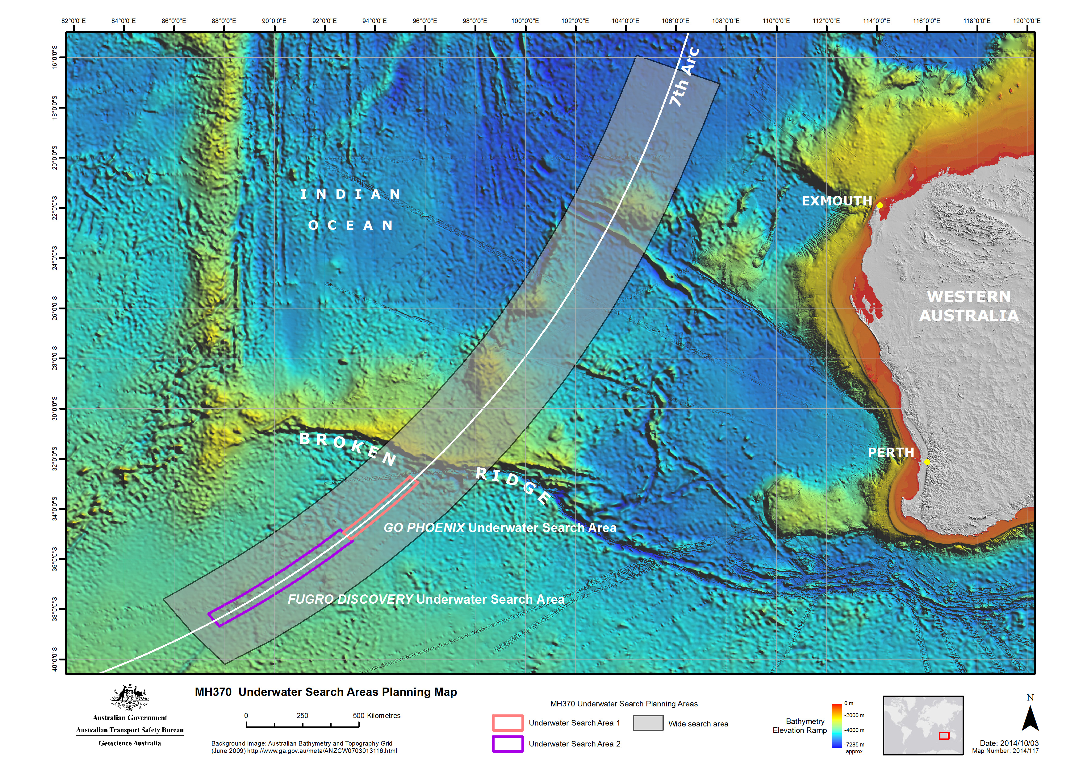
In addition to locating the aircraft, the underwater search aimed to map the MH370 debris field in order to identify and prioritise the recovery of specific aircraft components, including flight recorders, which would assist with the Malaysian investigation. The ATSB utilised the data from the bathymetric survey work to prepare the initial plan for the underwater search, to be followed and referred to by all parties involved. The plan included search timings, methods, procedures, safety precautions and the initial search areas for the various vessels.
Additional Maps
Additional maps showing the search areas, the progress of the bathymetric survey and details of the undersea terrain are available in the gallery at our images web page.
On 8 March 2014, the Boeing 777-200ER aircraft registered as Malaysia Airlines 9M-MRO and operating as flight MH370 (MH370) disappeared from air traffic control radar after taking off from Kuala Lumpur, Malaysia on a scheduled passenger service to Beijing, China with 227 passengers and 12 crew on board.
After analysis of satellite data it was discovered that MH370 continued to fly for over six hours after contact was lost. All the available data indicates the aircraft entered the sea close to a long but narrow arc of the southern Indian Ocean.
On 31 March 2014, following an extensive sea and air search, the Malaysian Government accepted the Australian Government’s offer to take the lead in the search and recovery operation in the southern Indian Ocean in support of the Malaysian accident investigation.
On behalf of Australia, the Australian Transport Safety Bureau (ATSB) coordinated and led the search operations for MH370 in the southern Indian Ocean.
At a meeting of Ministers from Malaysia, Australia and the People’s Republic of China held on 22 July 2016, it was agreed that should the aircraft not be located in the current search area, and in the absence of credible new evidence leading to the identification of a specific location of the aircraft, the search would be suspended upon completion of the current search area.
As such, the search for Malaysia Airlines flight MH370 was suspended on 17 January 2017.
The ATSB’s involvement in the search officially concluded in October 2017 with the release of our report, titled The Operational Search for MH370, which documented the ways in which the search area was identified, and how the search was conducted.
While the role of the ATSB was mainly to coordinate the underwater search for the missing aircraft, governments from around the world contributed to the search, with extraordinary expertise committed to the task of locating the missing aircraft.
It remained the role of the Malaysian Government to conduct the Annex 13 investigation.
The ATSB is unable to provide answers regarding, or comment on, the Annex 13 investigation, all enquiries pertaining to Malaysia’s investigation, or to provide information that could lead to locating the missing aircraft, need to be submitted to the Ministry of Transport Malaysia: www.mot.gov.my(Opens in a new tab/window)
The ATSB remains hopeful that new and significant evidence becomes available in the future to help locate the missing aircraft and those on board.