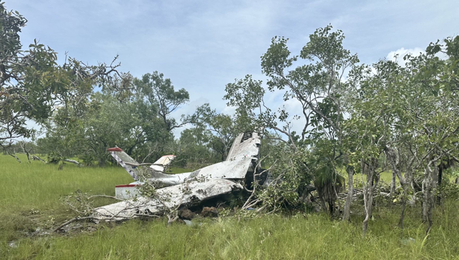
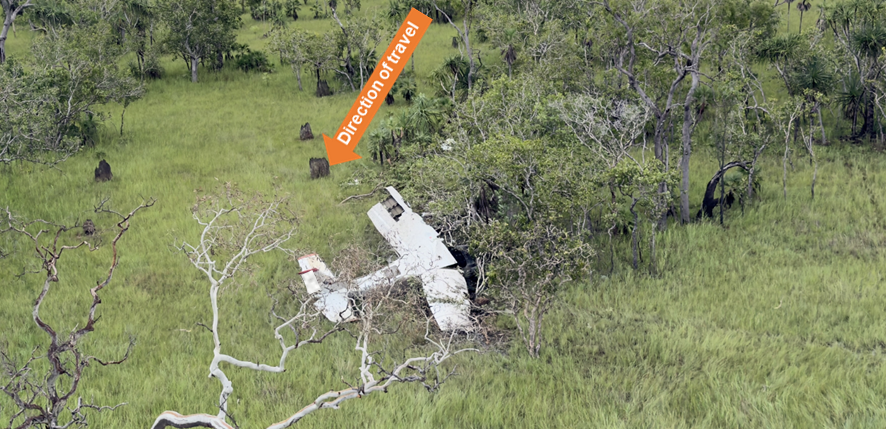
The ATSB is investigating a weather event involving a balloon display of multiple tethered balloons at Wangaratta Racecourse, Victoria, on 11 April 2026.
During a static balloon display, multiple tethered balloons encountered a sudden change of wind conditions.
One of the tether ropes for an Amateur-built GUS-69, registered VH-XUP, failed and the balloon became airborne before colliding with terrain resulting in injuries to a person on the ground.
The tether rope on a Kavanagh Balloons D-77, registered VH-CZX, was placed under extreme tension and the basket became briefly airborne before landing hard, resulting in injuries to an additional person on the ground.
To date, the ATSB investigation has included interviewing witnesses and involved parties, reviewing recorded data, and the collection of other relevant information.
The draft report internal review process has been completed. The draft report has been distributed to directly involved parties (DIPs) to check factual accuracy and ensure natural justice. Any submissions from those parties will be reviewed and, where considered appropriate, the draft report will be amended accordingly.
Following the external review process, any submissions and amendments to the draft report are internally reviewed. Once approved, the final report is prepared for publication and dissemination and released to DIPs prior to its public release.
The final report will be released at the conclusion of the investigation. Should a critical safety issue be identified during the course of the investigation, the ATSB will immediately notify relevant parties, so that appropriate safety action can be taken.
Last updated:
Occurrence summary
Investigation number
AO-2026-070
Occurrence date
11/04/2026
Occurrence time and timezone
1915 Australian Eastern Standard Time
Location
About 6.5 km north-north-west of Wangaratta Airport
State
Victoria
Report status
Pending
Anticipated completion
Q4 2026
Investigation level
Short
Investigation type
Occurrence Investigation
Investigation phase
Final report: External review
Investigation status
Active
Mode of transport
Aviation
Aviation occurrence category
Cabin injuries, Collision with terrain, Ground operations - Other, Hard landing, Turbulence/windshear/microburst
Occurrence class
Accident
Highest injury level
None
Aircraft details
Manufacturer
Amateur Built Aircraft
Model
GUS-69
Registration
VH-XUP
Serial number
GUS-01
Sector
Balloon
Operation type
Part 131 Balloons and hot air airships
Activity
General aviation / Recreational-Sport and pleasure flying-Other sport and pleasure flying
Departure point
Near Wangaratta Racecourse, Victoria
Injuries
None
Aircraft details
Manufacturer
Kavanagh Balloons
Model
D-77
Registration
VH-CZX
Serial number
D77-549
Sector
Balloon
Operation type
Part 131 Balloons and hot air airships
Activity
General aviation / Recreational-Sport and pleasure flying-Other sport and pleasure flying
The ATSB is investigating a collision with terrain involving a Robinson R44 II, VH-HYR, at Yorke Island Airport, Queensland, on 31 March 2026.
Shortly after take-off at 100 ft AGL, the low rotor RPM horn activated and the pilot conducted an emergency landing on the aerodrome. During the landing, the helicopter collided with terrain resulting in substantial damage. The pilot sustained serious injuries. The investigation is continuing.
To date, the ATSB investigation has included:
interviewing the pilot of the occurrence aircraft
examination of maintenance records
examination of independent engineering report
images of the wreckage
reviewing the common traffic advisory frequency recordings
examination of pilot training and records.
The wreckage was moved to an independent maintenance facility for further analysis.
The final report has been drafted and is undergoing internal review to ensure the report adequately and accurately reflects the evidence collected, analysis, and agreed findings.
The final report will be released at the conclusion of the investigation. Should a critical safety issue be identified during the course of the investigation, the ATSB will immediately notify relevant parties, so that appropriate safety action can be taken.
Last updated:
Occurrence summary
Investigation number
AO-2026-069
Occurrence date
31/03/2026
Occurrence time and timezone
1436 Australian Eastern Standard Time
Location
York Island Airport
State
Queensland
Report status
Pending
Anticipated completion
Q4 2026
Investigation level
Short
Investigation type
Occurrence Investigation
Investigation phase
Final report: Internal review
Investigation status
Active
Mode of transport
Aviation
Aviation occurrence category
Abnormal engine indications, Collision with terrain, Forced/precautionary landing
Occurrence class
Accident
Highest injury level
Serious
Aircraft details
Manufacturer
Robinson Helicopter Co
Model
R44 II
Registration
VH-HYR
Serial number
10341
Aircraft operator
Specialised Aviation Services Pty Ltd
Sector
Helicopter
Operation type
Part 91 General operating and flight rules
Activity
General aviation / Recreational-Other general aviation flying-Ferry flights
This preliminary report details factual information established in the investigation’s early evidence collection phase, and has been prepared to provide timely information to the industry and public. Preliminary reports contain no analysis or findings, which will be detailed in the investigation’s final report. The information contained in this preliminary report is released in accordance with section 25 of the Transport Safety Investigation Act 2003.
Summary video
The occurrence
On 19 March 2026, a Cessna 441 Conquest aircraft, registered VH-LBZ and operated by Skippers Aviation, was being utilised for a non-scheduled passenger air transport flight from Broome Airport to Mungalalu‑Truscott aerodrome, Western Australia. The flight was being operated by 2 pilots – a pilot in command under supervision1 (pilot flying), seated in the left seat and a training captain in the right seat. There were 5 passengers on board.
The aircraft had a permissible unserviceability, under the minimum equipment list (MEL)2 applied for the right engine fuel control computer. The MEL deferred defect log stipulated that both engines be operated in manual mode for take-off, using a specific procedure. The training captain, in consultation with the pilot flying, requested that they be assigned VH‑LBZ for training purposes, to cover the manual mode procedure. In preparation, the pilot flying reviewed the manual mode procedure both the night before and on the morning of the flight. This was in addition to having talked through and observed the training captain perform the procedure about 2 weeks prior.
The pilot flying arrived at the airport at about 0900 local time, about 40 minutes prior to the scheduled sign-on time, to prepare for the flight and to participate in a briefing with the training captain. The briefing was reported to be normal except that it included the procedure to operate the aircraft’s engines in manual mode, with the pilots referencing the flight manual.
The flight was scheduled to depart at 1030. Both pilots prepared the aircraft for departure and at about 1035 all 5 passengers had checked in and were escorted to the aircraft. The passengers received a safety briefing from the training captain at the aircraft.
The aircraft start was as per the manual mode procedure and, at 1058, Broome tower air traffic control (ATC) provided a clearance and the aircraft taxi was commenced. During the taxi to the runway holding point, the pilots completed their take-off brief, where they again discussed differences related to operating in manual mode. This included an earlier decision speed3 of 105 kt, setting an engine torque limit of 1,500 ft-lbs per side and that manual fuel enrichment using the START buttons may be required during the take‑off roll.
At about 1115, after waiting for traffic, VH-LBZ was cleared for take-off. The aircraft was lined up on runway 10 and the pilot flying moved the power levers up for a normal take‑off. The pilot flying noted that the engine torque increased to about 650 ft-lbs per side, below the target of 1,500 ft-lbs. In response, the pilot flying pressed the START buttons as per the procedure, alternating between left and right to enrich with fuel, reaching 1,450 ft-lbs engine torque before rotation.4
After take-off, both pilots recalled that, just after they had completed the after-take-off checks and at about 500 ft above mean sea level, with the autopilot engaged, the pilot flying verbalised their intention to enrich again as the torque was at 1,450 ft-lbs, and they wanted to increase it to 1,500 ft‑lbs. The pilot flying pressed what they believed to be the left and right START buttons (without looking at the panel).
At about 1117, immediately following the enrichment, the pilot flying recalled a change in engine sound, feeling the aircraft yaw slightly and an absence of thrust. The training captain also reported an immediate sound change and seeing the engine torque reduce asked the pilot flying if they had pressed the STOP buttons. The pilot flying was unsure, however, immediately lowered the nose to maintain airspeed.
The training captain called for an ‘air start’ and instructed the pilot flying to press the START buttons again. The training captain pulled the power levers back to where they believed the air start zone was, however, with limited time available to restart the engines, they decided to conduct a forced landing. At 1117:12, a MAYDAY5 call was made, and the pilot flying handed over control to the training captain. Broome tower ATC activated the crash alarm at 1117:18.
The decision was made by the training captain to land in the mangroves, relatively straight ahead of the aircraft track. The landing gear was extended as instructed by the training captain, and the pilot flying called for the flaps down, which the training captain actioned. The passengers were instructed to brace for impact.
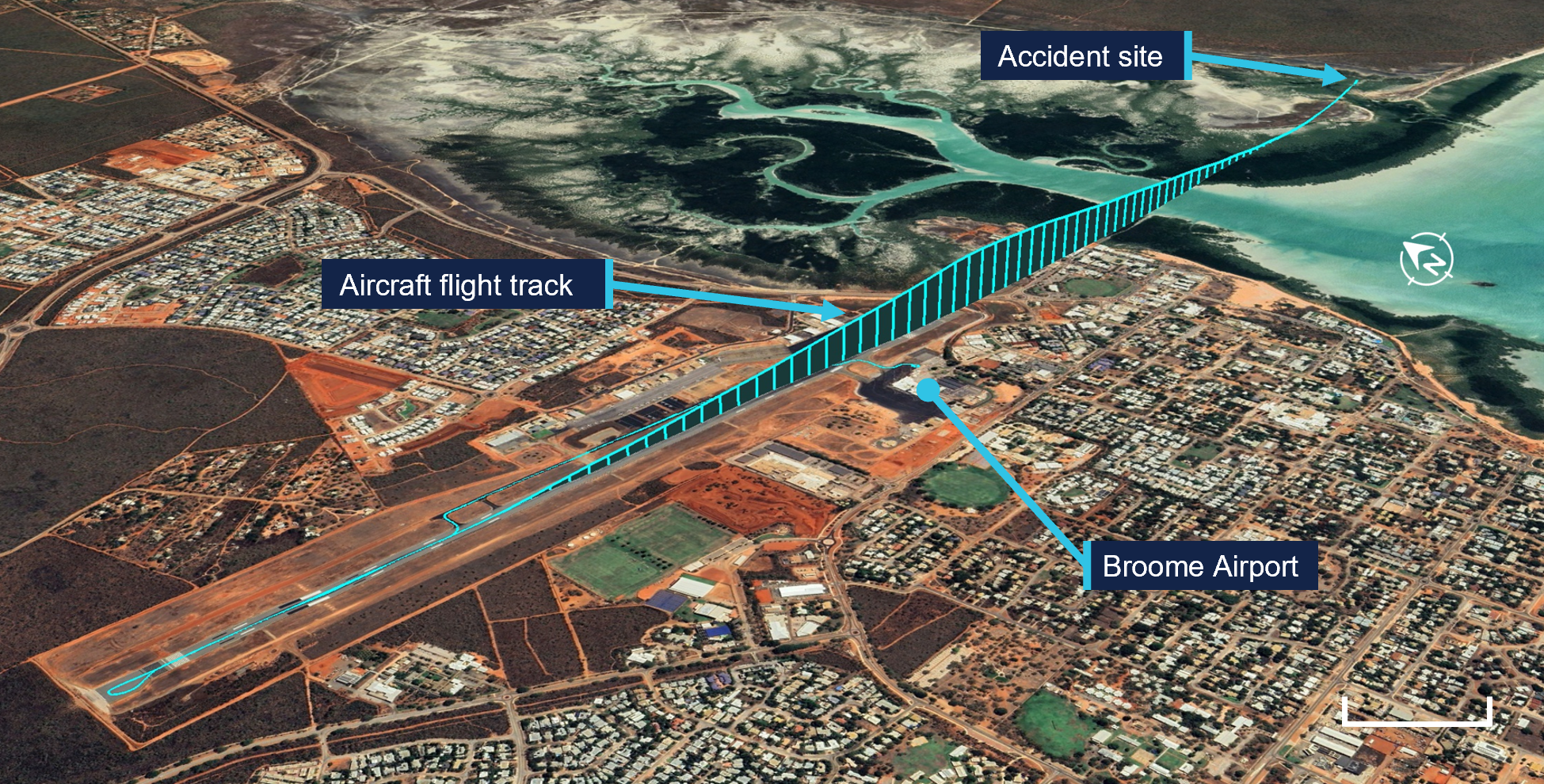
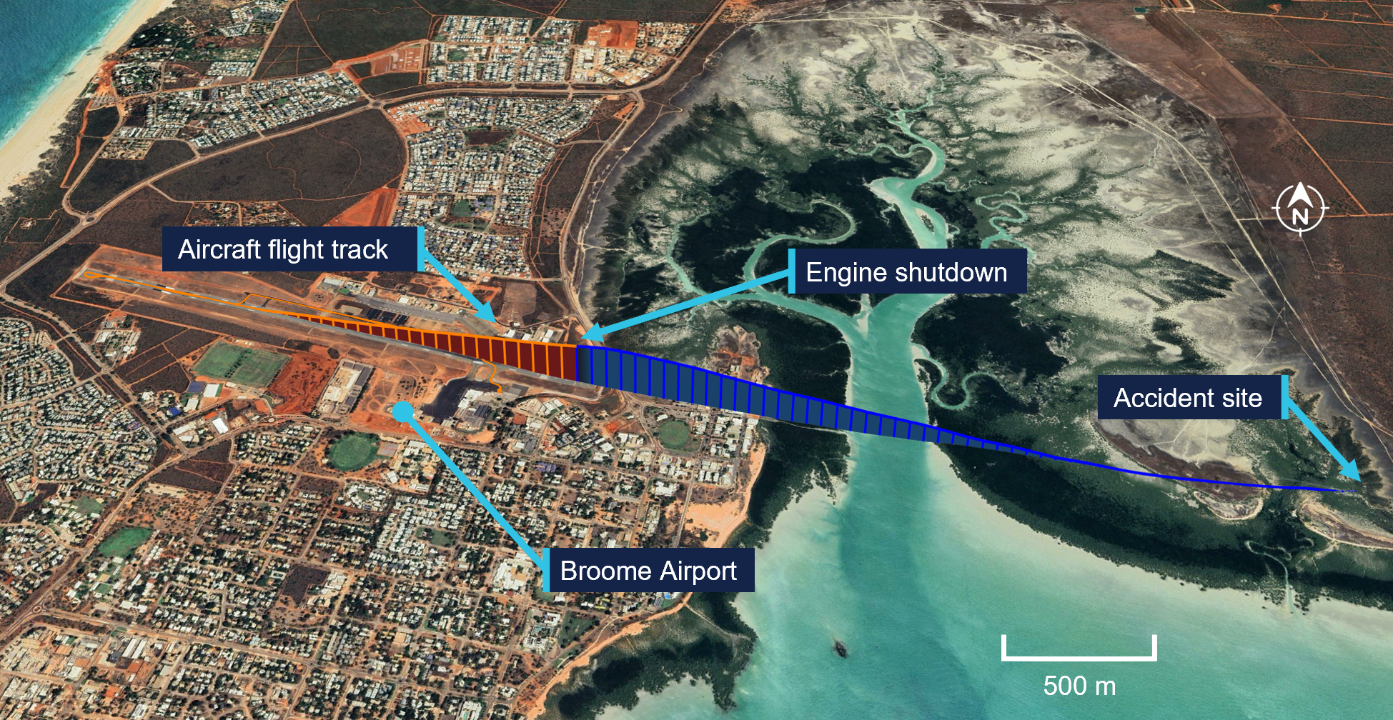
The training captain conducted a controlled descent and moved the condition levers to shut-off just before the aircraft impacted terrain at 1117:54, at a ground speed of 76 kt (141 km/h) (Figure 1). As a result of the impact, one passenger was seriously injured and the 2 pilots and 4 passengers received minor injuries. The aircraft was substantially damaged.
Figure 1: Flight track and location of accident site
Source: ATSB
The aircraft emergency locator transmitter activated on impact and the training captain attempted to contact Broome tower ATC via radio, however, was unsure if the radio was working, as they did not receive a response.
Broome tower ATC attempted to contact the aircraft operator to confirm the number of people on board, and if there were any dangerous goods, but was unable to do so. This information was instead obtained through contact with the training captain on their mobile phone.
The occupants commenced exiting the aircraft and the training captain was the last to egress, taking the fire extinguisher. The pilot flying applied first aid to the seriously injured passenger.
A search and rescue helicopter was dispatched at about 1141, arriving on site at 1210. Western Australia police arrived at about 1213. The seriously injured passenger was airlifted from the accident site and transported to hospital by ambulance. The flight crew and remaining passengers were assisted by police and the Department of Fire and Emergency Services to walk from the accident site and were met by ambulances.
Context
Personnel information
Pilot in command under supervision
The pilot in command under supervision held a Commercial Pilot Licence (Aeroplane), issued in 2018 and with class ratings for multi- and single-engine aeroplanes. They had accumulated 1,256.8 total flight hours, with 56.6 hours on the Cessna 441 aircraft type. The pilot held a current instrument rating, with their last proficiency check completed in January 2026, and a current class 1 aviation medical certificate (valid until April 2026) with no conditions. The pilot reported being well rested and fit to fly.
Training captain
The training captain held a Commercial Pilot Licence (Aeroplane) issued in 2022 and with class ratings for multi- and single-engine aeroplanes. They had accumulated 1,764.7 total flight hours, with 1,080.9 hours on the Cessna aircraft 441 type. They held a current instrument flight rating, with their last proficiency check completed in November 2025, and a current class 1 aviation medical certificate (valid until November 2026) with no conditions. The training captain reported being well rested and fit to fly.
In addition to their position as training captain, they also held the roles of Broome senior base pilot and the Cessna 441 fleet manager for the operator.
Aircraft information
General
The Cessna 441 Conquest is a pressurised, low‑wing aircraft, with seating for up to 2 pilots and 10 passengers. However, the Skippers Aviation operations manual limited the number of passengers that could be carried to 9.
VH-LBZ was powered by 2 Honeywell International Inc TPE331-10N-531S turboprop engines, fitted with Hartzell HC-B3TN-5 propellers. Both pilot seats were equipped with flight controls, however, single‑pilot line operations were flown from the left seat. The right pilot seat would normally only be occupied by a second pilot for training and checking, although for this flight the operator’s client had stipulated via policy that 2 crew would be carried.
The accident aircraft, serial number 4410038, was manufactured in the United States by the Cessna Aircraft Company in 1978 and registered in Australia as VH-LBZ in July 1984. At the time of take-off, the aircraft had a total time-in-service of 29,267.9 flight hours. The aircraft was operating under a Civil Aviation Safety Authority supplemental type certificate that, with specific maintenance requirements, permitted operators to continue operating the Cessna 441 past its service life of 22,500 flight hours to 40,000 flight hours.
Aircraft maintenance
The aircraft was maintained in accordance with the Skippers Aviation Cessna 441 maintenance program, which incorporated the requirements of the life extension program, permitted by the supplemental type certificate.
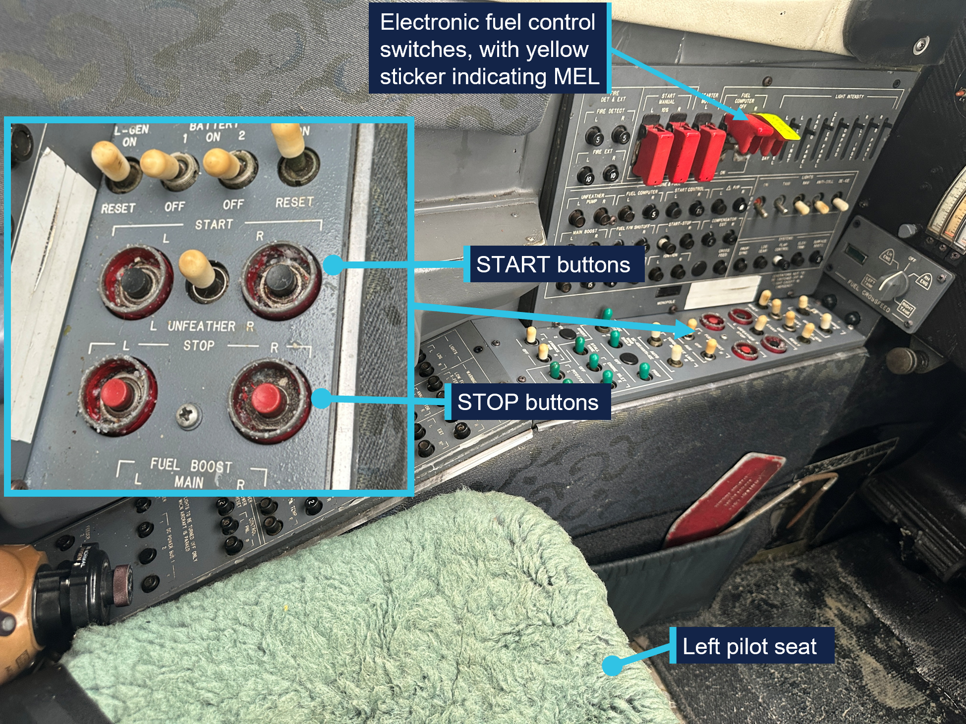
The aircraft had a deferred defect log6 entry dated 16 March 2026, which showed that the right engine fuel control computer was unserviceable. A yellow sticker was affixed to the right fuel control computer switch located on the left vertical panel inside the aircraft to identify the unserviceability (see START and STOP buttons). This was a permissible unserviceability in accordance with the aircraft’s MEL. As this was a category C defect,7 the aircraft was permitted to operate for a maximum of 10 days, with one or both fuel computers unserviceable, provided certain limitations were adhered to. Those limitations were:
manual mode (see Engine fuel control system) procedures in the airplane flight manual were followed
manual mode performance charts in the airplane flight manual were used
propeller reversing was not to be used for the engine operating in manual mode
propeller synchrophasing8 was inoperative.
The airplane flight manual procedures recommended that, where one fuel computer was inoperative, both engines were to be in manual mode for take-off. The operator’s deferred defect log included the MEL requirements and added that both engines were to be in manual mode for take-off and landing. Further, the operator required that the abovementioned specific MEL requirements be covered in line training for take-off and landing.
Engine fuel control system
Normal mode operation
Each engine was equipped with an electronic fuel control system (normal mode operation), which included an electronic fuel computer for regulating fuel flow and engine speed. The system automatic functions included:
automatic engine starting
fuel enrichment and optimum fuel scheduling
calculating a single red line exhaust gas temperature to assist the pilot with managing engine power
limiting engine torque and temperatures to prevent exceedance
the engine revolutions per minute (RPM) automatically changed with the condition lever selection9
electronic underspeed governing of the propeller.10
Manual mode operation
The electronic fuel control system was also fitted with a manual backup system (manual mode operation), which was to be used when the electronic fuel computer became inoperative for any reason. When operating in manual mode, among other reductions in certain system functions:
fuel enrichment required for take-off and engine acceleration was achieved by pressing the engine START button
the engine starting functions were to be performed manually by the pilot
the condition lever did not control the engine speed
the propeller synchroniser was inoperative
engine torque and temperature were to be monitored and manually adjusted by the pilot to prevent engine damage as the limiting functioning was inoperative
engine response to power lever advances was slower
aircraft performance was changed
propeller reversing was not permitted.
START and STOP buttons
The aircraft was fitted with START (black) and STOP (red) buttons for the left (L) and right (R) engines. Slightly recessed, the buttons were located in proximity on a horizontal switches panel to left of the left pilot seat (Figure 2). The START button was pressed momentarily to initiate the start sequence, in normal and manual modes.
When the STOP buttons were pressed, this activated the electrical fuel shutoff valve initiating an immediate cessation of fuel flow. When using the STOP buttons for a normal shutdown, the airplane flight manual advised that the buttons were to be pressed and held for 5 seconds to allow for any remaining fuel in the system to be purged.
Figure 2: Location of START and STOP buttons and electronic fuel control switches
Source: ATSB
Use of the START button for fuel enrichment
The fuel enrichment valve, part of the fuel control assembly,11 permitted fuel enrichment during engine start, primarily to accelerate the engine smoothly to operating speed. The electronic fuel computer controlled the fuel enrichment for acceleration while simultaneously ensuring that the exhaust gas temperature remained within limits. In manual mode, the pilot provided fuel enrichment by pressing and holding the START button, after fuel flow had been established. The procedure for manual mode starting included the START button could be pushed ‘as required for fuel enrichments to assist engine acceleration to 85% RPM’. The pilot must monitor exhaust gas temperature to remain within limitations.
The airplane flight manual further stated that the START button could be used as required to aid engine acceleration to 100% RPM, with brakes applied prior to the commencement of the take-off roll. However, it did not mention the use of the START button for enrichment during any other phases of flight.
Meteorological information
The aerodrome forecast for Broome Airport, valid from 1000 on 19 March 2026, indicated the wind was 100° at 14 kt, and CAVOK12 conditions. The forecast temperature was 34°C.
Wreckage and impact information
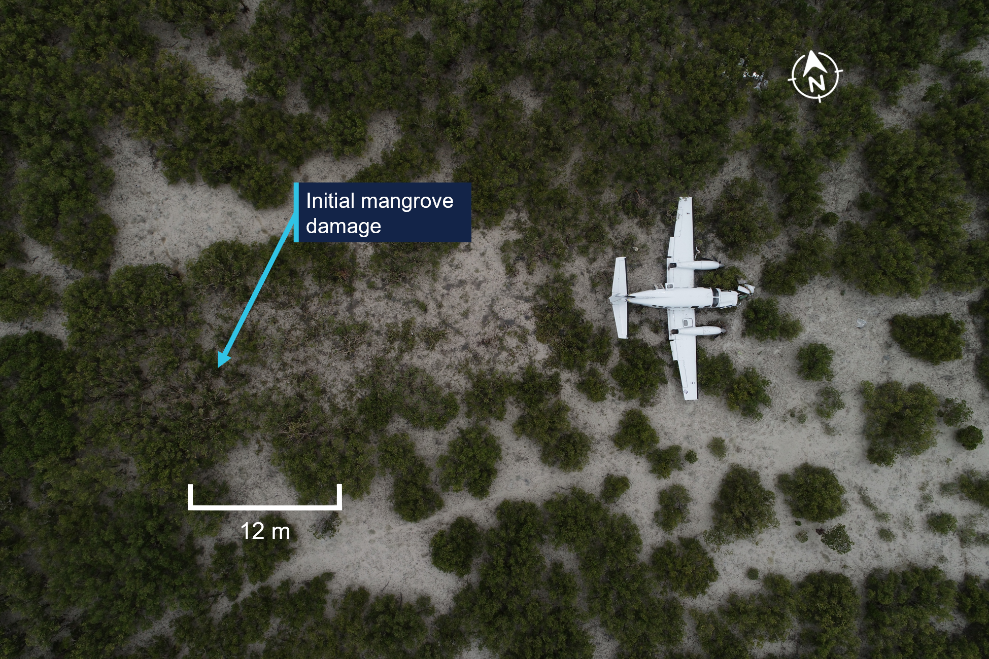
The forced landing area was in mangrove swampland about 3.6 km east of Broome Airport, in-line with the aircraft’s approximate take-off track. The flight path angle was about 9° nose down and the distance between the initial contact with mangrove trees and the wreckage was about 30 m (Figure 3).
Figure 3: Overhead view of aircraft accident site
Source: ATSB
The ATSB’s onsite examination identified that:
The aircraft was relatively intact with the landing gear down and the flaps partially extended. The aircraft rapidly decelerated once the landing gear had contacted the muddy terrain.
There was fuel in the left and right wing tanks and clean fuel in the left and right engine‑driven fuel pump filter bowls.
Examination of the left and right engine turbines viewed through the exit ducts did not show any observable damage.
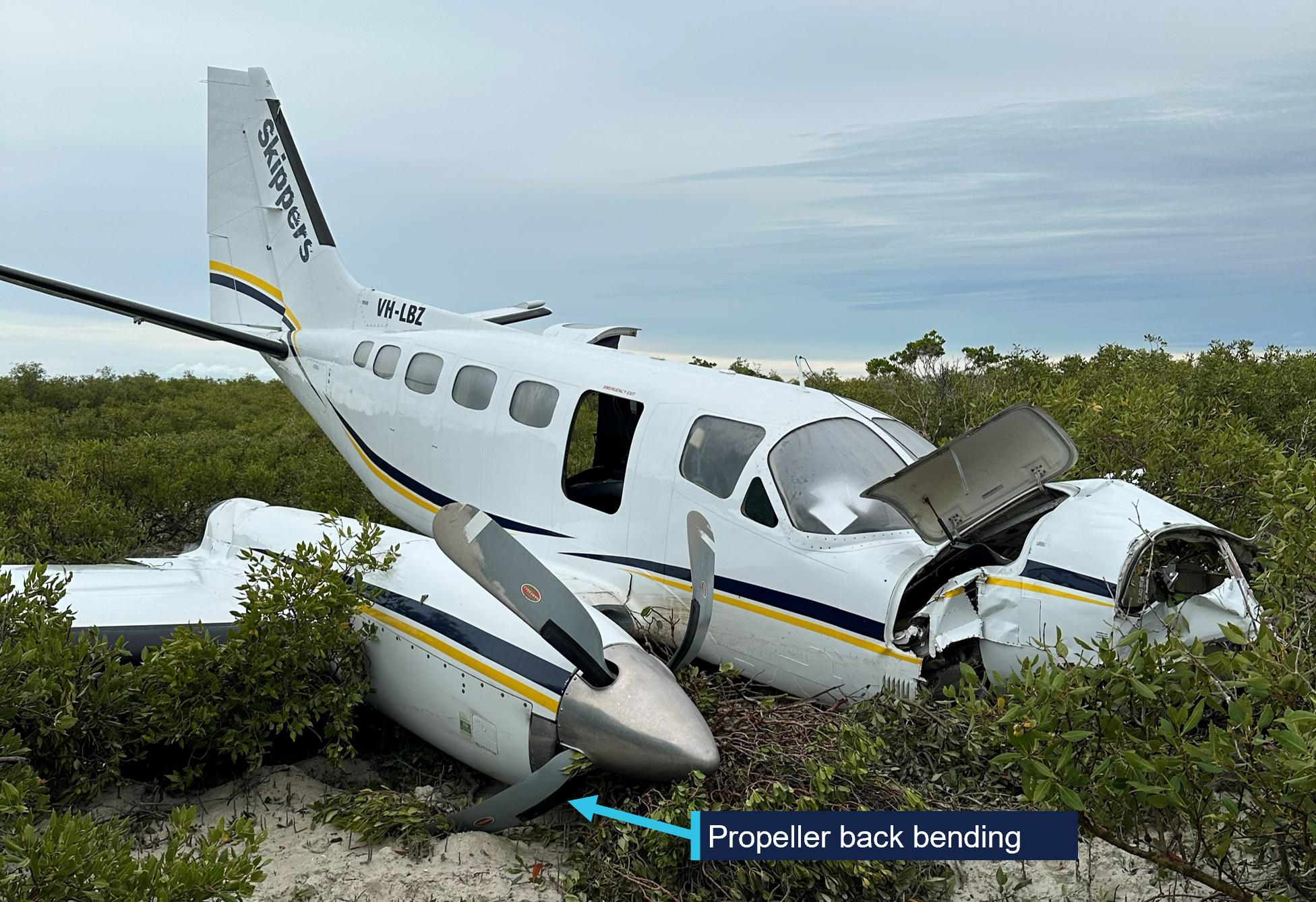
Damage to the left and right propeller showed back bending and limited rotational abrasion damage, which indicated the engines were not driving the propellers at the time of the impact (Figure 4).
Figure 4: Aircraft wreckage showing propeller back bend
Source: ATSB
Recorded information
The ATSB recovered 3 Garmin electronic recording devices from the aircraft:
G600 TXi flight display
GI 275 attitude indicator
GTN 650Xi GPS, navigation, communications and multifunction display.
While there were no parameters on the devices recovered that directly pertained to the engines, the GI 275 recorded the system voltage (aircraft power). The data retrieved from this unit showed a drop in the system voltage beginning at 1116:59, from 27.7 volts direct current (VDC) to 26.8 VDC within 1 second, then slowly decreased to 24.5 VDC over the next 17 seconds. The base system voltage was nominally 24 VDC, however, would be about 28 VDC when the generators13 were on. Therefore, a drop in voltage was consistent with the generator speed reducing as the engines shut down. In addition, there was also a rapid decrease in longitudinal acceleration at the same time.
The data retrieved also indicated that, at 1116:59, the aircraft (Figure 5):
was at an altitude of 490 ft above mean sea level
had an indicated airspeed of 141 kt (261 km/h)
was climbing at 1,225 ft/min
had about 9° nose-up attitude and 4° left roll
was on a heading of about 107°.
At 1117:54, the impact occurred at an indicated airspeed of about 82 kt (152 km/h) and a ground speed of 76 kt (141 km/h) coming to a stop by 1117:58.
Figure 5: Location of aircraft engine shutdown
Orange section is with power available, blue section is following the engine shutdown.Source: ATSB
Survival aspects
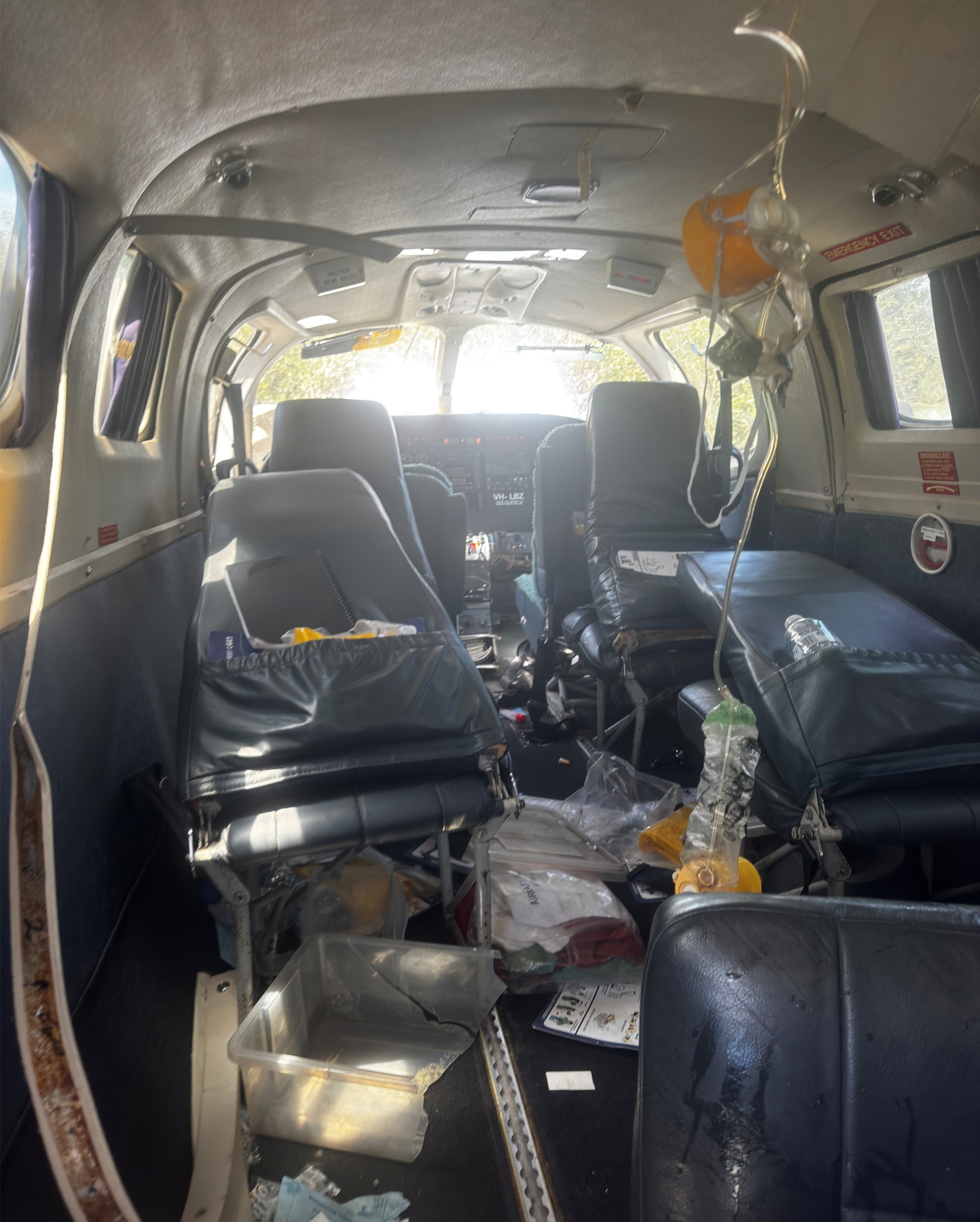
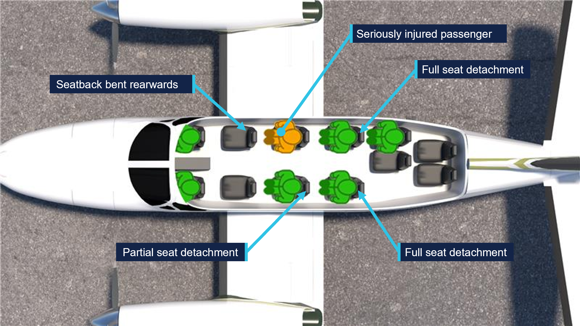
The liveable space within the aircraft cabin was maintained, and the exits were tested by the ATSB and found to function correctly. However, there was significant disruption to the cabin interior including displaced equipment, deployed oxygen masks and the complete detachment of 2 passenger seats from their seat tracks, with some of the floor structure lifting. An additional seat had partially detached and the seat behind the right pilot was significantly distorted, with a backward bend of almost 45° (Figure 6).
Figure 6: Aircraft cabin immediately after the accident
Source: Pilot of VH-LBZ
In addition, a passenger seated on the right side of the second row of passenger seats reported that their seatbelt failed during the impact, throwing them forward into the back of the seat ahead before coming to rest between the 2 pilots. This passenger received serious injuries. Figure 7 shows the location of the full and partially failed seats, and where the seriously injured passenger was seated. All other passengers and the pilots received minor injuries.
Figure 7: Location of seat failures and seriously injured passenger
Source: ATSB
Related occurrence
A previous ATSB investigation (200601053) involving a Cessna 441 Conquest, VH-LBA, 40 km north-west of Callion, Western Australia, on 27 February 2006, found that the pilot in command inadvertently shut down the left engine in-flight by pressing the STOP button. The investigation noted that:
…Prior to the event, the flight crew were discussing the use of the Start Button Guard Plate which was in place over the engine START buttons.In the course of explaining to the second pilot the use of the Start Button Guard Plate, the PIC inadvertently depressed the left engine STOP button...
Safety action
The Civil Aviation Safety Authority (CASA) issued a safety alert to Skippers Aviation Pty Ltd to prevent the use of Cessna 441 Conquest aircraft that have an MEL applied that requires the use of manual mode. The safety alert advised:
Skippers must not dispatch a flight where an MEL involving the use of manual mode is in force in any C441 Conquest operated by them until CASA has approved amendments to the Exposition and the Training and Checking manual that detail the use of manual mode and Skippers has conducted the appropriate training and checking of the flight crew assigned to the flight.
Skippers Aviation Pty Ltd advised that it has taken the following safety action, which addressed the safety alert issued by CASA and included additional actions:
Immediate grounding of the Cessna 441 Conquest fleet.
Issuance of a companywide ‘Memorandum to All Staff – The use of MEL 76-00-01 Fuel computers is Prohibited’.
Completion of a risk review of Cessna 441 Conquest operations which encompassed procedures, training, maintenance, workload, safety and staffing. The review determined that, while the operator considered all controls were compliant, multiple challenges existed and a decision was made to cease all Cessna 441 Conquest revenue operations permanently.
A cost benefit analysis was completed, and Broome operations were considered no longer feasible.
A review of companywide procedures and training is in progress, including all procedures related to the management of MELs.
Further investigation
To date, the ATSB has:
examined the wreckage and accident site
examined recorded data from the Garmin G600 TXi, GI 275 and GTN 650 devices
interviewed the pilots and passengers
collected radio communication, aircraft traffic surveillance data, and navigational application data
collected aircraft, pilot, crew and operator documentation.
The investigation is continuing and will include further review and examination of:
operational procedures and training
aircraft maintenance and MEL practices
crashworthiness and survivability aspects
aircraft design features (including the START/STOP buttons).
A final report will be released at the conclusion of the investigation. Should a critical safety issue be identified during the course of the investigation, the ATSB will immediately notify relevant parties so appropriate and timely safety action can be taken.
The ATSB would like to thank the Department of Biodiversity, Conservation and Attractions for its assistance in facilitating access to the aircraft accident site.
Purpose of safety investigations
The objective of a safety investigation is to enhance transport safety. This is done through:
identifying safety issues and facilitating safety action to address those issues
providing information about occurrences and their associated safety factors to facilitate learning within the transport industry.
It is not a function of the ATSB to apportion blame or provide a means for determining liability. At the same time, an investigation report must include factual material of sufficient weight to support the analysis and findings. At all times the ATSB endeavours to balance the use of material that could imply adverse comment with the need to properly explain what happened, and why, in a fair and unbiased manner. The ATSB does not investigate for the purpose of taking administrative, regulatory or criminal action.
About ATSB reports
ATSB investigation reports are organised with regard to international standards or instruments, as applicable, and with ATSB procedures and guidelines.
Reports must include factual material of sufficient weight to support the analysis and findings. At all times the ATSB endeavours to balance the use of material that could imply adverse comment with the need to properly explain what happened, and why, in a fair and unbiased manner.
An explanation of terminology used in ATSB investigation reports is available here. This includes terms such as occurrence, contributing factor, other factor that increased risk, and safety issue.
Publishing information
Released in accordance with section 25 of the Transport Safety Investigation Act 2003
Ownership of intellectual property rights in this publication
Unless otherwise noted, copyright (and any other intellectual property rights, if any) in this report publication is owned by the Commonwealth of Australia.
Creative Commons licence
With the exception of the Commonwealth Coat of Arms, ATSB logo, and photos and graphics in which a third party holds copyright, this report is licensed under a Creative Commons Attribution 4.0 International licence.
The CC BY 4.0 licence enables you to distribute, remix, adapt, and build upon our material in any medium or format, so long as attribution is given to the Australian Transport Safety Bureau.
Copyright in material obtained from other agencies, private individuals or organisations, belongs to those agencies, individuals or organisations. Where you wish to use their material, you will need to contact them directly.
^In-command under supervision allows a pilot to perform all duties and functions as a pilot in command under the supervision of a pilot in command appointed for that purpose.
^Minimum equipment list (MEL) is a list that provides for the operation of aircraft, subject to specified conditions, with particular equipment inoperative.
^An engine failure below the decision speed should result in a rejected take off; above this speed the take-off should be continued.
^Rotation: the positive, nose-up, movement of an aircraft about the lateral (pitch) axis immediately before becoming airborne.
^MAYDAY is an internationally recognised radio call announcing a distress condition where an aircraft or its occupants are being threatened by serious and/or imminent danger and the flight crew require immediate assistance.
^The deferred defect log identified the system affected, date and aircraft hours when logged, any limitations and deferral expiry date, a copy of which was in the flight log available to the pilots.
^Minimum equipment lists and repair categories are explained in Civil Aviation Advisory Publication (CAAP) 37-01 v5.1.
^Propeller synchronising and synchrophasing provide a means to match the RPM of both engines and establish a blade phase relationship between the left and right propellers to reduce vibration and cabin noise.
^The condition lever controlled engine speed (RPM) and fuel flow while the power lever adjusted the engine torque and propeller speed.
^The electronic underspeed governor is primarily to control fuel flow to maintain engine RPM during ground operations. It differs in operation to the propeller governor that directs oil to, or from, the propeller to maintain selected propeller/engine RPM.
^The fuel control assembly regulates fuel flow to the engine and contains a mechanical fuel shutoff valve and an electrical fuel shutoff valve.
^Ceiling and visibility okay (CAVOK): visibility, cloud and present weather are better than prescribed conditions. For an aerodrome weather report, those conditions are visibility 10 km or more, no significant cloud below 5,000 ft, no cumulonimbus cloud and no other significant weather.
^A combination starter-generator was mounted on each engine. The units operated as a starter during ground starts and were the aircraft’s primary power source.
Occurrence summary
Investigation number
AO-2026-068
Occurrence date
19/03/2026
Occurrence time and timezone
1117 Australian Western Standard Time
Location
3.6 km from Broome Airport
State
Western Australia
Report release date
02/06/2026
Report status
Preliminary
Anticipated completion
Q3 2026
Investigation level
Short
Investigation type
Occurrence Investigation
Investigation phase
Evidence collection
Investigation status
Active
Mode of transport
Aviation
Aviation occurrence category
Collision with terrain, Forced/precautionary landing
Occurrence class
Accident
Highest injury level
Serious
Aircraft details
Manufacturer
Cessna Aircraft Company
Model
441 Conquest
Registration
VH-LBZ
Serial number
4410038
Aircraft operator
Skippers Aviation Pty Ltd
Sector
Turboprop
Operation type
Part 135 Air transport operations - smaller aeroplanes
The ATSB is investigating a runway excursion and collision with tree involving a GippsAero GA8 Airvan, VH-WSU, at Lindeman Island, Queensland, on 8 March 2026.
During landing on soft and wet ground, the wheels slid and the pilot applied full power to conduct a go-around. The aircraft became airborne after the end of the runway and the landing gear contacted a tree, resulting in substantial damage. The aircraft was flown with reduced performance to Shute Harbour due to the runway condition at Lindeman Island being deemed unsuitable.
The final report has been drafted and is undergoing internal review to ensure the report adequately and accurately reflects the evidence collected, analysis, and agreed findings.
The final report will be released at the conclusion of the investigation. Should a critical safety issue be identified during the course of the investigation, the ATSB will immediately notify relevant parties, so that appropriate safety action can be taken.
Last updated:
Occurrence summary
Investigation number
AO-2026-065
Occurrence date
08/03/2026
Occurrence time and timezone
1435 Eastern Australia Standard Time
Location
Lindeman Island
State
Queensland
Report status
Pending
Anticipated completion
Q4 2026
Investigation level
Short
Investigation type
Occurrence Investigation
Investigation phase
Final report: Internal review
Investigation status
Active
Mode of transport
Aviation
Aviation occurrence category
Collision with terrain, Control issues, Diversion/return, Missed approach, Stall warning
Occurrence class
Accident
Highest injury level
None
Aircraft details
Manufacturer
Gippsland Aeronautics Pty Ltd
Model
GA8
Registration
VH-WSU
Serial number
GA8-17-244
Aircraft operator
Wave Air
Sector
Piston
Operation type
Part 135 Air transport operations - smaller aeroplanes
Activity
Commercial air transport-Non-scheduled-Joyflights / sightseeing charters
At 0834 Australian Eastern Standard Time on 13 March 2026, a Robinson R44 II helicopter, registered VH-TCF, departed from Gold Coast, Queensland, for a private flight to Mudgee, New South Wales (NSW), with an intermediate stop at Armidale, NSW, to refuel.
The pilot’s iPhone crash alarm activated, 72 minutes after the aircraft departed, and the wreckage was located the following day in dense bushland, 46 km north-east of Tenterfield, NSW. The pilot sustained fatal injuries and the helicopter was destroyed.
What the ATSB found
The ATSB found that it was very likely the pilot entered weather conditions unsuitable for visual flight, resulting in a loss of control and subsequent collision with terrain.
Safety message
The ATSB encourages all pilots, no matter what their experience levels, to develop the knowledge and skills required to avoid unintentional operations in instrument meteorological conditions (IMC). This includes having alternate plans in case of unexpected changes in weather, and making timely decisions to land, turn back, divert or hold in an area of clear weather. The use of a ‘personal minimums’ checklist can also be a strong mitigator against the risk of flying into bad weather.
The Vertical Aviation Safety Team, formally known as the International Helicopter Safety Team, has published several fact sheets about inadvertent IMC (IIMC) that are available from their website. Their fact sheet, Inadvertent entry into instrument meteorological conditions (IIMC), acknowledges that these encounters are the ‘most demanding, disorienting, and dangerous conditions a pilot can experience’ and result in the highest percentage of fatal injuries from helicopter accidents.
The fact sheet explained the immediate actions required by pilots in IIMC stating that:
A pilot’s immediate actions after encountering inadvertent IMC will determine the outcome of the entire event. Pilots who possess a plan of action prior to encountering it are more likely to experience a successful outcome (staying alive) than those who are less trained and proficient in the recognition and recovery procedures.
In addition, their fact sheet stated that:
Comprehensive training on IIMC is necessary for all rotorcraft helicopter training. This training should include, but not limited to:
• Determination of enroute weather
• Avoidance of inadvertent flight into instrument meteorological conditions
• In-flight weather abort procedures
• Recovery from inadvertent flight into instrument meteorological conditions.
The ATSB booklet Accidents involving visual flight rules pilots in instrument meteorological conditions (AR-2011-050) provides guidance on avoiding flight into adverse weather. Further information specific to helicopter pilots is also available on the ATSB website.
The investigation
The ATSB scopes its investigations based on many factors, including the level of safety benefit likely to be obtained from an investigation and the associated resources required. For this occurrence, the ATSB conducted a limited-scope investigation in order to produce a short investigation report, and allow for greater industry awareness of findings that affect safety and potential learning opportunities.
The occurrence
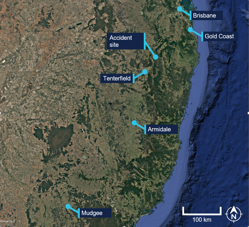
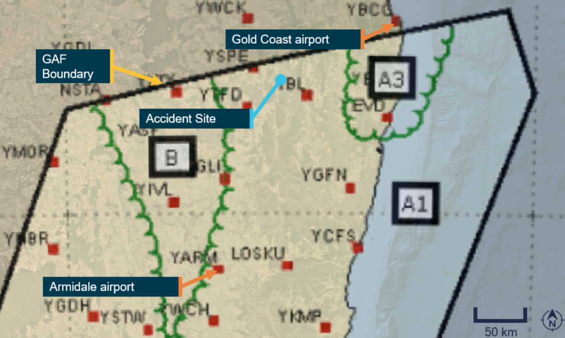
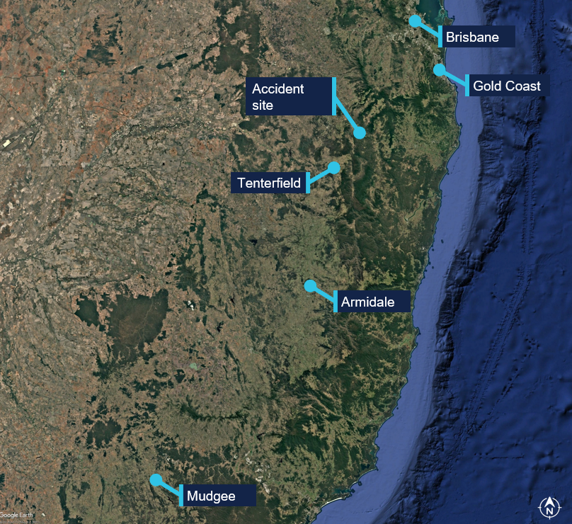
On 13 March 2026, the pilot and sole occupant of a Robinson R44 II helicopter, registered VH-TCF, planned to conduct a private flight under the visual flight rules (VFR),1 from Gold Coast, Queensland, to Mudgee, New South Wales (NSW), with an intermediate stop at Armidale, NSW, to refuel (Figure 1).
Figure 1: Map showing accident site and key locations
Source: Google Earth, annotated by the ATSB
The pilot was intending to travel over 3 days, to join a helicopter safari in southern Victoria with the intention of flying around Tasmania. A relative of the pilot reported that the pilot was ‘very excited about the trip’. They further advised that the pilot had been monitoring the weather in the days leading up to the departure and was expecting clear conditions for the flight.
At about 0834 Australian Eastern Standard Time (AEST),2 the helicopter departed from a private helipad, around 35 km from the Gold Coast Airport.
NSW Police advised that an automated emergency message associated with activation of the pilot’s iPhone crash alarm3 was received at 1046 Australian Eastern Daylight saving Time (AEDT),4 72 minutes after the aircraft departed. In response, a formal search was commenced by NSW Police.
The wreckage was located at 1113 AEDT on 14 March 2026, in dense bushland, 46 km north-east of Tenterfield, NSW. The pilot sustained fatal injuries and the helicopter was destroyed.
Context
Pilot information
Flight experience
The pilot held a Private Pilot Licence (Helicopter) and a single‑engine helicopter class rating. The pilot did not hold an instrument rating and had not logged any instrument flight time. As of 7 March 2026, the pilot’s logbook showed they had accrued about 1,262 hours total flight time, 84 of which were accrued on an R22. The remaining hours were obtained operating R44 helicopters, with all but 11.5 in VH-TCF. The pilot completed their last flight review on 21 September 2025. The instructor who conducted the review reported that it included ground theory training followed by a 1‑hour flight, and a second 1-hour flight the following day, consistent with entries in the pilot’s logbook. The instructor reported discussing interpretation of a weather forecast with the pilot, but did not require, or observe the pilot demonstrate, planning a flight based on the weather forecast. The instructor described the pilot as a ‘confident and comfortable’ pilot.
Medical information
At the time of the accident, the pilot was 77 years old. Their class 2 aviation medical certificate application was completed by a designated aviation medical examiner on 5 September 2025 and was valid to 5 September 2026. The certificate had the following limitations:
Must use [continuous positive airway pressure] CPAP in sleep period prior to exercising privileges of medical certificate.
Reading correction to be available whilst exercising the privileges of this licence.
Records obtained from the CPAP provider showed that the pilot was regularly using the CPAP machine as required.
The ATSB reviewed the pilot’s CASA aviation medical history since 2017. While the pilot had multiple conditions that increased the risk of medical incapacitation, these had been disclosed to CASA and were assessed as being adequately controlled.
The pilot was reported to have slept normally the night before the accident and had eaten breakfast before departing. There was no evidence to indicate the pilot was unwell, nor experiencing a level of fatigue known to affect performance.
The post-mortem did not identify any evidence of incapacitation, however, toxicology results were not available at the time of report writing.
Aircraft information
General information
The Robinson R44 II is a 4-seat helicopter, powered by a single Textron Lycoming IO‑540‑AE1A5 piston engine, driving a 2‑blade semi-rigid main rotor system and 2‑blade tail rotor system. VH-TCF, serial number 11912, was manufactured in the United States in 2007 and first registered in Australia in October 2007.
The helicopter was being maintained in accordance with the Robinson Helicopter R44 maintenance manual, the Lycoming IO-540 operator’s manual, supplemental type certificates and engineering orders. Its last periodic inspection was conducted on 13 February 2026 at 2,103.4 hours. Prior to the commencement of the accident flight, VH-TCF had accumulated 2,104.7 hours total time in service. It was equipped and maintained to a day visual flight rules standard, with the maintenance release reflecting this limitation.
The helicopter was equipped with lap sash seat belts and was being operated with the doors fitted.
Rotor system
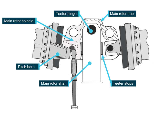
The Robinson R44 main rotor hub assembly is a semi-rigid rotor head, otherwise known as a teetering rotor head (Figure 2). Bolts secure the blades to the hub at the coning hinges. During stopping and starting of the main rotor, when RPM is low, blade tusks rest against droop stops, restricting teetering and preventing the blades from drooping. As the main rotor RPM increases, the blades straighten and become rigid due to rotational forces, and the tusks shift off the droop stops. During normal flight, the rotor is free to teeter and flap around its designed flight axis via the teeter hinge, while polyurethane teeter stops limit the degree of teetering.
Under certain flight conditions, semi-rigid rotor systems are susceptible to extreme teetering where the blades teeter beyond their normal operational range, resulting in what is commonly known as ‘mast bumping’ (see the following section titled Mast bumping).
Figure 2: Robinson main rotor hub assembly
Image modified to remove spindle tusk and droop stop bolt for clarity. Source: Robinson Helicopter Company, modified and annotated by the ATSB
Mast bumping
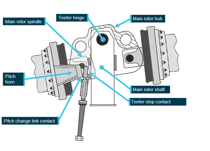
Mast bumping is the common term used to describe contact of the main rotor shaft, by the inboard main rotor spindle (Figure 3).
Mast bumping severity can generally be identified by extensive damage to, including destruction of, the teeter stops and varying degrees of damage to the main rotor shaft from direct impact.
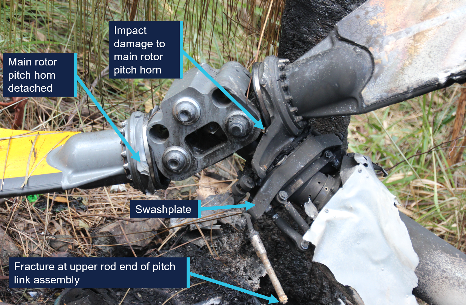
Extreme teetering can also result in the pitch change links exceeding their maximum displacement and often results in failure of one or both pitch links, typically at the upper rod end thread. Failure of a pitch link will allow uncontrolled rotation of the blade about its pitch axis and at this point, control of the helicopter is no longer possible. As documented in many investigation reports worldwide, scenarios involving mast bumping have been attributed to inappropriate flight control inputs that permit the development of, and/or inappropriate response to, low g5 flight conditions.
Figure 3: Extreme mast bump
Image modified to remove spindle tusks and droop stop bolts for clarity. Source: Robinson Helicopter Company, annotated by the ATSB
Site and wreckage information
Accident site
The accident site was located about 46 km north-east of Tenterfield Airport in a densely vegetated area. It was situated on the southern side of a steep slope, at an elevation of about 900 m (2,950 ft).
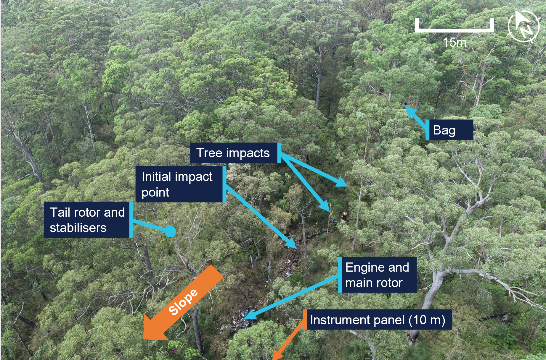
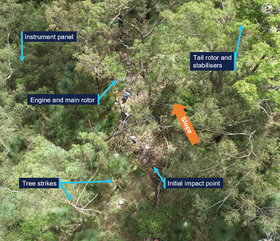
The wreckage trail was approximately 12 m long in a westerly direction (Figure 4). It consisted of an initial impact point, followed by a trail of debris down the slope leading to the fuselage, engine and main rotor, much of which were consumed by a post-impact fire. Damage was evident on 2 trees located near the initial impact point, indicating the helicopter had struck these trees in a near vertical descent.
Figure 4: Accident site
Source: ATSB
The aft section of the tailcone assembly, including the tail rotor and stabilisers, had separated from the fuselage and was located approximately 20 m from the fuselage across the slope through dense vegetation (Figure 4). A large, soft shell travel bag was located in the tree canopy (Figure 4), around 12 m upslope from the initial impact with the trees. Various other items from within the helicopter, such as a headset, were located between the bag and the initial impact site, indicating they had been liberated from the helicopter above the tree line, prior to the initial impact point.
The main instrument panel was located a further 10 m down the slope away from the fuselage.
Wreckage examination
Disruption to the helicopter and post-impact fire damage precluded a detailed examination of a significant proportion of the helicopter. This included testing of electrical and fuel system components and the determination of engine controls and instrument panel switch selections.
The intensity of the post-impact fire was indicative of a considerable amount of fuel on board the helicopter. A fuel jerry can, which had been filled at the helicopter’s departure location, was found on site. The contents were consistent with avgas, and testing showed no presence of water in the fuel.
Main rotor assembly
Examination of the main rotor components identified:
the main rotor hub was secure to the main rotor shaft, which was secure to the main rotor transmission
both main rotor blade tips were located within the accident site
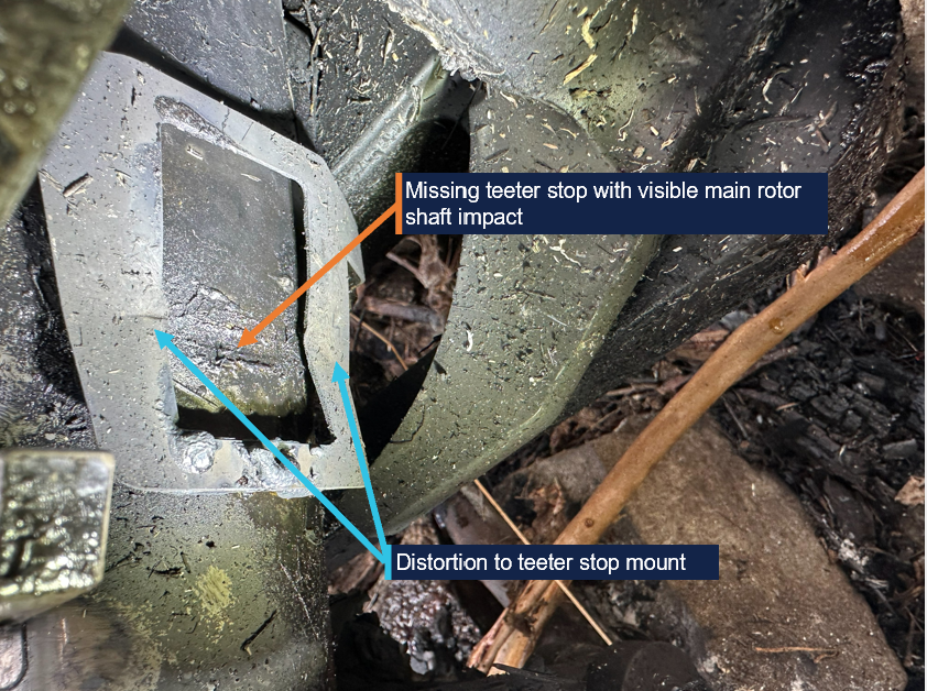
one teeter stop had fractured in the centre due to severe impact forces from the spindle, with the upper half liberated
the other teeter stop was not present (Figure 5)
both teeter stop stainless steel mounts exhibited distortion from spindle impact (Figure 5)
impact damage to the main rotor shaft at both teeter stop locations (Figure 5).
Figure 5: Example of damage to teeter stop and main rotor shaft on one side
Source: ATSB
both main rotor pitch change links had fractured in overstress, at the upper rod end thread (Figure 6)
one pitch horn had detached, with the fracture surface consistent with overstress (Figure 6)
the other pitch horn was secured to the spindle and exhibited damage consistent with contact with the main rotor hub (Figure 6).
Figure 6: Main rotor hub
Source: ATSB
Tailcone separation
The aft section of the tailcone was located around 20 m to the right of the wreckage trail with limited damage to the structure. Signature marks where it had separated from the tail boom, the lack of structural damage and its location, were consistent with the tailcone likely separating above the trees during the accident sequence, rather than it being a precursor to the accident.
Other systems
Where flight control tubes had been destroyed by impact or fire, the integrity of the control system was limited to confirming the connection at their respective attachment points and for the presence of securing hardware. In that context, no defects were identified. Further, fracture surfaces of rod ends, and other flight control components were consistent with overstress failure.
The examination also identified the following:
all major components were identified at the site
damage to the cooling fan was indicative of the engine rotating at the time of impact
damage to, and location of, the instrument panel (Figure 4) was consistent with a high energy liberation event, possibly from a main rotor strike.
Recorded data
Although the pilot was reportedly using the OzRunways6 electronic flight bag software, which provided a map overlaying the helicopter’s GPS location to aid in navigation, no track data was transmitted to the service provider. There were no other recording devices on board the helicopter.
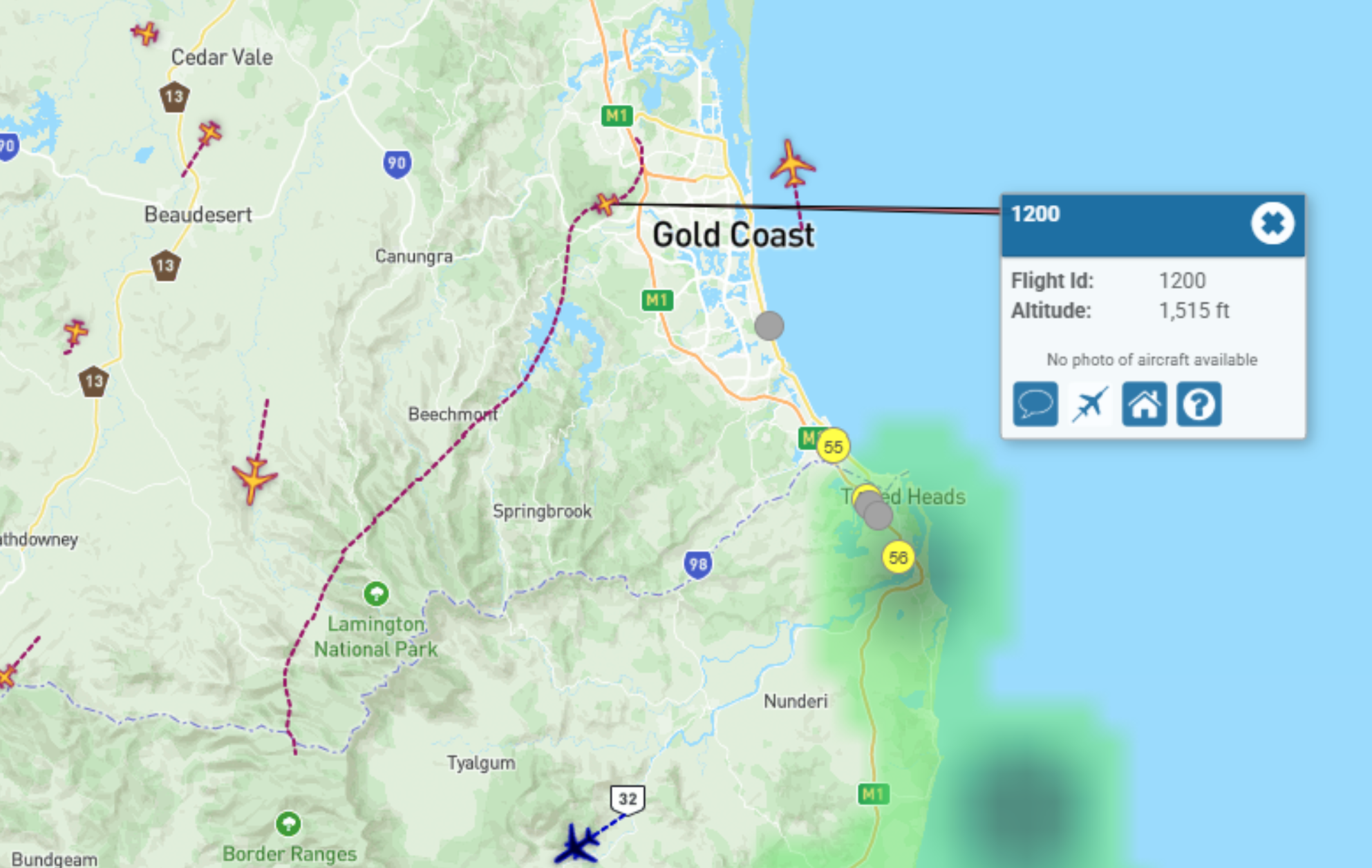
VH-TCF was identified on WebTrak7 around Gold Coast Airport. It showed the helicopter tracking roughly south-west at about 3,000 ft, before crossing the NSW border at 0854 AEST. This service then stopped recording the helicopter’s position.
Airservices’s secondary radar further detected unidentified aircraft returns in the vicinity of the accident site, however, these could not be confirmed as VH-TCF.
Weather information
Forecasts
The Bureau of Meteorology (BoM) terminal area forecast (TAF)8 issued at 0612 AEST on 13 March 2026 and valid from 0700 AEST for the Gold Coast Airport included:
visibility greater than 10 km with scattered cloud at 1,000 ft and broken9 cloud at 1,600 ft
from 0800 AEST, light showers of rain and broken cloud at 2,000 ft
a TEMPO10 between 0700–0900 AEST visibility greater than 10 km with broken cloud at 1,000 ft
a TEMPO between 0900–1800 AEST included visibility of 3,000 m, showers of rain and broken cloud at 1,000 ft and few towering cumulous at 2,000 ft
an INTER11 between 1800 AEST on 13 March and 0400 on 14 March included visibility of 4000 m, showers of rain and broken cloud cover at 1,200 ft
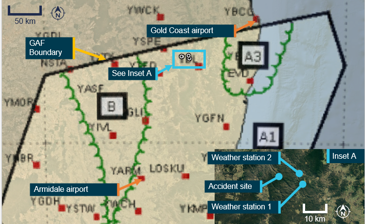
The BoM graphical area forecast (GAF),12 issued at 0809 AEST on 13 March 2026 for the area encompassing the flight path south of Gold Coast to the accident site (Figure 7) included:
visibility greater than 10 km with broken stratus with bases at 1,500 ft and tops at 2,000 ft and broken stratocumulus with bases at 2,000 ft and tops to 9,000 ft
visibility 4,000 m in isolated13 showers of rain with broken stratus with bases at 1,000 ft and tops at 2,000 ft, and broken cumulus/stratocumulus with bases at 2,000 ft and tops to 9,000 ft
visibility 3,000 m in isolated drizzle with broken stratus with bases at 800 ft and tops at 2,000 ft, and overcast stratocumulus with bases at 2,000 ft and tops to 9,000 ft
in a small coastal area just south of Gold Coast, isolated thunderstorms and rain were forecast, reducing visibility to 2,000 m with associated cumulonimbus with bases at 2,000 ft and tops above 10,000 ft, broken stratus with bases at 500 ft and tops at 2,000 ft, and broken cumulus/stratocumulus with bases at 2,000 ft and tops above 10,000 ft.
Figure 7: Geographical area forecast
Source: Bureau of Meteorology, annotated by the ATSB
The previous GAF issued at 0226 on the morning of 13 March reflected essentially the same expected weather conditions without the forecast small area of thunderstorms. An AIRMET14 valid from 0624 to 1024, was also issued for isolated thunderstorms in that area.
The aerodrome forecast (TAF) for the pilot’s first intended stop at Armidale Airport, NSW, issued at 0422 EDT and valid 0600–1900 on 13 March included:
wind from 080° at 8 kt
visibility greater than 10 km
cloud broken at 400 ft (TAF cloud heights are above aerodrome elevation).
During the period 0900–1100:
wind from 100° at 12 kt
visibility greater than 10 km
light showers of rain
scattered cloud at 3,000 ft
temperature 16°C at 0600 and 19°C at 0900
QNH 1,016 hPa at 0600 and 1,019 hPa at 0900.
Weather observations
The Gold Coast aerodrome observations (METAR)15 at 0830 AEST on the accident morning were:
wind from 170° at 9 kt
visibility greater than 10 km
few cloud at 1,500 ft (cloud heights above aerodrome elevation)
scattered cloud at 2,000 ft
broken cloud at 2,500 ft
temperature 27°C and dew point 24°C
QNH 1,013 hPa
Distant lightning strikes were reported at 0800 and 0930.
Satellite imagery
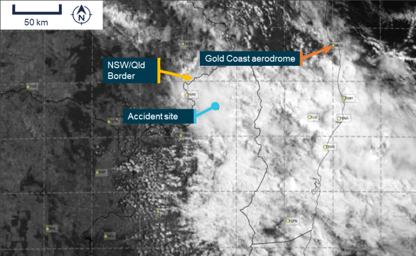
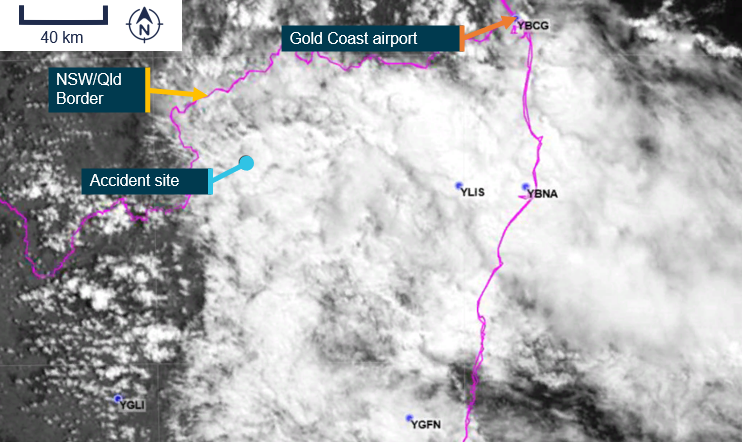
High resolution visible satellite imagery showed extensive cloud extending inland to the NSW/Queensland border, including at the accident site (Figure 8).
Figure 8: Satellite cloud imagery at 1040 AEST (6 minutes before the accident)
Source: Satellite image processed by the Bureau of Meteorology from the geostationary meteorological satellite Himawari-9, operated by the Japan Meteorological Agency, annotated by the ATSB
Witness reports
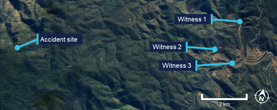
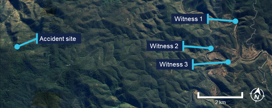
Several witnesses located near the accident site (Figure 9) reported very low cloud and drizzle on the morning of the accident. They stated that they observed a helicopter flying very low, ‘before lunchtime’ on the day. All witnesses reported that it was unusual to see a helicopter in the area, but this one was particularly unusual due to its low altitude.
In addition, one witness stated that the helicopter seemed to be stuck below cloud and remarked to their partner that it ‘looks like it’s trying to find a way out’. Another witness recalled waving at the helicopter and stated that it passed them twice before heading west.
Figure 9: Witness locations
Source: Google Earth, annotated by the ATSB
Operational information
Visual meteorological conditions
For flights under the VFR, the Civil Aviation Safety Regulations (CASR) Part 91 Manual of Standards (MOS) specified criteria for visual meteorological conditions (VMC)16 in terms of visibility and distance from cloud. The criteria for all aircraft operating in Class G (non‑controlled) airspace were:
At or below whichever is the higher of 3,000 ft AMSL and 1,000 ft above ground level (AGL):
visibility 5,000 m
clear of cloud
aircraft must be operated in sight of ground or water.
For helicopters (rotorcraft) operating below 700 ft over land in non‑controlled airspace (and not within 10 NM of an aerodrome with an instrument approach procedure), the criteria were:
flight visibility 800 m
clear of cloud
by day
at a speed that allows the pilot to see obstructions or other traffic in sufficient time to avoid a collision, and
if not more than 10 NM from an aerodrome with an IAP — in a way that ensures the flight maintains a separation of at least 500 ft vertically from any aircraft that is: less than 10 NM from the aerodrome; and conducting an IFR operation.
Flight planning requirements
Under section 7.02 Forecasts for flight planning, the MOS required that pilots study the appropriate authorised weather forecasts and reports. This included:
the route to be flown
the departure aerodrome, the planned destination aerodrome and any planned alternate aerodrome
any other reasonably available weather information that is relevant to the intended operation.
The pilot did not submit a flight plan and was not required to submit one for a private VFR flight in Class G airspace.
National aeronautical information processing system (NAIPS) records showed that weather information was accessed by the pilot’s account at 0740 and 0745 on 13 March 2026. The pilot had requested a location briefing for the Gold Coast aerodrome. In making this selection, a pilot may also select the graphical area forecast, however, the data did not record if this was requested, therefore the ATSB could not verify if the pilot had viewed this forecast.
The pilot did not request a location briefing for their first destination at Armidale. Although they requested a location briefing for Tenterfield, the Bureau of Meteorology did not issue aerodrome forecasts for Tenterfield Airport.
Spatial disorientation
Spatial disorientation occurs when a pilot does not correctly sense their aircraft’s attitude, airspeed, or altitude in relation to the earth’s surface. It is often described simply as the inability to determine ‘which way is up’, although the effects can often be more subtle than implied by that description.
Spatial disorientation occurs when the brain receives conflicting or ambiguous information from the sensory systems. It is likely to happen in conditions in which visual cues are poor or absent, such as in adverse weather or at night. It presents a danger to pilots, as the resulting confusion can often lead to incorrect control inputs and resultant loss of aircraft control. The flight control sensitivity and relative instability of helicopters compared to aeroplanes increases the risk of such a control loss.
VFR into IMC occurrences
Between 2015 and 2025 there were 116 VFR into instrument meteorological conditions (IMC)17 occurrences in Australian airspace reported to the ATSB. Of these, 13 were fatal accidents resulting in 24 fatalities. Based on these figures, approximately 1 in every 9 reported VFR into IMC occurrences results in a fatality.
For non-instrument rated pilots, entering IMC can quickly become fatal. Research has shown that pilots not proficient in instrument-only flight will typically become spatially disoriented and lose control of the aircraft within 1–3 minutes after visual cues are lost.
CASA’s flight safety article ‘Every which way but loose’ stated that:
the inherent instability of a helicopter means that even an [instrument flight rules] IFR-rated pilot who is proficient and enters cloud in a helicopter not designed for instrument flight will have difficulty maintaining control. Without the normal strong visual cues of a horizon, the pilot will quickly experience dynamic instability and be fighting the aircraft to maintain a stable altitude and airspeed.
Safety analysis
Prior to the flight, the pilot obtained a meteorological location briefing for the Gold Coast, which may have included a graphical area forecast. Although it was reported the pilot expected clear conditions for the flight to Armidale, there were several layers of cloud at Gold Coast Airport forecast at the time the pilot obtained the briefing, and at the time of departure. Further, the area forecast showed that there were likely to be extensive areas of low cloud, with low visibility along the flight path. This did not preclude the pilot from commencing the flight, but it did indicate a high likelihood of encountering conditions unsuitable for flight under the visual flight rules that would require a diversion or landing.
The available tracking data showed that the helicopter initially tracked south-west at around 3,000 ft, towards the NSW border. However, as the electronic flight bag software was not set to transmit the flight data, there was no further flight data available.
The graphical area forecast and satellite imagery was consistent with witness statements that there was thick cloud and precipitation in the area at the time of the accident. As such, it was very likely that the helicopter entered an area where there was low cloud and/or low visibility in precipitation.
While the ATSB could not rule out that the pilot applied a large control input due to avoiding a bird or terrain, it is very likely that without instrument training or an appropriately equipped aircraft, when they encountered low visibility conditions, they became spatially disorientated and applied inappropriate control inputs.
Consistent with this, the wreckage examination identified signatures of the main rotor assembly being subject to excessive teeter and mast bumping that resulted in both pitch links failing. Following this, the main rotor blades were free to rotate through various pitch angles, and the helicopter was no longer controllable.
The location of the bag and other items from inside the cabin at the accident site was indicative of main rotor contact with the cabin while airborne. In addition, the vertical path through the tree canopy was consistent with a complete loss of control prior to the collision with terrain.
While the evidence showed that the engine was operating when the accident occurred, a transient condition such as a partial or complete power loss could not be ruled out, although such an event should not have resulted in a loss of control. Further, there was no evidence to indicate that the pilot became incapacitated prior to the accident sequence due to a pre-existing medical condition.
Contributing factor
It was very likely that the pilot entered flight conditions unsuitable for visual flight, resulting in a loss of control and subsequent collision with terrain.
Findings
ATSB investigation report findings focus on safety factors (that is, events and conditions that increase risk). Safety factors include ‘contributing factors’ and ‘other factors that increased risk’ (that is, factors that did not meet the definition of a contributing factor for this occurrence but were still considered important to include in the report for the purpose of increasing awareness and enhancing safety). In addition ‘other findings’ may be included to provide important information about topics other than safety factors.
These findings should not be read as apportioning blame or liability to any particular organisation or individual.
From the evidence available, the following findings are made with respect to VFR into IMC and collision with terrain involving Robinson R44 II, VH-TCF, 46 km north-east of Tenterfield, New South Wales, on 13 March 2026.
Contributing factors
It was very likely that the pilot entered conditions unsuitable for visual flight, resulting in a loss of control and subsequent collision with terrain.
Sources and submissions
Sources of information
The sources of information during the investigation included:
a relative of the pilot
Civil Aviation Safety Authority
New South Wales Police Force
maintenance organisation for VH-TCF
accident witnesses
recorded data from Airservices Australia (WebTraks)
Civil Aviation Safety Regulations (2025), Part 91 Manual of Standards
Reinhardt, B. (2020), Every which way but loose, Flight Safety Australia, Civil Aviation Safety Authority
United States Helicopter Safety Team (2023), Training Fact Sheet – Inadvertent Entry into Instrument Meteorological Conditions (IIMC)
Submissions
Under section 26 of the Transport Safety Investigation Act 2003, the ATSB may provide a draft report, on a confidential basis, to any person whom the ATSB considers appropriate. That section allows a person receiving a draft report to make submissions to the ATSB about the draft report.
A draft of this report was provided to the following directly involved parties:
Civil Aviation Safety Authority
Robinson Helicopter Company
The United States National Transportation Safety Board.
A submission was received from the Civil Aviation Safety Authority. The submission was reviewed and, where considered appropriate, the text of the report was amended accordingly.
Purpose of safety investigations
The objective of an ATSB safety investigation is to improve transport safety through:
identifying safety issues for action by organisations with the responsibility for managing that safety risk
influencing safety action through engaging with stakeholders, communicating findings, and fostering awareness of safety issues and concerns.
In accordance with the TSI Act, the ATSB does not investigate for the purpose of taking administrative, regulatory or criminal action, and cannot apportion blame, assist in determining liability, or, as a general rule, assist in court proceedings.
About ATSB reports
ATSB safety investigation reports are developed in accordance with ATSB procedures and guidelines, and with regard to applicable international standards and instruments.
Reports must include factual material of sufficient weight to support the investigation’s analysis and findings. At all times the ATSB endeavours to balance the use of material that could imply adverse comment with the need to properly explain what happened, and why, in a fair and unbiased manner.
An explanation of terminology used in ATSB investigation reports is available here.
Publishing information
Released in accordance with section 25 of the Transport Safety Investigation Act 2003
Ownership of intellectual property rights in this publication
Unless otherwise noted, copyright (and any other intellectual property rights, if any) in this report publication is owned by the Commonwealth of Australia.
Creative Commons licence
With the exception of the Commonwealth Coat of Arms, ATSB logo, and photos and graphics in which a third party holds copyright, this report is licensed under a Creative Commons Attribution 4.0 International licence.
The CC BY 4.0 licence enables you to distribute, remix, adapt, and build upon our material in any medium or format, so long as attribution is given to the Australian Transport Safety Bureau.
Copyright in material obtained from other agencies, private individuals or organisations, belongs to those agencies, individuals or organisations. Where you wish to use their material, you will need to contact them directly.
^Visual flight rules (VFR): a set of regulations that permit a pilot to operate an aircraft only in weather conditions generally clear enough to allow the pilot to see where the aircraft is going.
^Australian Eastern Standard Time (AEST): Coordinated Universal Time (UTC) + 10 hours
^Apple iPhone Crash Detection is designed to detect severe car crashes — such as front-impact, side-impact and rear-end collisions, and rollovers. If the Apple device has satellite, mobile or Wi-Fi connection, it will automatically call emergency services after a 30-second countdown if the alert is not manually dismissed.
^Australian Eastern Daylight saving Time (AEDT): Coordinated Universal Time (UTC) + 11 hours
^g: an abbreviation for acceleration forces acting on a body with reference to earth’s gravity at sea level. 1 g = 9.8 m/s2.
^OzRunways is an electronic flight bag application that provides navigation, weather, area briefings and other flight
information. It provides the option for live flight tracking by transmitting the device’s position and altitude.
^WebTrak uses information from air traffic control secondary surveillance radars to display aircraft movements.
^A TAF is a statement of meteorological conditions expected for a specified period within a radius of 8 km of the aerodrome reference point.
^Cloud cover: in aviation, cloud cover is reported using words that denote the extent of the cover – ‘few’ indicates that up to a quarter of the sky is covered, ‘scattered’ indicates that cloud is covering between a quarter and a half of the sky, ‘broken’ indicates that more than half to almost all the sky is covered, and ‘overcast’ indicates that all the sky is covered.
^TEMPO: used to indicate significant temporary variations from the prevailing conditions previously given in the forecast. TEMPO is used for periods of 30 minutes or more but less than 60 minutes.
^INTER: used to indicate significant intermittent variations from the prevailing conditions previously given in the forecast. INTER is used for periods of less than 30 minutes.
^In a graphical area forecast (GAF), all cloud heights are above mean sea level (AMSL).
^Weather coverage is given as isolated if it consists of individual features which affect, or are forecast to affect, an area with a maximum spatial coverage of up to 50%.
^AIRMET provides information of certain meteorological phenomena that are not contained in the current area forecast.
^Visual Meteorological Conditions (VMC): an aviation flight category in which visual flight rules (VFR) flight is permitted – that is, conditions in which pilots have sufficient visibility to fly the aircraft while maintaining visual separation from terrain and other aircraft.
^Instrument meteorological conditions (IMC): weather conditions that require pilots to fly primarily by reference to instruments, and therefore under instrument flight rules (IFR), rather than by outside visual reference. Typically, this means flying in cloud or limited visibility.
Preliminary report
Report release date: 30/04/2026
This preliminary report details factual information established in the investigation’s early evidence collection phase, and has been prepared to provide timely information to the industry and public. Preliminary reports contain no analysis or findings, which will be detailed in the investigation’s final report. The information contained in this preliminary report is released in accordance with section 25 of the Transport Safety Investigation Act 2003.
The occurrence
On 13 March 2026, the pilot of a Robinson R44 II helicopter, registered VH-TCF, planned to conduct a private flight from Gold Coast, Queensland, to Mudgee, New South Wales (NSW), with an intermediate stop at Armidale, NSW, to refuel (Figure 1).
Figure 1: Map showing accident site and key locations
Source: Google Earth, annotated by the ATSB
At about 0834 Eastern Standard Time (EST),[1] the helicopter departed from a private helipad on the Gold Coast. The pilot was the sole occupant of the helicopter.
NSW Police advised that an automated emergency message associated with activation of the pilot’s iPhone crash alarm was received at 1046 Eastern Daylight-saving Time (EDT),[2] about an hour and a quarter after the aircraft departed. In response, a formal search was commenced by NSW Police.
The wreckage was located at 1113 EDT on 14 March 2026 in dense bushland near Paddy’s Flat, 46 km north-east of Tenterfield, NSW. The helicopter was destroyed and the pilot sustained fatal injuries.
Context
Pilot information
The pilot held a Private Pilot Licence (Helicopter) and a single‑engine helicopter class rating. The pilot also held a class 2 aviation medical certificate valid to 6 September 2026 with the following limitations:
Must use [continuous positive airway pressure] CPAP in sleep period prior to exercising privileges of medical certificate.
Reading correction to be available whilst exercising the privileges of this licence.
Records obtained from the CPAP provider showed that the pilot was regularly using the CPAP machine and that sleep apnoea was controlled.
As of 7 March 2026, the pilot’s logbook showed they had accrued 1,264.6 hours total flight time.
Aircraft information
VH-TCF was a Robinson R44 II helicopter, manufactured in the United States in 2007 as serial number 11912 and first registered in Australia in 2007. The helicopter was powered by a Textron Lycoming IO-540-AE1A5 engine. VH-TCF was being maintained in accordance with the Robinson R44 maintenance manual and the Lycoming IO-540 engine manual. According to the maintenance release, on the morning of 13 March 2026, the helicopter had a total time in service of 2,104.7 hours. There were no defects recorded.
Site and wreckage information
The accident site was located about 46 km north-east of Tenterfield Airport in a densely vegetated area to the west of Cataract National Park. It was situated on the southern side of a steep slope, at an elevation of about 870 m (2,850 ft).
The wreckage trail was approximately 12 m long in a westerly direction, across and down the slope as shown in Figure 2. It consisted of an initial impact point, followed by a trail of debris that led to the fuselage, engine and main rotors, much of which were consumed by a post-impact fire. The aft section of the tail cone assembly had separated from the fuselage and was located approximately 20 m from the fuselage across the slope.
Figure 2: Accident site
Source: ATSB
Significant damage was evident on 2 trees located near the initial impact point, indicating the helicopter had collided with trees in a near vertical descent. A bag found in the tree canopy, and various other parts from the helicopter, were located around 20 m up the slope from the initial impact site.
The instrument panel and other debris were found further down the slope away from the fuselage location. A fuel jerry can, which had been filled at the helicopter’s departure location, was found onsite. The contents were tested for presence of water, which returned a negative result.
Recorded data
Although the pilot was reportedly using the Oz Runways electronic flight bag software, no track data was transmitted to the service provider.
VH-TCF was identified on WebTrak[3] around Gold Coast Airport. It showed that the helicopter tracked roughly south-west before crossing the NSW border at 0854. This service then stopped recording the helicopter’s position (Figure 3).
Figure 3: Aircraft track from departure to the NSW border
Source: Airservices Australia WebTrak
National aeronautical information processing system (NAIPS) records showed that weather information was accessed by the pilot’s account at 0740 and 0745 on 13 March 2026. The requirements of the Aeronautical Information Publication (AIP) ENR 1.10 Flight Planning stated that a pilot must obtain current weather reports and forecasts for the route to be flown, then plan the flight having regard to that information.
Weather information
Forecasts
The Bureau of Meteorology graphical area forecast (GAF),[4] issued at 0809 EST on 13 March 2026 for the area encompassing the flight path south of Gold Coast to the accident site (Figure 4), included:
visibility greater than 10 km with broken[5] stratus with bases at 1,500 ft and tops at 2,000 ft and broken stratocumulus with bases at 2,000 ft tops to 9,000 ft
visibility 4,000 m in isolated[6] showers of rain with broken stratus with bases at 1,000 ft and tops at 2,000 ft, and broken cumulus/stratocumulus with bases at 2,000 ft and tops to 9,000 ft
visibility 3,000 m in isolated drizzle with broken stratus with bases at 800 ft and tops at 2,000 ft, and overcast stratocumulus with bases at 2,000 ft and tops to 9,000 ft
in a small coastal area just south of Gold Coast, isolated thunderstorms and rain were forecast, reducing visibility to 2,000 m with associated cumulonimbus with bases at 2,000 ft and tops above 10,000 ft, broken stratus with bases at 500 ft and tops at 2,000 ft, and broken cumulus/stratocumulus with bases at 2,000 ft and tops above 10,000 ft.
Figure 4: Geographical area forecast and additional weather stations
Source: Bureau of Meteorology and Google Earth, annotated by the ATSB
The previous GAF issued at 0226 on the morning of 13 March contained the same information without the forecast small area of thunderstorms. An AIRMET[7] valid from 0624 to 1024, was also issued for isolated thunderstorms in that area.
High resolution visible satellite imagery shows cloud extending inland to the NSW/Queensland border, including at the accident site (Figure 5).
Figure 5: Satellite cloud imagery at 1000 EST (14 minutes after the accident)
Source: Satellite image processed by the Bureau of Meteorology from the geostationary meteorological satellite Himawari-9, operated by the Japan Meteorological Agency, annotated by the ATSB
The aerodrome forecast (TAF)[8] for the pilot’s first intended stop at Armidale Airport, NSW, issued at 0422 EDT and valid 0600–1900 on 13 March included:
wind from 080° at 8 kt
visibility greater than 10 km
cloud broken at 400 ft (TAF cloud heights above aerodrome elevation).
During the period 0900–1100:
wind from 100°at 12 kt
visibility greater than 10 km
light showers of rain
scattered cloud at 3,000 ft
temperature 16°C at 0600 and 19°C at 0900
QNH 1,016 hPa at 0600 and 1,019 hPa at 0900.
Weather stations
The ATSB also obtained weather data from 2 Weather Underground[9] stations close to the accident site (inset Figure 2):
Site 1: 12.64 km 106° from the accident site at an elevation of about 530 m (Table 1)
Site 2: 10.67 km 084° from the accident site at an elevation of about 200 m (Table 2).
The ultraviolet (UV) index is a simple way of describing the level of UV radiation and can be affected by the amount of cloud cover. According to the Bureau of Meteorology, ‘thick unbroken clouds and rainfall can reduce UV, as thick clouds reflect and absorb more UV that thin cloud cover.’ The UV Index has 5 categories:
low (1–2)
moderate (3–5)
high (6–7)
very high (8–10)
extreme (11 and above).
The weather stations also measured solar irradiance, which is the power of electromagnetic radiation received from the sun, measured in watts per square metre. According to the National Environmental Satellite, Data and Information Service:[10]
When sunlight hits low clouds, a lot of that light – and heat – is reflected back into space. When sunlight hits clouds that are high in the atmosphere, those clouds reflect less sunlight energy. However, these high clouds also trap more heat.
The UV and solar irradiance[11] values from 13 March indicated that there was substantial cloud coverage at both locations on 13 March between 1004–1104 (Table 1 and Table 2). By comparison, on 15 March 2026, when the ATSB attended the accident site and observed a clear day, at 1119, the solar irradiance was recorded at 923 W/m2 and the UV index was 9.
Table 1: Five-minute weather data, site 1
Local time (EDT)
Temp (°C)
Dew point (°C)
Hum.
%
Wind dir.
Wind (kt)
Gust (kt)
Rain mm
Rain mm/hr
UV
Solar (W/m2)
1004
20.8
20.6
99
ENE
4.8
5.6
0
0
1
95.5
1009
20.9
20.7
99
E
3.1
4.5
0
0
1
94.4
1014
20.9
20.7
99
ESE
4.3
5.7
0
0
1
113.1
1018
20.9
20.7
99
E
3.5
4.8
0
0
1
136
1024
21.1
20.8
99
ESE
4.4
5.6
0
0
1
170
1029
21.1
20.8
99
ESE
3.9
5.0
0
0
1
131.6
1034
21.1
20.9
99
E
4.1
5.1
0
0
1
123.9
1039
21.1
20.9
99
E
4.3
4.9
0
0
1
121
1044
21.1
20.8
99
ESE
5.3
6.3
0
0
1
182.3
1049
21.1
20.8
99
ENE
3.0
4.6
0.05
1.27
1
94.3
1054
20.8
20.6
99
E
4.8
6.6
0.1
2.54
1
127.8
1059
20.8
20.6
99
ESE
3.3
5.0
0.1
2.54
1
102
1104
20.5
20.3
99
E
4.9
7.9
0.05
1.27
1
100.5
Table 2: Five-minute weather data, site 2
Local time (EDT
Temp (°C)
Dew point (°C)
Hum.
%
Wind dir.
Wind (kt)
Gust (kt)
Rain mm
Rain mm/hr
UV
Solar (W/m2)
1004
24.0
20.9
83
SSE
2.5
3.0
0
0
1
95.5
1009
23.8
20.9
84
WSW
1.8
2.4
0
0
1
94.4
1014
24.1
20.9
83
ENE
1.1
1.4
0
0
1
113.1
1019
24.3
20.9
82
NW
1.3
1.8
0
0
1
136
1023
24.5
21.0
81
ESE
2.1
3.1
0
0
2
170
1029
24.5
20.8
80
NNE
2.6
3.6
0
0
2
131.6
1034
24.8
20.9
79
ESE
2.0
2.9
0
0
2
123.9
1039
24.6
20.8
80
W
3.5
4.8
0
0
1
121
1044
25.3
21.1
78
NNE
1.7
2.3
0
0
2
182.3
1049
25.6
21.1
77
ENE
2.1
3.2
0
0
2
94.3
1054
25.4
21.1
77
NNW
2.3
3.0
0
0
2
127.8
1059
25.1
20.9
78
ENE
2.4
4.2
0
0
1
102
1104
24.7
21.1
81
ENE
1.9
3.4
0
0
1
100.5
Visual meteorological conditions
For flights under the visual flight rules (VFR),[12] the Civil Aviation Safety Regulations Part 91 Manual of Standards specified criteria for visual meteorological conditions (VMC)[13] in terms of visibility and distance from cloud. The criteria for all aircraft operating in Class G (non‑controlled) airspace were:
At or below whichever is the higher of 3,000 ft AMSL and 1,000 ft above ground level (AGL):
visibility 5,000 m
clear of cloud
aircraft must be operated in sight of ground or water.
For helicopters (rotorcraft) operating below 700 ft over land in non‑controlled airspace (and not within 10 NM of an aerodrome with an instrument approach procedure), the criteria were:
flight visibility 800 m
clear of cloud
by day
at a speed that allows the pilot to see obstructions in sufficient time to avoid a collision.
Witness information
Several witnesses located near the accident site (Figure 6) stated that they observed a helicopter flying very low, ‘before lunchtime’ on the day of the accident. All witnesses reported that it was unusual to see a helicopter in the area, but this one was particularly unusual due to its low altitude.
All witnesses reported very low cloud and drizzle on the morning of the accident. One witness stated that the helicopter seemed to be stuck below cloud and remarked to their partner that it ‘looks like it’s trying to find a way out’. Another witness recalled waving at the helicopter and stated that it passed them twice before heading west.
Figure 6: Witness locations
Source: Google Earth, annotated by the ATSB
Further investigation
To date, the ATSB has
examined the site and wreckage
retained drive shaft components and warning light bulbs for examination
interviewed witnesses and involved parties
obtained recorded flight data
obtained aircraft and operational information
obtained meteorological information.
The investigation is continuing and will include further review and examination of:
the mapped accident site and helicopter wreckage
aircraft and operational documentation
meteorological information.
A final report will be released at the conclusion of the investigation. Should a critical safety issue be identified during the course of the investigation, the ATSB will immediately notify relevant parties so appropriate and timely safety action can be taken.
Acknowledgements
The ATSB acknowledges the assistance of New South Wales Police, in particular the Lismore Search and Rescue unit.
Purpose of safety investigations
The objective of a safety investigation is to enhance transport safety. This is done through:
identifying safety issues and facilitating safety action to address those issues
providing information about occurrences and their associated safety factors to facilitate learning within the transport industry.
It is not a function of the ATSB to apportion blame or provide a means for determining liability. At the same time, an investigation report must include factual material of sufficient weight to support the analysis and findings. At all times the ATSB endeavours to balance the use of material that could imply adverse comment with the need to properly explain what happened, and why, in a fair and unbiased manner. The ATSB does not investigate for the purpose of taking administrative, regulatory or criminal action.
About ATSB reports
ATSB investigation reports are organised with regard to international standards or instruments, as applicable, and with ATSB procedures and guidelines.
Reports must include factual material of sufficient weight to support the analysis and findings. At all times the ATSB endeavours to balance the use of material that could imply adverse comment with the need to properly explain what happened, and why, in a fair and unbiased manner.
An explanation of terminology used in ATSB investigation reports is available here. This includes terms such as occurrence, contributing factor, other factor that increased risk, and safety issue.
Publishing information
Released in accordance with section 25 of the Transport Safety Investigation Act 2003
Ownership of intellectual property rights in this publication
Unless otherwise noted, copyright (and any other intellectual property rights, if any) in this report publication is owned by the Commonwealth of Australia.
Creative Commons licence
With the exception of the Commonwealth Coat of Arms, ATSB logo, and photos and graphics in which a third party holds copyright, this report is licensed under a Creative Commons Attribution 4.0 International licence.
The CC BY 4.0 licence enables you to distribute, remix, adapt, and build upon our material in any medium or format, so long as attribution is given to the Australian Transport Safety Bureau.
Copyright in material obtained from other agencies, private individuals or organisations, belongs to those agencies, individuals or organisations. Where you wish to use their material, you will need to contact them directly.
[1]Eastern Standard Time (EST): Coordinated Universal Time (UTC) + 10 hours
[2]Eastern Daylight-saving Time (EDT): Coordinated Universal Time (UTC) + 11 hours
[3]WebTrak uses information from air traffic control secondary surveillance radars to display aircraft movements.
[4]In a graphical area forecast (GAF), all cloud heights are above mean sea level (AMSL).
[5]Cloud cover: in aviation, cloud cover is reported using words that denote the extent of the cover – ‘few’ indicates that up to a quarter of the sky is covered, ‘scattered’ indicates that cloud is covering between a quarter and a half of the sky, ‘broken’ indicates that more than half to almost all the sky is covered, and ‘overcast’ indicates that all the sky is covered.
[6]Weather coverage is given as isolated if it consists of individual features which affect, or are forecast to affect, an area with a maximum spatial coverage of up to 50%.
[7]AIRMET provides information of certain meteorological phenomena that are not contained in the current area forecast.
[8]A TAF is a coded statement of meteorological conditions expected at an aerodrome and within a radius of 5 nautical miles of the aerodrome reference point.
[9]Weather Underground provides local and long-range weather forecasts, weather reports, maps and tropical weather conditions for locations worldwide.
[10]The National Environmental Satellite, Data, and Information Service (NESDIS) manages the United States environmental satellite programs, and manage the data gathered by the National Weather Service and other government agencies and departments.
[11]Solar irradiance is the power per unit area or electromagnetic radiation received from the sun, measured in Watts per square metre.
[12]Visual flight rules (VFR): a set of regulations that permit a pilot to operate an aircraft only in weather conditions generally clear enough to allow the pilot to see where the aircraft is going.
[13]Visual Meteorological Conditions (VMC): an aviation flight category in which visual flight rules (VFR) flight is permitted – that is, conditions in which pilots have sufficient visibility to fly the aircraft while maintaining visual separation from terrain and other aircraft.
Occurrence summary
Investigation number
AO-2026-067
Occurrence date
13/03/2026
Occurrence time and timezone
1046 Australian Eastern Daylight saving Time
Location
46 km north-east of Tenterfield
State
New South Wales
Report release date
24/09/2026
Report status
Final
Investigation level
Short
Investigation type
Occurrence Investigation
Investigation phase
Final report: Dissemination
Investigation status
Completed
Mode of transport
Aviation
Aviation occurrence category
Collision with terrain, In-flight break-up, Loss of control, VFR into IMC
Occurrence class
Accident
Highest injury level
Fatal
Aircraft details
Manufacturer
Robinson Helicopter Co
Model
R44 II
Registration
VH-TCF
Serial number
11912
Aircraft operator
Tasklake Pty Ltd
Sector
Helicopter
Operation type
Part 91 General operating and flight rules
Activity
General aviation / Sport and pleasure flying / Pleasure and personal transport
Occurrence Briefs are concise reports that detail the facts surrounding a transport safety occurrence, as received in the initial notification and any follow-up enquiries. They provide an opportunity to share safety messages in the absence of an investigation. Because occurrence briefs are not investigations under the Transport Safety Investigation Act 2003, the information in them is de-identified.
What happened
On the morning of 18 January 2026, the pilot of a RotorWay Exec 90 amateur-built light helicopter was conducting a local flight from a private property near Tamborine, Queensland, with one passenger on board. The pilot reported that during the hover, in preparation for landing, they experienced a sudden loss of tail rotor authority, followed by the onset of uncontrolled yaw[1] and rotation. To counter, the pilot lowered the collective[2] and set the helicopter down, however the helicopter’s rotation as it contacted the ground caused it to roll over and sustain substantial damage. Neither the pilot nor passenger were injured.
Figure 1: Damaged helicopter after recovery
Source: Operator supplied
Engineering information
The RotorWay Exec 90 is a kit-produced light utility helicopter manufactured by the RotorWay Helicopter Manufacturing Company (formerly RotorWay International) and intended for amateur construction. As-designed, the helicopter has a maximum take-off weight (MTOW) of 680 kg (1,500 lb) and is powered by a horizontally opposed 4-cylinder piston engine delivering 112 kW (150 hp).
The Exec 90 powertrain employed a v-belt system that transferred drive to the tail rotor through a series of 3 belts and 2 idlers, extending from the secondary drive unit adjacent to the engine, through the tail boom, to the tail rotor pulley (Figure 2).
Source: UK Air Accidents Investigation Branch report AAIB-27186 (AAIB Bulletin 8/2022)
At the time of the accident, the helicopter had accumulated 64 hours total time in service. Upon inspection after the accident, evidence of the failure of the centre tail rotor belt was found within the tail boom structure – consistent with the loss of tail rotor effectiveness experienced by the pilot prior to the ground contact. The pilot reported that the tail rotor belt had operated for approximately 30–40 hours since new.
Figure 3: Remnants of a loose / fractured tail rotor drive belt found within the tail boom
Source: Operator supplied, annotated by ATSB
Inspections and service bulletins
The pilot reported that tail rotor belt tension had been checked with the manufacturer’s recommended tool before the flight, and noted that there were no indications of imminent belt failure leading up to the loss of tail rotor drive.
Section 3 (D) of the RotorWay Exec 90 flight manual requires a pre-flight inspection of the tail rotor drive components, including the condition and tension of the drive belts, and includes the caution:
IMPORTANT: New belts will tend to stretch and become loose. Belt tension must be monitored and adjusted frequently until stretching has stopped.
Further, the helicopter kit manufacturer has published several mandatory and advisory service bulletins applicable to the Exec 90 helicopter tail rotor drive system.
Bulletin number
Publication date
Subject
M-07 (mandatory)
8 September 1992
Prohibition of certain tail rotor belt makes
M-20 (mandatory)
4 April 2002
Inspection for proper tail rotor belt routing
A-20 (advisory)
28 November 1994
Inspection and importance of tail rotor belt tension
A-21 (advisory)
12 May 1995
Tail rotor belt inspection, tensioning, and temperature monitoring
A-25 (advisory)
21 December 1995
Cold weather inspection of tail rotor belt tension
A-36 (advisory)
4 April 2002
Inspection for proper tail rotor belt routing
Most of these bulletins centred on the importance of regular inspection and checking of tail rotor belt tension, and bulletin A-21 further noted:
Advisory Bulletin A-20 (dated November 28, 1994) stressed the importance of checking the condition and tension of the belts before every flight. Although this may be time consuming, these pre-flight checks are essential to the continued safe operation of your helicopter.
Safety message
RotorWay Exec 90 helicopters (and related types with belt-driven tail rotor systems) have an established sensitivity to tail rotor belt tension, with an operational history of failures associated with improperly tensioned belts.
Pilots, owners and operators of these helicopters are reminded to ensure that all applicable checks, inspections and maintenance activities are carried out on the tail rotor drive system, with particular attention to the tension, condition and service life of the belts.
About this report
Decisions regarding whether to conduct an investigation, and the scope of an investigation, are based on many factors, including the level of safety benefit likely to be obtained from an investigation. For this occurrence, no investigation has been conducted and the ATSB did not verify the accuracy of the information. A brief description has been written using information supplied in the notification and any follow-up information in order to produce a short summary report, and allow for greater industry awareness of potential safety issues and possible safety actions.
[1]Yaw: the motion of an aircraft about its vertical or normal axis.
[2]Collective: a primary helicopter flight control that simultaneously affects the pitch of all blades of a lifting rotor. Collective input is the main control for vertical velocity.
Occurrence Briefs are concise reports that detail the facts surrounding a transport safety occurrence, as received in the initial notification and any follow-up enquiries. They provide an opportunity to share safety messages in the absence of an investigation. Because occurrence briefs are not investigations under the Transport Safety Investigation Act 2003, the information in them is de-identified.
What happened
On 24 January at 0900 local time, the pilot of a Robinson R22 Beta helicopter was conducting cattle mustering operations at a private property near Theodore, Queensland.
During a low-level manoeuvre, the pilot attempted to block a herd of cattle running alongside a fence line when the helicopter’s tail rotor contacted the top wire of the fence, resulting in the helicopter rotating rapidly. The pilot observed an immediate lack of tail rotor authority[1] and estimated the helicopter rotated 2 or 3 times. With insufficient height to recover the helicopter safely, the pilot conducted a forced landing next to the fence line. To reduce the severity of the helicopter’s rotating motion during the forced landing, the pilot closed the throttle and applied cyclic[2] to keep the helicopter level while descending. Prior to contact with the ground, the pilot raised the collective[3] to try to soften the landing. The helicopter landed hard resulting in the skids splaying outwards. The main rotor subsequently contacted the tail boom and the cockpit windscreen shattered (Figure 1). The pilot extracted themself from the helicopter and waited nearby for assistance.
Figure 1: Forced landing site
Source: Operator
As a result of the accident, the pilot sustained several fractured vertebrae. At the time of the occurrence, the pilot was wearing a flight helmet.
Safety message
Helicopter mustering is an operation that carries increased risk, particularly when manoeuvring at low level. Ground obstacles are hazards that pilots must actively monitor to ensure adequate separation from the aircraft. An inadvertent collision with an obstacle at a low level limits the available safety margins for recovery or time to execute emergency procedures.
In the case of this occurrence, the pilot’s immediate response followed the Robinson R22 emergency procedure for a loss of tail rotor effectiveness as stated in the R22 Pilot’s Operating Handbook. These actions likely reduced the severity of the accident and the injuries sustained by the pilot.
A similar occurrence the ATSB investigated into a Tail rotor strike involving Robinson R22 Beta II, VH-HGE, 58 km north-west of Anthony Lagoon, Northern Territory, on 1 July 2025 (AO-2025-035) discusses the benefits of conducting recency training for emergency procedures.
About this report
Decisions regarding whether to conduct an investigation, and the scope of an investigation, are based on many factors, including the level of safety benefit likely to be obtained from an investigation. For this occurrence, no investigation has been conducted and the ATSB did not verify the accuracy of the information. A brief description has been written using information supplied in the notification and any follow-up information in order to produce a short summary report, and allow for greater industry awareness of potential safety issues and possible safety actions.
[1]Lack of tail rotor authority: a lack of thrust produced by the tail rotor to counter the torque produced by the main rotor.
[2]Cyclic: a primary helicopter flight control that is similar to an aircraft control column. Cyclic input tilts the main rotor disc, varying the attitude of the helicopter and hence the lateral direction.
[3]Collective: a primary helicopter flight control that simultaneously affects the pitch of all blades of a lifting rotor. Collective input is the main control for vertical velocity.
The ATSB is investigating a tail rotor failure and subsequent collision with terrain involving a Robinson R22 Beta, registered VH-UBY, about 56 km west of Coonamble Airport, New South Wales, on 6 February 2026.
During aerial mustering operations approximately 100 ft above the ground, the pilot and sole occupant of the helicopter experienced an RPM spike followed by a yaw and a loss of control through the anti-torque pedals. Unable to counteract the yaw, the pilot attempted to land the helicopter, which spun several times during the descent.
Upon contact with the ground, the helicopter rolled onto its side resulting in substantial damage. The pilot experienced serious injuries, but was able to exit the helicopter without assistance. There was no fire.
The ATSB has commenced the examination and analysis of the initial evidence collected.
To date the investigation has included:
a review of engineering reports provided by the maintainer
interviewing the pilot
a detailed examination of the tail rotor driveshaft
examination of maintenance records.
analysis of related occurrences.
The continuing investigation will include examination of the manufacturer's drawings and specifications.
The ATSB is awaiting information from an external party and is unable to further progress the investigation until that third party input has been received. As a result, the investigation has been deferred.
A final report will be released at the conclusion of the investigation. Should a critical safety issue be identified during the course of the investigation, the ATSB will immediately notify relevant parties, so that appropriate safety action can be taken.
Last updated:
Occurrence summary
Investigation number
AO-2026-063
Occurrence date
06/02/2026
Occurrence time and timezone
10:15 Australian Eastern Daylight Time
Location
About 56 km west of Coonamble Airport
State
New South Wales
Report status
Pending
Anticipated completion
Q4 2026
Investigation level
Short
Investigation type
Occurrence Investigation
Investigation phase
Examination and analysis
Investigation status
Deferred
Mode of transport
Aviation
Aviation occurrence category
Abnormal engine indications, Collision with terrain, Propeller/rotor malfunction
Occurrence class
Accident
Highest injury level
Serious
Aircraft details
Manufacturer
Robinson Helicopter Co
Model
R22 Beta
Registration
VH-UBY
Serial number
4733
Aircraft operator
Dustdevil Helicopters Pty Ltd
Sector
Helicopter
Operation type
Part 138 Aerial work operations
Activity
General aviation / Recreational-Aerial work-Agricultural mustering
Occurrence Briefs are concise reports that detail the facts surrounding a transport safety occurrence, as received in the initial notification and any follow-up enquiries. They provide an opportunity to share safety messages in the absence of an investigation. Because occurrence briefs are not investigations under the Transport Safety Investigation Act 2003, the information in them is de-identified.
What happened
On 17 January 2026, the pilot and sole occupant of a Robinson R22 Beta II helicopter was conducting contracted stock mustering operations at a station, about 140 km north of Tennant Creek, Northern Territory. At about 0900 local time, the pilot refuelled the helicopter, filling the tanks to their capacity. Shortly after, they became airborne to continue with the mustering operation.
At about 0910, the pilot reported that while moving cattle through a gate, they conducted a right turn at about 35 kt and 120 ft above ground level. About 3 seconds after completing the turn, the pilot recalled hearing an unusual noise and suspected a possible bird strike with the tail rotor, perceiving no response to their anti-torque pedal inputs.
The pilot recalled that the low rotor RPM horn then sounded and the helicopter began to lose height. They reacted by lowering the collective in an attempt to regain the rotor RPM and attempted to gain forward airspeed. As the helicopter approached the ground the pilot flared and raised the collective[1] to reduce the rate of descent but the helicopter collided heavily with the terrain (Figure 1).
Figure 1: Occurrence helicopter
Source: Operator
On contact with the ground, the helicopter’s main rotor blades flexed and contacted the tail boom causing it to separate. The tail boom, attached tail rotor gearbox and tail rotor were located about 30 m from the main wreckage (Figure 2).
Figure 2: Occurrence aircraft tail boom, and tail assembly
Source: Operator
The pilot wore a flight helmet and was restrained with a 3-point lap and sash harness and was able to free themselves from the wreckage uninjured. However, the helicopter was substantially damaged.
The operator conducted a post-accident engineering analysis of the wreckage and reported there were no indications of pre-impact defects or damage to the tail rotor flight control system that would have resulted in a loss of tail rotor control.
The operator advised that impact marks on the ground indicated that the helicopter was travelling in a west‑north-west direction when it impacted the ground and reported the wind direction at the time of the occurrence was 10–15 kt from the south-east, indicating that the helicopter was likely operating downwind when it impacted the terrain.
Following discussions with the pilot, the operator reported that additional weight after refuelling, combined with a loss of airspeed when turning downwind, likely led to the helicopter being overpitched. The operator considered that this likely caused a reduction in rotor RPM that was not immediately identified by the pilot. The loss of rotor RPM caused the helicopter to descend from a low height and the pilot was unable to recover the low rotor RPM or arrest the rate of descent prior to impacting the ground.
Additionally, the operator reported that the pilot had been listening to music during the low level operation, and identified that this may have reduced the pilot’s ability to aurally detect a reduction of the engine and rotor RPM prior to the low rotor RPM horn sounding. This may have reduced the pilot’s reaction and recovery time for a low rotor RPM condition. Robinson Helicopter’s Safety Notice 10 provides guidance on the recovery technique for low rotor RPM.
Safety action
The operator reported the following safety recommendations for company pilots:
not to turn the helicopter downwind while at low altitude
the importance of throttle control and to be aware of manually overriding the engine governor
awareness of the helicopters engine RPM and listening for audible cues
fuel load management and consideration given to all-up weight when conducting low-level flight.
Additionally, the operator advised that a notice was sent to all company pilots advising that listening to music while flying was not permitted, reiterating the importance of audible cues from the helicopter engine.
The operator’s safe work method statements required company pilots to wear flight helmets when conducting mustering operations. The use of flight helmets reduces the risk and severity of head injuries, especially important when conducting low-level and other higher risk flight operations.
Flight at low level is a necessity during mustering operations and often involves abrupt manoeuvres with frequent power changes. Although the R22 engine is equipped with a governor to maintain constant engine RPM, large abrupt power changes can cause the governor to lag, reducing engine RPM and therefore rotor RPM. Pilots, especially during periods of high workload, have been known to grip the throttle control tightly, overriding the governor and preventing the governor from maintaining a constant engine RPM. Operators who routinely conduct low level flight are encouraged to review their training and checking regarding engine RPM management as well as the recovery techniques from a low rotor RPM condition.
About this report
Decisions regarding whether to conduct an investigation, and the scope of an investigation, are based on many factors, including the level of safety benefit likely to be obtained from an investigation. For this occurrence, no investigation has been conducted and the ATSB did not verify the accuracy of the information. A brief description has been written using information supplied in the notification and any follow-up information in order to produce a short summary report, and allow for greater industry awareness of potential safety issues and possible safety actions.
[1]The collective control changes the pitch angle of all main rotor blades.
Occurrence summary
Mode of transport
Aviation
Occurrence ID
AB-2026-009
Occurrence date
17/01/2026
Location
140 km north of Tennant Creek
State
Northern Territory
Occurrence class
Accident
Aviation occurrence category
Collision with terrain, Control - Other, Loss of control
Occurrence Briefs are concise reports that detail the facts surrounding a transport safety occurrence, as received in the initial notification and any follow-up enquiries. They provide an opportunity to share safety messages in the absence of an investigation. Because occurrence briefs are not investigations under the Transport Safety Investigation Act 2003, the information in them is de-identified.
Source: Operator
What happened
On 30 January 2026 at about 1205 local time, the pilot and sole occupant of a Cessna U206F departed from an Emu Point aircraft landing area, Northern Territory, en route to Darwin Airport.
Prior to departure the pilot conducted a pre-flight inspection and reported that the aircraft departed with 190 L of fuel. No abnormalities were observed during the take-off or the initial climb. The aircraft levelled off at about 2,000 ft above mean sea level (AMSL) and the pilot conducted the cruise checklist, with no issues identified. Shortly after this, the pilot observed an engine RPM overspeed. The pilot reduced the propellor pitch lever, but this had no effect, so they reduced the throttle to maintain an appropriate RPM.
Shortly after this, the engine began running rough, accompanied by increasing vibration and a reduction in engine power. Almost immediately, smoke began entering the cockpit via the cabin air vents, which the pilot closed. The engine performance continued to degrade to the extent that the aircraft was unable to maintain straight and level flight. The pilot observed smoke and oil spraying onto the airframe and windscreen, reducing forward visibility. They reported that the engine vibrations increased violently, to the point that the entire airframe was shaking.
The pilot selected an area of open grassland interspersed with trees and termite mounds beyond a heavily wooded area and prepared to conduct a forced landing.
Figure 1: Aircraft wreckage
Source: Operator, annotated by the ATSB
Prior to landing, the pilot conducted final checks, unlatched their door and maintained what power was available to assist in clearing the tree line. However, prior to touchdown, the aircraft collided with several trees before rotating left, impacting the ground heavily and coming to a stop (Figure 1).
The pilot reported a brief period of unconsciousness and after ‘coming to’, turned off the ignition and checked that the ELT[1] had activated. The pilot exited through the shattered cockpit windscreen and moved to a safe distance from the wreckage, returning briefly to retrieve a handheld VHF radio and a personal mobile phone. The pilot’s initial attempts to coordinate emergency assistance were unsuccessful. Shortly after, they established radio contact with another aircraft that relayed a MAYDAY call. A rescue aircraft with an emergency response team arrived about one hour later.
The pilot was medically assessed and later admitted to hospital with minor abrasions and a broken collarbone requiring surgery.
The aircraft was significantly damaged and, at the time of publishing, the remote location, terrain and weather conditions have prevented aircraft recovery. Consequently, the likely cause of the reported engine failure remains undetermined.
Safety message
In-flight engine failures and partial power loss in single-engine aircraft require pilots to exercise effective and timely decision-making to reduce the severity of injuries and damage. These events often result in the pilot experiencing high workload and time pressure, where preparedness is critical. Deciding on responses to a partial engine power loss before the flight will reduce your workload during the event and assist you in taking some form of considered action.
When experiencing a rough running engine, pilots should focus on flying the aircraft and continually assess landing options. The ‘aviate, navigate and communicate’ framework establishes a clear hierarchy of priorities, particularly during emergencies. Acting in the appropriate order of priority improves situation awareness and supports coordinated responses in a dynamic environment.
recommends that scanning the environment should take 85% of the time available, 10% on checking aircraft attitude including lookout, and 5% of the time scanning of the altitude and airspeed indications.
About this report
Decisions regarding whether to conduct an investigation, and the scope of an investigation, are based on many factors, including the level of safety benefit likely to be obtained from an investigation. For this occurrence, no investigation has been conducted and the ATSB did not verify the accuracy of the information. A brief description has been written using information supplied in the notification and any follow-up information in order to produce a short summary report, and allow for greater industry awareness of potential safety issues and possible safety actions.
[1]Electronic Locator Transmitter (ELT): an aviation safety device installed in aircraft that automatically or manually transmits a distress signal via satellites.
Occurrence summary
Mode of transport
Aviation
Occurrence ID
AB-2026-010
Occurrence date
30/01/2026
Location
102 km east-north-east of Port Keats Aerodrome
State
Northern Territory
Occurrence class
Accident
Aviation occurrence category
Collision with terrain, Engine failure or malfunction, Forced/precautionary landing, Smoke
Highest injury level
Serious
Brief release date
20/02/2026
Aircraft details
Manufacturer
Cessna Aircraft Company
Model
U206F
Sector
Piston
Operation type
Part 135 Air transport operations - smaller aeroplanes
Departure point
Emu Point Aircraft Landing Area, Northern Territory