Windshear-related hard landing involving Fokker 100, VH-NQE, Nifty Aerodrome, Western Australia, on 19 October 2012

Final report

Report release date: 06/02/2014

Safety summary

What happened

On 19 October 2012 a Fokker F100 aircraft (F100), registered VH-NQE, was being operated on a passenger charter flight from Perth Airport to Nifty Aerodrome in the Pilbara region of Western Australia. The weather for the approach into Nifty included high-based cumulus cloud and isolated thunderstorms. The temperature on the ground was 38 °C.

As the flight crew were positioning the aircraft for a 5 NM (9 km) straight-in approach into a slight headwind, they received a windshear caution. In response, the crew increased the approach speed and extended the speed brake to stabilise the approach.

The approach continued and apart from a few minor speed variances, the conditions appeared relatively benign. As the aircraft was in the final stages of the approach and descending from 80 ft to 30 ft above ground level, the airspeed dropped from 133 kt to 110 kt and the rate of descent increased to about 1,000 ft/min. The loss of airspeed occurred over a period of 3 seconds and by touchdown the aircraft was being affected by a 32 kt tailwind.

The aircraft touched down on the runway threshold, almost 300 m short of the normal touchdown point, and bounced. The high rate of descent at initial touchdown resulted in a hard landing with significant aircraft damage. There were no reported injuries to passengers or crew.

What the ATSB found

The ATSB found that when the aircraft was on approach to land at about 80 ft above ground level, the flight path almost certainly coincided with the strong outflow of a dry microburst, resulting in a performance-decreasing windshear that led to the rapid drop in airspeed, high sink rate, undershoot and a hard landing. Also, the aircraft was not fully configured for an approach in known or suspected windshear conditions, reducing the capability of the aircraft to recover from the high sink rate associated with a microburst event.

What's been done as a result

As a result of this occurrence, the operator sought to improve the weather information available at aerodromes serviced by their F100 fleet and modified its simulator training program along with consolidation of the windshear procedures/guidance. The operator also provided additional guidance in the use of flap following receipt of a windshear caution during approach and planned to introduce a new threat-based take-off and landing briefing model.

Safety message

The circumstances of this occurrence show that operators of transport category aircraft may need to review the guidance provided to crews to ensure that the risk of windshear associated with both thunderstorms and dry microbursts, is effectively managed.

Occurrence summary

Investigation number AO-2012-137
Occurrence date 19/10/2012
Location Camp Nifty Aerodrome
State Western Australia
Report release date 06/02/2014
Report status Final
Investigation level Systemic
Investigation type Occurrence Investigation
Investigation status Completed
Mode of transport Aviation
Aviation occurrence category Hard landing
Occurrence class Accident
Highest injury level None

Aircraft details

Manufacturer Fokker B.V.
Model F28
Registration VH-NQE
Serial number 11457
Sector Jet
Operation type Charter
Departure point Perth, Western Australia
Destination Nifty, Western Australia
Damage Substantial

Descent below the minimum permitted altitude involving Boeing 737-838, VH-VXB, 35 km south-west of Canberra Airport, Australian Capital Territory, on 17 October 2012

Final report

Report release date: 29/10/2014

Safety summary

What happened

On 17 October 2012, a Boeing 737-838 aircraft, registered VH-VXB and operated by Qantas Airways Limited (Qantas), was conducting a flight from Adelaide, South Australia to Canberra, Australian Capital Territory. The flight crew received an approach clearance into Canberra via a standard arrival route (STAR) and then an Area Navigation (Required Navigation Performance) (RNAV (RNP)) instrument approach to runway 35 at Canberra Airport. Just prior to commencing descent, at about 2030 Eastern Daylight-saving Time, air traffic control (ATC) cancelled the STAR and cleared the aircraft to track direct to the initial approach fix, HONEY, via a high-speed descent. As the aircraft approached 8,000 ft, ATC provided a descent clearance to 7,000 ft and also cleared the aircraft for the approach. As the aircraft approached HONEY it descended below the 7,000 ft altitude clearance limit. After being alerted to this by ATC, the flight crew climbed the aircraft back to 7,000 ft and continued the approach to land.

What the ATSB found

The ATSB found that, as the aircraft approached 8,000 ft, the auto-flight system vertical mode changed from a flight management computer‑derived and managed vertical navigation mode into the vertical speed mode. This was followed by a number of automated, but unnoticed, and crew‑initiated changes in the aircraft’s auto-flight system vertical mode. The combination of auto‑flight system mode changes and the management of the airspeed during the descent resulted in a high workload environment where the 7,000 ft altitude clearance limit was overlooked by the flight crew.

The ATSB also found that, on receipt of the approach clearance, the Qantas RNAV (RNP) approach procedures allowed the flight crew to remove the current limiting altitude from the auto‑flight system’s Mode Control Panel (MCP) and set the decision altitude. Application of this procedure by the flight crew removed the last automated safety system available to them to prevent descent through the current altitude limitation, well before the aircraft was established on the approach.

What's been done as a result

Following this occurrence, Qantas changed their RNAV (RNP) approach procedures to only allow the altitude on the MCP to be changed from the current limiting altitude once the aircraft was within 2 NM (4 km) of commencing the approach.

Safety message

This occurrence highlights the importance of paying continuous attention to active and armed auto-flight modes and the need to continually monitor descent profiles and airspace limitations in relation to the aircraft’s position, irrespective of the expectation that the descent is being managed by the auto-flight system. The adverse effect of workload and task focus on flight crew performance and the importance of robust procedures for high-precision approaches are also illustrated.

Occurrence summary

Investigation number AO-2012-138
Occurrence date 17/10/2012
Location Canberra Airport
State Australian Capital Territory
Report release date 29/10/2014
Report status Final
Investigation level Systemic
Investigation type Occurrence Investigation
Investigation status Completed
Mode of transport Aviation
Aviation occurrence category Operational non-compliance
Occurrence class Incident
Highest injury level None

Aircraft details

Manufacturer The Boeing Company
Model 737-838
Registration VH-VXB
Serial number 30101
Aircraft operator Qantas
Sector Jet
Operation type Air Transport High Capacity
Departure point Adelaide, South Australia
Destination Canberra, Australian Capital Territory
Damage Nil

Power loss involving Robinson R44, VH-NWD, Mount Molloy, Queensland, on 11 October 2012

Final report

Report release date: 27/02/2013

What happened

On 11 October 2012, at 0845 Eastern Standard Time a Robinson R44 Raven 1 helicopter departed a property near Mount Molloy for Georgetown, Queensland, on a private flight. On board the helicopter were the pilot and one passenger. Shortly after becoming airborne the helicopter experienced a loss of power. The pilot performed a 180° turn to the left and autorotated to a suitable area within autorotative distance, which was a contour drain located downslope from the departure point. The helicopter came to rest and remained upright, and the pilot and passenger were able to exit without injury. The helicopter was substantially damaged. 

The helicopter was inspected, and the left magneto was found to have a badly worn distributor block, which allowed the timing gear to move and alter the internal timing by approximately 40°. 

Pilots are encouraged to perform a self-briefing prior to every take-off to serve as a reminder of the actions to be performed in the event of an emergency.

Aviation Short Investigation Bulletin – Issue 15

Occurrence summary

Investigation number AO-2012-136
Occurrence date 11/10/2012
Location 38 km north west Cairns Airport
State Queensland
Report release date 27/02/2013
Report status Final
Investigation level Short
Investigation type Occurrence Investigation
Investigation status Completed
Mode of transport Aviation
Aviation occurrence category Engine failure or malfunction
Occurrence class Accident
Highest injury level None

Aircraft details

Manufacturer Robinson Helicopter Co
Model R44
Registration VH-NWD
Serial number 2147
Sector Helicopter
Operation type Private
Departure point Black Mountain Station, Queensland
Destination Georgetown, Queensland
Damage Substantial

Technical assistance to the Indonesian NTSC in the analysis of voyage data recorder (VDR) data from the MT Norgas Cathinka, following collision with ferry Bahuga Jaya, on 26 September 2012

Summary

At about 0444 on 26 September 2012, the 104.5 m LPG tanker MT Norgas Cathinka collided with the 96 m ferry Bahuga Jaya in Sundra Strait, Indonesia. The Bahuga Jaya sank as a result of the collision, with the reported loss of 8 lives.

The Indonesian National Transportation Safety Committee (NTSC) is responsible for investigating this occurrence. The NTSC requested assistance from the Australian Transport Safety Bureau (ATSB) in the replay, display and analysis of voyage data recorder (VDR) data from the MT Norgas Cathinka. To assist the NTSC and provide protection of the recorded data and analyses, the ATSB initiated an External Investigation under the provisions of the Transport Safety Investigation Act 2003.

For further information in relation to the investigation of this accident, please refer to the NTSC.

National Transportation Safety Committee 
Ministry Of Transportation Republic Of Indonesia 
Transportation Building 3rd Floor
Jalan Medan Merdeka Timur No. 5
Jakarta Pusat 10110
Indonesia

Phone  :  +62 21 384 7601
Email    :  knkt@dephub.go.id

Website: https://knkt.go.id/en

Occurrence summary

Investigation number ME-2012-011
Occurrence date 26/09/2012
Location Sundra Strait, Indonesia
State International
Report release date 29/04/2013
Report status Final
Investigation level Systemic
Investigation type External Investigation
Investigation status Completed
Mode of transport Marine
Marine occurrence category Collision
Occurrence class Accident
Highest injury level Fatal

Ship details

Name MT Norgas Cathinka / Bahuga Jaya
IMO number 9370654 / 7206392
Ship type LPG Tanker / Ferry
Flag Singapore / Indonesia

Hard landing involving Cessna P206B, VH-EGG, Monduran, Queensland, on 29 September 2012

Final report

Report release date: 20/12/2012

What happened

On 29 September 2012, a Cessna P206B aircraft, registered VH-EGG, departed Gympie on a private flight to Monduran, Queensland.

During the landing, a significant wind gust was experienced, resulting in a hard landing on the main landing gear. The aircraft bounced and the pilot applied a small amount of power in an attempt to regain control. A second wind gust of greater intensity then occurred. The aircraft stalled and touched down hard on the nose landing gear. The pilot maintained directional control and the aircraft came to a stop. The aircraft sustained damage to the propeller, nose landing gear, and lower engine cowls.

This incident highlights the importance of conducting a go-around as soon as landing conditions appear unfavourable.

Aviation Short Investigation Bulletin – Issue 14

Occurrence summary

Investigation number AO-2012-135
Occurrence date 29/09/2012
Location Monduran
State Queensland
Report release date 20/12/2012
Report status Final
Investigation level Short
Investigation type Occurrence Investigation
Investigation status Completed
Mode of transport Aviation
Aviation occurrence category Hard landing
Occurrence class Serious Incident
Highest injury level None

Aircraft details

Manufacturer Cessna Aircraft Company
Model 206
Registration VH-EGG
Serial number P2060372
Sector Piston
Operation type Private
Departure point Gympie, Queensland
Destination Monduran, Queensland
Damage Minor

Piper PA-23-250 Aztec Aircraft, VH-SPM near Mount Scratchley, Papua on 26 September, 1970

Summary

At approximately 1325 hours Eastern Standard Time on 26 September, 1970, a Piper PA23-250 Aztec aircraft, registered VH-SPM, collided with the precipitous face of a ravine, 490 feet below the main line of a ridge, on the eastern slopes of Mt. Scratchley in the Territory of Papua. The aircraft was engaged on a charter flight for the carriage of passengers and baggage from Kokoda to Port Moresby. The aircraft reported its departure from Kokoda but, when it did not arrive at Port Moresby, search and rescue procedures were initiated. The wreckage was sighted on 1 October, 1970 in dense rain forest, 10,100 feet above mean sea level. At first, the efforts of ground rescue parties to reach the wreckage were frustrated by extremely bad weather conditions, the high altitude and the precipitous terrain. Thirteen more days elapsed before a member of a mountain rescue party reached the accident site to find that the aircraft had been destroyed by impact forces and the pilot and the three passengers on board· had suffered fatal injuries.

Occurrence summary

Investigation number Report 70-5
Occurrence date 26/09/1970
Location Mt. Scratchley in the Territory of Papua
State International
Report release date 25/04/1971
Report status Final
Investigation type External Investigation
Investigation status Completed
Mode of transport Aviation
Occurrence class Accident
Highest injury level Fatal

Aircraft details

Model PA23-250 Aztec
Registration VH-SPM
Departure point Kokoda
Destination Port Moresby
Damage Destroyed

Aircraft proximity event between Beech 1900, VH-EMK and Airparts FU-24, VH-HVP, Jabiru Airport, Northern Territory, on 5 October 2012

Final report

Report release date: 27/02/2013

What happened

On 5 October 2012, a Beech 1900 VH-EMK was operating a passenger carrying charter flight from Darwin to Jabiru, Northern Territory.

With no response to their broadcasts on the local Jabiru aerodrome frequency, and no other aircraft observed on the aircraft traffic monitoring system, the crew continued their approach onto runway 09 at Jabiru. When approaching 5 NM to touchdown, the crew observed a ‘glint’ on the runway and broadcast on the local frequency, again with no response.

At about the same time, an Airparts FU-24, VH-HVP, had broadcast entering and back-tracking the runway for a departure in the opposite direction. The pilot of HVP heard a broadcast from EMK and believed they were further back in the approach.

As HVP was commencing the take-off run, the crew in EMK and the pilot in HVP saw each other and both immediately initiated avoidance manoeuvres.

It was found that the radio in HVP had not been broadcasting, due to an incorrectly positioned switch.

As a result of this incident, the operator of VH-HVP has arranged for all pilots to re-visit company Standard Operating Procedures on radio transmissions and low-level survey flying.

This incident demonstrates the importance of checking the serviceability of radio equipment prior to flight. In particular, the use of available resources such as AFRU for ensuring the radio is transmitting.

Aviation Short Investigation Bulletin – Issue 15

Occurrence summary

Investigation number AO-2012-134
Occurrence date 05/10/2012
Location Jabiru Airport
State Northern Territory
Report release date 27/02/2013
Report status Final
Investigation level Short
Investigation type Occurrence Investigation
Investigation status Completed
Mode of transport Aviation
Aviation occurrence category Near collision
Occurrence class Serious Incident
Highest injury level None

Aircraft details

Manufacturer Airparts NZ Ltd
Model FU-24
Registration VH-HVP
Serial number 282
Sector Piston
Operation type Aerial Work
Departure point Jabiru, Northern Territory
Destination Jabiru, Northern Territory
Damage Nil

Aircraft details

Manufacturer Beech Aircraft Corp
Model 1900
Registration VH-EMK
Serial number UC-159
Sector Turboprop
Operation type Charter
Departure point Darwin, Northern Territory
Destination Jabiru, Northern Territory
Damage Nil

Collision with terrain involving Robinson R22, VH-LLF, 130 km west of Halls Creek, Western Australia, on 3 October 2012

Final report

Report release date: 22/03/2013

Safety summary

What happened

On 3 October 2012 the pilots of two Robinson R22 helicopters, each with a passenger on board, landed in the vicinity of a narrow gorge about 130 km west of Halls Creek, Western Australia. With the others on the ground, one of the pilots lifted off in VH-LLF to have a look at the gorge from the air.

The pilot descended into the gorge and then during the ascent the helicopter tail contacted a rock overhang about 30 m above the gorge pool and separated, resulting in loss of control, collision with the surrounding rocks, and submersion. The pilot did not survive.

The pilot of the remaining R22 ferried the two passengers, in turn, out of the gorge area.

What the ATSB found

The ATSB found that the pilot of VH-LLF descended into a confined gorge through a relatively narrow opening without prior knowledge of the gorge characteristics. That created a situation where the pilot was required to climb the helicopter out of the gorge with marginal clearance and potential disorientation in fading light.

Subsequently, although the pilot of the remaining R22 was able to ferry the passengers out of the gorge area post-accident, it was carried out with higher risk than was absolutely necessary.

Safety message

As this occurrence demonstrates, helicopter pilots need to be mindful that some confined areas will allow access, but will present significant risks on the climb out.

Preliminary report

Report release date: 12/11/2012

Update 12 November 2012 - Preliminary factual report release

On 3 October 2012, the ATSB commenced an investigation into an accident involving a Robinson R22 Beta helicopter, registered VH-LLF, which collided with terrain 130 km west of Halls Creek, Western Australia.

The ATSB has released its preliminary factual report  into the collision. The information contained in the report is derived from the initial investigation of the occurrence. Readers are cautioned that new evidence will become available as the investigation progresses that may alter the circumstances as depicted in the preliminary report. As such, no analysis or findings are included in the report.

In the late afternoon on 3 October 2012, the pilot of a Robinson R22 Beta collided with terrain in a gorge on the Gliddon River (near the Margaret River).

The tail of the helicopter collided with an overhanging rock formation and a section of the tail boom separated from the fuselage. The helicopter rolled to the left and descended out of view of witnesses. The helicopter was found submerged on its right side with substantial damage. The pilot was deceased.

The ATSB attended the accident site, but was unable to closely examine the submerged wreckage. From the surface it was evident that the cabin roof was crushed in, both main rotor blades had severed a short distance from the main rotor hub, and one of the fuel tanks had detached from the aircraft structure.

The investigation is continuing and will include analysis of the available information to identify safety factors.

It is anticipated that the investigation will be completed by April 2013.

Read the preliminary factual report.

Inquest

Response to inquest findings

The Kununurra District Coroner recently handed down findings into a 2012 fatal Robinson R22 helicopter accident at a gorge located at Lousia Downs Station, Fitzroy Crossing in Western Australia.

The Coroner accepted the conclusions of the Australian Transport Safety Bureau in relation to the accident

Accident circumstances

On 3 October 2012 the pilots of two Robinson R22 helicopters, each with a passenger on board, landed in the vicinity of a narrow gorge about 130 km west of Halls Creek, Western Australia. With the others on the ground, one of the pilots lifted off in VH-LLF to have a look at the gorge from the air.

The pilot descended into the gorge and then during the ascent the helicopter tail contacted a rock overhang about 30 m above the gorge pool and separated, resulting in loss of control, collision with the surrounding rocks, and submersion. The pilot did not survive.

The pilot of the remaining R22 ferried the two passengers, in turn, out of the gorge area.

ATSB findings

The ATSB found the following contributing safety factors:

  • The pilot descended into a confined gorge through a relatively narrow opening without prior knowledge of the gorge characteristics; and
  • While ascending out of the gorge the helicopter tail contacted a rock overhang and separated, resulting in loss of control, collision with the surrounding rocks, and submersion in the gorge pool. 

The following other safety factors were also identified:

  • After the accident, the other pilot ferried the passengers from the gorge without any search and rescue alerting being active. 
  • During the flight to transfer one of the passengers to a homestead, the helicopter was operated in darkness without the appropriate equipment or pilot qualifications.

Safety message

As this occurrence demonstrates, helicopter pilots need to be mindful that some confined areas will allow access, but will present significant risks on the climb out.

Inquests are separate to ATSB investigations

The Coroner formulated her findings and recommendations independently of the ATSB. The ATSB cannot speak for the Coroners findings. However, the ATSB supports the coronial process and in the interests of ensuring that safety information is made available to the broadest audience the ATSB is making this publication.

The Coroner's report can be obtained from the Coroner's Court of Western Australia. Contact details are available at: www.coronerscourt.wa.gov.au. Queries regarding the Coroner's findings should be directed to the Coroner's Court of Western Australia.

Occurrence summary

Investigation number AO-2012-133
Occurrence date 03/10/2012
Location 130 km west of Halls Creek
State Western Australia
Report release date 22/03/2013
Report status Final
Investigation level Systemic
Investigation type Occurrence Investigation
Investigation status Completed
Mode of transport Aviation
Aviation occurrence category Collision with terrain
Occurrence class Accident
Highest injury level Fatal

Aircraft details

Manufacturer Robinson Helicopter Co
Model R22
Registration VH-LLF
Serial number 1468
Sector Helicopter
Operation type Private
Damage Substantial

Loss of separation assurance involving a Boeing 737-8BK, VH-VUM, south of Williamtown to north of Grafton, New South Wales, on 28 September 2012

Final report

Report release date: 20/03/2015

Safety summary

What happened

On 28 September 2012, an en route air traffic controller acknowledged a Route Adherence Monitor (RAM) alert in respect of a Boeing Company 737‑8BK aircraft, registered VH-VUM (VUM), on a scheduled passenger service between Sydney, New South Wales and Brisbane, Queensland. Believing that VUM was destined for Newcastle Airport under Department of Defence air traffic control jurisdiction, the controller erroneously inhibited the flight data record (FDR) for VUM. This action cancelled the RAM alert.

The inhibition of the FDR, in combination with the controller’s altitude filter being set at a lower flight level than appropriate to the combined sectors under the controller’s jurisdiction, meant that VUM’s FDR registered as a ‘not concerned’ aircraft track. Subsequently, due to this ‘not concerned’ status, the controller did not see or interrogate VUM’s FDR for the rest of the time it was under their jurisdiction. Similarly, the FDR did not attract the attention of two Inverell sector controllers after it entered and crossed their sector until they responded to a frequency change request from the flight crew of VUM.

There was no loss of separation with other aircraft for the resulting period that the aircraft operated without the active provision of ATC services and, during the course of the occurrence, two-way communications in controlled airspace remained available. However, maintenance of the minimum aircraft separation standards during this period was not assured. There was a loss of separation assurance.

What the ATSB found

High-reliability systems like air traffic control have many layers of controls to minimise risks associated with operational hazards. These controls were ineffective in this case as a result of a number of factors, including human perception and attention issues, the training of controllers with regard to ‘not concerned’ tracks, and the level of system protection against the potential impact of such tracks. Specifically, error‑tolerant system designs that aid in the detection and recovery of inadvertently-inhibited tracks offer another defence against this type of occurrence.

Two safety issues were identified as a result of this investigation. The first relates to the provision of awareness training for en route controllers who are routinely exposed to ‘not concerned’ radar tracks, which can lead to a high level of expectancy that such tracks are not relevant for aircraft separation purposes. The second issue relates to the limited protections against a controller mistakenly inhibiting an aircraft and need for procedures to account for the limitations in the interoperability between the Australian Advanced Air Traffic System/Australian Defence Air Traffic System.

What's been done as a result

In response to the occurrence, Airservices has amended its air traffic controller ab-initio training exercises to include ‘not concerned’ track scenarios to ensure that training emphasised the importance of scanning ‘not concerned’ radar tracks. The scenarios will also be included in operational simulation training where appropriate. Furthermore, Airservices will use this occurrence to raise awareness of black tracks and the need to scan ‘not concerned’ tracks amongst its air traffic control staff.

In respect of equipment interoperability, Airservices and the Department of Defence are currently working towards implementing a harmonised joint civil military air traffic service system via the OneSky Program. Once implemented this system will increase air traffic management interoperability between both organisations.

Safety message

This occurrence highlights the fallibility of human attention/perception and the resulting risk of involved parties being ‘primed’ to the circumstances of an occurrence to the extent that they automatically (but incorrectly) perform actions that they perceived were correct. There is the potential for additional error-tolerant design improvements to complement existing air traffic system human machine interface risk controls to reduce the likelihood of such behaviour.

Humans can also experience difficulty detecting display targets that are subtle, unexpected and deemed of low information value. This occurrence showed a reduced awareness among controllers of the potential impact of black, ‘not concerned’ tracks in an en route airspace environment, which might be addressed by additional controller training or through an integrated air traffic management system.

Occurrence summary

Investigation number AO-2012-132
Occurrence date 28/09/2012
Location 41 km SSW Williamtown
State New South Wales
Report release date 20/03/2015
Report status Final
Investigation level Systemic
Investigation type Occurrence Investigation
Investigation status Completed
Mode of transport Aviation
Aviation occurrence category Loss of separation assurance
Occurrence class Incident
Highest injury level None

Aircraft details

Manufacturer The Boeing Company
Model 737
Registration VH-VUM
Serial number 29675
Aircraft operator Virgin Australia Airlines
Sector Jet
Operation type Air Transport High Capacity
Departure point Sydney, New South Wales
Destination Brisbane, Queensland
Damage Nil

VFR flight into IMC involving de Havilland DH-84 Dragon, VH-UXG, 36 km south-west of Gympie, Queensland, on 1 October 2012

Final report

Report release date: 19/12/2013

Safety summary

What happened

At about 1107 on 1 October 2012, the pilot-owner of a vintage de Havilland DH-84 Dragon Mk 2, registered VH-UXG, took off on a private flight from Monto to Caboolture, Queensland. On board with the pilot were five passengers, baggage and equipment. The pilot was not qualified, and the aircraft not equipped for instrument flight. The weather on the coast and extending inland included low clouds and rain.

At 1315, the pilot radioed air traffic control (ATC) and requested navigation assistance, advising that the aircraft was in cloud. Over the next 50 minutes ATC provided assistance to the pilot and a search and rescue (SAR) helicopter was dispatched to the area. From the pilot’s radio calls it was apparent that he was unable to navigate clear of the cloud. Radio contact was intermittent and no transmissions from the aircraft were received after 1405.

An extensive search was initiated, and the aircraft wreckage was located on 3 October in high terrain. The aircraft was destroyed and there were no survivors.

What the ATSB found

With no or limited visual references available in and near cloud, it would have been very difficult for the pilot to maintain control of the aircraft. After maintaining control in such conditions for about an hour, and being unable to navigate away from the mountain range, the pilot most likely became spatially disoriented and lost control of the aircraft before it impacted the ground.
Due to the limited radio and radar coverage in the area, the ability of ATC and the SAR helicopter to assist was limited. However, the ATSB found that there were areas of potential improvement in the management of in-flight emergencies and coordination between ATC and SAR aircraft.

What's been done as a result

Airservices Australia and the Australian Maritime Safety Authority agreed to conduct a comprehensive review of their existing memorandum of understanding to ensure the effectiveness of collaborative in-flight emergency responses. The review is anticipated to be completed by the first quarter of 2014.

Safety message

Though it remains unclear precisely how the aircraft came to be in instrument conditions, this accident highlights the importance of pre- and in-flight planning and decision-making in limiting exposure to risk. It is important for pilots to incorporate approved weather forecasts, knowledge of the terrain, and diversion options into their flight planning, to plan for contingencies prior to and throughout a flight, and to carry out those plans well before encountering difficulty.

Update

Report release date: 17/04/2013

Updated: 17 April 2013

The investigation is continuing into the collision with terrain involving de Havilland DH‑84 Dragon, registered VH-UXG, which occurred 36 km south-west of Gympie, Queensland on 1 October 2012.

The ATSB has reviewed numerous witness reports and radio recordings, and it appears that the aircraft flew a roughly direct course from Monto before encountering what the pilot described to air traffic control (ATC) as ‘full cloud’ about 2 hours into the flight. The evidence at this stage indicates that the aircraft flew around the Borumba Dam, Imbil, and Kandanga areas for about an hour, probably mostly in or around cloud that would typically be described as instrument meteorological conditions. 

Radio and radar coverage in the area was limited. As such, ATC was unable to direct the pilot to an area of known visual conditions because of the extent of the cloud cover and uncertainty over the aircraft’s position. 

To date, there are no indications of an aircraft malfunction. However, the ATSB has retained the aircraft wreckage in case of a need for further examination. Several items and components that were retrieved from the accident site have been examined, including some aircraft instruments. Data was successfully downloaded from an aircraft GPS receiver that was found among the aircraft wreckage, but it did not contain information pertinent to the accident flight. 

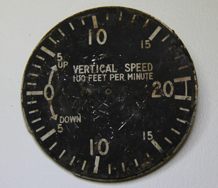
Following a burn-off of the area and a period of heavy rain, three ATSB investigators returned to the accident site to search for another GPS receiver that was known to be installed in the aircraft. This GPS was not found but investigators located the instrument face of the aircraft’s vertical speed indicator (Figure 1), which may provide further evidence.

Figure 1: Face of vertical speed indicator

Speed indicator face of the de Havilland DH 84 Dragon

 The investigation is continuing and will include examination of the:

  • air traffic radar and radio recordings
  • aircraft wreckage and instruments
  • aircraft’s maintenance records
  • emergency response
  • weather information
  • witness reports.

A final report is scheduled for release in October 2013. 

The information contained in this web update is released in accordance with section 25 of the Transport Safety Investigation Act 2003 and is derived from the initial investigation of the occurrence. Readers are cautioned that new evidence will become available as the investigation progresses that will enhance the ATSB's understanding of the accident as outlined in this web update. As such, no analysis or findings are included in this update.

Preliminary report

Report release date: 08/11/2012

The ATSB has released its preliminary report into the collision with terrain that occurred 36 km south-west of Gympie, Queensland on 1 October 2012. The information contained in the report is derived from the initial investigation of the occurrence. Readers are cautioned that new evidence will become available as the investigation progresses that may alter the circumstances as depicted in the preliminary report. As such, no analysis or findings are included in the report.

At about 1107 Eastern Standard Time on 1 October 2012, a de Havilland Aircraft Pty Ltd DH-84 Dragon, registered VH-UXG, took off from Monto on a private flight to Caboolture, Queensland under the visual flight rules. At 1315, the pilot contacted Brisbane Radar air traffic control (ATC) and advised that the aircraft’s position was about 37 NM (69 km) north of Caboolture and requested navigation assistance. At 1318, the pilot advised ATC that the aircraft was in ‘full cloud’.

For most of the remainder of the flight, the pilot and ATC exchanged communications, at times relayed through a commercial flight and a rescue flight in the area due to the limited ATC radio coverage in the area at low altitude. At 1348, the pilot advised Air Traffic Control that the aircraft had about an hour’s endurance remaining. The pilot’s last recorded transmission was at 1404.

A search for the aircraft was coordinated by Australian Search and Rescue (AusSAR). The aircraft wreckage was located on 3 October 2012, about 87 km north-west of Caboolture.

The aircraft was destroyed by impact forces. There was no fire. The accident was not survivable and the six occupants were fatally injured.

The ATSB's investigation is continuing and will include examination of the:

  • relevant air traffic radar and radio recordings
  • weather information pertinent to the flight
  • witness reports
  • aircraft’s maintenance records
  • pilot’s records and history, and
  • search and rescue records.

It is anticipated that the investigation will be completed by October 2013.

Occurrence summary

Investigation number AO-2012-130
Occurrence date 01/10/2012
Location 36 km SW of Gympie
State Queensland
Report release date 19/12/2013
Report status Final
Investigation level Systemic
Investigation type Occurrence Investigation
Investigation status Completed
Mode of transport Aviation
Aviation occurrence category VFR into IMC
Occurrence class Accident
Highest injury level Fatal

Aircraft details

Manufacturer de Havilland Aircraft
Model DH-84
Registration VH-UXG
Serial number 6077
Sector Piston
Operation type Private
Departure point Monto, Queensland
Destination Caboolture, Queensland
Damage Destroyed