Fuel starvation event involving a Cessna 210, VH-BKD, 3 km east of Broome Airport, Western Australia, on 3 May 2015

Final report

Report release date: 07/10/2015

What happened

On 3 May 2015, at about 0230 Central Standard Time (CST), a Cessna 210 aircraft, registered VH-BKD (BKD), departed from Alice Springs Airport, Northern Territory for a ferry flight to Broome, Western Australia. The pilot was the sole person on board.

At about 70 NM from Broome, the pilot obtained a weather report from the automated aerodrome weather information service (AWIS) located at Broome Airport. The AWIS indicated a dewpoint[1] of 22 °C and an ambient temperature of 22° C, which indicated conditions suitable for the development of fog.

The pilot reported that the AWIS information prompted them to start considering alternatives should fog prevent a landing. The pilot had planned and flown BKD at the optimum endurance profile of 45% power[2] and changed tanks[3] on a regular time-based pattern. The pilot reviewed the fuel log and determined they had sufficient fuel for a 30-minute search for a suitable break in the fog. If unsuccessful, the pilot planned to turn back inland on a reciprocal to the inbound track and land on the highway.

At about 15 NM from Broome, the pilot observed the start of a thick layer of fog below the aircraft. Arriving overhead Broome Airport at about 0622 Western Standard Time (WST), with the right fuel tank selected, the pilot initially surveyed the area from about 1,000 ft above ground level. However, as there were no breaks in the fog, the pilot descended the aircraft to about 650 ft. The pilot kept the aircraft in visual conditions while circling the airport and Cable Beach areas (Figure 1) occasionally flying at a lower level to take a closer look for possible breaks. With the right fuel tank still selected, the pilot’s search continued for about forty-five minutes.

Figure 1: Broome Airport and accident site
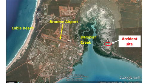
Figure 1: Broome Airport and accident site

Source: Google earth annotated by the ATSB

Deciding that landing was not possible until the fog lifted, the pilot sought assistance from the person waiting on the ground for the aircraft. As this person was local and understood the likely extent of the fog, they were able to offer the pilot two alternate airports, as options. The first option, Beagle Bay was about 62 NM to the north, and the second option Eco Beach, about 23 NM to the south. The pilot considered these options, but reasoned that with such widespread fog, these options may also be fog bound. With limited choices and now limited fuel, the pilot turned BKD for one last low-level check along runway 10. The pilot then initiated a climb with the intent of heading back to the highway to land.

Shortly after applying full power to initiate the climb, the aircraft’s engine surged and spluttered. The pilot instantly realised that the right tank had been selected for over an hour, and quickly changed the fuel selector to the left tank. However, the engine did not respond. The pilot then attempted to restart the engine with the ignition key, but reported hearing a crunching noise as the starter motor engaged. The propeller was still windmilling.

With the aircraft only at about 500 ft and descending into the thick layer of fog, the pilot levelled the aircraft’s wings and prepared for a forced landing. Electing to leave the undercarriage retracted, the pilot descended through the fog and noted the outline of a dirt track. The pilot attempted to land on the track, but the aircraft collided with the sandy terrain just prior to reaching it. The aircraft momentum allowed it to skid across the track, coming to rest in the mangroves a few metres on the other side (Figure 2 and 3). The accident site was located within the mangrove area of the Dampier Creek.

The pilot was not injured; however, the aircraft propeller and engine sustained substantial damage.

Figure 2: Initial contact point
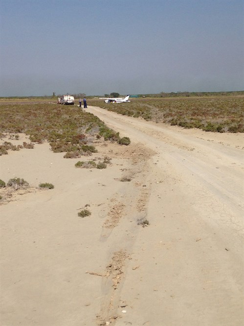
  Figure 2: Initial contact point

Source: WA Police 

Figure 3: VH-BKD in the mangroves
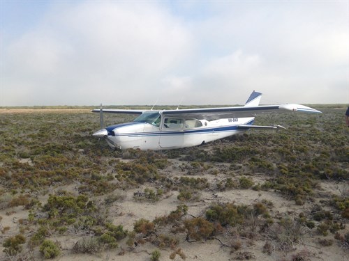
Figure 3: VH-BKD in the mangroves

Source: WA Police

Pilot experience and comments

The pilot had around 3,850 flying hours, with around 830 of those on Cessna 210 aircraft.

Pre-flight planning

The pilot elected to conduct the flight at night to increase their night command hours. The evening before the flight, the pilot checked the weather forecast and completed the flight plan. They noted a 30% probability of fog on the terminal area forecast (TAF) for Broome during the planned arrival time. However, the pilot reported that, in their experience, 30% probability of fog would mean non-existent or minimal impact on operations, so they did not consider or plan for any alternates

The pilot pre-flighted the aircraft in the morning prior to the 0230 departure.

The pilot had personal commitments in Broome that morning and back in Alice Springs the next day. Hence, they needed to deliver the aircraft in time to catch the lunchtime jet flight back from Broome to Darwin and eventually be back in Alice Springs the next morning.

The flight

The pilot made the following comments about the flight:

  • the cruise level was 8,500 ft
  • there was smooth conditions enroute but with a stronger headwind than forecast
  • the flight time between Alice Springs and Broome was about 5 hours.
Fuel management

The pilot maintained a fuel log during the flight. They initially used fuel from the left tank for 30 minutes, then 60 minutes on the right, back to the left. The pilot continued using this pattern until they arrived overhead Broome.

Although the pilot had calculated there was sufficient fuel to search for a break in the fog for 30 minutes, once pressured and distracted looking for an expected opening to be able to land, the pilot reported flying in excess of 60 minutes with the right fuel tank selected.

The aircraft fuel tanks were dipped post- accident. The right tank had no fuel remaining while there was 45 L remaining in the left tank.

Aviation weather forecasts and alternate aerodrome requirements

The Aeronautical Information Publication Australia (AIP) ENR 1.1 87 details the following requirements concerning planning for alternate aerodromes:

A pilot in command must make provision for flight to an alternate aerodrome, when required, in accordance with the following paragraphs:

…Except when operating an aircraft under the VFR by Day within 50NM of the point of departure, the pilot in command must provide for a suitable alternate aerodrome, when arrival at the destination will be during the currency of, or up to 30 minutes prior to the forecast commencement of, the following weather conditions:

Cloud – more than SCT below the alternate minimum

Visibility – less than the alternate minimum

Visibility – greater than the alternate minimum, but the forecast is endorsed with a percentage probability of fog, mist, dust or any other phenomenon restricting visibility below the alternate minimum….

Note: When weather conditions at the destination are forecast to be as above, but are expected to improve at a specific time, provision for an alternate aerodrome need not be made if sufficient fuel is carried to allow the aircraft to hold until that specified time plus 30 minutes.

AIP GEN 3.5-7 explains that:

PROB% is used in terminal area forecasts (TAF) to indicate an expected 30 or 40% probability of occurrence. If greater than or equal to 50% probability is forecast, reference is made to the phenomenon in the forecast itself not by the addition of a PROB statement

Safety message

The pilot had planned the flight using maximum endurance performance figures and kept a fuel log. The pilot’s fuel management used a time-based system up until arriving overhead the destination. Due to the unexpected distraction and increased workload of arriving at the destination airport covered in thick fog, with no planned alternates, the pilot lost situational awareness of the aircraft’s fuel state.

Issue number 5 in the ATSB’s Avoidable Accident Series – Starved and exhausted: Fuel management aviation accidents looks in more detail at such scenarios. The report notes that fuel exhaustion is more likely to occur on flights when there is little flight fuel margin.

The Avoidable Accidents series is available on the ATSB website under the Safety Awareness tab.

The ATSB published a research report titled Dangerous Distraction, an examination of aviation accidents and incidents involving pilot distraction in Australia between 1997 and 2004, covers in detail the role of pilot distraction in a number of aircraft accidents.

The research looked closely at 325 occurrences involving some measure of pilot distraction. The researchers were able to develop a taxonomy of three major causes of distraction. They were ‘flight management tasks’, ‘external objects’, and ‘people on board the aircraft’. The report concludes with a number of tentative suggestions for minimising the risk of pilot distraction. Further reading is available on the ATSB website.

Information regarding alternate aerodrome requirements is available in the Air Information Publication (AIP), ENR 1.1-87. This is available on the Airservices Australia website.

The Civil Aviation Safety Authority flight planning kit covers issues such as planning for alternates, obtaining local knowledge when flying to an unfamiliar destination and the importance of considering all aspects of the weather forecast.

This Flight Planning Kit is available from the online shop on the CASA website.

Aviation Short Investigations Bulletin - Issue 43

About this report

Decisions regarding whether to conduct an investigation, and the scope of an investigation, are based on many factors, including the level of safety benefit likely to be obtained from an investigation. For this occurrence, a limited-scope, fact-gathering investigation was conducted in order to produce a short summary report, and allow for greater industry awareness of potential safety issues and possible safety actions.

Publishing information 

Released in accordance with section 25 of the Transport Safety Investigation Act 2003

Published by: Australian Transport Safety Bureau

© Commonwealth of Australia 2015

image_5.png

Ownership of intellectual property rights in this publication

Unless otherwise noted, copyright (and any other intellectual property rights, if any) in this report publication is owned by the Commonwealth of Australia.

Creative Commons licence

With the exception of the Coat of Arms, ATSB logo, and photos and graphics in which a third party holds copyright, this publication is licensed under a Creative Commons Attribution 3.0 Australia licence.

Creative Commons Attribution 3.0 Australia Licence is a standard form licence agreement that allows you to copy, distribute, transmit and adapt this publication provided that you attribute the work.

The ATSB’s preference is that you attribute this publication (and any material sourced from it) using the following wording: Source: Australian Transport Safety Bureau

Copyright in material obtained from other agencies, private individuals or organisations, belongs to those agencies, individuals or organisations. Where you wish to use their material, you will need to contact them directly.

__________

  1. Dewpoint is the temperature at which water vapour in the air starts to condense as the air cools. It is used among other things to monitor the risk of aircraft carburettor icing or likelihood of fog at an aerodrome.
  2. Endurance power setting allows for the longest time in the air.


Occurrence summary

Investigation number AO-2015-042
Occurrence date 03/05/2015
Location 3 km East Broome Airport
State Western Australia
Report release date 07/10/2015
Report status Final
Investigation level Short
Investigation type Occurrence Investigation
Investigation status Completed
Mode of transport Aviation
Aviation occurrence category Fuel starvation
Occurrence class Accident
Highest injury level None

Aircraft details

Manufacturer Cessna Aircraft Company
Model 210N
Registration VH-BKD
Serial number 21063127
Sector Piston
Operation type Private
Departure point Alice Springs, Northern Territory
Destination Broome, Western Australia
Damage Substantial

Collision with terrain involving a Piper Aircraft Corp PA-28-180, VH-AGG, BURRA SA 10N, SA on 24 September 1976

Summary

ACFT ENTERED LOW CLOUD ON VFR FLT-PLT LOST CONTROL AND CRASHED INTO HILL

Occurrence summary

Investigation number 197604643
Occurrence date 24/09/1976
State South Australia
Report status Final
Investigation type Occurrence Investigation
Investigation status Completed
Mode of transport Aviation
Aviation occurrence category Collision with terrain
Occurrence class Accident
Highest injury level Fatal

Aircraft details

Manufacturer Piper Aircraft Corp
Model PA-28-180
Registration VH-AGG
Sector Piston
Departure point STRATHALBYN
Destination LEIGH CREEK
Damage Destroyed

Loss of control involving a Cessna Aircraft Company 150L, VH-FYC, MENINGIE , SA on 8 August 1976

Summary

ON T-O A-C SWUNG SHARPLY LEFT-PLT LIFTED A-C OFF AT LOW SPEED-AT ABOUT 100FT-STALLED-HIT GROUND

Occurrence summary

Investigation number 197604638
Occurrence date 08/08/1976
State South Australia
Report status Final
Investigation type Occurrence Investigation
Investigation status Completed
Mode of transport Aviation
Aviation occurrence category Loss of control
Occurrence class Accident
Highest injury level Serious

Aircraft details

Manufacturer Cessna Aircraft Company
Model 150L
Registration VH-FYC
Sector Piston
Departure point MENINGIE SA
Destination MENINGIE SA
Damage Destroyed

Total power loss involving a Cessna Aircraft Company U206B, VH-KUQ, Near AUVERGNE NT 54SE, NT on 25 April 1976

Summary

MAYDAY CALL-SEVERE PWR LOSS-PLT COMPELLED TO LAND UNSUITABLE AREA-CONTAMINATION FCU FILTER

Occurrence summary

Investigation number 197604627
Occurrence date 25/04/1976
State Northern Territory
Report status Final
Investigation type Occurrence Investigation
Investigation status Completed
Mode of transport Aviation
Occurrence class Accident
Highest injury level Serious

Aircraft details

Manufacturer Cessna Aircraft Company
Model U206B
Registration VH-KUQ
Sector Piston
Departure point HOOKER CREEK
Destination AUVERGNE
Damage Substantial

Airframe - Other involving a Moyes Delta Gliders Pty Ltd Unknown, Unknown, WANGI WANGI , NSW on 16 April 1976

Summary

ON 45 DEG CLIMB PT SIDE X TUBE BUCKLING FLD.LOST CTL.NO V PULL-OBSERVER NO BOAT THROTTLE CTL.

Occurrence summary

Investigation number 197601557
Occurrence date 16/04/1976
State New South Wales
Report status Final
Investigation type Occurrence Investigation
Investigation status Completed
Mode of transport Aviation
Aviation occurrence category Airframe - Other
Occurrence class Accident
Highest injury level Fatal

Aircraft details

Manufacturer Moyes Delta Gliders Pty Ltd
Model Unknown
Registration Unknown
Sector Other
Departure point LAKE MACQUARIE
Destination LAKE MACQUARIE
Damage Substantial

Loss of control involving a Cessna Aircraft Company 150G, VH-GJC, Near LAKE BANCANNIA, NSW on 21 May 1976

Summary

PLT TRIED TO MAKE STALL TURN AT LOW ALT LOST CONTROL STALLED AND CRASHED

Occurrence summary

Investigation number 197604632
Occurrence date 21/05/1976
State New South Wales
Report status Final
Investigation type Occurrence Investigation
Investigation status Completed
Mode of transport Aviation
Aviation occurrence category Loss of control
Occurrence class Accident
Highest injury level Fatal

Aircraft details

Manufacturer Cessna Aircraft Company
Model 150G
Registration VH-GJC
Sector Piston
Departure point MILPA NSW
Destination LAKE BANCANNIA NSW
Damage Destroyed

Wirestrike involving a Robinson R44, VH-LOL, 142 km west-south-west of Adelaide, South Australia, on 10 April 2015

Final report

Report release date: 27/08/2015

What happened

On 10 April 2015, at about 1120 Central Standard Time (CST), the pilot of a Robinson R44 helicopter, registered VH‑LOL (LOL) was engaged in herbicide dispensing operations near Marion Bay on the Yorke Peninsula in South Australia.

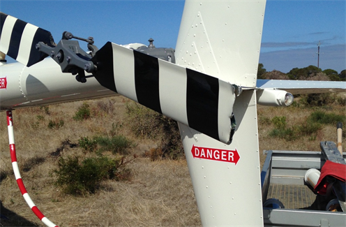
Also on board were client representatives who were directing the noxious weed management operation and manually dispensing the chemical into each bush. In the course of traversing the field at low level in search of the weed, the helicopter struck a previously unidentified power line. The helicopter’s main rotor blade made initial contact with the power line and during the avoidance manoeuvre, the tail rotor blades also made contact, severing the blade tips (Figure 1). The pilot landed the helicopter safely. The helicopter was substantially damaged but the occupants were uninjured.

Figure 1: Tail rotor blade damage to VH-LOL


Figure 1: Tail rotor blade damage to VH-LOL

Source: Maintenance organisation

Power line identification

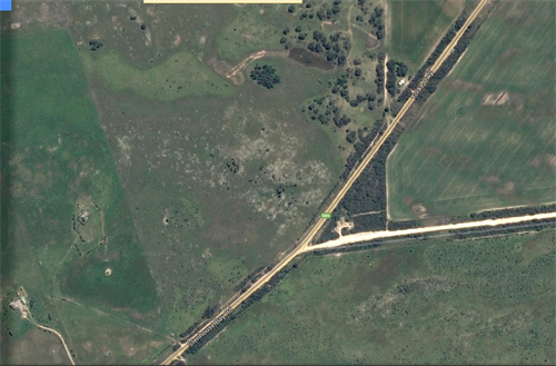
In preparation for the herbicide operations, the pilot conducted an aerial survey of the area. The aerial survey was a standard operating procedure to confirm the powerlines as previously advised by local sources. This survey identified main power lines running parallel to a boundary road and a secondary power line running parallel to the main lines (Figure 2). The secondary line effectively dissected the target area and operations were concentrated on sectors to the north and south of the secondary line. The location of the power lines were also mapped on the data logger that was being used to track the progress of the herbicide dispensing.

The unidentified powerline was a single wire that was strung between the poles supporting the main and secondary powerlines and traversed, unsupported, through the southern boundary of the operational area. It was not mentioned by the locals, nor marked on the data logger map. It was not readily discernible from the air although additional support poles did lead the wire away from the secondary power line towards a distant building.

Figure 2: Powerlines and boundary fencing

Figure 2: Powerlines and boundary fencing


Source: Google Earth and modified by ATSB

Pilot comment

The pilot stated that the aerial survey of the powerlines confirmed the accuracy of the local knowledge and created a sense of confidence in him that all obstructions had been identified and accordingly mapped. In hindsight, a fully independent assessment by the pilot in command for the presence of powerlines in the target area may have located the single wire. The pilot had in excess of 14,000 hours operating at low level but not necessarily in powerline congested areas.

Risk management

The helicopter operator had documented a risk assessment of the planned operation, addressing aircraft operational considerations, environmental impacts, required personal protective equipment and herbicide management. The cabin occupants were also provided with a helicopter safety brief and formal induction prior to commencement of flight operations. Risk assessment outcomes and operational requirements were included in a specific job plan that was discussed in briefings with ground and flight crews at the beginning of the campaign. Briefings were also conducted with crews prior to the commencement of each day’s flying.

Wire awareness, detection and avoidance techniques were also documented in the company operations manual in various sections along with specific references to aerial agriculture publications where mitigation for such hazards are addressed.

ATSB comment

This accident provides a reminder to flight crews of the need for consistency in aerial surveys for powerlines, the establishment of standardised procedures for their identification and the need for independent assessment of their presence. 

Single wires can be difficult to see and occur in the most unexpected places in rural areas. ATSB research article ‘Avoidable accidents No. 1 - Low level flying’ provides additional information on wire hazards associated with flight below 500’. The report is available at the ATSB website. 

‘Avoidable Accidents No. 2 – Wirestrikes involving known wires: A manageable aerial agriculture hazard’ also explains a number of strategies, developed by the Aerial Agriculture Association of Australia (AAAA) and the ATSB, to help pilots manage the on-going risk of wire strikes. The report is available at the ATSB website.

Safety action

Whether or not the ATSB identifies safety issues in the course of an investigation, relevant organisations may proactively initiate safety action in order to reduce their safety risk. The ATSB has been advised of the following proactive safety action in response to this occurrence.

Aircraft operator

As a result of this occurrence, the aircraft operator has advised the ATSB that they are taking the following safety actions:

The operator has reviewed the risk assessment and moved to standardise procedures and now place greater emphasis on employee inductions with a focus on hazards and published information relating to high-risk activities. Whilst the published information was generally available to company pilots, a greater focus on promulgating this information was recognised as beneficial.  The use of non-permanent staff was to be reconsidered along with the dissemination and acknowledgement of receipt of safety critical information specific to the contracted flying program.

Operator client

Following a separate, internal investigation into the accident, the client updated its procurement processes. This update was to further ensure that contractor and project sponsor responsibilities were clearly defined in contracts and operational plans, with respect to:

  • hazard identification
  • operational briefings
  • safety inductions.

Aviation Short Investigations Bulletin - Issue 42

About this report

Decisions regarding whether to conduct an investigation, and the scope of an investigation, are based on many factors, including the level of safety benefit likely to be obtained from an investigation. For this occurrence, a limited-scope, fact-gathering investigation was conducted in order to produce a short summary report, and allow for greater industry awareness of potential safety issues and possible safety actions.

Publishing information 

Released in accordance with section 25 of the Transport Safety Investigation Act 2003

Published by: Australian Transport Safety Bureau

© Commonwealth of Australia 2015

image_5.png

Ownership of intellectual property rights in this publication

Unless otherwise noted, copyright (and any other intellectual property rights, if any) in this report publication is owned by the Commonwealth of Australia.

Creative Commons licence

With the exception of the Coat of Arms, ATSB logo, and photos and graphics in which a third party holds copyright, this publication is licensed under a Creative Commons Attribution 3.0 Australia licence.

Creative Commons Attribution 3.0 Australia Licence is a standard form licence agreement that allows you to copy, distribute, transmit and adapt this publication provided that you attribute the work.

The ATSB’s preference is that you attribute this publication (and any material sourced from it) using the following wording: Source: Australian Transport Safety Bureau

Copyright in material obtained from other agencies, private individuals or organisations, belongs to those agencies, individuals or organisations. Where you wish to use their material, you will need to contact them directly.

Occurrence summary

Investigation number AO-2015-037
Occurrence date 10/04/2015
Location 142 km WSW of Adelaide
State South Australia
Report release date 27/08/2015
Report status Final
Investigation level Short
Investigation type Occurrence Investigation
Investigation status Completed
Mode of transport Aviation
Aviation occurrence category Collision with terrain
Occurrence class Accident
Highest injury level None

Aircraft details

Manufacturer Robinson Helicopter Co
Model R44
Registration VH-LOL
Serial number 1885
Sector Helicopter
Operation type Aerial Work
Departure point Innes National Park, South Australia
Destination Marion Bay, South Australia
Damage Substantial

Miscellaneous - Other involving a , Tyabb (ALA), 301ø M 7Km, VIC on 26 August 1973

Summary

DUR 3SEC DELAY FALL MAIN CHUTE NOT DEPLOYED-EVIDENCE SUGGESTS EFFORT MADE TO DEPLOY RESERVE

Occurrence summary

Investigation number 197302842
Occurrence date 26/08/1973
State Victoria
Report status Final
Investigation type Occurrence Investigation
Investigation status Completed
Mode of transport Aviation
Aviation occurrence category Miscellaneous - Other
Occurrence class Accident
Highest injury level Fatal

Aircraft details

Sector Other

Wheels-up landing involving a Cessna 210, VH-MCE, Gove Airport, Northern Territory, on 11 November 2014

Final report

Report release date: 22/04/2015

What happened

On 11 November 2014, the pilot of a Cessna 210 aircraft, registered VH-MCE (MCE), conducted a charter flight from Numbulwar to Gove, Northern Territory with five passengers on board. During the cruise, about 60 NM from Gove, the ammeter gauge indicated a discharge. The pilot switched off all electrics and checked the circuit breakers, none of which had popped. About 5 minutes after completing the checks, the pilot selected the alternator master switch back to ON and the gauge indicated a positive charge.

About 10-15 NM from Gove, the ammeter again indicated a discharge. The pilot switched all electrics off including the aircraft avionics. When at about 4 NM from Gove and 1,500 ft, the pilot selected the landing gear lever to the extended position. He heard the landing gear motor activate, so assumed the gear had fully extended. As the pilot reduced the engine power, the engine ran roughly and backfired. The pilot observed the oil pressure gauge reading zero and the cylinder head temperature (CHT) decreasing. The pilot observed that the flaps had not extended, but due to the distraction of the engine malfunction, did not look outside to confirm visually whether the landing gear was extended. The pilot carried out the engine trouble checks, and as the engine problem ruled out the option to go around, committed to landing the aircraft.

The aircraft landed just beyond the threshold and on the centreline of runway 31 with the wheels retracted. When the pilot realised the wheels were retracted, he immediately selected the fuel to OFF. The aircraft sustained substantial damage and the pilot and passengers were uninjured.

A crimped electrical cable was found to have caused the alternator to stop charging the battery. The engine had not been inspected before the completion of the ATSB report and the cause of the engine issues were unknown.

Aviation Short Investigations Bulletin - Issue 40

Occurrence summary

Investigation number AO-2014-177
Occurrence date 11/11/2014
Location Gove Airport
State Northern Territory
Report release date 22/04/2015
Report status Final
Investigation level Short
Investigation type Occurrence Investigation
Investigation status Completed
Mode of transport Aviation
Aviation occurrence category Wheels up landing
Occurrence class Accident
Highest injury level None

Aircraft details

Manufacturer Cessna Aircraft Company
Model 210M
Registration VH-MCE
Serial number 21062633
Sector Piston
Operation type Charter
Departure point Numbulwar, Northern Territory
Destination Gove, Northern Territory
Damage Substantial

Runway excursion involving a Cessna 404, VH-JOR, Pantijan (ALA), Western Australia, on 12 April 2015

Final report

Report release date: 10/06/2015

What happened

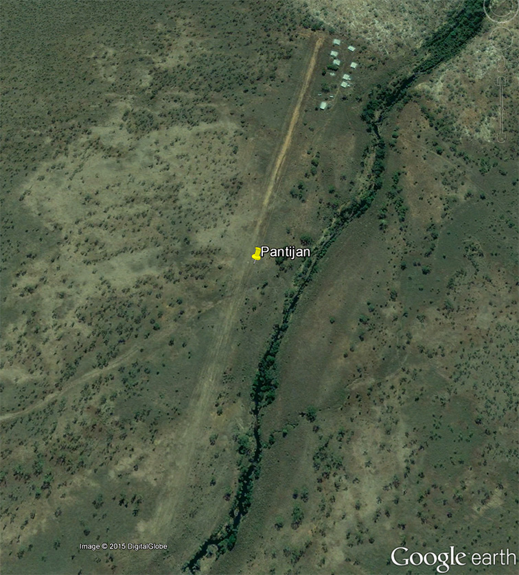
On 12 April 2015, the pilot of a Cessna 404 aircraft, registered VH-JOR (JOR), conducted preflight preparations at Broome Airport, Western Australia. The planned task involved a positioning flight from Broome to Derby, before a charter flight with five passengers, from Derby to Pantijan aeroplane landing area (ALA), Western Australia. The distance from Derby to Pantijan was 117 NM, with an estimated flying time of 49 minutes. The pilot reviewed information about the Pantijan airstrip in company documentation and using Google earth (Figure 1). He also arranged for the condition of the runway to be assessed by a contact person at Pantijan and the pilot of a helicopter scheduled to arrive at Pantijan before JOR.

Figure 1: Pantijan ALA

Figure 1: Pantijan ALA

Source: Google earth

Prior to departing Broome, the pilot received information regarding the serviceability of the airstrip at Pantijan, from the contact person at the airstrip. He was advised that the grass beside the landing area was long, with some termite mounds outside the wingspan of the aircraft. He was also advised that the threshold of runway 02 had grass cover and that midway along the strip the surface was soft. The pilot understood that the contact person had walked the strip to assess its condition, but that no vehicle had been available to drive across the landing surface. Due to rising terrain at the northern end of the airstrip, the pilot was advised to regard the strip as one-way and to land on runway 02, and depart from runway 20.

After arriving in Derby, the pilot weighed the passengers and baggage and loaded the aircraft for the flight to Pantijan. Baggage was loaded into the aircraft lockers and also stowed at the rear of the aircraft and secured with a cargo net. Some bags were placed on a rear seat and secured with seatbelts. After loading the baggage and passengers, the aircraft departed from Derby at 1346 Western Standard Time (WST).

When about 80 NM from Pantijan, the pilot of JOR heard the pilot of the helicopter, who he had spoken to prior to departure, broadcast that he was conducting an approach to the airstrip in the direction of runway 02. The pilot of JOR responded with his current position and did not receive any further communications from the pilot of the helicopter. As JOR approached Pantijan, the pilot observed fires in the area. The direction of the smoke indicated a tailwind of about 5 kt for a landing on runway 02.

At about 1430 WST, the aircraft arrived overhead Pantijan. The pilot slowed the aircraft, lowered the first stage of flap and descended to about 700 ft above ground level. He then conducted a circuit and a visual inspection of the entire length of the runway. The pilot observed that the runway was narrow and bordered by tall grass. The helicopter was parked adjacent to a shed about three quarters of the way along the runway and clear of the landing area. The sand on the airstrip appeared to be uniform in colour, with no obvious darker patches that may have indicated water. There was short grass at the threshold of runway 02 extending for about 200 m. A termite mound was located about half way along the runway and had been placed on its side and moved to the right of the runway centreline.

The pilot then conducted an approach to land on runway 02. The aircraft touched down at the pilot’s aiming point, about 50 m beyond the threshold, and the pilot applied moderate braking. The aircraft continued along the centre of the runway and, as it slowed through about 60 kt, the pilot applied left rudder to turn the aircraft slightly to the left and increase separation from the overturned termite mound. He felt the rudder pedals move to the full left position and the aircraft turned to the left. The pilot immediately applied right rudder in an attempt to counteract the turn, but the aircraft initially continued to veer left towards the edge of the runway.

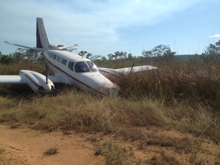
The left main landing gear momentarily lifted off the ground and the aircraft tipped to the right. As the aircraft veered off the runway and entered longer grass, the pilot regained control of the aircraft and it started to turn right and return towards the runway. The nose wheel then collided with a runway marker and collapsed, resulting in the aircraft nose contacting the ground and the aircraft skidded to a stop (Figure 2). The pilot secured the aircraft and assisted the passengers to disembark. One passenger had a cut to the back of the head from a loose object and another sustained a bleeding nose. Three other passengers and the pilot were not injured, however the aircraft sustained substantial damage.

Figure 2: Accident site

Figure 2: Accident site

Source: Aircraft operator (edited by the ATSB)

Pilot comments

Following the accident, the pilot found that where he had commenced the left turn on the runway, the ground was soft and appeared to have previously held standing water, although the surface was dry at the time. The runway marker was a 44-gallon drum, cut in half longitudinally and laid on the ground and it was obscured by long grass (Figure 3).

None of the baggage had come loose in the cabin; the only unsecured objects were phones, cameras and water bottles.

The pilot stated that when facing similar circumstances, he would select a landing path that did not require any planned directional changes during the landing roll, until the aircraft has decelerated to a safe taxi speed.

Figure 3: Drum runway marker

Figure 3: Drum runway marker

Source: Aircraft operator

Safety action

Whether or not the ATSB identifies safety issues in the course of an investigation, relevant organisations may proactively initiate safety action in order to reduce their safety risk. The ATSB has been advised of the following proactive safety action in response to this occurrence.

Aircraft operator

As a result of this occurrence, the aircraft operator has advised the ATSB that they are taking the following safety actions:

  • Company pilots operating beyond mobile phone coverage will be issued with a satellite phone. In this incident, access to a satellite phone may have enabled the aircraft pilot to communicate with the helicopter pilot on the ground and obtain further details regarding the condition of the airstrip.
  • The operators of remote airstrips will be reminded to follow the company’s runway inspection guide, which required a vehicle to assess the condition of the landing surface.
  • All company pilots will be reminded of the importance of maintaining directional control on unimproved (sand or gravel) airstrips.

Safety message

Airfields that are used infrequently or seasonally, potentially pose significant hazards to aviation. This incident highlights the importance of identification and management of any risks that might be associated with such an airfield. Potential hazards may be hard to identify, with objects possibly obscured by vegetation. Changes in the runway surface can be hard to detect visually and without a vehicle or some means to apply a similar force to that of a landing aircraft.

Aviation Short Investigations Bulletin - Issue 41

About this report

Decisions regarding whether to conduct an investigation, and the scope of an investigation, are based on many factors, including the level of safety benefit likely to be obtained from an investigation. For this occurrence, a limited-scope, fact-gathering investigation was conducted in order to produce a short summary report, and allow for greater industry awareness of potential safety issues and possible safety actions.

Publishing information 

Released in accordance with section 25 of the Transport Safety Investigation Act 2003

Published by: Australian Transport Safety Bureau

© Commonwealth of Australia 2015

image_5.png

Ownership of intellectual property rights in this publication

Unless otherwise noted, copyright (and any other intellectual property rights, if any) in this report publication is owned by the Commonwealth of Australia.

Creative Commons licence

With the exception of the Coat of Arms, ATSB logo, and photos and graphics in which a third party holds copyright, this publication is licensed under a Creative Commons Attribution 3.0 Australia licence.

Creative Commons Attribution 3.0 Australia Licence is a standard form licence agreement that allows you to copy, distribute, transmit and adapt this publication provided that you attribute the work.

The ATSB’s preference is that you attribute this publication (and any material sourced from it) using the following wording: Source: Australian Transport Safety Bureau

Copyright in material obtained from other agencies, private individuals or organisations, belongs to those agencies, individuals or organisations. Where you wish to use their material, you will need to contact them directly.

Occurrence summary

Investigation number AO-2015-038
Occurrence date 12/04/2015
Location Pantijan (ALA)
State Western Australia
Report release date 10/06/2015
Report status Final
Investigation level Short
Investigation type Occurrence Investigation
Investigation status Completed
Mode of transport Aviation
Aviation occurrence category Runway excursion
Occurrence class Accident
Highest injury level Minor

Aircraft details

Manufacturer Cessna Aircraft Company
Model 404
Registration VH-JOR
Serial number 4040642
Sector Piston
Operation type Charter
Departure point Derby, Western Australia
Destination Pantajin, Western Australia
Damage Substantial