On 25 June 2015, at about 1111 Eastern Standard Time (EST), a de Havilland Canada DHC-2 amphibian[1] aircraft, registered VH-AWI (AWI), taxied at Hardy Lagoon aircraft landing area (ALA), Queensland, for a flight to Shute Harbour with the pilot and seven passengers on board.
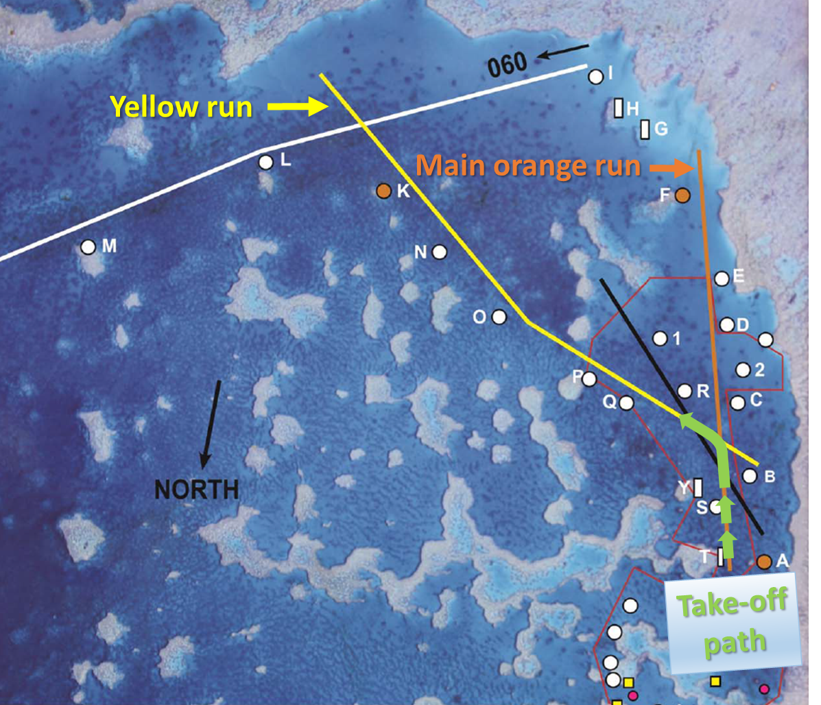
The Hardy Lagoon ALA had marker buoys to identify the location of the bommies[2] that were near each of the four take-off and landing areas. The main take-off run (orange run) to the south, started at buoy A, and continued onto buoys B, C, D, E, F (Figure 1, orange line). The take-off run to the east-south-east (yellow run), started at buoy B, and continued onto buoys Q, P, O, N, K (Figure 1, yellow line). As per company policy, the pilot elected to start the take-off at buoy A on the orange run and then turn onto the yellow run. This combination of take-off runs allowed the pilot the maximum take-off distance, for the aircraft’s take-off weight.
Figure 1: Hardy lagoon aircraft landing area.
Source: Aircraft operator, modified by the ATSB
The pilot taxied AWI to buoy A and lined up on the orange run. They then advanced the throttle slowly to commence the take-off. As AWI approached buoy B the engine was not at full power. The pilot commenced the turn onto the yellow run utilising the water rudders,[3] which were in the down position. Coming out of the turn the pilot retracted the water rudders and applied right rudder to stop the turn and line up on the yellow run.
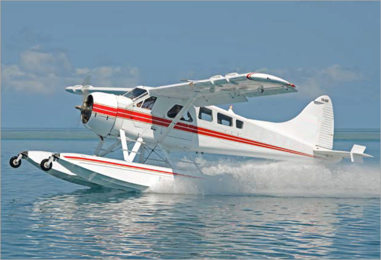
The pilot looked inside the cockpit to check the engine instrumentation and to see if the engine had reached full power. At this stage, the aircraft had not risen onto the step[4] (Figure 2). When the pilot looked outside again, they noticed that the nose of the aircraft had drifted too far to the left. The nose had lined up on the left side of the buoy Q, which marked the location of the Q bommie. The pilot attempted to apply more right rudder, but had already applied full right rudder. AWI then hit and passed over the Q coral reef bommie and the pilot closed the engine throttle. AWI continued moving forward and the pilot shut down the engine and lowered the flaps to help slow the aircraft. The left front float slid onto the P bommie and the aircraft came to a stop.
The pilot exited the aircraft and pushed the aircraft off the bommie, before re-entering the cockpit. When AWI had drifted far enough away from the bommie, the pilot restarted the engine and taxied the aircraft to a nearby moored boat, where the passengers disembarked.
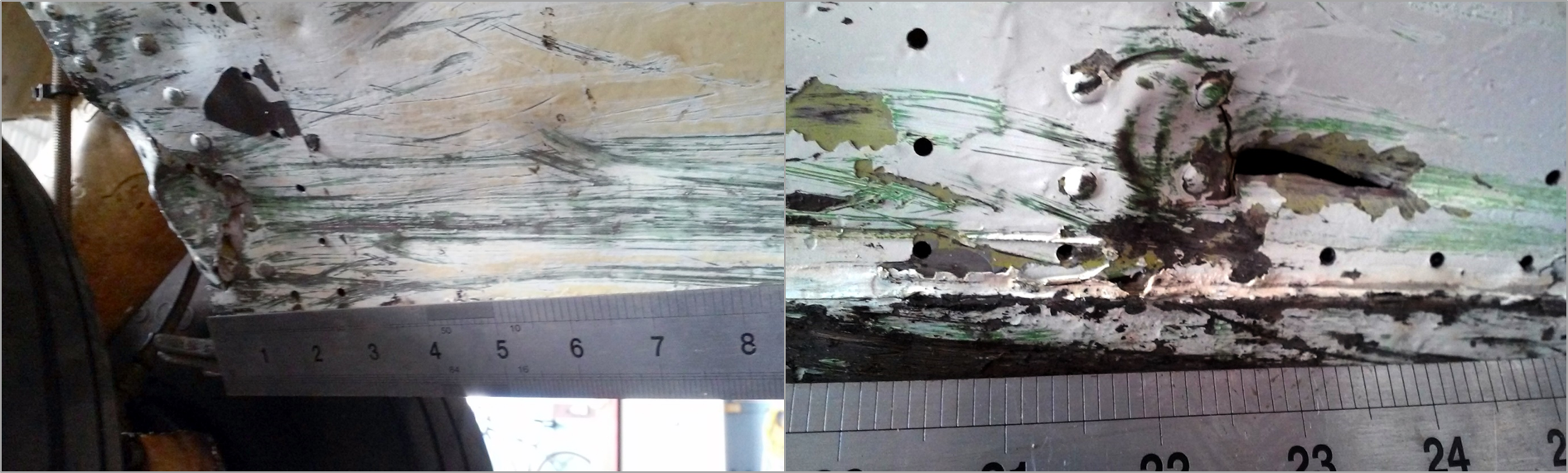
The pilot and seven passengers were uninjured and the aircraft sustained minor damage (Figure 3).
Figure 2: AWI conducting a water take-off (not the occurrence take-off). Note the high nose attitude, skids sitting up out of the water as the aircraft is ploughing through the water. AWI has not gained enough speed in the take-off to reach the step, where the nose would be lower and the aircraft would glide along the water on the floats.
Source: Aircraft operator, modified by the ATSB
Figure 3: Damage to AWI floats included two holes on the bottom side of each float compartment immediately forward of the wheel well.
Source: Aircraft operator
Attempt to reposition the aircraft
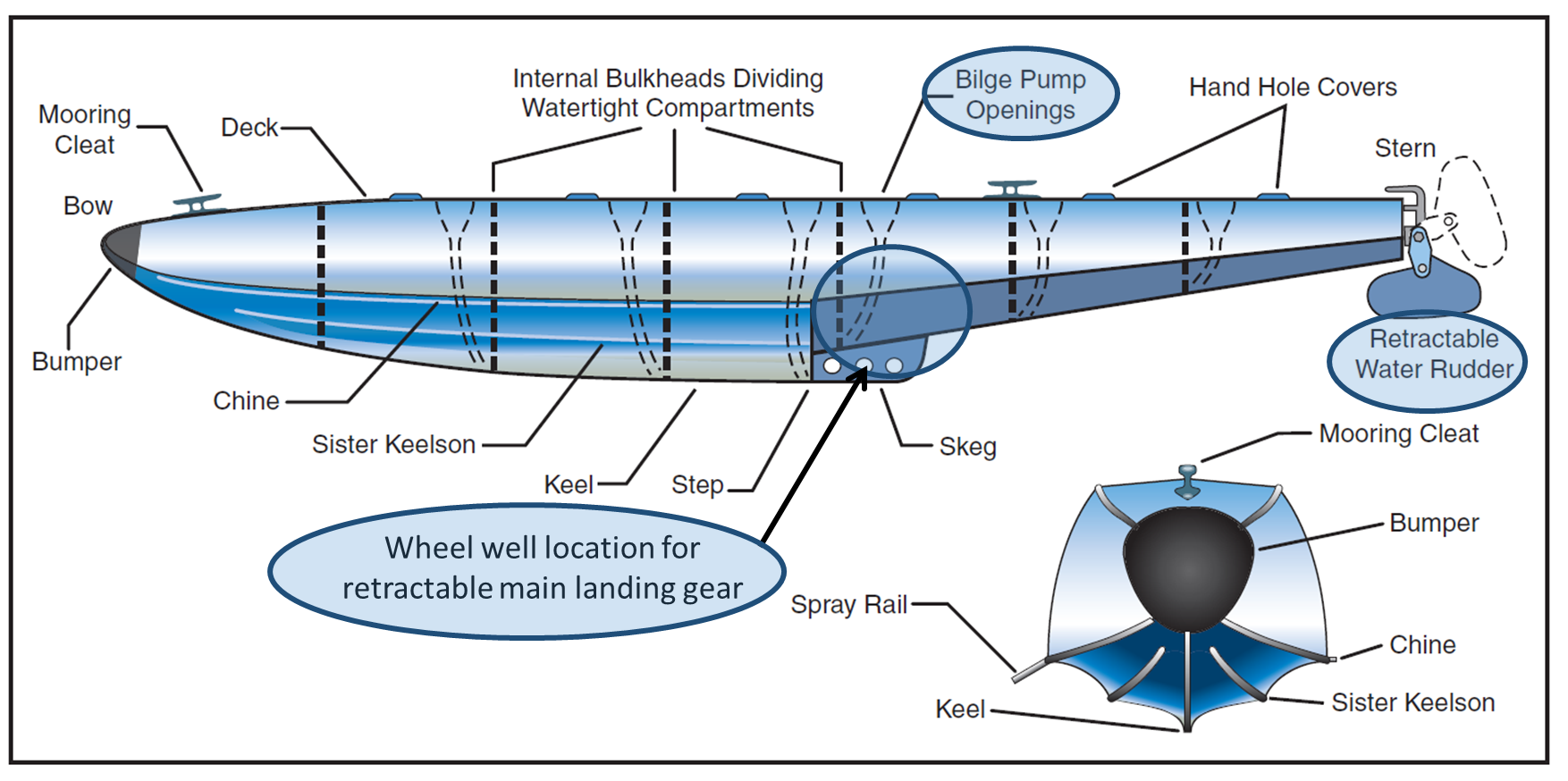
After consultation with the chief pilot, who was also at Hardy Lagoon, the pilot attempted a second take-off on the orange run, without any passengers on board. The pilot aborted the take-off at about buoy E, as the aircraft would normally be on the step at this point. The pilot taxied back to the moored boat, shut the aircraft down, and then pumped out water from the compartments in the floats (Figure 4). They then attempted another take-off on the orange run, again without success.
Figure 4: Example cross-section view of the float compartments. Note the bilge pump openings to remove water from the float compartments during the pre-flight inspection, the retractable water rudder used for directional control while taxiing and the location of the wheel well for the retractable main landing gear.
Source: Federal Aviation Administration, modified by the ATSB
Pilot comment
The pilot decided to use a combination of the orange and yellow run to give the maximum take-off distance. The pilot indicated that they did this because the aircraft was close to the maximum take-off weight and it was approaching low tide, so the coral reef bommies were more exposed.
The pilot reported a gentle breeze of about 8 kt from south-east and the water was smooth with small ripples. The wind direction was between the orange and yellow runs.
The pilot indicated that they did not advance the throttle as quickly as they would normally, due to a recent conversation with other another company pilot. The conversation was about managing the aircraft engine to ensure that the engine limits were not exceeded. In retrospect, the pilot thought that for the occurrence flight, the advancement of the throttle was too slow. Normally turning onto the yellow run the engine would be at full power.
Pilot experience
The pilot had a total time of about 904 hours, with 540 hours on the DHC-2 aircraft. Of their total time about 595 hours was on seaplanes, with 941 water landings and take-offs. The pilot had 34 landings at the Hardy Lagoon ALA, including 21 solo landings, and 13 under supervision. The pilot had last landed at the Hardy Lagoon ALA 32 days prior to the occurrence.
Operator comment
In light winds, where the pilot wanted additional take-off length, it was standard company procedure to start the take-off on the orange run and then to turn onto the yellow run. The aircraft had a payload of 440 kg, 10 kg under the company limit weight for the aircraft for take- off.
The chief pilot reported that the pilot had pumped out all the water from the floats prior to taxi on the occurrence flight.
Safety action
Whether or not the ATSB identifies safety issues in the course of an investigation, relevant organisations may proactively initiate safety action in order to reduce their safety risk. The ATSB has been advised of the following proactive safety action in response to this occurrence.
Aircraft operator
As a result of this occurrence, the aircraft operator has advised the ATSB that all company pilots will be made aware of the serious incident and conduct recurrent training on the Hardy Lagoon ALA.
Safety message
This serious incident illustrates that distractions can have a significant impact on flight safety. Distraction is a process, condition, or activity that takes a pilot’s attention away from the task of flying. Even a momentary deflection of attention away from the primary task can have adverse consequences.
The Federal Aviation Administration published a handbook Seaplane, skiplane, and float/ski equipped helicopter operations handbook, for pilots and is available from the FAA website. The handbook discuss the importance of the pilot planning an effective course of action, and mentally staying ahead of the seaplane.
The serious incident highlights the importance of pre-flight decision making and planning for emergencies and abnormal situations for the particular aerodrome. A thorough pre-flight self-brief covering the different emergency scenarios may help to minimise safety critical decisions during a high workload situation such as a take-off.
Decisions regarding whether to conduct an investigation, and the scope of an investigation, are based on many factors, including the level of safety benefit likely to be obtained from an investigation. For this occurrence, a limited-scope, fact-gathering investigation was conducted in order to produce a short summary report, and allow for greater industry awareness of potential safety issues and possible safety actions.
Publishing information
Released in accordance with section 25 of the Transport Safety Investigation Act 2003
Ownership of intellectual property rights in this publication
Unless otherwise noted, copyright (and any other intellectual property rights, if any) in this report publication is owned by the Commonwealth of Australia.
Creative Commons licence
With the exception of the Coat of Arms, ATSB logo, and photos and graphics in which a third party holds copyright, this publication is licensed under a Creative Commons Attribution 3.0 Australia licence.
Creative Commons Attribution 3.0 Australia Licence is a standard form licence agreement that allows you to copy, distribute, transmit and adapt this publication provided that you attribute the work.
The ATSB’s preference is that you attribute this publication (and any material sourced from it) using the following wording: Source: Australian Transport Safety Bureau
Copyright in material obtained from other agencies, private individuals or organisations, belongs to those agencies, individuals or organisations. Where you wish to use their material, you will need to contact them directly.
On 12 June 2015, the crew of a Boeing B737-300, registered VH-NLK, were conducting a non-directional beacon/distance measuring equipment (NDB/DME) approach into Kosrae Airport in the Federated States of Micronesia. The flight was the inaugural regular public transport (RPT) flight for Nauru Airlines into Kosrae. During the approach, at night and in instrument meteorological conditions, the aircraft descended below the minimum descent altitude and three enhanced ground proximity warning system (EGPWS) ‘too low terrain’ alerts were triggered. A go-around was performed prior to the aircraft reaching the missed approach point. During the go-around, the airspeed decayed and required the pilot to use full thrust. The flight crew identified and corrected the barometric pressure setting and the subsequent approach and landing into Kosrae were uneventful.
What the ATSB found
The flight crew did not complete the approach checklist before commencing the non-precision NDB approach into Kosrae, resulting in the barometric pressure setting on the altimeters not being set to the local barometric pressure. This resulted in the aircraft’s altitude being lower than what the pressure altimeter was indicating to the pilots. The aircraft descended below the EGPWS terrain clearance floor profile for the Kosrae runway, resulting in three separate EGPWS alerts.
Terrain clearance assurance was eroded further after receiving the first two EGPWS alerts by the flight crew not correcting the flight profile. The crew's belief that the EGPWS alerts were due to a decreased navigational performance and not terrain proximity led to the crew’s decision to inhibit the first EGPWS alert and not correct the flight path.
The flight crew initiated a missed approach when they lost visual contact with the runway. The captain was experiencing fatigue and the flight crew had an increased workload and stress due to the inaugural RPT flight into Kosrae at night in rapidly deteriorating weather. As a result, the crew’s decision making and task execution on the missed approach were affected, and the aircraft state, airspeed and attitude were not effectively monitored by either crew member.
The ATSB also found that there were established risk factors associated with Kosrae at the time the operator commenced regular public transport operations into Kosrae. The only instrument approach available for use was an offset procedure based on a non-precision navigation aid. The risk associated with this type of approach was amplified due to the need to use a 'dive and drive' style technique instead of a stable approach path, and that it required low level circling manoeuvring from the instrument approach to align the aircraft with the runway. Furthermore, there was very high terrain in close proximity to the runway and the airport did not have a manned air traffic control tower.
What's been done as a result
Following this occurrence, the operator has reviewed and changed procedures relating to:
increased time for flight crew on non-standard/non-routine activities during their cyclic training program
reviewed and included control column checklists, which includes the descent and approach checklist, with tactile indicators
included two-engine go-arounds in simulator sessions
reviewed and improved awareness of QNH setting procedures and human factors aspects of briefings and line checks.
Safety message
This occurrence highlights the importance of flight crews declaring any instances of acute fatigue and stress-inducing circumstances that may have an impact on their flying performance. Operators also need to remind flight crew of the importance of their decisions with regards to their fitness to fly. For flight crews, the importance of completing approach checklists and monitoring the approach at safety critical times is emphasised. For operators, the occurrence highlights the importance of incorporating dual-engine go-arounds into simulator training sessions.
The occurrence
On 12 June 2015, a Nauru Airlines[1] Boeing 737-300 aircraft, registered VH-NLK, operated a scheduled passenger flight originating in the Republic of Nauru and transiting Tarawa, Republic of Kiribati, and Marshall Islands Airport, Majuro atoll, Republic of the Marshall Islands, to Kosrae Airport and finally Pohnpei Airport, both in the Federated States of Micronesia (FSM). This was the operator’s inaugural scheduled regular public transport service to Kosrae and Pohnpei. Travelling on-board were the Nauruan President, the Nauruan Minister of Aviation, and the Chairman of the Board of Directors of Nauru Air Corporation. In the six weeks preceding this flight, the operator had flown three charter flights to the FSM airports. The captain also stated that he had flown a couple of charter flights (during the day) into Kosrae before this inaugural scheduled service.
The flight was originally scheduled to leave Nauru at 0230 Coordinated Universal Time (UTC) (1430 Nauru Time).[2] However, a technical issue with the original aircraft led to a change to VH‑NLK. This resulted in the aircraft departing 60 minutes late. The flight crew, comprising of a captain and first officer, originated in Nauru having been positioned there from their base in Brisbane, Queensland, the day before.
The sector from the Marshall Islands to Kosrae was delayed a further 17 minutes due to ground handling issues. The flight departed after last light at 0740 and the planned flight time was 1 hour 19 minutes. The approach and landing at Kosrae was at night.
For this sector, the captain was the pilot flying, and the first officer was the pilot monitoring.[3] During the climb to the planned cruising altitude of flight level (FL)[4] 360, in accordance with standard procedures, the flight crew selected the standard atmospheric pressure of 1013 hPa on the altimeters.
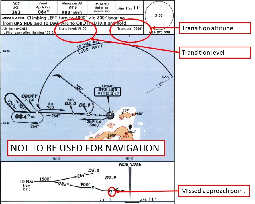
The flight crew stated that, prior to commencing the descent for Kosrae, they obtained the weather and the local QNH.[5] The weather had deteriorated from that forecast (see section titled Meteorological information). The flight crew also stated that, during the descent and approach, the local flight information service radio operator[6] provided a considerable number of weather updates on the local airport conditions at Kosrae. Visibility was around 3 NM, rain showers were in the area with low cloud and wind ‘pretty much straight down the strip for (runway) 05’. The captain, as pilot flying, conducted the briefing for the non-directional beacon (NDB)[7]/distance measuring equipment (DME)[8] approach to runway 05 (Figure 1). The captain stated that, at this time, they had made special mention of the unusually low transition level[9] of FL 55. The captain stated that at most airports they operated into, the transition level was between FL 110 and FL 130.
The crew then completed the descent checklist. They had decided that, based on the expected weather conditions, they would make two approach attempts, and if they could not land, would divert to Nauru Airport, the nominated alternate airport. Prior to descending below the transition level, the crew did not complete the approach checklist, which consisted of one item: set the altimeters to the local QNH and crosscheck them. Leaving the altimeters’ subscale set to the standard atmospheric pressure setting of 1013 hPa, and not setting the subscale to the local barometric pressure of 1007 hPa, resulted in the indicated altitude over-reading, such that when the altimeter indicated 500 ft, the aircraft’s actual altitude was about 320 ft above the mean sea level.
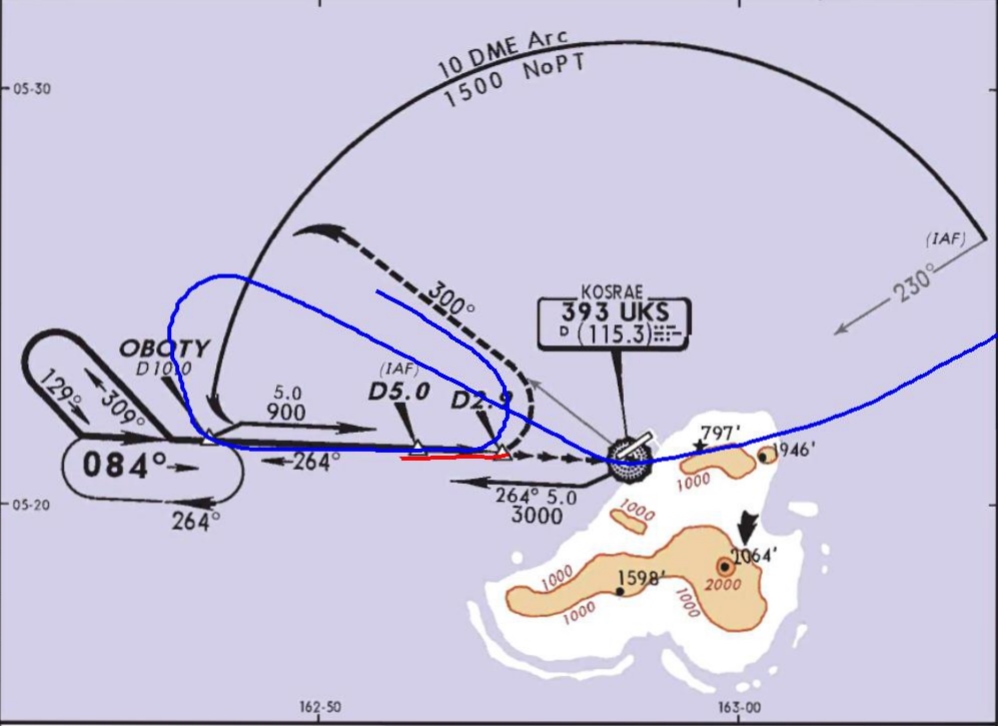
Figure 1: Kosrae NDB/DME-A approach chart with the transition altitude and level, and missed approach point highlighted
Source: Jeppesen – annotated by ATSB
At about 0856, the aircraft passed overhead the NDB at 5,000 ft, and continued the descent, tracking outbound on a heading of 300°, to about 10 NM from the NDB (10 DME). The flight crew were controlling the aircraft through the auto-flight systems, with an autopilot and the autothrottle engaged. At this point, the crew turned the aircraft left, and at 0901, the aircraft intercepted the inbound track to the NDB at about 1,800 ft. The crew selected the landing gear down at 1,500 ft, and flap 15 at 1,250 ft.
The crew stated that they established visual contact with the runway as the aircraft passed through 900 ft indicated altitude, about 5 NM from the DME. At about 740 ft indicated altitude, the crew selected flap 25. The crew elected to delay selection of the nominated landing flap of 40 degrees until they made positive visual contact with the runway. They did not subsequently select flap 40 on that approach.
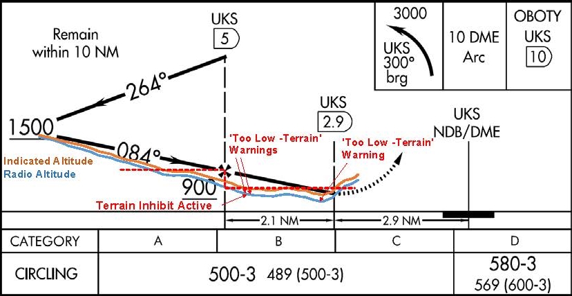
As the aircraft descended to the minimum descent altitude for the approach of 500 ft, the captain selected the altitude hold (ALT HOLD) mode to level the aircraft at 500 ft indicated altitude. At 0903:13, an Enhanced Ground Proximity Warning System (EGPWS) Terrain Clearance Floor (TCF) alert (see section titled EGPWS alerts) sounded, and lasted for 5 seconds (Figure 2). The aircraft was over water, at 368 ft radio altitude.[10] The crew reported that they were in visual meteorological conditions (VMC) at night, with the runway lights in sight. The crew stated that, at the time, they believed the EGPWS alert was due to a ‘map shift’ in the aircraft’s navigation position (see section titled The navigation function of the flight management system). The flight crew selected ‘terrain inhibit’, which cancelled the current EGPWS TCF alert. The crew were not aware that the EGPWS had its own internal GPS.
At 0903:19, the aircraft was at 4.31 DME, 480 ft indicated altitude and 340 ft radio altitude, and descending at about 313 fpm, when the EGPWS TCF alert again sounded, and lasted for 12 seconds. The aircraft maintained 480 ft indicated altitude for about 12 seconds, before descending again.
Figure 2: Approach profile annotated with indicated and radio altimeter readings highlighting the difference between the displayed and actual altitudes plus the three EGPWS Terrain Clearance Floor alerts and the Terrain Inhibit alert cancellation activation
Source: FAA and ATSB
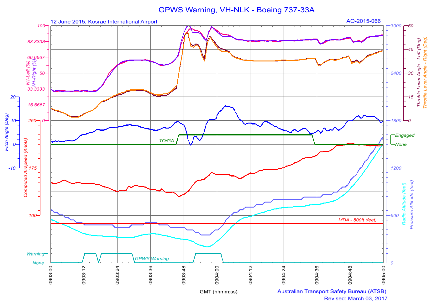
The crew reported losing visual reference with the runway when the aircraft was about 3 NM from the DME. In response to losing visual reference, the captain disconnected the autopilot and autothrottle and pressed the take-off/go-around (TOGA) switches on the thrust levers. At this time the recorded aircraft pitch angle was 9.5°. The flight data recorder data showed that TOGA was selected at 0903:47, at 448 ft indicated altitude, or 304 ft radio altitude (see Figure 3), and the aircraft was about 3.5 NM from the DME. At this time, the aircraft’s computed airspeed reduced to 129 kt.
The captain stated that he pressed the TOGA switches on the thrust levers once. In the Flight Director engaged go-around mode, one TOGA switch press results in a reduced thrust autothrottle setting, and two presses of the TOGA switch advances the autothrottle to full go-around thrust (see section titled Autothrottle go-around modes). The crew stated that the aircraft pitch angle was initially raised to 15°, however, the captain observed the airspeed decay and pitched the aircraft down to increase the airspeed. The first officer stated he called ‘sink rate’ twice. The captain then realised and rectified the situation, depressing the TOGA switch a second time commanding full go-around thrust.
At 0903:53, the aircraft was at 3.3 DME, and the third EGPWS TCF alert sounded, which lasted for 10 seconds. The aircraft was then at 384 ft indicated altitude, or 244 ft radio altitude, and descended 5 seconds later to its lowest radio altitude of 200 ft before climbing.
At 0904:04, the flaps were retracted to 15° and the aircraft reached its maximum pitch up angle of 16°. Two seconds later, the flaps were retracted to 10°. From the time the captain set the thrust to TOGA until the aircraft was stabilised on the missed approach path (at about 0905), the recorded aircraft pitch angle varied from -0.35° to +16°.
Figure 3: Selected flight data recorder data plot
Source: ATSB
When the aircraft was established on the missed approach heading, the captain continued a climb to 4,000 ft. After stabilising the aircraft in the missed approach, the crew identified that the altimeters were still set to 1013 hPa and corrected them to the local area QNH. After repositioning overhead, the NDB at 4,000 ft, the crew then conducted a second approach and the aircraft landed at Kosrae without further incident.
The captain held an Air Transport Pilot (Aeroplane) Licence, a multi-engine command instrument rating and a Class 1 Aviation Medical Certificate. The captain had a total of 16,600 hours of aeronautical experience, of which 16,100 hours were on the Boeing 737.
The captain’s last instrument rating had been completed on 14 January 2015 and the last flight review line check completed on 14 February 2015.
The captain reported sleeping well on the nights of 9 and 10 June 2015, obtaining 9.5 and 7 hours on the respective nights. On arriving at Nauru (11 June), he discovered that his mother was very ill. The night prior to the Kosrae duty, he had spent a significant amount of time at the hospital with his mother. The captain stated that he tried to get a few hours decent sleep prior to going to work, achieving five to six hours sleep between 0100 and 0700 local.
In interview, the captain stated that he had not informed the company of the situation with his mother. Some of his colleagues knew that his mother was sick, but not the extent of her illness. The captain stated that he believed it might have led to fatigue because he did not have a good sleep the night prior.
The captain stated that, in hindsight, it would have been better to remove himself from duty, but stated that it was his turn (to be the Nauruan captain flying for Nauruan dignitaries). He saw his mother every time he flew to Nauru and took the opportunity to go see her when he was requested to captain the inaugural Nauru Airlines scheduled service into the Federated States of Micronesia.
The first officer
The first officer held an Air Transport Pilot (Aeroplane) Licence, a multi-engine command instrument rating and a Class 1 Aviation Medical Certificate. The first officer had a total of 3,300 hours of aeronautical experience, of which 1,600 hours were on the Boeing 737.
The first officer’s last instrument rating had been completed on 8 October 2014 and the last line check completed on 3 March 2015.
The first officer reported obtaining 8 hours sleep on the night of 9 June 2015 and 5 hours on the night of 10 June. He reported getting a 2-hour nap as a passenger during the positioning flight from Brisbane to Nauru on 11 June and then obtained 12 hours sleep the night prior to the occurrence flight. The first officer reported feeling well rested.
Recent duty
The captain and first officer were based in Brisbane. The captain had not had a duty period since 5 June and had time off for the days prior to the positioning flight to Nauru on 11 June. The first officer had not had a duty period since 8 June and flew a positioning flight as a passenger from Nauru to Brisbane on 9 June, had 10 June off, and flew on the positioning flight to Nauru on 11 June.
Relevant aircraft systems
The navigation function of the flight management system
The aircraft was equipped with a flight management system (FMS) to assist the flight crew in managing the aircraft’s automatic navigation systems, and associated flight management functions. Inputs from two inertial reference systems (IRS) and specific ground-based radio navigation aids, through a number of FMS controlled radio navigation receivers,[11] enabled the FMS to determine the aircraft’s position. The aircraft was not fitted with a global positioning system (GPS) navigation unit. The accuracy of the FMS navigation data was dependent on the types of navigation aids used to generate navigation fixes, with specific combinations of radio navigation aids providing the most accurate data. However, when these were not available the FMS used IRS position information only. Due to the nature of the IRS, the accuracy of this source of position information decreased with elapsed time.
As FMS navigation accuracy decreased, an effect known as ‘map shift’ became prevalent. Map shift is where the navigation data presented to the pilot on the navigation display shifts from their actual positions as a result the inaccuracy of the FMS derived navigation position. Map shift is a common symptom of the FMS having an extended period of being reliant on IRS for navigation data. With respect to the occurrence, the positional data from the FMS was probably IRS based for the entire flight, due to the absence of the required navigation aids for that sector.
The flight data recorder’s recorded position information was sourced from the FMS derived aircraft position. There were inaccuracies identified in the FMS position from the commencement of the flight, with the runway position at take-off being about 810 m to the south-west of the actual runway threshold.
Enhanced ground proximity warning system (EGPWS)
VH-NLK was fitted with a ‘Class A’ terrain awareness and warning system that provided a terrain awareness display as well as the functions and features of a ground proximity warning system (GPWS). The unit, designated as being an enhanced ground proximity warning system (EGPWS), provided two types of alerts:
Look-ahead terrain alerts: the EGPWS function monitored the aircraft’s position, acquired through a self-contained global positioning system (GPS) receiver, against terrain proximity using an internal worldwide terrain database. If there was a potential terrain conflict, alerts were provided based on estimated time to impact.
GPWS type alerts: based on radio altimeter height and combinations of barometric altitude, airspeed, glide slope deviation, and aircraft configuration.
The look-ahead terrain alerts and radio altimeter height-based alerts were prioritised based on the level of hazard and the required crew reaction time.
The EGPWS recorded a significant selection of aircraft data associated with an alert, including GPS position and radio altimeter height, as well as the type of alert triggered. The EGPWS unit triggered three ‘TOO LOW TERRAIN’ alerts during the approach into Kosrae, at 0903:13-17, 0903:19-29 and 0903:54 to 0904:02. These alerts were terrain clearance floor (TCF) alerts. The data also identified a ‘terrain inhibit’ parameter following the first alert.
The EGPWS based TCF function used a terrain clearance envelope around the airport runway to provide protection against controlled flight into terrain situations where the existing GPWS unsafe terrain clearance protections provide limited or no protection. TCF alerts are based on current aircraft location, destination runway centre point position, and radio altimeter height. TCF is active during take-off, cruise, and final approach.
When an aircraft penetrates the TCF alert envelope, the aural message ‘TOO LOW TERRAIN’ will occur. The initial penetration of the TCF alert envelope was the trigger for the first EGPWS alert. This aural message will also occur post the initial envelope penetration for each 20 per cent degradation in height. This was the trigger for the second EGPWS alert. EGPWS cockpit alert annunciations remain illuminated until the alert envelope is exited. The EGPWS data indicates that the aircraft exited the TCF envelop after the second alert, but then re-entered the envelope after the flight crew had commenced the missed approach manoeuvre. This was the trigger for the third EGPWS alert. At the time of the three alerts, the aircraft configuration was gear down with flap 25. This was considered to be a landing configuration.
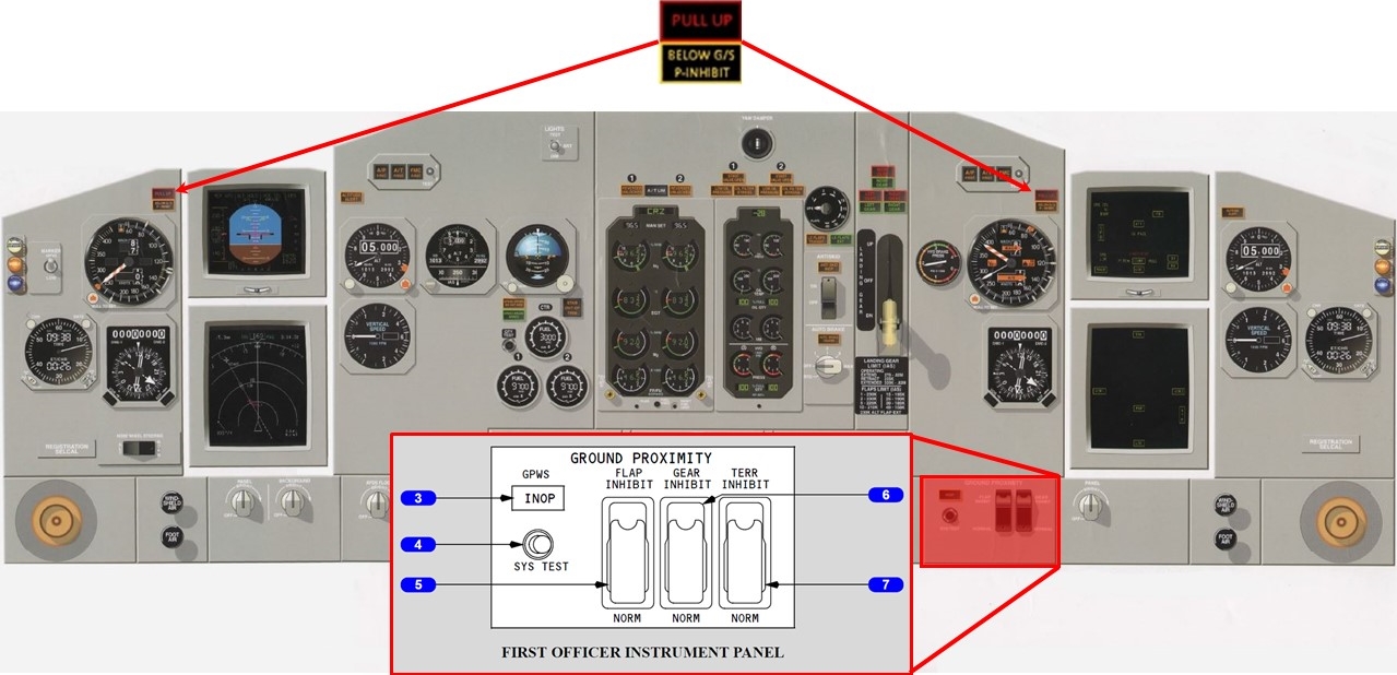
There were two EGPWS indicators and controls relevant to the unit’s operation. The instrument panel (Figure 4) includes the PULL UP warning light in the field of vision of both pilots.
The lower right section of the instrument panel included the GPWS controls. The terrain inhibit switch (7) in the NORM (guarded position) enabled EGPWS features. When selected to TERR INHIBIT, terrain/obstacle alerting was inhibited. Aircraft flight data identified that the first EGPWS alert had an associated inhibit signal. This inhibit signal was due to the flight crew selecting the terrain inhibit switch to ON following the first warning alert.
The Boeing 737 flight crew operations manual, which was the company’s approved reference, stated that the response for the TCF alerts was to correct the flight path, aircraft configuration, or airspeed. The manual also stated:
If a terrain caution occurs when flying under daylight VMC, and positive visual verification is made that no obstacle or terrain hazard exists, the alert may be regarded as cautionary and the approach may be continued.
The flight crew’s response to the first two EGPWS alerts did not appear to comply with the procedural requirements. The alerts did not occur in daylight VMC conditions and the crew’s visual reference with the runway or terrain was reported as intermittent. The crew’s response was stated to be due to the belief that the alert was the result of map shift issues and not because of ground proximity.
Comparison of FMS vs EGPWS position
The FMS did not have access to the EGPWS GPS information. The FMS recorded position of the aircraft at the time of the EGPWS alerts was compared against the position data recorded by the EGPWS. From the image below (Figure 5), it is evident that there was an FMS position error (approximately 1,065 m NW of the GPS position) at the time of EGPWS alerts. After the go-around, the FMS data appears to drift significantly (2,090 m north-north-west at landing), providing less reliable position information. It is important to note that the FMS derived position data was not required for the approach that was undertaken.
Figure 5: The flight data recorder data is shown below in blue and the EGPWS data is in red showing that, prior to the go-around, there was a 1.0 NM positional error to the flight management computer determined position
Source: Jeppesen, modified by the ATSB
Autothrottle go-around modes
There were two autothrottle go-around modes, the autopilot (AP) go-around (which required dual AP operation) and Flight Director (FD) go-around (which is the reversion mode when both APs were not engaged). The FD go-around required the aircraft to be in flight and below 2,000 feet radio altitude, and not in the take-off mode. The flight crew operations manual included the following discussion concerning the FD go-around mode:
With the first push of either take-off/go-around (TOGA) switch, the:
autothrottle (if armed) engages in go-around and advances thrust toward the reduced go-around N1[12] to produce 1,000 to 2,000 fpm rate of climb
autothrottle engaged mode annunciation on the flight mode annunciator (FMA) indicates go-around
AP (if engaged) disengages
pitch mode engages in TOGA and the pitch engaged mode annunciation on the FMA indicates TOGA
FD pitch commands 15 degrees nose up until reaching programmed rate of climb, and thereafter commands manoeuvring speed for each flap setting based on maximum weight calculations.
With the second push of either TOGA switch (if autothrottle engaged and after autothrottle reaches reduced go-around thrust), the autothrottle advances to the full go-around N1 limit.
The captain stated that he was not used to conducting a reduced thrust two engine go-around because he had always practiced a one-engine go-around in the simulator, which automatically provided full engine thrust from a single TOGA switch push. The captain stated that he had conducted a few full thrust go-arounds previously but in VMC conditions.
The Kosrae NDB/DME approach
The instrument approaches available for Kosrae were RNAV (GPS) approaches to runways 23 and 05, and the non-directional beacon (NDB) /distance measuring equipment (DME) approach. As VH-NLK was not fitted with GPS navigational equipment, the only instrument approach available to the flight was the NDB/DME approach.
The NDB/DME approach was classified as a circling approach only, due to the final approach course being offset from runway 05 heading by more than 30°. The missed approach point for this approach was at 2.9 DME with a minimum descent altitude of 500 ft.
According to the recorded data, prior to becoming established on the instrument approach, the aircraft overflew the NDB, turned onto the missed approach heading of about 300°, and then tracked outbound to the 10 DME arc before turning inbound on the 264° radial (see Figure 5). The recorded flight data identified that the aircraft descended below the published profile of 900 ft at 6.7 DME rather than 5 DME. The aircraft was required to remain at 500 ft until established on the final approach path for landing. However, the altimeter recorded 432 ft (radio altitude height of 306 ft) when the captain commenced the go-around.
Nauru Airlines procedures
Transition level
The flight crew reported that the transition level of FL 55 at Kosrae was lower than other ports in their network, which were typically FL 110 to FL 130. The crew stated that they had briefed the lower transition level prior to top of descent and had reminded themselves of the lower level while passing through FL 130. They also stated that the lower transition level, combined with increased crew workload on the approach due to deteriorating weather, led to the crew forgetting the approach checklist, therefore not setting the correct QNH.
The operator’s flight crew operating manual stated that setting the QNH during the descent required the local QNH to be set as the aircraft approached the transition level. Each pilot was required to call the exact altimeter indications and compare the indications to detect any discrepancy between instruments. Positive altimeter calls were also required to be carried out during the descent at FL 150, the transition level, and at 5,000 ft above aerodrome elevation.
As the local QNH was reported to be 1007 hPa and the crew left the QNH set at the standard pressure of 1013 hPa, the pilots’ altimeters were over-reading by 180 ft during the approach.
Instrument approach criteria
The company’s operations manual stated that ‘all approaches are to be flown in a stabilised manner with the aircraft established in the correct configuration no later than 1,000 ft above ground level for instrument approaches and 500 feet above ground level for visual approaches’.
The operations manual also required an NDB/DME approach to be flown using raw data.[13] A runway aligned GPS-based approach was available at Kosrae. At the time of the occurrence, the operator had established operational procedures for the use of GPS as the primary navigational aid for GPS-based approaches,[14] but the Civil Aviation Safety Authority had not authorised the operator to conduct RNAV (GPS) approaches.
The flight crew training manual (FCTM) specified that an approach was considered stabilised only when a number of criteria were met. Notably, these included:
the aircraft requiring only small changes in heading and pitch to maintain the correct flight path
the aircraft being in the correct landing configuration
all briefings and checklists having been conducted.
It also stated that unique approach procedures or abnormal conditions resulting in a deviation from the above elements required a special briefing. This was the case with the Kosrae approach, which required the flight crew to use a ‘dive and drive’[15] technique due to the unique structure of the approach, and then circling to align the aircraft to the landing runway.
The FCTM also contained recommended procedures for the conduct of circling approaches. The FCTM procedures included that the circling approach be conducted with the aircraft configured with landing gear down and flap 15 selected. The aircraft was required to be in the final landing configuration before the aircraft was established on final approach.
The captain assessed that, due to the need to conduct circling manoeuvring following the approach, there was a need for a special briefing. The approach required pitch and power changes due to the need to manoeuvre the aircraft from the missed approach point of the instrument approach to a point where the aircraft would be aligned with the runway for the final approach to landing. The manoeuvring was the result of the offset between the instrument approach course and the runway. There was also the requirement that this manoeuvring be conducted as a visual segment, and the consideration that the visual slope guidance would only provide useable information once the aircraft was aligned with the runway.
The circling approach procedure resulted in the delayed selection of flap 25 until the aircraft was at 740 ft (altimeter) and landing flap not being selected during the approach. The crew reported initially gaining visual reference with the runway environment at 900 ft. While the aircraft did not meet the operator’s stabilised approach criteria, the unique nature of the circling approach and the captain’s special briefing removed the need for strict compliance with these requirements.
Meteorological information
Sunset at the Marshall Islands Airport (departure aerodrome) was 0652 with the end of civil twilight at 0715. Sunset at Kosrae Airport was 0723 with the end of civil twilight 0745.
The terminal forecast for Kosrae held by the flight crew was issued on 11 June at 2339 UTC. It covered the period of 12 June from 0000 to 2400 UTC and stated the wind direction as 80° at 7 kt, visibility greater than 6 statute miles and showers in the vicinity of the aerodrome (not at the aerodrome, but between 5 to 10 statute miles from the aerodrome). The weather forecast provided to the flight crew did not require an alternate to be planned; however, the flight crew reported carrying sufficient fuel for a diversion to Nauru.
An aerodrome weather report (METAR) for Kosrae was issued on 12 June at 0750 UTC, approximately 70 minutes prior to the aircraft arriving overhead Kosrae. It stated the wind direction as 80° at 10 kt, visibility greater than 10 statute miles. It also stated that cloud was scattered at 1,500 ft and broken at 13,000 ft. The METAR did not include a trend forecast and there was no other indication that the local weather conditions would deteriorate.
The flight crew stated that, as they approached Kosrae, the weather deteriorated rapidly. They received regular updates on the changes from the Kosrae flight information services (FIS). During the approach, visibility began to fluctuate at or below 3 to 3.5 NM, the crew lost visual reference with the runway necessitating a missed approach. The flight crew reported that the FIS advised that the local barometric pressure was 29.74 in Hg (1007 hPa).
Flight data recorder information
The aircraft’s quick access recorder provided data regarding the aircraft’s pressure altimeter and the radio altimeter readings. Pressure altimeter information was sourced from the aircraft’s air data computer and was based on the standard pressure altimeter setting of 1013 hPa. A comparison of this pressure altitude information with the recorded radio altimeter information indicated that, on average during the approach, the aircraft’s height was about 120 ft lower than the pressure altimeter’s altitude reading.
Fatigue, workload and stress
Fatigue
Fatigue can have a range of adverse influences on human performance, such as slowed reaction time, decreased work efficiency, reduced motivational drive, increased variability in work performance, and more lapses or errors of omission (Battelle Memorial Institute 1998). Gawron, French, and Funke (2001) contend mental, or cognitive, fatigue is more central to performance degradation than physical fatigue. They state that cognitive fatigue can be ‘inferred from decrements in performance on tasks requiring alertness and the manipulation and retrieval of information stored in memory.’ (p. 581).
Researchers (see Staal, 2004, for a review) have identified that visual scanning and attentional processes have been shown to be particularly sensitive to disruption from performance degradation due fatigue. In addition, most people generally underestimate their level of fatigue.
Sleep is vital for recovery from fatigue, with both the quantity and quality of sleep being important. It is generally agreed that most people need at least 7 to 8 hours of sleep each day to achieve maximum levels of alertness and performance. Some research has concluded that less than 5 hours sleep in the previous 24 hours is inconsistent with a safe system of work (Dawson and McCullough 2005) whereas other research has shown that having less than 6 hours sleep affects performance (Thomas and Ferguson 2010, Williamson and others 2011).
At the time of the occurrence, the operator managed fatigue through the processes of flight hour and duty time limitations as required under Civil Aviation Orders 48.0 and 48.1. The operator had developed a fatigue risk management system, however, it was in a draft stage and not approved for use by the Civil Aviation Safety Authority.
Workload and stress
Dismukes and Berman (2010) conducted research on flight crew checklist use and monitoring behaviour. These researchers found that most instances of failure to monitor the aircraft state or position resulted from competing concurrent task demands on the crew’s attention. Humans have a limited ability to divide attention among tasks and generally have to switch attention back and forth between tasks. This leaves an individual vulnerable to losing track of the status of one task while being engaged in another.
Workload has been defined as ‘reflecting the interaction between a specific individual and the demands imposed by a particular task. Workload represents the cost incurred by the human operator in achieving a particular level of performance’ (Orlady and Orlady, 1999, p.203). An individual has a finite set of mental resources they can assign to a set of tasks. These resources can change given the individual’s experience and training and the level of stress being experienced at the time. An individual will seek to perform at an optimum level of workload by balancing the demands of their tasks. When workload becomes excessive the individual must, as a result of their finite mental resources, shed tasks.
Under conditions of stress, an individual’s attention will channel or tunnel. Focus on peripheral tasks will be reduced and centralised on to main tasks. What differentiates a main task from a peripheral task depends on what the individual perceives to be of greatest importance or greatest salience. Tunnelling of attention can result in either enhanced performance or reduced performance, depending on the nature of the task and the situation. ‘When peripheral cues are irrelevant to task completion the ability to tune them out is likely to improve performance. On the other hand, when these peripheral cues are related to the task and their incorporation would otherwise facilitate success on the task, performance suffers when they are unattended’ (Staal, 2004, p.31).
Emotional states have been described as providing a third processing layer on top of cognitive and physiological levels. ‘Emotions play an important role in motivating people to initiate and maintain a task in the first place, but they may also interfere with cognitive processing. In particular, under time pressure or threatening conditions, the regulation of our emotions is critical for efficient task performance’ (Gaillard, 2001, p.626).
Research on risk associated with approach and landing
In the late 1990s, the Flight Safety Foundation established the Approach and Landing Accident Reduction (ALAR) task force. The task force was commissioned to, among other things, identify common factors in approach and landing accidents and serious incidents involving turbine powered aircraft of a weight greater than 5,700 kg, and develop processes and guidance to aid operators in the reduction of these types of occurrences.
The ALAR task force identified a number of factors that were significant and common to approach and landing accidents and serious incidents. Some of these factors were also present in this occurrence, including an approach in instrument meteorological conditions (IMC), at night, in an environment where radar was not available, and where the flight crew use a non-precision instrument approach procedure.
The guidance material produced by the task force included the ALAR Risk Awareness Tool (RAT). Designed to increase flight crew’s awareness of factors that can increase the risk of an accident during approach and landing, the RAT is designed to be integrated into the approach briefing normally conducted before commencement of the descent. There were a number of factors from the RAT that identified an elevated level of risk associated with the occurrence approach. These included:
no ATC approach service or airport tower service
non-precision approach, especially with a step down procedure or circling procedure
visual approach in darkness
hilly or mountainous terrain
visibility restrictions, such as darkness or instrument meteorological conditions.
The RAT also makes the following point:
Greater risk is associated with conducting a nonprecision approach rather than a precision approach, and with conducting an approach in darkness and in IMC rather than in daylight and in VMC. The combined effects of two or more of these risk factors must be considered carefully.
The RAT also promotes the use of the missed approach or go-around manoeuvre when the safety of the approach or landing has become marginal, stating that ‘[f]ailure to recognize the need for a missed approach and to execute a missed approach is a major cause of approach-and-landing accidents’.
On 31 March 2014, an Airbus A320 departed Auckland, New Zealand for a scheduled passenger flight to Gold Coast, Queensland. On departure from Auckland, where the local QNH was 1025 hPa, the crew selected the standard atmospheric pressure of 1013 hPa on the altimeters during climb to flight levels.
During the cruise, about 15 minutes prior to commencing the descent for the Gold Coast, the crew obtained the automatic terminal information service (ATIS) for Gold Coast and the captain wrote the details onto the take-off and landing data (TOLD) card, including the local barometric pressure of 1018 hPa. The crew then conducted the approach briefing, including a review of this information, which was entered into the flight management guidance computer (FMGC) for the approach.
Approaching transition altitude, the ‘BARO REF’ warning flashed, however, the captain was communicating with ATC, hence the page in the FMGC with the QNH displayed was not selected.
The captain then completed the communication with ATC and commenced the transition check by stating ‘transition’. At this time, the captain omitted to select the FMGC onto the flight plan page to display the QNH that had been entered. The first officer stated ‘set QNH 1025’ and the captain entered that into the second altimeter and the first officer entered the same value into the standby altimeter and a cross check confirmed that all three altimeters matched.
Passing about 1,000 ft AMSL, as the first officer completed the turn onto final approach, he observed the T-VASIS indicating a ‘fly-up’ profile. The radio altitude callout of 500 ft sounded and the first officer realised that the approach path was incorrect. When at about 159 ft above ground level, the EGPWS ‘TERRAIN’ warning sounded, and the first officer commenced the missed approach. The crew checked the QNH on the TOLD card and realised an incorrect QNH had been set.
International overview of go-around events
Although most go-arounds are conducted without significant problems, difficulties are experienced. As part of its detailed review of go-around issues, the French Bureau d’Enquêtes et d’Analyses pour la sécurité de l’aviation civile (BEA) (2013) conducted a survey of flight crews from several French and British airlines. Key results included:
About 60 per cent of pilots indicated that they had encountered difficulties during the conduct of a go-around manoeuvre. The most common difficulties were capturing the go-around altitude, auto-flight system management, aircraft configuration management, coping with modifications to the flight path on ATC request and visual scan management.
About 85 per cent of pilots reported that they were adequately trained in go-arounds with one engine inoperative but almost half the pilots indicated that they were not sufficiently trained for go-arounds with all engines operating.
The BEA’s analysis of the survey results stated that a key problem was:
The sudden onset of new tasks, the need to perform vital, rapid and varied manoeuvres, and the rapid changes in the numerous parameters to be managed (controlled) in a limited period of time combine to make it difficult for a crew to perform a go-around that is not controlled right from the start.
In its conclusions, the BEA stated that ‘aeroplane state awareness during go-around’ type events involved a combination of factors, including time pressure and a high workload; and the low number of go-arounds with all engines operating performed by crews, both in-flight and in the simulator. The BEA issued a significant number of recommendations to the European Aviation Safety Agency relating to go-around issues.
While positioning the aircraft to commence the non-directional beacon/distance measuring equipment (NDB/DME) approach into Kosrae airport, Federated States of Micronesia, the approach checklist was not completed and so the altimeters were not set to the local barometric pressure. This resulted in the aircraft’s actual altitude being180 ft lower than the pressure altimeter’s reading. Three enhanced global positioning warning system (EGPWS) ‘Too Low Terrain’ alerts were triggered due to the aircraft's altitude being below the minimum terrain clearance.
The flight crew believed that the EGPWS alerts were due to decreased navigational performance and not terrain proximity. This led to the flight crew’s decision to inhibit the first EGPWS alert and not correct the flight path prior to their deciding to perform a go-around manoeuvre.
The captain stated that he was fatigued and the crew stated that they were experiencing increased workload. This appears to be due to the flight being the inaugural regular public transport flight into Kosrae, conducted at night in rapidly deteriorating weather. Fatigue, workload and stress appear to have affected the crew’s decision making and task execution on the missed approach.
This analysis will examine the type of approach procedure available to the flight crew for Kosrae, the operator’s operational procedures, the conduct of the go-around manoeuvre and the effects of fatigue, workload and stress on the occurrence.
Level of risk associated with the approach
The Flight Safety Foundation’s Approach and Landing Accident Reduction task force provided a number of focal points that were present in the occurrence approach into Kosrae, which in turn indicated an elevated level of risk associated with that approach.
Risk associated with the localised high terrain was mitigated by the aircraft having EGPWS based warning systems fitted. Risk factors of a night-time approach into an airport without a manned tower were the result of delays encountered over the previous sectors, issues that should be considered by the operator in a risk analysis for operations into Kosrae before commencing these operations. A further risk factor necessary for consideration prior to commencing operations into Kosrae was that there were only two types of instrument approaches: runway aligned GPS-based approaches, and the offset non-precision approach. As the occurrence aircraft was not fitted with equipment required for GPS based approaches, and the operator not approved to conduct them, the only option for operations into Kosrae was to conduct a non-precision approach. This elevated the risk associated with the approach, and that risk was further amplified by:
the approach necessitating a ‘dive and drive’ profile due to:
the offset of the final approach course from the runway heading
the location and height of the missed approach point, which was well below a normal 3 approach profile.
the need to conduct low level manoeuvring from the missed approach point to enable the aircraft to align with the runway.
The aircraft’s navigation system also represented a significant risk factor in the conduct of this approach. While the operator’s procedure required the use of raw navigational data for the approach, the use of an NDB as a primary approach aid is subject to several effects that can result in error, including the night effect, thunderstorm activity and localised high terrain, which were all potential sources of navigation error in this occurrence.
Further, due to the limited number of navigation aids available on the occurrence sector, the navigation system was dependent on inertial reference for position data. This will often result in the ‘map shift’ error being presented to the pilots, where the pilot’s navigation displays are significantly ‘shifted’ from the actual real-world position of the displayed data, and can contribute flight crew error. With respect to the occurrence flight, the flight crew incorrectly believed that the initial EGPWS alerts were the result of a ‘map shift’ error; however, a comparison between the aircraft’s quick access recorder data and the EGPWS GPS data identified a map shift error of about 1 NM seawards of where the aircraft’s actual position was.
The flight crew’s conduct of a briefing for the approach, and decision to perform a go-around when visual contact with the runway was lost, mitigated the risks to some extent.
Approach checklist
Prospective memory can be defined as the intention to perform an action in the future, coupled with a delay between recognising the need for action and the opportunity to perform it. A distinguishing feature of prospective memory is the need for an individual to remember that they need to remember something. Researchers (Dismukes, 2006) have identified that prospective memory issues may result in a failure to return to a task or procedure that has been interrupted, even when the task or procedure is habitual.
The crew had briefed the new transition level at top of descent and had briefly discussed the need to conduct the approach checklist on passing through the transition level when they were descending through FL 130 (the usual transition level). The crew had put a plan in place to complete the checklist. However, as they were flying over the non-directional beacon at FL 050 and were looking at the runway in preparation for the commencement of the approach, workload began to rise and they forgot to return to the approach checklist and complete it, as per a prospective memory error. Thus, as the aircraft descended through the transition level, the altimeters were not set to the local barometric pressure from the standard pressure setting of 1013 hPa and, as a result were over-reading the aircraft’s altitude by 180 ft. The aircraft’s actual height was, on average, 120 ft lower than the aircraft’s indicated altitude.
EGPWS warnings and crew response
The EGPWS issued a series of Terrain Clearance Floor (TCF) alerts during the NDB/DME approach into Kosrae. The EGPWS recorded data for a period around the EGPWS events. At the beginning of recording, the aircraft was 5.1 NM from the runway, with landing gear down, at a radio altimeter height of 663 feet and a vertical speed of -1,011 fpm. At approximately 19, 25 and 61 seconds after the commencement of the EGPWS recording, the EGPWS issued a ‘TOO LOW TERRAIN’ alert due to the aircraft’s penetration of the TCF envelope.
The EGPWS also recorded a ‘terrain inhibit’ parameter which corresponded to the pilot selection of the terrain inhibit feature. In the recorded data, the terrain inhibit was activated for two seconds, occurring four seconds after the beginning of the first TCF alert.
The flight crew stated that they heard the EGPWS warning prior to their reaching the missed approach point (MAP) and that they had the runway lights in sight although the visibility was fluctuating, and decided to keep going because they had a visual reference for the runway. Furthermore, the flight crew thought the warnings were due to map shift. Therefore, the flight crew believed the warnings were false and inhibited the first warning due to this belief.
The operator’s operations manual stated that, in instrument meteorological conditions (IMC), all EGPWS alerts were to be treated as genuine and flight crew must take rectification or avoidance action immediately. The operator’s flight crew operations manual stated that if positive visual verification was made that no obstacle or terrain hazard existed when flying under daylight VMC conditions prior to a terrain or obstacle warning, the alert could be regarded as cautionary and the approach continued.
The investigation found that the approach was being conducted at night in intermittent visual conditions prior to the aircraft going into IMC conditions just prior to the MAP. In these conditions, the EGPWS warnings should have been treated as genuine and action taken immediately rather than the crew inhibiting the alert.
Fatigue, workload and stress
The captain’s mother had become ill and her health had severely degraded by the time the captain arrived in Nauru from Brisbane. The captain stayed with her at the hospital for as long as possible before returning to his hotel where he had a disrupted night’s sleep of less than 6 hours. At the time of the EGPWS warnings, the captain had been awake for about thirteen hours and reported feeling fatigued.
The crew reported that their workload increased following the EGPWS alerts due to the deteriorating weather and distraction of the Kosrae flight information service (FIS) providing wind velocity change and visibility updates. The first officer stated that the FIS updates interrupted the crew’s working through checklists, as they needed to listen and respond. The effect of the increased workload would have been exacerbated by the stress of flying the operator’s inaugural RPT flight into Kosrae with Nauruan dignitaries on board.
For the captain, the workload would have been further exacerbated by the stress of his mother’s illness and the fatigue of a disrupted night’s sleep. The captain stated that in hindsight, he should have removed himself from the flight but didn’t want to as he was only one of two Nauruan captains employed by the operator and it was his turn to fly an important flight. He did not inform the operator of his mother’s illness.
On the decision to go-around, the captain pressed the takeoff/go-around button only once instead of twice, which resulted in a reduced thrust rather than a full power go-around. The aircraft was pitched up initially to 15° but was then pitched back down to increase the decaying airspeed. Soon after, the aircraft was at its lowest height of 200 ft by the radio altimeter. Given the increased workload of the crew, and the effects of stress and fatigue on the captain, the aircraft state, airspeed and attitude was not effectively monitored by either crew member following the go-around decision. Therefore, the execution of the go-around task and its attendant decision making was not performed effectively.
The go-around manoeuvre and recurrent training
The survey on the conduct of the go-around manoeuvre by the Bureau d’Enquêtes et d’Analyses (BEA, 2013) identified that it was common for the pilot flying to experience aircraft handling difficulties during the initial phase of the all-engine go-around manoeuvre, and that there was a general lack of training for the all-engine go-around manoeuvre.
With respect to the incident pilot’s handling issues during the go-around, these may have been affected by fatigue, workload and stress. However, it is also likely that these handling issues were contributed to by the limited training for the all-engine full-thrust go-around. The development of a recurrent training syllabus is a complex process and, as well as meeting specific regulatory requirements, involves operators making decisions about which of many important tasks and situations need to be included in each session. Go-arounds with one engine inoperative are typically conducted in every recurrent training session, and there has been increasing recognition that regularly practicing all-engine go-arounds is also important (BEA, 2013). Although the procedural steps are fundamentally the same, the increase in energy and time pressure associated with an all-engine go-around provides different challenges.
There are many permutations of the go-around task that need to be covered in recurrent training. A lesson from this occurrence and many similar occurrences is that flight crews should be regularly exposed to the time pressure and challenge of conducting full thrust go-arounds.
At the time of the occurrence, the operator did not include full-thrust go-arounds as part of their simulator-based recurrent training for their pilots. Although the inclusion of more go-around training including these aspects will reduce the overall risk associated with go-arounds, it is difficult to conclude that they would necessarily have reduced the likelihood of this occurrence.
Findings
From the evidence available, the following findings are made with respect to the Enhanced Ground Proximity Warning System (EGPWS) alerts involving a Boeing 737-300, VH-NLK, at Kosrae International Airport, Federated States of Micronesia, on 12 June 2015. These findings should not be read as apportioning blame or liability to any particular organisation or individual.
Safety issues, or system problems, are highlighted in bold to emphasise their importance. A safety issue is an event or condition that increases safety risk and (a) can reasonably be regarded as having the potential to adversely affect the safety of future operations, and (b) is a characteristic of an organisation or a system, rather than a characteristic of a specific individual, or characteristic of an operating environment at a specific point in time.
Contributing factors
The flight crew did not complete the approach checklist before commencing the non-precision NDB approach into Kosrae. As a result, the altimeters' barometric pressure settings remained at the standard setting of 1013 hPa instead of being set to the reported local barometric pressure of 1007 hPa. The flight crew descended the aircraft to the minimum descent altitude of 500 ft as indicated by the altimeters, however, due to the barometric pressure setting not being reset, the aircraft descended to a height significantly below 500 ft.
The crew descended the aircraft in IMC and at night below the approach profile for the Kosrae runway, resulting in EGPWS alerts. Terrain clearance assurance was eroded further by the flight crew not correcting the flight profile until the flight crew lost visual contact with the runway.
The flight crew's belief that the EGPWS warnings were due to a decreased navigational performance and not terrain proximity led to their decision to inhibit the first EGPWS warning and not correct the flight path.
Due to the captain’s fatigue and the increased workload and stress associated with the inaugural regular public transport flight into Kosrae at night in rapidly deteriorating weather, the crew’s decision making and task execution on the missed approach were affected.
Other factors that increased risk
The crew’s recurrent training had not included B737-300 full thrust go-around simulations.
The operator commenced regular public transport operations into Kosrae with the only instrument approachavailable for use beingan offsetprocedure based on a non-precision navigation aid. The risk associated with this type of approach was amplified due to the need to use a 'dive and drive' style technique instead of a stable approach path, and that it required low level circling manoeuvring from the instrument approach to align the aircraft with the runway. Furthermore, there was very high terrain in close proximity to the runway and the airport did not have a manned air traffic control tower. For this occurrence, the risk was further elevated as a result ofthe approach being conducted at night-time in poor weather conditions. [Safety issue]
Safety issues and actions
The safety issues identified during this investigation are listed in the Findings and Safety issues and actions sections of this report. The Australian Transport Safety Bureau (ATSB) expects that all safety issues identified by the investigation should be addressed by the relevant organisation(s). In addressing those issues, the ATSB prefers to encourage relevant organisation(s) to proactively initiate safety action, rather than to issue formal safety recommendations or safety advisory notices.
Depending on the level of risk of the safety issue, the extent of corrective action taken by the relevant organisation, or the desirability of directing a broad safety message to the [aviation, marine, rail - as applicable] industry, the ATSB may issue safety recommendations or safety advisory notices as part of the final report.
The initial public version of these safety issues and actions are repeated separately on the ATSB website to facilitate monitoring by interested parties. Where relevant the safety issues and actions will be updated on the ATSB website as information comes to hand.
Elevated risk from non-precision approach with low-level circling and non-stabilised approach procedure
The operator commenced regular public transport operations into Kosrae with the only instrument approach available for use being an offset procedure based on a non-precision navigation aid. The risk associated with this type of approach was amplified due to the need to use a 'dive and drive' style technique instead of a stable approach path, and that it required low level circling manoeuvring from the instrument approach to align the aircraft with the runway. Furthermore, there was very high terrain in close proximity to the runway and the airport did not have a manned air traffic control tower. For this occurrence, the risk was further elevated as a result of the approach being conducted at night-time in poor weather conditions.
Additional safety action
Whether or not the ATSB identifies safety issues in the course of an investigation, relevant organisations may proactively initiate safety action in order to reduce their safety risk. The ATSB has been advised of the following proactive safety action in response to this occurrence.
Proactive safety action taken by: Nauru Airlines
On 18 September 2017, Nauru Airlines stated that they had addressed the recommendations they had made as part of their internal investigation report into the occurrence. The actions taken appear below:
A review of the cyclic training program was undertaken by the Flight Standards Manager (FSM) with a focus on providing more flight crew training time to enable skill levels associated with non-standard/non-routine activities to be enhanced. The FSM has re-written the simulator program, changing it to two days twice a year in lieu of one day four times a year. This will provide flight crew with at least two full days of training instead of trying to fit training and checking in during a four-hour session. The training program has been drafted, but not yet implemented.
A review of the descent and approach checklist card type, content and location was completed. A control column checklist incorporating tactile indicators was put into operation within weeks of the event.
Two engine go-around training was included in the first simulator session following the event. This continues to be covered regularly.
Performance based navigation (PBN) ground schools have reminded crew of QNH setting requirements. In addition, a pilot notice was issued to remind crew of the QNH validity period (15 minutes).
A review of the options available for the most appropriate time to set the transition altitude QNH setting was undertaken soon after the event. The review identified that there is no foolproof method, and that this was a problem with most airlines. It was decided to stay with the current policy but increase training and checking of this procedure.
For all flight standards meetings conducted after the event, discussions on events that could arise from not setting QNH at the transition altitude have been included. Also included are, discussions of different transition altitudes on the company network and the different types of terrain that could be encountered in the airline’s current and future network of operations. Terrain considerations are now mentioned in the operations manuals and will be incorporated in the new route manual.
A review of the human factors and non-technical skills (HF-NTS) course content to include relevant points from this event into the applicable modules has been assigned.
Soon after the event, additional emphasis was placed on the importance of correct briefing and NTS in line checks. This is now being carried out during line and simulator checks.
General details
Captain details
Licence details:
Air Transport Pilot (Aeroplane) Licence Issued 22 Sep 1998
Endorsements:
Included relevant endorsements for the relevant B737 types.
Ratings:
Command (M/E Aeroplane) issued 22 Sep 1998. Instrument Rating Command (M/E Aeroplane) renewal dated 17 Jun 2014, with an expiry date of 30 Jun 2015.
Medical certificate:
Valid and current – completed 16 Feb 2015
Aeronautical experience:
16,600 hours flying experience
Last flight review:
14 Feb 2015
First Officer details
Licence details:
Air Transport Pilot (Aeroplane) Licence Issued 17 Sep 2013
Endorsements:
Included relevant endorsements for the relevant B737 types
Ratings:
Command (M/E Aeroplane) issued 09 Jan 2009.
Medical certificate:
Valid and current – completed 1 Oct 2014
Aeronautical experience:
3,300 hours flying experience
Last flight review:
3 Mar 2015
Sources and submissions
Sources of information
The sources of information during the investigation included the:
flight crew and operator of VH-NLK
aircraft enhanced ground positioning warning system (EGPWS)
EGPWS manufacturer
The US Federal Aviation Administration
Airservices Australia
Civil Aviation Safety Authority.
References
Battelle Memorial Institute. (1998). An Overview of the scientific literature concerning fatigue, sleep, and the circadian cycle, Report prepared for the Office of the Chief Scientific and Technical Advisor for Human Factors, US Federal Aviation Administration.
Bureau d’Enquêtes et d’Analyses pour la sécurité de l’aviation civile (BEA). (2013). Study on aeroplane state awareness during go-around. Available from www.bea.aero/etudes/asaga/asaga.php
Dawson, D., & McCulloch, K., (2005). ‘Managing fatigue: It’s about sleep’, Sleep Medicine Reviews, vol. 9, pp. 365-380.
Dismukes, K. (2006). Concurrent task management and prospective memory: pilot error as a model for vulnerability of experts. In Proceedings of the Human Factors and Ergonomics Society 50th Annual Meeting – 2006, pp. 909-913.
Dismukes, R.K. and Berman, B. (2010). Checklists and monitoring in the cockpit: Why crucial defences sometime fail. National Aeronautics and Space Administration Technical Memorandum NASA/TM-2010-216396. Ames Research Centre: Moffett Field, US.
Flight Safety Foundation (FSF) (1998). Flight Safety Digest, November 1998—February 1999: “Killers in Aviation”. Available from flightsafety.org
Gaillard, A.W.K. (2001). Stress, workload and fatigue as three biobehavioural states: A general overview. In P.A. Hancock, & P.A. Desmond (Eds.), Stress, workload, and fatigue. Mahwah, NJ: L. Erlbaum.
Gawron, V.J., French, J., & Funke, D. (2001). An overview of fatigue. In P.A. Hancock, & P.A. Desmond (Eds.), Stress, workload, and fatigue. Mahwah, NJ: L. Erlbaum.
Orlady, H.W., & Orlady, L.M. (1999). Human factors in multi-crew flight operations. Ashgate: Aldershot, UK p.203.
Thomas, M.J.W., & Ferguson, S.A., (2010). Prior sleep, prior wake, and crew performance during normal flight operations, Aviation, Space, and Environmental Medicine, vol. 81, pp. 665-670.
Staal, M.A. (2004). Stress, cognition and human performance: A literature review and conceptual framework. National Aeronautics and Space Administration Technical Memorandum NASA/TM–2004–212824. Ames Research Centre: Moffett Field, US.
Williamson, A., Lombardi, D.A., Folkard, S., Stutts, J., Courtney, T.K., & Connor, J.L., (2011). The link between fatigue and safety, Accident Analysis and Prevention, vol. 43, pp. 498-515.
Submissions
Under Part 4, Division 2 (Investigation Reports), Section 26 of the Transport Safety Investigation Act 2003 (the Act), the Australian Transport Safety Bureau (ATSB) may provide a draft report, on a confidential basis, to any person whom the ATSB considers appropriate. Section 26 (1) (a) of the Act allows a person receiving a draft report to make submissions to the ATSB about the draft report.
A draft of this report was provided to the flight crew, Nauru Airlines, the Federated States of Micronesia, and the Civil Aviation Safety Authority.
Submissions were received from the Civil Aviation Safety Authority and Nauru Airlines. The submissions were reviewed and where considered appropriate, the text of the report was amended accordingly.
Purpose of safety investigations
The objective of a safety investigation is to enhance transport safety. This is done through:
identifying safety issues and facilitating safety action to address those issues
providing information about occurrences and their associated safety factors to facilitate learning within the transport industry.
It is not a function of the ATSB to apportion blame or provide a means for determining liability. At the same time, an investigation report must include factual material of sufficient weight to support the analysis and findings. At all times the ATSB endeavours to balance the use of material that could imply adverse comment with the need to properly explain what happened, and why, in a fair and unbiased manner. The ATSB does not investigate for the purpose of taking administrative, regulatory or criminal action.
Terminology
An explanation of terminology used in ATSB investigation reports is available here. This includes terms such as occurrence, contributing factor, other factor that increased risk, and safety issue.
Publishing information
Released in accordance with section 25 of the Transport Safety Investigation Act 2003
Ownership of intellectual property rights in this publication
Unless otherwise noted, copyright (and any other intellectual property rights, if any) in this report publication is owned by the Commonwealth of Australia.
Creative Commons licence
With the exception of the Coat of Arms, ATSB logo, and photos and graphics in which a third party holds copyright, this publication is licensed under a Creative Commons Attribution 3.0 Australia licence.
Creative Commons Attribution 3.0 Australia Licence is a standard form licence agreement that allows you to copy, distribute, transmit and adapt this publication provided that you attribute the work.
The ATSB’s preference is that you attribute this publication (and any material sourced from it) using the following wording: Source: Australian Transport Safety Bureau
Copyright in material obtained from other agencies, private individuals or organisations, belongs to those agencies, individuals or organisations. Where you wish to use their material, you will need to contact them directly.
Occurrence summary
Investigation number
AO-2015-066
Occurrence date
12/06/2015
Location
Kosrae International Airport, Federated States of Micronesia
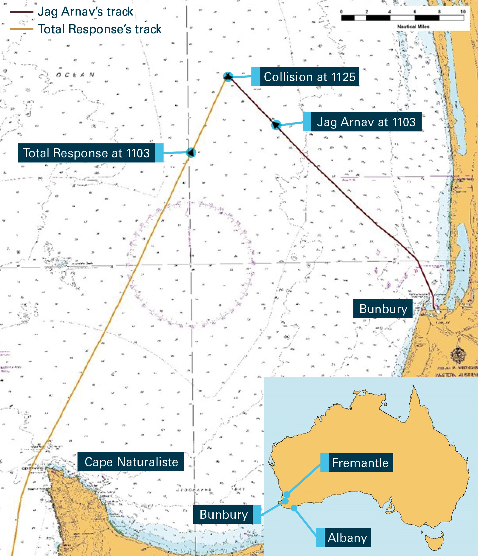
On 23 June 2015, in daylight with clear visibility, the bulk carrier Jag Arnav and fast utility vessel Total Response collided about 26 NM north-west of Bunbury, Western Australia. Jag Arnav sustained minor damage and no injuries to the crew. Total Response sustained structural damage to its bow and deck, and two crew members received lacerations and abrasions. Both vessels were able to resume their passage.
What the ATSB found
The ATSB found that a proper and effective lookout by all available means as required by the regulations was not being maintained on either vessel.
The investigation found that Total Response’s unqualified deckhand was performing the duties of deck watchkeeper without adequate supervision. Jag Arnav was not detected by anyone on board Total Response and consequently, no avoiding action was taken. The investigation considered it likely that the chief mate and deckhand on board Total Response were at least in a state of reduced alertness attributable to environmental factors including workload prevalent on the day.
The investigation also identified that Jag Arnav’s officer of the watch, the third officer, did not maintain an effective lookout despite various electronic aids to navigation detecting Total Response. The third officer reported visually detecting Total Response, but incorrectly assessed the vessel to be passing clear. No use was made of other available means such as radar or automatic identification system to confirm the assessment and determine risk of collision. Therefore, no action was taken to avoid collision with Total Response.
What's been done as a result
The owner of Jag Arnav, the Great Eastern Shipping Company, advised that it has circulated its report into the collision to other ships that they manage and will provide additional training for navigation officers. The company has also emphasised their requirements as laid out in its safety management system with regard to the use of radar for position fixing, acquiring observed targets, use of automatic target acquisition and the use of radar overlay on the electronic chart display and information system.
Safety message
Over the past 28 years, the ATSB or its predecessors have investigated 38 collisions between trading ships and small vessels on the Australian coast. These investigations have found that failure to keep a proper and effective lookout and to take early and effective avoiding action are recurring contributing factors to these collisions. This was again highlighted by this accident.
The detection of other vessels is the first step in assessing the risk of a collision and taking avoiding action. Systematic visual observations and active use of electronic equipment designed to detect and monitor other vessels can reduce the risk of vessels going undetected or the risk of a collision being incorrectly assessed. Early detection, monitoring and correct assessment of the risk of a collision ensures that timely and appropriate avoiding action can be taken.
The occurrence
On 20 June 2015, at about 1900 Western Standard Time,[1] the 19.9 m long fast utility vessel, [2]Total Response (Figure 1), sailed from Albany, Western Australia bound for Fremantle. The vessel’s crew comprised the skipper, chief mate and deckhand. The skipper and chief mate were to share the deck watchkeeper duties for the expected 20-hour passage.
During the passage, the vessel encountered adverse weather. The skipper diverted the vessel to Augusta and moored there to wait out the weather.
Figure 1: The fast utility vessel, Total Response
Source: Total AMS (TAMS)
Whilst laid up at Augusta, waiting for the adverse weather to subside, Total Response’s crew carried out routine maintenance. On 23 June, at about 0430, Total Response departed Augusta. The skipper navigated the ship out of the harbour and remained in the wheelhouse as deck watchkeeper.
At about 0700, the chief mate took over the duties of deck watchkeeper from the skipper. The deckhand joined them in the wheelhouse and the three men made light conversation. The weather and visibility were good with a light (5 knots) south-easterly wind. By about 0920, Total Response had rounded Cape Naturaliste for the final leg of its passage toward Fremantle. The auto-pilot was set on a heading of 027º and the vessel was making good about 16 knots.[3]
At about 1000, the chief mate and skipper decided to give the deckhand the opportunity to act as deck watchkeeper to aid in the deckhand gaining experience towards a deck watchkeeper qualification. The chief mate handed over the watch to the deckhand who took up the seat at the helm console (Figure 2). The chief mate moved to the table behind the deckhand and began using his laptop computer. The skipper was seated at the table on the other side of the wheelhouse.
Meanwhile, Jag Arnav was near the coast to the east of Total Response. The 229 m long bulk carrier had just sailed from Bunbury (Figure 3) for the United Arab Emirates. The master, third officer and a duty seaman were on the ship’s navigation bridge (bridge).
Figure 2: Locations of personnel in Total Response's wheelhouse
Source: TAMS, annotated by the ATSB
At about 1012, Jag Arnav’s master ordered a heading of 317° and increased speed to 12 knots for the sea passage. The ship was placed on auto-pilot and the visibility was ‘good’ (greater than 6 NM). The x-band[4] radar was set to a 6 NM range scale and the s-band[5] radar to a 12 NM range scale. The master handed over navigational responsibilities to the third officer who was the officer of the watch and switched on the bridge navigational watch alarm system.[6]
At about 1030, the master dismissed the duty seaman from the bridge and instructed him to go on deck and help the crew secure the ship for sea.
At about 1042, an alarm on the x-band radar was activated by a spurious radar echo. The alarm was acknowledged, but there were no radar targets on either radar’s display at that time.
Shortly after 1044, a faint target echo appeared on the s-band radar display on a true bearing of 251º at a distance of about 12 NM. Over the next 5 minutes, the echo became stronger and its ‘target trail’[7] became evident. The target echo was that of Total Response. No attempt was made by the third officer to acquire or track the target and neither radar’s automatic target acquisition[8] function was turned on at the time.
Meanwhile, in Total Response’s wheelhouse, the skipper told the deckhand to keep the vessel on the track displayed on the chart plotter[9] located near the helm console. The skipper also told the deckhand ‘not to touch anything, to keep a lookout and call him if he had any problems’. He then retired to his seat to rest. The chief mate had finished using his computer and remained at the table behind the deckhand. Shortly after taking over the watch from the chief mate at 1000, the deckhand observed the automatic identification system[10] (AIS) icon of a vessel near the coast on the chart plotter display. The deckhand did not report this to the chief mate or the skipper as he assumed the chief mate was already aware of it.
Figure 3: Section of navigational chart Aus 334 showing the tracks of both vessels
Source: Australian Hydrographic Service, annotated by the ATSB using electronically recorded data
At about 1100, Jag Arnav’s s-band radar indicated Total Response’s target echo on a 251º bearing at a distance of 7.4 NM. By this time, Total Response’s AIS icon had also appeared on the radar display. The third officer reported he sighted a vessel at about the same time on a bearing of about 4 points[11] on the port bow. Based on his visual observations, the third officer assessed the vessel would pass clear ahead of Jag Arnav and therefore maintained Jag Arnav’s course and speed. The third officer also fixed the ship’s position on the paper navigational chart and continued to do so at 5-minute intervals until the collision.
Shortly after, at about 1103, Total Response’s radar echo and AIS icon also appeared on the x‑band radar display (Figure 4).
At about 1112, Total Response was 4 NM away from Jag Arnav and still on a bearing of 251º. The vessel’s radar echo, trail and AIS icon were conspicuous on both of the ship’s radar displays. Neither radar’s automatic radar plotting aid[12] function was used to track Total Response.
At 1119, Total Response was about 2 NM away on the same steady bearing. The vessel had maintained its course and speed with the deckhand seated at the helm console. The chief mate was still situated behind the deckhand while the skipper rested on the seat on the other side of the wheelhouse.
Figure 4: Images of Jag Arnav's s-band (L) and x-band (R) radars at 1103
The images show Jag Arnav’s s-band radar set on a 12 NM range scale and the x-band radar set on a 6 NM range scale. Source: Jag Arnav’s voyage data recorder (VDR), annotated by the ATSB
On board Jag Arnav, the third officer reported sighting Total Response again just before the collision on a bearing of about 2 points on the port bow and again assessed the vessel to be passing clear ahead of Jag Arnav. At about 1124, the deck cadet working on the port side of the main deck noticed Total Response off the port beam, closing on the ship. He called the bridge using a handheld radio and reported the rapidly approaching vessel to the third officer who was near the chart table.
At about 1125, as the third officer acknowledged the cadet’s radio call, Total Response collided with Jag Arnav near its number two cargo hold on the port side. The master had also heard the radio call and had gone to the port bridge wing where he saw Total Response close astern. Realising there had been a collision, he took over from the third officer and began manoeuvring the ship to assist the vessel if required.
The force of the impact was such that the deckhand, chief mate and skipper of Total Response were thrown from their positions. Woken suddenly, the skipper quickly took over the vessel’s controls and manoeuvred clear of the ship. He then checked on his crew and found both the chief mate and deckhand had suffered abrasions and lacerations, including to their heads.
Shortly afterwards, the master of Jag Arnav established VHF radio contact with Total Response’s skipper and they exchanged information. After inspecting the vessel, the skipper confirmed that no assistance was required. Total Response’s bow had been damaged, but the hull was intact. Water was entering the engine room via the stern tube of the port propeller shaft and a bilge pump was used to pump it out.
At about 1156, Total Response’s skipper resumed its passage to Fremantle.
Jag Arnav’s crew inspected its hull, including cargo holds and tanks. No structural damage, other than a small indent where the vessel had impacted the hull, was found. At about 1445, after completing the necessary incident reporting, Jag Arnav’s master resumed its voyage.
Jag Arnav was a 229 m long bulk carrier registered in India and classed with Class NK. The ship was owned and managed by the Great Eastern Shipping Company (GESC), India. Its crew of 24 Indian nationals had joined the ship 1 month before the collision when GESC had taken delivery of the new ship from a shipyard in the Philippines.
The ship’s master held a master’s certificate of competency. He had 8 years of seagoing experience, the last five with GESC, and had been sailing as a master for 12 months.
The third officer had 18 months of seagoing experience, including his time as a deck cadet, all of it with GESC. Jag Arnav was his first ship as a deck officer after obtaining a second mate’s certificate of competency. During the 3 weeks at sea after sailing from the Philippines, he had kept navigational watches under the supervision of the master or chief mate as per GESC procedures for new deck officers.
Jag Arnav was equipped with all the navigational equipment required by the International Convention for the Safety of Life at Sea (SOLAS)[13] for a new ship of its size. The equipment included an electronic chart display and information system as the primary means of navigation (with paper nautical charts provided as back-up) and two radars. Both radars had automatic radar plotting aid and automatic target acquisition capability as well as data input from the automatic identification system (AIS) and GPS units. Jag Arnav was also fitted with a voyage data recorder (VDR)[14] and a bridge navigational watch alarm system.
GESC established a Quality, Safety and Environment Protection System throughout its fleet in accordance with the International Management Code for the Safe Operation of Ships and for Pollution Prevention (ISM Code).[15] This safety management system (SMS) comprised clearly defined policies and procedures that were documented and compiled in the form of manuals. The Fleet Operations Manual provided guidance and instructions concerning the safe navigation of the company’s ships based on relevant mandatory international regulations such as The International Regulations for Preventing Collisions at Sea, 1972, as amended (COLREGs) and the International Convention on Standards of Training, Certification and Watchkeeping for Seafarers (The STCW Code).[16]
The STCW Code, which prescribes minimum standards relating to training, certification and watchkeeping for seafarers, comprehensively covers the subject of the lookout.[17] Both the shipboard SMS procedures and the Code allowed the officer on watch to be the sole lookout in daylight provided it is safe to do so; taking into account factors such as weather, visibility, traffic density and proximity of navigational dangers. The STCW Code also requires that assistance be readily available to be summoned to the bridge should it be required.
Total Response
Total Response was registered in Western Australia as a domestic commercial vessel and was managed by Total AMS (TAMS) in accordance with the National Standard for Commercial Vessels (NSCV).[18]
The vessel was fitted with all the navigation equipment required by the NSCV for a vessel of its class. The equipment fitted included radar, GPS, autopilot, VHF and AIS. It was also fitted with a C‑Plot 95 electronic chart plotter with inputs from GPS and AIS. A bridge navigational watch alarm system was not required for a vessel of Total Response’s class.
The NSCV required Total Response’s core manning to comprise at least an appropriately qualified master (skipper) and an engineer. If the master also held engineer qualifications, the other crew member could be ‘uncertificated’. The NSCV also required that voyage duration, area and type of operation, passenger numbers and other factors be taken into account to determine an ‘appropriate crew’ in addition to the core manning. TAMS had decided that the skipper, chief mate and deckhand was appropriate manning for the voyage from Albany to Fremantle.
The skipper was appropriately qualified for his role[19] with about 9 years at sea, with the last year with TAMS, for the most part as skipper and engineer of Total Response.
The chief mate was also qualified for his role[20] and came from a fishing background with about 38 years of seagoing experience, the last five with TAMS, mostly on tugs towing barges.
The deckhand had joined Total Response in Albany for the voyage to Fremantle with about 8 years of seagoing experience, the last three with TAMS. His position on Total Response was as ‘uncertificated crew’ with his experience largely limited to being a dredge operator with limited experience in the role of a lookout on a navigation watch.
TAMS, as part of the company’s integrated management system, established a vessel SMS that outlined the company’s expectations for managing and operating the vessel in a safe and environmentally friendly manner. The vessel SMS contained TAMS policies, procedures, checklists, forms and in addition, vessel specific procedures.
State of alertness of Total Response’s crew
In seeking to determine their state of alertness in the time leading up to the collision, the ATSB interviewed Total Response’s crew. The interviews of the skipper, chief mate and deckhand were all consistent in the assertion that they were abruptly roused by the collision.
The skipper had planned on a short rest and was asleep in the time leading up to the collision.
The chief mate’s last recollection was of being seated or possibly lying down at the seat behind the helmsman’s chair, after using his computer sometime between 1030 and 1100. The deckhand stated that he remembered getting up for a drink, but had no memories until after the collision. Neither the chief mate nor the deckhand could account for the time between their last memories and the collision.
The crew’s work/rest schedules including sleep opportunities and time of day of sleep in the days prior to the occurrence, and time-on-task, as well as the time of day and the nature of the work task were used to assess fatigue levels. That assessment indicated that all three crew members had obtained sufficient restful sleep in the days leading up to the accident.
The possibility of oxygen deprivation was also considered as a possible factor leading to sleep. However, the Western Australian Department of Transport’s report into the collision stated, that based on the cubic volume of the internal space on Total Response, three adult males would not have been affected by any noticeable lack of oxygen. The report considered it unlikely that there could have been any decrease in oxygen levels to the point where there were any detrimental health effects.
In submission, the chief mate offered carbon dioxide build-up in the wheelhouse as a possible factor. Apart from its asphyxiating effect by displacing oxygen, breathing progressively higher concentrations of carbon dioxide for prolonged periods can cause increasingly severe headaches, fatigue, elevated respiration and pulse rates, and eventually unconsciousness leading to death. While it is possible for carbon dioxide build-up due to respiration in an enclosed space to reach levels at which adverse effects may be felt, ATSB calculations indicated that it was unlikely to be a contributory factor to the collision. There were also no fumes or other unusual smells reported being experienced in the wheelhouse.
In summary, there was no evidence to suggest that sleep-related fatigue, oxygen deprivation or carbon dioxide build-up were contributing factors to the collision.
Master’s Standing Orders
Total Response’s SMS procedures detailed the master’s responsibilities with regard to ensuring continuous and effective watchkeeping. The SMS also required the master of the vessel to develop standing orders to make clear his or her requirements for the safe navigation and operation of the vessel. These orders were required to address the circumstances under which the master was to be called and other vessel specific items such as watchkeeping, reporting and work methods. The master was required to ensure that the orders were read, understood and adhered to by all crew and that they were displayed on the bridge. At the time of the accident, there was no vessel specific master’s standing orders evident.
Collision regulations
The International Regulations for Preventing Collisions at Sea, 1972, as amended (COLREGs) provide internationally agreed rules and measures to prevent collisions. The COLREGs generally apply to all vessels in all waters and include requirements for keeping a lookout, the conduct of vessels and their responsibilities in preventing collisions.
With respect to keeping a lookout, COLREGs Rule 5 – Look-out, states:
Every vessel shall at all times maintain a proper look-out by sight and hearing as well as by all available means appropriate in the prevailing circumstances and conditions so as to make a full appraisal of the situation and of the risk of collision.
Rule 5 requires that a lookout be kept not only by sight and hearing, but by all available means. These usually include radar, AIS, electronic chart display and information system, and traffic information from other sources such as radio broadcasts and ship-to-ship calls. Maintaining a proper lookout is the first step in collision prevention so that risk of collision can be assessed in sufficient time for early and appropriate action to be taken.
The COLREGs also advise that, in determining if risk of collision exists:
Such risk shall be deemed to exist if the compass bearing of an approaching vessel does not appreciably change.
The COLREGs also specify the action each vessel should take to avoid collision depending on the situation. A crossing situation is described in Rule 15 as:
When two power-driven vessels are crossing so as to involve risk of collision, the vessel which has the other on her own starboard side shall keep out of the way and shall, if the circumstances of the case admit, avoid crossing ahead of the other vessel.
In most situations, one vessel is considered the ‘give-way’ vessel and the other the ‘stand-on’ vessel. In general, the ‘give-way’ vessel is responsible for taking action first, and Rule 16 states:
Every vessel which is directed to keep out of the way of another vessel shall, so far as possible, take early and substantial action to keep well clear.
Rule 17 details the steps the ‘stand-on’ vessel is required to take. In general, it is required to take action if it becomes necessary to avoid collision as a result of the other vessel not giving way or if action is required due to some other reason. In this case, a crossing situation had developed between Total Response (the ‘give-way’ vessel) and Jag Arnav (the ‘stand-on’ vessel).
Voyage Data Recorder
The ATSB found voice recordings from the bridge microphones recorded on Jag Arnav’s VDR did not meet the required performance standard,[21] with the recording being at times unintelligible which hindered its use in determining events and the actions of those on the bridge. In addition to the poor quality of the audio recordings, the VDR contained sensor data that could not be interpreted.
On 23 June 2015, at about 1125, Total Response and Jag Arnav collided in open waters, with good visibility, about 26 NM north-west of Bunbury, Western Australia. No action was taken by the crew of either vessel to avoid the collision. Total Response sustained structural damage and two crew members received minor injuries. Jag Arnav sustained minor damage, with no injuries to the crew.
The crew of both Total Response and Jag Arnav were required to maintain a proper lookout in accordance with Rule 5 of The International Regulations for Preventing Collisions at Sea, 1972, as amended (COLREGs). In addition to keeping a visual lookout (in the prevailing good conditions), a number of other means to help maintain a proper lookout were available on both vessels. This analysis will discuss the lookout onboard both vessels, the availability of electronic aids for supporting an effective lookout, and that state of alertness of Total Response’s crew.
Total Response’s lookout
On Total Response, only the skipper and chief mate were qualified to keep navigational watches as the deck watchkeeper. The deckhand, as ‘uncertificated crew’, could only undertake watchkeeping duties under the supervision of a qualified deck watchkeeper. When the deckhand was assigned the watchkeeping duties, the skipper believed that the chief mate remained the deck watchkeeper and was supervising the deckhand. However, the chief mate was of the understanding that he no longer held these duties and attended to other tasks. Consequently, this misunderstanding in responsibility resulted in the unqualified deckhand performing watchkeeping duties alone and unsupervised.
In addition, there were no master’s standing orders onboard, as required by the operator’s safety management system (SMS). While the ATSB could not establish if this would have influenced the outcome, it would have detailed the master’s (skipper’s) expectations for the operation of the vessel.
Shortly after taking over as deck watchkeeper, the deckhand sighted the automatic identification system (AIS) icon of a vessel (Jag Arnav) on the chart plotter. The deckhand assumed the chief mate was aware of the vessel and did not pay it any further attention or alert anyone to its presence. This removed an early opportunity to track and assess the ship for risk of collision.
Furthermore, the deckhand had only a basic understanding and knowledge of the bridge equipment including the radar, chart plotter and AIS. This meant that he could not interrogate the AIS icon himself or acquire a detected vessel on radar in order to be able to make an assessment of the risk of a collision. Total Response was equipped with several electronic means of detecting other vessels and assessing their risk of collision. Total Response’s chart plotter had a guard zone[22] function to warn of approaching vessels, but this was not in use at the time.
As Jag Arnav got closer, the skipper was resting while the chief mate remained at the table behind the deckhand. The large ship would have become increasingly visible to anyone keeping a lookout on Total Response and the vessel’s chart plotter, AIS and radar could all have been used to enhance the lookout.
The crew of Total Response had sufficient opportunity to detect Jag Arnav and take action to avoid collision. However, there was no attempt at avoiding action or communication with JagArnav until after the collision. The lack of supervision of the unqualified deckhand resulted in a failure to detect the inadequate and ineffective lookout being maintained, resulting in Jag Arnav not being detected by anyone on Total Response until after the collision. Furthermore, had better use been made of the chart plotter, radar and AIS, it would have likely provided prior warning of Jag Arnav’s approach and possibly alerted the crew to the developing situation.
State of reduced alertness
Total Response and Jag Arnav collided in open waters during daylight hours under conditions of good visibility and fair weather. However, no one on board Total Response saw Jag Arnav or was aware of its approach. The ATSB investigation determined that the crew’s performance was unlikely to have been affected by sleep-related fatigue, oxygen deprivation or carbon dioxide build-up.
In seeking to determine the likely state of alertness of the chief mate and deckhand on board Total Response in the time leading up to the collision, their respective workloads and environment were considered.
Mental and physical workloads both affect human performance and accident reports suggest workload is an important causal factor in many maritime accidents. Mental workload can be defined as ‘the mental effort or processing load required to undertake a task or number of tasks’.[23] Workload can be high such as when navigating in congested waters or relatively low such as when navigating a ship in open waters with little or no traffic. The relationship between workload and fatigue can be complex predominantly as both underload and overload can contribute to fatigue.[24] Underload, as with overload, is associated with low attention levels, low motivation, loss of situation awareness and the possible onset of fatigue.[25]
The chief mate, of the belief that he was no longer on watch, was likely in a relatively low workload. The deckhand was on watch, in what was essentially, a monitoring role, a task at which human sustained attention is notoriously poor. It was likely that the deckhand and chief mate were at least in a state of reduced alertness attributable to environmental factors including low social interaction, minimal traffic, a calm sea and warm day, as well as low workload, both physical and mental. It was possible that this could have led to inadvertent sleep despite sufficient prior sleep, however, this could not be established. Despite this, a reduced state of alertness would have adversely affected the deckhand and chief mate’s ability to maintain a proper lookout. This would account for their lack of awareness of Jag Arnav.
Jag Arnav’s lookout
In the time leading up to the collision, Jag Arnav’s third officer, the officer of the watch, was the sole lookout as allowed by the company’s SMS and the International Convention on Standards of Training, Certification and Watchkeeping for Seafarers (The STCW Code). The third officer reportedly sighted Total Response about 25 minutes before and again shortly before the collision. On both occasions, he incorrectly assessed the vessel to be crossing ahead of the ship. The next time the attention of the third officer was directed to the smaller vessel approaching was just before the collision when advised by the cadet.
The third officer had available the ship’s radars with automatic radar plotting aid and automatic target acquisition capability, AIS and electronic chard display and information system (ECDIS) to supplement a visual lookout and assist with the early detection of other vessels. The ECDIS also had the ability to display AIS targets and overlay radar images over the electronic chart. However, these electronic aids and/or their functions were either not properly used or not turned on.
A review of the voyage data recorder showed that Total Response was detected on the s-band and x‑band radars about 40 minutes and 20 minutes respectively before the collision. The radar echo and AIS icon were consistently appearing on both radars indicating a rapidly closing vessel on a steady compass bearing. The lack of appreciable change in bearing indicated that there was a risk of a collision and that the vessel would not pass clear or would do so at very close range. As it got closer, Total Response would have become increasingly visible to the third officer (almost certainly if aided by binoculars).
Further, as Jag Arnav was the ‘stand-on’ vessel, the third officer was obliged to wait for Total Response, the ‘give-way’ vessel, to take action until such time that it became clear that it was not taking action, or that its action alone could not prevent collision. Once this became apparent, the third officer was obliged to take action to avoid collision. However, the third officer’s assessment of the situation was based solely on visual sightings with no use of electronic aids to confirm the assessment. The third officer (incorrectly) assessed that Total Response would pass clear, ahead of Jag Arnav with no risk of collision and therefore, no need for avoiding action.
After visually identifying the approaching vessel, a more systematic observation using other equipment such as ECDIS, radar or AIS would have allowed a more thorough assessment of the situation. This would have alerted the third officer to the developing close quarters crossing situation and the risk of a collision with Total Response. A proper lookout by all available means, as required by the SMS, the master’s standing orders and the COLREGs would have ensured that the risk of collision posed by Total Response was recognised allowing appropriate action to be taken to avoid a collision.
Collisions between ships and small vessels
Between 1990 and 2017, 63 collisions between trading ships and small vessels on the Australian coast have been reported to the ATSB or its predecessors. Of these, 38 have been investigated.[26] Failure to keep a proper and effective lookout and take early and effective avoiding action have been identified as recurring contributing factors to these collisions
The keeping of a proper and effective lookout at sea at all times is a critical aspect of collision avoidance. The detection of other vessels is the first step in assessing risk of collision and taking avoiding action. Mariners today have increasing access to navigational aids that enhance the keeping of a lookout. Technology such as ECDIS integrated with radar and AIS are common on ships, and even small vessels are increasingly being fitted with chart plotters and AIS. These aids, when used effectively, give the lookout the ability to detect other vessels well before they are in visual range. Active use of safety features such as guard rings and guard zones, automatic target acquisition functions and ECDIS overlays can reduce the risk of vessels going undetected.
Lessons from past investigations into collisions between trading ships and small vessels on the Australian coast have shown that a proper lookout using all available means and the taking of early avoiding action in accordance with the COLREGs could have prevented most collisions.
The safety lessons from these investigations have been published in ATSB investigation reports. A number of ATSB safety bulletins also highlight these risks to educate seafarers and mariners. These documents and other safety information about marine safety issues are available on the ATSB website.
From the evidence available, the following findings are made with respect to the collision between the fast utility vessel, Total Response, and the bulk carrier, Jag Arnav, that occurred in daylight in good visibility and in open waters off Bunbury, Western Australia on 23 June 2015. These findings should not be read as apportioning blame or liability to any particular organisation or individual.
Contributing factors
A proper lookout, in accordance with The International Regulations for Preventing Collisions at Sea (COLREGs), was not maintained on board Total Response. No one, including the deckhand acting as watchkeeper, saw Jag Arnav or was aware of its approach.
Leading up to the collision, the responsibility for the supervision of the unqualified deckhand's watchkeeping activities, by a qualified deck watchkeeper, was not clearly established on board Total Response.
In the time leading up to the collision, it is likely that the chief mate and deckhand on board Total Response were at least in a state of reduced alertness attributable to the environmental factors, including the low mental and physical workload prevalent on the day, which may have influenced the effectiveness of the lookout.
A proper lookout by all available means, in accordance with the company procedures, master’s standing orders and COLREGs, was not maintained on board Jag Arnav. The third officer incorrectly assessed that Total Response would pass clear based on a visual sighting and made no use of electronic aids such as radar or automatic identification system to determine if risk of collision existed.
Other factors that increased risk
Jag Arnav’s voyage data recorder contained sensor data that could not be interpreted and poor quality audio recordings that did not meet the required International Maritime Organization performance standards.
At the time of the collision, there were no master's standing orders present on board Total Response as required by the company’s safety management system.
Safety issues and actions
Additional safety action
Whether or not the ATSB identifies safety issues in the course of an investigation, relevant organisations may proactively initiate safety action in order to reduce their safety risk. The ATSB has been advised of the following proactive safety action in response to this occurrence.
Great Eastern Shipping Company
In response to the accident, the Great Eastern Shipping Company advised the ATSB that they have taken the following actions:
Distributed a circular to company’s vessels advising them of the accident and the factors that led to it.
Distributed a circular to company’s vessels re-emphasising the requirement that all company standard operating procedures are always followed when a vessel proceeds to sea. Specifically:
Any target once observed needs to be acquired on the radar.
The auto target acquisition of both the radars is to be switched on after pilotage and after clearing port limits.
Position fixing is to utilise other means such as radar and not rely solely on GPS.
Instructions have been provided to masters to ensure that the officer on watch is competent and able to keep independent bridge watches during daylight hours with good visibility and low traffic before handing over the ‘Con’ and dismissing the helmsman from the bridge.
At the time of the accident, the company’s safety management system (SMS) stated that the primary means of navigation were paper charts. The SMS was amended to state that, if fitted, certified and part of a vessel’s safety equipment, an electronic chart display and information system (ECDIS) would be the primary means of navigation. Paper charts provided as a back‑up for the ECDIS were also to be kept updated as per the company’s SMS.
ECDIS was to be used with the available radar overlay when in use.
Additional training was to be provided to all navigation officers to prevent such occurrences.
Sources and submissions
Sources of information
The sources of information during the investigation included the:
interviews of the crew of Total Response and employees of the management company, Total AMS (TAMS).
documents as supplied by TAMS
statements, from the crew of Jag Arnav, and other information provided by Jag Arnav’s management company, Great Eastern Shipping Company
electronic information taken from the electronic chart plotter of Total Response
electronic information taken from the voyage data recorder of Jag Arnav
documentation supplied by the Western Australian Department of Transport.
International Maritime Organization, The International Convention for the Safety of Life atSea (SOLAS) 1974 as amended, IMO, London.
International Maritime Organization, The International Convention on Standards of Training, Certification and Watchkeeping for Seafarers (STCW), 1978, as amended, IMO, London.
International Maritime Organization, 1995, International Management Code for the Safe Operation of Ships and for Pollution Prevention (ISM Code) as amended, IMO, London.
International Maritime Organization, 1997, Resolution A.861(20) Performance Standards for Shipborne Voyage Data Recorders, IMO, London.
International Maritime Organization, 2012, MSC.333(90) Adoption of Revised Performance Standards for Shipborne Voyage Data Recorders (VDRs), IMO, London. Available at: www.imo.org/en/KnowledgeCentre
International Chamber of Shipping, 2016, Bridge Procedures Guide, Marisec Publications, London.
United Kingdom Hydrographic Office (UKHO), 2015, The Mariner’s Handbook, Tenth Edition, UKHO, Taunton, England.
Australian Maritime Safety Authority, 2012, The Marine Safety (Domestic Commercial Vessel) National Law Act 2012 (National Law), Australian Government, Canberra. Information available at: www.legislation.gov.au/Details/C2012A00121
Australian Maritime Safety Authority, 2012, National Standards for Commercial Vessels, AMSA, Canberra. Information available at: www.amsa.gov.au/about-national-system
Grech, RG, Horbery, TJ & Koester, T 2008, Human factors in the maritime domain, CRC Press, London
Grech, Working onboard: workload, stress and communication, Human Performance and limitation for mariners, 2015, London: The Nautical Institute.
Grech, Michelle R, Neal, Yeo GB, Humphreys M, Smith S, 2009, An examination of the relationship between workload and fatigue within and across consecutive days of work: is the relationship static or dynamic? Journal of Occupational Health Psychology.
Submissions
Under Part 4, Division 2 (Investigation Reports), Section 26 of the Transport Safety Investigation Act 2003 (the Act), the Australian Transport Safety Bureau (ATSB) may provide a draft report, on a confidential basis, to any person whom the ATSB considers appropriate. Section 26 (1) (a) of the Act allows a person receiving a draft report to make submissions to the ATSB about the draft report.
A draft of this report was provided to the Australian Maritime Safety Authority, Western Australian Department of Transport, the master, mate and deck hand of Total Response, Total AMS, the master and third officer of JagArnav and the Great Eastern Shipping Company.
Submissions were received from the Australian Maritime Safety Authority and Total Response’s chief mate. The submissions were reviewed and where considered appropriate, the text of the report was amended accordingly.
Appendices
Appendix A – Collision Regulations
Rules applicable to this accident as taken from the Convention on the International Regulations for Preventing Collision at Sea, 1972 (COLREGS).
Rule 5 - Look-out
Every vessel shall at all times maintain a proper look-out by sight and hearing as well as by all available means appropriate in the prevailing circumstances and conditions so as to make a full appraisal of the situation and of the risk of collision.
Rule 15 - Crossing situation
When two power-driven vessels are crossing so as to involve risk of collision, the vessel which has the other on her own starboard side shall keep out of the way and shall, if the circumstances of the case admit, avoid crossing ahead of the other vessel.
Rule 16 - Action by give-way vessel
Every vessel which is directed to keep out of the way of another vessel shall, so far as possible, take early and substantial action to keep well clear.
Rule 17 - Action by stand-on vessel
(a) (i) Where one of two vessels is to keep out of the way the other shall keep her course and speed.
(ii) The latter vessel may however take action to avoid collision by her manoeuvre alone, as soon as it becomes apparent to her that the vessel required to keep out of the way is not taking appropriate action in compliance with these Rules.
(b) When, from any cause, the vessel required to keep her course and speed finds herself so close that collision cannot be avoided by the action of the give-way vessel alone, she shall take such action as will best aid to avoid collision.
(c) A power-driven vessel which takes action in a crossing situation in accordance with sub-paragraph (a) (ii) of this Rule to avoid collision with another power-driven vessel shall, if the circumstances of the case admit, not alter course to port for a vessel on her own port side.
(d) This Rule does not relieve the give-way vessel of her obligation to keep out of the way.
Purpose of safety investigations
The objective of a safety investigation is to enhance transport safety. This is done through:
identifying safety issues and facilitating safety action to address those issues
providing information about occurrences and their associated safety factors to facilitate learning within the transport industry.
It is not a function of the ATSB to apportion blame or provide a means for determining liability. At the same time, an investigation report must include factual material of sufficient weight to support the analysis and findings. At all times the ATSB endeavours to balance the use of material that could imply adverse comment with the need to properly explain what happened, and why, in a fair and unbiased manner. The ATSB does not investigate for the purpose of taking administrative, regulatory or criminal action.
Terminology
An explanation of terminology used in ATSB investigation reports is available here. This includes terms such as occurrence, contributing factor, other factor that increased risk, and safety issue.
Publishing information
Released in accordance with section 25 of the Transport Safety Investigation Act 2003
Ownership of intellectual property rights in this publication
Unless otherwise noted, copyright (and any other intellectual property rights, if any) in this report publication is owned by the Commonwealth of Australia.
Creative Commons licence
With the exception of the Coat of Arms, ATSB logo, and photos and graphics in which a third party holds copyright, this publication is licensed under a Creative Commons Attribution 3.0 Australia licence.
Creative Commons Attribution 3.0 Australia Licence is a standard form licence agreement that allows you to copy, distribute, transmit and adapt this publication provided that you attribute the work.
The ATSB’s preference is that you attribute this publication (and any material sourced from it) using the following wording: Source: Australian Transport Safety Bureau
Copyright in material obtained from other agencies, private individuals or organisations, belongs to those agencies, individuals or organisations. Where you wish to use their material, you will need to contact them directly.
On 23 June 2015, at about 0420 Western Standard Time (WST), the captain and first officer of an Avro 146 aircraft, registered VH-NJW, and operated by National Jet Express, signed on to conduct a scheduled return flight from Perth to Granny Smith Airport, Western Australia (Figure1). The flight crew reviewed the weather forecast, including the aerodrome forecast (TAF)[1] for Leonora, which was the closest available TAF to Granny Smith. The TAF indicated broken[2] cloud 1,000 ft above ground level (AGL). The weather report (METAR) current at Leonora at that time indicated nil cloud detected (NCD). The forecast also included cloud at 1,500 ft AGL clearing at 0900 WST. Based on the weather forecast, the crew were required to plan for an alternate aerodrome,[3] and the captain planned sufficient fuel to return to Perth if they were unable to land at Granny Smith.
Figure 1: Selected aerodromes in Western Australia
Source: Google earth annotated by the ATSB
The first officer conducted the take-off and climb from Perth, and handed control of the aircraft to the captain after reaching the top of climb. In accordance with company procedures, the captain was required to conduct the landing at Granny Smith airport, due to the unsealed runway surface.
When established in the cruise, the flight crew received a weather report for Laverton indicating cloud at 800 ft AGL. The first officer spoke to the aerodrome reporting officer (ARO) at Granny Smith Airport, who reported that there were patches of blue sky above the aerodrome. The flight crew elected to continue to Granny Smith. They planned to overfly the aerodrome at the lowest safe altitude of 3,300 ft above mean sea level (AMSL), and if the weather was suitable, descend and join the circuit on downwind for runway 16. If they were unable to obtain the required visual reference for the aerodrome, the crew planned to divert to Laverton Airport, and conduct an area navigation (RNAV) approach and land there. The flight crew also discussed the option of conducting an RNAV approach at Laverton and, if suitable conditions for visual flight existed, they could then transit across to Granny Smith Airport, about 9 NM south of Laverton.
When the aircraft arrived overhead Granny Smith, the conditions were overcast. The flight crew elected to divert to Laverton, and advised the ARO that if they were able to establish visual reference at Laverton they would track from there to Granny Smith. The aircraft descended to the minimum sector altitude of 3,100 ft AMSL and the flight crew conducted the RNAV approach to runway 25. The crew configured the aircraft for the approach into Laverton, selecting gear down and flap 24, prior to arrival at the initial approach fix. When about 2.5 NM from the runway threshold and at about 2,150 ft AMSL, the aircraft became clear of cloud but the captain could not see the runway ahead at Laverton. The captain then disconnected the autopilot and turned the flight director off, in accordance with the standard company procedure for conducting a visual approach.
The weather to the south towards Granny Smith was clear, so the captain elected to divert to Granny Smith and turned the aircraft towards it, with the aircraft still configured for the approach with gear down and flap 24. The flight crew were able to maintain visual contact with the ground and reported about 8 km of visibility. The first officer had set the altimeter bug to 2,130 ft prior to commencing the descent, which was the minimum descent altitude (MDA) of 2,080 ft plus 50 ft as required by the company procedures. The wind was from 160° at 12 kt, and the captain planned to establish the aircraft on a straight in approach for runway 16.
The captain observed the radio altimeter (RADALT) indicating 500 ft and the electronic ground proximity warning system (EGPWS)[4] called ‘500’, both indicating the aircraft was 500 ft AGL. Shortly afterwards, the crew received an EGPWS ‘DON’T SINK’ warning. The first officer observed the RADALT indicating 380 ft and the vertical speed indicator showing about 100 ft per minute descent. The captain immediately applied nose-up pitch and increased the thrust, in accordance with the standard response. The aircraft climbed towards cloud and the captain levelled the aircraft off to remain clear of cloud. The crew then received a second ‘DON’T SINK’ warning (see ‘Don’t Sink’ section below). The first officer noted the RADALT indicating 410 ft and the captain immediately initiated a go-around, climbing to 4,000 ft AMSL.
Due to the time spent operating with the aircraft in the approach configuration, and the possibility of holding required in Perth, the captain then elected to divert to Kalgoorlie and refuel. After arrival in Kalgoorlie, the captain contacted the company flight operations manager. The manager queried whether the captain was fit to continue to operate the aircraft, to which the captain replied in the affirmative. After communicating with the company, at about 0900, the aircraft departed and tracked to Granny Smith. The conditions were still overcast at Granny Smith Airport, and the flight crew elected to track to Laverton, and conduct the RNAV approach. When at about 2,500 ft AMSL the aircraft encountered visual meteorological conditions.[5] The flight crew then elected to track to Granny Smith Airport, where the aircraft landed. The crew subsequently conducted the return flight to Perth.
Don’t Sink
According to the flight crew operating manual (FCOM), the EGPWS Mode 3 provides protection against loss of altitude after take-off or during a go-around. The amount of altitude loss is assessed against the height of the aircraft above the terrain. If the loss of altitude becomes significant for the height, a ‘Don’t Sink, Don’t Sink’ aural alert is given and the amber (terrain) ‘TERR’ caution lights illuminate. In response to a ‘Don’t Sink’ caution, the FCOM specified one memory action: adjust the pitch attitude and thrust to restore a positive rate of climb.
Pilot comments
The captain had limited sleep in the preceding three weeks. In the 24 hours prior to signing on for duty, the captain had about three hours’ sleep. The captain reported feeling irritable, with poor concentration, heavy eyes, and slow thinking processes. The captain believed that the captain’s decision-making had been affected by lack of sleep. The captain advised the first officer prior to the flight of having had little sleep.
Both the captain and the first officer had been on leave for three weeks prior to the incident flight.
The first officer reported that they had made the decision to transit to Granny Smith, based on the understanding that a visual segment could be flown as the aircraft was within 30 NM of the aerodrome, clear of cloud and in sight of the ground with visibility greater than 5 km. However, that applied, according to Aeronautical Information Publication Australia (AIP) ENR 1.5-12 section 1.15 Visual Approaches, when the aircraft was ‘at an altitude not below the lowest safe altitude [LSALT] /minimum sector altitude [MSA] for the route segment’. The minimum sector altitude was 3,300 ft.
Flight data
The aircraft operator analysed the flight data (Figure 2). The data showed that during the transit from Laverton to Granny Smith, EGPWS ‘DON’T SINK’ alerts were triggered when the aircraft’s altitude reduced to 346 ft AGL, and again 1 minute later at 529 ft and then 520 ft AGL.
Figure 2: Plan view of the incident flight from the recorded flight data
Source: Aircraft Operator
Safety action
Whether or not the ATSB identifies safety issues in the course of an investigation, relevant organisations may proactively initiate safety action in order to reduce their safety risk. The ATSB has been advised of the following proactive safety action in response to this occurrence.
Aircraft operator
As a result of this occurrence, the aircraft operator has advised the ATSB that they are taking the following safety actions:
Fitness to fly
The head of flying operations (HOFO) for the aircraft operator sent a notice to all company flight crew. The notice stated that fitness to fly was critical for their daily functions. The HOFO reminded flight crew that their personal health and safe operations of company aircraft were of the highest priority. Company pilots were advised not to work if they did not feel ‘up to the task’. The notice also provided contact information for the company’s recommended employee assistance program.
Safety notice
The company immediately issued an operational notice to all flight crew, titled Operations to airfields without instrument approach procedures. The notice stated the following:
On arrival at the destination, descent below the LSALT is only permitted if, within 5 NM of the airfield, conditions exist to permit a visual approach as per the runway approach profiles specified in the applicable Operations Notice or the OM-C1.
For reference, OM-A2 1.5.3 Lowest Safe Altitude
An aircraft may only be operated below the LSALT when:
Departing the prescribed circling area and operation above the MSA
Carrying out a published instrument approach
Carrying out a minimum weather circuit within the circling area and not below the circling altitude
In the process of taking off or landing in accordance with approved departure or arrival procedures
Visual conditions exist, utilising criteria laid down in the Jeppesen Airway Manual – Air Traffic Control – General Flight Procedures
Being radar vectored.
It is not permitted to conduct an instrument approach at a nearby airfield to gain visual reference, and then transit to the destination airfield below LSALT.
Safety message
The captain noted that in hindsight their decision-making was impaired by lack of sleep. Research (Thomas and Ferguson, 2010) has shown that prior sleep is a critical fatigue-related variable. Less than 6 hours’ sleep in the previous 24 hours was found to be associated with degraded operational performance and increased error rates.[6]
Civil Aviation Advisory Publication (CAAP) 48-1(1), states that ‘determining fitness for duty has always been a complex and challenging task…and substantial fatigue research has demonstrated that humans are quite poor at determining how fatigued they actually are.’ In addition, flight crewmembers ‘who are fatigued will have impaired decision-making and they will have poorer judgment in terms of how fatigued they are and whether they are actually fit for duty’.
Prior to flight, it is important for pilots to assess their fitness to fly. The following checklist provides a quick reference. A description of aeromedical factors is available in the US Federal Aviation Authority Pilot’s Handbook of Aeronautical Knowledge.
Decisions regarding whether to conduct an investigation, and the scope of an investigation, are based on many factors, including the level of safety benefit likely to be obtained from an investigation. For this occurrence, a limited-scope, fact-gathering investigation was conducted in order to produce a short summary report, and allow for greater industry awareness of potential safety issues and possible safety actions.
Publishing information
Released in accordance with section 25 of the Transport Safety Investigation Act 2003
Ownership of intellectual property rights in this publication
Unless otherwise noted, copyright (and any other intellectual property rights, if any) in this report publication is owned by the Commonwealth of Australia.
Creative Commons licence
With the exception of the Coat of Arms, ATSB logo, and photos and graphics in which a third party holds copyright, this publication is licensed under a Creative Commons Attribution 3.0 Australia licence.
Creative Commons Attribution 3.0 Australia Licence is a standard form licence agreement that allows you to copy, distribute, transmit and adapt this publication provided that you attribute the work.
The ATSB’s preference is that you attribute this publication (and any material sourced from it) using the following wording: Source: Australian Transport Safety Bureau
Copyright in material obtained from other agencies, private individuals or organisations, belongs to those agencies, individuals or organisations. Where you wish to use their material, you will need to contact them directly.
Early on the morning of 23 June 2015, the pilot pulled the Robinson R22 helicopter registered VHRBT from the hangar on a property about 6 NM east of Boyup Brook aeroplane landing area (ALA), and prepared for a private flight with one passenger to Jandakot, Western Australia.
Prior to commencing the flight, the pilot re-checked the area meteorological forecast (ARFOR). The ARFOR indicated the probability of low cloud with fog, west of Boyup Brook ALA. The pilot reported that it was a cold and clear morning, with calm conditions. Although there was fog in a gully, about 200-300 m down the slope from the hangar, the general area and intended flight path were completely clear (Figure 1).
At about 0650 Western Standard Time (WST), the pilot started the helicopter engine and allowed the engine to warm up. The pilot then completed final preparations for departure while waiting for first light[1]
At about 0700, just after first light, the pilot reported that the horizon and the outline of the buildings and trees were clearly visible. After broadcasting intentions on the radio, the pilot established the helicopter into a hover about 2-3ft above the ground.
Figure 1: Marks where the helicopter tail and skid struck the ground. The drain the pilot planned to clear prior to transitioning to forward flight and hangar arein the background
Source: Pilot
After completing a power check, the pilot conducted a pedal turn to the east. The pilot intended to gain some height prior to transitioning the helicopter into forward flight, in order to clear the hangar and drain areas.
Due to the down-sloping terrain, the helicopter was about 15ft above the ground soon after lift-off. As the pilot began to raise the collective[2] and with their attention momentarily inside the cockpit, the passenger alerted them to the almost instantaneous external fogging of the windscreen. The pilot was briefly able to see the ground through the side window, before that also became shrouded in condensation. The pilot described this instant lack of external reference, as like being in a ‘white room’. In an attempt to keep some necessary visual reference, the pilot reached down and flipped open the small vent located in the right door. Although a snapshot of ground was visible, it was insufficient to pinpoint the helicopter’s actual position.
Now about 30-40 ft above the ground, the pilot elected to put the helicopter back on the ground. Manoeuvring slightly left to avoid the assumed position of the drain, the pilot unexpectedly felt the tail and rear skids of the helicopter strike the ground. The pilot stated this was a heavy collision, and resulted in the helicopter bouncing back into the air. The pilot applied some collective and the helicopter bounced again then yawed rapidly to the right. The pilot applied full left pedal in an attempt to prevent the helicopter from entering a spin, however the yaw continued, so the pilot rapidly reduced the throttle to idle. As the yaw decreased, the helicopter fell onto its left side (Figure 2).
Figure 2: VH-RBT at rest on the left side. Note the broken tail boom and rotor blades
Source: Pilot
Although hanging in the seatbelt, the pilot reached forward and shut off the mixture control and master switch. The pilot then egressed and assisted the passenger to undo their seatbelt and safely egress. Ground assistance arrived shortly after. The pilot reported that the fog was no longer on the windscreen.
The pilot was uninjured; however, the passenger sustained minor injuries. The helicopter was substantially damaged.
Pilot experience and comments
The pilot had a total of about 915 helicopter and fixed wing hours, with about 756 of these on Robinson 22 helicopters.
The pilot commented that:
the frost on the ground and the cold moist air above may have been mixed by the movement of the helicopter blades and caused the windscreen fogging
when the windscreen fogged, the pilot thought that the helicopter had been moving forward, however when the helicopter tail struck the ground, the pilot realised that the lack of visual reference had led to a loss of situational awareness. The helicopter had in fact been moving backwards
in hindsight, although the take-off was attempted immediately after first light, it may have been more prudent to delay the departure until the sun was properly up. This would have allowed a better natural horizon and a slight increase in temperature
Helicopter information
The helicopter had all the fittings and wiring to have a heater,[3] however the operator had removed the heater at the start of summer, and it had not been re-installed.
The pilot advised that there was a fresh air vent at the front of the windscreen, which ran up on the inside of the windscreen. It was their practice to keep this open, although the pilot could not be sure that is was open on the accident flight. The vents fitted to each door were initially closed.
Pilot operating handbook
The Robinson Helicopter Company Safety Notice SN-18 R Issued: January 85 and revised in February 1989 and June 1994 states:
LOSS OF VISIBILITY CAN BE FATAL
Flying a helicopter in obscured visibility due to fog, snow, low ceiling, or even a dark night can be fatal. Helicopters have less inherent stability and much faster roll and pitch rates that airplanes. Loss of the pilot’s outside visual references, even for a moment, can result in disorientation, wrong control inputs, and an uncontrolled crash. This type of situation is likely to occur when a pilot attempts to fly through a partially obscured area and realizes too late that he is losing visibility. He loses control of the helicopter when he attempts to turn to regain visibility but is unable to complete the turn without visual references.….
ATSB comment
A cold windshield that is exposed to slightly warmer or moist air can ‘fog up’. It is likely that the helicopter moved between different temperature layers as it moved forward and up, and this may have led to a combination of temperatures suitable to allow fog.
The use of heaters, demisters (if fitted) and air vents should always be operated as per the manufacturer’s recommendations.
Decisions regarding whether to conduct an investigation, and the scope of an investigation, are based on many factors, including the level of safety benefit likely to be obtained from an investigation. For this occurrence, a limited-scope, fact-gathering investigation was conducted in order to produce a short summary report, and allow for greater industry awareness of potential safety issues and possible safety actions.
Publishing information
Released in accordance with section 25 of the Transport Safety Investigation Act 2003
Ownership of intellectual property rights in this publication
Unless otherwise noted, copyright (and any other intellectual property rights, if any) in this report publication is owned by the Commonwealth of Australia.
Creative Commons licence
With the exception of the Coat of Arms, ATSB logo, and photos and graphics in which a third party holds copyright, this publication is licensed under a Creative Commons Attribution 3.0 Australia licence.
Creative Commons Attribution 3.0 Australia Licence is a standard form licence agreement that allows you to copy, distribute, transmit and adapt this publication provided that you attribute the work.
The ATSB’s preference is that you attribute this publication (and any material sourced from it) using the following wording: Source: Australian Transport Safety Bureau
Copyright in material obtained from other agencies, private individuals or organisations, belongs to those agencies, individuals or organisations. Where you wish to use their material, you will need to contact them directly.
Section 21 (2) of the Transport Safety Investigation Act 2003 (TSI Act) empowers the Australian Transport Safety Bureau (ATSB) to discontinue an investigation into a transport safety matter at any time. Section 21 (3) of the TSI Act requires the ATSB to publish a statement setting out the reasons for discontinuing an investigation.
Discontinuation notice of AI-2015-063
Between 2012 and 2017, the ATSB identified Jandakot Airport (Western Australia) as having a disproportionate number and rate per flight of airborne near collisions and other aircraft separation related issues compared with other class-D[1] metropolitan airports.[2] As a result, the ATSB commenced a safety study investigation under the Transport Safety Investigation Act 2003, which aimed to identify the factors that resulted in this apparent increased the collision risk to aircraft operating at Jandakot Airport.
Recent data analysis from July 2017–2019 indicates that this is no longer the case, and this safety study has therefore been discontinued.
The ATSB will continue to monitor issues associated with near collisions and separation issues at Class D metropolitan airports.
Background information
Trends at Jandakot Airport
The ATSB initially analysed aircraft separation related occurrences across a 10-year period from 2008 to 2017 in class-D and outside controlled airspace across Australia. Inside the class-D metropolitan airport control zones (3 NM around the aerodrome), all metropolitan airports had a similar rate of separation occurrences in the first years of the study (2008–2012). However, in the second half of the study period (2013–2017), Jandakot Airport had a statistically higher rate of occurrences per 100,000 flights, compared to both the previous five-years (2008–2012) and all other metropolitan airports. However, from July 2017, this higher rate of separation occurrences at Jandakot reduced substantially (Figure 1). Evaluation of occurrences beyond the initial 10-year study range (to the right of the orange line in Figure 1) revealed this lower rate was on par with other metropolitan airports, and has remained so for each six month period since (to June 2019).
Figure 1: Rate of separation occurrences per 100,000 movements within the 3 NM control zone, January 2008 to June 2019
The reduction in the rate of separation related occurrences coincided with a 13 per cent reduction in the average number of flights in each 6-month period from July 2017 to June 2019 compared to flights from the previous five years. The number of separation related occurrences reduced by an average 65 per cent each 6 months from July 2017 to June 2019, five times more than the proportional reduction in flights, compared to the average of the previous five years.
Coinciding with the reduction in the number of flights at Jandakot Airport was the suspension of operations of a flight-training organisation from April 2017 at Jandakot Airport. In the five years prior, 25 of the 197 aircraft (about 13%) involved in separation related occurrences (98 occurrences) in the Jandakot class-D control zone were operated by that organisation; similar to the proportional reduction in the total number of flights described above. This suggests that if this particular flight training operator made up about 13 per cent of flights prior to suspending operations, it has been involved in the same proportion of separation related occurrences relative to the number of aircraft they had airborne. Therefore, during their active years, the organisation does not appear to have an over representation of aircraft directly involved in separation related occurrences at Jandakot.
That is, separation related occurrences reduced by five times more than the number of flights after the suspension of operations by a single flight training organisation, although occurrences directly involving that operator were probably were not disproportionately higher. Therefore, it is expected that other systemic factors existed contributing to the elevated rate at Jandakot between 2013 and 2017. It is possible that, in combination with the operational dynamics at the airport, increases in traffic density (the number of aircraft arriving, departing and in the circuit at the same time), at an already busy airport, had a disproportionate impact on the likelihood of a near collision. Additionally, dynamics in the control zone may have changed, through a different proportional mix of operations and aircraft types, such as ab-initio flight training, private and commercial flying. This in turn may have resulted in a reduction in the near collision risk.
The ATSB did not have information relating to the distribution of the types of operations conducted at Jandakot from 2008 to June 2019. However, the highest number of movements were between 2008 and 2012, and this period coincided with a considerably lower occurrence rate at Jandakot. Therefore, future increases in flight movements alone may not result in a disproportionate increase in separation related occurrences. However, it is possible that an increase in flight movements combined with a similar mix of organisations and operational dynamics to those occurring between 2013 and 2017 may result in the airborne collision risk increasing to previous levels at Jandakot Airport.
Other observations
Based on the reported data, the ATSB also made a number of observations during the analysis.
Pilot awareness of other aircraft
Overall, near collisions where neither pilot was aware of the other aircraft were more likely to involve a closer proximity distance than when at least one pilot was aware of the other aircraft. Consequently, in class-D airspace where air traffic control provide a verbal collision alert to either pilot, the distance between aircraft involved in near collisions were generally further than when no alert was provided.
Near collisions during air traffic control tower operations within the Jandakot Airport control zone were more likely to pass further away than near collisions at Moorabbin (Vic.) and Bankstown (NSW) airports. This was very likely due to a higher proportion of pilots at Jandakot Airport being aware of the other aircraft.
Collisions (class-D and outside controlled airspace)
There were 17 airborne collisions between 2008 and 2017. Almost all occurred at known geographical focal points for the activity conducted. Half involved approach, departure or within the circuit area of an aerodrome, with the other half involved both aircraft conducting the same type of activity (fire bombing, mustering, feral animal culling, gliding). Factors known to mitigate airborne collision risk in these circumstances are maintaining an effective lookout, using flight radio to identify other aircraft and alert other pilots, and implementing formalised strategies to coordinate between aircraft when conducting common operations.
Further steps
The ATSB did not identify any ongoing safety issues with this analysis. However, the ATSB will brief both the Civil Aviation Safety Authority and Airservices Australia on the detailed analysis to help with future airspace planning.
A limited-scope, fact-gathering investigation into this occurrence was conducted in order to produce this short summary report and allow for greater industry awareness of potential safety issues and possible safety actions.
What happened
On 25 January 2015, TasRail train 135 was travelling the Western Line between Railton and Deloraine (Tasmania). The train consisted of two locomotives TR01 & TR14 hauling 28 wagons. The trailing load was about 1254 tonnes and total train length (including locomotives) was about 460 m.
At about 2151, train 135 derailed near Kimberly (about 30 km south of Devonport) as it traversed an occupation crossing[1] at the(kilometre point) KP W99. As a result, 10 wagons derailed and 220 m of track was damaged. There were no injuries.
Train 135 and derailed wagons
Source: TasRail
What was found
Track geometry
The track between the KP W92 and KP W100 had been subject to various speed restrictions since 2008. In June 2014, a temporary speed restriction (TSR) was put in place due to poor track condition - reducing track speed from 30 km/h to 20 km/h. An increased track inspection frequency had been implemented with track patrols monitoring defect deterioration at 96 hour intervals.
Post-derailment track measurement identified a number of track geometry defects in the vicinity of the occupation crossing. The defects consisted of a sequence of (vertical) track twists and horizontal misalignments.
The track defects exceeded the limits specified in the TasRail Track and Structure Maintenance Standard (INF-TS-211 dated 1 March 2014), and were being managed through the application of a temporary speed restriction in accordance with an Infrastructure Waiver (018, dated 5 November 2014).
Rolling stock
The first wagon to derail was a QL class wagon. The QL class was a flat container wagon (originally a standard gauge RENY class wagon) converted for use on the TasRail narrow gauge rail network. The wagons were about 15.2 m in length with a deck height of about 1110 mm.
Wagon QLE23/P (the first wagon to derail) was loaded with two, twenty-foot equivalent (TEU) standard shipping containers. Each container was loaded with general goods, with a gross mass of 18.5 t and 22.4 t respectively. The load within each container was stacked uniformly to almost roof height. While the load generally conformed to the requirements of the TasRail Freight Loading Manual, calculations indicated that the load most likely exceeded the maximum centre of gravity limit of 1700 mm (above rail). All other components and parameters of wagon QLE23/P were within maintenance limits.
Conclusion
It was concluded that the sequence of track defects (twist and alignment) initiated harmonic body roll of the QL class wagon. When combined with the high centre of gravity of loaded wagon QLE23/P, the harmonic behaviour likely resulted in wheel unloading, promoting flange climb and the subsequent derailment of train 135.
Safety action
As a result of this occurrence, the TasRail has advised the ATSB that they are taking the following action in order to reduce their safety risk:
Suspension of QL wagons from intermodal traffic pending outcome of investigation.
Maintain a register of known track faults.
Measure major track faults every 96 hour inspection of the infrastructure, for track deterioration.
Review current condition monitoring methods and frequencies, and implement changes to detect and manage similar defects to those observed at the derailment location.
Re-write / update Section B of the Freight Loading Manual regarding container loading restrictions and what wagons are applicable.
Reduce the TSR speed where legacy wagons are in use and rail faults dictate.
Check / update the Tasrail Operational Risk Register.
ATSB comment
The ATSB has, in the past, investigated derailments with similar contributing factors. On 22 May 2007, ballast train 3MR2 derailed near Roopena, SA (ATSB investigation RO-2007-003). In that instance, the investigation determined that a combination of track geometry and rolling stock factors combined to cause the derailment. The investigation also found that uneven load distribution had contributed.
While a number of actions have been taken to address the safety issues, the ATSB concluded that there were further opportunities for improvement, such as:
Consideration of the combined effects of track geometry defects when assessing a track speed suitable for safe rail operations.
Consideration of the characteristics of poorer-riding rolling stock when assessing track geometry defects for the application of temporary speed restrictions.
Safety message
In light of previous similar occurrences, this incident further highlights to operators and maintainers, the importance of considering the combined effects of adjacent or localised track geometry irregularities when assessing appropriate temporary speed restrictions. The incidents also highlight the importance of considering freight loading (centre of gravity and load distribution) and the dynamics of poorer-riding rolling stock, when assessing track geometry defects and determining a suitable speed limit for train operations.
Purpose of safety investigations
The objective of a safety investigation is to enhance transport safety. This is done through:
identifying safety issues and facilitating safety action to address those issues
providing information about occurrences and their associated safety factors to facilitate learning within the transport industry.
It is not a function of the ATSB to apportion blame or provide a means for determining liability. At the same time, an investigation report must include factual material of sufficient weight to support the analysis and findings. At all times the ATSB endeavours to balance the use of material that could imply adverse comment with the need to properly explain what happened, and why, in a fair and unbiased manner. The ATSB does not investigate for the purpose of taking administrative, regulatory or criminal action.
Terminology
An explanation of terminology used in ATSB investigation reports is available here. This includes terms such as occurrence, contributing factor, other factor that increased risk, and safety issue.
Publishing information
Released in accordance with section 25 of the Transport Safety Investigation Act 2003
Ownership of intellectual property rights in this publication
Unless otherwise noted, copyright (and any other intellectual property rights, if any) in this report publication is owned by the Commonwealth of Australia.
Creative Commons licence
With the exception of the Coat of Arms, ATSB logo, and photos and graphics in which a third party holds copyright, this publication is licensed under a Creative Commons Attribution 3.0 Australia licence.
Creative Commons Attribution 3.0 Australia Licence is a standard form licence agreement that allows you to copy, distribute, transmit and adapt this publication provided that you attribute the work.
The ATSB’s preference is that you attribute this publication (and any material sourced from it) using the following wording: Source: Australian Transport Safety Bureau
Copyright in material obtained from other agencies, private individuals or organisations, belongs to those agencies, individuals or organisations. Where you wish to use their material, you will need to contact them directly.
[1] Level crossing provided for a private roadway.
On 14 June 2015, the pilot of a Robinson Helicopter Company R44 helicopter, registered VH-KJJ, was conducting cattle mustering operations at Waterloo Station, about 154 km south-west of Timber Creek, Northern Territory. After refuelling from drum fuel supply, the helicopter took off and, a short time later, experienced a loss of engine power at low altitude. The loss of engine power was a result of fuel starvation due to contaminants introduced into the helicopter’s fuel system during the drum refuelling. The loss of engine power required the pilot to conduct an autorotation and forced landing.
For reasons that could not be determined, the pilot was unable to satisfactorily reduce the rate of descent before the helicopter impacted the ground heavily. The pilot survived the impact but later succumbed to their injuries. The helicopter was destroyed.
What the ATSB found
The ATSB identified that the operator did not have adequate procedures to ensure fuel quality during drum refuelling.
The pilot was overdue for a helicopter flight review for low-level helicopter mustering operations. This potentially reduced the pilot’s familiarity and proficiency with managing engine failures and autorotations from low altitude. Had the pilot been able to satisfactorily reduce the rate of descent before touchdown, the impact forces would have been reduced.
The helicopter was likely ‘hot refuelled’, meaning that as a pilot only operation, the pilot had to exit the helicopter to refuel while it was operating. This increased the risk of loss of control of the helicopter as the flight controls were unmonitored.
What's been done as a result
The operator has informed the ATSB that they now test fuel supplies with water detection paste, and have restricted any aviation fuelling activities to be performed by authorised personnel.
In addition, an operator trial of a filter monitor-type filter highlighted that, although filter monitors increased the probability of detecting water contamination while refuelling, operators should assess the suitability and practicality of the available filter monitors for their operations.
Safety message
A number of defences are available to eliminate or significantly reduce the chance of using contaminated fuel from drum fuel supplies. These include:
application of appropriate aviation drum handling and storage methods
testing drum fuel supplies for contaminants prior to undertaking refuelling activities
use of filter monitors on drum hand pump supply lines
conducting fuel drains from aircraft after each refuel to ensure fuel quality.
In addition, the ATSB cautions pilots and operators to conduct hot refuelling in accordance with the aircraft flight manual and Civil Aviation Safety Authority regulations. Further, leaving the flight controls of an operating Robinson Helicopter Company R44 helicopter to conduct refuelling increases the risk of a loss of control.
Finally, this accident provides a timely reminder that the conduct of recurrent flight training allows pilots to practice and better respond to time critical emergencies such as those that occur from a low altitude.
The occurrence
On 14 June 2015, the pilot of a Robinson Helicopter Company R44 Raven 1 helicopter, registered VH-KJJ (KJJ), was conducting cattle mustering operations at Waterloo Station, about 154 km south-west of Timber Creek, Northern Territory (Figure 1). At about 0700 Central Standard Time[1], the pilot reportedly refuelled KJJ from the station’s main aviation gasoline (Avgas) fuel storage tank and conducted a daily inspection of the helicopter before commencing the days mustering activities.
Figure 1: Accident site location
Source: Google earth, modified by the ATSB
The mustering activities required two additional helicopters (Robinson R22 helicopters) to assist with drafting[2] cattle toward holding yards that were located about 19 km east-south-east of the Waterloo Station homestead. The pilots of the helicopters worked together to herd the cattle south along a dry creek bed that led toward the holding yards.
After operating the helicopter for about 3.5 hours, the pilot of KJJ radioed the R22 pilots to inform them of the need to refuel KJJ from a drum fuel supply that was close to the area of operation. This supply consisted of three 200 L Avgas fuel drums:
an older, rusty drum that had been refilled from the station’s main fuel supply prior to the mustering operations
a newer, undamaged drum that was also refilled from the station’s main fuel supply prior to the mustering operations
a third drum, on which the manufacturer’s bung seals were in place. These seals indicated that the drum had not been opened previously.
One of the R22 pilots responded by radio that as the drum fuel hand pump was on board their helicopter, they would refuel before KJJ. The R22 pilot reported using about 60 L of fuel from the oldest of the three fuel drums. About 10 minutes later the pilot of KJJ landed to refuel using most of the remaining fuel from that drum and a smaller quantity from the newer, undamaged drum. The third drum remained unopened after the refuels, with the manufacturer’s bung seals still in place.
A stockman, who was erecting the holding yards about 2 km south-east of the drum fuel supply, reported an awareness of the pilot of KJJ landing in the area of the drum fuel supply. The stockman confirmed being sure that the pilot landed to refuel the helicopter, although there was no-one near the landing area that observed the pilot refuelling KJJ.
The stockman indicated that, after spending about 5 minutes refuelling, the pilot of KJJ took off to the south to confirm the progress of the fencing activities at the holding yards. The pilot flew past the yards and reportedly continued south to check gates ahead of the cattle herd. The stockman at the holding yard recalled that the helicopter flew past at about 150 ft above ground level. This was broadly consistent with the aircraft’s height of about 190 ft as derived from altitude data downloaded from the helicopter’s global positioning system (GPS) equipment. The stockman also reported the engine noise of the helicopter as ‘normal’ and that the helicopter appeared to have been in normal flight at that time.
The stockman reported going back to work after the helicopter passed, only to be alerted seconds later by the ‘spluttering’ of the helicopter’s engine. Looking toward KJJ’s direction of travel, the stockman observed the helicopter in a nose-down attitude, just above the tree line. At about that time, they heard the pilot broadcast over the ultra-high frequency radio that KJJ’s engine had failed. The stockman recalled that the engine noise had stopped, which was followed shortly after by the sound of the helicopter impacting terrain.
The stockmen immediately drove to the accident site, which was located about 1 km south-east of the holding yard. The R22 pilots, who also heard the radio transmission, flew to that location. The stockman reported that on arrival at the site, the injured pilot was removed from the wreckage and comforted for about 2 hours until medical attention arrived.
The pilot later succumbed to their injuries. The helicopter was destroyed during the impact sequence.
The pilot held a Commercial Pilot (Helicopter) Licence and was endorsed on the Robinson Helicopter Company (Robinson) R44 (R44) helicopter. The pilot also held a valid Class 2 Aviation Medical Certificate.
The pilot’s total aeronautical experience at the time of the accident could not be determined as the pilot’s logbooks were incomplete. The last recorded entry was on 19 August 2013 and indicated a total of 6,592.5 flying hours, of which 214 hours were on R44 helicopters. The pilot also held a helicopter aerial stock mustering permission, sling approval and a low-level flying endorsement.
A review of the pilot’s training file identified that the pilot had satisfactorily completed a helicopter flight review on 25 March 2013. The review was conducted under Civil Aviation Regulation (CAR) 1988, Part 5 and included a Robinson R44 type endorsement. This authorised the pilot to conduct helicopter operations until the end of the flight review period on 31 March 2015.
The aerial mustering component of the pilot’s licence was valid if the pilot had completed at least 20 hours of aerial mustering in the previous 12 months. There was evidence that the pilot had likely completed at least 20 hours of aerial mustering in the previous 12 months. However, there was no evidence that the pilot conducted another flight review prior to the end of the flight review period.
Civil Aviation Safety Regulation 1998 (CASR) Part 61 was implemented on 1 September 2014, during the pilot’s flight review period. This meant that the competencies in the CASR Part 61 Manual of Standards (MOS) were required to be met if, after that time, the pilot completed a flight review for the ratings they held (seeTraining requirements).
Stockmen
A number of stockmen or station hands were employed on the cattle station to perform various tasks. This included general station work, drafting and cattle yarding. Occasionally, the stockmen worked to support aerial mustering operations by refuelling empty aviation gasoline (Avgas) fuel drums and relocating them close to the area of operations.
Prior to the accident, the pilot of VH-KJJ (KJJ) tasked one of the stockmen to reposition three full Avgas fuel drums from the station’s aircraft hangar for use in the muster. The stockman reported that two of the three drums selected from the hanger required refuelling from the station’s main Avgas fuel supply before repositioning.
The stockman that repositioned the drums reported that, although familiar with the operation of the main fuel supply bowser to refuel the drums, they were not aware of any particular refuelling process, or trained to inspect the empty stored drums for contaminants and damage. As such, the stockman loaded the three drums onto a transport truck and refuelled the two empty drums without inspection or fuel quality testing.
Aircraft information
General information
The Robinson R44 Raven 1 is a four-seat, single main and tail rotor helicopter powered by a six‑cylinder piston-engine and is equipped with skid-type landing gear. KJJ, serial number 1558, was manufactured in the United States in March 2006. First registered in Australia on 18 January 2012, KJJ had accumulated 1,009.9 flight hours total time in service at the time of the accident.
Maintenance history
The last recorded maintenance was a 100-hourly inspection at 916.4 hours total time in service on 24 February 2015 that resulted in the issue of a new maintenance release. Since that inspection, the helicopter had accumulated 93.5 hours. In that period:
one daily inspection was annotated on the maintenance release
there were no certifications for the required engine oil and filter changes in the helicopter’s logbook or maintenance release.
Meteorological information
Nearby stockmen and other pilots operating in the area reported that the temperature at the time of the accident was about 30 °C. They recalled that generally the weather conditions were fine with a light breeze. The pilots reported good flying conditions with little or no in-flight turbulence.
Recorded meteorological information at Kununnurra Airport, about 110 km to the north-west, indicated the temperature at 0900 was 28.7 °C with a relative humidity of 38 per cent. The wind was from the south-south-east at about 13 km/h and there was no recorded rain for the period.
Wreckage information
Accident site and wreckage information
The wreckage of the helicopter was located just beyond the bank of a dry creek bed in a relatively flat, sandy area that was surrounded by trees (Figure 2).
Damage to the engine, airframe and skids indicated that the helicopter impacted the ground in an upright, relatively flat attitude, with some forward movement and a high rate of descent. Calculations based on impact damage to trees located along the flight path indicated a final descent angle of about 40°.
The main rotor blades sustained penetrating damage to the blade skins, with little evidence of impact damage to their leading edges. Upward bending of the main rotor blades was also evident.
All of the critical helicopter components were accounted for at the site.
Figure 2: Accident site showing the surrounding terrain and wreckage distribution (looking south-east)
Source: ATSB
Functionality of the critical components was established. The two forward rotor drive vee-belts were intact and located in their respective upper and lower sheaves. The two rear rotor drive vee‑belts were located in the upper rear sheaves but were displaced from the lower sheaves, probably due to impact forces.
The helicopter’s GPS was recovered for further technical examination and download at the ATSB’s technical facilities in Canberra, Australian Capital Territory. The downloaded data provided information about the operation of the helicopter on the morning of the accident including the final flight path (Figure 3).
Figure 3: KJJ’s recorded GPS flight path, showing the helicopter’s track from the drum refuelling site to the accident site
Source: Google earth, modified by the ATSB
Engine examination
Other than impact damage, no mechanical defects or anomalies were noted that would have precluded normal engine operation. Evidence at the accident site indicated that the engine was not operating at the time of impact.
Aircraft fuel system
The R44 has two interconnected fuel tanks. The main fuel tank holds 112 L total useable fuel and the auxiliary fuel tank 64 L useable fuel. Both fuel tanks were fitted with fuel tank bladders, which remained intact despite the outer aluminium skin being perforated during the accident sequence (auxiliary tank shown at Figure 4). Both fuel tanks were almost full, consistent with the recent drum refuelling.
Figure 4: Perforated auxiliary fuel tank outer aluminium skin. Note the intact rubber bladder tank (circled in yellow)
Source: ATSB
On-site samples from the helicopter’s gascolator (fuel strainer), carburettor and fuel tanks identified the presence of water and particulates (Figure 5 and Figure 6). Approximately 800 mL of water was drained from the auxiliary fuel tank and water was also siphoned from the main tank. Residual water remained in the tanks and could not be drained due to the crush damage to the fuselage. A fuel tank dip test with water detecting paste confirmed that a depth of about 3.5 cm of water remained in the lower areas of each tank.
Fuel samples that were able to be recovered from the helicopter’s fuel tanks were heavily contaminated with water and rust-like particles (Figure 6). This contamination was similar to that identified in the fuel sample taken from the older, rusted fuel drum that was first used by the pilot during the drum refuelling.
Figure 5: Gascolator (left) and carburettor (right) showing fuel contamination as indicated by the change in colour of the water detecting paste to red
Source: ATSB
Figure 6: Water and particulate matter identified in a fuel sample obtained from KJJ’s fuel tanks
Source: ATSB
Drum fuel supply
The three 200 L drums of Avgas that were relocated from the station’s aircraft hangar were found upright in an open paddock close to the mustering operations (Figure 7). The two open drums and their contents were examined by the ATSB to eliminate them as potential sources of fuel contamination. The drum fuel hand pump was found positioned in the newer of the two open drums.
The older, rusty and dented drum contained a mixture of about 6 L total of fuel, rust and water. The inside lining of that drum was heavily rusted and was considered not suitable for aviation use.
Water and particulate contamination was also identified in a sample of fuel taken from the fuel pump filter (Figure 8).
The second, newer-type drum used by the pilot of KJJ during the refuel was about 3/4 full of Avgas and contained negligible traces of water. Any water contamination was probably introduced from the hand pump after its use in the older, heavily-contaminated drum.
Negligible traces of water were identified in the station’s main Avgas fuel supply that was used by the stockman to refill the two drums.
Figure 7: Drum fuel supply with a close-up (right) of the older, rusty and dented Avgas fuel drum. The left picture shows the drum fuel hand pump positioned in the newer of the two open drums
Source: ATSB
Figure 8: Fuel sample from the drum fuel hand pump filter showing the change in colour of the water-detecting paste to red indicating water contamination
Source: ATSB
Operational information
Petroleum industry fuel management and handling guidance
A petroleum company in Australia reported that although they supplied aviation drum fuel to their regional distribution depots, the quality of the drum fuel could not be assured once it left the depot. This was reported to be a consequence of varying procedures surrounding the management of drum fuel once out of the control of the supplier.
General information about aviation drum fuelling was published by some petroleum companies in an effort to maintain fuel quality. The information was available online and was last updated in 2013. It provided information about drum storage, pump filter standards, drum refuelling and precautions. The publications reinforced that users of aviation drum fuel should ensure that:
the grade of drum and its labels are appropriate for the fuel it contains
the drum and drum linings are intact and of suitable quality prior to refilling
the drum contents are checked for water using a dipstick and water-detecting paste
an appropriate aviation grade filter (filter monitor preferred) and pump is used during the delivery of fuel to an aircraft
proper drum storage techniques are used.
Fuel filter monitors
Representatives from the petroleum industry advised that many companies involved with the supply of aviation fuel in Australia adopted the Joint Industry Group (JIG) and the Energy Institute (EI) standards. Those standards outlined the requirements for fuelling from drums, drum storage and the equipment required to ensure fuel quality during the refuelling process. This included filter standards. The relevant drum-refuelling standards at the time of the accident included JIG 4 and EI 1530 and EI 1583.
At the time of the accident, the Civil Aviation Safety Authority (CASA) was not aware of any fuel delivery filtration standard, however specific aircraft refuelling requirements were published that would provide a defence against fuel contamination (see the following section titled Aircraft refuelling requirements).
A number of filters were available for use with various fuel types. It was preferable to use filters meeting the EI standard for aviation fuel filters (EI 1583) during aircraft refuelling operations. Commonly used filter types included:
particulate only (particulate)
filter water separator
particulate/water absorbing (filter monitor).
Figure 9 shows a particulate filter that has a relatively low particulate removal capability of about 10 µm. This filter type was used on the day of the accident and did not meet the requirements of EI 1583 or provide a suitable level of particulate screening during the helicopter refuelling. In addition, the filter did not have the capability to remove or separate water, although the ability to detect and remove water was not a requirement to meet the EI standard.
A filter monitor-type filter is also shown in Figure 9. This filter has a much higher capability to remove particulates than the particulate filter shown. It can also absorb any water present in aviation fuels, except that it is not recommended for use with fuel containing anti-icing additives. As water and/or particulates are absorbed within the filter, differential pressure increases and reduces the flow. The reduction in the flow depends on the level of contamination in the fuel.
An operator reported trialling the effectiveness of aviation fuel filter monitors for use with drum hand pumps. The operator’s trial identified that one type of filter monitor:
had a non-transparent filter housing that reduced the ability to observe any contamination
had non-standard thread fittings, making it difficult to adapt existing hand pump equipment
was not a screw-on-type filter, which made changing contaminated filters difficult
required re-priming after the drum hand pump unit was disassembled to facilitate transportation between drum fuel supply locations.
The operator indicated that, although the practicality of this particular type of filter monitor was not ideal, the effectiveness of the filter monitor-type filter to inhibit continued pumping of water‑contaminated fuel was beneficial.
The results of the operator’s test would suggest that it would be appropriate for individual operators to assess the suitability and practicality of the available filter monitors to their operations.
Figure 9: Examples of two types of filters used during drum refuelling. Note the off-white filter monitor (at left) meets the industry standard
Source: ATSB
Aircraft refuelling requirements
CASA Civil Aviation Order (CAO) 20.9, outlined the requirements for refuelling aircraft. Specifically, when refuelling using ground fuel stock (such as drum fuel), a pilot needed to ensure:
…that the aircraft is not flown unless the aviation fuel… complies with the specification and grade required or approved for the purpose by CASA.
and that:
All ground fuel stock shall be carefully checked for the presence of undissolved water before the fuelling operation is commenced.
Note 1 This precaution is particularly important when handling fuel from drum stocks.
Note 2 Attention is drawn to the necessity of using a positive method, such as suitable water detecting paste or paper, in testing for the presence of free water since sensory perceptions of colour and smell, if used alone, can be quite misleading…
and finally that:
All fuel shall be strained or filtered for the removal of free or suspended water and other contaminating matter before entering the aircraft tanks.
CAO 20.9 also stated that when fuelling an aircraft, all fuelling equipment and the aircraft needed to be bonded[3] to allow for dissipation of static electricity that may have been present and reduce the chance of a fire. The fuelling equipment used to refuel KJJ did not have a bonding wire for that purpose. Further, there were no fire extinguishers at the refuelling area in case of fire.
Operator’s refuelling processes
The operator maintained an 11,000 L Avgas bulk storage container at the station that was refilled on an as required basis. When needed, 200 L drums of Avgas were filled from the bulk storage and transported to the area of the mustering operation.
On the day of the accident, the pilots used another operator’s drum fuel hand pump. Although the filter attached to that pump was reported changed on a regular basis, it was not the correct type for use with aviation fuel in accordance with EI standard 1583 (see the previous section titled Fuel filter monitors). In addition, the drum fuel hand pump bung fitting was not threaded into the drum (Figure 10). When secured, that fitting provided a barrier to prevent dust from entering the opened drum and located the hand pump shaft while in use. Some pilots reported that they preferred not to secure the bung fitting to allow for movement of the hand pump inlet pick-up to the higher side of the drum.[4]
Operator fuel policy, procedures and practices
The ATSB could not identify any formal operator procedures for use in aerial mustering operations. This was consistent with the conduct of the muster as a private operation, which meant that there was no regulatory requirement for the operator to have an operations manual.
It was reported, however that the pilot replaced damaged or older fuel drums with new drum fuel stock supplied by the fuel distributer. Although there was evidence that new drum fuel supply was used, some older, damaged drums were in use at the time of the accident. It could be expected that an operations manual would help standardise procedures in relation to fuel management, refuelling and low-level helicopter operations among all personnel involved in those activities.
Figure 10: Drum refueling equipment used to refuel KJJ, showing the unsecured bung fitting
Source: ATSB
Risk of engine failure during mustering operations
Mustering operations entail operations at low level and at varying airspeeds. Such operations increase the risk associated with loss of engine power. More specifically, under certain height and airspeed combinations, it can be difficult to perform a safe landing in the event of an engine failure.[5] At the time of KJJ’s engine failure, the helicopter was operated in an appropriate height‑velocity region. All else being equal, it might be expected that an appropriately-qualified pilot might normally conduct a successful autorotation to touchdown from that region (appendix B).
Training requirements
Helicopter pilot training standards and guidelines
Given the pilot attained their Commercial Pilot (Helicopter) Licence in 2000, the associated training would have been in accordance with the CASA Day Visual Flight Rules (VFR) Syllabus‑Helicopters. This syllabus was replaced from 1 September 2014 with the introduction of Civil Aviation Safety Regulation (CASR) Part 61, which incorporated a number of elements of the former Day VFR Syllabus-Helicopters.
A review of the Part 61 Manual of Standards (MOS) identified that for a flight review conducted after 1 September 2014, the pilot was required to demonstrate competency for the rating held. If the pilot held a low-level flight operational rating, this included:
dealing with emergencies
various helicopter handling techniques
handling and avoiding overpitching
low main rotor revolutions per minute (RPM).
The Flight Instructors Manual – Helicopter, which was published by CASA and the Civil Aviation Authority New Zealand, was a basic guide to elementary flight training. Although there was no specific guidance regarding overpitching, or low main rotor RPM avoidance and recovery in the manual, those areas were highlighted as key teaching points for instructors during autorotation, low-level and hazard-training exercises.
Civil Aviation Advisory Publication (CAAP) 5.81-1(1) titled Flight Crew LicencingFlight Reviews gave context to the value and limitations of a flight review and would have applied when the pilot last conducted their helicopter flight review. The CAAP suggested that although a flight review was required by the regulations, it was but one method that contributed to pilot proficiency and the safety of flight. Importantly, pilots were encouraged to continually identify hazards and manage the risks associated with their own aviation activities. This included regularly practicing piloting skills and actively applying threat and error management principles.
A flight review provided an opportunity for pilots to refresh their flying skills and knowledge, and to have an independent assessment of their abilities. It would be unrealistic to expect that all of a pilot’s skills and knowledge would be assessed during a flight review. However, it would be expected that a number of safety critical aspects that, if not managed appropriately, could elevate the risk of damage or injury to persons, should be assessed. These could be expected to include:
the management of engine failures leading to autorotation and forced landing
awareness and avoidance of adverse aerodynamic situations, such as rotor stall
management of emergencies.
application of threat and error management and human factors practice.
While the CAAP included useful information about flight reviews prior to the introduction of CASR Part 61, the MOS was the current document that detailed the units of competency and standards for flight reviews after 1 September 2014.
Special Federal Aviation Regulation No.73 Robinson R-22/R-44 Special Training and Experience Requirements was introduced by the United States Federal Aviation Administration in 1995. CASA has subsequently introduced many of the R-22/R-44 special training and experience requirements into the CASR Part 61 MOS.
The United States Special Federal Aviation Regulation that was current at the time of the accident required specific awareness training, aeronautical experience, endorsements, and flight reviews for pilots operating Robinson helicopters. Specifically, this training included:
enhanced training in autorotation procedures
engine rotor RPM control without the use of the governor
low rotor RPM recognition and recovery
the effects of low G[6] manoeuvres and proper recovery procedures.
Low-level flying
Prior to the introduction of CASR Part 61, Civil Aviation Regulation (CAR) 5 required pilots holding a flight crew licence to undertake a biennial flight review for each category of aircraft on their licence. Guidance as to what constituted an acceptable flight review was contained in CAAP 5.81 1 (1), which emphasised the importance of flight safety through the application of the standards stipulated in the Day VFR Syllabus. There was no mandated requirement for pilots to demonstrate low-level flying or mustering in a flight review under the CAR 5 regulations.
With the introduction of CASR Part 61, pilots were required to conduct a flight review for low-level flying every 12 months. However, CASA subsequently changed this requirement under Regulation 61.1060, instrument number CASA EX92/15 on 25 May 2015. This instrument increased the low‑level flight review requirement to 24 months.
Helicopter operation
Autorotation
In the case of an engine failure, a helicopter pilot is required to immediately enter autorotation. This is achieved by lowering the collective lever[7] to reduce the drag generated by the main rotor blades and establishing the appropriate speed for the autorotative descent. Robinson stated that if autorotation is not entered immediately, the rotor RPM rapidly decays, the main rotor system stalls and the results are likely fatal.
As the helicopter descends, there is an upward flow of air through the main rotor system. This upward flow provides an autorotative force to create rotor thrust that, if properly managed, maintains rotor RPM throughout the descent and provides for a steady rate of descent. Amongst other factors, the rate of descent in autorotation is affected by the forward airspeed of the helicopter. If the airspeed is zero, the rate of descent will be high. The rate of descent reduces with increasing airspeed until reaching the minimum rate of descent airspeed. The rate of descent again increases with increased airspeed beyond the minimum rate of descent speed. If managed correctly, the pilot can maintain the rotor RPM within limits by manipulating the collective lever.
In general, autorotative descents are carried out at an optimum forward airspeed that approximates the minimum rate of descent airspeed. When landing from an autorotation:
Initially the forward airspeed is reduced by raising the nose of the helicopter (flaring) with aft cyclic.[8] This has the added benefit of reducing the ground speed and rate of descent and increasing (or recovering) the main rotor RPM.
At an appropriate height above the ground, the helicopter is established in the landing attitude with cyclic.
As the aircraft settles towards the ground, the pilot raises the collective lever to ‘cushion’ the aircraft onto the ground. Critically, this action decays the main rotor RPM and therefore rotational energy stored in the main rotor.
The final stages of an autorotation rely heavily on pilot judgement. In addition to the height and speed on entry into autorotation, factors such as uneven and/or wooded terrain, ploughed fields, the ambient conditions and the availability of suitable landing areas can all combine to affect the likelihood of a successful autorotation and touchdown.
If the pilot does not respond quickly and appropriately to a low rotor RPM situation, the main rotor RPM decreases further and the helicopter’s rate of descent increases. If the collective is maintained or raised further in an effort to decrease the rate of descent, the rotor RPM reduces to a point where the main rotor blades cone up.[9] The result is a loss of lift, an increased rate of descent and a further reduction in rotor RPM. The situation can rapidly deteriorate into a vicious cycle that culminates in the rotor blades effectively stalling and losing all lift. Once the blades are aerodynamically stalled, in-flight recovery is almost impossible.
The R44 helicopter is equipped with a low rotor RPM warning horn and caution light, which activates at 97 per cent main rotor RPM. The R44 pilot’s operating handbook (POH)[10] emergency procedure in response to the activation of the low RPM horn and associated caution light stated:
A horn and an illuminated caution light indicate that rotor RPM may be below safe limits. To restore RPM, immediately roll throttle on, lower collective and, in forward flight, apply aft cyclic. The horn and caution light are disabled when collective is fully down.
That procedure decreases main rotor blade pitch and reduces blade drag in an effort to increase rotor RPM. This may be counter instinctive to the pilot of a helicopter at low altitude.
Robinson safety notices SN-10 FATAL ACCIDENTS CAUSED BY LOW ROTOR STALL and SN‑24 LOW RPM ROTOR STALL CAN BE FATAL discussed blade stall and the associated risks and recovery actions and were available for inclusion in owner/operators’ R44 POHs. These safety notices are reproduced at appendix A.
Hot refuelling
Although pilots were permitted to hot refuel[11] helicopters in accordance with Civil Aviation Amendment order (No. R11) 2004, the operator and pilot had a number of responsibilities to ensure the safety of operations. Schedule 1, Substitution of section 20.10 of the CAOs included that, before authorising the hot refuelling of a helicopter, the operator should satisfy themselves that it can be done safely by considering the:
the configuration of the helicopter and it’s engine or engines; and
the location of the components of the helicopter’s fuel system; and
the refuelling system or systems to be used and it’s or their components; and
the helicopter’s flight manual [POH].
Additionally, the operator was required to include appropriate procedures in their operations manual. As the operator was conducting the mustering operations under the Private Category, there was no requirement for an operations manual.
In relation to fuel testing, the regulations stipulated that the operator should ensure that the pilot in command inspected and tested the helicopter’s fuel system for the presence of water on completion of each hot refuelling. This was because there was no fuel quality audit program or system for monitoring the quality of fuel used by the helicopter.
Additional pilot responsibilities during hot refuelling included that, unless they were exempted under CAO 95.7, the pilot must remain at the controls of the helicopter while refuelling was carried out. Under that order, exiting an operating R44 helicopter to conduct refuelling was not a valid reason to leave the flight controls.
Safety notice SN-17 NEVER EXIT HELICOPTER WITH ENGINE RUNNING was included in the R44 POH and highlighted that a number of accidents have occurred when pilots momentarily left an operating helicopter (appendix A). The notice advised that, unmonitored, the collective lever could creep up, increasing pitch and throttle and allowing the helicopter to lift‑off without pilot control.
To prevent inadvertent upward movement of the collective lever, it was reported by a number of helicopter pilots that an elastic strap was commonly positioned over the lever. There was evidence that the pilot of KJJ may have used this technique while not at the controls of the helicopter during ground operations (Figure 11). However, no approval for this method of securing the flight controls was found in the helicopter’s maintenance documentation. In any case, the POH stipulated that pilots must not leave flight controls unattended while the helicopter is operating. Civil Aviation Regulation 138 Pilot to comply with requirements etc of aircraft’s flight manual etc required Australian pilots to comply with that requirement.
CASA flight safety article titled Don’t walk away and an ATSB safety investigation highlighted the risks associated with leaving flight controls unattended while the helicopter was still operating. They can be viewed at:
Figure 11: Elastic strap found positioned near the collective (such as reported used by some pilots to secure the collective lever)
Source: ATSB
Related fuel contamination occurrences
A search of the ATSB’s occurrence database revealed that in the 10-year period from 2004 there was an average of about three reported fuel contamination-related occurrences per year. A number of the occurrences identified issues with water bypassing the aircraft’s fuel tank cap seals after periods of rain or entering the fuel system during the refuelling process. In many cases, the effects of water contamination remained unnoticed until the aircraft experienced an in‑flight engine power loss requiring the pilot to conduct a forced landing or return to an aerodrome.
The following occurrence investigations that relate to fuel contamination are available from the ATSB website at www.atsb.gov.au:
At an altitude of approximately 200 ft above ground level, the instructor heard the engine noise reducing and observed the engine RPM decreasing. The instructor immediately assumed control, lowered the nose of the aircraft to maintain airspeed and performed a successful emergency landing.
Water contamination was identified in the post-accident fuel samples taken from the aircraft’s fuel filter and the right fuel tank. Surface rust on the right tank fuel cap receptacle indicated that water had most likely entered the system through that point during the heavy rainfall in the previous days. During that period, the aircraft was parked in the open. The water contamination was not identified during the pre-flight fuel drain check that was conducted by the instructor and witnessed by the student.
On 13 December 2010, at about 1500 Eastern Standard Time, a Robinson R22 Alpha helicopter, registered VH-FDL, departed the Georgetown aeroplane landing area, Queensland with one pilot and one passenger on board.
The pilot reported that, when 9 km to the north of Georgetown on descent from 1,000 ft above ground level and passing through 150 ft, engine power was applied before the engine spluttered twice. This was immediately followed by a decrease in engine RPM and the low rotor RPM warning horn sounding. The engine subsequently failed. The pilot reported that carburettor heat was not applied during the descent and the carburettor temperature was above the yellow arc.
The pilot regained control of the rotor RPM and conducted a forced landing. During the landing, the helicopter’s skids struck a tree. The left skid then contacted the ground and the helicopter cartwheeled. The pilot was not injured, however the passenger sustained serious injuries.
The subsequent examination of the helicopter’s engine and fuel system did not identify any anomalies. It was possible that the small amount of water that was found in the carburettor contributed to the reported engine failure.
The pilot commenced the take-off from an elevated, 700 m long gravel airstrip on the eleventh of 12 flights. During the take-off, the aircraft did not achieve the required take-off performance. In an attempt to become airborne before the end of the useable runway surface, the pilot elected to dump some of the chemical load and continued the take-off. The aircraft subsequently collided with terrain a short distance from the departure end of the airstrip.
The loader reported that the aircraft was refuelled at the airstrip from drums that were previously used to store aviation oil. The drums themselves were refuelled on the morning of the accident from a Geraldton, Western Australia fuel facility. Fuel sample tests of the drum stock fuel after the accident indicated higher-than-normal gum levels.
The pilot was reported to have refuelled the aircraft’s left wing tank from those drums three times prior to the accident. The investigation concluded that the quality of the fuel for the flight was not a factor.
It could not be determined why the fuel samples from the load truck’s fuel hose returned higher‑than‑recommended gum levels. However, the use by the pilot of fuel that was stored in disused aviation oil drums increased the risk that the fuel would not be suitable for the intended application.
The ATSB found that the aircraft departed controlled flight from which the pilot was unable to recover, leading to a collision with terrain. Based on the available evidence, it was not possible to determine the reasons for the loss of control.
The ATSB identified two aspects of the aircraft’s operation with the potential to affect safety. These were the use of an unapproved fuel mix and operation of the aircraft above its published maximum take-off weight.
Other research information
Although not captured in the ATSB’s occurrence database, it was reported by a number of pilots using aviation drum fuel supply in Australia that they often identified water contamination in their fuel drums. The water contamination was normally identified using water detecting paste prior to refuelling, or by visually inspecting the hand pump filter bowl during the refuelling process (Figure 12). It was also reported that pilots would normally inspect fuel samples taken from the aircraft’s fuel tanks after refuelling to confirm there was no contamination.
Figure 12: Unrelated example of a visual indication of water contamination in a fuel filter bowl
The pilot of VH-KJJ (KJJ) experienced a loss of engine power after a significant amount of water in the helicopter’s fuel system interrupted the flow of fuel to the engine. The engine lost power while the helicopter was in low-level cruise flight, a short time after refuelling from a local drum fuel supply.
In response to the loss of engine power, the pilot entered autorotation and attempted a forced landing in a largely timbered environment. The impact damage to the helicopter from the forced landing was consistent with a high rate of descent at touchdown, most likely due to low main rotor revolutions per minute (RPM) in the latter stages of the autorotation.
This analysis will examine the circumstances surrounding the fuel contamination and the autorotation in response to the loss of engine power. It will also highlight a number of important operational safety considerations in respect of fuel-handling practices and low-level helicopter operations.
Response to the engine failure
Entry into and conduct of the autorotation
On-site evidence and data recovered from the helicopter’s global positioning system equipment provided an understanding of the helicopter’s operation on the day of the accident and, in particular, during the final stages of flight. This did not include the degree or sequence of control inputs by the pilot after the loss of engine power. However, it was evident that the pilot entered autorotation, established an initial speed of about 70 kt and completed a slight turn to the south‑east. This was consistent with a turn towards the ultimate touchdown point. In response to a loss of engine power, helicopter pilots enter autorotation and normally turn into wind and select the most suitable landing area before planning their descent.
Evidence of coning of the main rotor blades was consistent with decreased main rotor energy. Although the reason for this loss of energy could not be determined, any loss of energy would have decreased the pilot’s ability to arrest the helicopter’s rate of descent. In addition, the wooded terrain and limited suitable landing areas would have increased the difficulty faced by the pilot.
Ultimately, for reasons that could not be established, but consistent with the difficulties faced by the pilot, the pilot was unable to satisfactorily reduce the rate of descent before impacting the ground. The heavier-than-normal forces experienced during the touchdown influenced the likelihood of survival from the autorotation.
Expectancy and training currency
The ATSB considered a range of factors that may have influenced the pilot’s ability to conduct a successful autorotation touchdown from the low-level cruise height. These included expectancy and skill decay.
Pilots expect certain abnormal events during flight review and proficiency checks, and they are generally well prepared to respond to those scenarios. Research has shown that performance is slower, less effective and more variable when an abnormal event is not expected (Casner and others 2013, Hendrickson and others 2006).
Engine failures and power loss from fuel contamination are rare events and therefore they are generally not expected. In this case, the pilot had probably refuelled on many occasions from drum fuel supply without experiencing adverse in-flight effects from fuel contamination. Further, the pilot was aware that another helicopter had just refuelled using the same fuel supply without any reported engine-related difficulties. This likely reinforced the pilot’s expectation that there would be no issues related to fuel contamination.
Low expectancy has been associated with many previous occurrences related to in-flight management of abnormal events. To help overcome these problems, pilots conduct regular flight reviews and proficiency checks to ensure they have, or can regain the operational skills to respond to those events.
In this case, the pilot had not conducted a flight review since March 2013. A flight review would likely have provided an opportunity for the pilot to practice low-level autorotation in response to simulated loss of engine power, and react to other risks associated with low-level mustering operations. In consequence of this lack of recency, the pilot’s skill managing in-flight emergencies could be expected to have deteriorated, influencing their ability to execute and successfully recover from an autorotation.
Operators should not underestimate the value of regular emergency procedure training, flight reviews and the continual assessment of operational threats and risks. Some emergencies, like a loss of engine power at low level, require prompt and appropriate action. Importantly, recurrent flight training allows mustering pilots to review their low-level operations to increase the available options in the event of an in-flight emergency.
Fuel handling practices
Proper management of ground fuel supplies and assurance of fuel quality throughout the refuelling process should not be understated. There have been many aviation occurrences where pilots have experienced in-flight difficulties relating to fuel starvation or exhaustion. This includes instances of fuel starvation from contaminated fuel.
While there was industry guidance available to operators about acceptable fuel standards and practices to help prevent fuel contamination, it was evident that the application of, and adherence to those standards varied across the aviation industry. In this case, the mustering operation was conducted as a private operation. Therefore, it did not require an operations manual that would have outlined the drum-fuelling procedures and necessary equipment. Although some newer-type drums were being used on the day of the accident, the operator’s reported procedure for renewing fuel drums did not include isolating damaged fuel drums from the main drum supply. This allowed the re-use of the damaged drum after refilling.
It was probable that most of the contamination was introduced into KJJ’s fuel system while refuelling from the older, rusted and damaged drum. This was consistent with the negligible amounts of water, rust or particulates identified in the operator’s other fuel supplies. The water and rust particulates in the old, rusted and dented drum may have resulted from its storage unused for a period in a hot and humid environment.
Previous ATSB aviation safety investigations have highlighted risks associated with the improper use of drums for storage of aviation fuel, and the absence of recommended aviation filters during refuelling operations. Although the regulations required pilots and operators to have a suitable means of testing fuel prior to and after filling an aircraft’s fuel tanks, it was evident that no robust procedure was in place for testing fuel at the time of the accident.
A number of issues were identified with the refuelling procedures and use of drum fuel that, if addressed, could have prevented, or provided an opportunity to detect water and particulate contamination in the drum stock. The ability to detect contamination in fuel using visual inspection and smell can vary. As a result, it is recommended that pilots check for the presence of water using a positive test method, such as water-detecting paste. In this case, visual detection of water may have been difficult because of the amber colour of the fuel filter bowl, turbid colour of the contamination and quantity of water in the fuel. The use of water‑detecting paste would have identified the contamination prior to refuelling the helicopter, indicating that the fuel was unsuitable for aviation use. It was therefore likely that during the last refuel, the pilot was unable to identify any visible water or particulates transferred into the helicopter’s fuel from the drum fuel stock. Alternately, the pilot did not test the fuel from the helicopter’s fuel tanks and gascolator after refuelling.
Pilots from the other helicopters operating on the same muster reported no contamination when their helicopters’ fuel tanks were examined after the accident. This was most likely due to their only using half of the older, damaged drum, along with their method of tilting the drum fuel pump toward the higher side of the drum. This meant that any contaminants were, if present, drained away from the fuel pump inlet. The pilot of KJJ used almost all of the remaining fuel in the older, rusted drum. This would require the pilot to position the fuel pump inlet at the base of the drum, near the water and particulate contamination.
The addition of a filter monitor would have provided another line of defence before the fuel entered KJJ’s fuel tanks. Used correctly, a filter monitor meeting the petroleum industry standard would have inhibited the pilot from pumping the contaminated fuel once water contacted the filter membrane, as the pilot would feel increased pressure or resistance. The associated difficulty pumping fuel through the filter would have alerted the pilot of the potential water contamination. It could be expected that this would most likely have prompted testing and subsequent removal of any contamination from the helicopter’s fuel tanks.
The use of a filter that met the petroleum industry standard would have reduced the size of particulate able to pass through the filter to as low as 1 µm. This compares with the larger 10 µm particulate size filtered by the filter that was used on the day of the accident. This would have minimised the amount of particulate identified in KJJ’s fuel tank, carburettor and gascolator.
The use of appropriate fuel pump filters (filter monitors) and checks of the helicopter’s fuel system would have increased the likelihood that the pilot would detect the contaminated fuel. The importance of operators having appropriate fuel handling and storage procedures to ensure fuel quality is also highlighted.
Hot refuelling
The timing of the refuel that was derived from the recorded global positioning system data suggested that the pilot of KJJ did not shutdown the helicopter prior to refuelling (hot refuelling). The time normally required for a refuel, compared to the time spent on the ground that day, was insufficient for completion of the:
helicopter shutdown and start-up procedures
the actual refuelling process.
While the R44 pilot’s operating handbook did not exclude hot refuelling, there were regulations that stipulated the responsibilities of operators and pilots during such refuelling processes. Of note, the operator was required to have an operations manual that set out the operational circumstances and procedures to ensure the safe refuelling of aircraft. As the helicopter was being operated privately that day, and therefore there was no operations manual, hot refuelling should not have been conducted. In addition, the R44 pilot’s operating handbook required the pilot to remain at the controls while the helicopter was operating.
Unmonitored helicopter flight controls with the rotors running, such as during hot refuelling, increases the risk of the helicopter unintentionally becoming airborne and subsequent injury to bystanders.
Findings
From the evidence available, the following findings are made with respect to the collision with terrain involving Robinson Helicopter Company R44, registered VH-KJJ, which occurred 153 km south-west of Timber Creek, Northern Territory on 14 June 2015. These findings should not be read as apportioning blame or liability to any particular organisation or individual.
Contributing factors
Following drum refuelling, fuel from the helicopter's fuel tanks and gascolator were likely not tested for the presence of contamination. This was a missed opportunity for the pilot to detect water and particulates introduced from the drum fuel supply.
The helicopter’s fuel system was contaminated with water and particulates during the drum refuelling, preventing a combustible fuel supply to the helicopter’s engine during flight and causing it to stop shortly after take-off.
During a low-level autorotation and forced landing, and for reasons that could not be determined, the pilot was unable to satisfactorily reduce the rate of descent before impacting the ground. The heavier-than-normal forces experienced during the touchdown influenced the likelihood of survival from the autorotation.
Other factors that increased risk
The operator did not have an effective procedure for testing and managing drum fuel supply, increasing the risk of fuel contamination from that supply.
The operator did not use a filter monitor that was recommended by the petroleum industry and was suitable for aviation use. Such a filter would have minimised the risk of water contamination during the drum refuelling.
The pilot had not completed the stipulated helicopter flight review for low-level helicopter operations. This likely influenced the pilot’s familiarity and proficiency with managing time‑critical emergencies that occur from a low altitude.
The unmonitored flight controls during the hot refuelling increased the risk of the helicopter unintentionally becoming airborne and injuring bystanders.
Sources and submissions
Sources of information
The sources of information during the investigation included:
the Civil Aviation Safety Authority
a number of helicopter training providers
a number of other helicopter operators
a petroleum company that supplied aviation drum fuel in Australia
a number of property station hands.
References
Casner, SM Geven, RW & Williams, RT 2013, ‘The effectiveness of airline pilot training for abnormal events’, Human Factors: The Journal of the Human Factors and Ergonomics Society, vol. 55, pp.477-485.
Hendrickson, SM Goldsmith, TE & Johnson, PJ 2006, ‘Retention of airline pilots’ knowledge and skill’, Proceedings of the Human Factors and Ergonomics Society 50th Annual Meeting, pp.1973‑1976.
Submissions
Under Part 4, Division 2 (Investigation Reports), Section 26 of the Transport Safety Investigation Act 2003 (the Act), the ATSB may provide a draft report, on a confidential basis, to any person whom the ATSB considers appropriate. Section 26 (1) (a) of the Act allows a person receiving a draft report to make submissions to the ATSB about the draft report.
A draft of this report was provided to the helicopter operators, the Civil Aviation Safety Authority and a petroleum company that supplied aviation drum fuel in Australia.
Submissions were received from the helicopter operators and a petroleum company that supplied aviation drum fuel in Australia. The submissions were reviewed and where considered appropriate, the text of the report was amended accordingly.
Appendices
Appendix A – Robinson Helicopter Company Safety Notices
Appendix B – R44 Height – Velocity Diagram
Purpose of safety investigations
The objective of a safety investigation is to enhance transport safety. This is done through:
identifying safety issues and facilitating safety action to address those issues
providing information about occurrences and their associated safety factors to facilitate learning within the transport industry.
It is not a function of the ATSB to apportion blame or provide a means for determining liability. At the same time, an investigation report must include factual material of sufficient weight to support the analysis and findings. At all times the ATSB endeavours to balance the use of material that could imply adverse comment with the need to properly explain what happened, and why, in a fair and unbiased manner. The ATSB does not investigate for the purpose of taking administrative, regulatory or criminal action.
Terminology
An explanation of terminology used in ATSB investigation reports is available here. This includes terms such as occurrence, contributing factor, other factor that increased risk, and safety issue.
Publishing information
Released in accordance with section 25 of the Transport Safety Investigation Act 2003
Ownership of intellectual property rights in this publication
Unless otherwise noted, copyright (and any other intellectual property rights, if any) in this report publication is owned by the Commonwealth of Australia.
Creative Commons licence
With the exception of the Coat of Arms, ATSB logo, and photos and graphics in which a third party holds copyright, this publication is licensed under a Creative Commons Attribution 3.0 Australia licence.
Creative Commons Attribution 3.0 Australia Licence is a standard form licence agreement that allows you to copy, distribute, transmit and adapt this publication provided that you attribute the work.
The ATSB’s preference is that you attribute this publication (and any material sourced from it) using the following wording: Source: Australian Transport Safety Bureau
Copyright in material obtained from other agencies, private individuals or organisations, belongs to those agencies, individuals or organisations. Where you wish to use their material, you will need to contact them directly.
On 10 June 2015, the pilot of a Cessna 441 aircraft, registered VH-JLT (JLT), conducted pre-flight preparations for a charter flight from Darwin to Oenpelli, Northern Territory with 6 passengers. The pilot planned to track direct to Oenpelli, but on requesting an airways clearance, was advised by the clearance delivery controller that there was a requirement to plan via the VANDI ONE standard instrument departure (SID) (Figure 1). The pilot then reviewed the SID chart and noted the left turn on departure and the height limit of 6,000 ft at waypoint BAXIB. The pilot wrote ‘6,000’ on the navigation log. As part of the airways clearance issued to JLT, the pilot was initially issued a clearance to climb to 3,000 ft. The pilot entered ‘3000’ into the aircraft’s altitude alerter.
Figure 1: Extract of VANDI ONE SID
Source: Airservices Australia – annotated by the ATSB
At about 0856 Central Standard Time (CST), a Raytheon B200 aircraft, registered VH-ZCJ (ZCJ), operating an aeromedical flight with a pilot, a flight nurse and four passengers on board, was approaching Darwin from Elcho Island, Northern Territory, on the GATOR THREE A standard arrival route (STAR) (Figure 2). The pilot had been advised to expect track shortening and a visual approach to runway 11. At 0856:16, the Darwin approach controller cleared ZCJ to descend to 7,000 ft.[1]
At about 0859, JLT took off. The pilot conducted a left turn as required by the SID, and the Tower controller directed the pilot to contact Approach. At 0859:52, the pilot of JLT contacted the approach controller and advised that they were conducting a VANDI SID, and passing 1,000 ft on climb to 3,000 ft. About 20 seconds later, the pilot of ZCJ reported that they were visual and were then passing about 8,400 ft on descent.
At 0900:44, the approach controller cleared JLT to climb to flight level (FL) 130.[2] The pilot then selected 13,000 in the altitude alerter. The controller did not cancel any requirements, hence JLT was still required to be at or below 6,000 ft at waypoint BAXIB in accordance with the SID. Shortly after that communication, the pilot of JLT inadvertently selected Brisbane Centre frequency (on COM1), and was no longer able to hear Darwin Approach frequency.
At 0901:00, the approach controller cleared ZCJ, which was then passing about 7,700 ft, to descend to 3,000 ft. In accordance with the STAR, that could only be complied with after passing waypoint VIKUV at or above the 7,000 ft height restriction published for that point on the STAR.
Figure 2: Extract of GATOR THREE A STAR
Source: Airservices Australia – annotated by the ATSB
About 13 seconds later, the approach controller observed ZCJ approaching 7,000 ft. The controller asked the pilot of ZCJ to confirm they were aware that the level restriction at VIKUV still applied, and to expect track shortening after VIKUV. The pilot responded ‘roger’. The radar display indicated the aircraft then descended below 7,000 ft to 6,800 ft, which was still within the specified tolerances (+/- 200 ft) of the level restriction. At 0901:41, the radar display showed the ZCJ at 6,700 ft, and the controller asked the pilot to confirm they were maintaining 7,000 ft, and the pilot responded ‘affirm’.[3] JLT was then about 11 NM away, and there was still about 3,100 ft vertical separation between the aircraft at that time.
At about 0902, ZCJ was approaching waypoint BITES at 7,000 ft, JLT was at 5,000 ft and the aircraft were about 6 NM apart (Figure 3). The controller then issued JLT as traffic to the pilot of ZCJ, and advised that JLT had been assigned FL130 and had a 6,000 ft requirement at BAXIB. The pilot of ZCJ acknowledged the traffic and could see it on the aircraft’s traffic collision avoidance system (TCAS). The pilot of JLT did not hear that communication as they were not listening on the approach frequency at that time.
At 0902:41, as the two aircraft converged, an Australian Defence Air Traffic System (ADATS) predicted conflict alert (PCA) activated on the controller’s situational display (Figure 4). The controller advised the supervisor, as required following a PCA activation, that vertical navigation ‘strategic’ separation was in place (see right). JLT was then at 6,100 ft, above the level restriction of 6,000 ft, and ZCJ at 7,000 ft with less than 2 NM between the aircraft. At 0903:07, 1.6 NM and 800 ft existed between the aircraft, and the pilot of ZCJ reported that they had JLT in sight. The approach controller confirmed that the pilot of ZCJ was able to maintain separation with JLT. The pilot of ZCJ then received a TCAS ‘TRAFFIC TRAFFIC’ alert and disconnected the autopilot in anticipation of taking avoiding action. The approach controller quickly attempted to contact JLT, advising that ZCJ was maintaining separation with them and to confirm they were complying with the level restriction, but did not receive a reply; JLT continued to climb. The controller then advised the pilot of ZCJ that the aircraft had climbed through the 6,000 ft level restriction and issued a requirement to the pilot of ZCJ to maintain separation with that aircraft. By the time the controller had completed that transmission, the two aircraft had passed. The approach controller then cancelled ZCJ’s level restrictions, and cleared the aircraft to descend to 4,000 ft. ZCJ continued to descend in accordance with the STAR route and the pilot did not take any avoiding action.
At 0903:36, the approach controller again called JLT and received no response. At 0903:55, the approach controller received an ADATS conflict alert (CA), with the closest proximity according to the radar reducing to 400 ft vertically and 0.3 NM between the two aircraft. The pilot of ZCJ estimated the proximity between the aircraft to be about 200 ft vertically and 100-200 m horizontally. The controller stated that ‘surveillance passing’ separation standard was in place (see right).
The pilot of JLT sighted ZCJ slightly above, to their left, and closer than normal. The pilot realised the radio was selected to Brisbane Centre frequency and switched it to the Darwin Approach frequency. After two more unsuccessful attempts to contact JLT on the Darwin frequency, Brisbane Centre advised the controller that JLT was with them. The pilot of JLT, then back on Darwin Approach frequency, asked the approach controller whether they had been trying to contact them. The approach controller advised the pilot that the aircraft had climbed through a level restriction, and the pilot asked the controller to confirm they had been cleared to FL130. The controller said yes, but in accordance with the SID. The controller then handed JLT off to Brisbane Centre. ZCJ landed on runway 11 without further incident.
At 0903:36, the approach controller again called JLT and received no response. At 0903:55, the approach controller received an ADATS conflict alert (CA), with the closest proximity according to the radar reducing to 400 ft vertically and 0.3 NM between the two aircraft. The pilot of ZCJ estimated the proximity between the aircraft to be about 200 ft vertically and 100-200 m horizontally. The controller stated that ‘surveillance passing’ separation standard was in place.
Separation Standards According to the Manual of Air Traffic Services (MATS), separation is the concept of ensuring aircraft maintain a prescribed minimum from another aircraft (or object), whilst meeting the associated conditions, and requirements of the standard. A separation standard is a prescribed means to ensure separation between aircraft using longitudinal, lateral, vertical and visual standards.
Strategic Separation Strategic separation is achieved by designing flight paths that minimise conflictions between arriving and departing aircraft. Tactical separation is achieved by changing an aircraft’s speed, altitude or direction, including requiring aircraft to proceed at specific times to preserve separation.
Surveillance Passing The ‘surveillance passing’ standard applies to aircraft on reciprocal tracks (within 45° of each other’s track), when aircraft are observed by an air traffic surveillance system to have definitely passed and their position symbols are not touching.
The pilot of JLT sighted ZCJ slightly above, to their left, and closer than normal. The pilot realised the radio was selected to Brisbane Centre frequency and switched it to the Darwin Approach frequency. After two more unsuccessful attempts to contact JLT on the Darwin frequency, Brisbane Centre advised the controller that JLT was with them. The pilot of JLT, then back on Darwin Approach frequency, asked the approach controller whether they had been trying to contact them. The approach controller advised the pilot that the aircraft had climbed through a level restriction, and the pilot asked the controller to confirm they had been cleared to FL130. The controller said yes, but in accordance with the SID. The controller then handed JLT off to Brisbane Centre. ZCJ landed on runway 11 without further incident.
Figure 3: Situation display showing JLT at 5,000 ft and ZCJ at 7,000 ft
Source: Defence air traffic control – annotated by the ATSB
Figure 4: Situation display showing the predicted conflict alert, with JLT at 6,100 ft and ZCJ at 7,000 ft
Source: Defence air traffic control – annotated by the ATSB
New traffic management plan (TMP) for Darwin Airport
A new traffic management plan (TMP) for Darwin Airport came into effect on 28 May 2015. This was the result of about two years of design and development, and included consultation with industry. Traffic management planning regulates the flight profiles of arriving and departing aircraft to improve the traffic flow. The new procedures consisted of a number of vertical navigation requirements, with intermediate level restrictions. Several notices to airmen (NOTAMs) were promulgated by Airservices Australia advising of the new TMP, commencing in December 2014. Local operators were asked to provide feedback on the plan.
An Airservices Air Traffic Management (ATM) specialist reported that the new TMP was based on fulfilling a requirement from the Civil Aviation Safety Authority (CASA) to reduce controller workload. Removing the need to assign levels to each aircraft, also reduces the number of radio transmissions. The new procedures meant that the controllers would not be required to issue as much tactical separation, as the new procedures provided strategic separation. The TMP was designed to be of most benefit during busy periods, when Darwin can have up to 45 aircraft on frequency at the same time, including military jet aircraft. Controllers would then have more time to process and communicate with aircraft that are not captured in the TMP.
Since the implementation of the new plan, there had been a significant number of non-compliance events with the vertical navigation requirements. Darwin was one of the few airports in Australia with vertical navigation requirements on SIDs and STARs, and has more of them than any other airport in Australia.
Controller comments
The approach controller provided the following comments:
The duty runway was runway 11.
In accordance with the TMP, ZCJ was inbound on the GATOR THREE STAR, and JLT outbound on the VANDI ONE SID. With the vertical requirement for that STAR and SID, there was a 1,000 ft buffer between the planned routes of the two aircraft.
All communications and clearances were issued in accordance with the current Airservices Australia Aeronautical Information Package (AIP). Phraseology published in the AIP refers to cancellation of STAR level restrictions but not SID level restrictions. Consequently, the controllers had been advised to cancel the waypoint level restriction on a SID using the phrase, for example, ‘cancel BAXIB level restriction’.
The new TMP included changes to the departure and approach procedures design and charts, radiotelephony, and was a significant change to the airspace and their mode of operations. The controllers had been directed to issue full climb and descent clearances, which was consistent with Airservices operations in other locations where intermediate level restrictions existed.
The controller did not, and was not required to issue a safety alert to ZCJ, and believed that to do so would increase risk. The controller did not issue a safety alert to JLT and assigned separation responsibility to the pilot of ZCJ. The pilot of ZCJ had JLT in sight and if the controller had issued a heading or climb instruction to the pilot of ZCJ, the pilot may have looked inside at the instruments to follow the instruction, instead of keeping JLT in sight.
The controller’s initial response was to attempt to communicate with the pilot of JLT and confirm they were maintaining 6,000 ft, but the pilot did not respond. The controller wanted to issue a safety alert to the pilot of JLT as they had not been issued ZCJ as traffic. However, on receiving no response from the pilot of JLT, the controller immediately assigned safety recovery to ZCJ, and then confirmed the aircraft had passed each other.
The controller was also the senior training officer in Darwin, and because of the significant number of VNAV restrictions in the new TMP, the controller created maps and diagrams, and clearly depicted the restrictions on SIDs and STARs, and placed them on the console as a situational awareness tool for the controllers.
Prior to a controller operating under the new TMP, they had completed two simulator sessions. The scenarios included common and predicted conflictions and multiple aircraft not tracking via SIDs and STARs, and aircraft not in compliance with the TMP requirements.
Immediate actions
Following the incident, the pilots of both aircraft participated in a briefing with the controllers. They viewed the radar tapes and discussed the TMP. The aim was to educate the pilots, as local operators, and discuss the TMP with the aim to prevent further incidents from occurring.
The operator of JLT attended this briefing. They were surprised that the controllers had assumed the Cessna 441 was equipped with a traffic collision avoidance system (TCAS) and a flight management system (FMS). It was not fitted with either. The operator also stated that the same applies to most of the general aviation aircraft operating in and out of Darwin Airport.
Pilot comments
Pilot of VH-JLT
The pilot of JLT provided the following comments:
The pilot should have reviewed the en route section of the Jeppesen for the planning. The new Jeppesen charts only arrived the day before the new TMP came into effect.
The Planner advised that four other pilots had also flight planned direct to Oenpelli that morning (instead of via the VANDI ONE SID).
They had never had altitude restrictions before on the SIDs. It was the first time the pilot had ever been cleared to an altitude above a level restriction. The STARs have intermediate level restrictions, but prior to the new TMP, the pilot had only ever been cleared to an altitude lower than the restriction when also cancelling the height restriction (for example ‘descend to 4,000 cancel STAR level restriction’).
Pilot of VH-ZCJ
The pilot of ZCJ stated that the flight management system (FMS) calculated the top of descent point based on the track of the STAR. As the pilot had been advised to expect track shortening and a visual approach, they had to commence the descent earlier. The aircraft was slightly above the normal approach path and at a slightly higher rate of descent than normal, when approaching 7,000 ft. The pilot had vertical navigation (VNAV) mode selected, with VPATH in the flight mode annunciator, and ALTV armed, therefore the FMS follows the STAR profile programmed and captured the approach level restriction (of 7,000 ft).
In addition, the pilot commented that the company had sent emails and a flight operations notice to company flight crew highlighting the changes and new procedures for Darwin, prior to the commencement of the new TMP. There were NOTAMs issued months beforehand about the new SIDs and STARs to ensure the pilots were aware of the new procedures.
Operator comments – operator of VH-JLT
The operator of JLT advised that the auto-flight system of JLT was unserviceable on the incident flight. That unserviceability led to increased pilot workload, therefore reducing the pilot’s spare capacity to maintain situational awareness.
The operator believed that the change management process prior to the airspace changes was insufficient. The number of incidents that occurred immediately following the implementation of the new TMP supported that belief. The operator suggested that face-to-face briefings with the local pilots would have been more effective than just issuing NOTAMs.
The Jeppesen Charts with the new procedures were only released the day before the changes were implemented. Additionally, the associated GPS software was not available until 10 hours after the new procedures commenced at midnight.
Safety actions
Whether or not the ATSB identifies safety issues in the course of an investigation, relevant organisations may proactively initiate safety action in order to reduce their safety risk. The ATSB has been advised of the following proactive safety actions in response to this occurrence.
Aircraft operator – VH-ZCJ
As a result of this occurrence, the operator of ZCJ has advised the ATSB that they have taken the following safety actions:
Education email from Defence air traffic control (ATC)
An email from Defence ATC was sent by CASA to the operator of ZCJ, who then distributed the email to company pilots operating out of Darwin. The email advised that since the new TMP came into effect on 28 May, there had been nine occurrences of pilots failing to comply with the VNAV requirements of the SIDs and STARs. The email directed pilots to the relevant sections of the AIP. These stated that when ATC issues climb clearances to an aircraft on a SID, or descent clearances to an aircraft on a STAR, the aircraft must comply with all level restrictions or requirements published on the SID or STAR charts unless ATC explicitly cancels the restrictions or requirements.
Safety bulletin
A safety bulletin was issued to all flight crew operating out of Darwin. The bulletin advised flight crew of the recent violations of SID and STAR altitude restrictions under the new TMP. Pilots were reminded to maintain extra vigilance and situational awareness while briefing and approaching the new level restrictions. The bulletin noted that as evidenced by this incident, other aircraft may not comply with the restrictions. Flight crew were directed to engage VNAV with active vertical mode where available. In aircraft without VNAV capability, the Altitude Selector was to be set to the limiting altitude and the cleared level written down until the SID or STAR restriction had been passed.
Critical to Safety Operations notice
A ‘Critical to Safety Operations’ notice was issued to all flight crew operating out of Darwin. The notice reiterated the need to comply with level restrictions unless explicitly cancelled. The notice also provided directives regarding the use of VNAV and the FMS to conduct SIDs and STARs in Darwin.
Flight operations manual update
The Flight operations manual is being updated with further guidance on the new Darwin procedures.
Local airspace briefing
The local airspace briefing presentation for new pilots has been updated to incorporate the new Darwin TMP procedures.
Aircraft operator – VH-JLT
As a result of this occurrence, the operator of JLT has advised the ATSB that they are taking the following safety actions:
Training information for flight crew
Company flight crew have been reminded of the importance of adhering to standard operating procedures and regulatory requirements.
Traffic control facility training
The operator will participate in training sessions in the Air Traffic Control Facility with Defence ATC Darwin, to develop understanding of the issues that flight crew and air traffic control personnel identify with the airspace.
Safety newsletter
A safety newsletter will be sent to all company flight crew to remind them of the importance of understanding the SID and STAR chart requirements.
Air traffic control
New procedure implemented
With immediate effect, Darwin ATC implemented a new procedure following this incident. If a VNAV restriction is in place and one aircraft has not complied, the controller is to immediately resort to tactical separation until that confliction is cleared.
Training and awareness
Materials designed to enhance awareness of the requirements and implications of the new traffic management plan will be promulgated to local aviation operators.
Incident briefings
Defence ATC provided briefings with other local operators at the ATC Facility showing this incident, discussing the TMP and the need for compliance of VNAV on the SID's and STARs.
Safety message
For controllers, this incident highlights the need to monitor aircraft after issuing a full climb or descent, where an intermediate level restriction applies. If an aircraft appears not to be complying with a level restriction, apply tactical separation.
For pilots, this incident provides a reminder to become familiar with published standard departure and arrival procedures and charts, particularly those with intermediate level restrictions, and the associated phraseology used by air traffic controllers and pilots.
Decisions regarding whether to conduct an investigation, and the scope of an investigation, are based on many factors, including the level of safety benefit likely to be obtained from an investigation. For this occurrence, a limited-scope, fact-gathering investigation was conducted in order to produce a short summary report, and allow for greater industry awareness of potential safety issues and possible safety actions.
Publishing information
Released in accordance with section 25 of the Transport Safety Investigation Act 2003
Ownership of intellectual property rights in this publication
Unless otherwise noted, copyright (and any other intellectual property rights, if any) in this report publication is owned by the Commonwealth of Australia.
Creative Commons licence
With the exception of the Coat of Arms, ATSB logo, and photos and graphics in which a third party holds copyright, this publication is licensed under a Creative Commons Attribution 3.0 Australia licence.
Creative Commons Attribution 3.0 Australia Licence is a standard form licence agreement that allows you to copy, distribute, transmit and adapt this publication provided that you attribute the work.
The ATSB’s preference is that you attribute this publication (and any material sourced from it) using the following wording: Source: Australian Transport Safety Bureau
Copyright in material obtained from other agencies, private individuals or organisations, belongs to those agencies, individuals or organisations. Where you wish to use their material, you will need to contact them directly.
Early in the afternoon on 4 June 2015, a Pacific Aerospace CT/4B, registered VH-YCU (YCU), was conducting an instrument training flight in the training area to the south-west of Tamworth, New South Wales, with an instructor and student on board. At the same time, a Diamond DA 40, registered VH-UNV (UNV), departed Tamworth on a visual navigation student assessment flight, bound for Bankstown, New South Wales, also with an instructor and student on board. Both aircraft were operating under the visual flight rules,[1] and the weather conditions were fine and clear.
As part of the training sequence, the instructor in YCU directed the student to intercept the 360 degree bearing from the Quirindi non-directional beacon (NDB)[2] The instructor further directed the student to track inbound to the Quirindi NDB at 4,500 ft[3] on that bearing (Figure 1), and carry out a Quirindi NDBA approach.
When about 10 NM north of Quirindi, the student in YCU broadcast their position and intentions on the Quirindi Common Traffic Advisory Frequency (CTAF).[4] The pilot of a recreational aircraft responded to the effect that they were operating in the circuit area at Quirindi. There was no response from any other aircraft. When about 5 NM from Quirindi, the student in YCU made another broadcast on the CTAF, indicating their intention to enter a holding pattern from overhead the NDB, in preparation for the NDBA approach. There was no response from any other aircraft to that broadcast.
At about the same time, UNV was tracking from Gate South (a reporting point south-west of Tamworth) towards Quirindi, also at 4,500 ft (Figure 1). The crew of UNV planned to overfly Quirindi then turn to the south-east and track towards Scone. The crew of UNV were monitoring the area VHF,[5] but not the Quirindi CTAF. As such, the crew of UNV did not hear the CTAF broadcasts made by the student in YCU. Even though the crew of both aircraft were monitoring the area VHF, neither had made any broadcasts on that frequency, so neither crew was aware of the other aircraft. At the time, both were tracking towards Quirindi at the same altitude.
Figure 1: Extract from a visual chart showing the manner in which the tracks of the two aircraft converged as they neared Quirindi, and the general direction of flight of each aircraft after they passed Quirindi (YCU turning to the north-east and UNV turning to the south-east)
Source: Airservices Australia, additions by the ATSB
Just north of Quirindi, the traffic collision avoidance device fitted to YCU alerted the crew to an aircraft in their vicinity, at a distance of 0.4 NM, at the same altitude. The instructor commenced an intensified lookout and soon sighted UNV. At that moment, UNV was in about the 10 o’clock position[6] relative to YCU, at the same altitude, on a slightly converging flight path. The instructor in YCU estimated that at the time UNV was sighted, YCU was in approximately the 4 o’clock position relative to UNV.
Although there was no immediate risk of a collision, the instructor in YCU took control of the aircraft from the student and made a heading adjustment through about 20 degrees to the right. On the new heading, the instructor was satisfied that the flight path of the two aircraft would diverge. In recalling the incident, the instructor in YCU estimated that, at their closest point, the separation between the two aircraft was about 60 m laterally, at the same altitude.
After sighting UNV, the instructor in YCU attempted to establish contact with the crew of UNV on the Quirindi CTAF. The pilot of the recreational aircraft operating at Quirindi responded, but there was no response from the crew of UNV.
Still unaware of the proximity of YCU, the crew of UNV passed over Quirindi then turned to the south-east towards Scone, and commenced a climb to 5,500 ft. As they climbed, the instructor in UNV sighted YCU behind and beneath them, in about their 8 o’clock position. By that time, the crew in YCU had also passed Quirindi, and were now turning towards the north-east for the NDBA holding pattern. Having sighted YCU, the instructor in UNV was satisfied that the two aircraft were on divergent headings and vertical separation was increasing as UNV climbed.
Following the separation issue, the instructor in YCU called air traffic control (Brisbane Centre) on the area VHF in an attempt to establish communications with the crew of UNV. The crew of UNV, who were still monitoring the area VHF, intercepted that call and responded. The crew of UNV then selected the Quirindi CTAF on one of their radios, and they had a brief discussion on that frequency. By the time communications were established on the CTAF, UNV was nearing 5,500 ft on a south-easterly heading towards Scone. The crew of YCU were resuming their planned exercise, entering the Quirindi NDBA holding pattern.
Instructor comments - YCU
The instructor in YCU made a number of comments regarding the incident, including:
Use of radios. YCU was fitted with two VHF radios. During operations in the training area, the crew were monitoring the area VHF on one radio, and company operations on the other. The radio that was being used to monitor the company operations frequency, was switched to the Quirindi CTAF as they prepared for their NDBA approach at Quirindi. As such, the crew were monitoring the area VHF and Quirindi CTAF at the time of the incident.
Instrument flight training hood. The student in YCU was wearing an instrument flight training hood. The hood projected forward from the student’s helmet in a manner that denied the student external visual reference, but allowed the student to scan cockpit instruments (to simulate instrument meteorological conditions). Under these circumstances, the instructor maintained a lookout for other aircraft and hazards, but the position of the student’s helmet and hood was such that the instructor’s visibility to the left of the aircraft was partially obscured. With that in mind, when alerted to other traffic in the vicinity, the instructor targeted a lookout to the left of the aircraft, past the student’s helmet and hood. During this targeted lookout, the instructor sighted UNV. When the instructor sighted UNV, the aircraft was remaining on a constant line of sight relative to YCU, in approximately the 10 o’clock position.
Density of training operations at Quirindi and Gunnedah. The instructor in YCU noted that even though Quirindi and Gunnedah are often used for flight training purposes, there is nothing in the En route Supplement Australia (ERSA) to alert pilots accordingly.
Instructor comments - UNV
The instructor in UNV made a number of comments regarding the incident, including:
Use of radios. UNV was fitted with two VHF radios. The instructor commented that depending on the circumstances, either radio could be used to monitor and broadcast on relevant CTAFs. At the time of this incident, the crew were monitoring the area VHF with one radio, and the company operations frequency on the other.
Monitoring the CTAF. The instructor in UNV was aware that the student in UNV was not monitoring the Quirindi CTAF as they approached from the north, even though it was normal practise to monitor a CTAF under these circumstances (overflying an aerodrome). On this occasion, the instructor elected not to prompt the student to monitor the CTAF in order to reinforce a teaching point to the student regarding frequency management. The instructor was satisfied that a visual lookout would suffice under the circumstances – the conditions were fine and clear, and there were no broadcasts or other transmissions on the area VHF to suggest that there was any potentially conflicting traffic in their area.
ATSB comment
The separation issue in this case may have been avoided if the pilots of the two aircraft involved had been monitoring and broadcasting on the same frequency. Both crews were monitoring the area VHF, but operating under the visual flight rules, there was no specific requirement for the crew of either aircraft to make a broadcast on that frequency. The crew of YCU broadcast their position and intentions on the Quirindi CTAF, but the crew of UNV were not monitoring that frequency.
The requirement to monitor a CTAF is subject to a level of interpretation, particularly with respect to the altitude above an airfield at which the requirement applies. The Aeronautical Information Package (AIP) requires a pilot to broadcast on the CTAF when he/she enters the vicinity of a non-controlled aerodrome. AIP goes on to describe the vicinity of a non-controlled aerodrome as being:
…within 10 nm of the aerodrome and at a height above the aerodrome that could result in conflict with operations at the aerodrome.
Existing forums and processes (managed by CASA and Airservices Australia) allow airspace users to influence the manner in which airspace is managed and propose changes to relevant documents (such as the En Route Supplement Australia). Where changes have the potential to improve safety, operators are encouraged to present proposals for consideration, using those forums and processes. One relevant forum for proposing airspace-related safety improvements is the CASA Regional Airspace and Procedures Advisory Committee.
Safety message
Pilots are encouraged to ‘err on the side of caution’ when considering when to make broadcasts and whether specific frequencies should be monitored, particularly noting the fundamental importance of communication in the effective application of the principles of see-and-avoid. An ATSB report titled Limitations of the See-and-Avoid Principle outlines the major factors that limit the effectiveness of un-alerted see-and avoid.
Insufficient communication between pilots operating in the same area is the most common cause of safety incidents near non-controlled aerodromes.
A search for other traffic is eight times more effective when a radio is used in combination with a visual lookout than when no radio is used.
Decisions regarding whether to conduct an investigation, and the scope of an investigation, are based on many factors, including the level of safety benefit likely to be obtained from an investigation. For this occurrence, a limited-scope, fact-gathering investigation was conducted in order to produce a short summary report, and allow for greater industry awareness of potential safety issues and possible safety actions.
Publishing information
Released in accordance with section 25 of the Transport Safety Investigation Act 2003
Ownership of intellectual property rights in this publication
Unless otherwise noted, copyright (and any other intellectual property rights, if any) in this report publication is owned by the Commonwealth of Australia.
Creative Commons licence
With the exception of the Coat of Arms, ATSB logo, and photos and graphics in which a third party holds copyright, this publication is licensed under a Creative Commons Attribution 3.0 Australia licence.
Creative Commons Attribution 3.0 Australia Licence is a standard form licence agreement that allows you to copy, distribute, transmit and adapt this publication provided that you attribute the work.
The ATSB’s preference is that you attribute this publication (and any material sourced from it) using the following wording: Source: Australian Transport Safety Bureau
Copyright in material obtained from other agencies, private individuals or organisations, belongs to those agencies, individuals or organisations. Where you wish to use their material, you will need to contact them directly.