ACARS
Aircraft Communications Addressing and Reporting System.
Acc Rep
Accredited representative. In accordance with Annex 13, the ATSB may assist other overseas agencies in the investigation of accidents and serious incidents that do not involve Australian registered aircraft. In these cases an ATSB investigator would be appointed to the investigation as an accredited representative. On 1 April 2014 the ATSB appointed an accredited representative to the MH370 investigation, at the request of the Malaysian Government.
ADF
Australian Defence Force.
AFP
Australian Federal Police.
Airspace
Any part of the earth's atmosphere that can be used by an aircraft. It is a three-dimensional space where aircraft can operate.
AMSA
Australian Maritime Safety Authority.
Annex 13
Annex 13 of the Convention on International Civil Aviation (Chicago, 1944) provides the international Standards and Recommended Practices for Aircraft Accident Inquiries and was developed by ICAO. These practices are the basis for aviation accident, serious incident and incident investigations, accident prevention and accident and serious incident reporting.
ATC
Air traffic control. ATC is used to manage the safe and orderly flow of aircraft into, out of, and across airspace.
Australian Search and Rescue Region (Zone)
Australia, as signatory to the Convention on International Civil Aviation, 1944; the International Convention for the Safety of Life at Sea, 1974; and the International Convention on Maritime Search and Rescue, 1979, is responsible for search and rescue over a vast area (52.8 million square kilometres) made up of the East Indian, South-west Pacific and Southern oceans. Australia has the same boundaries for aviation and maritime search and rescue.
AUV
An autonomous underwater vehicle (AUV) is a battery-powered self-propelled underwater vehicle that can be launched and retrieved from a search vessel and is pre-programmed with a search mission. The vehicle may be fitted with instruments including sonar and optical imaging systems.
Bathymetry
The study and mapping of sea floor topography. It involves obtaining measurements of the ocean depth and is equivalent to mapping topography on land.
Beaufort Scale
A scale of wind force, developed in 1805 by Admiral Sir Francis Beaufort, which uses observations of the effects of wind on the sea surface to estimate wind speed. Measurements range from 0 (calm) through to 12+ (hurricane).
BFO
Burst frequency offset. BFO is a measure of the difference between the expected frequency of a satellite transmission and the frequency received at the ground station.
BOM
Bureau of Meteorology.
BTO
Burst Timing Offset. BTO is a measure of the time taken for a satellite transmission round trip (ground station to satellite to aircraft and back) and allows a calculation of the distance between the satellite and the aircraft.
Controlled air space
Airspace that is actively monitored and managed by air traffic controllers. To enter controlled airspace, an aircraft must first gain a clearance from an air traffic controller.
CSIRO
Commonwealth Scientific and Industrial Research Organisation.
CVR
Cockpit Voice Recorder. A CVR is a recorder placed in an aircraft for the purpose of facilitating the investigation of an aircraft accident or incident. It records the total audio environment of the cockpit area.
Cyclone
Cyclones are low pressure systems that form over warm tropical waters and have gale force winds (sustained winds of 63 km/h or greater and gusts in excess of 90 km/h) near the centre.
DCA
Department of Civil Aviation, Malaysia.
DEFTECH
DEFTECH is a Malaysian Government defence contractor. It is responsible for the procurement and contract management of chosen operators in the search for MH370, such as Phoenix International.
Depressor
A steel weight that is towed behind a search vessel on a long cable in front of the towfish, to help stabilise it. This allows the towfish to “fly” with less motion above the seafloor, while gathering detailed imagery.
DIRD
Department of Infrastructure and Regional Development.
EOI
Expression of Interest.
FDR
Flight Data Recorder. An FDR is a recorder placed in an aircraft for the purpose of facilitating the investigation of an aircraft accident or incident. It records flight parameters such as indicated airspeed.
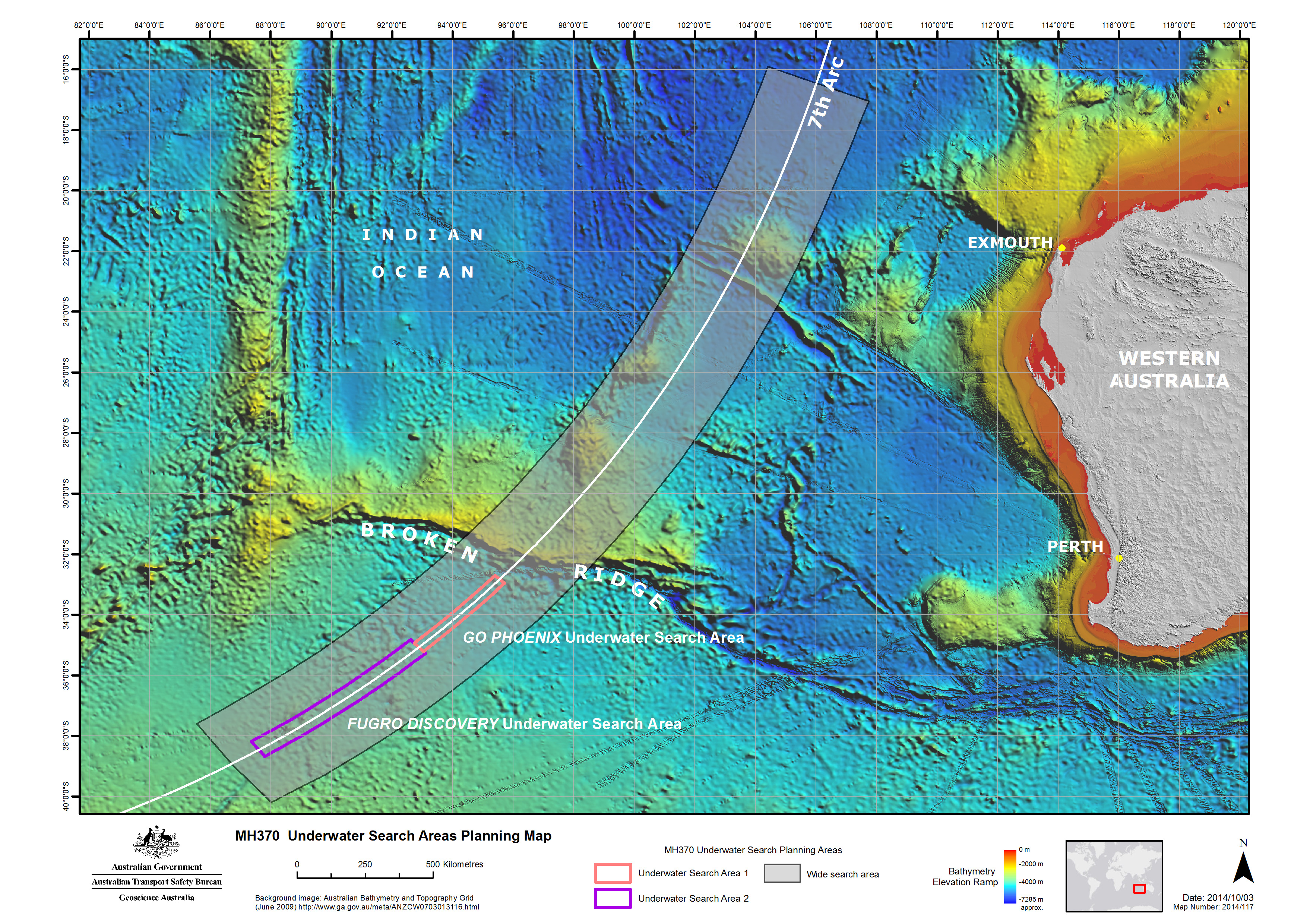
Fugro
Fugro Survey Pty Ltd is the Australian owned subsidiary of the Dutch based company, Fugro N.V. It is contracted by the Australian Government to provide vessels, personnel and equipment to conduct a bathymetric survey and underwater search operations for MH370. It operates the vessels Fugro Discovery, Fugro Equator and Fugro Supporter.
GA
Geoscience Australia.
GES
Ground earth station. A satellite ground station sends or receives data from orbiting satellites.
GO Marine
The company, GO Marine, is a subcontractor to Phoenix International. It owns the vessel GO Phoenix used for underwater search operations.
Handshake
Satellite log-on interrogation messages that originate at the ground earth station and are transmitted through the satellite to the aircraft’s satellite communication system.
ICAO
International Civil Aviation Organization.
Inmarsat
A satellite communications company based in the United Kingdom. It owns and operates a global satellite network and is a member of the SSWG.
JACC
Joint Agency Coordination Centre.
Knots
A unit of speed that is equal to one nautical mile (1.852km) per hour.
MBES
Multibeam echo sounder.
MOT
Ministry of Transport, Malaysia.
Nautical mile (NM)
A unit of distance based on the circumference of the earth, used for marine charting and navigating. One nautical mile (NM) is equal to 1.852km.
Phoenix
Phoenix International Holdings Inc. is a company based in the United States. It has been contracted by DEFTECH to supply a vessel, equipment and experts in the search for MH370.
Ping
A pulse of sonar sound.
Primary radar
Primary (or terminal area) radar relies on radio waves reflecting off metallic objects and is effective within a short range from the radar head, which is usually located at an airport.
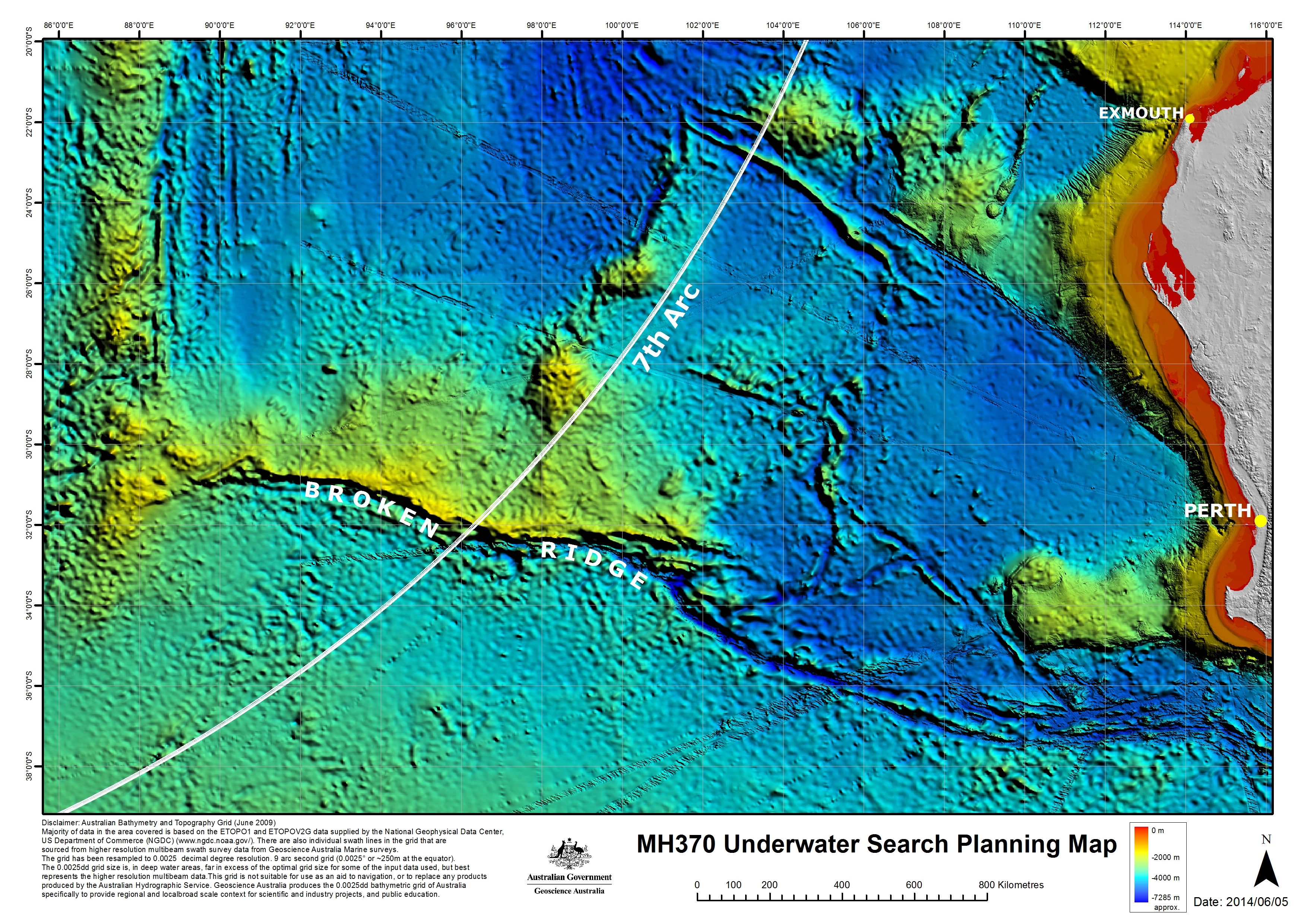
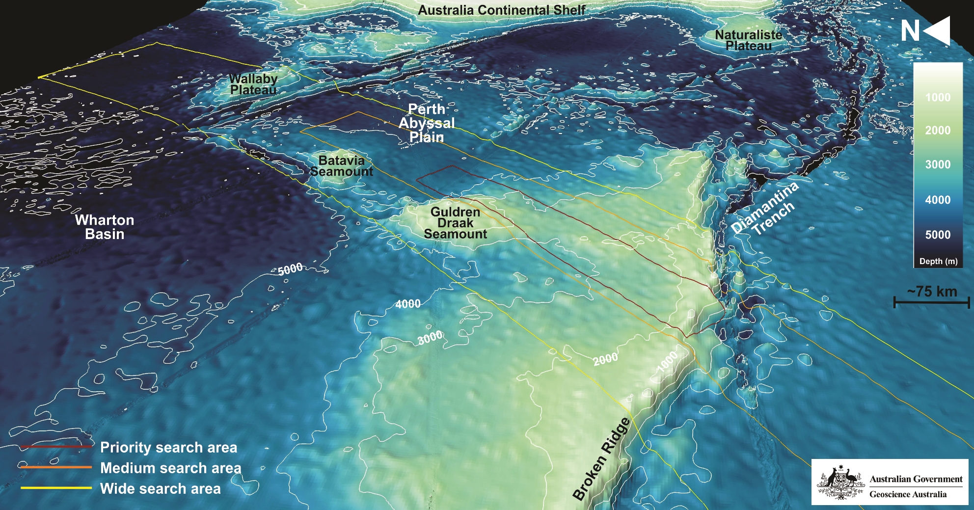
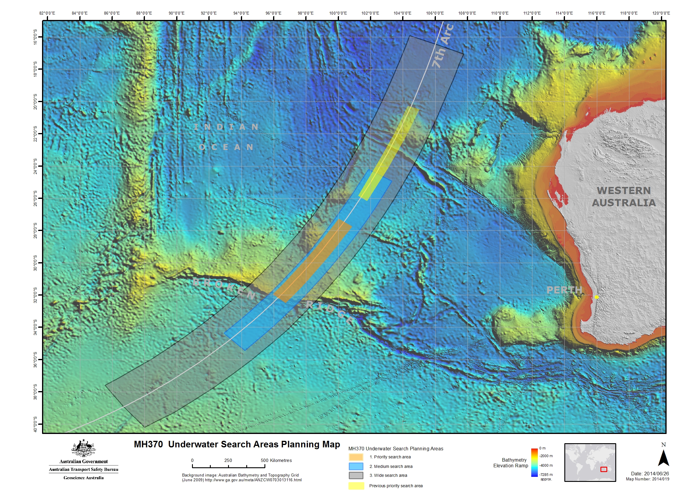
Priority Search Area
An area, 20 NM to the west or 30 NM to the east of the seventh arc that has been determined as a probable location for MH370, by analysing satellite communications and aircraft performance.
REOI
Request for Expressions of Interest.
RFT
Request for Tender.
RMP
Royal Malaysian Police.
SAS
Synthetic Aperture Sonar. A sonar system which uses sophisticated post-processing of sonar data to combine a number of sonar pings to form an image with higher resolution than conventional sonar.
SATCOM
Satellite communications.
Sea state
A description of sea conditions, recorded using the World Meteorological Organization Sea State Codes. Measurements range from 0 (calm) through to 9 (phenomenal).
Secondary radar
Secondary (or en route) radar returns are dependent on a transponder in the aircraft to reply to an interrogation from a radar ground station.
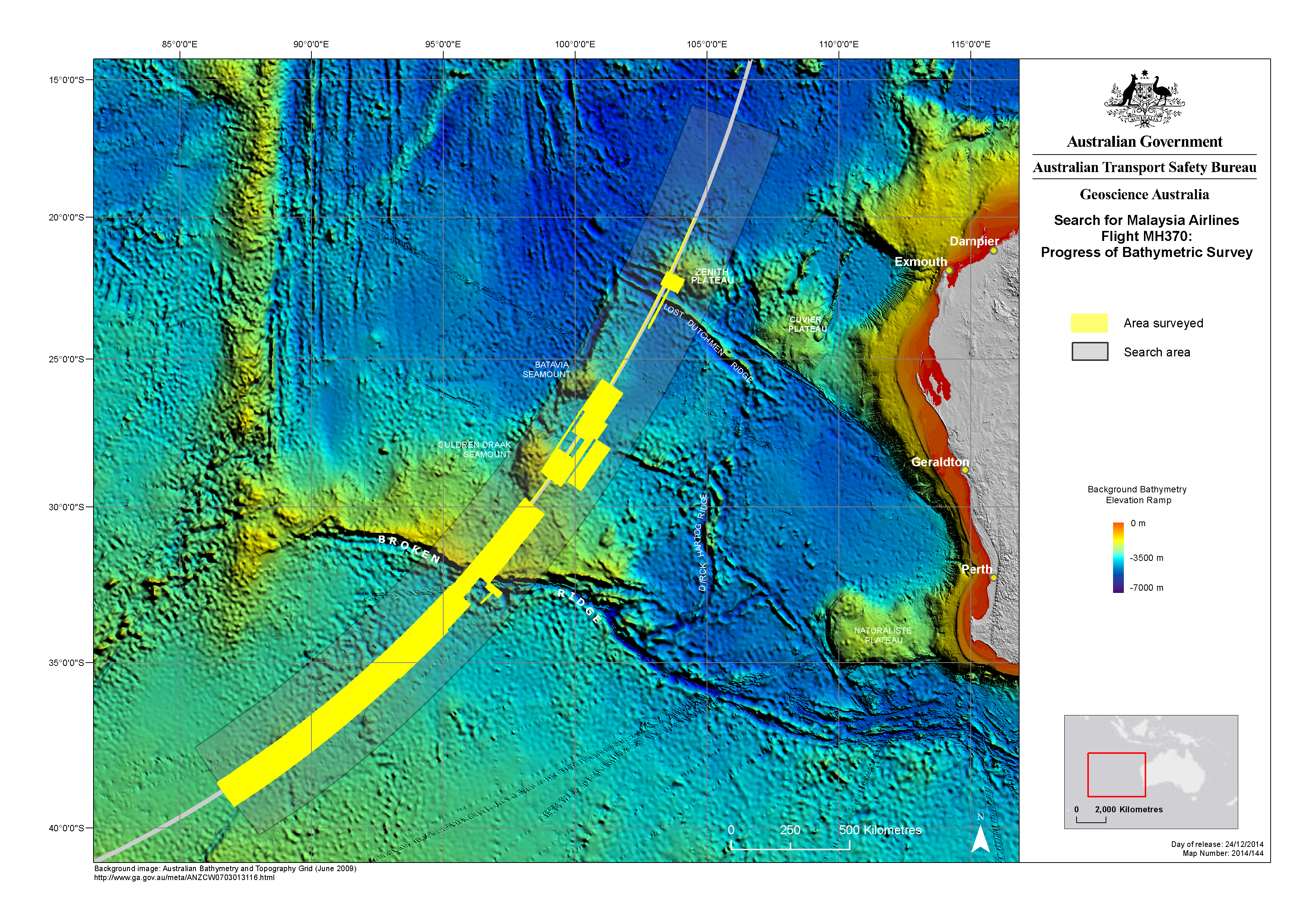
Seventh arc
Independent analysis of satellite communications and aircraft performance confirms MH370 will be found in close proximity to the arc labelled as the 7th arc. The arc extends from latitude 20 degrees south to latitude 39 degrees south. At the time MH370 reached this arc the aircraft is considered to have exhausted its fuel and to have been descending.
SL Hydrospheric
SL Hydrospheric (Hydrospheric Solutions) is a subcontractor to Phoenix International. It provides Synthetic Aperture Sonar equipment for MH370 underwater search operations.
Sonar buoy
A floating buoy equipped with an acoustic receiver and a radio transmitter that emits radio signals when it detects underwater sounds.
SSS
Sidescan sonar.
SSWG
Search Strategy Working Group. Coordinated by the ATSB, the group of international satellite and aircraft specialists has been working towards defining the most probable position of MH370, at the time of the last satellite communications.
Surface search
A surface search for MH370 was conducted from 18 March to 28 April 2014. Coordinated by AMSA and the JACC, it was carried out by an international fleet of aircraft and ships along the seventh arc.
Swing
The amount of time it takes a vessel to go from its port of departure, out to sea and return to port.
Towfish
A vehicle which is towed behind a search vessel. The vehicle may be fitted with instruments including sonar and optical imaging systems.
TPL
Towed Pinger Locator. A TPL is a device that is towed behind a vessel for detecting the signals being emitted from an underwater locator beacon fitted to an aircraft’s Flight Data Recorder and Cockpit Voice Recorder.
Transponder
A device that emits an identifying signal in response to an interrogating received signal from a communications satellite or ground station.
Tripartite
Shared by or involving three parties. Tripartite meetings that make decisions with regard to MH370 involve the governments of Australia, Malaysia and the People’s Republic of China.
ULB
Underwater locator beacon. A device attached to aviation flight recorders that when immersed in water emits an acoustic signal, to assist with locating an aircraft’s Flight Data Recorder and Cockpit Voice Recorder.
Uncontrolled air space
Airspace that has no supervision by air traffic control, so no clearance is required.
UTC
Coordinated Universal Time. UTC is the worldwide standard for time and date.
WAPOL
Western Australia Police.
Waypoint
A predetermined geographical position that is defined in terms of latitude and longitude coordinates, used for navigation.
9M—MRO
Missing Malaysia Airlines flight MH370’s aircraft registration number.