The ATSB is investigating a near collision involving a Tecnam P2002 Sierra, registration 24-7996, and a Diamond Aircraft Industries DA40 NG, registration VH-YPH, at Port Macquarie Airport, New South Wales, on 29 April 2026.
During final approach, the crew of the Diamond DA 40 observed the Tecnam P-2002 enter active runway 21 and line up for take-off. The DA40 conducted a missed approach and subsequently overflew the P-2002 in close proximity.
To date, the ATSB investigation has included interviewing witnesses and involved parties, retrieving and reviewing recorded data, and the collection of other relevant information. The ATSB has commenced the examination and analysis of the initial evidence collected.
A final report will be released at the conclusion of the investigation. Should a critical safety issue be identified during the course of the investigation, the ATSB will immediately notify relevant parties, so that appropriate safety action can be taken.
Last updated:
Occurrence summary
Investigation number
AO-2026-077
Occurrence date
29/04/2026
Occurrence time and timezone
15:55 Australian Eastern Standard Time
Location
Port Macquarie Airport
State
New South Wales
Report status
Pending
Anticipated completion
Q3 2026
Investigation level
Short
Investigation type
Occurrence Investigation
Investigation phase
Examination and analysis
Investigation status
Active
Mode of transport
Aviation
Aviation occurrence category
Missed approach, Near collision, Runway incursion
Occurrence class
Serious Incident
Highest injury level
None
Aircraft details
Manufacturer
Tecnam - C. Aeronautiche SRL
Model
P2002 Sierra
Registration
24-7996
Serial number
23
Sector
Piston
Operation type
Part 103 Sport and recreational aircraft
Activity
General aviation / Recreational-Instructional flying-Instructional flying - dual
Departure point
Port Macquarie Airport, New South Wales
Destination
Port Macquarie Airport, New South Wales
Injuries
None
Damage
Nil
Aircraft details
Manufacturer
Diamond Aircraft Industries
Model
DA40 NG
Registration
VH-YPH
Serial number
40.N289
Aircraft operator
Australian International Aviation College Pty Ltd
Sector
Piston
Operation type
Part 141 Recreational, private and commercial pilot flight training
Activity
General aviation / Recreational-Instructional flying-Instructional flying - dual
The ATSB is investigating a runway incursion and near collision involving a Cessna 402C, registered VH-HMG, and a safety vehicle, at Jandakot Airport, Western Australia, on 3 March 2026.
During take-off for an air transport operation flight with 4 passengers on board, the sole pilot of the Cessna 402 observed a safety vehicle enter the runway in front of the aircraft. The aircraft was above the maximum speed for a rejected take-off and took off above the vehicle in close proximity.
The ATSB has completed the evidence collection and analysis phases of the investigation and is drafting the final report.
The final report will be released at the conclusion of the investigation. Should a critical safety issue be identified during the course of the investigation, the ATSB will immediately notify relevant parties, so that appropriate safety action can be taken.
Last updated:
Occurrence summary
Investigation number
AO-2026-064
Occurrence date
03/03/2026
Occurrence time and timezone
07:07 Western Australia Standard Time
Location
Jandakot Airport
State
Western Australia
Report status
Pending
Anticipated completion
Q3 2026
Investigation level
Short
Investigation type
Occurrence Investigation
Investigation phase
Final report: Drafting
Investigation status
Active
Mode of transport
Aviation
Aviation occurrence category
Near collision, Runway incursion
Occurrence class
Serious Incident
Highest injury level
None
Aircraft details
Manufacturer
Cessna Aircraft Company
Model
402C
Registration
VH-HMG
Serial number
402C1002
Aircraft operator
Paul Lyons Aviation Pty Ltd
Sector
Piston
Operation type
Part 135 Air transport operations - smaller aeroplanes
Activity
Commercial air transport-Non-scheduled-Passenger transport charters
The ATSB is investigating a runway incursion and near collision involving a Boeing 737, registered ZK-TXB, and a ground vehicle at Melbourne Airport, Victoria, on 17 February 2026.
During the take-off on runway 34 at Melbourne Airport, the pilot of a Boeing 737 was alerted by ATC to a vehicle on the runway at the intersection of runway 09/27 and as a result conducted a high-speed rejected take-off.
The ATSB has commenced the examination and analysis of the initial evidence collected.
To date, the ATSB investigation will include:
interviewing the flight crew and airport staff
examining available closed-circuit television (CCTV)
examination of relevant procedures and policies
analysis of flight recorder and air traffic surveillance data
A final report will be released at the conclusion of the investigation. Should a critical safety issue be identified during the course of the investigation, the ATSB will immediately notify relevant parties, so that appropriate safety action can be taken.
Occurrence summary
Investigation number
AO-2026-061
Occurrence date
17/02/2026
Occurrence time and timezone
04:45 Australian Eastern Daylight Time
Location
Melbourne Airport
State
Victoria
Report status
Pending
Anticipated completion
Q3 2026
Investigation level
Short
Investigation type
Occurrence Investigation
Investigation phase
Examination and analysis
Investigation status
Active
Mode of transport
Aviation
Aviation occurrence category
Near collision, Rejected take-off, Runway incursion
Occurrence class
Serious Incident
Highest injury level
None
Aircraft details
Manufacturer
The Boeing Company
Model
737-8BK
Registration
ZK-TXB
Serial number
29644 LN:2231
Aircraft operator
Texel Air
Sector
Jet
Operation type
Part 129 Foreign air transport operators
Activity
Commercial air transport-Scheduled-Scheduled freight only
The ATSB is investigating a runway incursion involving a Fairchild Industries SA227-DC, registered VH-HPE, at Mackay Airport, Queensland, on 12 November 2025.
During the take-off run, the pilot of the Fairchild SA227 observed a safety vehicle on the runway and overflew the vehicle in close proximity.
The final report has been drafted and is undergoing internal review to ensure the report adequately and accurately reflects the evidence collected, analysis, and agreed findings.
The final report will be released at the conclusion of the investigation. Should a critical safety issue be identified during the course of the investigation, the ATSB will immediately notify relevant parties, so that appropriate safety action can be taken.
Last updated:
Occurrence summary
Investigation number
AO-2025-067
Occurrence date
12/11/2025
Occurrence time and timezone
20:00 Australian Eastern Standard Time
Location
Mackay Airport
State
Queensland
Report status
Pending
Anticipated completion
Q3 2026
Investigation level
Defined
Investigation type
Occurrence Investigation
Investigation phase
Final report: Internal review
Investigation status
Active
Mode of transport
Aviation
Aviation occurrence category
Near collision, Runway incursion
Occurrence class
Serious Incident
Highest injury level
None
Aircraft details
Manufacturer
Fairchild Industries Inc
Model
SA227-DC
Registration
VH-HPE
Serial number
DC-823B
Aircraft operator
Sharp Aviation Pty Ltd
Sector
Turboprop
Operation type
Part 121 Air transport operations - larger aeroplanes
Activity
Commercial air transport-Scheduled-Scheduled freight only
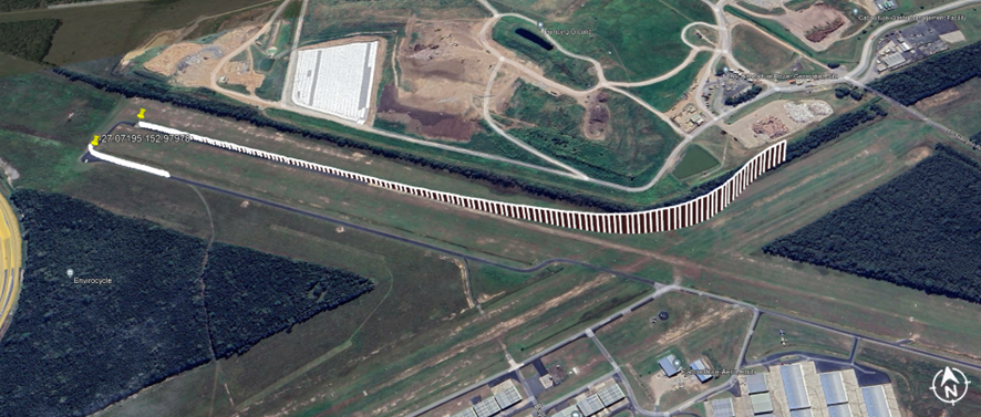
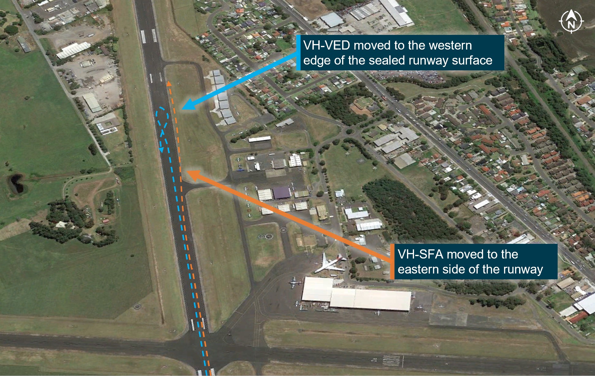
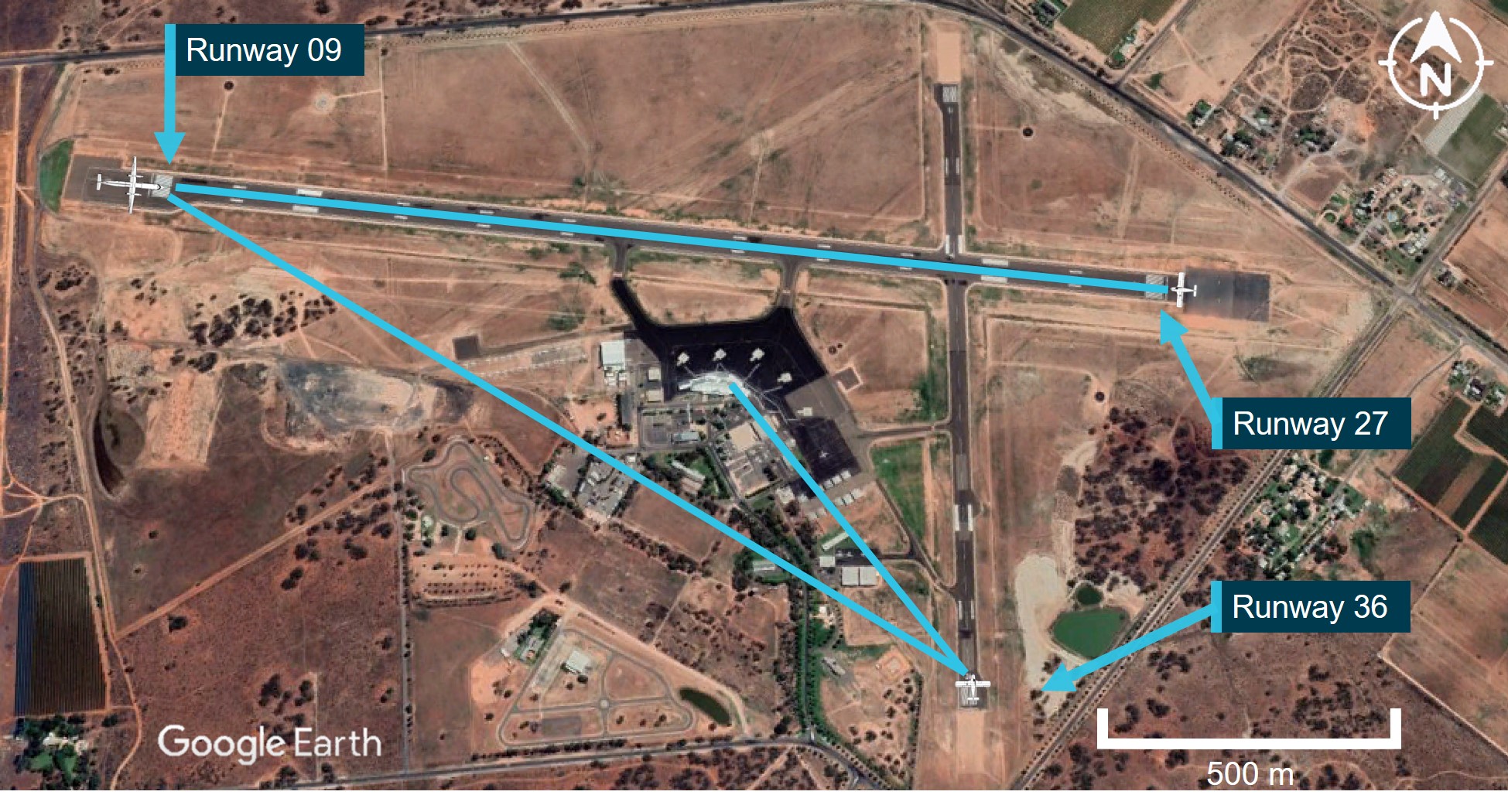
On 15 July 2024, a QantasLink De Havilland Aircraft of Canada Limited DHC-8-402, (Dash 8), registered VH-QOD, was taxied to reposition to a different bay at Wagga Wagga Airport, New South Wales. This repositioning required the Dash 8 crew to taxi out onto the runway and then return to a different bay. As the Dash 8 entered runway 05, the crew were unaware that a Piper PA-28, registered VH-XDK, operating on a training flight by the Australian Airline Pilot Academy (AAPA), had already commenced its take-off roll from the opposite end of the runway.
The instructor of the PA-28 was aware of the Dash 8 taxiing and assumed that the Dash 8 had received and understood their previous positional broadcasts. However, the crew of the Dash 8 were not aware of the PA-28 preparing for take-off on runway 23.
Upon entering runway 05, the Dash 8 was notified by a preceding aircraft that had landed, that there was another aircraft taking off from runway 23. The captain of the Dash 8 immediately stopped the aircraft and engaged reverse thrust to clear the runway. Simultaneously, the PA-28 pilot rejected their take-off from runway 05.
What the ATSB found
The ATSB identified that during ground-based repositioning, the Dash 8 was unaware of the PA-28 that was taxiing for take-off on an opposing runway. This led to a situation where the crew of the Dash 8 had an incomplete comprehension of the ground-based traffic.
Without any prior alert or expectation of the presence of the PA-28, the Dash 8 crew did not visually detect the PA-28 on take-off from the reciprocal end of the runway, prior to the Dash 8 entering the runway to taxi to the terminal. The PA-28 presented a difficult visual target due to its size and orientation over the 1,700 m distance, making unalerted detection unlikely.
Once made aware of the potential conflict of collision, the captain of the Dash 8 immediately reversed the aircraft away from the preferred runway without confirming that no other aircraft or obstacle was behind the Dash 8.
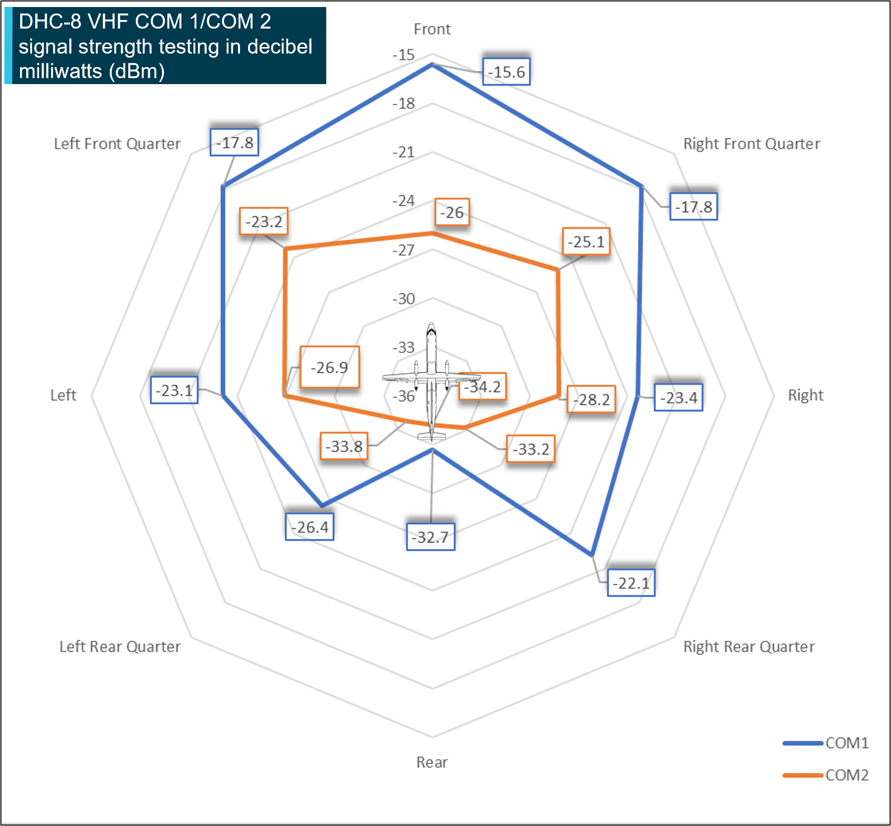
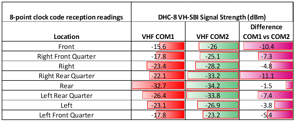
While the pilot of the PA-28 gave all the required radio calls, they did not directly communicate with the Dash 8 crew to identify the possible conflict, then positively arrange separation. Additionally, the Dash 8 ground-based reception, on VHF communications panel radio 2, had reduced strength and clarity.
The QantasLink radio procedure required crew to use the number 2 VHF communications panel radio to broadcast and receive on local frequencies during operations at a non-controlled aerodrome. This likely reduced ground-based reception strength and the likelihood of the Dash 8 hearing other traffic in certain circumstances.
Reduced VHF ground-based communication was identified at the eastern end of runway 23 at Wagga Wagga Airport. Local operator reports and procedures indicate that reduced communication strength and clarity can be experienced on the eastern end of taxiway A to other areas of the airport.
During taxi for take-off, the PA-28 was not broadcasting transponder information, which also did not identify them to other traffic in the vicinity of the aerodrome. The AAPA procedure requiring the selection of the transponder to ‘ALT’ before entering the runway, rather than prior to taxi, became a missed opportunity to provide electronic enhancement of situational awareness to other airport operators.
What has been done as a result
ATSB issued a safety advisory notice (AO‑2024‑041‑SAN‑01) to advise pilots and operators to review their procedures to ensure that mode S transponders are on from first movement of the aircraft.
AAPA has advised the ATSB that changes have been made to its PA-28 Flight Crew Operating Manual, and Quick Reference Handbook, which reflects the transponder being selected to ALT mode after start in both the checklist as well as being incorporated as part of the scan action flow.
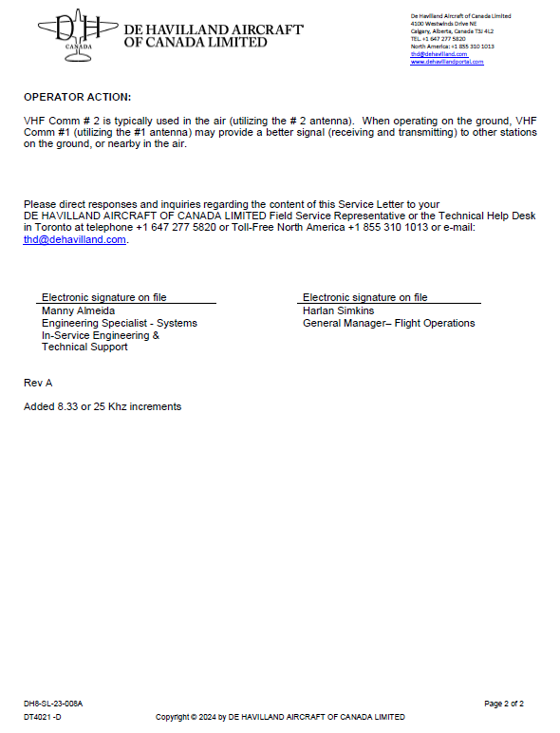
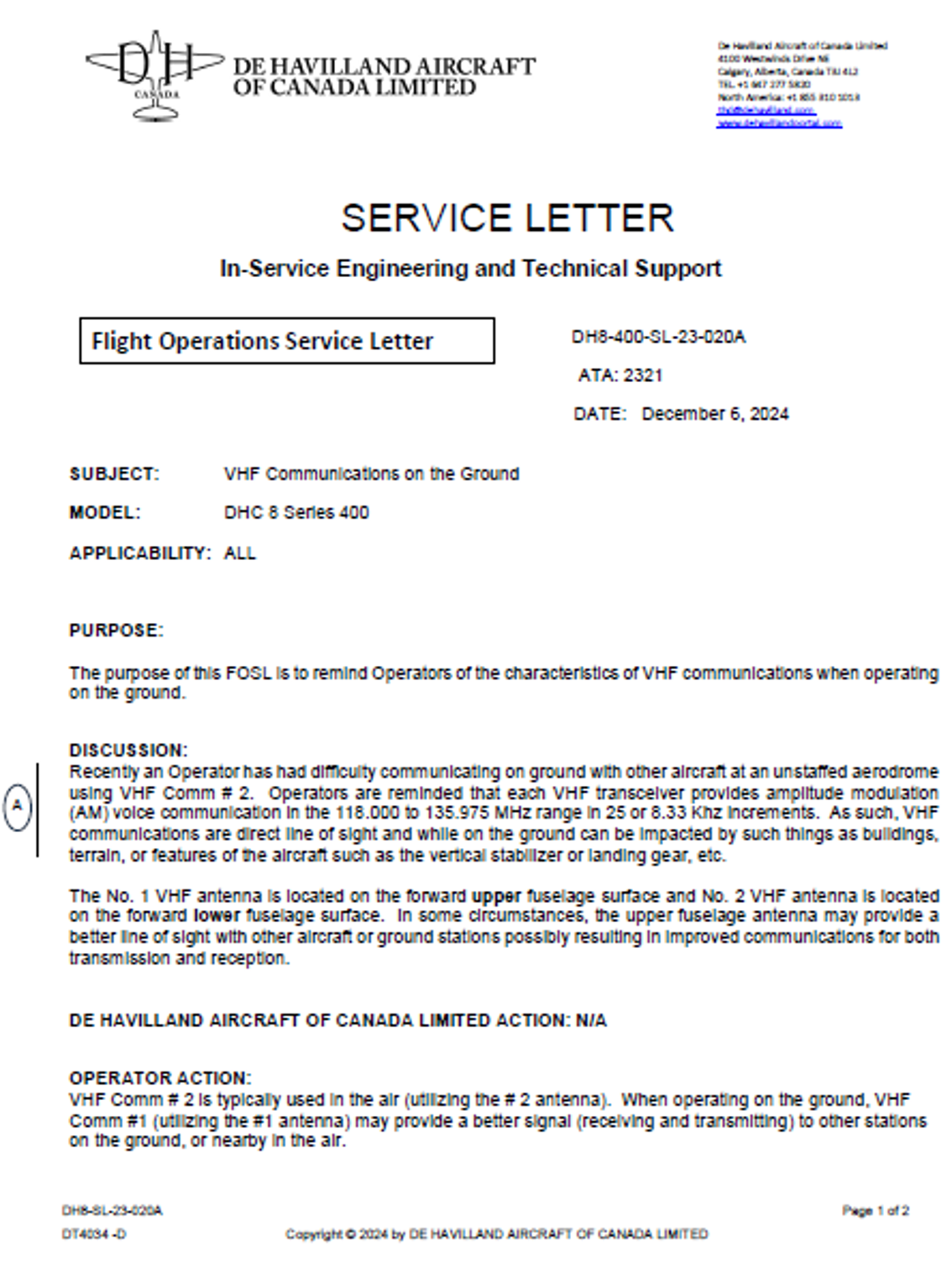
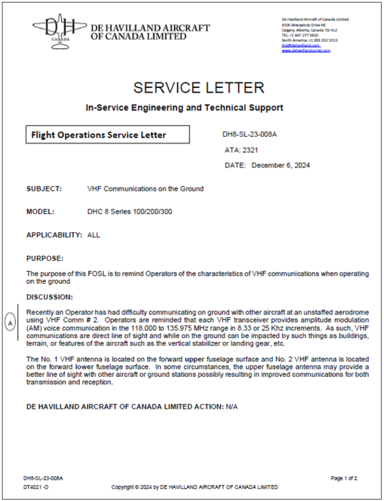
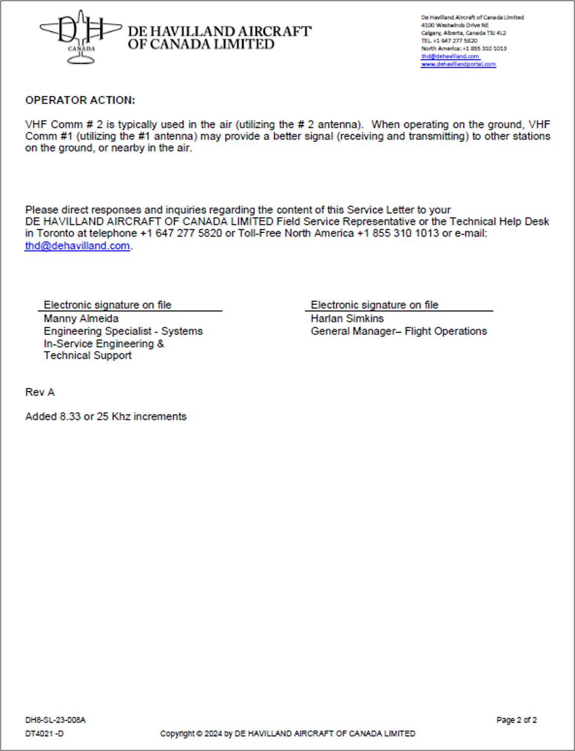
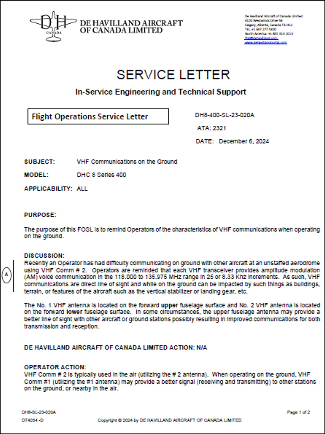
On 6 December 2024, De Havilland Aircraft of Canada Limited issued 2flight operations service letters relating to radio communications, with one covering Dash 8 100-300 series aircraft and the other covering the Dash 8 400 series aircraft. The service letters remind operators that ground‑based VHF communications are affected by line of sight and can be impacted by buildings, terrain or aircraft structures and that use of VHF COM 1 is more effective for ground-based communications with other aircraft on the ground.
The airport operator had issued a notice to airmen (NOTAM) notifying aircraft of a potential radio black spot at Wagga Wagga Airport under some conditions.
QantasLink issued a safety alert notice encouraging crew to consider additional precautions when taxiing for departure or any other manoeuvring on-ground at Wagga Wagga Airport. This advice was issued due to on-ground VHF communications between aircraft possibly being affected by obstacles in the line of sight.
Safety message
Communication and self-separation in non-controlled airspace is one of the ATSB’s SafetyWatchpriorities. Wherever you fly, into either non-controlled or controlled aerodromes, maintaining a vigilant lookout at all times is important. Situational awareness and alerted see-and-avoid is an effective defence against collision and good airmanship dictates that all pilots should be looking out and not be solely reliant on the radio for traffic separation. Being aware of other nearby aircraft and their operational intentions is important.
Effective use of all available sources of information is an effective risk control to achieve enhanced situational awareness and an accurate mental model of other traffic at a non‑controlled aerodrome.
Pilots are reminded that although accurate and timely radio calls play a critical role in ensuring collision avoidance in uncontrolled airspace, they cannot assume from an absence of other radio calls that there is no conflicting traffic. This is particularly important in an environment where there is high expectation of mixing with other aircraft of different sizes, flight rules and performance levels operating at the same time, in the same airspace.
Pilots can enhance their situational awareness and mutual traffic separation by:
making the recommended broadcasts when in the vicinity of a non-controlled aerodrome
actively monitoring the common traffic advisory frequency while maintaining a visual lookout and constructively organising separation through direct contact with other aircraft
ensuring mode S transponders, where fitted, are selected to transmit altitude information before taxiing
not hesitating to contact another aircraft if there is any uncertainty as to their position and/or intentions.
The ATSB SafetyWatch highlights the broad safety concerns that come out of our investigation findings and from the occurrence data reported to us by industry. This investigation report highlights the safety concerns around reducing the collision risk around non-towered airports.
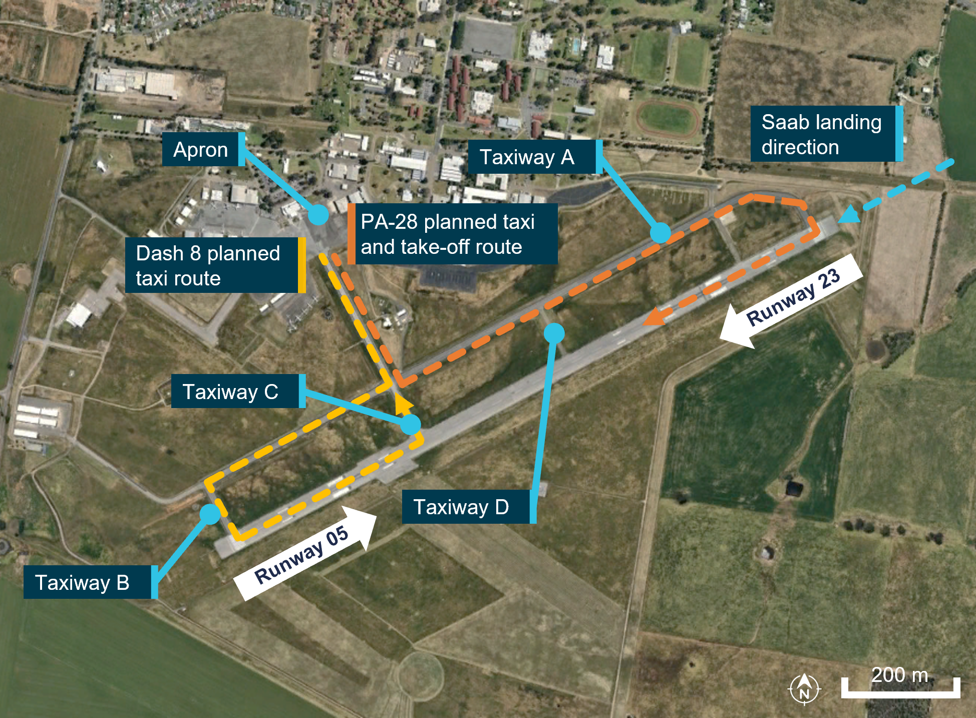
The occurrence
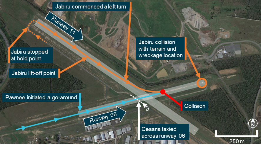
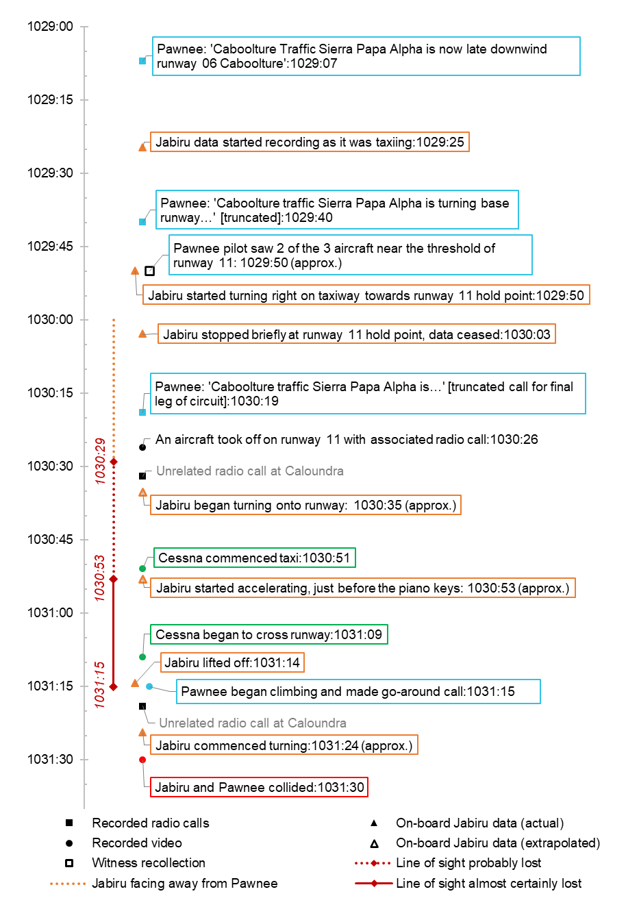
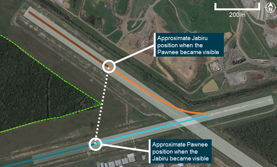
On 15 July 2024, a Piper Aircraft Corporation PA-28, registered VH-XDK, operated by the Australian Airline Pilot Academy (AAPA), with an instructor and student on board, taxied from the apron at Wagga Wagga Airport, New South Wales (Figure 1) for a training flight. At 1609 local time, the crew broadcast they were taxiing for runway 23 (Figure 2, position A). About 20 seconds later, the crew of an inbound Saab 340 responded, asking for the call sign to be repeated. The Saab 340 was 30 NM away at this stage and could not understand the call sign, even when repeated twice more. About 5 minutes later at 1614:12, the crew of the Saab 340 broadcasted that they were now on a 10 NM straight in approach for runway 23 (see Appendix A – CTAF Recordings).
At about the same time,the 2 crew members of a QantasLink De Havilland Aircraft of Canada Limited DHC-8-402 (Dash 8), registered VH-QOD, were on board the aircraft at the Wagga Wagga Airport apron. The crew were making preparations to reposition the aircraft from the apron to another bay (on the apron) by taxiing the aircraft via the runway (Figure 1). The Dash 8 crew reported they spent about 5 minutes[1] preparing the aircraft on the flightdeck prior to taxiing. However, they did not recall hearing the initial taxi call and callsign repeats from the PA-28, but did recall hearing the 10 NM inbound call from the Saab 340.
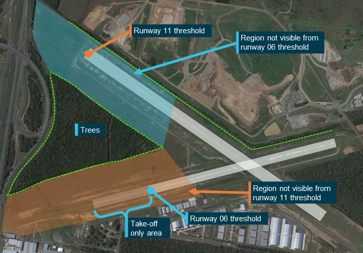
Figure 1: Intended taxi routes for aircraft
Source: Google Earth, annotated by the ATSB
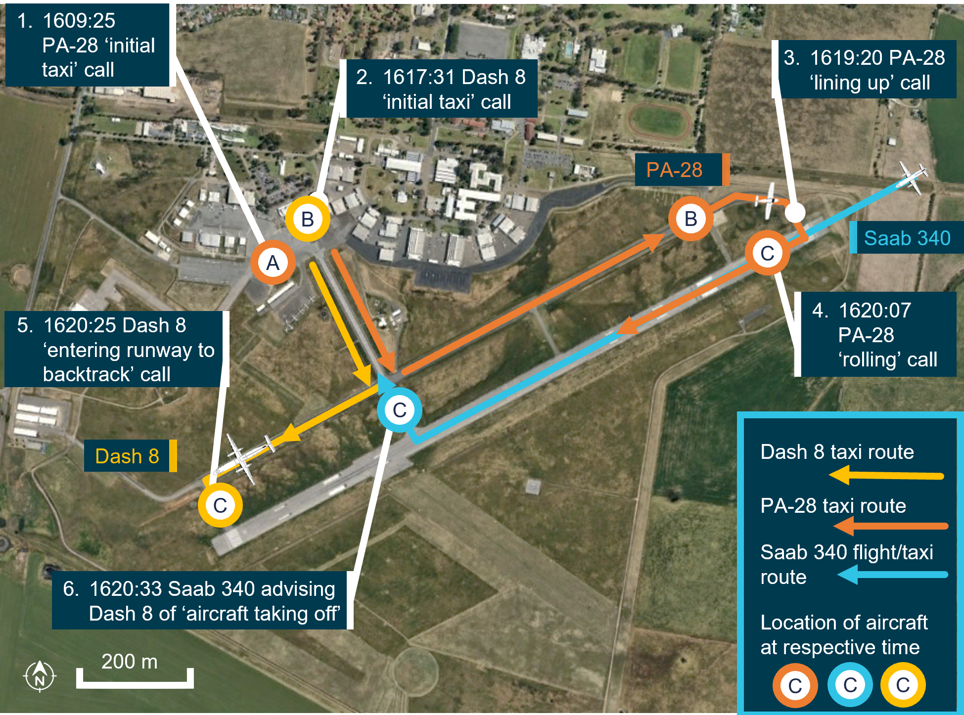
At 1616:27 the Saab 340 crew broadcast that they had joined a 5 NM final for runway 23.
At 1617:31 (Figure 2, position B, Dash 8) the Dash 8 crew broadcast that they were taxiing for runway 05. At this time, the PA-28 was on taxiway A, approaching runway 23 (Figure 2, position B, PA-28).
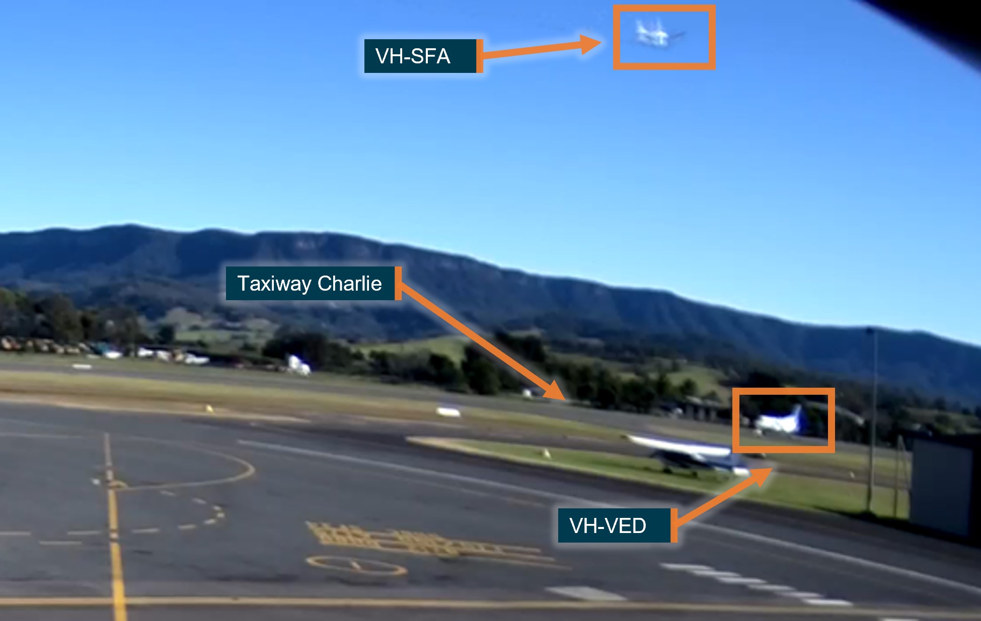
Figure 2: Position of respective aircraft at given times
Source: Google Earth, annotated by the ATSB. Note: aircraft not to scale
Being aware only of the inbound Saab 340, the Dash 8 crew communicated directly with them. This was to gain an understanding of the Saab 340 crew’s intentions on landing and exiting the runway. While still taxiing towards the runway at 1618:32, the Dash 8 crew told the Saab 340 crew of their intent to enter and backtrack from the threshold of runway 05, keeping out of the way of the Saab 340’s landing.
The instructor of the PA-28 recalled hearing the radio calls from both aircraft during this time. The PA-28 was aware of the Dash 8 taxiing for runway 05 and assumed that the Dash 8 had also heard their earlier calls, and would hold short of the runway for their departure.
At 1619:20, the PA-28 was positioned on runway 23, with strobe lights on, behind the landed Saab 340 and the instructor made a ‘lining up and holding’ call (Figure 2, position B, PA-28). About 30 seconds later the Saab 340 crew made a broadcast that they were clear of the preferred runway (Figure 2, position C, Saab 340). The PA-28 instructor then broadcast their ‘rolling call’ (Figure 2, position C, PA-28) and commenced take-off at 1620:07.
At 1620:25, the Dash 8 crew gave an entering call for runway 05 with intentions to taxi to taxiway C (Figure 2, position C, Dash 8) and then entered the runway.
On hearing the Dash 8 crew’s broadcast, the Saab 340 crew notified the Dash 8 that ‘there is an aircraft taking off on runway 23’ at 1620:33. Simultaneously, the PA-28 student pilot also rejected their take-off.
The Dash 8 crew immediately stopped at their current position, with the aircraft still perpendicular with the runway and estimated by the captain to be about 5 m inside the runway gable markers.[2] The captain acknowledged the broadcast and then visually identified the PA-28 on the runway.
The captain of the Dash 8 subsequently engaged Beta plus power mode[3] (reverse thrust) to reverse the Dash 8 backwards along taxiway B to ensure clearance of the preferred runway. The PA-28 crew broadcast they would exit runway 23 on taxiway D.
The Dash 8 captain then established direct radio contact with the PA-28 crew, stating ‘nil radio transmission heard and they are still broken’.
The PA-28 vacated the runway and taxied again for a subsequent departure. The Dash 8 then re-entered runway 05 and backtracked runway 23 and vacated to the apron.
Context
Pilot information
Flight crew VH-QOD (Dash 8)
The captain held an Air Transport Pilot Licence (Aeroplane) and a valid class 1 aviation medical certificate. They reported a total flying time of 2,912 hours with 2,389 of those being on the Dash 8 aircraft type. The captain reported being familiar with Wagga Wagga Airport and had operated there regularly.
The first officer (FO) held a Commercial Pilot Licence (Aeroplane) (CPL-A) and a valid class 1 aviation medical certificate. They reported a total flying time of 1,312 hours with about 438 of those hours being on the Dash 8. The FO had been employed with the operator for approximately a year and had flown into Wagga Wagga Airport during their training and subsequent line operations.
Flight crew VH-XDK (Piper PA-28)
The instructor of the PA-28 held a CPL (Aeroplane) with a grade 2 instructor rating. They held a valid class 1 aviation medical certificate and reported a total flying time of 796 hours, with approximately 146 hours being on the PA-28. The instructor regularly operated out of Wagga Wagga Airport, as it was the company base of operation.
The student pilot of the PA-28 held a class 1 aviation medical certificate and reported about 17 hours of flying time.
Aircraft information
VH-QOD (Dash 8)
The De Havilland Aircraft of Canada Limited (DHC) DHC-8-402, was a high-wing, pressurised, commuter aircraft powered by 2 turboprop engines. VH-QOD was manufactured in Canada in 2006 and was first registered in Australia on 22 May 2006.
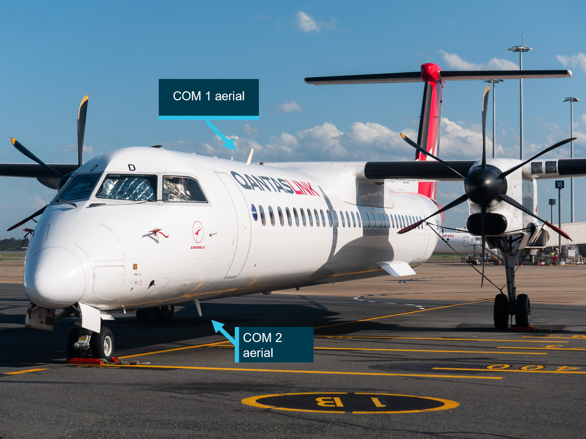
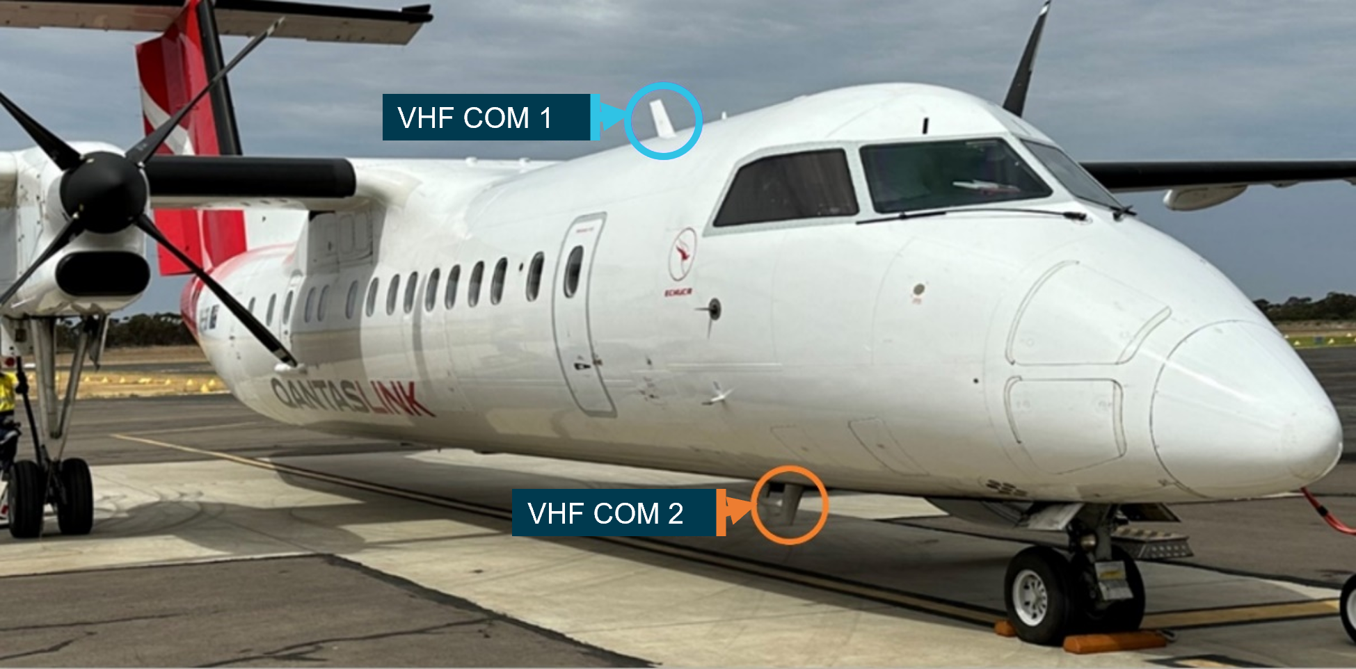
VHF radio antenna position and condition
The Dash 8 had 2 VHF radio systems, each using separate antennas installed on the upper and lower fuselage (Figure 3):
Number 1 VHF COM antenna (VHF COM 1) mounted on the roof of the aircraft forward of the wings.
Number 2 VHF COM antenna (VHF COM 2) mounted on the belly of the aircraft.
Figure 3: Dash 8 with annotations of VHF antenna locations on airframe
Source: Gyo Kamata Jetphotos.com, annotated by the ATSB
Transponder and ADS-B system on the Dash 8
The Dash 8 was equipped with an automatic dependent surveillance-broadcast ADS-B mode S transponder. ADS-B uses digital positional data provided by a GPS sensor on board the aircraft. This information is transmitted via the same channels used in conventional aircraft transponder transmissions. The Dash 8, ADS-B transponder units are fully integrated through the Dash 8 audio and radio control and display unit. Positional data for each ADS-B transponder is provided through the aircraft flight management system.
TCAS system on the Dash 8
A traffic collision avoidance system (TCAS) was fitted to the Dash 8. A TCAS interrogates the transponders of nearby aircraft and uses this information to calculate the relative range and direction of this traffic. The system displays this information to the flight crew, providing situational awareness of the location of other aircraft, and is available on the ground and when airborne.
TCAS is designed to be used as an airborne device, which performs surveillance of nearby aircraft and provides information on the relative direction and altitude of these aircraft so that the collision avoidance algorithms can perform their function (Federal Aviation Administration, 2011)
Limitations exist for the use of TCAS in lateral separation. Current generations of TCAS are primarily focused on vertical separation (climb or descent); TCAS I and II generations of TCAS do not provide horizontal separation.
In certain circumstances functions and alerts within the TCAS system are inhibited. An example is documented in FAA AC 90-120 (Federal Aviation Administration, 2024) that noted:
2.11.5 ACAS[4] does not display aircraft on the ground and may not display an aircraft when own-ship ACAS estimates that the other aircraft is below 380 feet Above Ground Level (AGL), unless the other aircraft is operating with a Mode S transponder that reports airborne status.
While the use of TCAS for monitoring other aircraft on the ground was not an operator procedure, the Dash 8 crew identified that they regularly used it as an aid for situational awareness. The captain and FO both recalled reviewing their TCAS with only one aircraft (the Saab 340) being seen.
Flightradar24 application
The crew of the Dash 8 utilised an electronic flight bag (EFB).[5] Additionally during taxi, they reviewed the Flightradar24 application as a tool to enhance their situational awareness of potential traffic in the area.
Flightradar24 is a global flight tracker that shows live air traffic from around the world and combines data from several sources including ADS-B.
QantasLink did not have a formal policy referring to the use of the Flightradar24 application. However, the flight crew advised that this application is often used by pilots as a resource to aid situational awareness. As with TCAS, only the Saab 340 aircraft was visible on the Flightradar24 app during the Dash 8 taxi period.
VH-XDK (Piper PA-28)
VH-XDK was a Piper Aircraft Corporation, PA-28-161 Cherokee Warrior III, manufactured in the US in 2008. VH-XDK was a single‑engine, 4‑seat, low‑wing design aircraft, operated by Australian Airline Pilot Academy Pty Ltd (AAPA).
VHF radio systems on PA-28
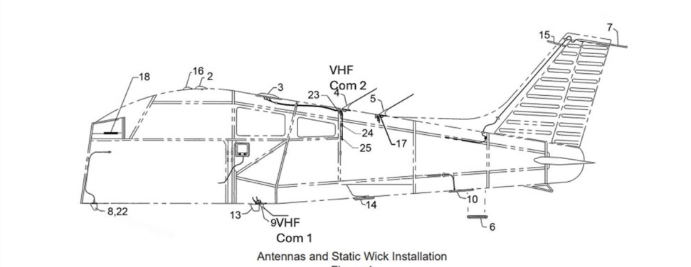
The aircraft was equipped with 2 Garmin G430[6] VHF navigation/communication systems, transmitting at a minimum of 10 watts through 2 independent antennas. The VHF COM 2 antenna is located on the top of the fuselage and the VHF COM 1 antenna is located on the underside of the fuselage.
Figure 4: Antenna location on PA-28
Source: PA-28 operator
Transponder and ADSB system PA-28
The PA-28 was fitted with a Garmin GTX 330ES MODE-S, providing a mode S digital transponder signal. The transponder likely would have made the PA-28 electronically conspicuous to the Dash 8 crew through the flight crew’s Flightradar24 application on their EFBs, when selected to ON/ALT.
Meteorological information
Weather conditions at Wagga Wagga Airport around the time of the occurrence were identified as a moderate north-westerly wind at about 13 kt, with greater than 10 km visibility. The cloud was reported as broken (between 5–7 oktas[7]) between 2,000 ft and 2,600 ft above ground level.
Airport information
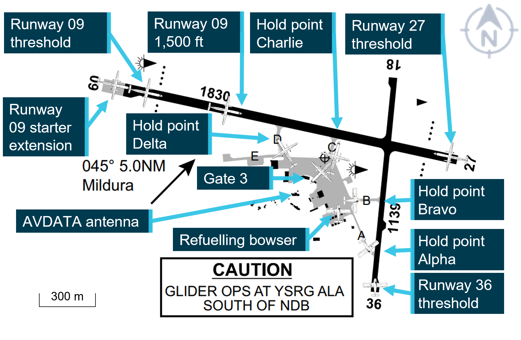
Wagga Wagga Airport
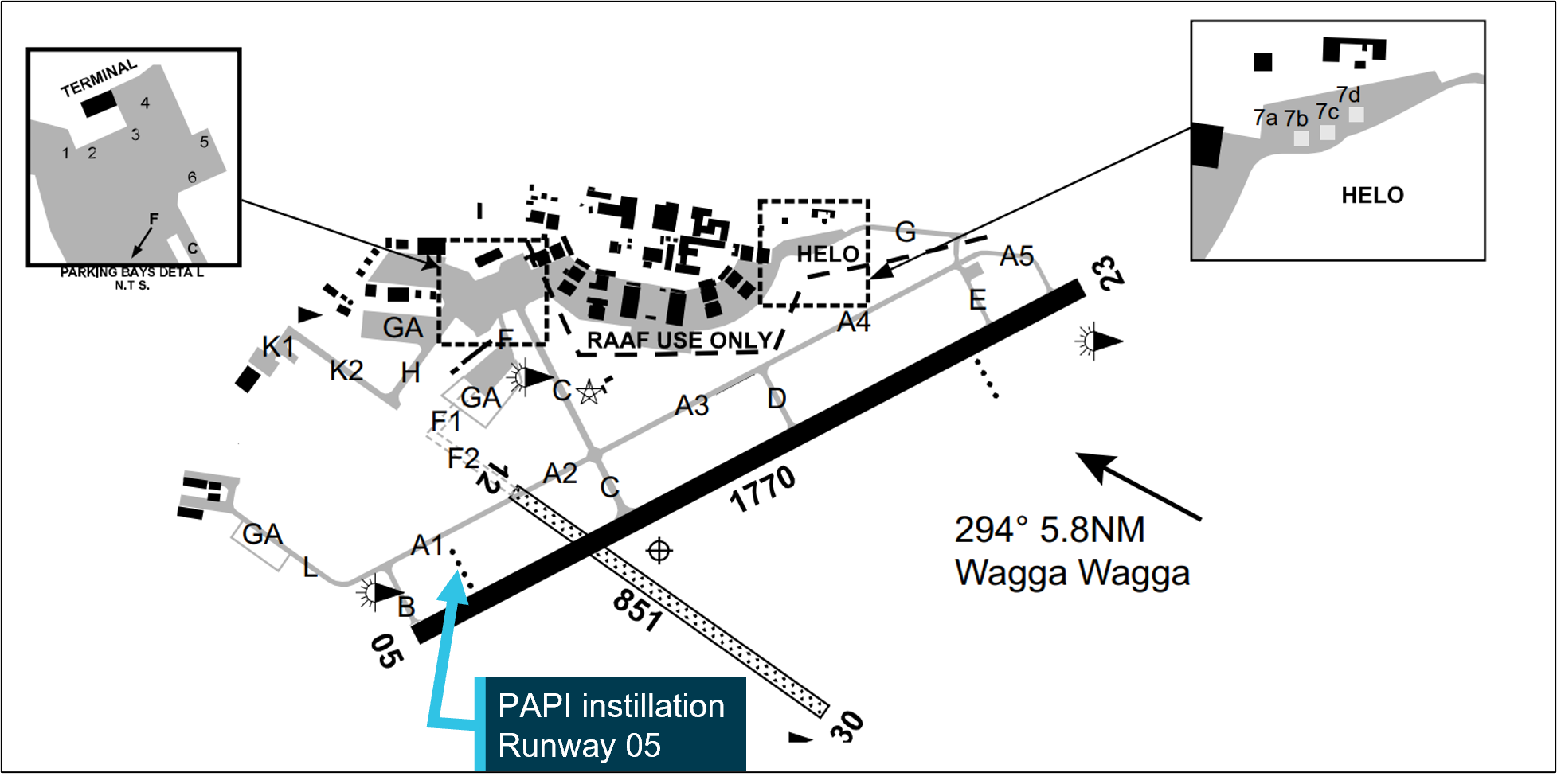
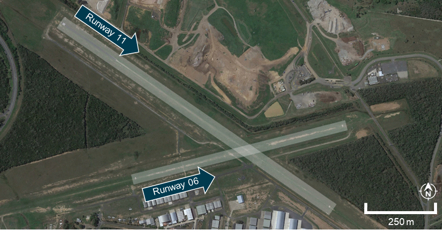
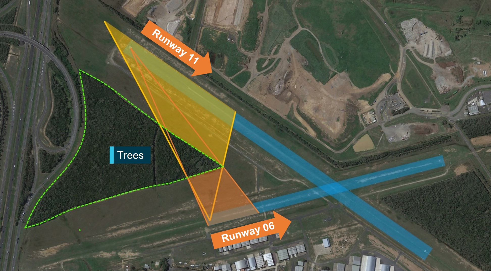
Wagga Wagga Airport is a regional, certified aerodrome, located about 6 NM to the south‑east of Wagga Wagga township in New South Wales, Australia. The aerodrome had an elevation of 724 ft (221 m) above mean sea level (AMSL), and had 2 runways running north‑east, south-west and north-west, south-east. The primary sealed runway at Wagga Wagga is runway 05/23 and is 1,770 m long with the secondary, unsealed runway 12/30 being 851 m long (Figure 5).
Runway 05/23 exhibited a minor elevation differential between each runway threshold. The threshold of runway 05 was recorded at 216 m AMSL while the threshold of runway 23 was slightly lower at 214 m AMSL, resulting in a 2 m downward gradient from runway 05 to runway 23. Approximately 300 m from the runway 05 threshold, the elevation increased to 217.5 m AMSL, a rise of 1.5 m, before gradually declining towards the runway 23 threshold. This subtle elevation change created a minor undulation in the runway profile.
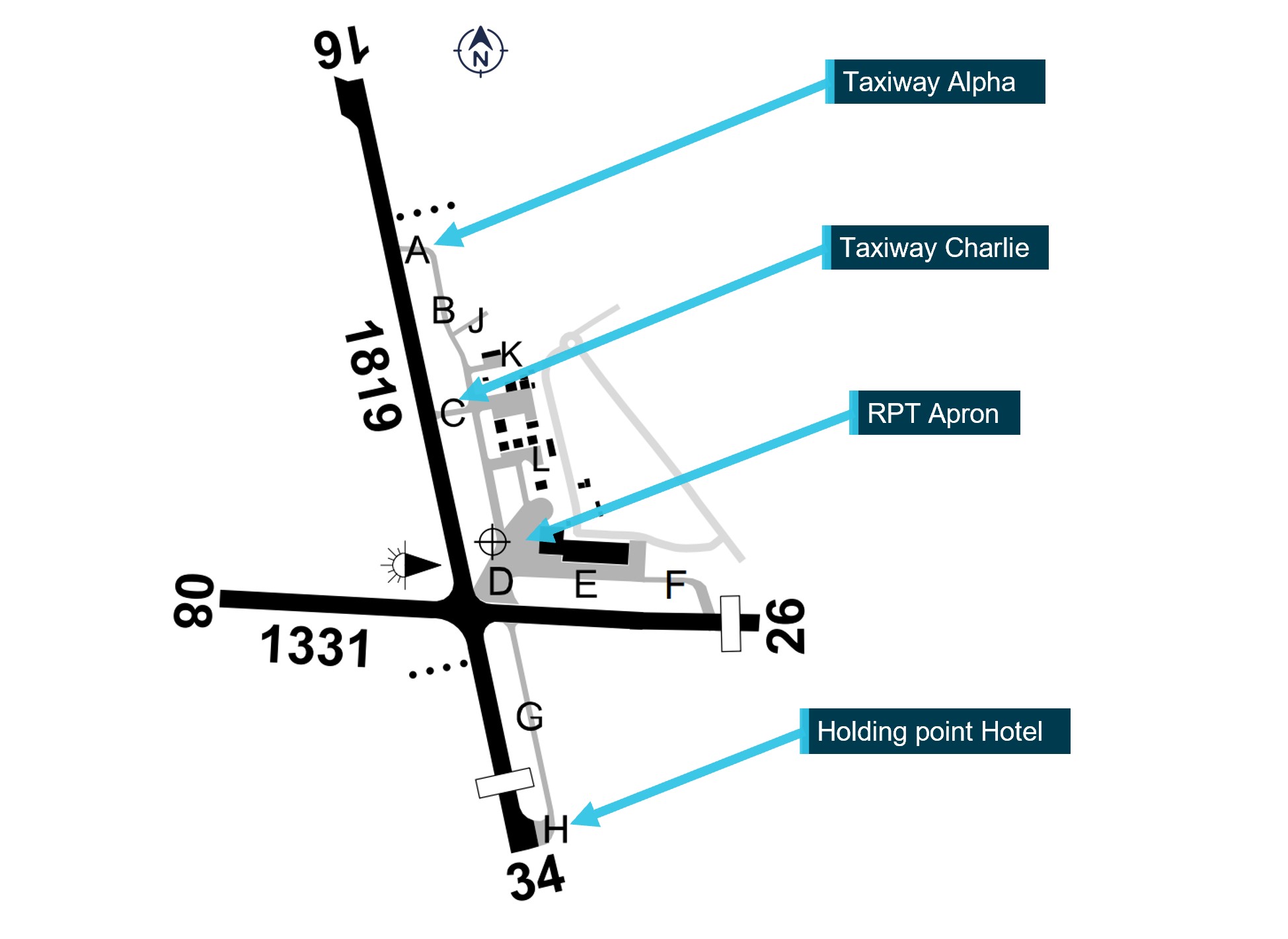
Figure 5: Wagga Wagga Airport layout
Source: En Route Supplement Australia (ERSA). Airservices Australia, annotated by the ATSB
Airspace
Wagga Wagga Airport was located within non-controlled Class G[8] airspace which was available for use by aircraft operating under visual flight rules (VFR) and instrument flight rules (IFR).
No air traffic control separation service was provided between aircraft operating in this airspace. Pilots are responsible for making themselves aware of nearby aircraft and maintaining mutual self‑separation. The primary method of traffic separation at Wagga Wagga Airport was by VHF communications coupled with visual reference, and relied on pilots using ‘alerted see-and-avoid’[9] practices (see See-and-avoid).
The Wagga Wagga CTAF operated on the VHF radio band and required pilots to monitor and make some positional broadcasts when operating within the vicinity of the aerodrome, or within 10 NM.
Reported radio dead spot
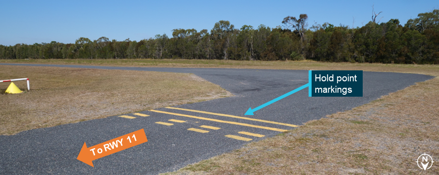
The Australian Airline Pilot Academy (AAPA) had issued an internal notice to all crew (NOTAC) on 23 August 2023, advising of a potential radio ‘deadspot’ on Wagga Wagga Airport. The NOTAC detailed:
NOTAC 032/17 CURRENT 23 08 1100 LST - Until Removed To: All Pilots
POTENTIAL RADIO DEADSPOT ON WAGGA AIRPORT
There is an identified radio dead spot on Taxiway Alpha between taxiway Charlie and the runway 23 holding point, prior to entering Runway 23, crew must visually check that no aircraft are entering the runway from taxiway Charlie.
Authority: Chief Pilot.
Prior to the occurrence, the aerodrome operator had identified that ground-based vehicle radio communications were observed to have reduced effectiveness in some circumstances, however no further testing was carried out.
Radio signal transmission reception
The ATSB conducted an analysis to determine whether the radio line of sight (LOS) between the 2 aircraft, positioned at opposite ends of the runway, was obstructed by the terrain elevation at approximately 300 m down runway 05.
Firstly, a geometric LOS analysis was conducted. The analysis utilised a strict geometric LOS model, assuming a direct, unobstructed path between the transmitter and receiver, as described in standard International Telecommunications Union (ITU-R) (2019) radio propagation principles (Parsons, 2000). The results determined that the terrain elevation created a physical obstruction, blocking the direct radio LOS between the aircraft.
To assess the potential for radio communication despite the LOS obstruction, diffraction[10] effects were evaluated. The inclusion of diffraction effects was used as radio waves, particularly in the very high frequency (VHF) band used in aviation, can propagate beyond geometric LOS by bending around obstacles such as terrain features (Rappaport, 2002). This phenomenon enables communication in scenarios where direct LOS is obstructed.
A knife-edge diffraction model was used to estimate the signal loss caused by the terrain. This model, a standard method in radio wave propagation analysis, approximates the terrain feature as a sharp, idealised edge obstructing the radio wave path (International Telecommunications Union (ITU-R), 2019). The knife-edge model was selected due to its applicability for analysing diffraction over a single, well-defined obstacle and its computational simplicity for VHF frequency analysis.
The calculations were completed using the Wagga Wagga CTAF frequency of 118.2 MHz and assumed values derived from generic radio and antenna specifications.
Results indicated that despite the geometric LOS obstruction caused by the terrain, communication between the 2 aircraft was feasible[11] due to diffraction effects.
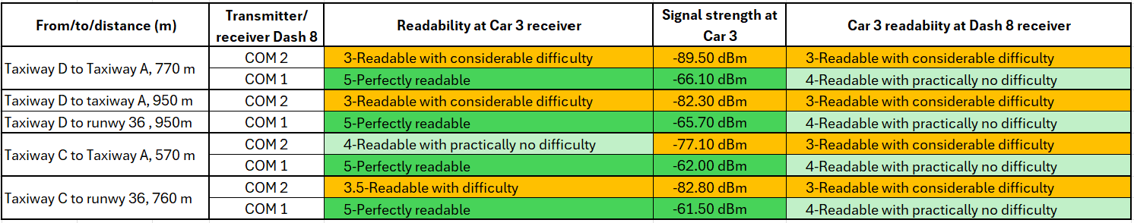
A similar calculation was conducted between taxiway C and taxiway A5. It indicated that communication between 2 aircraft was also feasible. The calculated signal strength indicated that a radio transmission should have theoretically been received clearly.
All calculations regarding VHF line of sight communication were theoretical and assumed idealised conditions. Noting the advice by AAPA of a potential radio dead spot on the airport, it should be noted that this observed dead spot may result from real-world environmental factors such as localised interference or other unmodeled conditions like vegetation or temporary obstacles, which cannot be fully replicated in theoretical calculations.
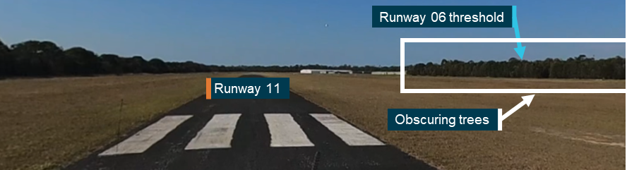
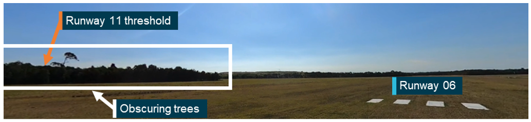
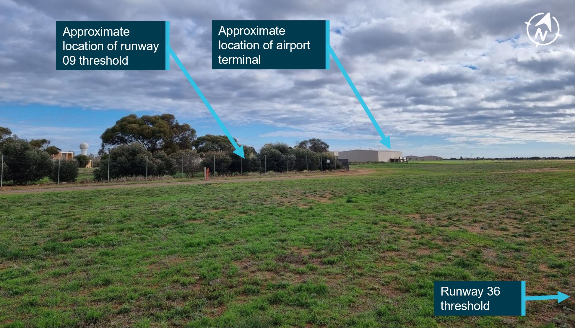
Visibility between opposite runway thresholds
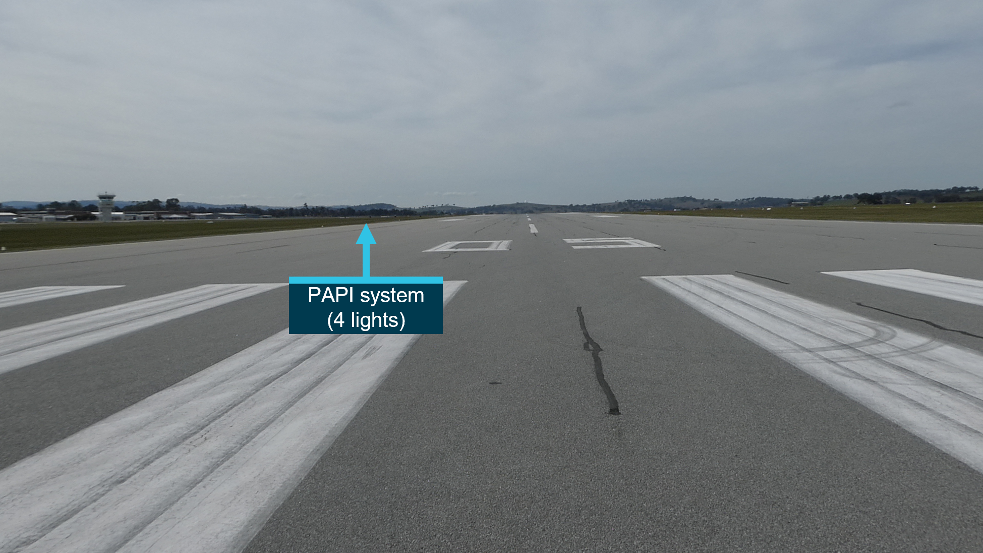
A clear line of visual (eye level) sight existed between the taxiway B holding point at the threshold of runway 05 and the threshold of runway 23 (Figure 6). The pilot of the PA-28 reported they could clearly see the Dash 8 at the threshold of runway 05, as the Saab 340 vacated the runway, prior to them commencing take-off. The crew of the Dash 8 reported being able to see the Saab 340 land and vacate the runway, but did not visually detect the PA-28 prior to entering the preferred runway. After they were notified by the Saab 340, the captain and first officer were able to visually identify the PA-28 on runway 23 which was at that stage moving towards the Dash 8 on its take-off roll.
Both the FO and the captain commented during interview of a possible obstruction to their line of sight from the PAPI[12] installation. The PAPI installation is positioned to the left of runway 05. The orientation was to the left of the Dash 8 when the aircraft was holding on taxiway B, prior to entering runway 05. PAPI units must be no more than 0.9 m above ground level.
Figure 6: View from ground level, threshold runway 05
Source: airport operator, annotated by the ATSB
It was noted that the visual range from holding point B to the threshold of runway 23 is greater than 1,700 m over undulating terrain, with the PA-28 presenting a small target for visual identification by the Dash 8 crew.
ATSB calculations indicate there was a clear line of sight between the eye height of the Dash 8 crew and the eye height of the PA-28 crew. The visual line of sight between both aircraft was about 1.7 m above the geographical terrain undulations between the thresholds of runways 05 and 23.
Human performance limitations
Object perception
There are limitations to the size of objects that are perceptible at a distance. The ATSB considered whether the crew of the Dash 8 could have been able to detect there was a small aircraft (PA-28) at the threshold of runway 23 when the Dash 8 was at taxiway B at the runway 05 end, based on the known limitations of distant object perception. It was reported by the PA-28 pilots that the Dash 8 was visible to them when they were lined up for take-off once the Saab 340 cleared the runway. However, the Dash 8 is a larger aircraft and was side-on to the PA-28 pilots at this point, and they were alerted to the Dash 8’s presence through broadcasts, however this does not mean that the Dash 8 crew could identify the PA‑28.
The 3 main factors that would affect the visual image size of the PA-28 aircraft in the Dash 8 pilot’s eye are:
the dimensions of the aircraft
its relative orientation
distance from the viewer.
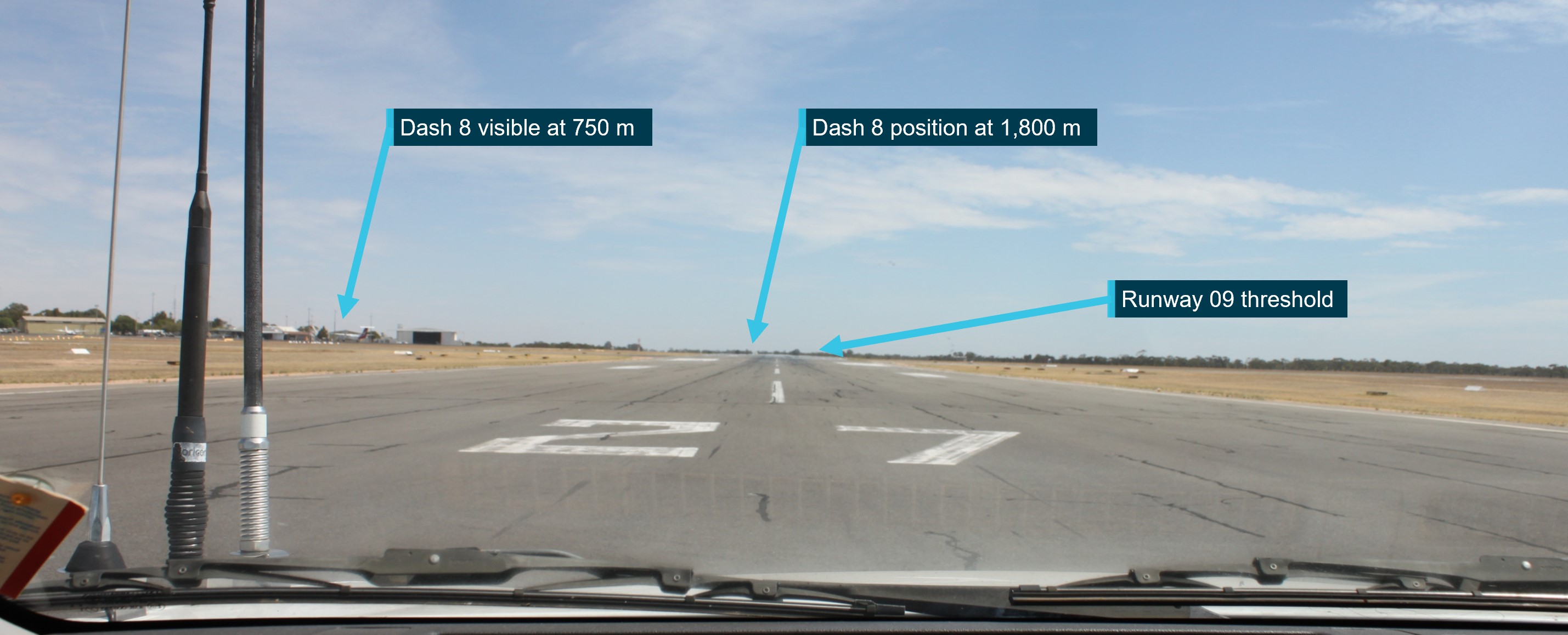
Past research (Hobbs, 2004) has shown distant objects can be seen when their visual angle is at least 24−36 minutes of arc (0.4−0.6°), and down to a minimum of 12 minutes of arc (0.2°) in ideal viewing conditions (ATSB, 2025).
Once the Saab 340 had cleared the runway and the visual path to the PA-28 was clear for the Dash 8 crew, the PA-28 was lined up for take-off. When lined up on the runway, the most prominent part of the PA-28 was the fuselage, which was 1.65 m high, with a wingspan of 10.79 m (noting that the wings would be edge-on). At the distance of 1,700 m, this would have presented a visual image that was about 3 minutes of arc (0.06°).[13] Additionally, as the PA-28 was moving down the runway, the gradual change in angular size would likely have been virtually imperceptible due to the eye’s limited sensitivity to small angular variations. Therefore, in the absence of confounding factors, it would have been very unlikely that the PA-28 would have been detectable by the Dash 8 pilots at that distance.
Other factors can also exist that can affect whether a pilot will be able to see another aircraft, including the background that an object is seen against. As can be seen in Figure 6, the background behind the runway 23 threshold was dark and would have provided good contrast to the white PA-28 aircraft, making detection easier.
Finally, the use of lights by the PA-28 would have enhanced detection. Strobe lights would have enhanced detection though flash and movement. However, landing lights are angled forward and downwards, and may not have been as detectable by the Dash 8 crew.
See-and-avoid
At and around non-controlled aerodromes, pilots are responsible for making themselves aware of nearby aircraft and maintaining separation. Safe operations at non-controlled aerodromes rely on all pilots maintaining an awareness of their surroundings and other aircraft, the principle of ‘see‑and‑avoid’.
A visual traffic search in the absence of specific traffic information is less likely to be successful than a search where traffic information has been provided. Knowing where to look can greatly increase the chance of sighting the traffic.
An ‘unalerted’ search is one where reliance is entirely on the pilot searching for, and sighting, another aircraft without prior knowledge of its presence. An ‘alerted’ search is one where the pilot is alerted to another aircraft’s presence, typically through radio communications or aircraft-based alerting systems. An alerted search supports a pilot’s situational awareness and enhances their visual lookout for traffic by developing an expectation of visually acquiring the traffic in a particular area.
Issues associated with unalerted see-and-avoid have been detailed in the ATSB research report, Limitations of the See-and-Avoid Principles(Hobbs, 2004). The report highlights that unalerted see-and-avoid relies entirely on the pilot’s ability to sight other aircraft.
Tools to enable ‘alerted see-and-avoid’ include:
VHF radio
transponders, used by traffic collision avoidance system (TCAS)
Hobbs (2004) identified that an alerted search is likely to be 8 times more effective than an unalerted search, this highlighted that knowing where to look greatly increases the chances of sighting other traffic.
Alerted see-and-avoid relies on pilot or crew awareness of all traffic in their vicinity, especially those that may be considered a hazard to their operations. Enhanced situational awareness requires the pilot or crew mental model of the location and intentions of nearby traffic to be updated regularly to form an evolving understanding of the nearby traffic. Without this information, the likelihood of effective situational awareness is degraded, and the mental model and shared understanding of hazards is compromised.
Operational procedures
QantasLink Dash 8 procedures
Non-controlled aerodrome VHF radio procedure
The QantasLink Dash 8 standard operating procedure for departure from a non‑controlled aerodrome (such as Wagga Wagga Airport), at the time of the occurrence, required VHF COM 1 to be set to the area frequency and VHF COM 2 to be set to the CTAF, as passenger boarding commenced.
Prior to releasing the handbrake to taxi, a call was to be made to the relevant air traffic centre on VHF COM 1 and then followed by a taxi call to the CTAF on VHF COM 2. However, due to this being a repositioning flight, the crew only broadcast on VHF COM 2 on the CTAF frequency.
Controlled aerodrome VHF radio procedure
The QantasLink Dash 8 standard operating procedure for departure from a controlled aerodrome, at the time of the occurrence, required VHF COM 1 to be set to the primary air traffic control frequency for ground and air-based communications. The VHF COM 2 was set for other communications (such as ATIS,[14] AWIS,[15] PAL and CTAF).
Reverse thrust on the ground
QantasLink policy for engaging reverse thrust during ground operations required prior approval from the Head of Flight Operations. This approval requirement was due to the risks associated with not being able to confirm clearance from other traffic or obstacles that cannot be visually identified from the flight deck. The captain advised during interview that they were aware of this policy.
Procedures for transponder use
The QantasLink procedure was to set the transponder to ‘ON/ALT’ with the applicable transponder code[16] as part of the pre-flight process. This is achieved either after obtaining airways clearance or (at airports where airways clearance is not obtained until after take-off), as part of the pre‑flight process before engine start.
AAPA PA-28 operator procedures
VHF radio procedure
The AAPA procedures, contained within the ‘Piper Warrior III Crew Operating Manual’, normal procedures, required COM 1 to be selected to the local area frequency, tower, ground, clearance delivery, approach or departure frequency as required. COM 2 was required to be set to the CTAF, ATIS, AWIS, MULTICOM or guard frequency (121.5 MHz) as required.
The instructor confirmed during interview that, at the time of the occurrence, COM 1 was set to Melbourne Centre (area frequency) and COM 2 was set to the Wagga Wagga CTAF.
Procedures for transponder use
The PA-28 operator’s’ procedure for transponder operation was to set the applicable transponder code and select the STBY[17] function during taxi. Prior to entering the runway, ON/ALT mode[18] was to be selected.
The PA-28 operator’s training manual notes:
All pilots must ensure ALT is selected on the transponder during the LINE UP CHECKLIST. Other aircraft equipped with TCAS rely on transponder information for pilot alerting and collision avoidance functions.
PA-28 external light use
The PA-28 operator’s procedure for the selection of external lights is documented in its Piper Warrior III flight crew operating manual, normal procedures.
As required by the ‘pre line up scan action flow’, the pilot selects the landing lights ‘on’ (during daytime operations), immediately prior to commencing a take-off roll at a non‑controlled aerodrome.
The instructor recalled that normal behaviour would involve the pilot selecting the landing lights ‘on’, when the ‘rolling call was issued’.
Regulations regarding transponder use
The use of surveillance equipment such as ADS-B and transponder is outlined in the Civil Aviation Safety Regulations Part 91 Manual of Standards (MOS) and the Airservices Australia Aeronautical Information Publication (AIP).
Chapter 26 of the Part 91 MOS, operation of surveillance equipment – general requirements stated, among other things, that transponder equipment required to be fitted and carried on an aircraft must be continuously operated. It also identified that ‘continuous operation’ for a transponder means that the equipment must be operated in a mode that enables a secondary surveillance radar (SSR)[19] response to be transmitted and, where an altitude reporting capability is available, that this capability is also activated.
AIP Australia ENR 1.6 paragraph 7.1.9 stated:
A pilot operating a Mode S transponder must:
b. On receipt of ATC clearance, or requesting the earlier of Push Back or Taxi, select TA/RA/XPDR/ ON AUTO as applicable.
CASA advised that item ‘b’ only applies at controlled aerodromes. At non-controlled aerodromes, transponders must be turned on prior to becoming airborne.
Radio communication
VHF radio is the primary communication tool commonly used to provide ‘alerted see‑and‑avoid’ from sport and recreational private flying to air transport. Broadcasts on the CTAF to any other traffic in the vicinity of a non-controlled aerodrome are made to provide situational awareness, traffic separation and deconfliction to other traffic in the vicinity.
Positional broadcasts
Civil Aviation Safety Regulation 91.630 made certain radio calls mandatory for aircraft that are fitted with or carry a VHF radio. Chapter 21 of the Part 91 Manual of Standards (MOS) prescribed one type of mandatory broadcast that applies at all non-controlled aerodromes, namely:
When the pilot in command considers it reasonably necessary to broadcast to avoid the risk of a collision with another aircraft.
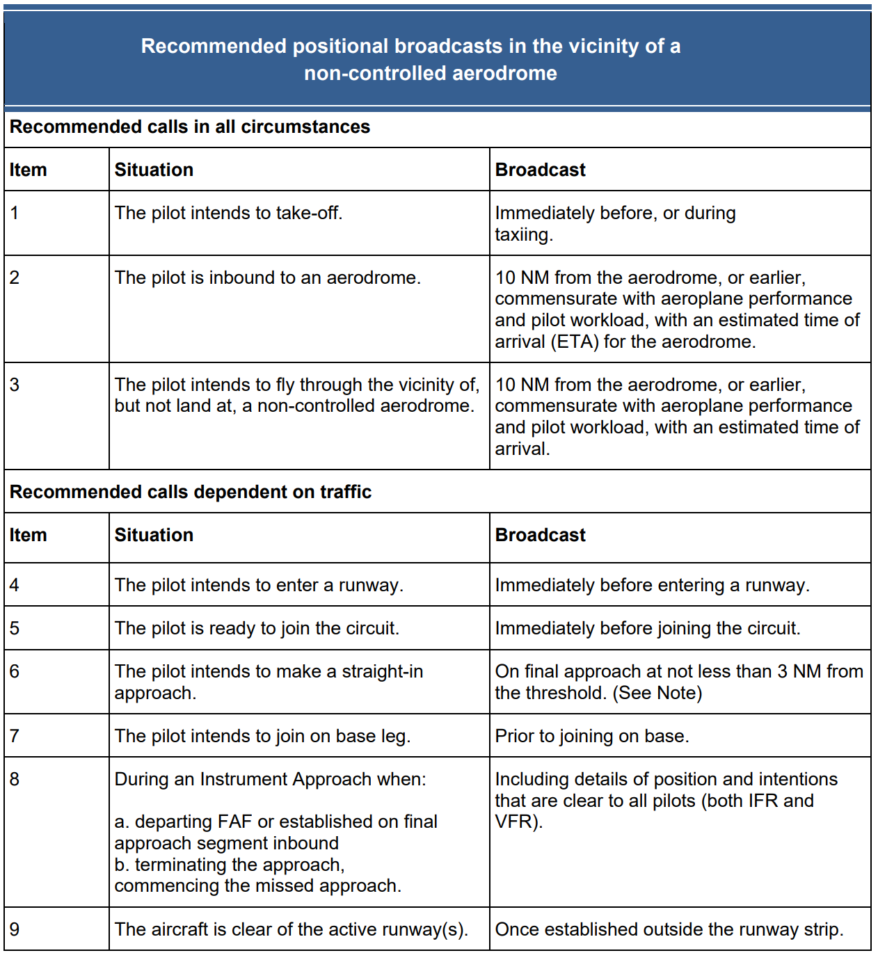
To aid in increasing situational awareness at non-controlled aerodromes, recommended broadcasts are published by the Civil Aviation Safety Authority (CASA). These broadcasts enable pilots to alert other traffic to their location and intentions before take‑off, inbound to land at, or if intending to overfly a non-controlled aerodrome.
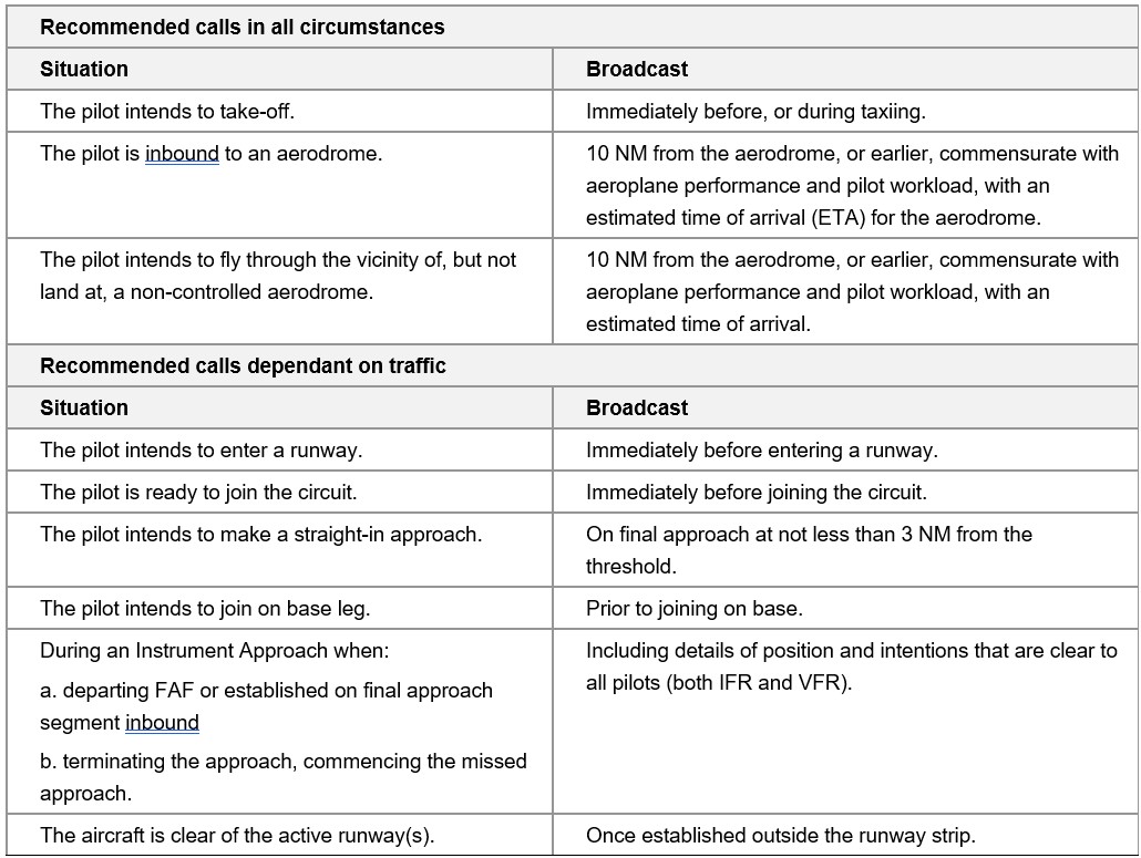
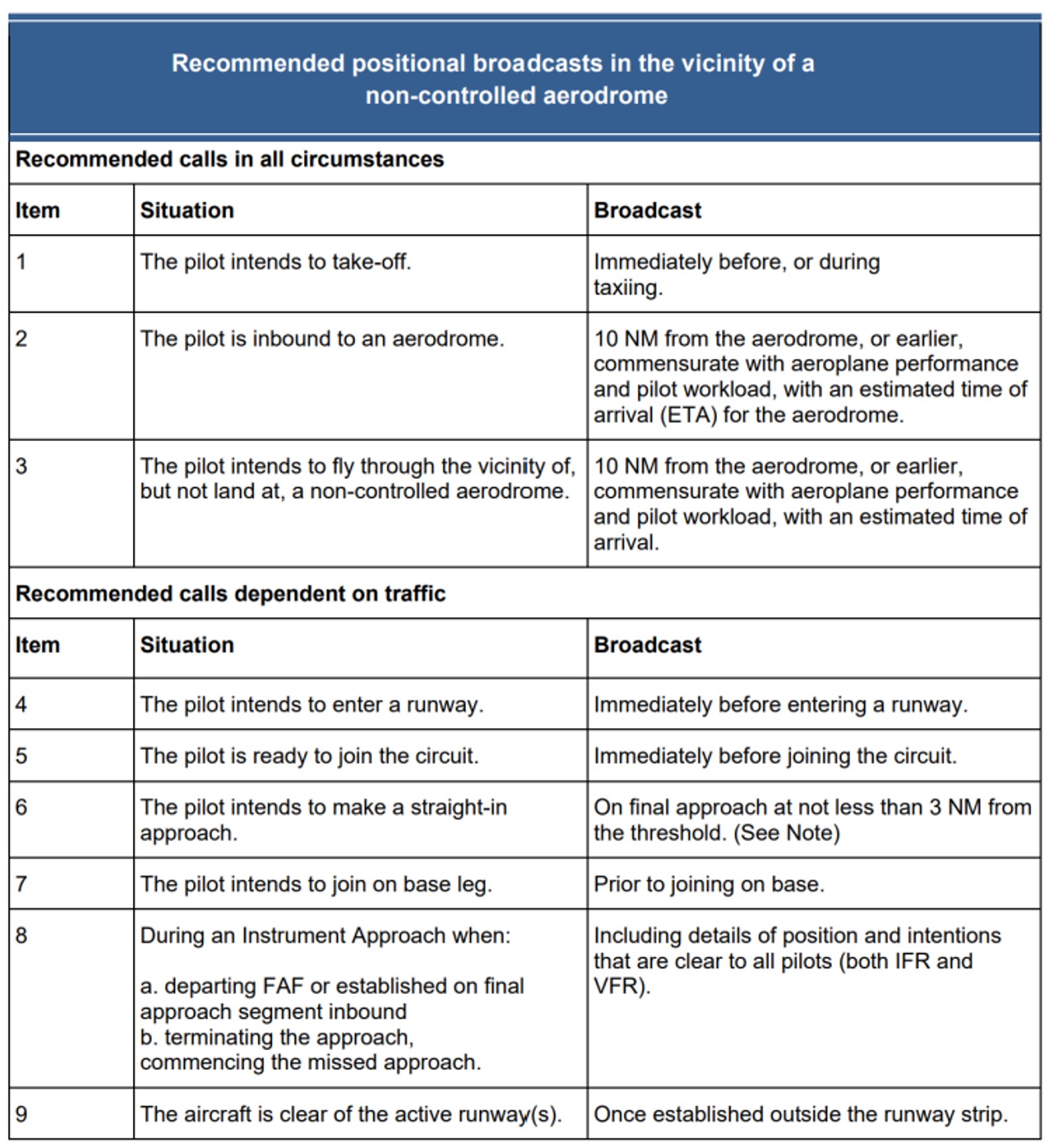
Standardised radio transmissions and phraseology assist with effective and efficient radio communication. To achieve this, the application of recommended positional broadcasts (Table 1) for VFR traffic are published in CASA Advisory Circular (AC) 91-10, Operations in the vicinity of non-controlled aerodromes.
Table 1: Recommended positional broadcasts in the vicinity of a non-controlled aerodrome
Item
Situation
Broadcast
Recommended calls in all circumstances
1
The pilot intends to take off.
Immediately before, or during taxi.
2
The pilot is inbound to the aerodrome.
10 NM from the aerodrome, or earlier, commensurate with aeroplane performance and pilot workload, with an estimated time of arrival (ETA) for aerodrome.
3
The pilot intends to fly through the vicinity of, but not land at, a non-controlled aerodrome.
10 NM from the aerodrome, or earlier, commensurate with aeroplane performance and pilot workload, and an estimated time of arrival.
Recommended calls dependent on traffic
4
The pilot intends to enter the runway.
Immediately before entering a runway.
5
The pilot is ready to join the circuit.
Immediately before joining the circuit.
6
The pilot intends to make a straight in approach.
On final approach at not less than 3 NM from threshold.
7
The pilot intends to join on base leg.
Prior to joining base leg.
8
During an instrument approach when:
a. departing FAF or established on final approach segment inbound
b. terminating the approach, commencing the missed approach.
Include the details of position and intentions that are clear to all pilots (both IFR and VFR).
9
The aircraft is clear of the runway(s).
Once established outside of the runway strip.
Source: CASA AC 91-10 Operations in the vicinity of non-controlled aerodromes
Limitations of positional broadcasts
Positional broadcasts are a one-way communication and do not imply receipt of information by other parties unless direct radio contact is made between stations.
Positional broadcasts rely on the accuracy of the information being broadcast and the ability of other traffic receiving, comprehending and reacting to this information.
CASA AC 91-10 stated:
8.2.1 Pilots are reminded that although correct and informative radio calls play a critical role in ensuring collision avoidance in uncontrolled airspace, to ensure the safety of their aircraft they cannot assume that an absence of other radio calls means there are no nearby or conflicting aircraft.
8.2.2 Pilots must continually look out for other aircraft, even when their broadcasts have generated no response
8.2.3 Accidents and incidents have occurred where pilots incorrectly assessed the threat posed by another aircraft, either due to the pilot incorrectly assessing the relative aircraft flight paths, or inaccurate information being provided by other pilots.
Dash 8 radio reception and transmission
Two Dash 8 ground communication events has been previously identified by ATSB investigations (AO-2023-025 and AO-2023-050) at Mildura Airport (see Related occurrences).
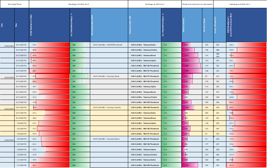
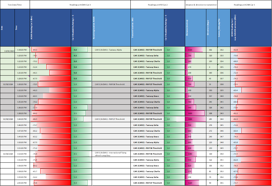
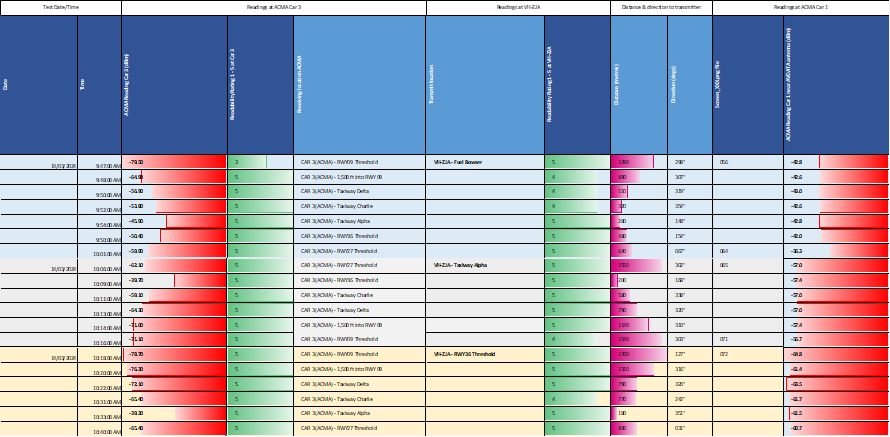
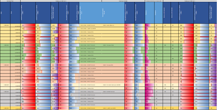
These 2 events resulted in the second investigation testing the Dash 8’s VHF systems. The testing was conducted by the ATSB, the Australian Media and Communications Authority[20] and QantasLink. The testing measured the transmission power pattern of the Dash 8’s 2 communication systems (upper and lower antennae), when the aircraft was on the ground at Mildura Airport.
The testing identified that ground‑based Dash 8 signal strength reception could be adversely affected by the aircraft’s orientation relative to the other aircraft or antenna locations. Additionally, the average signal strength forward of the aircraft was 8.5 dBm[21] stronger than the average signal strength behind and to the side of the aircraft. A significant recorded signal strength and clarity reduction on both VHF COM 1 and VHF COM 2 radios was observed when the tail of the Dash 8 was pointed towards the receiver.
It was further identified that reception and transmission on VHF COM 2 on the ground (via the lower antenna, as used for QantasLink Dash 8 ground communications at non‑controlled aerodromes) had significantly reduced strength and clarity compared to VHF COM 1.
The Dash 8 manufacturer, De Havilland Aircraft of Canada Limited, advised that VHF COM 1 was expected to provide more reliable performance in ground-based communication with other ground stations.
Two flight operations service letters (Appendix B – Flight Operations Service Letters) were released on 6 December 2024 for the Dash 8-100/200/300 (DH8-SL-23-008A) and Dash 8‑400 (DH8-SL-23-020A). Details included a description of the limitations of VHF line of sight communications and the recommendation that VHF COM 1 may provide a better signal (receiving and transmitting) to other stations on the ground, or nearby in the air.
As a result of the first occurrence at Mildura on 6 June 2023 (see ATSB investigation report AO-2023-025), QantasLink issued a technical advisory bulletin, effective from 17 July 2024, which changed the VHF communications procedure for Mildura departures. The aim of the change was to improve ground-to-ground CTAF VHF communication during the taxi phase. However, this has only been adopted at Mildura Airport through a route manual amendment (now company port supplement) and does not provide any effective level of mitigation to this known risk for other non-controlled aerodromes.
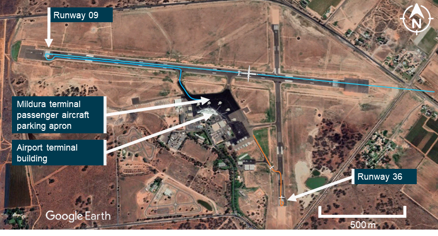
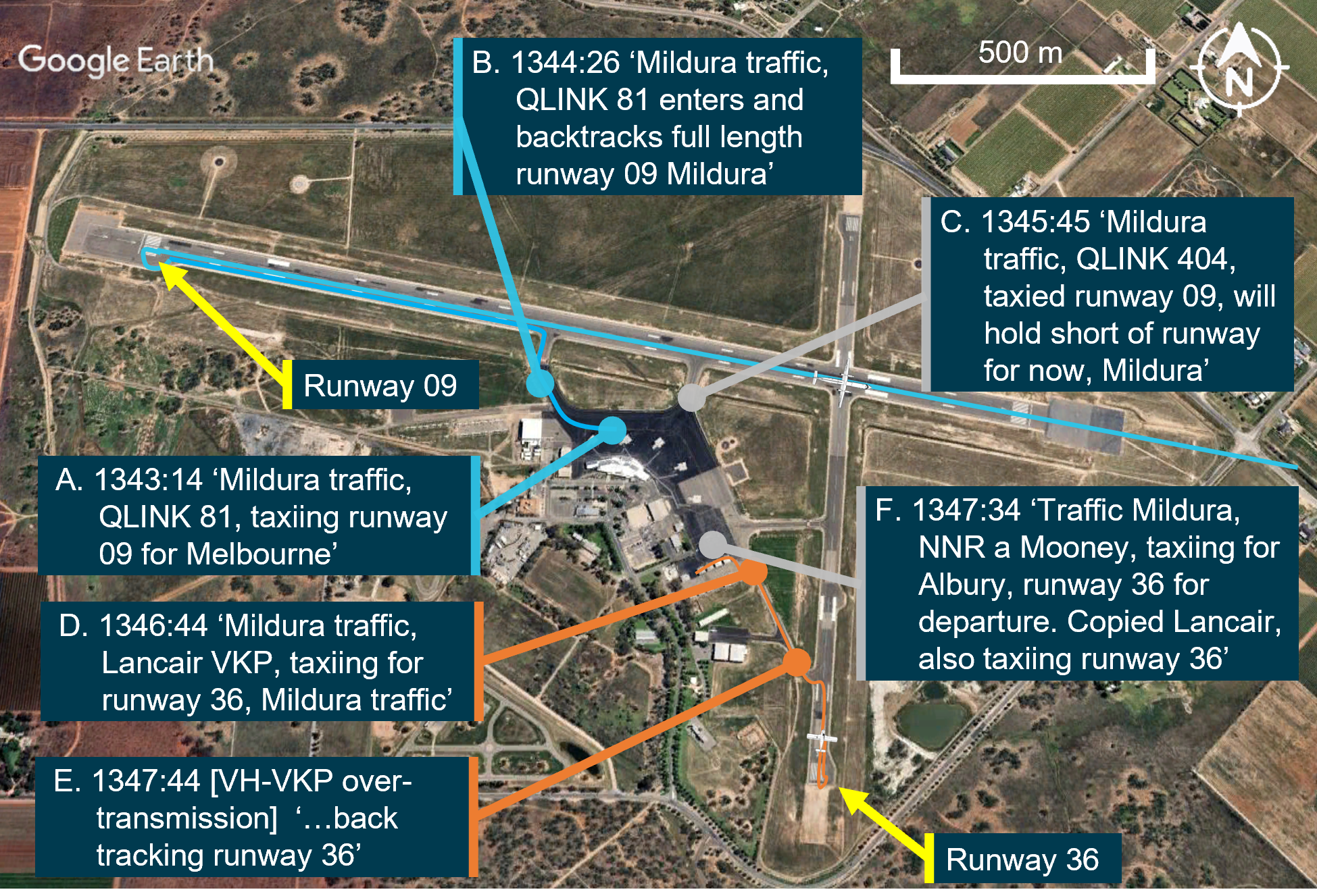
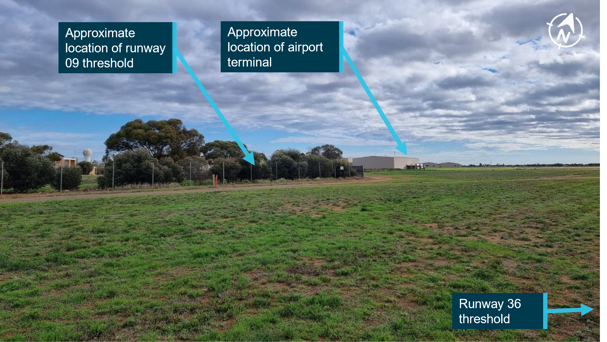
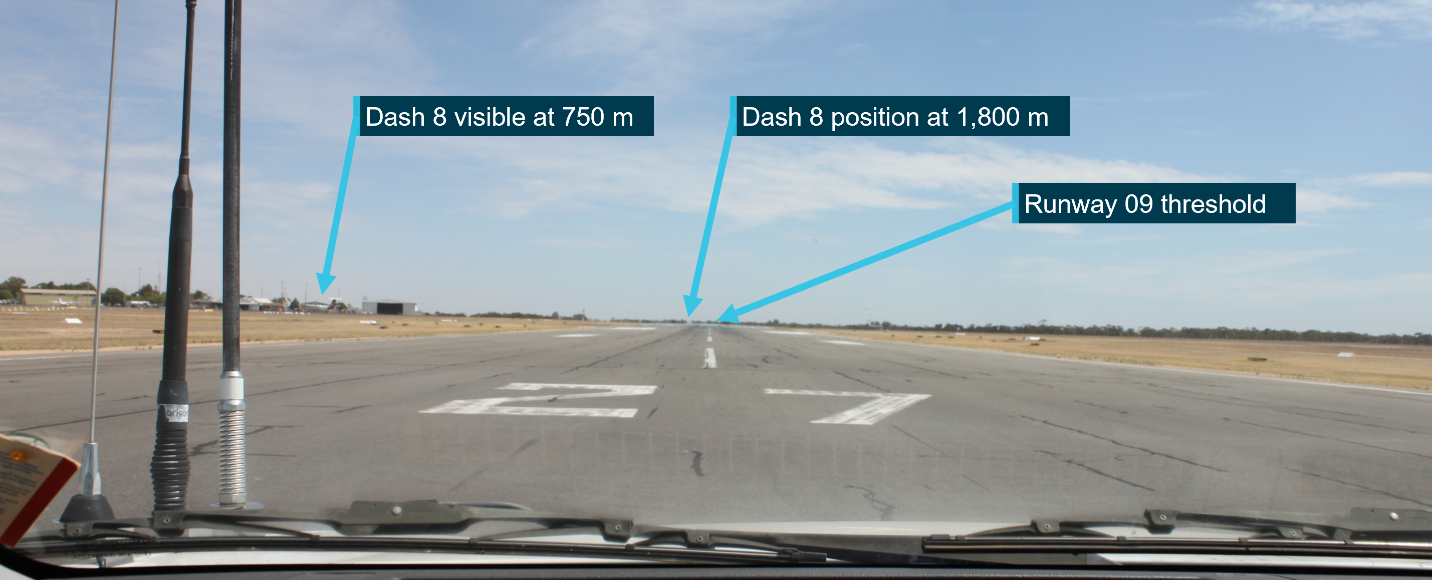
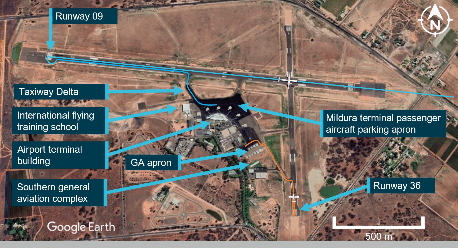
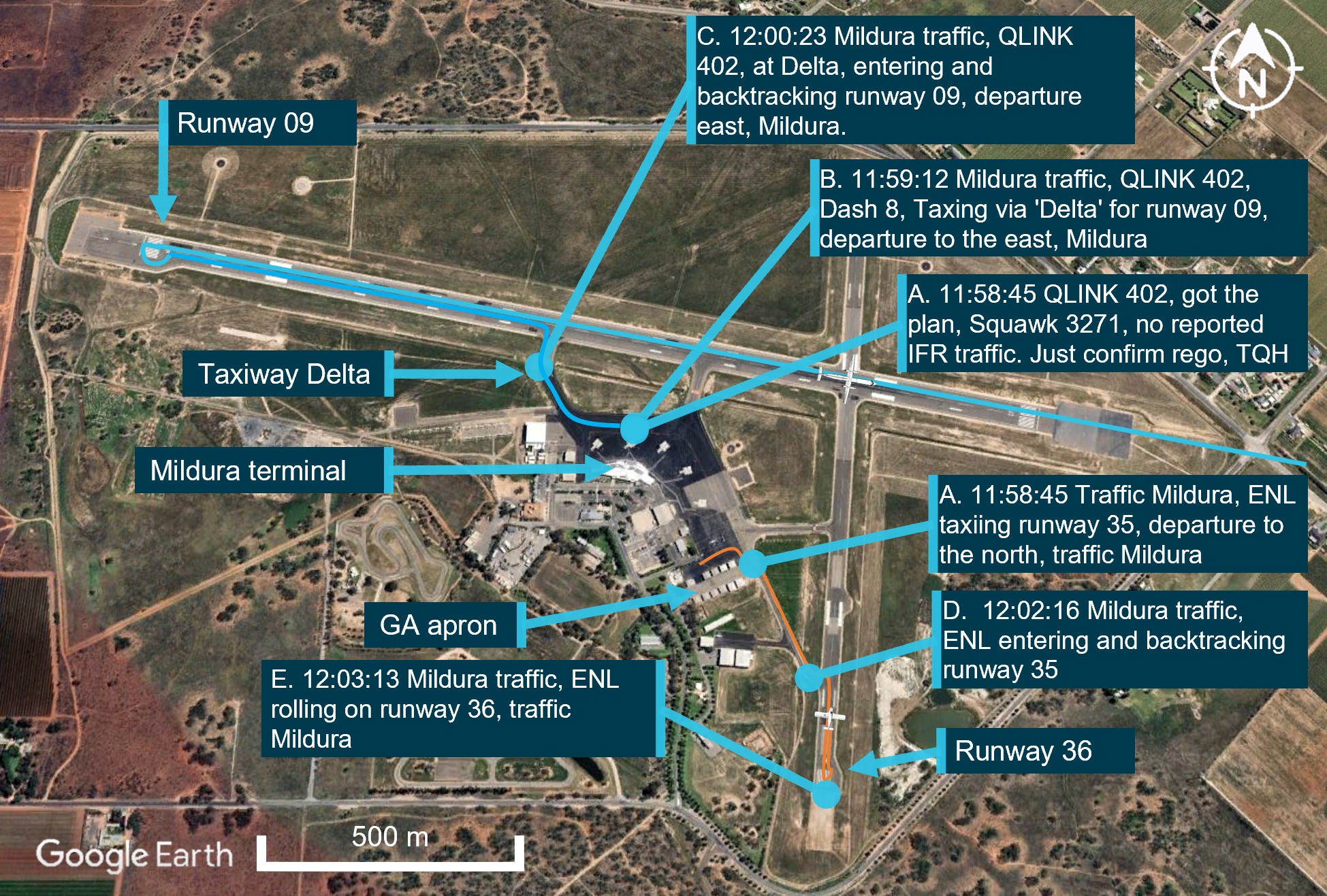
On 6 June 2023, a Piper PA-28-161, taxied for runway 36 at Mildura Airport, Victoria. At about the same time, a QantasLink De Havilland Aircraft of Canada Limited DHC-8-315 (Dash 8) began to taxi for runway 09. Both aircraft broadcast their intentions on the local common traffic advisory frequency. The pilot of the PA-28 was aware of the Dash 8, but the crew of the Dash 8 were not aware of the PA-28. Both aircraft commenced their take‑off at about the same time and the Dash 8 crossed ahead of the PA-28 at the runway intersection of 09/36 by about 600 m.
The pilot of the PA-28 was unable to visually sight the location of the Dash 8 due to airport buildings and assumed that the Dash 8 was still backtracking on runway 09. They did not directly contact the Dash 8 to positively organise separation. They also incorrectly referred to the runway direction at Mildura Airport as ‘runway 35’ instead of ‘runway 36’.
The Dash 8 crew was focused on obtaining their pre-departure information from air traffic control and had the volume for the radio tuned to the common traffic advisory frequency turned down. An over transmission from air traffic control meant that the Dash 8 crew only received certain elements of the PA-28 pilot’s radio calls. This likely led to an incomplete comprehension of traffic by the Dash 8 crew who believed that the PA-28 was not at Mildura (due to the incorrect reference to runway 35). However, they did not seek further information of the source of the radio calls to positively identify the traffic location.
The investigation found that, due to the topography and buildings at Mildura Airport, aircraft are not directly visible to each other on the threshold of runways 09, 27 and 36. The Dash 8 crew did not give a rolling call on runway 09, nor were they required to. The lack of a requirement for mandatory rolling calls increased the risk of aircraft not being aware of each other immediately prior to take-off.
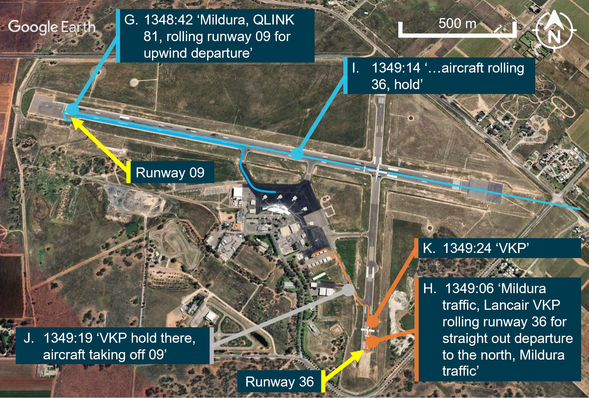
On 29 September 2023, De Havilland Aircraft of Canada Limited DHC-8-315 (Dash 8), taxied for runway 09 at Mildura, Victoria. A short time later, an amateur‑built Lancair Super ES aircraft taxied for runway 36 at Mildura, for a private flight to Ballarat.
Both aircraft gave taxi, entering and backtracking calls on the local common traffic advisory frequency. Neither the pilot of the Lancair, nor the crew of the Dash 8, were aware of each other. The crew of the Dash 8 gave a rolling call and had commenced their take-off on runway 09 as the pilot of the Lancair gave a rolling call on runway 36, this was received by the Dash 8 crew with an immediate response given to the Lancair to hold on the runway. Another aircraft, taxiing behind the Lancair for runway 36, advised them to hold position while the Dash 8 departed.
The Dash 8 crossed the runway 09/36 intersection while the Lancair remained on the threshold of runway 36.
The investigation found that, due to the topography and buildings at Mildura Airport, aircraft are not directly visible to each other on the threshold of runways 09, 27 and 36. It was also identified that the crew of the Dash 8 were actively engaged in in organising separation with other airborne traffic and the Lancair’s entering and backtracking call was over transmitted.
It was also identified that the Dash 8 had reduced ground-based radio reception and transmission strength and clarity on VHF COM 2 (which used an antenna on the aircraft underbelly) and was required to be used by company procedures. The investigation also found that the Dash 8 had reduced radio reception and transmission strength to and from other airfield users located behind the Dash 8 which affected radio call readability.
This led to a situation where the crew of the Dash 8 had an incomplete comprehension of the ground-based traffic at Mildura, and had no knowledge of the Lancair until during the take-off. In addition, due to the position and distance of the Dash 8, the pilot of the Lancair had no awareness of the Dash 8 until another aircraft advised that the Dash 8 was rolling on runway 09.
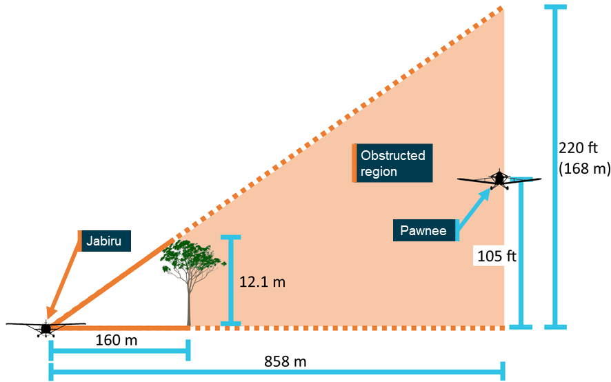
On 19 March 2024, a Fairchild SA226-TC (Metroliner), taxied at Geraldton, Western Australia, for runway 03. About one minute later, a Beechcraft A36 (Bonanza), taxied for runway 14. After reaching their respective runway thresholds, both pilots attempted to contact the other, however, they did not hear each other, nor could they see each other. A third aircraft assisted by relaying information. Based on the information received, the Bonanza and Metroliner pilots commenced their take-off within 3 seconds of each other. The Metroliner crossed runway 14 about 400 m in front of the Bonanza, with a vertical separation of about 250–300 ft.
The investigation found that, when aircraft were positioned at the thresholds of runway 03 and 14 (and 08), they will unlikely be visible to each other due to the position of the airport buildings. Further, they may not be contactable on VHF radio due to potential shielding effects. This resulted in the pilots being unable to verify each other’s position and intentions prior to commencing their take-off.
While the pilot of the third aircraft was attempting to assist, the details provided were inaccurate and incomplete. This inadvertently resulted in misinterpretation by the Bonanza and Metroliner pilots and influenced their decision to take off.
Safety analysis
Introduction
On 15July 2024, a QantasLink De Havilland Aircraft of Canada Limited DHC-8-402, registered VH-QOD, entered runway 05 at Wagga Wagga Airport, unaware that a Piper PA-28, registered VH-XDK, was commencing its take-off roll from runway 23.
While the crew of the Dash 8 was entering the runway, the crew of a third aircraft (Saab 340), notified the Dash 8 crew of the PA-28’s presence.
Once the Dash 8 crew was aware of the PA-28, the captain stopped the aircraft about 5 m past the holding point, then engaged ‘reverse thrust’ to back the Dash 8 clear of the runway. Concurrently, the pilot of the PA-28 rejected their take-off from runway 23.
This analysis will explore operational considerations such as situational awareness, the breakdown of communication, shared mental model and alerted see‑and‑avoid, as well as the limitations identified within operational procedures and specific aircraft system limitations.
Situational awareness and communication
The PA-28 crew was aware of the Dash 8 intentions and location. The PA-28 instructor subsequently held the assumption that the Dash 8 crew had, likewise, received their radio broadcasts and were aware of the PA-28’s location and intentions for take-off.
The Dash 8 crew did not expect any other traffic, in addition to the Saab 340. The Dash 8 crew reported not identifying the PA-28 either visually or via electronic means, nor hearing the PA-28’s radio communications. During taxi to the opposite end of the runway, the Dash 8 was pointing in the opposite direction to the PA-28, and later the line of sight to the PA-28 would have been obscured by the landing Saab 340. As the PA-28 transponder was not turned on prior to entering the runway, it was not identifiable electronically either prior to this time. The remaining opportunity to increase situational awareness was the initial taxiing radio calls. The Dash 8 crew’s broadcast immediately after they were told about the conflicting traffic shows they were surprised to learn there was another aircraft operating from the airport, this suggests that the Dash 8 crew members did not hear these transmissions rather than forgot them.
Contributing factor
During ground-based repositioning, the Dash 8 entered runway 05 while the PA-28 had commenced its take-off roll from runway 23. The Dash 8 crew were not aware of the PA-28 until notified by the crew of a third aircraft of the potential conflict.
Communication
Succinct and timely radio communication is important to ensure high levels of situational awareness and aids in providing alerted see-and-avoid safety outcomes. As such, the accuracy of the information broadcast by pilots is critical in ensuring minimum misunderstanding.
Common traffic advisory frequency (CTAF) recordings indicated that the PA-28 pilot made the recommended positional broadcasts in preparation for their departure – a taxi call when leaving the apron area, entering the runway and then a rolling call on the runway. However, positional broadcasts are ‘one-way’ communications by nature and do not explicitly mean that other traffic in the vicinity interpret and understand the intended information.
The PA-28 instructor reported that they believed that the Dash 8 crew had received and understood their broadcasts. This misunderstanding was based on the presumption that because the PA-28 could hear the radio calls and see the Dash 8, that the Dash 8 crew also could hear the radio calls and see the PA-28.
The PA-28 crew could hear the communications between the Dash 8 and Saab 340, centring on the Dash 8 crew ensuring they did not impede the Saab 340’s landing. However, the PA-28 instructor expected that the Dash 8 would hold short of the runway to allow them to take-off without hearing any broadcasts to that effect. As a result, the PA-28 crew did not initiate any direct radio contact with the Dash 8 crew to clarify their intentions.
Had the PA-28 instructor attempted to make direct contact with the Dash 8, and not been successful, they would have subsequently realised there had been a communication breakdown.
Contributing factor
The pilots of the PA-28 gave the recommended radio calls, however, did not directly communicate or engage with the Dash 8 crew to arrange separation.
Visual identification
The topography at the aerodrome results in a runway height change between the thresholds of runway 05/23 at Wagga Wagga Airport. This change is up to 2 m in elevation between the thresholds, with a slight hump towards the runway 05 end. However, there was a clear visual line of sight from one threshold to the other.
When the Dash 8 was on taxiway B at the holding point of the runway, the crew’s vision of the PA-28 may have been blocked by the landing Saab 340. By the time that aircraft cleared the runway, the PA-28 was lined up on the runway and had started its take-off roll.
Based on the limitations of vision, it is very unlikely that the Dash 8 crew would have been able to detect the presence of the PA-28 about 1,700 m away, simply by looking in that direction, as the image of that aircraft would have been too small for detection. The use of landing and strobe lights would have assisted, but over that distance would have been limited. Consequently, the Dash 8 crew, who reported looking before entering the runway, did not detect its presence.
If the Dash 8 crew had previously been alerted to the presence of another aircraft, this would have increased the chance of detection. Alerted see‑and‑avoid means that the presence and approximate location of another aircraft is known or expected, allowing the crew to narrow their visual search. However, in this case, the absence of the Dash 8 crew detecting radio calls from the PA-28 and no other aircraft identified during taxi either visually or electronically, meant that the Dash 8 crew held an expectation that there were no other ground-based aircraft operating at the airport at that time. Not detecting the PA‑28 was consistent with that expectation.
Contributing factor
Without any prior alert or expectation of the presence of the PA-28, the Dash 8 crew did not visually detect the PA-28 on take-off from the reciprocal end of the runway, prior to the Dash 8 entering the runway to taxi to the terminal.
The ATSB identified that while the PA-28 crew conducted their taxi, engine run-ups and aircraft checks, their transponder was set to standby. Prior to entering the runway for take-off, the pilot of the PA-28 then switched the transponder from standby to ‘ON’.
The Dash 8 crew reported that electronic surveillance equipment was used as an aid to supplement the identification of potential conflicting traffic in the vicinity of a non‑controlled aerodrome prior to take-off. Both the captain and first officer of the Dash 8 recalled conducting a check of their onboard surveillance systems (electronic flight bag, traffic collision avoidance system (TCAS) aircraft display and Flightradar24 application) during taxi and did not identify any traffic other than the third-party landing aircraft.
Non-active mode S transponders do not provide electronic surveillance information to other aircraft. If the transponder is not selected ‘on’, a missed opportunity exists to provide situational awareness to other aircraft.
It is likely, had the PA-28 mode S transponder been activated at the first aircraft movement for taxi, the flight crew of the Dash 8 would have detected the presence of the PA-28 and developed an expectation of its location and potential confliction. This would have prompted the crew to coordinate both verbally and aided alerted see‑and‑avoid.
Contributing factor
During taxi for take-off, the PA-28 was not broadcasting transponder information to identify them to other traffic in the vicinity of the aerodrome.
Australian Airline Pilot Academy procedures for transponder
The AAPA’s manual had a procedure that prescribed the use of the transponder on standby during startup and taxi, with a requirement to only switch it to ‘ALT’ prior to entering the runway.
Widespread use of surveillance equipment, such as transponders with ADS-B installed, offer significant improvement to allow pilots to be more certain of the location of traffic, particularly outside controlled airspace environments.
Had the PA-28 crew been required to select their mode S transponder to ‘ON/ALT’ prior to initial taxi, this would have made them electronically visible to the Dash 8 crew who reported actively seeking this information.
Contributing factor
The Australian Airline Pilot Academy flying school flight crew operating manual only required pilots to activate the transponder prior to entering the runway. The use of a transponder during taxi would normally provide an additional source of positional data to other pilots, aiding visual identification and alerted 'see‑and‑avoid' to other aircraft. (Safety issue)
Topographic shielding
Local operators at Wagga Wagga Airport have observed and reported that a reduction in effectiveness of VHF communications had been experienced at certain locations on the airport. This observation of topographical radio shielding was identified by multiple parties.
Topographic changes exist in and around Wagga Wagga Airport and were suggested by stakeholders to result in varying levels of topographical radio shielding at the eastern end of taxiway A and the end of runway 23.
Prior to the occurrence, the PA-28 operator issued internal notifications of an ‘identified radio dead spot’, to its flight crews.
Operator advice and reported experience regarding topographical shielding at Wagga Wagga Airport was documented procedurally for AAPA, but was not available to Dash 8 crew operating into Wagga Wagga Airport. The ATSB did not independently confirm the existence of radio shielding. Operator experience and local procedure indicates this is likely an ongoing issue at Wagga Wagga Airport.
Contributing factor
Reduced VHF ground-based communication was identified at the eastern end of runway 23 at Wagga Wagga Airport. Local operator reports and procedures indicate likely reduced communications on the eastern end of taxiway A to other areas on the aerodrome.
Dash 8 radio reception and transmission
VHF radio transmissions facilitate exchanges between air traffic control, aircraft, and emergency services. These signals primarily rely on line of sight propagation, requiring an unobstructed path between the transmitting and receiving antennas. When line of sight is obstructed by terrain features, aircraft structure, or by man-made structures like buildings, VHF signals can be significantly attenuated, leading to reduced communication range, signal distortion, or complete loss of contact. However, under certain conditions, VHF signals may propagate beyond line of sight through mechanisms such as reflection and diffraction. While these phenomena can marginally extend communication range, their effectiveness is highly dependent on the environment.
Previous analysis of Dash 8 ground-based communications (AO-2023-050) identified a significant reduction in radio signal strength and readability when using the VHF COM 2 antenna for ground operations. The analysis determined that the aircraft structure and surrounding airport infrastructure at Mildura Airport impeded VHF COM 2 signal transmission and reception, limiting its effectiveness. In contrast, using the VHF COM 1 antenna provided a clearer line of sight to ground-based stations, resulting in more reliable communication.
ATSB analysis of the radio communications between the Dash 8, the Saab 340, and the PA-28 identified that the Dash 8 crew, while using VHF COM 2, could hear and respond to the Saab 340, likely due to its proximity to the aircraft. However, they could not hear the PA-28.
Their inability to hear the PA-28 was likely due to previously identified issues with the VHF COM 2 antenna and the addition of runway undulations which further obstructed the line of sight between the Dash 8’s VHF COM 2 antenna and the PA-28. This likely exacerbated the antenna’s limitations and hindered effective signal propagation.
Contributing factor
Dash 8 ground-based transmissions on VHF COM 2 had reduced strength and clarity. This likely led to situations where other aircraft had difficulty in receiving and understanding radio transmissions, and the Dash 8 not receiving the PA-28 radio transmissions.
Qantas procedures for VHF
QantasLink procedures required the use of VHF COM 2 for ground-based communication at non-controlled aerodromes. However, the use of VHF COM 2 for ground-based communications was not required for controlled airspace, where ground‑based communications were conducted by VHF COM 1.
In previous ground-based signal strength testing at Mildura Airport (see ATSB investigation report AO-2023-050), the ATSB identified a significant reduction in the Dash 8 VHF radio transmission strength and readability particularly when greater transmission and reception distances were involved. It was also found that the use of VHF COM 2 reduced ground-based transmission reception strength and clarity in comparison with VHF COM 1.
Following a near collision occurrence at Mildura on 6 June 2023, QantasLink changed the VHF communications procedure for Mildura Airport departures. The changed procedure required use of the VHF COM 1 system, noting that this was found to have an improvement in both transmission clarity and reception. However, this has only been adopted at Mildura Airport and so does not provide any effective level of mitigation to this known risk for other non-controlled aerodromes.
Given the reported radio dead spot at Wagga Wagga Airport, the use of VHF COM 2 with the bottom‑mounted antenna by QantasLink Dash 8s likely increased the likelihood of Dash 8 crews not receiving strong and readable radio calls from other ground-based aerodrome users.
Contributing factor
QantasLink's radio procedure required crew to use communications panel radio 2 (COM 2) to broadcast and receive on local frequencies during operations at a non-controlled aerodrome. This reduced the likelihood of the Dash 8 receiving the calls from other aircraft at either end of runway 05/23 at Wagga Wagga Airport in certain circumstances. (Safety issue)
Part of the shared mental model for all operations at non-controlled aerodromes is the situational awareness of all crew, in this instance the crew of the Saab 340 identified a potential threat to the safety of the other 2 aircraft and clearly broadcasted their concern.
Crew interviews as well as CTAF recordings clearly showed that the proactive initiative of the Saab 340 crew to alert the Dash 8 crew of the presence of the PA-28 was instrumental in preventing a potential on runway collision.
Other finding
Third party intervention by the Saab 340 crew prevented the Dash 8 from lining up on runway 05 whilst the PA-28 was engaged in the take-off roll.
After entering the preferred runway, the captain became aware of the hazard present due to the vacating third party aircraft report. The captain’s decision to apply brakes and then engage reverse thrust to clear the runway was almost certainly made to avoid the greatest perceived threat, that being, a possible collision on the runway.
Reversing the aircraft under its own power is a non-normal manoeuvre with additional risks. As such QantasLink policy would normally require Head of Flight Operations approval to conduct the manoeuvre.
The captain’s decision to reverse the aircraft could be attributed to the lower (perceived) risk involved with reversing the aircraft, versus the known risk of a possible collision.
The captain exercised their command authority, based on the information available, to make an assessment of the greatest threat, subsequently deciding to reverse the aircraft, without being able to positively confirm traffic and obstacle avoidance.
Risk management focuses on reducing the potential risks associated with a decision. Thus, considering that decision‑making, when elements of uncertainty exist, focuses on making the best decision given the available information.
The pilot in command of an aircraft has the final authority over the safety of the aircraft and its occupants. When operating in dynamic environments, the pilot in command will need to consider possible outcomes and alternative courses of action to ensure clear risk-based decisions are made. In this instance the captain elected to reduce the likelihood of a catastrophic event by reversing clear of the preferred runway after having a reasonable expectation that the taxiway was clear behind the Dash 8.
Other finding
On assessing that a collision risk existed with the rolling PA-28, the captain held a reasonable expectation that it was clear and reversed the aircraft away from the preferred runway without being able to confirm that no other aircraft were behind the Dash 8.
Findings
ATSB investigation report findings focus on safety factors (that is, events and conditions that increase risk). Safety factors include ‘contributing factors’ and ‘other factors that increased risk’ (that is, factors that did not meet the definition of a contributing factor for this occurrence but were still considered important to include in the report for the purpose of increasing awareness and enhancing safety). In addition ‘other findings’ may be included to provide important information about topics other than safety factors.
Safety issues are highlighted in bold to emphasise their importance. A safety issue is a safety factor that (a) can reasonably be regarded as having the potential to adversely affect the safety of future operations, and (b) is a characteristic of an organisation or a system, rather than a characteristic of a specific individual, or characteristic of an operating environment at a specific point in time.
These findings should not be read as apportioning blame or liability to any particular organisation or individual.
From the evidence available, the following findings are made with respect to the runway incursion involving De Havilland Aircraft of Canada Limited DHC-8, VH-QOD, and Piper PA‑28, VH-XDK, at Wagga Wagga Airport, New South Wales, on 15 July 2024.
Contributing factors
During ground-based repositioning, the Dash 8 entered runway 05 while the PA-28 had commenced its take-off roll from runway 23. The Dash 8 crew were not aware of the PA‑28 until notified by the crew of a third aircraft of the potential conflict.
The pilots of the PA-28 gave the recommended radio calls, however, did not directly communicate or engage with Dash 8 crew to arrange separation.
Without any prior alert or expectation of the presence of the PA-28, the Dash 8 crew did not visually detect the PA-28 on take-off from the reciprocal end of the runway, prior to the Dash 8 entering the runway to taxi to the terminal.
During taxi for take-off, the PA-28 was not broadcasting transponder information to identify them to other traffic in the vicinity of the aerodrome.
The Australian Airline Pilot Academy flying school flight crew operating manual only required pilots to activate the transponder prior to entering the runway. The use of a transponder during taxi would normally provide an additional source of positional data to other pilots, aiding visual identification and alerted 'see‑and‑avoid' to other aircraft. (Safety issue)
Reduced VHF ground-based communication was identified at the eastern end of runway 23 at Wagga Wagga Airport. Local operator reports and procedures indicate likely reduced communications on the eastern end of taxiway A to other areas on the aerodrome.
Dash 8 ground-based transmissions on VHF COM 2 had reduced strength and clarity. This likely led to situations where other aircraft had difficulty in receiving and understanding radio transmissions, and the Dash 8 not receiving the PA-28 radio transmissions.
QantasLink's radio procedure required crew to use communications panel radio 2 (COM 2) to broadcast and receive on local frequencies during operations at a non-controlled aerodrome. This reduced the likelihood of the Dash 8 receiving the calls from other aircraft at either end of runway 05/23 at Wagga Wagga Airport in certain circumstances. (Safety issue)
Other (key) findings
Third party intervention by the Saab 340 crew prevented the Dash 8 from lining up on runway 05 whilst the PA-28 was engaged in the take-off roll.
On assessing that a collision risk existed with the rolling PA-28, the captain held a reasonable expectation that it was clear and reversed the aircraft away from the preferred runway without being able to confirm that no other aircraft were behind the Dash 8.
Safety issues and actions
Central to the ATSB’s investigation of transport safety matters is the early identification of safety issues. The ATSB expects relevant organisations will address all safety issues an investigation identifies.
Depending on the level of risk of a safety issue, the extent of corrective action taken by the relevant organisation(s), or the desirability of directing a broad safety message to the aviation industry, the ATSB may issue a formal safety recommendation or safety advisory notice as part of the final report.
All of the directly involved parties are invited to provide submissions to this draft report. As part of that process, each organisation is asked to communicate what safety actions, if any, they have carried out or are planning to carry out in relation to each safety issue relevant to their organisation.
Descriptions of each safety issue, and any associated safety recommendations, are detailed below. Click the link to read the full safety issue description, including the issue status and any safety action/s taken. Safety issues and actions are updated on this website when safety issue owners provide further information concerning the implementation of safety action.
Safety issue description: The Australian Airline Pilot Academy flying school flight crew operation manual only required pilots to select ALT on the transponder, as part of the Pre Line Up Scan Action Flow and associated Checklist prior to entering the runway. The use of a transponder during taxi would normally provide an additional source of positional data to other pilots, aiding visual identification and alerted 'see‑and‑avoid' to other aircraft.
Safety advisory notice to pilots and operators of mode S transponder equipped aircraft
The effective use of the mode S transponder from first movement of the aircraft can serve as an effective tool in adding another layer of collision avoidance between aircraft on the ground. Utilising the mode S transponder with ADS-B OUT enabled is the most effective way of making an aircraft electronically conspicuous and delivering maximum interoperability with other aircraft as well as the ground ATM environment. The ATSB advises pilots and operators to review their procedures to ensure that mode S transponders are on from first movement of the aircraft, particularly at non-controlled aerodromes.
Safety issue description: QantasLink's radio procedure required crew to use communications panel radio 2 (COM 2) to broadcast and receive on local frequencies during operations at a non‑controlled aerodrome. This reduced the likelihood of the Dash 8 receiving the calls from other aircraft at either end of runway 05/23 at Wagga Wagga in certain circumstances.
Safety action not associated with an identified safety issue
Whether or not the ATSB identifies safety issues in the course of an investigation, relevant organisations may proactively initiate safety action in order to reduce their safety risk. All of the directly involved parties are invited to provide submissions to this draft report. As part of that process, each organisation is asked to communicate what safety actions, if any, they have carried out to reduce the risk associated with this type of occurrences in the future. The ATSB has so far been advised of the following proactive safety action in response to this occurrence.
Safety action by Wagga Wagga Airport
After the occurrence, the aerodrome operator identified that it was possible that a radio black spot may be present based on observations of radio reception just beyond the threshold of runway 23.
Wagga Wagga city council has issued a precautionary NOTAM after the occurrence which provides advice to all operators of possible visibility issues with aircraft on the threshold of runway 23 and the possibility of radio black spots existing under some conditions. The NOTAM note reads:
LIGHT ACFT AT THR OF RWY 23 NOT VISIBLE TO OTHER ACFT USING RWY 05.
RADIO BLACK SPOTS MAY RESULT UNDER SOME CONDITIONS.
Safety action by QantasLink
On 2 August 2024 QantasLink safety issued a company safety alert notice advising crew of a suspected VHF radio blackspot on taxiway A4 and A5 towards the threshold of runway 23 and other areas of the Wagga Wagga aerodrome. They issued the following advice to crew:
Whilst we investigate the issue with the aerodrome operator and other aerodrome users, we encourage crew to consider the following precautions when taxiing for departure or any other manoeuvring on the ground:
- ensure any weak, garbled or carrier-wave only CTAF transmissions are clarified to ensure your separation plan remains valid; -
- stop at runway holding points and visually check for traffic prior to runway entry; -
- where possible all aircraft to use the into wind (duty) runway for departure so aircraft are not departing from opposite ends of the runway; and –
- ensure AFRU responses on the CTAF frequency are heard clearly.
Safety action by Civil Aviation Safety Authority
On 9 September 2025, CASA advised that new guidance and recommendations relating to the use of radios where the antenna is mounted on the underside of the aircraft fuselage to both Advisory Circular (AC) 91-10 and AC 91-14 had been updated.
This guidance advised:
Pilots operating aircraft with similar antenna placements are reminded that ground-based transmissions, when made using a radio with a fuselage underside antenna, are likely to have an increased risk of not being reliably received by other traffic. To enhance situational awareness and collision avoidance, especially at non-controlled aerodromes where radio-alerted see‑and‑avoid is critical, pilots are strongly recommended, wherever practicable, to use radios connected to antennas in unobstructed locations, such as an aircraft upper fuselage, for ground communications
Glossary
AAPA
Australian Airline Pilot Academy
ADSB
Automatic Dependent Surveillance–Broadcast
AIP
Aeronautical information publication
AMSL
Above mean sea level
ATC
Air traffic control
CASA
Civil Aviation Safety Authority
CPL
Commercial pilot licence
CTAF
Common traffic advisory frequency
EFB
Electronic Flight Bag
ERSA
En route supplement Australia
FO
First officer
IFR
Instrument flight rules
LOS
Line of sight
MOS
Manual of Standards
NOTAC
Notice to all crew
NOTAM
Notice to airmen
TCAS
Traffic collision avoidance system
VFR
Visual flight rules
Sources and submissions
Sources of information
The sources of information during the investigation included:
the instructor of VH-XDK
the crew of VH-QOD
QantasLink
Australian Airline Pilot Academy
Civil Aviation Safety Authority
Wagga Wagga Airport
Aviation Bureau de la sécurité des transports du Canada
De Havilland Aircraft of Canada.
References
ATSB. (2025). Cockpit Visibility Study. Supporting AO-2023-001 – Midair collision involving Eurocopter EC130 B4, . Canberra: Australian Transport Safety Bureau.
Bailey, L. L., & Thompson , R. C. (2000). The effects of performance feedback on air traffic control team coordination: A simulation study. United States: Department of Tranportation. Federal Aviation Administration. Office of Aviation. Civil Aerospace Medical Institute.
Civil Aviation Safety Authority. (2013, December). PIlot's responsibility for collision avoidance in the vicinity of non-controlled aerodromes using 'see-and-avoid'. Canberra, ACT, Australia.
Civil Aviation Safety Authority. (2014). SMS 3: Safety Risk Management: SMS for Aviation, A Practical Guide. Canberra, ACT, Australia.
Federal Aviation Administration. (2011). Introduction to TCAS II Version 7.1. U.S. Department of Transportation.
Federal Aviation Administration. (2024). AC 91-120. Operational Use of Airborne Collision Avoidance Systems. U.S. Department of Transportation.
Hobbs, A. (2004). Limitations of the see-and-avoid principle. Canberra, Australia: Australian Transport Safety Bureau.
International Telecommunications Union (ITU-R). (2019). Recommendation ITU-R P.526-15: Propagation by diffraction. Geneva: ITU.
Nguyen, T., Lim, C., Nguyen, N., Gorden-Brown, L., & Nahavandi, S. (2019). A review of situation awareness assessment approaches in aviation environments. IEEE Systems Journal, 3590-3603.
Parsons, J. D. (2000). The mobile radio proagation channel (2nd ed.). Wiley.
Rappaport, T. S. (2002). Wireless Communications: Principles and Practice (2nd ed). Cambridge University Press.
Reynolds , R., & Blickensderfer, E. (2009). Crew Resource managment and shared mental models: A proposal. Journal of Aviation/Aerospace Education & Research, 15‑23.
Stanton , N., Salmon, P., Walker, G., Salas, E., & Hancock, P. (2017). State of science: situation awareness in individuals, teams and systems. . Ergonomics, 449-466.
Wickens, C., Hollands , J., Banbury, S., & Parasuraman , R. (2013). Engineering psychology and human performance. Person Bostan, MA
Submissions
Under section 26 of the Transport Safety Investigation Act 2003, the ATSB may provide a draft report, on a confidential basis, to any person whom the ATSB considers appropriate. That section allows a person receiving a draft report to make submissions to the ATSB about the draft report.
A draft of this report was provided to the following directly involved parties:
the Civil Aviation Safety Authority
the Australian Airline Pilot Academy
QantasLink
Wagga Wagga Airport
Aviation Bureau de la sécurité des transports du Canada
De Havilland Aircraft of Canada Limited
the pilot of PA-28
the crew of Dash 8.
Submissions were received from:
the Civil Aviation Safety Authority
the Australian Airline Pilot Academy
QantasLink.
The submissions were reviewed and, where considered appropriate, the text of the report was amended accordingly.
“Wagga traffic, REX 6673, Saab 340, IFR, 29 DME from the north east, through 9200(ft), Turning right for Echo Echo for the RNP runway 23, for that position at 14 (time), short final 17 (time), last aircraft calling on the CTAF, just callsign?
5
1610.05
VH-XDK
"Yea, that was XDK"
5
1610.10
REX 6673
"Ahaa, sorry one more time your readability is one at moment"
5
1610.16
VH-XDK
"ahhh XDK"
5
1610.22
REX 6673
"Still can’t hear you will speak a little bit closer thanks"
5
1614.12
REX 6673
"Wagga Traffic Rex 6673 now 10 NM final straight in runway 23 Wagga"
5
1614.26
Unknown
carrier wave only (3 transmissions of PTT,) followed by, AUTOMATED “Wagga Wagga Airport airfield lighting on”
5
1616.27
REX 6673
"Wagga Traffic Rex 6673 now 5nm final runway 23 Wagga"
5
1617.31
VH-QOD
"Wagga Traffic, QOD, is a Dash 8, taxiing to the runway and then we will be coming back in for amended Bay 18 Wagga….."
5
1617.47
REX 6673
"Wagga Traffic REX 6673 Saab 340 we are now Short final RWY 23 Wagga".
5
1618.02
VH-QOD
"Aaah REX 6673, QOD will you be exiting at Charlie, do you think?….."
5
1618.10
REX 6673
"Ahh Hard to say at the moment but we will let you know in about 30sec…."
5
1618.15
VH-QOD
"Copy that we will just hold until you are sure thanks….."
5
1618.32
VH-QOD
"Rex 6673, QOD we will just start taxi enter and backtrack from the threshold of runway 05 but we will be out of your way…"
5
1618.42
REX.6673
Aahh 6673 yep
5
1619.20
VH-XDK
"Wagga traffic, Warrior XDK lining up and holding RWY 23 wagga"
4
1619.55
REX 6673
"Wagga traffic REX 6673 clear of all RWY'S Wagga"
5
1620.07
VH-XDK
"Wagga traffic, Warrior XDK rolling runway 23 Wagga…"
3
1620.25
VH-QOD
" Wagga traffic QOD is entering and taxiing for an exit on Charlie Wagga…"
5
1620.33
REX 6673
"…. There is an aircraft taking off on runway 23…"
5
1620.35
VH-QOD
"…. Thanks…."
5
1620.47
VH-XDK
"Wagga traffic XDK will exit on delta and taxi for holding point A5 runway 23…."
4
1621.01
VH-QOD
"…. Aircraft on the 23 threshold… QOD….nil radio transmission heard and they are still broken…."
5
1621.11
VH-XDK
"….QOD, XDK Yea we might have been in the radio deadspot"
4
1621.48
VH-QOD
" Aircraft on the RWY at Wagga, QOD, … we can see you guys exiting the RWY now, we are clear here at the 05 threshold, behind the gable markers, but we still can’t hear any of your transmission”
5
1622.03
VH-XDK
"…. QOD this is XDK… how do you read?"
4
1622.03
VH-QOD
"… XDX… yea we read you 5's now but we didn’t hear any transmission from you guys before…."
5
1622.08
VH-XDK
"…Might have been in the radio dead spot down at A5…"
5
1622.18
VH-QOD
"….Righto, no worries, we are not aware of any radio dead spot ummm,…we are clear of the gable markers here, are you taxiing back for RWY 23?"
5
1622.28
VH-XDK
"Affirm you can enter and continue as planned"
4
1622.33
VH-QOD
"Yea no worries, appreciate that guys,…. …and REXS if you are still on frequency …. Thanks for that we did not hear any radio calls"
5
1623.51
Other aircraft Flight Ops 249
"And traffic Wagga,Flight Ops 249, IFR King Airis currently 30 NM north of Wagga inbound via Echo Delta for the RNP 29 estimating Echo Delta at time 28 and Wagga at time 32, Traffic Wagga …."
5
1624.23
VH-QOD
"Wagga Traffic QOD Clear RWY all done"
5
1626.11
VH-XDK
"Wagga trafficXDK Lining up and shortly rolling RWY 23 for a circuit, and will extend upwind and downwind for flight ops 249
4
1626.24
Other aircraft – Flight Ops 249
"Yea Flight Ops Thanks for that"…
5
Appendix B – Flight Operations Service Letters
Purpose of safety investigations
The objective of a safety investigation is to enhance transport safety. This is done through:
identifying safety issues and facilitating safety action to address those issues
providing information about occurrences and their associated safety factors to facilitate learning within the transport industry.
It is not a function of the ATSB to apportion blame or provide a means for determining liability. At the same time, an investigation report must include factual material of sufficient weight to support the analysis and findings. At all times the ATSB endeavours to balance the use of material that could imply adverse comment with the need to properly explain what happened, and why, in a fair and unbiased manner. The ATSB does not investigate for the purpose of taking administrative, regulatory or criminal action.
About ATSB reports
ATSB investigation reports are organised with regard to international standards or instruments, as applicable, and with ATSB procedures and guidelines.
Reports must include factual material of sufficient weight to support the analysis and findings. At all times the ATSB endeavours to balance the use of material that could imply adverse comment with the need to properly explain what happened, and why, in a fair and unbiased manner.
An explanation of terminology used in ATSB investigation reports is available here. This includes terms such as occurrence, contributing factor, other factor that increased risk, and safety issue.
Publishing information
Released in accordance with section 25 of the Transport Safety Investigation Act 2003
Ownership of intellectual property rights in this publication
Unless otherwise noted, copyright (and any other intellectual property rights, if any) in this report publication is owned by the Commonwealth of Australia.
Creative Commons licence
With the exception of the Commonwealth Coat of Arms, ATSB logo, and photos and graphics in which a third party holds copyright, this report is licensed under a Creative Commons Attribution 4.0 International licence.
The CC BY 4.0 licence enables you to distribute, remix, adapt, and build upon our material in any medium or format, so long as attribution is given to the Australian Transport Safety Bureau.
Copyright in material obtained from other agencies, private individuals or organisations, belongs to those agencies, individuals or organisations. Where you wish to use their material, you will need to contact them directly.
[1]The ground manoeuvre required a shorter than normal preparation timeframe than for normal operations (preparing for a revenue flight).
[2]Gable markers are used clearly define the runway strip. The runway strip means a defined area, including the runway and stopway. Aircraft required to hold short of a runway must hold at the appropriate runway holding position or the runway strip edge.
[3]Beta range plus power operations/reverse thrust, can be used for reversing the aircraft on the ground. This is achieved by adjusting the propeller pitch, to generate thrust in the opposite direction to normal operations.
[4]A traffic alert and collision avoidance system (TCAS) fulfills the International Civil Aviation Organization (ICAO) airborne collision avoidance system (ACAS) standard, and the terms are often used interchangeably.
[5]An electronic flight bag (EFB) is an electronic storage and display system. EFBs replace traditional paper products in the flight deck.
[6]The GNS 430 features a digitally‑tuned VHF COM radio. The GNS 430’s COM radio operates in the aviation voice band, from 118.000 to 136.975 MHz, in 25 kHz steps (default).
[7]Total cloud amount measured visually by the fraction (in eighths or oktas) of the sky covered by clouds.
[8]This airspace is uncontrolled. Both IFR and VFR aircraft are permitted and neither require air traffic control clearance.
[9]Improved visual acquisition by pilots alerted to traffic presence (by radio, electronic conspicuity, or other means).
[10]Diffraction, in the context of radio LOS refers to the bending of radio waves around obstacles or edges when they encounter an obstruction in their path, such as a building, hill, or other physical barrier.
[11]Real-world factors such as equipment degradation or interference could lead to deviations, potentially affecting the reliability of the predicted communication outcomes.
[12]A precision approach path indicator (PAPI) is a visual glide slope indicator that consists of 4 lights arranged perpendicular to the edge of the runway.
[13]This assumes the aircraft being observed was directly head on, which underestimates the visual surface, and the actual visible dimension may have been slightly larger.
[14]Automatic Terminal information Services (ATIS) is a continuous broadcast of recorded information, that providing pilots with current and routine data about an airport and its surrounding area, such as weather conditions and runway usage.
[15]Aerodrome Weather Information services (AWIS) broadcasts actual weather conditions using Bureau of Meteorology approved equipment.
[16]Transponder codes are 4-digit numbers transmitted by an aircraft transponder in response to a secondary surveillance radar interrogation signal to assist air traffic controllers with traffic separation.
[17]Selects the standby mode. When in standby mode, the transponder will not reply to any interrogations.
[18]In ALT mode, the transponder replies to identification and altitude interrogations.
[19]A surveillance radar system which uses transmitters/receivers (interrogators) and transponders.
[20]Australian Communications and Media Authority (ACMA) which regulates communications and media services in Australia.
[21]1 mW = 0 dBm. The dBm scale is logarithmic (so a loss of −3 dBm is half of the signal strength (10-0.3) and −10 dBm is 10 times less than 0 dBm at 0.1 mW, similarly 0.01 mW = −20 dBm. The closer the value is to 0, the stronger the signal. e.g. −56 dBm is a better signal strength than −90 dBm.
On 22 December 2023, a Bombardier DHC-8 was operating a scheduled passenger flight between Adelaide, South Australia and Port Lincoln, South Australia. During final approach to runway 19,[1] the pilot of a Van’s RV-6 made a broadcast on the Port Lincoln common traffic advisory frequency (CTAF),[2] advising that they were taxiing to runway 15 for a departure.
The crew of the DHC-8 acknowledged the RV-6’s broadcast, relayed their current position, and their intention to backtrack on runway 19 before taxiing to the passenger terminal via runway 15 and taxiway Bravo (Figure 1). The pilot of the RV-6 acknowledged and advised they would hold at the threshold of runway 15 until the DHC-8 was established on taxiway Bravo and clear of runway 15.
Figure 1: Track of DHC-8 and RV-6 at Port Lincoln Airport
The blue track depicts the holding position of the RV-6 and its subsequent take-off roll. The orange track shows the landing and taxi path of the DHC-8 the position held when the crew heard the RV-6 take-off broadcast and their subsequent taxi path to the apron.
Source: Google Earth annotated by ATSB.
After landing, the DHC-8 turned around using the turning node at the end of runway 19. They then backtracked on the runway and as they approached the intersection of runway 19 and 15, the crew heard the pilot of the RV‑6 make a rolling call. The crew of the DHC-8 immediately stopped and advised the RV-6 pilot of their position and requested the RV-6 pilot stop their take-off run. However, the RV-6 continued and became airborne prior to the runway intersection. After the RV‑6 had passed, the crew of the DHC-8 noted that the right side of their aircraft was infringing the gable markers for runway 15.
The pilot of the RV-6 stated that upon reflection, they should have waited for the DHC-8 to backtrack and use runway 15 to exit via taxiway Bravo as originally arranged. They advised that their judgement had been affected due to the build‑up of excessive heat inside the cockpit associated with the aircraft’s bubble canopy.
Safety message
Runway incursions and other runway separation issues continue to be a significant risk to safe aviation operations and are a key global safety priority. When operating at a non-towered airport, pilots have responsibility for maintaining separation with other aircraft. One of the key ways of doing this is the clear communication of intentions and ensuring that any changes to agreed plans are communicated in advance. This allows involved crews time to assess and, if necessary, revise their operation.
The ATSB SafetyWatch highlights the broad safety concerns that come out of our investigation findings and from the occurrence data reported to us by industry. One of the safety concerns is reducing the collision risk around non-towered airports.
About this report
Decisions regarding whether to conduct an investigation, and the scope of an investigation, are based on many factors, including the level of safety benefit likely to be obtained from an investigation. For this occurrence, no investigation has been conducted and the ATSB did not verify the accuracy of the information. A brief description has been written using information supplied in the notification and any follow-up information in order to produce a short summary report, and allow for greater industry awareness of potential safety issues and possible safety actions.
[1] Runway number: the number represents the magnetic heading for the runway.
[2] A common traffic advisory frequency (CTAF): a designated frequency on which pilots make positional broadcasts when operating in the vicinity of a non-controlled airport or within a broadcast area.
Occurrence summary
Mode of transport
Aviation
Occurrence ID
AB-2024-002
Occurrence date
22/12/2023
Location
Port Lincoln Airport
State
South Australia
Occurrence class
Incident
Aviation occurrence category
Runway incursion
Highest injury level
None
Brief release date
29/02/2024
Aircraft details
Manufacturer
Bombardier Inc
Model
DHC-8
Sector
Turboprop
Operation type
Part 121 Air transport operations - larger aeroplanes
In the early afternoon of 29 September 2023, a QantasLink De Havilland Aircraft of Canada Limited DHC-8-315 (Dash 8) registered VH-TQZ, being operated on a scheduled air transport flight to Melbourne, Victoria, began to taxi at Mildura, Victoria for runway 09. A short time later, an amateur‑built Lancair Super ES registered VH‑VKP, taxied for runway 36 at Mildura for a private flight to Ballarat.
Both aircraft gave taxi, entering and backtracking calls on the local common traffic advisory frequency. Neither the pilot of the Lancair, or the crew of the Dash 8, were aware of each other. The crew of the Dash 8 gave a rolling call and had commenced their take‑off on runway 09 as the pilot of the Lancair gave a rolling call on runway 36, this was received by the Dash 8 crew with an immediate response given to the Lancair to hold on the runway. Another aircraft, taxiing behind the Lancair for runway 36, advised them to hold position while the Dash 8 departed.
The Dash 8 crossed the runway 09/36 intersection while the Lancair remained on the threshold of runway 36.
What the ATSB found
The ATSB’s investigation identified that the Dash 8 crew were actively engaged in organising separation with other airborne traffic. During this time, the pilot of the Lancair made a taxi call, and then an entering and backtracking call which partially over‑transmitted the Dash 8 checking on other airborne traffic. The crew of the Dash 8 heard neither of the Lancair pilot’s calls. This led to a situation where the crew of the Dash 8 had an incomplete comprehension of the ground‑based traffic at Mildura, and had no knowledge of the Lancair until during the take‑off. In addition, due to the position and distance of the Dash 8, the pilot of the Lancair had no awareness of the Dash 8 or its radio calls until another aircraft advised that the Dash 8 was rolling on runway 09.
The ATSB investigation found that the Dash 8 aircraft type had reduced ground‑based radio reception and transmission strength with other airfield users located behind the aircraft, which affected radio call readability. This reduced the situational awareness for the Dash 8 crew and other traffic. Further, the Dash 8 ground‑based transmissions on VHF COM 2 (which used an aerial on the aircraft underbelly) had reduced strength and clarity compared to VHF COM 1 (which used an aerial on the roof). This likely led to situations where other aircraft had difficulty in receiving and understanding radio transmissions, and the Dash 8 not receiving other traffic radio transmissions. Due to topography and buildings at Mildura Airport, aircraft are not directly visible to each other on the threshold of runways 09, 27 and 36. This, and the lack of a requirement for mandatory rolling calls, increased the risk of aircraft not being aware of each other immediately prior to take‑off.
The ATSB also identified that the QantasLink radio procedure required Dash 8 crews to use the VHF COM 2 radio to broadcast and receive on local frequencies during operations at all non‑controlled aerodromes. This reduced the ground‑based reception and transmission strength of the Dash 8, and therefore reduced the likelihood of radio calls being received in some circumstances.
Furthermore, the aircraft manufacturer, De Havilland Aircraft of Canada Limited, did not have guidance to operators on the transmission and reception performance limitations of VHF COM 2 radios for ground‑based communications in Dash 8 aircraft.
What has been done as a result
On 6 December 2024, De Havilland Aircraft of Canada Limited issued 2flight operations service letters relating to radio communications, with one covering Dash 8 100‑300 series aircraft and the other covering the Dash 8 400 series aircraft. The service letters remind operators that ground‑based VHF communications are affected by line of sight and can be impacted by buildings, terrain or aircraft structures and that use of VHF COM 1 is more effective for ground‑based communications with other aircraft on the ground.
In support of the De Havilland Aircraft of Canada Limited service letters, the ATSB has issued a safety advisory notice (AO‑2023‑050‑SAN‑01) in conjunction with this report to advise operators ofDash 8 aircraft of the potential for reduced ground‑based communications quality of VHF COM 2 radios. The SAN advises all operators and crew of De Havilland Aircraft of Canada Limited Dash 8 aircraft to consider the use of VHF COM 1 radios for all ground‑based communication while operating at non‑controlled aerodromes.
QantasLink has updated its operations manual to reflect the updated minimum company requirements of a rolling call to be made at all CTAF aerodromes. This is to improve procedural consistency across the pilot group, and to reduce the likelihood of traffic conflict. QantasLink has provided guidance to its pilot group on specifics of potential radio communication degradation on the ground at Mildura Airport between runway 36 and 09 thresholds, including the conduct of rolling calls, and required the clarification of broken, suspicious or ambiguous radio calls from other aircraft prior to departure. QantasLink has also made changes to its operations into Mildura Airport, requiring crews to use VHF COM 1 for ground‑based departure communications, however this does not apply to other non‑controlled aerodromes.
In response to the draft ATSB report, QantasLink provided a bowtie qualitative risk assessment on the proposed adoption of modified CTAF radio panel usage, which focused on additional threats, increased complexities and controls. ATSB acknowledges that the risk assessment identified additional threats. However, QantasLink has not provided an assessment of how these threats may pose a higher risk than the existing aircraft collision risk identified in the safety issue. The ATSB notes that the risk assessment does not address aerodromes other than Mildura that may exhibit similar risk factors, namely, radio shielding, visual obstructions, and/or multiple runways. Furthermore, the risk assessment did not take into account the newly introduced advice from the aircraft manufacturer in 2 flight operations service letters. Notwithstanding, the ATSB has closed the safety issue as partially addressed as the risk has been controlled at Mildura. However, noting that the use of VHF COM 2 at other non‑controlled airports for ground‑based traffic communication currently remains unaddressed, the ATSB expects QantasLink will appropriately apply its safety management system to ensure any similar risk is controlled.
As a result of the potential radio interference at Mildura Airport that was investigated in an ATSB investigation (AO-2023-025) into a similar collision‑risk pairing event about 3 months earlier, Mildura Airport successfully established a permanent notice to airmen for Mildura Airport operations as of 4 April 2024. This included the advice that aircraft are not directly visible to each other on the thresholds of runway 09, 27 and 36 and that mandatory rolling calls are required from all aircraft immediately prior to take‑off due to the increased risk of aircraft not being aware of each other. This permanent notice to airman was subsumed into the En Route Supplement Australia publication for Mildura Airport in the 2406 amendment cycle on 13 June 2024.
Additionally, QantasLink has updated its operations manual to reflect the updated minimum company requirements of a rolling call to be made at all CTAF aerodromes. This was to improve procedural consistency across the pilot group, and to reduce the likelihood of traffic conflict.
Safety message
Communication and self‑separation in non‑controlled airspace is one of the ATSB’s SafetyWatch priorities. Whenever you fly, into either non‑towered or controlled aerodromes, maintaining a vigilant lookout at all times is important. Situational awareness and alerted see‑and‑avoid is an effective defence against collisions, and good airmanship dictates that all pilots should be looking out and not be solely reliant on the radio for traffic separation. Being aware of other nearby aircraft and their operational intentions is important to prevent collisions. Remember that there may be a variety of aircraft of different sizes, flight rules, and performance levels all operating at the same time, in the same airspace.
Pilots can guard against similar issues to those highlighted by this incident by:
making the recommended broadcasts when in the vicinity of a non‑controlled aerodrome
actively monitoring the CTAF while maintaining a visual lookout for other aircraft and constructively organising separation through direct contact with other aircraft
clarifying radio call over‑transmissions to ensure that all stations in the vicinity have the best chance of updating their mental model of potentially conflicting traffic
ensuring transponders, where fitted, are selected to transmit altitude information
ensuring transmissions are made at non‑controlled aerodromes with the radio/antenna that will provide the optimal ground‑based transmission and reception strength.
The ATSB SafetyWatch highlights the broad safety concerns that come out of our investigation findings and from the occurrence data reported to us by industry. This investigation report highlights the safety concerns around Reducing the collision risk around non-towered airports.
The occurrence
In the early afternoon of 29 September 2023, a De Havilland Aircraft of Canada Limited DHC-8-315 (Dash 8), registered VH‑TQZ, with 4 crew and 50 passengers on board, being operated by QantasLink on a scheduled air transport flight to Melbourne, Victoria, began to taxi at Mildura Airport for runway 090F[1] (Figure 1, blue line). A short time later, an amateur‑built Lancair Super ES aircraft, registered VH-VKP, taxied for runway 36 at Mildura, for a private flight to Ballarat (Figure 1, orange line). The pilot was accompanied by 2 passengers.
Figure 1: Overview of airport showing Dash 8 (blue) and Lancair (orange) ground tracks
Aircraft in the overhead images are not the occurrence aircraft. Source: Google Earth, annotated by the ATSB
Radio data collected from Mildura Airport CTAF recordings (Appendix A) are overlaid on a Google Earth image of the airfield (Figure 2). These showed that the crew of the Dash 8 (call sign QLINK81) made a taxi call for runway 09 at Mildura (A), with a further entering and backtracking call 72 seconds later (B). The crew of a second Dash 8 (QLINK 404) called taxiing for runway 09 and held short of runway 09 (C).1F[2]
Figure 2: Sequence of events while the Dash 8 and Lancair taxied to their respective runways
Source: Google Earth, annotated by the ATSB
The Dash 8 flight crew were backtracking on runway 09 while making a series of calls with the pilot of a Tecnam aircraft, about 11 km north of Mildura and a Cessna joining the circuit overhead the aerodrome. The Dash 8 flight crew spent about 11 minutes communicating with the Cessna to establish deconfliction. It was during this time that the pilot of the Lancair made their taxi call on the CTAF (D).
The flight crew of the Dash 8 had just begun another call to contact the overhead traffic at the same time as the Lancair pilot transmitted an entering and backtracking call for runway 36 (E). This over-transmission made the first 10 seconds of the Lancair pilot’s call unintelligible.
A Mooney aircraft, departing Mildura for Albury, also gave a call about 70 seconds after the Lancair taxi call, stating that they intended to taxi for runway 36 and that they had copied the Lancair also taxiing for runway 36 (F). According to ATSB interviews with the respective pilots, neither the pilot of the Lancair nor the flight crew of the Dash 8 backtracking on runway 09 were aware of each other at this time.
Subsequent events are shown in Figure 3. After reaching the end of the runway, at 1348:42, the Dash 8 gave a rolling call on 09 for departure (G). After a short backtrack along runway 36, the Lancair gave a rolling call on runway 36 at 1349:06 (H). The Dash 8 first officer immediately responded with ‘aircraft rolling 36, hold’ (I). The Lancair pilot did not recall hearing any calls from the Dash 8.
Figure 3: Sequence of events after Dash 8 commenced take-off
Source: Google Earth, annotated by the ATSB
Believing that the Dash 8 crew’s call may not have been heard by the Lancair, the Mooney pilot relayed to the Lancair that there was another aircraft rolling on runway 09 (J). The Lancair pilot acknowledged and aborted their take-off at 1349:24 (K) as they had not yet begun to roll, at which point the Lancair was stationary at the end of runway 36, about 730 m from the runway intersection. As the Dash 8 had already passed V1,2F[3] the flight crew continued the take-off.
Context
Pilot information
Flight crew VH-TQZ (Dash 8)
The captain held an Air Transport Pilot Licence (ATPL) (Aeroplane), a valid class 1 aviation medical certificate and reported a total flying time of about 18,500 hours with about 420 of those being on the Dash 8 and about 60 hours as captain. The captain reported being familiar with Mildura Airport and had operated there regularly in the past and recalled operating into Mildura at least 5 times in 2023, with the last flight being the week before the occurrence.
The first officer (FO) held an ATPL (Aeroplane), a valid class 1 aviation medical certificate, and reported a total flying time of about 3,100 hours, having flown about 700 of those hours in the Dash 8. The FO was familiar with Mildura Airport having regularly operated there over 50 times and had also operated into Mildura the previous week.
Pilot VH-VKP (Lancair)
The pilot held a Private Pilot Licence (Aeroplane) and reported a total flying time of about 200 hours, with about 93 hours on VH-VKP. They held a valid class 2 aviation medical certificate and were familiar with Mildura Airport, however had only operated there 3 or 4 times previously.
Aircraft information
VH-TQZ
The De Havilland Aircraft of Canada Limited DHC-8-315 is a high-wing, pressurised, commuter aircraft powered by 2 turboprop engines. VH-TQZ was manufactured in Canada in 2000 and was first registered in Australia on 29 November 2000. It was registered with Qantas Airways Limited on 8 February 2011, and operated by Eastern Australia Airlines Pty Limited.
VHF radio antenna position and condition
The Dash 8 had 2 VHF antennas installed on the upper and lower fuselage.
Number 1 VHF COM antenna (VHF COM 1) mounted on the roof of the aircraft forward of the wings.
Number 2 VHF COM antenna (VHF COM 2) mounted on the belly of the aircraft (Figure 4).
Figure 4: Dash 8 antenna position
Source: ATSB
The VHF COM 2 antenna was installed onto VH-TQZ on 1 March 2018 with the last reported C‑check3F[4] conducted on VH-TQZ on 1 August 2023. There was no reported corrosion present under the VHF COM 2 antenna and the only recent defects in the previous 6 months related to the VHF COM 2 screen and frequency knob on the head unit inside the cockpit which were subsequently returned to service.
Traffic collision avoidance system
A traffic collision avoidance system (TCAS) was fitted to the Dash 8. A TCAS interrogates the transponders of nearby aircraft and uses this information to calculate the relative range and altitude of this traffic. The system provided a visual representation of this information to the flight crew and issued alerts should a traffic conflict be identified. Other aircraft do not receive TCAS alerts if they are not fitted with TCAS.
These alerts include:
Proximate traffic: an alert issued when another aircraft is within 6 NM range (and 1,200 ft vertically if the traffic is transmitting altitude information).
Traffic advisory (TA): an alert issued when the detected traffic may result in a conflict.
Resolution advisory (RA): a manoeuvre, or a manoeuvre restriction, calculated by the TCAS to avoid a collision (the closest point of separation is approximately 25 seconds away or less). This alert is inhibited (inactive) on the ground.
Due to its method of operation, a TCAS cannot detect aircraft that are not equipped with a transponder or one with a transponder that is switched off. Additionally, the system is unable to issue an alert for traffic that is not fitted with an altitude reporting transponder (mode C or S), or in circumstances where the mode C or S transponder on board the conflicting traffic is not transmitting altitude information.
The crew of the Dash 8 reported that the TCAS was used regularly by the operator as an aid to identify potential conflicting traffic in the vicinity of a non-controlled aerodrome prior to take-off.
QantasLink advised that the use of TCAS was not a formalised procedure for monitoring other aircraft ground movements and that TCAS identification on the ground may be unreliable due to system limitations.
The first officer recalled conducting a check of the TCAS prior to rolling on runway 09 and the TCAS only identified airborne traffic in the vicinity of Mildura Airport.
VH-VKP
VH-VKP was a privately owned amateur‑built aircraft Lancair Super ES, built in New Zealand in 1997. It was first registered in Australia on 26 November 2020 to the pilot. The Lancair is a low wing, fixed undercarriage, piston engine, 4‑seat touring aircraft made from composite materials.
VHF radio antenna position
The primary VHF radio antenna on the Lancair was located underneath the rear of the aircraft empennage and was used to make the required broadcasts on the day of the occurrence. No defects or communication problems, either prior to or after the occurrence at Mildura, were reported by the owner.
Lancair transponder operation
The Lancair was equipped with a mode C transponder and the pilot recalled turning the transponder on (and selecting mode C) before entering the runway at 1347. The pilot believed that the transponder was operating and transmitting positional and altitude information during the take-off. The ATSB was unable to identify any transponder data of the Lancair during its taxi at Mildura.
In September 2024, the Lancair had 2-yearly Civil Aviation Order 100.5 instrument checks conducted and it was found that the transponder was transmitting a weak signal, was considered unserviceable and was replaced. It is unknown if this problem existed with the transponder at the time of the incident at Mildura, however recorded transponder data of the Lancair at the time of the occurrence was unavailable.
Meteorological information
At Mildura Airport around the time of the occurrence, the wind was variable at about 3 kt, with clear conditions and good visibility. Four of the pilots involved remember the wind favouring runway 36 with one stating that the wind at the time of the occurrence was from the north at about 5 kt.
Mildura Airport
Mildura Airport was a certified aerodrome. The aerodrome had an elevation of 167 ft above mean sea level and had 2 sealed runways, orientated in an east-west, north-south direction. The main east-west runway was 1,830 m long and the secondary, north-south runway was 1,139 m long.
The airport was serviced by a number of major aviation carriers and a large international flying school and accommodated aircraft as large as Boeing 737s but regularly operated with lower capacity passenger flights from numerous operators. It also accommodated general and recreational aviation flight training schools, charter operators and private flying. The aerodrome terminal building was upgraded in 1994, with further expansion constructed in 2004 due to increased utilisation and growth. Due to aerodrome expansion in recent years, numerous new buildings had been erected, including the site of an international flight training school and the southern general aviation hangar complex.
The En Route Supplement Australia (ERSA), promulgated by Airservices Australia, provides information to pilots on the operations specific to each aerodrome. The ERSA entry for Mildura Airport detailed that aircraft may not be visible to one another while on the runway. It also stated that the circuit can be busy due to it being a training airfield with multiple runways in use at any time, in conjunction with frequent high-capacity passenger air transport operations (Figure 5).
Figure 5: Mildura Airport ERSA details
Source: Airservices Australia
Airspace and traffic services
Mildura Airport was located within non-controlled Class G4F[5] airspace and did not have an air traffic control tower. The non-controlled airspace surrounding Mildura Airport was available for use by aircraft operating under visual flight rules (VFR) and instrument flight rules (IFR). No separation service was provided to aircraft operating in this airspace, with pilots responsible for making themselves aware of nearby aircraft and maintaining mutual self-separation. The primary method of traffic separation at Mildura Airport was by visual reference and relied on pilots using ‘alerted see‑and-avoid’5F[6] practices (see Alerted see-and-avoid).
Common traffic advisory frequency
The Mildura Airport CTAF was a designated very high frequency (VHF) radio frequency on which pilots must monitor and make positional broadcasts when operating within a 10 NM radius of the aerodrome. For non-controlled aerodromes, including Mildura, there were a number of recommended VHF radio calls (Table 1) to assist traffic coordination and to enhance the situational awareness of pilots operating within the surrounding airspace.
Visual line of sight limitations
ATSB inspection of Mildura Airport established that from the threshold of runway 36, the threshold of runway 09 was visually obscured by the terminal buildings (Figure 6). The threshold of runway 36 was similarly not visible from the threshold of runway 09.
Figure 6: View from threshold runway 36
Source: Operator, annotated by the ATSB
The ATSB site inspection also identified a lack of line of sight between the thresholds of runway 09 and 27 (either end of the same physical runway about 1,800 m away) when viewed from the occupant height of a road vehicle. This was due to raised terrain along the runway between the two ends (Figure 7).
Figure 7: View from threshold of runway 27
Dash 8 not clearly visible at other end of runway. Source: ATSB
Operations in the vicinity of non-controlled aerodromes
At and around non-controlled aerodromes, pilots are responsible for making themselves aware of nearby aircraft and maintaining separation. Safe operations at non-controlled aerodromes relies on all pilots maintaining an awareness of their surroundings and other aircraft, flying in compliance with procedures, while being observant, courteous and cooperative.
VHF radio is the primary communication tool to provide ‘alerted see-and-avoid’ commonly across aviation from sport and recreational flying to air transport. VHF radio allows for the communication of information (in this instance traffic information) to the pilot from other aircraft (Civil Aviation Safety Authority, 2013). Other tools to enhance ‘alerted see‑and-avoid’ include ground radar, automatic dependent surveillance broadcast (ADS-B), and traffic collision avoidance system (TCAS).
Civil Aviation Safety Regulation 91.630 made certain radio calls (listed in the Part 91 Manual of Standards) mandatory for aircraft that are fitted with or carry a radio. Chapter 21 of the Part 91 Manual of Standards prescribed one type of mandatory broadcast that applied at all non-controlled aerodromes, namely:
When the pilot in command considers it reasonably necessary to broadcast to avoid the risk of a collision with another aircraft.
To aid in increasing situational awareness at non-controlled aerodromes, recommended broadcasts are published by the Civil Aviation Safety Authority (CASA) for pilots to alert other traffic to their location and intentions before take-off, inbound to land at, or if intending to overfly a non-controlled aerodrome.
Table 1: Recommended radio calls
Source: CASA advisory circular 91-10 Operations in the vicinity of non-controlled aerodromes
In addition, individual aerodromes can require additional broadcasts due to unique circumstances by adding a requirement into the ERSA entry for their aerodrome. As seen in Figure 5, the ERSA entry for Mildura did not have any additional broadcast requirements.
CASA advisory circular 91-10, Operations in the vicinity of non-controlled aerodromes, provided further guidance on operations at non-controlled aerodromes, including that:
• In addition to making positional broadcasts, pilots should listen to other broadcasts to increase situational awareness
• Whenever pilots determine that there is a potential for traffic conflict, they should make radio broadcasts as necessary to avoid the risk of a collision or an Airprox event. Pilots should not be hesitant to call and clarify another aircraft’s position and intentions if there is any uncertainty.
Alerted see-and-avoid
Issues associated with unalerted see-and-avoid have been detailed in the ATSB research report Limitations of the See-and-Avoid Principles(Hobbs, 1991). The report highlights that unalerted see-and-avoid relies entirely on the pilot’s ability to sight other aircraft. An ‘unalerted’ search is one where reliance is entirely on the pilot searching for, and sighting, another aircraft without prior knowledge of its presence.
An ‘alerted’ search is one where the pilot is alerted to another aircraft’s presence, typically through radio communications or aircraft-based alerting systems. Broadcasting on the CTAF to any other traffic in the vicinity of a non-controlled aerodrome is known as radio-alerted see-and-avoid and assists by supporting the pilot’s situational awareness and visual lookout for traffic with the expectation of visually acquiring the subject in a particular direction. The ATSB research report found that an alerted search is likely to be 8 times more effective than an unalerted search, because knowing where to look greatly increases the chances of sighting traffic.
Positional broadcasts
Traditionally VHF radio broadcasts are made at non-controlled aerodromes in order to provide situational awareness, traffic separation and deconfliction to other traffic in the vicinity of the aerodrome.
However, positional broadcasts rely on the accuracy of the information being broadcast and the ability of other traffic receiving, comprehending and reacting to this information.
Civil Aviation Advisory Publication (CAAP) 166-2(1),Pilots’ responsibility for collision avoidance in the vicinity of non‑controlled aerodromes using ‘see and-avoid’ stated:
11.5 Pilots should be mindful that transmission of information by radio does not guarantee receipt and complete understanding of that information. Many of the worst aviation accidents in history have their genesis in misunderstanding of radio calls, over-transmissions, or poor language/phraseology which undermined the value of the information being transmitted.
11.6 Without understanding and confirmation of the transmitted information, the potential for alerted see-and-avoid is reduced to the less safe situation of unalerted see-and-avoid.
Positional broadcasts are a one-way communication, intended to provide a short and concise broadcast to minimise radio channel congestion. However, they do not imply receipt of information by other parties unless direct radio contact is made between stations to acknowledge the traffic, confirm intentions and if required, discuss measures to provide deconfliction.
The successful broadcast of the information is also subject to limitations of the VHF radio system.
VHF radio line of sight limitations
The VHF radio requires line of sight between both stations in order to function effectively. If an aircraft does not have a clear visual path direct to another in the vicinity, then the radio wave signal strength and clarity can be affected by obstacles. In some cases, terrain, vegetation or buildings can create areas that may shield or substantially reduce radio wave propagation and adversely affect broadcast signal strength and clarity.
At Mildura Airport, VHF radio calls on the CTAF frequency were recorded from an antenna south of the main terminal. Due to its elevated position, this antenna is within line of sight of the entire runway environment.
The Dash 8 operator’s internal investigation report identified that instrument flight rules (IFR) taxi calls and entering backtracking calls were recorded well, however reduced radio strength and clarity existed with broken radio calls and aircraft unable to hear each other when on the thresholds of runway 09/36.
Transponder operation at non-controlled aerodromes
Historically, transponders have usually been switched to the standby mode on engine start‑up and taxi. This was done to prevent clutter or false collision avoidance information to airborne traffic while not an immediate collision risk on the ground. If a transponder was fitted, pilots were required to select the transponder to ‘on’ and if mode C or S (that is, altitude information output) was available, this was to be selected to ‘on’ before entering the runway.
The introduction of Civil Aviation Safety Regulation 1998 (CASR) Part 91 basic operating rules commenced on 2 December 2021 and included a change to the required operation of aircraft fitted with a functioning transponder. This change required the selection of the transponder to a transmitting mode prior to the aircraft moving under its own power for the intention of take-off. This is particularly important in a non-controlled aerodrome environment where any form of enhanced situational awareness to all flight crew is paramount to avoiding the risk of collision.
Witnesses’ recollections
Dash 8 crew at the holding point
The crew of the second Dash 8 (QLINK 404) that taxied to holding point Charlie believed that all radio calls appeared normal, and it was their understanding that all parties seemed to know what was going on. They reported being aware of the 2 aircraft taxiing for runway 36. The FO recalled the Lancair taxi call, and the captain recalled the entering or backtracking call and the lining up call from the Lancair. They both recalled the first Dash 8 organising traffic and their rolling call. The crew of the second Dash 8 described the radio signal strength of the Lancair as ‘staticky’ and ‘scratchy’ with a readability score of 2 out of 5.
Mooney pilot taxiing for runway 36
The pilot of the Mooney that taxied behind the Lancair, noted that they heard all the radio calls made by all aircraft and that they did not believe that their reception was blocked by airport shielding. The pilot recalled that they were holding at the taxiway Alpha holding point as the Dash 8 made their rolling call, at about the same time the Lancair had completed their enter and backtrack. Shortly after that, the Lancair called rolling on runway 09, to which the rolling Dash 8 replied to hold position. Worried that the Lancair had not heard this broadcast, the pilot of the Mooney advised the Lancair of the departing traffic.
Dash 8 operator radio procedure
The QantasLink Dash 8 standard operating procedure for departure from a non-controlled aerodrome, at the time of the occurrence, required VHF COM 1 to be set to the area frequency and VHF COM 2 to be set to the CTAF, as passenger boarding commenced.
Prior to releasing the handbrake to taxi, a call was to be made to the relevant air traffic centre on VHF COM 1 and then followed by a taxi call to the CTAF on VHF COM 2. The departing aircraft was to remain on the CTAF until after departure and clear of the CTAF, only then was the VHF COM 2 selected to 121.5 Mhz.
As a result of a related event on 6 June 2023 (see ATSB investigation report AO-2023-025), the operator provided its crew with a route manual amendment for Mildura on 8 June 2023 with a caution that:
Crew must be extra vigilant when managing the threat of cross-strip operations at Mildura. Aircraft operating on cross runways may not be visible to each other. When operating from runway 09, the runway 36 threshold and touch down zone will not be visible.
Radio wave degradation is likely to occur on the ground due to terrain and obstacle shielding. This radio shielding is most likely to occur when one aircraft is operating on runway 09 (west of Taxiway D), and other aircraft is positioned on runway 36 (south of taxiway A).
Due to reduced visibility and radio wave degradation threats, flight crew are required to:
• Conduct a rolling call for all departures.
• Clarify any broken, suspicious or ambiguous radio calls from other aircraft prior to departure.
In the course of this investigation, QantasLink issued a technical advisory bulletin, effective from 17 July 2024, which changed the VHF communications procedure for Mildura departures. The aim of the change was to improve ground‑to-ground CTAF VHF communication during the taxi phase. The changed procedure required use of the VHF COM 1 system, noting that this was found to have an improvement in both transmission clarity and reception.
Tests and research – radio signal strength and clarity
The ATSB conducted VHF signal strength and readability testing, undertaken on 13–14 March 2024 at Mildura Airport. The aim of the testing was to establish if signal strength degradation was occurring due to line of sight limitations and obstacles on the airport or/and if radio signal strength and clarity was aircraft related.
The testing included numerous stakeholders including expertise provided by Australian Communications and Media Authority (ACMA), Airservices Australia, QantasLink, Mildura Airport management, aerodrome reporting officers (ARO) and a local operator.
ACMA was consulted in the development of the testing schedules and assisted the ATSB during the testing with measuring equipment, by recording radio signal strength data and providing advice. All stakeholders, with the exception of the local operator, were consulted on the testing schedules prior to the conduct of the testing.
The testing comprised of signal strength, readability and clarity assessments to and from various locations on the aerodrome. The testing focused on the circumstances related to the runway incursion, concentrating on the quality of radio transmissions on the airfield and in particular between the threshold of runways 09 and 36.
Testing specific to Dash 8 aircraft was conducted on VH-SBI, provided by the operator. This involved reception signal strength testing of aircraft transmissions.
Test schedules
The testing comprised of 4 schedules:
Schedule 1 involved aerodrome signal reception strength and readability testing. This comprised of measuring the strength and readability of radio transmissions to and from VHF radios in ARO vehicles at relevant points on the airfield (Figure 8).
Schedule 2 involved light aircraft signal reception strength and readability testing. This was achieved by testing transmissions to and from a light aircraft to an ARO vehicle to measure the strength and readability of radio transmissions of both stations.
Schedule 3 included Dash 8 signal strength testing. By transmitting from relevant points on the airfield using the testing Dash 8 aircraft’s VHF radios COM 1 and COM 2, and an ARO vehicle to measure the strength and readability of radio transmissions.
Schedule 4 involved Dash 8 airframe signal strength and shielding testing. This was achieved by recording the test Dash 8 aircraft’s VHF radios COM 1 and COM 2 reception strengths and readability of radio transmissions around the aircraft at about 20 m distance using an 8-point clock code.
Figure 8: Test locations at Mildura Airport
Source: En Route Supplement Australia, annotated by the ATSB
Signal strengths and readability measurements
The signal strength measurement recorded during the testing was the signal power level received from the radio transmission on the ACMA equipment at various locations remote from the aircraft or vehicle. Signal strength was measured in dBm which represents decibels relative to a milliwatt (mW). This is the power ratio in decibels (dB) of the measured power referenced to one milliwatt.6F[7]
A stronger and acceptable signal is one higher than −70 dBm. A weaker, unreliable signal is less than this towards a level of −100 dBm. Stronger signal strength results in more reliable and clear communications.
ATSB also recorded a radio signal readability test. For this, a qualitative 1–5 readability scale provided by ACMA (Table 2) was recorded at the receiving locations. To avoid subjectivity, these scores were recorded by ATSB, ACMA and Airservices employees and averaged to arrive at an agreed value to accurately represent the call readability.
Table 2: VHF radio readability scale
Scale
Description
5
Perfectly readable
4
Readable with practically no difficulty
3
Readable with considerable difficulty
2
Readable now and then
1
Unreadable
Aerodrome signal strength, shielding and readability testing
Schedule 1 testing was conducted on the afternoon of 13 March 2024 at about the same time of day as the occurrence. It measured the signal strength and readability during CTAF transmissions from ARO car 2 (ARO and ATSB investigator) transmitting from locations at Mildura Airport (Figure 8). Signal strength measurements and readability assessments were recorded by the ATSB and ACMA staff using ACMA measuring equipment in ARO car 3 which relocated around the aerodrome for the series of tests. Observers of the testing, including Airservices and a Mildura ARO were also in ARO car 3.
Additional signal strength readings were taken by an ACMA officer from their vehicle, designated ACMA car 1, located near the AVDATA antenna at Mildura Airport (Figure 8). ARO car 2 also conducted a readability assessment of ARO transmissions from ARO car 3 and recorded their readability testing.
The testing identified that between the radio transmission points on the aerodrome, the lesser the distance and greater the line of sight, the clearer the radio transmission was with a readability of 4 (readable with practically no difficulty) or more and signal strengths of greater than −70 dBm.
The testing also identified that the most significant reduction in recorded signal strength and readability was received when transmitting greater distances at:
the runway 36 threshold to the threshold of runway 09, which reduced readability to 3 (readable but with considerable difficulty) and had a weaker signal strength of less than −70 dBm
transmitting from the runway 27 threshold to the runway 09, resulting in readability of 3 (readable but with considerable difficulty) and a weaker signal strength of less than −70 dBm
transmitting from the runway 09 threshold with slight general reduction in signal readability across all other runway thresholds and holding points to 4 (readable with practically no difficulty), but a general reduction in signal strength of less than −70 dBm across all readings.
The results of schedule 1 are shown in Appendix B.
Light aircraft signal strength and readability testing
Schedule 2 testing was conducted on the morning of 14 March 2024. However, due to the unavailability of Lancair VH-VKP due to inclement weather, the Aero Dynamic Flight Academy at Mildura provided Cessna 172, VH-ZJA and an instructor to assist with the testing.
Signal strength and readability during CTAF transmissions from VH-ZJA (Instructor and ATSB investigator) were conducted, transmitting from locations at Mildura Airport. Signal strength measurements and readability assessments were recorded by the ATSB and ACMA staff using ACMA measuring equipment in ARO car 3 which also relocated around the aerodrome for the series of tests. Observers of the testing, including Airservices and a Mildura ARO were also in ARO car 3.
The testing identified that between the aircraft radio transmission points on the aerodrome, the lesser the distance and greater the line of sight, the clearer the radio transmission was with a readability of 4 (readable with practically no difficulty) or more and signal strengths of greater than −70 dBm.
The testing also identified that the most significant reduction in recorded signal strength and readability was received when transmitting greater distances at:
transmitting from the Mildura fuel bowser to the threshold of runway 09, which may be indicative of close proximity hangar shielding
when receiving from the fuel bowser, a general reduction in signal strength to taxiway Charlie, Delta and the runway 09 threshold greater than −70 dBm.
However, the readability scores in this testing did not score less than 3 (readable with considerable difficulty).
The results of schedule 2 testing are shown in Appendix 2.
Dash 8 signal strength and readability testing
Schedule 3 testing was conducted on the afternoon of 14 March 2024 at around the same time as the occurrence and measured the signal strength and readability during CTAF transmissions from a QantasLink DHC-8-316, Dash 8 aircraft, VH-SBI.
The VHF radios installed in both VH-SBI (test aircraft) and VH-TQZ (occurrence aircraft) were Collins Aerospace VHF Transceiver Model: VHF-22C, Part No: 822-1113-021, with RF Power Output 20W Nominal/16W Minimum. These were installed after being released to service in 2022 in Singapore.
Dash 8 flight crew with an ATSB investigator conducted a modified schedule 1 test using both the No 1 VHF COM antenna (VHF COM 1) mounted on the roof of the aircraft forward of the wings and No 2 VHF COM antenna (VHF COM 2) mounted on the belly of the Dash 8 (Figure 4) to provide comparative ground-based signal strength and readability results. The testing focused on the recorded signal strength and reception of radio signals to and from the Dash 8 to ATSB and ACMA staff using ACMA measuring equipment in ARO car 3 which relocated around the aerodrome for the series of tests.
The purpose of this testing was to ascertain if there were any limitations of the reception and transmission of radio signals that may be affected by attenuation of the signal due to reflection, refraction or shielding from aircraft structure and what limitations this might have on both VHF COM 1 and COM 2.
This testing was conducted by the Dash 8 transmitting on VHF COM 1 first and subsequently from COM 2 from 6 locations around Mildura Airport (Figure 8). These locations were at:
gate 3 (nose in)
hold point taxiway C
hold point taxiway D
starter extension on runway 09
runway 09 threshold
1,500 ft into runway 09.
The ARO vehicle (car 3) with the ACMA staff and test equipment then progressed to various locations around the airport to take transmission and readability measurements. The stationary ACMA vehicle (car 1) recorded measurements of the same VH-SBI transmissions.
The testing identified that between the Dash 8 and the radio reception points on the aerodrome, the lesser the distance and greater the line of sight, the clearer the radio transmission was with a readability of 4 (readable with practically no difficulty) or more and signal strengths stronger than −70 dBm.
The testing also identified that the most significant reduction in recorded signal strength and readability was received when transmitting greater distances at:
receiving and transmitting from the runway 09 starter extension to the runway 36 threshold on VHF COM 2 scored a readability assessment of 2 (readable now and then), and signal strength weaker than the −70 dBm acceptable signal strength limit
receiving and transmitting from the runway 09 threshold to the runway 36 threshold on VHF COM 2 with a readability of 1 (unreadable), and −85 dBm signal strength, 15 dBm weaker than the acceptable signal strength of −70 dBm
receiving transmissions from the 09 threshold or starter extension to taxiway Alpha on VHF COM 2 with a readability of 1 (unreadable), and −85 dBm signal strength, 15 dBm weaker than the acceptable signal strength of −70 dBm
It was identified that transmission and reception from the Dash 8 were considered 1 (unreadable) from the runway 09 threshold to the runway 36 threshold on VHF COM 2, while these were 5 (perfectly readable) to 4 (readable with practically no difficulty) on VHF COM 1.
Testing also identified a significant reduction in recorded signal strength and readability was recorded when the Dash 8 was:
parked at gate 3 (nose in) transmitting and receiving to the threshold of runway 27 on VHF COM 2
transmitting and receiving from holding points Delta and Charlie to the runway 36 threshold and holding point Alpha on VHF COM 2.
General trends identified from schedule 3 testing were that:
Dash 8 VHF radio readability was most adversely affected by stations transmitting from directly behind the Dash 8 on both VHF COM 1 and 2 with slightly reduced readability and increasing signal weakness with increasing distance.
VHF radio readability was adversely affected by increased distance between the ground-based stations, this was more evident on VHF COM 2, leading to unreadable radio signal readability and weaker signal strength.
VHF readability was somewhat adversely affected from the runway 27 threshold to the runway 09 threshold using VHF COM 2, however Dash 8 reception from the runway 09 threshold reduced further to become only 2 (readable now and then).
Dash 8 airframe signal strength and shielding testing
The purpose of schedule 4 testing was to ascertain if there were any limitations of the reception and transmission of radio signals that may be affected by attenuation of the signal due to reflection, refraction or shielding from aircraft structure and what limitations this might have on both VHF COM 1 and COM 2.
The testing was conducted on the Mildura apron, adjacent to parking bay 3, with VH-SBI facing towards the terminal (nose in), simulating the startup position with engines running. An ATSB investigator was also present on the flight deck with operator’s crew. ATSB and ACMA staff conducted a ground-based signal strength and readability test from the tarmac at about 20 m distance from the aircraft at 8 cardinal points around the aircraft (Figure 9). The testing was restricted to close proximity testing and possible results from a greater distance may vary. However, the magnitude of variation even at close distance was considered significant.
Figure 9: Dash 8 airframe signal strength and shielding testing
It should be noted that when considering these schematics the higher dBm figures (less negative and located on the outside of the antennae radiation pattern) are of a stronger signal strength level with a greater readability. Source: ACMA test data, annotated by the ATSB
Testing identified that:
the signal strength was strongest towards the front of the aircraft and weakest to the rear using VHF COM 1
the signal strength of VHF COM 2 was consistently less (greater than half strength) at all locations with the VHF COM 2 maximum loss (−10 dBm) at the front and right rear quarter most notable.
at the direct rear of the aircraft, the lowest VHF COM 1 strength (−32.7 dBm) was recorded and was consistent with similar levels to VHF COM 2
transmissions on VHF COM 2 on the ground had significantly reduced strength compared to VHF COM 1 and that radio reception and transmission strength to the rear of the aircraft was reduced on both VHF COM1 and VHF COM 2.
The results of schedule 4 testing are shown at Table 3.
Table 3: 8-point testing VH-SBI
Aircraft antenna installation and condition
The operator identified the VHF COM 2 antenna on the test aircraft, VH-SBI, was installed on 23 March 2020.
The operator’s approved maintenance program included a company derived task to remove the VHF COM antennas at each 7,000 hr ‘C Check’ and to inspect both the fuselage mounting surface, perforated foil gasket and antenna for corrosion and condition.
No defects were identified relating to the antenna or base plate mount, either prior to the testing or after.
No corrosion or foreign object damage to the antenna or mount was identified and the operator was not aware of any directives or advisory information from the manufacturer regarding elevated risk of corrosion in this location.
Dash 8 aircraft communications
VHF radio certification – ground-based testing
The Dash 8 manufacturer, De Havilland Aircraft of Canada Limited, advised that initial ground-based VHF radio testing for original certification was conducted during original certification for the Dash 8 on 29 March 1984, in Downsview, Ontario, Canada and that this involved measuring the field strength intensity of the reception of radio signal of VHF COM 2 in ground-to-ground communications of a single aircraft. The manufacturer confirmed that at the time, there was no requirement for certification to consider the aircraft’s transmission field strength intensity. The testing was recorded by an EMC-25 field intensity meter, connected to the aircraft’s VHF COM 2 antenna on the ground with the aircraft conducting a tight turn while receiving radio transmissions from a ground source located at no less than 2,000 ft (610 m).
At the time of original certification in 1984, De Havilland Aircraft of Canada Limited identified that the Dash 8 aircraft radio installation was a Collins Aerospace Proline II VHF transceiver Model: VHF-22C. The radio had been certified to the required technical standing orders (TSO)-C37b and C38b standards and complied with the US Federal Communications Commission (FCC) Rules and Regulations, Parts 15 and 87 during certification testing.
Ground-based communication limitations
The ATSB supplied the above test results to De Havilland Aircraft of Canada Limited for review and comment. It identified that Dash 8 aircraft have a relatively uniform antenna polar pattern of reception on both VHF COM 1 and 2 whilst airborne and that in the air, radio range was near horizon limits. De Havilland Aircraft of Canada Limited identified that the original certification testing of the VHF COM 2 was performed at close transmitter/transceiver antenna distances and that the 1984 certification testing indicated a satisfactory result.
The De Havilland Aircraft of Canada Limited review of the ATSB Mildura test results identified that the signal strength and readability results appeared consistent with the effects of VHF line of site limitations such as physical obstructions, and intervening airport ground and localised aircraft structures, such as fuselage, wings and the tail.
De Havilland Aircraft of Canada Limited further reported that, due to the physical location of the VHF COM 1 antenna, this would inherently have better line of sight and more reliable performance in ground-based communication with other ground stations when compared to the installation location of the VHF COM 2 antenna
In response to ATSB questions about what guidance has been provided to Dash 8 operators for the use of the 2 communication channels, De Havilland Aircraft of Canada Limited reported that there was no guidance published by them on best practices for VHF radio communication usage. It was De Havilland Aircraft of Canada Limited’s understanding that this was done at the airline, or national level.
In terms of the communications issues apparent in this incident, and an earlier incident at Mildura also involving a Dash 8 (see ATSB investigation AO-2023-025), De Havilland Aircraft of Canada Limited reported that it considered the root cause of both events to be operational and not aircraft related.
De Havilland Aircraft of Canada Limited further identified that due to the lower mounted aerial position of VHF COM 2, that base plate corrosion due to moisture wicking, if not drained correctly, could degrade signal strength. Additionally, antenna damage from foreign objects may also have the same effect.
Related occurrences
Occurrence history
The ATSB reviewed 30 years of recorded occurrences involving Dash 8 aircraft communication difficulties, both in the vicinity of non-controlled aerodromes and during ground-based communications at non-controlled aerodromes from 1995–2024. There were 57 communication occurrences and 51 runway-related occurrences.
Further review identified that of the above radio communication occurrences between a Dash 8 and another station, there were 25 during approach to land and 27 on the ground where the reason for the radio communication issue remained undetermined. At the time of this occurrence, these undetermined ground-based occurrences were identified across 15 different aerodromes in Australia (see Appendix C). Of these aerodromes, 10 involved a secondary runway and at the time, 4 of which also had dedicated CTAF broadcast procedures due to line of sight limitations during ground-based operations.
Ground‑based air traffic services (ATS) were also identified at 9 of those aerodromes, which provides a local ground‑based radio frequency and one circuit‑based frequency to facilitate communication with air traffic control.
Due to the historic nature of these reported occurrences, it is not possible to provide further analysis of the exact contributing factors of the undetermined events; this could be due to numerous factors not related to limitations to line of sight, Dash 8 VHF COM 2 transmissions or reception. However, all led to a breakdown of alerted see‑and‑avoid during operation within the vicinity of a non-controlled aerodrome.
On 6 June 2023, a Piper PA-28-161, registered VH-ENL, taxied for runway 36 at Mildura, Victoria. At about the same time, a QantasLink De Havilland Aircraft of Canada Limited DHC-8-315 (Dash 8), registered VH-TQH, began to taxi for runway 09. Both aircraft broadcast their intentions on the local common traffic advisory frequency. The pilot of the PA-28 was aware of the Dash 8, but the crew of the Dash 8 were not aware of the PA-28. Both aircraft commenced their take-off at about the same time and the Dash 8 crossed ahead of the PA-28 at the runway intersection of 09/36 by about 600 m.
The pilot of the PA-28 was unable to visually sight the location of the Dash 8 due to airport buildings and assumed that the Dash 8 was still backtracking on runway 09. They did not directly contact the Dash 8 to positively organise separation. They also incorrectly referred to the runway direction at Mildura Airport as ‘runway 35’ instead of ‘runway 36’.
The Dash 8 crew was focused on obtaining their pre-departure information from air traffic control and had the volume for the radio tuned to the common traffic advisory frequency turned down. An over‑transmission from air traffic control meant that the Dash 8 crew only received certain elements of the PA-28 pilot’s radio calls. This likely led to an incomplete comprehension of traffic by the Dash 8 crew who believed that the PA-28 was not at Mildura (due to the incorrect reference to runway 35). However, they did not seek further information of the source of the radio calls to positively identify the traffic location.
The investigation found that, due to the topography and buildings at Mildura Airport, aircraft are not directly visible to each other on the threshold of runways 09, 27 and 36. The Dash 8 crew did not give a rolling call on runway 09, nor were they required to. The lack of a requirement for mandatory rolling calls increased the risk of aircraft not being aware of each other immediately prior to take-off.
On 19 March 2024, a Fairchild SA226-TC Metroliner, registered VH-KGX and operated by CASAIR, taxied at Geraldton, Western Australia for runway 03. About one minute later, a Beechcraft A36 Bonanza, registered VH-CKX and operated by Shine Aviation, taxied for runway 14. After reaching their respective runway thresholds, both pilots attempted to contact the other, however, they did not hear each other, nor could they see each other. A third aircraft assisted by relaying information. Based on the information received, the Bonanza and Metroliner pilots commenced their take-off within 3 seconds of each other. The Metroliner crossed runway 14 about 400 m in front of the Bonanza, with a vertical separation of about 250–300 ft.
The investigation found that, when aircraft were positioned at the thresholds of runway 03 and 14 (and 08), they will unlikely be visible to each other due to the position of the airport buildings. Further, they may not be contactable on VHF radio due to potential shielding effects. This resulted in the pilots being unable to verify each other’s position and intentions prior to commencing their take-off.
While the pilot of the third aircraft was attempting to assist, the details provided were inaccurate and incomplete. This inadvertently resulted in misinterpretation by the Bonanza and Metroliner pilots and influenced their decision to take off.
ATSB investigation (AO-2024-041)
The ATSB is investigating a runway incursion involving a De Havilland Aircraft of Canada Limited DHC-8-402 registered VH‑QOD and a Piper PA-28, registered VH-XDK, at Wagga Wagga Airport, New South Wales, on 15 July 2024.
The De Havilland Aircraft of Canada Limited DHC-8 entered active runway 05 as the Piper PA-28 began its take-off roll. The crew of the DHC-8 was made aware of the PA-28 by another aircraft and stopped, reversing the aircraft clear of the runway.
Both crews report making the appropriate radio calls, however, no radio calls were heard from either aircraft reportedly due to known radio shielding.
The investigation is continuing.
Safety analysis
Introduction
On 29 September 2023, a Lancair, registered VH-VKP (Lancair) lined up for take-off on runway 36 at Mildura, however, a QantasLink De Havilland Aircraft of Canada Limited DHC-8-315 registered VH-TQZ (Dash 8), was just becoming airborne on runway 09 at Mildura. The Lancair stopped on the runway after being alerted to the conflicting traffic by the Dash 8 and another aircraft, the Dash 8 crossed ahead of the Lancair at the runway intersection.
This analysis will explore the operational considerations pertaining to radio calls and communication at Mildura Airport, the flight crew and pilot’s mental models, and factors pertaining to the breakdown of communication.
Communication and local traffic mental models
Succinct and timely radio communication is important to ensure high levels of situational awareness and aids in providing enhanced alerted see-and-avoid safety outcomes. As such, the accuracy of the information broadcast by pilots is also critical in ensuring minimum misunderstanding.
The ATSB investigation considered a range of human factors that could have influenced the decisions and actions of the pilots involved. While both the Dash 8 and the Lancair crews made radio calls in accordance with the applicable regulation and guidance, not being aware of each other meant that they were unable to anticipate the risk of collision and take appropriate action.
Alerted see-and-avoid relies on crew/pilot awareness of all traffic in the vicinity that may be considered a hazard to their operations. Enhanced situational awareness requires the crew/pilot mental model of the location and intentions of nearby traffic being updated in order to form an evolving understanding of the nearby traffic.
Without this information, the likelihood of effective situational awareness is degraded, and the mental model and shared understanding of hazards is compromised.
During one of the busiest parts of passenger transport operations from a non‑controlled aerodrome, the crew of the Dash 8 were managing the co-ordination and deconfliction of a number of other airborne aircraft in the vicinity of Mildura Airport. This added complexity within the busy phase of pre-departure for the Dash 8 crew and likely led to attentional focus on the identified airborne traffic. Reduced Dash 8 ground-based signal reception associated with distance between the stations, aircraft and geographical shielding, likely reduced the clarity of calls on the CTAF. Although the Lancair pilot’s taxi call was not over-transmitted and was likely received by the Dash 8’s radio, its reduced clarity meant it would have required more of the crew’s attention to notice and interpret.
A significant amount of radio use was recorded by the Mildura CTAF prior to the occurrence (Appendix A). Substantial use can introduce difficulty in identifying relevant parties, especially during multiple runway operations. The Dash 8 crew had focussed their concern on the identified overhead aircraft as an increased threat to their operation and, while in the protracted process of organising this separation, was not aware of the Lancair. The phenomenon of inattentional blindness, where an unexpected stimulus is not perceived even though it can be physically seen (Mack & Rock, 1998), also applies to auditory stimulus. Known as inattentional deafness, being focused on something else in the auditory environment reduces the chance of hearing an unexpected but salient auditory event (Dehais and others, 2012). The more a person’s attention is required for other tasks, the higher the chance of missing something unexpected, such as the Dash 8 crew missing the Lancair taxi call while focused on overhead aircraft. At an extreme end of this spectrum is cognitive tunnelling where the person is too focused on the task at hand at the expense of what is happening in the present environment (Mack & Rock, 1998).
Such focus can reduce the chance of hearing and therefore appreciating the relevance of other radio broadcasts. The culmination of the Dash 8 crew’s focus likely led to the Dash 8 crew not being aware that the Lancair was taxiing for a conflicting runway.
Contributing factor
The Dash 8 crew were actively engaged in multiple communications with airborne traffic to ensure separation for departure, and were not aware of the Lancair taxiing for runway 36.
While the Dash 8 was organising separation with another airborne aircraft, the pilot of the Lancair also broadcast their ‘entering and back tracking’ call at the same time, resulting in an over-transmission and only partial receipt of the Lancair call to the CTAF. The over-transmission was not queried by any of the other local traffic.
This was a missed opportunity that could have allowed the Dash 8 crew to update their mental model as they still had no expectation of another aircraft on the ground that had the potential to become a conflict. The Dash 8 crew continued to focus their attention on airborne traffic.
Should over-transmission occur, a request for one or both stations to repeat their last transmission is vital to ensuring position and intentions are well known to all other operators in the vicinity.
Contributing factor
The Lancair pilot's entering and backtracking radio call for runway 36 was partially over‑transmitted. This did not afford an opportunity to alert other aircraft as to their location or intentions.
The pilot of the Lancair did not hear the calls from the Dash 8, and visual identification of the location of the Dash 8 backtracking on runway 09 was not possible from the threshold of runway 36. This likely reduced the effectiveness of the alerted see-and-avoid principle and prevented the Lancair pilot from seeing the other traffic on runway 09.
Analysis of the radio calls made on the CTAF frequency and the traffic at Mildura, identified that both airborne and taxiing traffic did not witness any direct communication, between either the departing Dash 8 crew or the taxiing Lancair. It is highly likely that both the Dash 8 crew and the Lancair pilot did not either receive or recognise each other’s positional broadcasts and therefore were not able to update their mental model of other aircraft in the vicinity of Mildura Airport at the time.
Contributing factor
Neither the Dash 8 nor the Lancair crews heard each other's previous radio calls prior to the Dash 8 taking off on runway 09, and the Lancair giving a rolling call on runway 36.
The Lancair pilot was aware of other airborne traffic and traffic taxiing behind them as they entered and backtracked runway 36.However, during all the time from start up, taxi and entry to runway 36, they were not aware of the Dash 8 backtracking and holding on the threshold of 09, likely a result of weaker signal strength transmission from the VHF COM 2 of the Dash 8 at the threshold of runway 36, there being no visual line of sight between the thresholds of runway 36 and 09, and localised radio transmission effects between these two locations.
The crew of the Dash 8 were not aware of the presence of the Lancair as a threat to their operation. Although visibility was greater than 10 km with no cloud in the area, start-up, taxi direction and entering the runway orientation of the Dash 8, meant that visibility of the GA apron was limited to the Dash 8 crew with it being behind them. Visual searches prior to take-off on runway 09 for other conflicting traffic were likely obscured by obstacles such as trees, hangars and buildings between the threshold of runway 09 and runway 36.
Furthermore, the Dash 8 crew also checked electronic surveillance equipment prior to departure and did not identify any conflicting traffic.
In addition to neither crew hearing radio calls from the other aircraft, the above resulted in both crew of the Dash 8 and the pilot of the Lancair having incorrect mental models of the local traffic at Mildura during their take-off. While each of the pilots made assumptions as to local traffic location and intentions, neither were directly aware of each other to positively ascertain traffic separation, resulting in a missed opportunity to utilise the mitigation of alerted see-and-avoid effectively.
Contributing factor
Both the Dash 8 and Lancair crews had no awareness of each other at any stage until after the Dash 8 was taking off, and the Lancair pilot gave a rolling call.
The Mooney pilot taxiing behind the Lancair, became situationally aware of the departing Dash 8 on runway 36 and identified the potential collision risk as the Lancair gave a rolling call on runway 09. At this time, the Dash 8 requested the Lancair stop their take-off, however fearing that the Lancair may not have understood the import of the call, the pilot of the Mooney advised the Lancair to hold their position, due to the departing traffic. This third-party intervention likely prevented a near miss or collision at the runway 09/36 intersection.
Other finding
Third party intervention by the Mooney pilot prevented the Lancair from rolling on runway 36. The Lancair pilot held on the runway until the Dash 8 departed.
Dash 8 radio reception and transmission
The VHF radio strength and readability testing conducted at Mildura on 14 March 2024 by the ATSB in conjunction with the Australian Communications and Media Authority (ACMA), identified that Dash 8 signal strength reception could be adversely affected by the Dash 8’s orientation relative to the other aircraft or antenna locations. Significant recorded signal reduction on both VHF COM 1 and VHF COM 2 radios was observed when the tail of the aircraft was pointed towards the receiver.
Schedule 3 testing with no geographical or man-made obstructions between stations identified that the Dash 8 with the nose in at the terminal gate and tail pointed to the end of runway 27, recorded a significant drop in readability on VHF COM 2 to the threshold of runway 27 to a readability of 3 (readable with considerable difficulty). Signal strength weakening, over one of the shortest distances tested was also observed. Conversely, testing on VHF COM 2 at the taxiway Charlie holding point to the threshold of runway 27 with almost the same physical distance, but different aircraft orientation at about right angles to the runway 27 threshold, resulted in perfectly readable transmissions and adequate signal strength.
This had the effect of reducing the likelihood that other ground-based airfield users located behind the Dash 8 would either receive the transmission or that the Dash 8 would receive transmissions made by those aft ground-based stations.
This meant that a Dash 8 taxiing from the bay, or at holding points Charlie or Delta, would be orientated with their tail towards the GA parking, refuelling area, taxiway Alpha and the threshold of runway 36. This, coupled with reduced VHF COM 2 strength and readability, significantly reduced the likelihood of transmissions being received and understood by other airfield users, which adversely affected the situational awareness of all operations in the vicinity of the aerodrome.
Contributing factor
The reduced Dash 8 radio reception and transmission strength to the rear of the aircraft affected radio call readability to and from other airfield users. This reduced the situational awareness for the Dash 8 crew and other traffic.
Testing conducted by ATSB and ACMA measured the transmission power pattern of the VHF COM 2 (via the lower antenna) on the ground and identified that signal reception exhibited significant directional variation, with the average signal strength forward of the aircraft being about 8.5 dB stronger than the average signal strength behind and to the side of the aircraft. Depending on the external physical environment and other factors, this can lead to signal degradation or loss.
While geographic obstacles and structures between the stations had the likelihood of reducing signal strength and readability in general, it was identified that a significant reduction in radio signal strength and consequent readability existed when VHF COM 2 was used for ground-based communications when compared with VHF COM 1, even when no geographical or man-made structures were present between the stations. It was further identified that Dash 8, VHF COM 2, radio signal strength also declined significantly depending on the distance between ground-based transmission stations.
VHF COM 2 transmissions made from the starter extension and threshold of runway 09, to a receiver at the threshold of runway 36 or holding point Alpha, lacked the signal strength and readability required for effective communication when compared to the use of VHF COM 1, which had an acceptable level of signal strength and readability despite potential surface-based obstacles that may partially impede VHF radio line of sight.
Schedule 3 radio signal strength testing from the Dash 8 and readability testing to and from the Dash 8 (Table 4) at taxiway Delta and Charlie with its tail pointing directly towards the holding point at taxiway Alpha and the runway 36 threshold without significant man-made shielding, had reduced Dash 8 VHF COM 2 readability and this was also reflected in the Dash 8 VHF COM 2 readability from taxiway Delta to the threshold of runway 36.
Table 4: Schedule 3 testing of VHF COM strength and readability
Both these tests with COM 2 indicated recorded strength values 10 to 20 dBm lower than the acceptable level with reduced readability. Comparatively, Dash 8 VHF COM 1 reception at these locations resulted in perfectly readable transmissions with improved signal strength.
Readability at the Dash 8 from taxiway Alpha and the threshold of runway 36 was also found to be significantly reduced on VHF COM 2 with some reduction on VHF COM 1.
Further to this, testing conducted with the Dash 8 at taxiway Charlie, with its tail orientated to the terminal, with a clear line of sight to both taxiway Alpha and the threshold of runway 36, showed reduced Dash 8 VHF COM 2 transmission readability and signal strength readings lower than the acceptable level. Comparatively, the Dash 8 VHF COM 1 reception at this location resulted in perfectly readable transmissions with improved signal strengths.
The readability at the Dash 8 from taxiway Alpha and the threshold of runway 36 was also found to be reduced significantly on VHF COM 2 with some reduction on VHF COM 1 readability.
The reduction of transmission strength and readability of VHF COM 2 broadcasts, coupled with the reduced transmission reception provided to the flight crew, increased the likelihood of the Dash 8 crew and the other operators in the vicinity of a non-controlled aerodrome having communication difficulties.
Given the decades of operation of this aircraft type and related types without widespread reports of radio problems using VHF COM 2 on the ground, and the difficulty in ascertaining and obtaining the applicable standards, the ATSB did not further evaluate certification aspects of the aircraft VHF radio.
Contributing factor
Dash 8 ground-based transmissions on VHF COM 2 had reduced strength and clarity. This likely led to situations where other aircraft had difficulty in receiving and understanding radio transmissions, and Dash 8 aircraft not receiving other traffic radio transmissions.
Rolling calls at Mildura Airport
Prior to take-off, rolling calls at all non-controlled aerodromes were not required when there was no identified traffic. This determination was based on the situational awareness of flight crew and may not always be correct at aerodromes where visual identification of other traffic is limited by buildings, terrain or vegetation. At Mildura Airport, it has been established that when 2 aircraft are at the thresholds of runway 09 and 36, they are not visible to each other due to buildings and trees. Similarly, 2 aircraft at either end of runway 09/27 intending to take off toward each other, may not be visible due to central runway elevation.
While the lack of visibility may be recognised by some pilots and prompt them to make a take-off rolling call, a lack of awareness of another aircraft will not prompt the pilot to consider the possibility of another aircraft. As such, a reliance on an extra broadcast through recognition of the lack of visibility will often be ineffective, especially when there is no expectation of another aircraft.
Aerodromes can mandate additional broadcasts where there is a need, such as a rolling call to improve flight crew situational awareness of conflicting traffic when there are visibility limitations. Although Mildura Airport had recognised that aircraft may not be visible to each other on the runway prior to take‑off and had this noted in the En Route Supplement Australia (ERSA), they had not mandated any additional mitigating radio calls.
The need for further radio calls is exacerbated due to topography and buildings at Mildura Airport, with aircraft not directly visible to each other on the threshold of runways 09, 27 and 36.
Contributing factor
Due to topography and buildings at Mildura Airport, aircraft are not directly visible to each other on the threshold of runways 09, 27 and 36. The lack of a requirement for mandatory rolling calls increased the risk of aircraft not being aware of each other immediately prior to take-off. (Safety issue)
Operator procedures
QantasLink procedures required the use of VHF COM 2 for ground-based communication at non-controlled aerodromes. However, the use of VHF COM 2 for ground-based communications was not required for controlled airspace, where ground-based communications were conducted by VHF COM 1.
Schedule 3 ground-based signal strength testing on Mildura Airport (Table 4) identified a significant and mostly uniform reduction in the Dash 8 VHF COM 2 radio transmission strength and readability compared to the Dash 8 VHF COM 1 system. It was also found that the use of VHF COM 2 reduced ground-based recorded signal strength and call readability to other aerodrome users in comparison with signal strength and readability results from the Dash 8 VHF COM 1 system.
It was also identified that radio call reception at the Dash 8 was significantly reduced while using VHF COM 2. This was particularly evident during transmissions made in the vicinity of the threshold of runway 09 to most of the other tested locations on the airport.
Procedurally required use of the Dash 8 VHF COM 2 radio system for ground-based communications at non‑controlled aerodromes reduced the likelihood of other aircraft receiving and interpreting their calls in some circumstances. Furthermore, the reduced transmission reception also increased the likelihood of Dash 8 crews not receiving strong and readable radio calls from other aerodrome users.
The use of VHF COM 1 in preference to VHF COM 2 to broadcast and receive on local frequencies during ground‑based operations at non-controlled aerodromes would increase the VHF transmission strength and readability, increasing the likelihood of other aircraft and vehicles on the ground receiving a strong and clear transmission from the Dash 8 aircraft.
Radio calls made at runway 09 and 36 thresholds with reduced line of sight and at significant distances, compounded by using VHF COM 2, are less likely to be heard by other aerodrome operators. This likely reduced the situational awareness of the Dash 8 crew and all other traffic at Mildura.
In addition, many regional non-controlled aerodromes into which QantasLink Dash 8 aircraft operate have some, if not all, of the attributes of Mildura Airport. However, regardless of cross runways, non-line of sight communication due to geographical or man-made structures, the reduced transmission strength of the Dash 8 ground-based VHF COM 2 transmissions routinely used at all non-controlled aerodromes added a potential risk to clear communications that may degrade situational awareness for all operators.
ATSB analysis of 30 years of non-controlled aerodrome occurrences involving Dash 8 aircraft communication, identified 25 unresolved radio communication issues during approach and landing and 27 occurrences of radio communication difficulties in ground‑based communication at 15 different aerodromes in multiple Australian states. Some of these exhibit similar characteristics to the occurrence at Mildura.
Contributing factor
The QantasLink radio procedure required Dash 8 flight crews to use the VHF COM 2 radio to broadcast and receive on local frequencies during operations at non-controlled aerodromes. This reduced the ground-based radio transmission and reception strength, and therefore reduced the likelihood of other aircraft receiving calls in some circumstances. (Safety issue)
Manufacturer advice to operators
De Havilland Aircraft of Canada Limited identified that there is no specific guidance provided on the limitations of ground-based communications on VHF COM 2 to operators. Its understanding was that most operators used VHF COM 1 for ground-based communications and that best practice VHF communication usage was conducted at an airline or national level. However, the ATSB identified that without specific knowledge of the nature or limitations of the ground-based communications provided by the manufacturer, including reduced signal strength and clarity, operators would not be in a position to identify and mitigate the risks.
Contributing factor
De Havilland Aircraft of Canada Limited did not publish any guidance to operators of Dash 8 aircraft on the transmission and reception performance limitations of VHF COM 2 radios for ground-based communications.(Safety issue)
Safety advisory notice
The Australian Transport Safety Bureau advises all operators and crew of De Havilland Aircraft of Canada Limited DHC-8 (Dash 8) aircraft to consider the use of VHF COM 1 radios for ground-based communication while operating at non-controlled aerodromes, to improve radio transmission and reception with other stations.
Findings
ATSB investigation report findings focus on safety factors (that is, events and conditions that increase risk). Safety factors include ‘contributing factors’ and ‘other factors that increased risk’ (that is, factors that did not meet the definition of a contributing factor for this occurrence but were still considered important to include in the report for the purpose of increasing awareness and enhancing safety). In addition ‘other findings’ may be included to provide important information about topics other than safety factors.
Safety issues are highlighted in bold to emphasise their importance. A safety issue is a safety factor that (a) can reasonably be regarded as having the potential to adversely affect the safety of future operations, and (b) is a characteristic of an organisation or a system, rather than a characteristic of a specific individual, or characteristic of an operating environment at a specific point in time.
These findings should not be read as apportioning blame or liability to any particular organisation or individual.
From the evidence available, the following findings are made with respect to the aircraft separation issue during take‑off involving a Lancair, VH-VKP, and De Havilland Aircraft of Canada Limited DHC‑8-315, VH-TQZ, at Mildura Airport, Victoria, on 29 September 2023.
Contributing factors
The Dash 8 crew were actively engaged in multiple communications with airborne traffic to ensure separation for departure, and were not aware of the Lancair taxiing for runway 36.
The Lancair pilot's entering and backtracking radio call for runway 36 was partially over‑transmitted. This did not afford an opportunity to alert other aircraft as to their location or intentions.
Neither the Dash 8 nor the Lancair crews heard each other's previous radio calls prior to the Dash 8 taking off on runway 09, and the Lancair gave a rolling call on runway 36.
Both the Dash 8 and Lancair crews had no awareness of each other at any stage until after the Dash 8 was taking off, and the Lancair pilot gave a rolling call.
The reduced Dash 8 radio reception and transmission strength to the rear of the aircraft affected radio call readability to and from other airfield users. This reduced the situational awareness for the Dash 8 crew and other traffic.
Dash 8 ground-based transmissions on VHF COM 2 had reduced strength and clarity. This likely led to situations where other aircraft had difficulty in receiving and understanding radio transmissions, and Dash 8 aircraft not receiving other traffic radio transmissions.
Due to topography and buildings at Mildura Airport, aircraft are not directly visible to each other on the threshold of runways 09, 27 and 36. The lack of a requirement for mandatory rolling calls increased the risk of aircraft not being aware of each other immediately prior to take-off. (Safety issue)
The QantasLink radio procedure required Dash 8 flight crews to use the VHF COM 2 radio to broadcast and receive on local frequencies during operations at non‑controlled aerodromes. This reduced the ground-based radio transmission and reception strength, and therefore reduced the likelihood of other aircraft receiving calls in some circumstances. (Safety issue)
De Havilland Aircraft of Canada Limited did not publish any guidance to operators of Dash 8 aircraft on the transmission and reception performance limitations of VHF COM 2 radios for ground-based communications. (Safety issue)
Other finding
Third party intervention by the Mooney pilot prevented the Lancair from rolling on runway 36. The Lancair pilot held on the runway until the Dash 8 departed.
Safety issues and actions
Central to the ATSB’s investigation of transport safety matters is the early identification of safety issues. The ATSB expects relevant organisations will address all safety issues an investigation identifies.
Depending on the level of risk of a safety issue, the extent of corrective action taken by the relevant organisation(s), or the desirability of directing a broad safety message to the aviation, industry, the ATSB may issue a formal safety recommendation or safety advisory notice as part of the final report.
All of the directly involved parties were provided with a draft report and invited to provide submissions. As part of that process, each organisation was asked to communicate what safety actions, if any, they had carried out or were planning to carry out in relation to each safety issue relevant to their organisation.
Descriptions of each safety issue, and any associated safety recommendations, are detailed below. Click the link to read the full safety issue description, including the issue status and any safety action/s taken. Safety issues and actions are updated on this website when safety issue owners provide further information concerning the implementation of safety action.
Safety issue description: Due to topography and buildings at Mildura Airport, aircraft are not directly visible to each other on the threshold of runways 09, 27 and 36. The lack of a requirement for mandatory rolling calls increased the risk of aircraft not being aware of each other immediately prior to take-off.
Safety issue description: The QantasLink radio procedure required Dash 8 flight crews to use the VHF COM 2 radio to broadcast and receive on local frequencies during operations at non-controlled aerodromes. This reduced the ground-based radio transmission and reception strength, and therefore reduced the likelihood of other aircraft receiving calls in some circumstances.
Safety issue description: De Havilland Aircraft of Canada Limited did not publish any guidance to operators of Dash 8 aircraft on the transmission and reception performance limitations of VHF COM 2 radios for ground-based communications.
Safety advisory notice to operators and crew of De Havilland Aircraft of Canada Limited DHC-8 aircraft
SAN number
AO-2023-050-SAN-01
The Australian Transport Safety Bureau advises all operators and crew of De Havilland Aircraft of Canada Limited DHC-8 (Dash 8) aircraft to consider the use of VHF COM 1 radios for ground-based communication while operating at non-controlled aerodromes to improve radio transmission and reception with other stations.
Safety action not associated with an identified safety issue
Whether or not the ATSB identifies safety issues in the course of an investigation, relevant organisations may proactively initiate safety action in order to reduce their safety risk. All of the directly involved parties are invited to provide submissions to this draft report. As part of that process, each organisation is asked to communicate what safety actions, if any, they have carried out to reduce the risk associated with this type of occurrences in the future. The ATSB has so far been advised of the following proactive safety action in response to this occurrence.
Safety action by QantasLink addressing CTAF operations
The introduction of rolling calls at all CTAF aerodromes through introduction of changes to their current operations manual.
Pilot group provided further guidance on specifics of potential radio wave degradation on the ground between runway 36 and 09 thresholds at Mildura.
Glossary
ACFT
Aircraft
ATS
Air traffic services
ADS-B
Automatic dependant surveillance - broadcast
ATPL
Air transport pilot licence
ACMA
Australian Communications and Media Authority
ARO
Aerodrome reporting officer
ATSB
Australian Transport Safety Bureau
BCST
Broadcast
CAAP
Civil aviation advisory publication
CASA
Civil Aviation Safety Authority
CASR
Civil Aviation Safety Regulation 1998
CTAF
Common traffic advisory frequency
dBM
Decibels per milliWatt
ERSA
En Route Supplement Australia
FO
First officer
FOSL
Flight operations service letter
IFR
Instrument flight rules
NOTAM
Notice to airmen
RA
RWY
Resolution advisory
Runway
TA
Traffic advisory
TFC
Traffic
THR
Threshold
TWY
Taxiway
TCAS
Traffic collision advisory system
VFR
Visual flight rules
VHF
Very high frequency
Sources and submissions
Sources of information
The sources of information during the investigation included:
the pilot of VH-ENL
the crew of VH-TQH
the crew of QLINK 404
The pilot of VH-NNR
QantasLink
De Havilland Aircraft of Canada Limited
Civil Aviation Safety Authority
Airservices Australia
Mildura Airport
AVDATA
ADSB data
References
Bell, M., Facci, E., & Nayeem, R. (2005). Cognitive Tunnelling, Aircraft-Pilot Coupling Design Issues and Scenario Interuption Under Stress in Recent Airline Accidents. 2005 Inernational Symposium on Aviation Psychology, (pp. 45-49).
Civil Aviation Safety Authority. (2013, December). PIlot's responsibility for collision avoidance in the vicinity of non-controlled aerodromes using 'see-and-avoid'. Canberra, ACT, Australia.
Civil Aviation Safety Authority. (2021, November). Operations in the vicinity of non-controlled aerodromes. Canberra, ACT, Australia.
Dehais, F., Causse, M., Regis, Régis, N., Menant, E., Labedan, P., Tremblay, S. (2012). Missing Critical Auditory Alarms in Aeronautics: Evidence of Inattentional Deafness? Proceedings of the Human Factor and Ergonomics Society Annual Meeting, (p. Vol 56).
Hobbs, A. (1991). Limitations of the see-and-avoid principle. Canberra: Australian Transport Safety Bureau.
Mack, A., & Rock, I. (1998). Inattentional blindness. Cambridge MA: MIT Press.
Submissions
Under section 26 of the Transport Safety Investigation Act 2003, the ATSB may provide a draft report, on a confidential basis, to any person whom the ATSB considers appropriate. That section allows a person receiving a draft report to make submissions to the ATSB about the draft report.
A draft of this report was provided to the following directly involved parties:
Civil Aviation Safety Authority
Airservices Australia
Mildura Airport
QantasLink
De Havilland Aircraft of Canada Limited
pilot of VH-VKP
crew of VH-TQZ
crew of QLNK 404.
Submissions were received from:
Civil Aviation Safety Authority
QantasLink
De Havilland Aircraft of Canada Limited.
The submissions were reviewed and, where considered appropriate, the text of the report was amended accordingly.
Appendices
Appendix A – Recorded VHF radio transmissions
Table 5: Recorded VHF radio transmissions
UTC 29 Sept
Origin
Call transcript
1343:14:00
QLINK 81
Mildura traffic QLINK 81, taxi's runway 09 for Melbourne
1344:26:00
QLINK 81
Mildura traffic QLINK 81, enters and backtracks full length runway 09 Mildura
1345:00:00
QLINK404
Midura traffic, QLINK 404, taxies runway 09, will hold short of runway for now, Mildura.
1345:22:00
QLINK*81
Zulu Papa Victor, QLINK 81
1345:32:00
QLINK 81
And 1769, QLINK 81
1345:27:00
Tecnam 1769
QLINK 81, 1769 go ahead
1345:30:00
QLINK 81
We are about to line up and roll on 09, will be making a right turn for departure to Melbourne, can you confirm your current position north of the field?
1345:48:00
Tecnam 1769
Can do, 6 NM to the north of the field at the moment
1345:55:00
QLINK 81
Understood, just need you remain north of the field until we have departed?
1346:00:00
Tecnam 1769
Understood, will remain north of the field until you have departed.
1346:04:00
QLINK 81
Zulu Papa Victor, QLINK 81
1346:23:00
VH-ZPV
Traffic, Zulu Papa Victory passing 2,000 ft, descending to 1,200, going mid-downwind 27, Mildura traffic
1346:44:00
Lancair
Mildura traffic, Lancair Victor Kilo Papa, taxiing for runway 36, Mildura traffic.
Copied, so you’re joining runway 09, is that correct?
1347:06:00
ZPV
Copied that, going crosswind 09, Mildura traffic
1347:25:00
ZPV
Mildura traffic, Zulu Papa Victor, remaining on the dead side, Mildura traffic.
1347:34:00
Mooney
Traffic Mildura CTAF, November November Romeo a Mooney, taxiing for Albury, runway 36 for departure. Copied Lancair, also taxiing runway 36.
1347:47:00
QLINK 81
Zulu Papa Victor just confirm…
1347:51:00
Lancair
(Over‑transmission; QLINK 81 continuing transmission and likely part of Victor Kilo Papa call for entering and backtracking runway 36)
1347:56:00
Lancair
…back tracking runway 36
1347:58:00
ZPV
Zulu Papa Victory, tracking dead side 09, Mildura traffic
1348:24:00
ZPV
Zulu Papa Victory, maintaining dead side 09, Mildura traffic
1348:42:00
QLINK 81
Mildura, QLINK 81, rolling runway 09 for upwind departure.
1349:06:00
Lancair
Mildura traffic, Lancair Victor Kilo Papa rolling runway 36 for straight out departure to the north, Mildura traffic.
1349:14:00
QLINK 81
…aircraft rolling 36, hold.
1349:19:00
Mooney
Victor Kilo Papa hold there, aircraft taking off 09.
1349:24:00
Lancair
Victor Kilo Papa
1349:50:00
Mooney
Good to go now sir
1349:54:00
Lancair
VKP rolling runway 36, departure to the north, VKP, Mildura traffic.
1350:01:00
QLINK 81
Traffic Mildura QLINK 404, Dash 8, entering and backtracking 09 will be for departure to the East, climbing to flight levels.
1350:13:00
Mooney
VKP, your hatch is open sir, on the back of your aircraft
1350:18:00
Lancair
VKP, just caught that
1350:20:00
Mooney
Traffic Mildura, November November Romeo entering and backtracking runway 36 for departure to Albury, copied traffic taxiing runway 09.
Source: Transcribed from Airservices and AVDATA recorded data 29 September 2024
Appendix B – CTAF transmission test results
Schedule 1 test – CTAF transmission testing
Schedule 2 test – CTAF transmission testing from Cessna 172 VH-ZJA
Schedule 3 test – CTAF transmission testing from Bombardier De Havilland Aircraft of Canada Limited DHC-8-315Q VH-SBI
Appendix C – Aerodromes with historical undetermined Dash 8 communication occurrences
Aerodrome
Number of occurrences
Secondary runway
Line of sight limitations procedures
Details/comments
Armidale, NSW
1
Yes
No
Ground based ATS frequency
Bundaberg, Qld
1
Yes
No
Ground based ATS frequency
Gladstone, Qld
3
No
Yes
Limited to ATS contact on ground due to shielding
Horn Island, Qld
3
Yes
Yes
Due to terrain, Take-off runway 14 and land runway 32 not available
Ground based ATS frequency
Mackay, Qld
1
No
No
No details relating to line of sight limitations or ground based ATS frequency
Mildura, Vic
4
Yes
No
Ground based ATS frequency
Procedures implemented from April 2024
Moranbah, Qld
1
No
No
No details relating to line of sight limitations or ground based ATS frequency
Moree, NSW
1
Yes
No
Ground based ATS frequency
Port Lincoln, SA
1
Yes
No
Ground based ATS frequency
Port Macquarie, NSW
1
No
No
Ground based ATS frequency
Roma, Qld
2
Yes
No
Ground based ATS frequency
Toowoomba, Qld
1
Yes
Yes
Due to single lane and obstructed visibility, all TFC using TWY and/or taxilane B or C to check for oncoming ACFT and BCST intentions
Wagga Wagga, NSW
3
Yes
Yes
Light ACFT at THR of RWY 23 not visible to other ACFT on the ground using RWY 05. Radio black spots may result under some conditions
Further procedures implemented from March 2024
Ground based ATS frequency
Williamtown, NSW
2
No
No
No details relating to line of sight limitations or ground based ATS frequency
Whyalla, SA
2
Yes
No
ATS available in the circuit but not on the ground
Appendix D – Flight Operations Service Letters
Purpose of safety investigations
The objective of a safety investigation is to enhance transport safety. This is done through:
identifying safety issues and facilitating safety action to address those issues
providing information about occurrences and their associated safety factors to facilitate learning within the transport industry.
It is not a function of the ATSB to apportion blame or provide a means for determining liability. At the same time, an investigation report must include factual material of sufficient weight to support the analysis and findings. At all times the ATSB endeavours to balance the use of material that could imply adverse comment with the need to properly explain what happened, and why, in a fair and unbiased manner. The ATSB does not investigate for the purpose of taking administrative, regulatory or criminal action.
Terminology
An explanation of terminology used in ATSB investigation reports is available here. This includes terms such as occurrence, contributing factor, other factor that increased risk, and safety issue.
Publishing information
Released in accordance with section 25 of the Transport Safety Investigation Act 2003
Ownership of intellectual property rights in this publication
Unless otherwise noted, copyright (and any other intellectual property rights, if any) in this report publication is owned by the Commonwealth of Australia.
Creative Commons licence
With the exception of the Commonwealth Coat of Arms, ATSB logo, and photos and graphics in which a third party holds copyright, this report is licensed under a Creative Commons Attribution 4.0 International licence.
The CC BY 4.0 licence enables you to distribute, remix, adapt, and build upon our material in any medium or format, so long as attribution is given to the Australian Transport Safety Bureau.
Copyright in material obtained from other agencies, private individuals or organisations, belongs to those agencies, individuals or organisations. Where you wish to use their material, you will need to contact them directly.
[1]Runway number: the number represents the magnetic heading of the runway. In this case, ‘09’ represents a magnetic heading of 090 degrees.
[2]See Witnesses for the recollections of the crew of this Dash 8 and the pilot of the Mooney, discussed below.
[3]V1: the critical engine failure speed or decision speed required for take off. Engine failure below V1 should result in a rejected take off; above this speed the take-off should be continued.
[4]A detailed operator maintenance check of the aircraft and systems, which occurs about every 18 months to 2 years (depending on type of aircraft) and takes up to 3 weeks.
[5]This airspace is uncontrolled. Both IFR and VFR aircraft are permitted and neither require air traffic control clearance.
[6]Improved visual acquisition by pilots alerted to traffic presence (by radio, electronic conspicuity, or other means).
[7]1 mW = 0 dBm. The dBm scale is logarithmic (so a loss of −3 dBm is half of the signal strength (10-0.3) and −10 dBm is 10 times less than 0 dBm at 0.1 mW, similarly 0.01 mW = −20 dBm. The closer the value was to 0, the stronger the signal. e.g. −56 dBm is a better signal strength than −90 dBm.
[8]Bowtie analysis is a risk analysis methodology that uses a visual representation of threats, hazards, consequences, and risk controls.
[9]When on the ground, pilots often need to communicate with air traffic services that are not located at the airport.
Occurrence summary
Investigation number
AO-2023-050
Occurrence date
29/09/2023
Location
Mildura Airport
State
Victoria
Report release date
30/05/2025
Report status
Final
Investigation level
Defined
Investigation type
Occurrence Investigation
Investigation status
Completed
Mode of transport
Aviation
Aviation occurrence category
Aircraft separation, Runway incursion
Occurrence class
Incident
Highest injury level
None
Aircraft details
Manufacturer
De Havilland Canada/De Havilland Aircraft of Canada
Model
DHC-8-315
Registration
VH-TQZ
Serial number
555
Aircraft operator
QantasLink
Sector
Turboprop
Operation type
Part 121 Air transport operations - larger aeroplanes
On the morning of 28 July 2023, the pilot of a Piper PA-25 Pawnee, registered VH-SPA, was in the circuit to land on runway 06 at Caboolture Airfield, Queensland. Caboolture was a non-controlled aerodrome relying on self-separation by pilots. The Pawnee was a tow aircraft for the local gliding club, and had been towing gliders from runway 06 and had previously landed on the same runway. Several other aircraft had used the intersecting runway 11 during periods where runway 06 was not being used. The windsock indicated a light wind that varied in direction, favouring runway 11 or runway 06 approximately equally.
As the Pawnee was on final approach to land, a Jabiru J430, registered VH-EDJ, commenced a take-off roll on runway 11. Approximately 16 seconds later, just prior to the Pawnee touching down, a Cessna 172, registered VH-EVR, taxied across runway 06 without stopping or making a radio call. Seeing the Cessna, the Pawnee pilot elected to conduct a go-around to avoid a potential collision with it.
While the Jabiru pilot appeared to see the Pawnee late in the sequence and attempted to evade it, the 2 aircraft collided near the runway intersection at approximately 130 ft above ground level. The Jabiru’s right wing was damaged as a result, and the aircraft collided with terrain, fatally injuring the pilot and passenger. The Pawnee was damaged, but it landed safely and its pilot was uninjured.
What the ATSB found
While in the circuit, the Pawnee pilot had made positional radio calls, and a radio call stating their intention to land and hold short of the runway intersection. Based on the Jabiru pilot's apparent unawareness of the Pawnee until just before the collision, and most witnesses not recalling hearing any calls from the Jabiru throughout the event, it is likely that the Jabiru pilot could not transmit or hear radio calls for reasons that could not be determined. Likely unaware of the landing Pawnee’s presence, the Jabiru pilot commenced take-off on runway 11 while the Pawnee was on final approach to runway 06.
A stand of trees between the runways prevented the Pawnee and Jabiru pilots from being able to see one another’s aircraft once the Jabiru had taxied onto the runway heading. Not having heard any radio calls from the Jabiru, and unable to see it when on final approach to land, the Pawnee pilot was not aware that the Jabiru was taking off on runway 11.
The Cessna pilot had previously turned down the aircraft’s radio and not restored the volume prior to crossing runway 06. The pilot was therefore not aware of the Pawnee, and seeing the traffic on runway 11, was not expecting aircraft to be operating on runway 06.
The local gliding club regularly chose to operate on runway 06 for the first flights of the day, due to the runway’s proximity to the glider hangars, and sometimes used runway 06 later in the day when winds were light, including during periods of light traffic on runway 11/29. The use of an intersecting runway increased the collision risk as Caboolture was a non-controlled aerodrome relying on alerted see‑and‑avoid principles, exacerbated by the stand of trees blocking pilots’ sightlines.
Both the Jabiru and Pawnee pilots were familiar with the aerodrome and would have been aware of the line of sight limitations between the intersecting runways due to the stands of trees. However, the ATSB found that the aerodrome operator, the Caboolture Aero Club (CAC), did not effectively manage or inform pilots of the risk presented by trees and buildings around the airfield that prevented pilots from being able to see aircraft on intersecting runways and approach paths.
In this accident, it is likely that all 3 pilots had an understanding that runway 11 was in general use by aircraft, and therefore could be considered an active runway under applicable Civil Aviation Safety Authority (CASA) guidance for pilots using non-controlled aerodromes. However, the Pawnee pilot reasonably considered runway 06 to be an active runway through their own use of it. The ATSB found that the CASA guidance did not clearly define the term ‘active runway’, and the definition could be interpreted in different ways. Further, the guidance did not provide practical advice to pilots using a secondary runway, and in some situations, it was contrary to existing regulations.
What has been done as a result
The CAC amended the Caboolture Airfield operations manual to state that no simultaneous runway operations are permitted under any circumstances. Pilots wanting to operate on a different runway must request this and receive confirmation or acknowledgement from all aircraft taxiing or in the circuit. The manual also now states that rolling (take-off) calls must be made. A submission has been made to include the procedure in Caboolture Airfield’s En Route Supplement Australia (ERSA) entry.
CASA advised that it is in the process of improving guidance material regarding the factors and safety issues which should be considered in determining runway use. To better align with the regulations and avoid confusion, CASA is removing all references of the term 'active' when associated with a runway. CASA will also expand the guidance provided in the Part 91 Acceptable Means of Compliance and Guidance Material to assist in the industry's understanding of this issue.
Safety message
This accident demonstrates that following the existing regulations, rules of the air and associated guidance does not completely overcome the risks inherent in using multiple runways concurrently. Pilots need to carefully consider the choice of runway, not only in context of which runway might be considered ‘active’ or ‘in use’ by others, but in terms of the specific type of risks that arise when any 2 or more aircraft are going to use different runways. These risks can be heightened or alleviated by a range of factors (for example, visual obstructions) that differ widely across operations and aerodromes, and can change over time.
More generally, self-separation using alerted see-and-avoid principles carries some risk in all situations. Pilots can mitigate this to some extent by:
checking radio equipment for functionality prior to taxi
establishing two-way communication with potentially conflicting aircraft as needed
being mindful of the potential for radio communications to be missed or misinterpreted
never assuming a runway or aerodrome is safe to use simply because no other aircraft are visible.
The ATSB SafetyWatch highlights the broad safety concerns that come out of our investigation findings and from the occurrence data reported to us by industry. One of the safety concerns is reducing the collision risk around non-towered airports.
Summary video
The occurrence
Overview
On the morning of 28 July 2023, the pilot of a single-seat Piper PA-25 Pawnee, registered VH‑SPA and operated by the Caboolture Gliding Club, was towing gliders from runway 06[1] at Caboolture Airfield, Queensland. At various times, other aircraft were using the intersecting runway 11 (Figure 1).
Figure 1: Runway configuration at Caboolture Airfield
Source: Google Earth, annotated by the ATSB
As the Pawnee was on final approach to land after returning from the second glider tow, a Jabiru J430, registered VH-EDJ, with a pilot and passenger on board conducting a private flight to Dirranbandi Airport, Queensland, commenced a take-off roll on runway 11. About 16 seconds later, with the Pawnee about 200 m from touchdown, a Cessna 172, registered VH‑EVR, taxied across runway 06 without stopping or making a radio call. Seeing the Cessna, the Pawnee pilot elected to conduct a go‑around. The Pawnee began climbing at almost the same time as the Jabiru lifted off.
The 2 aircraft continued to climb on converging tracks. About 9 seconds later the Jabiru began a steep left turn in an apparent evasive manoeuvre but the 2 aircraft collided near the runway intersection, at about 130 ft above ground level.
The Jabiru’s right wing tip and aileron separated in the impact, and the aircraft collided with terrain, fatally injuring the pilot and passenger on board. The Pawnee was damaged, and the pilot returned to land without further incident.
First glider tow
At 1005 the pilot of the Pawnee took off from runway 06. It was a clear day with a 1–3 kt wind that varied between easterly and north-easterly. This was the Pawnee pilot’s first flight of the day, and the first time runway 06 had been used that day. All previous flights by other aircraft had operated on runway 11, which intersected runway 06.[2]
After the glider was released from aerotow,[3] the Pawnee pilot rejoined the circuit[4] for runway 06, and landed at 1017 without incident. Two radio calls related to this approach were recorded. The aircraft stopped short of the runway intersection, turned around and backtracked to the start of runway 06 – the runway threshold – to collect another glider.
Second glider tow and Pawnee rejoining the circuit
Caboolture Airfield was defined as an aircraft landing area (ALA), and was a non‑controlled aerodrome located within class G (non-controlled) airspace, and had a designated common traffic advisory frequency (CTAF) on which pilots made positional broadcasts when operating within the vicinity of the airport.[5] Calls were not recorded at Caboolture Airfield, but some transmissions from aircraft in flight were recorded at Caloundra Airport, an airport about 32 km to the north that used the same CTAF frequency. The ATSB identified no recordings of radio transmissions from any aircraft on the ground at Caboolture around the time of the accident and some transmissions were only partially recorded (see Recorded data).
At 1022, the Pawnee pilot took off with another glider in tow. There was a radio recording of the Pawnee pilot responding at 1024 to a radio check request from another aircraft (the original call was not recorded). At about 1027, another aircraft took off from runway 11 after making a take-off radio call on CTAF that was heard by the Pawnee pilot, but not recorded.
Meanwhile, the pilot of a Jabiru J430, registered VH‑EDJ, had just commenced taxi towards runway 11. The Jabiru had been taxied directly from the hangars next to runway 06, turning north-west onto the taxiway parallel to the runway (and facing northwest) from 1027:25.[6]
The Pawnee pilot reported that after the glider was released from aerotow, with the tow rope still attached, they made a radio call to indicate they were descending towards Caboolture to the west of the airfield. This call was not recorded.
At the time, the wind was suitable for runway 06 and there was no other traffic in the circuit or on the ground that the Pawnee pilot considered as a potential threat to a safe landing on this runway. The Pawnee pilot then joined the crosswind leg for runway 06 and made the following radio call at 1028:09 (truncated in the recording):
Caboolture traffic sierra papa alpha Pawnee is heading crosswind to runway 06 Caboolture and…
The Pawnee pilot later reported that they also communicated with the aircraft that had just departed to arrange mutual separation. The Pawnee pilot then made the following radio call at 1029:07 on the downwind leg for runway 06:
Caboolture traffic sierra papa alpha is now late downwind runway 06 Caboolture
At 1029:40 the pilot then made a radio call for the base leg, which was truncated in the recording:
Caboolture traffic, sierra papa alpha is turning base runway…
Recorded data recovered from the Jabiru showed that at 1030:02, the pilot stopped at a hold point next to runway 11, facing north-east, perpendicular to the runway. At this time there were 2 other aircraft on the ground in the vicinity of the runway 11 threshold: one ahead of the Jabiru and one in the run-up bay. The Pawnee pilot recalled that while on the base leg, and focused on the potential for other traffic in the same circuit, they saw 2 aircraft in that area but did not identify what type they were and could not recall their exact positions.
The Pawnee pilot turned onto the final leg and made another radio call at 1030:19, truncated in the recording:
Caboolture traffic, sierra papa alpha is…
According to the Pawnee pilot and several witnesses who heard the transmissions, the Pawnee pilot announced that the aircraft would be landing on runway 06 and ‘holding short’, indicating that the aircraft would not be crossing the intersection with runway 11/29 during the landing. The ATSB could not determine whether the pilot made this statement during the base call or the final call.
The Pawnee pilot reported that they intended to hold short because they did not want to cross ‘another active runway’, aware of another aircraft about to use runway 11 as well as one that had just taken off. In this case the pilot was using the term ‘active runway’ to describe a runway that is, or could soon be, in use, and considered both runway 11 and runway 06 to be active (the latter through their own use of it). The Pawnee pilot was expecting the second departing aircraft not to commence take-off until the Pawnee pilot had reported that they stopped short of the runway intersection. In general, the Pawnee pilot reported they made the hold short call to advise other traffic of their intentions. They did not expect pilots to use the intersecting runway on the basis of the hold short call, and only expected pilots to use the intersecting runway after a ‘stopped short’, or ‘clear’ call was made. The pilot reported that they had done this (radioed an intention to land and hold short with other traffic using runway 11) on many other occasions and the other aircraft had always waited until the pilot had radioed that they had stopped short and were clear of all runways.
The aircraft ahead of the Jabiru departed at about 1030:26 following an associated radio call (which was heard by the Pawnee pilot but not recorded).
Pawnee continuing final approach and Jabiru commencing take-off
The subsequent sequence of events is illustrated in Figure 2 and Figure 3.
Figure 2: Approximate tracks of the involved aircraft based on video recordings and recorded track data
Dotted lines indicate aircraft taxiing. Source: Google Earth, annotated by the ATSB
Figure 3: Sequence of events
Source: ATSB
An eyewitness stated that after waiting at the hold point, the Jabiru taxied onto the runway and immediately began the take-off roll. The recorded data was incomplete at this point, but ATSB analysis estimated that the Jabiru likely began to turn onto runway 11 at about 1030:35, establishing the runway heading a few seconds later. Take‑off would have commenced at about 1030:53. Two witnesses reported hearing the Jabiru pilot make a ‘rolling’ (take-off) call on runway 11, while 7 other witnesses, including the Pawnee pilot, stated that they did not remember hearing a rolling call. No witnesses recalled any other calls from the Jabiru.
At about the same time (1030:51), a Cessna 172, registered VH-EVR, had just commenced taxiing from a run-up bay south of the runway intersection. The aircraft was being operated by a solo student pilot who was intending to depart from runway 11. When the Cessna pilot first entered the aircraft, they heard the Pawnee making radio calls in the circuit. However, the Cessna pilot later reported having turned the radio volume down in order to concentrate on engine run-ups and pre-flight checks at the run‑up bay. As a result, the Cessna pilot did not hear the previous transmissions from the Pawnee pilot, and was not aware of it approaching runway 06 for landing. The Cessna pilot reported making a taxi call once checks were complete, and taxied onto the taxiway parallel to runway 11/29, heading towards the threshold of runway 11. At this point, the pilot realised the radio volume had not been restored and turned the volume back up.
At 1031:09, with the Pawnee about 200 m from touchdown on runway 06, the Cessna began to cross runway 06 ahead of the Pawnee. The Cessna pilot did not stop or make a radio call prior to crossing the runway. In interview, the Cessna pilot reported having been trained to stop and ‘clear’ a runway visually prior to crossing. However, the Cessna pilot had just seen an aircraft taking off from runway 11 and another (the Jabiru) lining up. With an understanding that aircraft were currently operating on runway 11, the Cessna pilot reported that they were therefore not expecting aircraft to be operating on runway 06/24, and did not look for any. In addition, due to the limited use of runway 06/24, the Cessna pilot did not always come to a complete stop before crossing.
As the Cessna began to cross the runway, the Pawnee pilot initiated a go-around,[7] unsure of the Cessna pilot’s intentions (for example, whether the Cessna was going to turn onto runway 06) and concerned about the potential for a ground collision. The Pawnee pilot reported making a radio call stating that they were going around, and said something like ‘watch out sunshine’. The order of these statements could not be determined. The radio call was not recorded, but 6 of the 10 witnesses with access to a radio reported hearing both the ‘going around’ and the ‘watch out sunshine’ parts of the call, and were relatively consistent in terms of the specific words used. Another 2 witnesses reported hearing the ‘watch out’ part of the call, but not the ‘going around’ part. At the same time, the Pawnee pilot applied full power, adopted a climb attitude and retracted one stage of flap.
Both aircraft climbing and collision
At 1031:15, the Pawnee began climbing while maintaining the runway 06 heading just as the Jabiru lifted off from runway 11 before the runway intersection. The Pawnee pilot was focusing on their climb rate, concerned about clearance between the trailing tow rope and the Cessna.[8] At about 1031:24, while the 2 aircraft were climbing at similar rates on converging tracks, the Jabiru pilot commenced a steep left turn (Figure 4). Given the steepness of the turn, and the low altitude, this was likely an attempt to avoid a collision. The Pawnee pilot reported not seeing the Jabiru until immediately after the impact, when they momentarily saw something behind the Pawnee’s left wing as they leant over to fully retract the flaps.
Figure 4: CCTV still image at 1031:06, from a camera south of the runway intersection, showing the 2 aircraft converging as the Jabiru turns left
Source: Caboolture Aero Club, annotated by the ATSB
At 1031:30, the 2 aircraft collided on similar tracks above runway 06, just north-east of the 06/11 intersection, at a height of about 130 ft. The leading edge of the Pawnee’s inboard left wing struck the Jabiru’s right wing at the outboard trailing edge, resulting in separation of the Jabiru’s right wing tip and part of the right aileron.
The Jabiru then rolled to the right while rapidly losing altitude. At 1031:38 it collided with terrain in a nose-down, right-wing-down attitude near the end of runway 06. The pilot and passenger were fatally injured.
The Pawnee sustained damage to its left wing in the collision but remained controllable and the pilot was uninjured.
After the collision the Pawnee pilot circled the airfield to direct first responders towards the accident site. The aircraft later landed on runway 11 without further incident.
Context
Pilot information
Jabiru VH-EDJ
The pilot of VH‑EDJ (the Jabiru) held an Air Transport Pilot Licence (aeroplane) and was a grade 2 flight instructor with multiple endorsements and ratings including as a flight instructor and for large passenger jets, having previously been an airline pilot. The pilot’s logbooks and other flight history could not be located. The pilot was reportedly experienced in general aviation and diligent with radio calls. The pilot had regularly flown at Caboolture Airfield, and held a class 2 aviation medical certificate that was valid until 30 October 2024. They were required to wear corrective lenses, but no other medical issues were listed on their licence. It could not be determined whether the pilot was using corrective lenses at the time of the accident. The ATSB could not obtain recent activity or sleep history for the pilot.
A post-mortem examination identified no significant pre-existing medical conditions (there was moderate heart disease that was considered ‘not significant enough to have caused a medical event’). Toxicology testing showed no alcohol, illicit drugs or relevant medications. Both the pilot and passenger had non-elevated levels of carbon monoxide.
Pawnee VH-SPA
The pilot of VH-SPA (the Pawnee) held a Private Pilot Licence (aeroplane) and held endorsements for glider operations and glider towing operations. The pilot was a level 3 instructor[9] with Gliding Australia, as well as a senior instructor and tow pilot examiner for Recreational Aviation Australia. They had operated as a tow pilot at Caboolture for over 20 years, and had performed 2,570 aerotow glider launches with a total flight experience of over 2,000 hours. The pilot held a class 2 aviation medical certificate that was valid until 17 July 2025. There were no relevant medical restrictions on the pilot’s licence, and they reported no medical issues or medications. The pilot also reported being well rested prior to the accident.
Cessna VH-EVR
The pilot of VH-EVR (the Cessna) was a student pilot conducting flying training at Caboolture. The pilot had commenced the process of attaining a Commercial Pilot Licence in January 2023 and did not yet hold a flight crew licence. The pilot had approximately 60 hours of flying experience. They attended Caboolture Airfield for flying training from Monday to Friday. The pilot was preparing to conduct their third solo navigation flight at the time of the occurrence. The pilot reported that runway 06/24 had been closed for approximately half of their training to date, having begun in January 2024.
Aircraft information
Jabiru VH-EDJ
The Jabiru J430 is a high-wing light aircraft. VH-EDJ had a single Jabiru 3300 piston engine and a ground-adjustable fibreglass propeller. It was constructed primarily by the pilot, first registered on 19 February 2019, and had recorded 283.7 hours total time in service at the time of the accident.
The aircraft was fitted with a Dynon SkyView SV-HDX1100 integrated touch screen avionics system, as well as an automatic dependent surveillance broadcast (ADS-B) transponder.[10] This model of transponder was capable of broadcasting the aircraft’s position (ADS-B OUT), but not receiving other positional broadcasts (ADS-B IN).
Pawnee VH-SPA
The Piper PA-25-235 Pawnee B is a low-wing single-engine aircraft. VH-SPA was powered by a Textron Lycoming O-540 piston engine with a fixed-pitch aluminium propeller. The aircraft was manufactured in 1969, and first registered in Australia in 1974. It had 10,181 hours total time in service, and had been operating as a tow aircraft at Caboolture Airfield since January 1997.
The aircraft was fitted with a basic analogue instrument suite. There was no ADS-B transponder fitted.
Wreckage and impact information
Overview
The ATSB conducted an onsite examination of the aircraft wreckage (Figure 5). The collision location and all aircraft components and wreckage were confined within the airfield. The Jabiru main wreckage site was near the threshold of runway 24, with a section of the Jabiru’s right aileron, right wing tip and associated wreckage located near the runway intersection.
Figure 5: Locations of aircraft and wreckage after the Pawnee had landed
Source: Queensland Police Service, annotated by the ATSB
Based on the damage to each aircraft (described below), and the aileron and wing tip found near the runway intersection, the ATSB determined that the Pawnee’s left wing leading edge collided with the Jabiru’s right wing trailing edge. Damage signatures indicated that the relative angle between the 2 aircraft was about 30° in roll (Figure 6). There was no impact with the Pawnee’s propeller.
Figure 6: Approximate collision attitudes
This is a simplified diagram designed to illustrate the approximate difference in height and roll attitudes between the aircraft at the point of collision. The image does not reflect differences in pitch and yaw. Source: ATSB, Piper Aircraft and Jabiru Aircraft
Jabiru VH-EDJ
Accident site information
The Jabiru’s impact point was about 212 m beyond the separated wing tip and aileron (Figure 7). The right wing impacted the ground first, followed by the propeller and engine. The aircraft tumbled across runway 06/24 for about 42 m in a direction almost parallel to runway 11, coming to rest next to the runway threshold.
Figure 7: Jabiru wreckage trail
Source: ATSB
The rudder and elevator control surfaces were almost undamaged. They could be moved by hand after the accident, and the associated cables were continuous with all attaching hardware present. While the wing attachment points were heavily disrupted, damage to the control system appeared consistent with the midair collision and subsequent impact with terrain. Flaps were in the correct position for take-off.
The Jabiru’s engine mounts had fractured in the impact, with the control cables and fluid lines still intact. The wreckage site showed evidence of fuel spill from the wing tanks. Forward bending in the propeller blades indicated that the engine was driving the propellers at the time of impact. This, in conjunction with witness statements and video recordings indicated that the engine was producing power at the time of the accident.
There was no fire. First responders reported that both occupants were wearing shoulder and lap restraints.
Based on measurements of the ground scarring and the chord-wise symmetry of the right wing damage, it is likely that the Jabiru impacted terrain right wing first, in a nose‑down attitude of about 85°.
Based on the steep impact angle, the estimated speed, and disruption of the fuselage, the impact was not considered survivable.
Radio examination
A Microair M760-01 VHF transceiver radio was recovered from the Jabiru’s cockpit following the accident. The unit was heavily damaged and pulled away from the instrument panel, with the associated wiring still connected but damaged. The antenna and radio were still connected via a coaxial cable when the aircraft was inspected onsite, and the cable and antenna appeared undamaged. The ATSB retained the radio and some of the associated hardware (such as push-to-talk buttons) for subsequent testing. The cable and antenna were not retained. The headsets were damaged in the collision with terrain and therefore also not retained.
The radio turned on when power was applied during testing, and was selected on when recovered (a click is heard and felt at the beginning of the knob’s rotation to indicate on/off). The position of the volume knob prior to impact could not be determined as it may have moved during impact, recovery and transit. The radio was selectable between active and standby frequencies using a toggle switch, which was broken when found. The radio frequencies were set to 125.850 MHz (the CTAF frequency; see Radio communications at Caboolture Airfield) and 125.700 MHz (the area frequency). It was not possible to confirm which was selected as the active frequency prior to the collision.
Overall, the extent of damage to the radio and associated components precluded a determination of its probable functionality at the time of the accident.
Pawnee VH-SPA
The Pawnee remained intact after the collision (Figure 8). The tow rope stayed attached. Heavy impact damage occurred on the left wing leading edge, between about 0.25–1.2 metres from the wing-fuselage interface. Other impact damage was identified:
on the wing strut, directly above the damage to the leading edge
on a fuselage cowling panel located above the left wing
on the left wing lower surface, including a small piece of fibre-reinforced plastic, caught between 2 panels, which appeared consistent with the skin of the Jabiru.
Figure 8: Damage to the Pawnee’s left wing
Source: ATSB
During the ATSB examination, the rudder, aileron, and elevator controls all responded appropriately to control inputs with a full range of movement without binding or restriction. All flight control surfaces were inspected for damage, and none was found. A basic visual inspection found no obvious issues with the engine or controls. There was no visible damage to the propeller. Based on the condition of the aircraft and the location of damage, and given that the aircraft landed safely, a detailed examination of the aircraft and engine was not conducted.
The radio and headset were tested by the ATSB and found to be serviceable in both transmit and receive modes. The frequency was set to the Caboolture Airfield CTAF frequency.
Operations at non-controlled aerodromes
Aircraft landing areas
Caboolture Airfield is an aircraft landing area (ALA). ALAs are non-controlled aerodromes that are not certified by CASA. They are unregulated facilities where pilots and operators are responsible for determining whether they are suitable for their use.
In general, CASA had no requirements or regulations that specified how ALAs were to be managed and operated.[11] The regulations and guidance provided to pilots regarding right of way, radio use and rules of the air were applicable at all non-controlled aerodromes, not just ALAs.
See-and-avoid
In non-controlled airspace, pilots rely on the use of the rules of the air and ‘see‑and‑avoid’ principles to maintain separation from other aircraft sharing the airspace.
An ‘alerted’ visual search is one where the pilot is alerted to another aircraft’s presence, typically through radio communications or aircraft-based alerting systems. Broadcasting on the CTAF to any other traffic in the vicinity of a non-controlled aerodrome is known as radio-alerted see-and-avoid and assists by supporting the pilot’s situational awareness and visual lookout for traffic with the expectation of visually acquiring the subject in a particular area.
Conversely, an ‘unalerted’ search is one where reliance is entirely on the pilot searching for, and sighting, another aircraft without prior knowledge of its presence. Unalerted see‑and‑avoid relies entirely on the pilot’s ability to sight other aircraft.
Issues associated with unalerted see-and-avoid have been detailed in the ATSB research report See and Avoid(Hobbs, 1991). The report stated:
See-and-avoid can be considered to involve a number of steps. First, and most obviously, the pilot must look outside the aircraft.
Second, the pilot must search the available visual field and detect objects of interest, most likely in peripheral vision.
Next, the object must be looked at directly to be identified as an aircraft. If the aircraft is identified as a collision threat, the pilot must decide what evasive action to take. Finally, the pilot must make the necessary control movements and allow the aircraft to respond.
Not only does the whole process take valuable time, but human factors at various stages in the process can reduce the chance that a threat aircraft will be seen and successfully evaded. These human factors are not ‘errors’ nor are they signs of ‘poor airmanship’. They are limitations of the human visual and information processing system which are present to various degrees in all pilots.
The United States Federal Aviation Administration (FAA) advisory circular AC 90-48D CHG 1 Pilots’ Role in Collision Avoidance indicated that it takes unalerted pilots around 12.5 seconds to sight an aircraft and react effectively to it (Table 1).
Table 1: Reaction times for airborne collision avoidance
Event
Seconds
See object
0.1
Recognise aircraft
1.0
Become aware of collision course
5.0
Decision to turn left or right
4.0
Muscular reaction
0.4
Aircraft lag time
2.0
TOTAL
12.5
Source: Federal Aviation Administration AC 90-48D CHG 1
The ATSB research report found that an alerted search is likely to be 8 times more effective than an unalerted search, as knowing where to look greatly increases the chances of sighting traffic. Similarly, an FAA research report (Andrews 1977) suggested that unalerted pilots may take 9 times longer to react than alerted pilots.
The ATSB research report Aircraft performance and cockpit visibility study supporting investigation into the midair collision involving VH-AEM and VH-JQF, near Mangalore Airport, Victoria on 19 February 2020 (AS-2022-001) contains more information on the human performance limitations of the see-and-avoid principle.
Standard circuit pattern
A circuit is the specified path to be flown by aircraft operating in the vicinity of an aerodrome (Figure 9). It comprises upwind, crosswind, downwind, base and final approach legs.
Figure 9: Standard left-hand circuit pattern
Source: SKYbrary, modified by the ATSB
Regulations and right of way
Part 91 of the Civil Aviation Safety Regulations 1998 (CASR) consolidates all of the general operating and flight rules for Australian aircraft and contains regulations detailing pilot responsibilities in relation to rules for the prevention of a collision, operating near other aircraft, right of way and operating in non-controlled airspace. These included but were not limited to the following regulations:
91.330: Right of way rules
91.335: Additional right of way rules
91.340: Right of way rules for take-off and landing
91.365: Taxiing or towing on movement area of aerodrome
91.370: Take-off or landing at non-controlled aerodrome—all aircraft
91.375: Operating on manoeuvring area, or in the vicinity, of non-controlled aerodrome—general requirements.
Right of way rules, which applied when there was a risk of collision between 2 aircraft, stated that when an aircraft is landing:
Any other aircraft (whether in flight or operating on the ground or water) must give way to the aircraft that is landing.
Regulations describing take-off and landing procedures stated that a pilot may not commence take-off until certain circumstances are met, including:
…if another aircraft is landing before the subject aircraft and is using a crossing runway—the other aircraft must have crossed, or must have stopped short of, the runway the subject aircraft is taking off from.
Regulation 91.370 prevented a pilot who is preparing to land from continuing an approach to land beyond the runway threshold if another aircraft is taking off on the same runway. These were not intended to take precedence over right of way rules, in the event of a collision risk. There was no specific regulation governing the continuation of a landing when another aircraft is taking off on a crossing runway.
When an aircraft is taxiing at an aerodrome:
the aircraft and any tow vehicle must give way…to an aircraft that is landing or on its final approach to land[12]
Land and hold short operations (LAHSO) are a set of internationally recognised procedures to allow a landing aircraft to land and hold short of a runway intersection while a crossing runway is simultaneously used by another aircraft. LAHSO is subject to stringent safety standards and training requirements, and applies only to controlled aerodromes (where aircraft in the area are directed by an air traffic controller). LAHSO procedures are therefore not applicable at a non-controlled aerodrome such as Caboolture.
In all other circumstances, including at non-controlled aerodromes, aircraft in flight or on the ground must give way to a landing aircraft as stated above.
When 2 aircraft are on converging headings at approximately the same altitude, the aircraft that has the other aircraft on its right must give way to the other aircraft.
Regulation 91.335 required that, when there is a risk of collision between 2 aircraft, the aircraft with right of way must maintain the same heading and speed until there is no longer a risk of collision. However, the regulation also stated that the avoidance of a collision takes precedence over compliance with these rules. Where an aircraft is required to give way to another aircraft, the aircraft must not be flown so that it passes ahead, or directly over, or under the other aircraft so close that there is a collision risk.
Advisory circulars
CASA published plain-language and explanatory guidance on the regulations in the form of advisory circulars (ACs) and other material. The following advisory circulars issued by CASA provided guidance to pilots operating at non-controlled aerodromes, including ALAs:
AC 91-10 - Operations in the vicinity of non-controlled aerodromes
AC 91-14 - Pilots’ responsibility for collision avoidance.
Regarding operations at non-controlled aerodromes, AC 91-14 noted that ‘rules of the air regarding right of way and rules for prevention of collisions must always be respected.’
The advisory circulars also outlined ‘alerted see-and-avoid’ principles and highlighted their importance for maintaining separation at non-controlled aerodromes. AC 91-14 gave guidance on visual searches and stressed the importance of improving a pilot’s situation awareness beyond reacting to what they can see using tools such as radio, ADS-B, and other electronic systems used for traffic avoidance. It stated:
The primary tool of alerted see-and-avoid that is common across aviation—from sport and recreational to air transport—is radio communication.
Carriage of radios
Part 91 of the CASR did not require aircraft to carry a radio when in the vicinity of uncertified aerodromes (such as Caboolture Airfield), but a radio was required in the vicinity of certified aerodromes (CASR 91.400).[13] Some aerodromes, including Caboolture, had a relevant instruction in the En Route Supplement Australia (ERSA) that required the carriage and use of a radio (see En Route Supplement Australia).
Mandatory and recommended radio calls
CASR 91.630 made certain radio calls (listed in the Part 91 Manual of Standards) mandatory for aircraft that are fitted with or carry a radio. The Part 91 Manual of Standards prescribed one type of mandatory broadcast at a non-controlled aerodrome, namely:[14]
When the pilot in command considers it reasonably necessary to broadcast to avoid the risk of a collision with another aircraft.
AC 91-10 reinforced this requirement and also stated:
Whenever pilots determine that there is a potential for traffic conflict, they should make radio broadcasts as necessary to avoid the risk of a collision or an Airprox event.
The Airservices Aeronautical Information Publication[15] stated:
In Class G [uncontrolled] airspace, pilots … should monitor the appropriate [radio] frequency and announce if in potential conflict. Pilots intercepting broadcasts from aircraft which are considered to be in potential conflict must acknowledge by transmitting own callsign and, as appropriate, aircraft type, position, actual level and intentions.
CASA recommended certain other broadcasts at a non-controlled aerodrome or dependent on traffic. AC 91-10 stated:
Pilots are reminded they are required to make all broadcasts necessary to avoid the risk of a collision with another aircraft as prescribed by Section 21.04 [Non-controlled aerodromes — prescribed broadcasts] of the Part 91 MOS. Table 5 [Recommended broadcasts in the vicinity of a non-controlled aerodrome] … contains the recommended broadcasts to achieve this requirement.
The recommended calls for non-controlled aerodromes included when a pilot:
intends to take off
is inbound to an aerodrome.
Calls that were recommended dependent on traffic included when:
a pilot intends to enter a runway, including crossing a runway
a pilot is joining a circuit
theaircraftisclearoftheactiverunway(s).
Limitations of radio communication
Positional broadcasts are a one-way communication, intended to provide a short and concise broadcast to minimise radio channel congestion. They do not imply receipt of information by other parties unless direct radio contact is made between stations to acknowledge the traffic, confirm intentions and, if required, discuss measures to provide deconfliction.
The VHF radio requires line of sight between both stations in order to function effectively. If an aircraft does not have a clear visual path direct to another in the vicinity, then the radio wave signal strength and clarity can be affected by obstacles. In some cases, terrain, vegetation or buildings can create areas that may shield or substantially reduce radio wave propagation and adversely affect broadcast signal strength and clarity.
AC 91-14 also advised:
Pilots should be mindful that transmitting information by radio does not guarantee receipt and complete understanding of that information. Many of the worst aviation accidents in history have their genesis in misunderstanding of radio calls, over-transmissions, or poor language/phraseology which undermined the value of the information being transmitted.
Without understanding and confirming the transmitted information, the potential for alerted see-and-avoid is reduced to the less safe situation of unalerted see-and-avoid.
AC 91-10 stated:
Pilots are reminded that although correct and informative radio calls play a critical role in ensuring collision avoidance in uncontrolled airspace, to ensure the safety of their aircraft they cannot assume that an absence of other radio calls means there are no nearby or conflicting aircraft…Pilots must continually look out for other aircraft, even when their broadcasts have generated no response.…
Pilots should not be hesitant to call and clarify another aircraft’s position and intentions if there is any uncertainty.
It is essential that pilots maintain a diligent lookout because other traffic may not be able to communicate by radio. For example, the other pilot may be tuned to the wrong frequency, selected the wrong radio, have a microphone failure, or have the volume turned down.
Runway use
Determination of ‘active runway’
The concept of an ‘active runway’ for non-controlled aerodromes was not defined in the regulations. The Part 91 Manual of Standards did not explicitly define the term, but referred to it in a paragraph about aircraft lighting (original emphasis):
[white strobe lights must be displayed] if the aircraft, on its way to the runway from which it will take off, or on its way from the runway on which it has landed, crosses any other runway that is in use for take-offs or landings (an active runway) — while the aircraft is crossing the active runway;
The same passage, slightly paraphrased, was also included in the CASR Part 91 Plain English Guide.[16] The following definition was provided as guidance in AC 91-10:
Active runway: The runway most closely aligned into the prevailing wind, or, in nil wind, or when predominantly all crosswind, it is the runway in use.
Landings and take-offs should be made on the active runway or the runway most closely aligned into wind.
Use of multiple runways
The advisory circular AC 91-10 made the following statements regarding ‘active’ and ‘secondary’ runways (each in separate sections):
• Pilots should be vigilant when using a runway that is not the active runway to ensure that they do not create a hazard to aircraft using the active runway.
• Landings and take-offs should be made on the active runway or the runway most closely aligned into wind.
• If a secondary runway is being used (e.g. for crosswind or low-level circuits), pilots using the secondary runway should not impede the flow of traffic using the active runway.
The CASA Visual Flight Rules Guide stated:
If a secondary runway is being used, pilots using this secondary runway should avoid impeding the flow of traffic on the active runway.
Other information on the use of runways at non-controlled aerodromes
Other than as stated above, there were no regulations or guidance applicable to the use of non-controlled aerodromes about:
determination of which runway is ‘active’, ‘secondary’ or ‘in use’ in the context of the relevant guidance
the use of runways that were not the active runway
stopping prior to entering a runway.
Caboolture Airfield information and procedures
Caboolture Airfield
As stated previously, Caboolture Airfield was a non-controlled aerodrome owned by the Queensland State Government and leased to the Caboolture Aero Club (CAC) for the aerodrome’s operation and management. It was an uncertified aerodrome, also known as an ALA. It was located about 3.5 km east of Caboolture, Queensland, with an elevation of 40 ft above mean sea level. Based on interviews with pilots familiar with Caboolture, the airfield sometimes had relatively high traffic volumes for an ALA, with a diverse traffic mix including light sport aircraft, weight shift aircraft, helicopters, gliders and warbirds. Several flight schools conducted both fixed-wing and helicopter flight training at the airfield.
Caboolture Airfield had 2 intersecting runways with magnetic orientations of 114°/294° (runway 11/29), and 065°/245° (runway 06/24). Their lengths were 1,129 m and 820 m respectively. Both runways were unsealed grass, except for a sealed portion at the beginning of runway 11.
Two different stands of evergreen trees were established between the intersecting runways (Figure 10). The stand between the arrival ends of runway 06 and runway 11 was dense and it was not possible to see through it. Site measurements found that at its eastern-most point, the trees were at a height of about 9.5 m, but elsewhere, the trees were approximately 14 m high (the terrain itself is relatively flat). The northern border of the aerodrome was marked by a fence and a line of trees. Hangars, training schools and other administrative buildings stood to the south of the 2 runways. From the perspective of any of the 4 runway thresholds, the trees and buildings around Caboolture Airfield prevented pilots from being able to see either end of the intersecting runway (Figure 11 and Figure 12).
The ATSB estimated that the first 460 m of runway 11, and the first 180 m of runway 06, would not be visible from the other runway’s threshold. Visibility between the runways was significantly more affected if an aircraft was using the 250 m section prior to the runway 06 threshold (which was permitted for take-off only) (Figure 10, Figure 11, and Figure 12).
Figure 10: Obscured parts of the adjacent runway from the thresholds of runways 11 (orange) and 06 (blue) while at ground level
The shaded areas illustrate the areas that would not be visible from the threshold of the other runway. Source: Google Earth, annotated by the ATSB
Figure 11: Perspective from ground level at the threshold of runway 11
Source: ATSB
Figure 12: Perspective from ground level at the threshold of runway 06
Source: ATSB
Operations manual
Though not required to do so by regulation, the CAC maintained and published a Caboolture Airfield operations manual (available to the public on the club’s website), detailing procedures for pilots intending to operate at Caboolture Airfield. The most recent revision was 2.0, issued in March 2023. The manual did not take precedence over the CASR.
The Caboolture Airfield operations manual noted that traffic at the thresholds of runways 11 and 29 would not be visible if taking off before the threshold of runway 06 (pilots were permitted to commence take-off 250 m before the threshold of runway 06). It stated that aircraft towards the departure end of runway 06 might not be visible from before the landing threshold due to a crest in the runway.
The Caboolture Airfield operations manual stated (original emphasis):
Aircraft shall obey the standard Rule of the Air of ‘giving way to aircraft' established on final.
En Route Supplement Australia
Background
Information about controlled and non-controlled aerodromes around Australia was published in the En Route Supplement Australia (ERSA). The ERSA was part of the Airservices Australia AIP and published by Airservices Australia but the details for each aerodrome were provided by the aerodrome operator. CASR 139 required operators of certified aerodromes to ensure there was adequate aerodrome information in the ERSA. The types of information required included telephone numbers, runway specifications, lighting, visual aids, available ground services, local traffic regulations, special procedures and local precautions.
While there was no obligation for an uncertified aerodrome like Caboolture to have an ERSA entry, one had been submitted and maintained by CAC as the aerodrome operator. As a result, the CAC was considered to be an ‘aeronautical data originator’ under the regulations, and was therefore responsible for keeping the ERSA entry up to date.
ERSA information for Caboolture Airfield
The ERSA information for Caboolture Airfield noted the presence of gliding operations. It stated that trees may ‘encroach on Transitional Slopes gradients’; that is, may not meet obstacle clearance criteria that are mandated only for certified aerodromes. The effect of the trees on visibility between runways was not noted. The ERSA information advised visiting pilots to refer to the Caboolture Airfield operations manual synopsis available on the ‘aero club’ (CAC) website. This synopsis referred to a one-page appendix containing a quick reference handout with basic aerodrome and circuit information. This did not mention visibility between runways. However, as discussed in Guidance on the use of runways, the Caboolture Airfield operations manual noted visual obstructions elsewhere.
The ERSA information for Caboolture also stated: ‘Carriage and use of radio is required by the AD OPR [aerodrome operator].’ There was no regulatory requirement for pilots to follow specific aerodrome instructions of this nature that are in the ERSA, except with regard to circuit direction and at controlled aerodromes. However, according to AC 91‑10, such instructions may be considered a condition of use imposed by the aerodrome operator.
Relevant information for other aerodromes
An ATSB review of ERSA information (2024 data) identified 27 entries for non-controlled aerodromes, including 6 entries for uncertified aerodromes[18] that included information about visual obstructions between runways. ERSA entries for 4 uncertified aerodromes noted obstructions between intersecting runways or intersecting runway centrelines (where the runways themselves do not intersect but the approach and departure flight paths do). The other 2 entries were for visibility between both ends of the same runway.
The ATSB examined the relevant guidance associated with the visual obstructions. The entry for Casino required pilots to broadcast their intentions before operating on the runway, Great Lakes Airfield stated that a pilot must confirm that runways are clear prior to take-off or landing (without specifying the means to do so, but likely via radio), and 3 others required a radio to be carried and used (in a similar manner to the ERSA entry for Caboolture). None directly linked these requirements to the visual obstructions.
There were also 19 entries for certified, non-controlled aerodromes that included information about visual obstructions between runways or runway ends.[19] Of these, 9 entries stated that certain radio calls were to be considered mandatory, and all of these linked the requirement to the visual obstructions.
Guidance on the use of runways
Standard left circuits were specified at Caboolture, except for runway 29, which was a right circuit.
With regard to which runway was preferred for use, the Caboolture Airfield operations manual stated:
The active runway is the RWY [runway] most into wind and the runway being used by other aircraft at the time of your departure or inbound radio broadcast. Other runways may be used with radio notification to other traffic and with priority given to other aircraft already established in the circuit of the runway in use (the active runway) and with awareness of the Glider Launch point operations.
Regarding selection of runways by pilots, the manual stated:
The pilot in command of an aircraft has the authority to select the runway most suited to the performance and operational requirements for the safe operation of their aircraft however, with combined operations the active runway is usually the one required by aircraft with the poorest cross wind capability. These factors may be less important to pilots of fast, heavy aircraft who are more interested in the length of runway available for safe operations.
All operators at YCAB [Caboolture Airfield] are advised that any pilot selecting a runway other than the one which is clearly the ‘active’ runway (by virtue of into wind and minimum cross wind component and established circuit traffic), or that has been nominated as the ‘active’ runway by a radio information communication, then such pilot will lose all right of way privileges and shall conduct the landing or take-off procedure such as to give way to, and maintain separation from all other circuit traffic.
The manual also described the gliding operations at Caboolture, and outlined the concept of a ‘launch point’: a base of operations for unpowered aircraft such as gliders, centred around a camping trailer that acted as a mobile administrative office. The manual stated:
The launch point is usually established at a point on the airfield that minimises the time and effort required to retrieve the aircraft after landing and remain clear of the active runway so that the launch crew or parked aircraft do not impede the landing or taxiing aircraft.
The Caboolture Airfield operations manual did not state the gliding club’s general preference to use runway 06 (see Gliding club information).
Based on interviews with pilots at Caboolture, including members of the CAC, in light or variable wind conditions, there was a general preference for runway 11. There were 2 main reasons for this:
Runway 11 was the only runway with a paved section just beyond the threshold. All other runways were unsealed grass.
Although open at the time of the occurrence, runway 06/24 had been closed for resurfacing for a long period of time (see Closure of runway 06/24), so operators had developed a habit of simply not using it.
Radio communications at Caboolture Airfield
The common traffic advisory frequency (CTAF) was 125.85 MHz, which was a frequency shared with Caloundra Airport, 32 km north-north-east of Caboolture.
The Caboolture Airfield operations manual stressed the importance of radio communication at Caboolture, and required that all aircraft – including gliders – carry a VHF radio tuned to 125.85 MHz. Regarding mandatory broadcasts, the manual required pilots to make an inbound call when 10 NM from the aerodrome, or at a known geographical feature. No other mandatory calls were listed, and the manual referred readers to the CASA advisory circular AC 91-10 (see Mandatory and recommended radio calls).
The Cessna pilot stated that they were trained to always make a radio call when crossing a runway, with the exception of runway 06/24 at Caboolture, where they were told not to make a call based on instructions from the CAC. An instructor at the Cessna pilot’s flying school reported telling students to generally avoid making a runway crossing call for runway 06/24 while the runway was closed, which they also recalled was based on a change to CAC procedures. The CAC did not have a record of a directive or change in policy regarding crossing calls. Several Caboolture operators interviewed by the ATSB advised that crossing calls had been a subject of ongoing discussion at the CAC. Some questioned the benefits of making a crossing call when there was no chance of a conflict with other traffic, arguing that such calls only added more crowding on an already congested radio frequency.
Closure of runway 06/24
Runway 06/24 was closed for resurfacing in December 2021, and reopened on 6 April 2023. Because Caboolture was an uncertified aerodrome, there was no regulatory requirement for hold point markings. However, runway hold point markings had been previously present on the taxiway across runway 06/24, but they were removed when the taxiway was repaved as part of the resurfacing (Figure 13). At the time of the occurrence, these lines had not been repainted. Hold point markings were still present on runway 11/29 (Figure 14).
Figure 13: Taxiway across runway 06/24 without hold point markings
Source: ATSB
Figure 14: Hold point markings at the threshold of runway 11
Source: ATSB
Gliding club information
General information
The Caboolture Gliding Club (CGC) was responsible for all unpowered glider operations conducted at Caboolture Airfield. Gliding operations were generally conducted on Fridays, Saturdays and Sundays. The CGC headquarters was situated near the threshold of runway 06. The club also used a camping trailer as a mobile base of operations that could be towed to the launch point during gliding operations. The positioning of the base would depend on which runway the CGC deemed was most appropriate for gliding operations for a given period. All unpowered gliders were towed into the air using the Pawnee.
The process for towing gliders from runway 06 was as follows: a pilot would check for conflicting traffic on runway 11/29 via radio. If clear, the pilot would tow a glider into the air using the Pawnee, then release it from the tow rope after gaining sufficient altitude. The Pawnee pilot would then re‑join the circuit for runway 06 after it released, land while stopping short of the runway intersection, then backtrack to the launch point to pick up any other gliders for aerotow. The tow rope, which can be jettisoned in an emergency, would normally remain attached to the tow aircraft throughout.
Runway selection
Runway selection is important for towed glider take-offs as well as landings. The CGC’s documented standard operating procedures stated:
Before moving any equipment to the flight line the Duty Instructor will consult with the Tug [tow] Pilot to determine the runway to be used.
There was no other information within the procedures regarding runway selection and the procedures did not discuss potential visibility issues between runways. If the winds were favourable or sufficiently light, and traffic on runway 11/29 was light, it was common on the first flights of the day for the gliders to be towed into the air from runway 06. This prevented members from having to hand-tow the gliders long distances from the hangars to other runways. The gliders could then land on whichever runway had been selected for operation by the duty instructor in consultation with the tow pilot. The CGC would sometimes use runway 06 throughout the day, depending on the prevailing winds, including during periods when runway 11/29 was being used by other aircraft. Several members stated that if the traffic volume on the intersecting runway became too high, the tow pilot or the duty instructor would decide to move gliding operations to the runway being used by the rest of the traffic.
The CGC reported that winds, both at ground level and aloft, were an important consideration in runway selection, particularly for glider launches and landings. On the morning of the occurrence, prior to any gliding operation, CCTV footage of the windsock near the runway intersection showed that there was a light (easterly) wind favouring runways 11 and 06 approximately equally. There was enough variability in the wind that at any given time, the windsock could be seen favouring runway 11 or runway 06. The CGC had its own windsock near the end of runway 06. This was not visible on CCTV cameras but would often show a different wind direction to the other windsock. The CGC duty instructor and Pawnee pilot reported observing a north-easterly wind on the morning of the occurrence.
The duty instructor assessed that traffic on 11/29 was light, later estimating one movement every 15 minutes. Based on this, it was decided that the gliders could be safely towed from runway 06 for the first flights. According to the information they used, winds were forecast to increase down runway 06 throughout the day. It was therefore decided that gliding operations would continue on runway 06 while the conditions permitted it.
Regarding runway selection for landing prior to the accident, the Pawnee pilot stated that they selected runway 06 prior to joining the crosswind leg based on the wind conditions at the time (established by their view of the 2 windsocks at the airfield).
After the accident, the ATSB surveyed 18 pilots familiar with Caboolture Airfield (including the Pawnee and Cessna pilots) about a range of topics. The relevant responses were as follows:
When asked about simultaneous intersecting runway operations at Caboolture, most pilots reported that the CGC had used runway 06, particularly for their first flights of the day while other traffic was operating on runway 11.
Their assessment of how often intersecting runways were in use concurrently was roughly evenly distributed between ‘rare’ and ‘often’.
None of the pilots believed it was common to hear tow pilots or others make radio calls to indicate they would be holding short of the runway intersection but some had heard that occur before with tow pilots.
None of the pilots could recall a previous situation where a landing pilot made a hold short call and a second pilot took off while the first aircraft was still in the process of landing.
Recorded data
On-board recording
The Pawnee carried no flight data recording devices, and no automatic dependent surveillance broadcast (ADS-B) transponder. An ADS-B transponder was fitted to the Jabiru but the ATSB did not identify any recorded ADS-B data from the Jabiru during the accident flight.[20]
The Jabiru was fitted with a Dynon SkyView SV-HDX1100 avionics system. The system was capable of recording flight data installed in the cockpit. Flight data from the accident flight was recovered from the damaged device at the ATSB’s engineering facility in Canberra (Figure 15). The unit recorded the latter part of the Jabiru’s taxi towards the hold point for runway 11, turning onto the perpendicular taxiway from about 1029:49–1029:59, and the data terminated at 1030:03 when the Jabiru was at the hold point. This likely coincided with the Jabiru coming to a stop, as reported by a witness, while another aircraft was departing on runway 11. Assuming the Jabiru’s average taxi speed from the hold point to the runway was the same as the recorded segment, the ATSB estimated that the Jabiru would have been stopped for about 2 seconds before commencing taxi to the runway, starting to turn onto the runway heading at about 1030:35.
Figure 15: Flight data recovered from the Dynon SkyView system in the Jabiru
Source: Google Earth, ATSB
The GPS data recording was re-established at 1030:56, as the Jabiru was on the threshold markings of runway 11, rolling on the runway’s heading at 13 kt. Data showed the Jabiru accelerating and taking off, then initiating a left turn before colliding with the Pawnee at a height of approximately 130 ft.
Video recording
Video footage of the accident was recovered from a closed-circuit television (CCTV) at Caboolture Airfield. The system included several cameras on buildings south of the runway intersection, aimed in different directions. Due to the limits of resolution and distance, the CCTV did not capture movement of the Jabiru near the threshold of runway 11. The Cessna crossing runway 06, the Pawnee initiating a go-around, part of the Jabiru’s take-off and the collision itself were all visible on the recordings.
An example of the footage provided by the CCTV system is shown in Figure 16. Timestamps from the CCTV footage were adjusted to align with the times provided by the Jabiru’s recorded GPS data.
Figure 16: Still from a CCTV camera located to the south of the runway intersection
Source: Caboolture Aero Club, annotated by the ATSB
Using the CCTV recordings, the ATSB logged aircraft movements in the hour prior to the accident. From 0930 until the Pawnee took off with the first glider at approximately 1005, there were 15 movements on runway 11. While the Pawnee was airborne on the first flight, an additional aircraft landed on runway 11. The next movement was the Pawnee landing on runway 06, then taking off with the second glider at 1022.
A review of the CCTV recordings found that from 0930 until the occurrence, 9 other aircraft used the same taxiway as the Cessna to cross runway 06. Of these, 8 aircraft, including the Jabiru, did not stop before crossing.
CTAF recording
CTAF broadcasts were not recorded at Caboolture Airfield, nor were they required to be. Recorded broadcasts were recovered from Caloundra Airport, which shared the same CTAF frequency. Due to distance and line of sight limitations, radio calls on or near the ground at Caboolture were generally not recorded, and some calls from within the Caboolture Airfield circuit were only partially recorded. There may have been other radio calls from aircraft in the vicinity that were not recorded.
Recordings of radio calls made by the Pawnee pilot were assessed by the ATSB as being clear and readable. The recordings included some two-way communication, indicating that the Pawnee’s radio was functional for transmitting and receiving at the time. There was no evidence in the recording of the sound associated with simultaneous radio calls interfering with one another (often referred to as heterodyning), and no witnesses recalled hearing any such interference on the morning of the accident. Several pilots who flew at Caboolture stated that heterodyning was relatively common due to frequency congestion.
Aircraft visibility
Using CCTV footage and recorded GPS data from the Jabiru, the ATSB conducted an analysis to determine when the pilots of the Pawnee and Jabiru may have had an opportunity to see one another based on whether there was a line of sight between their relative locations and the location of trees around the airfield, and on the orientations of the 2 aircraft.
While taxiing towards the hold point near the threshold of runway 11 (facing north-east from about 1027:25 to about 1029:58), the Jabiru pilot might have been able to observe the Pawnee in the downwind or base legs of the (runway 06) circuit. Once the Jabiru had turned towards the hold point, the Pawnee was on or turning onto the base leg, putting it almost directly behind the Jabiru. Approximate positions of the Pawnee and Jabiru are shown in Figure 17.
Figure 17: Approximate positions of the Jabiru and Pawnee
Positions of the Pawnee were approximated based on CTAF transmissions, assuming a 1 NM wide circuit. The take-off time was estimated by extrapolating the Pawnee’s position backwards from when recorded data recommenced at 1030:56. Source: Google Earth, annotated by the ATSB
Without flight data for the Pawnee, and given the perspective of the camera, the Pawnee’s position and altitude could not be determined to a high degree of accuracy. For the purposes of estimating the Pawnee’s position, it was assumed that during the final approach the Pawnee maintained the same heading as runway 06, along the centreline, with a constant speed and a 3° angle of descent.
The Pawnee pilot later recalled seeing 2 aircraft near the threshold of runway 06 while the Pawnee was on the base leg of the circuit, one of which was about to take off. At this point, the Jabiru was taxiing towards the hold point near the threshold of runway 11, and a third aircraft was conducting engine run-ups in the nearby run-up bay. It could not be determined which 2 of the 3 aircraft the Pawnee pilot saw.
At the time the Jabiru had commenced its take-off roll, the Pawnee (on final approach) would have descended to about 105 ft and the trees would have obstructed line of sight from this point onwards. This was determined using a trigonometric calculation based on the assumptions described above (Figure 18). The trees would also have obscured line of sight from earlier than this, possibly from when the Pawnee descended below about 220 ft (a more precise estimate could not be made due to uncertainties about the Pawnee’s height and location on the downwind and base legs of the circuit). If the Pawnee’s descent rate had been constant throughout the final descent, it would have likely descended below 220 ft at about 1030:29, when the Jabiru was likely taxiing towards the runway.
Figure 18: Tree line obstruction height calculation when the Jabiru began its take-off roll
Not to scale. This calculation shows that the Jabiru and the Pawnee were not visible to one another when the Jabiru began rolling on runway 11. The Pawnee was estimated to be 105 ft high at this point. Assuming the Jabiru pilot’s view was 2 m above the ground, the 14.1-m trees blocked the Jabiru’s view up to 220 ft. Source: ATSB
By the time the Jabiru had turned onto the runway heading at about 1030, the Pawnee would have been behind the Jabiru and below the tree line from the perspective of the Jabiru pilot.
The trees would have prevented the 2 pilots from observing one another up until they were over their respective runways and had passed the end of the stand of trees, at approximately 1031:15. At this point, the Jabiru had only just lifted off the ground, and the Pawnee was just about to begin climbing, having almost touched down prior to commencing the go-around. The point in time that the line of sight was regained is illustrated in Figure 19. At this time, the Pawnee was about 75° to the right of the Jabiru’s heading, and the Jabiru was about 55° to the left of the Pawnee’s heading.
Figure 19: Sightlines between the 2 aircraft as they climbed from the aerodrome
Source: Google Earth, annotated by the ATSB
At this point, both of the aircraft would have been visible to each other, in the occupants’ peripheral vision if they were looking directly ahead. Objects in a person’s peripheral vision are more difficult to detect due to a number of factors including limitations from visual clutter and reduced visual acuity (Rosenholtz, 2016). During this period until the collision, there would have been very little relative movement of the aircraft in each field of view, making detection difficult.[21] Visual detection of objects is also strongly dependent on a person’s attention, head position and potential sight-blockers from the aircraft itself, such as a passenger, cockpit pillars, aircraft nose, wing struts or wings. The ATSB assessed that it was possible that the Pawnee’s structure blocked the pilot’s potential view of the Jabiru.
Related occurrences
Collisions or near collisions at non-controlled aerodromes
From 2013–2023 in Australia, there were 8 other reported collisions between 2 heavier‑than-air[22] aircraft at non-controlled aerodromes, where at least one of the aircraft involved was either in the aerodrome circuit, taking off, landing or taxiing.[23]
From 2013–2023 there were 118 reported near collisions[24] at non-controlled aerodromes. ATSB analysis indicated that, where relevant information was available, almost all of the incidents had 2 factors in common: a breakdown (or absence) of radio communication, and pilots not seeing each other’s aircraft. The following relevant types of communication issues were seen in the occurrences that were investigated:
pilots misinterpreting radio communications
one or both pilots not carrying a radio
radio equipment not functioning properly
radio transmissions not being heard
interference from other transmissions.
Over the same time period, at non-controlled aerodromes, the ATSB occurrence database was searched for any collisions, near collisions, instances of separation issues[25] or runway incursions where keywords in the occurrence summary indicated that intersecting runways were involved. The search found:
1 collision (excluding this accident)
7 near collisions
19 instances of separation issues
2 runway incursions.
The collision was investigated by the ATSB (AO-2015-023) and involved 2 aircraft landing on different runways that collided at the runway intersection. Both aircraft sustained substantial damage and the pilots were not injured. The ATSB found that although there were no visual obstructions between the 2 runways, the pilots did not see one another. One pilot reported having an awareness of the other aircraft being in the vicinity, but not seeing it due to it blending into the terrain. The other pilot reported not expecting another aircraft to be landing on the other runway. Neither pilot was using their radio.
A more recent example was a near collision in June 2023 at Mildura Airport between a Piper PA‑28 and a Bombardier DHC-8 (Dash 8). An investigation report was published on the ATSB’s website (AO‑2023‑025). Mildura was a certified, non-controlled aerodrome, and both flight crews were preparing for take-off. The Dash 8 crew believed the PA-28 was at a different aerodrome because the PA-28 pilot misidentified a runway in a previous radio call. The PA-28 pilot knew the Dash 8 was at Mildura, but believed it was still taxiing. Airport buildings prevented the PA-28 pilot from seeing the Dash-8. The Dash 8 started its take-off roll on runway 09 as the PA-28 made a rolling call on the intersecting runway 36. The Dash 8 crew did not make a rolling call, believing there to be no traffic at the airport. The Dash 8 crossed ahead of the PA-28 at the runway intersection by about 600 m.
The ATSB investigated a related runway separation occurrence at Mildura, in September 2023 between a Dash 8 and a Lancair Super ES. Both aircraft were preparing to depart, from intersecting runways. Due to communication issues as well as the buildings and topography around the airport, neither of the flight crews were aware of the other aircraft prior to the Dash 8 taking off and the Lancair giving a rolling call. The pilot of a third aircraft (behind the Lancair) heard the Dash 8’s call and advised the Lancair to hold position while the Dash 8 departed, which they did. An investigation report was published on the ATSB’s website (AO‑2023‑050).
Other incidents at Caboolture Airfield
Not including this occurrence, there have been 21 occurrences at Caboolture Airfield involving aircraft separation between 2013 and 2023. Four of these occurrences were classified as near collisions, and the others were separation issues. Three of the occurrences at Caboolture involved intersecting runway operations that were counted in the above list. These occurrences were reported, but not investigated and are summarised below:
In May 2021, the pilot of a Vans RV6 took avoiding action to pass below a Robinson R22 helicopter as both aircraft were departing on intersecting runways. The R22 crew reported not hearing radio calls from the RV6 (Near collision).
In April 2021, while on approach, the pilot of an Aeropro 2k Eurofox reported horizontal separation concerns with a tow aircraft and glider that were climbing from an intersecting runway. The pilot did not hear any radio calls from the tow aircraft or glider. The tow aircraft was not identified (Separation issues).
In May 2016, while landing on runway 30 (now runway 29), the crew of a Cessna 206 initiated a go-around to maintain separation with a Cessna 140 taking off from runway 24 (Separation issues).
Safety analysis
Introduction
While the Pawnee was on final approach to land on runway 06, the Jabiru pilot commenced a take-off on the intersecting runway 11. The Cessna taxied across runway 06 in front of the Pawnee, and the Pawnee pilot initiated a go-around to avoid a potential collision with it. While the Pawnee pilot did not see the Jabiru until immediately after the collision, the Jabiru pilot appeared to notice the Pawnee moments before the collision and turned, likely in an attempt to avoid the Pawnee. The leading edge of the Pawnee’s left wing struck the trailing edge of the Jabiru’s right wing. The Jabiru’s aileron and a section of outer wing separated as a result, and the Jabiru subsequently collided with terrain. This impact was not survivable, and the pilot and passenger were fatally injured. The Pawnee remained controllable and landed safely shortly after.
This analysis will discuss the events and conditions that led to the midair collision and/or increased safety risk.
Pilot awareness
Jabiru pilot’s awareness
The Jabiru pilot’s decision to take off as the Pawnee was on final approach indicated that either the Jabiru pilot was not aware of the Pawnee at all when commencing take-off, or had some awareness but elected to take off anyway.
As established in the Context section of this report (see Aircraft visibility), trees between the intersecting runways meant the Pawnee would not have been visible from the Jabiru for a significant part of the sequence of events, including the period leading up to the commencement of the take-off. The Jabiru pilot may have had an opportunity to see and/or hear the Pawnee during preparation for flight or taxi. However, even if the Jabiru pilot only had a general awareness of the Pawnee’s presence through seeing it earlier (such as when in the circuit), it would have been difficult to accurately project its flight path and predict its position.
The Jabiru pilot’s level of situation awareness was therefore highly dependent on whether they heard any or all of the Pawnee pilot’s radio calls. The Pawnee pilot’s account, statements from various witnesses and common traffic advisory frequency (CTAF) recordings from Caloundra Airport were all consistent (accounting for witness recollection) to determine that the Pawnee pilot made at least 4 radio calls indicating their position in the circuit for runway 06.
Examples of reasons the Jabiru pilot might not have heard and understood the Pawnee pilot’s calls include technical reasons, such as if the radio volume was turned down or other settings were incorrect, or the radio and associated equipment were not functioning correctly. No radio calls from the Jabiru were recorded, but this was as expected given the absence of other recordings from any aircraft on the ground (and the cut-off Pawnee transmissions). From a technical perspective, an examination of the Jabiru’s radio found that the device was probably functional, but it was not possible to determine the radio’s volume or other settings as well as the functionality of other components in the system such as the headset, cables and antenna. It is important to note that a problem with transmission does not necessarily indicate a problem with reception, or vice versa.
Notably, most witnesses including the Pawnee pilot did not hear any calls from the Jabiru. The Jabiru pilot was reportedly diligent in making radio calls. A pilot with their amount of experience would know the recommended calls, including when entering the runway and commencing take-off. Further, the pilot would not have been expecting a reply, so the absence of such responses would not have indicated a radio problem to the pilot. On the other hand, a pilot who sees other aircraft in the circuit area might notice the apparent absence of radio traffic (in which case they may suspect a radio issue and test it and/or discontinue the flight).
The possibility of undetermined human factors affecting the Jabiru pilot’s receipt and interpretation of the radio calls was considered. For example, there may have been some distraction preventing the pilot from hearing or understanding the calls. However, if this were the case it is unlikely that the receipt of all 4 radio calls in the circuit was affected to an extent that the Jabiru pilot was completely unaware of an aircraft in the circuit for runway 06.
Alternatively, if the Jabiru pilot was aware of another aircraft using the intersecting runway, it is possible that they heard and understood the ‘land and hold short’ call from the Pawnee, and therefore determined that it would be safe to take off, expecting the Pawnee to hold short of the intersection, or believing that one of the aircraft would pass the intersection significantly behind the other. However, the pilot had extensive flying experience and was very likely familiar with the rules of the air (which did not permit a take-off before the intersecting runway was clear), and the Pawnee pilot reported never seeing a pilot act on such a call previously.
Another possibility is that the Jabiru pilot misheard or misinterpreted radio calls from the Pawnee, and believed the Pawnee had already stopped short of the intersection (but was not visible due to the trees). This belief could have been reinforced by the other aircraft departing on runway 11 prior to the Jabiru. However, if the Jabiru pilot had been generally aware of another aircraft using the intersecting runway (whether or not the pilot thought it had landed), it is unlikely they did not then hear and react to the go-around call or alter the Jabiru’s flight path unless there were other factors involved. None of the witnesses heard any transmissions from the Jabiru after the Pawnee announced the go‑around, and the Jabiru continued on a fairly straight climbing path.
If the Jabiru pilot had initially not been aware of the Pawnee but did hear its go-around call, they probably would have then been looking out for it from that point onward until the pilot made an apparent avoidance manoeuvre about 6 seconds before the collision. There was also no radio call received by others at this time.
There were 2 occupants of the Jabiru, and the Pawnee was visible for a 9-second period before the apparent evasive manoeuvre began. This is less than, but close to, the 12.5 seconds that the United States Federal Aviation Administration determined it would take from a pilot seeing an object to evasive action beginning, if the pilot is not alerted to the other aircraft’s presence. As suggested by related research (Hobbs 1991, Andrews 1977), an alerted pilot would likely see, recognise, and react to the other aircraft much more quickly. However, visual searches and reaction times are highly variable and, in this case, the Jabiru pilot’s reaction time alone does not clearly indicate whether they would have been aware or unaware of the Pawnee before it became visible.
In summary, although other possibilities could not be completely excluded, the possibility that the Jabiru pilot was not aware of the Pawnee’s presence on runway 06 until immediately before the collision is significantly more consistent with the established evidence and expected pilot behaviour. Therefore, a problem with the Jabiru’s transmission and reception of radio calls is the simplest and most compelling explanation for the absence of radio calls from the Jabiru, the pilot’s apparent unawareness of the Pawnee until just before the collision, and consequently, the pilot’s decision to take off as the Pawnee was landing.
Ultimately, however, the reasons for the Jabiru pilot’s likely non-awareness of the Pawnee could not be established with certainty. In any case, if the Jabiru pilot was not expecting other traffic they would have been less likely to see the Pawnee when it came into view. As established above, the relative movement of the Pawnee would have been slight and the view from the Jabiru cockpit could have been impeded by the aircraft’s structure (such as its high wing, wing strut, and/or cockpit pillars).
Contributing factor
The Jabiru pilot likely unknowingly could not transmit or hear radio calls, and was probably not aware of the Pawnee being on final approach to runway 06 when they decided to commence take-off on runway 11.
The Jabiru’s steep left turn was likely an attempt by the pilot to avoid collision, indicating that they saw or became aware of the Pawnee at that time. Given that this was done immediately before the collision, the pilot’s choice to turn left (rather than right, or to descend) was probably mostly reactive rather than with consideration of factors such as the flight paths or a potential collision with the tow cable.
Pawnee pilot’s awareness
The Pawnee pilot saw aircraft near the threshold of runway 11 while on the base leg of the circuit, although it could not be determined whether the Pawnee pilot saw the Jabiru taxiing towards the hold point, or the other aircraft in the run-up bay. Due to the sightlines being obscured, the Pawnee pilot would not have been able to see the Jabiru for much longer, losing visibility after descending below about 200 ft. At this time, the Jabiru was likely taxiing towards the runway. Accordingly, it would not necessarily have been clear to the Pawnee pilot how soon the Jabiru would be commencing take-off.
At non-certified aerodromes it was recommended, but not mandated, that pilots make a radio call for take-off, and if traffic necessitated it, for entering a runway. However, the Pawnee pilot did not hear the Jabiru pilot make a radio call for entering runway 11 or for commencing the take-off.
Of the other witnesses with access to a radio, 2 reported hearing a rolling (take-off) call from the Jabiru, while 6 did not hear any Jabiru calls. These types of call are very common at busy aerodromes such as Caboolture, and (especially if not relevant to the listener at the time) could be easily misremembered, not noticed, or confused with another aircraft’s call, and people can also inadvertently construct false memories (Foster & Garry 2012).
An examination of the Pawnee’s radio following the accident found it to be functioning normally and set to the correct frequency. The CTAF recordings show that the Pawnee pilot heard and responded to calls from other aircraft, and there were no recordings of any aircraft on the ground at Caboolture Airfield. As discussed above, it is also possible that the Jabiru’s radio was not fully functional, or not set correctly.
Radio transmissions interfering with one another was considered as a possibility in this occurrence. A call from a taxiing aircraft at Caloundra Airport at 1030:32 could have hypothetically been made at the same time as an entering and rolling call from the Jabiru pilot. However, this was determined to be improbable, since none of the witnesses recalled a heterodyning sound and it is unlikely that a transmission 32 km away would be significantly stronger than one at the same aerodrome unless there was a problem with the Jabiru’s radio.
If a take-off call was not transmitted from the Jabiru, it is possible that the 2 witnesses who recalled hearing it might have mistaken the taxi call at Caloundra for a take-off call. Given the conflicting witness accounts, uncertainty over the functionality of the Jabiru’s radio, and the number of plausible scenarios, it could not be determined whether the Jabiru pilot attempted to transmit a take-off call before the Jabiru departed on runway 11.
Regardless of whether a radio call was successfully transmitted by the Jabiru, it was not heard by the Pawnee pilot. This was evidenced by the Pawnee pilot’s statement, the absence of a radio response from the Pawnee pilot, their decision to continue climbing on the runway heading during the go-around, and the absence of any evasive manoeuvres prior to the collision, any of which could be expected if the Pawnee pilot had been aware of the Jabiru taking off.
During the landing the Pawnee pilot was aware of another aircraft about to take off on runway 11, but (reinforced by previous experience) was expecting the other pilot not to commence take-off until the Pawnee pilot had reported that they stopped short of the runway intersection. Having not heard an entering/rolling call, the Pawnee pilot had no indication that the other aircraft (the Jabiru) was actually taking off and no opportunity to see it until about 15 seconds before the collision (as both aircraft were climbing), because the stand of trees between runways blocked line of sight between the 2 aircraft. The ATSB assessed that it was possible that the Pawnee’s structure blocked the pilot’s potential view of the Jabiru.
In addition, there had just been a runway incursion ahead of the Pawnee pilot while in a high-workload phase of flight and they had just commenced a go-around. The Pawnee pilot was also focused on their climb rate, concerned about the clearance between the tow rope and the Cessna. The resulting distraction, surprise, and additional workload probably affected the ability of the Pawnee pilot to visually detect the Jabiru. Finally, the Jabiru would have exhibited very little relative movement in the Pawnee pilot’s field of view, making its detection more difficult.
Contributing factor
The Pawnee pilot did not hear an entering and/or rolling call from the Jabiru pilot, and it was not possible to establish from the available evidence whether a call was broadcast. In combination with the line of sight between them being blocked, the Pawnee pilot was therefore not aware that the Jabiru was taking off on the intersecting runway.
Cessna pilot’s awareness
While the Pawnee was in the circuit for runway 06, the Cessna pilot was conducting engine run-ups and pre-flight checks in the run-up bay adjacent to the runway. The pilot had turned the radio volume down in order to concentrate on the aircraft checks. Once these were completed, the Cessna pilot began taxiing towards the threshold of runway 11, and turned the radio back up. About 18 seconds after commencing taxi, the Cessna crossed runway 06/24. The radio volume being down until taxi restricted the pilot’s opportunity to be aware of any traffic operating at Caboolture, including the Pawnee intending to land on runway 06. Since the radio was not turned up until after the commencement of taxi (1030:51) the Cessna pilot would not have heard the Pawnee’s likely final call at 1030:19.
Most of the Cessna pilot’s flight training had been conducted when runway 06/24 was closed. After it was reopened, most operators at Caboolture preferred to use runway 11 provided wind conditions did not prevent it. Operators using Caboolture reported a general preference for runway 11, apart from the Caboolture Gliding Club (CGC), which preferred runway 06 for first flights. When the CGC was using runway 06, it was sometimes only for the initial glider flights, and the Cessna pilot would only have seen gliders operating on one day (Fridays) out of the 5 the pilot usually used the airfield. Consequently, the Cessna pilot was not used to seeing aircraft using runway 06.
On the morning of the occurrence, when the Cessna pilot first entered the aircraft, they heard the Pawnee pilot making radio calls in the circuit. However, during taxi and immediately prior to crossing runway 06, the Cessna pilot saw an aircraft take off from runway 11, and another aircraft (the Jabiru) lining up behind it. At that time, the Cessna pilot had an understanding that aircraft were currently operating on runway 11. Not expecting any traffic on runway 06/24, the Cessna pilot did not ‘clear’ the runway prior to crossing. The pilot also reported not coming to a complete stop before crossing the runway, and that due to the limited use of runway 06/24, they did not always come to a complete stop before crossing.
Only one of the other 9 aircraft that had taxied across runway 06 previously on that day had stopped. Although entering the runway as the Pawnee was landing contravened general flight rules, there was no obligation for the Cessna pilot to come to a full stop prior to crossing.
Contributing factor
The Cessna pilot did not hear the Pawnee pilot make a landing call, and had limited opportunity to be aware of traffic during taxi, due to having turned the radio volume down during pre-flight checks and not restoring it before taxi.
Contributing factor
Not having heard the Pawnee pilot's landing call and with most traffic using runway 11, the Cessna pilot had no expectation of an aircraft using runway 06, and taxied across the runway without stopping or looking for traffic while the Pawnee was landing. This resulted in the Pawnee commencing a go-around manoeuvre.
Pawnee pilot’s intention to hold short
While in the circuit, the Pawnee pilot was broadcasting the aircraft’s position and intentions in accordance with the alerted see-and-avoid principles used at non-controlled aerodromes. The Pawnee pilot’s radio call stating an intention to hold short of the runway intersection was not a standard call at non-controlled aerodromes, though it did not contravene any Civil Aviation Safety Authority (CASA) regulations or guidance.
Pilots using an intersecting runway would not be permitted to act contrary to the regulations on the basis of such a call because this would effectively be a type of land and hold short operation, which is not permitted at non-controlled aerodromes. In particular, if a pilot were to act upon an anticipatory ‘hold short’ radio call and take off or land on an intersecting runway under the assumption that the landing aircraft was going to hold short of the intersection, then that pilot would likely be contravening the general flight rules described in the Civil Aviation Safety Regulations. These rules require the pilot to wait until the landing aircraft has stopped short of the intersection, or crossed the intersection.
The Pawnee pilot’s aim was to provide information to other traffic at Caboolture airfield about their own intentions. However, a ‘holding short’ radio call could lead to other pilots expecting that the intersecting runway could be safely used when, in fact, there would be no certainty that the landing aircraft would be able to hold short. The possibility of a go‑around or long landing is always present. The potential for this call to have influenced the Jabiru pilot’s decision-making is discussed in Jabiru pilot’s awareness.
In the case of this accident, it was unlikely that the Jabiru pilot heard the Pawnee pilot’s hold short call (see Jabiru pilot’s awareness) so the call was probably not a factor in the Jabiru pilot’s decision to take off.
Other factor that increased risk
During the circuit call for turning onto the base leg, the Pawnee pilot stated that they would hold short of the runway intersection. While the Pawnee pilot did not intend other pilots to rely on it to avoid conflict, this call could have led to other pilots assuming that the intersecting runway could be safely used when there was no certainty that the Pawnee would be able to hold short.
Simultaneous operations at intersecting runways
Visibility between runways
A stand of trees was between the threshold of runway 06 and runway 11. The trees were between about 9 and 14 metres tall, and prevented pilots at one runway threshold from observing aircraft at the other.
The Pawnee and Jabiru pilots would have been able to observe each other’s aircraft for most of the time the Pawnee was in the circuit for runway 06. However, the ATSB analysis shows that the trees would have obstructed both pilots’ vision of each other, likely from about the time the Pawnee was on the final leg and certainly by the time the Jabiru had lined up with runway 11. Consequently, there would have been no opportunity for the Jabiru pilot to see the Pawnee landing on runway 06, or for the Pawnee pilot to see the Jabiru lining up and departing from runway 11.
Based on the analysis, there was no line of sight between the aircraft for about 46 seconds or more, until a point about 15 seconds before the collision, when the Jabiru was just lifting off and the Pawnee began climbing following the pilot’s decision to perform a go-around.
Contributing factor
A stand of trees between the intersecting runways prevented the Jabiru and Pawnee pilots from being able to observe one another, from no later than the time the Jabiru turned onto runway 11 for take-off until both aircraft had begun climbing.
Gliding club use of runway 06
Caboolture Airfield could be busy at times, involving a diverse mix of traffic including light sport aircraft, weight shift aircraft, helicopters, gliders and warbirds. It is an aircraft landing area (ALA), and therefore not subject to the same regulations imposed by CASA on certified aerodromes. However, CASA guidance about operations at non-controlled aerodromes still applied.
According to interviews, pilots using Caboolture generally preferred runway 11 due to its paved section and established habits after the runway 06/24 closure. When weather and traffic conditions permitted it, the CGC preferred to use runway 06 for its first glider launches so that gliders would not need to be hand-towed a long distance before or after a flight. The CGC sometimes used runway 06 later in the day when winds were light, including during periods of light traffic on runway 11/29.
The CGC’s preference for runway 06 even when other traffic was generally using runway 11/29 increased the risk of collision by using a runway that other pilots might not consider to be the ‘active runway’ in accordance with CASA and Caboolture Aero Club (CAC) definitions (as described in Guidance on the use of runways above). Depending on a pilot’s interpretation of the guidance and the circumstances, either runway could be considered the active runway, and operating on both concurrently would increase risk. This is further discussed in Guidance to pilots using intersecting runways.
While CGC procedures did not discuss operations on an intersecting runway, club members took various measures to minimise conflicts. Prior to take-off, tow pilots would check via radio that runway 11/29 was clear, and the CGC would only operate from runway 06 when conditions and traffic volume allowed it.
However, as demonstrated in this occurrence, the amount of traffic on the aerodrome could vary relatively quickly (there was traffic using runway 11 prior to the first glider launch, then almost no traffic on runway 11 until after the second launch). Further, there was no advice to pilots in the En Route Supplement Australia (ERSA) or Caboolture Airfield operations manual about the gliding club’s use of what might (at times) be considered a secondary runway, or in coordinating operations between pilots using different runways.
This risk of intersecting runway operations was exacerbated by the trees obstructing the pilots’ vision of certain sections of the intersecting runways. Aircraft separation was therefore reliant on radio calls being broadcast, heard, and understood by the pilots on intersecting runways. The obstruction caused by the trees was understood by CGC members. However, it was not noted in the club’s procedures. The obstruction caused by the trees was noted in the Caboolture Airfield operations manual, but only for aircraft operating before the threshold of runway 06, when in fact visibility was affected for much of the south-eastern end of the runway.
In this case, the Pawnee pilot reported selecting runway 06 for landing based on wind conditions, rather than as a result of CGC’s earlier decision or common practice.
Other factor that increased risk
The Caboolture Gliding Club had a regular practice of using runway 06 for some flights, including during periods of light traffic on runway 11/29. This increased the risk of collision as Caboolture was a non-controlled aerodrome relying on alerted see‑and‑avoid principles, and there was a stand of trees obstructing pilots' vision of intersecting runways. (Safety issue)
Use of intersecting runways
Based on the traffic being light and a favourable wind forecast, the Pawnee pilot and duty instructor for the gliding club decided to use runway 06 for the first gliding flights of the day.
Given that runway 11 was frequently used by other traffic, this meant that the glider tow aircraft and gliders would likely be using a secondary runway, increasing the risk of conflict. However, this was permissible under the Civil Aviation Safety Regulations (CASR) since Caboolture was a non-controlled aerodrome. The relevant guidance from CASA, the CGC and the CAC is discussed in the Context section of this report (see Runway use, Gliding club information and Guidance on the use of runways, respectively).
Prior to joining the circuit, the Pawnee pilot elected to land on runway 06, although there would have been a reasonable expectation that the 2 aircraft near the threshold would soon be using runway 11. This decision was reportedly based on the position of the 2 windsocks at Caboolture. While there was no way to determine exactly what the Pawnee pilot could see at the time of the decision, the wind would have favoured runways 06 and 11 fairly equally. At the time, there was no other traffic in the circuit or on the ground that the Pawnee pilot considered as a potential threat to a safe landing on 06.
The trees between the 2 runways would have blocked the Pawnee pilot’s view of the runway 11 threshold from any altitude below about 220 ft, as well as the view of the Pawnee by the occupants of the Jabiru, and the ATSB estimated the Pawnee’s height at about 100 ft when the Jabiru commenced the take-off roll.
Without having heard any further take-off calls and no longer able to see the threshold of runway 11 during the latter part of the approach, the Pawnee pilot would not have necessarily been aware that the remaining aircraft were about to take off (discussed in Pawnee pilot’s awareness). Nevertheless, the Pawnee pilot was aware of other aircraft using runway 11 more generally and considered the potential for a conflict. The Pawnee pilot considered runways 06 and 11 to both be active at the time of their approach and attempted landing.
The Pawnee pilot’s intention to stop short might have been a factor in the decision to operate on an intersecting runway, since the pilot did not intend to obstruct runway 11. Nevertheless, the decision to use runway 06 while aware of the potential for other traffic to be using runway 11 increased the risk of conflict.
Contributing factor
Based on the observed wind conditions at the time, and not anticipating any conflicting traffic, the Pawnee pilot elected to land on runway 06 even though all other traffic had been using runway 11.
Aerodrome operator guidance on visibility issues
Trees and buildings at Caboolture Airfield prevented aircraft at a given runway threshold from seeing either threshold of the intersecting runway. While aircraft are allowed to operate on intersecting runways at non-controlled aerodromes, the circumstances at Caboolture resulted in pilots being solely reliant on radio calls being made and correctly heard and interpreted to avoid traffic on intersecting runways.
The aerodrome operator, CAC, published limited information in the Caboolture Airfield operations manual about visibility between runways at Caboolture. This information was only for pilots operating from the displaced threshold of runway 06. The manual did not acknowledge that runway 11 threshold would likely not be visible from airborne aircraft on, or possibly before, the final leg of an approach to runway 06, as well as on the ground up to a point well past the threshold. Likewise, the manual did not mention similar visibility issues due to trees and buildings that pilots would have on any of the other 3 thresholds.
There was also no information in the ERSA to advise pilots of any obstructions to visibility at Caboolture Airfield. The ERSA, not an aerodrome operations manual, is the primary source of information pilots use to familiarise themselves with an aerodrome. While the ERSA entry for Caboolture Airfield included a note for pilots to refer to the aerodrome operations manual, not all pilots will do so, and the relevant information was not present in the operations manual at the time of the accident.
An ATSB review of the ERSA identified 27 aerodromes, 6 of which were uncertified, that had entries relating to visual obstructions between runways. There were 10 such aerodromes, including 1 that was uncertified, that included instructions for pilots to regard radio as calls mandatory (all the certified aerodrome entries stated that this was due to the visibility issues). Another uncertified aerodrome required pilots to confirm runways were clear before take-off or landing.
In this occurrence it is unlikely that mandated radio calls would have prevented a collision, because the Jabiru pilot probably could not transmit and hear radio calls. Additionally, a risk of collision is not eliminated if an aircraft attempting to land hears a rolling call from the intersecting runway; though the landing pilot would now be alerted to another aircraft, going around or rolling through the intersection still risks a collision. Only stopping short of the intersection would guarantee that the 2 aircraft did not collide, and this is not always feasible. If the operations manual and/or the ERSA required pilots to ensure runways are clear before landing, the Pawnee pilot likely would have radioed the 2 aircraft near the runway 11 threshold (including the Jabiru) to confirm they were not taking off. However, there is no certainty that this would have prevented the collision, particularly if the Jabiru had radio issues. A lack of response from the Jabiru could be interpreted to mean that the aircraft was not preparing to depart.
Apart from this accident, since 2016 there have been 3 other reported instances of separation concerns due to intersecting runway operations at Caboolture. The risk of a collision could be mitigated if local and visiting pilots were informed of the visibility hazards, and guidance or procedures were provided for their management.
Other factor that increased risk
The Caboolture Aero Club did not effectively manage or inform pilots of the risk presented by trees and buildings around the airfield that prevented pilots from being able to see aircraft on intersecting runways and approach paths. (Safety issue)
Guidance on intersecting runways at non‑controlled aerodromes
In addition to the regulations and right of way rules applicable at non-controlled aerodromes (including both certified and uncertified aerodromes), CASA provided guidance to pilots at these aerodromes regarding runway selection. This guidance was framed in terms of an ‘active runway’ and a ‘secondary runway’.
The following sections discuss how the concept of an ‘active runway’ is subject to different interpretations by pilots, as well as how the idea of an ‘active’ and ‘secondary’ runway can conflict with CASR regulations. Finally, they discuss the available guidance to pilots regarding runway selection at non-controlled aerodromes, and provide examples of recent occurrences where additional guidance could have provided a substantial improvement to risk controls.
Determination of active runway
CASA provided 4 official publications that described the concept of an ‘active runway’:
part 91 Manual of Standards (MOS)
CASR Part 91 Plain English Guide
advisory circular AC 91-10 - Operations in the vicinity of non-controlled aerodromes
CASA Visual Flight Rules Guide.
Although each definition had different elements and was subject to varying interpretations, they each suggested that a runway is active if it is ‘in use’ and/or one most closely aligned into the prevailing wind. The MOS and associated guide informed pilots to use strobes when their aircraft ‘… crosses any other runway that is in use for take-offs and landings (an active runway)’, implying that more than one runway could be active at a time. The other 2 documents indicated that only one runway could be active. AC 91-10 implied that a runway is always active if it is into wind, even if aircraft are operating on another runway. Further, there was no formal definition or further guidance to describe what makes a runway ‘in use’. There are various possible circumstances that might cause a runway to become ‘in use’, including when an aircraft:
is either on the runway or above it, in the process of landing or taking off
is holding at, or taxiing to a runway with the intention of using it
is on final approach to a runway
has entered the circuit for a runway.
In addition, there was no information about when the ‘in use’ period would end, whether that was a certain time after an aircraft landed/took off, or when the circuit for that runway was empty, or some other criteria.
In the case of this accident, all 3 involved pilots likely considered runway 11 to be an active runway in the sense that it was in general use. However, the Pawnee pilot considered runway 06 to also be active through their own use of it, and also believed that they had right of way as the landing aircraft. By some CASA definitions, this would have made runway 11 the secondary runway from the perspective of the Pawnee pilot.
While this situation had the potential to cause confusion between the pilots, there was insufficient evidence to determine whether it contributed to this accident because it is not clear whether the Jabiru pilot was even aware of the Pawnee, and therefore whether the Jabiru pilot had any reason to consider which runway might be active.
Regardless, there are other potential situations where pilots at non-controlled aerodromes might have conflicting views, particularly when visibility is limited by trees, buildings or terrain or when there are radio communication issues. For example, if an aircraft is in the circuit for a runway, that pilot, having made the appropriate calls, could consider their runway active. Meanwhile, on an intersecting runway, an aircraft has recently taken off and another aircraft is waiting to depart. The waiting pilot has good reason to consider this runway active (an aircraft has just departed and they are about to depart). However, visual obstructions might prevent the 2 pilots from observing one another. If the final approach/take-off calls are not heard, or not made (neither are mandatory), both pilots would be operating on intersecting runways that they believe to be active, with no expectation of crossing traffic.
Implications of an active runway
CASA guidance stated that pilots at non-controlled aerodromes should operate on the active runway, or the runway most closely aligned into wind. However, it also acknowledged that there were situations where a secondary runway could be used. If a secondary runway was in use, CASA guidance stated that pilots on the secondary runway should not create a hazard, and should not impede the flow of traffic on the active runway.
There are 2 issues with this advice: firstly, depending on when a runway is considered ‘active’ (whenever a pilot believes it to be ‘in use’), there could be no way to use a secondary runway without impeding traffic on the active runway. If an aircraft is waiting to depart on the active runway, then an aircraft landing on the secondary runway is impeding the flow of traffic, since the departing aircraft must wait for the landing aircraft to stop, or cross the intersection in accordance with the regulations.
Conversely, if the landing aircraft (using a secondary runway) is not impeding traffic on the intersecting (active) runway because there is no traffic to impede, then that intersecting runway could be considered not active. Based on the ‘in use’ definition for active runways, the landing aircraft is now on an active runway, and the intersecting runway (not currently in use) is secondary.
The second issue with this advice is that telling pilots to not obstruct the active runway on a secondary runway is akin to giving the active runway right of way. In fact, the Caboolture Airfield operations manual states this explicitly. In certain situations, this directly conflicts with existing right of way regulations. For example, a landing aircraft has right of way over an aircraft waiting to take off on an intersecting runway. If all parties agree that the waiting aircraft is on the active runway, then right of way would be with the departing aircraft based on the guidance but with the landing aircraft based on the regulations. Unless an exemption exists, regulations take precedence over guidance material or operations manuals, but the contradiction is unhelpful and avoidable.
Guidance to pilots using intersecting runways
In addition to this accident, there have been numerous near collisions and similar incidents at non-controlled aerodromes involving intersecting runways and visual obstructions. This includes 2 recent examples at Mildura Airport (a certified aerodrome) involving large passenger aircraft operations.
Beyond instructing pilots to not obstruct traffic when using a secondary runway, CASA guidance on intersecting runway operations did not provide pilots with any actionable advice. However, there are various things that pilots operating at non-controlled aerodromes can do to minimise the risk of using an intersecting runway. Some, but not all non-controlled aerodromes with acknowledged visibility issues have provided additional guidance to pilots via the ERSA to help reduce this risk. This includes:
informing pilots of potential visual obstructions between runways
requiring pilots to broadcast their intentions before entering a runway
requiring pilots to confirm other runways are clear (such as via two-way radio communication) prior to landing/taking off.
It is important that pilots using non-controlled aerodromes are equipped with the knowledge and skills necessary to assess and manage the risks associated with the concurrent use of multiple runways. CASA is in a position to provide guidance such as this for all pilots, rather than relying on aerodrome operators to identify and mitigate risk on a case-by-case basis.
Other factor that increased risk
The Civil Aviation Safety Authority guidance for pilots using non-controlled aerodromes did not clearly define the active runway. The guidance did not provide practical advice to pilots using a secondary runway, and in some situations, it was contrary to existing regulations. (Safety issue)
Hold point markings
When runway 06/24 was resurfaced, hold point markings on the taxiways were removed. They had not been restored at the time of the accident. As an uncertified aerodrome, there was no requirement for the runways at Caboolture to have hold point markings in place, and pilots were not required to stop prior to crossing a runway if there was no conflicting traffic. The CAC operations manual did not include any reference to hold point markings.
If hold point markings had been in place at the time of the accident, it is unclear whether they would have affected the Cessna pilot’s decision to taxi across the runway without stopping. The pilot was otherwise aware that they were crossing a runway, but did not stop because they had no expectation that the runway would be in use.
Other factor that increased risk
There were no hold point markings on the taxiway crossing runway 06. Although not required at non-certified aerodromes, hold point markings can help prevent runway incursions.
Findings
ATSB investigation report findings focus on safety factors (that is, events and conditions that increase risk). Safety factors include ‘contributing factors’ and ‘other factors that increased risk’ (that is, factors that did not meet the definition of a contributing factor for this occurrence but were still considered important to include in the report for the purpose of increasing awareness and enhancing safety). In addition ‘other findings’ may be included to provide important information about topics other than safety factors.
Safety issues are highlighted in bold to emphasise their importance. A safety issue is a safety factor that (a) can reasonably be regarded as having the potential to adversely affect the safety of future operations, and (b) is a characteristic of an organisation or a system, rather than a characteristic of a specific individual, or characteristic of an operating environment at a specific point in time.
These findings should not be read as apportioning blame or liability to any particular organisation or individual.
From the evidence available, the following findings are made with respect to the midair collision involving Jabiru J430, VH-EDJ, and Piper PA-25-235, VH-SPA, at Caboolture Airfield, Queensland on 28 July 2023.
Contributing factors
The Jabiru pilot likely unknowingly could not transmit or hear radio calls, and was probably not aware of the Pawnee being on final approach to runway 06 when they decided to commence take-off on runway 11.
The Pawnee pilot did not hear an entering and/or rolling call from the Jabiru pilot, and it was not possible to establish from the available evidence whether a call was broadcast. In combination with the line of sight between them being blocked, the Pawnee pilot was therefore not aware that the Jabiru was taking off on the intersecting runway.
The Cessna pilot did not hear the Pawnee pilot make a landing call, and had limited opportunity to be aware of traffic during taxi, due to having turned the radio volume down during pre-flight checks and not restoring it before taxi.
Not having heard the Pawnee pilot's landing call and with most traffic using runway 11, the Cessna pilot had no expectation of an aircraft using runway 06, and taxied across the runway without stopping or looking for traffic while the Pawnee was landing. This resulted in the Pawnee commencing a go-around manoeuvre.
A stand of trees between the intersecting runways prevented the Jabiru and Pawnee pilots from being able to observe one another from the time the Jabiru turned onto runway 11 for take-off until both aircraft had begun climbing.
Based on the observed wind conditions at the time, and not anticipating any conflicting traffic, the Pawnee pilot elected to land on runway 06 even though all other traffic had been using runway 11.
Other factors that increased risk
The Caboolture Gliding Club had a regular practice of using runway 06 for some flights, including during periods of light traffic on runway 11/29. This increased the risk of collision as Caboolture was a non-controlled aerodrome relying on alerted see-and-avoid principles, and there was a stand of trees obstructing pilots' vision of intersecting runways. (Safety issue)
During the circuit call for turning onto the base leg, the Pawnee pilot stated that they would hold short of the runway intersection. While the Pawnee pilot did not intend other pilots to rely on it to avoid conflict, this call could have led to other pilots assuming that the intersecting runway could be safely used when there was no certainty that the Pawnee would be able to hold short.
The Caboolture Aero Club did not effectively manage or inform pilots of the risk presented by trees and buildings around the airfield that prevented pilots from being able to see aircraft on intersecting runways and approach paths. (Safety issue)
The Civil Aviation Safety Authority guidance for pilots using non-controlled aerodromes did not clearly define the active runway. The guidance did not provide practical advice to pilots using a secondary runway, and in some situations, it was contrary to existing regulations. (Safety issue)
There were no hold point markings on the taxiway crossing runway 06. Although not required at non-certified aerodromes, hold point markings can help prevent runway incursions.
Safety issues and actions
Central to the ATSB’s investigation of transport safety matters is the early identification of safety issues. The ATSB expects relevant organisations will address all safety issues an investigation identifies.
Depending on the level of risk of a safety issue, the extent of corrective action taken by the relevant organisation(s), or the desirability of directing a broad safety message to the Aviation industry, the ATSB may issue a formal safety recommendation or safety advisory notice as part of the final report.
All of the directly involved parties were provided with a draft report and invited to provide submissions. As part of that process, each organisation was asked to communicate what safety actions, if any, they had carried out or were planning to carry out in relation to each safety issue relevant to their organisation.
Descriptions of each safety issue, and any associated safety recommendations, are detailed below. Click the link to read the full safety issue description, including the issue status and any safety action/s taken. Safety issues and actions are updated on this website when safety issue owners provide further information concerning the implementation of safety action.
Safety issue description: The Caboolture Gliding Club had a regular practice of using runway 06 for some flights, including during periods of light traffic on runway 11/29. This increased the risk of collision as Caboolture was a non-controlled aerodrome relying on alerted see-and-avoid principles, and there was a stand of trees obstructing pilots' vision of intersecting runways.
Safety issue description: The Caboolture Aero Club did not effectively manage or inform pilots of the risk presented by trees and buildings around the airfield that prevented pilots from being able to see aircraft on intersecting runways and approach paths.
Guidance on intersecting runways at non‑controlled aerodromes
Safety issue description: The Civil Aviation Safety Authority guidance for pilots using non-controlled aerodromes did not clearly define the active runway. The guidance did not provide practical advice to pilots using a secondary runway, and in some situations, it was contrary to existing regulations.
Safety action not associated with an identified safety issue
Additional safety action taken by the Caboolture Aero Club
The CAC advised that hold point markings have been restored on the taxiway across runway 06/24.
Glossary
AC
Advisory circular
ADS-B
Automatic dependent surveillance broadcast
ALA
Aircraft landing area
CAC
Caboolture Aero Club
CASA
Civil Aviation Safety Authority
CASR
Civil Aviation Safety Regulations
CGC
Caboolture Gliding Club
CTAF
Common traffic advisory frequency
ERSA
En route supplement Australia
GPS
Global positioning system
LAHSO
Land and hold short operations
MOS
Manual of standards
Sources and submissions
Sources of information
The sources of information during the investigation included:
the Pawnee and Cessna pilots
Airwork Aviation
Caboolture Aero Club
Caboolture Gliding Club
Civil Aviation Safety Authority
Queensland Police Service
CTAF recordings from Caloundra Airport
Airservices Australia
Jabiru flight data recorder
accident witnesses
16 other pilots familiar with Caboolture Airfield
video footage of the accident flight and other photographs and videos taken on the day of the accident.
References
Andrews, J. W. (1977). Air-to-air visual acquisition performance with pilot warning instruments (PWI). Massachusetts Institute of Technology, Lincoln Laboratory, FAA Report no. FAA-RD-77-30.
Federal Aviation Administration. (2016). Pilots' Role in Collision Avoidance. Advisory Circular 90-48D.
Foster, J. L., & Garry, M. (2012). Building false memories without suggestions. The American journal of psychology, 125(2), 225-232.
Hobbs, A. (1991). Limitations of the see-and-avoid principle. Canberra: Australian Transport Safety Bureau.
Rosenholtz, R. (2016). Capabilities and Limitations of Peripheral Vision. The Annual Review of Vision Science, 2, 435-457.
Submissions
Under section 26 of the Transport Safety Investigation Act 2003, the ATSB may provide a draft report, on a confidential basis, to any person whom the ATSB considers appropriate. That section allows a person receiving a draft report to make submissions to the ATSB about the draft report.
A draft of this report was provided to the following directly involved parties:
Pawnee and Cessna pilots
Civil Aviation Safety Authority
Caboolture Aero Club
Caboolture Gliding Club
Airwork Aviation.
Submissions were received from the:
Pawnee and Cessna pilots
Civil Aviation Safety Authority
Caboolture Aero Club
Caboolture Gliding Club.
The submissions were reviewed and, where considered appropriate, the text of the report was amended accordingly.
Purpose of safety investigations
The objective of a safety investigation is to enhance transport safety. This is done through:
identifying safety issues and facilitating safety action to address those issues
providing information about occurrences and their associated safety factors to facilitate learning within the transport industry.
It is not a function of the ATSB to apportion blame or provide a means for determining liability. At the same time, an investigation report must include factual material of sufficient weight to support the analysis and findings. At all times the ATSB endeavours to balance the use of material that could imply adverse comment with the need to properly explain what happened, and why, in a fair and unbiased manner. The ATSB does not investigate for the purpose of taking administrative, regulatory or criminal action.
Terminology
An explanation of terminology used in ATSB investigation reports is available here. This includes terms such as occurrence, contributing factor, other factor that increased risk, and safety issue.
Publishing information
Released in accordance with section 25 of the Transport Safety Investigation Act 2003
Ownership of intellectual property rights in this publication
Unless otherwise noted, copyright (and any other intellectual property rights, if any) in this report publication is owned by the Commonwealth of Australia.
Creative Commons licence
With the exception of the Commonwealth Coat of Arms, ATSB logo, and photos and graphics in which a third party holds copyright, this report is licensed under a Creative Commons Attribution 4.0 International licence.
The CC BY 4.0 licence enables you to distribute, remix, adapt, and build upon our material in any medium or format, so long as attribution is given to the Australian Transport Safety Bureau.
Copyright in material obtained from other agencies, private individuals or organisations, belongs to those agencies, individuals or organisations. Where you wish to use their material, you will need to contact them directly.
[1]Runway numbers represent the magnetic heading closest to the runway orientation (e.g. runway 11 is oriented 114° magnetic).
[2]See Video recording for a description of the preceding flights.
[3]Aerotow: the process of a powered aircraft towing a glider into the air.
[5]See Mandatory and recommended radio calls and Radio communications at Caboolture Airfield.
[6]Further details of the Jabiru’s taxi sequence are in On-board recording.
[7]A go-around, also known as a missed approach, is an aborted landing of an aircraft that is on final approach or has already touched down.
[8]The tow rope was about 55 m long and can hang 40 ft or more below the tow aircraft.
[9]Level 3 is the highest instructor rating within Gliding Australia, and certifies instructors to train other instructors as well as glider pilots.
[10]Automatic Dependent Surveillance Broadcast (ADS-B): a means by which aircraft, aerodrome vehicles and other objects can automatically transmit or receive data such as identification, position and additional data, as appropriate, in a broadcast mode via data link.
[11]The only regulation applicable to uncertified aerodromes was regarding radio communication facilities, and the requirement for the aerodrome to carry an Aerodrome Frequency Confirmation System, depending on the frequency of scheduled air transport flights.
[12]For a runway that does not have a marked runway hold position, the aircraft giving way and any tow vehicle must not encroach upon a graded runway strip.
[13]CASR 91.400 had a provision to mandate carriage of a radio at certain designated aerodromes; as of 2025, there were no aerodromes listed as such.
[14]Some non-controlled aerodromes (not Caboolture) were in ‘mandatory broadcast areas’ where radio calls were mandatory.
[15]The Aeronautical Information Publication (AIP), published by Airservices Australia, contained aeronautical maps, charts and other aeronautical information and instructions.
[16]At the time of writing, version 4.2 (2025) was current.
[17]At the time of writing, version 8.1 (2024) was current.
[18]Casino (NSW), Great Lakes Airfield (Vic), Kyneton (Vic), Maryborough (Vic), Murray Bridge (SA), and Waikerie (SA).
[19]Information about visual obstructions between runways was also included for 2 aerodromes that had control towers but were usually only controlled during the day: Broome and Camden. They were excluded from this review.
[20]The transponder used a separate antenna system to the radio. The transponder was not examined for functionality.
[21]Over the 15-second period, Jabiru would have moved from about 45° to 55° to the left of the Pawnee’s nose. The Pawnee would have moved from about 75° to 90° to the right of the Jabiru’s nose.
[22]There were 2 additional collisions between 2 balloons, which are excluded from this data.
[23]This data includes a collision between 2 helicopters using adjacent helipads near Main Beach, Gold Coast, Queensland, on 2 January 2023 (AO-2023-001).
[24]In accordance with the ATSB’s definition, a near collision occurs when an aircraft that is airborne, taking off or landing comes into such close proximity with another aircraft, terrain, person or object where immediate evasive action was required or should have been taken.
[25]Occurrences coded as ‘separation issues’ are those in non-controlled airspace where separation is a concern, but where the definition of near collision is not met.
Preliminary report
Report release date: 08/09/2023
This preliminary report details factual information established in the investigation’s early evidence collection phase and has been prepared to provide timely information to the industry and public. Preliminary reports contain no analysis or findings, which will be detailed in the investigation’s final report. The information contained in this preliminary report is released in accordance with section 25 of the Transport Safety Investigation Act 2003.
The occurrence
On the morning of 28 July 2023, the pilot of a Piper PA-25, registered VH-SPA and operated by Caboolture Gliding Club, took off from runway 06[1] at Caboolture Airfield, Queensland, with a glider in tow. It was a clear day with light winds. This was the pilot’s second flight of the day, having previously completed one prior glider aerotow in VH-SPA. After the glider was released, the pilot of VH-SPA entered the circuit for runway 06, with the intention of landing so that the aircraft could be used to tow a third glider into the air.
Caboolture Airfield was located within class G (non-controlled) airspace, and had a designated common traffic advisory frequency (CTAF) on which pilots made positional broadcasts when operating within the vicinity of the airport. To date no recordings of radio transmissions from any aircraft on the ground at Caboolture around the time of the accident have been identified (see Recorded data). Witness recollections of radio transmissions are being collated and analysed by the ATSB.
Some transmissions from aircraft in flight were recorded. While in the circuit, the pilot of VH-SPA made several radio calls on the CTAF, the last of which was at about 1030:19 and was partially recorded. According to several witnesses who heard the transmission, the pilot announced that VH-SPA was commencing a final approach to runway 06 and stated that the aircraft would be ‘holding short’, indicating that it would not be crossing the intersection with runway 11/29.
At about 1030:44, while VH-SPA was on final approach, the pilot of a Jabiru J430, registered VH‑EDJ, began take-off on runway 11. The pilot and passenger were conducting a private flight to Dirranbandi Airport, Queensland.
Also at that time, a Cessna 172, registered VH-EVR, was being taxied at the airfield by a solo student pilot. The pilot of VH‑EVR later reported having turned the radio volume down to conduct engine run-ups near the intersection of the two runways and had not restored normal volume upon completion. As a result, the pilot of VH-EVR did not hear any transmissions from the pilot of VH‑SPA, and was not aware of the aircraft approaching runway 06.
At 1030:49, just prior to VH-SPA touching down on runway 06, VH-EVR crossed runway 06 ahead of VH-SPA in a north-west direction. The pilot of VH-SPA initiated a go-around, and made an associated radio call (according to several witnesses) which was not recorded.
At 1030:55, VH-SPA began climbing while maintaining a runway 06 heading as VH-EDJ lifted off runway 11 before the runway intersection. About 5–10 seconds later, while the aircraft were climbing on crossing tracks, the pilot of VH-EDJ commenced a left turn, likely in an attempt to avoid a collision.
At 1031:11, the two aircraft collided on similar tracks above runway 06, just north-east of the 06/11 intersection, at a height of about 200–300 feet (Figure 1).
Figure 1: Approximate tracks of VH-EDJ and VH-SPA based on video footage
Source: Google Earth, annotated by the ATSB
The leading edge of the inboard left wing of VH-SPA struck VH-EDJ’s right wing at the outboard trailing edge, resulting in separation of the right wing tip and part of the right aileron. VH-EDJ rolled to the right while rapidly losing altitude. VH-EDJ collided with terrain in a nose-down, right‑wing-down attitude near the end of runway 06. The pilot and passenger were fatally injured.
VH-SPA sustained damage to its left wing in the collision but remained flyable and the pilot was uninjured. The pilot circled the airfield to direct people towards the accident site. The aircraft landed on runway 11 without further incident.
Context
Pilot information
Both pilots involved in the collision were experienced fixed-wing pilots. They were both qualified for their respective roles, and both held valid class 2 aviation medical certificates.
The pilot of VH-EDJ held an Air Transport Pilot Licence (aeroplane) and was a grade 2 flight instructor with various instrument ratings.
The pilot of VH-SPA held a Private Pilot Licence (aeroplane) and held endorsements for glider operations and glider towing operations. The pilot was also an accredited flight instructor/examiner for both gliders and tow aircraft.
The pilot of VH-EVR was a student pilot conducting flying training at Caboolture. The pilot had completed 2 solo navigation flights and was preparing to conduct a third flight at the time of the occurrence.
Aircraft information
VH-EDJ
The Jabiru J430 is an amateur-built high-wing light aircraft. It has a single Jabiru 3300 reciprocating engine and a ground-adjustable fiberglass propeller. VH-EDJ was constructed primarily by the pilot in Australia in 2019, and first registered on 19 February 2019, with 283.7 hours total time in service.
VH-SPA
The Piper PA-25-235 Pawnee B is a low-wing single-engine aircraft. It is powered by a Textron Lycoming O-540 reciprocating engine, with a fixed-pitch aluminium propeller. VH-SPA was manufactured in 1969, and first registered in Australia on 23 August, 1974. It had 10,181 hours total time in service and had been operating as a tow aircraft at Caboolture airfield since January 1997.
Wreckage and impact information
The ATSB conducted an on-site examination of the aircraft wreckage. The right wing of VH-EDJ collided with the ground forward of the threshold marking for runway 24. The nose then struck the ground, and the aircraft tumbled to a stop 45 metres from the initial impact point (Figure 2).
Figure 2: Wreckage and impact point of VH-EDJ
Source: ATSB
VH-EDJ came to rest right-side down, and was later disturbed by first responders attempting to reach the pilot and passenger. First responders reported both the pilot and passenger were wearing seatbelts. The right wing tip and a section of the right aileron was recovered near the intersection of runway 11/06, near the point at which the two aircraft collided.
VH-SPA sustained impact damage to the leading edge of its left wing as a result of the collision (Figure 3).
Figure 3: Damage to VH-SPA following the collision with VH-EDJ
Source: ATSB
Airfield information and procedures
Caboolture Airfield was an aircraft landing area,[2] located about 3.5 km east of Caboolture, Queensland. It had an elevation of 40 ft above mean sea level, and two intersecting runways with magnetic orientations of 114°/294° (runway 11/29), and 065°/245° (runway 06/24). Their lengths were 1,129 m and 820 m respectively. Both runways were unsealed grass, except for a sealed portion at the beginning of runway 11. Trees about 10–14 m high between the intersecting runways obscured parts of adjacent runways (Figure 4).
Figure 4: Obscured parts of the adjacent runway from the thresholds of runways 11 (orange) and 06 (yellow)
Source: Google Earth, annotated by the ATSB
The carriage and use of a radio was required by the aerodrome operator for all aircraft operating at Caboolture Airfield. As a non-controlled aerodrome, separation was maintained by ‘alerted see‑and-avoid’ principles guided by Civil Aviation Safety Authority (CASA) advisory circulars AC 91-10 Operations in the vicinity of non-controlled aerodromesand AC 91-14 Pilots’ responsibility for collision avoidance. These stated that pilots should broadcast position and intention so that nearby traffic would have an awareness of the aircraft and be able to plan accordingly.
Recorded data
VH-SPA carried no flight data recording devices, and no automatic dependent surveillance broadcast (ADS-B) transponder. An ADS-B transmitter was fitted to VH-EDJ but no data on the accident flight was available. Two data recording devices were recovered from VH-EDJ for later examination.
Video footage of the accident was recovered from a closed-circuit television system installed at Caboolture Airfield.
Common traffic advisory frequency (CTAF) broadcasts were not recorded at the airfield. Caloundra Airport, 32 km north-north-east of Caboolture, operated on the same CTAF frequency and recorded all transmissions received there. Due to distance and line-of-sight limitations, radio calls on or near the ground at Caboolture were generally not received, but some calls from within the Caboolture Airfield circuit were received and recorded. Recordings of radio calls made by the pilot of VH-SPA indicated that the aircraft’s radio was functional for transmitting and receiving.
Further investigation
To date, the ATSB has:
examined both aircraft and the accident site
recovered aircraft components, including the radio from VH-EDJ (which was damaged in the accident), and other items for further examination
interviewed relevant parties, including eyewitnesses and witnesses with access to common traffic advisory frequency (CTAF) transmissions
collected aircraft, pilot, aerodrome and operator documentation
analysed video recordings and CTAF transmissions.
The investigation is continuing and will include:
examination of aircraft components and other items recovered from the accident site
further review of aircraft, pilot, aerodrome and operator documentation
further analysis of video recordings and CTAF transmissions
analysis of aircraft flight paths, with particular attention given to potential visibility restrictions
a review of similar occurrences
analysis of procedures at non-controlled aerodromes with intersecting runways
interviews with other pilots familiar with Caboolture Airfield.
Should a critical safety issue be identified during the course of the investigation, the ATSB will immediately notify relevant parties so appropriate and timely safety action can be taken.
A final report will be released at the conclusion of the investigation.
Purpose of safety investigations
The objective of a safety investigation is to enhance transport safety. This is done through:
identifying safety issues and facilitating safety action to address those issues
providing information about occurrences and their associated safety factors to facilitate learning within the transport industry.
It is not a function of the ATSB to apportion blame or provide a means for determining liability. At the same time, an investigation report must include factual material of sufficient weight to support the analysis and findings. At all times the ATSB endeavours to balance the use of material that could imply adverse comment with the need to properly explain what happened, and why, in a fair and unbiased manner. The ATSB does not investigate for the purpose of taking administrative, regulatory or criminal action.
Terminology
An explanation of terminology used in ATSB investigation reports is available here. This includes terms such as occurrence, contributing factor, other factor that increased risk, and safety issue.
Publishing information
Released in accordance with section 25 of the Transport Safety Investigation Act 2003
Ownership of intellectual property rights in this publication
Unless otherwise noted, copyright (and any other intellectual property rights, if any) in this report publication is owned by the Commonwealth of Australia.
Creative Commons licence
With the exception of the Coat of Arms, ATSB logo, and photos and graphics in which a third party holds copyright, this publication is licensed under a Creative Commons Attribution 3.0 Australia licence.
Creative Commons Attribution 3.0 Australia Licence is a standard form licence agreement that allows you to copy, distribute, transmit and adapt this publication provided that you attribute the work.
The ATSB’s preference is that you attribute this publication (and any material sourced from it) using the following wording: Source: Australian Transport Safety Bureau
Copyright in material obtained from other agencies, private individuals or organisations, belongs to those agencies, individuals or organisations. Where you wish to use their material, you will need to contact them directly.
[1] Runway numbers represent the magnetic heading closest to the runway orientation (e.g. runway 11 is oriented 114º magnetic).
[2] An aircraft landing area is an aerodrome that has not been certified by CASA. These aerodromes are non-controlled, unregulated facilities. It is the responsibility of pilots and operators to determine whether these aerodromes are suitable for use.
On 6 July 2023, a pilot was conducting a navigational exercise in a Piper PA-28 (PA-28), registered VH-SFA and operated by Schofields Flying Club Limited, from Bankstown Airport with an intermediate stop at Shellharbour Airport, New South Wales. As the aircraft taxied for departure from Shellharbour, a Saab 340 (Saab), operated by Link Airways as flight FC251 from Brisbane, Queensland to Shellharbour, was on approach to land on runway 34.
After landing, the Saab was required to backtrack the runway due to a taxiway weight restriction. As the Saab crew lined up with the centreline to commence their backtrack, they observed the PA‑28 rolling on the runway towards them. They attempted to contact the pilot of the PA-28 via radio but were unable to make contact. To avoid a collision, they moved to the western edge of the runway. The pilot of the PA-28 detected the Saab ahead of them, and after initial hesitation, elected to continue the take-off. They tracked to the eastern side of the runway and passed over the left wing of the Saab at a height of approximately 150 ft.
What the ATSB found
The ATSB found that the pilot of the PA-28 assumed that the Saab would be vacating the runway via a taxiway at the end of the runway. They were not aware of the weight restriction on the taxiway and incorrectly assumed the runway would be clear for their departure.
The PA-28 pilot also used non-standard radio phraseology, which did not clearly state that they were entering the runway. The Saab crew re-stated their intention to backtrack on the runway, however, this transmission was not heard by the pilot of the PA-28 and they commenced their take-off.
The pilot of the PA-28 detected the Saab at a point where a rejected take-off was almost certainly possible, but due to hesitation and perceived handling difficulties, they elected to continue the take-off from an occupied runway.
What has been done as a result
Schofields Flying Club revised their admission procedures for students trained by other organisations and introduced procedures to increase oversight and standardise competency assessments among flight instructors. Link Airways reviewed their policy and guidance for operations into Shellharbour and encouraged crew to refamiliarise themselves with CASA guidance for radio procedures in non-controlled airspace.
Safety message
When operating at a non-towered airport, pilots are responsible for maintaining separation between one another. This practice of ‘self-separation’ relies on pilots making clear radio broadcasts when necessary to prevent traffic conflicts and paying attention to transmissions being made by other pilots sharing the same airspace. Additionally, an effective lookout is crucial to identify conflicts that may not be identified through normal radio broadcasts.
Pilots need to use information from both inside and outside the aircraft to maintain situational awareness and to inform their own decisions. This can include the use of traffic displays from sources such as automatic dependent surveillance broadcast (ADS‑B) data. When threats are not detected early, the time and flexibility for making decisions can be greatly reduced and safety can be compromised.
The ATSB SafetyWatch highlights the broad safety concerns that come out of our investigation findings and from the occurrence data reported to us by industry. One of the safety concerns is Reducing the collision risk around non-towered aerodromes.
The investigation
Decisions regarding the scope of an investigation are based on many factors, including the level of safety benefit likely to be obtained from an investigation and the associated resources required. For this occurrence, a limited-scope investigation was conducted in order to produce a short investigation report, and allow for greater industry awareness of findings that affect safety and potential learning opportunities.
The occurrence
On 6 July 2023, the pilot of a Piper Aircraft Inc. PA-28-181 (PA-28), registered VH-SFA and operated by Schofields Flying Club Limited, was conducting a return solo navigation training flight from Bankstown Airport, New South Wales. The planned flight involved a touch-and-go landing at Shellharbour with a full stop landing at Goulburn, New South Wales before returning to Bankstown.
The PA-28 departed Bankstown at 0931 local time, arriving in the Shellharbour common traffic advisory frequency (CTAF) broadcast area (see the section titled Shellharbour Airport) at 1000. The pilot recalled that the Shellharbour airspace was very busy, and that they conducted a go‑around during their first approach due to traffic congestion. After conducting a circuit, the pilot elected to conduct a full stop landing in order to make use of the facilities and at around 1010, parked the PA-28 on the regular public transport (RPT) apron (Figure 1).
During this time, a Saab 340B (Saab), registered VH-VED and operated by Link Airways as flight FC251, was enroute to Shellharbour from Brisbane, Queensland. At 1041, while on descent, the flight crew broadcast on the CTAF that the aircraft was at 30 NM inbound to the airport. The Saab ground crew observed the PA-28 in the parking bay that had been allocated to the Saab and advised the pilot, over the radio, that an aircraft was inbound for that bay.
Figure 1: Shellharbour Airport layout
Source: En Route Supplement Australia, annotated by the ATSB
There were multiple VFR[1] aircraft in the Shellharbour CTAF area and the pilot monitoring (PM)[2] in the Saab made a series of broadcasts to other aircraft to organise separation and sequencing for their arrival. At 1051, after flying a circuit, the Saab turned onto a 3-mile final for runway 34.[3] At 1052, the pilot of the PA-28 made a radio broadcast advising they were taxiing for runway 34. Neither of the Saab flight crew recalled hearing this transmission. At 1053, the Saab flight crew made a radio broadcast, advising that they would be backtracking on the runway and subsequently landed on runway 34.
The PA-28 pilot taxied to, and held, at holding point Hotel (Figure 1) where they observed the Saab land and commence a turn to the right. Being unaware of the intended backtrack, they incorrectly assumed that the Saab would exit the runway on taxiway Alpha and taxi to the RPT apron. They then diverted their attention to other traffic in the circuit.
At 1054, after identifying a gap in the traffic, the PA-28 pilot broadcast that they were entering the runway using the non-standard phraseology ‘turning on runway 34’. The PM in the Saab, in the turn to backtrack the runway, immediately replied, advising that they would be backtracking runway 34, however the PA-28 pilot did not hear this transmission. The PA‑28 pilot reported that, with the large number of aircraft in the circuit they felt pressured to commence the take-off as soon as possible and forgot to make a rolling call prior to commencing their take-off run. They further stated that as the aircraft accelerated past 50 kt, and towards the rotation speed, they saw the Saab appear to re-enter the runway at taxiway Alpha.
The pilot flying (PF) in the Saab advised that they ensured the landing lights were left on to aid in detection while on the runway. They also stated that, as right circuits were required when using runway 34, they made the reversal turn to the right on the runway to enable them to view the traffic in the circuit. As they realigned with the runway centreline to commence the backtrack, the PF noticed the PA-28 appeared to be rolling on the runway towards them. The PM attempted to contact the pilot of the PA-28, however, other aircraft in the circuit made broadcasts about this time, possibly over transmitting the call by the PM, and the transmission from the Saab was not heard by the pilot of the PA-28. In order to minimise the risk of collision with the approaching aircraft, the PF taxied the Saab to the western side of the sealed runway surface (Figure 2).
Figure 2: Aircraft avoiding action
The dashed lines show the approximate paths over the ground of each aircraft. The track of VED is based on recorded ADS-B data. The track of SFA is based on pilots’ statements.
Source: Google Earth, annotated by the ATSB
The PA-28 pilot, seeing the Saab on the runway ahead of them, initially hesitated. They advised they had never conducted a rejected take-off during their training and reported being unsure of the expected braking performance and the handling behaviour when using rudder steering.
During the period of hesitation, the aircraft continued to accelerate towards the rotation speed of 60 kt. The pilot then assessed that the distance between the 2 aircraft was sufficient to continue the take-off. Additionally, they perceived that any attempt to stop the aircraft on the runway remaining was not assured and may have resulted in a ground collision. Based on the avoiding action taken by the Saab crew, they continued the take-off and rotated prior to the runway intersection, before slowly veering to the eastern side of the runway (Figure 2) and passing approximately 150 ft over the left wing of the Saab (Figure 3).
Figure 3: CCTV footage
Source: Shellharbour Airport CCTV. Annotated by the ATSB
Context
VH-SFA pilot training
The pilot commenced flight training with the flying school in January 2023 after obtaining their recreational pilot licence (RPL) with another training school. English was not their first language, but they had demonstrated the required fluency and competency on the radio to obtain this licence. The pilot had accrued approximately 110 hours total time, 22 hours of which was as pilot in command. A review of their training records indicated that they had flown with 6 different instructors for the 14 flights since commencing with the flying school. They had recently been approved to commence solo navigation training to obtain their private pilot licence (PPL). The occurrence flight was the third solo navigation flight completed by the pilot.
Various comments had been made in the training records regarding inconsistencies in their procedural rigour, times of reduced situational awareness and the use of non-standard radio calls and phraseology.
The flying school confirmed that aborted take-off practice was delivered as part of the RPL syllabus of training, and as such had not been covered in the pilot’s training with them. However, a review of the pilot’s training file from their previous training provider indicated that the pilot had been assessed as achieving the required competency during the emergency circuit lessons in the RPL syllabus in November 2021, where rejected take-offs were conducted from simulated engine failures during the take-off run.
Planned navigation exercise
The exercise was originally planned via Bathurst, however the weather forecast along this route included low cloud over the Blue Mountains. The supervising instructor, responsible for signing out solo students that day, recognised this and changed the planned route to avoid the low cloud. The forecast weather along the revised navigation route was favourable for flight under the visual flight rules, with good conditions at Shellharbour for the aircraft’s scheduled time of arrival.
This was the student’s fourth visit to Shellharbour during their training; however, they had never stopped there before. All previous visits had involved touch-and-go landings or circuit training with an instructor. As the flight plan only included a touch-and-go landing, the taxiways were not briefed prior to the flight.
Shellharbour Airport
Shellharbour Airport (Figure 1) has two intersecting sealed runways 16/34 and 08/26. Runway 34 was in use at the time of the occurrence and had a 0.1% down slope to the north. The view of the entire runway from the threshold marker was clear of obstructions with good visibility (Figure 4).
Figure 4: View from the runway 34 threshold
Source: Shellharbour aerodrome operator.
The Enroute Supplement Australia (ERSA) facilities page detailed local procedures and restrictions. A note under ‘Local traffic regulations’ detailed a maximum weight restriction of 5,700 kg for taxiways Alpha and Bravo which run parallel to runway 34. As a result of this weight limitation, heavier aircraft such as the Saab 340 were required to backtrack along the runway to the intersection of the runways where they could then vacate via taxiway Delta for the RPT apron (Figure 1). The flying school’s internal investigation of this occurrence identified that the student was unaware of this limitation and was briefed by an instructor on their return to Bankstown.
The Shellharbour CTAF operates on a discreet frequency of 127.3. This frequency is the primary means of communication between aircraft operating in the vicinity of the aerodrome with the aerodrome receiving a mix of general aviation and regular public transport aircraft. Both the PA-28 pilot and the Saab flight crew described the airspace as typically being very busy when the weather was good. This was probably due to the number of flying school aircraft that use Shellharbour for circuit training and as an intermediate waypoint on navigation exercises.
Communication
Operations in the vicinity of non‑controlled aerodromes require flight crew to be aware of other aircraft that may be operating in the area by maintaining a listening watch on the radio and, if necessary, making radio broadcast to organise collision avoidance and sequencing. Communication is key to developing awareness, and guidance has been produced to standardise radio transmissions and phraseology to assist with effective and efficient radio communication.
Civil Aviation Safety Regulations 1998 Part 91 – Manual of Standards Chapter 21 listed the broadcast and reporting requirements for non-controlled CTAF airspace (Table 1).
Table 1: CTAF – prescribed broadcasts
Situation
Frequency
Requirement
When the pilot in command considers it reasonably necessary to broadcast to avoid the risk of a collision with another aircraft.
CTAF
Broadcast
In addition to this prescribed broadcast requirement, guidance in Civil Aviation Advisory Publication 166-01 v4.2 Operations in the vicinity of non-controlled aerodromes; and the Visual Flight Rules Guide produced by the Civil Aviation Safety Authority provided a list of recommended radio broadcasts to mitigate the risk of a collision in the CTAF (Table 2).
Table 2: Recommended positional broadcasts in the vicinity of a non-controlled aerodrome
A recording of the CTAF frequency at the time of the occurrence was obtained and provided a record of what broadcasts were made by the Saab flight crew and the PA-28 pilot. A summary of the key communication events appears in Table 3.
Table 3: Shellharbour CTAF radio broadcasts
During the time the Saab commenced their approach and the PA-28 departed, a number of radio transmissions were unreadable, probably due to different aircraft making simultaneous radio broadcasts. Significantly, one of these transmissions coincided with the report of the PM in the Saab trying to alert the pilot of the PA-28 to the conflict on the runway. Additionally, the crew of both aircraft reported missing radio transmissions from the other aircraft involved in the occurrence and having limited opportunity to make broadcasts due to the number of aircraft in the circuit.
A review of the radio broadcasts made around the time of the occurrence confirmed that in addition to the 2 occurrence aircraft on the runway, there was 1 aircraft departing from mid‑downwind overhead the field, and 3 other aircraft in the circuit.
Aircraft performance calculations
The estimated braking performance for a Piper PA-28 Archer II was used to determine the approximate distance to reject a take-off in the prevailing conditions. Calculations were based upon actual weather observations recorded by the Bureau of Meteorology at Shellharbour, pilot interviews, and the take-off and landing performance charts in the PA-28 Archer II pilot operating handbook (POH). To this calculation, the applicable landing safety factor recommended in CASA guidance material[4] was applied. The calculations are presented in Figure 5 and show the distance to accelerate to 50 kt and reject the take-off.
The point where the aircraft reached 50 kt and the PA-28 pilot first sighted the Saab was based on the interview with the pilot of the PA-28. Calculations were based on the aircraft commencing take-off from the threshold of runway 34 and not from runway entry at holding point Hotel. The pilot’s reported hesitation was not accounted for in this calculation.
Figure 5: Calculated braking performance in the event of a rejected take-off by VH-SFA
Source: Google Earth annotated by the ATSB.
Safety analysis
A review of the radio broadcasts that were made on the CTAF frequency supported the pilots’ assessment that the Shellharbour CTAF was busy on the day of the occurrence, increasing their workload and hampering effective radio communication. In this environment, both crew missed radio transmissions from the other aircraft involved in the occurrence. The use of non-standard phraseology from the PA-28 pilot as they entered the runway was unclear in its intentions and open to interpretation. Despite this, the Saab crew appear to have understood the intent as they immediately restated that they were backtracking the runway. Significantly, this transmission was missed by the PA-28 pilot who commenced the take-off without making a rolling call or confirming with the Saab crew that they were clear of the runway. It was determined that in the context of a busy radio frequency there was little opportunity for the Saab crew to make an additional broadcast due to transmissions made by other aircraft around this time.
Despite the impact on communication, there were multiple opportunities for the pilot of the PA-28 to identify that the Saab had not vacated the runway. They recalled observing the Saab commence a right turn on the runway, indicating they had an unobstructed view of the aircraft from the holding point and threshold of runway 34. However, they did not continue to monitor the Saab and diverted their attention to the traffic in the circuit. The decision to expedite the take‑off was influenced by self-imposed time pressure due to the traffic density. The pilot was aware that they should not have taken off from an occupied runway, indicating that they would not have done so if they had detected the conflict.
Once the pilot of the PA-28 detected the Saab on the runway, their response further added to the potential for a collision. Based on the descriptions provided by the crew of where each aircraft was located on the runway at the time the conflict was detected by the pilot of the PA-28, braking performance calculations showed that there was most likely enough room to stop in the distance available.
Although the pilot advised they had never conducted a rejected take-off during their training, training records indicated the required competencies had been demonstrated, however this was 19 months prior to the occurrence. These sessions involved the student rejecting a take-off in response to a simulated engine failure during the take-off roll. While the student had been assessed as competent, it could not be determined if the training scenario provided an accurate assessment of the pilot’s threat identification and decision-making skills. There was no record of an additional rejected take-off training assessment. In practice, the manipulation of controls to reject a take-off is similar to those required to stop an aircraft following normal and maximum performance landings. It is therefore unlikely that the pilot would have encountered control characteristics that they were not familiar with.
Student records indicated the PA‑28 pilot was familiar with Shellharbour circuit procedures, having previously flown there with instructors and on a solo navigation exercise. However, as these previous flights did not include full-stop landings, it is reasonable that taxiways not intended to be used as part of this exercise were not discussed during the pre-flight briefing. However it also meant that the pilot was unaware that larger aircraft, such as the Saab, could only access the apron by backtracking along the runway.
While detail of the taxiway restrictions are provided in the local regulations section of the Enroute Supplement Australia facilities page, a specific warning entry (such as already published for another airport hazard) that alerts inexperienced pilots to the possibility that taxiway restrictions require larger aircraft to backtrack along the runway could:
prompt pilots to check that aircraft are actually clear of the runway prior to commencing their own take-off
reduce the likelihood of misidentifying the turn to backtrack as the aircraft vacating the runway.
Findings
ATSB investigation report findings focus on safety factors (that is, events and conditions that increase risk). Safety factors include ‘contributing factors’ and ‘other factors that increased risk’ (that is, factors that did not meet the definition of a contributing factor for this occurrence but were still considered important to include in the report for the purpose of increasing awareness and enhancing safety). In addition ‘other findings’ may be included to provide important information about topics other than safety factors.
These findings should not be read as apportioning blame or liability to any particular organisation or individual.
From the evidence available, the following findings are made with respect to the runway incursion involving a Piper PA-28, VH-SFA, and Saab 340, VH-VED, at Shellharbour Airport, New South Wales on 6 July 2023.
Contributing factors
The PA-28 pilot did not hear the backtracking broadcast from the Saab, reducing their awareness of the conflict on the runway.
Although the PA-28 pilot observed the Saab commence a turn at the end of its landing roll on the runway, the pilot incorrectly assessed the aircraft had vacated the runway prior to commencing their take-off.
The PA-28 pilot continued the take-off from an occupied runway and departed overhead the Saab that was backtracking the runway.
Other factors that increased risk
The busy traffic environment at the time of the occurrence impacted the effectiveness of radio communication and increased both flight crews’ workload.
Safety actions
Whether or not the ATSB identifies safety issues in the course of an investigation, relevant organisations may proactively initiate safety action in order to reduce their safety risk. The ATSB has been advised of the following proactive safety action in response to this occurrence.
Safety action by Schofields Flying Club
Schofields reviewed their procedures for onboarding students trained by other organisations. All students are now required to commence training from the beginning of the relevant syllabus, or, after a formal assessment by the Head of Operations, they may be considered to enter the syllabus at a higher level. Additional safety action was taken to reduce the number of students allocated to each instructor, improving oversight, and the introduction of competency standards discussions during fortnightly flight instructor meetings.
Safety action by Link Airways
Following an internal review of the occurrence, Link Airways revised company guidance for operations into Shellharbour. Due to the workload and identified potential for conflict with VFR aircraft in the circuit, the requirement to conduct an instrument approach for all arrivals or a 10 NM final approach leg has been removed. Flight crew are reminded to make all required radio calls to maintain situational awareness and to review the CASA publication BE HEARD, BE SEEN, BE SAFE – Radio procedures in non-controlled airspace.
Sources and submissions
Sources of information
The sources of information during the investigation included:
Under section 26 of the Transport Safety Investigation Act 2003, the ATSB may provide a draft report, on a confidential basis, to any person whom the ATSB considers appropriate. That section allows a person receiving a draft report to make submissions to the ATSB about the draft report.
A draft of this report was provided to the following directly involved parties:
the occurrence pilots
Schofields Flying Club
Link Airways
Civil Aviation Safety Authority
Submissions were received from:
Link Airways
Schofields Flying Club
The submissions were reviewed and, where considered appropriate, the text of the report was amended accordingly.
Purpose of safety investigations
The objective of a safety investigation is to enhance transport safety. This is done through:
identifying safety issues and facilitating safety action to address those issues
providing information about occurrences and their associated safety factors to facilitate learning within the transport industry.
It is not a function of the ATSB to apportion blame or provide a means for determining liability. At the same time, an investigation report must include factual material of sufficient weight to support the analysis and findings. At all times the ATSB endeavours to balance the use of material that could imply adverse comment with the need to properly explain what happened, and why, in a fair and unbiased manner. The ATSB does not investigate for the purpose of taking administrative, regulatory or criminal action.
Terminology
An explanation of terminology used in ATSB investigation reports is available here. This includes terms such as occurrence, contributing factor, other factor that increased risk, and safety issue.
Publishing information
Released in accordance with section 25 of the Transport Safety Investigation Act 2003
Ownership of intellectual property rights in this publication
Unless otherwise noted, copyright (and any other intellectual property rights, if any) in this report publication is owned by the Commonwealth of Australia.
Creative Commons licence
With the exception of the Coat of Arms, ATSB logo, and photos and graphics in which a third party holds copyright, this publication is licensed under a Creative Commons Attribution 3.0 Australia licence.
Creative Commons Attribution 3.0 Australia Licence is a standard form licence agreement that allows you to copy, distribute, transmit and adapt this publication provided that you attribute the work.
The ATSB’s preference is that you attribute this publication (and any material sourced from it) using the following wording: Source: Australian Transport Safety Bureau
Copyright in material obtained from other agencies, private individuals or organisations, belongs to those agencies, individuals or organisations. Where you wish to use their material, you will need to contact them directly.
[1] Visual flight rules (VFR): a set of regulations that permit a pilot to operate an aircraft only in weather conditions generally clear enough to allow the pilot to see where the aircraft is going.
[2] Pilot Flying (PF) and Pilot Monitoring (PM): procedurally assigned roles with specifically assigned duties at specific stages of a flight. The PF does most of the flying, except in defined circumstances, such as planning for descent, approach and landing. The PM carries out support duties and monitors the PF’s actions and the aircraft’s flight path.
[3] Runway number: the number represents the magnetic heading of the runway.
In the early afternoon of 6 June 2023, a Piper PA-28-161, registered VH-ENL, taxied for runway 36 at Mildura, Victoria for a private flight to Broken Hill, New South Wales. At about the same time, a QantasLink Bombardier DHC-8-315 (Dash 8), registered VH-TQH, being operated on a scheduled passenger transport flight to Sydney, began to taxi at Mildura for runway 09.
Both aircraft gave taxi, and entering and backtracking calls on the local common traffic advisory frequency (CTAF). The pilot of the PA‑28 was aware of the Dash 8 backtracking on runway 09. The crew of the Dash 8 were not aware of the PA‑28 preparing for take‑off from the cross runway. The crew of the Dash 8 had commenced their take-off on runway 09 as the pilot of the PA‑28 gave a rolling call on runway 36 at the commencement of their take‑off. The Dash 8 crossed ahead of the PA‑28 at the runway intersection of 09/36 by about 600 m.
What the ATSB found
The ATSB’s investigation identified that the pilot of the PA‑28 incorrectly identified the runway direction at Mildura Airport during their taxiing, and entering and backtracking radio calls (saying ‘runway 35’ instead of ‘runway 36’). This, combined with the Dash 8 crew’s focus on obtaining their pre‑departure information from air traffic control, with the volume for the radio tuned to the CTAF frequency turned down, and only receiving certain elements of the PA‑28 pilot’s radio calls due to an over transmission from air traffic control, likely led to an incomplete comprehension of traffic at Mildura by the Dash 8 crew (who believed that the PA‑28 was not at Mildura). However, they did not seek further information of the source of the radio calls to positively identify the traffic location.
While the pilot of the PA‑28 was aware of the Dash 8, they assumed that the Dash 8 was still backtracking on runway 09, were unable to visually sight the location of the Dash 8 (due to airport buildings) and did not directly contact the Dash 8 to positively organise separation.
The ATSB also found that even though it wasn’t a requirement, the Dash 8 crew did not give a rolling call on runway 09, based on their mental model of the local traffic at Mildura.
Due to topography and buildings at Mildura Airport, aircraft are not directly visible to each other on the threshold of runways 09, 27 and 36. The lack of a requirement for mandatory rolling calls increased the risk of aircraft not being aware of each other immediately prior to take-off.
After the incident, the Dash 8 crew monitored the flightpath of VH-ENL to ensure their safety and provide assistance if required.
What has been done as a result
QantasLink has updated its operations manual to reflect the updated minimum company requirements of a rolling call to be made at all CTAF aerodromes. This is to improve procedural consistency across the pilot group, and to reduce the likelihood of traffic conflict. Additionally, QantasLink have also provided further guidance to their pilot group on specifics of potential radio wave degradation on the ground at Mildura between runway 36 and 09 thresholds, including the conduct of rolling calls and clarification of broken, suspicious or ambiguous radio calls from other aircraft prior to departure.
Review of potential radio interference at Mildura Airport is being further investigated in an ATSB investigation (AO-2023-050) into a similar event at Mildura Airport about 3 months later, involving a similar collision-risk pairing. ATSB is continuing to work with Qantas Safety, Mildura Airport, the Australian Communications and Media Authority, CASA and Airservices Australia to identify any potential radio communication interference and shielding.
Safety message
Communication and self-separation in non-controlled airspace is one of the ATSB’s SafetyWatch priorities. Wherever you fly, into either non-towered or controlled aerodromes, maintaining a vigilant lookout at all times is important. Situational awareness and alerted see-and-avoid is an effective defence against collisions, and good airmanship dictates that all pilots should be looking out and not be solely reliant on the radio for traffic separation. Being aware of other nearby aircraft and their operational intentions is important. Remember that there may be a variety of aircraft of different sizes, flight rules, and performance levels all operating at the same time, in the same airspace.
Pilots can guard against similar issues to those highlighted by this incident by:
making the recommended broadcasts when in the vicinity of a non-controlled aerodrome
actively monitoring the CTAF while maintaining a visual lookout for other aircraft and constructively organising separation through direct contact with other aircraft
ensuring transponders, where fitted, are selected to transmit altitude information.
The ATSB SafetyWatch highlights the broad safety concerns that come out of our investigation findings and from the occurrence data reported to us by industry. This investigation report highlights the safety concerns around Reducing the collision risk around non-towered airports.
The occurrence
In the early afternoon of 6 June 2023, a Piper PA-28-161 (PA‑28), registered VH-ENL taxied for runway 36[1] at Mildura, New South Wales, for a private flight to Broken Hill (Figure 1 orange line). The pilot was the sole occupant. At about the same time, a QantasLink Bombardier DHC-8-315 (Dash 8), registered VH-TQH, with 3 crew and 33 passengers on board, being operated on a scheduled passenger transport flight to Sydney, began to taxi at Mildura for runway 09 (Figure 1 blue line).
Both aircraft gave taxi, runway entering and runway backtracking calls on the local common traffic advisory frequency (CTAF) (see Radio calls). The pilot of the PA‑28 was aware of the Dash 8 backtracking on runway 09, however the crew of the Dash 8 were not aware of the PA‑28 preparing for take-off on the cross runway.
The Dash 8 had started its take off roll on runway 09 as the PA‑28 gave a rolling call on runway 36 and commenced take-off. As the Dash 8 crossed the runway intersection of 09/36 at about 200 ft vertically, the PA‑28 was rolling towards the intersection and about 600 m from the Dash 8 (Figure 1 aircraft positions).
Figure 1: VH-TQH (Dash 8) and VH-ENL (PA‑28) ground tracks
Source: Google Earth, annotated by the ATSB
Context
Aircraft information
VH-TQH
The Bombardier Incorporated, DHC-8-315, is a high-wing, pressurised aircraft powered by 2 turboprop engines. VH-TQH was manufactured in Canada in 2003 and was first registered in Australia on 15 August 2003. It was registered with Qantas Airways Limited on 7 February 2011, and operated by Eastern Australia Airlines Pty Limited.
VH-ENL
VH-ENL was a privately owned Piper Aircraft Corporation, PA-28-161 Cherokee Warrior II, manufactured in the US in 1980. The Cherokee was a popular training and private owner aircraft, featuring a fixed-tricycle undercarriage configuration, 4 seats and a low wing design.
Pilot Information
Flight crew VH-TQH (Dash 8)
The captain held an Air Transport Pilot Licence (ATPL) (Aeroplane), a valid Class 1 aviation medical certificate, and reported a total flying time of 2,375 hours with about 2,130 of those being on the Dash 8. The captain reported being familiar with Mildura Airport and had operated there regularly in the past and recalled operating into Mildura at least 5 times in 2023, with the last flight being the week before the occurrence.
The first officer (FO) held an ATPL (Aeroplane), a valid Class 1 aviation medical certificate, and reported a total flying time of about 2,230 hours, having flown about 1,900 of those hours in the Dash 8. The FO was familiar with Mildura Airport having regularly operated there over 40 times and had also operated into Mildura the previous week.
Pilot VH-ENL (PA‑28)
The pilot held a Private Pilot Licence (Aeroplane) and reported a total flying time of about 1,250 hours, with about 260 hours on the PA‑28, and about 60 hours on VH-ENL. They held a valid Class 2 aviation medical certificate and had last conducted a single-engine flight review on 5 October 2022.
The pilot was familiar with Mildura Airport after conducting their initial training there in 1995 and reported operating into Mildura at least 3 times in 2023.
Meteorological conditions
Weather conditions at Mildura Airport around the time of the occurrence were identified as a moderate north-north easterly wind at 10 kt, with greater than 10 km visibility. The cloud reported was broken (between 5-7 oktas[2]) at 1,000 ft above ground level.
Mildura Airport
Mildura Airport was a certified aerodrome situated about 5 NM south-west from the city of Mildura. The airport had an elevation of 167 ft above mean sea level and had 2 sealed runways, orientated in an east-west, north-south direction. The main east-west runway was 1,830 m long and the secondary, north-south runway was 1,139 m long.
The airport was serviced by a number of major aviation carriers and a large international flying school. Mildura Airport accommodated aircraft as large as Boeing 737s but regularly operated with lower capacity passenger flights from numerous operators, while also accommodating general and recreational aviation flight training schools, charter operators and private flying. The airport terminal building was upgraded in 1994 with further expansion constructed in 2004 due to utilisation and growth. Due to airport expansion in recent years, numerous new buildings had been erected, including the site of an international flight training school and the southern general aviation hangar complex (Figure 1).
The Enroute Supplement Australia (ERSA) promulgated by Airservices Australia provides information to pilots on the operations specific to each aerodrome. The ERSA entry for Mildura Airport detailed that aircraft may not be visible to one another while on the runway. It also stated that the circuit can be busy due to it being a training airfield with multiple runways in use at any time, in conjunction with frequent high-capacity passenger carriage operations (Figure 2).
Figure 2: Mildura Airport ERSA details
Source: Airservices Australia
Airspace and traffic services
Mildura Airport was located within non-controlled Class G[3] airspace, and did not have an air traffic control tower. The non-controlled airspace surrounding Mildura Airport was available for use by aircraft operating under visual flight rules (VFR) and instrument flight rules (IFR). No separation service was provided to aircraft operating in this airspace, with pilots responsible for making themselves aware of nearby aircraft and maintaining mutual self-separation. The primary method of traffic separation at Mildura Airport was by visual reference and relied on pilots using ‘alerted see-and-avoid’[4] practices (see Alerted see‑and-avoid).
Common traffic advisory frequency
The Mildura Airport CTAF was a designated very high frequency (VHF) radio frequency on which pilots must monitor and make positional broadcasts when operating within a 10 NM radius of the airport. The Mildura Airport CTAF was shared with Wentworth Airport to assist traffic coordination and to enhance the situational awareness of pilots operating within the surrounding airspace. Wentworth Airport was 13 NM to the north‑west of Mildura Airport and was commonly used by general and recreational aviation operators (Figure 3).
Figure 3: Mildura / Wentworth proximity
Source: Google Earth, annotated by the ATSB
Delays due to aircraft serviceability
The captain of the Dash 8 was conducting the daily aircraft checks on arrival at Mildura early in the morning and identified the unserviceability of an altitude alerter instrument on VH‑TQH. After discussions and troubleshooting with Qantas technical support by phone, the aircraft was declared unserviceable for the proposed flight. This required dispatch of components by another company aircraft from Melbourne to Mildura, thereby delaying the intended flight by about 6 hours before the aircraft was repaired and declared serviceable to depart.
Recorded information
Radio calls
Recorded radio data collected from Mildura Airport CTAF and the Melbourne Centre (air traffic control) area frequency recordings (Appendix 1) indicated that the crew of the Dash 8 contacted Melbourne Centre to arrange a transponder code prior to taxing at Mildura. Due to the delayed departure of the Dash 8, the transponder code was not readily available and this resulted in a number of radio calls between the Dash 8 and Melbourne Centre, with an associated delay in receipt of the transponder code.
At the same time the Dash 8 was receiving the code on the Melbourne Centre frequency, the pilot of the PA‑28 broadcast their taxi call on the Mildura CTAF (Figure 4, note A). However, the pilot of the PA‑28 mis-identified runway 36 during this call, instead referring to the intended runway as ‘… runway 35’.
The crew of the Dash 8 confirmed the code to Melbourne Centre and about 14 seconds later made a taxi call for runway 09. About 10 seconds after that, the Dash 8 crew made an entering and backtracking call for runway 09 at Mildura.
A further 2 minutes later, the pilot of the PA‑28 made an entering and backtracking call, again with the mis-identified runway number ‘35’ and did not finalise the radio call with the required location identifier of ‘… traffic Mildura’.
The crew of the Dash 8, missed the first part of the transmission on the CTAF, however identified that the aircraft calling was referring to runway 35 and assumed the aircraft was in Wentworth, due to the runway direction, signal strength and clarity of the transmission.
No radio call was recorded for the Dash 8 as it began to roll on runway 09. About 20 seconds later, the pilot of the PA‑28 gave a rolling call, this time with the correct runway direction and location, ‘… runway 36, traffic Mildura”.
After the Dash 8 crew had departed, the FO recalled visually checking for VH-ENL to establish if they had rejected the take-off, over-run the runway or needed assistance. After observing VH-ENL on climb from runway 36 at Mildura, the FO attempted to contact the pilot of the PA‑28 in order to establish the reason for the breakdown of communication and to render any airborne assistance.
Flight tracking data
Recorded ADS-B exchange data from VH-TQH on the day of the occurrence showed the Dash 8 entering and backtracking on runway 09 at 0200:37. After reaching the threshold of runway 09, the crew of VH-TQH lined up, and began their take-off roll at 0202:32.
Recorded data (Garmin watch of the pilot) on the taxi track of VH-ENL showed the PA‑28 initial entry to runway 36 and backtrack occurred at 0202:18, and that initial power application occurred on the threshold of runway 36 at about 0203:22 (about 31 seconds after VH-TQH), accelerating VH-ENL along runway 36 until about abeam taxiway Bravo at 0203:38. At that time, the recorded data of VH-TQH shows the Dash 8 crossing the runway 09/36 intersection about 600 m ahead, and about 200 ft above the intersection of both runways (Figure 4).
Figure 4: Recorded data sequence
Source: Google Earth with recorded data overlay, annotated by the ATSB
The pilot of the PA‑28, after identifying that the Dash 8 had departed on the crossing runway, continued their take-off roll. Recorded data further showed the PA‑28 crossing the runway intersection about 18 seconds after the Dash 8, and at about 220 ft above the intersection.
Operations in the vicinity of non-controlled aerodromes
At and around non-controlled and non-towered aerodromes, pilots are responsible for making themselves aware of nearby aircraft and maintaining separation. Safe operations at non-towered aerodromes relies on all pilots maintaining awareness of their surroundings and of other aircraft, and on flying in compliance with procedures, while being observant, courteous and cooperative.
VHF radio is the primary communication tool to provide ‘alerted see-and-avoid’ commonly across aviation from sport and recreational flying to air transport. VHF radio allows for the communication of information (in this instance traffic information) to the pilot from other aircraft (Civil Aviation Safety Authority, 2013). Other tools to enhance ‘alerted see-and-avoid’ include ground radar, automatic dependent surveillance broadcast (ADS-B), and traffic collision avoidance system (TCAS).
To aid in increasing situational awareness at non-controlled aerodromes, recommended broadcasts are published by the Civil Aviation Safety Authority (CASA) for pilots to alert other traffic to their location and intentions before take-off, inbound to land at, or if intending to overfly a non-controlled aerodrome.
Table 1: Recommended radio calls
Source: CASA advisory circular 91-10 Operations in the vicinity of non-controlled aerodromes
In addition, individual aerodromes can require additional broadcasts due to unique circumstances by adding a requirement into the ERSA entry for their aerodrome. As seen in Figure 2 above, the ERSA entry for Mildura did not have any additional broadcast requirements.
CASA advisory circular 91-10, Operations in the vicinity of non-controlled aerodrome, provides further guidance on operations at non-controlled aerodromes, including that:
• In addition to making positional broadcasts, pilots should listen to other broadcasts to increase situational awareness
• Whenever pilots determine that there is a potential for traffic conflict, they should make radio broadcasts as necessary to avoid the risk of a collision or an Airprox event. Pilots should not be hesitant to call and clarify another aircraft’s position and intentions if there is any uncertainty.
Alerted see-and-avoid
Issues associated with unalerted see-and-avoid have been detailed in the ATSB research report Limitations of the See-and-Avoid Principles(Hobbs, 1991). The report highlights that unalerted see-and-avoid relies entirely on the pilot’s ability to sight other aircraft. An ‘unalerted’ search is one where reliance is entirely on the pilot searching for, and sighting, another aircraft without prior knowledge of its presence.
An ‘alerted’ search is one where the pilot is alerted to another aircraft’s presence, typically through radio communications or aircraft based alerting systems. Broadcasting on the CTAF to any other traffic in the vicinity of a non-controlled aerodrome is known as radio-alerted see-and-avoid and assists by supporting the pilot’s situational awareness and visual lookout for traffic with the expectation of visually acquiring the subject in a particular area. The ATSB research report found that an alerted search is likely to be 8 times more effective than an unalerted search, as knowing where to look greatly increases the chances of sighting traffic.
Positional broadcasts
Traditionally VHF radio broadcasts are made at non-controlled aerodromes in order to provide situational awareness, traffic separation and deconfliction to other traffic in the vicinity of the aerodrome.
However, positional broadcasts rely on the accuracy of the information being broadcast and the ability of other traffic receiving, comprehending and reacting to this information.
Civil Aviation Advisory Publication (CAAP) 166-2(1),Pilots’ responsibility for collision avoidance in the vicinity of non-controlled aerodromes using ‘see and-avoid’ stated:
11.5 Pilots should be mindful that transmission of information by radio does not guarantee receipt and complete understanding of that information. Many of the worst aviation accidents in history have their genesis in misunderstanding of radio calls, over-transmissions, or poor language/phraseology which undermined the value of the information being transmitted.
11.6 Without understanding and confirmation of the transmitted information, the potential for alerted see-and-avoid is reduced to the less safe situation of unalerted see-and-avoid.
Positional broadcasts are a one-way communication, they are intended to provide a short and concise broadcast to minimise radio channel congestion. However, they do not imply receipt of information by other parties unless direct radio contact is made between stations to acknowledge the traffic, confirm intentions and if required, discuss measures to provide deconfliction.
The successful broadcast of the information is also subject to limitations of the VHF radio system.
VHF radio line of sight limitations
The VHF radio requires line-of-sight between both stations in order to function effectively. If an aircraft does not have a clear visual path direct to another in the vicinity, then the radio wave signal strength and clarity can be affected by obstacles. In some cases, terrain, vegetation or buildings can create areas that may shield or substantially reduce radio wave propagation and adversely affect broadcast signal strength and clarity.
Mildura Airport had an aerodrome frequency response unit (AFRU) that assists in indicating the correct selection of the VHF frequency at non-towered aerodromes. The AFRU automatically responds to a radio transmission with either a pre-recorded voice message, if no transmission has been received in the last 5 minutes or an audible ‘beep-back’ tone, on the CTAF. This then alerts the pilot to the possibility of other traffic currently broadcasting or being in the vicinity of the CTAF.
After the event, the operator’s internal investigation report concluded that broken radio transmissions were present and due to radio wave degradation, which was determined by the operator’s investigation to be likely caused by terrain shielding, obstacles, buildings and the local environment between runways 09 and 36.The operator concluded that non-mandated radio calls, a cross strip layout with runway visibility restrictions and low level radio shielding may have contributed to the Dash 8 not hearing a radio call from the PA‑28.
Visual line of sight limitations
Threshold visibility
The Dash 8 captain recalled that from the threshold of runway 09, the threshold of runway 36 was visually obscured by the terminal buildings, and the pilot of the PA‑28 also recalled the buildings prevented pilots from seeing the threshold of runway 09 from the southern end of runway 36 (Figure 5).
Figure 5: Visual line of sight from runway 36/09/27
Source: Google Earth, annotated by the ATSB
Operator’s report
The operator’s internal investigation report identified an obstructed visual line of sight from the threshold of runway 36 to 09 (Figure 6). The report identified that neither aircraft could visually identify each other ‘due to local infrastructure and terrain that limits visibility between runway 09 and 36’.
Figure 6: View from threshold runway 36
Source: Operator report, annotated by the ATSB
ATSB site examination
ATSB on-site examination of the airport confirmed the obstruction noted in the operator’s report from the threshold of runway 36 to the threshold of runway 09, and in addition, from the threshold of runway 09 to the threshold of 36. In addition, the ATSB site inspection identified a lack of aircraft visibility also occurs from the thresholds of runway 09 and 27 (either end of the same physical runway). However, this was due to raised terrain along the runway between the two ends (Figure 7).
Figure 7: View from threshold of runway 27
Source: ATSB
Traffic collision avoidance system
A traffic collision avoidance system (TCAS), as fitted to the Dash 8, interrogates the transponders of nearby aircraft and uses this information to calculate the relative range and altitude of this traffic. The system provides a visual representation of this information to the flight crew as well as issuing alerts should a traffic conflict be identified.
These alerts include:
Proximate traffic – an alert issued when an aircraft is within a range of less than 6 NM and 1,200 ft, or a range of 6 NM if the traffic is not transmitting altitude information
Traffic advisory (TA) – an alert issued when the detected traffic may result in a conflict
Resolution advisory (RA) – a manoeuvre, or a manoeuvre restriction, calculated by the TCAS to avoid a collision (the closest point of separation is approximately 25 seconds away or less).
Due to its method of operation, a TCAS cannot detect aircraft that are not equipped with a transponder (or switched off). Additionally, the system is unable to issue an alert for traffic that is not fitted with an altitude reporting transponder (mode C or S), or in circumstances where the mode C or S transponder on board the conflicting traffic is not transmitting altitude information.
The PA‑28 was equipped with a Mode C transponder and the pilot recalled normally setting the transponder to code 1200 and then selected mode C before entering the runway, meaning the altitude of the aircraft was being transmitted during the take-off.
The crew of the Dash 8 reported that the TCAS was used as an aid to identify potential conflicting traffic in the vicinity of an aerodrome prior to take-off, however on climb the RA alert is inhibited below 1,100 ft.
QantasLink advised that the use of TCAS was not a formalised procedure for monitoring other aircraft ground movements and that TCAS identification on the ground may be unreliable due to system limitations.
The first officer recalled conducting a check of the TCAS prior to rolling on runway 09 and the TCAS did not identify any traffic in the vicinity of Mildura Airport, however after crossing the upwind end of runway 09, the FO recalled the TCAS identifying an aircraft consistent with the PA‑28’s position and altitude after take-off on runway 36.
Crew/pilot mental models
The ATSB investigation considered a range of human factors that could have influenced the decisions and actions of the pilots involved.
Cognitive tunnelling is an inattentional blindness/deafness where an individual becomes overly ‑focused on some variable other than the present environment (Mack & Rock, 1998). This can reduce the likelihood of seeing/hearing something unexpected. Cognitive tunnelling may also impact an individual’s decision-making processes (Bell, Facci, & Nayeem, 2005).
The flight crew recalled that before taxiing, they focused their attention on receiving the transponder code for their departure. The Dash 8 operator’s internal investigation report identified that the VHF radio volume on Com 2 (tuned to the Mildura CTAF) was turned down to aid the receipt of the transponder code.
Recorded data from the area frequency (Melbourne Centre) and the CTAF (local traffic) indicated that, while receiving a radio broadcast from Melbourne Centre with the transponder code, the pilot of the PA‑28 also broadcast on the CTAF local frequency at the same time.
Alerted see-and-avoid relies on crew/pilot awareness of all traffic in the vicinity that may be considered a hazard to their operations. Enhanced situational awareness requires the crew/pilot mental model of the location and intentions of nearby traffic being updated in order to form an evolving understanding of the nearby traffic.
Without this information, the likelihood of effective situational awareness is degraded, and the mental model and shared understanding of hazards is compromised.
Safety analysis
Introduction
On 6 June 2023, a Piper PA-28-161, registered VH-ENL (PA‑28) began its take-off roll on runway 36 at Mildura, however, a QantasLink Bombardier DHC-8-315 registered VH-TQH (Dash 8), was just becoming airborne on runway 09 at Mildura. The Dash 8 crossed ahead of the PA‑28 at the runway intersection of 09/36 by about 600 m laterally, and 200 ft vertically.
This analysis will explore the operational considerations pertaining to radio calls at Mildura, the flight crew and pilot’s mental models and factors pertaining to the breakdown of communication.
Communication
Succinct and timely radio communication is important to ensuring high levels of situational awareness and aids in providing alerted see-and-avoid safety outcomes. As such, the accuracy of the information broadcast by pilots is also critical in ensuring minimum misunderstanding.
The use of a standard phraseology format is an important factor to increase the effectiveness of radio communication and to prevent misunderstanding. It also increases the attentional expectation of pilots to recognise key phraseology in the cockpit to determine the significance of the information to their operations.
However, these communications can be subject to human error, even when it involves experienced pilots. In this instance, the pilot of the PA‑28 unknowingly announced an incorrect runway direction designator (runway 35 instead of runway 36) on 2 separate occasions which introduced confusion and led the Dash 8 crew to incorrectly deduce that the transmission did not originate from Mildura.
During one of the busiest parts of passenger transport operations from a non‑controlled aerodrome, the crew of the Dash 8 had difficulty in receiving a transponder code for their departure from Mildura. Controllers had difficulty finding the code due to the 6-hour mechanical delay from the original flight plan and their response also coincided with the taxi call from the PA‑28 pilot.
This added complexity within a busy phase of pre-departure, and likely led to additional attentional focus on obtaining the departure code to the exclusion of effective situational awareness and the monitoring of other traffic on the CTAF. Such focus can reduce the chance of hearing and appreciating the relevance of other radio broadcasts.
In addition, the volume on the aircraft radio that was tuned to the Mildura CTAF was turned down (likely to facilitate the crew’s focus on receiving the pre-departure transponder code). This would have further reduced the likelihood of the crew noticing the PA‑28 broadcasts.
Although the operator suggested VHF radio shielding may have affected the receipt of the PA‑28 radio call by the Dash 8 crew, the ATSB had no direct evidence of such radio shielding. However, even if radio shielding was possible at Mildura Airport, the above explained over transmission, focus of attention and radio volume in this occurrence likely contributed to the Dash 8 crew not fully comprehending the PA‑28 broadcasts.
Local traffic mental model and runway threshold visibility
The circumstances and the restrictions imposed on the available electronic aids, particularly TCAS functionality, were impediments to effectively applying alerted see-and-avoid practices.
The crew of the Dash 8 were not aware of the presence of the PA‑28 as a threat to their operation. Although visibility was greater than 10 km with no cloud in the area, visual searches prior to take-off on runway 09 for other conflicting traffic were likely obscured by obstacles such as trees, hangars and buildings between the threshold of runway 09 and runway 36.
In many instances the conduct of a rolling call on the runway is given by pilots to increase the situational awareness of other traffic, however if there is no identified traffic that may cause a hazard at the airport, a pilot is not required to make a rolling call.
However, other traffic may be expecting such a call, in order to update their mental model of traffic in the vicinity of the aerodrome, especially where visual identification of traffic is limited.
The pilot of the PA‑28 received and understood the calls from the Dash 8, however believed that the aircraft was still backtracking on runway 09 as they had not heard, but were expecting, the Dash 8 to give a rolling call. Visual identification of the location of the Dash 8 backtracking on runway 09 was not possible from the threshold of runway 36 and therefore reduced the effectiveness of the alerted see-and-avoid principle.
This resulted in both crew of the Dash 8 and the pilot of the PA‑28 having incorrect mental models of the local traffic at Mildura during their take-off. While each of the pilots made assumptions as to local traffic location and intentions, neither tried to contact the other directly to positively ascertain traffic separation, resulting in a missed opportunity to utilise the mitigation of alerted see-and-avoid effectively.
Rolling calls at Mildura Airport
While take-off rolling calls are not required when there is no identified traffic, this is based on the situational awareness of flight crew and may not always be correct at airports where visual identification of other traffic is limited by buildings, terrain or vegetation. At Mildura Airport, it has been established that when two aircraft are at the thresholds of runway 09 and 36, they are not visible to each other due to buildings and trees. Similarly, two aircraft at either end of runway 09/27 intending to take-off will not be visible to each other due to central runway elevation.
While the lack of visibility may be recognised by some pilots and prompt them to make a take-off rolling call, a lack of awareness of another aircraft will not prompt the pilot to think about the possibility of another aircraft. As such, a reliance on an extra broadcast through recognition of the lack of visibility will often be ineffective, especially when there is no expectation of another aircraft.
Airports can mandate additional broadcasts where there is a need, such as a rolling call to improve flight crew situational awareness of conflicting traffic when there are visibility limitations. However, although Mildura Airport had recognised that aircraft may not be visible to each other on the runway and had this noted in the Enroute Supplement Australia (ERSA), they had not mandated additional radio calls.
Airmanship
After take-off the crew of VH-TQH made contact with the pilot of VH-ENL, partly to establish the communication breakdown, but also to check on the welfare of the other pilot after the incident and if required render any additional airborne support to the pilot after the occurrence.
Findings
ATSB investigation report findings focus on safety factors (that is, events and conditions that increase risk). Safety factors include ‘contributing factors’ and ‘other factors that increased risk’ (that is, factors that did not meet the definition of a contributing factor for this occurrence but were still considered important to include in the report for the purpose of increasing awareness and enhancing safety). In addition ‘other findings’ may be included to provide important information about topics other than safety factors.
Safety issues are highlighted in bold to emphasise their importance. A safety issue is a safety factor that (a) can reasonably be regarded as having the potential to adversely affect the safety of future operations, and (b) is a characteristic of an organisation or a system, rather than a characteristic of a specific individual, or characteristic of an operating environment at a specific point in time.
These findings should not be read as apportioning blame or liability to any particular organisation or individual.
From the evidence available, the following findings are made with respect to the near collision involving a Piper PA-28-161, VH-ENL, and Bombardier DHC‑8-315, VH-TQH, at Mildura Airport, Victoria, on 6 June 2023.
Contributing factors
Both aircraft crews had incorrect mental models of local traffic at Mildura and neither crew spoke directly to the other to ascertain position and intentions before take-off.
Both Dash 8 crew were focussed on receiving the final information from air traffic control when the CTAF broadcast from the other aircraft occurred, and the volume for the radio tuned to the CTAF frequency had been turned down. Their focus and reduced radio volume, and an over transmission, likely led to an incomplete comprehension of traffic at Mildura during the time compressed phase of pre-departure.
Due to topography and buildings at Mildura Airport, aircraft are not directly visible to each other on the threshold of runway 09, 27 and 36. The lack of a requirement for mandatory rolling calls increased the risk of aircraft not being aware of each other immediately prior to take-off.
The Dash 8 crew assumed there was no traffic at Mildura and elected to not make a rolling call on runway 09 before take-off. The PA 28 pilot was aware that the Dash 8 was backtracking, but was not aware it had begun its take-off roll.
The PA‑28 pilot broadcasted an incorrect runway direction for Mildura Airport in both the 'taxiing' and 'entering and backtracking' radio calls.
Other findings
The crew of the Dash 8 monitored the other aircraft after the occurrence to ensure their safety and render assistance if required.
Safety issues and actions
Central to the ATSB’s investigation of transport safety matters is the early identification of safety issues. The ATSB expects relevant organisations will address all safety issues an investigation identifies.
Depending on the level of risk of a safety issue, the extent of corrective action taken by the relevant organisation(s), or the desirability of directing a broad safety message to the aviation, industry, the ATSB may issue a formal safety recommendation or safety advisory notice as part of the final report.
All of the directly involved parties are invited to provide submissions to this draft report. As part of that process, each organisation is asked to communicate what safety actions, if any, they have carried out or are planning to carry out in relation to each safety issue relevant to their organisation.
Descriptions of each safety issue, and any associated safety recommendations, are detailed below. Click the link to read the full safety issue description, including the issue status and any safety action/s taken. Safety issues and actions are updated on this website when safety issue owners provide further information concerning the implementation of safety action.
Safety issue description: Due to topography and buildings at Mildura Airport, aircraft are not directly visible to each other on the threshold of runway 09, 27 and 36. The lack of a requirement for mandatory rolling calls increased the risk of aircraft not being aware of each other immediately prior to take-off.
Safety action not associated with an identified safety issue
Whether or not the ATSB identifies safety issues in the course of an investigation, relevant organisations may proactively initiate safety action in order to reduce their safety risk. All of the directly involved parties are invited to provide submissions to this draft report. As part of that process, each organisation is asked to communicate what safety actions, if any, they have carried out to reduce the risk associated with this type of occurrences in the future. The ATSB has so far been advised of the following proactive safety action in response to this occurrence.
Safety action by QantasLink addressing CTAF operations
The introduction of rolling calls at all CTAF aerodromes through introduction of changes to their current Operations Manual.
Pilot group provided further guidance on specifics of potential radio wave degradation on the ground between runway 36 and 09 thresholds at Mildura.
Safety action by ATSB
Review of potential radio interference at Mildura Airport is being further investigated in an ATSB investigation (AO-2023-050) into a similar event at Mildura Airport about 3 months later, involving a similar collision-risk pairing. ATSB is continuing to work with QantasLink Safety, Mildura Airport, the Australian Communications and Media Authority, CASA and Airservices Australia to identify any potential radio communication interference and shielding.
Glossary
ADS-B
Automatic Dependant Surveillance - Broadcast
AFRU
Aerodrome frequency response unit
ATPL
Air transport pilot licence
ATSB
Australian Transport Safety Bureau
CAAP
Civil aviation advisory publication
CASA
Civil Aviation Safety Authority
CTAF
Common traffic advisory frequency
ERSA
En route supplement Australia
ETA
Estimated time of arrival
FO
First officer
IFR
Instrument flight rules
Qantas
Queensland and Northern Territory Air Service
RA
Resolution advisory
TA
Traffic advisory
TCAS
Traffic collision advisory system
VFR
Visual flight rules
VHF
Very high frequency
Sources and submissions
Sources of information
The sources of information during the investigation included:
the pilot of VH-ENL
the crew of VH-TQH
QantasLink
the Civil Aviation Safety Authority
Airservices Australia
Mildura Airport
AVDATA
ADSB and Garmin watch data
References
Bell, M., Facci, E., & Nayeem, R. (2005). Cognitive Tunnelling, Aircraft-Pilot Coupling Design Issues and Scenario Interpretation Under Stress in Recent Airline Accidents. 2005 International Symposium on Aviation Psychology, (pp. 45-49).
Civil Aviation Safety Authority. (2013, December). Pilot's responsibility for collision avoidance in the vicinity of non-controlled aerodromes using 'see-and-avoid'. Canberra, ACT, Australia.
Civil Aviation Safety Authority. (2021, November). Operations in the vicinity of non-controlled aerodromes. Canberra, ACT, Australia.
Hobbs, A. (1991). Limitations of the see-and-avoid principle. Canberra: Australian Transport Safety Bureau.
Mack, A., & Rock, I. (1998). Inattentional blindness. Cambridge MA: MIT Press.
Submissions
Under section 26 of the Transport Safety Investigation Act 2003, the ATSB may provide a draft report, on a confidential basis, to any person whom the ATSB considers appropriate. That section allows a person receiving a draft report to make submissions to the ATSB about the draft report.
A draft of this report was provided to the following directly involved parties:
Civil Aviation Safety Authority
Airservices Australia
Mildura Airport
QantasLink
pilot of VH-ENL
crew of VH-TQH
Submissions were received from:
Civil Aviation Safety Authority
QantasLink
Mildura Airport
Airservices Australia
Pilot of VH-ENL.
The submissions were reviewed and, where considered appropriate, the text of the report was amended accordingly.
Appendices
Appendix – Recorded VHF radio transmissions
Combined VHF radio transmissions transcribed. Shaded transmissions indicate calls made on Melbourne Centre frequency, while unshaded transmissions were made on Mildura common traffic advisory frequency.
Table 2: Recorded VHF radio transmissions
Time
Radio call detail
11:57:57
Mel Centre, g'day QLINK 402, IFR Dash 8 taxis runway 09 for Sydney
11:58:10
QLINK 402, g'day centre, I'll need to find your plan here, is this the one from earlier this morning?
11:58:20
Affirm QLINK 402, if it does not come up, we can resend it again
11:58:24
Standby, I should be able to chase that up, just standby one
11:58:45
QLINK 402, got the plan, squawk 3271, no reported IFR traffic, I'll just confirm the aircraft rego while I have you as well, Tango, Quebec, Hotel.
11:58:45
Traffic Mildura, ENL taxiing runway 35, departure to the north, traffic Mildura
11:58:58
Thanks very much squawk 3271 and affirm that's correct, just broken plan 6, no swap, QLINK 402
11:59:07
Thanks
11:59:12
Mildura traffic, QLINK 402, Dash 8, Taxing via 'Delta' for runway 09, departure to the east, Mildura
12:00:23
Mildura traffic, QLINK 402, at Delta, entering and backtracking runway 09, departure east, Mildura
12:02:16
Mildura traffic, ENL entering and backtracking runway 35
12:03:13
Mildura traffic, ENL rolling on runway 36, traffic Mildura
12:03:35
Mildura traffic, QLINK 402airbourne runway 09’er, did not hear any of your calls
12:05:21
Aircraft on Mildura CTAF, are you there?
12:05:48
Aircraft just departed runway 36 Mildura on CTAF, you there?
12:05:57
ENL yes
12:05:59
G'day ENL, QLINK 402, just confirming you copied our taxi calls, we did not hear you on that one, we heard an aircraft at Wentworth
12:06:10
Ah, negative, I thought you were still taxiing 09, I did not hear you make a rolling call
Copy, we did not hear a taxi call, that's OK, but you did hear us entering and backtracking?
I did hear you entering and backtracking, did you hear my entering and backtracking?
12:06:32
Ah negative, we heard a rolling call, just as we were as well
12:06:36
My apologies
12:06:44
Copy, just confirm it was ENL
Confirm, affirm
Source: Transcribed from Airservices and AVDATA recorded data
Purpose of safety investigations
The objective of a safety investigation is to enhance transport safety. This is done through:
identifying safety issues and facilitating safety action to address those issues
providing information about occurrences and their associated safety factors to facilitate learning within the transport industry.
It is not a function of the ATSB to apportion blame or provide a means for determining liability. At the same time, an investigation report must include factual material of sufficient weight to support the analysis and findings. At all times the ATSB endeavours to balance the use of material that could imply adverse comment with the need to properly explain what happened, and why, in a fair and unbiased manner. The ATSB does not investigate for the purpose of taking administrative, regulatory or criminal action.
Terminology
An explanation of terminology used in ATSB investigation reports is available here. This includes terms such as occurrence, contributing factor, other factor that increased risk, and safety issue.
Publishing information
Released in accordance with section 25 of the Transport Safety Investigation Act 2003
Ownership of intellectual property rights in this publication
Unless otherwise noted, copyright (and any other intellectual property rights, if any) in this report publication is owned by the Commonwealth of Australia.
Creative Commons licence
With the exception of the Commonwealth Coat of Arms, ATSB logo, and photos and graphics in which a third party holds copyright, this report is licensed under a Creative Commons Attribution 4.0 International licence.
The CC BY 4.0 licence enables you to distribute, remix, adapt, and build upon our material in any medium or format, so long as attribution is given to the Australian Transport Safety Bureau.
Copyright in material obtained from other agencies, private individuals or organisations, belongs to those agencies, individuals or organisations. Where you wish to use their material, you will need to contact them directly.
[1]Runway number: the number represents the magnetic heading of the runway. In this case, ‘36’ represents a magnetic heading of 360 degrees.
[2]Total cloud amount measured visually by the fraction (in eighths or oktas) of the sky covered by clouds.
[3]This airspace is uncontrolled. Both IFR and VFR aircraft are permitted and neither require air traffic control clearance.
[4]Improved visual acquisition by pilots alerted to traffic presence (by radio, electronic conspicuity, or other means).
Occurrence summary
Investigation number
AO-2023-025
Occurrence date
06/06/2023
Location
Mildura Aerodrome
State
Victoria
Report release date
14/05/2024
Report status
Final
Investigation level
Defined
Investigation type
Occurrence Investigation
Investigation status
Completed
Mode of transport
Aviation
Aviation occurrence category
Runway incursion
Occurrence class
Serious Incident
Highest injury level
None
Aircraft details
Manufacturer
Piper Aircraft Corp
Model
PA-28-161
Registration
VH-ENL
Serial number
28-8116063
Aircraft operator
Galaxy Aviation Australia Pty Ltd
Sector
Piston
Operation type
Part 91 General operating and flight rules
Departure point
Mildura Airport, Victoria
Destination
Broken Hill Airport, New South Wales
Damage
Nil
Aircraft details
Manufacturer
Bombardier Inc
Model
DHC-8-315
Registration
VH-TQH
Serial number
597
Aircraft operator
Eastern Australia Airlines Pty Ltd
Sector
Turboprop
Operation type
Part 121 Air transport operations - larger aeroplanes