Occurrence Briefs are concise reports that detail the facts surrounding a transport safety occurrence, as received in the initial notification and any follow-up enquiries. They provide an opportunity to share safety messages in the absence of an investigation. Because occurrence briefs are not investigations under the Transport Safety Investigation Act 2003, the information in them is de-identified.
What happened
On 6March 2026 at 0915 local time, a Bell 206L-3 was being used for dispensing operations (agricultural spraying) at a location 40 km north-west of Orange Airport, New South Wales, with only a pilot on board.
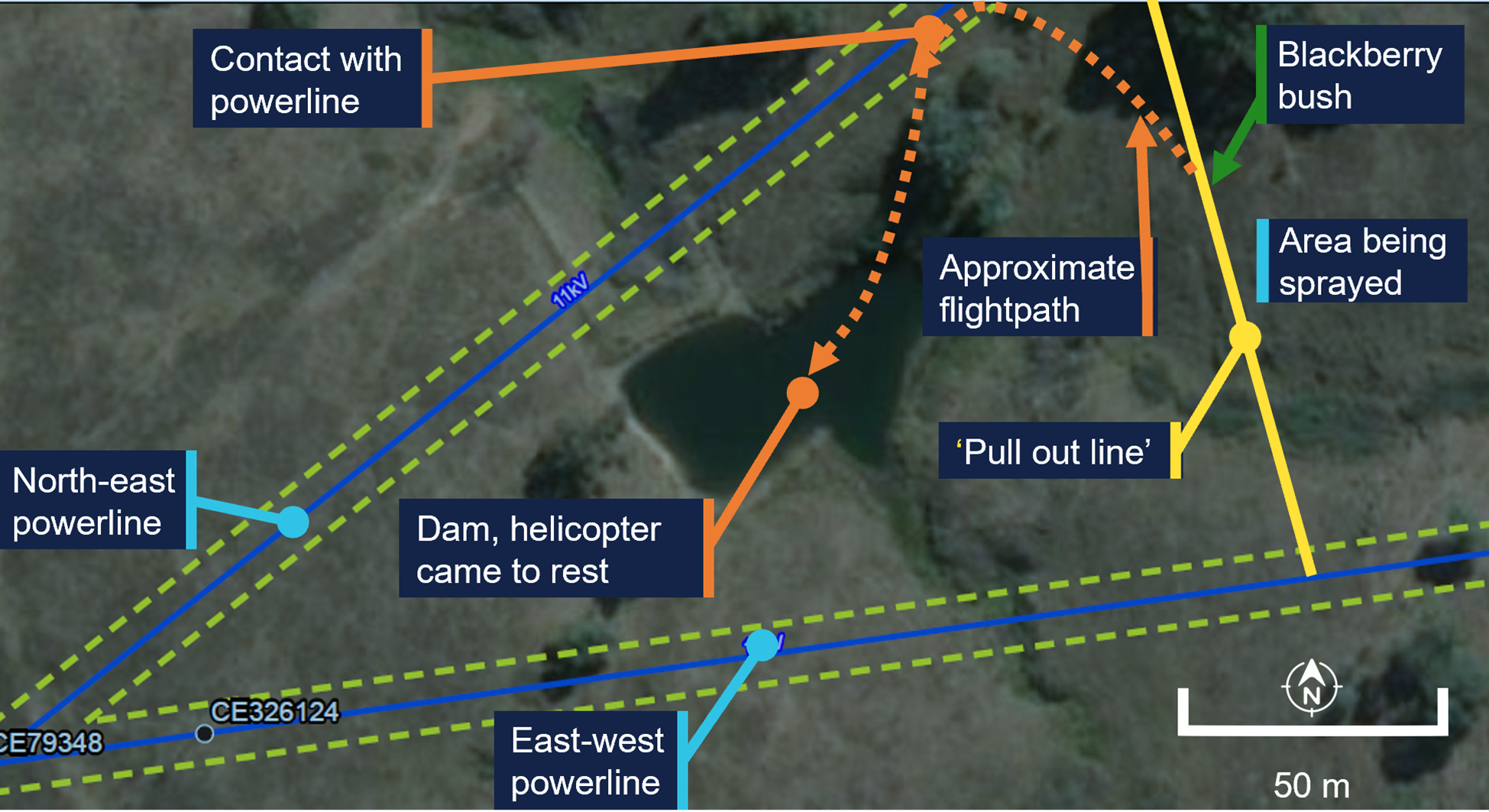
The spraying was being conducted in proximity to unmarked powerlines orientated east‑west and north-east (Figure 1). The area to be sprayed was to the east of a designated ‘pull out line’ that acted as a planned limit of operations. The pilot had identified the location of both the powerlines prior to commencing operations.
Figure 1: Area of operation
Green dotted lines mark the exclusion zone, as defined by the infrastructure owner. Source: Earthstar Geographics, annotated by the ATSB
The pilot reported that during dispensing, they deviated from the planned spray path to conduct an unplanned task: to spray some nearby blackberries they had identified.
Once this unplanned task was completed the pilot commenced a turn and the helicopter made contact with the north-east powerline, which had 3 wires.
The wire cutting kit fitted to the helicopter successfully cut 2 of the 3 wires. However, the third wire struck the main rotor and tail boom. The helicopter descended with some controllability until approximately 5 m above the ground, at which point controllability became difficult. The pilot reported their focus was on keeping the helicopter level and ensuring it did not roll over. The pilot was unable to reach a suitable emergency landing area and conducted a partially controlled ditching into a nearby dam.
Once the helicopter came to rest in the dam it began to roll towards an inverted position. The pilot exited the aircraft as it was rolling and swam to the edge of the dam.
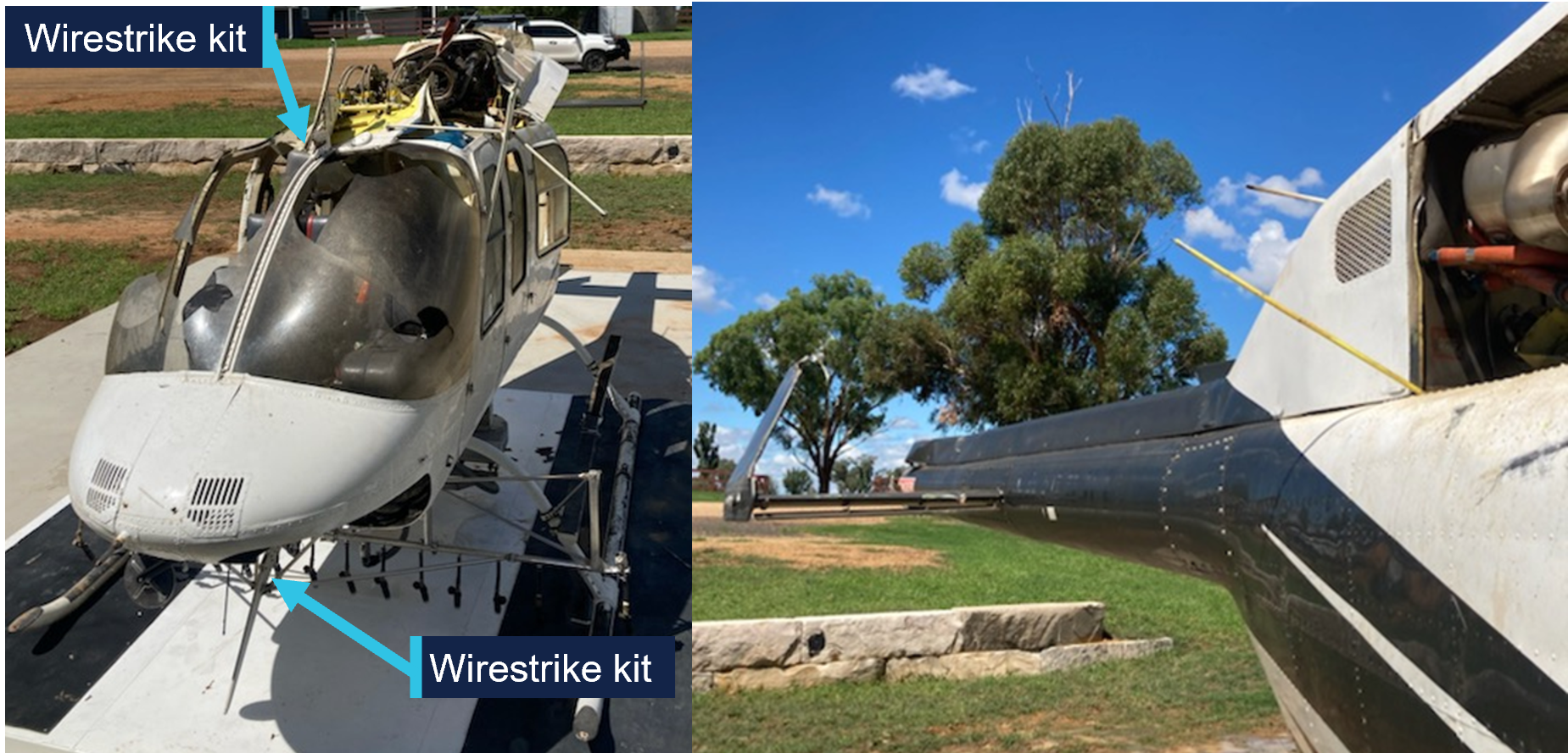
The pilot’s helmet was struck during the accident, and the pilot was not injured. The helicopter sustained substantial damage (Figure 2).
Figure 2: Damage to helicopter, shown after recovery from the water
Source: Helicopter operator, annotated by the ATSB
Safety message
Pilots and operators need to be aware that when a plan is changed new risks can be introduced. This is especially critical for low level operations where previously identified hazards may be subsequently overlooked.
Aerial powerlines pose an ongoing threat to flying operations. In Queensland, New South Wales, Victoria, and South Australia, the Look up and live website or app can be used by pilots to plan flying operations in proximity of overhead powerlines.
Electrical power and telecommunications companies in Australia can mark powerlines that are identified as a hazard for low-level flying operations. The ATSB has released an educational booklet, Wirestrikes involving known wires: A manageable aerial agriculture hazard (AR-2011-028AR-2011-028). This booklet contains several examples of wirestrike accidents and lessons learned from them.
About this report
Decisions regarding whether to conduct an investigation, and the scope of an investigation, are based on many factors, including the level of safety benefit likely to be obtained from an investigation. For this occurrence, no investigation has been conducted and the ATSB did not verify the accuracy of the information. A brief description has been written using information supplied in the notification and any follow-up information in order to produce a short summary report, and allow for greater industry awareness of potential safety issues and possible safety actions.
Occurrence summary
Mode of transport
Aviation
Occurrence ID
AB-2026-016
Occurrence date
06/03/2026
Location
41 km north-east of Orange Airport
State
New South Wales
Occurrence class
Accident
Aviation occurrence category
Ditching, Wirestrike
Highest injury level
None
Aircraft details
Manufacturer
Bell Helicopter Co
Model
206L-3
Sector
Helicopter
Operation type
Part 138 Aerial work operations
Activity
General aviation / Recreational-Aerial work-Agricultural spreading / spraying
On 25 January 2026, at 0917 local time, the pilot and only occupant of a Robinson R44 Raven I helicopter, registered VH-8HR and operated by Whitsunday Air Services, departed Whitsunday Airport (Shute Harbour), Queensland, for nearby Daydream Island.
After departing, the helicopter climbed to an altitude of about 1,000 ft above sea level and shortly after crossing the coast, the pilot reported that the low rotor RPM horn sounded. The pilot recalled that they immediately reacted by increasing the throttle and lowering the collective lever which returned the engine and rotor RPM to within the normal operating range.
About 10 seconds later, the engine RPM briefly reduced a second time before a rapid increase of engine and rotor RPM which activated the high rotor RPM alert. The pilot recalled then switching off the engine governor to manually control the throttle inputs and maintain a constant engine RPM. They were able to stabilise the engine and rotor RPM for about 10 seconds, during this time they observed the engine was running rough with a significant increase in manifold pressure and the helicopter had begun an uncommanded descent.
The pilot reported that they began to slow the helicopter to the best rate of climb speed of 55 kt. While over water and beyond gliding distance from land they observed another engine RPM reduction, and elected to enter an autorotation, activated the emergency pop-out floats and ditched the helicopter onto the ocean. After ditching, the helicopter remained upright and the pilot reported they were uninjured. They were subsequently rescued by water police about 20 minutes later.
What the ATSB found
The right magneto distributor gear jammed when an internal rotating electrode became loose. This led to a mechanical failure of the gear teeth that affected the engine timing and subsequently reduced the helicopter power output.
The altered engine timing likely resulted in the number one cylinder exhaust valve being damaged. This resulted in a loss of compression in the cylinder and a further loss of power.
As a result of the power loss, the pilot was unable to maintain altitude, entered autorotation, and activated the emergency pop-out floats before conducting a successful forced landing onto the water.
The damaged magneto likely caused erroneous engine governor inputs which caused an engine and rotor RPM overspeed.
Safety message
The occurrence highlights the importance of pilot training and understanding of governor‑off throttle control and engine RPM management. The pilot’s decision to switch the engine governor off, and manually control the throttle, likely eliminated erroneous throttle inputs from the governor that caused the fluctuations in engine RPM.
Pilots are required to demonstrate competency in governor-off control during their biennial single engine helicopter flight reviews. Operators of Robinson R44 and R22 helicopters with engine governors should ensure that pilots have good understanding of the situations that could require manual throttle control and the techniques and precautions to manage those abnormal situations.
The investigation
The ATSB scopes its investigations based on many factors, including the level of safety benefit likely to be obtained from an investigation and the associated resources required. For this occurrence, the ATSB conducted a limited-scope investigation in order to produce a short investigation report, and allow for greater industry awareness of findings that affect safety and potential learning opportunities.
The occurrence
On 25 January 2026, at 0917 local time, the pilot of a Robinson R44 Raven I helicopter, registered VH-8HR and operated by Whitsunday Air Services, departed Whitsunday Airport (Shute Harbour), Queensland, for nearby Daydream Island, where the pilot was to board 2 passengers for a scheduled scenic flight at 0930.
On departure from Shute Harbour, the helicopter climbed to an altitude of about 1,000 ft above sea level. However, shortly after crossing the coast, the pilot reported that the low rotor RPM horn sounded. The pilot recalled that they immediately reacted by increasing the throttle and lowering the collective1 which returned the engine and rotor RPM to within the normal operating range.
About 10 seconds later the engine RPM briefly reduced a second time before a rapid engine RPM increase, reaching 115.9% engine RPM and 114.2% rotor RPM, activating the high rotor RPM alert. The pilot recalled then switching the engine governor off to manually control the throttle inputs which maintained a constant engine RPM for about 10 seconds. The pilot observed the engine was running rough with a significant increase in manifold pressure and that the helicopter had begun an uncommanded descent the pilot was unable to arrest.
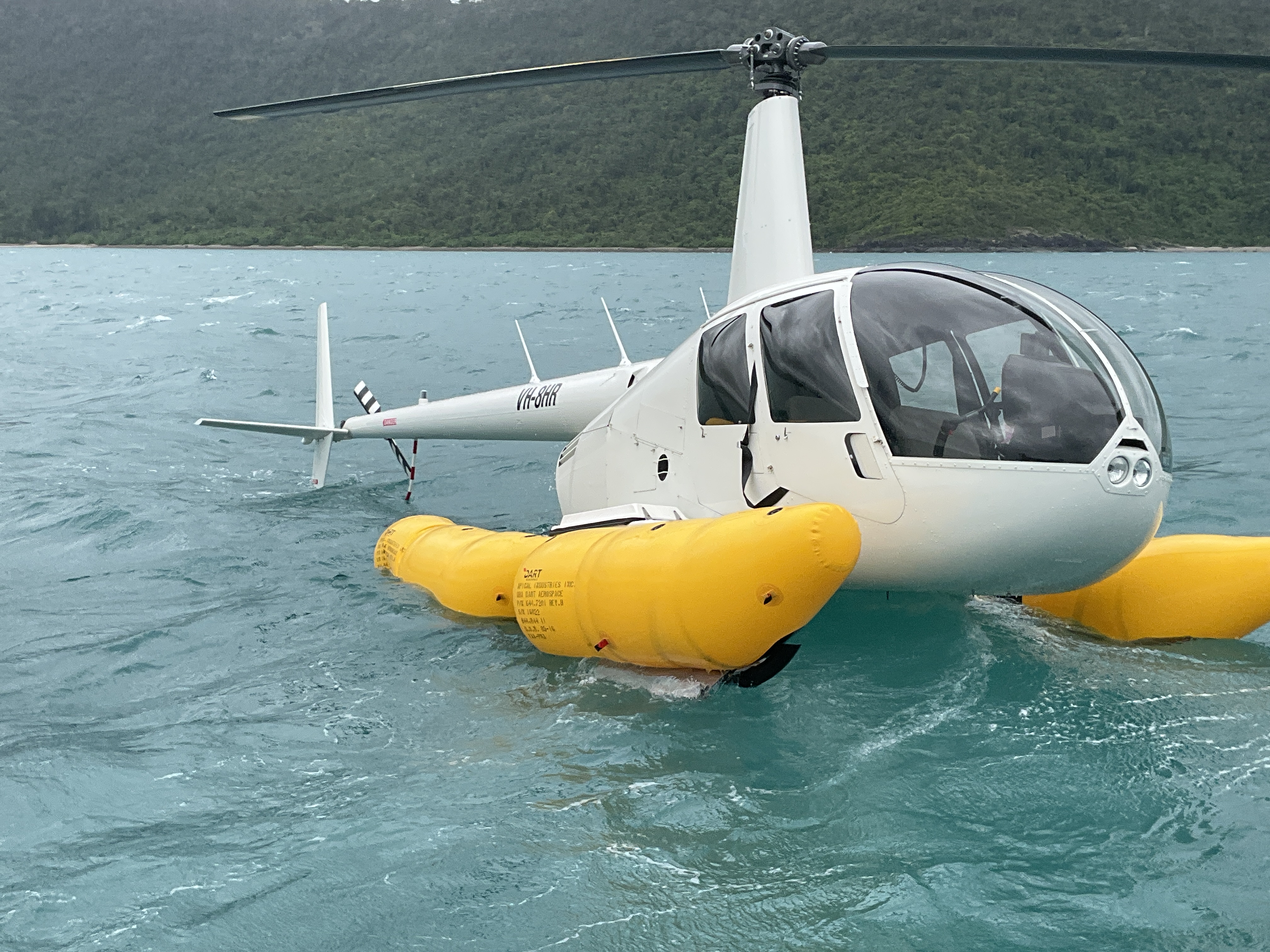
The pilot attempted to slow the helicopter to the best rate of climb speed of 55 kt. As the helicopter airspeed slowed to about 60 kt it was still descending and they were still unable to maintain altitude. The pilot reported that the engine RPM again reduced while over water and they elected to enter an autorotation. The helicopter was beyond gliding distance from land, and the pilot activated the emergency pop-out floats and conducted a ditching onto the ocean (Figure 1).
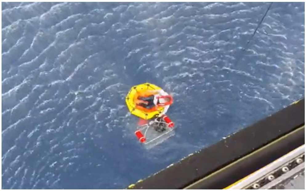
Figure 1: VH-8HR shortly after pilot was met by local water police
Source: Queensland Police
The helicopter landed and remained upright on the water without further damage. The pilot then transmitted a MAYDAY call which was received by a nearby fixed-wing aircraft that relayed the distress call to Brisbane Centre air traffic control. The pilot observed a knocking sound which they suspected was coming from the engine and shut the helicopter down.
The pilot remained in the helicopter and recalled that, about 20 minutes after the ditching, they were met by the local water police and transferred from the helicopter onto the police vessel.
The pilot was uninjured during the ditching and the helicopter was towed back to land upright on its floats before being transported to the operator’s maintenance provider.
Context
Personnel information
The pilot held a Commercial Pilot Licence (Helicopter) issued on 6 April 2023 having previously completed their initial flight training and a commercial licence in New Zealand. They had also successfully completed a gas turbine engine endorsement on 29 January 2024 and a low-level rating on 12 May 2025. They also held a class one medical certificate that was valid until 4 October 2026 with no restrictions.
The pilot had accumulated about 1,600 total hours flying helicopters including 835 hours flying the Robinson R44.
They had last completed a proficiency check flight with the operator on 12 June 2025 that included autorotation landings and governor malfunctions and was found competent by the operator.
The pilot had last completed helicopter underwater escape training on 4 June 2025, which was valid for 3 years.
Fatigue
The pilot reported they felt fully alert at the time of the occurrence having slept 9 hours in the previous 24 hours and 17 hours in the past 48 hours.
The ATSB considered that it was very unlikely that fatigue affected the pilot’s performance on the day of the occurrence.
Aircraft information
The Robinson Helicopter Company (RHC) R44, Raven I is a 4‑place, light helicopter, powered by a Lycoming O-540-F1B5, 6-cylinder, horizontally-opposed piston engine. It has a 2‑bladed main rotor system and a conventional 2‑bladed tail rotor. The R44 pilot operating handbook (POH) stated that at maximum continuous power, the engine operated at 2,718 RPM, which indicated as 102% on the engine tachometer display in the cockpit and also advised a transient limit of 105% RPM with a warning:
Intentional operation above maximum continuous speed (engine RPM) prohibited.
Engine power is displayed to the pilot via the manifold pressure gauge in inches of mercury. A placard on the pilot’s cyclic2 control displayed the maximum continuous power limit adjusted for pressure altitude3 and outside air temperature. It also included a transient 5-minute limit of an additional 1.6 inches of manifold pressure above the continuous power limit for maximum take-off power. Conditions on the day indicated a maximum continuous power limit of about 24.1 inches and a 5-minute maximum take-off limit of 25.7 inches.
The POH also stated the safe operational rotor RPM range is between 90 and 108%, which is marked with a green arc on the rotor RPM tachometer.
The R44 helicopter is equipped with a low rotor RPM horn and caution light which both activated when the rotor RPM dropped below 97%. VH-8HR was also equipped with a high rotor RPM alert that sounded through the pilot’s headset and activated when the rotor RPM was approaching 108%.
VH-8HR was manufactured in the United States as serial number 2751 in 2023 and had flown a total of 1,116.8 hours prior to the occurrence flight. The operator had been the registration holder since July 2023.
VH-8HR was equipped with emergency pop-out floats manufactured by DART Aerospace. A helium‑filled cylinder was located under the front left seat that provided the means for float inflation. The pop-out floats are activated when the inflation lever on the pilot’s collective control is squeezed (9 kg of force required).
Engine
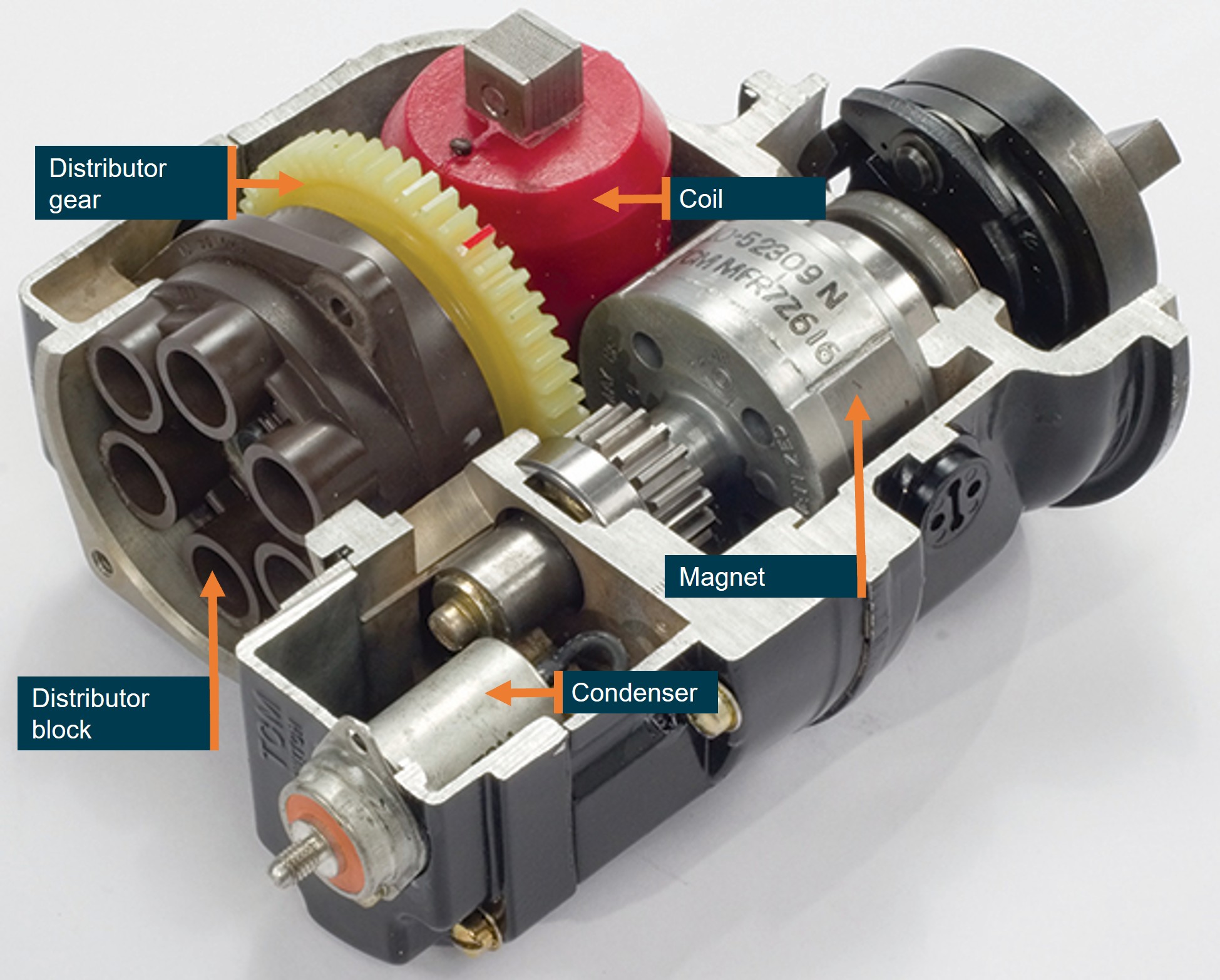
At the time of the occurrence, the Lycoming engine was fitted with 2 magnetos (part number 10-6006-46-201), manufactured by Continental Aerospace Technologies (CAT), that produced high voltage for the 12 spark plugs. Fitted to the distributor gear of each magneto (Figure 2) was a rotating electrode that provided the timing of the electrical energy to the distributor block4 and then to the relevant spark plug via a high-tension lead.
Figure 2: Sectioned view of an exemplar magneto
This magneto is similar to the one that was fitted to VH-8HR. Source: Aviation Safety Magazine, annotated by the ATSB
The R44 helicopter is equipped with an automatic throttle governor designed to assist pilots in controlling RPM under normal flight conditions.
The POH provided a description of the governor operation.
The governor maintains engine RPM by sensing changes and applying corrective throttle inputs through a friction clutch which can be easily overridden by the pilot. The governor is active only above 80% engine RPM and can be switched on or off using the toggle switch on the end of the right seat collective.
The R44 throttle governor takes its signal source from the tachometer breaker contact (points) assembly within the engine-right5 magneto and provides throttle inputs to maintain the engine RPM at 102%. Above 112% RPM, the governor is inactive.
R44 magneto changes
Prior to January 2021 all piston-engined RHC helicopters were fitted with dual magnetos. In 2020 RHC received United States Federal Aviation Administration (FAA) approval to replace the engine-left magneto with an electronic ignition system (EIS) manufactured by Lycoming. The July 2020 Robinson newsletter described the new EIS:
The EIS installation replaces the left starting magneto. The remaining right magneto provides redundant ignition and eliminates the need for a backup power supply. EIS has very high spark-energy for easy engine starts and eliminates internal moving parts for increased reliability.
On 13 February 2024, Lycoming issued mandatory service bulletin 656 (revised to 656A in April 2025) that stated:
Lycoming has identified an internal wear issue with some EIS units used on 6-cylinder engines in rotary wing applications. This internal wear progresses over time and can lead to engine power fluctuations. This bulletin requires the replacement of EIS units in 6-cylinder helicopter applications. Affected 6-cylinder EIS part numbers are 66K6D3SN-03, 66K6D3SN-02, and 66K6D3SN-01.
The service bulletin required the replacement of the EIS every 50 flight hours in helicopters with 6-cylinder engines due to the wear issues.
On 24 February 2024 RHC released kit instructions KI-272-5 for the installation of Bendix Style magnetos that replaced the EIS and avoided the required 50‑hour EIS replacement.
Maintenance history
On 31 May 2024, the operator’s maintenance provider replaced the EIS (engine-left) on VH-8HR using the RHC KI 272-5 magneto conversion kit. At that time the helicopter had flown 389.7 hours flight time.
On 8 November 2024, and 585.4 hours flight time, the maintenance records showed the engine-left magneto was unable to be timed to the engine and was replaced.
On 7 April 2025, the helicopter had accumulated 781.2 hours and underwent scheduled maintenance that included a 500-hour inspection of the distributor gear within the magnetos. The maintenance organisation reported nil defects with the distributor gear during this inspection.
On 17 December 2025, the helicopter had accumulated 1,066.5 hours, and maintenance records showed a pilot had reported that the engine ran rough on the engine-left magneto. One high-tension lead was found to be unserviceable and the lead was repaired and a subsequent engine run found the engine operated normally.
The magnetos had been inspected every 100 hours as per CAT service bulletin SB 643C part 1 and magneto timing had also been completed as per Lycoming service bulletin SB 183A during the last five 100‑hourly inspections.
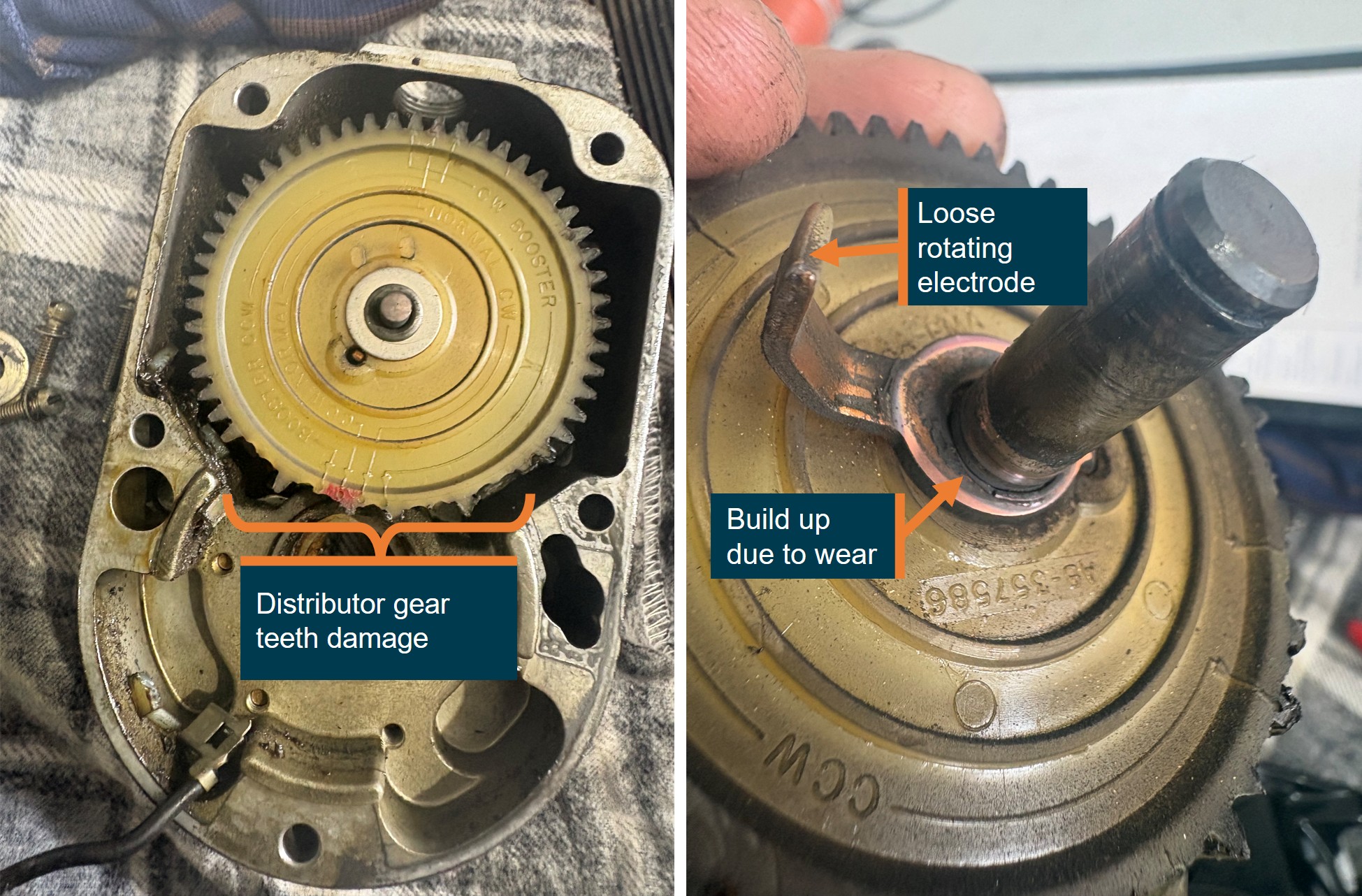
Following the occurrence, the operator’s maintenance provider inspected the engine‑right magneto and identified that the rotating electrode on the distributor gear had come loose and subsequently contacted the distributor block, jamming the gear which resulted in numerous gear teeth being stripped (Figure 3).
Source: Whitsunday Air Services, annotated by the ATSB
The engine-right magneto had been fitted to the helicopter for about 18 months and 727 flying hours. The magneto distributor gear was last inspected on 7 April 2025. After that inspection, the helicopter operated a further 335.6 hours before the magneto failed. At the time of the occurrence, the 500-hour magneto distributor gear inspection was due in 164.4 hours flying time.
Maintenance records also indicated that individual cylinder compression checks had been completed at 100-hourly service intervals with nil defects reported.
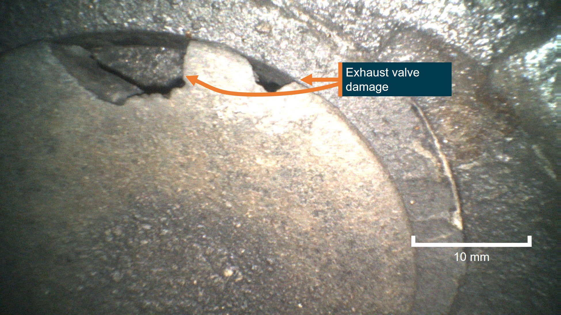
The post‑occurrence engine inspection also identified damage to the exhaust valve on the number one engine cylinder, with a compression test indicating nil compression. The maintenance organisation reported the erosion damage was likely from environmental conditions, fuel and exhaust deposits. The maintenance organisation identified that the combination of a magneto failure and lack of compression in the cylinder would have resulted in a substantial power loss.
CAT reviewed the supplied images and a summary of the occurrence and advised that the distributor gear rotating electrode could detach due to:
• Mechanical fatigue or vibration: High cyclic loading and torsional vibration in the O‑540 engine can weaken the electrode attachment over time.
• Improper staking or attachment during a prior overhaul: If the rotor assembly was not correctly staked, riveted, or assembled during the last 500‑hour inspection, the electrode can loosen prematurely.
• Internal contamination or sudden rotor binding: Foreign material or gear debris can momentarily jam the rotor, placing abnormal shear loads on the electrode.
• Heat distortion: Excessive magneto temperature (due to lean running, under‑cowl heat, or advanced timing) can warp the rotor plate or insulator, stressing the electrode until it separates.
CAT also provided an assessment of the exhaust valve damage (Figure 4) stating that it was entirely consistent with late, weak or erratic ignition timing and provided the following explanation:
A jammed magneto or slipping distributor gear causes late or erratic ignition timing. When ignition occurs too late:
• Combustion continues as the exhaust valve opens, exposing the valve face to extremely hot combustion gases.
•This leads to localized overheating, erosion, and burning of the valve edge, matching the borescope damage observed on No. 1 cylinder.
• Intermittent or weak ignition can also cause backfiring or detonation, further overstressing the exhaust valve and increasing temperature spikes.
Late timing = combustion into exhaust stroke → valve overheating → valve burning.
Figure 4: VH-8HR cylinder one exhaust valve
Source: Whitsunday Air Services, annotated by the ATSB
Meteorological information
Meteorological information recorded at 0900 local time at Hamilton Island Airport, 19 km south-east of the ditching location showed:
wind from 110° at 20 kt
visibility greater than 10 km
cloud broken6 at 2,200 ft and overcast at 2,700 ft
temperature was 27° C and dew point 24° C
QNH7 of 1,010 hectopascals.
The pilot estimated that the wind strength on the day was 10–15 kt from the south-east and recalled the sea state was about 0.5 m of swell when they landed on the water.
Recorded data
The helicopter was equipped with an RHC installed engine monitoring unit (EMU). The user guide for the EMU stated:
The EMU monitors engine speed, rotor speed, engine oil temperature, cylinder head temperature, manifold pressure, ambient pressure, and outside air temperature. Data is stored once per second. If the EMU detects an engine or rotor parameter outside of operating limits, an exceedance record is created and data is stored at a higher rate of 15 times per second during the exceedance event.
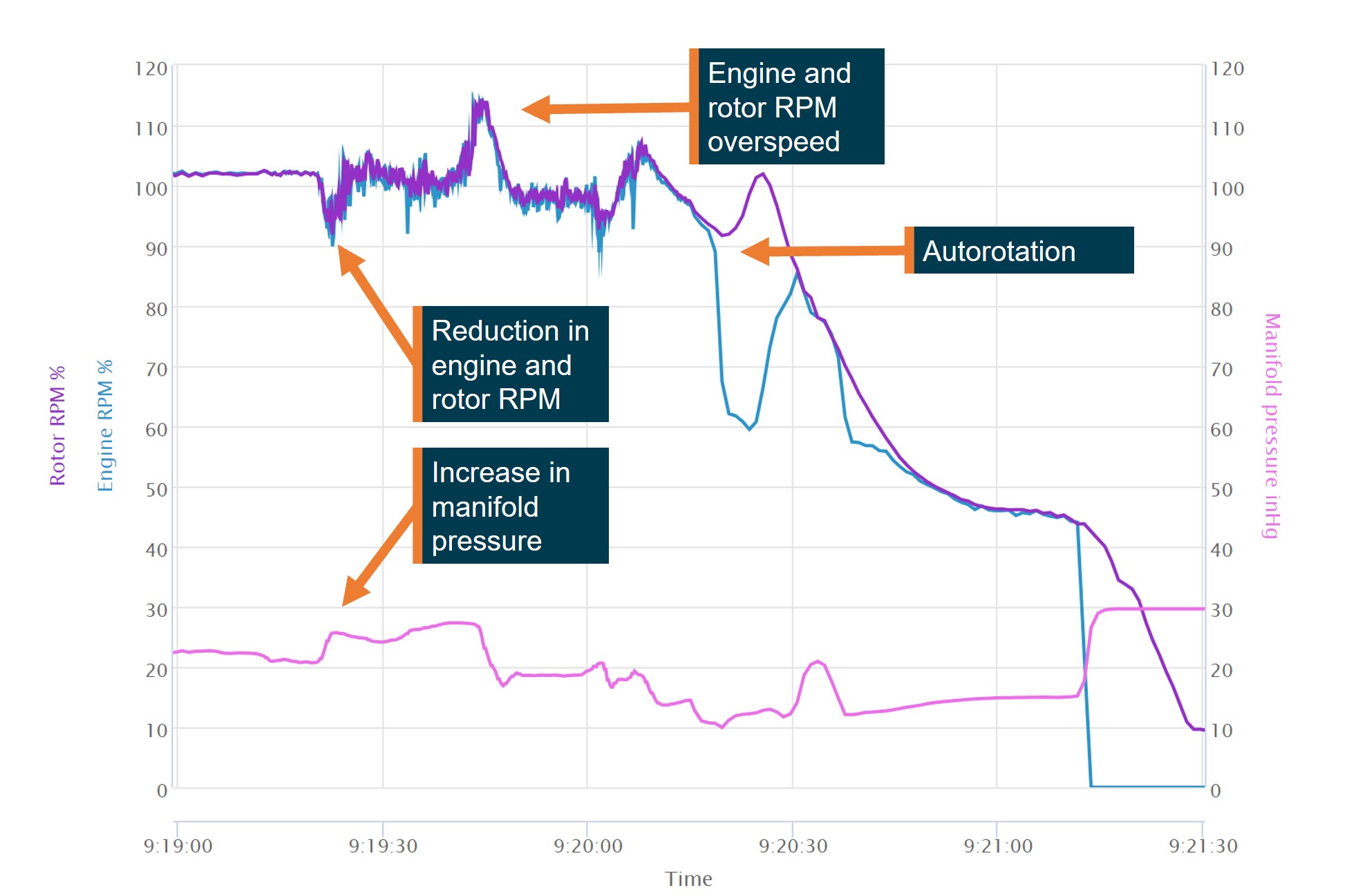
The EMU data (Figure 5) recorded at 0919:208 showed an engine RPM reduction from the normal 101–102% RPM operating range reducing to about 94% RPM before increasing again. A further momentary reduction in engine RPM was recorded about 10 seconds later and then returned to within the normal operating range before then rapidly increasing, peaking at 115.9% engine RPM. The increase in engine RPM also resulted in a rotor RPM overspeed, peaking at 114.2%. The pilot reported after the overspeed that they switched the governor off and manually controlled the throttle.
The engine RPM then reduced and stabilised at about 98% for about 10 seconds. At about 0920 the engine RPM again dropped below 90% and then increased to about 104%.
At about 0920:20 the engine RPM reduced to about 62%, while the rotor RPM remained above 90% and increased to 100%, consistent with the pilot closing the throttle and conducting an autorotation before flaring to land on the water.
Engine manifold pressure recorded by the EMU on departure indicated pressure within normal operating range. At about 0919:20, at a similar time to the first engine RPM reduction, the manifold pressure increased above 25 inches before it momentarily reduced to about 24 inches, then increased and peaked at about 27.5 inches.
Figure 5: VH-8HR engine monitoring unit data
Source: ATSB
The helicopter was also equipped with a cockpit video recording camera, as optional equipment from the RHC factory. The camera featured both internal and external storage, however no external storage was fitted for the occurrence flight. The internal storage recorded continuously and was sufficient for 3 hours of recordings before being overwritten. During the subsequent post‑occurrence inspection it was identified that the internal camera battery had failed and the last recorded data stored was from June 2025. It was reported that previous internal battery failures had been identified by RHC, and a requirement for battery replacement to be carried out yearly had been added to the maintenance schedule in August 2025. The battery on this device had not reached the required replacement date.
It was also identified during the inspection that the internal camera mountings had failed, with the potential to impact the data quality and footage available.
Survivability
MAYDAY transmission
Following the successful forced landing, the pilot reported that they broadcast a MAYDAY transmission on the local area common traffic advisory frequency (CTAF). A nearby fixed‑wing aircraft heard the transmission and relayed the details of the MAYDAY to Brisbane Centre air traffic control. The pilot recalled that their workload during the management of the event prevented an earlier MAYDAY call being made.
Lifejackets and emergency locator transmitters
The pilot wore a constant-wear vest style lifejacket and felt no need to inflate the lifejacket at any point. The lifejacket was equipped with pockets and was where the pilot kept a personal survival emergency locator transmitter (ELT) that was an operator requirement to be carried. The onboard automatic ELT fitted to the helicopter was not activated during the occurrence.
Communication
The pilot reported they were able to communicate with the operator’s base on Hamilton Island via VHF radio while awaiting rescue and made several phone calls to assist with the coordination of the retrieval of the helicopter.
Rescue
The pilot reported about 20 minutes after the ditching, local police arrived by boat and they transferred to the police boat. They remained on station to monitor the helicopter until a larger vessel arrived that towed the helicopter to shore.
Similar occurrences
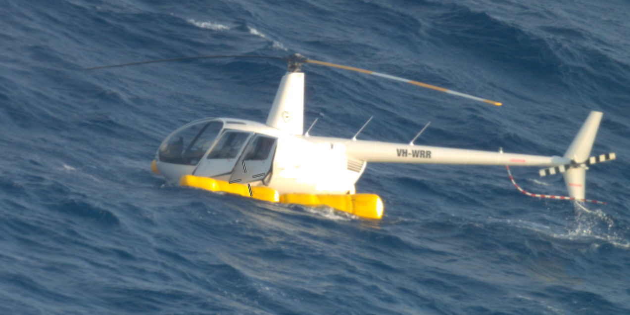
Partial engine power loss and ditching involving Robinson R44, VH-WRR (AO‑2017‑110)
On 8 November 2017, the pilot of a Robinson R44 ditched about 49 km north of Hamilton Island Airport, Queensland. In addition to the pilot, there were 3 passengers on board.
When about 40 minutes into the flight, on return to Hamilton Island, the pilot heard the engine sound decrease and noted that the helicopter was unable to maintain the cruise altitude of 1,000 ft. The pilot reported that the indicated main rotor revolutions per minute (RPM) decreased and the low rotor RPM horn activated. The engine RPM indication was also oscillating throughout the range. In response to the low RPM horn, the pilot increased throttle and again raised the collective. The rotor RPM initially spiked and then decreased with associated re-activation of the low rotor RPM horn. The engine RPM gauge continued to oscillate and the helicopter could not maintain altitude. The pilot noticed the engine noise was changing with the fluctuations in the indications. While there appeared to be no observable damage sustained to the helicopter, it later sank and was unable to be recovered.
A maintenance logbook entry around 2 weeks prior to the accident noted that the helicopter had intermittent tachometer/governor fluctuations. The right magneto points were found to be out-of-tolerance and adjusted. A ground run to test the adjusted magneto was completed satisfactorily.
Post-accident discussions between the manufacturer, operator and maintenance provider resulted in a consensus of opinion that the power reduction was associated with either a governor control failure and/or a compromised engine RPM signal from poor tachometer points.
On 15 June 2018, at 1050 local time, a Robinson R44 conducting a charter flight experienced an engine RPM governor failure.
The pilot was not certain of the cause of the drop in RPM. Rather than turning off the governor as the flight manual instructs for governor failure, the pilot elected to manually control engine RPM by overriding the clutch in the governor.
The aircraft’s magnetos had undergone a 500-hour service immediately prior to the scenic charter flight. An engineering inspection following the incident flight found that a problem with the tachometer points of the magneto caused the governor to read a higher RPM than existed and wind down the throttle, subsequently slowing the rotor system.
Safety analysis
Magneto damage
Since the magneto distributor gear was last inspected, VH-8HR had flown 335.6 hours and it was due to be re-inspected in 164.4 hours flying time.
The reason for the loose electrode on the distributor gear was not able to be determined, however the magneto manufacturer indicated that the rotating electrode could become loose due to fatigue, vibration, incorrect installation, or heat damage.
The loose electrode likely caused the distributor gear to jam, damaging the gear. Either due to this damage or a result of the jamming, the timing of the electrical supply to the spark plugs was affected and caused the engine to misfire.
Exhaust valve damage
The helicopter had accumulated 1,116.8 total flying hours and had mostly been operated throughout the Whitsunday Islands and Great Barrier Reef, exposing the helicopter to a corrosive salt air environment. The helicopter’s maintainer reported erosion damage to the valve sealing face following the occurrence, likely due to the corrosive operational environment, fuel or exhaust deposits.
The magneto manufacturer, Continental Aerospace Technologies (CAT), stated the damage to the valves was consistent with late ignition timing due to the damaged magneto. The late timing of the ignition resulted in combustion during the exhaust stroke and therefore overheated the exhaust valve resulting in burning, increasing the likelihood of premature failure.
The damage to the exhaust valve prevented adequate compression during the combustion cycle in the cylinder, leading to a reduction of power.
Forced landing
As a result of the damaged magneto and damaged exhaust valve, the power available was insufficient for the pilot to maintain altitude.
Without sufficient power to maintain altitude, the pilot’s decision to close the throttle and enter autorotation removed the threat of further engine RPM fluctuations during the landing. During the autorotation the rotor RPM increased from about 92% to more than 100% RPM, therefore, the increased inertia in the rotor system likely assisted the pilot to conduct a controlled ditching without further damage to the helicopter or emergency pop‑out floats.
The pilot activated the emergency pop-out floats during the autorotation which allowed the aircraft to remain upright on landing and remain buoyant. They were then able to take refuge in the helicopter until first responders arrived.
Erratic governor control
The Robinson R44 engine-right magneto provided electrical signal to the engine tachometer in the cockpit. The engine governor applied throttle inputs to maintain a constant engine RPM.
The damaged right magneto likely caused the engine tachometer to incorrectly read the engine RPM and therefore throttle inputs made by the governor were not accurate and resulted in engine RPM fluctuations. The fluctuations resulted in several reductions in engine RPM and one significant engine RPM increase which increased both the engine and rotor RPM over the manufacturer’s limits, increasing the likelihood of damage to the helicopter.
The pilot reported that following the overspeed, they elected to switch the governor control off and fly the aircraft using manual throttle control. The engine monitoring unit (EMU) data showed a 10‑second period where the engine and rotor remained at about 98% RPM, consistent with the pilot manually controlling the throttle. The data then showed a further, momentary engine RPM reduction. The governor switch position was not a parameter recorded by the onboard EMU and therefore the ATSB was unable to determine if the cause of the further reduction was caused by inputs from the governor.
Findings
ATSB investigation report findings focus on safety factors (that is, events and conditions that increase risk). Safety factors include ‘contributing factors’ and ‘other factors that increased risk’ (that is, factors that did not meet the definition of a contributing factor for this occurrence but were still considered important to include in the report for the purpose of increasing awareness and enhancing safety). In addition ‘other findings’ may be included to provide important information about topics other than safety factors.
These findings should not be read as apportioning blame or liability to any particular organisation or individual.
From the evidence available, the following findings are made with respect to the power loss and ditching involving Robinson R44, VH-8HR, 19 km north-west of Hamilton Island, Queensland, on 25 January 2026.
Contributing factors
The right magneto distributor gear was jammed by a loose electrode. This led to a mechanical failure of the gear teeth affecting the engine timing and subsequently the helicopter lost power.
The altered engine timing likely resulted in the number one cylinder exhaust valve being damaged. This resulted in a loss of compression and a further loss of power.
The pilot was unable to maintain altitude and entered autorotation, activated the emergency pop-out floats and conducted a successful forced landing onto the water.
Other factors that increased risk
The damaged magneto likely caused erroneous governor inputs and therefore an engine and rotor RPM overspeed.
Sources and submissions
Sources of information
The sources of information during the investigation included the:
pilot of the accident flight
operator
Civil Aviation Safety Authority
Queensland Police Service
aircraft manufacturer
magneto manufacturer
recorded data from the engine monitoring unit on the aircraft.
Submissions
Under section 26 of the Transport Safety Investigation Act 2003, the ATSB may provide a draft report, on a confidential basis, to any person whom the ATSB considers appropriate. That section allows a person receiving a draft report to make submissions to the ATSB about the draft report.
A draft of this report was provided to the following directly involved parties:
the pilot of the accident flight
Whitsunday Air Services
Heli Biz
United States National Transportation Safety Board
Robinson Helicopter Company
Continental Aerospace Technologies
Bureau of Meteorology
Civil Aviation Safety Authority.
Submissions were received from:
Whitsunday Air Services
Heli Biz.
The submissions were reviewed and, where considered appropriate, the text of the report was amended accordingly.
Purpose of safety investigations
The objective of a safety investigation is to enhance transport safety. This is done through:
identifying safety issues and facilitating safety action to address those issues
providing information about occurrences and their associated safety factors to facilitate learning within the transport industry.
It is not a function of the ATSB to apportion blame or provide a means for determining liability. At the same time, an investigation report must include factual material of sufficient weight to support the analysis and findings. At all times the ATSB endeavours to balance the use of material that could imply adverse comment with the need to properly explain what happened, and why, in a fair and unbiased manner. The ATSB does not investigate for the purpose of taking administrative, regulatory or criminal action.
About ATSB reports
ATSB investigation reports are organised with regard to international standards or instruments, as applicable, and with ATSB procedures and guidelines.
Reports must include factual material of sufficient weight to support the analysis and findings. At all times the ATSB endeavours to balance the use of material that could imply adverse comment with the need to properly explain what happened, and why, in a fair and unbiased manner.
An explanation of terminology used in ATSB investigation reports is available here. This includes terms such as occurrence, contributing factor, other factor that increased risk, and safety issue.
Publishing information
Released in accordance with section 25 of the Transport Safety Investigation Act 2003
Ownership of intellectual property rights in this publication
Unless otherwise noted, copyright (and any other intellectual property rights, if any) in this report publication is owned by the Commonwealth of Australia.
Creative Commons licence
With the exception of the Commonwealth Coat of Arms, ATSB logo, and photos and graphics in which a third party holds copyright, this report is licensed under a Creative Commons Attribution 4.0 International licence.
The CC BY 4.0 licence enables you to distribute, remix, adapt, and build upon our material in any medium or format, so long as attribution is given to the Australian Transport Safety Bureau.
Copyright in material obtained from other agencies, private individuals or organisations, belongs to those agencies, individuals or organisations. Where you wish to use their material, you will need to contact them directly.
Footnotes
1
^ A primary flight control that collectively adjusts the pitch on the main rotor blades.
2
^ Cyclic: a primary helicopter flight control that is similar to an aircraft control column. Cyclic input tilts the main rotor disc, varying the attitude of the helicopter and hence the lateral direction.
3
^ Pressure altitude is the altitude corrected for atmospheric pressure.
4
^ A distribution block is a device used to consolidate and distribute electrical power from a single source.
5
^ This term is derived from the way the engine is fitted in fixed-wing aircraft with a front‑mounted propeller. The engine is fitted facing aft in the R44, therefore engine-right is on the left side of the helicopter.
6
^ Broken: 5–7 okta of cloud cover. An okta is a unit of measurement used to describe the extent of cloud cover (1–8).
7
^ QNH: the altimeter barometric pressure subscale setting used to indicate the height above mean sea level.
8
^ A timing correction was made to align with ADS-B data. Timing is initially set by a technician and is not linked to GPS or other sources. Additionally, while there is an internal clock, this can drift over time.
Occurrence summary
Investigation number
AO-2026-009
Occurrence date
25/01/2026
Occurrence time and timezone
09:22 Australian Eastern Standard Time
Location
19 km north-west of Hamilton Island
State
Queensland
Report release date
14/05/2026
Report status
Final
Investigation level
Short
Investigation type
Occurrence Investigation
Investigation phase
Final report: Dissemination
Investigation status
Completed
Mode of transport
Aviation
Aviation occurrence category
Abnormal engine indications, Ditching, Engine failure or malfunction
Occurrence class
Serious Incident
Highest injury level
None
Aircraft details
Manufacturer
Robinson Helicopter Co
Model
R44
Registration
VH-8HR
Serial number
2751
Aircraft operator
Whitsunday Air Services Pty Ltd
Sector
Helicopter
Operation type
Part 91 General operating and flight rules
Activity
General aviation / Recreational-Other general aviation flying-Ferry flights
Departure point
Whitsunday Airport (Shute Harbour), Queensland
Destination
Daydream Island Helicopter Landing Site, Queensland
The ATSB is investigating abnormal engine indications and ditching involving Bell 206L-3, VH-LMW, 6.5 km west of Horn Island Airport, Queensland, on 6 January 2026.
During climb, the pilot observed uncommanded yaw and fluctuating torque indications. The pilot received a low rotor alert and conducted an autorotation before activating the floats and ditching the helicopter.
The ATSB has commenced the examination and analysis of the initial evidence collected.
To date, the ATSB investigation has included interviewing the flight crew, examination of maintenance and pilot records and other relevant documentation.
A final report will be released at the conclusion of the investigation. Should a critical safety issue be identified during the course of the investigation, the ATSB will immediately notify relevant parties, so that appropriate safety action can be taken.
Last updated:
Preliminary report
Report release date: 16/04/2026
This preliminary report details factual information established in the investigation’s early evidence collection phase and has been prepared to provide timely information to the industry and public. Preliminary reports contain no analysis or findings, which will be detailed in the investigation’s final report. The information contained in this preliminary report is released in accordance with section 25 of the Transport Safety Investigation Act 2003.
The occurrence
On 6 January 2026, at about 1406 local time, a Bell B206L-3 helicopter, registered VH‑LMW and operated by Fortescue Helicopters, was returning to Horn Island (Ngurupai) from Sadie’s Beach Helipad, Thursday Island (Waiben), Queensland, after transporting 2 passengers between the outer Torres Strait Islands.
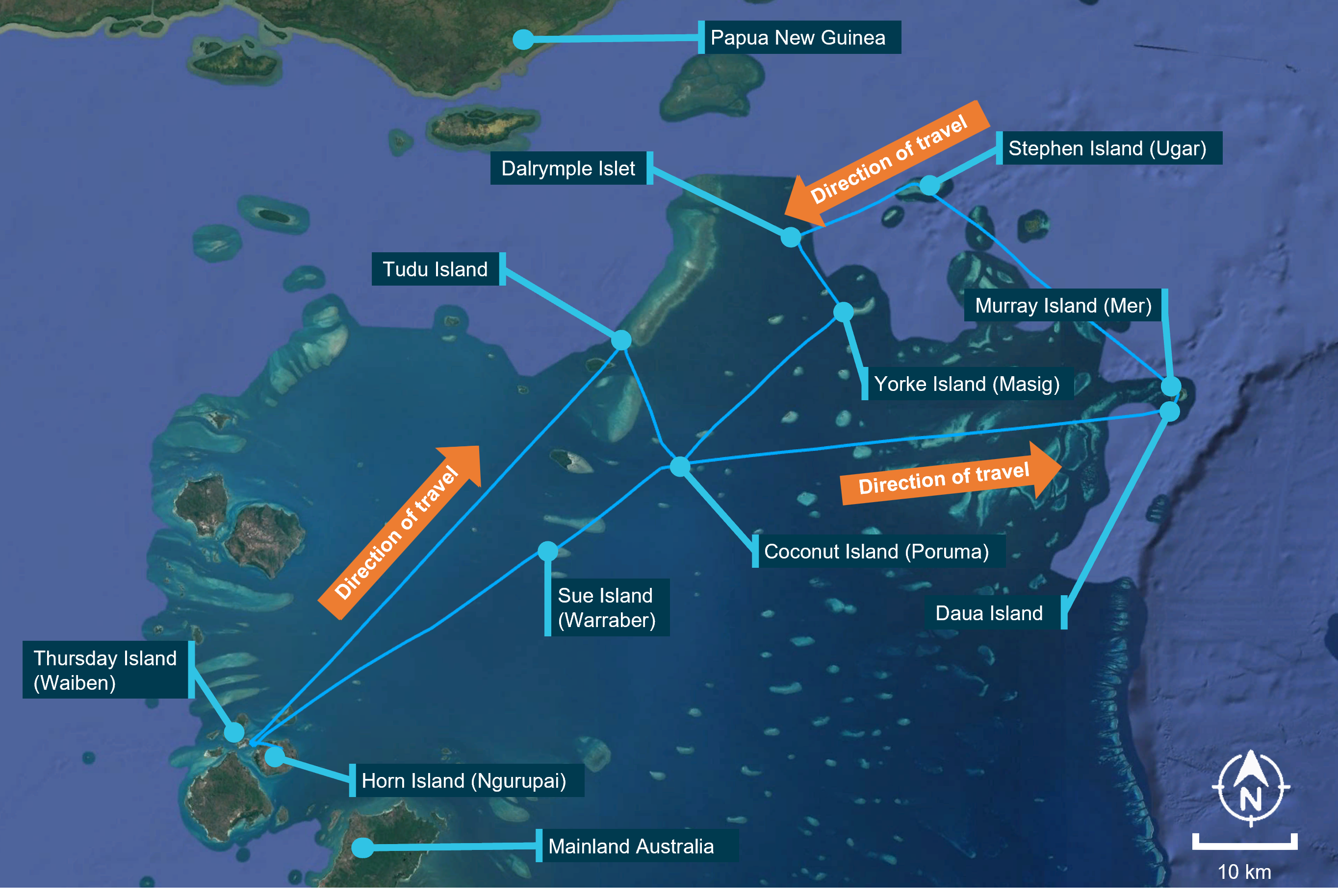
VH-LMW operations that day included 11 sectors, beginning from Horn Island Airport before embarking passengers at Thursday Island at about 0800. Following the departure from Thursday Island, the helicopter tracked and landed briefly at Tudu Island, Coconut Island (Poruma), Daua Island, Murray Island (Mer), Stephen Island (Ugar), Dalrymple Islet, Yorke Island (Masig), Coconut Island and Sue Island (Warraber), before returning the passengers to Thursday Island at about 1400 (Figure 1). The helicopter had completed about 3.2 hours of flying that day prior to the accident flight.
Figure 1: VH-LMW flight track
Source: Google Earth, annotated by the ATSB
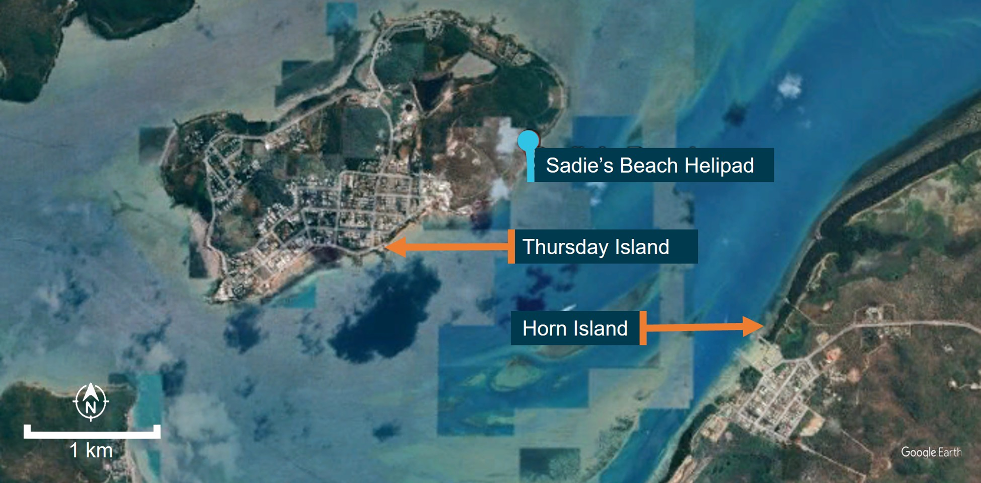
On each of the 2 stops at Coconut Island, about 130 km north-east of Thursday Island, the helicopter was refuelled from a company intermediate bulk container (IBC). The pilot reported that after disembarking the passengers at Sadie’s Beach Helipad, Thursday Island (Figure 2), before the re-positioning flight to Horn Island, about 200 lb (114 L) of fuel remained on board.
Figure 2: Location of Sadie’s Beach, Thursday Island
Source: Google Earth, annotated by the ATSB
Following a normal take-off, at about 300 ft over the water, the pilot reported the helicopter made several sudden and violent yawing[1] movements of about 60° to each side, accompanied by a reduction in both engine RPM and rotor RPM. An immediate scan of the engine gauges indicated that the torque gauge was fluctuating between 10–90%. The pilot partially reduced the collective[2] to recover rotor RPM, estimating they had lost about 5–6% rotor RPM at this time, however it continued to decay until the low rotor RPM warning light illuminated.
The pilot initiated an autorotation[3] and activated the pop-out floats at about 100 ft above the water. The pilot reported that the engine had stopped before the aircraft landed on the water.
After landing on the water, the helicopter remained afloat and upright for about 15 seconds, during which time the pilot transmitted a MAYDAY call. They recalled the helicopter then rolled about 120 degrees onto the right side. Images of the inverted helicopter showed the rear right float had detached from the skid tube and the front right float had also partially detached. The pilot reported that the float had pushed against their door which prevented egress from their nearest exit, requiring the pilot to egress through the front left (passenger) door. They then swam away from the helicopter before inflating their lifejacket. The helicopter continued to roll in the water until it became inverted.
A private boat nearby, followed by a police boat, arrived within about 5 minutes to rescue the pilot.
Context
Pilot information
The pilot held a Commercial Pilot Licence (Helicopter) single-engine class, with a low‑level rating. At the time of the occurrence, the pilot’s total flying experience was 1,144 hours with about 300 hours on the Bell 206. The pilot’s last flight review was a proficiency check on 30 October 2025, valid for 2 years.
The pilot completed helicopter underwater escape training (HUET) on 25 September 2025 and held a Class 1 medical certificate valid until 14 January 2026. They had been employed by the operator since September 2025.
Aircraft information
VH-LMW was a Bell 206L-3, single-engine turbine powered helicopter, serial number 51120, constructed in the United States in 1984. A Rolls-Royce Allison 250-C30P engine was fitted to the helicopter and was registered to Fortescue Helicopters Pty Ltd, on 19 April 2023. VH‑LMW was fitted with emergency pop‑out floats for short‑term stability in the event of a ditching.
Meteorological information
Meteorological information recorded at Horn Island Airport at 1400 indicated:
The operator was contracted to transport employees of an organisation that regularly conducted inspections on islands throughout the Torres Strait.
The previous day, VH-LMW had flown 2.3 hours conducting similar inspections on islands in the north of the Torres Strait. Prior to that the helicopter had not been flown since 22 December 2025 when it had returned from Atherton, Queensland, following scheduled maintenance.
Wreckage and post-impact information
The helicopter ditched shortly after take-off from Sadie’s Beach Helipad, about 6.5 km from Horn Island Airport. Following the pilot’s rescue, the police and pilot anchored the helicopter to prevent it drifting in the current while the operator was making recovery arrangements.
The operator subsequently arranged recovery of the helicopter and commissioned an independent engineering report. The results of the engineering report were not available to the ATSB at the time of writing.
Fuel
The pilot’s flight plan showed the intended fuel for departure at the commencement of their day from Horn Island Airport was 800 lb (363 L).
The helicopter used Jet A-1 fuel that was stored in static tanks on Horn Island and an intermediate bulk container (IBC) on Coconut Island which was supplied via Horn Island as part of a broader distribution network. The pilot reported the IBC had been refilled in early December 2025.
Fuel quality and contamination
Free water[6], if present in aviation fuel, can result in filter blockages and, in more severe cases, engine failure through fuel starvation. In tropical climates, it can also create conditions that support algal growth in fuel tanks, which can degrade fuel quality and further contribute to filter obstruction. Water contamination is commonly checked in fuel using a water detecting tablet or paste which indicates the presence and level of water.
Microorganisms that can be found in aviation turbine fuel can include bacteria, yeasts and fungi. As these organisms develop, they form solid residues that can block and damage fuel filters. Some microorganisms also generate acids that can accelerate corrosion of metal components. Because most microbial growth depends on the presence of free water, this kind of contamination is most commonly found anywhere fuel meets water, particularly in high humidity environments.
The CASA advisory circular AC 91-25 v1.2 Fuel and oil safety stated that:
Fuelling in remote locations exposes operators to increased risk in various areas, such as:
multi-transfer fuelling cycles,
contamination of fuelling equipment whilst in transit and during aircraft arrival
At the completion of the scheduled maintenance in December 2025, the pilot reported they had a discussion with the maintenance provider about algal growth which the pilot had identified in the helicopter’s fuel tanks. The pilot subsequently began an algal preventative treatment for VH-LMW. That involved adding an algal preventative to the full fuel tank while the helicopter remained on the ground between 22 December and 5 January.
Operator refuelling process
The operator’s procedure for drum stock refuelling required that fuel be sourced from approved drums and subjected to a series of quality checks prior to use. The procedure detailed that:
Drum stocks of fuel should be:
Stored under cover;
Stored with minimal ground contact (using wooden slats or equivalent);
Stored horizontally with bungs at the 3 and 9 o'clock position, or stored vertically with drum tops covers in place;
Refueling pumps must be fitted with a Go/No-Go filter;
Drum seals are checked that they are tight and not broken prior to use;
Drum-stock fuel is to be consumed within the specified Aviation Release Note certification date - Check the release note for the fuel to confirm it is from an approved source and within date;
Before fuelling an aircraft, a small amount of fuel is to be pumped into a container to be visually checked for colour, clarity and freedom from dirt and/or visible water;
Prior to opening the drum stand the drum upright and leave for a minimum of 30 minutes for AVGAS and one hour for JET A1 (or as long as practical);
Before commencing fuelling operation’s, the following earthing procedures should be carried out prior to opening the fuel cap: a. Drum to ground; b. Aircraft to ground; c. Nozzle to aircraft (disconnect by reversing this procedure);
Check fuel pump and associated equipment for contamination – should the pump not be fitted with an aviation grade filter the fuel should be checked for contamination using water detector capsules, or an approved equivalent;
Full or partly used drums should be stored when not under cover by tilting the drum so that the bungs are clear of any pooled water, or by laying the drum on its side.
The pilot reported they had taken a fuel sample from VH-LMW prior to their departure from Horn Island that morning and reported that the fuel drain looked normal. Prior to refuelling VH-LMW from the IBC at Coconut Island, the pilot had also reported they took 2 fuel samples from the IBC, an initial large sample that, in their experience, often contained contaminants, followed by a second smaller sample which they used to assess the quality of the fuel before refuelling the helicopter. They also stated they were conscious that the presence of water within the IBC was possible and therefore did not place the fuel hose toward the bottom of the IBC where water was likely to settle.
A Go-No-Go absorptive cartridge (filter) can be fitted to a fuel pumping device to absorb water from the fuel and remove any solids.
The pilot reported that during their time with the operator they had not used a filter when refuelling from an IBC. However, they had previously used filters during their employment with other operators within the Torres Strait. The pilot reported they were unaware the operator had a filter and were advised after the occurrence the filter was stored at the company‑owned pilot accommodation on Thursday Island.
Survival aspects
The pilot conducted an autorotation and ditched the helicopter which remained stable for a brief time before rolling onto its right side. The pilot, who had completed helicopter underwater escape training (HUET), was able to egress and swim clear of the helicopter. However, the effectiveness of the emergency pop-out flotation system was limited. Images of the helicopter after impact showed the right rear float detached from the skid tube and the right front float displaced and the pilot reported the float obstructed their door and required an egress via the front left door. This may have impeded egress in a multi-occupant scenario or for occupants who had not completed HUET training.
HUET involves a replica of a helicopter cabin and fuselage being lowered into a swimming pool to simulate the ditching of a helicopter. The cabin can rotate upside down and focuses participants on bracing for impact, identifying primary and secondary exit points, opening an exit, releasing harness, egressing the wreckage and surfacing. HUET is normally part of a program of graduated training that builds in complexity, with occupants utilising different seating locations, exits and visibility. This training is conducted in a controlled environment with safety divers in the water.
The pilot recalled that HUET assisted them to quickly determine their primary exit was blocked by the float and identified the front left door as a secondary exit and successfully egressed the overturned and partially submerged helicopter.
Further investigation
To date, the ATSB has:
collected records from the aircraft operator and Civil Aviation Safety Authority
collected fuel source records and quality control documentation
collected recorded data
interviewed the pilot, passengers and operator.
The investigation is continuing and will include:
further interviews relating to fuel quality monitoring
analysis of the survivability of the accident post-water impact
analysis of the independent engineering investigation report
review of operator’s fuel management process for mobile storage facilities and quality control
review of pilot induction training and procedures.
A final report will be released at the conclusion of the investigation. Should a critical safety issue be identified during the course of the investigation, the ATSB will immediately notify relevant parties so appropriate and timely safety action can be taken.
Purpose of safety investigations
The objective of a safety investigation is to enhance transport safety. This is done through:
identifying safety issues and facilitating safety action to address those issues
providing information about occurrences and their associated safety factors to facilitate learning within the transport industry.
It is not a function of the ATSB to apportion blame or provide a means for determining liability. At the same time, an investigation report must include factual material of sufficient weight to support the analysis and findings. At all times the ATSB endeavours to balance the use of material that could imply adverse comment with the need to properly explain what happened, and why, in a fair and unbiased manner. The ATSB does not investigate for the purpose of taking administrative, regulatory or criminal action.
About ATSB reports
ATSB investigation reports are organised with regard to international standards or instruments, as applicable, and with ATSB procedures and guidelines.
Reports must include factual material of sufficient weight to support the analysis and findings. At all times the ATSB endeavours to balance the use of material that could imply adverse comment with the need to properly explain what happened, and why, in a fair and unbiased manner.
An explanation of terminology used in ATSB investigation reports is available here. This includes terms such as occurrence, contributing factor, other factor that increased risk, and safety issue.
Publishing information
Released in accordance with section 25 of the Transport Safety Investigation Act 2003
Ownership of intellectual property rights in this publication
Unless otherwise noted, copyright (and any other intellectual property rights, if any) in this report publication is owned by the Commonwealth of Australia.
Creative Commons licence
With the exception of the Commonwealth Coat of Arms, ATSB logo, and photos and graphics in which a third party holds copyright, this report is licensed under a Creative Commons Attribution 4.0 International licence.
The CC BY 4.0 licence enables you to distribute, remix, adapt, and build upon our material in any medium or format, so long as attribution is given to the Australian Transport Safety Bureau.
Copyright in material obtained from other agencies, private individuals or organisations, belongs to those agencies, individuals or organisations. Where you wish to use their material, you will need to contact them directly.
[1]Yawing: a yaw rotation is a movement around the yaw axis of an aircraft that changes the direction the vehicle is facing.
[2]Collective: a primary helicopter flight control that simultaneously affects the pitch of all blades of a lifting rotor. Collective input is the main control for vertical velocity.
[3]Autorotation is a condition of helicopter flight during which the main rotor of a helicopter is driven only by aerodynamic forces with no power from the engine. It is a means by which a helicopter can be landed safely in the event of an engine failure.
[4]Scattered: 3–4 okta of cloud cover. An okta is a unit of measurement used to describe the extent of cloud cover (1–8).
[5]QNH: the altimeter barometric pressure subscale setting used to indicate the height above mean sea level.
[6]Water in aviation fuel exists in a dissolved form, in solution and as free water that is separated from the fuel and may be present as droplets or settled at the base of storage systems.
Occurrence summary
Investigation number
AO-2026-003
Occurrence date
06/01/2026
Occurrence time and timezone
14:08 Australian Eastern Standard Time
Location
6.5 km west of Horn Island Airport
State
Queensland
Report release date
16/04/2026
Report status
Preliminary
Anticipated completion
Q4 2026
Investigation level
Short
Investigation type
Occurrence Investigation
Investigation phase
Examination and analysis
Investigation status
Active
Mode of transport
Aviation
Aviation occurrence category
Control issues, Ditching, Engine failure or malfunction
Occurrence class
Accident
Highest injury level
None
Aircraft details
Manufacturer
Bell Helicopter Co
Model
206L-3
Registration
VH-LMW
Serial number
51120
Aircraft operator
Fortescue Helicopters Pty Ltd
Sector
Helicopter
Operation type
Part 133 Air transport operations - rotorcraft
Activity
General aviation / Recreational-Other general aviation flying-Ferry flights
On 8 October 2025 at about 0719 local time, a Robinson R44 Raven I helicopter, registered VH-XSO and operated by GBR Helicopters, departed Thursday Island, Queensland, with 2 passengers on board to conduct work related to their employment on Coconut Island (Poruma), 55 NM (102 km) north-east of Horn Island.
While en route at about 600 ft above sea level, the low rotor RPM horn sounded, and the pilot reacted by immediately lowering the collective lever and entered autorotation. The pilot suspected a total engine power loss and transmitted a MAYDAY call, deployed the emergency pop-out floats and instructed the passengers to brace.
The helicopter landed on the water and immediately began to roll onto its left side as the left side float detached from the helicopter’s skid tube. The pilot instructed the passengers to evacuate, with the rear seat passenger and pilot egressing on the right side and the front left passenger egressing from their left door, under water.
The 3 occupants were able to inflate their lifejackets and climb on board the partially submerged helicopter.
An emergency locator transmitter activation was received by the Joint Rescue Coordination Centre who initiated a rescue. The pilot’s MAYDAY call was also heard by the pilot of another helicopter in the area that diverted to the accident location and provided updated information on the welfare of the occupants.
The rescue helicopter arrived about 50 minutes after the ditching and winched the 3 people on board before transferring them to Thursday Island Hospital. During the winching operation, one of the people being rescued impacted the submerged wreckage, fracturing a rib.
The pilot and passengers received serious injuries from chemical burns from exposure to aviation gasoline in the water while waiting to be rescued. Subsequently, the helicopter sank and was not able to be located or recovered.
What the ATSB found
During the cruise at about 600 ft while operating over the ocean, the helicopter engine had a total power loss, forcing the pilot to conduct a forced landing onto the ocean surface.
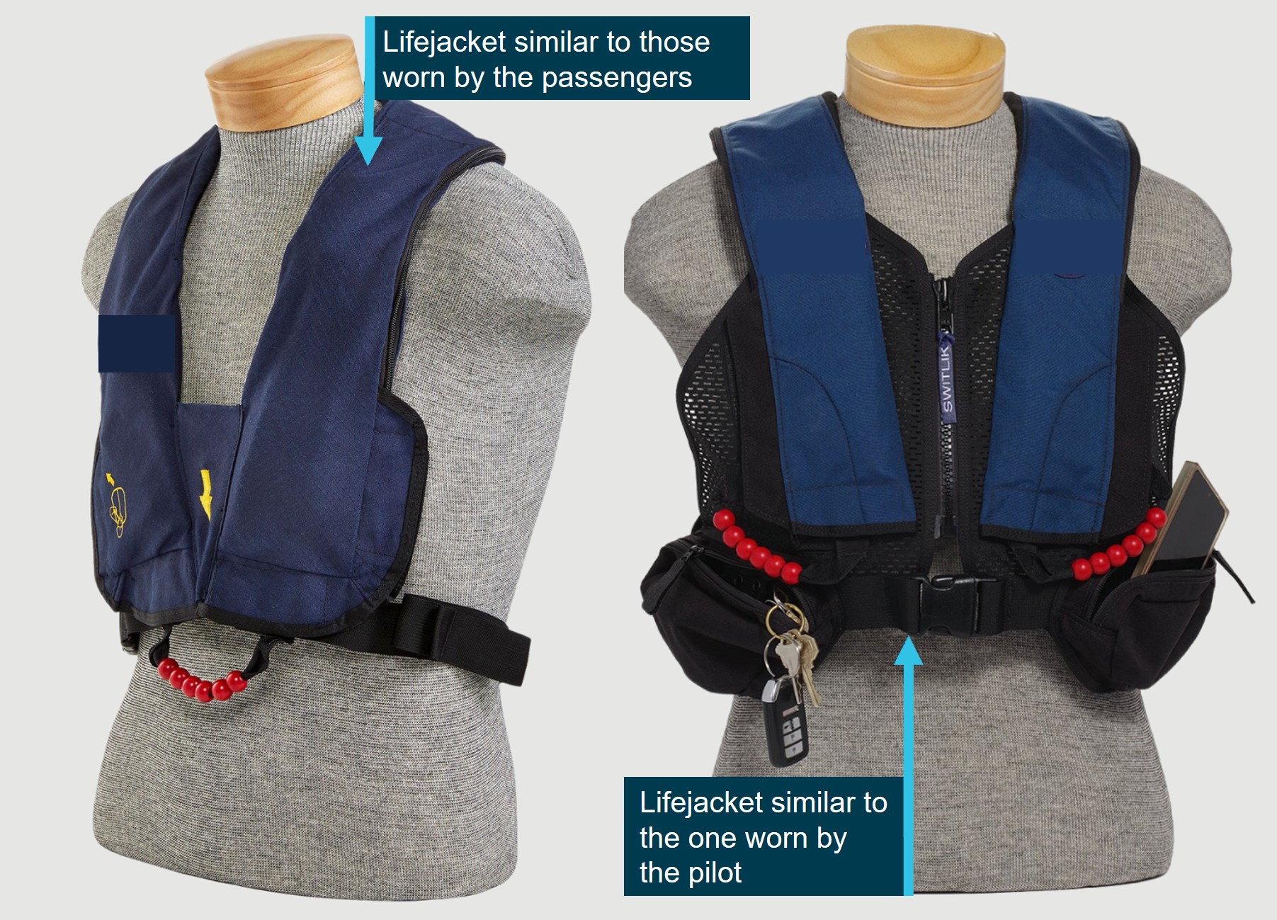
The pilot transmitted an effective MAYDAY call, activated the pop-out floats and instructed the passengers to brace prior to ditching. This improved the occupants' survivability during and after the ditching. Further, the operator’s use of constant wear lifejackets likely increased the ease and speed of use by the occupants (compared to pouch-worn lifejackets), enhancing their survivability post-accident.
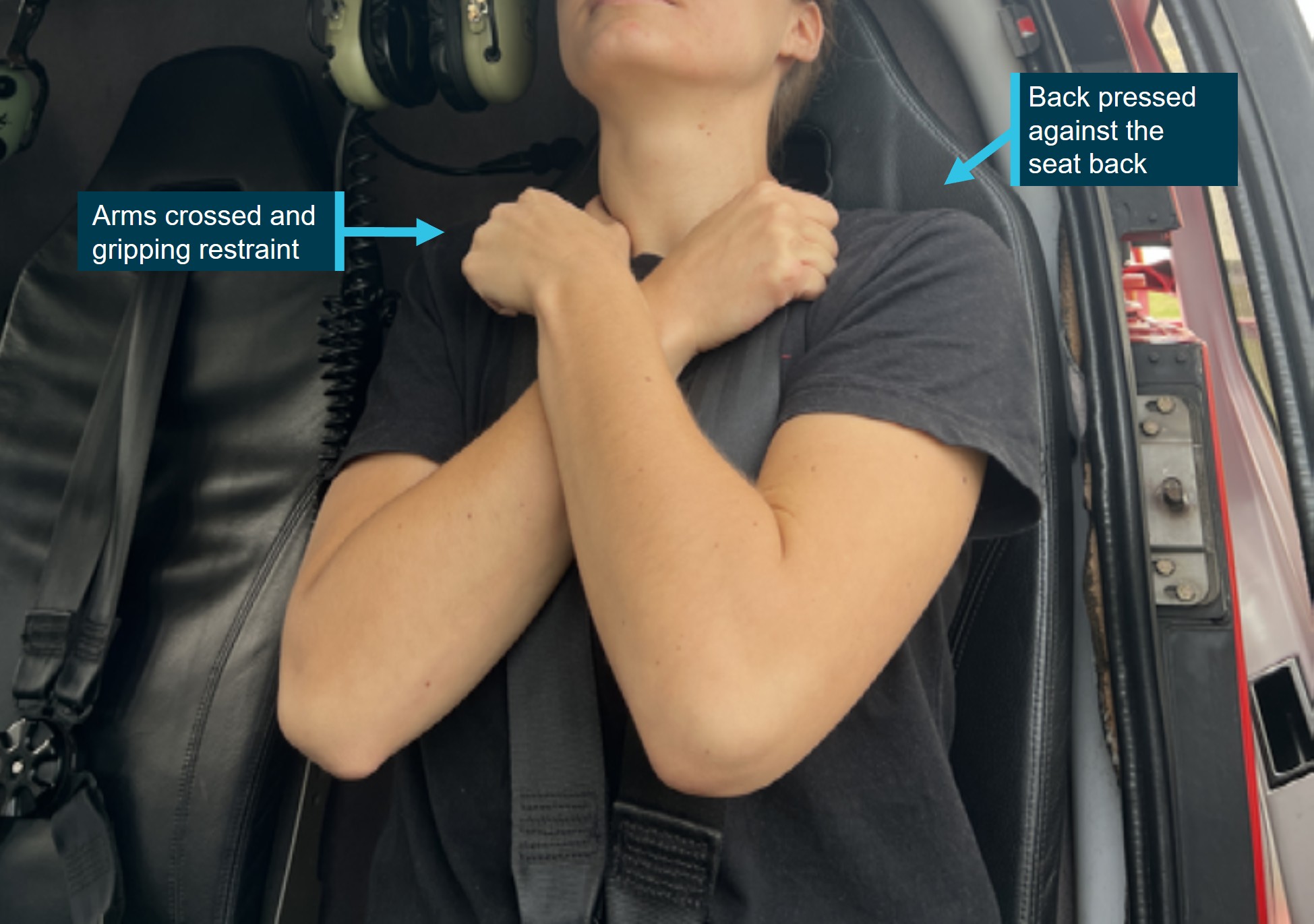
Although the passengers flew regularly as part of their employment, on this occasion the pilot did not provide the passengers with information on the appropriate brace position during the pre-flight safety briefing. Subsequently, when the pilot instructed them to brace for impact, both passengers adopted inappropriate brace positions that increased the risk of injury.
During the ditching, the left pop-out float detached causing the helicopter to roll in the water. This reduced the likelihood of timely emergency egress and exposed the occupants to fuel in the water that resulted in chemical burns.
GBR Helicopters did not provide company pilots with a survival emergency locator transmitter for all overwater flights. Although it did not influence the outcome on this occasion, it had the potential to reduce the post‑impact survivability of a ditching event by relying on the onboard automatic emergency locator transmitter.
Queensland Department of Education employees who regularly flew over water in helicopters as passengers were not provided with helicopter underwater escape training (HUET) which increased the risk of drowning in the event of a ditching.
One of the occupants of the ditched helicopter likely sustained an additional serious injury after impacting the wreckage while being winched during their rescue.
Safety message
Passengers, who regularly fly in helicopters for their employment, are not always provided with aviation‑specific training including helicopter underwater escape training (HUET).
Research has shown that disorientation, entanglement with debris, unfamiliarity with seat belt release mechanisms and difficulty locating or opening exits, are commonly cited as hazards when attempting to escape from a helicopter following an in-water accident. HUET provides participants with familiarity with the crash environment and improves occupant confidence in their ability to manage an in-water emergency egress situation. Individuals and organisations whose employees regularly travel in helicopters over water are encouraged to consider the potential life-saving benefits of HUET for their employees in otherwise survivable helicopter accidents.
The accident highlighted the importance of an effective MAYDAY transmission. With limited time before landing on the water, the pilot’s broadcast alerted other aircraft to their identity and approximate location, resulting in another helicopter arriving at the accident site about 11 minutes after the ditching. Situations requiring a MAYDAY call are often intense and time‑limited, and calculation of an accurate position may not always be possible. The ATSB reminds pilots that, as in this situation, an accurate location, transmitted effectively during an emergency, will likely reduce response time during a rescue and increase the survivability of occupants.
Summary video
The occurrence
Departure and cruise
On the 8 October 2025, at about 0705 local time, the pilot of a Robinson R44 Raven I helicopter, registered VH-XSO, operated by GBR Helicopters Pty Ltd, ferried the helicopter from Horn Island Airport, Queensland, to Sadie’s Helipad on the south-eastern side of Thursday Island, Queensland, about 4 NM north-west of Horn Island Airport.
On arrival at Sadie’s Helipad the pilot shut down the helicopter and commenced a safety briefing for 2 passengers employed by the Queensland Department of Education. Both passengers were familiar with the R44 helicopter, having flown in the model numerous times as part of their employment. The pilot assisted the passengers to board the helicopter, seating one passenger in the rear right seat, behind the pilot and the other in the front left seat.
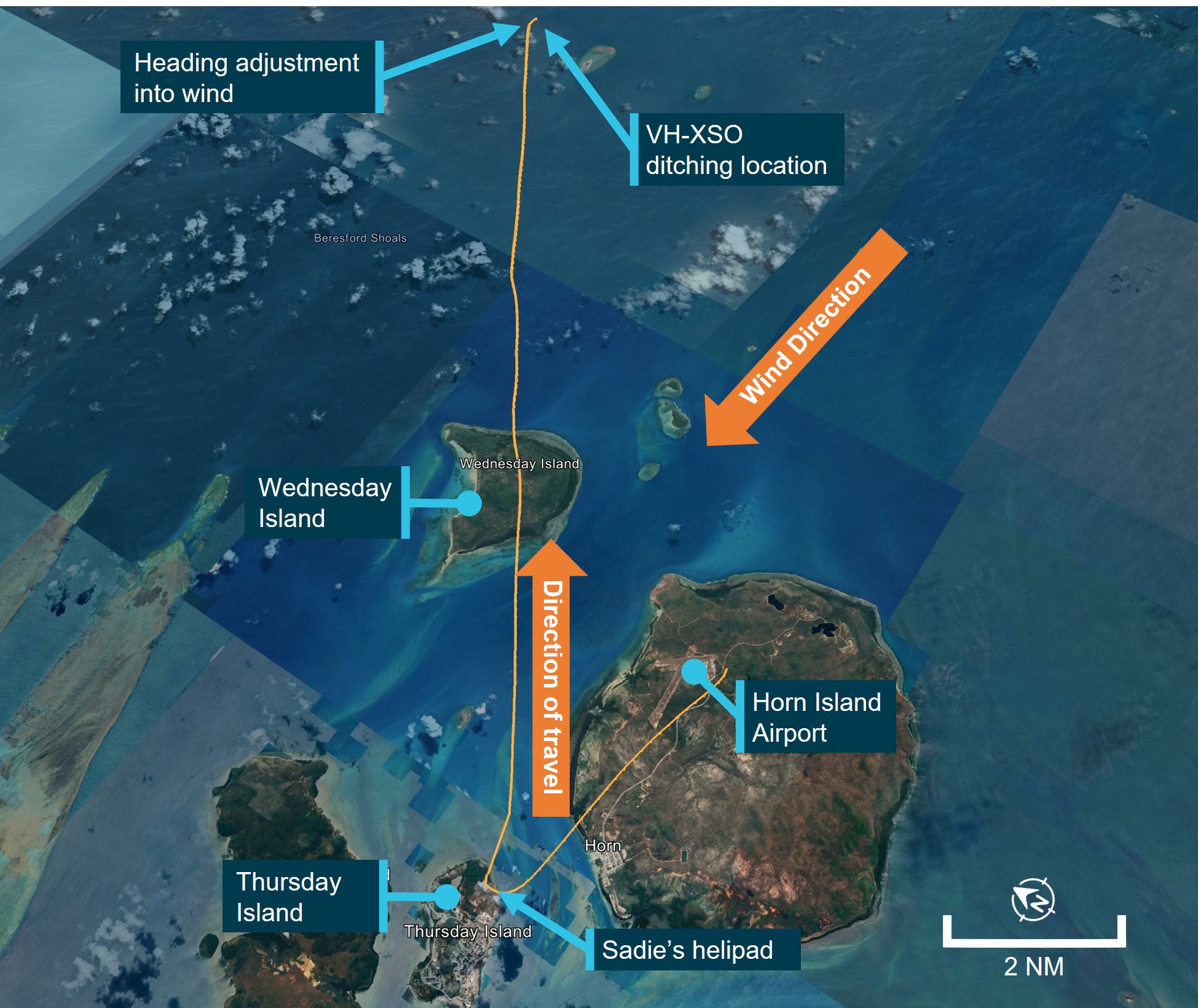
The non-scheduled air transport passenger flight was planned from Thursday Island (Figure 1) direct to Coconut Island (Poruma), about 55 NM (102 km) north-east of Horn Island Airport, where the passengers were to conduct duties related to their employment before the flight continued to Warraber Island and then return to Thursday Island.
At 0719, the helicopter became airborne from Sadie’s Helipad and climbed to an altitude of about 600 ft above sea level. Once they had passed over Wednesday Island, the pilot recalled they conducted a ‘CLEAR-OFF’1 check to assess the helicopter’s performance and position, the check indicated the helicopter was operating normally and on track for its destination.
Figure 1: VH-XSO flight track
Source: Google Earth, annotated by the ATSB
Ditching
After the completion of the check, the pilot considered that they had reached a sufficient distance that would no longer impede traffic approaching to land at Horn Island Airport and they planned to commence a further climb. The pilot reported at this time the low rotor RPM horn activated. They rapidly lowered the collective2 to preserve the rotor RPM and entered autorotation.3 They then observed the engine RPM reducing through about 50% before the engine then completely stopped.
Preparing for a ditching,4 the pilot broadcast a MAYDAY5 call on the local common traffic advisory frequency (CTAF). The transmission included the helicopter’s position relative to Horn Island and that they were ditching into the ocean. The pilot inflated the emergency pop-out floats and instructed the passengers to brace. Prior to contact with the water, the pilot adjusted the helicopter’s heading to the right to align the helicopter more into wind.
Recorded data showed that at 0730:15, the helicopter’s altitude was at sea level. The pilot described the contact with the water as ‘upright’ between an airspeed of 5–10 kt. One passenger described the landing as ‘pretty hard’ and that the water covered the windscreen on impact. The pilot then instructed both passengers to evacuate and recalled that the helicopter rolled immediately on its left side. The pilot and rear right passenger were able to egress via their doors to the right side of the helicopter, which was not submerged, and inflated their lifejackets. The front left passenger, positioned on the lower side (left side) of the rolled helicopter egressed using their low side (left) door, reporting that they struggled to open the door due to the pressure of the water. Once the door was opened, the passenger exited and surfaced near the main rotor blades. While attempting to return to the cabin, they struck their head twice on the helicopter’s main rotor blade. They reported feeling heavy in the water and had difficulty maintaining buoyancy until the other passenger instructed them to inflate their lifejacket.
All the occupants were subsequently able to climb onto the partially submerged helicopter (Figure 2). The pilot observed that the left float, still inflated, had detached from the skid tube and had become entangled around the helicopter’s rotor hub.
Figure 2: VH-XSO shortly after ditching
Source: GBR Helicopters, annotated by the ATSB
Unsure if other aircraft had heard the pilot’s MAYDAY transmission, the occupants attempted to call for help using their phones, however due to water ingress were unable to place any calls. Assisted by the passengers, the pilot entered into the submerged cabin of the helicopter to ensure the emergency locator transmitter (ELT) had been activated. They entered the cabin a second time, shortly after, to retrieve the helicopter’s survival kit and satellite phone. The satellite phone, which had also been submerged, did not work.
All 3 occupants later reported that after a period of time on the submerged helicopter, they noticed a burning sensation, mostly on their legs as they were submerged and presumed this was from fuel in the water. The occupants were individually swept off the helicopter on several occasions as a result of the sea state6 conditions and were assisted by the others to climb back onto the helicopter.
Rescue
The Joint Rescue Coordination Centre (JRCC) received an ELT activation detection in the Torres Strait at 0731.
The pilot of a second R44, operated by another helicopter company based in the Torres Strait, heard a broken transmission of the pilot’s MAYDAY call including the registration and that they were ditching. The second pilot was able to contact the operator of VH‑XSO’s base manager who advised the last known position of the aircraft using company aircraft tracking software. The airborne R44 pilot was then able to track to the location, alerting other airborne fixed wing traffic, who also diverted to the location. About 11 minutes after the ditching, the R44 pilot located the ditched helicopter and relayed, via a fixed wing aircraft that also began orbiting above the site, the ditching location and state of the occupants to Brisbane Centre air traffic control. The helicopter pilot flew above VH-XSO to ensure the occupants were not separated from the ditched helicopter until remaining fuel required them to continue their flight to Horn Island. A company helicopter arrived at the location shortly after and continued monitoring the occupants in the water.
The Horn Island rescue helicopter crew, operating a Leonardo Helicopters AW139, received notification of the task at 0741 and after a reconfiguration for water winching, started engines at 0758 and were airborne at 0804. On board were the aircraft captain, air crew officer (winch operator) and rescue crew officer. The rescue helicopter arrived at the location of the ditched helicopter at 0819, about 50 minutes after the ditching.
A rescue crew officer descended into the water via the winch about 20 m from the wreckage to reduce the effects of the rescue helicopter’s downwash. They approached the wreckage toward the tail of the helicopter and recalled being about 2–5 m from the wreckage when, due to debris and the potential to snag the winch cable on the wreckage, they requested the 3 people to be rescued to enter the water. The rescue crew officer individually winched each person using a rescue strop7 and accompanied each person during the winch.
One rescued person later recalled that once in the winch rescue strop, as the winch cable tightened, they were immersed underwater and impacted the tail of the partially submerged wreckage on the right side of their chest. Neither the rescue crew officer who accompanied the person on the winch, nor the aircrew officer operating the winch, observed the impact with the wreckage nor did the person advise the crew of the impact following the winching.
Once all 3 people had been winched from the water, the rescue helicopter tracked to Thursday Island Hospital and arrived there at 0841. The rescue crew officer recalled during the flight, the survivors advised they were suffering from a burning sensation on their legs and they assisted to rinse the affected areas with water.
Injuries and damage
Medical records indicated all 3 occupants of the ditched helicopter received chemical burns due to their exposure to aviation gasoline. Two of the occupants suffered chemical burns to 14% of their total body surface area (TBSA) while the third suffered burns to 21% of their TBSA. One occupant also suffered a minor head injury, likely from impact with the wreckage following their egress.
The third occupant also received a fracture to a right-side rib. This was reported to medical staff and the ATSB as being a result of the rescue operation where after being attached to the rescue strop, they impacted the tail of the partially submerged wreckage.
Occupants were treated for chemical burns and kept under observation for about 6 hours at Thursday Island Hospital before being discharged later the same day.
In addition to the occupants of the ditched helicopter, the rescue crew officer was kept under observation at the hospital for chemical burns, however reported they were uninjured and also released the same day.
VH-XSO was later reported to have sunk and was not able to be located or recovered.
Context
Personnel information
Pilot experience
The pilot held a commercial helicopter pilot’s licence issued on 22 April 2025 and a current low-level rating valid until 30 March 2027. They had accumulated about 210 hours total time flying helicopters.
They also held an unrestricted Class 1 aviation medical that was valid until 1 November 2026.
Training
The pilot had last completed an operator proficiency check on 20 June 2025 which included emergency autorotations and they were deemed competent by the operator.
The pilot had completed helicopter underwater escape training (HUET) and survival on 20 July 2023 that was valid for 3 years. The pilot later stated that they felt their HUET training was ‘instrumental’ in their efficient egress from the helicopter.
Fatigue
The pilot recalled they had slept well and felt rested and that the early flight did not require a change to their usual sleep pattern. They were rostered the day prior to the occurrence for an 8‑hour duty period, however were not required to fly and had last flown 5 days earlier on 3 October 2025.
The ATSB considered that it was unlikely that fatigue affected the pilot’s performance on the day of the occurrence.
Aircraft information
General information
The Robinson Helicopter Company R44, Raven I is a 4‑place, light helicopter, powered by a Lycoming O-540-F1B5, 6-cylinder, horizontally-opposed piston engine. It has a 2‑bladed main rotor system and a conventional 2‑bladed tail rotor.
The manufacturer advised that the most recent calculation for R44 helicopter engine power loss events indicated a failure rate of 0.37 events per 100,000 flight hours.
VH-XSO was manufactured in the United States as serial number 0817 in 2000 and had flown a total of 3,253.7 hours prior to the occurrence flight. Nautilus Aviation had been the registration holder since January 2024 and cross-hired the helicopter to GBR Helicopters.
Emergency pop-out floats
VH-XSO was fitted with emergency pop-out floats (Robinson Helicopter Company part number C-950). The pilot operating handbook (POH) pop-out float supplement stated that they were ‘intended for safety during overwater flight’ and that the ‘pop-out floats were not certified for ditching’. The supplement did however provide a procedure for practise autorotations onto water, directing pilots to conduct autorotations as per the basic manual with the addition of ensuring a slight nose high attitude.
Following inflation, the POH supplement indicated the emergency pop-out floats would remain inflated for at least one hour and typically maintained shape for several hours.
The R44 type certificate data sheet (H11NM) provided the certification basis for the helicopter and included certification of ‘emergency pop-out floats’ under US Federal Aviation Administration (FAA) Title 14 Code of Federal Regulations (CFR) Part 27. The emergency pop-out floats were certified under Part 27.521 - float landing conditions.
CASR Part 133 Manual of Standards Division 12, section 11.51 stated:
(2) Subject to subsection (3), the rotorcraft must be fitted with emergency flotation equipment if one or more of the following applies to the flight:
(a) the flight:
(i) is to, or from, a helideck on a vessel or other offshore facility; and
(ii) will have an approach and landing or baulked landing stage, or a take‑off and initial climb stage, over water;
(b) the rotorcraft will be flown further over water from land than the distance in which, with 1 engine inoperative, the rotorcraft could reach a suitable forced landing area, for the flight, on land.
(3) Despite paragraph (2)(b), the flight over water is permitted without having to fit emergency flotation equipment if:
(a) it is in a rotorcraft access lane mentioned in the AIP; or
(b) both:
(i) it is to comply with an ATC instruction; and
(ii) it is for no longer than 2 minutes at normal cruising speed in still air.
The R44’s pop-out floats are bolted to the helicopter skid tubes and featured 6 individual chambers per float, the R44 POH described the system:
The pop-out float system consists of inflatable floats stowed in protective covers along the skid tubes, a pressure cylinder located in the compartment under the left front seat, flexible hoses from the cylinder to the floats, an inflation lever located on the pilot’s collective, and an additional stabilizer installed at the base of the lower vertical stabilizer.
The cylinder was filled with helium, with the required operating pressure indicated on a placard on the cylinder and actual pressure was displayed on a gauge at the top of the cylinder.
Squeezing the inflation lever (required about 9 kg of force) caused a spring-loaded pin to puncture a metal sealing disk and allowed the helium to fill the floats.
The POH provided a caution to pilots:
Do not inflate floats above 80 KIAS [knots indicated airspeed]. Do not exceed 80 KIAS with floats inflated.
During the autorotation the pilot reported they reduced the helicopter’s airspeed below the 80 kt limit and then inflated the floats. The pilot also suspected that the left float may have detached or partially detached while the helicopter was descending as they recalled hearing a flapping noise from the left side of the helicopter. However, the R44 POH also contained a note to state:
Some flapping of float covers during flight with floats inflated is normal……
Images of the helicopter in the water showed the left float completely detached from the skid tube and caught on the hub of the main rotor (Figure 3) which prevented the helicopter rolling fully inverted.
Figure 3: VH-XSO ditched
Source: GBR Helicopters, annotated by the ATSB
The manufacturer advised that the floats may be susceptible to damage if:
deployed above the 80 kt airspeed limit
there is a higher than normal vertical impact
there is high forward airspeed
allowing the nose to drop when contacting the water, which could cause the float to separate from the skid and may start as a partial separation before fully detaching.
The manufacturer conducted tests using a 1/7 scale model of the Robinson R66 model equipped with identical floats as used on the R44. These tests were conducted in conditions that simulated uniform waves per the sea state 48 definition and demonstrated that the R66 would remain upright.
Robinson Helicopter Company advised that additional unofficial testing of the R66 in irregular wave conditions peaking at sea state 4 levels, also demonstrated it would remain upright. Although model testing was limited to the R66 configuration, the manufacturer advised that the results extended to the R44 6‑chamber floats by analysis to substantiate European Union Aviation Safety Agency (EASA) requirements for overwater commercial operations. The R44 emergency pop-out float supplement contained a limitation saying the following for normal operations on water:
Safe operation on water has been demonstrated in waves up to 1 foot (0.3 M) (trough to crest) Maximum recommended water taxi speed is 5 kt. Some application of collective is required.
However, the R44 POH did not contain any limitations on the maximum sea state stability of the helicopter to remain upright.
Recent maintenance
The operator advised that prior to the ditching, recent maintenance was completed on VH-XSO following identification of an unserviceable main rotor gearbox pinion and swashplate,9 which was found to be ‘noisy, rough and rusty’. The operator replaced the main rotor gearbox assembly and swashplate. At the completion of the maintenance on 24 September 2025, 2 maintenance test flights were conducted that totalled about 36 minutes and the aircraft was then released into service.
After release to service, a company pilot further reported that the left skid tube on VH‑XSO was cracked. The skid was replaced with one from another R44 helicopter undergoing maintenance at the time. This included the removal of the left side emergency pop-out floats and reattachment to the replacement skid tube, which was completed on 30 September 2025.
VH-XSO then operated on 1 and 2 October 2025 which totalled 4.8 hours of flying over the 2 days and was not flown again prior to the occurrence flight on 8 October.
As VH-XSO sank and was not recovered, the ATSB was unable to determine if recent maintenance may have contributed to either the total loss of power or the left emergency pop-out float separation from the skid tubes.
Fuel
The pilot stated that they departed Horn Island with about 150 L of fuel on board. The R44 helicopter uses about 60 L per hour during normal flying operations and had flown for about 12 minutes before the low rotor RPM warning, including the ferry flight to Thursday Island.
As a result of the helicopter rolling 90° on its left side and the swell of the ocean causing movement, it was likely that this caused fuel to leak from a vent located in the R44’s mast fairing.
Due to the presence of fuel in the ocean following the ditching, the ATSB concluded it was unlikely that fuel exhaustion was a factor.
Carburettor heat
The R44 Raven I is equipped with a carburettor that delivers a fuel air mixture to the engine. A gauge in the helicopter’s cockpit displays the air temperature inside the carburettor and features a yellow caution arc between −17°C and 3°C.
Pressure drops and fuel evaporation inside the carburetor cause significant cooling. Therefore, carburetor ice can occur at OATs [outside air temperatures] as high as 30˚C. Even in generally dry air, local conditions such as a nearby body of water can be conducive to carburetor ice and apply carb heat as required.
The pilot reported that they observed low cloud during the flight and that they had mostly flown fuel‑injected variants of the R44 previously, so were particularly conscious to regularly check the carburettor temperature gauge in VH-XSO. The pilot recalled the carburettor temperature was about 10° before they applied about half carburettor heat early in the flight, while abeam Horn Island, to increase the temperature and reduce the possibility of carburettor ice build-up.
Meteorological information
One minute recorded meteorological data from Thursday Island indicated that the outside air temperature had been a consistent 28°C from 0700 local time with a mean sea level pressure of 1010 hectopascals. One minute meteorological data from Horn Island Airport, about 13 NM (24 km) south-west of the accident location, from 0700 until the time of the occurrence showed wind strengths of 10–19 kt from a consistent east‑south‑east direction.
The ATSB was unable to obtain data from a nearby Queensland Government wave measuring device, however the European Centre for Medium-Range Weather Forecasts (ECMWF) forecast the following ocean conditions in the area:
wave height: 0.82 m (steady)
sea temperature: 27.3°C (steady)
wave period: 3.55 seconds (steady)
wave direction: 115°(ESE)
swell height: 0–0.2 m (steady).
The passengers described windy conditions and being ‘smashed’ by the swell and on several occasions were washed off VH-XSO and were required to assist each other to get back onto the partially submerged helicopter.
Operational information
Overwater flights
The operator’s rotorcraft exposition for both their Civil Aviation Safety Regulation (CASR) Part 133 (air transport operations - rotorcraft) and Part 138 (aerial work operations) for flights over water, detailed that the rotorcraft must be fitted with emergency pop-out floats and that one or more suitable forced landing areas must be available at all times during flight.
The exposition detailed the requirements of a suitable forced landing area in relation to ditching as:
the rotorcraft must be able to ditch in the area of water with a reasonable expectation that there would be no injuries to persons in the rotorcraft or on the water. Company policy is that this is only viable in sea states of less than 2 metres.
CASR Part 133.010 provided the definition of a suitable forced landing area:
Areas of ground
(1) An area of ground is a suitable forced landing area for a flight of a rotorcraft if the rotorcraft could make a forced landing in the area with a reasonable expectation that there would be no injuries to persons in the rotorcraft or on the ground.
Areas of water
(2) An area of water that meets the requirements mentioned in subregulation
(3) is a suitable forced landing area for a flight of a rotorcraft if the rotorcraft:
(a) is equipped with emergency flotation equipment; or
(b) has a type certificate or supplemental type certificate for landing on water.
(3) For the purposes of subregulation (2), the requirements are the following:
(a) the rotorcraft must be able to ditch in the area of water with a reasonable expectation that there would be no injuries to persons in the rotorcraft or on the water;
(b) there must be a reasonable expectation that persons in the rotorcraft would survive in the area of water for the time that it would take to rescue the persons;
(c) if the flight is a passenger transport operation or a medical transport operation—the area of water must be:
(i) adjacent to land; or
(ii) adjacent to an offshore installation with search and rescue capabilities; or
(iii) in a location, set out in the rotorcraft operator’s exposition, that has search and rescue capabilities.
(4) Factors that affect whether there is a reasonable expectation about the matters mentioned in paragraphs (3)(a) and (b) include the following:
(a) the surface condition of the area of water, including the wave height, wind conditions and swell;
(b) the limits of the capability of the rotorcraft’s emergency flotation system to stay upright and floating in certain sea states.
Survivability
Operator’s procedures
For overwater flights, the pilot was required to leave a search and rescue time (SARTIME) with company operations that detailed the commencement and completion times of the intended flight. The pilot reported that they left SARTIME details with company operations and that the flight was also being monitored by aviation tracking software that recorded the helicopter’s position, altitude and performance every 2 minutes.
Helicopter underwater escape training
Fear, anxiety, panic and inaction are the common behavioural responses experienced by occupants during a helicopter ditching. The initial impact, in-rushing water, disorientation, entanglement with debris, unfamiliarity with seatbelt release mechanisms and an inability to reach or open exits have all been cited as problems experienced when attempting to escape from a helicopter following an in-water accident (Rice and Greear, 1973).
Helicopter underwater escape training (HUET) involves a replica of a helicopter cabin and fuselage being lowered into a swimming pool to simulate the ditching of a helicopter. The cabin can rotate upside down and focuses participants on bracing for impact, identifying primary and secondary exit points, opening an exit, releasing harness, egressing the wreckage and surfacing. HUET is normally part of a program of graduated training that builds in complexity, with occupants utilising different seating locations, exits and visibility. This training is conducted in a controlled environment with safety divers in the water.
The CASR Manual of Standards (MOS) Part 133, Chapter 12, section 12.04 discusses the requirements for flight crew general emergency training. The section included that training must cover ditching procedures, including in-water practical training, underwater escape and the use of lifejackets when lifejackets were required to be carried on the flight.
The operator’s risk assessment for an aircraft emergency while over water included a mitigating control that all pilots conducting overwater flight had currency in HUET. The pilot recalled that the techniques learnt during HUET assisted with their efficient egress.
Neither passenger had ever completed HUET, nor was there any regulatory requirement for them to do so.
The passenger in the rear right seat stated they initially attempted to egress the helicopter while wearing their seatbelt. They stated they were panicked and took 2 attempts to then unbuckle their seatbelt.
The front left passenger described ‘fumbling’ during their egress and stated they had difficulty opening their door due to the force of the water, and similar to the other passenger, they also attempted to egress with their seatbelt still fastened.
The Australian Transport Safety Bureau advises helicopter operators involved in overwater operations of the importance of undertaking regular HUET for all crew and regular passengers to increase their survivability in the event of an in-water accident or ditching.
The ATSB contacted 2 large organisations with employees who regularly flew as passengers in light helicopters over water as part of their employment. One of the organisations required that employees who flew 2 or more return flights per year underwent HUET, the other required HUET when employees flew 3 or more return flights per year. As part of a separate ATSB investigation, passengers from a third organisation with employees who regularly flew in the Torres Strait reported they were also provided HUET by their employer.
The Queensland Department of Education stated they did not provide any aviation training to their employees, nor was there a regulatory requirement for the passengers to conduct HUET.
Survival emergency locator transmitter
For all air transport flights, the operator required their aircraft to be fitted with a serviceable automatic emergency locator transmitter (ELT).10 The operator’s exposition also stated:
For any flights where a safe landing may not be possible in the event of an emergency, the PIC [pilot in command] should also carry a survival ELT.
The operator did not require nor did they provide a survival ELT11 to the pilot for the occurrence flight.
ATSB aviation research AR-2012-128A review of the effectiveness of emergency locator transmitters in aviation accidents(2013) found that automatic ELTs functioned as intended in about 40 to 60% of accidents in which their activation was expected and that automatic ELT activation accounted for the first notification in only about 15% of incidents. The research report safety message stated:
Pilots and operators of general aviation and low-capacity aircraft need to be aware that a fixed fuselage mounted ELT cannot be relied upon to function in the types of accidents in which they were intended to be useful. The effectiveness of ELTs in increasing occupant safety and assisting SAR efforts may be enhanced by using a GPS-enabled ELT, using an ELT with a newer 3-axis g-switch, ensuring it is installed correctly, ensuring your beacon is registered with AMSA and pre-emptively activating the beacon if a forced landing or ditching is imminent. Additionally, carrying a personal locator beacon in place of or as well as a fixed ELT will most likely only be beneficial to safety if it is carried on the person, rather than being fixed or stowed elsewhere in the aircraft.
CASA Part 133 MOS Chapter 11.50 required that a life raft fitted with a survival ELT be carried in single-engined rotorcraft if flights were conducted over water at a distance greater than 25 NM (46 km) from a suitable forced landing situated on land.
GBR Helicopters’ operations manual advised that flights were not conducted at distances over water where a life raft was required to be carried.
During the course of other ATSB investigations, it was identified that at least 2 other helicopter operators that conducted regular overwater flights with multiple helicopters, required their pilots to carry a survival ELT in addition to the helicopter’s automatic ELT.
Lifejackets
The operator’s exposition required occupants to wear lifejackets during overwater flight. For Torres Strait operations, passengers were provided with aviation‑approved constant wear vest style lifejackets with a single inflation cord that activated 2 gas cylinders that inflated the jacket. The lifejacket was worn over the head with a single strap fastened across the lower back (Figure 4).
The pilot wore a similar style lifejacket that was fastened at the front with a buckle and zip and featured pockets and dual toggles that individually inflated the 2 gas cylinders separately.
Both the pilot and passengers did not report any difficulty using or inflating the lifejackets.
Figure 4: Lifejackets provided for the occupants by the operator
Source: Red Barron ALSE, annotated by the ATSB
These lifejackets allow the wearer to inflate with a single movement. In comparison, pouch style lifejackets, common in overwater helicopter passenger operations and worn around the waist, required the lifejacket to be pulled from the pouch and then physically placed over the head prior to inflation. They are designed to be donned using one arm to allow the other arm to assist with buoyancy.
Survival kit
The operator advised that survival kits were located in all helicopters operating from its Horn Island base, serviced annually and stowed in an area where they were easily accessible but would not affect the operation of the helicopter. The operator’s exposition stated the minimum contents for their survival kits:
• survival manual
• 2 rations barley sugar
• 13 m light rope
• 2 water purifier tablets
• 1 knife
• 1 box of waterproof matches
• 2 space blankets
• 1 orange plastic sheet
• 1 compass
• 2 containers of water
• 1 signalling mirror
• 1 can opener.
One passenger stated the kit was also equipped with a small torch, however it was not bright enough to attract the attention of the pilot of the R44 helicopter who located the ditched helicopter.
The pilot reported that flares and sea dye were also available at the Horn Island base, however, were not part of the survival kit, were not required to be carried under the regulations or the operator’s exposition and that the pilot had not carried them on the flight.
Brace position
As of 1 December 2022, CASR Part 133 MOS chapter 7 section 7.01– Safety briefing card required that an operator supply a safety briefing card to all passengers specific to the helicopter type and model, which should include detail on how to assume the emergency brace position.
Section 7.02 –Safety briefings, instructions, or demonstrations, before take-off (9)(p) required that a safety briefing addresses when, and how, to assume the brace position.
Both passengers received a safety briefing from the pilot prior to their departure. The pilot recalled they had shown the passenger the operation of the doors, alternative exits and discussed the operation of the lifejackets. During interview the passengers were asked to recall the details of the safety briefing. Neither passenger reported receiving instruction of the brace position.
The operator had produced a specific briefing card for R44 helicopters. The card was available for each passenger in the helicopter, as required. The operator’s briefing card advised passengers the brace position was leaning back into the forward-facing seat while gripping the upper part of the harness for both the lap and sash style seatbelt fitted in VH-XSO and double shoulder harness as pictured (Figure 5). One of the passengers stated they were not aware of the safety briefing card in the helicopter.
Figure 5: GBR Helicopters R44 helicopter emergency brace position
Source: GBR Helicopters, annotated by the ATSB
During the emergency, when the pilot instructed the passengers to brace, the front left passenger stated that they sat upright in their seat and placed one hand on the pilot’s arm, the second passenger reported they gripped the crossbar on the back of the pilot’s seat and held the position until water impact.
Recorded information
Aviation planning software from the pilot’s electronic flight bag (EFB) recorded data every 5 seconds in increments of 100 ft altitude. The recorded data identified that the helicopter became airborne from Sadie’s Helipad, Thursday Island, at about 0719:50 and initially climbed to about 500 ft above sea level. At 0729:45 the helicopter was recorded at 600 ft and 83 kt ground speed. The data then showed a rapid descent (Table 1).
Table 1: VH-XSO last 5 recorded data points
Local time
Height above sea level (ft)
Ground speed (kt)
Heading (Magnetic)
0729:45
600
83
060˚
0729:50
500
75
059˚
0729:55
300
65
061˚
0730:00
200
56
082˚
0730:05
100
49
088˚
Separate aircraft tracking software, used by the operator to monitor aircraft position, recorded the helicopter’s last known position at about 600 ft and 90 kt ground speed and identified that the engine was ‘off’.
Related occurrences
A search of the ATSB occurrence database showed 7 other Australian registered helicopters had ditched into the ocean since 2011. The pilots of 6 of those occurrences had sufficient time to deploy the emergency pop-out floats, and 3 of the 6 helicopters involved rolled shortly after landing on the water.
Engine flame-out and ditching involving Bell LongRanger, VH-RHF, Cone Bay, approximately 98 km north of Derby, Western Australia (AO-2013-097)
On 8 June 2013 VH-RHF, was conducting an aerial survey flight with 4 passengers in the Buccaneer Archipelago area north of Derby, Western Australia. The helicopter was being flown at about 1,000 ft to a planned fuel stop on an island in Cone Bay and was over water when the engine flamed out. The pilot entered autorotation to glide towards land but was unable to reach it. During the glide the pilot deployed the helicopter’s pop-out floats in preparation for an emergency ditching. Shortly after touchdown the helicopter rolled inverted. The pilot and the 4 passengers exited without injury.
Ditching – Robinson R44, VH-HOT, 2 km east of Cairns, Queensland (AO-2011-001)
On 3 January 2011, VH-HOT departed Cairns Airport, Queensland, for a 30-minute charter flight. On board the helicopter was the pilot and 3 non-English speaking passengers. About 25 minutes into the flight, at about 400 ft above sea level, the engine failed and the rotor low rpm horn sounded. The pilot broadcast a MAYDAY and entered autorotation. During the descent he deployed the inflatable floats, however the right float did not fully inflate. The pilot assisted the passengers to egress the helicopter and inflated their life preservers. They were rescued from the water by fishermen in a small boat.
Abnormal engine indications and ditching involving Bell 206L-3, VH-LMW, 6.5 km west of Horn Island Airport, Queensland (AO-2026-003)
On 6 January 2026 during climb, the pilot and only occupant observed uncommanded yaw and fluctuating torque indications. The pilot received a low rotor alert and conducted an autorotation before activating the floats and ditching the helicopter which subsequently inverted. The pilot escaped the wreckage uninjured.
At the time of publication of this report this investigation was ongoing.
Safety analysis
Introduction
On 8 October 2025 a Robinson R44 Raven I, registered VH-XSO and operated by GBR Helicopters, departed Thursday Island, Queensland, with the pilot and 2 passengers on board. During cruise at about 600 ft above sea level the low rotor RPM horn activated and the pilot entered an autorotation. The pilot conducted a ditching and the helicopter immediately rolled onto its left side resulting in the front left seat passenger egressing the helicopter underwater. The 3 occupants were seriously injured from chemical burns from the fuel in the water while waiting for rescue, and one was additionally injured from an impact with the wreckage during the rescue winching.
This analysis will explore the operational considerations related to factors that affected the survivability of the occupants during an overwater emergency.
Total power loss
The pilot reported while in the cruise at about 600 ft, that the low rotor RPM horn activated and the helicopter engine RPM reduced before the engine completely stopped prior to ditching into the ocean. The last recorded data point from the operator’s flight tracking software for VH-XSO also indicated ‘engine off’.
The helicopter subsequently sank and was not able to be located or recovered. Consequently, the ATSB was unable to determine the likely cause of the engine power loss.
Contributing factor
For reasons undetermined, the helicopter engine had a total power loss during the cruise at 600 ft while operating over water, requiring the pilot to conduct a ditching.
Briefing of the brace position
Although the passengers had flown in helicopters in the Torres Strait regularly, and were familiar with the R44, the pilot of VH-XSO provided a pre-flight safety briefing which included operation of the doors as an emergency exit and alternative exits if a door was blocked, and the use of the lifejackets.
However, on this occasion, the pilot did not brief the passengers on how to adopt the correct brace position as required by the operator’s manual and the regulations. Although the pilot advised both passengers to brace during the autorotation, the front left passenger grabbed the pilot’s arm and sat back in their seat, while the rear seat passenger braced themselves using the cross bar on the back of the pilot’s seat. Both brace positions increased the risk of injury to the passengers and had the potential to interfere with the pilot’s ability to control the helicopter during the emergency.
The operator advised that VH-XSO contained safety briefing cards that depicted the brace position for the lap and sash harness fitted to VH-XSO. However, one passenger was not aware of the location of the safety briefing card.
Not being briefed on adopting the appropriate brace position increased the risk of injury to both occupants which may have further hindered emergency egress from the helicopter or affected the pilot’s ability to control the helicopter during the emergency.
Other factor that increased risk
The pilot did not provide the passengers with information on the appropriate brace position during the pre-flight safety briefing.
MAYDAY transmission and emergency response
Realising they were forced to ditch the helicopter, the pilot transmitted a MAYDAY call that alerted another helicopter that they intended to ditch in the ocean. The second helicopter diverted to the ditched helicopter, and in conjunction with a nearby fixed wing aircraft, were able to communicate the emergency to Brisbane Centre air traffic control, providing their location, which reduced the response time of the search and rescue aircraft in locating the occupants, and additional information on the survivor’s welfare.
Although the automatic emergency locator transmitter (ELT) had alerted the Joint Rescue Coordination Centre (JRCC) to the aircraft’s last known position, past studies have shown that the activation and transmission of ELTs is not always certain. Had the ELT not been activated, the pilot’s MAYDAY call was likely to have been the initiation of the emergency response.
Following their MAYDAY call, the pilot was able to deploy the emergency pop-out floats in preparation for the water landing; this very likely prevented the helicopter from rapidly sinking and allowed the occupants time to egress. Although the helicopter rolled shortly after ditching, the partially submerged helicopter provided some refuge from the ocean conditions and made visual identification for first responders easier. The helicopter’s ELT had also been activated, alerting rescuers to its location. However, had the helicopter sunk, ocean currents and wind would have carried the occupants away from their last known position.
The pilot also advised the passengers to brace prior to the water impact, and even though they had not been advised of the appropriate brace position, it is likely that this gave the passengers additional time to prepare and consider possible egress options.
Other finding
The pilot transmitted an effective MAYDAY call, activated the pop-out floats and instructed the passengers to brace prior to ditching. This improved the occupants’ survivability during and after the ditching.
Emergency pop-out floats
On landing, the left side emergency pop-out float detached from the skid and the helicopter rolled onto its left side. The detached float then became entangled in the rotor assembly, providing some buoyancy to the mast and preventing the helicopter from becoming inverted. The manufacturer advised that the floats may be susceptible to damage as a result of high forward airspeeds or impact forces.
The helicopter’s left skid had also recently been replaced due to an identified crack. The replacement of the skid meant that the emergency pop-out floats were reattached to the replacement skids. The operator advised that the skid replacement and emergency pop‑out float attachment was completed in accordance with the manufacturer’s maintenance manual.
The helicopter’s roll to the left resulted in the front left passenger egressing through their door while under water. Had the emergency pop-out float not lodged around the helicopter’s main rotor hub it is likely that all 3 occupants would have been required to egress from an inverted helicopter, increasing the risk of disorientation during escape.
The Robinson Helicopter Company advised that the R44 would likely remain stable in sea states of up to 2.4 m, which was above the forecast wave heights of about 0.8 m on the day of the accident. Following the egress, the 3 occupants then sought refuge on board the partially submerged helicopter. However, their legs were mostly submerged and they were often swept off the helicopter entirely. This exposed them to the leaked aviation gasoline and resulted in serious injuries to all 3 occupants. Without the detachment of the emergency pop-out float it was likely the helicopter would have remained upright and the occupants could have remained on board until their rescue with significantly less time exposed to the leaked fuel in the water.
Both the helicopter and the detached left emergency pop-out float were not recovered, and the cause of the detachment could not be accurately determined.
Contributing factor
For reasons that were undetermined, during the ditching, the left float detached causing the helicopter to roll in the water. This reduced the likelihood of a successful emergency egress and exposed the survivors to fuel in the water leading to chemical burn injuries.
Survival emergency locator transmitter on overwater flights
GBR Helicopters did not provide company pilots with a survival ELT for all overwater flights, nor were they required to unless the flight involved a distance from a suitable forced landing area that required the carriage of a life raft.
The single-engined Robinson R44 helicopter VH-XSO was fitted with emergency pop-out floats, certified for water landing, however they were not certified for ditching, resulting in a greater risk of float damage and therefore capsize during a ditching event.
The ATSB considered that during the ditching, the attached remaining emergency pop‑out float could have been damaged or detached, which may have resulted in the helicopter sinking immediately after impact. In such circumstances, had the occupants successfully egressed they would have been subject to wind and current and likely drifted from the last known position, increasing the search area, reducing the likelihood of timely detection and increasing the occupants’ exposure time in the water.
Carriage of a survival ELT by the pilot would have provided an additional layer of safety, if carried on their person, via timely and accurate location for search and rescue focus, increasing post‑impact survivability.
Other factor that increased risk
GBR Helicopters did not provide company pilots with a survival ELT for all overwater flights. This reduced the post‑impact survivability of a ditching event. (Safety Issue)
Helicopter underwater escape training
It is a regulatory requirement for pilots conducting overwater flight to conduct helicopter underwater escape training (HUET) every 3 years, although there is no regulatory requirement for passengers who travel regularly in helicopters over water to conduct the training.
Both passengers had flown regularly in helicopters over water as part of their employment with the Queensland Department of Education during the 12 months preceding the occurrence flight and had never undertaken HUET.
HUET is considered to provide individuals with familiarity with the crash environment and confidence in their ability to cope with the emergency situation (Ryack et al., 1986). Interviews with survivors from helicopter accidents requiring underwater escape frequently mention that they considered that HUET was very important in their survival. Training assists by providing reflex conditioning, a behaviour pattern to follow and reducing confusion and panic (Hytten, 1989).
Passengers stated they fumbled and felt panicked, both attempting to egress while still wearing their seatbelts. Therefore, it was likely the passengers’ egress would have been more efficient and reduced the risk of drowning had they completed HUET.
Other organisations whose employees travelled numerous times per year in helicopters over water arranged HUET for these employees. However, Queensland Department of Education employees were not provided with any aviation‑specific training. HUET training provides the opportunity to develop a behavioural pattern for underwater emergency helicopter egress and has been shown to increase post‑impact survivability and decrease the risk of drowning.
Other factor that increased risk
Queensland Department of Education employees who regularly fly over water in helicopters were not provided with Helicopter Underwater Escape Training which increased the risk of drowning. (Safety Issue)
Lifejackets
GBR Helicopter’s Horn Island operation provided passengers with constant wear, vest style, lifejackets and required that they be worn at all times for overwater flights.
The front seat passenger described ‘feeling heavy’ in the water and had difficulty staying buoyant, compounded by the constant swell, until they were instructed to inflate their lifejacket. The wearable vest style life jacket was able to be immediately inflated post‑accident, without requiring it to be donned while attempting to remain afloat in the water.
Had any of the occupants lost consciousness while awaiting a rescue, a first responder need only inflate the passenger’s lifejacket, removing the additional step of donning the jacket from a pouch for a person requiring assistance.
The quick inflation of the lifejacket provided rapid buoyancy and increased their post‑accident survivability.
Other finding
The use of constant wear, vest style lifejackets likely increased the ease and speed of use, enhancing the survivability of occupants.
Rescue
Following the arrival of the rescue helicopter on site, the rescue crew officer was winched into the water to retrieve the people one-by-one via the winch with themselves also attached. During one winch recovery, the person being rescued reported they impacted the wreckage of the helicopter while being dragged through the water, likely resulting in the fracture to their rib. Environmental conditions on the day likely increased the difficulty for the rescue, with the wind and sea state moving the rolled and partially submerged wreckage. This likely increased the difficulty of identifying their proximity to the wreckage, especially sections of the helicopter that were submerged, and increased the risk of impact and therefore injury.
Neither the rescue crew officer or the aircrew officer observed the impact with the wreckage and were not advised by the injured person during the transfer to Thursday Island Hospital.
Although it was considered possible that the rib injury was sustained during the ditching sequence or subsequent egress, the elapsed time between the ditching and rescue was likely sufficient for the injured individual to have recognised the presence of a fracture injury. In the absence of any reported awareness of such an injury before the rescue, it is therefore more likely that the fractured rib was sustained during the winch recovery.
Contributing factor
One of the people being rescued likely sustained an additional serious injury after impacting the wreckage while being winched.
Findings
ATSB investigation report findings focus on safety factors (that is, events and conditions that increase risk). Safety factors include ‘contributing factors’ and ‘other factors that increased risk’ (that is, factors that did not meet the definition of a contributing factor for this occurrence but were still considered important to include in the report for the purpose of increasing awareness and enhancing safety). In addition ‘other findings’ may be included to provide important information about topics other than safety factors.
Safety issues are highlighted in bold to emphasise their importance. A safety issue is a safety factor that (a) can reasonably be regarded as having the potential to adversely affect the safety of future operations, and (b) is a characteristic of an organisation or a system, rather than a characteristic of a specific individual, or characteristic of an operating environment at a specific point in time.
These findings should not be read as apportioning blame or liability to any particular organisation or individual.
From the evidence available, the following findings are made with respect to the power loss and ditching involving Robinson R44, VH-XSO, 24 km north-east of Horn Island Airport, Queensland, on 8 October 2025.
Contributing factors
For reasons undetermined, the helicopter engine had a total power loss during the cruise at 600 ft while operating over water, requiring the pilot to conduct a ditching.
For reasons that were undetermined, during the ditching, the left float detached causing the helicopter to roll in the water. This reduced the likelihood of a successful emergency egress and exposed the survivors to fuel in the water leading to chemical burn injuries.
One of the people being rescued likely sustained an additional serious injury after impacting the wreckage while being winched.
Other factors that increased risk
The pilot did not provide the passengers with information on the appropriate brace position during the pre-flight safety briefing.
GBR Helicopters did not provide company pilots with a survival emergency locator transmitter for overwater flights. This reduced the post‑impact survivability of a ditching event. (Safety Issue)
Queensland Department of Education employees who regularly fly over water in helicopters were not provided with Helicopter Underwater Escape Training which increased the risk of drowning. (Safety Issue)
Other findings
The pilot transmitted an effective MAYDAY call, activated the pop-out floats and instructed the passenger to brace prior to ditching. This improved the occupants' survivability during and after the ditching.
The use of constant wear, vest style lifejackets likely increased the ease and speed of use, enhancing the survivability of occupants.
Safety issues and actions
Central to the ATSB’s investigation of transport safety matters is the early identification of safety issues. The ATSB expects relevant organisations will address all safety issues an investigation identifies.
Depending on the level of risk of a safety issue, the extent of corrective action taken by the relevant organisation(s), or the desirability of directing a broad safety message to the aviation industry, the ATSB may issue a formal safety recommendation or safety advisory notice as part of the final report.
All of the directly involved parties were provided with a draft report and invited to provide submissions. As part of that process, each organisation was asked to communicate what safety actions, if any, they had carried out or were planning to carry out in relation to each safety issue relevant to their organisation.
Descriptions of each safety issue, and any associated safety recommendations, are detailed below. Click the link to read the full safety issue description, including the issue status and any safety action/s taken. Safety issues and actions are updated on this website when safety issue owners provide further information concerning the implementation of safety action.comes to hand.
Helicopter underwater escape training for regular passengers
Safety issue description: Queensland Department of Education employees who regularly fly over water in helicopters were not provided with Helicopter Underwater Escape Training which increased the risk of drowning.
Carriage of survival emergency locator transmitter
Safety issue description: GBR Helicopters did not provide company pilots with a personal locator beacon for overwater flights. This reduced the post‑impact survivability of a ditching event.
Glossary
ATC
Air Traffic Control
CASA
Civil Aviation Safety Authority
CASR
Civil Aviation Safety Regulations
CTAF
Common terminal area frequency
EASA
European Union Aviation Safety Agency
ECMWF
European centre for medium-range weather forecasts
ELT
Emergency locator transmitter
EPIRB
Emergency position-indicating radio beacon
FAA
Federal Aviation Administration
HUET
Helicopter underwater escape training
JRCC
Joint Rescue Coordination Centre
KIAS
Knots of indicated airspeed
kt
Knots
NM
Nautical mile
SAR
Search and rescue
PLB
Personal locator beacon
POH
Pilot operating handbook
RPM
Revolutions per minute
Sources and submissions
Sources of information
The sources of information during the investigation included:
the pilot of the accident flight
passengers of the accident flight
the pilot of VH-WTT
recorded data from EFB and satellite tracking device
images provided by the operator
maintenance records of the occurrence aircraft
the rescue crew officer
Queensland Department of Education
Civil Aviation Safety Authority
Robinson Helicopter Company
Bureau of Meteorology.
References
Rice, E. a. (1973). Underwater escape from helicopters. In proceedings of the eleventh annual symposium, Cited in Brooks C. (1989)The human factors relating to escape and survival from helicopters ditching in water (pp. 59-60). Phoenix AZ: AGRAD.
Ryack, B. L. (1986). Surviving Helicopter crashes at sea,. Aviation Space and Environment Medicine, 57(6), 603-609.
Submissions
Under section 26 of the Transport Safety Investigation Act 2003, the ATSB may provide a draft report, on a confidential basis, to any person whom the ATSB considers appropriate. That section allows a person receiving a draft report to make submissions to the ATSB about the draft report.
A draft of this report was provided to the following directly involved parties:
the pilot of VH-XSO
the passengers on board VH-XSO
GBR Helicopters
the rescue helicopter operator
CASA
Bureau of Meteorology
Robinson Helicopter Company
Queensland Department of Education
Australian Maritime Safety Authority
United States National Transport Safety Board (NTSB)
Submissions were received from:
the pilot of VH-XSO
the passengers on board VH-XSO
GBR Helicopters
the rescue helicopter operator
CASA
Bureau of Meteorology
Robinson Helicopter Company
Queensland Department of Education
The submissions were reviewed and, where considered appropriate, the text of the report was amended accordingly.
Purpose of safety investigations
The objective of a safety investigation is to enhance transport safety. This is done through:
identifying safety issues and facilitating safety action to address those issues
providing information about occurrences and their associated safety factors to facilitate learning within the transport industry.
It is not a function of the ATSB to apportion blame or provide a means for determining liability. At the same time, an investigation report must include factual material of sufficient weight to support the analysis and findings. At all times the ATSB endeavours to balance the use of material that could imply adverse comment with the need to properly explain what happened, and why, in a fair and unbiased manner. The ATSB does not investigate for the purpose of taking administrative, regulatory or criminal action.
About ATSB reports
ATSB investigation reports are organised with regard to international standards or instruments, as applicable, and with ATSB procedures and guidelines.
Reports must include factual material of sufficient weight to support the analysis and findings. At all times the ATSB endeavours to balance the use of material that could imply adverse comment with the need to properly explain what happened, and why, in a fair and unbiased manner.
An explanation of terminology used in ATSB investigation reports is available here. This includes terms such as occurrence, contributing factor, other factor that increased risk, and safety issue.
Publishing information
Released in accordance with section 25 of the Transport Safety Investigation Act 2003
Ownership of intellectual property rights in this publication
Unless otherwise noted, copyright (and any other intellectual property rights, if any) in this report publication is owned by the Commonwealth of Australia.
Creative Commons licence
With the exception of the Commonwealth Coat of Arms, ATSB logo, and photos and graphics in which a third party holds copyright, this report is licensed under a Creative Commons Attribution 4.0 International licence.
The CC BY 4.0 licence enables you to distribute, remix, adapt, and build upon our material in any medium or format, so long as attribution is given to the Australian Transport Safety Bureau.
Copyright in material obtained from other agencies, private individuals or organisations, belongs to those agencies, individuals or organisations. Where you wish to use their material, you will need to contact them directly.
Footnotes
1
A precautionary check of the aircraft’s performance and position - compass, log, engine, altitude, radio, orientation, fuel and forced landing areas.
2
A primary flight control that collectively adjusts the pitch on the main rotor blades.
3
Autorotation is a condition of descending flight where, following an engine failure or deliberate disengagement, the rotor blades are driven solely by aerodynamic forces resulting from rate of descent airflow through the rotor. The rate of descent is driven mainly by airspeed.
4
A ditching is a controlled emergency landing of an aircraft on water.
5
MAYDAY: an internationally recognised radio call announcing a distress condition where an aircraft or its occupants are being threatened by serious and/or imminent danger and the flight crew require immediate assistance.
6
Sea state is the general condition of the free surface on a large body of water.
7
Rescue strop is designed for hoisting personnel from ships, shore and sea during helicopter operations.
8
World Meteorological Organization - Sea State 4 wave heights of between 1.25 and 2.5 metres.
9
A helicopter swash plate transmits flight control inputs to the main rotor blades allowing vertical and rotational movement.
10
Automatic emergency locator transmitter (ELT): a radio beacon that transmits an emergency signal that may include the position of a crashed aircraft, activated either manually or due to the forces of an accident.
11
A survival ELT refers to approved emergency position-indicating radio beacons (EPIRB) and personal locator beacons (PLB). They are removable from an aircraft or carried on the person, and require manual activation.
Occurrence summary
Investigation number
AO-2025-062
Occurrence date
08/10/2025
Occurrence time and timezone
07:20 Australian Eastern Standard Time
Location
24 km north-east of Horn Island Airport
State
Queensland
Report release date
07/05/2026
Report status
Final
Investigation level
Defined
Investigation type
Occurrence Investigation
Investigation phase
Final report: Dissemination
Investigation status
Completed
Mode of transport
Aviation
Aviation occurrence category
Ditching, Engine failure or malfunction
Occurrence class
Accident
Highest injury level
Serious
Aircraft details
Manufacturer
Robinson Helicopter Co
Model
R44
Registration
VH-XSO
Serial number
817
Aircraft operator
GBR Helicopters Pty Ltd
Sector
Helicopter
Operation type
Part 133 Air transport operations - rotorcraft
Activity
Commercial air transport-Non-scheduled-Passenger transport charters
In the early morning of 27 March 2025, rapidly rising floodwater started surrounding the Queensland town of Adavale, flooding homes and requiring people to seek refuge on their roofs.
The planned Queensland Fire Department swift water rescue team were unable to deploy to Adavale, so Channel Country Helicopters, a local helicopter mustering company, was requested to assist with the evacuation of the town as a mercy flight. They agreed and subsequently dispatched three Robinson R22 helicopters to Adavale.
When the second helicopter arrived overhead the town, the pilot spotted a person on the roof of a demountable building with a strong flood current flowing around it. The pilot assessed the situation as critical and proceeded to land on a flat roof section to pick up the passenger. The pilot was not sure whether the roof could hold the weight of their helicopter, they kept the aircraft in a flying condition with the skids resting lightly on the roof.
After the passenger climbed in, the pilot took off from the roof and attempted to depart upwind. As the helicopter cleared the demountable roof it was no longer in ground effect and available performance was insufficient for level or climbing flight. The lack of available power caused the rotor RPM to decay, activating the ‘low RPM’ warning horn. The pilot then immediately realised the criticality of the situation, identified a sheltered landing spot and conducted a controlled ditching into chest-high floodwater in the lee of a nearby building.
The pilot and passenger then safely exited the helicopter into the water but were unable to climb to the roof of the building. The pilot then attempted to retrieve a ladder from the take-off site but was washed away by the current. They found shelter in a tree about 900 m downstream of the ditching site and was later rescued by another helicopter. The passenger avoided the strong current by standing close to the helicopter, but sustained significant chemical burns due to the fuel seeping out of the helicopter’s tank.
The helicopter was substantially damaged by the floodwater.
Source: Photo received from operator
What the ATSB found
After the embarkation of the passenger on the roof, the helicopter was overloaded to an extent that prevented flight out of ground effect, with insufficient clear space available to accelerate to an airspeed to obtain translational lift. Once this was recognised by the pilot, they conducted a successful ditching into floodwater. The pilot’s choice of landing site in the only sheltered area available allowed for the helicopter to remain upright in the otherwise fast‑flowing water. Additionally, their rapid and correct application of the helicopter manufacturer’s low RPM recovery procedures resulted in a controlled ditching which allowed both pilot and passenger to exit the helicopter without injury.
The pilot’s decision‑making was affected by the heavy workload of conducting a rescue operation, for which they were not prepared, in a light helicopter. The pilot conducted an unfamiliar and demanding rescue operation which likely overwhelmed their decision‑making capacity while the passenger was boarding the helicopter. This heavy workload, in addition to the rotor operating at high power, prevented the pilot from verbally briefing the passenger on seatbelt use and other safety information. The passenger was subsequently unrestrained during the flight.
Once committed to the rescue, under high workload and the perception of imminent danger of staying on the roof, the pilot continued with the plan and did not reassess the feasibility of the flight once they realised that helicopter performance was going to be marginal with the heavier than expected passenger on board.
The helicopter operator was aware that the requested flight was outside of their normal scope of operations. However, they felt a moral obligation to act due to their perception of being the only people that could help preserve life. This meant that they agreed to conduct mercy flight operations to attempt rooftop rescues for which they were not trained or equipped.
Safety message
Many aspects of emergency response in Australia rely on volunteers, both by organised groups and ad-hoc by people who happen to be in the right position to help. These ad‑hoc or bystander rescues save many lives when dedicated, trained assistance is not available. However, when responding to an emergency it is of paramount importance to stop and take a moment to assess risk to the rescuers before assisting others. This applies in any emergency context, not just aviation, and is strongly reinforced in training for surf rescue, medical first aid, fire-fighting and marine rescue operations.
In the aviation context, mercy flights are by definition outside the scope of the normal operations of the involved pilots and operators. This places a high burden on pilot and operator to assess risks that may be out of their area of expertise. Where possible it is important for all involved to take the time to reassess the risk of (continuing) the proposed flight and consider any alternatives. This may include discontinuing a rescue and waiting for additional assistance, as continuing may expose the crew and the people being assisted to much greater risks.
Summary video
The investigation
The ATSB scopes its investigations based on many factors, including the level of safety benefit likely to be obtained from an investigation and the associated resources required. For this occurrence, the ATSB conducted a limited-scope investigation in order to produce a short investigation report, and allow for greater industry awareness of findings that affect safety and potential learning opportunities.
The occurrence
On the morning of 27 March 2025, widespread rain associated with a passing surface trough was causing catastrophic flooding in Queensland’s channel country region. In particular, the small rural town of Adavale, about 89 km north of Quilpie, was most heavily affected. Telephone communication had been lost the previous day, but during the night reports reached authorities indicating that the town was rapidly flooding and that some people in lower lying areas had sought shelter on roofs.
At around 0630,[1] an aerial work operator, Channel Country Helicopters, dispatched a Robinson R22 helicopter, registered VH-KNG, from Quilpie with the pilot and a police officer on board to assess the situation in Adavale. The officer had tried to reach Adavale in the days before but had found the roads impassable. A helicopter flight was previously arranged but had not been possible due to the heavy rain until the operator noted an improvement of weather conditions.
On arrival in Adavale at 0721, the pilot and the police officer found the situation in the town critical, with fast‑flowing floodwaters throughout the town. This limited landing access, with the only dry place available at the town waste disposal site, about 1 km to the north‑east. After disembarking the police officer, the pilot returned to Quilpie and refuelled the helicopter.
Around 0915, the helicopter operator received a phone call from the local disaster management group asking ‘if they were able to conduct a mercy flight’[2] as there were people reported on the roofs of buildings in Adavale and no other rescue assets were available. The operator assessed that the weather was not suitable for VFR flight at the time, but agreed to send its helicopters when able. The operator then briefed its pilots on some of the risks involved, including the possibility of overloading roofs when landing and the need to pay special attention to powerlines and other overhead obstructions that were expected in the town.
Once the weather cleared, the operator mobilised the first 2 Robinson R22 helicopters, shortly followed by a third helicopter.
The first helicopter that arrived in Adavale touched down on a roof of a demountable building, boarded a resident who was waiting on the roof, and departed to a nearby cattle station.
At around 1115, the second helicopter, VH-KNG (flown by the pilot who had ferried the police officer to Adavale that morning), which had stopped en route to avoid flying through rain showers,[3] was back overhead Adavale where the pilot observed that the fast-flowing water was ‘pushing around a parked semi‑trailer road‑train’, reinforcing a sense of urgency to evacuate residents. The pilot then spotted a person on the same roof and elected to conduct a rooftop rescue.
On approach to the rescue site, the pilot recalled that they assessed that the building was at immediate risk of being washed away, and that the roof strength was insufficient to carry the full weight of the helicopter. The pilot then opted to maintain lift on the main rotor while picking up the passenger to reduce the load on the roof sheeting. The helicopter touched down on the flat roof between the two demountable buildings (Figure 1). The pilot kept the helicopter flying throughout the passenger embarkation, with only part of the skids lightly touching the roof.
Figure 1: View underneath roof
Source: Video still from passenger, annotated by the ATSB
The passenger boarded the helicopter from the left side, into the left seat, wearing a rain jacket with some personal effects. During the rapid boarding and take-off, the noise of the engine running at full power did not allow verbal communication with the boarding passenger. The passenger did not attempt to secure their seat belt prior to take‑off.
The pilot reported realising the passenger was heavy, but being confident that the helicopter would be able to fly away after building up airspeed to obtain translational lift.[4] The pilot lifted off the helicopter (in ground effect[5] over the roof) and immediately departed into wind. However, once clear of the roof with reduced ground effect, the helicopter was no longer able to sustain level flight. As rotor speed decayed below 97%, the low rotor RPM light and horn alarms activated in the cockpit.
The pilot lowered the collective[6] and applied aft cyclic[7] and quickly concluded that the helicopter would not be able to clear approaching obstacles such as trees, buildings and powerlines during the take‑off run. They then selected an area sheltered from the floodwater current, behind a building about 60 metres away, and conducted a controlled ditching.
Figure 2: Overview of flight
Source: Google Earth, annotated by the ATSB
After ditching, the helicopter became submerged in floodwater, stopping the engine. Due to the lee of the building protecting the helicopter from the main current, it remained upright, allowing both the passenger and pilot to egress into the chest deep water.
There was no access to the roof of the building, so the pilot attempted to return to the take-off site to retrieve a ladder. However, the pilot was swept away by the current before finding shelter in a tree about 900 metres downstream, where they were later rescued by a larger helicopter.
The passenger stayed in the lee of the building, in the sheltered water near the helicopter, and was later transported to a temporary shelter on a roof by the police officer, who had commandeered a small motorboat.
The pilot was unhurt, but the passenger sustained serious chemical burns due to exposure to the fuel leaking from the submerged helicopter’s tank. The passenger was treated for their injuries by the swift-water rescue team and later in hospital.
No further rooftop rescues were conducted by the operator, instead company helicopters guided motorboat and swift-water rescue teams to people in need of rescue.
Figure 3: Adavale flood in the afternoon after the accident
Source: Nathan Covey
Context
Pilot information
The pilot held a Commercial Pilot Licence (CPL) for helicopters and aeroplanes, a valid class 2[8] aviation medical certificate and a low‑level mustering endorsement for helicopters.
The pilot reported having flown for about 25 years, first in fixed wing aircraft and then operating helicopters for the last 3 years, mostly in support of cattle mustering operations.
At the time of the accident, the pilot had accumulated about 11,400 hours aeronautical experience, of which about 800 hours were on R22 helicopters. The pilot had flown about 30 hours in the preceding 90 days but had not flown for 5 days prior due to the poor weather conditions.
The pilot was very familiar with the area, having flown there for most of their career, and felt well rested on the day of the accident. They reported that they started work at about 0600 for the initial flight to Adavale with the police officer, and that they were not experiencing any effects of fatigue.
Aircraft information
General information
The Robinson Helicopter Company R22 Beta II helicopter is powered by a Textron Lycoming O‑360‑J2A 4‑cylinder piston engine. The R22 has 2 seats, with the pilot flying from the right seat, with each seat fitted with a 3‑point, inertia reel shoulder strap seatbelt, similar to those used in motor vehicles.
The R22 is commonly used for helicopter flight training, private flight and livestock mustering operations. It has a payload capacity of about 215 kg and a maximum seat limit of 109 kg (including any items in the small luggage compartment under the seats).
VH-KNG
VH-KNG was manufactured in the US in 2001 and first registered in Australia in October 2011. The helicopter had undergone a periodic inspection on 21 February 2025 with a total time in service of 13,424.2 hours.
The current maintenance release was not located and was likely lost in floodwaters. There were no indications of any mechanical issues with the aircraft before the accident.
Figure 4: VH-KNG after the accident
Source: Channel Country Helicopters
Weight and balance
During the last maintenance period the aircraft was weighed, and empty weight was recorded as 405 kg. The helicopter was used in mustering operations, and had both doors removed. This reduced the empty weight by about 5 kg, increasing the total payload to about 222 kg for a maximum take‑off weight of 622 kg.
With full fuel when it departed Quilpie, the ATSB calculated, based on the flying time from departure in Quilpie, the helicopter had approximately 70 L or 50 kg of 100LL Avgas[9] on board on arrival in Adavale. The pilot reported their weight was 78 kg. As can be seen in Table 1, that left an available load of about 94 kg.
The passenger reported their weight as around 130 kg with an estimated additional 10 kg for their wet clothing and essential medical equipment also carried. This resulted in the helicopter being about 46 kg overweight.
Table 1 VH-KNG calculated take-off weight
Item
Weight (kg)
Basic Empty weight
405
Removed doors left and right
-5
Fuel (avgas 70 litres)
50
Pilot
78
Total
528
Maximum all up weight
622
Available margin on landing
94
Passenger weight
130
Passenger personal effects /clothing
10
Total
668
Available margin on take-off
-46
Helicopter performance
Performance data provided by the Robinson R22 pilot’s operating handbook (POH) indicated that, at its maximum take‑off weight (MTOW) of 622 kg and the temperature at the time of the accident of 24°C (see Meteorological conditions), the helicopter should have had sufficient available performance to hover in ground effect (IGE) up to a pressure altitude of about 7,900 ft and an out of ground effect (OGE) up to a pressure altitude of about 3,400 ft (Figure 5).
This performance is based on ‘ideal conditions’, however, in this case, high humidity would likely have further decreased the available performance by as much as 3 or 4% (FAA, Federal Aviation Agency, 2021). However, this should still have allowed OGE hover at maximum take‑off weight, at the calculated pressure altitude of 811 ft at the time and location of the accident.
No performance data was available for the helicopter outside its maximum allowed take‑off weight and the manufacturer advises against exceeding limits due to possible overloading of the rotor drive components.[10]
Figure 5 shows the maximum pressure altitude for flight out of ground effect at maximum take‑off weight (orange line) and the calculated helicopter weight and actual pressure height (red line).
The pilot recalled that they thought that the helicopter performance would be ‘marginal’ on take‑off, but believed they would be able to climb out using translational lift after take‑off.
Figure 5: OGE hover ceiling vs gross weight
Source: Robinson R22 Pilot’s operating handbook, annotated by the ATSB
Power check
To confirm sufficient power is available for hover out of ground effect, the Robinson flight training guide (Robinson Helicopter Company, 2019) recommends conducting a power check before committing to a take‑off requiring OGE hover performance:
…Perform a takeoff to a 2 foot IGE hover and complete a hover check to confirm available power. The [OGE] maneuver should not be attempted unless the IGE hover manifold pressure is 2 inches below the maximum takeoff power (5 minute) limit…
The pilot did not conduct a power check but they stated that they were aware the helicopter was heavily loaded and that they had to take off straight away as the building was ‘highly likely to be washed away’.
Confined area take-off
The manufacturer’s recommend take-off profile, as defined in the POH (Figure 6), involves accelerating in ground effect before pitching up into a climb. This technique ensures sufficient energy and reaction time available at any stage of the take‑off to enter autorotation in case of an engine or tail‑rotor failure. For the R22, this required acceleration to 45 kt indicated airspeed in ground effect before starting to climb.
Figure 6: Height velocity diagram Robinson R22
Source: R22 Pilot’s operating handbook, annotated by the ATSB
When operating from unprepared landing areas, physical space may not be available to follow the recommended take‑off profile. As this forces the helicopter to climb out of ground effect before obtaining translational lift, the pilot must ensure that the helicopter’s weight is below the OGE limit before attempting a confined area take‑off.
The Civil Aviation Safety Authority (CASA) has published advisory circular 91‑29 (AC 91‑29): Guidelines for helicopters – suitable places to take‑off and land (CASA, 2023). Section 11.1.1 provided the following description of a ‘confined area’:
An unprepared landing site that has obstructions that require a steeper than normal approach, where the manoeuvring space in the ground cushion is limited, or whenever obstructions force a steeper than normal climb-out angle is often defined as ‘Confined Area’.
Photos, video and satellite imagery of the take‑off site show several obstructions in the form of power lines and trees in the departure direction (Figure 2). These obstructions were high enough to limit departure using the recommended take‑off profile and to require a confined area take‑off.
Low RPM recovery
The lift produced by a helicopter rotor is determined by a combination of rotor RPM, and the angle of attack of the rotor blades. The pilot controls the amount of lift by using the collective lever to vary the pitch angle of the blades. As the pitch increases, the governor increases the engine throttle to maintain a constant rotor RPM. When the governor has fully opened the throttle, any further increase of collective pitch will result in the rotor RPM reducing, progressively reducing lift and resulting in a loss of climb performance or a descent.
Further increasing the collective pitch will force the blades to reach their critical angle of attack (around 15°) and airflow will separate from the blades resulting in aerodynamic rotor stalling.
As per Robinson Safety Notice 24:
The stall causes a sudden loss of lift and an increase in drag, slowing down rotor RPM further. As the helicopter begins to fall the upward moving air through the rotor increases angle of attack further making recovery virtually impossible, even with full down collective.[11]
And Robinson Safety Notice 10:
No matter what causes the low rotor RPM, the pilot must first roll on throttle and lower the collective simultaneously to recover RPM before investigating the problem. It must be a conditioned reflex. In forward flight, applying aft cyclic to bleed off airspeed will also help recover lost RPM.[12]
A low RPM light and warning horn are fitted in the R22 to warn the pilot of this condition; both activate when the rotor RPM decays below 97%.
The R22 pilot’s operating handbook states:
LOW RPM HORN
[…] The horn activates simultaneously with the LOW RPM caution light and indicates rotor speed below 97% RPM. To restore RPM, lower collective, roll throttle on and, in forward flight, apply aft cyclic. [..]
The R22’s light weight and low inertia rotor system means that rapid pilot intervention is required before control is lost.
Meteorological conditions
No weather forecast was available for either Quilpie or Adavale, a grid point wind and temperature forecast for southern Queensland showed winds near Adavale at around 6 kt at 010°, which is consistent with the pilot’s reported observations of a light northerly wind and localised showers. Temperature was reported at 24°C. No humidity observations were available for Adavale, but given the inclement weather and flooding conditions, it was expected to be high.
The nearest reported QNH,[13] at Charleville, about 175 km away, was reported as 1012 hPa. Adavale lies at an elevation of 781 ft which resulted in a pressure altitude of 811 ft and a density altitude of 2,048 ft.
Operator information
The helicopter was operated by Channel Country Helicopters (CCH), which was based at Quilpie Airport and held a Civil Aviation Safety Regulation 1998 (CASR) Part 138 aerial work certificate. It operated 3 Robinson R22 helicopters used primarily for mustering and agricultural aerial work.
While a CASR Part 138 aerial work certificate does not allow the operator to carry passengers as part of air transport operations, it did permit carriage of ‘aerial work passengers’ on operations which are aerial work operations.
These included aerial work passengers such as:
persons rescued as part of search and rescue operations
emergency service operation personnel carried as part of an aerial work operation that is also an emergency service operation.
Disaster response management
Managing disaster response in Australia is primarily a matter for the individual states and territories. To provide for disaster response and recovery at an appropriate level, Queensland has plans in place at local, district and state levels.
The disaster response for the flooding in south‑west Queensland was managed at a district level by the district disaster coordinator (DDC) in Charleville, guided by the district disaster management plan (DDMP), and locally in Quilpie council led by the local disaster coordinator (LDC), following the local disaster management plan (LDMP).
Flooding in the area had severely affected the roads around the region in the days before the accident, this was followed by a loss of phone coverage in both Quilpie and Adavale the day before the accident, which meant that only limited satellite communication was available.
However, the LDC had maintained some contact with Adavale residents and identified that overnight reports indicated that flooding was becoming more widespread and that the town of Adavale was at risk of severe flooding with residents beginning evacuation to the roofs of their dwellings.
Queensland Fire Department
As flooding had been anticipated in the wider region due to the expected heavy rains, a swift-water rescue team (SRT)[14] had been pre-positioned in Charleville in anticipation of the floods. This consisted of specially trained Queensland Fire Department personnel with an inflatable rescue craft (Figure 7) being transported by a chartered heavy‑lift helicopter to the site of the rescue. This helicopter was not equipped or crewed for instrument or night flying conditions and so could only be used during daylight and in visual meteorological conditions (VMC).[15]
As the only dedicated rescue asset available in the area, the SRT was planned to be used for life threatening situations only, under direction of the DDC.
The LDC in Quilpie contacted the DDC in Charleville for urgent assistance in the early hours of the morning of the accident. However, due to a combination of inclement weather conditions and a technical fault on the heavy‑lift helicopter, the SRT was not immediately available to deploy.
Figure 7: QFD swift-water rescue team and volunteer boats at Adavale
Source: Queensland Fire Department
Queensland Police Service
The Queensland Police (QPS) operational procedures manual (OPM) chapter 2.21.2 addresses helicopter use in search and rescue as well as disaster management situations. These procedures required approval from the DDC before tasking helicopters. The OPM specified that privately owned helicopters could be used if no other options were available, but did not include directions on the identification of hazards or the management of risk when using privately owned helicopters.
Disaster management plans
Neither the DDMP, LDMP nor the local evacuation sub‑-plan contained references to evacuation by helicopter. Adavale residents were anticipated to use their own means of transport to get to the evacuation centre.
The residents trapped on their roofs were unable to make their own way to higher ground due to the fast‑flowing floodwaters. As the SRT was unable to immediately deploy, and no other rescue assets were available at short notice, the DDC requested that the LDC check if local helicopters were available to conduct rescues.
Mercy flight
Although the term ‘mercy flight’ is no longer defined in aviation regulations, the Civil Aviation Safety Authority (CASA) recognises that there may be times when it is necessary for pilots to not follow aviation safety rules in order to respond to a sudden or extraordinary emergency.[16] The legal basis for this is the provision in section 10.3 of the Commonwealth Criminal Code Act 1995 which states that:
a person is not criminally responsible for an offence [in response to a] sudden or extraordinary emergency . . . if committing the offence is the only reasonable way to deal with the emergency.
CASA makes it clear that these provisions are a last resort option. For example, a pilot can get people to emergency medical treatment or out of a life‑threatening situation if there is no other (legal) way to do so. Before declaring a mercy flight, CASA states that pilots and operators should consider if the flight itself gives rise to equally serious or greater risks to safety and to manage those risks accordingly (CASA, 2025).
Tasking of local helicopters
The deputy LDC contacted the CCH chief executive officer (CEO) at Quilpie Airport at about 0915 on the morning of the accident and requested ‘mercy flight’ operations with their helicopters to rescue people from roofs in the Adavale township. Although outside the scope of their normal operations, the CEO recognised the urgency of the request and the need to provide immediate help to the people trapped in the floodwater and informed the deputy LDC that they would send out helicopters as soon as the weather cleared enough to conduct safe operations.
Operator processes
Pilot briefing
The CEO of Channel Country Helicopters (CCH) contacted the chief pilot, who was unable to get to Quilpie due to the floods. They discussed the mercy flight request and the need to conduct operations that were outside the scope of their normal operations in an effort to save lives. They agreed to assist in the rescue operation and identified a number of hazards to be mitigated.
The CEO then informed the pilots of the need to conduct rooftop rescues and provided a briefing which included:
risks of placing too much helicopter weight on temporary roof structures, which would require pilots to continue to fly the helicopter while boarding passengers
risks associated with power lines in close proximity to the township, which would restrict landing and take-off areas.
Task familiarity
In the course of their normal employment, the operator’s pilots mostly conducted low level flight and aerial stock mustering. The pilots were not familiar with rescue operations, particularly those requiring special landing techniques, passenger onboarding during flight and in‑flight risk assessment of rescue operations at low level during emergencies.
The accident pilot stated that they had never conducted rescue operations and had never landed on a structure before.
Pilot expectations
The pilot was well aware of the extent of the flooding due to the previous operations that morning and understood that there was little other external help available. They recalled that this set an expectation that they were the only available assistance at the time to evacuees in Adavale.
They reported that when asked to conduct a rescue flight, they felt compelled to assist due to the urgency of the natural disaster and the imminent risk to life.
STEP landing
The technique used for landing on rooftops is defined as ‘Single-Skid, Toe-in and Hover Exit/Entry Procedure’ or STEP landing. STEP landings are commonly used in military, search and rescue, helicopter skiing, or any operation where a helicopter is unable to fully set its full weight down on its landing gear due to uneven or soft terrain.[17]
The conduct of a STEP landing requires the pilot to keep most of their focus on controlling the helicopter throughout the boarding process. This was particularly important as any inadvertent interference with the controls by a boarding passenger into a small helicopter cabin could lead to uncontrolled helicopter movement.
While this manoeuvre is conducted routinely in certain types of operations, it is not commonly required during cattle mustering operations, and the pilot was not familiar with it.
Safety analysis
Introduction
On 27 March 2024, a Robinson Helicopter Company R22 Beta, registered VH-KNG, was being used to conduct rooftop rescue of residents of the township of Adavale, Queensland, during large scale flooding. After picking up a passenger from a rooftop, the pilot assessed during take-off that they did not have the required performance to continue flight and conducted a controlled ditching into floodwaters.
This analysis will explore the operational considerations pertaining to helicopter loading, take‑off performance, the pilot’s decision‑making and factors affecting the controlled ditching and survivability of the occupants.
Decision‑making processes
Pilot workload
Once committed to the rooftop landing, the pilot faced an increased workload due to a combination of factors which likely negatively affected their decision‑making processes.
While the pilot had significant aeronautical experience, including considerable recent experience flying the Robinson R22, they had never landed on top of a structure or conducted, or ever trained for, any type of rescue operations. The accident flight was their first attempt at a rescue operation and as such, it is likely that the pilot was under significant workload.
The high degree of concentration required likely limited the pilot’s cognitive capacity to assess the weight or brief the passenger prior to take‑off. Similarly, the lack of full consideration for the aircraft’s performance limitations were likely due to the narrowed attentional focus on the immediate control demands required in the confined area.
Plan continuation
Plan continuation is described as when pilots decide to continue with the original plan of action despite the presence of cues or information that suggests changing the course of action would be the safer (Orasanu, Fischer, & Davison, 2002)
Furthermore, as workload increases, the stimuli or conditions will appear obvious to people external to the situation; however, it can be very difficult for a pilot caught up in the plan to recognise the saliency of the cues and the need to alter the plan (Skybrary); (TSBC).
Plan continuation bias is often associated with situations involving dynamically changing risk and pilots underestimating the risk (Wiegmann, Goh, & O'Hare, 2002) as well as in high‑pressure environments where altruistic or time critical factors are present (Nadri and others 2024; Orasanu & Martin 1998)
The need to identify and control rapidly changing risks in emergency flights is emphasised in the procedures used by dedicated SAR operations and firefighting aircraft. For example, the AMSA ‘rotorcraft rescue standards and procedures manual’ chapter 1.6 (AMSA, 2025) contains procedures for dynamic risk assessment process that involves the whole crew of the aircraft and is repeated at critical points in the mission.
As the only crew member on an ad hoc search and rescue mission, the pilot did not have training in these specialised procedures nor the support of additional crew members to alert them to the emerging indications of increased risk. Additionally, their understanding at this point that the passenger was in grave danger, made it likely that the pilot did not consider disembarking the passenger as a possibility.
Consequently, although the pilot was aware that the helicopter weight (and consequently performance) was ‘marginal’, their perception of imminent danger of roof collapse meant they did not change their plan and continued the take‑off without considering an alternative course of action.
Helicopter performance
On conducting the rooftop landing and passenger loading, the pilot was unable to calculate the gross weight of the helicopter before conducting the take‑off. Their estimation of the passenger weight was likely hampered by the bulky raincoat the passenger was wearing and the focus of the pilot on controlling the aircraft during an operation that they were not specifically trained or experienced in.
Weight data supplied to the ATSB by the accident pilot and passenger and a calculation of the remaining fuel load indicated that the helicopter was likely at least 46 kg over its maximum allowable take‑off weight (MTOW).
Being significantly overweight, when the helicopter became airborne in ground effect over the building, there was no assurance that it could achieve the required performance that was needed to clear nearby obstacles during take‑off.
This could have been ascertained if the helicopter pilot had performed a power check while still above the building, however because the position of the helicopter on the roof was precarious with the passenger onboarding and the pilot held concerns that the structure would not support the helicopter weight or last much longer in the floodwater, this was not conducted.
Moral obligation to conduct rescue operations
After receiving a phone call from the deputy local disaster coordinator informing them of the emergency in Adavale and requesting urgent assistance, the CEO of Channel Country Helicopters likely felt a moral obligation to assist in the rescue of evacuees facing extreme danger in the flood zone.
The request for mercy flight operations reinforced the urgency of the request and the need to assist even though it was outside the scope of their normal operations. This moral obligation was likely also passed to the pilots conducting the operations and would have been a strong influence in their acceptance of additional risk to their normal operations.
Controlled ditching
While embarking the passenger, the pilot initially felt confident that the helicopter performance was adequate to obtain translational lift. However, once it cleared the roof and lost ground effect, the helicopter was no longer able to sustain level flight or climb.
The pilot applied the correct recovery technique for low rotor RPM, selected the only sheltered location available, next to a building about 60 m from the take‑off site and conducted a controlled ditching of the helicopter with very little lateral speed.
It is common for helicopters to roll over in emergency landings, especially when ditching. In this case, the identification of a sheltered landing site, and the correct emergency technique, allowed the helicopter to remain upright after landing. This made it possible for both the pilot and passenger to safely exit the helicopter.
Survivability
The pilot’s workload during the boarding of the passenger likely limited the pilot’s cognitive capacity to brief the passenger. Furthermore, the high noise levels in the cockpit would have made a normal passenger safety briefing very difficult. Consequently, the passenger was not made aware of the use of the seatbelt, the weight limit of the seat, exit procedures and the possibility of inadvertent interference with the aircraft controls.
The incorrect (or lack of) use of seatbelts has been identified by the ATSB as a factor affecting survivability in several light aircraft incidents.[18] Inadvertent interference with helicopter flight controls by passengers has been identified as an issue in several incidents and is the subject of a Robinson Helicopters safety notice.[19]
If the pilot had continued the flight while building up airspeed in ground effect, there would have been a high risk of a forward impact with an obstacle or the floodwater. In that case the lack of seatbelt would have likely resulted in severe injuries to the unrestrained passenger.
In this accident the correctly applied forced landing technique by the pilot meant that the passenger was not exposed to forces large enough to require a seatbelt and their lack of restraint may have made their exit from the small helicopter cabin easier.
Exposure to fuel
After exiting the helicopter, the passenger witnessed the pilot being washed away in the floodwater. Recognising the danger of entering the floodwater current, they stayed in the sheltered area near the submerged helicopter. This exposed the passenger to AVGAS floating on the water, causing significant chemical burns that were subsequently treated in hospital.
Findings
ATSB investigation report findings focus on safety factors (that is, events and conditions that increase risk). Safety factors include ‘contributing factors’ and ‘other factors that increased risk’ (that is, factors that did not meet the definition of a contributing factor for this occurrence but were still considered important to include in the report for the purpose of increasing awareness and enhancing safety). In addition ‘other findings’ may be included to provide important information about topics other than safety factors.
These findings should not be read as apportioning blame or liability to any particular organisation or individual.
From the evidence available, the following findings are made with respect to the ditching in floodwater involving Robinson R22 Beta, VH‑KNG, at Adavale, Queensland, on 27 March 2025.
Contributing factors
The pilot conducted an unfamiliar and demanding rescue operation which likely overwhelmed their decision‑making capacity. Under time pressure due to the perceived imminent risk of a roof collapse, the pilot did not assess available performance after boarding a heavier than expected passenger and committed to the rescue with an immediate take‑off.
The pilot departed with the helicopter significantly overweight. As a result, it did not have available performance to conduct a confined area take‑off.
The CEO and pilot felt a moral obligation to conduct a rescue operation for which they were neither trained nor equipped.
Other factors that increased risk
The passenger was not briefed before the flight, consequently they did not wear the fitted 3‑point seatbelt, which increased their risk of injury.
Other findings
After take-off, the pilot immediately realised the helicopter could not maintain altitude and, following the correct procedure for low rotor RPM, made a controlled landing in the only sheltered area available, allowing the pilot and passenger to exit safely.
Flood currents around the ditching site prevented the passenger from seeking shelter away from the helicopter while waiting to be rescued. This caused an extended exposure to fuel floating on the water, resulting in serious chemical burns.
Sources and submissions
Sources of information
The sources of information during the investigation included the:
pilot of the accident flight
passenger the accident flight
CEO of Channel Country Helicopters
Queensland Police Service
Queensland Fire Department
maintenance organisation for VH-KNG
Bureau of Meteorology
photographs and videos taken on the day of the accident
district disaster management plan for Charleville region
local disaster management plan for Quilpie.
References
AMSA, Australian Maritime Safety Authority. (2025). Rotary Wing Search and Rescue standards and procedures manual (Version 8 ed.). Canberra.
FAA, Federal Aviation Agency. (2021). Helicopter Flying Handbook. United States of America: Simon and Schuster.
Nadri, C., Regalado, J., Ferris, T., & Zahabi, M. (2024). Cognitive Biases in Commercial Aviation: Empirical Review of Accident Reports. Proceedings of the Human Factors and Ergonomics Society Annual Meeting.68, pp. 56-60. Los Angeles: SAGE publications.
Orasanu, J. &. (1998). Errors in aviation decision making: A factor in accidents and incidents. Proceedings of the workshop on human error, safety, and systems development, (pp. 100-107).
Orasanu, J., Fischer, U., & Davison, J. (2002). Risk perception: A critical element of aviation safety. 15th IFAC World Congress (pp. 50-51). Barcelona: Elsevier.
Wiegmann, D. A., Goh, J., & O'Hare, D. (2002, 6). The role of situation assessment and flight experience in pilots' decisions to continue visual flight rules flight into adverse weather. Human Factors, 189-197.
Submissions
Under section 26 of the Transport Safety Investigation Act 2003, the ATSB may provide a draft report, on a confidential basis, to any person whom the ATSB considers appropriate. That section allows a person receiving a draft report to make submissions to the ATSB about the draft report.
A draft of this report was provided to the following directly involved parties:
the pilot of the accident aircraft
the operator of the accident aircraft
Charleville district disaster coordinator
Quilpie local disaster coordinator
Civil Aviation Safety Authority
Robinson Helicopter Company
A submission was received from the Civil Aviation Safety Authority.
The submission was reviewed and, where considered appropriate, the text of the report was amended accordingly.
Purpose of safety investigations
The objective of a safety investigation is to enhance transport safety. This is done through:
identifying safety issues and facilitating safety action to address those issues
providing information about occurrences and their associated safety factors to facilitate learning within the transport industry.
It is not a function of the ATSB to apportion blame or provide a means for determining liability. At the same time, an investigation report must include factual material of sufficient weight to support the analysis and findings. At all times the ATSB endeavours to balance the use of material that could imply adverse comment with the need to properly explain what happened, and why, in a fair and unbiased manner. The ATSB does not investigate for the purpose of taking administrative, regulatory or criminal action.
About ATSB reports
ATSB investigation reports are organised with regard to international standards or instruments, as applicable, and with ATSB procedures and guidelines.
Reports must include factual material of sufficient weight to support the analysis and findings. At all times the ATSB endeavours to balance the use of material that could imply adverse comment with the need to properly explain what happened, and why, in a fair and unbiased manner.
An explanation of terminology used in ATSB investigation reports is available here. This includes terms such as occurrence, contributing factor, other factor that increased risk, and safety issue.
Publishing information
Released in accordance with section 25 of the Transport Safety Investigation Act 2003
Ownership of intellectual property rights in this publication
Unless otherwise noted, copyright (and any other intellectual property rights, if any) in this report publication is owned by the Commonwealth of Australia.
Creative Commons licence
With the exception of the Commonwealth Coat of Arms, ATSB logo, and photos and graphics in which a third party holds copyright, this report is licensed under a Creative Commons Attribution 4.0 International licence.
The CC BY 4.0 licence enables you to distribute, remix, adapt, and build upon our material in any medium or format, so long as attribution is given to the Australian Transport Safety Bureau.
Copyright in material obtained from other agencies, private individuals or organisations, belongs to those agencies, individuals or organisations. Where you wish to use their material, you will need to contact them directly.
[1]All times referred to in this report are local time, Coordinated Universal Time (UTC) + 10 hours.
[2]By declaring a mercy flight, a pilot can operate beyond some of the usual regulatory constraints, for example to transport someone who needs lifesaving medical help or to evacuate someone from an emergency such as flood or fire.
[3]Apart from the requirements to maintain VMC visibility, flying through rain has a strong corrosive effect on the main and tail rotor blade’s leading edges of helicopters and is generally not recommended.
[4]Translational lift occurs when clear, undisturbed air, flows through the rotor system from wind or forward speed.
[5]When hovering within about one rotor diameter of the ground, the performance of the main rotor is affected by ground effect. A helicopter hovering in-ground-effect (IGE) requires less engine power to hover than a helicopter hovering out‑of-ground-effect (OGE).
[6]Cyclic: a primary helicopter flight control that is similar to an aircraft control column. Cyclic input tilts the main rotor disc, varying the attitude of the helicopter and hence the lateral direction.
[7]Collective: a primary helicopter flight control that simultaneously affects the pitch of all blades of a lifting rotor. Collective input is the main control for vertical velocity.
[8]Commercial pilots with a Class 2 medical certificate can fly commercial flights without passengers if the maximum take‑off weight is less than 8,618 kg (CASA).
[9]Avgas 100LL: leaded gasoline fuel for reciprocating piston engine aircraft.
[13]QNH: the altimeter barometric pressure subscale setting used to indicate the height above mean seal level.
[14]Swift-water rescue teams are part of Queensland Fire Department (QFD) and consist of a team of specially trained firefighters equipped with either paddled or motorised inflatable craft.
[15]Minimum visibility requirements for VFR flight in helicopters are a horizontal visibility of 800 m and clear of cloud (Part 91 MOS 2.07).
On the morning of 10 November 2023, a Cessna 421C, registered VH-VPY, departed the Sunshine Coast Airport, Queensland for a transpacific international ferry flight to Oakland, California in the United States. Two pilots were on board to conduct the flight, where the first leg was planned to stop at Pago Pago, American Samoa. The aircraft was configured with additional ferry fuel tanks to ensure sufficient fuel was available between the stops for the extended journey across the open ocean.
Approximately 50 minutes after departure, the left engine failed and the pilots initiated a return to the Sunshine Coast. During the return leg the pilots identified that the aircraft was unable to maintain altitude and calculations based on the descent rate indicated they would be unable to reach the Sunshine Coast. The pilots notified air traffic control of their intention to ditch, who immediately engaged the national search and rescue service provider.
After considering the configuration of the aircraft, the pilots elected not to follow the aircraft manufacturer’s guidance on ditching. They configured the aircraft to avoid a nose down attitude on touchdown and allowed their airspeed to slow before the aircraft contacted the water. Both occupants were uninjured and exited through the rear door.
After deploying the emergency life raft, both pilots were retrieved by a rescue helicopter 32 minutes after ditching. The aircraft sank and was not recovered.
What the ATSB found
During climb, the nature of the left engine failure prevented the propeller from being feathered. The drag from the propeller, combined with the weight of the fuel onboard, reduced the one engine inoperative climb performance which resulted in a ditching being unavoidable.
In this occurrence, the pilots’ considered approach towards assessing their options and working together to maintain control of the aircraft increased the likelihood of a successful ditching.
Air traffic control and the Australian Maritime Safety Authority provided a rapid response to the emergency. Their coordination and allocation of resources minimised the pilots’ time in the water, further increasing the chances of survival. The pilots did not hold the required licence ratings and approvals to conduct the flight, and the aircraft was not compliant with the special ferry flight permit conditions, however, this did not contribute to the events that led to the aircraft ditching.
Safety message
The Civil Aviation Safety Authority has put in place regulations designed to ensure aircraft are airworthy and pilots are properly trained and qualified. When people operate outside of the rules, they remove the built-in safety defences and undetected problems are more likely to emerge.
For ferry flights where the certified maximum take-off weights are exceeded to accommodate the additional fuel for an overwater journey, pilots should be aware that if an engine failure were to occur, the available climb performance of the aircraft may not be sufficient to maintain height. There is guidance material available to assist pilots to plan and consider their survival in the event a ditching is required.
The pilots’ chances of surviving the ditching were enhanced by their early liaison with emergency services and their preparation of the aircraft during its descent. By ensuring the descent and airspeeds were managed prior to their contact with the water, the impact forces were minimised, allowing the pilots to exit the aircraft.
The investigation
Decisions regarding the scope of an investigation are based on many factors, including the level of safety benefit likely to be obtained from an investigation and the associated resources required. For this occurrence, a limited-scope investigation was conducted in order to produce a short investigation report, and allow for greater industry awareness of findings that affect safety and potential learning opportunities.
The occurrence
On the morning of 10 November 2023, a Cessna 421C registered VH-VPY (VPY), was prepared for a transpacific ferry flight from Sunshine Coast, Queensland, to Oakland, California in the United States under the instrument flight rules (IFR). On board were the pilot in command (PIC) who held a commercial pilot licence and an aircraft maintenance engineer familiar with the aircraft who also held a commercial pilot licence. The submitted flight plan included the requirement for fuel stops at Pago Pago, American Samoa, and then at Honolulu, Hawaii. To complete the flights between these locations, the aircraft had been fitted with additional long range ferry fuel tanks that provided approximately 14 hours of endurance.[1] To account for the weight of the additional fuel, a special flight permit had been issued that allowed the flight to be conducted with a 10% increase above the maximum take-off weight of the aircraft.
The pilots had originally planned for the flight to depart Sunshine Coast Airport at 0500 local time, however rain showers delayed the departure. The crew subsequently revised the flight plan to depart after daylight when the conditions had improved. The delay meant that the aircraft would have arrived in Pago Pago after last light. On the morning of the flight, the engineer/pilot accepted an offer by the PIC to fly the aircraft based on their familiarity with the aircraft and they agreed that they would operate from the left seat where they felt most comfortable. At 0733 the aircraft departed and commenced climbing to the planned cruising altitude of flight level (FL)210.[2] For the next 49 minutes the crew reported that the aircraft performed as expected for the higher weight, and that all engine indications were normal.
About 213 km from the Australian coastline and while the aircraft was climbing through FL120, both pilots reported hearing a loud muffled bang from the left engine. The pilot in the left seat observed a large bulge to the cowling and oil streaming from the left engine. The pilots immediately completed the engine failure checks and while securing the failed engine, identified that the propeller would not fully feather.[3]
The PIC, who was seated in the right seat, notified Brisbane Centre air traffic control (ATC) of the engine failure and advised that that they would be returning to the Sunshine Coast but would not be declaring an emergency. ATC initiated an alert phase.[4] At 0825 the crew provided an update to ATC, advising that they had shut down the left engine and that the aircraft was unable to maintain height. ATC activated the distress phase[5] and notified the Joint Rescue Coordination Centre (JRCC)[6] which immediately began coordinating a search and rescue response.
The aircraft continued to gradually descend; the pilots determined that it was unlikely they would reach land, and at 0839 the pilots declared an emergency to ATC. The pilots reported that during the return they worked to maximise their range. The pilot in the right seat called airspeeds, rates of descent and operated the radios, that then allowed the pilot in the left seat to concentrate on hand flying the aircraft. To maximise the aircraft performance, the pilots attempted to reduce the fuel on board by overfilling the wing tanks using the ferry tank provisions that then vented excess fuel overboard.
ATC maintained regular contact with the pilots throughout the descent. They requested activation of the emergency locator transmitter and to be advised of what emergency equipment was on board the aircraft.
Two rescue helicopters were tasked to attend to the emergency, with the first helicopter departing from Sunshine Coast Airport at 0854. A nearby Royal Flying Doctor Service (RFDS) aircraft was also routed by ATC to monitor VPY and provide updates in the event of a ditching. At 0900 the crew of VPY confirmed to ATC that they would be ditching.
The pilots explored various configurations to minimise the rate of descent and determine the handling characteristics of the aircraft with a windmilling propeller. These tests formed the basis of their decision to attempt the ditching in a configuration that differed from the manufacturer’s guidance in the flight manual. They decided against the use of full flaps to avoid a nose low attitude, and instead, adopted a nose high attitude to achieve a slower speed for the touchdown.
The pilot flying recalled that their priority was to maintain control by keeping the aircraft tracking straight with wings level and to complete the ditching at low speed. To assist with this, they shut down the functional right engine in the final phase of the descent and glided the aircraft from approximately 200 ft above the surface of the water. The ditching occurred at 0907 and approximately 53 km from Sunshine Coast Airport (Figure 1).
Figure 1: VH-VPY flight path and key moments during the flight
Source: Google Earth and Flightradar24, annotated by the ATSB
The pilots reported that on contact with the water the aircraft initially skimmed the crest of a wave, followed by very rapid deceleration when the nose pitched into the water. Water washed over the windscreen and the aircraft settled upright in a slight nose down attitude. The crew quickly made their way back through the cabin and over the partially emptied ferry bladder fuel tank to the rear door. There they deployed the life raft before exiting into the water.
The RFDS aircraft overflew the ditching site and provided coordinates and updates on the pilots to ATC and the inbound rescue helicopters. The first helicopter arrived on scene at 0920 and at 0939 completed winching operations to rescue the pilots (Figure 2). The aircraft sank during the rescue and was not recovered. Although uninjured, the pilots were transported to hospital for precautionary treatment.
Figure 2: VH-VPY remained partially afloat after the ditching and the pilots are nearby using the inflated life raft
Source: RACQ LifeFlight Rescue
Context
Pilot qualifications
The pilot in command (PIC) owned the aircraft and occupied the right seat during the accident flight. They were issued an Australian private aeroplane licence in 1981 prior to the CASA regulatory reform. The introduction of the flight crew licensing suite of regulations on 1 September 2014 included a transition period that expired on 31 August 2018. When the new flight operations regulations became effective, existing Civil Aviation Regulations (CAR) – Part 5 licence holders were required to transition to the new Civil Aviation Safety Regulations Part 61 licence to continue to operate. CASA stated that the PIC’s CAR 5 licence was not transferred to a Part 61 licence and was not valid at the time of the accident.
The PIC also held a US-issued commercial pilot licence with multi-engine class rating and the appropriate design feature endorsements to operate a Cessna 421C under the instrument flight rules (IFR). They had a total flying experience of about 4,000 hours with 1,000 hours instrument flying experience and 30 hours on multi-engine aircraft. Although they had limited experience operating the aircraft model, they had completed a specific Cessna 421 initial pilot training course at a Federal Aviation Administration (FAA) approved provider that included about 16 hours of ground instruction and 10 hours of training in an FAA approved simulator.
The training covered multiple emergency scenarios in the simulator including flight with one engine inoperative. While not demonstrated in the simulator, the ground instruction covered the manufacturer’s recommended ditching procedure published in the aircraft flight manual.
Holders of a foreign flight crew licence granted by the national aviation authority of an International Civil Aviation Organization contracting state wanting to operate an Australian registered aircraft in Australian airspace were required to obtain an Australian certificate of validation.[7] The PIC did not have a certificate of validation for their FAA licence.
On review of the draft report, CASA advised:
CASA has previously provided guidance on the training pilots should complete prior to conducting flights from a seat they have not previously flown from to ensure they satisfy CASR 61.385(1) Limitations on exercise of privileges of pilot licences – general competency requirement. That is the pilot must be competent to exercise the privileges of the licence and ratings from whatever seat they occupy and may require training to comply with the reg [sic].
The pilot flying the aircraft from the left seat held an Australian commercial pilot licence with multi‑engine class rating and the appropriate design feature endorsements to operate a Cessna 421C under the visual flight rules (VFR), however, they did not hold an instrument rating. They had a total flying experience of about 1,400 hours with 500 hours on multi‑engine aircraft, and about 100 hours on type. They were also an aircraft maintenance engineer with the company that had installed the ferry tank installation in the aircraft.
Survival preparation
Neither pilot had previously conducted an extended international ferry flight over open water. In their planning for the flight they had engaged with other ferry pilots and industry professionals familiar with this type of operation to develop an understanding of what to expect from such a journey.
Following these discussions, a comprehensive suite of emergency survival equipment and personal provisions was acquired, which included:
manual inflation lifejackets and a 2-person life raft
personal GPS, satellite communicator and satellite phone
The Cessna Aircraft Company 421C type aircraft is a twin-engine, low-wing pressurised aircraft equipped with retractable landing gear. VH-VPY was fitted with 2 Teledyne Continental GTSIO‑520-L piston engines, each driving a 3‑bladed McCauley propellor. The aircraft was manufactured in the United States in 1979 and issued serial number 421C0688. First registered in Australia in 2013, it was purchased by the current owner in August 2020.
The aircraft was fitted with a Micro Aerodynamics Incorporated vortex generator kit. This kit increased the maximum take-off weight (MTOW) by 129 lb to 7,579 lb and reduced the clean stall speed from 86 kt to 79 kt.
The aircraft maintenance logbooks, current weight and balance loading system and documentation required for the ferry flight were onboard the aircraft when it sank.
Aircraft ferry tank design and installation
The aircraft contained a main fuel tank in each wing that provided a combined fuel quantity of 810 L of Avgas. It was also fitted with one of the factory option 108 L wing locker tanks in the left engine nacelle (Figure 3). To achieve the additional endurance required between the available refuelling locations, an engineering order was obtained to install a long-range ferry fuel system.
One 1,134 L ferry bladder tank was installed in the cabin of the aircraft and restrained to the floor by straps. The second bladder tank was installed in the nose locker and provided an additional 132 L of Avgas. The ferry fuel system fuel management controls were located on a panel behind the pilot’s seats and included electric fuel pumps and fuel control valves. The total fuel capacity of the aircraft was 2,184 L.
The engineering organisation responsible for the design of the ferry tank system was experienced with such installations and had previously designed a similar system for another Cessna 421C. The tanks’ design data release[8] package included engineering instruction sheets, technical drawings and ferry operating instructions. Flight with the system installed was subject to the Civil Aviation Safety Authority (CASA) issuing a special (ferry) flight permit and the aircraft complying with continued airworthiness requirements detailed in CASA exemption EX90/23 Design of Temporary Modifications or Repairs (Special Flight Permit) Instrument 2023.
The bladder tank was designed to be a top-up tank for the main fuel tanks located in the wings and did not incorporate a means to jettison or quickly drain the contents. The manufacturer of the bladder tank reported that incorporating of means to jettison introduced complexity and potential failure points in the system. Consequently, top-up systems were less prone to failure or mismanagement.
The pilots reported that the tank was tested for leaks prior to installation and again in flight.[9] No faults were identified with the system.
The bladder tank was located in the passenger cabin of the aircraft behind the pilot and copilot seats and was restrained[10] with multiple ratchet straps to the existing seat tracks. CASA guidance relating to the restraint of the ferry equipment is covered in Advisory Circular AC 21-09 v4.1 – Special Flight Permits section 5.1.4:
The aircraft and ferry fuel system, including the restraints of internal ferry tanks against emergency landing loads, must be found safe for the intended flight.
Following the ditching, both occupants reported that the bladder tank did not move, and the aircraft remained intact.
In addition to the ferry tank bladder located in the cabin, the aircraft was configured with a 35 USG (132 L) bladder tank stored in the nose locker. This bladder tank was connected to the ferry fuel control panel. This tank and its connection was an unspecified modification to the approved ferry tank system.
Figure 3: Fuel tanks in VPY included the main wing tanks, a left locker tank, a nose locker tank (unapproved) and the ferry tank (approved)
Source: Cessna, modified by the ATSB
Special ferry flight permit
For ferry flights where the aircraft meets all airworthiness requirements, except those that cannot be met because of an overweight condition, a special (ferry) flight permit can be issued by CASA. The issued permit for a particular flight usually contains conditions tailored to the type of operation. This is common when conducting international ferry flights in smaller aircraft.
For flights that do not exceed 110% of the certified MTOW and the type certificate holder of the aircraft or the national airworthiness authority of the state of design supports the overweight operation in writing, no further engineering evaluation is required.
CASA had issued the owner a special flight permit and some of the listed conditions to conduct the flight included:
the pilots must be instrument rated, current and properly rated for the aircraft
life jackets and a life raft must be carried in a location that allows ready access in the event of a ditching
MTOW not to exceed 110% of the manufacturer’s certified limit
the aircraft was to be flown in VMC while above MTOW.
Weight and balance
The engineering instruction sheet for the ferry system required that a temporary loading system amendment was generated to incorporate the ferry tank installation. The pilot advised that a temporary loading system was not obtained for the flight and that the previous loading system issued in 2020 was used. A copy of the most recent weight and balance record for VPY was obtained. While this load data system expired in July 2023 and did not incorporate the ferry system, it provided the last known empty weight of VPY as 2,438.81 kg.
The PIC reported[11] the aircraft fuel tanks contained 1,773 L (466.8 USG) of fuel prior to the occurrence flight departure. This quantity of fuel could have provided about 14 hours endurance, 2 hours more than the flight planned elapsed time of about 12 hours. In addition, the pilot reported that the addition of the nose locker tank maintained the centre of gravity within the specified limits. A copy of the flight plan and fuel planning data was requested from the PIC, however a copy was not provided to the ATSB.
ATSB’s review of the CCTV recordings and fuel bowser transaction records showed that a total of 1,732 L of fuel was uplifted into the aircraft with the fuel being distributed throughout the 5 fuel tanks. It could not be determined how much fuel was in the fuel tanks prior to being refuelled on the morning of the ferry flight.
When the aircraft departed, the ATSB determined that with the reported fuel quantity of 1,773 L (466.8 USG) on board, the aircraft was about 50 kg over the special flight permit weight limit. The weight of the emergency equipment and personal luggage carried on the flight was not available to be included, and therefore the actual weight of the aircraft was greater than calculated. ATSB’s review of the aircraft weight and balance identified that when the aircraft departed, it was probably outside the rear of normal centre of gravity envelope.
The pilots attempted to reduce the total fuel on board by overfilling the right main fuel tank using the transfer pumps. The engineering organisation specified a minimum system transfer rate of 3 L/min. When the engine failed, the aircraft had been airborne for about 50 minutes and burnt approximately 71 L from the right main wing tank (half of the total burn of 142 L). Based on the minimum transfer rate of 3 L/min, and the time the pumps would have been operating during the descent, the pumps should have transferred a minimum of 135 L. At the minimum transfer rate, the pumps would have transferred enough fuel from the bladder to overfill the right main tank by about 60 L. For flows above the minimum flow, additional fuel would have vented overboard through the right tank but the quantity of fuel could not be determined.
Using the fuel consumption rates published in the aircraft flight manual, it was determined that the aircraft would have been about 55 kg under the ferry weight limit at the time the engine failed, and about 150 kg under the ferry weight limit when the aircraft was ditched. The weight of the aircraft was above the normal certified maximum take-off weight for the duration of the flight, up to and including the ditching.
One engine inoperative aircraft performance
On a twin-engine aircraft, feathering the propeller of a failed engine results in both a reduction in drag and a reduction in adverse yaw. A feathered propeller also leads to improved handling characteristics and the engine-out flight performance of the aircraft. The US Federal Aviation Administration FAA Airplane Flying Handbook Chapter 13: Transition to Multiengine Airplanesadvises the drag and adverse yaw being produced by a windmilling[12] propeller can be equivalent to the drag produced by the entire airframe.
After the left engine had failed, the pilots reported that the propeller did not fully feather and continued to rotate (windmill). The Cessna 421 aircraft flight manual (AFM) identifies that 400 ft/min must be subtracted from the aircraft climb performance for a windmilling propeller. That performance assumes an unfeathered propeller. The effect of a partially feathered propeller is not specified, however drag produced by the rotating propeller would reduce aircraft climb performance.
Weight has a very pronounced effect on aircraft performance. If weight is added to an aircraft, it must fly at a higher AOA [angle of attack] to maintain a given altitude and speed. This increases the induced drag of the wings, as well as the parasite drag of the aircraft. Increased drag means that additional thrust is needed to overcome it, which in turn means that less reserve thrust is available for climbing.
Manufacturers conduct extensive flight tests to establish loading limits for their aircraft. If an aircraft is loaded beyond the certified maximum, the centre of gravity[13] limits are invalid (New Zealand CAA, 2023). Some of the effects likely to be encountered when operating an incorrectly loaded or overloaded aircraft include reduced stability and controllability issues as well as a reduced rate of climb and increased stall speed.
Ditching procedure
The Cessna 421C flight manual included an emergency procedure for ditching. The manual advised the procedure had not been flight tested and was based on best judgement. The checklist included a check to ensure the landing gear was retracted, planning the approach into wind, using full flap with sufficient power for a 300 ft/min descent rate at 105 kt and maintaining a continuous descent until touchdown in a level attitude.
The configuration used by the pilot in this occurrence differed from that specified in the manufacturer’s procedure. They elected not to extend flaps and did not fly a constant descent rate to the ditching. Approaching the water, the aircraft was flared and allowed to slow in a nose-high attitude which permitted a controlled touchdown onto the water at 80 kt, significantly slower than the airspeed specified in the ditching checklist.
The manufacturer advised the ATSB that the situation was unique and as such, they were unable to advise whether the pilot’s actions increased or decreased the risk during the ditching.
Background to ditching guidance
Textron Aviation reported that the ditching procedure prescribed for the Cessna 421C had been produced during the development program for certification of the aircraft, approximately 50 years prior. They advised that the ‘best judgement’ information used to develop the ditching procedure was probably sourced from the US military. Extensive information on aircraft ditching and considerations is provided in the publication National Search and Rescue Manual Volume II Planning handbook. The images and considerations in the Cessna 421C checklist are consistent with the advice provided in the handbook.
The FAA[14] reviewed ditching procedures for several transport category aircraft and found the following common considerations:
• If possible, a reduction in weight should be attempted since this would reduce the landing speed.
• Maximum flaps should be utilized to reduce touchdown speed to a minimum.
• The final rate of descent should be kept as low as possible.
• At touchdown, the aircraft should be in a specified nose up attitude. Generally this attitude is between 10 and 14 degrees.
• The final approach should be made with the aircraft straight and level, with roll correction and yaw angles below 10 degrees.
• The undercarriage should be retracted if possible.
Further analysis of ditching accidents between 1959–1995 in FAA Report AR-95/112 Transport Water Impact Part II identifies that an aircraft would be very likely to sustain little or no damage to the main fuselage if controlled contact with the water was made with a nose up attitude of between 5°–14° and at speeds below 95 kt.
CASA Advisory Circular AC 91-09 v1.0 - Ditching provides general guidance to operators and pilots regarding ditching. It identifies that (when applicable) a ditching should be completed with the landing gear retracted. It also states:
Individual aeroplane design may have a significant effect on this outcome with aeroplanes with a significant amount of their structure ahead of the main wheels performing in a less violent manner; however, a misjudged flare may exacerbate the consequences of a ditching…
In his research of ditching occurrences, Newman (1988) identified that ditching an aircraft is normally survivable. He noted that using the proportion of ditchings that had fatalities as an indicator of risk was problematic, as in some cases the occupants may have survived the ditching but not survived during the period after egressing the aircraft. The guidance from AC 91-09 shows that in cold water, the largest threat to survivable post-ditching is a loss of body heat. Figure 4 illustrates the expected survival times at various water temperatures.
Figure 4: Upper limit of survival times in water for people wearing normal clothing
Source: CASA Advisory Circular AC 91-09 - Ditching
Emergency response
After leaving a ditched aircraft, survival is the primary consideration until rescue arrives. Prompt communication with the air traffic service provider or nearby aircraft/vessels to notify authorities is crucial to minimise the emergency response time. A summary of the emergency response is provided below in Table 1. Significantly, the rescue helicopter was airborne before VPY had ditched and onsite 13 minutes after it had ditched. While rated to be capable of holding 2 persons, the pilots reported that it was difficult for them to both fit within the raft. Both pilots were safely recovered 32 minutes after the ditching (Figure 5).
Table 1: Search and rescue activities
Time
Activity
0830
ATC notifies JRCC
0836
ATC advise JRCC that VPY is unable to maintain height
0839
AMSA tasks a rescue helicopter at Sunshine Coast
0840
Coordination of the operation is transferred from JRCC to AMSA
0850
ATC request a nearby Royal Flying Doctor Service (RFDS) aircraft to intercept and monitor as VPY descends
0901
ATC advise AMSA that the pilot of VPY has confirmed they will be ditching
0903
Rescue helicopter departs Sunshine Coast
0907
RFDS aircraft relays that VPY has ditched and the location of the occupants to ATC who pass those details to AMSA
0920
Rescue helicopter arrives onsite and commences winch retrieval of the pilots
0939
Both pilots safely recovered
Figure 5: A pilot in the life raft being retrieved by a helicopter rescue crewman
Source: RACQ LifeFlight Rescue
Safety analysis
The ATSB was unable to conduct an inspection of the aircraft and relied on the account of those involved in determining the sequence of events and contributing factors. This analysis considers the engine failure, the effect of weight on the aircraft performance, pilot preparation, the execution of the ditching and the response to the emergency.
Engine failure
Both pilots provided a similar account describing the engine failure that resulted in the sudden and complete loss of oil from the left engine. The nature of the failure prevented the left propeller from fully feathering. While the precise loss of performance with a partially feathered propeller could not be quantified, the excess drag from the unfeathered propeller reduced the available climb performance.
Weight of fuel on board
Based on the fuel figures provided by the pilot in command, when the aircraft departed the Sunshine Coast, the weight was over the gross weight limit defined in the special ferry flight permit. Following the consumption of fuel during the climb, the weight of the aircraft would have reduced to less than the maximum allowable weight. However, the weight of the aircraft was above the normal certified gross weight limit for which planning and performance data was available.
Performance charts in the flight manual showed the negative effect of weight on climb performance. A reduction in the quantity of fuel onboard would therefore have had an accompanying increase in performance. Because there was no way to quickly reduce the quantity of fuel on board, the weight of the fuel, in combination with the one engine inoperative led to the aircraft being unable to maintain height.
Considering the distance from land where the engine failure occurred and the minimum rate of descent that the pilots were able to achieve, a ditching was unavoidable.
Airworthiness
The aircraft weight and balance documentation had not been updated after installing the ferry system. Weight and balance calculations showed that the aircraft was above the limit specified in the ferry approval documentation and outside the normal centre of gravity envelope. While this would have resulted in reduced stability margins, the aircraft was unlikely to have exhibited any significant adverse control characteristics or instability.
By using a reputable engineering organisation familiar with the aircraft to design the ferry fuel installation, the likelihood of a technical failure related to the fuel system was reduced. However, the additional bladder tank in the nose locker was not part of the engineering organisation’s design and was therefore not compliant with the exemption to use the temporary approved modification for the purpose of ferrying the aircraft under the special flight permit. The unapproved modification did not contribute to the need for the ditching or the outcome of the ditching, however.
By not complying with the permit’s conditional limitations, the safety defences built into the assessment process were removed. While this did not contribute to the occurrence, it increased the likelihood of an adverse outcome.
Licensing
The special (ferry) flight permit required the flight to be flown under the instrument flight rules (IFR) and an IFR flight plan was submitted for the flight. The pilot flying (in the left seat) held an Australian licence with the appropriate ratings to operate the aircraft as pilot in command, however, they were not instrument rated. The pilot in command (in the right seat) held a multi‑engine instrument rating, however, they did not have the required certificate of validation for their FAA licence that would have permitted them to operate an Australian registered aircraft in Australian airspace. Based on the qualifications of the crew, it was determined that they did not hold the appropriate ratings and approvals to comply with the conditions of the special flight permit.
While this action would represent intentional non-compliance with aviation regulations, the main advantage of doing so would be to ensure the pilot with the most experience on the aircraft type was flying while the aircraft was overweight. The hazard being that an emergency early in the flight would require appropriate corrective action while the weight and performance of the aircraft was critical.
In the context of the occurrence flight, the pilot qualifications did not contribute to the engine malfunction, or the aircraft ditching. However, the delayed departure from the Sunshine Coast in visual meteorological conditions, meant their arrival at Pago Pago would have been after dark. A VFR rated pilot operating the controls from the left seat or an IFR rated pilot operating from an unfamiliar seat on an IFR private flight increases the risks associated with loss of visual reference.
Pilot preparation
Despite not having conducted an overwater ferry flight previously, the pilots had taken measures to ensure they had a good idea of what to expect. Ditchings were not covered in general training and by engaging with industry professionals, they were able to apply their knowledge and experience to their own preparations. By carrying the appropriate survival equipment and being familiar with its use, the pilots were pre-prepared for the ditching. This improved their chances of survival while they were rescued.
Ditching
Most aircraft are not flight tested in a real-world ditching. The emergency procedure in the flight manual was based on the best judgement of the aircraft manufacturer and designers who had expert knowledge of the aircraft’s design.
While the ditching procedure and configuration used by the pilots was not consistent with the flight manual, the method utilised considered the aircraft configuration, perceived limitations and the prevailing environmental conditions. The method used was found to be similar to that recommended for larger transport category aircraft.
Noting that the manufacturer was not able to advise whether the modified procedure employed by the crew increased or decreased the likelihood of a successful ditching, it could not be determined if the decision not to follow the manufacturer’s guidance increased the likelihood of aircraft damage/breakup when compared to the manufacturer's procedure.
The crew worked well together to ensure the aircraft was flown as efficiently as possible. This reduced the distance the aircraft was ditched from the coastline, which minimised the time taken for the rescue to be accomplished.
Emergency response
The occurrence highlights the importance for pilots to contact ATC as soon as practical. Once notified, ATC activated its distress phase protocols. The information ATC obtained from the pilots ensured that the rescue authority (AMSA) was informed and the equipment that could assist in locating the pilots had been activated or was in use.
Additionally, the early coordinated response from AMSA was initiated before the pilots had declared an emergency, with the first rescue helicopter becoming airborne even before the ditching had occurred. This early response and arrival minimised the pilots’ exposure time in the water, increasing their chances of survival.
Findings
ATSB investigation report findings focus on safety factors (that is, events and conditions that increase risk). Safety factors include ‘contributing factors’ and ‘other factors that increased risk’ (that is, factors that did not meet the definition of a contributing factor for this occurrence but were still considered important to include in the report for the purpose of increasing awareness and enhancing safety). In addition ‘other findings’ may be included to provide important information about topics other than safety factors.
These findings should not be read as apportioning blame or liability to any particular organisation or individual.
From the evidence available, the following findings are made with respect to the ditching involving Cessna 421C, registered VH-VPY, 53 km east of the Sunshine Coast Airport, Queensland, on 10 November 2023.
Contributing factors
While flying over open water the left engine failed. The nature of the engine failure prevented the propeller from feathering and the excess drag from the windmilling propeller reduced the available performance of the aircraft.
Following the engine failure, as it was not possible for the pilot to quickly jettison sufficient fuel from the ferry tank, the weight of that fuel further reduced aircraft performance, resulting in the aircraft ditching.
Other factor that increased risk
The aircraft was loaded in excess of the weight and balance limitations imposed by the special ferry flight permit, and in addition, an unapproved modification was made to the ferry fuel system. These actions removed the defences incorporated into the ferry permit approval process and increased the likelihood of an adverse outcome.
Both pilots did not hold the appropriate approvals and ratings to conduct the ferry flight.
Other findings
The pilots were familiar with the survival equipment and were well prepared in the event of a ditching.
While the pilot actions during the ditching were not consistent with the flight manual, the method utilised considered the aircraft configuration and its performance in the prevailing conditions. It could not be determined if this increased the likelihood of aircraft damage/breakup when compared to the manufacturer's procedure.
Early communication between the pilots, air traffic control and the Australian Maritime Safety Authority’s Response Centre allowed rescue efforts to commence prior to ditching, increasing the chances of survival.
Sources and submissions
Sources of information
The sources of information during the investigation included:
Civil Aviation Authority 2023, Good Aviation Practice Weight and Balance. Available at www.aviation.govt.nz
Flight Safety Foundation 2003, ‘Waterproof flight operations: A comprehensive guide for corporate, fractional, on-demand and commuter operators conducting overwater flights’, Flight Safety Digest, vol. 22–23.
Joint Chiefs of Staff Washington DC, National Search and Rescue Manual. Volume 2: Planning handbook (1991). United States.
Newman RL 1988, ‘Ditchings: A case history and a review of the record’, SAFE Journal, vol. 18, pp.6–15.
Patel AA & Greenwood RP 1996, Transport water impact and ditching performance, US Department of Transportation Technical Report DOT/FAA/AR-95/54.
Pilot’s operating handbook and Aeroplane Flight Manual Cessna 421C REPORT VB-760 Issued 1 November 1979, Revised 15 August 1996.
Tahliani M, Muller M 1996, Transport Water Impact Part II, US Department of Transportation Technical Report DOT/FAA/AR-95/112.
Submissions
Under section 26 of the Transport Safety Investigation Act 2003, the ATSB may provide a draft report, on a confidential basis, to any person whom the ATSB considers appropriate. That section allows a person receiving a draft report to make submissions to the ATSB about the draft report.
A draft of this report was provided to the following directly involved parties:
pilots from the accident flight
Airservices Australia
Australian Maritime Safety Authority
Civil Aviation Safety Authority
Federal Aviation Administration
maintenance organisation for VH-VPY
Textron Aviation
CASA‑approved design organisation.
Submissions were received from:
pilots from the accident flight
Civil Aviation Safety Authority
CASA‑approved design organisation.
The submissions were reviewed and, where considered appropriate, the text of the report was amended accordingly.
Purpose of safety investigations
The objective of a safety investigation is to enhance transport safety. This is done through:
identifying safety issues and facilitating safety action to address those issues
providing information about occurrences and their associated safety factors to facilitate learning within the transport industry.
It is not a function of the ATSB to apportion blame or provide a means for determining liability. At the same time, an investigation report must include factual material of sufficient weight to support the analysis and findings. At all times the ATSB endeavours to balance the use of material that could imply adverse comment with the need to properly explain what happened, and why, in a fair and unbiased manner. The ATSB does not investigate for the purpose of taking administrative, regulatory or criminal action.
Terminology
An explanation of terminology used in ATSB investigation reports is available here. This includes terms such as occurrence, contributing factor, other factor that increased risk, and safety issue.
Publishing information
Released in accordance with section 25 of the Transport Safety Investigation Act 2003
Ownership of intellectual property rights in this publication
Unless otherwise noted, copyright (and any other intellectual property rights, if any) in this report publication is owned by the Commonwealth of Australia.
Creative Commons licence
With the exception of the Commonwealth Coat of Arms, ATSB logo, and photos and graphics in which a third party holds copyright, this report is licensed under a Creative Commons Attribution 4.0 International licence.
The CC BY 4.0 licence enables you to distribute, remix, adapt, and build upon our material in any medium or format, so long as attribution is given to the Australian Transport Safety Bureau.
Copyright in material obtained from other agencies, private individuals or organisations, belongs to those agencies, individuals or organisations. Where you wish to use their material, you will need to contact them directly.
[1]Endurance: the maximum time that an aircraft can remain airborne before fuel exhaustion.
[2]Flight level: at altitudes above 10,000 ft in Australia, an aircraft’s height above mean sea level is referred to as a flight level (FL). FL370 equates to 37,000 ft.
[3]Feathering: the rotation of propeller blades to an edge-on angle to the airflow to minimise aircraft drag following an in‑flight engine failure or shutdown.
[4]Alert Phase: an emergency phase declared by the air traffic services when apprehension exists as to the safety of the aircraft and its occupants.
[5]Distress Phase: an emergency phase declared by the air traffic services when there is reasonable certainty that an aircraft and its occupants are threatened by grave and imminent danger or require immediate assistance.
[6]Joint Rescue Coordination Centre (JRCC): A department of the Australian Maritime Safety Authority, the national agency responsible for maritime safety, protection of the marine environment, and maritime aviation search and rescue (SAR), the JRCC provides SAR coordination services for maritime, aviation and assists Police with land-based incidents.
[8]Design data release: Includes all necessary drawings, specifications and other technical information provided by design organisation This should enable repeatable manufacture to take place in conformity with the design data, and provide operating instructions to permit the safe operation of the aircraft.
[9]In-flight testing of the ferry setup was a condition of the special flight permit.
[10]The C421 was designed to FAA CAR 3 standards which required the seat and seatbelt provisions to be able to adequately restrain occupants and items in the cabin up to a forward acceleration of 9.0 G. The ratchet straps and seat track hardware used to restrain the bladder tank met this standard.
[11]The pilots initially reported that the aircraft was fully fuelled, which was interpreted by the ATSB as fuelled to capacity of 2,184 L, however this amount was revised during their review of the draft report.
[12]Windmilling: a rotating propeller being driven by the airflow rather than by engine power, and results in increased drag at normal propeller blade angles.
[13]In an aeroplane, the centre of gravity (CG) is the point at which the aircraft would balance were it possible to suspend it at that point. As the location of the centre of gravity affects the stability of the aircraft, it must fall within specified limits that are established by the aircraft manufacturer.
On the evening of 14 July 2023 an aerial light display was scheduled to be conducted over the waters of Victoria Harbour, Docklands, Victoria using a swarm of 500 Damoda Newton V2.2 remotely piloted aircraft (RPA).
At 1830 the Remote Pilot in Command (RPIC) launched the swarm. Shortly after, the RPIC identified both visually and from multiple errors on the ground control station (GCS) computer, that multiple aircraft were out of position.
Despite this, the aircraft automatically commenced the transition from the launch location towards the show area. As the aircraft transitioned, further errors with increasing severity appeared on the GCS computer. Aircraft were observed to be out of position and colliding in the air, with multiple aircraft breaching the geofence.
As the errors cascaded, the RPIC commanded the aircraft in the swarm to loiter (hold position) and attempted to return those with the most significant errors to the launch site individually. Whilst multiple aircraft were in the loiter, the GCS computer lost connection to almost 400, with the majority descending into the harbour below.
427 of the 500 aircraft in the swarm were lost into the water, with divers subsequently recovering 236.
What the ATSB found
The ATSB determined that shortly after launch, the swarm encountered wind conditions that exceeded the aircraft’s published capability. That was not identified by the RPIC as they were unaware that the wind speed affecting the aircraft was displayed on the GCS computer. Additionally, while the GCS computer displayed the wind speed, it did not have the functionality to actively alert the pilot to exceedances.
Consequently, the RPIC allowed the flight to continue toward the show area, where wind speeds more than twice the published limit were encountered. In these conditions the aircraft were unable to maintain position, resulting in aircraft collisions, breaches of the operating area, and activation of failsafe modes that led to most of them descending to the water.
The RPIC did not make use of all processes available to them to collect relevant wind information prior to launching the swarm. There were also a number of factors on the day that caused the RPIC to have a higher than normal workload that affected their decision‑making capacity, and was likely to be under pressure to conduct the show. It was also found that the operator had no procedure in place to verify that pilots were familiar with all relevant functions of the GCS software.
Finally, while not contributory to the accident, the investigation also identified that the flight crew did not comply with operational limitations set by the regulator and contained within their own documentation.
What has been done as a result
Operator
The operator advised that in response to this accident it undertook a detailed review of its operating procedures and made several changes, including:
changes to the crewing requirements to have 2 Civil Aviation Safety Authority‑approved pilots operating every show
introduction of wind speed test flights using individual aircraft prior to show launch to establish actual conditions in the show area
establishment of multiple go/no-go points during the launch sequence allowing for more clearly defined stop points
introduction of sterile cockpit procedures to limit outside interactions with the flight crew in critical phases in the lead‑up to show launch.
Additionally, the ATSB issued a safety recommendation that the operator develops a process to ensure that future software changes are communicated and understood by all pilots before commencing operations.
Manufacturer
The manufacturer advised that updating the ground control station software to include an active alert for wind speed exceedances was technically possible and that this feature was being considered for future software releases. The ATSB issued a safety recommendation to the manufacturer that such alerting be implemented.
Safety message
In Remotely Piloted Aircraft System (RPAS) swarm operations the flight crew are highly dependent on the ground control station software, its functionality and the data it provides for safe operation. It is therefore critical that the flight crew be familiar with all functionalities and understand the information being presented to them. Functionality that actively alerts crew to exceedances in flight‑critical parameters can assist crew awareness.
Operators should have systems in place to ensure that pilots are familiar with new functionality when introduced. To assist flight crews, operators should ensure that operational documentation, including checklists, carry the relevant prompts for flight crews to gather all necessary information to assist their decision‑making processes.
Additionally, the impact of human factors on RPAS operations should be actively considered and managed. While the risk profile may differ from that of crewed operations, factors such as workload and operational pressure can equally impact RPAS operations.
As RPAS operations continue to rapidly develop and diversify, compliance with operational guidelines and limitations set or approved by the regulator are critically important to minimise risk to both the operation and the public. This is particularly important where RPAS are being operated in higher risk environments, such as public displays in built‑up areas.
Summary video
The occurrence
Test flight
Late in the evening of 13 July 2023, the Remote Pilot in Command (RPIC) and copilot of a Damoda Newton V2.2 Remotely Piloted Aircraft (RPA) swarm operated by the Australian Traffic Network Pty Limited (ATN) arrived at a pre-arranged launch site on North Wharf at Docklands, Melbourne, Victoria (Figure 1). They were to conduct a limited test of a swarm RPA display (drone show) which was to take place the following evening in support of a sporting event at the Docklands Stadium.
Figure 1: Operational area and launch site
Source: Google Earth, annotated by the ATSB
The RPIC and copilot set out 10 aircraft [1] on the launch site and prepared the ground control station (GCS) to test the show program. The primary function of the flight was to test for potential interference from the launch site and the surrounding area. Shortly before the launch time, the RPIC identified that the wind conditions were well above the 15.6 kt limit that the aircraft could safely operate in and the test was downscaled to a hover test. The hover test involved 10 aircraft launching to a height of 10 m and hovering for a short time before landing.
The hover test was successfully completed with the GCS system recording minimal interference from the launch site. However, the RPIC reported that as part of this process the launch location programmed for the show was identified to be incorrect and that this location needed to be updated before the show the following evening.
Flight preparation
At approximately 1400 local time on 14 July 2023 the RPIC and copilot returned to the launch site to prepare for the show that was scheduled for 1830. On surveying the intended operating area, the RPIC identified that the mast of a boat moored on the wharf directly adjacent to the launch area was an obstacle for the swarm as it transitioned from the launch area to the show area. The mast was measured at approximately 15 metres tall, requiring the height of the swarm’s transition between the launch and the show to be increased.
Shortly after arriving, the copilot and RPIC were met onsite by 4 members of the show support crew. A fifth member, who was to assist in setting up and conducting safety checks on the 500 aircraft, was late. Following launch, the support crew were to monitor the exclusion zone [2] surrounding the show area for intruders.
The RPIC briefed the crew on several topics, including the operational plan for the display, the requirements for the launch grid and setting up the aircraft. The support crew then commenced setting out the launch grid and aircraft as per the show plan. The RPIC recalled that setting out the aircraft took slightly longer than anticipated due to the wind interfering with the process of measuring out the grid. During the set‑up the RPIC took multiple ground level wind readings with a handheld anemometer. The pilot recalled that these readings were returning 8–10 kt of sustained wind, with frequent gusts up to 12 kt.
Throughout the set‑up the RPIC was interrupted on multiple occasions by tasks normally assigned to the copilot. This included:
additional briefings to support personnel
multiple interactions with the client who wanted to confirm whether the show would be able to go ahead in the prevailing conditions
interactions with other stakeholders and senior management of the operator’s company who were in attendance to view the show.
Setting up the grid took approximately 2 hours, after which the RPIC gave the support crew a 30‑minute break while they completed a walkthrough of the grid to ensure that the location and identification of each aircraft aligned with the set‑up plan.
At 1740, the RPIC started screen recording on the ground control station (GCS) computer. This recorded all activity on the screen of the GCS computer and audio within range of the computer’s microphone (see the section titled Ground Control Station).
Throughout the 50 minutes leading up to the show the recording captured interactions between the RPIC and copilot, and with support crew and stakeholders. It also recorded a range of operationally critical information. A detailed summary of events captured in the recording can be found in Appendix A, with key events summarised below.
At 1750 the first recorded wind speed reading was taken, giving 14 kt. At 1754 and 1817 further readings are taken at 12 kt and 14 kt respectively. At 1805 and following the 1816 reading the pilot and copilot discussed the prevailing wind conditions. The copilot stated that they believed that conditions were suitable to launch the swarm. In response, the RPIC identified that the readings they had were only at ground level and they had not tested for gusts at the intended height of the show. No further wind speed readings were taken and there was no further discussion of the wind speed recorded before the show.
At 1756 the RPIC was recorded dictating a voice to text message to the client’s representative with an update regarding the status of the show. They advised that the conditions were on trend with the forecast and they expected the show to go ahead at that point. At 1816 the RPIC identified that the representative had asked them for an update by 1815 as to whether the show would go ahead. At 1817 the RPIC was recorded dictating a further text message to the client that they were good to launch.
At 1759 the RPIC identified that to reprogram the show position to avoid the boat mast in front of the launch area required the assistance of another company pilot as they had not used that software functionality before. However, they were unable to contact the other company pilot for a further 8 minutes, despite prearranging for them to be available at 1800 to assist.
Between 1807 and 1817 the RPIC and the other company pilot went through the process of moving the show, performing the show virtual preview and interpreting the results of the preview. The RPIC applied the relevant correction to the show position, increasing the show height and moving the show to the left. The RPIC identified that the increased show height now exceeded the 120 m limit of the approval, but the other company pilot identified that the surrounding buildings provided some shielding. The RPIC elected to continue the show.
At 1817, following the completion of the show repositioning, the RPIC identified that they needed to work through the pre‑flight checklist prior to launch. The pilot and copilot worked through the items on the pre‑flight checklist. On multiple occasions they are interrupted by external communications from stakeholders and support crew.
At 1827 the RPIC instructed the copilot to make an airband broadcast in accordance with the pre‑flight checklist. The copilot questioned the need for the broadcast but was overruled by the RPIC and made the relevant transmission. The RPIC then completed the verification that the show program had been successfully uploaded to all 500 aircraft. At 1829 the copilot read out the last pre‑launch items on the checklist and the RPIC confirmed that they had been completed.
Flight
Launch
The aircraft were programmed to take off and ascend into a hover in a series of 10 layers of 50 aircraft (Figure 2). The aircraft would then move out over the water transitioning into the show area flying through a series of waypoints to make the relevant patterns of the show before returning and landing back on the grid. The whole show was planned to take about 10 minutes from take-off to return.
At 1830:15 the RPIC commanded the show to launch on the GCS. Following a 10 second countdown the aircraft powered up and the take‑off sequence commenced. The aircraft took off as programmed, with the 10 layers of aircraft stacked over the take‑off grid (Figure 2). However, 15 seconds after the first aircraft launched the GCS recorded 45 aircraft with errors, indicating that aircraft were out of position. Over the following 30 seconds the GCS recorded a further 78 aircraft showing as out of position.
Transition to the show area
At 1831:11 the swarm commenced its transition into the show area, but within 30 seconds more than half of the aircraft in the show were indicating errors, most for being out of position. At 1831:43 and 1831:48 the RPIC attempted to command the swarm to loiter, the first attempt was unsuccessful as they had not selected the aircraft to send the command to. The second attempt was successful with the loiter command reaching all the aircraft that were connected to the GCS computer.
At approximately the same time as the second loiter command was issued, multiple aircraft presented with critical errors indicating an autopilot failure. This was shortly followed at 1831:55 by the RPIC identifying that there was a ‘fly‑away’. Further errors of varying severity levels continued to present on the GCS. After confirming that the copilot had the fly‑away aircraft under their control, the RPIC directed the copilot to disarm[3] that aircraft.
By this time over 400 aircraft were presenting errors on the GCS. Between 1832:30 and 1832:50 the GCS rapidly lost connection to almost 400 of the aircraft in the swarm. When the connection was lost aircraft were in multiple different modes, with many showing loiter as per the RPIC’s command, some attempting to return to the launch area and others, predominantly those with critical errors, showing land in place.
Of the remaining aircraft connected to the GCS, 7 aircraft were attempting to continue with the show, which the RPIC then commanded to return home, while the remainder were indicating varying levels of errors.
Nine minutes and 56 seconds after the show was commanded to launch, the last operational aircraft returned to the launch point.
Divers contracted by the operator attempted to recover the aircraft from the harbour over the following days. The divers recovered 236 of the 427 aircraft that entered the water, with 191 unrecovered.
Figure 2: CCTV footage of show
Source: City of Melbourne, cropped and annotated by the ATSB
Context
Aircraft information
Overview
The swarm consisted of 500 Newton V2.2 remotely piloted aircraft manufactured by Shenzhen Damoda Intelligent Control Technology Co., Ltd. (Damoda).
The Newton V2.2 is a quadcopter designed specifically for light show operations (Figure 3). It measured 360 mm square, sat 109 mm high, and weighed 725 grams. Mounted centrally on the bottom of the aircraft was a single colour‑changing LED light outputting a maximum of 16 watts. With a single battery the aircraft was designed for a show time of between 16 and 18 minutes and with a maximum hover endurance of approximately 26 minutes. The number of aircraft within the swarm could be varied depending on the individual show requirements, up to a maximum of 1,024.
Figure 3: Damoda Newton V2.2
Source: Operator, annotated by the ATSB
To conduct a show each aircraft was programmed with a series of timed waypoints and light colour changes. The aircraft operated independently through these waypoints with minimum separation distances of approximately 1.5 m during the show. Aircraft were not fitted with sensors to allow independent collision avoidance, relying on positional and time‑based accuracy to prevent collisions.
The aircraft were installed with a firmware package to enable operations. Due to the flight critical nature of the firmware, the operations manual required a flight test be conducted following a firmware update and that a record of this flight be made in the aircraft maintenance log.
Batteries
For the show each aircraft was fitted with a removeable Lithium Polymer (LiPo) battery that weighed 300 g and had a maximum energy capacity of 42.56Wh. Upon installation the aircraft had a red button that would protrude from the body of the aircraft to indicate that the battery was mounted correctly. For a swarm of 500 RPA these batteries equated to a total energy capacity of 21.28kWh.
Aircraft limitations
The manufacturer’s wind speed limit for the Newton V2.2 was 8 m/s (equivalent to 15.6 kt or 29 km/h), this wind limit was common to all Damoda aircraft. In addition to the wind speed limit the aircraft also had an ingress protection or IP[4] rating of 63. This rating indicated that the aircraft were dust tight and could resist water spray but were not designed to operate in rain or be immersed in water and they would not float.
Aircraft positioning
Due to the close proximity of the swarm aircraft, uncorrected GNSS position information was not sufficiently accurate. To obtain high accuracy GNSS positions the aircraft were connected to a network containing a Real Time Kinematic (RTK) receiver. By using an independent stationary receiver in proximity to the aircraft the positional accuracy can be improved from several metres to centimetres as required for show operations. At 1822, 8 minutes before the show was due to launch, all aircraft were showing between 23 and 28 satellites connected and a high accuracy RTK position fix.
Prior to the show, the operator set up a spectrum analyser to identify potential interference in the GNSS signal that may cause the aircraft to malfunction or be out of position. The RPIC advised that prior to the show no abnormalities were identified in the signal that could have affected the aircrafts’ ability to accurately position themselves.
GNSS spoofing
GNSS spoofing is the process of tricking a receiver into reporting an incorrect position. Spoofing a signal requires 2 steps, first the incoming signal to the receiver needs to be jammed and then the receiver must lock onto an independently generated false signal providing incorrect information. In the lead‑up to the display the GCS computer shows the position of each aircraft on the ground and in flight. These positions were shown over a base map and corresponded with locations recorded by CCTV footage (Figure 4). If the signal to the aircraft had been spoofed these locations would not have aligned.
Figure 4: Comparison of GCS and recorded aircraft positions
Note: The satellite basemap image as shown on the GCS is not an accurate representation of the actual structures around the launch site. This image was taken earlier in 2023 but the ATSB was unable to confirm the exact date. Source: City of Melbourne and operator annotated by the ATSB.
Aircraft modes
The Newton V2.2 could be operated in 6 different flight modes, G (guided), S (stabilised), L (loiter), R (return to launch), LD (land) and AH (altitude hold). A mode could be selected for an individual aircraft, it could be commanded for all aircraft in the swarm or it could be automatically changed by logic within the aircraft in the event that certain conditions were met. Manual mode changes could be commanded via the ground control station computer or a backup manual controller (see the section titled Ground control station).
In guided mode the aircraft was positioned based on the corrected GNSS position and transited through a series of pre‑programmed waypoints, before returning to the launch location.
In stabilised mode the GNSS positioning was disabled and the aircraft was manually flown using the hand controller. This mode was used if the aircraft had an error that rendered it unable to return to home automatically.
In loiter mode the aircraft held both lateral and vertical position until a further command was provided by the pilot, either via the GCS or using the hand controller.
In return to launch (RTL) mode the aircraft automatically tracked back to a position over the launch location. As the aircraft did not have obstacle avoidance sensors, this option was preferred only for individual or small groups of aircraft as commanding RTL for the whole swarm was likely to result in multiple aircraft collisions and loss of aircraft.
In land mode the aircraft landed directly below its current location.
Aircraft errors
The Newton V2.2 had 6 error modes that could be presented on the ground control station. These were:
EKF (autopilot failure)
W (waypoint issue)
B (battery voltage was low)
F (aircraft had breached the geofence)
T and S (Too far and Static) both indicated that the aircraft was not at the planned position. Too far indicated that the aircraft was more than 0.8 m from its target position. The distance from the target position required to activate a static error was not identified in the aircraft documentation.
These errors were broken into 3 categories depending on the required pilot response when they are presented.
EKF or W errors required the pilot to return the aircraft to launch.
B error - the aircraft should activate RTL automatically.
F error - the aircraft would automatically activate RTL and re-enter the geofence. If it did not return within the geofence the motors would be automatically shut down.
T and S errors were for information and monitoring. The pilot was only to intervene and manually activate RTL if the distance between the planned and actual locations continued to increase.
The display of these errors on the GCS is discussed further in the section Flight control software - Warnings. The RPIC identified that there were up to 10 aircraft presenting with EKF errors, and that they had never experienced more than one EKF error simultaneously.
Fleet
At the time of the occurrence the operator had a total Damoda V2.2 fleet of 1,136 aircraft registered with the Civil Aviation Safety Authority (CASA). The first 515 of these were registered with CASA at the end of October 2022. The remaining aircraft were registered in April of 2023, shortly after their purchase.
Along with these additional aircraft, the operator also purchased additional support equipment for a second complete GCS layout. This enabled the operator to either operate 2 independent fleets of 500 aircraft or to combine the 2 fleets for a single show of up to 1,024 aircraft. When the operator purchased the additional aircraft, it was supplied with the latest version of the aircraft firmware and the manufacturer’s latest GCS software (see the section titled Flight control software).
Ground control station
The ground control station (GCS) consisted of 4 elements:
a laptop computer running Damoda’s flight control software
a Wi-Fi network to which all the aircraft were connected, enabling communications and data transfer between the aircraft and flight control software before and during the show
a differential ground station for real time correction of the GNSS signal
a spectrum analyser used to identify abnormalities or issues in the frequency bands that the aircraft and the GNSS signal were operating.
These elements were brought to the show location by the operator and were set up by the flight crew.
Flight control software
Operating on a laptop computer, the flight control software provided all command and control actions for the swarm through the local network. Common to all Damoda aircraft types, the software allowed flight crew to monitor the status of all aircraft before and throughout the show. It was used to upload, manipulate and test the proposed show, control the aircraft either through the software itself or by tethering them to the hand controller.
The flight control software also displayed errors and warnings affecting the aircraft or the software. The flight control software was not used for the development of the show flight paths or ‘drama’. This was completed in a different software package and a drama file containing the show flight paths for each aircraft was imported into the flight control software for uploading to the individual aircraft.
When the operator received the first 500 aircraft in October 2022 these were provided with version 2 of the manufacturer’s flight control software. Prior to the acquisition of the operator’s second 500 aircraft in April 2023, the manufacturer introduced an updated version of the flight control software (version 3), and this was provided to the operator, along with an updated version of the aircraft firmware.
Wind speed monitoring
A wind monitoring function was introduced with version 3 of the flight control software. This function displayed the maximum wind speed and direction encountered by aircraft in the swarm, in the upper right corner of the screen (Figure 5). To provide a reading, at least one aircraft had to be active and connected to the GCS software.
The wind monitoring function remained visible and its position constant on the screen throughout the operation of the GCS. Other functionality could be selected or deselected depending on the pilot’s information preference. Wind speed and direction were calculated and displayed in real time through the interpretation of aircraft bank angle and motor speed, combined with the planned and actual positions of the aircraft.
When the wind speed limit was exceeded, there was no audible, visual or tactile alert presented to the pilot. As such, the flight crew needed to actively monitor the parameter to be aware of an exceedance of the wind speed limit. Figure 6 shows the wind speed indicator at 3 moments during the show with the wind speed below, just above and significantly exceeding the 8 m/s published wind speed limit of the aircraft.
Figure 5: GCS software display with wind speed readout highlighted
Source: Operator, annotated by the ATSB
Figure 6: Wind speed display below, just above and significantly exceeding the wind speed limit
Source: Operator, cropped and annotated by the ATSB
The flight crew advised that at the time of the show they were not aware that this functionality was available to them. The RPIC reported that they only became aware of it when they were reviewing the incident with another one of the operator’s pilots who identified the indicator to them. The RPIC stated that if they had identified this information at the time of the show then they would have likely terminated the show when the wind speed limit was reached.
Warnings
The GCS software could present 2 different types of warnings depending on whether an individual or multiple aircraft were affected.
Errors related to individual aircraft presented on the GCS computer in an individual box as shown in Figure 7. These boxes showed the aircraft identifier, the error or errors and the mode the aircraft was operating in. They were then grouped by colour coded category depending on the required pilot response. Errors requiring immediate action were coded red, those that resulted in an automatic RTL were coded orange and those that only required monitoring were coded blue.
Where an aircraft showed errors from multiple different categories the aircraft was placed in the highest category of urgency encountered. Figure 8 shows all 3 of the categories appearing on the GCS for this occurrence, shortly after the aircraft transitioned towards the show area.
Figure 8: GCS recording showing the 3 error categories as they appeared on the night of the show
Source: Operator annotated by the ATSB
Errors that affected multiple aircraft were presented as a pop‑up over other windows on the GCS screen (Figure 9) and required acknowledgement before any other action could be taken. These warnings were presented in instances such as a failure of data to successfully upload to aircraft or failure of a command to reach the aircraft.
Figure 9: GCS screenshot showing a multi-aircraft warning pop‑up
Source: Operator, annotated by the ATSB
Both types of warnings relied on data processed by the GCS to display the relevant information to the pilot. The errors were then presented in such a way that the pilot could rapidly interpret the meaning and respond appropriately.
Adjusting the show
The GCS software had the capability to adjust the position, height and orientation of the drama file to ensure that the flight paths could be executed safely. The flight crew had multiple options for making the adjustment, which could be used independently or simultaneously. They could change the height or position of the whole drama file or they could adjust the launch and landing profiles, which changed the position and altitude that the aircraft moved to before they transitioned into the show area.
Due to the boat mast hazard the RPIC, in consultation with one of company’s other pilots, elected to adjust the position of the transition into the show area by increasing the height by 11 m and moving all aircraft 2 m to the left (Figure 10). To accommodate for these changes the total height of the show was also adjusted up by 8 m taking the maximum show height to 126 m.
Figure 10: Drama adjustment functionality as set by the RPIC
Source: Operator, annotated by the ATSB
Setting the geofence and exclusion zone
The geofence is a polygon made of a series of GNSS locations surrounding the show area (Figure 11). It was manually created in the flight control software and then uploaded to the aircraft. Once in flight, if an aircraft passed through the geofence it automatically activated the RTL mode to bring it back inside the geofenced area and return to land. If the aircraft remained outside the geofence then the motors were shut down and the aircraft fell to the ground or water uncontrolled.
Figure 11: Development and placement of Geofence
Source: Operator, annotated by the ATSB
The flight control software had a measurement feature that allowed the operator to identify and measure approximate distances over the base map. This allowed the determination of the size of both the geofence and the subsequent size of the exclusion zone (see the section titled Exclusion zone).
Hand controller
Swarm operations are conducted autonomously with the aircraft moving through a series of pre‑programmed waypoints or in the relevant failsafe modes. In the event of a system issue or error that prevented the automated system from effectively controlling the swarm, manual control could be taken using a hand controller. The controller allowed the operator to fly the swarm, command mode changes and activate relevant failsafe modes on the aircraft. For the hand controller to be used it must be tethered to the relevant aircraft in the swarm. It could be tethered to all aircraft in the swarm or to certain aircraft independently.
The manual controller employed by the operator was a VANTAC Taranis hand‑held controller, manufactured by FrSky. The VANTAC (Figure 12) was a programmable, 24 channel, 2.4 GHz transmitter that could be used to control a range of remote devices, including RPA. The controller had 8 programable control switches, (6 3‑position and 2 2‑position) that the user could assign to modes or operational settings. In support of the Damoda swarm operations the switches were assigned as per Figure 12. The mode switch allowed the operator to change the mode between land, loiter and stabilised modes. As part of the operator’s pre-flight checklist the throttle (vertical movement on the left control stick) on the controller was to be set to 50% so that if the controller was required the aircraft would have sufficient power to hover.
The emergency kill switch was a 2‑position switch. When activated it immediately shut down the motors, causing the aircraft to fall to the ground. This was the command that the copilot implemented once the RPIC instructed them to disarm the fly‑away aircraft.
Figure 12: FrSky VANTAC Taranis controller
Source: Operator
Crew information
The operator’s manuals listed the crew for a light show operation in 3 distinct groups, all under the oversight of the RPIC, as follows:
flight crew, responsible for the safe setup and operation of the fleet of drones
ground/support crew, assisted in the set-up of the fleet and operational area and monitoring the ground and airspace around the show for potential intruders
additional security or other personnel involved in securing the operational area, such as water police for a show over water.
Flight crew
For light show operations involving up to 500 aircraft the company operations manual required a flight crew of 2 – a mission commander (RPIC) and a copilot. The CASA permission for the operation (see the section titled Operational approval) listed specific pilots who were approved to operate more than one RPA at a time. The CASA permission did not specifically require a second pilot, however the operator’s manuals contained a requirement for a 2 or 3 pilot operation depending upon the swarm size.
Remote pilot in command
The RPIC was authorised and qualified to act as the mission commander for the operation that was being undertaken. They held a Remote Pilot License (RePL) for multi‑copter operations up to 25 kg. Upon joining the operator in October 2022, they had completed the Damoda training program and subsequently been endorsed by CASA to operate more than one RPA at a time.
At the time of the operation the RPIC had approximately 6 hours on type consisting of 32 training or operational shows varying in size from 10 to 1,050 aircraft conducted at a range of locations, including over water, and in both day and night conditions. The RPIC’s most recent show flight was the rehearsal for the Docklands operation, which was carried out 4 days prior to the show.
The RPIC held ultimate responsibility for the safe operation of the show in accordance with the relevant permissions and operator’s manuals. The operations manual outlined the specific responsibilities of the RPIC to include but were not limited to:
• Conducting an operational safety briefing on items relevant to the RPA operation.
• RPA crew co-ordination.
• Ensuring the RPA is in CASA approved airspace.
• Ensuring operations are conducted in accordance with company operating procedures including the JSA [job safety assessment] and Flight Authorisation.
• Maintaining communication with the RPA crew throughout the entire operation using Local Comms Handheld Radios.
• Confirming responsibilities of all flight crew members
• Reviewing the show design and verify operational area, exclusion area, and minimum drone separation distance (1.0 m) prior to flight.
• Confirming proper set-up of base station.
• Operation of the RPA.
• Post-flight data recording.
• Confirm all crew fitness for duty.
• Reporting incidents to the Chief Pilot.
Copilot
The copilot for this operation was authorised and qualified to operate in the role of copilot. They held a RePL for multi‑copter operations up to 25 kg and had completed the operator’s Damoda training program following the introduction of the aircraft type in October 2022.
The copilot had previously completed 17 lightshow training flights operating in either the RPIC or copilot role, the most recent of which was as a copilot 3 days prior to the occurrence flight at Sydney Olympic Park. The operator’s flight logs identified that prior to that operation they had not completed a show in more than 6 months. The copilot had not been endorsed by CASA as qualified to operate as mission commander (RPIC) in one‑to‑many operations, however under the operator’s manuals this was not required to operate in the role of copilot.
The copilot’s role as outlined in the operator’s manuals was to assist the RPIC in the conduct of the show. The manual delegated specific responsibilities to the copilot. While not specifically stated in the manual, one of the aims of this was to reduce the RPIC’s workload. The responsibilities of the copilot included:
• conducting an operational safety briefing on airspace items
• management of stakeholders
• management of show support crew
• monitoring operating area Airband VHF frequencies throughout the entire operation
• broadcasting on VHF frequency when needed
• immediately advising Mission Commander of any relevant airspace traffic
• show timing
• co-ordinating incident response
• assist the Remote Pilot in Command and be co-located during the show unless attending to an emergency
• activate emergency procedures in event of RPIC incapacitation
• Hold direct communication with the all crew throughout the entire operation using Local Comms Handheld Radios (or co-location).
• Visual observation of swarm
• Alert of drone flyaway
• Control of drone flyaway Drones IDs 1-500
The copilot was also the operator’s chief remote pilot (CRP). As such, they had overall responsibility for the RPAS operation, including the approval of operations planned by the other pilots. The copilot had completed training on the V2.2 aircraft and GCS software when it was introduced, however they stated that they normally left the planning and operation of the shows to the other pilots who were more proficient in swarm operations. This allowed them to focus on other areas of their role in the organisation.
Due to staffing changes at the operator (see the section titled Staffing changes) the chief remote pilot had been brought into this operation as a copilot. As they were not endorsed by CASA, they could not assume the role of RPIC.
Ground crew
In support of the flight crew the operator’s manual required that one ground crew member be present for every 100 aircraft within the display. Under the operations manual these crew members were responsible for a range of tasks. These included:
ground handling of the RPAs
pre- and post-flight checks of the RPAs
battery management
monitoring of the ground and airspace around the show area for potential breaches
maintaining direct communications with the flight crew throughout the entire operation.
The operator sourced ground crew members from a labour hire company. Ground crew members were briefed by the RPIC and required to complete a consent and compliance declaration acknowledging that they understood their role. Once briefed by the RPIC the management of the show support crew was the responsibility of the copilot.
Additional personnel
As this show was to be conducted over water, the operator was required to ensure that water traffic was maintained clear of the show area exclusion zone. To enforce this zone the operator had engaged vessels from Parks Victoria, Victorian water police and a private contractor to monitor the show area perimeter. Communications between these vessels and the flight crew was maintained by UHF radio.
Multi-crew operations
Cockpit gradient
A cockpit or authority gradient refers to how balanced power and decision‑making authority is within a team. Authority is not necessarily defined by experience or competence in a role but may be through the role that a person holds (SKYbrary, 2025). Where a cockpit gradient is too steep, team members may not be willing to challenge or express concerns over a leader’s decisions, and where too shallow it can slow decision‑making processes.
A negative gradient is where a team member in a subordinate role has more power or authority than the team leader. This can undermine the team leader’s authority and lead to the leader deferring to, or placing additional weight on, that team member’s opinions or ideas.
In crewed operations, to be endorsed to fly multi‑crew, pilots must undertake multi‑crew coordination (MCC) training. Part of this training required the candidate to demonstrate effective management of flight deck gradient for tasks that were being performed. Neither the CASA approval nor the operator’s documentation required this or equivalent training for swarm operations.
Operator information
Operations manual
The operator maintained an operations manual and operations library in accordance with the requirements of Part 101 of the Civil Aviation Safety Regulations 1998 (CASR); both had been approved by CASA. The operations manual contained the operator’s overarching processes and procedures and outlined various regulatory compliance requirements. The operational library contained more specific aircraft information and operational processes.
For example, the operator’s manual contained information about the conduct of RPAS display operations, however the specific process for carrying out the pre‑show checklist was contained in the operational library. Similarly, the basic and overarching emergency procedures were contained within the operations manual but specific responses and processes for different emergencies were in the operational library.
The operations manual outlined that the chief remote pilot was responsible for all operational matters and remote pilot training affecting safety. This included:
ensuring that operations were conducted in compliance with relevant regulations
responsibility for applications, permissions and approvals to facilitate operations
maintaining a reference library of operational documents
developing checklist and procedures relating to flight operations.
Checklists
To support show operations using Damoda aircraft the operator maintained and utilised several checklists contained within the operations library. The show day and flight checklists were the primary documents used by the crew in preparations for a show. There were different versions of these checklists depending on whether more or less than 500 drones were being used in the show.
For a show of up to 500 drones, the show day checklist consisted of 10 items, taking the crew through the set‑up of the GCS and the laying out of all drones in preparation for the show. It also included guidance on the set‑up of the network and RTK equipment and environmental monitoring including electromagnetic and wind conditions.
The final item on this checklist (Figure 13) was for a weather inspection. This item required the pilot to check the current weather forecast and measure the wind speed at 5‑minute intervals for the 30 minutes before the show start ‘if the pilot has capacity’. The checklist did not identify a specific location where these wind readings are to be taken. The checklist was dated 7 March 2023, which was before the introduction of the wind management plan and weather drone (see the section titled Wind management plan).
Figure 13: Item 10 on the operator’s show day checklist
Source: Operator
At interview both the RPIC and copilot identified that this checklist was available to assist them in the lead‑up to the show. The RPIC stated that they and other pilots were familiar with the content and they did not always refer to the checklist during preparations for the show.
For a show of up to 500 drones the flight checklist consisted of 20 items taking the flight crew through the set‑up of the aircraft and GCS equipment, a review of the emergency procedures and final checks. Item 17 was the final item before launch and it required the RPIC to consider their confidence in the fleet and assess the overall risk factors before deciding whether to launch the show. The RPIC stated that the flight checklist was mandatory and was always used in the lead‑up to the show.
Emergency procedures
The operator’s manuals outlined the procedures in the event of an emergency during the swarm display. It defined procedures for a range of non‑swarm related emergencies including fire on the ground, crew medical event and non‑cooperative traffic (aircraft or bird) interacting with the swarm.
The general response to any of these emergencies was to respond to the immediate threat (if required) and then place the swarm on the ground as quickly and safely as possible either using an RTL or land command sent to all aircraft or manually controlling aircraft to the ground.
The operator maintained specific emergency procedures for aircraft producing EKF (autopilot failure) and W (waypoint issue) errors. These errors required an immediate response from the pilot to select RTL and if the RTL command failed the aircraft were to be flown back manually using the hand controller.
Item 2 of the operator’s flight checklist required that the RPIC and copilot reviewed the emergency procedures prior to flight. The GCS recorded that the RPIC stated that the response to these errors would be to RTL, take control of the aircraft manually and if neither of these were successful, land the aircraft in the water.
In response to this occurrence, the RPIC activated the emergency procedure for EKF errors and fly away aircraft. While initially the RPIC activated a loiter command, at that time neither the fly away nor the first EKF error had occurred. When these occurred the RPIC instructed the copilot to control and then deactivate the aircraft and attempted to RTL each aircraft showing an EKF error on the GCS.
Training and checking
With the introduction of the Damoda aircraft all the operator’s pilots, including the copilot (CRP) undertook initial training with the manufacturer’s Australian agent. The CRP identified that there were some gaps in the training so the operator’s pilots undertook further in‑house familiarisation and testing with the show software to understand the relevant capabilities and features.
When version 3 of the GCS software was introduced, no formalised training was undertaken with the manufacturer or its Australia agent. The operator and RPIC reported that the manufacturer had provided a document with installation guidance and some differences between the old and new versions of the software. They further identified that prior to starting operations with the new software the pilots undertook familiarisation with it, identifying updates to existing features and some of the new features.
There was no documented process for ensuring that all pilots had the same level of competence or were aware of all the relevant features of the software.
Prior to commencing show operations, the RPIC was required to complete the operator’s internal training program and be checked by CASA for approval to operate multiple aircraft simultaneously. The training syllabus for operations using the Damoda aircraft involved 8 sessions. The first required the pilot to demonstrate correct set‑up and operation of all the show hardware, including the GCS and aircraft.
The following sessions involved incremental increases in the number of aircraft from a single aircraft through to a 1,050 aircraft flight. Each session required the pilot to identify the relevant configuration, set‑up and crewing changes for the number of aircraft being operated. The CASA check for approval to the operational instrument was built into this training syllabus and was completed as part of session 7. Session 8 was a final demonstration flight with 1,050 RPA.
The operator’s manual required show‑qualified RPICs, copilots and ground crew members to undertake proficiency checks to ensure that they were operationally capable. Proficiency checks covered a range of items applicable to each of these roles. They were required every 12 months unless the candidate had carried out a minimum of 4 relevant light show operations in the last 12 months, whereby the time between the proficiency checks could be extended to 24 months.
The RPIC had joined the operator less than 12 months previously and had completed more than the required 4 light show operations as RPIC meaning that a proficiency check was not required until October 2024.
Proficiency checks were required for each aircraft type and additional proficiency checks were not required in the event of significant changes to the software.
Wind management plan
In response to a specific request from an earlier client the operator had developed a wind management plan. Introduced on 21 May 2023, the plan was ‘…to ensure the safe and successful execution of a drone light show event in windy conditions’. While initially developed for that specific client the plan made no specific reference to that client or event, generally identifying the set‑up and operational wind limits and specifying how weather could be monitored. The set‑up limit was 18 kt (9.2 m/s) measured 3 hours before the flight and the operational limit was 14 kt (7.2 m/s) measured 5 minutes before the flight. The wind management plan also contained higher level statements about how the use of certain aircraft, training of pilots, engagement with stakeholders, an emergency response plan and post‑event evaluation was used to achieve the purpose of the plan.
Despite containing operationally relevant information related to wind management and responses to adverse conditions the plan was only included in the event plan for the show and was not integrated into the organisation’s operational processes and procedures.
Version 1.1 of the wind management plan was dated 6 June 2023, approximately 5 weeks before the accident flight. The updated version increased the operational wind limit from 14 to 15.3 kt (7.2 to 7.9 m/sec) and introduced, at the RPIC’s discretion, the use of a weather drone to test the conditions in the show area before the show was launched. The plan did not detail how the weather drone could be used, but the CRP identified that it could be conducted with a separate aircraft or an aircraft from the swarm could be tethered to the controller and flown manually for the weather check. As with the earlier version, the updated version of the plan was only included in the event operational plan and not integrated into show processes and procedures.
The wind management plan did not refer to the wind speed readout on the GCS display.
The RPIC advised that they were aware of the wind management plan and that, to their knowledge at the time of the occurrence, it did not contain the option for the launch of a weather drone. They further stated that this was only introduced post this accident.
Staffing changes
In the weeks leading up to the show there were several staffing changes that impacted how the show was planned and carried out. Firstly, the operator’s chief executive officer (CEO) had left and this show was the first opportunity for the new CEO to see the company’s drone swarm operation in practise. Secondly, the operations manager, who had been the main point of interaction between the client and flight crew during show preparations had left the company and had not been replaced.
As a result of the departure of the operations manager, the RPIC had taken on this role and subsequently was involved in preparation of multiple shows, including the Docklands show. This included liaising directly with the client and other stakeholders. The RPIC stated that having the pilot operating the show involved in client interaction during operational planning was normally avoided. This was to ensure that the RPIC on the night could focus on operating the show and not have to worry about engaging with the client.
Normally, once a show had been planned, contact with the client would be handed over to the copilot for them to manage on the night of the show. For this show that did not occur due to the already established relationship between the RPIC and client.
The reduction in team size brought about by the operations manager’s departure reduced the personnel available for this show. Subsequently the CRP who was copilot‑qualified, but stated that they weren’t ‘recent’ in the operation, stepped into the role of copilot. The RPIC commented that this resulted in a different dynamic between the RPIC and copilot than if the copilot had been more experienced.
Operator’s review
Following the accident the operator conducted a review into the occurrence and identified the following:
The flight crew did not consider the conditions in the show area at altitude.
RPIC was under unrealistic pressure to complete the show in the allotted time.
The copilot’s limited experience increased pressure on the RPIC.
Requirement to move the show reduced time available for show preparations.
The RPIC had significant confidence in the reliability and functionality of the operational fleet.
Operational information
Operational approval
In Australia RPAS operations are governed by Part 101 of the CASR. Under regulation 101.300 a person may not operate more than one RPA without a specific approval from CASA. On 12 May 2023 CASA issued a 12‑month approval for the operator and specified pilots to operate more than one RPA at a time and at night, subject to a series of conditions. Some of the conditions listed on this approval were that the:
• operator must have an active notice to airmen (NOTAM) advising when and where the operation was taking place
• operator must operate in accordance with their operations manual
• operator may only operate Damoda multirotor aircraft up to 750 g
• RPA must have appropriate failsafe functionality in the event the data link to it was lost.
• operator must maintain an appropriate exclusion distance to non-essential personnel as outlined in the specific revision of their operations library.
Provided that these conditions could be met, the operator was permitted to plan shows at any location in Australia.
Show planning
Once a potential show location had been identified, an operational self‑assessment was to be carried out on the site using the process outlined in the operations library. The assessment was to include hazards within the operational area, including the show airspace, the launch and recovery area and the traversal airspace between these 2 areas. The assessment also determined the exclusion zone requirements.
The self-assessment required consideration of the access to both the ground and airspace in these areas, clearance and obstacles, the potential for RF interference, ground topography and other potential users. The manual specifically identified that waterways were a preferred operational area as the water provided a natural barrier to public access. Waterways without vessel access were preferred, however where vessel access was possible then an exclusion zone needed to be set up and enforced by the relevant authorities.
Docklands
The show planning for the Docklands operation was carried out by the RPIC and one of the operator’s other pilots. Part of the planning process was engagement with the harbour authority to organise a harbour closure and enforcement of the exclusion zone around the show. In the days leading up to the show, the operator requested that the 15‑minute closure window for the show be moved later due to forecast wind conditions. The operator advised that the harbour authority had stated that this was not possible.
Event operational plan
The event operational plan contained all the relevant information that the crew required to conduct the show, such as timings, location, relevant stakeholder contact details and plans for traffic and crowd control. Listed as attachments to the operational plan were 5 appendices (labelled A through E). Appendix A was the wind management plan. The event operational plan did not specify which version was attached, however at the time v1.1 was current. Appendix D contained the operator’s risk assessment. This document identified the loss of aircraft into the water as a hazard that required treatment. Most of the treatments were related to management of batteries and inspection of aircraft, the final treatment was the availability of divers onsite to recover any RPAS that were lost into the water.
The event operational plan and its appendices were available to the flight crew on the day of the accident. However, the RPIC reported that in the lead‑up to the show the crew would normally refer to the checklists rather than the event operational plan for relevant processes. In the 50 minutes leading up to the show the only reference that was recorded to the event operational plan was associated with obtaining the frequency for the nearby Essendon air traffic control tower.
Operational area
Victoria Harbour is located approximately 1 km south‑west of the Melbourne CBD. The area surrounding the harbour is a mixed residential and commercial precinct with the Docklands Stadium on the northern end and several high‑rise buildings adjacent to the harbour, with the tallest being approximately 140 m.
South of the harbour the Bolte Bridge crosses the Yarra River with two 140 m tall support towers. The selected launch site had previously been used by another operator to launch a swarm display. That display had encountered issues with magnetic interference close to the ground, which was believed to be due to the large volume of steel reinforcing of the concrete at the launch site associated with its previous use as an operational dock.
The operator had identified this as a potential hazard and expected that there may be some magnetic interference with the aircraft, however there were minimal impacts identified in the GCS recording or reported by the flight crew prior to or during the initial launch of the swarm.
As shown in Figure 1 there were multiple jetties where pleasure craft were moored extending up to 90 m into the harbour. As the operator did not have access controls in place for these jetties, to ensure safety for anyone on them at the time of the show, they needed to be outside of the exclusion zone around the show area.
Exclusion zone
An exclusion zone ensures that, in the event of an aircraft operational issue, it will be contained and not pose a risk to non‑essential personnel. The zone is calculated from the geofence, based on the aircraft’s maximum operational speed and its wind speed limit. Therefore, an aircraft operating at maximum operational speed with a tail wind at the aircraft’s wind speed limit will still be contained. The exclusion zone was calculated at 50 ft operating height increments between 100 ft and 400 ft (maximum allowable show height).
Table 1, reproduced from the operations library, shows the calculated minimum exclusion zones for Damoda V2 aircraft between 100 ft and 400 ft.
Table 1: Damoda V2 minimum exclusion zones by aircraft height
Prior to setting the geofence, the pilot measured the distance between the edge of the show area and a publicly-accessible jetty on the opposite side of the harbour to be 62 m. The RPIC then set the geofence around the show area manually using a buffer of 8–15 m, resulting in an effective exclusion zone between 47–54 m (Figure 14).
Figure 14: Exclusion zone positioning
Source: Operator, modified and annotated by the ATSB
Based on the operator’s exclusion zone calculation process, the ATSB assessed the size of zone required to contain aircraft operating at maximum show speed and subject to a tailwind of twice the approved limit of the aircraft (16 m/s) at a height of 126 m (the maximum planned height of the show). In that scenario, an exclusion zone of more than 100 m would have been required.
Meteorological information
Operator accessed information
The flight crew advised that, throughout the afternoon and in the lead‑up to the show, they had accessed meteorological information from several sources. This included the Bureau of Meteorology (BoM), Windy and Willy Weather applications and aviation meteorological forecasts, including the relevant graphical area forecast and terminal area forecast for Essendon Airport (6 nautical miles to the north-west of Docklands). In discussing the wind conditions the flight crew noted that they were above the limit of the aircraft, but expected them to ease leading up to the show time.
Ground‑based monitoring
The flight crew were monitoring the wind speed on the ground using a handheld anemometer[6]. The flight crew reported that during the set‑up for the show the wind had been recorded in excess of the aircrafts’ limit.
Table 2 shows the recorded wind readings that were taken in the 40 minutes leading up to the show, ending at 1817.
Table 2: Wind speed measurements taken at launch site recorded by GCS
Local time
Wind Speed (knots)
Wind Speed (m/s)
Notes
1750
14
7
1752
11
5.5
1754
12
6
1754
29
15
Crew member recorded advising ‘only for a second but then it went back down to 12’
1817
14
7
1830
-
-
Show launch
Aircraft wind limit
16
8
Bureau of Meteorology aviation forecasts and observations
The graphical area forecast issued by the BoM, valid at the time of the show for the Docklands area, identified surface visibility exceeding 10 km and severe turbulence below 6,000 ft for most of south‑eastern Victoria.
At 0927 on the day of the show the BoM issued a terminal area forecast (TAF) for Essendon Airport (YMEN)[7]. The TAF was valid between 1000 and 2200 local time on the day of the show. It forecast winds from the north at 18 kt gusting to 28 kt, strengthening to 20 kt gusting 32 kt from 1100, with severe turbulence below 5,000 ft from 1000.
At 1507 the BoM issued an amended TAF valid from 1600 till 0400 the day after the show. From 1600 it forecast winds from the north at 18 kt gusting 28 kt and severe turbulence below 5000 ft. From 2200 winds were forecast from the north at 14 kt with the turbulence reducing to moderate.
Corresponding observations
METAR and SPECI information for YMEN for the period from the start of the amended TAF at 1600 until 1830 (the show launch time) was consistent with the forecast conditions. The wind direction was consistently from the north and wind speeds varied around the aircrafts’ limit, with gusts between 25–30 kt (Figure 15).
Figure 15: YMEN wind speed observations
Source: ATSB using BOM data
Aircraft
While airborne and connected to the GCS the aircraft reported wind speed and direction information, which was displayed on the wind monitor. The wind speed was manually extracted from the GCS recording and plotted at 5 second intervals showing the changes in wind speed throughout the occurrence (Figure 16).
Within 10 seconds of the first data being recorded, the aircraft were operating in excess of the wind speed limit. As the aircraft climbed during the transition to the show area the wind speed increased rapidly progressing to more than double the 8 m/s limit of the aircraft.
Over the following 35 seconds the wind speed decreased and remained at or close to the limit until 1833:30, approximately 2 minutes after the show was launched. At the time the wind speed decreased most of the aircraft had activated their failsafe mode and were attempting to land in the water. Notwithstanding the potential effect of wind gusts, at these lower heights the wind speeds were likely closer to the speeds recorded on the ground before launch.
Figure 16: Wind speeds displayed on the GCS
Source: ATSB based on operator data
Recorded data
Aircraft
Following the occurrence the operator downloaded the flight logs from the aircraft that were not submerged and provided these, along with the screen recording and logs from the GCS software to the manufacturer for further analysis.
The manufacturer identified that up to 397 aircraft simultaneously reported ‘T’ errors. Further analysis of the available logs indicated that aircraft throttled to 100% and that the recorded pitch angle of the aircraft (max 53°) exceeded the normal flight angle (Figure 17).
The manufacturer concluded that the aircraft had encountered wind conditions exceeding their capability.
Figure 17: Aircraft pitch, roll and throttle parameters
Source: Manufacturer, annotated by the ATSB
Specifically, while most of the aircraft were showing the commanded loiter mode, the manufacturer identified that:
Due to the influence of the wind speed, the power of the motors was no longer able to provide the required lift for the drones, so they moved up and down and slowly landed.
Without the capacity to provide the required lift the aircraft could not maintain position in the loiter as the RPIC had commanded and subsequently descended. This resulted in most of the aircraft ditching into the harbour. The GCS recording did not show evidence of a mode change, with most aircraft still showing the ‘L’ indicating they were in loiter mode on the GCS when connection was lost.
The manufacturer’s report also stated that the pilot was responsible for testing the wind speed and should be aware that the winds at height may be greater than that on the ground.
Ground control station
In accordance with the operator’s show day checklist the RPIC started screen recording on the GCS laptop computer at 1740, 50 minutes before the show was launched. The recording captured all activity that was displayed on the screen, including command inputs and selections, errors and function displays through until 1920, 50 minutes after launch.
The recording only captures what was displayed on the screen and not the information that the software used to generate the visual display. For example, during the show an aircraft status window was open over the location map so the location of the aircraft during and after transition into the show area was not visible.
The software used to record the screen also recorded the input from the computer’s microphone, capturing the interactions and communications between various crew members that were within range. Appendix A summarises the recording leading up to the show.
Closed circuit television
A series of 6 closed circuit television (CCTV) cameras around Victoria Harbour (Figure 18) captured the show’s launch, transition to the show area and some of the show. The footage captured the uncommanded movement of multiple aircraft, aircraft collisions, the aircraft landing in the water and the fly away aircraft (Figure 2).
Camera 1 captured the location of the boat mast that the RPIC had identified as presenting an obstacle to the swarm (Figure 2). Camera 4 captured multiple flags showing full extension at the time that the show was launching in the background. Noting that wind conditions varied with height, this camera was used to gain a general understanding of the conditions around the show site in the lead‑up to, and at the time of, the show.
Figure 18: CCTV cameras around Docklands
Source: Google Earth, annotated by the ATSB
Safety analysis
Introduction
At 1830 on 14 July 2023, the remote pilot in command (RPIC) of a swarm of 500 Damoda Newton V2.2 aircraft commanded the aircraft to launch to conduct a light show. Shortly after launch, and before the aircraft transitioned to the show area, the RPIC was presented with an increasing number of errors. The swarm continued towards the show area where further errors presented with multiple aircraft entering failsafe modes and landing or falling into the water. A total of 427 aircraft were submerged, with only 236 recovered.
The following analysis will consider the conduct of the show from the launch to the aircraft ditching into the water, including the factors that impacted the decision to launch. It will also review several safety issues that increased the risk to the operation.
Launch decision
Available information
Prior to the show the flight crew monitored wind conditions by referencing various weather sources and taking wind speed measurements at ground level. The conditions on the ground were below the limit of the aircraft with gusts exceeding the limit. The flight crew expected that, based on their interpretation of the available forecasts, wind conditions would ease in the lead‑up to the show time.
However, at 1817, 13 minutes before the show launch, a wind speed of 7 m/s was recorded on the ground, only 1 m/s below the allowable wind limit. At this time there was a conversation between the RPIC and the copilot about the wind conditions. The RPIC identified that the conditions on the ground were near the limit of the aircraft and that the wind speed in the show area was likely to be higher than that at ground level. The copilot responds that it’s only gusting and that they just have to get off the ground. In the following 13 minutes prior to the launch the RPIC was occupied with other tasks and no further wind speed assessment was undertaken.
Contributing factor
The remote pilot in command launched the show with the wind speed close to the limit of the aircraft and aware that conditions in the show area were likely to be worse than those on the ground.
Wind management plan
The version of the operator’s wind management plan current at the time of the accident provided guidance for the collection of wind information within the show area using a weather drone. The RPIC was aware of the wind management plan but not that it contained the option to use a weather drone. That understanding was consistent with the content of the previous version of the plan that did not contain that option.
As the wind management plan was attached to the event operational plan, which was prepared by the RPIC and approved by the copilot in their role as CRP, both flight crew should have been aware of the plan’s availability to them on the night of the show and its contents. However, in response to the draft report, both advised that they were unaware of its attachment to the event operational plan. Further, as the wind management plan had not been included in any operational process or procedure there was no prompt for the flight crew to review or access the plan prior to the show for guidance in the windy conditions. Subsequently, neither the plan nor the weather drone option it contained were used.
If a weather drone had been launched it is highly likely that it would have encountered conditions like those experienced by the swarm. That would then have provided the flight crew with confirmation that conditions were unsuitable for the light show to proceed.
Contributing factor
In the lead‑up to the show, the flight crew did not use a weather drone to conduct a wind check at show altitude as outlined in the operator's wind management plan. As a result, the remote pilot in command did not have accurate information about the conditions within the show area at the time they launched the swarm.
Control issues and ditching
Show launch
Ten seconds after the RPIC commanded the swarm to launch, the wind speed displayed on the ground control station (GCS) was equal to the aircrafts’ limit of 8 m/s. A further 10 seconds later the readout was showing a wind speed of 9.9 m/s. At this time 85 aircraft were displaying errors on the GCS. Of these, the 20 where the error type was visible were all showing ‘T’ errors indicating that they were out of position. The manufacturer’s analysis of the flight data identified that these ‘T’ errors were presented due to the aircraft motors being unable to hold position against the prevailing wind.
Having ruled out interference with or spoofing of the GNSS signal the ATSB also considered the possibility of a malicious actor attempting to take control of the swarm. However, the GCS computer showed no unexpected changes to aircraft mode or any commands received by the aircraft that were not commanded either by the RPIC or automatically through aircraft logic. Additionally, if the aircraft had been interfered with and tasked to alternate positions then they would likely not have recorded out of position errors.
Contributing factor
Shortly after launch, before transitioning to the show area, the swarm encountered wind conditions that exceeded the aircrafts’ operational manoeuvring capability. This resulted in multiple aircraft being out of position and errors presenting on the ground control station computer.
Ground control station wind speed display
There was no indication from the discussion, comments or actions recorded on the GCS computer that the flight crew identified a wind limit exceedance. They did not equate the 85 aircraft indicating ‘T’ errors to a limit exceedance or identify the wind speed readout. The RPIC and copilot were both unaware of the GCS wind speed display functionality so were not monitoring it for limit exceedances. They stated that if they had identified that the wind was in exceedance of limit that they would have taken actions to terminate the show.
Once the show had launched the copilot’s responsibilities as outlined in the operations manual were to monitor the airspace for relevant traffic, visually observe the swarm and to monitor it for fly aways. These 3 tasks required the copilot’s attention to be on the swarm and the surrounding airspace rather than detail displayed on the GCS computer. While the copilot visually identified aircraft out of position, they did not associate it with a wind speed limit exceedance.
Contributing factor
The flight crew were both unaware that the ground control station had a wind speed monitoring function. The remote pilot in command did not use it to monitor the wind conditions after take-off. As a result, they did not identify that the wind exceeded the aircrafts’ limits and continued with the transition to the show area.
Movement into the show area
As the aircraft moved into the show area along the pre‑programmed flight paths, the wind speed increases noticeably from 8.3 m/s to 18.5 m/s 40 seconds later. CCTV footage showed multiple aircraft in the upper layers of the show drop into the lower layers and collide with one another. The GCS displayed an increasing number of errors across all 3 categories. Not all errors were shown on the screen simultaneously so it was not possible to determine the exact number of aircraft presenting each error. However, the manufacturer’s analysis showed a maximum of 397 aircraft simultaneously recorded T errors indicating that they were out of position and the GCS recorded at least 11 aircraft presented with F errors indicating that they had breached the geofence.
The RPIC’s last command to the swarm was to loiter, the manufacturer’s analysis confirmed that this command was received by aircraft in the swarm. The manufacturer’s analysis further identified that, due to the wind conditions the motors were unable to provide the required lift to remain airborne while attempting to maintain their position. The manufacturer reported that they subsequently descended into the water below their location.
Contributing factor
Shortly after starting the transition into the show area, the swarm encountered wind conditions that were more than double the published capability of the aircraft. This led to multiple aircraft being unable to hold position, with at least 11 aircraft breaching the geofence, multiple aircraft collisions and most aircraft descending into the water.
Human Factors
Pilot workload
All tasks require a level of cognitive load to process the information and undertake the activity. Workload is a measure of the amount of mental effort that is needed or expended to process this information. Humans have a limited capacity to process information, where the information processing required is close to, or exceeds, the human capability this is referred to as overload and can have multiple negative effects on performance. These effects can include, task shedding, attentional focusing, reduction in situational awareness, increased fatigue and the increased chance of errors. (United Kingdom Civil Aviation Authority, 2016)
The level of workload that an individual task requires varies depending on a range of factors. These include the difficulty of the task, familiarity and recency with the task, the number of other tasks that are being conducted concurrently and the time available to complete the task. (United Kingdom Civil Aviation Authority, 2016)
The completion of an RPAS light show requires flight crew to be familiar and interact with multiple systems including:
the aircraft
the various hardware and software elements of the GCS
condition monitoring equipment
operational processes and procedures.
The flight crew also need to interact with and manage support crew and stakeholders. The operator had procedures to mitigate this through the implementation of the multi‑crew operation requiring at least 2 flight crew members for shows of more than 10 aircraft.
Workload review
A review of the operational environment in the lead‑up to and at the time the show was launched identified 2 factors that increased the RPIC’s workload above the normal level for show operations. These were the
copilot’s limited experience in show operations
RPIC’s lack of familiarity with adjusting the show position.
Copilot experience
For this operation the operator’s chief remote pilot (CRP) was performing the role of copilot. At the time of the show the RPIC had completed almost twice as many shows as the copilot, and the copilot had only conducted a single show in the previous 6 months, which was on the Wednesday night before this show. While not required to be, the copilot was also not approved by CASA to operate in the RPIC role.
At interview both flight crew identified that the copilot had less experience in show operations compared to the RPIC and the copilot themselves identified that, while current, they were ‘rusty’ when it came to show processes and procedures. As a result, some tasks that were normally assigned to the copilot were carried out by the RPIC. The GCS recording captured the RPIC:
actively managing various stakeholders and the show support crew
ensuring that the show timings were met
alerting the copilot of an aircraft fly away.
All these tasks were the responsibility of the copilot in the operator’s procedures. The RPIC reported that if they had been operating with a more current pilot the division of tasks would have been more equal, which would have reduced their mental load.
The increased tasks that the RPIC carried out meant that they had to move from task to task rapidly, and work on multiple tasks concurrently. Both of which are known to increase workload. (United Kingdom Civil Aviation Authority, 2016)
RPIC lack of familiarity
On the night of the show the presence of the boat mast hazard meant that the RPIC had to reposition the show. Being unfamiliar with the required process, the RPIC elected to consult, by phone, with another pilot who was familiar with the system.
The conversation between the RPIC and the other pilot had been prearranged for 1800, 30 minutes before the show launch time. However, the other pilot did not call back until 8 minutes later, leaving only 22 minutes before launch to effect the change.
Subsequently the RPIC was preoccupied with tasks of moving the show for 18 of the 30 minutes leading up to the show. Based on the required actions it was assessed that, for someone familiar with the process and site, the move of the show could have been completed in about 5 minutes.
In summary, the combination of task unfamiliarity, time pressure and extra tasks due to the copilot’s limited show experience significantly increased the RPIC’s workload in the lead‑up to launch. That reduced the effectiveness of the wind speed assessment vital for the safety of the launch decision.
Contributing factor
The remote pilot in command's workload was significantly increased due to their unfamiliarity with the process to make the necessary show position adjustment and the copilot’s limited knowledge and experience in show operations. This reduced the effectiveness of the wind speed assessment vital for the safety of the launch decision.
Operational pressure
Pressure refers to a feeling of internal or external stress, which may not necessarily be based on actual urgency or necessity. This pressure can stem from various sources, such as tight schedules, stakeholder expectations or personal standards of performance. It can lead to rushed decisions, cutting corners or taking of unnecessary risks that can impact the safety of operations. (Ramdeen, 2024)
Multiple ATSB investigations and other publications have discussed the impact that personal, social or organisational pressures (perceived or actual) can have on pilot weather‑related decision‑making. In their safety leaflet about visual flight rules into instrument meteorological conditions (VFR into IMC) occurrences, (UK CAA, 2024) the United Kingdom Civil Aviation Authority (CAA) identified that as a pilot:
‘You may feel pressure to commence or continue a flight due to factors such as time constraints, passenger expectations, disruption to your personal life or the continuation bias of wanting to execute the intended plan. The effect of these pressures is sometimes referred to as ‘get-there-itis’ and can lead to a disregard for weather conditions or an overly optimistic interpretation of the situation, increasing the likelihood of a VFR into IMC scenario’
As a large public event an RPAS light show will likely place a level of pressure on the flight crew, and particularly the RPIC, for the show to go ahead. The operator’s procedures went some way to mitigating this hazard by assigning the copilot the task of stakeholder engagement to isolate the RPIC from the potential pressures. On this occasion however, the RPIC conducted this task.
Factors known to increase pressure
A review of the operational environment on the night of the show identified a number of the factors that the CAA identified as likely to increase pressure. These, together with 2 other factors, are discussed in the following sections.
Time constraints
To conduct the show, the harbour needed to be closed to keep vessel traffic out of the exclusion area. To minimise disruption the port authority provided a 15‑minute time window, starting at 1830, for the 10‑minute show. In the days leading up to the show the operator identified that the forecast conditions at the show time were going to be marginal and had requested that the show time be moved later. The operator advised that the port authority would not allow them to move the show later due to the impact on the harbour’s operations. This meant that the RPIC had to launch at 1830, or the show could not go ahead.
Stakeholder expectation
RPAS light show operations do not involve passengers however there are other stakeholders who will have the same desire for a flight to go ahead and limited understanding of the operational requirements. In this case the client had expended significant capital and expected that the show would proceed.
The RPIC advised that they had been in contact with the client’s representative on multiple occasions in the lead‑up to the show giving updates on conditions and what that meant for the likelihood of the show going ahead. The RPIC stated that they were aware that the client had other people waiting on the decision as to whether the show would proceed.
Secondly, the recently appointed CEO and COO had limited experience with the light show operation and had travelled specifically to see this show and observe the operation in person. The RPIC advised that the CEO and COO had spoken with them in the lead‑up to the show and expressed a desire to see the show operate effectively.
Continuation bias
Continuation bias is ‘an unconscious cognitive bias to continue with the original plan in spite of changing conditions.’ (Transportation Safety Board of Canada, 2019) In a crewed operation continuation bias might appear as a pilot departing into questionable conditions on a route they have completed successfully a number of times before. It could also appear as a flight crew conducting multiple attempts to land at the destination airport rather than divert to a location where the conditions are more suitable. (Federal Aviation Administration, 2022)
The RPIC reported that the operator had never had to cancel a show due to wind conditions. Further, the RPIC’s records indicated that they had conducted more than 30 shows without incident. Therefore, continuing with the show launch was a familiar process and based on previous experience a negative outcome from this decision was not expected.
Additional factors
The light show was being conducted in a populated area, had been advertised by the client and was supporting a national sporting team’s fixture, which was expected to draw a large crowd. The show therefore had a higher than normal profile that provided significant publicity and an opportunity to demonstrate the operator’s capability.
On the night of the accident the copilot, as the operator’s CRP, held greater organisational authority than the RPIC. Despite the RPIC holding overall responsibility for the safe conduct of the flight, that pairing created a negative cockpit gradient. On multiple occasions during the lead‑up to the launch the copilot stated to the RPIC that they believed that the conditions are suitable for launch. While the RPIC identified that they were the ultimate authority onsite, the statements from the copilot potentially influenced their decision‑making.
Summary
The review of the operational environment identified that the RPIC was likely experiencing time pressure, expectations from the client and senior staff that the show would go ahead, an expectation bias as they had conducted many shows without a similar issue with these aircraft. As identified by the CAA these pressures can lead to a disregard or overly optimistic interpretation of the situation. Further increasing pressure the show had a higher than normal profile and there was a negative cockpit gradient between the RPIC and copilot.
The operator’s report into the accident identified that the RPIC had been placed under additional pressure by external factors including:
the client engagement
the time pressure from the time window available for the show to be carried out
confidence in the fleet due to the number of successful shows that had been completed.
Further, the RPIC identified directly that they had felt that there was pressure to have the show happen and for it to be successful.
Leading up to the show the RPIC had information that the weather conditions on the ground were near, but below, the limit of the aircraft but the conditions within the show area were unknown. An optimistic interpretation of conditions in the show area would be that the conditions were better or at least equivalent to those at ground level. Under this interpretation of the conditions they would have been acceptable for the show to go ahead.
In crewed operations a poor weather‑related decision can put the aircraft, crew and passengers at risk of a fatal outcome. In uncrewed operations the primary risks relate to financial and reputational damage in the event of an incident or accident. While present, the risk to personal safety of the crew was low, which may have altered the flight crew’s risk perception or tolerance.
Contributing factor
It is likely that the remote pilot in command perceived a higher than normal level of pressure for the show to go ahead. This combined with a higher than normal workload, contributed to their decision to launch the show into unknown wind conditions.
Operational requirements
To mitigate against the boat mast obstacle the RPIC elected to lift the entire show by 8 m above the originally planned maximum height of 118 m to a height of 126 m. The operator’s CASA permission required the RPIC to comply with their approved operations manual and subsequently operations library. The operations library stated that shows were not to be conducted at night above 120 m (400 ft) unless a specific approval had been approved by CASA, no such permission had been issued for this operation.
At the time that they changed the show height the RPIC identified that they were in exceedance of the 400 ft limit. The phone discussion with the other pilot who was assisting in the show move identified that this was a minor breach of the limit, and it was mitigated by the presence of buildings that exceeded the maximum show height.
The CASA permission also required that the operations be conducted within an exclusion zone, which was detailed in the operations library. The role of the exclusion zone was to ensure that in the event of an aircraft loss of control, bystanders were maintained at a safe distance. For a maximum show height of 400 ft a minimum exclusion zone of 70 m was required. The exclusion zone set by the RPIC was not able to be precisely determined but was estimated to be between 47 and 54 m, from a publicly accessible jetty.
The exclusion zone is calculated based on aircraft height and wind conditions. The RPIC’s decision to lift the show to avoid the boat mast meant that the planned exclusion zone of 70 m was no longer applicable. The zone should have been recalculated based on the new show height. For an 8 m (26 ft) increase in show height the exclusion zone should have been increased by about 4 m. Further, the wind speeds that the aircraft encountered, being more than twice the wind limit, increased the required exclusion zone to more than 100 m.
The available data did not identify the maximum height that aircraft reached or whether any aircraft exceeded the exclusion zone. However, as the flight was automated, if it had continued as planned it would have been in breach of both the maximum height and exclusion zone restrictions approved by the regulator. By not complying with these limitations safety defences built into the documentation and approval process were removed. While this did not contribute to the accident, it increased the risk of an adverse outcome.
Other factor that increased risk
The remote pilot in command programmed and launched the show with a maximum height which exceeded the 120 m limit and with an insufficient exclusion zone, both of which were limitations in accordance with the operator's CASA‑issued permission to conduct the shows. This increased the risk of injury to bystanders in the event of an aircraft malfunction.
Ground control station capability
Version 3 of the Damoda flight control software introduced a wind speed read out, showing wind speed and direction, in the top right corner of the display. Following launch, if the wind speed limit was exceeded, no active alert was shown on the GCS computer display. In its report, the manufacturer expressed a view that the flight crew should be actively monitoring the wind speed readout.
An alert, visual, audible or tactile, improves the chance that the operator will be made aware of this information, especially when under high workload. In crewed aviation there are multiple alerts that are provided to pilots despite information already being presented independently to them. For example, aircraft are required to have an airspeed indicator but active stall warnings are commonly used.
The software displayed multiple types of alerts, which varied from individual aircraft showing single or multiple errors, through to pop‑up boxes advising that a command had failed to reach one or more aircraft. All were clearly identifiable on the screen and were easily interpreted by someone who was familiar with the system.
For light show operations wind speed and direction are critical to the safety of flight. The small tolerances between aircraft and their relatively light weight means that changes in wind speed can significantly impact the aircraft position and lead to an increased risk of collisions.
The implementation of an active alert to the wind speed monitoring function would improve the pilot’s ability to both identify and respond to wind speed exceedances.
The RPIC stated that they were not aware of the wind speed readout at the time of the occurrence. Therefore, for an alert to have been effective in this instance it would have had to both identify the wind speed readout and the exceedance to the flight crew. As the alerting function did not exist, it was not possible to determine if it could have effectively done both these things. As such, the lack of an alert was not considered contributory to the accident.
Other factor that increased risk
Version 3 of the Damoda ground control station software included a wind speed readout, but did not actively alert the pilot if the wind speed limit was exceeded. This increased the risk that a pilot would fail to identify a limit exceedance and continue a show into unsafe conditions. (Safety issue)
Pilot training
Following the introduction of version 3 of the GCS software, the operator’s pilots undertook familiarisation flights with the new software, and the manufacturer was consulted about issues when they were encountered. However, there was no formalised training, as there had been for an earlier version of the software, and there was no system of assessment in place to ensure that all pilots had an equivalent understanding of the software before they started using it operationally.
The operator had both initial training and proficiency requirements for pilots to ensure that they were competent in the systems that they would be expected to use. The ongoing proficiency checks were only required on the introduction of new aircraft types or annually or biennially, depending on how recently a pilot had completed operational flights. As such, if a pilot had recently been checked and a new software version was then introduced it could be up to 2 years of operational flying before their proficiency on the new software and understanding of all its features would be assessed.
The flight crew for this show were not aware of the wind speed indication function or confident in the process of moving the show. However, at least one other pilot was aware of these systems and how to effectively use them.
Without a timely verification process in place there was no way for the operator to know whether their familiarisation process had been effective and if the pilots understood how to use the relevant features in an operational environment. Had such a system been in place, it is more likely that the flight crew would have identified the wind speed limit exceedance and that moving the show would have been done more efficiently.
Other factor that increased risk
The operator did not provide formal training on version 3 of the ground control station software to its pilots, instead relying on familiarisation flights and ad hoc advice from the manufacturer. This increased the risk that show-qualified pilots would fail to identify exceedances in flight critical parameters and experience increased workload. (Safety issue)
Operational document changes
The option of using weather drones to assess airborne conditions was introduced with version 1.1 of the wind management plan, dated 6 June 2023. This represented a significant change in the information gathering process for the wind speed information in the lead‑up to the show. The wind management plan, along with the event risk assessment, the emergency management plan and the maritime safety management plan, were available to the flight crew as attachments to the event operational plan. While the event plan was available, it was not a primary reference during preparations for the show. The show day and pre‑flight checklists were the primary references.
As neither of these documents contained reference to either the weather drone or the wind management plan, subsequently the flight crew were less likely to use a weather drone to collect relevant information from the show area. That increased the risk of launching into unsafe flight conditions.
It could not be determined whether inclusion of the information in the operator’s procedures would have altered the outcome of the accident as it was not known how or where this information would have been included in the operational procedures/documents. Additionally, as not all the procedures such as the show day checklist were routinely used, the inclusion of the weather drone option may not have been identified by the members of the flight crew, particularly given the high workload and time‑restricted environment in the lead‑up to show launch.
Other factor that increased risk
Following the introduction of a weather drone option to the wind management plan in June of 2023, the operator had not updated its operational procedures to include this option. As a result, flight crew were not prompted to use this method for gathering information on wind conditions in the show area prior to launch. (Safety issue)
Findings
ATSB investigation report findings focus on safety factors (that is, events and conditions that increase risk). Safety factors include ‘contributing factors’ and ‘other factors that increased risk’ (that is, factors that did not meet the definition of a contributing factor for this occurrence but were still considered important to include in the report for the purpose of increasing awareness and enhancing safety). In addition ‘other findings’ may be included to provide important information about topics other than safety factors.
Safety issues are highlighted in bold to emphasise their importance. A safety issue is a safety factor that (a) can reasonably be regarded as having the potential to adversely affect the safety of future operations, and (b) is a characteristic of an organisation or a system, rather than a characteristic of a specific individual, or characteristic of an operating environment at a specific point in time.
These findings should not be read as apportioning blame or liability to any particular organisation or individual.
From the evidence available, the following findings are made with respect to control issues and ditching involving RPA swarm of 500 Damoda Newton 2.2 RPA, Victoria Harbour, Docklands, Victoria on 14 July 2023.
Contributing factors
The remote pilot in command launched the show with the wind speed close to the limit of the aircraft and aware that conditions in the show area were likely to be worse than those on the ground.
In the lead‑up to the show, the flight crew did not use a weather drone to conduct a wind check at show altitude as outlined in the operator's wind management plan. As a result, the remote pilot in command did not have accurate information about the conditions within the show area at the time they launched the swarm.
Shortly after launch, before transitioning to the show area, the swarm encountered wind conditions that exceeded the aircrafts’ operational manoeuvring capability. This resulted in multiple aircraft being out of position and errors presenting on the ground control station computer.
The flight crew were both unaware that the ground control station had a wind speed monitoring function. The remote pilot in command did not use it to monitor the wind conditions after take-off. As a result, they did not identify that the wind exceeded the aircrafts’ limits and continued with the transition to the show area.
Shortly after starting the transition into the show area, the swarm encountered wind conditions that were more than double the published capability of the aircraft. This led to multiple aircraft being unable to hold position, with at least 11 aircraft breaching the geofence, multiple aircraft collisions and most aircraft descending into the water.
The remote pilot in command's workload was significantly increased due to their unfamiliarity with the process to make the necessary show position adjustment and the copilot’s limited knowledge and experience in show operations. This reduced the effectiveness of the wind speed assessment vital for the safety of the launch decision.
It is likely that the remote pilot in command perceived a higher than normal level of pressure for the show to go ahead. This combined with a higher than normal workload, contributed to their decision to launch the show into unknown wind conditions.
Other factors that increased risk
The remote pilot in command programmed and launched the show with a maximum height which exceeded the 120 m limit and with an insufficient exclusion zone, both of which were limitations in accordance with the operator's CASA‑issued permission to conduct the shows. This increased the risk of injury to bystanders in the event of an aircraft malfunction.
Version 3 of the Damoda ground control station software included a wind speed readout, but did not actively alert the pilot if the wind speed limit was exceeded. This increased the risk that a pilot would fail to identify a limit exceedance and continue a show into unsafe conditions. (Safety issue)
The operator did not provide formal training on version 3 of the ground control station software to its pilots. Instead, relying on familiarisation flights and ad hoc advice from the manufacturer. This increased the risk that show-qualified pilots would fail to identify exceedances in flight critical parameters and experience increased workload. (Safety issue)
Following the introduction of a weather drone option to the wind management plan in June of 2023, the operator had not updated its operational procedures to include this option. As a result, flight crew were not prompted to use this method for gathering information on wind conditions in the show area prior to launch. (Safety issue)
Safety issues and actions
Central to the ATSB’s investigation of transport safety matters is the early identification of safety issues. The ATSB expects relevant organisations will address all safety issues an investigation identifies.
Depending on the level of risk of a safety issue, the extent of corrective action taken by the relevant organisation(s), or the desirability of directing a broad safety message to the Aviation industry, the ATSB may issue a formal safety recommendation or safety advisory notice as part of the final report.
All of the directly involved parties were provided with a draft report and invited to provide submissions. As part of that process, each organisation was asked to communicate what safety actions, if any, they had carried out or were planning to carry out in relation to each safety issue relevant to their organisation.
Descriptions of each safety issue, and any associated safety recommendations, are detailed below. Click the link to read the full safety issue description, including the issue status and any safety action/s taken. Safety issues and actions are updated on this website when safety issue owners provide further information concerning the implementation of safety action.
No trigger in key operational documents to use weather drone
Safety issue description: Following the introduction of a weather drone option to the wind management plan in June of 2023, the operator had not updated its operational procedures to include this option. As a result, flight crew were not prompted to use this method for gathering information on wind conditions in the show area prior to launch.
Safety issue description: The operator did not provide formal training on version 3 of the ground control station software to its pilots. Instead, relying on familiarisation flights and ad hoc advice from the manufacturer. This increased the risk that show-qualified pilots would fail to identify exceedances in flight critical parameters and experience increased workload.
Safety recommendation to The Australian Traffic Network Pty Limited
The ATSB makes a formal safety recommendation, either during or at the end of an investigation, based on the level of risk associated with a safety issue and the extent of corrective action already undertaken. Rather than being prescriptive about the form of corrective action to be taken, the recommendation focuses on the safety issue of concern. It is a matter for the responsible organisation to assess the costs and benefits of any particular method of addressing a safety issue.
Safety recommendation description: The Australian Transport Safety Bureau recommends that The Australian Traffic Network Pty Limited develops a process to ensure that future software changes are communicated and understood by all pilots before commencing operations.
Safety issue description: Version 3 of the Damoda ground control station software included a wind speed readout, but did not actively alert the pilot if the wind speed limit was exceeded. This increased the risk that a pilot would fail to identify a limit exceedance and continue a show into unsafe conditions.
Safety recommendation to Damoda Intelligent Control Technology Co., Ltd
The ATSB makes a formal safety recommendation, either during or at the end of an investigation, based on the level of risk associated with a safety issue and the extent of corrective action already undertaken. Rather than being prescriptive about the form of corrective action to be taken, the recommendation focuses on the safety issue of concern. It is a matter for the responsible organisation to assess the costs and benefits of any particular method of addressing a safety issue.
Safety recommendation description: The Australian Transport Safety Bureau recommends that Damoda Intelligent Control Technology Co., Ltd implements active wind speed exceedance alerting in the ground control station software.
Safety action not associated with an identified safety issue
Additional safety action by The Australian Traffic Network Pty Limited
The Australian Traffic Network Pty Limited advised the ATSB that following this incident it implemented several changes to its show planning and conduct processes. These included:
changes to the crewing requirements to have 2 CASA-approved pilots operating every show
establishment of multiple go/no-go points during the launch sequence allowing for more clearly defined stop points
introduction of sterile cockpit procedures to limit outside interactions with the flight crew in critical phases in the lead‑up to show launch.
Glossary
ATN
The Australian Traffic Network Pty Limited
CAA
United Kingdom Civil Aviation Authority
CASA
Civil Aviation Safety Authority
CASR
Civil Aviation Safety Regulations
CCTV
Closed Circuit Television
CRP
Chief Remote Pilot
GCS
Ground Control Station
IMC
Instrument Meteorological Conditions
IP
Ingress Protection
JSA
Job Safety Assessment
LED
Light Emitting Diode
LiPo
Lithium Polymer
RePL
Remote Pilot License
RPA
Remotely Piloted Aircraft
RPAS
Remotely Piloted Aircraft System
RPIC
Remote Pilot in Command
RTK
Real Time Kinematic
RTL
Return To Launch
VFR
Visual Flight Rules
Sources and submissions
Sources of information
The sources of information during the investigation included:
the remote pilot in command and copilot
The Australian Traffic Network Pty Limited
the aircraft and ground control station software manufacturer
Civil Aviation Safety Authority
another Australian operator of the type
ground control station software screen recording
Bureau of Meteorology
video footage of the accident flight and other photographs and videos taken on the day of the accident
References
Federal Aviation Administration. (2022). CFIT and Plan Continuation Bias. Washington DC: United States Department of Transportation.
Ramdeen, A. (2024, 04). Performing Under Percieved Pressure in Aviation Maintenance. Naval Safety Command Aviation Safety Blog.
Transportation Safety Board of Canada. (2019). AIR TRANSPORTATION SAFETY INVESTIGATION REPORT A18P0031 Loss of control and collision with terrain Island Express Air Inc. Beechcraft King Air B100, C-GIAE Abbottsford Airport, British Columbia 23 February 2018. Quebec: Transportation Safety Board of Canada.
UK CAA. (2024). VFR Flight Into IMC - CAP 2562. London: UK CAA.
United Kingdom Civil Aviation Authority. (2016). Flight crew human factors handbook. West Sussex: United Kingdom Civil Aviation Authority.
Submissions
Under section 26 of the Transport Safety Investigation Act 2003, the ATSB may provide a draft report, on a confidential basis, to any person whom the ATSB considers appropriate. That section allows a person receiving a draft report to make submissions to the ATSB about the draft report.
A draft of this report was provided to the following directly involved parties:
remote pilot in command
Australian Traffic Network Pty Ltd chief remote pilot
Aircraft and GCS software manufacturer
Civil Aviation Safety Authority
Submissions were received from:
remote pilot in command
Australian Traffic Network Pty Ltd chief remote pilot
The submissions were reviewed and, where considered appropriate, the text of the report was amended accordingly.
Appendices
Appendix A – Ground control station recording summary
Time (local)
Speaker
Theme
Topic/ Quote
1740
Recording started
1742-1743
RPIC
Support crew management
RPIC demonstrated to crew members how to operate the radio and then directs what equipment they need to be taking with them.
1747
RPIC
Support crew management
RPIC directed support crew member what to be on the lookout for when monitoring airspace.
1749
Copilot
Flight crew interactions
Copilot noted that they have the Essendon Airport control tower VHF frequency ready if required.
1750
Support Crew member
Wind speed monitoring
Wind speed reading taken at 14 kt
1752
Support Crew member
Wind speed monitoring
Wind speed reading taken at 11 kt
RPIC
Support crew management
RPIC directed the support crew member to take a further wind speed reading on the grid.
1753
RPIC and copilot
Stakeholder interactions
RPIC directed the copilot to conduct a radio check with the waterway authority boat
1754
Support Crew member
Wind speed monitoring
Wind speed reading taken 11.9 kt
Copilot
Wind speed monitoring
Copilot responds that ’that’s ok it’s the 14 that we are worried about’
RPIC
Wind speed monitoring
RPIC identified that they have had multiple 29 km/h gusts and the threshold of the aircraft is 24-25 km/h
1756
RPIC
Client interactions
RPIC dictated text message identified that current wind is above limit but is in line with forecast which is predicting it to drop. Says that ‘we are still preparing for launch’
1757
RPIC
Show adjustment
RPIC’s first reference to needing to move the show to avoid the mast. Needed to work out how to lift the show over it.
RPIC
Support crew management
RPIC instructs support crew member on their role to ensure that unauthorised personnel are not in the area.
1758
RPIC and copilot
Show adjustment
Initial discussion between RPIC and copilot regarding moving the show. Copilot asked what will use less battery, RPIC identifies that isn’t there primary concern but that lifting the show will exceed the permitted show altitude.
1759
RPIC
Show adjustment
RPIC identified that this is not something they have done before and will need to call a third pilot who is not on site to assist. Makes call and no answer.
1801
RPIC
Show adjustment
RPIC performed a show test and identifies issue with the separation of the aircraft as they come back towards the recovery location at the end of the show.
1803
Copilot
Support crew management
Copilot confirmed with RPIC what the call signs of the support crew are for radio traffic and where they are located.
1805
RPIC and Copilot
Show adjustment
RPIC identified to copilot that the exclusion zone is 60.5 m which is short of the requirements.
RPIC and copilot
Wind speed monitoring
RPIC asked the copilot for their thoughts on the wind situation. Copilot responded that the aircraft will be able to hand the gusts but would be more concerned if it was constant.
1806
RPIC
Show adjustment
RPIC attempted to call third pilot again no answer, RPIC notably frustrated.
1807-1816
RPIC, copilot and third pilot
Show adjustment
Third pilot calls back RPIC they discuss how to effectively move the show to ensure that the boat mast is avoided.
1810
Wind speed monitoring
Microphone records audible wind noise.
1811
RPIC
Wind speed monitoring
Microphone again records audible wind noise. RPIC stated that if a gust like that happens on take-off this will be an issue.
1814
RPIC and third pilot
Show adjustment
RPIC identified that with the adjustment the show will now traverse to 135 m, above the maximum permitted height. Third pilot assured RPIC that there are buildings around higher than that so it is fine.
1816
RPIC
Client interactions
RPIC noted that the client has asked them to make a decision at 1815.
1817
Copilot
Wind speed monitoring
Copilot stated that they believe the show is good to launch.
RPIC & CoPilot
Wind speed monitoring
RPIC responded questioning the conditions at the height of the show. Copilot responded that they only have to get the show off the ground and over the dock.
RPIC
Client interactions
RPIC dictated voice to text transmission to client advising ‘at the moment we are good to go’
RPIC & waterway authority
Stakeholder interactions
Waterway authority contacted the RPIC via radio confirming the waterway closure at 1825
1817 - 1829
RPIC & CoPilot
Pre-flight checklist
RPIC and copilot worked through the pre-flight checklist. Including responses for emergencies including EKF and W errors which are RTL, fly manually or land in the river.
1823
RPIC & support crew member
Support crew management
Support crew member requested a radio check interrupting the pre-flight checklist.
RPIC & waterway authority
Stakeholder interactions
Waterway authority radio call stating that they are closing the river.
1824
RPIC & support crew member
Support crew management
Support crew member contacted RPIC and copilot about exit point access for a bystander.
1825
RPIC & support crew members
Support crew management
RPIC contacted support crew members advising them to close the exclusion zone.
1826
RPIC & support crew members
Support crew management
Support crew member contacted the RPIC requesting access to the exclusion zone for client personnel wishing to observe the show. After some confusion about what they were trying to do RPIC confirmed via copilot that they can come through.
1828
RPIC & CoPilot
Pre-flight checklist
RPIC requested airband call as per checklist, copilot inquired as to whether it’s necessary. RPIC responded that it’s their call and copilot completes the call.
1829
RPIC & CoPilot
Pre-flight checklist
RPIC and copilot completed the checklist. Copilot read out the last item ‘question PIC confidence’ RPIC response ‘terrified’
Copilot
Wind speed monitoring
Copilot identified that the wind has died off and they are ‘all good’.
1830
RPIC commands show launch
1830:36
RPIC
Observations
RPIC identified toilet bowling
1830:42
Copilot
Observations
Copilot identified 50+ T errors
1831:05
RPIC
Observations
RPIC alerted those around them to the fact that they might have drones fall on them.
1831:11
Aircraft commence transition to the show area
1831:33
RPIC
Observations
RPIC identified aircraft at the top falling into one another.
1831:36
Copilot
Observation
Copilot stated to pause it and switch off the lights.
1831:43
RPIC
Actions
RPIC attempted to loiter all aircraft in the show.
1831:46
RPIC
Observations
RPIC identified the fly away
1831:47
RPIC
Observations
RPIC identified that they loiter command has failed.
1831:48
First EKF (autopilot failure) Error is displayed
1832:10
RPIC and Copilot
Actions
RPIC asked copilot if they have control over the fly away. Copilot confirmed they do.
1832:15
RPIC
Observations
RPIC identified that there are now 10 EKF errors displaying.
1832:24
RPIC and Copilot
Actions
RPIC again confirmed that the copilot has control over the fly away and then says ‘disarm, disarm, disarm’
1832:40
RPIC and copilot
Observations
Copilot asked if the aircraft can be landed, RPIC stated that they are off line so they cannot be selected to send a command to.
1832:56
RPIC
Observations
RPIC stated that ‘all failed’ error has presented.
1833:11
RPIC
Observations
RPIC stated that status of most aircraft cannot be determined as they are off line. But they are attempting to RTL each aircraft that is still connected.
1836:19
RPIC
Observations
RPIC identified that the show has ended aircraft are continuing to come back.
1836:38
Copilot
Observations
Copilot identified that aircraft are still returning to the grid.
1837:05
RPIC and copilot
Actions
RPIC directed the copilot to point the access points controlling the network out towards the show area to attempt to reconnect with the aircraft still in the area.
1839
RPIC
Observations
RPIC identified 2 further aircraft are returning to the grid.
1840
All aircraft have returned or lost connection to the GCS
1841
RPIC & waterway authority
Stakeholder interactions
Waterway authority contacted the RPIC to confirm they are ok to open the river. RPIC confirmed.
1842-1844
RPIC & support crew members
Support crew management
Support crew members requested and are granted permission to open the road and RPIC requests that they all return to operations control.
Purpose of safety investigations
The objective of a safety investigation is to enhance transport safety. This is done through:
identifying safety issues and facilitating safety action to address those issues
providing information about occurrences and their associated safety factors to facilitate learning within the transport industry.
It is not a function of the ATSB to apportion blame or provide a means for determining liability. At the same time, an investigation report must include factual material of sufficient weight to support the analysis and findings. At all times the ATSB endeavours to balance the use of material that could imply adverse comment with the need to properly explain what happened, and why, in a fair and unbiased manner. The ATSB does not investigate for the purpose of taking administrative, regulatory or criminal action.
Terminology
An explanation of terminology used in ATSB investigation reports is available here. This includes terms such as occurrence, contributing factor, other factor that increased risk, and safety issue.
Publishing information
Released in accordance with section 25 of the Transport Safety Investigation Act 2003
Ownership of intellectual property rights in this publication
Unless otherwise noted, copyright (and any other intellectual property rights, if any) in this report publication is owned by the Commonwealth of Australia.
Creative Commons licence
With the exception of the Commonwealth Coat of Arms, ATSB logo, and photos and graphics in which a third party holds copyright, this report is licensed under a Creative Commons Attribution 4.0 International licence.
The CC BY 4.0 licence enables you to distribute, remix, adapt, and build upon our material in any medium or format, so long as attribution is given to the Australian Transport Safety Bureau.
Copyright in material obtained from other agencies, private individuals or organisations, belongs to those agencies, individuals or organisations. Where you wish to use their material, you will need to contact them directly.
[1]For a limited test a smaller set of 10 aircraft from the main fleet are used. They are used to test the system and location without the need for all 500 aircraft and the associated support crew.
[2]The exclusion zone around the show was a safety feature in case of an aircraft issue that ensured that spectators were not injured by falling aircraft. It was calculated based on the height and maximum speed of the aircraft performing the show.
[3]Disarming the aircraft switched off the aircraft’s motors.
[4]Ingress protection code is given by a sequence of 2 digits following the letters IP and indicates how well a device is protected against the ingress of dust and water. The first digit indicates the level of protection from solid particle ingress from 0 (no protection) to 6 (dust tight). The second digit indicates that level of protection against water ingress from 0 (no protection) to 9 (protected against high pressure water jets and immersion in water).
[5]The minimum exclusion zone was 30 m unless otherwise specifically approved by CASA.
[7]The terminal area forecast issued by the BOM is valid for areas within 5 NM of the aerodrome. Subsequently the forecast is not officially valid for the Victoria Harbour.
On 8 November 2017, at about 1508 Eastern Standard Time,[1] the pilot of a Robinson R44 helicopter, registered VH-WRR and operated by Whitsunday Air Services, ditched about 49 km north of Hamilton Island Airport, Queensland. In addition to the pilot, there were three passengers on board.
Prior to the flight, the passengers received a safety briefing and were instructed to wear seatbelts and life jackets. At about 1430, the helicopter departed Hamilton Island for a 1 hour scenic (charter) flight over Whitehaven Bay and the Great Barrier Reef.
When about 40 minutes into the flight, on return to Hamilton Island, the pilot heard the engine sound decrease and noted that the helicopter was unable to maintain the cruise altitude of 1,000 ft. The pilot checked the manifold pressure[2] gauge and noted it was at 22 inches Hg, however, it was set at 24.5 inches Hg when leaving the reef between 500 and 1,000 ft. In response to the reduction in power, the pilot raised the collective[3] to increase power and maintain altitude, but the manifold pressure did not change. The pilot reported that the indicated main rotor revolutions per minute (RPM) decreased and the low rotor RPM horn activated. The engine RPM indication was also oscillating throughout the range.
In response to the low RPM horn, the pilot increased throttle and again raised the collective. The rotor RPM initially spiked and then decreased with associated re-activation of the low rotor RPM horn. The engine RPM gauge continued to oscillate and the helicopter could not maintain altitude. The pilot noticed the engine noise was changing with the fluctuations in the indications. However, there were no further indications that suggested a problem with the helicopter.
Consequently, when at 700 ft, the pilot elected to conduct an autorotation[4] onto the water. The pilot activated the emergency flotation system[5] and broadcast a MAYDAY[6] call on the common traffic advisory frequency. The engine RPM gauge continued to provide erratic readings and the low engine sound continued during the landing. About 30 seconds later, the helicopter landed on the water with the emergency floats deployed (Figure 1).
The pilot contacted another company pilot who was operating in the area and informed them of the situation and their location. The pilot shut down the engine and applied the rotor brake.[7] The pilot activated the emergency locator transmitter and instructed the passengers to prepare to inflate their life jackets and undo their seatbelts in readiness to exit the helicopter.
About 10 to 15 minutes later, the company aircraft was circling overhead. The pilot and passengers remained in the helicopter until they were rescued by the crew of a local vessel about 1 hour later. All occupants were uninjured. While there appeared to be no observable damage sustained to the helicopter, it later sank and was unable to be recovered.
Figure 1: VH-WRR after ditching about 49 km north of Hamilton Island Airport, Queensland
Source: Australian Maritime Safety Authority, modified by the ATSB
Additional comments
The following additional comments were made with regard to the accident:
The pilot reported refuelling the helicopter prior to the flight and conducting a check for contaminants, none of which was found. After the helicopter had landed on the water, the fuel gauges indicated that the tanks were half full.
A review of the meteorological conditions around the time of the accident indicated they were conducive to serious carburettor icing conditions with descent power selected.
The Civil Aviation Safety Authority noted the partial power loss described in this accident may be consistent with a magneto/governor failure, which has reported to have occurred on other R44 helicopters.
A maintenance logbook entry around 2 weeks prior to the accident noted that the helicopter had intermittent tachometer/governor fluctuations. The right magneto points were found to be out-of-tolerance and adjusted. A ground run to test the adjusted magneto was completed satisfactorily. Robinson Helicopter Company had issued Service Letter 62, which stated that the throttle governor signal source was ‘the tachometer breaker contact (points) assembly located within the engine-right magneto…excessive wear causing insufficient point gap…(that) could cause an erratic tachometer indication.’
Post-accident discussions between the manufacturer, operator and maintenance provider resulted in a consensus of opinion that the power reduction was associated with either a governor control failure and or a compromised engine RPM signal from poor tachometer points.
Similar occurrences
A search of the ATSB’s database found the following occurrences involving an engine power loss followed by a ditching in helicopters:
On 3 January 2011, a Robinson R44 helicopter, departed Cairns Airport, Queensland for a 30-minute charter flight (ATSB investigation AO-2011-001). About 25 minutes into the flight, when at about 400 ft above mean sea level, the engine failed and the rotor low RPM horn sounded. The pilot broadcast a MAYDAY and entered autorotation. During the descent, he deployed the emergency floatation system, however, the right float did not fully inflate. When at about 50 ft above the sea, the helicopter entered an uncommanded 360⁰ yaw to the left. The pilot was unable to control the yaw and the helicopter impacted the water heavily and turned onto its right side. The pilot assisted the passengers to egress and inflated their life jackets. A post-occurrence engine strip and examination found no fault that would give reason for the engine to fail in flight.
On 26 January 2011, a Robinson R44 helicopter departed the Knuckle Reef helipad, Queensland, for a 20-minute charter flight (ATSB investigation AO-2011-008). On board the helicopter were the pilot and three passengers. While returning to the helipad 15 minutes later, at about 950 ft above sea level, the helicopter experienced engine problems, including a sudden loss of cylinder head temperature indication and variations in the engine manifold pressure. The helicopter was unable to maintain altitude and began to descend at 200 ft per minute. The pilot inflated the emergency floatation system, commenced an autorotation and landed on the sea. Following the safe recovery of the occupants, the helicopter was unable to be recovered.
Findings
These findings should not be read as apportioning blame or liability to any particular organisation or individual.
During the cruise, for undetermined reasons, the helicopter experienced a partial engine power loss. After unsuccessful attempts to increase power, the pilot manually deployed the emergency floatation system and performed a successful ditching.
Safety message
Power loss
Without the recovery of the helicopter, the reasons for the partial engine power loss could not be conclusively determined. However, the indications were consistent with a magneto/governor failure, which Robinson Helicopter Company have published a revised service letter Governor troubleshooting / magneto maintenance describing how the failure occurs and the compliance procedure.
The pilot commented that this was the first time he had been involved in an emergency situation and the training he received prepared him well for executing the autorotation and managing the situation after landing on the water.
The United States Federal Aviation Administration Helicopter Flying Handbook stated that, when rotor RPM begins to decrease, it is essential to recover and maintain RPM. Low rotor RPM and ensuing blade stall can result in a total loss of rotor lift, allowing the helicopter to fall to the surface and possibly resulting in blade strikes to the tail boom and other airframe damage. Low rotor RPM during an autorotation may result in a less than successful result.
Survival factors
This accident highlights the importance of being adequately prepared for an emergency situation such as a ditching. In this case, the helicopter was fitted with an emergency floatation system, the passengers were wearing life jackets, and the pilot’s post-landing actions resulted in a positive outcome where no injuries occurred. Without a floatation system the risk of the helicopter sinking with the occupants on board would be greatly increased.
About this report
Decisions regarding whether to conduct an investigation, and the scope of an investigation, are based on many factors, including the level of safety benefit likely to be obtained from an investigation. For this occurrence, a limited-scope, fact-gathering investigation was conducted in order to produce a short summary report, and allow for greater industry awareness of potential safety issues and possible safety actions.
Publishing information
Released in accordance with section 25 of the Transport Safety Investigation Act 2003
Ownership of intellectual property rights in this publication
Unless otherwise noted, copyright (and any other intellectual property rights, if any) in this report publication is owned by the Commonwealth of Australia.
Creative Commons licence
With the exception of the Coat of Arms, ATSB logo, and photos and graphics in which a third party holds copyright, this publication is licensed under a Creative Commons Attribution 3.0 Australia licence.
Creative Commons Attribution 3.0 Australia Licence is a standard form licence agreement that allows you to copy, distribute, transmit and adapt this publication provided that you attribute the work.
The ATSB’s preference is that you attribute this publication (and any material sourced from it) using the following wording: Source: Australian Transport Safety Bureau
Copyright in material obtained from other agencies, private individuals or organisations, belongs to those agencies, individuals or organisations. Where you wish to use their material, you will need to contact them directly.
On 2 May 2017, the pilot of a Messerschmitt-Bölkow-Blohm BK117-A3 helicopter, registered ZK‑IED, was tasked to relocate power poles from the northern side of the inlet to the southern side at Porirua Harbour, Pauatahanui Arm, New Zealand. The pilot reported that while in the cruise at about 300 ft, the helicopter started an un-commanded yaw, at which point the pilot released the sling load and entered into an autorotation onto the water. The helicopter was substantially damaged, and the pilot was uninjured.
On 3 July 2017, the New Zealand Transport Accident Investigation Commission (TAIC) requested Australian Transport Safety Bureau (ATSB) technical assistance with data recovery from a global positioning system (GPS) device that was onboard the helicopter at the time of the ditching. In accordance with paragraph 5.23 of Annex 13 to the Convention on International Civil Aviation Aircraft Accident and Incident Investigation, the ATSB appointed an accredited representative (ATSB investigator) to the TAIC investigation. To facilitate this request, the ATSB initiated an external investigation under the provisions of the Transport Safety Investigation Act 2003.
The ATSB successfully recovered the data from the GPS and provided a copy to the TAIC on 4 September 2017.
TAIC is responsible for the release of the final investigation report into this accident. Any enquiries in respect of the ongoing TAIC investigation or release of the investigation report should, in the first instance, be directed to the:
Transport Accident Investigation Commission Level 9, 114 The Terrace PO Box 10323 Wellington, 6143, New Zealand
_______________ The information contained in this web update is released in accordance with section 25 of the Transport Safety Investigation Act 2003 and is derived from the initial investigation of the occurrence. Readers are cautioned that new evidence will become available as the investigation progresses that will enhance the ATSB's understanding of the accident as outlined in this web update. As such, no analysis or findings are included in this update.
CIRCUMSTANCES: "On 16 July 1983, the pilot/owner of the aircraft, Mr Elsing, flew it from Griffith, its home base, to Hobart with Mr and Mrs Twilley as passengers. The purpose of the trip was an overnight visit to Hobart, with a return to Griffith on 17 July. Mrs Twilley suffered earache and airsickness on the flight to Hobart and decided to return on an airline flight. Initially her husband was to accompany her but finally decided to return on VH-WJC. Prior to departing from Hobart the pilot supervised the refuelling of the aircraft and had 344 litres added to the fuel tanks. After the refuelling he personally checked the security of the fuel tank caps. The pilot submitted a flight plan to the Hobart Briefing Office for a private category flight from Hobart to Moorabbin, tracking via Launceston and Wonthaggi. The plan indicated that the flight would be conducted under Instrument Flight Rules (IFR) at Flight Level 120 (12000 feet on standard atmospheric pressure of 1013.2 millibars), with two persons on board. The flight plan showed that the aircraft had a fuel endurance of 220 minutes, and carried an Emergency Locator Beacon (ELB) and life jackets. There was no indication that a life raft was carried. The aircraft departed Hobart at 1352 hours and the flight apparently progressed normally until 1452 hours when the pilot advised Launceston Air Traffic Control, ""Er Whiskey Juliet Charlie we seem to have been in trouble with er fuel here the red er warning light comes and the gauge is down .."". At 1454 hours the pilot transmitted a Mayday call, indicating that he was descending from Flight Level 120 to track to Bass (a position reporting point); present position was 85 nautical miles (nm) from Launceston and he would be making a controlled ditching. Launceston Control suggested a diversion to Devonport but the pilot did not respond to the suggestion. At 1455 The pilot reported, ""We have lost an endurance of more than two two zero in flying time of seven zero minutes and when the warning light goes on this aircraft we have got three zero minutes flying left ....."". At 1456 the pilot advised that he intended to remain on track and make an emergency descent at 2000 feet per minute ""in case the pressurisation gets lost"". At that time the pilot reported his position as 92 miles from Launceston and indicated that he would stay on track and fly low ""in case we cut out"". At 1457 he asked if there was any advice available from Aero Commander experts on how to ditch the aircraft, however no information on the matter was immediately available. At 1459 Launceston Control established that the pilot intended descending to 500 feet to ""observe the situation"". The pilot also advised that the aircraft was ""DME Wonthaggi nine five"", i.e. the aircraft was 95 nm from the Wonthaggi Distance Measuring Equipment (navigation aid). In response to further enquiries, the pilot reported that the aircraft had left 4000 feet on descent and the remaining flying time was ""none whatsoever theoretically"". The last recorded transmission from the aircraft was at 1501 45 when the pilot confirmed that there were two persons on board. There was no indication from the pilot, at any time, that the fuel supply had been exhausted or that either engine had failed. It was estimated that the aircraft ditched at about 1505 hours, at an approximate position of 81 nm from Wonthaggi on the planned track. Searching aircraft subsequently sighted a fuel slick and a survivor in the water, however, contact with this person was lost before rescue helicopters and ships reached the area. No trace has since been found of the aircraft or its occupants. Subsequent investigation indicated the loss of fuel reported by the pilot was probably the result of a malfunction in the fuel system, rather than a spurious indication of fuel remaining. In the absence of the wreckage the precise reason for the fuel loss cannot be determined. Calculations relating to aircraft performance revealed that had the pilot elected to remain at the planned cruising level, the aircraft could have glided for about 35 nm after fuel expiry, with both propellers feathered. It was considered that had the pilot elected to turn back when he realised the nature of the problem and maintained altitude until the remaining fuel was exhausted, the aircraft could have reached the northern Tasmanian coast. There is no known hazard associated with a potential loss of cabin pressurisation that would have required an emergency descent from FL 120. The pilot's reason for conducting such a descent could not be established, however the effect of the decision was that the aircraft was ditched at an earlier time, and further from the Victorian coast, than was necessary. This factor increased the difficulties encountered during the subsequent search and rescue operation."