Aircraft proximity event between Janus, VH-IZI and MD500N, VH-KXS, Bacchus Marsh (ALA), Victoria, on 29 June 2013

Summary

On 29 June 2013, a Janus glider, registered VH‑IZI (IZI), departed from runway 27 at the Bacchus Marsh aeroplane landing area (ALA) to conduct a local flight. During the flight, the wind direction at the ALA changed, resulting in runway 19 becoming the active runway. At about the same time, the pilot of a McDonnell Douglas 500N helicopter, registered VH‑KXS (KXS), was conducting circuits. He was on his fifth circuit and had reported broadcasting a call on the common traffic advisory frequency (CTAF) immediately prior to turning base for runway 19.

At about 1430 Eastern Standard Time, IZI joined the downwind leg of the circuit for runway 19. After ensuring the radio volume was turned up, the pilot reported broadcasting a downwind call on the CTAF. Towards the end of the downwind leg, while descending through about 500 ft, the passenger in the front seat of IZI observed KXS in his 12 o’clock position. The pilot then observed KXS below him, on a diagonal track for runway 19. The pilot estimated that KXS passed about 100 ft below IZI. He further reported that he did not hear any calls from the pilot of KXS on the CTAF.

When established on late base, at 500 ft, the pilot of KXS reported sighting IZI on downwind, in his 10 o’clock position, about 100 ft above and 100 m away. The pilot stated that he did not believe there was any risk of a collision with IZI and continued with the circuit.  He reported that he did not hear a downwind call from IZI.

This incident highlights the importance of broadcasting radio calls to alert pilots and assist them to see-and-avoid other aircraft. It is also a reminder to be aware of different types of aircraft with differing performance and requirements that may share use of an aerodrome.

 Aviation Short investigation Bulletin Issue 22

Occurrence summary

Investigation number AO-2013-108
Occurrence date 29/06/2013
Location Bacchus Marsh (ALA)
State Victoria
Report release date 17/09/2013
Report status Final
Investigation level Short
Investigation type Occurrence Investigation
Investigation status Completed
Mode of transport Aviation
Aviation occurrence category Near collision
Occurrence class Serious Incident
Highest injury level None

Aircraft details

Manufacturer Schempp-Hirth Flugzeugbau GmbH
Model Janus
Registration VH-IZI
Serial number 71
Operation type Gliding
Departure point Bacchus Marsh, Vic.
Destination Bacchus Marsh, Vic.
Damage Nil

Aircraft details

Manufacturer McDonnell Douglas Helicopter Company
Model 500
Registration VH-KXS
Serial number LN089
Sector Helicopter
Operation type Private
Departure point Bacchus Marsh, Vic
Destination Bacchus Marsh, Vic
Damage Nil

Aircraft proximity event between a Fairchild SA227, VH-HVH and an Aerospatiale AS350, VH-JRJ, near Bathurst Island Airport, Northern Territory, on 21 June 2013

Summary

On 21 June 2013, a Fairchild SA227 aircraft, registered VH‑HVH (HVH), was being operated on a scheduled passenger flight from Bathurst Island to Darwin, Northern Territory. The crew broadcast a taxi, entering the runway, and a rolling call on the Bathurst Island common traffic advisory frequency (CTAF). After take-off, the crew broadcast another call advising that they intended to depart the circuit on the downwind leg, on climb to 5,000 ft.

At about the same time, the pilot of an Aerospatiale AS.350 helicopter, registered VH‑JRJ (JRJ), was taxiing at Barra Base, near the Port Hurd aeroplane landing area (ALA) for a ferry flight to Darwin. The pilot reported broadcasting a taxi and an airborne call on the CTAF. He had planned to overfly the Bathurst Island aerodrome, along the coast to Cape Gambier and then to Darwin.

When at 16 NM and 7 NM from the Bathurst Island aerodrome, the pilot of JRJ broadcast a call on the CTAF advising he was overflying the aerodrome and then flying coastal to Cape Gambier at 2,500 ft.

At 1709, HVH was on downwind, climbing through 2,000 ft when the first officer sighted a helicopter (JRJ). The captain had been recording the departure time and looked up and saw JRJ about 50-100 ft above and 400 m to his right. The first officer initiated a descent and JRJ passed overhead.

The crew of each aircraft had not heard the other on the CTAF.

The captain of HVH suggested that enhanced VHF coverage would improve communications, enabling pilots to hear broadcasts made both on the ground and airborne over a larger area.

This incident emphasises the importance of alerted see-and-avoid practices and the importance of safety when operating around non-towered aerodromes.

Aviation Short investigation Bulletin Issue 22

Occurrence summary

Investigation number AO-2013-105
Occurrence date 21/06/2013
Location near Bathurst Island Aerodrome
State Northern Territory
Report release date 17/09/2013
Report status Final
Investigation level Short
Investigation type Occurrence Investigation
Investigation status Completed
Mode of transport Aviation
Aviation occurrence category Near collision
Occurrence class Serious Incident
Highest injury level None

Aircraft details

Manufacturer Fairchild Industries Inc
Model SA227
Registration VH-HVH
Serial number DC-886B
Aircraft operator Hardy Aviation (NT)
Operation type Air Transport Low Capacity
Departure point Bathurst Island, NT
Destination Darwin, NT
Damage Nil

Aircraft details

Manufacturer Aerospatiale Industries
Model AS350
Registration VH-JRJ
Serial number 2292
Sector Helicopter
Operation type Private
Departure point Port Hurd, NT
Destination Darwin, NT
Damage Nil

Collision with terrain involving Cirrus SR22, VH-CKS, Boxwood, Victoria, on 27 June 2013

Final report

What happened

On 27 June 2013, a Cirrus SR22 aircraft, registered VH-CKS, collided with a tree that was adjacent to the private airstrip at Boxwood, Victoria. The pilot of the aircraft was attempting to land on the unlit airstrip after last light. As a result of the collision, the pilot lost control and the aircraft continued for a short distance before impacting terrain inverted. The pilot was fatally injured, and the aircraft destroyed

What the ATSB found

The pilot was appropriately licensed to operate the visual flight rules category aircraft at night and had passed a number of airports in the vicinity, all of which were appropriate for a night landing. However, consistent with a degree of self-imposed pressure to get home after a series of business commitments and prior to a 1-month period away from home, the pilot bypassed these airports and continued to their property airstrip. This airstrip did not meet the physical, lighting and obstacle clearance requirements for night operations.

The final approach to land was made after last light, with a family member positioned in a motor vehicle ‘at the end of the strip’. The vehicle’s headlights were intended to illuminate the upwind end of the strip, facing the oncoming aircraft. However, this lighting was inadequate and provided insufficient guidance for the approach and landing. This increased the risk of a collision with terrain.

Safety message

Night landings at inadequately lit airstrips are inherently dangerous and increase the risk of a collision with terrain. The requirements for the conduct of operations at night, including lighting, pilot qualifications, aircraft equipment and systems and aerodrome equipment are intended to reduce this risk.

It is likely that, had these risk controls been given effect, this accident would not have happened.

Cirrus SR22, VH-CKS

Cirrus SR22, VH-CKS

Source: ATSB

Source: ATSB

Safety analysis

Introduction

The aircraft was capable of normal operation until the collision with the tree. Similarly, there was no operational reason for the attempted night landing on the ill-equipped property airstrip when there was a suitable aerodrome 30 km away. This analysis will focus on the pilot’s decision to continue the flight to, and attempt a night landing on the property airstrip.

Landing on an unlit airstrip at night

There were indications of a conscious decision by the pilot to land at their property’s airstrip, knowing that the lighting was inadequate. Likely influencing the pilot was a degree of self-imposed pressure to get home after a series of business commitments and prior to a 1-month period away from home.

Given the decision to continue to the property airstrip, the pilot planned his final approach using two pre-selected waypoints and with vehicular headlights illuminating the airstrip. This contrasted with the pilot’s recorded night flying experience, which showed that all previous night landings were on licenced aerodromes that were equipped with appropriate runway and obstruction lighting.

It was concluded that the pilot was either unaware of or accepted the risks associated with the night approach and landing at Boxwood. In addition to the influence of any self-imposed pressure to get home, the potential for the pilot to have accepted these risks may have also been influenced by confidence that his experience and ability, aircraft equipment and his local knowledge would be sufficient to conduct the landing.

Navigation

The approach was consistent with reliance by the pilot on the provision of lateral and vertical guidance from the course deviation and vertical speed indications on the aircraft’s primary flight display. In this context, although the decent path was relatively constant, the turn onto final was commenced overhead the 2 NM (4 km) waypoint, resulting in the aircraft overshooting the extended centre‑line. As a result, the aircraft was to the north of the intended track to the airstrip and required the pilot to track back to the centreline during the remainder of the approach. This increased the risk that, given the inadequate lighting, the aircraft would strike the trees north‑adjacent to the airstrip.

The use of Global Positioning System-derived waypoints for the final approach may have given the pilot a false sense of accuracy and an expectation that a single-point light source was adequate for the attempted night approach and landing. In contrast, the only means of judging the latter stages of the approach, flare and touchdown was by the aircraft’s landing light. Together with the closer‑than‑recommended location of the trees to the runway, this sole reliance on the landing light increased the risk of the pilot not comprehending the trees in time to take avoiding action.

Sources and submissions

Sources of information

The sources of information during the investigation included:

  • Airservices Australia
  • the Bureau of Meteorology
  • the Civil Aviation Safety Authority (CASA)
  • the maintenance provider
  • the United States National Transportation Safety Board (NTSB)
  • the aircraft manufacturer
  • a family member at Boxwood
  • Victorian Police.

Submissions

Under Part 4, Division 2 (Investigation Reports), Section 26 of the Transport Safety Investigation Act 2003 (the Act), the Australian Transport Safety Bureau (ATSB) may provide a draft report, on a confidential basis, to any person whom the ATSB considers appropriate. Section 26 (1) (a) of the Act allows a person receiving a draft report to make submissions to the ATSB about the draft report.

A draft of this report was provided to the family member, the aircraft manufacturer, CASA and the NTSB.

Submissions were received from some of the parties to the investigation. The submissions were reviewed and where considered appropriate, the text of the report was amended accordingly.

Context

Pilot information

The pilot held a Commercial Pilot (Aeroplane) Licence, a valid Command Instrument Rating (Single-engine aeroplanes) and a valid Class 1 Medical Certificate. This certificate required the pilot to wear distance vision correction and to have reading correction available during flight.

The pilot renewed his instrument rating on 25 May 2013. The pilot’s application for renewal indicated that a significant proportion of his flying since his last renewal was at night, reportedly associated with business travel.

At the time of the accident, the pilot had accumulated a total of 633 flying hours, including 101 hours of night flying. The pilot had flown the accident aircraft for a total of 267 flight hours, 34 hours of which were at night. During the last 90 days the pilot accumulated 59 flying hours.

The pilot was reported to have intended to fly the aircraft to Boxwood for several days previous, but work commitments detained him in Melbourne. On return to Boxwood, the pilot was scheduled to depart on a 1-month period away from home.

The pilot’s post-mortem examination and toxicological testing found no underlying factor that might have contributed to the accident.

Aircraft information

The Cirrus SR22 aircraft was manufactured in 2005, was appropriately registered and had a valid Certificate of Airworthiness and current aircraft Maintenance Release with no recorded defects. The aircraft was approved for instrument and night flight in the charter category, and had accumulated about 1,788 flight hours.

The aircraft was equipped with a factory-fitted advanced cockpit ‘glass panel’ instrument display that consisted of 2 Avidyne integrated flight displays (flat screens) mounted side-by-side (Figure 1). The left screen was referred to as the Primary Flight Display (PFD) and the more centrally mounted screen as the Multi-Function Display (MFD). The brightness of the screens is controlled manually for night operations.

Information displayed on these glass panel displays included from a Stormscope, Active Traffic Awareness, Jeppesen Chartview, an Embedded Terrain Awareness Warning System and a CMax engine and fuel monitoring system. Conventional analogue flight instruments were located on the lower left of the instrument panel and indicated the aircraft’s airspeed, attitude and altitude.

The PFD screen was divided laterally to depict flight information on the upper part of the screen and azimuth information on the horizontal situation indicator, which formed the lower part of the display. Within this lower display, a horizontal deviation indicator displayed any left or right deviations from a selected course.

A vertical deviation indicator on the PFD directed the pilot to adjust the rate of descent in order to fly a constant descent path. This provided the pilot with a form of descent guidance between waypoints.

The MFD had a pilot checklist, approach chart and map function, which allowed the selection of chart images to show the aircraft’s progress on a ‘moving-map’ display. The type, scale and orientation of these images could be selected manually by the pilot.

Figure 1: Aircraft instrument panel showing the Primary Flight Display (left screen), the Multi-Function Display (right screen) and analogue instruments during a daylight flight

Figure 1: Aircraft instrument panel showing the Primary Flight Display (left screen), the Multi-Function Display (right screen) and analogue instruments during a daylight flight.
Source: A pilot that had flown VH-CKS

Source: A pilot that had flown VH-CKS

Wreckage

The aircraft impacted terrain in a nose-down attitude of approximately 70° – 90° with significant forward speed. Both wings were breached from impact forces and all of the remaining fuel on board leaked from the damaged integral wing fuel tanks. There was no evidence of fire (Figure 2).

An examination of the wreckage identified no pre-existing mechanical defect that may have contributed to the accident. Consistent with there being no report from the pilot of a problem with the aircraft, there was evidence that the engine was producing power prior to the impact.

Figure 2: Aircraft wreckage showing the trees adjacent to the airstrip, one of which was struck by the aircraft (looking back along the direction of the approach)

Figure 2: Aircraft wreckage showing the trees adjacent to the airstrip, one of which was struck by the aircraft (looking back along the direction of the approach).
Source: ATSB

Source: ATSB

The aircraft’s primary structure and flight control surfaces were identified at the accident site. Flight control continuity was established with no pre-impact defects identified. Furrowing of the horizontal stabilisers and elevators and impact damage to the elevator leading edges was consistent with their striking tree branches during flight. In addition, portions of tree branches were embedded in the lower centre wing section, between the left and right main landing gear.

The aircraft’s two batteries remained secure in the aircraft and had retained voltage. The instrument panel was severely disrupted and the MFD and PFD were liberated from the panel by impact forces. Both units included memory storage devices that stored engine and flight information and were recovered for examination in the Australian Transport Safety Bureau’s technical facilities in Canberra, Australian Capital Territory.

Recorded electronic data

The MFD had a compact flash card and the PFD two non-volatile memory chips that recorded engine and flight information, including data from the flight to Boxwood that night. Data was downloaded from those devices with assistance from the United States National Transportation Safety Board.

The recovered flight information included the aircraft’s speed, track, altitude and a number of engine parameters. The flight data also included a number of waypoints, including one on the extended runway centreline about 2 NM (4 km) east of the airstrip, and another about two thirds along the runway (Figure 3).

Figure 3: Approach flight path

Figure 3: Approach flight path.
Source: Google Earth and GPS track data overlaid by ATSB

Source: Google Earth and GPS track data overlaid by ATSB

The recorded data showed that at 1806:08 the aircraft was at 1,600 ft above mean sea level on a northerly heading on what appeared to be a base leg. The aircraft was then turned onto about 267° for the final leg of the approach. The aircraft was flown through the 2 NM (4 km) waypoint before the turn, which positioned it to the north of the extended centreline. This required a number of heading corrections by the pilot to regain track to the final waypoint. The aircraft maintained a steady descent path and airspeed of 93 kt toward the last waypoint.

At 1808:01, all recordings ceased, indicating the likely time of impact.

Weather

The nearest available Bureau of Meteorology aerodrome forecasts[4] were for Benalla and Shepparton Airports, 30 and 40 km respectively from Boxwood. The forecasts for those airports at the time of the pilot’s arrival at Boxwood predicted partly cloudy conditions and nil wind.

Airstrip details

The airstrip was oriented in an approximately east–west direction. It was constructed from hard‑packed earth and was about 760 m long with an upslope of 2°‑3° in the direction of landing. There was rising terrain to the west of the strip and a power cable about 10 m above ground level situated about 200 m to the east of the strip. A line of trees north-adjacent and parallel to the strip was about 30 m (98 ft) high.

There were no markers or lighting associated with the airstrip.

It was reported that the pilot’s previous landings at Boxwood were all in daylight. The airstrip did not conform to the physical dimensions for night operations as recommended in Civil Aviation Advisory Publication 92-1(1) Guidelines for aeroplane landing areas, nor did the single set of vehicle headlights meet the recommended minimum night lighting requirements.

In contrast, the aerodromes at Benalla and Shepparton were suitable night destinations for the flight. The pilot was reported to have previously landed at Benalla when returning to the Boxwood area after dark.

__________

  1. Aerodrome Forecasts are a statement of meteorological conditions expected for a specific period of time, in the airspace within a radius of 5 NM (9 km) of the relevant aerodrome.

Findings

From the evidence available, the following findings are made with respect to the collision with terrain involving Cirrus SR22 aircraft, registered VH-CKS, which occurred at Boxwood, Victoria on 27 June 2013 and should not be read as apportioning blame or liability to any particular organisation or individual.

Contributing factors

The pilot attempted a landing at Boxwood after last light, knowing that the lighting was inadequate.

The single-point light from vehicle headlights did not provide adequate guidance for an approach and landing at night.

The airstrip did not meet the physical and obstacle clearance requirements for night operations.

The occurrence

The pilot departed Moorabbin Airport, Victoria at 1723 Eastern Standard Time[1] on 27 June 2013 on a private flight in a Cirrus SR22 aircraft, registered VH-CKS. The night visual flight rules[2] flight was to an airstrip on a private property at Boxwood, about 40 km east-north-east of Shepparton Airport, Victoria.

A family member reported that at about 1750, the pilot made contact by mobile phone and advised where to position a vehicle on the airstrip to provide guidance for a landing. In accordance with the family member’s understanding of those instructions, the vehicle was positioned at the western end of the airstrip facing east towards the aircraft’s expected approach path. The vehicle’s headlights were selected to high beam and flashed to ensure identification. The family member observed the aircraft’s landing light travel from south to north before turning west towards the airstrip. During that period, mobile phone communication was maintained between the pilot and family member and the pilot confirmed that the vehicle headlights were visible. The conversation with the pilot was reported to be normal with no indication of any problems.

Last light[3] for Boxwood on 27 June 2013 was 1737. The private airstrip was not illuminated by fixed or portable lighting. The pilot attempted the approach and landing at about 1806‑1808. There would have been no celestial light, such as from the moon, at that time.

As the aircraft approached the airstrip, the family member saw from the aircraft’s landing light that the aircraft was not aligned with the extended runway centre-line. As the aircraft continued the approach the family member advised the pilot that the aircraft appeared to be too close to the trees north-adjacent to the airstrip. The pilot appeared to continue the approach until the aircraft collided with a tree adjacent to the airstrip. The aircraft rolled to the left and impacted terrain coming to rest inverted. The pilot was fatally injured and the aircraft destroyed.

__________

  1. Eastern Standard Time (EST) was Coordinated Universal Time (UTC) + 10 hours.
  2. Visual flight rules (VFR) are a set of regulations that allow a pilot to only operate an aircraft in weather conditions generally clear enough to allow the pilot to see where the aircraft is going.
  3. Last light is the time when the centre of the sun is at an angle of 6° below the horizon following sunset. At this time large objects are not definable but may be seen and the brightest stars are visible under clear atmospheric conditions. Last light can also be referred to as the end of evening civil twilight.

Purpose of safety investigations & publishing information

Purpose of safety investigations

The objective of a safety investigation is to enhance transport safety. This is done through:

  • identifying safety issues and facilitating safety action to address those issues
  • providing information about occurrences and their associated safety factors to facilitate learning within the transport industry.

It is not a function of the ATSB to apportion blame or provide a means for determining liability. At the same time, an investigation report must include factual material of sufficient weight to support the analysis and findings. At all times the ATSB endeavours to balance the use of material that could imply adverse comment with the need to properly explain what happened, and why, in a fair and unbiased manner. The ATSB does not investigate for the purpose of taking administrative, regulatory or criminal action.

Terminology

An explanation of terminology used in ATSB investigation reports is available here. This includes terms such as occurrence, contributing factor, other factor that increased risk, and safety issue.

Publishing information 

Released in accordance with section 25 of the Transport Safety Investigation Act 2003

Published by: Australian Transport Safety Bureau

© Commonwealth of Australia 2014

image_5.png

Ownership of intellectual property rights in this publication

Unless otherwise noted, copyright (and any other intellectual property rights, if any) in this report publication is owned by the Commonwealth of Australia.

Creative Commons licence

With the exception of the Coat of Arms, ATSB logo, and photos and graphics in which a third party holds copyright, this publication is licensed under a Creative Commons Attribution 3.0 Australia licence.

Creative Commons Attribution 3.0 Australia Licence is a standard form licence agreement that allows you to copy, distribute, transmit and adapt this publication provided that you attribute the work.

The ATSB’s preference is that you attribute this publication (and any material sourced from it) using the following wording: Source: Australian Transport Safety Bureau

Copyright in material obtained from other agencies, private individuals or organisations, belongs to those agencies, individuals or organisations. Where you wish to use their material, you will need to contact them directly.

Occurrence summary

Investigation number AO-2013-104
Occurrence date 27/06/2013
Location Boxwood
State Victoria
Report release date 30/06/2014
Report status Final
Investigation level Defined
Investigation type Occurrence Investigation
Investigation status Completed
Mode of transport Aviation
Aviation occurrence category Collision with terrain
Occurrence class Accident
Highest injury level Fatal

Aircraft details

Manufacturer Cirrus Design Corporation
Model SR22
Registration VH-CKS
Serial number 1645
Sector Piston
Operation type Private
Destination Private airstrip at Boxwood, Victoria
Damage Destroyed

Airspeed management occurrence involving an Airbus A320, VH-JQG, Sydney Airport, New South Wales, on 25 June 2013

Final report

What happened

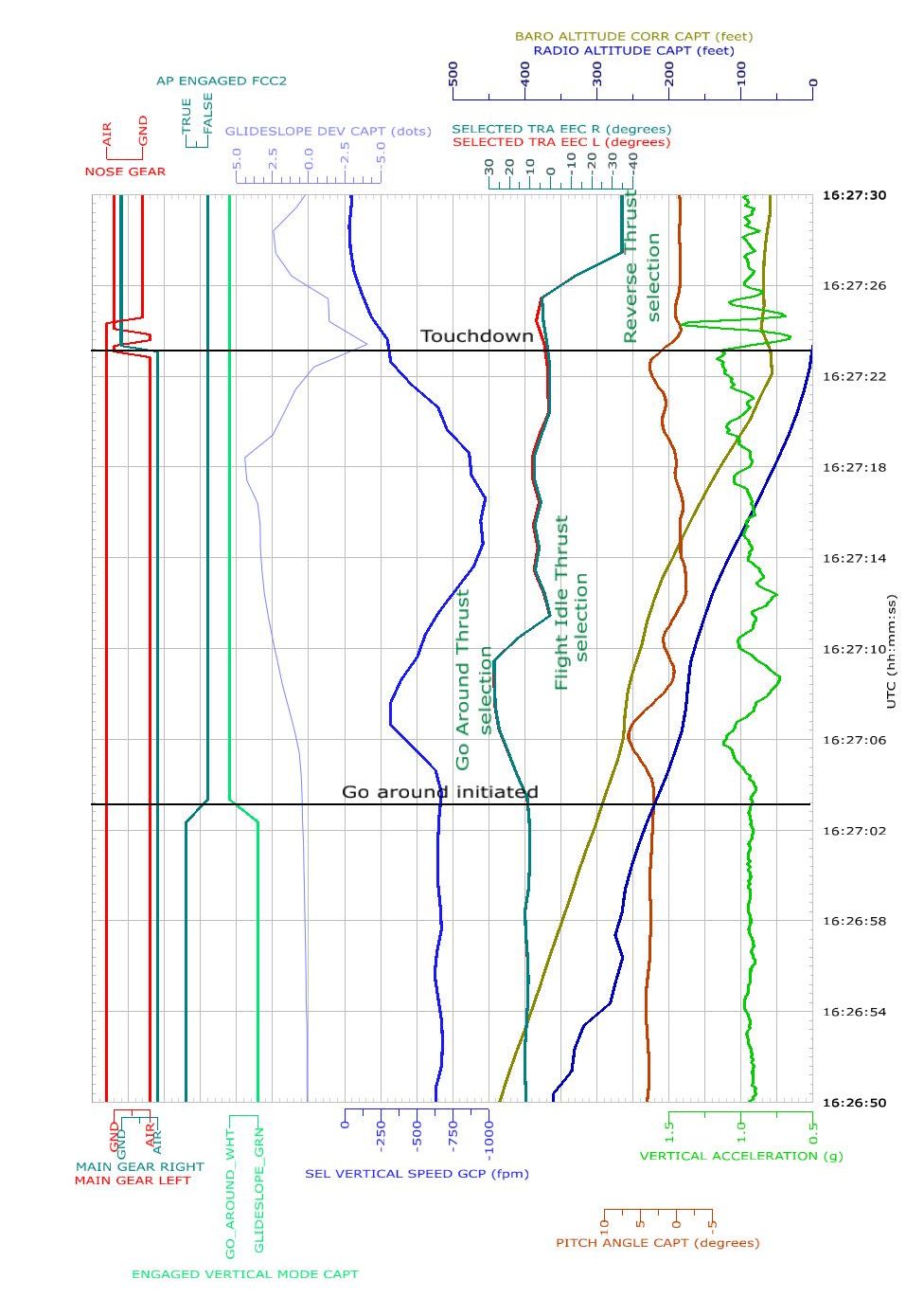
On 25 June 2013, the flight crew of an Airbus A320-232 aircraft, registered VH-JQG and operated by Jetstar Airways (Jetstar), was conducting an instrument landing system approach with autoland training at Sydney Airport, New South Wales.

During the approach, the training captain (pilot flying) disconnected the autothrust system by retarding the thrust levers to the IDLE STOP, and asked the first officer to assess the effect on the proposed approach. After briefly referring to the Quick Reference Handbook, the crew extended the landing gear and wing flap, and finalised the pre-landing checklist. The flight crew then became involved in a discussion about the requirements in the handbook for the proposed approach.

With engine thrust at idle and the aircraft in a high drag configuration, the airspeed quickly reduced to below the minimum approach speed. The captain was in the process of applying thrust when the aircraft’s alpha-floor protection system activated. Take-off/go-around thrust was automatically commanded by this system and the flight crew conducted a missed approach.

What the ATSB found

The ATSB found that during an autoland training exercise with the autothrust disengaged, both pilots were distracted by their consideration of a training scenario. As a result, they did not identify the airspeed reducing below the target approach speed in sufficient time to prevent activation of the aircraft’s alpha-floor protection system.

The ATSB also found that during the autoland training exercise, the training captain directed the first officer to set hypothetical minima/decision heights in the autoflight system in support of the training scenario. These heights were not applicable to the instrument approach being flown and the practice was not approved by Jetstar. The resulting increased workload impacted on the first officer’s capacity to effectively fulfil the pilot monitoring role.

What's been done as a result

As a result of this occurrence, Jetstar issued a memo to its check and training pilots highlighting the requirements for autoland training. The memo reiterated that flight crew must only use the minima for the approach being flown.

Safety message

This occurrence demonstrates the risks associated with conducting training exercises during periods of high workload. Training pilots need to be cognisant of trainee experience and capability and ensure that the training exercise never compromises the primary task of monitoring/flying the aircraft.

Context

Pilot information

Training captain

The captain held an Air Transport Pilot (Aeroplane) Licence and a valid Class 1 Medical Certificate. The captain had a total of 19,600 hours aeronautical experience including 11,900 hours on the A320.

The captain commenced employment with Jetstar Airways (Jetstar) in May 2008 as a direct-entry captain on the A320 and was appointed as a training captain in January 2012.

About 4 weeks prior to the occurrence, the captain completed low visibility operations training in the simulator followed by the line training component (including autoland training) in the aircraft.

The captain noted that the occurrence flight was the fifth early morning (about 0500) start in a row and that their sleep in the nights before the occurrence was ‘broken’. The captain reported obtaining about 5 hours sleep the previous night and that the time free of duty prior to the occurrence flight was about 15 hours. There were no fatigue concerns or health issues reported to Jetstar in relation to the occurrence flight.

Trainee first officer

The first officer (FO) held an Air Transport Pilot (Aeroplane) Licence and a valid Class 1 Medical Certificate. The FO had a total of 3,300 hours aeronautical experience, including 125 hours on the A320.

The FO commenced employment with Jetstar in February 2013 and, at the time of the occurrence, was in the final stages of line training.

About 3 months prior to the occurrence, the FO completed low visibility operations training in the simulator as part of the A320 type endorsement.

The FO reported obtaining about 8 hours of sleep the previous night and having been free from duty for about 20 hours. There were no fatigue or health issues reported to Jetstar in relation to the occurrence flight.

Instrument landing system (ILS) criteria

At the time of this occurrence, runway 16 right (16R) at Sydney Airport was equipped with an instrument landing system (ILS) that allowed for operations to CAT I minima. CAT II and CAT III operations were not available primarily because the required approach and other lighting facilities were not installed. The landing minima for a CAT I approach include:

a decision height (DH) of 200 ft above threshold elevation

visibility equal to or greater than 800m

runway visual range (RVR) 550m.

By comparison, CAT II and CAT III approaches are designed to permit flight to lower or zero DHs and/or reduced RVR conditions. Commensurate with such DHs, flight crew control of the aircraft along the ILS beam and at the correct speed is required to a very high level of accuracy.

At the time of the occurrence, the only ILS in Australia that provided for CAT II or CAT III approaches was the runway 16 ILS at Melbourne Airport, Victoria. The landing minima for that approach are listed at Table 1.

Table 1: CAT II and CAT III A/B landing minima for the Melbourne runway 16 ILS

Category Melbourne ILS Runway 16
CAT IIDH100 ft
 RVR300m
CAT IIIADH50 ft
 RVR175m
CAT IIIBDHNo DH
 RVR75m

Aircraft flight envelope protection

Autothrust

The A320 is equipped with an autothrust system that automates the applicable thrust requirements and provides the crew with visual indications of the aircraft’s energy state. Indications including speed, acceleration, deceleration and relevant speed limitations are displayed on the primary flight display.

Autothrust is activated by positioning the thrust levers between the IDLE STOP and CLB (climb) detent. One of the methods to disconnect autothrust is to retard the thrust levers to the IDLE STOP.

Jetstar recommended that autothrust be used during approach as it provides accurate speed control. However, the pilot flying was required to keep a hand on the thrust levers and be prepared to manually control the thrust. If the pilot flying wished to perform an approach or landing using manual thrust, that selection was to be made prior to 1,000 ft above ground level.

Low-energy warning

An aural ‘SPEED SPEED SPEED’ warning is available when the aircraft is configured with flap 2, 3, and FULL. The warning is repeated every 5 seconds and advises the pilot that:

  • the aircraft’s energy level (aircraft speed/angle-of-attack) is reducing below the required threshold
  • thrust must be increased.
Alpha-floor protection

The A320 is equipped with an alpha-floor protection system that is designed to protect the aircraft from entering a low-energy state. If the aircraft’s airspeed reduces such that the angle-of-attack reaches the alpha-floor threshold, the system commands take-off/go-around thrust regardless of the autothrust condition or thrust lever position. This protection was available from lift-off to 100 ft on approach.

Operator procedures

Jetstar described low visibility operations as those to less than the CAT I ILS minima. Autolands were required for CAT III operations and preferred for CAT II operations.

Jetstar’s A320 Flight Crew Training Manual stated that practice autoland training required prior approval and could only be conducted in CAT I or better conditions. When conducting autoland training, the manual required use by crews of the actual minima for the approach being flown.

Most of the aircraft systems relevant to an ILS approach are automatically monitored and the effect of any failures processed with the optimum approach category displayed to flight crew. There were a number of other failures that required the flight crew to reference the Quick Reference Handbook to establish the relevant approach category.

Jetstar conducted low visibility training in the A320 simulator. In addition to that training, each pilot was required to conduct a low visibility approach and autoland in not less than CAT I conditions:

  • in the aircraft with a check/training pilot
  • during normal line operations.

As a consequence of this occurrence, Jetstar:

  • issued a memo to their check and training pilots highlighting the requirements for autoland training
  • reiterated to its flight crew that they must only use the actual minima for the approach being flown.

Related occurrences

A search of the ATSB occurrence database covering the previous 10 years identified one other alpha-floor activation during approach. This occurred on 7 September 2013, when the flight crew of an Airbus A320, registered VH-VFJ, were on descent into Auckland Airport, New Zealand.[6] Passing about 4,200 ft, the aircraft’s autoflight system sequenced to final approach mode but exited that mode when the crew levelled the aircraft at 3,000 ft to comply with a company speed restriction.

The crew’s subsequent manipulation of the autoflight system resulted in the inadvertent engagement of open climb mode, an increase in engine thrust, and aircraft acceleration. To avoid exceeding a speed limitation the captain retarded the thrust levers to the IDLE STOP, inadvertently disconnecting the autothrust system. The crew resumed the approach but were unaware that the autothrust system was disengaged.

The aircraft decelerated and soon after the final stage of flap was selected, the aircraft’s flight management guidance system generated a low-energy warning. The crew were in the process of responding to the low-energy warning when the alpha-floor autothrust mode engaged.

A search of the United States National Transportation Safety Board, Federal Aviation Administration and National Aeronautics and Space Administration databases identified a number of alpha-floor activations, the vast majority of which resulted from incorrect configuration changes. Those activations were generally associated with the conduct of a go-around and involved the inadvertent selection of the aircraft’s flaps to zero or to a position less than required for the existing airspeed.

__________

  1. ATSB investigation AO-2013-159: Flight envelope protection event. Available at www.atsb.gov.au.

Findings

From the evidence available, the following findings are made with respect to the airspeed management occurrence involving Airbus A320, registered VH-JQG and operated by Jetstar Airways, which occurred during an instrument approach to Sydney Airport, New South Wales on 25 June 2013. These findings should not be read as apportioning blame or liability to any particular organisation or individual.

Contributing factors

  • During an autoland training exercise with the autothrust disengaged, both pilots were distracted by their consideration of a training scenario, and did not identify the airspeed reduce below the target approach speed in sufficient time to prevent activation of the aircraft’s alpha-floor protection system.
  • The introduction of multiple training scenarios required the first officer to consult the Quick Reference Handbook to consider and set hypothetical minima/decision heights in the aircraft’s autoflight system. This increased the first officer’s workload and impacted on their capacity to effectively fulfil the pilot monitoring role.

Safety analysis

Introduction

During an autoland training exercise with the autothrust disengaged, the aircraft’s airspeed reduced below the minimum approach speed. The reduction was not detected by the crew and resulted in the activation of the aircraft’s alpha-floor protection system and the associated takeoff/go-around thrust. In response to the associated low-energy warning the flight crew initiated a goaround for a routine approach and landing. The following analysis will examine the conduct of the training scenario and the factors that led to the undetected airspeed reduction.

Airspeed reduction

The training captain reported retarding the thrust levers to idle during the approach with two goals in mind. The first was to reduce the airspeed to the final approach speed in line with normal procedures. The second was to disconnect the autothrust, which is a consequence of retarding the thrust levers to the IDLE STOP. This action was announced to the first officer (FO) to simulate the loss of autothrust function, prompting the FO to refer to the Quick Reference Handbook (QRH) as normal.

With the thrust levers at the IDLE STOP the airspeed was reducing, a trend that was exacerbated by the extension of landing gear and wing flap. A discussion followed by the crew on the applicable approach category and associated visibility requirements for an autoland without autothrust functionality. During the discussion, the FO initially misinterpreted the QRH. The captain explored the issue further with the FO, distracting the crew from monitoring the aircraft’s performance. As a consequence, neither identified the airspeed reducing below the target approach speed in sufficient time to prevent activation of the aircraft’s alpha-floor protection system.

Autoland training

The training captain considered that to conduct autoland training effectively, low visibility scenarios should be incorporated into training autoland approaches. In the absence of suitable published approach minima (Category II and III) at Sydney Airport, and in visual conditions, the captain decided to use hypothetical minima as the criteria for the training scenario. These minima were entered into the aircraft’s autoflight system. However, the use of different minima to those published for the approach was not approved by Jetstar Airways (Jetstar). In addition, the requirement for the FO to consult the QRH and enter hypothetical minima into the autoflight system elevated the FO’s workload. This moved their attention away from monitoring the aircraft’s position, performance and systems.

The Jetstar guidelines indicated that low visibility training was not to be conducted in the actual aircraft. However, the training captain believed that autoland training, which was authorised in the aircraft, was enhanced by the discussion of low visibility and its effect on the approach category, and the simulation of equipment failures. This was consistent with the captain’s recent simulator training.

In this regard, the training captain’s understanding that a manual thrust autoland approach was approved was correct. However, given that the loss of autothrust was presented as a simulated failure, Jetstar viewed this as non-normal training, which should only occur in the simulator. Irrespective of the training captain’s understanding, the decision to introduce and discuss various failure scenarios during the approach increased the FO’s workload.

A high workload can reduce an individual’s capacity to attend to various sources of information and associated tasks (Harris, 2011). In this occurrence, it is likely that the FO’s focus of attention on the QRH as a result of the training scenarios reduced the FO’s capacity to effectively fulfil the pilot monitoring role.

Safety issues and actions

Additional safety action

Whether or not the ATSB identifies safety issues in the course of an investigation, relevant organisations may proactively initiate safety action in order to reduce their safety risk. The ATSB has been advised of the following proactive safety action in response to this occurrence

Proactive safety action taken by Jetstar

Jetstar advised that in response to this occurrence they issued a memo to all check and training captains reminding flight crew that:

Only normal operations are permitted in the aircraft and that all abnormal and emergency procedures may be conducted in the simulator only.

When conducting Low Visibility Operations training, flight crew must only set the minima for the actual approach being flown.

Sources and submissions

Sources of information

The sources of information during the investigation included the:

  • flight crew of VH-JQG
  • Jetstar Airways
  • aircraft flight data recorder
  • Airbus.

References

Harris, D 2011. Human Performance on the Flight Deck, Ashgate, Surrey, England.

Submissions

Under Part 4, Division 2 (Investigation Reports), Section 26 of the Transport Safety Investigation Act 2003 (the Act), the ATSB may provide a draft report, on a confidential basis, to any person whom the ATSB considers appropriate. Section 26 (1) (a) of the Act allows a person receiving a draft report to make submissions to the ATSB about the draft report.

A draft of this report was provided to the flight crew of VH-JQG, Jetstar Airways and the Civil Aviation Safety Authority. Any submissions from those parties will be reviewed and where considered appropriate, the text of the draft report will be amended accordingly.

The occurrence

On 25 June 2013, an Airbus A320-232 aircraft, registered VH-JQG, was being operated by Jetstar Airways on a scheduled passenger flight from Sydney to Ballina and return, New South Wales. The flight crew comprised a training captain, operating as pilot flying,[1] and a trainee first officer (FO).

The FO was undergoing further line training and was assigned to the captain for this training. The occurrence took place on the second day of the training. The planned training included two autolands, the first of which was completed the previous day. The second autoland was planned on arrival at Sydney.

After arrival at Ballina, and with the benefit of a longer than usual turnaround time, the captain briefed the FO for the return flight to Sydney. The brief included:

  • that the captain would be the pilot flying
  • that although the weather forecast did not require it, they would conduct an instrument landing system (ILS)[2] approach with autoland into Sydney
  • a review of the A320 Quick Reference Handbook (QRH) in relation to the required equipment for low visibility approaches
  • discussion of the captain’s intent to verbally introduce various scenarios during the approach. In response, the FO was to advise the effect of these scenarios on the approach category[3] and consequent minima (decision height and required visibility).

Prior to commencing descent into Sydney, the captain conducted an approach briefing for an ILS approach to runway 16 right (16R). While that ILS approach was category (CAT) I, the captain indicated that for training purposes they would treat the approach as if low visibility conditions existed and the infrastructure was CAT IIIB capable. CAT IIIB approaches typically have no decision height and require a runway visual range (RVR) of 175M. The intent was that during the approach, the crew would enter the applicable scenario-based decision height in the aircraft’s flight management guidance computer (FMGC). The captain reiterated that he would announce some equipment failure scenarios, and asked the FO to have the QRH opened at the relevant page.

The crew commenced the runway 16R ILS approach at about 1015 Eastern Standard Time[4]. At that time the aircraft was descending through 3,000 ft and the airspeed was reducing through 200 kt. The target landing speed was 130 kt.

At or about 2,000 ft, the captain asked the FO to assess how a flight control computer failure would affect the approach category. After consulting the QRH, the FO advised that they could continue with the autoland but the applicable approach category would change to CAT IIIA. In response, the captain directed the FO to set the decision height in the FMGC to the RWY 16R CAT IIIA minima.[5]

On descent through 1,500 ft, the flight crew noted the runway in sight, with light rain showers in the area. At about this time, the captain retarded the thrust levers to idle. This had the intended effect of disconnecting the autothrust system and activating the master caution. After confirming autothrust disconnection with the FO, the captain asked if the ILS approach could be continued using manual thrust.

The FO’s initial assessment was that a go-around was required. The captain disagreed but further discussion was suspended to allow the crew to extend the remaining flap and action the landing checklist. The captain then asked the FO to consult the QRH again, after which the FO correctly assessed that the approach could be continued to the CAT II landing minima.

The FO went on to read out the applicable visibility and lighting requirements but the captain focussed on getting the FO to re-set the scenario-based decision height in the FMGC prior to 1,000 ft. At this time, the airspeed was nearing the landing speed of 130 kt and still reducing at about 1 kt/sec.

When the captain returned to scanning the flight instruments, he observed that the speed was quite low and advanced the thrust levers accordingly. As the thrust increased the aircraft’s alphafloor (speed protection) system activated, which commanded take-off/go-around thrust. At about the same time the FO recalled hearing the ‘SPEED SPEED SPEED’ synthetic voice warning (see the section titled Aircraft flight envelope protection).

The approach was no longer stable and the crew conducted a go-around before returning to land on the same runway. At the time of the alpha-floor activation the aircraft was about 800 ft above ground level and the airspeed had reduced to 114 kt.

__________

  1. Pilot flying (PF) and pilot monitoring (PM) are procedurally assigned roles with specifically assigned duties at specific stages of a flight. The PF does most of the flying, except in defined circumstances; such as planning for descent, approach and landing. The PM carries out support duties and monitors the PF’s actions and aircraft flight path.
  2. A standard ground aid to landing, comprising two directional radio transmitters: the localizer, which provides direction in the horizontal plane; and the glideslope, for vertical plane direction, usually at an inclination of 3°. Distance measuring equipment or marker beacons along the approach provide distance information.
  3. The ILS approach category (CAT) was primarily dependant on the approach lighting systems installed and as such dictated the minimum weather conditions required for landing. Additional information is provided in the section titled Context.
  4. Eastern Standard Time (EST) was Coordinated Universal Time (UTC) + 10 hours.
  5. The applicable landing minima reduces as the CAT changes from CAT I, to CAT II and then to CAT IIIA/B. See the section titled Instrument landing system (ILS) criteria.

Purpose of safety investigations & publishing information

Purpose of safety investigations

The objective of a safety investigation is to enhance transport safety. This is done through:

  • identifying safety issues and facilitating safety action to address those issues
  • providing information about occurrences and their associated safety factors to facilitate learning within the transport industry.

It is not a function of the ATSB to apportion blame or provide a means for determining liability. At the same time, an investigation report must include factual material of sufficient weight to support the analysis and findings. At all times the ATSB endeavours to balance the use of material that could imply adverse comment with the need to properly explain what happened, and why, in a fair and unbiased manner. The ATSB does not investigate for the purpose of taking administrative, regulatory or criminal action.

Terminology

An explanation of terminology used in ATSB investigation reports is available here. This includes terms such as occurrence, contributing factor, other factor that increased risk, and safety issue.

Publishing information 

Released in accordance with section 25 of the Transport Safety Investigation Act 2003

Published by: Australian Transport Safety Bureau

© Commonwealth of Australia 2015

image_5.png

Ownership of intellectual property rights in this publication

Unless otherwise noted, copyright (and any other intellectual property rights, if any) in this report publication is owned by the Commonwealth of Australia.

Creative Commons licence

With the exception of the Coat of Arms, ATSB logo, and photos and graphics in which a third party holds copyright, this publication is licensed under a Creative Commons Attribution 3.0 Australia licence.

Creative Commons Attribution 3.0 Australia Licence is a standard form licence agreement that allows you to copy, distribute, transmit and adapt this publication provided that you attribute the work.

The ATSB’s preference is that you attribute this publication (and any material sourced from it) using the following wording: Source: Australian Transport Safety Bureau

Copyright in material obtained from other agencies, private individuals or organisations, belongs to those agencies, individuals or organisations. Where you wish to use their material, you will need to contact them directly.

Occurrence summary

Investigation number AO-2013-103
Occurrence date 25/06/2013
Location Sydney Airport
State New South Wales
Report release date 29/09/2015
Report status Final
Investigation level Defined
Investigation type Occurrence Investigation
Investigation status Completed
Mode of transport Aviation
Aviation occurrence category Unstable approach
Occurrence class Incident
Highest injury level None

Aircraft details

Manufacturer Airbus
Model A320
Registration VH-JQG
Serial number 2169
Aircraft operator Jetstar Airways
Operation type Air Transport High Capacity
Departure point Ballina, NSW
Destination Sydney, NSW
Damage Nil

Weather related precautionary landing involving a Piper a PA-28, VH MSG, 20 km north-east of Hamilton Aerodrome, Victoria, on 13 April 2013

Summary

The student pilot departed Coldstream on a navigation training flight to Hamilton, Victoria and return. The pilot reported that a stronger than forecast headwind was experienced, which resulted in the aircraft’s ground speed being about 20 kt slower than planned and a subsequent increase in flight time. When approaching the Mount William and Serra Ranges, the pilot observed low cloud ahead, and experienced rain showers and moderate turbulence. The pilot diverted 45° to the left.

Shortly after, the pilot was confronted with a ‘wall of cloud’. The pilot determined that he would not be able to land at Hamilton and commenced tracking for Colac. Shortly after, he received a call on the common traffic advisory frequency (CTAF) from persons on the ground at Hamilton aerodrome. The pilot informed them that he was diverting to Colac.

The ground personnel advised the pilot that the weather had improved and suggested that he could fly to the south of the Ranges and then track west to the aerodrome. The pilot turned the aircraft around and commenced tracking towards the Ranges. Soon after, the pilot realised that the conditions had not improved, and he conducted a precautionary search and landing onto a road.

This incident highlights need for pilots to continually assess the weather enroute and lookout for deteriorating conditions behind, around, and ahead of you. Make decisions early and when in doubt, turn about. In addition, it is important to be aware that the presence of others may influence your decision-making process. Pilots must know, and fly within their own personal limitations on that particular occasion.

Aviation Short Investigation Bulletin Issue 20

Occurrence summary

Investigation number AO-2013-071
Occurrence date 13/04/2013
Location 20 km NE of Hamilton aerodrome
State Victoria
Report release date 28/06/2013
Report status Final
Investigation level Short
Investigation type Occurrence Investigation
Investigation status Completed
Mode of transport Aviation
Aviation occurrence category Weather - Other
Occurrence class Serious Incident
Highest injury level None

Aircraft details

Manufacturer Piper Aircraft Corp
Model PA-28
Registration VH-MSG
Serial number 28-7615173
Operation type Flying Training
Departure point Coldstream, Vic
Destination Coldstream, Vic
Damage Nil

Landing below minima due to fog involving Boeing 737s, VH-YIR and VH-VYK, Mildura Airport, Victoria, on 18 June 2013

Final report

Report release date: 31/05/2016

Safety summary

What happened

On 18 June 2013, two Boeing 737 aircraft, VH-YIR operated by Virgin Australia Airlines Pty. Ltd. as Velocity 1384 and VH-VYK operated by Qantas Airways Ltd. as Qantas 735, were on scheduled flights to Adelaide, South Australia.

On nearing Adelaide, the forecast improvement in weather conditions had not occurred and as a result, both aircraft commenced a diversion to Mildura, Victoria. Upon arrival at Mildura, the actual weather conditions were significantly different to those forecast, in particular with visibility reduced in fog.

The flight crew of Qantas 735 conducted an instrument approach and landed below minima. The flight crew of Velocity 1384 also conducted an instrument approach and landed below minima in fog and with fuel below the fixed reserve.

What the ATSB found

The ATSB found that the weather deterioration at Adelaide did not appear on the forecast when both aircraft departed their respective ports and furthermore the forecast duration of the fog in the later, amended forecast showed a clearance time earlier than actually occurred. This meant that Qantas 735 continued to Adelaide with the expectation that the fog would clear prior to their arrival, which did not occur. It also influenced the decision making of the Virgin Australia flight watch personnel, who did not pass this weather to the flight crew of Velocity 1384.

In relation to the weather at Mildura, the ATSB found that the deterioration was significantly worse than originally forecast. This resulted in the need for both Qantas 735 and Velocity 1384 to land in conditions that were below minima. The ATSB identified that both flight crew uploaded sufficient fuel for the originally-forecast conditions in accordance with their operators’ fuel policy and the Civil Aviation Safety Authority requirements.

The ATSB also found that in certain weather patterns and at certain locations, fog is both rare and difficult to forecast reliably.

In addition, the ATSB noted that the industry expectation for the provision of flight information services was not aligned with that provided by Airservices Australia (Airservices). Further, it was identified that in certain circumstances, pilots will not be made aware of a deterioration of weather at an airport that has an Automatic Weather Information Service or other Automatic Broadcast Service. These services did not provide for the recognition and active dissemination of special weather reports (SPECI) to pilots, thereby not meeting the intent of the SPECI alerting function provided by controller-initiated flight information service.

What's been done as a result

In response to this occurrence, Airservices advised that they would work with the Bureau of Meteorology to explore feasible options to provide information on significant deteriorations in weather conditions to address the very high frequency radio range limitations of the automated broadcast services. In the meantime, Airservices has updated the Manual of Air Traffic Services to ensure dissemination of weather information from locations with an Automatic Weather Information Service should that service be unavailable.

The Bureau of Meteorology advised of various system changes and improvements in response to this occurrence. This included to equipment used in forecasting.

Virgin Australia Airlines Pty. Ltd. (Virgin) advised of a review and benchmarking exercise as part of its examination of this occurrence. This resulted in enhancements to Virgin’s flight planning and flight following policies, re-organisation of the flight following section and expansion of communication infrastructure across the Virgin fleet. In addition, Virgin’s pilot weather requirements have been clarified and enhanced.

In response to this occurrence the ATSB issued a safety recommendation to Airservices. This recommended that Airservices, as the issue owner, work in collaboration with the Bureau of Meteorology to instigate a system change to reinstate the alerting function of SPECI reports currently not available through an Automatic Broadcast Service.

Safety message

Pilots are reminded of their responsibility for collecting all relevant information to support inflight decision making. This includes weather and operational information for the destination, which should be considered prior to a decision point or point of no return.

It is important that pilots understand what will be provided under Airservices’ provision of flight information service and that they are also able to request weather and operational information from air traffic control. In addition, pilots should note the potential benefits of informing the controller of a non-normal situation. These include increased monitoring and support as required and the potential to reduce pilot workload in stressful situations.


The occurrence

On 18 June 2013, two Boeing 737-800 aircraft, VH-YIR operated by Virgin Australia Airlines Pty. Ltd. as Velocity 1384 and VH-VYK operated by Qantas Airways Ltd. as Qantas 735, were on scheduled passenger flights to Adelaide, South Australia.

Velocity 1384 departed Brisbane, Queensland at 0638 Eastern Standard Time[1] and had six crew and 85 passengers on board. The estimated time of arrival at Adelaide was 0920. The captain was the pilot flying and the first officer (FO) was the pilot monitoring.[2] The fuel on board at take-off from Brisbane was 8,800 kg as recorded on the flight data recorder. This comprised flight fuel to Adelaide of 6,410 kg, variable and fixed fuel reserves of 1,540 kg and additional fuel of 940 kg.

Qantas 735 departed Sydney, New South Wales at 0727 and had six crew and 146 passengers on board. The estimated arrival time at Adelaide was 0917. The captain was the pilot flying, with the FO as pilot monitoring. The fuel on board at take-off from Sydney was 7,900 kg, as recorded on operational documentation. This comprised flight fuel to Adelaide of 5,000 kg, variable and fixed fuel reserves of 1,600 kg and additional fuel of 1,300 kg. The captain reported routinely uploading additional fuel for contingencies.

At 0700, the Bureau of Meteorology (BoM) issued an updated aerodrome forecast (TAF)[3] for Adelaide, which indicated a 30 per cent probability of fog developing. For an understanding of the aircrafts’ positions at this time, see Figure 1. At 0800, the BoM issued an updated trend forecast (TTF)[4], which showed that fog had reduced visibility at Adelaide and was expected to clear by 0900. See Figure 2 for the aircrafts’ positions at that time.

At this stage, the crew of Qantas 735 were aware of the changes to the TTF and continued to Adelaide on the basis that the fog would clear prior to their arrival. In addition, they had sufficient fuel to hold for about 45 minutes should the fog last longer than forecast and land with required fuel reserves. The crew of Velocity 1384 were not aware of the changes to the forecast. They were advised of fog at Adelaide by Air Traffic Control (ATC) at 0844, once they changed to the en route sector frequency immediately prior to the Adelaide terminal area airspace. Figure 3 shows the aircraft’s approximate positions at 0900.

The crew of Qantas 735 elected to hold at waypoint BLACK, which was 48 NM (89 km) from Adelaide, rather than continue their descent to the airport, which was still affected by fog. The crew of Velocity 1384 had commenced their descent to Adelaide and gathered further information about the conditions from the Adelaide tower controller.

Based on the report from the Adelaide tower controller that conditions were not suitable for landing, and that there had been no successful landing attempts, the crew of Velocity 1384 elected to divert to Mildura, Victoria at 0904. The observation reports issued by BoM at that time indicated that the conditions at Mildura were above the alternate minima for the aircraft, despite the TAF for Mildura indicating a temporary deterioration during the forecast period. The crew’s estimated arrival time at Mildura was 0932.

The crew of Qantas 735 heard Velocity 1384 broadcast their decision to divert to Mildura. On being informed by ATC that the latest trend forecast for Adelaide predicted a delay in the fog clearing of 30 minutes, and after gathering observation reports for Mildura, the crew of Qantas 735 also elected to divert there at 0913. Their estimated arrival time at Mildura was 0942.

In making the decision to divert to Mildura, the captain of Qantas 735 reported that they were aware that they had the capability to conduct an autoland at Adelaide Airport (see the section titled Low visibility/autoland capability). However, based on the reports of significantly better weather at Mildura, a diversion to that airport was assessed as preferable to continuing to Adelaide.

The captain of Velocity 1384 similarly reported that they considered the option of an autoland at Adelaide. However, given the observations of significantly better weather at Mildura, they also concluded a diversion was a better option at that time.

Arrival at Mildura

At 0916, the pilot of an air ambulance flight departing Mildura made a call to ATC that conditions were deteriorating, with a cloud base at 400 ft. The pilot did not specify the cloud datum, but a comparison of the reported cloud base with the observed cloud base from the Mildura Airport automated station, which was generated 2 minutes later, identified that the reported cloud base was probably with reference to mean sea level. At the time, neither Velocity 1384 nor Qantas 735 were on this frequency and so did not hear this transmission. At 0918, just after Velocity 1384 transferred to this frequency, the controller for this sector informed them of four other aircraft due to arrive at Mildura around their arrival time, which included Qantas 735. At 0922, Qantas 735 transferred to the same frequency and was also advised of the arriving traffic.

Also at 0918, the BoM issued a SPECI[5] observation for Mildura, showing cloud at 200 ft above ground level (AGL) but visibility in excess of 10 km. The area GPS-based navigation Global Navigation Satellite System (RNAV GNSS) instrument approach to runway 27 at Mildura required pilots to be clear of cloud at a minima of 660 ft (493 ft AGL), reducing to 560 ft (393 ft AGL) using an actual aerodrome QNH[6] (see the sections titled Area navigation Global Positioning System navigation systemand Airport information). As the conditions had deteriorated below this minima, the RNAV GNSS approach could not be conducted in normal operations. The aerodrome forecast for Mildura, valid at that time, contained a temporary deterioration with cloud at 600 ft AGL.

Between 0928 and 0932, three further SPECI’s were issued for Mildura, indicating that visibility was decreasing in mist. In line with Airservices Australia (Airservices) procedures, as Mildura broadcast weather information via an Aerodrome Weather Information Service (AWIS)[7], the controller responsible for this sector was not automatically-provided with the SPECI reports at their console. However, they could request it through The Australian Advanced Air Traffic System.[8] As the AWIS for Mildura was not broadcasting due to an unserviceability, the inbound aircraft could not obtain this information from the AWIS (see the section titled Aerodrome weather information service).

At 0936 the controller made a broadcast on the area frequency to traffic at Mildura, informing them of the details of the 0932 SPECI. This SPECI indicated broken[9] cloud at 200 ft and that the visibility was now 2,100 m in mist. A review of data from the cockpit voice recorder of Velocity 1384 identified that, for the duration of the controller’s broadcast of the SPECI, the crews of Qantas 735 and Velocity 1384 were busy communicating on the Mildura common traffic advisory frequency.[10]

At 0937 the crew of Qantas 735 contacted the crew of Velocity 1384 to discuss the arrival and the crew of Velocity 1384 stated that they were tracking to the initial waypoint to commence the RNAV GNSS approach to runway 27. At 0939 the crew of a Qantaslink Bombardier DHC-8 aircraft (Dash-8) broadcast to traffic at Mildura that they were conducting a goaround. The crew of Velocity 1384 asked for an appreciation of the weather and were told by the Dash-8 crew that at the minima, they ‘couldn’t see anything’.

At 0940 the crew of Qantas 735 contacted Velocity 1384 to advise that they were commencing the RNAV GNSS approach ‘due fuel’. The Velocity 1384 FO replied that they were ‘in the same boat’ but, after discussion between the captain and FO of Velocity 1384, they elected to hold and allow Qantas 735 to continue with the approach. This decision was passed to the crew of Qantas 735.

The crew of Qantas 735 applied a revised minimum to the approach that was 200 ft lower than that published. This was based on the knowledge that the cloud base would preclude becoming visual via a normal approach. The crew reported that as they descended toward the revised minimum, the extent of the cloud reduced and they gained sufficient visual reference of the runway environment to continue the approach. At 0946 the crew of Qantas 735 broadcast that they had landed at Mildura. The aircraft landed on runway 27 with the required fuel reserves intact and the crew reported that the runway was visible once they descended below the cloud.

At 0948 the crew of the Dash-8 asked Qantas 735 for their assessment of the weather. The crew replied that the cloud base was at 150 ft AGL and that they had landed off the approach ‘due fuel’. At this time, a SPECI was issued for Mildura, showing visibility was now 900 m in fog and that the cloud was overcast at 100 ft AGL.

At 0950, Velocity 1384 sought an update on the weather from Qantas 735, who stated that the fog had appeared to be getting thicker but was now clearing, although the cloud was still below minima. At 0952, Velocity 1384 updated ATC that they were still holding due to the low cloud at Mildura. ATC asked them to nominate a latest divert time to proceed to a suitable airport. The FO replied that they did not have the fuel to proceed anywhere else. After obtaining further information from the crew, ATC initiated an alert phase and at 0958, after contacting the crew again, ATC activated the Mildura Airport emergency procedures.

At 0954, the controller made another ‘all stations’ broadcast with the latest TAF issued for Mildura, valid from 1000. This forecast predicted:

  • visibility as 3 km in mist
  • scattered cloud at 300 ft AGL
  • an improvement in both visibility and cloud base in the hour from 1000
  • a 30 per cent probability of the visibility reducing to 500 m in fog for the period between 1000 and 1200.

Given their available fuel, the crew of Velocity 1384 determined that they needed to commence an approach just after 1000 to allow for a second approach if needed. They discussed the conduct of a ‘sighting’ approach to ensure the aircraft was aligned with the runway from the RNAV GNSS approach. The captain was still the pilot flying; however, they briefed that if at any time during the approach the FO sighted the runway, then the FO was to take control and land.

At 1002, Velocity 1384 transmitted that they were on a 4 NM (7 km) final for the RNAV GNSS approach. At 1004, as they were not visual with the runway, the crew initiated a missed approach from 132 ft AGL. The FO reported that as they commenced the missed approach, it was possible to confirm that they were aligned with the runway by looking directly down. At 1012, ATC initiated a distress phase.

The aircraft was positioned for a second approach, during which the cabin crew were briefed and prepared for an emergency landing, briefing the passengers to brace accordingly. At 1014, Velocity 1384 landed at Mildura in foggy conditions with fuel below the required reserves. As they taxied in, the captain told the cabin crew to stand down and normal arrival procedures resumed.

Figure 1: Approximate aircraft positions at 0700, when the amended forecast for Adelaide was issued with a 30 per cent probability of fog

Figure 1: Approximate aircraft positions at 0700, when the amended forecast for Adelaide was issued with a 30 per cent probability of fog

Source: ATSB

Figure 2: Approximate aircraft positions at 0800, when the trend forecast for Adelaide was issued with fog conditions forecast to lift at 0900

Figure 2: Approximate aircraft positions at 0800, when the trend forecast for Adelaide was issued with fog conditions forecast to lift at 0900

Source: ATSB

Figure 3: Approximate aircraft positions at 0900, just prior to initiating the diversion to Mildura

Figure 3: Approximate aircraft positions at 0900, just prior to initiating the diversion to Mildura

Source: ATSB

__________

  1. Eastern Standard Time (EST) is Coordinated Universal Time (UTC) + 10 hours. Unless otherwise indicated, all times in this report are quoted in EST.
  2. Pilot flying (PF) and pilot monitoring (PM) are procedurally assigned roles with specifically assigned duties at specific stages of a flight. The PF does most of the flying, except in defined circumstances; such as planning for descent, approach and landing. The PM carries out support duties and monitors the PF’s actions and aircraft flight path.
  3. Aerodrome Forecasts are a statement of meteorological conditions expected for a specific period of time, in the airspace within a radius of 5 NM (9 km) of the aerodrome.
  4. A trend forecast is defined as an aerodrome weather report to which a statement of trend is appended.
  5. A SPECI is a special weather observation report that is triggered by a significant change in a set of parameters, including cloud and visibility.
  6. Altimeter barometric pressure subscale setting to provide altimeter indication of height above mean seal level in that area.
  7. An AWIS provides actual weather conditions, via telephone or radio broadcast, from an automatic weather station.
  8. An advanced hardware and software system that is used by Airservices Australia to help manage domestic and international flights in Australian airspace.
  9. Cloud cover is normally reported using expressions that denote the extent of the cover. The expression few indicates that up to a quarter of the sky was covered, scattered indicates that cloud was covering between a quarter and a half of the sky, broken indicates that more than half to almost all the sky was covered, while overcast means all the sky was covered.
  10. Common Traffic Advisory Frequency is the frequency on which pilots operating at a non-towered aerodrome should make positional radio broadcasts.

Context

Personnel information

Virgin Australia Airlines Pty. Ltd.

Captain

The captain held an Air Transport Pilot (Aeroplane) Licence with a Boeing 737-300 to 800 endorsement and a current Class 1 Aviation Medical Certificate with various conditions. These included the need for distance vision correction to be worn. The captain had also held Training Captain/Approved Testing Officer approvals since April 2003. The captain’s relevant aeronautical experience is outlined in Table 1.

Table 1: Captain’s aeronautical experience

Total flying hours19,966
Total flying hours on the B737-8009,111
Total flying last 90 days135 hours
Total flying last 30 days54 hours
Total flying last 7 days0 hours
Last proficiency check13 March 2013

The captain reported their recent sleep as normal. For the 3 days preceding the occurrence, they advised going to bed by 2000. The captain reporting obtaining about 6.5 hours sleep the night prior to the occurrence and being well rested. Prior to this flight, the captain was on stand-by on 17 June 2013 without being called out and had a rostered day off on 16 June 2013. It is considered likely that fatigue was not a factor in the captain’s performance in the occurrence.

First officer

The first officer (FO) held a held an Air Transport Pilot (Aeroplane) Licence with a Boeing 737-300 to -900 endorsement and a current Class 1 Aviation Medical Certificate with no restrictions. The FO’s relevant aeronautical experience is outlined in Table 2.

Table 2: FO’s aeronautical experience

Total flying hours7,100
Total flying hours on the B737-8001,120
Total flying last 90 days132 hours
Total flying last 30 days14 hours
Total flying last 7 days14 hours
Last proficiency check1 April 2013

The FO had recently come off a month of leave and reported their recent sleep as normal. The FO reported obtaining about 7 hours sleep the night prior to the occurrence and felt well rested. The day previously (17 June 2013), the FO was on stand-by without being called out. The FO reported a duty day on 16 June 2013 that included flying Brisbane–Melbourne and return with approximately 7 hours duty time. Taking into account their recent duty and rest opportunities, it is considered that FO fatigue was not a factor in the occurrence.

Flight dispatch

The team leader dispatch oversaw the flight planning and flight watch functions of the operations centre. The team leader on the day was a qualified dispatcher with over 20 years of experience.

The flight watch dispatcher was responsible for maintaining flight watch services, either by actively monitoring, or passively following various assigned flights (see the section titled Flight dispatch and following). The dispatcher on duty for 18 June 2013 was appropriatelyqualified and had over 4 years of experience, most of that with Virgin Australia Airlines Pty. Ltd. (Virgin).

Operations control centre

The operations controller was responsible for overseeing the Virgin flight network, including coordinating air traffic control (ATC) slot times for arrivals. This role included liaison with flight dispatch to update flight plans and manage diversions as applicable. The controller on duty on 18 June 2013 had 9 years of experience in the operations department at Virgin.

The meteorologist on duty had over 35 years of experience, including 30 years as a forecaster with the Bureau of Meteorology (BoM). They had been situated within Virgin’s operations control centre, initially as a BoM employee, before joining a private company providing the same service to Virgin. The meteorologist had worked in the Virgin operations control centre for a total of about 8 years.

Qantas Airways Ltd.

Captain

The captain held an Air Transport Pilot (Aeroplane) Licence with a Boeing 737-300 to -800 endorsement and a current Class 1 Aviation Medical Certificate with a restriction that distance correction was to be worn, and reading correction be available while exercising the privileges of the licence. The captain’s relevant aeronautical experience is outlined in Table 3.

Table 3: Captain’s aeronautical experience

Total flying hours17,069
Total flying hours on the B737-8007,590
Total flying last 90 days167 hours
Total flying last 30 days71 hours
Total flying last 7 days18 hours
Last proficiency check1 May 2013

The captain reported their recent sleep as normal and that they obtained about 7.5 hours sleep the night prior to the occurrence. The captain reported flying Sydney–Adelaide and return on 17 June 2013 with about a 6.5 hour duty time. The captain had a day off on 16 June 2013. Given the sleep obtained and rest opportunities available, it is not considered likely that fatigue was a factor in the captain’s performance in the occurrence.

First officer

The FO held an Air Transport Pilot (Aeroplane) Licence with a Boeing 737-300 to -900 endorsement and a current Class 1 Aviation Medical Certificate with no restrictions. The FO’s relevant aeronautical experience is outlined in Table 4.

Table 4: FO’s aeronautical experience

Total flying hours7,714
Total flying hours on the B737-8003,982
Total flying last 90 days172 hours
Total flying last 30 days57 hours
Total flying last 7 days11 hours
Last proficiency check1 February 2013

The FO reported their recent sleep as normal and that they obtained about 7.5 hours sleep the night before the occurrence. The FO’s roster showed that 16 and 17 June 2013 were rostered days off. Given the sleep obtained and rest opportunities available, it is not considered likely that FO fatigue was a factor in the occurrence.

Flight dispatch

The dispatch duty manager was a qualified dispatcher with over 36 years’ experience in dispatch. Twenty of those years were as duty manager. The dispatch duty manager had oversight of the dispatch and flight watch functions at Qantas Airways Ltd. (Qantas).

Airservices Australia

The Tailem Bend[11] and Mallee[12] en route sector controllers were appropriately-endorsed and current for their respective sectors. The controllers were supported by aisle supervisors and a systems supervisor.

The aisle supervisors were appropriately endorsed and current for their role, which included oversight of the en route sector controllers.

The systems supervisor was completing the final day of a 2day endorsement check for the position, and operating under supervision at the time of the occurrence.

Aircraft information

Fuel system

Overview

The B737-800 is equipped with three fuel tanks. The No. 1 tank is integral with the left main wing, the No. 2 tank is integral with the right main wing and the centre fuel tank is located within the fuselage and extends into each wing. Fuel tank capacity is indicated in Table 5.

During normal operations both engines are pressure fed from the centre tank until it is empty and then each engine is pressure fed from its respective wing tank.

When opened, a cross-feed valve located in the centre tank and controlled by a switch on the cockpit forward overhead panel allows both engines to be supplied from one wing tank.

Table 5: Usable fuel capacity

TankVolume(US Gallons)Volume(litres)Weight(kg)
No. 11,2884,8763,852
No. 21,2884,8763,852
Centre4,29916,27312,856
Total6,87526,02520,896

The fuel quantity remaining is indicated in tonnes on the upper display unit (Figure 4). This display, together with an explanation of the LOW FUEL, FUEL CONFIGURATION and FUEL IMBALANCE indications, is expanded at Figure 5.

Figure 4: Location of the fuel quantity indication on the upper display unit (circled in yellow)

Figure 4: Location of the fuel quantity indication on the upper display unit (circled in yellow)

Source: Boeing, modified by the ATSB

Figure 5: Fuel quantity display in detail with an explanation of the LOW FUEL, FUEL CONFIGURATION AND FUEL IMBALANCE indications

 Fuel quantity display in detail

1 LOW FUEL INDICATION

- Occurs when fuel quantity is less than 907 kg (2,000 lbs) in the related main wing tank.

- Digits on tank(s) with low fuel quantity turn amber.

- Displayed until quantity is increased to 1,134 kg (2,500 lbs).

2. FUEL CONFIGURATION (CONFIG) INDICATION

- Occurs when the centre tank quantity is greater than 726 kg (1,600 lbs), both centre tank pumps are producing low or no pressure and either engine is running.

- Digits on the centre tank turn amber.

- Inhibited when centre tank quantity is less than 363 kg (800 lbs).

3. FUEL IMBALANCE (IMBAL) INDICATION

- Occurs when the main wing tanks differ by more than 453 kg (1,000 lbs).

- Digits on the tank with the lower fuel quantity turn amber.

- Inhibited on the ground.

- Inhibited by a LOW fuel indication when both indications exist.

- Displayed until any imbalance is reduced to 91 kg (200 lbs).

Source: Boeing, modified by the ATSB

Fuel-related Non-normal procedures

A LOW fuel indication and/or fuel IMBAL indication would normally result in the flight crew actioning the appropriate nonnormal checklist in the aircraft’s Quick Reference Handbook (QRH). This typically involves the pilot monitoring (PM) locating the correct checklist in the QRH and reading the title and condition to the pilot flying (PF) to confirm selection of the correct checklist. The PM would then read out the steps and point towards the appropriate cockpit switch for the PF to confirm before actioning by the PM. Non-normal procedures that are deemed time critical contain memory items for actioning by the crew before referencing the QRH. This prevents further degradation of these types of abnormal situations. The low fuel and fuel imbalance checklists did not contain any memory Items.

Recorded information – Velocity 1384

Data from the aircraft’s flight data recorder (FDR) showed that at 0933, as Velocity 1384 was on descent to Mildura, a fuel imbalance developed between the main wing tanks (No.1 and No. 2). Three minutes later, the FO was heard on the cockpit voice recorder (CVR) as being happy to ‘leave those pumps off’.

At 0938, a ‘LOW FUEL QTY Tank 2’ message was recorded on the FDR, with 880 kg remaining in the No. 2 main wing tank and 1,054 kg in the No. 1 main wing tank. This imbalance was likely the result of the crossfeed valve being opened by the crew. Differences in pump outputs between the tanks would then result in the No. 2 tank supplying the majority of the fuel to both engines and therefore being used at a higher rate. This scenario is explained in the Flight Crew Training Manual (FCTM) (see appendix A).

At about 0951 the fuel imbalance reached a maximum of 573 kg, before reducing as the fuel quantity in the No. 2 main wing tank remained constant. This was likely the result of the fuel pumps in the No. 2 tank being selected OFF, leaving the No. 1 tank to supply both engines.

The FDR recorded a LOW FUEL QTY message for both main wing tanks at about 0955. At that stage, the No. 1 tank had 887 kg and the No. 2 tank 433 kg remaining. From this time, the imbalance began to increase again. It is likely that the fuel pumps for the No. 2 tank were selected back to ON, with the crossfeed valve open. The CVR recorded discussion between the crew about the position of the fuel pumps and crossfeed valve. That discussion did not result in a change to the valve position and it remained open. When the aircraft touched down, the No. 1 tank had 594 kg and the No. 2 tank 18 kg remaining, with an imbalance of 576 kg. Had the 18 kg of fuel in the No. 2 main wing tank been consumed, the position of the crossfeed valve at OPEN would have ensured fuel was supplied to both engines from the No. 1 main wing tank.

Data from the CVR indicated that the crew actioned the low fuel and fuel imbalance checklists from memory. Discussion with operators indicated that while that was not considered unusual in the circumstance, they would expect crew to then reference the nonnormal checklists to ensure nothing was missed. They further noted that they would not expect crew to conduct a fuel imbalance check during a fuel low situation, such as the occurrence flight, unless a fuel leak was suspected or identified. Completing the fuel imbalance checklist with low fuel on board would have resulted in the closure of the crossfeed valve (see appendix B). In this instance, that would have increased the risk of the starvation of fuel to the No.2 engine late in the approach or on landing due to the low fuel level in the No.2 main wing tank at that time.

It should be noted that while these actions were being carried out, the crew were also managing air traffic and making decisions relating to the occurrence of fog at the airport. The FCTM cautioned against conducting fuel balancing activities ‘during approach or times of high workload’ and further states that fuel balancing is ‘to reduce wear and tear on the airframe and landing gear, and not for controllability reasons’.

Low visibility/autoland capability

An autoland is a precise, repeatable landing that can be conducted in poor weather conditions where insufficient visual cues are available to the pilots. It uses a number of automatic flight control systems on board the aircraft, combined with specific ground-based instrument landing system (ILS)[13] and runway environment requirements (Table 6).

Table 6: Categories of ILS and required minimum cloud ceiling and visibility in which:

  • cloud ceiling is measured from landing wheel height above the threshold and expressed as a decision height in feet
  • visibility is the average distance that distinguishing obstacles can be seen around the aerodrome. Alternatively runway visual range (RVR) is the electronically-recorded visibility at some aerodromes as measured from various stages of the runway - touchdown zone (TDZ), middle of the runway (MID) or end of the runway (END).
Category of ILSMinimum decision height (ft)Minimum visibility/RVR (m)
I200800 m visibility or 550 m RVR
II100300 m TDZ125 m MID or125 m END if MID RVR is not available(that is, sufficient visual reference for a manual landing and verification that the aircraft will land in the TDZ)
IIIA50175 m TDZ 125 m MID or125 m END if MID not available that is, insufficient visual reference to permit manual landing; however, sufficient to allow the pilot to determine if the aircraft will land in the TDZ
IIIBNot applicable75 m TDZ75 m MID75 m END

The low visibility/autoland capability can be divided into two levels, defined as ‘fail passive’ or ‘fail operational’. These levels depend on the:

  • number of redundancies available in the event of a system component failure
  • effect such a failure would have on the aircraft’s ability to continue with an autoland approach.

A system component failure in a fail passive system will not result in significant deviation of the aircraft’s flight path but will mean that the aircraft can no longer be landed automatically. Fail passive capability is the minimum required aircraft capability to conduct a Cat II and some CAT IIIA ILS approaches.

A fail operational system is a higher capability. It allows for completion of the ILS and autoland following failure of any single system component after a specified alert height as determined by a number of safety parameters. Fail operational capability is the minimum capability to conduct Cat IIIB, and some Cat IIIA ILS approaches.

At the time of this occurrence, runway 16 at Melbourne Airport, Victoria was the only location in Australia with:

  • promulgated low visibility procedures for the conduct of CAT III ILS approaches
  • the necessary runway and ground infrastructure approved for autoland procedures in weather conditions resulting in reduced visual cues.

At the time of the occurrence, Adelaide Airport was certified for CAT I ILS with autoland. Certification for various levels of autoland is dependent on a number of factors. In this respect, Adelaide Airport did not meet all of the regulatory and redundancy requirements for a higher certification. However, the airport and equipment had demonstrated the ability to support emergency landings below CAT I meteorological conditions during practice approaches. Those practice approaches were carried out in conditions equal to or better than the CAT I minima.

While runway 16 at Melbourne Airport met the requirements of flight instrument procedures requiring autoland capability, on the morning of the occurrence, the forecast for Melbourne was for low cloud and a 30 per cent chance of fog until 1000. In addition, a notice to airmen (NOTAM)[14] listed holding requirements for Melbourne. Taking into account the forecast fog and these holding requirements at Melbourne, neither Velocity 1384 nor Qantas 735 had sufficient fuel to proceed to Melbourne from Adelaide.

Both aircraft had the necessary equipment to conduct at least a CAT II (fail passive) autoland at Adelaide and both flight crews were trained and approved in Cat II/III autoland procedures. However at the time of the occurrence, only Qantas had the appropriate approval from the Civil Aviation Safety Authority (CASA) to conduct autoland operations in B737 aircraft.

Potential safety benefit of CAT III B autoland facilities at all Australian major airports

As a result of stakeholder input during the report review process, the ATSB considered the potential safety benefit of the installation of CAT III B autoland facilities at all Australian major airports. However, appropriate meteorological data was not available at the time to support such an examination and potential safety recommendation for the widespread installation of equipment of this magnitude and complexity.

In response to this occurrence, the ATSB also initiated research into the reliability of weather forecasts in Australia, initially at Adelaide and Mildura Airports (see the section ATSB research investigation). On completion of this initial research, the ATSB will progressively examine the weather forecast reliability at all Australian major airports. It could be expected that the results from this ongoing research effort may assist regulators and industry make informed decisions about the need for further infrastructure at major Australian airports.

Area navigation Global Positioning System navigation system

The B737 is equipped to conduct area navigation Global Navigation Satellite System (RNAV GNSS) approaches, which are classified as non-precision approaches. However, the accuracy of the on-board equipment meant that Qantas 735 and Velocity 1384 were aligned with the runway centre-line during the final part of their respective approaches. Given the nature of the emergency, this allowed the crew to land despite the low visibility conditions.

Additional equipment

VH-VYK

VH-VYK was fitted with a very high frequency (VHF)/ aircraft communications addressing and reporting system (ACARS), which was routinely used by Qantas flight operations and flight crew. It was also fitted with a Head-up Guidance System (HGS), which is located on the captain’s side. The HGS displays certain aircraft parameters such as altitude and airspeed, and is useful during low visibility operations as it allows the captain to scan the outside environment while also viewing relevant parameters on the HGS.

VH-YIR

VH-YIR was fitted with satellite communications (SATCOM) equipment that supported telephone and ACARS equipment. At the time of the occurrence, Virgin had not yet commenced using ACARS routinely in their B737 fleet, although it was available for use by the crew. The aircraft was not fitted with HGS.

Meteorological information

Bureau of Meteorology

The Bureau of Meteorology (BoM) is the designated meteorological authority in Australia for the provision of a meteorological service for international air navigation in accordance with International Aviation Civil Organization (ICAO) Annex 3 – Meteorological Service for International Air Navigation. The objective of this service is to contribute towards the safety, regularity and efficiency of air navigation.

To achieve that objective, the BoM produces and supplies relevant operational meteorological information to operators, flight crew, air traffic services units, search and rescue services, airport management and others concerned with the conduct of air navigation. In accordance with the core standards and recommended practices outlined in Annex 3, the BoM had implemented a quality management system that was certified in accordance with the standards contained in AS/NZ ISO 9001:2008.

Forecasting priorities

The BoM Aeronautical Services Handbook (ASH), which is available as guidance for staff, lists the priorities for the provision of services. In relation to forecasts and warnings, the ASH outlined a framework for prioritising tasks. The priority reflects the need to create forecasts and warnings in relation to time critical activities, such as ditching reports and search and rescue activities. Under the forecast priority guidance, issuing an amended aerodrome forecast (TAF) for Category B airports, such as Mildura, is ranked below the need to create information concerning en route weather phenomena that may affect the safety of aircraft operations (SIGMET).[15] Generation of a routine TAF for Mildura Airport is also secondary to issuing trend forecasts (TTF) and amended TAFs for major international airports and category A airports (such as Canberra).

Forecasting fog

Forecasting fog for aviation purposes is known to present a number of challenges. A number of these challenges have been identified by the Centre of Australian Weather and Climate Research and include that:

  • the development of fog depends on factors that are not well understood
  • fog is relatively uncommon at most airports
  • the required accuracy of the forecast is high
  • the potential consequences of an unforecast fog are high.

At interview, the BoM similarly stated that as fog is a very rare event for most airports, it is difficult to accurately forecast. This was the case for Adelaide Airport, which is affected by fog about four or five times a year. In addition, it was possible for fog to exist at nearby locations, such as at Edinburgh Airport, without operations at Adelaide Airport being affected.

For regional airports, such as Mildura, the BoM relied on satellite imagery, in addition to other data, to provide indications of fog. However, it can be difficult to differentiate between fog and low cloud when using satellite imagery. The BoM reported that their review of the forecasting used for Mildura on the day of the occurrence showed that the conditions (including wind direction) were not conducive to fog developing at that time of day and were more consistent with the possibility of low cloud. As such, the TAF that was valid at the time reflected a temporary period of low cloud that was expected to last between 30 and 60 minutes (TEMPO), rather than fog.

Forecasts and observations

Adelaide Airport

The 0303 TAF for Adelaide on the morning of the occurrence forecast scattered cloud and light winds. This was the forecast that was available to the crews of Velocity 1384 and Qantas 735 at their times of departure and used for flight planning.

At 0700, an amended TAF for Adelaide was issued effective from that time. This TAF predicted similar conditions as the 0303 forecast, but with the addition of a 30 per cent probability of fog developing. Concurrently, the TTF for Adelaide showed light winds with few clouds with no significant changes expected over the forecast period. However, a TTF conveys the most likely sequence of meteorological events and as such, does not contain forecast probabilities that are included in TAFs.

At 0800, the TTF for Adelaide showed visibility had reduced to 1 km to the north-west and that patches of fog and shallow fog were present. The trend was for visibility to decrease to 500 m in fog before clearing at 0900 to a visibility in excess of 10 km and few cloud.

Subsequent TTFs were issued for Adelaide, each extending the predicted time for the fog to clear. The first TTF with no fog present was issued at 1230.

The BoM reported that the fog forecasting procedure for Adelaide Airport used various inputs, including a computer model, observed wind speed and direction at 2,000 ft, surface wind speed, recent precipitation, dew point depression, the position of high pressure systems, and dew point as a function of time of year. The BoM also advised that ‘the forecast for the airport was recalculated twice overnight using the observed 2,000 ft wind speed and direction from the upper wind balloon flights’ at 2100 on 17 June and 0300 on 18 June.

On the morning of the occurrence, the ‘upper air wind flight’ at 0300 measured the 2,000 ft wind as being outside the fog formation envelope of the fog forecasting procedures. The 0303 TAF was computed on that basis.

At about 0630 on 18 June, ATC at Parafield and Edinburgh Airports, to the north of Adelaide, began to advise BoM forecasters that visibility was reducing in fog. The forecasters then decided to amend the Adelaide TAF at 0700 to include a 30 per cent probability of fog. BoM observations, together with reports from Adelaide Airport tower controllers placed the fog well to the north of Adelaide Airport.

The BoM reported that fog was not included in the 0700 TTF as the surface winds did not support the formation of fog. As a TTF does not include probability forecasts, only the 0700 amended TAF could include the 30 per cent probability of fog. The 0800 TTF indicated fog as it was considered imminent and formed at 0804, which was reflected in a SPECI issued at 0805.

Mildura Airport

The 0358 amended TAF for Mildura that morning forecast light winds and scattered cloud at 3,000 ft and broken cloud at 6,000 ft. The TAF also included TEMPO periods between 0500 and 1000 in which the cloud base was forecast to reduce to 600 ft AGL.

A new routine TAF was issued for Mildura at 0902 that was valid from 1000. This TAF forecasted visibility in excess of 10 km and scattered cloud at 3,000 and 5,000 ft. No significant weather was listed on the TAF and no indication of low cloud or fog was given. Neither crew were aware of this TAF nor would they have been able to use this forecast in support of their decision to divert. This was because the Aeronautical Information Publication (AIP) Australia stated that a TAF that is valid for 30 minutes prior to the arrival must be used for flight planning purposes. As such, it could not be used for arrivals at Mildura prior to 1000.

A further amended TAF was issued for Mildura at 0952 and covered the period 1000–2200. This TAF forecasted a visibility of 3,000 m in mist, with scattered cloud at 300 ft AGL and broken at 4,000 ft AGL. In addition there was a 30 per cent probability of 500 m visibility in fog and broken cloud at 200 ft AGL between 1000 and 1200.

The METAR observation reports issued for Mildura at 0830 and 0900 showed light winds, visibility in excess of 10 km and the cloud lifting from broken at 3,400 to broken at 3,900 ft. These were the reports obtained by the crew of Velocity 1384 and Qantas 735 to assist their decision making about diverting to Mildura.

The BoM reported that their assessment of Mildura at around 0830 showed that low cloud was more likely to occur than fog. In addition, improved conditions could be expected from 1000 as the wind was forecast to tend southerly and both fog and low cloud were rare in a southerly flow at Mildura. Based on this information, the forecast for TEMPO conditions was continued.

At around 0900, weather recording instrumentation at Mildura started to indicate patches of low cloud at around 400 ft. A visual satellite image indicated a bank of low cloud south of Mildura indicating that the prediction of temporary (TEMPO) deteriorations was still appropriate.

At 0918, a special weather report (SPECI) observation was issued for Mildura, listing the cloud as broken at 200 ft, and visibility in excess of 10 km. Subsequent SPECIs at 0928, 0930 and 0932 showed the visibility decreasing from 5,000 m to 2,100 m in mist, with broken cloud at 200 ft. The first SPECI indicating the presence of fog was issued at 0948, showing visibility as 900 m in fog and cloud overcast at 100 ft.

Between 0925 and 0931, the visibility at Mildura abruptly decreased from about 28 km to 1,000 m. In addition to the recorded indications, the BoM forecaster received a phone call from ATC asking about the conditions. In response the forecaster contacted the BoM observer located at Mildura Airport. The observer advised the forecasting office that the mist and subsequent fog arrived rapidly from the south. Given the speed in which it developed, the fog was forecast to dissipate in about 1–2 hours.

As a result of this development, the forecaster issued an amended TAF for Mildura at 0952 that was valid from 1000. This TAF included a forecast for mist and a 30 per cent probability of fog, a forecast visibility of 500 m and broken cloud at 200 ft AGL for 2 hours.

After the amended TAF was issued, the BoM meteorologist located within the National Operations Centre at Airservices Australia (Airservices) rang the relevant BoM forecaster to discuss the conditions at Mildura Airport. The BoM reported advising Airservices that the deterioration was unlikely to improve in the next 15 minutes.

Subsequent SPECIs show that the visibility at Mildura reached a low of 200 m in fog at 1011. Cloud remained overcast at 100 ft. The visibility then started to increase, with the first SPECI showing no fog, but with mist and overcast cloud at 100 ft being issued at 1048. At 1130, the visibility had increased to greater than 10 km and the cloud was now listed as few at 300 ft.

Further information on the Adelaide and Mildura forecasts and observations is in appendix C.

Code grey forecast

The ICAO Annex 3 – Meteorological Service for International Air Navigation does not permit the inclusion in a TAF of a probability of less than 30 per cent that a weather phenomenon, such as fog, may occur during the forecast period. In order to provide some airline operators an advance notice about such low probability weather conditions that may interrupt flight operations, the BoM issues an aerodrome weather briefing (AWB) product and, if applicable, a ‘code grey’ forecast. When a TAF is issued that is valid for the period 1800 to 2400 UTC (0400–1000 EST), any current ‘code grey’ forecast is superseded by that TAF.

The availability of a code grey forecast is unique to Australia, and is used to highlight the possibility of weather conditions that airline operators may wish to consider in terms of flight planning. They are typically used in long haul operations due to the extended flight time between departure and arrival. There is no regulatory requirement to carry alternate aerodrome fuel in the case of a code grey forecast and they are not routinely referred to by short haul flight crew or in the construction of flight plans for short haul domestic operations. As such, there was no requirement for the crews of Velocity 1384 or Qantas 735 to obtain or account for a code grey forecast in their fuel planning for Adelaide. Additionally, the AWB for Adelaide included the potential for fog by way of a code grey, but the TAF issued at 1800 did not forecast fog. Based on the procedure that any current code grey is superseded by the 1800 to 2400 UTC TAF, the TAF issued at 1800 UTC for Adelaide would normally cancel the code grey forecast.

Automatic weather stations

Automatic weather stations (AWS) provide data to the BoM that is used to generate observation reports and forecasts at various locations throughout Australia. At locations where there is no authorised observer, or where the observer is not available, the observation generated has the word ‘AUTO’ preceding the observation.

AIP GEN 3.5 paragraph 4.1 defined aerodrome weather reports as:

…reports of observations of meteorological conditions at an aerodrome. The reports are generated by electronic recording devices called automatic weather stations (AWS) and may have manual input from approved observers. Manual input of visibility, weather and cloud is for an area within a radius of approximately 5 NM of the ARP [aerodrome reference point].

A routine weather report (METAR) is issued at fixed times, hourly or half hourly. Special reports (SPECI) are issued by the BoM whenever weather conditions fluctuate about or are below specified criteria, including significant weather, temperature, QNH or wind changes. SPECI reports are also issued when stipulated conditions begin, end or change in intensity. These conditions include thunderstorms, hail storms and fog.

The 1-minute AWS visibility data for Mildura Airport on 18 June 2013 recorded a reduction in visibility from greater than 10 km to around 1,500 m at 0927. The visibility then fluctuated before dropping below 1,000 m at 0947. There was a slight improvement before it again reduced below 1,000 m at 0959, remaining there until 1026 when there were further fluctuations. An improvement in visibility was recorded from 1042, when the visibility increased above 3,000 m.

The 1-minute AWS cloud data for Mildura Airport showed that the lowest layer of cloud was below 200 ft at 0837, with increased cloud detected below 200 ft at 0918. The visibility and cloud detected by the AWS was broadly consistent with the SPECIs that were available at that time as both were generated from the same data source.

Aerodrome weather information service

At certain airports, an Aerodrome Weather Information Service (AWIS) provides actual weather conditions via telephone or broadcast on VHF radio. This information is sourced from the airport’s AWS and is generally broadcast continuously and updated every minute. The distance at which flight crew can access the relevant AWIS is limited by the range of VHF but is typically within about 30 minutes flight time for large jet aircraft at normal cruising altitudes.

Mildura Airport had an AWIS that was normally capable of broadcasting on VHF. However, on the day of the occurrence, a NOTAM was in place advising that the broadcast function of the Mildura AWIS was unserviceable. Despite this limitation, the data was still being received from the AWS and could be obtained by telephone, or on request from ATC. Only one caller was able to access the AWS via phone at any one time.

Airport information

Mildura Airport had a number of non-precision instrument approaches available for landing and, in terms of its facilities, was a suitable alternate for the Boeing 737-800. These included a RNAV GNSS approach to runway 27 with a minima of 660 ft and a Distance Measuring Equipment (DME)[16] or GNSS arrival, to be used with the Mildura non-directional beacon (NDB)[17] or VHF omnidirectional radio range (VOR)[18] ground-based navigation aids. The DME or GNSS arrival had a circling minima of 980 ft for large jet aircraft.

In order to use Mildura Airport as an alternate, the forecast cloud and visibility were required to be above the alternate minima. The alternate minima for runway 27 at Mildura for large jet aircraft were 1,233 ft and 6 km if the forecast QNH was used. This could be reduced to 1,133 ft if the actual aerodrome QNH was used (see below), although the visibility requirement remained at 6 km.

While the RNAV GNSS approach had a minima of 660 ft, if the actual aerodrome QNH was obtained from an approved source, this could be reduced to 560 ft. AIP ENR 1.5 section 5.3.2 defines approved sources of actual QNH as ‘ATC and ATIS except when the aerodrome forecast QNH is provided [such as when the actual aerodrome QNH is not available], AWIS and CASAapproved meteorological observers’. The validity time for the actual aerodrome QNH is listed as 15 minutes from the time of receipt. There is also a note stating ‘METAR QNH does not meet this requirement’. As the Mildura AWIS was not broadcasting, application of the lower minima could only be applied if the actual QNH was obtained from ATC.

The lower minima for the RNAV GNSS approach was based on the higher accuracy possible with GPS (GNSS) tracking. This approach also offered the benefit of a runwayaligned approach that did not require significant manoeuvring once visual. This was the approach conducted by both Velocity 1384 and Qantas 735.

At 0953, Velocity 1384 informed ATC that they would have to declare a fuel emergency in 10 minutes. In response, at 0958, the ATC operations room manager in Melbourne Centre contacted the Victorian Police coordination centre to activate the Mildura Airport emergency plan. This resulted in local emergency services being contacted to initiate a response to the arrival of Velocity 1384.

Operational information

Fuel policy

Virgin and Qantas each had a fuel policy within their operations manual, which specified the minimum fuel required, including the necessary fixed fuel reserves. Both allowed aircraft to be dispatched without carrying alternate fuel if the weather forecast for the destination did not require an alternate. Alternate fuel is calculated as sufficient fuel to approach the destination, conduct a missed approach and proceed to the nominated alternate airport for landing.

In the case of the occurrence flights, as the TAF for Adelaide that was used for flight planning did not require an alternate, each aircraft departed with sufficient fuel to reach Adelaide and land with the stipulated fuel reserves intact. In this case, the captain of Qantas 735 chose to load additional fuel prior to departure, however this was not in response to a forecast weather condition. Discretionary loading of additional fuel by an aircraft captain was allowed under each operator’s fuel policy.

Flight dispatch and following

Virgin

In relation to the use of specific meteorological products for flight planning, the Virgin operations manual for flight dispatch stated:

If required to plan a flight which reflects weather requirements (i.e. a 'live' flight plan), the TTF shall be used in the first instance, providing the flight's scheduled ETA [estimated time of arrival] is within the validity time of the TTF. If the ETA is outside the validity of the TTF, then the weather requirements shall be determined from the current TAF.

METAR/SPECI are observations, not forecasts, and as such cannot be used for Flight Planning purposes, other than as a reference to determine temperature for performance purposes.

When planning for an alternate aerodrome, the policy reflected the requirements of the AIP in that the aerodrome had to be suitable for the flight and had to not itself require an alternate. Flight planning was required to take into account the requirements for holding fuel in lieu of the requirement to nominate an alternate. In this instance, if the aircraft could carry sufficient fuel to hold until 30 minutes beyond any specified time of improvement in the weather conditions at the destination, an alternate was not required.

Flight dispatch and flight following consisted of two modes. For long haul operations and those flights to islands, Asia and from the east to the west coast of Australia, flights were ‘actively’ followed. This meant that flight following personnel provided relevant updates to the flight crew on weather and operational matters. For all other short haul domestic flights, this service was not guaranteed, and was provided as workload permitted. At interview, the first officer (FO) of Velocity 1384 confirmed that this was their understanding of the flight following service for domestic operations.

In relation to the provision of this service, Virgin’s documented guidance stated that:

The service requires the Flight Dispatcher to continually monitor relevant operational information as it is received and to evaluate it in terms of its impact on the progress of all flight watched flights.

Qantas

Qantas’s Flight Dispatch manual stated that information to prepare a flight plan included various sources of weather and operational information, including TAFs. At interview, a dispatch duty manager reported that flight plans are calculated using the relevant TAF rather than a TTF.

Flight dispatch and following was similar to Virgin in that only international and selected short haul flights were actively flight followed. These flights were always provided with relevant updates regarding weather and operational information. Short haul domestic operations, particularly those under 90 minutes duration, were provided with updated weather and operational information on a workload permitting basis.

In-flight decision making

Weather information

The AIP ENR 1.10 paragraph 1.1 had a requirement for a pilot in command to consider forecasts and observation reports during their pre-flight planning. There was no corresponding guidance for application to crews’ in-flight planning. As a result, the ATSB sought clarification from CASA on the extent to which pilots are able to use observation reports for in-flight planning decisions, such as to continue to the destination or initiate a diversion.

CASA, in their response stated that ‘ultimately the decision [to continue to the destination or initiate a diversion] rests with the pilot in command, but only can be based on available forecasts (TAF), Aerodrome Weather Reports (METAR/SPECI), Aerodrome Weather Information Service (AWIS) or observations’. In addition, CASA clarified that there was no ‘strategic difference between an in-flight scenario and a pre-flight plan’ in relation to the use of forecasts.

In relation to the use of observation reports for in-flight planning, CASA noted that ‘weather observations are not a legal instrument to determine if an alternate should be held or for fuel planning, unless the observation has a trend appended to it (eg TTF…)…’. However, they further stated that ‘…a pilot is able to use both a valid forecast and observation information’.

Further to the use of observation reports, CASA’s advice noted:

The usefulness of the observation is dependent directly on how far away the aircraft is from the aerodrome. For example, a report showing an improvement in the weather may be useful to an aircraft in the holding pattern directly overhead the aerodrome, to decide on whether or not to fly the approach or not. Conversely, if the aircraft is a distance away (eg one hour) the observation should be viewed with caution.

Applicable to this occurrence, where the valid TAF indicated weather below landing minima at the destination, and a recent observation report indicated weather above the minima (without a trend specified, that is no TTF), CASA reported that:

…for in-flight planning considerations the decision making must be based on the forecast element so a pilot must hold an alternate and applicable fuel but is able to make a decision to attempt an approach at the destination should the flight crew calculate additional fuel is available to do so. Specific operator procedures and fuel policies may also need to be considered.

Weather awareness

Velocity 1384

At the time that Velocity 1384 departed Brisbane, the TAF current for their arrival into Adelaide forecast fine conditions. As such, they were not required to carry fuel to reach an alternate.

At 0700, when the amended TAF for Adelaide was issued, Velocity 1384 was established at flight level (FL) 400 in the cruise.[19] At that time, they were about 150 NM (278 km) south-west of Brisbane. Virgin flight watch personnel reported receiving and reviewing this TAF when it was issued. As the TAF had a 30 per cent chance of fog and the TTF issued at the same time forecast no deterioration, they elected not to pass the amended TAF to the crew of Velocity 1384 through ACARS.

When the TTF for Adelaide was issued at 0800 and showed fog, flight watch again reviewed the situation for applicability to Velocity 1384. The TTF predicted that the fog would clear at 0900 and the company meteorologist called the BoM to determine the forecaster’s confidence that the fog would clear at 0900. The BoM forecaster replied that they believed the fog would clear as stated in the TTF. In addition, the Virgin meteorologist reviewed other information sources to determine the probable impact of fog on the arrival of Velocity 1384. The arrival time of Velocity 1384 was planned for 0920, which was after the forecast clearance of the fog. On this basis, and the additional information gathered by the meteorologist, flight operations did not pass the 0800 TTF to the crew of Velocity 1384.

There were two additional opportunities for the crew of Velocity 1384 to become aware of the deteriorating weather at Adelaide while en route. A review of the relevant ATC recorded radio communication identified that the first opportunity was at 0816, when the crew of Qantas 735 requested further information from ATC regarding conditions in Adelaide. This was in response to their receipt of the 0800 TTF showing fog and the crew nearing their diversion point (see the following section titled Qantas 735). The crew of Qantas 735 asked ATC if the forecast improvement was likely to occur as expected. In response, the en route controller contacted Adelaide Tower to ascertain the current conditions. These conditions were reported back to Qantas 735 as including a visibility of 700 m in fog. The controller then offered to gather further information for the crew of Qantas 735 but indicated there would be a slight delay in doing so. A review of recorded radio communication between Qantas 735 and ATC identified that this frequency was also being monitored by the crew of Velocity 1384 at this time. The exchange between ATC and Qantas 735 was not captured on Velocity 1384’s cockpit voice recording as it only recorded the 2 hours preceding engine shutdown. Engine shutdown was at about 1019.

The second opportunity occurred at 0838, when ATC updated Qantas 735 on the conditions at Adelaide. This transmission was captured on Velocity 1384’s cockpit voice recording. In this update, ATC stated that the visibility was now 500 m in fog, with no landing attempts having been made for a while. Another Virgin aircraft then asked ATC to clarify if that report was for Melbourne, to which ATC replied ‘negative, Adelaide’. At this time, the Velocity 1384 FO was out of the flight deck. The captain reported hearing this transmission while preparing for the approach into Adelaide. However, this information was not communicated to the FO upon the FO’s return to the flight deck.

The Virgin operations manual, volume 1A, section 9.1.3 outlined the post-dispatch fuel requirements for flight crew. This included that ‘At any time after dispatch, it is the PIC’s [pilot in command] responsibility to ensure the fuel on board is sufficient to allow for the safe operation of the aircraft to an adequate aerodrome’.

The manual gave the following guidance to crew in order to ensure compliance:

Once airborne, the amount of fuel onboard the aircraft at any point inflight should not be less than:

  • Fuel required to enable the aircraft to fly from that point to 1500 ft above an adequate aerodrome, make an approach and land; and
  • Variable Reserve based on the point above but not more than the Maximum Variable Reserve; and
  • Fuel to provide for WX [weather] holding, if the weather at the selected adequate aerodrome is forecast to be below the applicable alternate minima or a probability of thunderstorms is forecast; and
  • Fuel to provide for any required TFC [traffic] holding at the selected adequate aerodrome; and
  • Fixed Reserve.

In relation to in-flight fuel checks, it further stated:

If sufficient fuel does not remain on board at the PNR [Point of No Return] to allow continued flight to the destination in accordance with the inflight fuel requirements, a diversion shall be made to an aerodrome which satisfies the inflight fuel requirements.

Section 9.2, Inflight fuel management, section 9.2.1 Procedures, stated:

The captain shall ensure that the fuel situation is continually monitored by inflight fuel checks. Changes in operational status of the aerodrome of intended landing, alternate aerodromes and deviations from the original flight plan, shall be taken into account.

This section also provided guidance on what actions to carry out if an in-flight fuel check indicated the expected fuel remaining on arrival at the destination was insufficient. This guidance identified the need to ‘take into account the traffic and weather conditions expected’ for the destination, along the diversion route and at the alternate (if applicable).

Information was sought from Virgin on their level of assurance that flight crew were complying with the above requirements. Virgin advised that after a review of various information sources, including audit data and internal occurrence reports, they were satisfied there was no indication of systemic noncompliance.

The crew of Velocity 1384 reported that the first time they became aware of the fog at Adelaide was on initial contact with the Tailem Bend sector controller at 0844. At this time the aircraft was about 156 NM (289 km) to the east-north-east of Adelaide Airport.

Qantas 735

Qantas 735 had not departed Sydney when the amended TAF for Adelaide was issued at 0700; however, they had entered the ‘sterile cockpit’[20] phase of flight. As a result, and in accordance with the Qantas procedures in such situations, flight watch did not pass the amended TAF via ACARS until Qantas 735 had reached top of climb and the sterile cockpit period had ended. In addition to the TAF, flight operations also passed the 0800 TTF to the crew at the top of climb.

The crew of Qantas 735 had started collecting weather information proactively prior to this point. About 5 minutes after take-off, the crew sent a request through ACARS for the current Automatic Terminal Information Service (ATIS)[21] at Adelaide. These requests are actioned automatically and do not require flight following staff input. The flight crew continued collecting weather updates for various ports as the flight progressed, including Mildura, Melbourne, Canberra, Sydney and Adelaide. These requests for forecasts and observations ceased when Qantas 735 reached holding waypoint BLACK.

At 0816, the crew of Qantas 735 received information about the current conditions at Adelaide. This included the 0800 TTF, which indicated fog that was predicted to clear at 0900. At 0820, the aircraft reached its latest point of safe diversion back to Sydney. By this time, the flight crew had gathered the latest information about the conditions at Adelaide from multiple sources, which continued to state a forecast improvement from 0900. As their planned arrival time was 0917, the crew elected to continue to Adelaide. They also had sufficient fuel to hold for about 45 minutes beyond their planned arrival time.

The Qantas Flight Administration Manual, section 16.5.1, mandated the minimum fuel requirements for all engines operations. These included that ‘at all times inflight onboard fuel shall not be less than’:

  • Fuel to proceed to a Suitable Airport;
  • 10% of the above;
  • Approach Fuel;
  • Fixed Fuel Reserve; and
  • Special Holding Fuel (when required). Note: A ‘Suitable Airport’ may be, in order of priority:
  • the Destination Airport;
  • an Alternate Airport, following an approach and missed approach at destination, if the destination requires an alternate; or
  • any other Suitable Airport to which an enroute diversion can be made.

A further note specified that:

The Pilot In Command is required to assess, prior to DPA [Designated Point All Engines Operating] based on a Suitable Airport, that the above Minimum Mandatory requirements will be met at DPA. The Pilot in Command may adjust the DPA to be a geographical point, other than a position on the Fuel Flight plan (i.e. a PNR [Point of No Return]), if necessary.

In relation to a change in weather conditions after DPA, the manual contained the following note:

It is recognised that there are occasions when a flight may pass DPA with the required fuel on board and a subsequent deterioration in forecast weather may then result in the minimum mandatory requirements above not being met.

The action by the crew of Qantas 735 at 0816 to seek additional information from ATC in relation to the clearance of the fog at Adelaide was to inform their decision-making as they approached the DPA. In this occurrence, the forecast extension of the fog at Adelaide occurred after DPA, which limited the available options.

ATC

As the actual conditions deteriorated in Adelaide, the en route controllers in Melbourne Centre responsible for the surrounding airspace started informing inbound flight crew of these changes. This ATC initiated flight information service (FIS) (see the section titled Airservices Australia) extends to aircraft within 60 minutes of the condition or destination. In this case, controllers in adjacent sectors informed flight crew of the amended TAF and SPECIs for Adelaide from the time that the fog was included on the TTF at 0800.

At 0844, when Velocity 1384 and Qantas 735 were both on the Tailem Bend sector frequency, the controller provided the following information:

Qantas seven-thirty-five and Velocity thirteen-eighty-four you are probably both aware of the weather in Adelaide at the moment. Latest SPECI from two-two-three-zero [0830 EST], wind zero four zero degrees at five knots, visibility one five zero metres in fog, cloud overcast at one hundred, temperature is six, dewpoint is zero five.

Various supervisors in Melbourne Centre advised that they were aware that the weather in Adelaide was deteriorating. The supervisors were also aware that the weather was similarly deteriorating and, in some cases, additional traffic holding requirements were affecting other ports such as Melbourne, Canberra and Albury. These deteriorations resulted in an increase in the number of in-flight diversions and therefore ATC workload.

In relation to Mildura, the first time the systems supervisor became aware that the conditions were deteriorating was on receipt at around 0930 of a telephone call from the Mildura aerodrome reporting officer (ARO). The ARO was calling to query why aircraft were diverting to Mildura given the conditions. As a result, the systems supervisor contacted the BoM to advise them of the unexpected deterioration and that the current Mildura TAF did not reflect the severity of the conditions. At around 0957, the systems supervisor again called BoM for an appreciation of the weather as Velocity 1384 was compelled to land at Mildura.

The BoM meteorologist at the Airservices National Operations Centre (NOC), located in Canberra, contacted the BoM after the amended TAF was issued at 0952. The NOC was responsible, in part, for liaison with the airlines and the meteorologist was querying the conditions at Mildura in relation to Velocity 1384. The BoM advised the NOC that conditions were unlikely to improve in the next 15 minutes.

Diversion to Mildura

As the crews of Velocity 1384 and Qantas 735 became aware that the fog at Adelaide was not dissipating as initially forecast, they both started collecting weather and operational information for alternate airports. The other airports in the area reporting suitable weather were Mildura, Broken Hill and Woomera. Boeing 737-800 aircraft were unable to use Broken Hill due to runway pavement limitations. Woomera was not considered by either crew as there were no company facilities at that airport, nor was it a routine destination for the airlines.

The flight plan provided to the crew of Velocity 1384 included the weather and NOTAMs for Mildura, as Mildura was listed as a diversion port in the event of an en route depressurisation. This information included the current TAF at the time the crew diverted to Mildura, which forecast a TEMPO period of low cloud covering their planned arrival time. In order to proceed to an airport with a TEMPO for deterioration of weather conditions below the alternate criteria, crews must ensure they have sufficient fuel to hold for the duration of the deterioration and land with fuel reserves intact, or provide for flight to an alternate destination. The FO mentioned the TEMPO during the crew’s discussion of the diversion to Mildura; however, at that time the captain was conducting a separate calculation and the crew did not discuss the TEMPO requirements any further.

To supplement the information already provided, the crew asked ATC for the latest observation reports for Mildura. They were provided with two routine (METAR) reports for Mildura, which indicated conditions were suitable for an approach, with cloud above the landing minima and visibility in excess of 10 km.

The crew of Qantas 735 had been monitoring the Mildura weather through ACARS and heard the transmission by ATC of the METAR information to Velocity 1384. They also obtained the TAF showing a TEMPO and reported calculating that they could meet this additional fuel requirement for Mildura. Due to limited information, the ATSB was not able to validate the crew of Qantas 735’s calculations. However, fuel uplift records from Sydney and Mildura, as well as flight plan fuel figures adjusted for taxi and auxiliary power unit fuel burn, enabled the ATSB to calculate if this requirement could be met. This showed that Qantas 735 could hold until about 1020, 10 minutes short of the requirement.

Shortly after both crew initiated a diversion to Mildura, the BoM released an amended TAF for Mildura, removing the TEMPO requirement. However, neither crew had access to this TAF and, even if they had, they would not have been able to use it for flight planning purposes at that stage as it was not valid for use before 1000.

The crews of Velocity 1384 and Qantas 735 reported having placed a greater weight on the observation reports for Mildura, given the ongoing forecast issues for Adelaide. This decision was further influenced by the fact that the observation reports for Mildura showed an improving trend in conditions.

The ATSB calculated that, at 0918 when the first SPECI associated with the low cloud at Mildura was issued, Qantas 735 had sufficient fuel to hold at cruise altitude until about 0955 then return to Adelaide and complete an emergency autoland with the fixed fuel reserve intact. However, once Qantas 735 commenced descent towards Mildura, the divert time of 0955 would have reduced by about 20 minutes due to the increasing distance from Adelaide and additional fuel required to climb back to cruise altitude and effect a return.

Additionally, the workload associated with preparing for and conducting a diversion and approach could generally be expected to affect the crew’s capacity to determine whether they had sufficient fuel to conduct a further diversion.

Similar calculations for Velocity 1384 indicated that the fuel on board at 0918 permitted the aircraft to hold for about 5 minutes before diverting to Adelaide and landing with the fixed fuel reserve intact. The captain of Velocity 1384 reported that the required decision making and associated actions to return to Adelaide could be achieved in this timeframe.

Landing below minima

Civil Aviation Regulation 1988 (CAR) subregulation 257(4) specified that if an element of the meteorological minima for landing is less than that determined for the aircraft operation at the aerodrome, the aircraft must not land at that aerodrome. However, CAR 257(5) specified that ‘if an emergency arises that, in the interests of safety, makes it necessary for an aircraft to land at an aerodrome where the meteorological minima is less than that determined for that aircraft operation at that aerodrome’ then CAR 257(4) did not apply.

The flight crews of Velocity 1384 and Qantas 735 had insufficient fuel to divert to another airport once they arrived at Mildura. Given the meteorological conditions were less than the landing minima for a Boeing 737, this constituted an emergency. As such, both crews were able to land under the provisions of CAR 257(5).

Airservices Australia

The ATSB examined the training and guidance material available to air traffic controllers relating to the provision of air traffic services. In addition to training in core ATC competencies, controllers received training in the classroom and simulator that covered aircraft operational aspects including, but not limited to:

  • flight planning
  • alternate requirements
  • meteorology
  • aircraft performance.

Additionally, assessment was made in simulators and onthejob in relation to controllers’ management of nonroutine events. Specifically, this included responding to changing conditions, passing operational information and responding to pilot requests. Particular emphasis was placed on prioritising and disseminating information, including the need to document these actions to ensure an accurate record and a common understanding between controllers and supervisors.

Airservices advised that monitoring of a flight will increase if flight crew declare an emergency. The declaration of an emergency, including due to insufficient fuel, enables ATC to understand the nature and extent of the situation. Without this, the diversion of an aircraft to an alternate due to poor weather at the destination will not trigger increased monitoring. Airservices advised that this was because diversions are common and controllers are encouraged not to become involved in pilot decision making.

Flight information service

The AIP Australia detailed the various elements of flight information service (FIS), including that ‘pilots are responsible for obtaining information necessary to make operational decisions’. It also noted that:

To ensure that accurate information is obtained in adequate time, pilots must take into consideration that ATC initiated FIS is limited to aircraft within one hours flight time of the condition or destination at time of receipt of the information by ATC. The only exception to this is SIGMET information, which shall cover a portion of the route up to two hours flying time ahead of the aircraft.

For in-flight FIS, the service consisted of three elements:

  • ATC-initiated FIS
  • the Automatic Broadcast Services (ABS)
  • an On-request service.

ATC-initiated FIS allowed for the provision to crews by ATC of pertinent operational information. This included ‘meteorological conditions and the existence of non-routine met products’. AIP GEN 3.3 section 2.5.2 stated that:

When providing FIS, ATC will not alert pilots to the availability of aerodrome weather reports that are available from an automatic broadcast service.

The ABS consist of:

  • Automatic Terminal Information Service (ATIS). An ATIS provides normal operational information for the airport terminal area. It is broadcast automatically and continuously and contains information required for takeoff and landing. It provides weather observations as well as relevant operational information, such as the requirement for additional holding fuel and the unavailability of facilities or services.
  • Automatic En Route Information Service (AERIS). This service continuously broadcasts routine meteorological reports (METAR) on a network of VHF transmitters. It caters predominately for aircraft operating in control areas within VHF range of the facility.
  • Aerodrome Weather Information Service (AWIS). AWIS allows for the actual weather conditions at suitably-equipped locations to be accessed by telephone and, at some locations, the information is also broadcast on VHF. Most broadcasts are continuous and the information is updated every minute. At a number of the AWIS locations, the broadcast is pilot-activated via radio.
  • Meteorological Information for Aircraft in Flight (VOLMET). VOLMET provides meteorological information for Australian major international airports and Townsville via high frequency (HF) radio transmission.

As with the broadcast of weather observations via ATIS, an AWIS does not append the words ‘METAR’ or ‘SPECI’ to weather observations that are broadcast via AWIS. However, the information provided by an AWIS is generated from the associated automatic weather station (AWS), which is the same data source used by BoM to create a METAR or SPECI report (Figure 6).

Many non-major airports in Australia have an AWIS and, as this is classified as an ABS, ATC will generally not alert pilots to significant deteriorations or improvements in specified weather condition (SPECIs) at those locations. In this case, pilots can still access the source weather data from the AWIS, although there is no verbalisation in the respective weather observations of the trigger term ‘SPECI’. Instead, pilot awareness of the implications for the flight of the reported weather conditions is crucial to effective in-flight decision making.

Figure 6: Overview of the Automatic Weather Station outputs and end user products. Note that the approved BoM observer input is optional and, if not actioned, will result in an ‘AUTO’ METAR or SPECI

Figure 5: Fuel quantity display in detail with an explanation of the LOW FUEL, FUEL CONFIGURATION AND FUEL IMBALANCE indications

If there is no AWIS, or it is a major airport, ATC will advise the availability of a SPECI report as FIS, workload permitting. These reports:

  • are generated by the AWS
  • offer the potential that an approved observer may amend the source data
  • have the term ‘METAR’ or ‘SPECI’ appended to the report by the BoM before their distribution, including to ATC, via the Aeronautical Fixed Telecommunication Network.

The on-request service is available to all aircraft in all classes of airspace on VHF or HF. To access the on-request service, pilots are to use a standard radio call comprising the prefix of the ATC unit applicable and the call sign ‘Flightwatch’ (for example ‘Melbourne Centre Flightwatch request actual weather (location)’). There is the potential that due to workload considerations, pilot requests may be redirected to another VHF frequency or Flightwatch HF.

Hazard alert

AIP GEN 3.3 sections 2.5.4 and 2.5.5 detailed the hazard alert service provided by ATC as part of ATC-initiated FIS. This alert is used to notify flight crew of a ‘sudden change to a component of FIS, not described in a current MET product or NOTAM, having an immediate and detrimental effect on the safety of an aircraft…’. The transmission is prefixed by ‘Hazard Alert’.

When the change is anticipated to be prolonged, the ‘Hazard Alert’ prefix continues to be used in broadcasts repeated at H+15 and H+45 in the hour following the initial transmission. These broadcasts normally cease either after 1 hour or after an updated MET product or NOTAM is available, whichever occurs earlier.

During the investigation, the ATSB became aware that the En Route Supplement Australia (ERSA), which is a supplement to the AIP, and the Jeppesen Australian Airways Manual contained incomplete information on hazard alerting. Specifically, ERSA section 4 Hazard alerts (GEN-FIS-2) and Jeppesen Meteorology reports and advisories section 4.4, Hazard alerts defined hazard alerts without specifying that they were ‘limited to a sudden change to a component of FIS not described in a current MET product or NOTAM’. However, Jeppesen Air traffic rules and services,section 8.5 ATC initiated FIS did contain this advice.

Changes to FIS

The Manual of Air Traffic Services (MATS) is a joint document of Airservices and the Department of Defence. The manual contains the rules that relate to the provision of air traffic services. In 2009 the MATS was amended to reflect changes to the AIP, in that pilots were not to be alerted to the availability of a SPECI that could be obtained from an ABS. This change came about, in part, due to the introduction of more automatic weather stations, which increased the amount of data available for various airports. While the increase in data was a benefit to BoM, an unexpected outcome was the production of numerous AUTO SPECI reports. These were triggered by a change in one of the recorded parameters meeting the requirements for a SPECI (see the section titled Automatic weather station).

The increased number of automatically-generated weather observations increased the amount of weather being delivered to controllers’ consoles for various airports. All required review and, if pertinent, broadcast to relevant traffic. This resulted in a significant increase in controller workload. Often the reports were consistent with the forecast, or were triggered by an improvement in conditions. As such, they did not always represent a significant or unforecast deterioration.

In response, in December 2008, Airservices conducted a Safety Case Assessment and Reporting Determination (SCARD), which was required whenever:

…changes to service levels, procedures or equipment, which will affect the performance, functional or technical specification of a system or service; and organisational changes affecting safety accountabilities.

The SCARD assessed changes to FIS, including that SPECIs that can be obtained from an ABS do not need to be ‘directed’ or ‘broadcast’ to aircraft by ATS.

The SCARD determined that a safety case was not required as there was no change to the Air Traffic Services Provider Certificate. The size of the change was assessed as ‘small’ and the magnitude of the change as ‘reasonable’. In assessing the magnitude of the change, Airservices identified a potential failure of ‘the pilot does not obtain in-flight information’, with the effect that the ‘pilot is not aware of significant weather information’. The overall assessment was considered ‘minor’ and approved by the relevant managers.

As a result of this process, Airservices amended the AIP and MATS to reflect that SPECIs would no longer be broadcast to pilots if an ABS (such as AWIS) was available. In addition, The Australian Advanced Air Traffic System was amended so that controllers were no longer automatically provided with weather for an airport that had an ABS. They could, however, access the weather if requested by flight crew or for their own information.

Although only one component of ABS, AWIS is the most prevalent ABS supporting nonmajor airports in Australia. In order to access information from an AWIS, an aircraft needs to be within VHF range. For a large jet aircraft, this position is typically within 30 minutes flight time of the AWIS and occurs during a period of increased crew workload associated with the descent.

For further information on the history of the changes to FIS and hazard alerting, see appendix D.

Air reports

The AIP GEN 3.5 section 11 contained information for pilots in relation to broadcasting an air report (AIREP). This included that a special AIREP should be made ‘when requested, or as soon as practicable after encountering a condition which is likely to affect the safety or markedly affect the efficiency of other aircraft’. In the climb out, such as the air ambulance pilot departing Mildura Airport on the morning of the occurrence, the AIP specified that a pilot ‘must report meteorological conditions, not previously advised, which are likely to affect the safety of aircraft operations’.

A short AIREP should be provided by pilots when requested and ATS should be advised when a pilot encounters:

  • Cloud – unexpected significant variations to amount, base or tops (by reference to QNH);
  • Visibility – reduced due fog, mist, hail, rain, snow or dust, improvement observed;
  • Wind – significant variation to forecast;
  • Other Phenomena – incidence of severe or moderate turbulence, thunderstorms, moderate or severe icing, hail, line squalls, standing waves or winds of 40 KT or more within 2,000FT of ground level.

In respect of the distribution of short AIREPs, MATS section 3-10-930 required controllers to:

  • Distribute short AIREPs originated by general aviation pilots to:
  • the MET office responsible for MET watch over the area
  • the briefing office associated with the area
  • other aircraft and ATS units, if considered of operational significance.

The pilot of the air ambulance aircraft who departed Mildura at 0916 did not use the term ‘AIREP’. However, the information that was passed to ATC in that report did meet the conditions listed in AIP for broadcast by a pilot.

The Mallee controller who was responsible for the airspace above Mildura did not pass this information on, either internally or directly to BoM. They reported to Airservices that this was due to high workload at the time, and a consideration that the information in the pilot’s report did not differ significantly to the forecast TEMPO conditions. Supervisors at Melbourne Centre indicated that the BoM would often ask for more than one report of deteriorating weather to inform their decision making in relation to amending a forecast. This is particularly the case if the sole report is consistent with the current forecast, as in this instance, when the low cloud at Mildura as reported by the air ambulance pilot was already forecast.

The BoM subsequently advised the ATSB that there was no procedure in place to require a forecaster to request multiple reports of deteriorating weather before amending a forecast. The BoM further stated that forecast amendments are based on a number of factors and not limited to aerodrome weather reports.

International provision of flight information service

United States

The United States (US) AIP that was current at the time of the occurrence listed the various areas of FIS that were provided to pilots in the US. AIP GEN 3.5 section 6 outlined the inflight weather broadcasts available to pilots, including weather advisory broadcasts. These covered SIGMET and weather advisory information, such as moderate/severe icing. In addition, the US Hazardous Inflight Weather Advisory Service is an automated, continuous broadcast providing in-flight weather advisories. These included the following products:

  • Alert Severe Weather Watch bulletins
  • SIGMETs
  • Convective SIGMETs
  • Centre Weather Advisories
  • AIRMETs (advisories of significant weather phenomena)
  • urgent pilot weather reports.

US AIP GEN 3.5 section 7 described two basic types of FIS, ‘broadcast only’, which was called FIS-B and ‘two-way request/reply’. Broadcast system components comprised a ground- or spacebased transmitter, an aircraft receiver and a portable or installed cockpit display device.

In the US, FIS is available from four types of service providers and operates independently of ATC, but in some cases will be a Federal Aviation Administration (FAA)operated service. FIS in this context is:

…a method of receiving aviation weather and other operational data in the cockpit that augments traditional pilot voice communication with FAA’s Flight Service Stations (FSS), ATC facilities, or Airline Operations Control Centers.

Subsequent cautions in section 7 stated that:

To ensure airman compliance with Federal Aviation Regulations, manufacturer’s operating manuals should remind airmen to contact ATC controllers, FSS specialists, operator dispatchers, or airline operations control centers for general and mission critical aviation weather information and/or NAS [national airspace system] status conditions (such as NOTAMs, Special Use Airspace status, and other government flight information).

FIS should not serve as the sole source of aviation weather and other operational information. ATC, FSSs and, if applicable, AOCC [airline operations control center] VHF/HF voice remain as a redundant method of communicating aviation weather, NOTAMs, and other operational information to aircraft in flight.

Weather avoidance assistance was also available from ATC in the US. AIP GEN 3.5 Section 10.2.1 stated that ‘to the extent possible, controllers will issue pertinent information of weather and [stipulated] areas and assist pilots in avoiding such areas if requested’. Section 10.2.4 contained the caveat that:

It should be remembered that the controller’s primary function is to provide safe separation between aircraft. Any additional service, such as weather avoidance assistance, can only be provided to the extent that it does not derogate the primary function. It is also worth noting that the separation workload is generally greater than normal when weather disrupts the usual flow of traffic. ATC radar limitations and frequency congestion may also be factors in limiting the controller’s capability to provide additional service.

The provision of FIS in the US has more components than the system in Australia and is supported by greater infrastructure, both groundbased and inaircraft. Nevertheless, the underpinning principle that the primary function of ATS is the safe separation of aircraft, with weather avoidance as an additional service subject to workload, is consistent with the system in Australia.

Canada

Transport Canada, in their document Aeronautical Information Manual – RAC – Rules of the Air and Air Traffic Services section 1.1.1 ATC and Information Services stated that:

Flight information service is provided by ATC units to assist pilots by supplying information concerning known hazardous flight conditions. This information will include data concerning unfavourable flight conditions and other known hazards; which may not have been available to the pilot prior to takeoff or which may have developed along the route of flight.

The section went on to state the ‘prevention of collisions and expediting of traffic’ will take precedence over this service. In addition, it was noted that:

…Flight information will be made available, whenever practicable, to any aircraft in communication with an ATC unit, prior to takeoff or when in flight, except where such service is provided by the aircraft operator. Many factors (such as volume of traffic, controller workload, communications frequency congestion and limitations of radar equipment) may prevent a controller from providing this service.

Section 1.1.2 of the Transport Canada manual was titled Flight Advisory and Information Services and outlined the elements of the in-flight information service. In part, these included:

(b) FISE: the exchange on the FISE [flight information service en route] frequency of information pertinent to the en-route phase of flight. Air traffic information is not provided. Upon request from an aircraft, a FIC [flight information centre] provides:

(i) meteorological information: SIGMET, AIRMET, PIREP [pilot report], aviation routine weather report (METAR), aviation selected special weather report (SPECI), aerodrome forecast (TAF), altimeter setting, weather radar, lightning information and briefing update;

(ii) aeronautical information: NOTAM, RSC [runway surface condition], CRFI [Canadian runway friction index], MANOT [missing aircraft notices] and other information of interest for flight safety; and

(iii) relay of communications with ATC: IFR clearance and SVFR [special VFR] authorization.

The provision of FIS under this system is similar to that provided by Airservices, in that it is primarily pilot initiated (or ‘upon request’). While the provision of FIS for ‘known hazardous flight conditions’ is supplied to pilots, this is dependent on many factors, including controller workload. This arrangement is consistent with the service provided by Airservices.

New Zealand

The AIP New Zealand, in GEN 3.3 outlined the services provided by New Zealand ATC in relation to FIS. In New Zealand, FIS is defined as:

3.3.7 FIS will include the provision of available and relevant information concerning:

(a) SIGMET;

(b) weather conditions reported or forecast, at departure, destination, and alternative aerodromes;

(Table GEN 3.3-3 lists aerodrome MET information available in-flight on request from ATS)

(c) changes in the serviceability of navigation aids;

(d) changes in the condition of aerodromes and associated facilities, including information on the state of the aerodrome movement areas when they are affected by snow, ice, or water;

(e) unmanned free balloons;

(f) pre-eruption volcanic activity, volcanic eruptions, and volcanic ash clouds;

(g) release into the atmosphere of radioactive materials or toxic chemicals;

(h) traffic to aircraft likely to be affected; and

(i) other activities likely to affect safety.

AIP GEN Section 3.3.1 stated that ‘FIS will be provided whenever practicable to all aircraft that are known to be affected by the information’. Additionally, subsequent sections stated:

3.3.4 For aircraft in flight, flight information is normally confined to information concerning the route being flown up to and including the next attended aerodrome. This includes available information regarding nominated alternate aerodromes and unattended aerodromes enroute at which a landing is planned.

3.3.5 FIS does not diminish the responsibilities normally vested in the pilot of an aircraft, including that for making a final decision regarding any suggested alteration to flight plan.

3.3.6 Where ATC units provide both FIS and ATC service, the provision of ATC service will take precedence over the provision of FIS whenever the provision of ATC service so requires.

The provision of flight information service by New Zealand ATC and the precedence afforded the provision of ATC services over FIS are consistent with the service provided by Airservices.

Tests and research

ATSB research investigation

In support of this occurrence investigation, the ATSB initiated a research investigation into the reliability of aviation weather forecasts at Adelaide and Mildura Airports between 2009 and 2013 (AR-2013-200 that will, on completion, be available at www.atsb.gov.au). At the time of writing, the results of this research for Mildura Airport were available and are summarised below.

Exposure to weather conditions below the landing minima at Mildura was found to be very unlikely during the period studied. Specifically, weather conditions were observed below the landing minima 0.99 per cent of the time, and below the alternate minima about 2.6 per cent of the time at Mildura Airport between 2009 and 2013. Additionally, a review of forecast retrievals for the period up to 2 hours prior to arrival found that 0.09 per cent of the time weather predicted above the alternate minima actually deteriorated below the landing minima. In other words, considering the forecasts that did not predict conditions below the alternate minima (0.09 per cent), and all observations below the landing minima (0.99 per cent), in the period 2009–2013, 10 per cent of the time that the observations were below the landing minima at Mildura Airport, those conditions were not forecast (0.09/0.99). Taking into account aircraft traffic arrival patterns at Mildura, these events, which would not have required crews to have planned for an alternate, resulted in the potential for an average of four aircraft per year being affected by unforecast weather conditions that were below the landing minima.

The ATSB also found that the forecasting process at Mildura Airport appeared to be conservative, with a high false alarm rate. That is, conditions that were forecast to be below the alternate minima, were actually observed to be above those minima.

Significant fluctuations in forecast accuracy and the resulting risk to safety were observed over time. Additionally, aspects such as aircraft holding time and the number of traffic movements also need to be taken into account to determine the operational effect and risk of any inaccuracy. These, and other factors, are investigated in detail in ATSB research report AR-2013-200.

ATSB industry safety forum

On 31 March 2014, the ATSB hosted a safety forum in Canberra, with representatives from Airservices, the Australian Federation of Air Pilots, the Australian and International Pilots Association, the BoM, CASA, CivilAir (Australia’s ATC union), Qantas, Virgin and the Virgin Pilot’s Association.

During the forum, it was apparent that there was an expectation by pilots that they would be told of any significant deterioration in weather by ATC. In particular, in relation to this occurrence, it was noted that pilots would have expected the crews of Velocity 1384 and Qantas 735 to have been told of the fog at Adelaide prior to changing to the Tailem Bend sector frequency. That is, there was an expectation that the crew would have been told about the fog in Adelaide when the condition commenced.

Given that at 0800 neither aircraft was within 60 minutes flight time of Adelaide, a potential misinterpretation of FIS by industry was indicated. It should be noted that ATC will only provide FIS to aircraft within 1 hours flight time of the destination or condition and, as the provision of FIS is workload dependent, pilots should not rely on this service in order to become aware of changes at their destination.

It was also noted at the forum that, while ACARS equipment is widely fitted and used on large jet aircraft, not all Australian airline fleets are equipped with ACARS. It is also not necessarily fitted in smaller jet and nonjet aircraft. As such, there is still a reliance on services such as FIS to provide pilots with an appreciation of deteriorations in weather at certain airports.

Notwithstanding this industry view, there is a requirement for pilots to obtain all relevant weather information inflight to aid operational decision making. Primarily this will be achieved through the on-request service, supplemented by the ATC-initiated FIS when possible.

Related occurrences

A number of reviews of the ATSB occurrence database were carried out in an effort to understand the potential operational and other factors in this occurrence. These included in the areas of:

  • the number of unforecast weather occurrences reported since the changes to the provision of FIS in Australia were introduced in 2009
  • the level of assistance provided by ATC to flight crew in response to a number of nonroutine events
  • similar occurrences to that at Mildura in June 2013.
Unforecast weather occurrences reported since the changes to the provision of FIS in Australia in 2009

A review of the ATSB occurrence database was conducted for the period January 2009–March 2015 in order to determine the number of unforecast weather occurrences reported in this time. This period was chosen to reflect the system after the changes to the provision of FIS in Australia were introduced in 2009. The search identified 160 occurrences, and that in 117 of these occurrences the crew received an alert of the deterioration from either ATC or the operator’s flight watch service.

It should be noted that there was insufficient detail in some of the reports to identify if the crew was alerted to the unforecast weather. Therefore, crews may have been alerted on more than the 117 occurrences identified. In addition, some of these unforecast deteriorations were observed during approach, meaning the deterioration was only just prior to the arrival of the aircraft.

Of the 160 occurrences, 36 resulted in the declaration of a PAN or other emergency by the crew to facilitate either a diversion (particularly to a military airport) or priority landing. In almost all cases, the landing was made with fuel above the fixed reserve.

Four occurrences were identified in which the weather change was forecast but the crew were not alerted.

Assistance provided by ATC to flight crew in response to nonroutine events

A second review of the ATSB occurrence database was conducted to examine the level of assistance provided by ATC to flight crew and identify any systemic issues. The following nonroutine events were examined:

  • engine issues
  • lost or unsure of position
  • encounter with unforecast weather, including VFR flight into instrument meteorological conditions[22]
  • low fuel situations
  • inadvertent flight below the minimum permitted altitude.

The time period for this review was July 2008 to December 2013. This encapsulated the pre2009 FIS change through to the occurrence at Mildura. This was to examine the typical level of assistance provided by ATC around the time of the occurrence for any systemic issues.

By filtering the above occurrences for those making some reference to ATC in the reporter’s text (870 occurrences), the ATSB found 171 occurrences with evidence that ATC provided assistance to the pilot, some of which was at pilot request. There was only one occurrence found where the pilot believed they should have received greater assistance from ATC, however that occurred in the context of high controller workload and potential miscommunication between the pilot and ATC about the situation.

Similar occurrences to that at Mildura in June 2013

A further review of the ATSB occurrence database identified five occurrences that had happened since 1999 and were similar to this occurrence. These occurrences were investigated by the ATSB website and are detailed below.

ATSB investigation 199904029

On 20 August 1999, as the Airbus A320 aircraft, registered VH-HYO, approached runway 23 at Adelaide Airport, South Australia for landing, the crew observed a bank of fog drifting toward the aerodrome from the north-east. By the time the aircraft arrived at the airport, the runway threshold was obscured by the fog. As a result, the crew elected to conduct a missed approach.

During the missed approach, the crew noticed that the threshold area of runway 05 was clear and requested an immediate visual approach to runway 05 before the fog drifted further to the southwest. Due to other instrument flight rules traffic, ATC could not issue an immediate clearance for the approach. By the time that clearance was available, the remainder of the runway was obscured by fog.

A Boeing 737 aircraft had been able to land on runway 05 following a VOR/DME approach, so the A320 crew attempted to conduct a similar approach. However, that attempt resulted in a second missed approach. The aircraft tracked to the north-east of the aerodrome and the crew informed ATC that they would conduct an instrument landing system (ILS) approach to runway 23 and then land using the aircraft's autoland system. With 1,500 kg of fuel remaining, the aircraft landed without incident in the fog with 250–350 m visibility.

The aircraft was certificated for autoland approaches, but the ground equipment was not. The ILS transmitter was a Category 1 unit with a minimum visibility of 1,200 m required for landing. The crew decided to conduct an autopilot-coupled approach with automatic landing, as fog was also present at Edinburgh Airport, rendering that airport unsuitable as an alternate.

Fog had not been forecast for Adelaide when the crew submitted their flight plan. Consequently, the aircraft did not carry fuel for holding at Adelaide or for diversion to an alternate airport. However, fog had been forecast for both Edinburgh and Parafield airports. The BoM reported at the time that this was not unusual, as records showed that in the previous 20 years, fogs formed at both Adelaide and Edinburgh on about 50 per cent of occasions that it was forecast, with Edinburgh proving to be the greater risk. On the day of the A320 occurrence, moisture levels were higher to the north of Adelaide, with fog forming at Edinburgh at 0730. What was unusual about the occurrence involving the A320 was that the advection of fog moved in from the north at a greater speed than the surface wind. In addition, the onset time of fog at Adelaide Airport that day was 40 minutes later than any recorded onset time at that location in the preceding 30 years.

BoM records at the time showed that Adelaide Airport averaged 4.9 fog events per annum. The highest annual total for such events was nine, as recorded in 1956 and 1983. At the time of the A320 occurrence on 20 August 1999, there had been 11 fog events recorded at Adelaide Airport during 1999.

ATSB investigation 200401270

On 6 April 2004 an Airbus A330 aircraft landed on runway 34L at Sydney Airport in weather conditions that were below the applicable landing minima. During the latter stage of the flight, unforecast fog developed at Sydney, which resulted in the deterioration of visibility to below the landing minima.

The flight had been planned using a valid TAF for Sydney, which predicted conditions above the alternate minima for the flight’s arrival. As there were no operational requirements due to the forecast weather, the flight departed Perth without fuel for a diversion to an alternate airport after an approach at Sydney.

Unforecast fog developed at Sydney Airport after the aircraft passed the flight planned last point of safe diversion, which had been based on a diversion to Melbourne. By the time the crew became aware of the fog, the aircraft did not have sufficient fuel to proceed to an alternate airport categorised by the operator as suitable for normal operations. While the crew was manoeuvring the aircraft for an approach to runway 34L at Sydney, the fog moved across the threshold of that runway reducing visibility to below the landing minima.

ATSB investigation 200605473

On 16 September 2006 an Airbus A330 landed on runway 21 at Perth Airport in weather conditions that were below the applicable landing minima.

Before departure from Singapore, the TAF for Perth Airport predicted a 30 per cent probability of fog after 0200 Western Standard Time[23]. The aircraft was due at Perth at 0020 WST so in accordance with the operator's fuel policy, fuel was not specifically carried for a diversion to an alternate aerodrome. While the aircraft was in cruise, the TAF was revised to forecast fog from 2400 WST, but the TTF which superseded the TAF trended fog from 0030 WST.

At about 2350 WST, when the flight crew commenced descent, the aircraft passed the point where it had sufficient fuel to divert to Learmonth, Western Australia. About 10 minutes later, the TTF was amended to forecast fog to occur before the aircraft's arrival time. The fog occurred at about 0015 WST. The crew attempted two ILS approaches before using autoland to land on runway 21 in weather conditions that were below the prescribed landing minima for the ILS.

ATSB investigation AO-2012-073

At 0027 WST on 1 June 2012, the flight crew of a Boeing 717 aircraft, registered VH-NXO, were conducting an instrument approach to land on runway 03 at Perth Airport after a flight from Paraburdoo, Western Australia. The approach was being conducted in instrument meteorological conditions. When the aircraft was at the decision altitude, the crew initiated a missed approach procedure as they had not obtained visual reference with the runway. Almost immediately, the crew obtained visual reference with the runway, discontinued the missed approach procedure and landed.

The onset of fog at Perth Airport at the estimated time of arrival was not forecast until after the aircraft had passed the point in the flight when it had insufficient fuel remaining to divert to a suitable alternate airport. Before that point, there had been no requirement for the aircraft to carry fuel to continue to a suitable alternate.

ATSB investigation AO-2015-067

On the morning on 23 June 2015, the crew of a Bombardier DHC-8, registered VH-XFQ, prepared for a flight from Perth to Darlot, Western Australia. As there was no TAF service available for Darlot, the crew was required to nominate an alternate airport on the flight plan. The captain obtained the TAF for Leinster, which was about 30 NM (56 km) to the west of Darlot and, after determining it was suitable to do so, nominated Leinster as the alternate aerodrome. Given the proximity of Leinster to Darlot, the captain also carried sufficient fuel to reach Wiluna in the event that Leinster became unsuitable.

During the flight, the conditions deteriorated below those forecast for the area, requiring a diversion first to Leinster, where the conditions were worse than forecast. As a result, the crew then diverted to and landed at Wiluna. The aircraft was refuelled and the flight returned to Darlot once conditions improved.

__________

  1. The Tailem Bend en route sector comprised the airspace from 36 NM (67 km) to 140 NM (259 km) to the east of Adelaide Airport.
  2. The Mallee en route sector comprised the airspace from 140 NM (259 km) to about 270 NM (500 km) to the east of Adelaide Airport and included the en route airspace above Mildura.
  3. A standard ground aid to landing, comprising two directional radio transmitters: the localizer, which provides direction in the horizontal plane; and the glideslope, for vertical plane direction, usually at an inclination of 3°. Distance measuring equipment or marker beacons along the approach provide distance information.
  4. A Notice To Airmen advises personnel concerned with flight operations of information concerning the establishment, condition or change in any aeronautical facility, service, procedure, or hazard, the timely knowledge of which is essential for safe flight.
  5. A weather advisory service issued to warn of potentially hazardous (significant) or extreme meteorological conditions that are dangerous to most aircraft, such as thunderstorms or extreme turbulence.
  6. A ground-based transponder station. A signal from an aircraft to the ground station is used to calculate its distance from the ground station.
  7. A radio transmitter at a known location, used as a navigational aid. The signal transmitted does not include inherent directional information.
  8. A navigation aid that emits a signal that can be received by appropriately-equipped aircraft and represented as the aircraft’s bearing (called a 'radial') to or from that aid.
  9. At altitudes above 10,000 ft in Australia, an aircraft’s height above mean sea level is referred to as a flight level (FL). FL 400 equates to 40,000 ft.
  10. Employed to minimise unnecessary distractions during critical phases of flight. Qantas maintained a sterile cockpit from push back until established above 10,000 ft above mean sea level in the climb.
  11. An automated pre-recorded transmission indicating the prevailing weather conditions at the aerodrome and other relevant operational information for arriving and departing aircraft.
  12. Instrument meteorological conditions (IMC) describes weather conditions that require pilots to fly primarily by reference to instruments, and therefore under Instrument Flight Rules (IFR), rather than by outside visual references. Typically, this means flying in cloud or limited visibility.
  13. Western Standard Time (WST) was UTC + 8 hours.

Safety analysis

Introduction

After realising that the fog at their original destination of Adelaide Airport would not clear prior to their arrival time, the flight crews of Velocity 1384 and Qantas 735 initiated a diversion to Mildura Airport, Victoria. The diversion was based, in part, on weather observation reports at Mildura indicating the weather was better than forecast. However, on arriving at Mildura, the crew of both aircraft encountered weather conditions worse than those forecast and reported prior to the diversion.

As a result, the crews were compelled to land at Mildura in conditions below the minima permitted for landing, with Velocity 1384 also landing below their required fuel reserves. The ATSB reviewed each of the independent systems in place to support the flights, including air traffic control (ATC), the operators and the Bureau of Meteorology (BoM), as well as the actions of individuals within these systems. Overall, given the intent of the supporting systems, the individual actions were predominately reasonable for the information the individuals had at the time.

This occurrence has highlighted the effect of various factors coming together to create and influence a rare event. This analysis will examine the factors that contributed to these outcomes, including reviewing the risk controls that support inflight decision making.

Weather conditions at Adelaide

At the time of departure for both aircraft, the forecast conditions at Adelaide Airport were such that an alternate airport was not required. As a result, neither crew was required to carry additional fuel to that calculated for the flight to Adelaide, which included the mandatory fuel reserves. The Virgin Australia Pty. Ltd. (Virgin) and Qantas Airways Ltd. (Qantas) fuel policies were approved by the Civil Aviation Safety Authority (CASA) and each flight crew uploaded sufficient fuel in accordance with their respective policies.

While Velocity 1384 was en route to Adelaide, and while Qantas 735 was in the process of departing for Adelaide, an updated forecast was issued at 0700 including a 30 per cent probability of fog. Within the hour, the weather conditions deteriorated below the landing minima at Adelaide Airport due to fog. This fog was included on the Adelaide Airport trend forecast (TTF) that was issued at 0800 but was forecast to clear by 0900. The crews of Velocity 1384 and Qantas 735 each estimated arriving at Adelaide Airport after 0900.

As the aircraft neared Adelaide, the BoM issued another TTF at 0900. This TTF forecast that the fog would now remain until 0930. Based on this revised information, the crew of Qantas 735 decided to divert to Mildura Airport, rather than holding or conducting an autoland at Adelaide. This decision took into account the observations at Mildura, which indicated the weather there was suitable for landing. The crew of Velocity 1384 (who were not authorised to conduct an autoland at Adelaide as Virgin did not have the appropriate approval from CASA to conduct an autoland) also used the observations at Mildura as the basis of their decision to divert to that airport.

The diversion of two 737 aircraft to an alternate airport due to inclement weather at the intended destination did not result in increased monitoring by ATC. Airservices Australia (Airservices) advised that a diversion in these circumstances would not generally trigger controllers or supervisors to increase their monitoring of conditions at the alternate. Additionally, in this occurrence, the observations showed the weather at Mildura was better than forecast at the time the diversion was initiated.

The BoM reported that the fog conditions at Adelaide were particularly unusual and that, based on their experience, they did not initially expect it to form. In addition, the forecaster believed that once formed, the fog would dissipate fairly rapidly. This explains the fog’s predicted clearance on the TTF of 1 hour after its formation. Given the time of day and expected temperature increase, this was a reasonable assessment. However, on the day the fog did not clear as anticipated, which resulted in the forecast end period for the fog being inaccurate. In addition, the Adelaide aerodrome forecast (TAF) valid at the time retained a 30 per cent probability that visibility would reduce in fog.

The predicted clearance of the fog at 0900 on the 0800 TTF was used by the crew of Qantas 735 to inform their decision to continue to Adelaide from the point at which they could have returned to Sydney. This predicted clearing time was also used by the flight following personnel at Virgin to inform their decision not to pass the 0800 TTF to the crew of Velocity 1384. This was on the basis that, given their arrival time, it would not affect the flight.

Weather conditions at Mildura

The 0158 amended TAF for Mildura Airport was available to both flight crew and predicted a temporary deterioration (TEMPO) of the weather. This included broken cloud at 600 ft above ground level (AGL), which was below the alternate minima for Mildura. This TEMPO meant that anyone flying to Mildura Airport required either 60 minutes of holding fuel to outlast the predicted deterioration, or needed to nominate an alternate destination airport.

The BoM reported that their assessment of Mildura Airport at around 0830 showed that low cloud was more likely than fog, and that improved conditions could be expected from 1000. As the wind was forecast to tend southerly, and fog and low cloud were rare in a southerly flow at Mildura, the decision was made to continue with the current TEMPO.

At around 0900, weather instrumentation at Mildura Airport started to indicate patches of low cloud around 400 ft AGL and a visual satellite image indicated a bank of low cloud south of the airport. The forecast TEMPO was still considered by BoM to be appropriate for the conditions; however, at around 0930, the visibility at Mildura abruptly decreased.

The BoM observer at Mildura Airport advised the forecasting office that the mist and subsequent fog arrived from the south and resulted in a rapid deterioration in conditions. Given the speed at which it developed, the fog was forecast to lift in about 1–2 hours. The forecaster then issued an amended TAF at 0952 with a 30 per cent probability of fog, visibility 500 m and broken cloud at 200 ft AGL for 2 hours. By this time, Qantas 735 had landed at Mildura and Velocity 1384 was holding after advising ATC that they intended to delay their approach to land.

After issuing the 0952 amended TAF, the BoM received a call about the weather at Mildura from the BoM meteorologist located at the Airservices national operations centre. The BoM reported advising that the weather deterioration was unlikely to improve in the next 15 minutes. Velocity 1384 landed at Mildura at 1014, in fog conditions. BoM reported that the fog was observed for approximately 20 minutes after the amended TAF was issued, with low cloud remaining for 45 minutes after the fog cleared. This supports the assessment that the fog would clear rapidly at Mildura.

As previously stated, given the forecast conditions at Adelaide Airport, the flight crews of Velocity 1384 and Qantas 735 were not required to carry fuel for an alternate. However, this reduced their options after the unexpected need to divert from Adelaide to a suitable alternate destination. Their arrival at Mildura Airport in the now deteriorated weather meant that they had insufficient fuel to divert to another airport. As such, both aircraft were committed to land in conditions below the landing minima at Mildura Airport. This contingency in the case of an emergency was permitted under Civil Aviation Regulation 257(5).

The crews’ decisions to hold or attempt an immediate landing at a lower minima at Mildura Airport relied on crew judgement. Given the uncertainty about the duration and trend of the weather deterioration, the decision of the crew of Velocity 1384 to hold and of the crew of Qantas 735 to attempt a landing were both reasonable. While conditions deteriorated after Qantas 735 landed, in different circumstances, the weather may equally have improved sufficiently to allow Velocity 1384 to hold, before landing in conditions above the minima.

Pilot airborne report

At 0916, an air ambulance pilot who was departing Mildura Airport made a call to the Mallee sector air traffic controller, who was responsible for the airspace above Mildura. The pilot reported weather conditions at the airport for the information of inbound aircraft. These included a low bank of cloud coming across the field, with a base of 400 ft. The Mallee controller acknowledged the report but, at that stage neither Velocity 1384 nor Qantas 735 were on the Mallee frequency.

The controller subsequently reported initially continuing to give priority to aircraft separation. However, at about 0934 when their workload had reduced, they obtained the latest weather for Mildura to inform their assessment of the appropriate response to the ambulance pilot’s report. This assessment resulted in the controller passing the latest SPECI for Mildura to all of the aircraft on frequency at 0935, which included Velocity 1384 and Qantas 735.

The Manual of Air Traffic Services (MATS) for ATC stated that controllers should pass airborne report (AIREP) information to affected aircraft and the BoM. In this instance, the controller did not pass the AIREP to incoming aircraft nor to their supervisor, who could have informed BoM of the deterioration. This was due to the workload associated with additional traffic arriving at Mildura and was consistent with the MATS priority of giving precedence to traffic separation over the dissemination of weather information.

While the BoM had additional sources from which to obtain information about the developing deterioration at Mildura Airport, including an on-site observer, this may not be the case for all airports. As such, the dissemination of AIREP information by ATC remains a necessary source of information for BoM and should be actioned whenever possible.

In addition, dissemination of the AIREP to both Velocity 1384 and Qantas 735 when they came on frequency would have ensured they were aware of the deterioration at Mildura prior to arriving overhead the airport. As both aircraft were committed to landing at Mildura by this time this would not have influenced the occurrence. However, the timely dissemination of such information optimises the likelihood of effective flight crew planning and decision making.

A review of the ATSB occurrence database showed that in the vast majority of cases, once aware of any non-normal situation, controllers initiated appropriate action to support flight crew. This included provision of unforecast weather conditions to flight crew. This would indicate that the actions of the Mallee controller, which were reportedly influenced by workload, were not symptomatic of a systemic issue in the provision of flight information service (FIS).

Additionally, the actions of the shift supervisor to advise the aisle supervisor and BoM of the unforecast conditions at Mildura reflected the appropriate escalation of important operational information.

In-flight decision making

The Aeronautical Information Publication (AIP) Australia states that the pilot in command is responsible for in-flight fuel management. Specifically, they are required to ensure the fuel available on board the aircraft is sufficient to proceed to an aerodrome where a safe landing can be made with the planned fixed fuel reserves remaining.

Ultimately the responsibility for collecting information, such as weather updates, to support in-flight decision making remains with the pilot in command. A number of information sources are available to assist this in-flight decision making in relation to assessing the weather affecting a flight and the need to divert to an alternate destination. While the infrastructure available to flight crews may vary between operators and aircraft, broadly these information sources relate to support from the operator of the aircraft (in this case the airlines) and support from ATC.

Support from operators

Virgin and Qantas each had a flight dispatch and operations facility that supported flight crew by preparing flight plan packages (including applicable weather, notices to airmen (NOTAM) and diversion information). In addition, both had a flight following (flight watch) service for long haul operations (typically international) and limited following for short haul domestic operations. In the case of short haul domestic operations, the flight watch service was typically limited to flights from the east to the west coast of Australia, to remote islands and in support of extended diversion time operations.

For the remaining short haul domestic operations, primarily under 90 minutes flight time, the flight following service was considered ‘as available’, and was dependent on flight watch personnel workload at the time. That is, if information about a weather deterioration was received from the BoM, and if flight watch personnel workload permitted, the information was passed to the flight crew. However, this service was not guaranteed and as such, the responsibility for checking the weather en route remained with the pilot in command but may be assisted by the operators’ flight operations personnel in some cases.

Support from ATC

Flight information service

The AIP outlines the elements of ATC-initiated FIS. This included amendments to meteorological products such as:

  • special weather reports (SPECI)
  • amended TAFs
  • en route weather phenomena that may affect the safety of aircraft operations (SIGMET).

The provision of this service is limited to aircraft within 1 hours flight time of the condition or destination, or 2 hours for a SIGMET.

The MATS that was valid at the time of the occurrence stated that if ATC is providing both controlling and FIS, precedence was to be given to the provision of air traffic control over FIS.

Provision of flight information service to the aircraft when en route to Adelaide

When the amended TAF for Adelaide Airport was issued at 0700, neither Velocity 1384 nor Qantas 735 were within 60 minutes of Adelaide. Likewise, when the 0800 TTF was issued showing fog, both aircraft were still outside this 60 minute arrival time. Evidence from the relevant ATC en route sector recorded radio communication showed that controllers were providing inbound aircraft within 60 minutes of Adelaide Airport with advice of an amended TAF and of ongoing SPECIs.

At the time that Velocity 1384 and Qantas 735 switched to the Tailem Bend frequency, the last en route frequency before Adelaide Approach, the controller queried both crews’ awareness of the fog at Adelaide Airport. The crew of Velocity 1384 were unaware of the fog and from this point commenced collecting further information and planning their diversion to Mildura.

The flight crew of Qantas 735 queried the fog at Adelaide Airport with the en route controller in the sector prior to Tailem Bend, at around 0816. This was in response to the 0800 TTF that showed fog with a predicted improvement from 0900. The flight crew of Qantas 735 asked ATC if this improvement appeared likely as forecast and, as a result, the en route controller contacted Adelaide Tower to ascertain the current conditions. This information was reported back to the crew of Qantas 735 as including a visibility of 700 m in fog. The controller then offered to gather further information and get back to the flight crew of Qantas 735 but indicated there would be a slight delay. At the time Qantas 735 made this request, the flight crew of Velocity 1384 was on the same frequency, but remained unaware of the fog in Adelaide until they were alerted by the Tailem Bend controller.

Provision of flight information service to aircraft inbound to, or at Mildura

In relation to the provision of ATC-initiated FIS at Mildura, the controller responsible for the Mallee en route sector reported that workload initially precluded them from passing information on the weather deterioration at Mildura Airport. This workload was related to the five inbound aircraft, all of which required traffic information on each other, and other aircraft within the Mallee sector.

Mildura was equipped with an Aerodrome Weather Information Service (AWIS) from which pilots could normally access current weather reports. However, on the day of the occurrence, the AWIS was subject to a NOTAM stating it was not broadcasting. Despite this, it was still providing data to the BoM that was generated by the Mildura Automatic Weather Station. This data could be accessed from ATC on request, or by pilots directly via a telephone number that was provided in the NOTAM.

Consistent with the requirements of the MATS, as Mildura had an AWIS, which was an element of the Automatic Broadcast Services (ABS), the SPECI reports derived from the AWS were not sent to the Mallee controller’s console. This was despite the fact that the AWIS was not broadcasting, as communicated in the NOTAM. After this occurrence, the MATS was amended to ensure dissemination responsibility for a SPECI was retained by the controller in the event the associated AWIS was not broadcasting (see the section titled Safety issues and actions). The recorded ATC information from the occurrence show that the Mallee controller did broadcast a SPECI to all aircraft inbound to Mildura; however, this did not occur until 0936. The 0954 amended TAF was passed to Mildura traffic by the Mallee controller once it was released by the BoM.

As MATS did not require the provision of SPECI reports at airports that have an ABS such as AWIS, in order for pilots to become aware of a deterioration, they must either access the AWIS or request those observations from ATC. The meteorological information obtained from an AWIS is operationally equivalent to that provided in routine observations (METAR) and SPECI reports. However, the calculation techniques and reporting frequency are different. For example, METARs are reported every 30 minutes, SPECI are reported when criteria are met and AWIS reports are updated every minute. Therefore, pilots are required to understand and recognise the reporting mechanism and interpret its operational significance for AWIS reports.

The broadcast range limitations of an AWIS, a function of using very high frequency radio for this service, means it can typically only be accessed about 30 minutes away from the airport. Under the provision of FIS, for major airports and airports without a broadcasting AWIS, pilots will be alerted if they are within 60 minutes of the affected destination or the relevant condition.

Given the prevalence of AWIS at many nonmajor airports in Australia, there remains a risk that, given this 30-minute ‘gap’ in the availability of weather reports, pilots will not be made aware of significant weather deteriorations at these airports in sufficient time to support their in-flight decision making. Pilots can ask ATC for any relevant weather information via the on request service. In terms of their in-flight decision making, it is reasonable to expect that such requests would occur prior to a decision point or point of no return. However, it is also worth noting that the on-request service is workload dependent, and is therefore not guaranteed.

In addition, it is not possible for an ABS to recognise the importance of, and then actively disseminate SPECI information to pilots. As a result, significant weather deteriorations may remain unnoticed unless the pilot:

  • accesses the ABS at a time when the SPECI information is available
  • continuously monitors the ABS, which would be impractical and distracting.

The inherent passivity of the ABS increases the risk that potential landing options will unknowingly reduce in critical situations.

Limited options are available to crew once past their decision point, such as was the case on arrival at Mildura. However, had the 0918 SPECI been disseminated, each crew would have been informed of the developing deterioration at Mildura. Although the captain of Velocity 1384 indicated that there was sufficient time to assess the option of returning to Adelaide, there was only a matter of several minutes available to make that decision and track towards Adelaide. In contrast, the crew of Qantas 735 had greater time to make that assessment. This additional time also meant that the crew of Qantas 735, had they been provided with the 0928 and 0930 SPECIs, would likely have had a clearer understanding of the deteriorating trend at Mildura when there was still the option for them to return to Adelaide.

Regardless, a return to Adelaide would have necessitated an automated landing by both crews in conditions that, like Mildura, were below landing minima and therefore constituted an emergency.

Anything that impacts on the provision of SPECI reports and other operational information to pilots increases the risk that pilots will not be aware of the changes at the destination in sufficient time to support in-flight planning and effective decision making. Research has shown that appropriate flight crew situation awareness relies on crew being alert to developing situations and aware of the implications of these situations (Orasanu, 1993). Good situation awareness supports effective decision making, which relies on accurate information being obtained in a timely manner (Endsley, 1997). Decision making can be influenced by such factors as workload and stress (Li, 2011; Harris & Li, 2015). By providing SPECI information proactively, the risk of it being missed as a function of pilot workload, or limitations in the range of AWIS, is reduced.

Hazard alert

The MATS section on hazard alerting required ATC to prefix an FIS call with ‘Hazard Alert’ in the case of a change to a component of FIS not described in a current meteorological product or NOTAM. Once the change appeared in an updated product, or after 1 hour, whichever was sooner, the ‘Hazard Alert’ prefix would cease.

For the deterioration at Adelaide, ATC did not need to use the ‘Hazard Alert’ prefix as the deterioration was in a current meteorological product. Similarly, once the 0918 Mildura SPECI was available showing the deterioration, there was also no need for this prefix. Given the 2-minute time period between the air ambulance pilot’s report of the deterioration and the production of a SPECI, the opportunity for a hazard alert to incoming aircraft was effectively negated. However, as the Mildura AWIS was not broadcasting the actual weather conditions, which were consistent with the SPECI, it could be considered that ATC should have provided this SPECI information to incoming aircraft as ATC-initiated FIS.

The Airservices investigation into this occurrence noted that the Mallee controller did not consider the air ambulance pilot’s report significantly different to the forecast TEMPO conditions in the 0158 TAF for Mildura. On this basis, the controller did not update the incoming aircraft of this deterioration. In addition, once the controller’s workload decreased, they commenced passing the latest SPECI and amended TAF information to aircraft at Mildura.

Flight crew awareness of the weather

Velocity 1384

When Velocity 1384 departed Brisbane for Adelaide, the TAF that was current at the time showed favourable conditions for arrival and did not require the nomination of an alternate airport. The observations for Adelaide at that time supported that forecast. At the time the amended TAF was issued at 0700, Velocity 1384 was at FL 400 in the cruise, about 150 NM (278 km) from Brisbane. Flight watch personnel at Virgin reported reviewing this TAF for applicability to Velocity 1384. The review determined that, because the TAF had only a 30 per cent chance of fog and the TTF issued at the same time forecast no deterioration, the amended TAF would not be passed to the flight crew.

At 0800, when the TTF was issued for Adelaide showing fog that was predicted to clear from 0900, Virgin’s flight watch personnel again reviewed the product for applicability to Velocity 1384. At this stage, the company meteorologist called the BoM to determine their confidence in this clearance and also reviewed other information sources to determine the possible impact of fog on the arrival of Velocity 1384. During the telephone call with the company meteorologist, the BoM supported the content of the 0800 TTF that the fog would clear at 0900. On this basis, the decision was made that, given Velocity 1384 was planned to arrive at Adelaide at 0920, they would not be affected by the fog. As such, the TTF was not passed to the flight crew.

In support of this decision, the flight following personnel understood that as this flight was not being actively flight followed, the flight crew would, as part of their normal responsibilities, be actioning any weather updates. In addition, the assessment of the TTF was completed amongst the flight following personnel’s other priorities and workload. As such, the action to not pass this information to Velocity 1384 was provided for by the Virgin dispatch manual. The FO of Velocity 1384 confirmed that this was consistent with their understanding of the Virgin flight following service for domestic operations. That was, the FO was not expecting to necessarily be sent amended weather by flight following personnel. While the 0700 amended TAF and 0800 TTF were not required to be sent to the crew under Virgin’s flight following procedures, not passing the weather removed an important source of information regarding the deteriorating conditions at Adelaide. However, as the deterioration was forecast to improve prior to their arrival, it is likely that, at that stage, they would have elected to continue to Adelaide.

Despite not being passed the updated weather information from their flight operations centre, the crew of Velocity 1384 had two opportunities to become aware of the deterioration in Adelaide prior to being notified at 0844 by the Tailem Bend controller. The first was at 0816 when Qantas 735 queried the conditions in Adelaide based on the forecast of fog in the 0800 TTF. This query was made on the same frequency as was being monitored by Velocity 1384 at the time. However, this call occurred just prior to the commencement of the 2-hour, continuous loop cockpit voice recording for the flight. This precluded a full understanding of what factors may have contributed to the crew of Velocity 1384 missing this report.

The second opportunity was at 0839 when Qantas 735 was updated on the conditions at Adelaide Airport and was told the visibility was now 500 m in fog, with no landing attempts having been made for a while. Another Virgin aircraft then asked ATC to clarify if that report was for Melbourne, to which ATC responded ‘negative, Adelaide’. The FO of Velocity 1384 was absent from the flight deck and the captain reported preparing for the approach into Adelaide at that time. The captain reported hearing this information but did not pass it to the FO on their return. Virgin advised that a review of their operations identified no systemic issue in relation to flight crew seeking weather information. The actions of the flight crew of the second Virgin aircraft to query ATC about the weather update for Adelaide were consistent with this advice.

As the crew of Velocity 1384 did not obtain the updated weather for Adelaide Airport while en route, they remained unaware of the deterioration until quite close to Adelaide. This limited their options and the time available to plan a diversion to a suitable alternate airport. The Virgin operations manual included a requirement for crew to check there was sufficient fuel remaining on board to continue to the destination at the point of no return. This included taking account of the traffic and weather conditions expected at the destination, along the diversion route and at the alternate (if applicable).

Despite the fact that the crew of Velocity 1384 did not seek the weather information for Adelaide Airport, it is probable that had they become aware of the fog on the 0800 Adelaide TTF and its forecast clearance from 0900, they would have elected to continue to Adelaide. Given the actions of the Qantas 735 crew (who did obtain the weather) to continue to Adelaide, this decision would have been reasonable. However, by not obtaining the weather for Adelaide while en route, the crew removed an information source that could have resulted in a better awareness of the situation at Adelaide and the opportunity to plan a diversion earlier.

In situations where crew are primed to search for information, it is more likely that considered decision making will occur in a less stressful environment and that the associated workload will reduce. Conversely, if crew are not aware, or primed, of a situation they may not recognise relevant information that could assist their decision making.

Qantas 735

As the flight crew of Qantas 735 was preparing to depart Sydney, just prior to leaving the gate, the 0700 amended TAF for Adelaide was issued. Given the TAF only had a 30 per cent probability of fog, and as the aircraft was in the ‘sterile cockpit’ phase of flight, flight watch did not pass the TAF to the crew at this point. After the aircraft reached top of climb and the sterile cockpit period ended, flight watch sent a message via the aircraft communications addressing and reporting system stating that the amended TAF now indicated a 30 per cent chance of fog, providing an overview of the conditions at Adelaide Airport and advising that the TTF forecast no significant change during its validity period.

Prior to this point, about 5 minutes after takeoff, the crew of Qantas 735 sent a request via the aircraft communications addressing and reporting system for the current Aerodrome Terminal Information Service at Adelaide Airport. They then continued to collect weather updates for various ports, including Mildura, Melbourne, Canberra, Sydney and Adelaide. These included updates of forecasts and observations and occurred frequently for the remainder of the flight to waypoint BLACK (48 NM or 89 km from Adelaide).

At 0816 the flight crew received information about the current conditions at Adelaide. This included the 0800 TTF, which indicated the fog would dissipate by 0900. At 0820, Qantas 735 reached their latest point of safe diversion back to Sydney. Information gathered by the flight crew about the conditions at Adelaide from multiple sources continued to show a forecast improvement from 0900. As their arrival time was 0917, the crew elected to continue to Adelaide at this point. Supporting this decision, the flight crew had also calculated that they had sufficient fuel to hold for about 45 minutes beyond their planned arrival time without using the fixed fuel reserve. They considered this was a sufficient buffer if the fog did not clear by 0900.

Use of weather observations for decision making

The flight crews of Velocity 1384 and Qantas 735 reported assessing the Mildura weather prior to diverting from Adelaide Airport. Both reported considering the observation reports that were current at the time as a more reliable indicator of the weather at Mildura Airport than the relevant forecast. The captain of Qantas 735 reported feeling that the observation reports were more reliable given the inaccuracy of the forecast at Adelaide. The crew of Velocity 1384 reported using the observation reports to confirm their understanding of Mildura’s suitability as an alternate destination.

The ATSB asked CASA for a ruling on the use of observations in-flight. CASA responded that a pilot is able to use a valid forecast and observation information. They also cautioned that observations should only be used if the arrival time was proximal to the observation and, if the forecast indicated conditions below minima, the forecast would have precedence over observations. That is, crews must carry sufficient fuel to meet the forecast requirements affecting a destination, even if the observations at that location indicate that the weather is suitable for an arrival.

While the crew of Qantas 735 reported considering the implications of the TEMPO on the 0158 Mildura TAF, and calculated that they had sufficient fuel to meet this requirement, the crew of Velocity 1384 did not complete that consideration. The FO of Velocity 1384 raised the TEMPO as an issue with the captain; however, at that time the captain’s attention was on another matter and the TEMPO was not discussed. As such, when the crew of Velocity 1384 initiated the diversion to Mildura Airport, they had not confirmed sufficient fuel to meet the TEMPO requirement.

Irrespective, the extent and duration of the deterioration meant that even meeting the TEMPO fuel requirement, this would not have provided sufficient fuel to hold until the fog and low cloud at Mildura cleared sufficiently. Unless early consideration was given to a return to Adelaide Airport for an emergency autoland approach, a landing below minima at Mildura Airport was the only option at Mildura Airport.

Summary

A review of the international aviation system identified that Australia is comparable to the international industry, particularly with regard to the provision of flight information services (FIS). Consistent with international practice, the provision of FIS relies on flight crew having a clear understanding of their role and primary responsibility to actively seek and update operational information to assure safe flight.

Critical to the assurance of safe flight is for weather services, air traffic services and aircraft operators to also have a clear understanding of their roles and responsibilities in the system. This includes the importance of controller/pilot communication to enhance situation awareness, particularly in regard to nonroutine situations such as deteriorating weather or aircraft low fuel state. For example, informing ATC of a non-routine situation will increase the level of monitoring a flight will receive.

Aviation is a complex, high reliability industry. High reliability industries are characterised by high consequence but very low likelihood of an adverse outcome. While such industries contain systems for managing risk, it can never be entirely eliminated.

In certain conditions, provision for flight to an alternate airport will be required. Occasionally the destination weather deteriorates, necessitating a diversion. However, it is often not practical to provide for a further alternate once a diversion has been initiated. In such cases there is a residual risk that the aircraft may be compelled to land in conditions below the landing minima. This emphasises the importance of the BoM’s ongoing efforts to improve the accuracy of meteorological forecasting.

In order to better quantify the residual risk, specifically the likelihood of unforecast weather deterioration, the ATSB is examining the reliability of aerodrome forecasts as part of research investigation AR-2013-200 Reliability of aviation weather forecasts. This research investigation will initially examine the reliability of the aerodrome forecasts for Mildura and Adelaide Airports, before expanding to cover other major Australian airports.

Findings

From the evidence available, the following findings are made with respect to the landing below minima due to fog involving two Boeing 737s, registered VH-YIR and VH-VYK, which occurred at Mildura Airport, Victoria on 18 June 2013. These findings should not be read as apportioning blame or liability to any particular organisation or individual.

Safety issues, or system problems, are highlighted in bold to emphasise their importance. A safety issue is an event or condition that increases safety risk and (a) can reasonably be regarded as having the potential to adversely affect the safety of future operations, and (b) is a characteristic of an organisation or a system, rather than a characteristic of a specific individual, or characteristic of an operating environment at a specific point in time.

Contributing factors

  • The meteorological conditions at Adelaide Airport deteriorated below the landing minima while Velocity 1384 and Qantas 735 were en route to Adelaide.
  • The inaccuracy of the forecast clearance of the fog at Adelaide Airport compelled the flight crews of Velocity 1384 and Qantas 735 to either conduct an emergency landing at Adelaide or divert to Mildura Airport.
  • The actual weather conditions encountered by the flight crews of Velocity 1384 and Qantas 735 on arrival at Mildura were below landing minima and significantly worse than the aerodrome forecast and weather reports used by both flight crews to assess its suitability as an alternate destination to Adelaide.
  • On arrival at Mildura, Velocity 1384 and Qantas 735 had insufficient fuel to divert to any other airport and were committed to a landing in conditions below their landing minima.

Other factors that increased risk

  • The flight crew of Velocity 1384 did not obtain updated weather information for Adelaide while en route and were therefore unaware of the weather deterioration affecting the airport, limiting the options and time available to plan a diversion to an alternate destination airport.
  • The flight crews of Velocity 1384 and Qantas 735 gave precedence to the aerodrome weather reports at Mildura over the aerodrome forecast when deciding to divert.
  • Despite the Bureau of Meteorology (BoM) knowing of the deteriorating weather at Mildura from other sources, by not passing on the in-flight weather report of deteriorating weather from the departing air ambulance pilot, the controller removed an important source of information for use by the BoM.
  • The in-flight weather report given by the air ambulance pilot was not passed to the flight crews of Velocity 1384 and Qantas 735 by the controller when they changed frequency inbound to Mildura Airport, removing an important source of information for flight crew planning and decision making.
  • The automatic broadcast services did not have the capacity to recognise and actively disseminate special weather reports (SPECI) to pilots, thus not meeting the intent of the SPECI alerting function provided by controller-initiated flight information service. [Safety issue]
  • For many nonmajor airports in Australia, flight crews of arriving aircraft can access current weather information using an Automatic Weather Information Service via very high frequency radio, which has range limitations. Where this service is available, air traffic services will generally not alert pilots to significant deteriorations in current weather conditions at such airports, increasing the risk of flight crew not being aware of the changes at an appropriate time to support their decision making. [Safety issue]

Other findings

  • The flight crews of Velocity 1384 and Qantas 735 planned for, and uploaded, sufficient fuel for the forecast conditions at Adelaide Airport in accordance with the respective operator's fuel policies.
  • The flight crew of Qantas 735 proactively sought weather information for various airports soon after departing Sydney.
  • The meteorological information obtained from an Aerodrome Weather Information Service (AWIS) is operationally equivalent to that provided in routine (METAR)/special weather (SPECI) reports. However, as the AWIS broadcast doesn't contain the label 'SPECI', pilots are required to recognise and interpret its operational significance.
  • Critical to the assurance of safe flight, all elements of the aviation system including weather services, air traffic services, aircraft operators and flight crews need to have a clear understanding of their roles and responsibilities in that system.

Safety issues and actions

The safety issue identified during this investigation is listed in the Findings and Safety issues and actions sections of this report. The ATSB expects that all safety issues identified by the investigation should be addressed by the relevant organisation(s). In addressing those issues, the ATSB prefers to encourage relevant organisation(s) to proactively initiate safety action, rather than to issue formal safety recommendations or safety advisory notices.

All of the directly involved parties were provided with a draft report and invited to provide submissions. As part of that process, each organisation was asked to communicate what safety actions, if any, they had carried out or were planning to carry out in relation to each safety issue relevant to their organisation.

The initial public version of these safety issues and actions are repeated separately on the ATSB website to facilitate monitoring by interested parties. Where relevant the safety issues and actions will be updated on the ATSB website as information comes to hand.

Limited provision of flight information service for some nonmajor airports

For many nonmajor airports in Australia, flight crews of arriving aircraft can access current weather information using an Automatic Weather Information Service via very high frequency radio, which has range limitations. Where this service is available, air traffic services will generally not alert pilots to significant deteriorations in current weather conditions at such airports, increasing the risk of pilots not being aware of the changes at an appropriate time to support their decision making.

ATSB Safety Issue No: AO-2013-100-SI-01

Alerting function of special weather reports (SPECI) is not met by the automatic broadcast services

The automatic broadcast services did not have the capacity to recognise and actively disseminate special weather reports (SPECI) to pilots, thus not meeting the intent of the SPECI alerting function provided by controller-initiated flight information service.

ATSB Safety Issue No: AO-2013-100-SI-02

Additional safety action

Whether or not the ATSB identifies safety issues in the course of an investigation, relevant organisations may proactively initiate safety action in order to reduce their safety risk. The ATSB has been advised of the following proactive safety action in response to this occurrence.

Bureau of Meteorology

Although no safety issue was identified by the ATSB, the Bureau of Meteorology advised of the following safety action in response to this occurrence:

  • A review of Trend Forecast services was undertaken through a consultative process with the aviation industry and the Australian Defence Force. The reasons for reviewing Trend Forecast services include:

The TTF format is unique to Australia.

Although the TTF and TAF are forecasts for the same aerodrome, they convey different information concerning the probability and timing of meteorological phenomena.

Perceived conflict information between TAF and TTF as TAF can mention probabilities of 30 and 40 per cent, whereas TTF is a forecast of the most likely outcome over the next three hours.

The report on the Review of the Trend Forecast was released for comment on the 29 September 2015. The closing date for feedback is 29 January 2016. At the time of release of this report, the BoM was progressing the action items from the report and will discuss the outcomes with CASA.

  • Aviation Cameras for Forecasters (AvCam). For the 2015–16 financial year [FY] the BoM will install weather cameras at 15–20 locations at major capital city aerodromes, including Adelaide airport, and key regional aerodromes. The AvCam project [will] provide an additional tool for forecasters to assess current weather conditions, including fog, to supplement human observations or other automated present weather sensors and instrumentation.
  • Trial Automation of Observations at Cairns and Canberra (TAOCC) Project. Information from the trial could be used to enhance observations and better define the capability requirement at all airports (completion expected 2017).
  • Centralised Aerodrome Weather Information Service (C-AWIS) Project (completion expected 2015/16 FY). The Centralised-AWIS (C-AWIS) project aims to deliver a cost effective and reliable replacement to the current AWIB/AWIS that will centrally process AWS data.
  • Aviation Verification System (AVS) 2 (due to be completed in 2017). The implementation of the next generations of TAF verification, AVS2, aims to:

- Improve the accuracy of forecasts in relation to predicting the onset and cessation times for thunderstorms and below minima conditions at airports;

- Result in developing a less conservative forecast approach for significant weather events (with below minima conditions);

- Improve forecaster responsiveness in amending forecasts after weather events have passed;

  • Climatology Interface Development Project. This project aims to develop a new national climatological interface for the display and interpretation of climate information at aerodromes and key aviation locations (due to be completed in 2017).
  • In September 2015 the BOM implementation of Himawari 8 satellite data. Himawari-8 provides observations that enable the Bureau to create true-colour images of the Australian region, every ten minutes, based on reflected visible light. These are useful, for example, for identifying fog and low cloud, which may not be visible in thermal infrared images because it has a similar temperature to the ground below.
  • The BoM’s Aviation Weather Services already has a formal process in place to conduct regularly consultative meetings/workshops with key aviation stakeholders to identify improvements and current and future requirements.
Virgin Australia Airlines Pty. Ltd.

Although no safety issue was identified by the ATSB, Virgin Australia Airlines Pty. Ltd. (Virgin) advised of the following safety action in response to this occurrence:

  • The flight following policy was rewritten. This included clarification of the minimum requirements of the service provided (i.e. definition of notifiable updates) and removal of the differentiation between passive and active flight following such that all flights are now flight followed.
  • Amended flight planning policy to apply ‘worst case’ of TAF or TTF forecast conditions.
  • Introduction of an adverse weather flight planning policy.
  • Review of Flight Watch/Following activities across several carriers to obtain best practice for this activity – Virgin America and Westjet were visited.
  • Central Flight Watch desk dissolved and Flight Following introduced mid 2014 with desks split up into regions and Flight Following assigned to individual desks.
  • Pilot weather updating requirements have been clarified and enhanced and ACARS [aircraft communications addressing and reporting system] equipment continues to be rolled out across the Virgin fleet.

Sources and submissions

Sources of information

The sources of information during the investigation included:

  • the flight crew of Velocity 1384
  • the flight crew of Qantas 735
  • Airservices Australia
  • the Bureau of Meteorology
  • the Civil Aviation Safety Authority
  • Virgin Australia Airlines Pty. Ltd.
  • Qantas Airways Ltd.

References

Endsley, M 1997, ‘The role of situation awareness in naturalistic decision making’, in C Zsambok & G Klein (Eds.) Naturalistic Decision Making, Lawrence Erlbaum Associates, pp. 269–283.

Harris, D & Li, WC 2015, Decision Making in Aviation, Ashgate Publishing.

Li, WC 2011, ‘The causal factors of aviation accidents related to decision errors in the cockpit by system approach’, Journal of Aeronautics, Astronautics and Aviation, Series A, 43, pp. 159–166.

Orasanu, JM 1993, ‘Decision-making in the cockpit’, in EL Wiener, BG Kanki & RL Helmreich (Eds.) Cockpit Resource Management, Academic Press, pp.137–172.

Potts, R, Boneh, T, Manickam, M, Miao, Y, Newham, P & Weymouth, G. Application of Bayesian Networks for fog forecasting for aviation in Australia. Centre of Australian Weather and Climate Research. Presentation at Australasian Bayesian Network Modelling Society Meeting 2627 November 2009.

Submissions

Under Part 4, Division 2 (Investigation Reports), Section 26 of the Transport Safety Investigation Act 2003 (the Act), the ATSB may provide a draft report, on a confidential basis, to any person whom the ATSB considers appropriate. Section 26 (1) (a) of the Act allows a person receiving a draft report to make submissions to the ATSB about the draft report.

A draft of this report was provided to the flight crews of Velocity 1384 and Qantas 735, Airservices Australia, the Bureau of Meteorology, the Civil Aviation Safety Authority, Virgin Australia Airlines Pty. Ltd. and Qantas Airways Ltd.

Submissions were received from the flight crew of Velocity 1384, Airservices Australia, the Bureau of Meteorology, the Civil Aviation Safety Authority, Virgin Australia Airlines Pty. Ltd. and Qantas Airways Ltd. The submissions were reviewed and where considered appropriate, the text of the report was amended accordingly.

Appendices

Appendix A – Flight Crew Training Manual extract

Flight Crew Training Manual extract

Appendix B – Fuel low and fuel imbalance checklists

Boeing 737 fuel low checklist (Virgin Australia Airlines Pty. Ltd.)
Fuel low and fuel imbalance checklists
Boeing 737 Fuel imbalance checklist (Virgin Australia Airlines Pty. Ltd.)
rid37-fuel-imbalance-checklist-p1_page_1.jpg
Fuel low and fuel imbalance checklists

Appendix C – Weather forecasts and reports

The weather forecasts and reports tabulated below do not indicate whether the applicable weather information was passed to the aircraft. More particularly, they indicate specific times when weather information was issued by the Bureau of Meteorology or Airservices Australia.

Time: 0525 EST – Velocity 1384 crew at flight briefing

Adelaide TAFTAF YPAD 171703Z 1718/1824VRB05KT 9999 FEW030 SCT045FM181000 VRB05KT CAVOKRMKT 06 06 11 14 Q 1018 1018 1020 1020
Adelaide TTF METARMETAR YPAD 171900Z 07004KT 9999 FEW022 05/04 Q1018RMK RF00.0/000.0TTF: NOSIG
Mildura TAFTAF AMD YMIA 171758Z 1718/181224005KT 9999 SCT030 BKN060BECMG 1718/1720 21006KT 9999 SCT006 SCT030BECMG 1800/1802 18010KT 9999 SCT030 SCT050BECMG 1807/1809 16008KT 9999 SCT040TEMPO 1719/1724 BKN006RMKT 06 05 07 13 Q 1016 1018 1020 1019
Mildura METARMETAR YMIA 171900Z AUTO 29005KT 9999 SCT048 06/05 Q1017RMK RF00.0/000.0

Time: 0600 EST – Qantas 735 crew at flight briefing

Adelaide TAFTAF YPAD 171703Z 1718/1824VRB05KT 9999 FEW030 SCT045FM181000 VRB05KT CAVOKRMKT 06 06 11 14 Q 1018 1018 1020 1020
Adelaide TTF METARMETAR YPAD 172000Z 06004KT 9999 FEW022 05/04 Q1019RMK RF00.0/000.0TTF: NOSIG
Mildura TAFTAF AMD YMIA 171758Z 1718/181224005KT 9999 SCT030 BKN060BECMG 1718/1720 21006KT 9999 SCT006 SCT030BECMG 1800/1802 18010KT 9999 SCT030 SCT050BECMG 1807/1809 16008KT 9999 SCT040TEMPO 1719/1724 BKN006RMKT 06 05 07 13 Q 1016 1018 1020 1019
Mildura METARMETAR YMIA 172000Z 26003KT 9999 FEW042 06/05 Q1017RMK RF00.0/000.2

Time: 0638 EST – Velocity 1384 departs Brisbane

Adelaide TAFNo change from previous
Adelaide TTF METARMETAR YPAD 172030Z 08005KT 9999 FEW022 05/05 Q1019RMK RF00.0/000.0TTF: NOSIG
Mildura TAFNo change from previous
Mildura METARMETAR YMIA 172030Z 27003KT 9999 FEW038 05/05 Q1017RMK RF00.0/000.2

Time: 0700 EST – Velocity 1384 approaching top of climb, Qantas 735 at gate loading last passengers at Sydney

Adelaide TAFTAF AMD YPAD 172100Z 1721/182405005KT 9999 FEW025FM180000 VRB05KT 9999 FEW030 SCT045FM181000 VRB05KT CAVOKPROB30 1721/1724 0500 FGRMKT 05 10 14 15 Q 1019 1020 1020 1020
Adelaide TTF METARMETAR YPAD 172100Z 05004KT 9999 FEW022 05/05 Q1019RMK RF00.0/000.0TTF: NOSIG
Mildura TAFNo change from previous
Mildura METARMETAR YMIA 172100Z 28005KT 9999 FEW042 05/05 Q1018RMK RF00.0/000.2

Time: 0707 EST – Velocity 1384 in cruise, Qantas 735 preparing to pushback from Sydney

Adelaide ATISATIS YPAD S 172107RWY: 23WND: 050/5, MAX DW 5 KTS.VIS: GREATER THAN 10 KMCLD: FEW022TMP: 5.QNH: 1020

Time: 0711 EST – Velocity 1384 in cruise, Qantas 735 taxiing at Sydney

Adelaide TTF SPECISPECI YPAD 172111Z 06005KT 9999 MIFG FEW022 SCT058 05/05 Q1020RMK RF00.0/000.0TTF: NOSIG

Time: 0730 EST – Velocity 1384 in cruise, Qantas 735 on initial climb from Sydney

Adelaide TTF SPECISPECI YPAD 172130Z 06004KT 9999 MIFG FEW022 05/04 Q1020RMK RF00.0/000.0TTF: NOSIG
Adelaide ATISATIS YPAD T 172130RWY: 23WND: 050/5, MAX DW 5 KTS.VIS: GREATER THAN 10 KM, REDUCEDTO 4000 M TO THE NORTH IN FOG.CLD: FEW020TMP: 5.QNH: 1020
Mildura METARMETAR YMIA 172130Z 27004KT 9999 FEW040 05/05 Q1018RMK RF00.0/000.2

Time: 0748 EST – Velocity 1384 and Qantas 735 in cruise

Amended TAF for Adelaide issued at 0700 EST passed to the crew of Qantas 735 via ACARS.

Time: 0756 EST – Velocity 1384 and Qantas 735 in cruise

Adelaide ATISATIS YPAD U 172156RWY: 23WND: 360/5, MAX DW 5 KTS.VIS: GREATER THAN 10 KM,REDUCED TO 1500 M IN FOG.CLD: FEW015TMP: 5.QNH: 1020

Time: 0758 EST – Velocity 1384 and Qantas 735 in cruise

Adelaide ATISAPCH: EXP INST APCHRWY: 23OPR INFO: HIAL ONWND: 360/5, MAX DW 5 KTS.VIS: GREATER THAN 10 KM,REDUCED TO 1500 M IN FOG.CLD: FEW015TMP: 5.QNH: 1020

Time: 0800 EST – Velocity 1384 and Qantas 735 in cruise

Adelaide TTF SPECISPECI YPAD 172200Z 01006KT 1000NW 9999 PRFG MIFG FEW022 05/05 Q1020RMK RF00.0/000.0TTF: FM2200 01005KT 0500 FGFM2300 05005KT 9999 FEW025
Mildura METARMETAR YMIA 172200Z 28005KT 9999 SCT034 05/04 Q1019RMK RF00.0/000.2

Time: 0804 EST – Velocity 1384 and Qantas 735 in cruise

Adelaide ATISATIS YPAD W 172204APCH EXP INST APCHRWY 23OPR INFO HIAL ON. LOW VIS PROCSWND 360/5, MAX DW 5 KTS.VIS 700M IN FOGCLD FEW015TMP 5.QNH 1020

Time: 0805 EST – Velocity 1384 and Qantas 735 in cruise

Adelaide TTF SPECISPECI YPAD 172205Z 01006KT 0500N 2000 FG FEW022 04/04 Q1020RMK RF00.0/000.0TTF: FM2205 01005KT 0500 FGFM2300 05005KT 9999 FEW025
Mildura METARNo change from previous

Time: 0815 EST – Velocity 1384 and Qantas 735 in cruise, Qantas 735 approaching diversion point

Adelaide TTF SPECISPECI YPAD 172215Z 02006KT 0250N 0500 FG BKN001 04/04 Q1020RMK RF00.0/000.0TTF: FM2300 05005KT 9999 FEW025
Mildura METARNo change from previous

Time: 0830 EST – Velocity 1384 and Qantas 735 in cruise

Adelaide TTF SPECISPECI YPAD 172230Z 04005KT 0150 FG BKN001 06/05 Q1020RMK RF00.0/000.0TTF: FM2300 05005KT 9999 FEW025
Mildura METARMETAR YMIA 172230Z 27004KT 9999 BKN034 06/05 Q1019RMK RF00.0/000.2
Adelaide ATISATIS YPAD X 172230APCH EXP INST APCHRWY 23OPR INFO HIAL ON. LOW VIS PROCSWND 360/5, MAX DW 5 KTS.VIS 500M IN FOGCLD FEW015TMP 6.QNH 1020

Time: 0900 EST – Velocity 1384 and Qantas 735 on descent to Adelaide

Adelaide TTF SPECISPECI YPAD 172300Z 04006KT 0150 FG BKN000 06/06 Q1021RMK RF00.0/000.0TTF: FM2330 05005KT 9999 FEW025
Mildura METARMETAR YMIA 172300Z 23004KT 9999 BKN039 07/06 Q1019RMK RF00.0/000.2

Time: 0902 EST – Velocity 1384 and Qantas 735 on descent to Adelaide

Adelaide TAFTAF YPAD 172302Z 1800/1906VRB05KT 9999 FEW030 SCT045FM181000 VRB05KT CAVOKFM190000 04008KT CAVOKRMKT 11 14 15 11 Q 1020 1020 1020 1021
Mildura TAFTAF YMIA 172302Z 1800/181220008KT 9999 SCT030 SCT050RMKT 08 12 13 10 Q 1020 1019 1019 1020

Time: 0911 EST – Velocity 1384 diverting to Mildura, Qantas 735 holding to east of Adelaide

Adelaide ATISATIS YPAD Y 172311APCH: EXP INST APCHRWY: 23OPR INFO: HIAL ON. LOW VIS PROCSWND: 360/5, MAX DW 5 KTS.VIS: 500M IN FOGCLD: FEW015TMP: 7.QNH: 1021

Time: 0918 EST – Velocity 1384 and Qantas 735 en route to Mildura

Mildura SPECISPECI YMIA 172318Z 22004KT 9999 BKN002 SCT041 08/06 Q1019RMK RF00.0/000.0

Time: 0928 EST – Velocity 1384 and Qantas 735 on descent to Mildura

Mildura SPECISPECI YMIA 172328Z 21006KT 5000 BR BKN002 07/07 Q1019RMK RF00.0/000.0

Time: 0930 EST – Velocity 1384 and Qantas 735 approaching Mildura

Mildura SPECISPECI YMIA 172330Z 21006KT 3300 BR BKN002 07/07 Q1019RMK RF00.0/000.0

Time: 0932 EST – Velocity 1384 overhead Mildura, Qantas 735 approaching Mildura

Mildura SPECISPECI YMIA 172332Z 20007KT 2100 BR BKN002 07/07 Q1019RMK RF00.0/000.0

Time: 0948 EST – Velocity 1384 overhead Mildura, Qantas 735 landed at Mildura

Mildura SPECISPECI YMIA 172348Z 19007KT 0900 FG OVC001 07/07 Q1019RMK RF00.0/000.0

Time: 0952 EST – Velocity 1384 overhead Mildura, Qantas 735 shutdown at Mildura

Mildura TAFTAF AMD YMIA 172352Z 1800/181220007KT 3000 BR SCT003 BKN040BECMG 1800/1801 19006KT 9999 SCT030 SCT050PROB30 1800/1802 0500 FG BKN002RMKT 07 11 13 10 Q 1019 1019 1019 1020

Time: 0956 EST – Velocity 1384 overhead Mildura

Mildura SPECISPECI YMIA 172356Z 21007KT 0400 FG OVC001 07/07 Q1020RMK RF00.0/000.0

Time: 1000 EST – Velocity 1384 overhead Mildura

Mildura SPECISPECI YMIA 180000Z 20006KT 0300 FG OVC001 07/07 Q1020RMK RF00.0/000.0

Time: 1011 EST – Velocity 1384 on final approach to runway 27 Mildura, lands at 1014 EST.

Mildura SPECISPECI YMIA 180011Z 20006KT 0200 FG OVC001 07/07 Q1020RMK RF00.0/000.0

Appendix D – Aeronautical Information Publication Australia and Manual of Air Traffic Services amendments

Aeronautical Information Publication Australia

Provision of flight information service

Aeronautical Information Publication (AIP) Australia GEN 3.3, Section 2 FLIGHT INFORMATION SERVICE contained information about the provision of a flight information service (FIS). This service was ‘structured to support the responsibility of pilots to obtain information inflight on which to base operational decisions relating to the continuation or diversion of a flight.’

During the period prior to the occurrence involving VH-YIR and VH-VYK, there were several amendments to the AIP regarding the provision of FIS. These included a number of amendments in June 2007 and another in March 2009, which are discussed below.

AIP of 15 March 2007

The version of the AIP that was current on 15 March 2007 stated that, in relation to FIS, pilots were responsible for requesting information necessary to make operational decisions. However, there was also scope for the provision of air traffic control (ATC)-initiated FIS.

The AIP also indicated that the FIS comprised three elements: 

  • Automatic Broadcast Services;
  • On Request Service; and
  • Hazard Alert Service.

The automatic broadcast services (ABS) consisted of:

  • Automatic Terminal Information Service (ATIS),
  • Automatic En Route Information Service (AERIS),
  • Aerodrome Weather Information Service (AWIS), and
  • Meteorological Information for Aircraft in Flight (VOLMET).

An automatic terminal information service (ATIS) is an automated pre-recorded transmission indicating the prevailing weather conditions at an airport and other relevant operational information for arriving and departing aircraft. An AERIS is a continuous broadcast of routine aerodrome weather reports (METAR[24]) from selected airports around Australia. It operates from specific very high frequency (VHF) transmitters and the contents of the broadcast from each transmitter cater for the needs of aircraft operating in control areas within the broadcast range of each transmitter.

An AWIS is a transmission of actual weather conditions, as measured by automatic weather stations (AWS),[25] via either telephone or radio broadcast from selected sites. The broadcast is usually continuous with updates available on a minute by minute basis.

VOLMET broadcasts provide meteorological information for Australian major international airports and contain METAR/SPECI or trend forecast (TTF) information and the availability of SIGMETs[26]. The broadcasts are of 5 minutes’ duration and occur at times 00–05 and 30–35 (commencing on the hour and half hour).

The on-request service is provided by FLIGHTWATCH, the generic call sign of the service. This service responds to in-flight requests for operational information from pilots operating in all classes of airspace on air traffic control VHF frequencies or high frequencies (HF).

The Hazard Alerting service is provided by ATC and provides pilots with information that is assessed by ATC to be of an unexpected and critical nature, and could assist pilots to avoid hazardous situations. The AIP indicated that a hazard alert would be broadcast on appropriate ATC frequencies during the 60-minute period following the onset of the hazardous conditions, or would be directed to those aircraft in continuous communications with ATC within 60 minute’s flight time of the hazardous condition.

The AIP defined hazard alerts to include:

SIGMET,

AIRMET,

observations, pilot reports, or amended forecasts indicating that weather conditions at the destination have unexpectedly deteriorated below the IFR or VFR alternate minima, and

any additional information that could assist the pilot in the avoidance of hazardous situations.

Amendment 51 of 7 June 2007

On 7 June 2007, amendment 51 of the AIP redefined the elements of an FIS by adding an ATC initiated FIS and removing the Hazard Alert Service. The ABS and the on-request service remained as described in the previous version of the AIP.

The AIP stated that ATC-initiated FIS provided pertinent operational information including meteorological conditions and the existence of non-routine meteorological products. It also indicated that the provision of ATC-initiated FIS would be generally limited to aircraft within 60 minutes flight time of the condition or destination at the time of the receipt of the information by ATC. It cautioned that pilots must consider that time period when complying with the requirement to obtain information on which to base their operational decisions.

Hazard alerting was removed from the list of FIS elements and the definitions of what constituted a hazard alert were removed from the AIP. The only section in the AIP that defined hazard alerting procedures stated:

A sudden (not forecast NOTAMed) change to a component of FIS having an immediate and detrimental effect on the safety of an aircraft will be communicated by ATC using the prefix “Hazard Alert”.

Amendment 58 of 12 March 2009

On 12 March 2009, amendment 58 of the AIP changed the pilot responsibility in relation to FIS from ‘requesting’ the operational information to ‘obtaining’ the information. The amendment also introduced the following change regarding the availability of aerodrome weather reports (METAR/SPECI):

When providing FIS, ATC will not alert pilots to the availability of aerodrome weather reports that are available from an automatic broadcast service.

In addition, when there was a sudden change in pertinent operational information that was not described in a current meteorological product or NOTAM, and the change had an immediate and detrimental effect on the safety of an aircraft, ATC would communicate this change to pilots with the prefix ‘Hazard Alert’. The AIP did not contain a list of information that would constitute a Hazard Alert, or what constituted non-routine meteorological products.

The information in amendment 58 was current at the time of the occurrence involving VHYIR and VHVYK.

Industry education on the changes to AIP in March 2009

The March 2009 changes to the AIP were communicated to the aviation industry by three methods. The first was the change to the AIP itself, which included standard amendment bar marking against each changed, introduced or deleted paragraph or text. The second was the issue of an Aeronautical Information Circular, effective 12 March 2009 that was intended ‘to provide education on changes to the delivery of the SPECI and ARFOR elements of the ATC initiated Flight Information Service (FIS)’. The third method was an article in the Flight Safety Australia magazine, March-April 2009 edition. This magazine was produced by the Civil Aviation Safety Authority and distributed to pilots and other aviation personnel. The article stated:

‘Aviation special weather’ - SPECI, which can be obtained from an automatic broadcast service (ABS), no longer needs to be ‘directed’ or ‘broadcast’ to aircraft by ATS [air traffic services]. The availability of SPECI from an ABS meets the requirement for in-flight information service. If an ABS is not available, pilots may request weather information from ATS as part of the on-request flight information service.

A further article in the Flight Safety Australia, March–April 2012 edition, outlined the provision of ATC initiated flight information services. That article highlighted the 60-minute flight time restriction on the provision of information. It also indicated that the FIS was for the provision of operational information, which included meteorological products and the existence of non-routine MET products. The article did not contain a definition of non-routine MET products but did contain the following practical example of what ATC initiated FIS would not include:

…you will not automatically receive routine TAF information showing deteriorating weather conditions if you are en route to a location [bolding in original].

The article directed readers to the applicable section of the AIP for more information. In May 2012, Airservices Australia (Airservices) published on its website an information paper for pilots about the provision of in-flight information services. That paper indicated that the ATC initiated FIS service was ‘mainly designed to inform you of unexpected or non-routine information’. Other sections of the information paper repeated the information that was contained in the AIP.

Manual of Air Traffic Services

The Manual of Air Traffic Services (MATS) is an Airservices and Department of Defence internal document that promulgates the procedures for the provision of air traffic services in Australia. It is not routinely made available outside these organisations and is not made available to pilots or operators. The content of MATS is intended to be consistent with the content of the AIP so that procedures and practices used by pilots and air traffic controllers are standardised.

Provision of flight information service

During the period prior to the occurrence involving VHYIR and VHVYK there were several amendments to the MATS regarding the provision of FIS, including three amendments as discussed below.

MATS of 15 March 2007

The MATS, current as at 15 March 2007, indicated that FIS was to be provided to all aircraft that were being provided with an ATC service, or were otherwise known to the relevant ATC unit. It stated that FIS was to include operational information about meteorological conditions and hazard alerts.

The MATS also contained a section dealing with the provision of a hazard alert service. It defined a hazard alert as information assessed by ATC to be of an unexpected and critical nature. It stated that controllers were to consult a number of sources of information to assess if a hazard alert was necessary. This included weather forecasts, amended forecasts and observations and reports indicating weather conditions at the destination have deteriorated below the Instrument or Visual Flight Rules alternate minima.

The MATS also indicated that responsibility for issuing a hazard alert rested with ‘the responsible ATS unit’. Further information in the MATS stated:

Unless the destination is within a control zone, it is the responsibility of the ATS unit within whose area the destination aerodrome is situated to distribute Hazard Alert information relating to the destination. It is the responsibility of the Tower to identify and coordinate Hazard Alert information relating to destination aerodrome(s) within activated civil or military control zones.

and that:

Officers may, at times, experience situations not specifically covered whereby the safety of an aircraft may be considered to be in doubt. Nothing in these instructions shall preclude officers from exercising their best judgement and initiative to assist pilots.

Amendment 12 of 7 June 2007

In this amendment the section on the provision of FIS was changed in several areas. In particular, the sections on hazard alerts were amended, with other sections relating to the provision of significant information and a hazard alert service, and the associated responsibilities, being deleted from the manual.

The operational information required to be provided by ATC to pilots was amended to require the provision of information about meteorological conditions and the existence of non-routine meteorological products such as SPECI reports and amended TAFs.

A timing requirement on the provision of this operational information was also introduced so that pilots were alerted ‘within one hour of the conditions’ with controllers being able to use various means to communicate the information including:

by directed transmissions to those aircraft maintaining continuous communications with ATS at the time the information is identified and that are within one hour’s flight time of the conditions;[[27]]

Information on the provision of hazard alerts was amended to require controllers to:

Communicate a sudden (not forecast or NOTAMed) change to a component of FIS having an immediate and detrimental effect on the safety of aircraft by using the prefix “Hazard Alert”. Use the prefix only until an updated MET product or NOTAM is available for dissemination as per 5.1.1.9.

Section 5.1.1.9 of the MATS indicated that components of the FIS would be notified to relevant aircraft as soon as practicable after receipt by ATC.

MATS version 1 of 7 September 2007

In September 2007, the MATS was entirely reformatted and the reference to amendments changed to ‘versions’, with version 1 being effective on 7 September 2007. The section of this version on the provision of FIS to pilots in flight indicated that the controller was to provide FIS to all aircraft that were being provided with an ATC service. The definition of FIS remained substantially the same as the 7 June 2007 release of MATS but the section on hazard alerts was reduced to:

Use the prefix HAZARD ALERT when communicating a sudden change to a component of FIS which has an immediate and detrimental effect on the safety of aircraft.

The amendment further indicated that the use of the prefix ‘hazard alert’ was only to be used until such time as the updated meteorological product, such as a report or forecast, or NOTAM on which the alert was based, became available to pilots by other means.

In addition, the section relating to the responsibilities of officers ‘exercising their best judgement and initiative to assist pilots’ was removed from the section relating to the provision of flight information services.

The order of precedence in the provision of FIS by controllers was indicated as:

Where air traffic service units provide both flight information and air traffic control services, give precedence to the provision of air traffic control over flight information, unless doing so would compromise safety.

The MATS also outlined the responsibility of air traffic service officers in relation to how information was to be communicated to relevant aircraft. It indicated that, if they became aware of information that was outside their area of responsibility, they may have to address the information to a pilot of an aircraft though another ATC unit. Furthermore, controllers were to notify the pilots of aircraft affected by non-routine meteorological products at the time that the products were identified in the form of a directed transmission to the pilots and within 60 minutes’ flight time of the conditions notified.

MATS version 7 of 11 March 2009

MATS version 7, effective on 11 March 2009, amended the examples of non-routine meteorological products to ‘selected’ SPECI reports under the ‘Scope of FIS’ section. In respect of the provision of SPECI information to pilots, MATS was amended to include the requirement that:

Do not alert pilots to the availability of a SPECI that can be obtained from an Automatic Broadcast Service.

In addition, an amendment was made so that pilots were responsible for ‘obtaining’ information necessary to make operational decisions, rather than being responsible for ‘requesting’ the information, as had been contained within MATS since 2001. That change was to reflect the availability of ABS and amendments to ATC-directed FIS.

MATS version 23 was current at the time of occurrence involving VH-YIR and VH-VYK. The section relating to the provision of FIS was substantially the same as version 7 of the MATS.

Reason for the change to the AIP and MATS in March 2009

Prior to the changes to the AIP and MATS in March 2009, ATC notified pilots receiving an ATC service about all SPECI reports and amendments to forecasts. However, an increase in the number of SPECI reports due to an increase in the number of AWS being commissioned, and the introduction of required change parameters being programmed into the software of the AWS led to a large increase in the number of SPECI reports being received by controllers. This reportedly increased controller workload and Airservices reviewed their position on the provision of in-flight information to flight crews. At the same time, Airservices were also conducting a review of the provision of hazard alerting services to aircraft. The result of these reviews was reflected in changes to the AIP and to MATS in March 2009.

The reviews, and subsequent procedural amendments, resulted in a number of changes in the way in which SPECI reports were handled by the air traffic control system and the way in which this information was relayed to pilots in flight. In particular, if a SPECI report was available from an automatic broadcast service (ABS) then it would not be made available to the pilot by ATC. The pilot would be responsible for seeking this information from the ABS or asking ATC.

The changes also resulted in any SPECI report that was available from an ABS not being sent automatically to a controller’s workstation. The controller could request specific SPECI reports for an airport if required; however, only those SPECI reports that covered airports without an ABS would be automatically sent to the controller’s workstation.

The changes were specifically introduced to reduce controller workload. In addition, changes regarding the 60minute time period in which amended aerodrome forecast information would be broadcast to aircraft that are being provided with an ATC service, aligned the MATS to the International Civil Aviation Organization (ICAO) Regional Supplementary Procedures.

ICAO Regional Supplementary Procedures

ICAO Document 7030, Regional Supplementary Procedures, Fifth Edition 2008, outlined the procedural parts of the air navigation plans that have been developed to meet the needs of specific regions that are not covered in the worldwide provisions. The document described specific flight information regions in which the procedures were to apply, each having a section that was further divided into chapters dealing with specific topics.

The Brisbane and Melbourne flight information regions were listed in the section Middle East/Asia (MID/ASIA) Regional Supplementary Procedures. Chapter 6 – Air Traffic Services, stated:

Amended aerodrome forecasts shall be passed to aircraft within 60 minutes from the aerodrome of destination, unless the information has been made available through other means.

__________

  1. Routine aerodrome weather report issued at fixed times, hourly or half-hourly.
  2. These conditions can be determined by BoM or other AWSs.
  3. A weather advisory service issued to warn of potentially hazardous (significant) or extreme meteorological conditions that are dangerous to most aircraft, such as thunderstorms or extreme turbulence.
  4. The time period for the provision of SIGMETs (messages about en route weather phenomena that are potentially hazardous to aircraft) was increased to 2 hours in MATS version 6 effective on 19 November 2008.

Purpose of safety investigations & publishing information

Purpose of safety investigations

The objective of a safety investigation is to enhance transport safety. This is done through:

  • identifying safety issues and facilitating safety action to address those issues
  • providing information about occurrences and their associated safety factors to facilitate learning within the transport industry.

It is not a function of the ATSB to apportion blame or provide a means for determining liability. At the same time, an investigation report must include factual material of sufficient weight to support the analysis and findings. At all times the ATSB endeavours to balance the use of material that could imply adverse comment with the need to properly explain what happened, and why, in a fair and unbiased manner. The ATSB does not investigate for the purpose of taking administrative, regulatory or criminal action.

Terminology

An explanation of terminology used in ATSB investigation reports is available here. This includes terms such as occurrence, contributing factor, other factor that increased risk, and safety issue.

Publishing information 

Released in accordance with section 25 of the Transport Safety Investigation Act 2003

Published by: Australian Transport Safety Bureau

© Commonwealth of Australia 2016

image_5.png

Ownership of intellectual property rights in this publication

Unless otherwise noted, copyright (and any other intellectual property rights, if any) in this report publication is owned by the Commonwealth of Australia.

Creative Commons licence

With the exception of the Coat of Arms, ATSB logo, and photos and graphics in which a third party holds copyright, this publication is licensed under a Creative Commons Attribution 3.0 Australia licence.

Creative Commons Attribution 3.0 Australia Licence is a standard form licence agreement that allows you to copy, distribute, transmit and adapt this publication provided that you attribute the work.

The ATSB’s preference is that you attribute this publication (and any material sourced from it) using the following wording: Source: Australian Transport Safety Bureau

Copyright in material obtained from other agencies, private individuals or organisations, belongs to those agencies, individuals or organisations. Where you wish to use their material, you will need to contact them directly.

Interim report

Report release date: 05/06/2014

The information contained in this Interim report is released in accordance with section 25 of the Transport Safety Investigation Act 2003 and is derived from the ongoing investigation of the occurrence. Readers are cautioned that new evidence will become available as the investigation progresses that will enhance the ATSB's understanding of the accident as outlined in this Interim report. As such, no analysis or findings are included in this report.

What happened

On the morning of 18 June 2013, a Boeing Company 737 (B737) aircraft, registered VH-YIR and operated by Virgin Australia Airlines Pty Ltd was conducting a scheduled passenger service from Brisbane, Queensland to Adelaide, South Australia. On board were 6 crew members and 85 passengers.
 
On the same morning, another B737 aircraft, registered VH-VYK and operated by Qantas Airways Limited, was conducting a scheduled passenger service from Sydney, New South Wales, to Adelaide. On board were 6 crew and 146 passengers.
 
Due to unforecast weather in Adelaide, both aircraft diverted to an alternate airport at Mildura, Victoria. This airport was also affected by unforecast fog and low cloud at the time of their arrival.

Safety action

As a result of its developing understanding of the occurrence, the ATSB has commenced the following safety action:

Safety forum regarding the provision of operational information
The ATSB is planning to convene a safety forum in respect of the provision of operational information to the flight crews in this occurrence, and more generally. This forum is planned to include representatives from the Civil Aviation Safety Authority, Airservices Australia, the Bureau of Meteorology, the operators of VH-YIR and VH-VYK, and other relevant parties.

Reliability of aviation weather forecasts
As a result of this and other occurrences involving observed but not forecast weather, the ATSB has commenced research investigation AR-2013-200 Reliability of aviation weather forecasts. This investigation will analyse Bureau of Meteorology data across Australian airports, with a focus on those supporting regular public transport operations, and is subject to the availability of long-term data holdings of aviation forecasts and observations.

Continuing investigation

The investigation is continuing and will:

  • examine the accuracy of aviation meteorological products in Australia
  • examine the procedures used to provide information to flight crews from air traffic services and management of  changes to those procedures
  • examine the provision by the operators of information to the respective flight crews
  • examine the relevant recorded data
  • review the distribution, dissemination and sharing of operational information to the aviation industry as stipulated by the Civil Aviation Safety Authority, and enacted by Airservices Australia and the Bureau of Meteorology.

Preliminary report

Report release date: 18/07/2013

The information contained in this preliminary report is derived from the initial investigation of the occurrence. Readers are cautioned that there is the possibility that new evidence may become available that alters the circumstances as depicted in the report.

The occurrences

On the morning of 18 June 2013, a Boeing 737 aircraft, registered VH-YIR and operated by Virgin Australia, was conducting a scheduled passenger service from Brisbane, Queensland to Adelaide, South Australia. On board were six crew members and 85 passengers.

On the same morning, another B737 aircraft, registered VH-VYK and operated by Qantas Airways, was conducting a scheduled passenger service from Sydney, New South Wales, to Adelaide. On board were six crew and 146 passengers.

Due to poor weather in Adelaide, both aircraft were forced to divert to an alternate airport (Mildura, Victoria). This airport was also affected by unforecast poor weather at the time of their arrival.

Continuing investigation

The ATSB’s ongoing investigation will examine the:

  • provision of information to flight crews from Air traffic services (ATS)
  • ATS policies and procedures affecting the flights
  • provision by the operators of information to the respective flight crews
  • the basis for the sequencing of the aircraft landings at Mildura
  • Bureau of Meteorology meteorological services and products as they applied to these flights
  • accuracy of aviation meteorological products in Australia.

Occurrence summary

Investigation number AO-2013-100
Occurrence date 18/06/2013
Location Mildura Airport
State Victoria
Report release date 31/05/2016
Report status Final
Investigation level Systemic
Investigation type Occurrence Investigation
Investigation status Completed
Mode of transport Aviation
Aviation occurrence category Low fuel
Occurrence class Serious Incident
Highest injury level None

Aircraft details

Manufacturer The Boeing Company
Model 737
Registration VH-YIR
Serial number 39925
Aircraft operator Virgin Australia
Sector Jet
Operation type Air Transport High Capacity
Departure point Brisbane, Qld
Destination Adelaide, SA
Damage Nil

Aircraft details

Manufacturer The Boeing Company
Model 737
Registration VH-VYK
Serial number 34183
Aircraft operator Qantas
Sector Jet
Operation type Air Transport High Capacity
Departure point Sydney, NSW
Destination Adelaide, SA
Damage Nil

Collision with terrain involving Bell 412, VH-EMZ, 12 km west-south-west of Horn Island Airport, Queensland, on 13 June 2013

Summary

On 13 June 2013, at about 1924 Eastern Standard Time, a Bell 412 helicopter, registered VH‑EMZ (EMZ), departed Horn Island, Queensland on a training flight to Prince of Wales Island, Torres Strait. On board the helicopter was the pilot flying (PF) who was under instruction, a training pilot, and a crewman. The PF conducted a practice approach using the ‘Nightsun’ to illuminate the ground below the helicopter.

At 400 ft AGL, and about 0.6 NM from the targeted landing area, the training pilot noted that the indicated airspeed (IAS) was 60 kt with a 500 ft/min rate of descent and the GPS showed a ground speed of 45 kt. The PF looked outside to confirm that the profile and sight picture were correct for a visual approach and adjusted the Nightsun beam onto the landing site. The training pilot also looked out of the cockpit and when he looked back inside the cockpit he observed a high rate of descent of about 800 ft/min and he called ‘rate of descent’. The training pilot also observed that the IAS was below 35 kt and called ‘go around’. The training pilot reported that there was no immediate response so he repeated the call to ‘go around’.

The PF reported commencing a go-around and responded ‘going around’. The training pilot reported that he felt the collective move. The helicopter entered an incipient vortex ring state and impacted the ground heavily. The crew were uninjured, and the helicopter was substantially damaged.

 Aviation Short investigation Bulletin Issue 22

Occurrence summary

Investigation number AO-2013-099
Occurrence date 13/06/2013
Location 12 km WSW Horn Island Airport
State Queensland
Report release date 17/09/2013
Report status Final
Investigation level Short
Investigation type Occurrence Investigation
Investigation status Completed
Mode of transport Aviation
Aviation occurrence category Collision with terrain
Occurrence class Accident
Highest injury level None

Aircraft details

Manufacturer Bell Helicopter Co
Model 412
Registration VH-EMZ
Serial number 33001
Sector Helicopter
Operation type Flying Training
Departure point Horn Island, Qld
Destination Prince of Wales Island, Qld
Damage Substantial

Operational event involving Boeing 737, VH-YIR, Sydney Airport, New South Wales, on 4 June 2013

Final report

What happened

On 4 June 2013, a Boeing 737-800 (737) aircraft, registered VH-YIR and operated by Virgin Australia (Virgin), was on a scheduled passenger service from Melbourne, Victoria to Sydney, New South Wales. During descent into Sydney, the crew was advised by air traffic control (ATC) to expect an independent visual approach (IVA) to runway 16 Right (16R).

As the aircraft approached the extended centre-line of runway 16R, the aircraft’s traffic collision avoidance system (TCAS) provided a traffic alert followed by a resolution advisory (RA) in relation to an Airbus A320 aircraft on approach to parallel runway 16 Left (16L). As the crew commenced descent in response to the RA, the aircraft continued through the extended centreline of runway 16R by about 300 m. When the TCAS alert ceased, the pilot flying captured the extended runway centre-line from the other side. The flight crew continued the approach and landed, whilst the A320 executed a go-around procedure.

As both aircraft were cleared and utilising IVA procedures, the occurrence did not constitute an ATC loss of separation assurance.

What the ATSB found

The ATSB found that the 737 passed through the centreline as a result of the aircraft’s automatic flight control system not being set to the correct flight mode for an intercept and turn onto the runway 16R localiser. This most likely occurred due to insufficient force being applied to the approach mode push-button and, as the flight crew did not perform an effective check of either the mode control panel or the flight mode annunciator to verify a mode change, they were unaware that the aircraft’s flight mode was not set as intended.

The ATSB also found that the risk of an undetected mode selection error was increased as the Virgin procedures did not mandate that flight crew announce flight mode changes.

There were no technical failures of the aircraft, aircraft tracking systems or ground equipment in relation to this occurrence.

What's been done as a result

In response to this occurrence, Virgin introduced a flight policy requiring crews to verbally announce flight mode changes when operating above 500 ft.

Safety message

During an IVA, accurate interception and tracking of the runway centreline is essential to maintain separation with aircraft using the parallel runway. This occurrence highlights the importance of pilots remaining vigilant during this type of approach, including to the consideration of and response to all RAs. The importance of crews conducting comprehensive checks of the mode control panel and flight mode annunciator to ensure that the flight mode selected is consistent with the crew’s intention is also reinforced.

Context

Personnel information

Qualifications and experience

The captain held an Air Transport Pilot (Aeroplane) Licence ATP(A)L. The captain’s total aviation experience was about 16,000 hours of which 7,000 hours were on the 737. They had flown the 737 with Virgin Australia (Virgin) for 11 years, with 6 years as pilot in command.

The first officer (FO) held an ATP(A)L and had previously obtained their Commercial Pilot Licence in 2004. The FO had flown with Virgin for about 5 years and had about 2 years’ experience in 737 aircraft.

Crew duty

The captain and FO each commenced duty in Sydney at approximately 0755 and operated a sector from Sydney to Cairns and then from Cairns to Melbourne before the occurrence flight from Melbourne to Sydney. Total duty time[14] for each pilot was 11 hours 43 minutes and the flights were conducted within the same time zone.

Prior to the occurrence flight the captain had 3 days off duty and a 9-day break from flying.

The captain stated that they commuted from Brisbane to Sydney on the previous evening to preposition for the first leg out of Sydney the next morning. The Captain reported experiencing a typically restful sleep the night before the occurrence flight.

The FO was returning to work from a period of simulator training in the days preceding the occurrence. They reported receiving about 7 hours of quality sleep during the night before the occurrence.

Aircraft and operational information

Mode control panel

The aircraft’s automatic flight control system includes an autopilot flight director system (AFDS) and auto-throttle, which are controlled using the AFDS mode control panel (MCP) and the flight management computer (FMC). Normally, the AFDS and auto-throttle are controlled automatically by the FMC to fly an optimised lateral and vertical flight path through climb, cruise and descent.

The MCP facilitates more direct control of the aircraft flight modes and can be used to intervene between the FMC and either of the AFDS and auto-throttle. Pilots may use the MCP to make a range of flight mode selections including autopilot engagement, course and heading, target speeds and altitudes.

The mode selector switches are pushed to select desired command modes for the AFDS and auto-throttle. The switch illuminates to indicate mode selection and that the mode can be deselected by pushing the switch again. While a mode is active, deselection can be automatically inhibited and is indicated by the switch being extinguished.

When engagement of a mode would conflict with current AFDS operation, pushing the mode selector switch has no effect. All AFDS modes can be disengaged either by selecting another command mode or by disengaging the autopilot and turning the flight directors off (Figure 4).

Figure 4: Mode control panel with the location of the approach mode push-button highlighted in red

Figure 4: Mode control panel with the location of the approach mode push-button highlighted in red

Source: ATSB

Once the approach mode push-button on the MCP is pressed, the system approach mode is armed. The approach mode becomes active when the localiser and glide slope signals are captured, causing the green light on the MCP approach push-button to extinguish. Once this occurs, the only means to deactivate approach mode include:

  • selecting take-off/go around (TOGA) thrust
  • disengaging the autopilots and switching the flight directors off
  • retuning the very high frequency navigation (VHF NAV) receivers.

Illumination of the approach push-button light indicates that the armed or active mode can be deselected. It is not an accurate indicator of the status of a selected mode. As discussed in the following description, only the flight mode annunciator (FMA) provides a true indication of the mode status.

Flight mode annunciator

As previously stated, auto-flight system mode selections are made using the MCP. They are displayed from left to right on the FMA at the top of each pilots primary flight display (PFD) and include:

  • auto-throttle
  • roll (or lateral) mode
  • pitch (or vertical) mode.

Engaged flight modes are displayed on the top line of the FMA in green letters and are the primary indication to the pilot that an AFDS mode is active. Armed modes are displayed in smaller, white letters beneath the engaged modes. A highlighting rectangle appears around the relevant mode annunciation for a period of 10 seconds following mode engagement. Confirmation of the status of the auto-flight system modes is made by reference to the FMA.

Figure 5 is an example of a B737 PFD for an aircraft on approach to Sydney runway 16R. The representation shows the aircraft close to touchdown with both Localiser and Approach correctly captured by dual autopilots.

Figure 5: B737 PFD with the FMA highlighted in red. The top line of the FMA shows in green text that Mode Control Panel Speed is engaged, VOR or Localiser Tracking is engaged, and Glideslope is engaged and captured. The second, lower line shows in white that Flare is armed

Figure 5: B737 PFD with the FMA highlighted in red. The top line of the FMA shows in green text that Mode Control Panel Speed is engaged, VOR or Localiser Tracking is engaged, and Glideslope is engaged and captured. The second, lower line shows in white that Flare is armed

Source: Aerosoft Australia (modified by the ATSB)

Flight mode monitoring

The Virgin Operations Manual provided guidance regarding crew monitoring of indications, limitations and on systematic cooperation and exchange of information between flight crew. The manual also included a requirement to check FMA annunciations that may indicate downgraded capability, and for flight crew to monitor the FMA during low visibility approach and auto-land operations. However, the document did not mandate that flight crews verbally announce FMA changes.

Aircraft and ground-based systems

Under certain conditions, including as a result of ground-based technical factors, the aircraft’s automation may allow the aircraft to fly through the localiser briefly, before intercepting the localiser from the other side. However, the known onboard or ground-based technical factors with the potential to cause these brief incursions did not contribute to this occurrence.

Independent visual approaches

Sydney Airport operates two parallel runways (16L/34R and 16R/34L) that are set 1,037 m apart (Figure 6). Use of the independent visual approach (IVA) procedure, which is only possible in visual meteorological conditions,[15] allows two aircraft to be established on final approach to the parallel runways at the same time.

IVA procedures were introduced with the commissioning of runway 16L/34R in 1994. At the time of writing, Sydney Airport was the only location in Australia with parallel runways and where IVAs were in operation. All runways at Sydney Airport are instrument landing system (ILS) equipped.

Figure 6: Sydney Airport runway configuration

Figure 6: Sydney Airport runway configuration

Source: Airservices Australia (modified by the ATSB)

Procedures

At the time of the occurrence, Airservices Australia (Airservices) published the requirements and procedures for IVAs in the Australian Aeronautical Information Publication (AIP). The AIP stated that IVAs could be conducted to parallel runways with centrelines separated by at least 760m, provided that aircraft were making straight-in approaches that commenced at the ILS outer marker or 4 NM (7.4 km) from the runway threshold, and air traffic control (ATC) maintained a minimum 1,000 ft vertical or 3 NM (5.6 km) radar separation between the affected aircraft. These preconditions were stipulated until a number of additional conditions were met and an aircraft was cleared for an IVA. When an aircraft was vectored by ATC to intercept the final course, the final vector had to permit the aircraft to intercept that course at an angle not greater than 30°.

The AIP also contained a section on pilot responsibilities during IVAs. These included flying accurate headings, ensuring that the runway centre-line was not crossed during intercept, accurately tracking the runway centreline, maintaining a visual lookout for aircraft approaching the parallel runway and advising ATC immediately when avoiding action was initiated or contact with the runway was lost.

During an IVA, accurate tracking of the runway centreline is essential. This can be achieved either electronically (localiser, RNAV[16] or ground-based augmentation system (GBAS) landing system[17]) or visually.

The difference between reporting ‘visual’[18] and reporting the runway in sight is significant. A visual call by the flight crew to ATC is all that is required if established on the centreline using electronic indications. In contrast, a specific runway in sight call is required from flight crews if they are not electronically established on centreline (Figure 7).

Any aircraft being processed for an IVA needs to inform the Sydney ATC Director[19] when they have the runway in sight as soon as possible.

Figure 7: Runway centre-line tracking requirements

Figure 7: Runway centre-line tracking requirements

Source: Airservices Australia

A local ATC restriction was in place that did not allow foreign-based airlines (excluding New Zealand-based operators) to participate in IVAs until their aircraft was established on the runway centreline. In addition, Qantas Airways Limited Boeing 747 aircraft were treated by ATC as a foreign international operator, due to a limitation imposed by the airline.

At Sydney Airport, the ILS critical areas[20] were not protected during IVAs. Airservices reported that aircraft operating on IVAs to runways 16L and 16R were spaced 4 NM (7.4 km) apart in trail for each runway in order to optimise the efficiency of landing rate. If the ILS critical areas were to be protected, this spacing would need to be increased to 7 NM (13 km). Together with the requirement for ground traffic to be positioned outside the ILS critical areas, leading to congestion and towing and taxiing restrictions in the remaining aircraft ground movement areas, this would result in a 39 per cent reduction in the arrival rate into Sydney per hour.

Design and implementation

The design and implementation of IVAs at Sydney was a collaborative undertaking involving industry, the Civil Aviation Safety Authority (CASA) and Airservices.

Due to the different runway lengths and airport layout in Sydney, extensive analysis was conducted by Airservices on the operation of a parallel runway (16L/34R) prior to its construction and commissioning in 1994. A design group was formed to investigate different methods of achieving an efficient mixed-mode operation, where both runways are used for arrivals and departures. The group focused on airports with a distance between their parallel runways similar to that of Sydney.

Minneapolis St Paul and Raleigh Durham Airports, which are both located in the United States (US) and operated under Federal Aviation Administration (FAA) regulations, were selected as possible models given the distance between their parallel runways was similar to Sydney. As those airports had accumulated years of experience with mixed-mode parallel runway operations, it was determined the most efficient approach would be to adopt a similar mixed-mode operation at Sydney Airport.

Conservative restrictions were applied to the baseline FAA model to develop the IVA procedures for application at Sydney Airport. These restrictions reflected the local conditions at Sydney Airport and the then inexperience in high-capacity parallel runway operations in Australia.

Implementation of IVAs at Sydney was managed by Airservices. With support from industry and CASA, this included an information/education program involving industry meetings and presentations, the development of a training video outlining pilot and ATC responsibilities and the production of operational documentation.

Reviews of IVA operations at Sydney Airport prior to the occurrence

Civil Aviation Safety Authority

Civil Aviation Safety Regulation 1998 (CASR) Part 172 Manual of Standards - Air Traffic Services specifies the regulatory framework for the approval of air traffic service providers in Australia, and includes standards for air traffic facilities, safety management and the provision of air traffic services. In January 2013, CASA published the results of a review of its CASR Part 172 approval of Airservices. The review sought to identify areas for improvement of Airservices safety and service performance and to determine if conditions needed to be applied to the Airservices approval.

CASA’s review determined that there was a high instance of traffic alert and collision avoidance system (TCAS) alerts at Sydney involving IVAs, and that the IVA operation was implicated in TCAS incident reports more frequently than any other event. These included traffic advisory (TA) and resolution advisory (RA) occurrences. In addition, CASA noted a number of changes in operating dynamics since the introduction of IVA procedures, such as aircraft utilising the TCAS RA mode instead of the original TCAS TA mode once used for arrivals into Sydney.

CASA also found that there were frequent occasions during the conduct of IVAs where controllers issued visual approach clearances from the downwind or base legs that resulted in aircraft intercepting adjacent, parallel final approach paths. Aircraft would then fly either ‘side-by-side’ or one overtake the other during final approach. It was also noted that ATC standards did not require controllers to provide positive separation between aircraft on adjacent final approaches, nor was ATC required to provide traffic information to flight crews of aircraft vectored into close proximity.

One of the recommendations from the CASA review was that, in respect of IVA operations at Sydney Airport:

Airservices should review Independent Visual Approach (IVA) procedures at Sydney in order to determine if sufficient risk mitigators are in place to ensure the continued safe operation of aircraft.

Airservices Australia

Airservices conducted a review of parallel runway operations at Sydney Airport in 2003. The review included an evaluation of the IVA procedures at Sydney and recommended a number of improvements.

Subsequently, Airservices became aware of a potential recommendation from CASA’s CASR Part 172 review in respect of IVA procedures at Sydney Airport. Airservices advised CASA that they would review the procedures in conjunction with industry and implement any agreed actions.

On 14 November 2012 Airservices revised the wording on the Sydney Automatic Terminal Information Service (ATIS)[21] in respect of IVA approaches to advise pilots to ‘not pass through the assigned runway centreline’. This revision of the Sydney ATIS was in place at the time of the occurrence on 4 June 2013.

On 20 November 2012, following a discussion with airlines, Airservices published a safety bulletin on IVAs[22] noting that their reporting system had identified the inconsistent application by some pilots of their responsibilities during IVAs. The following five pilot responsibilities were reiterated in the safety bulletin:

  • Pilots ensuring that the runway centreline is not crossed during intercept (Figure 8)
  • Pilots maintaining a visual lookout for aircraft approaching the adjacent parallel runway centreline
  • TCAS RAs during IVAs
  • Importance of “Visual” reports and the specific requirements for “specific Runway XX Right or left in sight”
  • Pilots understanding of radio failure procedure as described in ERSA (En Route Supplement Australia)

Figure 8: Extract from Airservices Safety Bulletin – Independent Visual Approaches

Figure 8: Extract from Airservices Safety Bulletin – Independent Visual Approaches

Source: Airservices Australia

In addition to the safety bulletin, Airservices reported that they planned to review the IVA procedures, with airline input, in the first quarter of 2013.

The Airservices review of IVA procedures was attended by CASA and airline and Airservices representatives. It identified a number of potential risk mitigation factors and considered the release of an order by the US FAA for ATC to review approach speeds to reduce potential overshoot situations during parallel runway operations.

On 24 November 2013, standard circuit speeds for application by Sydney ATC during IVA procedures were introduced. On 12 December 2013, a change was introduced to the phraseology used by ATC to clear an aircraft for an IVA to increase pilot awareness of the IVA procedure, given pilot responsibilities ‘change slightly between a visual approach and a visual approach as part of the IVA procedure’. This required controllers to include the word ‘independent’ when clearing an aircraft for a visual approach during IVA procedures.

Related occurrences

A review of the ATSB and Airservices occurrence databases was undertaken to examine the number of TCAS RA occurrences during IVA operations at Sydney Airport in the period 20082013 (Figure 8). Based on the available information, in that period there were 277 reported RAs during IVA procedures.

Figure 9: TCAS RA occurrences during IVA operations at Sydney airport (2008–2013)

Figure 9: TCAS RA occurrences during IVA operations at Sydney airport (2008–2013)

Source: ATSB

Airservices advised that over the period 2008–2013, there were about 154,000 approaches per year at Sydney Airport, and that about 60 to 85 per cent involved IVAs. Given this broad range, it was not possible to determine whether there were any trends in the rate of RA occurrences (per approach) in recent years. The ATSB was unable to compare this alert rate against the US airports using similar procedures because there were more limited requirements for reporting TCAS RA occurrences in the US.

A review of the ATSB database indicated that about 30 per cent of all reported TCAS RA occurrences in Australia, or involving Australian aircraft overseas, occurred at Sydney Airport. Data provided by Airservices indicated that about 62 per cent of all RAs in the Sydney terminal area occurred during IVA procedures. The other 38 per cent included other approaches, departures and overflying aircraft.

In certain situations, two aircraft can be flown on IVAs at Sydney in a manner consistent with the required procedures, yet both aircraft’s TCAS can generate an RA. For example, of the 277 reported RA occurrences during IVAs at Sydney during 2008–2013, 30 involved one of the aircraft passing through the extended centre-line. For many of the other occurrences there was insufficient information to determine whether a deviation occurred.

The extent to which centre-line deviations occurred during IVAs when no RA was reported could not be reliably determined as there were no specific reporting requirements for such events.

__________

  1. Duty time may be defined as the period from when a crew member is required to report for a duty, until the crew member is free of the duty.
  2. Conditions in which pilots have sufficient visibility to fly the aircraft maintaining visual separation from terrain and other aircraft.
  3. A method of navigation that permits aircraft operation on any desired course within the coverage of station-referenced navigation signals or within the limits of a self-contained system capability, or a combination of these.
  4. A system for approach and landing operations using the GBAS augmentation system, in which the user receives information directly from a ground-based transmitter.
  5. By reporting ‘visual’ the pilot indicates their acceptance of responsibility to see and avoid obstacles during flight below the minimum vector altitude or minimum sector altitude/lowest safe altitude.
  6. In Sydney, the Director(s) are the only ATC persons permitted to apply IVAs.
  7. To maintain ILS signal integrity, the critical areas needed to remain clear of vehicles, aircraft and equipment.
  8. An automated pre-recorded transmission indicating the prevailing weather conditions at the aerodrome and other relevant operational information for arriving and departing aircraft.
  9. Available from www.airservicesaustralia.com.

Findings

From the evidence available, the following findings are made with respect to the flight path management occurrence involving Boeing 737, registered VH-YIR and operated by Virgin Australia, which occurred at Sydney Airport, New South Wales on 9 June 2013. These findings should not be read as apportioning blame or liability to any particular organisation or individual.

Safety issues, or system problems, are highlighted in bold to emphasise their importance. A safety issue is an event or condition that increases safety risk and (a) can reasonably be regarded as having the potential to adversely affect the safety of future operations, and (b) is a characteristic of an organisation or a system, rather than a characteristic of a specific individual, or characteristic of an operating environment at a specific point in time.

Contributing factors

  • The flight crew applied insufficient force to the approach mode push-button on the mode control panel to arm the mode, which was not identified during their subsequent check of the flight mode annunciator.
  • Due to their expectation that the aircraft approach mode was armed, and a subsequent degradation in monitoring the aircraft’s systems, the flight crew did not anticipate that the aircraft’s automated systems would not capture the runway 16R localiser and did not immediately detect the flight path deviation.
  • The flight crew did not recognise that the traffic advisory alert provided by the aircraft’s traffic collision avoidance system 12 seconds prior to the aircraft passing through the runway centreline was a potential indication of a problem with the aircraft’s flight path.

Other factors that increased risk

  • The Virgin Australia procedures did not require its flight crew to, whenever practicable, announce flight mode changes. [Safety issue]
  • Air traffic control did not, and was not required to provide traffic information to aircraft using adjacent runways and abeam each other during independent visual approach procedures at Sydney. [Safety issue]

Other findings

  • Relative to other approaches or flight operations, there is a relatively high rate of traffic collision avoidance system resolution advisory alerts during independent visual approaches at Sydney Airport.

Safety analysis

Introduction

While conducting an independent visual approach (IVA) to runway 16R at Sydney Airport, the flight crew of a Boeing 737 (737), registered VH-YIR and operated by Virgin Australia (Virgin), passed through the runway centreline as an Airbus A320 aircraft, registered VH-VFL, was conducting an IVA to parallel runway 16L. Both flight crews received a traffic advisory (TA) followed by a resolution advisory (RA) through their aircraft’s traffic collision avoidance systems (TCAS) and acted in accordance with their respective RA instructions. At that time, the 737 captain realised they were passing through the extended runway 16R centreline and disengaged the autopilot before manually flying the aircraft back towards the centre-line. The flight crew then armed the approach mode, which captured the localiser course. The flight crew of the A320 performed a go-around, and both aircraft landed safely. Although the occurrence was far from developing into a collision, and both aircraft were in visual meteorological conditions, this analysis examines the crew actions and IVA procedures at Sydney Airport and their influence on the development of the occurrence.

Arming the approach and mode awareness

The mode control panel (MCP) is the interface between the flight crew and the aircraft’s automatic flight control system (AFCS). Pressing the approach mode pushbutton on the MCP illuminates the integral pushbutton light, indicating that the crew have ‘issued an instruction’ to the AFCS. The flight mode annunciator (FMA) then displays a message as a means of feedback from the AFCS to the crew confirming either that a mode is armed or active. Checking both the MCP and the FMA is therefore critical to the flight crew’s continued awareness of the aircraft’s mode status.

Checking the FMA

Although it seems logical that a pilot would check the FMA, research has shown that they do not always do so, even when flight crews are required to call out auto-flight mode changes (Björklund and others 2006). Other research has suggested that 32 per cent of pilots do not observe the FMA within the first 20 seconds of a manually-selected mode change (Mumaw and others 2001).

Björklund and others (2006) state:

Two out of five mode transitions on the FMA were never “seen” by the flight crews. In contrast to instrument monitoring in non-glass-cockpit aircraft, monitoring for mode transitions is likely to be based more on a pilot’s mental model of the automation that drives expectations of where and when to look. Such models are often incomplete and buggy (e.g., Sarter, 1995). Therefore, it may not be surprising that many mode transitions in this study are neither visually nor verbally verified by flight crews, and that the FMA triggered only 4% of call-outs in this study, of which one out of four was not the official call-out. The FMA did not get consulted for 40% of all mode transitions.

Goteman and Dekker (2006) also found that FMA call-outs were shed when pilots were under a higher task load. It was also found that compliance with the required call-outs was higher when the operator only required a selected set of mode changes to be called.

Mode awareness

In an effort to increase pilots’ mode awareness, aircraft manufacturers have recommended that pilots call out mode (or FMA) changes. Many operators have incorporated this into their operating procedures.

Ineffective auto-flight system mode awareness has been identified as a contributing factor in many occurrences since the introduction of complex auto-flight systems (Federal Aviation Administration 1996). Attempts to address the problem have only been partially successful, as a 2013 report into operations of flight path management systems (Flight Deck Automation Working Group 2013) stated:[23]

The 1996 FAA report[[24]] identified insufficient autoflight mode awareness as an important vulnerability area. Since that [the 1996] report was published, some changes to flight deck equipment design have been made in new aircraft to address this vulnerability area (e.g., only showing selected target values or modes on the PFD [Primary Flight Display], to foster the pilots reviewing the information on the mode annunciator display rather than on the mode selection panel).

In addition, the issue has been addressed in training through increased emphasis on mode awareness and in some operators’ flight crew procedures by having the pilots call out all mode changes. However, other operators find this use of callouts to be too burdensome and a potential distraction.

These mitigations are only partially successful. The data analysis reveals that autoflight mode selection, awareness and understanding continue to be common vulnerabilities.

In this occurrence, it was found that, contrary to their intentions, the 737 flight crew did not arm the approach mode, probably as a result of applying insufficient force to the mode push-button. Subsequently, the crew’s check/confirmation, if any, of the mode change using either the MCP or FMA was ineffective. This meant the crew’s belief of their selection of the approach flight mode led to an incorrect expectation that the aircraft would automatically capture the localiser.

Virgin did not mandate that its crew announce mode changes at the time of the occurrence. Despite the absence of this procedural requirement, the 737 captain made a verbal call announcing their selection of the approach mode. However, the flight crew did not effectively verify via the FMA display that approach mode was armed.

Flight path monitoring

As the 737 turned on final to intercept the extended runway 16R centre-line, the flight crew expected that the aircraft’s autopilot system would capture the localiser via the automated approach mode. As the flight continued, the flight crew did not anticipate that the aircraft was about to fly through the centre-line.

About 16 seconds prior to passing through the centre-line, the TA provided by the aircraft’s TCAS was the first indication of a potential problem with the aircraft’s flight path. The first officer (FO), who was the pilot monitoring, reported hearing the TCAS TA and that they considered it may have been due to the previously advised medical traffic departing Bankstown. Although the captain, who was the pilot flying, described the medical traffic as a minor distraction, the FO remained concerned about its location. This distraction probably reduced the crew’s ability to fully appreciate the location of their own aircraft and anticipate its future position relative to the runway centreline.

Flight crew response to the TCAS advisories

Automated conflict detection and alerting systems such as TCAS form a fundamental layer of defence against collision through their traffic and resolution advisory functionality. In this occurrence, the TCAS system performed as expected and provided the necessary stimulus for the crew of the 737 to disengage the autopilot and manually fly the aircraft back toward the runway16R centre-line.

The FO recalled the TCAS TA and, although immediately thinking it must have been a consequence of the medical traffic, decided to refer to the TCAS display. This display indicated the traffic as an A320 to the left-rear of the 737. The captain was previously aware of the A320 and acknowledged the value of TCAS as a situation awareness tool.

Twelve seconds passed between the TCAS TA and RA, with recorded data verifying that the 737 flight crew responded by disengaging the autopilot within 4 seconds of the RA. Recorded data also showed that, during the initial 12-second period, the captain described observing a number of unexpected external visual cues, until such time as the aircraft continued through the runway 16R centreline. There was no obvious action taken to rectify the aircraft’s flight path during the period between the TA and the RA.

Although Virgin’s Operations Manual stated that all TCAS warnings were to be treated as genuine and action taken in response, there have been anecdotal reports among a number of operators of TCAS TAs being considered of nuisance value during IVAs at Sydney. This may be due to the technical limitations of TCAS, leading to a ‘cry wolf’ effect (Wickens and others 2009), or reduced trust and use of the system during IVAs due to false alarms associated with the inherent parallel runway proximity to other aircraft.

There was no irrefutable evidence to suggest that pilots ignore TCAS TAs or RAs during IVA procedures at Sydney.

Fatigue

Thomas and Ferguson (2010) examined the effects of different amounts of sleep on the performance of Australian airline flight crews. The study found that the average amount of sleep in the previous 24 hours for captains was 7.0 hours and 7.1 hours for FOs. The occurrence of crew errors was higher, and threat management poorer, during flights when the crew included a captain with less than 6 hours sleep or a FO with less than 5 hours sleep in the previous 24 hours.

It is generally agreed that most people need at least 7 to 8 hours of sleep each day to achieve maximum levels of alertness and performance. Both pilots reported receiving an adequate amount of rest which was conducive to the vigilance, reaction times and cognitive requirements of the flight.

Although both of the crew reported obtaining an adequate amount of quality sleep the previous night, the occurrence took place during the last leg of an 11 hour 43 minute duty period. Although consistent with the captain’s report of experiencing some degree of tiredness during the final leg, it could not be concluded that this equated to a level of fatigue likely to affect the crew’s performance of the task; in particular, their ability to make and verify flight mode selections.

Independent visual approaches

As the crew approached the extended centreline of runway 16R, the captain was aware of an A320 on approach to runway 16L. The captain reported that it was only from using the TCAS that they gained an accurate understanding of the A320’s position and altitude. This may be due, in part, because ATC did not, and was not required to provide, traffic information to aircraft using adjacent runways and abeam each other during independent visual approach procedures at Sydney. Traffic information regarding the A320 may have assisted the crew of the 737 form an accurate traffic picture at a critical point during the final approach phase.

Relative to other approaches and flight operations, there is a relatively high rate of RAs during IVA procedures at Sydney. This reinforces the need for compliance with the IVA procedures into Sydney and for flight crew to assure themselves that the correct flight mode has been selected. Confirmation of the correct flight mode will allow crews to focus on additional aspects of the approach, including surrounding traffic and flight path monitoring during the critical stages of flight.

__________

  1. Performance-based operations Aviation Rulemaking Committee/Commercial Aviation Safety Team Flight Deck Automation Working Group, 2013.
  2. Federal Aviation Administration 1996, The Interfaces Between Flight crews and Modern Flight Deck Systems.

Safety issues and actions

The safety issues identified during this investigation are listed in the Findings and Safety issues and actions sections of this report. The Australian Transport Safety Bureau (ATSB) expects that all safety issues identified by the investigation should be addressed by the relevant organisation(s). In addressing those issues, the ATSB prefers to encourage relevant organisation(s) to proactively initiate safety action, rather than to issue formal safety recommendations or safety advisory notices.

All of the directly involved parties were provided with a draft report and invited to provide submissions. As part of that process, each organisation was asked to communicate what safety actions, if any, they had carried out or were planning to carry out in relation to each safety issue relevant to their organisation.

Where relevant, these safety issues and actions will be updated on the ATSB website as information comes to hand. The initial public version of these safety issues and actions are in PDF on the ATSB website.

Annunciation of mode changes

The Virgin Australia procedures did not require its flight crews to, whenever practicable, announce flight mode changes.

Issue number:  AO-2013-095-SI-01

Provision of traffic information

Air traffic control did not, and was not required to provide traffic information to aircraft using adjacent runways and abeam each other during independent visual approach procedures at Sydney.

Issue number:  AO-2013-095-SI-02

Sources and submissions

Sources of information

The sources of information during the investigation included:

  • Virgin Australia (Virgin) and Jetstar Airways
  • the 737 flight crew
  • Airservices Australia (Airservices)
  • the Manual of Air Traffic Services

References

Björklund, CM Alfredson, J & Dekker, SWA 2006, ‘Mode monitoring and call-outs: An eyetracking study of two-crew automated flight deck operations’, The International Journal of Aviation Psychology, vol. 16, pp. 257–269.

Civil Aviation Safety Authority 2013, Review of CASR Part 172 Air Traffic Service approval of Airservices Australia.

Federal Aviation Administration 1996, Human Factors Team Report on The Interfaces Between Flightcrews and Modern Flight Deck Systems.

Goteman, O & Dekker, S 2006, Flight crew callouts and aircraft automation modes: An observational study of task shedding, International Journal of Applied Aviation Studies, vol. 6, pp. 235–248.

Mumaw, RJ Sarter, NB and Wickens, CD 2001, ‘Analysis of pilots’ monitoring and performance on an automated flight deck’.Proceedings of the Eleventh International Symposium in Aviation Psychology,p. 6.

Performance-based operations Aviation Rulemaking Committee/Commercial Aviation Safety Team Flight Deck Automation Working Group 2013, Operational use of flight path management systems. Available from www.faa.gov.

Thomas, MJW & Ferguson, SA 2010, ‘Prior sleep, prior wake, and crew performance during normal flight operations’, Aviation, Space, and Environmental Medicine, vol. 81, pp. 665–670.

Wickens, CD Rice, S Keller, D, Hutchins, Hughes, J & Clayton, K 2009, ‘False alerts in air traffic control alerting system: Is there a “cry wolf” effect’, Human Factors, vol. 51, pp. 446–462.

Submissions

Under Part 4, Division 2 (Investigation Reports), Section 26 of the Transport Safety Investigation Act 2003 (the Act), the ATSB may provide a draft report, on a confidential basis, to any person whom the ATSB considers appropriate. Section 26 (1) (a) of the Act allows a person receiving a draft report to make submissions to the ATSB about the draft report.

A draft of this report was provided to the flight crew, Virgin, Airservices, Jetstar and the Civil Aviation Safety Authority.

Submissions were received from Virgin and Airservices. The submissions were reviewed and where considered appropriate, the text of the report was amended accordingly.

The occurrence

On 4 June 2013, a Boeing 737-800 aircraft (737), registered VH-YIR and operated by Virgin Australia, was on a scheduled passenger service from Melbourne, Victoria to Sydney, New South Wales. The captain was the pilot flying (PF) and the first officer (FO) was the pilot monitoring (PM).[1]

On first contact with an approach controller, flight crews are required to notify receipt of the latest automatic terminal information service[2] broadcast for their destination. At 1845 Eastern Standard Time,[3] the flight crew contacted the Sydney Approach controller for approach clearance and were cleared to descend to 8,000 ft for runway 16 Right (16R).[4] The crew were also advised to expect an independent visual approach (IVA).[5] At that time, the aircraft was 46 NM (85 km) to the southwest of Sydney.

At 1848, the flight crew of an Airbus A320 (A320), registered VH-VFL and operated by Jetstar Airways, contacted the Sydney Approach controller from a location 53 NM (98 km) to the north of Sydney. The approach controller cleared the A320 flight crew to descend to 8,000 ft for runway 16L and advised the crew to expect an IVA. At that time the 737 was 25 NM (46 km) to the southwest of Sydney on descent to a re-cleared 6,000 ft.

The Sydney Director[6] assigned the 737 flight crew a right turn heading 070° and descent to 3,000 ft at 1854:51. Shortly after at 1855:07, the Director instructed the crew to continue on their current heading and advised that there was a chance they may be taken off the approach as there was medical traffic heading north-east from Bankstown. Figure 1 illustrates the relative position and flight paths of the 737 and A320 to Bankstown Airport.

Figure 1: 737 and A320 approach paths for arrival at Sydney Airport

Figure 1: 737 and A320 approach paths for arrival at Sydney Airport

Source: Google earth (modified by the ATSB)

At 1856:10 the Director instructed the 737 flight crew to turn right onto a heading of 125° to join final for runway 16R, and cleared the crew for a visual approach with a requirement to not descend below 2,000 ft until established on the precision approach path indicator (PAPI).[7] The 737 flight crew reported that at that stage of an approach they would normally select the approach mode, which involves the PF pressing the approach push-button on the aircraft’s mode control panel. With this flight mode armed, and given the reliance on the instrument landing system (ILS)[8] at Sydney to conduct IVA approaches (see the section titled Independent visual approaches), the aircraft’s automatic flight control system (AFCS) flies the heading selected by the crew until the aircraft captures the ILS localiser signal. Once captured, the AFCS follows the localiser course, which coincides with the runway extended centre-line in this case. The captain recalled selecting the approach mode using the push-button but stated that the action may not have been sufficiently forceful to enable the selection. The FO also recalled the captain announcing a mode change by stating ‘arming approach’, and considered that the approach pushbutton was pressed. However, recorded data indicated that the captain’s action to select the push-button was not effective. Neither pilot could clearly recall verifying a change on the flight mode annunciator (FMA)[9] to confirm that the approach mode was armed.

Radar data indicated that at 1857:27, the 737 was at 3,100 ft, with a ground speed of 210 kt, on a heading of 124° and 1.7 NM (3.2 km) from the extended centre-line of runway 16R. The 737 was 1.6 NM (3.0 km) from the A320 with 700 ft vertical distance between the aircraft.

At 1857:42, the A320’s traffic collision avoidance system (TCAS)[10] provided a traffic advisory (TA)[11] in relation to the proximity of the 737. The 737 crew received a TCAS TA at about the same time. The FO on the 737 recalled hearing the TA and initially thought it related to the medical traffic referred to earlier by air traffic control (ATC). The FO looked at the aircraft’s navigation display and noted an aircraft behind and to the left of the 737.

At 1857:53, the 737’s TCAS provided a resolution advisory (RA)[12] alert to descend. The captain reported becoming aware of a flight path deviation at about the same time as the RA, and noticed that the aircraft was about to pass through the centre-line for runway 16R. The captain disconnected the autopilot at 1857:57 and manually commenced a descent to comply with the RA.

At the same time, the 737 passed through the extended centre-line for runway 16R and, at 1858:03, the RA changed from ‘descend’ to ‘don’t climb’. At 1858:12 the aircraft reached its maximum deviation (320 m) to the left of the runway 16R extended centre-line.

The A320’s flight crew received a ‘climb’ RA at 1857:54 before advising ATC at 1858:05 of that alert. The 737 crew advised ATC at 1858:10 that they too had received an RA.

At 1858:17 the 737’s TCAS provided a ‘clear of conflict’ annunciation, which the crew conveyed to ATC. The Director asked the 737 crew if they were able to continue the approach, and the crew replied that they could. At 1858:30, the 737 captain armed the approach mode. At 18:58:32 the AFCS captured the localiser and, at 18:59:44, the AFCS captured the glideslope before the aircraft landed at about 1900.

At 1858:26 the A320 crew advised they were clear of the conflict, and were provided instructions to re-sequence for another approach. This entailed a left turn to re-intercept the extended centreline of runway 16L (Figure 1).

As both aircraft were cleared for and using IVA procedures, the occurrence did not constitute an ATC loss of separation assurance.[13]

The aircraft flight paths during final approach and the sequence of recorded TCAS events for the 737 and A320 are shown in Figure 2.

Figure 2: Aircraft flight paths (737 shown in blue (runway 16R) and the A320 in red (runway 16L)) and TCAS events

Figure 2: Aircraft flight paths (737 shown in blue (runway 16R) and the A320 in red (runway 16L)) and TCAS events

Source: Google earth (modified by the ATSB)

Flight data for selected parameters associated with approach mode selection and the TCAS advisories from the 737 are illustrated at Figure 3.

Figure 3: Recorded flight data from the 737

Figure 3: Recorded flight data from the 737

Source: ATSB

__________

  1. Pilot Flying (PF) and Pilot Monitoring (PM) are procedurally assigned roles with specifically assigned duties at specific stages of a flight. The PF does most of the flying, except in defined circumstances; such as planning for descent, approach and landing. The PM carries out support duties and monitors the PF’s actions and aircraft flight path.
  2. An automated pre-recorded transmission indicating the prevailing weather conditions at the aerodrome and other relevant operational information for arriving and departing aircraft. At Sydney, this operational information would include for relevant arriving aircraft/crews to expect an independent visual approach.
  3. Eastern Standard Time was Coordinated Universal Time (UTC) + 10 hours.
  4. Runways are named by a number representing the magnetic heading of the runway.
  5. Independent visual approaches conducted at Sydney Airport allow simultaneous operations to parallel runways under specific conditions. One requirement of these approaches is that aircraft do not cross the extended centre-line of the assigned runway during an intercept of the final approach path.
  6. The Director is an air traffic controller who is responsible for spacing and horizontal separation on final approach to the runways at Sydney airport. This is distinct from ‘Sydney Tower’ controllers, who provide aircraft with final clearance to land and for take-off.
  7. A ground-based, visual approach indicating system that uses a colour discriminating system to assist pilots identify the correct glide path to the runway.
  8. A standard ground aid to landing, comprising two directional radio transmitters: the localiser, which provides direction in the horizontal plane; and the glideslope, for vertical plane direction, usually at an inclination of 3°. Distance measuring equipment or marker beacons along the approach provide distance information.
  9. The FMA is located at the top of each pilot’s primary flight display and informs the crew of the active and armed autoflight and auto-throttle modes.
  10. Traffic collision avoidance system (TCAS) is an aircraft collision avoidance system. It monitors the airspace around an aircraft for other aircraft equipped with a corresponding active transponder and gives warning of possible collision risks.
  11. When a TA is issued, pilots are instructed to initiate a visual search for the traffic causing the TA.
  12. An indication given to the flight crew recommending a manoeuvre or a manoeuvre restriction to avoid collision. RAs can be divided into two categories: corrective advisories, which advise the pilot to deviate from the current flight path (for example ‘descend’); and preventive advisories, which advise the pilot to maintain or avoid certain vertical speeds (for example ‘don’t climb’).
  13. Loss of separation assurance describes a situation where a separation standard existed but planned separation was not provided or separation was inappropriately or inadequately planned.

Purpose of safety investigations & publishing information

Purpose of safety investigations

The objective of a safety investigation is to enhance transport safety. This is done through:

  • identifying safety issues and facilitating safety action to address those issues
  • providing information about occurrences and their associated safety factors to facilitate learning within the transport industry.

It is not a function of the ATSB to apportion blame or provide a means for determining liability. At the same time, an investigation report must include factual material of sufficient weight to support the analysis and findings. At all times the ATSB endeavours to balance the use of material that could imply adverse comment with the need to properly explain what happened, and why, in a fair and unbiased manner. The ATSB does not investigate for the purpose of taking administrative, regulatory or criminal action.

Terminology

An explanation of terminology used in ATSB investigation reports is available here. This includes terms such as occurrence, contributing factor, other factor that increased risk, and safety issue.

Publishing information 

Released in accordance with section 25 of the Transport Safety Investigation Act 2003

Published by: Australian Transport Safety Bureau

© Commonwealth of Australia 2015

image_5.png

Ownership of intellectual property rights in this publication

Unless otherwise noted, copyright (and any other intellectual property rights, if any) in this report publication is owned by the Commonwealth of Australia.

Creative Commons licence

With the exception of the Coat of Arms, ATSB logo, and photos and graphics in which a third party holds copyright, this publication is licensed under a Creative Commons Attribution 3.0 Australia licence.

Creative Commons Attribution 3.0 Australia Licence is a standard form licence agreement that allows you to copy, distribute, transmit and adapt this publication provided that you attribute the work.

The ATSB’s preference is that you attribute this publication (and any material sourced from it) using the following wording: Source: Australian Transport Safety Bureau

Copyright in material obtained from other agencies, private individuals or organisations, belongs to those agencies, individuals or organisations. Where you wish to use their material, you will need to contact them directly.

Occurrence summary

Investigation number AO-2013-095
Occurrence date 04/06/2013
Location Sydney Airport
State New South Wales
Report release date 07/08/2015
Report status Final
Investigation level Systemic
Investigation type Occurrence Investigation
Investigation status Completed
Mode of transport Aviation
Aviation occurrence category ACAS warning
Occurrence class Incident
Highest injury level None

Aircraft details

Manufacturer The Boeing Company
Model 737
Registration VH-YIR
Serial number 39925
Aircraft operator Virgin Australia
Sector Jet
Operation type Air Transport High Capacity
Departure point Melbourne, Vic.
Destination Sydney, NSW
Damage Nil

Aircraft details

Manufacturer Airbus
Model A320
Registration VH-VFL
Serial number 5489
Aircraft operator Jetstar Airways
Sector Jet
Operation type Air Transport High Capacity
Departure point Gold Coast, Qld
Destination Sydney, NSW
Damage Nil

Collision between two road-rail vehicles, near Rinadeena, Tasmania, on 4 June 2013

Preliminary report

Preliminary report released 15 August 2013

This preliminary report details factual information established in the investigation’s early evidence collection phase and has been prepared to provide timely information to the industry and public. Preliminary reports contain no analysis or findings, which will be detailed in the investigation’s final report. The information contained in this preliminary report is released in accordance with section 25 of the Transport Safety Investigation Act 2003.

Safety summary

What happened

On 4 June 2013, track workers were preparing a road rail vehicle to travel to a worksite near Rinadeena Station on the West Coast Wilderness Railway, Tasmania, when the vehicle unexpectedly started to roll backwards down a 1:20 grade. The driver was unable to slow the vehicle, so he and the passenger jumped clear, sustaining minor injuries.

The now unmanned out-of-control vehicle continued to accelerate down the steep grade, heading towards a second road rail vehicle containing four track workers. Two passengers of the second vehicle jumped clear, sustaining minor injuries, but a third passenger and the driver were still inside when the unmanned road rail vehicle collided with theirs. The passenger sustained minor injuries but the driver was trapped and seriously injured in the collision. He was subsequently removed from the vehicle and air lifted to hospital. Both road rail vehicles were extensively damaged.

What the ATSB has found so far

The preliminary ATSB investigation has found that the vehicle’s rear road-going tyres were lifted from the track during an inspection of the rear rail guidance wheels. As a result, the braking force provided by them was lost and the vehicle began to roll down the grade.

The investigation has also found that West Coast Wilderness Railway had not considered all of the risks associated with operating road rail vehicles on the steep railway.

What's been done as a result

Immediately after the incident, West Coast Wilderness Railway suspended all road rail operations and initiated a full review of its management of the safety of these vehicles. This has led to the development of updated procedures and training and a review of suitable on/off tracking points.

Safety message

All rail organisations operating road rail equipment should consider the advice in safety alert RISN Number 7/2012 Risk associated with Hirail Operations (issued by the Department of Infrastructure, Energy & Resources, Tasmania) and review their management of the risks associated with these operations.

Final report

Safety summary

What happened

On 4 June 2013, track workers were preparing a road-rail vehicle to travel to a worksite near Rinadeena Station on the West Coast Wilderness Railway, Tasmania, when the vehicle unexpectedly started to roll backwards down a 1:20 grade. The driver was unable to slow the vehicle, so he and the passenger jumped clear, sustaining minor injuries.

The now unmanned out-of-control vehicle continued to accelerate down the steep grade, heading towards a second road-rail vehicle containing four track workers. Two passengers of the second vehicle jumped clear, sustaining minor injuries, but a third passenger and the driver were still inside when the unmanned road-rail vehicle collided with theirs.

The passenger sustained minor injuries but the driver was trapped and seriously injured in the collision. He was subsequently removed from the vehicle and air lifted to hospital. Both road-rail vehicles were extensively damaged.

What the ATSB found

The ATSB found that the vehicle’s rear road tyres were lifted from the track to examine a suspected problem with the rear rail guidance wheels. As a result, the braking force provided by the rear road wheels was lost and the vehicle began to roll down the incline. The rail guidance wheel electric brake controller had not yet been set correctly and, as a result, little braking effort was applied through the rail guidance wheels.

The investigation also found that the West Coast Wilderness Railway had not considered all of the risks associated with the operation of road-rail vehicles on the steep railway. As a result, documented operational procedures had not been developed and locations where vehicles could be safely on and off railed had not been defined.

Other findings related to the effectiveness of the training provided to the road-rail vehicle operators, road-rail vehicle procurement standards, acceptance testing and commissioning of road-rail vehicles, reliability of the very high frequency (VHF) radio network in the Rinadeena area and radio communication protocols.

What's been done as a result

West Coast Wilderness Railway has reviewed its risk register and implemented operational procedures covering the safe operation of road-rail vehicles on the network. This has led to the development and implementation of an updated training package, procurement specifications and documented on/off tracking points. The company has also taken action to improve radio reception in the Rinadeena area and to ensure reliable communications at the station.

Safety message

All organisations operating road-rail vehicles should consider the risks associated with operating the vehicles on their networks. Information on the risk of operating road-rail vehicles can be found at the Office of National Rail Safety Regulator website.

Occurrence summary

Investigation number RO-2013-014
Occurrence date 04/06/2013
Location near Rinadeena
State Tasmania
Report release date 11/06/2014
Report status Final
Investigation level Systemic
Investigation type Occurrence Investigation
Investigation status Completed
Mode of transport Rail
Rail occurrence category Collision
Occurrence class Serious Incident
Highest injury level Serious

Train details

Train number Mitsubishi Fuso Canter 4.0 FE85
Type of operation Road-rail vehicle
Departure point Queenstown, TAS
Destination near Rinadeena
Train damage Substantial

Train details

Train number 1995 Mazda T4600 truck
Type of operation Road-rail vehicle
Departure point Queenstown, TAS
Destination near Rinadeena, TAS
Train damage Destroyed

TCAS RA event involving two Boeing 737-8FE, VH-VUX and ZK-PBF near Sydney Airport, NSW on 10 June 2013

Discontinued

Section 21 (2) of the Transport Safety Investigation Act 2003 (TSI Act) empowers the Australian Transport Safety Bureau (ATSB) to discontinue an investigation into a transport safety matter at any time. Section 21 (3) of the TSI Act requires the ATSB to publish a statement setting out the reasons for discontinuing an investigation.

On 12 June 2013, the ATSB commenced an investigation into an occurrence involving a Traffic Alert and Collision Avoidance System (TCAS) Resolution Advisory received by the flight crew of a Boeing 737-800, registered VH-VUX, during an independent visual approach to runway 34R at Sydney Airport, New South Wales on 10 June 2013. The second aircraft involved in the resolution advisory, another Boeing 737, registered ZK-PBF, was on approach to runway 34L. 

Examination of the information collected during the initial stages of the investigation identified that the flight crews in both aircraft complied with all air traffic control requirements and there was no loss of separation. 

The ATSB is investigating an earlier occurrence involving independent visual approaches at Sydney Airport that occurred on 4 June 2013 (investigation AO-2013-095). This will include a review of other occurrences associated with these types of approaches, including that at Sydney on 12 June 2013. Any safety issues associated with independent visual approaches at Sydney can be expected to be identified as a result of investigation AO-2013-095.

Accordingly, the ATSB has decided to discontinue investigation AO-2013-098.


Occurrence summary

Investigation number AO-2013-098
Occurrence date 10/06/2013
Location Sydney Airport
State New South Wales
Report release date 17/09/2013
Report status Discontinued
Investigation level Systemic
Investigation type Occurrence Investigation
Investigation status Discontinued
Mode of transport Aviation
Aviation occurrence category ACAS warning
Occurrence class Incident
Highest injury level None

Aircraft details

Manufacturer The Boeing Company
Model 737
Registration VH-VUX
Serial number 37823
Aircraft operator Virgin Australia
Operation type Air Transport High Capacity
Departure point Gold Coast, Qld
Destination Sydney, NSW
Damage Nil

Aircraft details

Manufacturer The Boeing Company
Model 737
Registration ZK-PBF
Serial number 33799
Aircraft operator Virgin Australia Airlines (NZ)
Operation type Air Transport High Capacity
Departure point Samoa
Destination Sydney, NSW
Damage Nil