The ATSB is investigating a midair collision involving 2 Van's RV-7 aircraft, registered VH-EWS, and VH-NMG, near Wedderburn Aerodrome, New South Wales, on 30 November 2025.
Four Van’s RV-7 aircraft were in formation and returning to Wedderburn Aerodrome when 2 of the aircraft collided in mid-air. One of the aircraft involved in the collision was able to safely land at the aerodrome. The other aircraft impacted with terrain and the pilot sustained fatal injuries.
The ATSB has commenced the examination and analysis of the initial evidence collected.
To date, the ATSB investigation has:
examined the wreckage and the other damaged aircraft involved in the collision
interviewed the pilots from the formation as well as witnesses to the accident
examined the available closed-circuit television footage
examined the pilot records
completed preliminary analysis of the available flight data.
A preliminary report, which detailed factual information established during the evidence collection phase, was released on 30 January 2026 - see below.
The investigation is continuing and will include:
examination of maintenance records
examination of pilot records and training
consideration of formation flying procedures and practices
further analysis of recorded data.
A final report will be released at the conclusion of the investigation. Should a critical safety issue be identified during the course of the investigation, the ATSB will immediately notify relevant parties so appropriate and timely safety action can be taken.
Preliminary report
Report release date: 30/01/2026
This preliminary report details factual information established in the investigation’s early evidence collection phase, and has been prepared to provide timely information to the industry and public. Preliminary reports contain no analysis or findings, which will be detailed in the investigation’s final report. The information contained in this preliminary report is released in accordance with section 25 of the Transport Safety Investigation Act 2003.
The occurrence
Just before midday on 30 November 2025, a group of 4 aircraft were returning from a private formation flight, which had departed from the Wedderburn aeroplane landing area, New South Wales. The formation used the call sign ‘Acro Formation’ and consisted of 1 Van’s RV‑6A aircraft (registration VH-LMK), 2 Van’s RV-7 (VH‑EWS and VH‑VNZ), and 1 Van’s RV-7A (VH-NMG). Each aircraft’s respective pilots were the sole occupants.
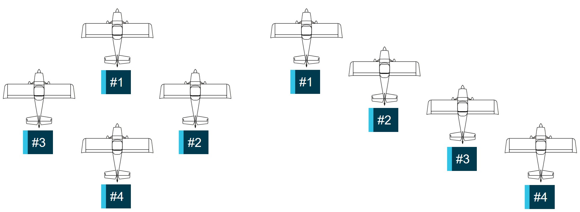
During its return, Acro Formation was in a box formation (as shown in Figure 1). VH-LMK was formation lead in position #1, VH-NMG in position #2, VH-EWS in position #3 and VH‑VNZ was in position #4.[1] At 1205:08, #1 broadcast on the Wedderburn common traffic advisory frequency that the formation was 10 NM (19 km) from Wedderburn. At 1209:14, the pilot of #1 directed #3 and #4 to move their aircraft into the echelon right formation (as shown in Figure 1) and the formation then descended to about 600 ft above ground level (AGL). This was to facilitate the planned stream landing after entering the Wedderburn circuit via an initial and pitch manoeuvre.[2]
Figure 1: Box (left) and echelon right (right) formations
Source: ATSB
At 1209:58, the pilot of #1 broadcast that the formation was joining crosswind for runway 35. Shortly after, the pilot waved at the formation to signal that they were about to turn and leave the formation. The pilot in #1 then commenced a climbing turn to join crosswind and establish the aircraft at the normal circuit height of 1,000 ft AGL. The remaining aircraft would follow, but with a 3 second delay between each aircraft.[3]
According to a nearby eyewitness who was watching the formation from outside a hangar at the aerodrome, each aircraft turned into the circuit after similar time delays. They recalled that #3 continued the turn, tighter than the previous aircraft, which put it onto a converging heading with #2. An overlay of the flight tracks from the available flight data for each aircraft showing the initial and pitch sequence is shown in Figure 2.
A generic low wing aircraft is displayed. Pitch, roll and yaw data was not available to accurately depict aircraft orientation. Source: Cesium and individual aircraft flight tracking data, annotated by the ATSB
At about 1210:09, #3 (VH-EWS) collided with #2 (VH-NMG) at about 1,140 ft AGL (Figure 3), and about 350 m south-east of the northern threshold of runway 35. From the collision, the rear fuselage of #3, just rearward of the baggage compartment, separated from the aircraft. Almost immediately, #3 descended rapidly and impacted terrain in a near vertical trajectory, fatally injuring the pilot. Aircraft #2 remained flyable and the pilot, who was not injured, was able to land the aircraft at the aerodrome and taxi off the runway.
Figure 3: Flight track of the formation showing the collision point between #3 (VH‑EWS, in blue) and #2 (VH-NMG, in yellow) at about 1210:09
A generic low wing aircraft is displayed. Pitch, roll and yaw data was not available to accurately depict aircraft orientation. Source: Cesium and individual aircraft flight tracking data, annotated by the ATSB
Context
Pilot information
VH-EWS
The pilot of VH-EWS held a Private Pilot Licence (Aeroplane), which had been issued in 2010. They held flight activity endorsements, which permitted them to conduct aerobatics above 500 ft AGL, spins, formation flying and formation aerobatics. They also held an instructor rating specifically for teaching spins and formation flying. The pilot held a class 2 aviation medical certificate with a requirement to wear distance vision correction and have reading correction available when flying, which was valid until February 2026.
Their most recent logbook and flying records could not be located after the accident. They were reported as being very experienced in general aviation activities and had held their formation endorsement since 2016. At the time of their most recent medical examination in February 2024, the pilot reported a total of 2,500 flying hours. Their last flight review was in December 2023 and was valid until February 2026.
VH-NMG
The pilot of VH-NMG held a Recreational Pilot Licence (Aeroplane) that was issued in 2022. They held flight activity endorsements, which permitted them to conduct aerobatics above 1,500 ft AGL, spins, formation flying and formation aerobatics. The pilot’s class 2 aviation medical certificate was valid until May 2026, however, it was not valid for night flying.
The pilot reported a total of 509 flying hours of which 331 hours were on Van’s RV-7 aircraft. Their last flight review was in April 2024 and was valid until April 2026.
Aircraft information
VH-EWS
VH-EWS was a Van’s RV-7 amateur-built aircraft with a manufacture date of 2012. It was a piston-engine, 2‑seat aircraft with a low wing, and tailwheel landing gear (Figure 4 left).
VH-NMG
VH-NMG was a Van’s RV-7A amateur-built aircraft with a manufacture date of 2009. It was similar to VH-EWS except that it had a tricycle landing gear (Figure 4 right).
Figure 4: VH-EWS (left) and VH-NMG (right)
Source: Reuben Morison (left) and Clinton J Down Photography (right) via www.Jetphotos.com, modified by the ATSB
Meteorological information
Weather
The other pilots in the formation reported that conditions were good, although there was some turbulence during their flight. They did not express any concerns that the conditions were not suitable for their flight. Closed circuit television footage obtained from a hangar at the aerodrome showed that the sky in the immediate vicinity was clear, with cloud well above the circuit height.
There was no Bureau of Meteorology forecast or observations for the aerodrome, however, the graphical area forecast[4] valid for the time and area of the flight did not indicate any weather phenomena that may have impacted visibility. Moderate turbulence was forecast below 6,000 ft above mean sea level.
The aerodrome had a weather station that recorded numerous parameters including wind speed and direction. At the time of the accident, average winds were below 10 kt and generally westerly. Cloud and visibility data were not recorded parameters.
Daylight
At the time of the accident, Geoscience Australia recorded the sun position at an elevation of 75° 16’ 34’’ and azimuth of 33° 59’ 04”.[5] This was high in the sky towards the north‑north‑east. The 3 remaining pilots reported that the sun position did not present an issue for their visibility.
Aerodrome information
Wedderburn was a non-controlled aeroplane landing area[6] located approximately 3 km south of Wedderburn township and 19 km to the south-east of Camden Airport, New South Wales. It had an elevation of 850 ft with a paved and adjacent grass runway aligned 17/35,[7] which was 980 m long. The aerodrome was privately owned and operated.
Recorded information
None of the aircraft were fitted with, nor were they required to have, a flight data recorder or cockpit voice recorder. However, flight tracking data was obtained for each aircraft, from sources including third party flight tracking providers, electronic flight bag applications and onboard avionics. Generally, this data included latitude, longitude, ground speed, course and altitude, at variable rates between 1 and 5 seconds.
Although the pilots of VH-EWS and VH-NMG had frequently flown with onboard video cameras, neither pilot did so during the accident flight, nor did the other pilots in the formation.
Common traffic advisory frequency recordings for Wedderburn were retrieved, however, the discrete frequency used during their formation flying was not recorded.
Closed circuit television footage from one of the nearby hangars captured VH-EWS descending rapidly just prior to it entering the tree canopy but did not capture the subsequent collision with terrain. Another camera captured the other aircraft in the formation landing at the aerodrome after the accident. The collision between the aircraft was not captured.
Wreckage and impact information
VH-EWS
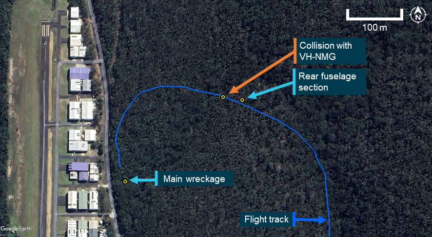
The main wreckage of VH-EWS was located in dense bush about 250 m west‑south‑west of the collision point. The rear fuselage was in similarly dense bush, 250 m north-east of the main wreckage (Figure 5).
Figure 5: VH-EWS wreckage site locations and its flight track adjacent to the aerodrome
Source: Google Earth, annotated by the ATSB
Observations of the site identified that the aircraft collided with trees prior to impacting terrain in a nose down attitude at an impact angle of about 65°. The main wreckage trail extended for about 5 m from the initial impact point towards the south. The aircraft was significantly disrupted, with the propeller buried into the earth at the point of impact (Figure 6).
Figure 6: VH-EWS main wreckage showing key parts of the aircraft
Source: ATSB
Due to the wreckage disruption a full flight control continuity check was not possible, but examination of the available controls did not identify any pre-collision defects. All aircraft parts were accounted for at the wreckage site. Examination of the propeller indicated that the engine was providing power at the time of impact.
The tail section showed damage consistent with contact with VH-NMG. Specifically, there was compression damage to the upper rudder and vertical stabiliser, and propeller strike marks from right to left at the rear fuselage separation point (Figure 7). The rear fuselage section was complete and there was no evidence of pre-collision defects in the flight controls or structure.
Figure 7: VH-EWS rear fuselage and tail assembly
Source: ATSB
VH-NMG
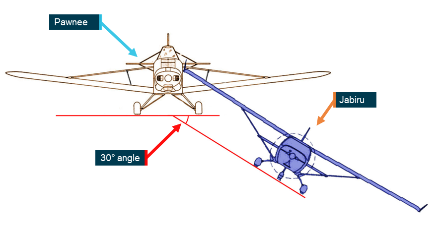
Examination of VH-NMG identified aircraft impact damage to the lower fuselage, nose wheel fairing, propeller blades and spinner. The lower fuselage damage consisted of skin and rib damage and a large intrusion into the aircraft structure just aft of the wing carry through structure and red paint transfer observed in several locations. The damage was consistent with the upper rudder and vertical stabiliser damage on VH-EWS with the orientation of the intrusion at about 30° left of VH-NMG’s longitudinal axis[8] (Figure 8). A flight control function check showed slight fouling of the ailerons and elevators due to the skin intrusion into the area of the flight controls.
Figure 8: VH-NMG lower fuselage and nose wheel fairing damage
Source: ATSB
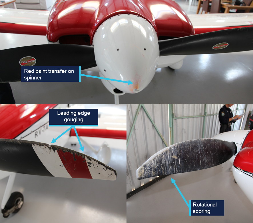
Examination of the propeller and its spinner showed leading edge gouges, rotational scoring, tip bending and red paint transfer that was consistent with VH-NMG striking VH‑EWS several times during the collision sequence (Figure 9).
Figure 9: VH-NMG propeller damage
Source: ATSB
Aircraft to aircraft impact alignment
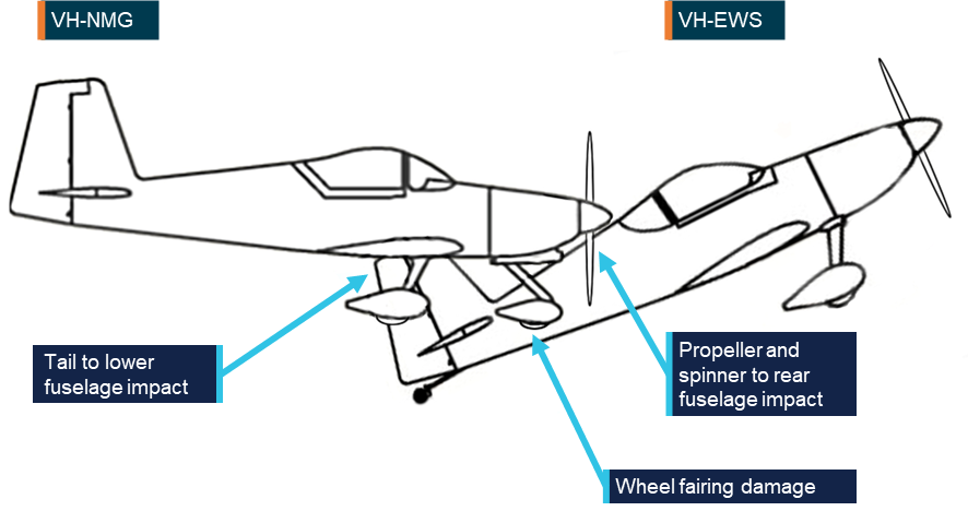
An assessment of the aircraft impact damage identified that VH-EWS collided with VH‑NMG from below and slightly ahead. VH-EWS was likely in a nose up attitude and 30° nose left relative to VH-NMG. The vertical stabiliser from VH-EWS intruded into the lower fuselage of VH-NMG, and the propeller of VH-NMG cut through the rear fuselage of VH-EWS. A depiction of the impact alignment is shown at Figure 10.
Figure 10: Aircraft to aircraft relative impact alignment
Source: ATSB
Further investigation
The investigation is continuing and will include:
examination of maintenance records
examination of pilot records and training
consideration of formation flying procedures and practices
further analysis of recorded data.
A final report will be released at the conclusion of the investigation. Should a critical safety issue be identified during the course of the investigation, the ATSB will immediately notify relevant parties so appropriate and timely safety action can be taken.
Acknowledgements
The ATSB acknowledges the significant assistance provided by the NSW Police Force during the onsite phase of the investigation.
Purpose of safety investigations
The objective of a safety investigation is to enhance transport safety. This is done through:
identifying safety issues and facilitating safety action to address those issues
providing information about occurrences and their associated safety factors to facilitate learning within the transport industry.
It is not a function of the ATSB to apportion blame or provide a means for determining liability. At the same time, an investigation report must include factual material of sufficient weight to support the analysis and findings. At all times the ATSB endeavours to balance the use of material that could imply adverse comment with the need to properly explain what happened, and why, in a fair and unbiased manner. The ATSB does not investigate for the purpose of taking administrative, regulatory or criminal action.
About ATSB reports
ATSB investigation reports are organised with regard to international standards or instruments, as applicable, and with ATSB procedures and guidelines.
Reports must include factual material of sufficient weight to support the analysis and findings. At all times the ATSB endeavours to balance the use of material that could imply adverse comment with the need to properly explain what happened, and why, in a fair and unbiased manner.
An explanation of terminology used in ATSB investigation reports is available here. This includes terms such as occurrence, contributing factor, other factor that increased risk, and safety issue.
Publishing information
Released in accordance with section 25 of the Transport Safety Investigation Act 2003
Ownership of intellectual property rights in this publication
Unless otherwise noted, copyright (and any other intellectual property rights, if any) in this report publication is owned by the Commonwealth of Australia.
Creative Commons licence
With the exception of the Commonwealth Coat of Arms, ATSB logo, and photos and graphics in which a third party holds copyright, this report is licensed under a Creative Commons Attribution 4.0 International licence.
The CC BY 4.0 licence enables you to distribute, remix, adapt, and build upon our material in any medium or format, so long as attribution is given to the Australian Transport Safety Bureau.
Copyright in material obtained from other agencies, private individuals or organisations, belongs to those agencies, individuals or organisations. Where you wish to use their material, you will need to contact them directly.
[1]For ease of reference, each aircraft and/or pilot will be referred to by their formation position number.
[2]Initial and pitch: a circuit entry technique for formation flights. This involved flying an upwind leg, aligned with the landing runway, commencing from a predetermined position (initial). At about halfway along the runway, the lead aircraft in the formation will then turn onto the crosswind leg (pitch) with each aircraft following in succession with a set time delay between them. Once complete, there should be sufficient lateral separation between each aircraft as they continue in the circuit to land in succession (stream landing).
[3]The 3 second delay was reported by the surviving pilots as being their standard time delay for a formation initial and pitch manoeuvre.
[4]Graphical area forecast provides information on weather, cloud, visibility, icing, turbulence and freezing level in a graphical layout with supporting text.
[5]The elevation of the sun is the angle between the direction of the sun and the observer's local horizon. The azimuth is the angle between North, measured clockwise around the observer's horizon.
[6]An aeroplane landing area is an aerodrome that has not been certified by the Civil Aviation Safety Authority. These aerodromes are non-controlled, unregulated facilities. It is the responsibility of pilots and operators to determine whether these aerodromes are suitable for use.
[7]Runway number: the number represents the magnetic heading of the runway.
[8]The longitudinal axis of an aircraft runs from its nose to its tail.
Occurrence summary
Investigation number
AO-2025-071
Occurrence date
30/11/2025
Occurrence time and timezone
12:10 Australian Eastern Daylight Time
Location
Near Wedderburn aeroplane landing area
State
New South Wales
Report status
Preliminary
Anticipated completion
Q3 2026
Investigation level
Short
Investigation type
Occurrence Investigation
Investigation phase
Examination and analysis
Investigation status
Active
Mode of transport
Aviation
Aviation occurrence category
Collision
Occurrence class
Accident
Highest injury level
Fatal
Aircraft details
Manufacturer
Amateur Built Aircraft
Model
Van's RV-7
Registration
VH-EWS
Serial number
73226
Sector
Piston
Operation type
Part 91 General operating and flight rules
Activity
General aviation / Recreational-Sport and pleasure flying-Aerobatics
Departure point
Wedderburn Aircraft Landing Area, New South Wales
Destination
Wedderburn Aircraft Landing Area, New South Wales
Injuries
Crew - 1 (fatal)
Damage
Destroyed
Aircraft details
Manufacturer
Amateur Built Aircraft
Model
Van's RV-7A
Registration
VH-NMG
Serial number
73232
Sector
Piston
Operation type
Part 91 General operating and flight rules
Activity
General aviation / Recreational-Sport and pleasure flying-Aerobatics
On 18 October 2025, a Go Ballooning Gold Coast balloon pilot and a ground crew member were preparing for a scheduled sunrise sightseeing flight near Beaudesert, Queensland. Weather forecasts indicated light winds and some clearing rain. The operator’s tour manager arrived at the launch site at about 0500 local time with 24 passengers booked for the flight. As the crew began the envelope cold inflation, a change in wind direction pushed the partially inflated balloon envelope across the field, striking 2 light posts near the road. After the crew recovered the balloon from the light posts, it was relocated with the help of the passengers. An inspection by the pilot identified a tear in one of the upper envelope panels.
The pilot, who was also the maintainer, estimated the tear to be about 45 cm and conducted a field repair using specialised adhesive tape. After checking the weather conditions were suitable for launch, the pilot assessed the repair was sufficient to continue with the proposed flight. The crew boarded the passengers, and the balloon departed the Beaudesert launch site.
During the latter part of the flight, the repair degraded, allowing air to escape from the balloon’s envelope. The pilot continued the flight to the chosen landing site as planned and landed the balloon without further incident.
What the ATSB found
The ATSB found that the position selected within the launch site did not provide sufficient clearance from nearby obstacles, which resulted in damage to the balloon’s envelope after being moved by an unexpected wind gust.
The envelope repair using adhesive tape was not conducted in accordance with the manufacturer’s requirements, and the pilot did not fully understand the manufacturer’s limits for field repairs for the tear location and did not review the manufacturer’s written requirements before proceeding with the repair.
The pilot’s decision to continue with the intended flight was likely influenced by the pilot’s perception of the expectations of the waiting passengers, along with the improvement in weather conditions and the pilot’s confidence in the repair. Subsequent in‑flight deterioration of the repair emphasised the potential risk of the tear propagating which increased the risk to occupants on board. However, the pilot continued for the remaining 5–10 minutes of the flight rather than landing immediately.
Safety message
Balloon repairs must be conducted in accordance with the manufacturer’s instructions.
Non-approved repairs that appear to work without consequence can normalise unsafe practices over time and represent a significant risk to all occupants on board. Operators and maintainers should be familiar with the approved maintenance standards and practices before commencing any repair work.
Pilots and maintainers should also be aware of external and internal commercial pressures to continue a flight without fully researching and conducting an appropriate repair.
The ATSB SafetyWatch highlights the broad safety concerns that come out of our investigation findings and from the occurrence data reported to us by industry. One of the safety concerns is Reducing passenger injuries in commercial ballooning operations.
The investigation
The ATSB scopes its investigations based on many factors, including the level of safety benefit likely to be obtained from an investigation and the associated resources required. For this occurrence, the ATSB conducted a limited-scope investigation in order to produce a short investigation report, and allow for greater industry awareness of findings that affect safety and potential learning opportunities.
The occurrence
On 18 October 2025, a Kubíček BB142P hot-air balloon, registered VH-RRP, was being operated by Go Ballooning Gold Coast on a sightseeing flight from Beaudesert, Queensland.
The pilot, who was also the operator and maintenance controller, obtained relevant weather information from the Bureau of Meteorology and via a phone‑based weather application, Rain Parrot, to assess the weather conditions and plan the proposed flight.
The pilot picked a familiar launch site location in a large open field adjacent to a supermarket car park, which they had operated from numerous times previously.
The pilot and a ground crew member arrived at the launch site (Figure 1) at about 0300 to unload and prepare the balloon for launch. The balloon basket was positioned close to the public road bordering the launch area. This position was within 10 m of a public road and about 20 m from nearby light posts bordering the shopping centre car park.
Figure 1: Location of balloon launch site
Source: Google Earth, annotated by the ATSB
As per Go Ballooning Gold Coast’s operational procedure the pilot released several helium pibal[1] balloons to observe wind conditions at different levels for the intended flight and confirmed the launch site suitability for the planned flight.
The pilot and ground crew member were preparing the balloon by cold inflation,[2] when the pilot described that the wind speed increased to about 6 kt and changed direction. At a time that could not be determined, the partially inflated balloon envelope moved from a north-east to a south-west position around the basket that was secured to the front of a 4-wheel drive car. The crew attempted to restrain the balloon by pulling on the crown line,[3] but were unable to stop the movement of the envelope. The balloon envelope continued to travel across the public road and struck 2 light posts (Figure 2) in the shopping centre car park. During recovery from one of the light posts, it sustained a tear to the upper section of the envelope.
Figure 2: Photograph of balloon after striking light posts
Source: Supplied, annotated by the ATSB
At about 0500 local time, the tour manager and 24 passengers, booked for the scheduled sunrise flight, arrived at the launch site on the operator’s bus.
After the crew retrieved the balloon envelope it was deflated and packed up with the assistance of some of the passengers.
The balloon was then repositioned away from the obstacles and laid out for the pilot to inspect for any damage. The pilot identified a tear in the upper section of the envelope, above the balloon equator.[4] The pilot estimated the tear to be about 45 cm in length (Figure 3), and no other damage was identified.
The pilot reported that they had previously carried out field repairs on balloons and was confident that the specialised adhesive tape provided from the manufacturer would temporarily fix the tear to allow the flight to proceed as planned.
After the pilot applied the tape, the balloon was fully inflated with hot air and was visually inspected. The pilot reported that they believed the repair was sufficient to continue with the flight. About 20 minutes after completing the repair and following an assessment that the wind speed was within the allowable limits for launch, the pilot decided to continue with the flight as scheduled. A safety briefing was given to the passengers before boarding, and the flight proceeded at about 0550.
Figure 3: Photograph of damage to balloon envelope
Source: Supplied, annotated by the ATSB
The pilot reported that after take-off, the balloon tracked in a southerly direction, opposite to the intended direction of flight for about 30 minutes. The pilot reported that about 5–10 minutes before arriving at a newly planned landing site, heat at the top of the balloon likely caused the adhesive repair tape to weaken, partially re-opening the tear and allowing a small, uncontrolled venting of air. The pilot reported not being concerned and continued to the planned landing site. The balloon landed safely at 0620 at Kerry, Queensland, about 17 km south of Beaudesert.
Context
Pilot information
The pilot was the owner and operator of Go Ballooning, operating sightseeing balloon flights and private charters in south-east Queensland, since 2015.
They held a Civil Aviation Safety Authority (CASA) Commercial Pilot (Balloon) Licence and had over 20 years of experience with 2,299 total flying hours at the time of the incident. In the previous 2 weeks the pilot had flown about 6.5 hours in VH-RRP. The pilot held a current CASA class 2 aviation medical certificate, a valid CASA maintenance authority (MA) for balloons and a valid Kubíček maintenance certificate.
The pilot reported having slept their normal 7–8 hours prior to the incident and self‑assessed as ‘1’ on a fatigue scale of 1–7 where 1 is fully alert and 7 is completely exhausted.
Balloon information
VH-RRP was manufactured in 2022 by the Kubíček factory in Czechia and could operate with a maximum of 24 passengers and 1 pilot. The balloon was registered to Go Ballooning Australia on 9 December 2022.
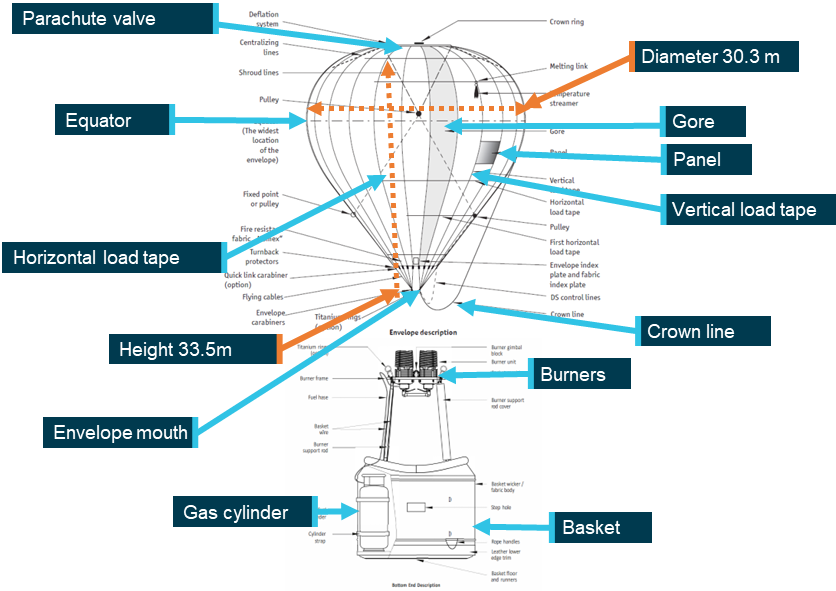
The BB142P balloon envelope had a volume of 14,158 m2 and was about 30 m in diameter and almost 34 m in height which supported a maximum take-off weight of 4,500 kg (Figure 4). The balloon envelope was constructed of 32 gores[5] and was inflated by hot air from 4 burners connected to 4 independent fuel systems.
Figure 4: Schematic of a Kubíček balloon
Envelope and basket not to scale. Source: Adapted from the Kubíček hot air balloon flight manual (section 1), annotated by the ATSB
A manned free balloon certificate of airworthiness was issued on 16 February 2023, and the balloon had accumulated a total time of 369.6 hours in service and the basket 942 hours at the time of the event.
Meteorological information
The ATSB obtained relevant weather data from the Bureau of Meteorology. For Beaudesert, observations for wind were recorded at 1-minute intervals at ground level about 3 km to the north-west of the launch site. Between 0448 and 0515, surface winds were reported as west to north-westerly at approximately 3 kt, shifting through the west to a southerly, then south‑easterly at approximately 2 kt from 0516 through to the launch time of 0550. The forecast temperature for Amberly, (about 50 km to the north-west of the launch site) at the time of the launch was around 16°C.
The pilot recalled that, at the time of preparation, forecast conditions for the time of the launch were:
light and variable winds
unrestricted visibility
no low cloud, a few scattered high-level clouds.
Regulatory oversight
Operators require a Civil Aviation Safety Authority (CASA) Air Operator’s Certificate (AOC) to conduct balloon transport operations under Part 131 of the Civil Aviation Safety Regulations (CASR).
The Part 131 Manual of Standards (MOS) sets out the specific requirements for these operations. The MOS does not specify size requirements for balloon launch sites, however an operator is required to keep records of launch and landing sites. This includes a description of each launch and landing site with maps, diagrams, and records of any hazards associated with the site and any limitations or restrictions. The documented information is required to form part of the operator’s exposition.[6]
CASA Advisory Circular (AC) 131-02 v4.0 specifies in section 8.2 Ground Handling:
Operators and PIC [pilot in command] are recommended to consider the hazards or risks to persons or property that might arise during any of the following activities:
• laying out, inflation and preparation for launch
• take-off and climb
• landing, normal deflation and pack up
• relocation of inflated balloon on the ground
• use of the handling line for hot air balloons
• use of the trail rope for gas balloons.
Pre-flight damage assessment and repair
After contact with the light posts and inspection of the envelope, the pilot identified an estimated 45 cm tear, located above the equator of the balloon in gore 22, panel 26 (Figure 5) and no other damage. The pilot, who was also a maintenance authority, applied specialised adhesive tape to the tear as they had reportedly done on previous occasions for temporary field repairs on minor fabric damage.
Figure 5: Location of tear in balloon envelope VH-RRP
Source: Photograph supplied; diagram from Kubicek maintenance manual, annotated by the ATSB
Manufacturer instructions for envelope repair
The operator’s exposition outlined the pre-flight procedures with a list of pre-flight inspections and checks for the balloon which included verifying the envelope integrity in accordance with damage limitation in the Kubíček Hot Air Balloon Flight Manual (BFM).
The BFM provides information on the damage limits applicable to various sections of the balloon. Different sections of the balloon envelope are subject to varying thermal loads, internal pressures and fabric tensions during operation. Therefore, the structural consequences of damage will differ depending on where the damage is located on the envelope. The hottest and highest structurally loaded area of the balloon envelope is above the equator.
The operator accessed the BFM and the Kubíček Maintenance Manual(BMM) for the BB142P model.
The BFM stated that repairs above the first horizontal load tape are limited to:
…small holes or tears of no more than 5 mm (1/4 in) in any direction. The integrity of the panel must not be affected by the holes or tears.
Any damage exceeding the above limits must be repaired prior the next flight according to the instructions given by the Kubicek Maintenance Manual
For damage limitation the BFM warning states:
Any damage to the fabric weakens the fabrics resistance to tear and causes localized heating of the fabric around that damage. Damage exceeding those listed above increase the potential of propagating a tear or hole and is unacceptable for flight.
The BMM (section 3.21) repair guidance for using an adhesive patch above the equator, stated:
Adhesive Patch without Overstitching:
If the damage is not more than 2.5 cm (1") in any dimension. There must be minimum of 10 cm (4") between any two damaged locations on a single panel.
Adhesive Patch with Overstitching:
If the damage is not more than 10 cm (4“) in any dimension. May not be used if the damage extends to within 2.5 cm (1“) of a load tape. There must be a minimum of 10 cm (4“) between any two adhesive patches on a single panel.
A further note also stated that:
Always check adhesion of the patch as the adhesive may adhere differently on different materials (polyester vs. polyamide, ripstop, etc.) and its adhesion may also be affected by outside temperature, age and dustyness of the fabric, and other factors. When in doubt, use sewn patch.
Balloon envelope damage
The size (45 cm) and location (above the equator) of the tear significantly exceeded the limit to use adhesive tape for repair. The BMM stated that a sewn partial panel or panel with the same material as used in the original panel was required for a tear of this size. The panel repair is designated as a category B repair which covers the common maintenance tasks that may be carried out by individuals who have undertaken a manufacturer maintenance course and hold a valid manufacturer maintenance certificate. The approved method to repair the damage, as detailed in the BMM, required the affected panel to be repaired in accordance with the manufacturer's directions before further flight.
Operational information
Launch site selection and preparation
The pilot reported that between 40 and 50 sites were used for launching and landing balloons, with agreements in place with landowners to access several private properties on the Gold Coast. The operator’s exposition included documented information for each site, including the Beaudesert launch site. The balloon basket was positioned close to the public road bordering the launch area. While this suited the southerly wind at the time for the balloon layout, it left little clearance from other obstacles in the circumstances of a wind shift.
Passenger briefings
The pilot reported that the passenger briefing was given prior to boarding the passengers. It was described as the operator’s standard briefing and included details on the brace position for landing, that passengers should not enter or exit the balloon until the pilot has given permission and that smoking was strictly prohibited.
Balloon envelope damage in-flight
The operator’s exposition referred to the manufacturer’s flight manual for emergency procedures. The Kubíček BFM stated that in the event of damage to the envelope in‑flight the balloon should be kept flying at a low altitude to avoid a hard landing and landed as soon as possible.
Safety risk
ATSB investigation 198900820 illustrated that damage to the envelope of a balloon that propagates to the point where it rapidly deflates can have disastrous implications for flight safety.
On 13 August 1988, 2 hot air balloons, VH-NMS and VH-WMS, were operating tourist flights near Alice Springs Airport. VH-WMS departed about 2 minutes ahead of VH-NMS and climbed to about 4,000 ft AMSL (2,000 ft AGL) and drifted in a westerly direction. After reaching 4,000 ft, VH-WMS commenced descending as VH-NMS climbed towards it. VH‑NMS continued climbing until its envelope collided with the basket of VH-WMS, tearing a large hole in the envelope fabric. The disruption to the envelope of VH-NMS prevented the balloon maintaining inflation and it descended uncontrolled until it collided with terrain. The pilot and 12 passengers were fatally injured.
Safety analysis
During the envelope pre-inflation for a scheduled sunrise sightseeing balloon flight, the wind suddenly increased and changed direction pushing the balloon envelope into contact with 2 nearby light posts. This caused a tear in a panel above the equator of the envelope greater than the manufacturer’s allowable limit. The pilot applied adhesive tape to repair the damage while passengers waited. After hot inflation and inspection of the repair, the pilot then decided to operate the flight as scheduled. The repair subsequently degraded in‑flight however a safe landing was made.
This analysis will explore the assessment of the launch location, damage assessment and repair, as well as factors relating to the continuation of the flight.
Launch site
The pilot selected a regular launch site and although the site had been used previously, the positioning of the basket and envelope layout for the flight did not provide sufficient available space to ensure clearance of surrounding obstacles at all times during the balloon’s preparation for flight, increasing the risk of envelope damage.
A wind change occurred at a critical part of envelope inflation, causing the envelope to contact nearby light poles. During recovery from the light pole, the envelope sustained damage.
Repair
The onsite repair did not comply with the operator’s exposition which required repairs to be conducted in accordance with balloon manufacturer’s instructions.
Although adhesive tape was allowed for smaller tears up to 10 cm in that area of the envelope, this tear was at least 45 cm. The decision to apply adhesive tape for the repair indicated that the pilot, who was also the maintainer, did not fully understand the manufacturer’s requirements relating to envelope damage limits and did not review the manufacturer’s written requirements before proceeding with the repair.
The absence of any other obvious deformation of the envelope, or further tearing after the tape was applied, was interpreted that the repair was sufficient. Previous experience repairing minor damage with the adhesive tape likely reinforced the perception that this was an adequate method for this repair, even though 45 cm was beyond admissible damage where such repair was permitted.
Had the pilot consulted the hot air balloon flight manual, a sewn panel repair would have necessitated the postponement or cancellation of the flight. The pilot’s decision to repair the tear to enable the planned flight to continue without consulting the manufacturer’s envelope repair requirements increased the risk of further in-flight envelope tear propagation, potentially leading to catastrophic envelope failure and a subsequent uncontrolled descent.
Flight continuation
Research has shown that many aviation accidents involve a ‘plan continuation bias’ or ‘plan continuation error’.[7] That is, pilots decide to continue with the original plan of action despite the presence of cues or information that suggests changing the course of action would be the safer option (Orasanu and others 2001; Orasanu 2010). Plan continuation bias is often associated with situations involving dynamically changing risk and pilots underestimating the risk level (Orasanu and others 2001; Wiegmann and others 2002).
The absence of any immediate deterioration in the tape repair after hot inflation likely reinforced the pilot's belief that the envelope was airworthy. The pilot’s expectation that the balloon was serviceable, supported the pilot’s desire to continue the flight. Improving stability in the surface wind direction and strength then provided an opportunity to launch the balloon.
With the 24 passengers already arrived and waiting, it was likely the pilot perception of the passengers’ expectations was also a strong motivator to continue and influenced the pilot’s decision to conduct the flight. The weight of the perceived passenger expectation would likely have the pilot searching for solutions to enable the flight to proceed, rather than cancelling and rescheduling the flight to conduct repairs.
The manufacturer’s flight manual instructions were to land as soon as possible following in‑flight envelope damage. While the pilot reported awareness of the tape repair degrading in flight, they did not assess the need to land earlier.
Findings
ATSB investigation report findings focus on safety factors (that is, events and conditions that increase risk). Safety factors include ‘contributing factors’ and ‘other factors that increased risk’ (that is, factors that did not meet the definition of a contributing factor for this occurrence but were still considered important to include in the report for the purpose of increasing awareness and enhancing safety). In addition, ‘other findings’ may be included to provide important information about topics other than safety factors.
These findings should not be read as apportioning blame or liability to any particular organisation or individual.
From the evidence available, the following findings are made with respect to the flight with damaged envelope involving Kubíček BB142P, VH‑RRP, near Beaudesert, Queensland, on 18 October 2025.
Contributing factors
The location in the launch area did not provide adequate clearance from obstacles during inflation.
A change in the wind direction caused the partially inflated balloon envelope to move and strike 2 light posts, resulting in significant envelope damage.
The pilot identified the tear and conducted a repair not in accordance with the balloon manufacturer’s requirements, increasing the risk of in‑flight envelope failure.
The pilot continued with the intended flight, likely due to their confidence in the repair, improvement in the weather conditions and perceived passenger expectations. When the repair failed, the pilot continued for the remaining 5-10 minutes of the flight rather than landing immediately.
Sources and submissions
Sources of information
The sources of information during the investigation included:
the pilot of the incident flight
Civil Aviation Safety Authority
Bureau of Meteorology
balloon manufacturer
witness
video footage of the accident flight and other photographs taken on the day of the accident.
References
ATSB (1989) Kavanagh Hot Air Balloon E-260, VH-NMS, 14 km SSE of Alice Springs Airport NT, 13 August 1989 198900820
Orasanu, J., Martin, L., & Davison, J. (2001). Cognitive and contextual factors in aviation accidents: Decision errors. In Linking expertise and naturalistic decision making (pp. 209-225). Psychology Press.
Orasanu, J. M. (2010). Flight crew decision-making. In Crew resource management (pp. 147-179). Academic Press.
Wiegmann, D. A., Goh, J., & O'Hare, D. (2002). The role of situation assessment and flight experience in pilots' decisions to continue visual flight rules flight into adverse weather. Human factors,44(2), 189-197.
Submissions
Submissions were received from:
the pilot of the incident flight
Civil Aviation Safety Authority
Bureau of Meteorology.
The submissions were reviewed and, where considered appropriate, the text of the report was amended accordingly.
Purpose of safety investigations
The objective of a safety investigation is to enhance transport safety. This is done through:
identifying safety issues and facilitating safety action to address those issues
providing information about occurrences and their associated safety factors to facilitate learning within the transport industry.
It is not a function of the ATSB to apportion blame or provide a means for determining liability. At the same time, an investigation report must include factual material of sufficient weight to support the analysis and findings. At all times the ATSB endeavours to balance the use of material that could imply adverse comment with the need to properly explain what happened, and why, in a fair and unbiased manner. The ATSB does not investigate for the purpose of taking administrative, regulatory or criminal action.
About ATSB reports
ATSB investigation reports are organised with regard to international standards or instruments, as applicable, and with ATSB procedures and guidelines.
Reports must include factual material of sufficient weight to support the analysis and findings. At all times the ATSB endeavours to balance the use of material that could imply adverse comment with the need to properly explain what happened, and why, in a fair and unbiased manner.
An explanation of terminology used in ATSB investigation reports is available here. This includes terms such as occurrence, contributing factor, other factor that increased risk, and safety issue.
Publishing information
Released in accordance with section 25 of the Transport Safety Investigation Act 2003
Ownership of intellectual property rights in this publication
Unless otherwise noted, copyright (and any other intellectual property rights, if any) in this report publication is owned by the Commonwealth of Australia.
Creative Commons licence
With the exception of the Commonwealth Coat of Arms, ATSB logo, and photos and graphics in which a third party holds copyright, this report is licensed under a Creative Commons Attribution 4.0 International licence.
The CC BY 4.0 licence enables you to distribute, remix, adapt, and build upon our material in any medium or format, so long as attribution is given to the Australian Transport Safety Bureau.
Copyright in material obtained from other agencies, private individuals or organisations, belongs to those agencies, individuals or organisations. Where you wish to use their material, you will need to contact them directly.
[1]Pibal: a lighter-than-air gas‑filled small rubber balloon used to estimate wind speed and direction at the launch (take-off) site and in the first few hundred feet above the surface.
[2]Cold inflation is the initial stage of inflating a hot air balloon. Cold air is forced into the envelope prior to using the burners.
[3]Crown line: a rope connected to the top of the balloon envelope used to control the balloon’s position during inflation.
[4]The equator of the balloon is the widest part of the balloon envelope in diameter. The loss of hot air from a same size tear would be greater when the tear was higher in the balloon.
[5]A gore is a section of fabric running from the top to the bottom of the envelope.
[6]An exposition is a Part 131 document detailing an organisation's policies and processes, specific to each operator.
[7]In terms of continuing a flight to the original destination, plan-continuous bias is often known as ‘mission‑itis’, ‘get‑home‑itis’ and ‘press‑on‑itis’.
Occurrence summary
Investigation number
AO-2025-065
Occurrence date
18/10/2025
Occurrence time and timezone
04:45 Australian Eastern Standard Time
Location
Near Beaudesert
State
Queensland
Report release date
05/02/2026
Report status
Final
Investigation level
Short
Investigation type
Occurrence Investigation
Investigation status
Completed
Mode of transport
Aviation
Aviation occurrence category
Aircraft preparation, Airframe - Other, Collision
Occurrence class
Serious Incident
Highest injury level
None
Aircraft details
Manufacturer
Kubicek Factory
Model
BB142P
Registration
VH-RRP
Serial number
2052
Aircraft operator
Go Ballooning Gold Coast Pty Ltd
Sector
Balloon
Operation type
Part 131 Balloons and hot air airships
Activity
Commercial air transport-Non-scheduled-Joyflights / sightseeing charters
Occurrence Briefs are concise reports that detail the facts surrounding a transport safety occurrence, as received in the initial notification and any follow-up enquiries. They provide an opportunity to share safety messages in the absence of an investigation. Because occurrence briefs are not investigations under the Transport Safety Investigation Act 2003, the information in them is de-identified.
What happened
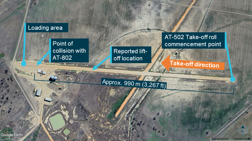
On 26 September 2025, 3 agricultural aircraft were conducting aerial application operations from a private airstrip base near Pilliga, New South Wales. The operating airstrip runway was oriented east-west, with the aircraft loading area positioned at the western runway end (Figure 1). Around 1700 local time, with a westerly prevailing wind (290°/10 kt) and the sun towards the western horizon, the pilot of an Air Tractor AT-502B (AT‑502) aircraft commenced backtracking toward the eastern end of the runway for a take-off into the wind. While backtracking, the pilot received a radio call from an Air Tractor AT-802A (AT‑802) aircraft inbound from the east. The 2 pilots coordinated separation and the AT-802 landed on the runway behind the AT-502 at the eastern end of the runway and began taxiing towards the loading area.
Figure 1: Operating airstrip
Source:Google Earth, annotated by the ATSB with information from the operator
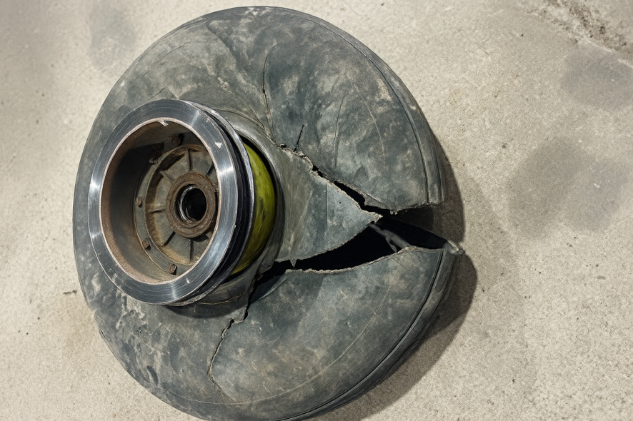
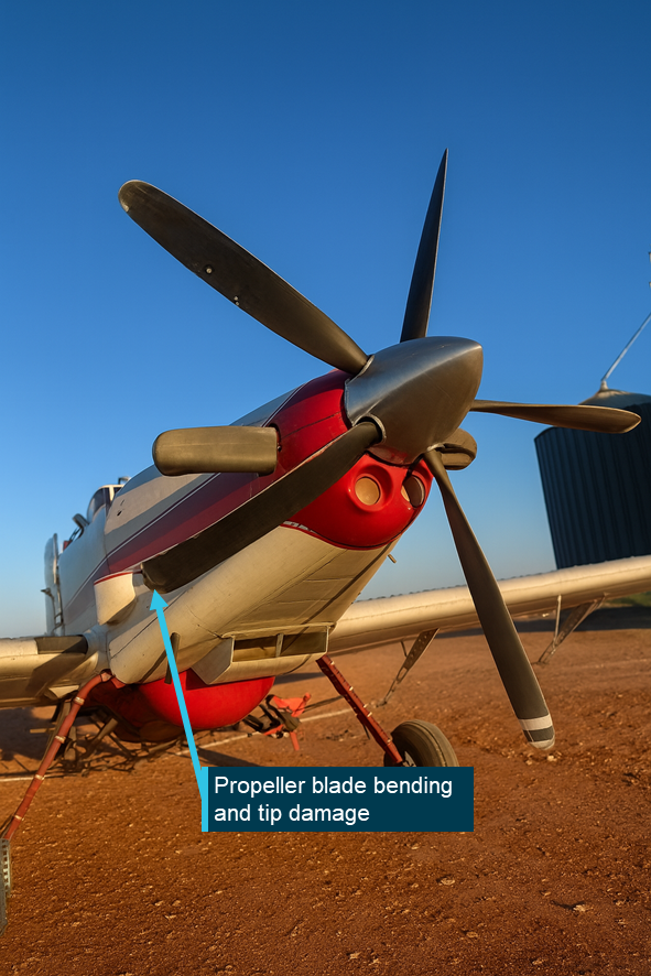
When the AT-502 pilot judged there was likely sufficient runway distance behind the just‑landed AT-802, they commenced the take-off run. Aircraft acceleration and take-off were described as normal and the aircraft lifted off behind and passed directly over the top of the taxiing AT-802. As it did so, the AT-502’s left main landing gear wheel struck the AT-802’s rotating propeller – slashing the main gear tyre (Figure 2) and damaging the outboard tip of one propeller blade (Figure 3).
The AT-502 pilot maintained control and, after dumping the load of chemical, they returned to the airstrip for an uneventful landing. The AT-802 pilot reported immediate and significant airframe vibrations from the damaged propeller and shut down the engine. Neither pilot sustained any injury.
The AT-502 pilot noted that the low sun angle created glare and associated visibility issues and may have affected their judgement of the distance to the taxiing aircraft in front. They also noted that the glare had caused the AT-802 pilot to taxi more slowly than expected, increasing the time needed to clear the airstrip.
Figure 2: AT-502 damaged left main landing gear tyre
Source: Operator supplied
Figure 3: AT-802 with propeller blade damage
Source: Operator supplied, annotated by the ATSB
Safety message
Pilots of aircraft operating from unlicensed and uncontrolled aircraft landing areas and aerodromes must ensure that they establish and maintain complete situational awareness. Regular visual scans, radio calls and use of positioning technology (such as ADSB-IN and OUT) can collectively enhance awareness and reduce conflict risk. In situations where these tools are absent or degraded (reduced or affected visibility, for example), procedural and operational allowances must be made to ensure that aircraft separation is always assured.
The ATSB SafetyWatch highlights the broad safety concerns that come out of our investigation findings and from the occurrence data reported to us by industry. One of the safety concerns is Reducing the collision risk around non-towered airports.
About this report
Decisions regarding whether to conduct an investigation, and the scope of an investigation, are based on many factors, including the level of safety benefit likely to be obtained from an investigation. For this occurrence, no investigation has been conducted and the ATSB did not verify the accuracy of the information. A brief description has been written using information supplied in the notification and any follow-up information in order to produce a short summary report, and allow for greater industry awareness of potential safety issues and possible safety actions.
The ATSB is investigating a mid-air collision between 2 light aircraft, a Jabiru and a Cessna 182, south-west of Sydney on 26 October 2024.
A team of transport safety investigators from the ATSB's Canberra office, with experience in aircraft operations and maintenance, was deployed to the accident sites of both aircraft to conduct evidence-collecting activities.
The evidence collection phase of the investigation involves interviewing witnesses and involved parties, site mapping, examination of the wreckage of both aircraft, and collect relevant recorded information including any air traffic control and flight tracking data, as well as pilot and aircraft maintenance records, and weather information.
The ATSB has commenced the examination and analysis of the initial evidence collected.
To date, the ATSB has:
examined the wreckage
examined aircraft components and other items recovered from the accident site
collected surveillance data from Airservices Australia
collected OzRunways data for relevant aircraft
collected pilot and aircraft records
conducted interviews with relevant parties
conducted detailed analysis of video recordings and radio transmissions
reviewed aircraft, pilot, aerodrome and operator documentation
conducted detailed analysis of the aircraft flight paths
reviewed procedures at non-controlled aerodromes
liaised with the NSW Police Force.
The investigation is continuing and will include, further:
analysis of video recordings
review of similar occurrences
review of previous flight tests conducted by the flight test examiner
review of procedures and practices relating to the conduct of flight tests
review of communication, electronic conspicuity and surveillance equipment, and interviews with relevant parties.
Preliminary and interim reports, which detail factual information established during the course of the investigation, have been released (see below).
A final report will be released at the conclusion of the investigation and will detail analysis and findings. Should a critical safety issue be identified during the course of the investigation, the ATSB will immediately notify relevant parties, so that appropriate safety action can be taken
Interim report
Report release date: 04/12/2025
This interim report details information relating to this accident, and has been prepared to provide timely information to the industry and public. This report contains no findings, which will be detailed in the investigation’s final report. The information contained in this interim report is released in accordance with section 25 of the Transport Safety Investigation Act 2003.
The occurrence
Overview
On the morning of 26 October 2024, a commercial pilot licence (Aeroplane) (CPL(A)) flight test was being conducted in a Cessna 182 aircraft, registered VH-APN (APN), departing from Shellharbour Airport, New South Wales. On board APN were a pilot under examination (the CPL candidate) and a Civil Aviation Safety Authority (CASA) approved flight test examiner (the examiner).
On the same morning, a private flight was being conducted in a Jabiru UL 450 aircraft, registered 19-4079 (4079), departing from The Oaks aerodrome (The Oaks), New South Wales. On board 4079 was a pilot (the pilot of 4079), who was the sole occupant.
Around midday, APN and 4079 collided in-flight and both aircraft impacted terrain. All occupants of both aircraft were fatally injured. The following describes the events that led up to the midair collision.
VH-APN pre-flight and departure from Shellharbour Airport
Three days earlier, on 23 October 2024, a ‘CPL task’ for the flight test and other instructions were sent by email from the examiner to the CPL candidate. The CPL task was a scenario that included instructions to plan and fly from Shellharbour Airport and land at Warnervale Airport flying via Macquarie Lighthouse for some aerial photography. The task then stipulated an onward flight from Warnervale Airport to land at Cessnock Airport, with a return leg to Shellharbour via the most direct track. A map recovered from the accident site showed a red path drawn upon it, consistent with the CPL task. This map indicated that the Cessnock to Shellharbour leg was planned via an inland route passing over Prospect Reservoir and Campbelltown.
A witness account indicated that, on 26 October 2024, the flight examiner and CPL candidate had planned to meet at a local bakery at around 0730 local time, prior to starting the ground component of the CPL flight test at Shellharbour Airport, at around 0800. National Airspace Information Planning System (NAIPS)[1] records indicated that the CPL candidate submitted a flight plan at about 1005. At 1018, a radio broadcast was recorded from APN on the Shellharbour Airport common traffic advisory frequency (CTAF),[2] indicating that APN was taxiing for runway 16 for a crosswind departure.
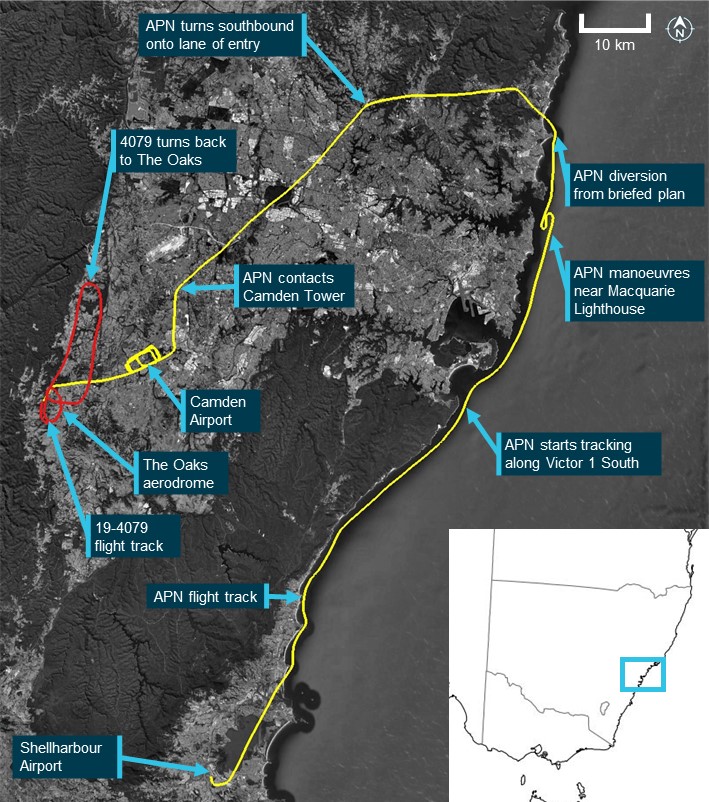
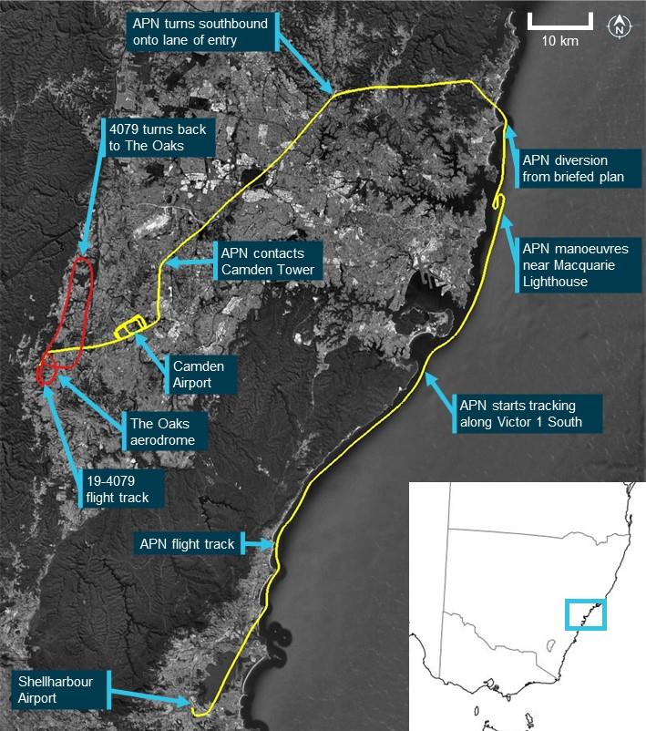
Flight data transmitted by the CPL candidate’s electronic flight bag (EFB)[3] device (APN flight data) indicated that at 1035, APN departed Shellharbour Airport, climbing to 1,500 ft above mean sea level.[4] At 1036, a radio call recorded on the CTAF stated that APN was departing crosswind and tracking north-east toward the sea cliff bridge, with the flight proceeding in this direction (Figure 1).
VH-APN flight along the coastline and diversion to Camden Airport
APN crossed the coastline near Wollongong beach, and subsequently descended to about 500 ft, following the coast toward Sydney and passing the sea cliff bridge at about 1047. At 1054, APN flight data showed the aircraft starting to track northbound along the visual flight rules route referred to as ‘Victor 1 South’ at about 500 ft (Figure 1). As APN approached Macquarie Lighthouse, flight data indicated that the aircraft tracked slightly further away from the coastline before conducting a large ‘S’ manoeuvre, consistent with the CPL aerial photography task planned prior to the flight. The flight continued tracking as planned until abeam Long Reef at 1106, APN started to track inland, consistent with a diversion from the planned route. The track followed published visual landmarks, intercepting and tracking in a south‑westerly direction toward Prospect Reservoir along the visual ‘lane of entry’[5] route for Bankstown Airport.
APN continued tracking in a south-westerly direction toward Bringelly township, an inbound reporting point for Camden Airport (Figure 1). At 1124, APN contacted Camden Tower air traffic control (ATC), requesting clearance for a touch-and-go and to conduct some circuits. ATC gave instructions to maintain 1,800 ft, join final for runway 24 and report when APN was 3 NM (5.6 km) from the runway threshold, with the aircraft starting to track toward this position. At 1128, APN reported being 2 NM (3.7 km) from runway24, with Camden Tower ATC clearing APN for a visual approach. Shortly after, APN called ATC again requesting to remain at 1,800 ft for a practice glide approach to runway 24, which was approved.
At 1129, the APN flight data indicated that the aircraft had joined the crosswind leg for runway 24 at 1,800 ft, with APN being cleared for a visual approach by ATC about 1 minute later. APN descended and tracked consistent with a glide approach, with a clearance for a touch-and-go issued at 1131. The pilots of APN continued in 2-way communication with Camden Tower for another circuit, followed by a request for an upwind departure from runway 24, which was approved by ATC and acknowledged by APN. At 1141, APN touched down on runway 24 for the third time and started to climb to about 1,300 ft while maintaining the runway direction. Tracking data showed that APN continued in this direction and altitude, departing the Camden Airport control zone to the west just after 1143.
19-4079 planned flight and departure from The Oaks aerodrome
On the same morning, the pilot of 4079 was conducting a private flight departing from The Oaks. The purpose of the flight was a social event to travel to Cessnock Airport and meet with other pilots who were also flying from The Oaks. The flight was arranged using a group message that invited pilots to join. The message stated that the planned departure from The Oaks was between 1000 and 1030.
During the evening prior, a message was sent by the pilot of 4079 at 1954 confirming that they intended to join the group of pilots flying to Cessnock. The group consisted of 3 pilots, each with their own aircraft that comprised 2 Jabiru aircraft, 4079 and 55-1837 (the other Jabiru), and a Sonex Legacy aircraft registered 19-2041 (the Sonex). All 3 aircraft travelling to Cessnock in the group were registered with Recreational Aviation Australia. The 2 other pilots flying to Cessnock recalled that, prior to the flight, it was decided that the pilot of the Sonex, which was a faster aircraft, would wait about 10 minutes before departing so that all aircraft would arrive at Cessnock at about the same time.
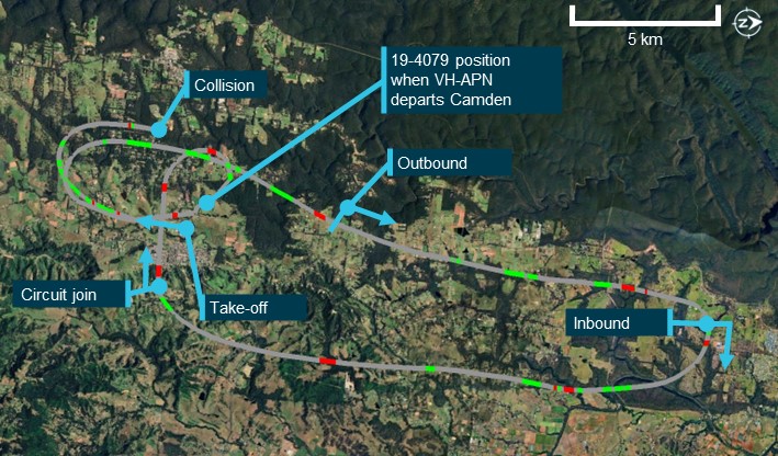
At 1124, around the same time that APN approached an inbound point for Camden Airport, video on board 4079 showed the aircraft rolling for take-off on runway 18 right (18R)[6] from The Oaks. The other Jabiru pilot recalled hearing a ‘rolling’ radio call from the pilot of 4079 around this time. Tracking data from the other Jabiru showed that this aircraft had departed about 30 seconds prior to 4079. At 1125, automatic dependent surveillance broadcast (ADS-B)[7] flight data showed 4079 on an initial climb from runway 18R. The flight data showed that the flight path was consistent with 4079 flying a right circuit for runway 18R or 18L and departing the aerodrome on the downwind leg in a northerly direction.
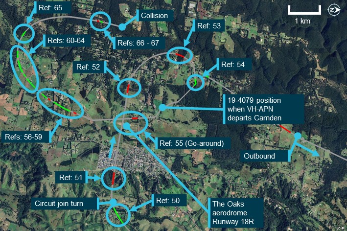
Figure 1: Flight paths of VH-APN, 19-4079 and accident location
Source: Google Earth and Geoscience Australia, annotated by the ATSB
19-4079 return to The Oaks aerodrome
At interview with the ATSB, the pilot of the other Jabiru flying to Cessnock reported that they decided to turn back due to experiencing turbulence. This pilot reported broadcasting that they were turning back to The Oaks on 2 frequencies, one corresponding to The Oaks CTAF (126.70) (The Oaks radio frequency) and another frequency that was pre-arranged for en route group chatter. Neither of the other pilots flying to Cessnock recalled hearing a broadcast from the pilot of 4079 in response. At 1133, the 4079 flight data showed that the aircraft started turning back towards The Oaks in a southerly direction. Due to the other Jabiru being further north, 4079 was ahead for the return to The Oaks.
During the return, the other Jabiru pilot recalled hearing the pilot of 4079 make a 7 NM (13.0 km) inbound call on The Oaks radio frequency. While inbound, this pilot also recalled hearing another call from an aircraft that was ‘really fuzzy’ and potentially related to another aerodrome. About 6 minutes after turning back, the flight data for 4079 showed that the aircraft had started a slow right turn to the west, and then tracked directly overhead The Oaks at about 1,800 ft. The other Jabiru pilot recalled hearing the pilot of 4079 broadcast that they were joining mid-field crosswind and observed the aircraft in that position. At this time, the other Jabiru pilot estimated that they were about 3 to 4 NM (5.6 to 7.4 km) behind 4079. At 1141, the ADS-B data showed 4079 crossing directly overhead The Oaks at about 1,900 ft before turning right and starting to descend.
The Sonex pilot reported hearing the pilot of 4079 broadcast that they were ‘established downwind for runway 18’. At 1142, the 4079 flight data and onboard video showed that the aircraft descended toward runway 18 left (18L). Around this time, the pilot of the other Jabiru recalled hearing the pilot of 4079 broadcast that they were on the base leg of the circuit. The track of 4079 was in a generally south‑easterly direction toward the threshold of runway 18L, however, instead of landing, the data showed the aircraft flying along the runway at about 100 ft.
Collision between VH-APN and 19-4079
At about 1143:30, shortly after APN departed the Camden Airport control zone, the onboard video and 4079 flight data indicated that the pilot of 4079 conducted a go‑around from runway 18L at The Oaks. The onboard video showed that the pilot of 4079 was transmitting a radio communication on The Oaks radio frequency. The Sonex pilot, who was in the run-up bay for runway 36, reported that they heard the pilot of 4079 transmit they were going around and observed 4079 from their position. Around this time, APN tracking data showed that this aircraft turned slightly right onto a track of 263° (true) while continuing to maintain about 1,250–1,350 ft.
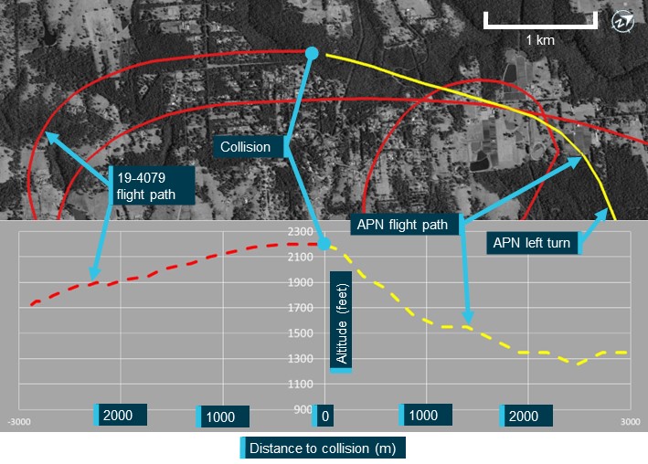
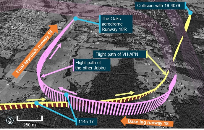
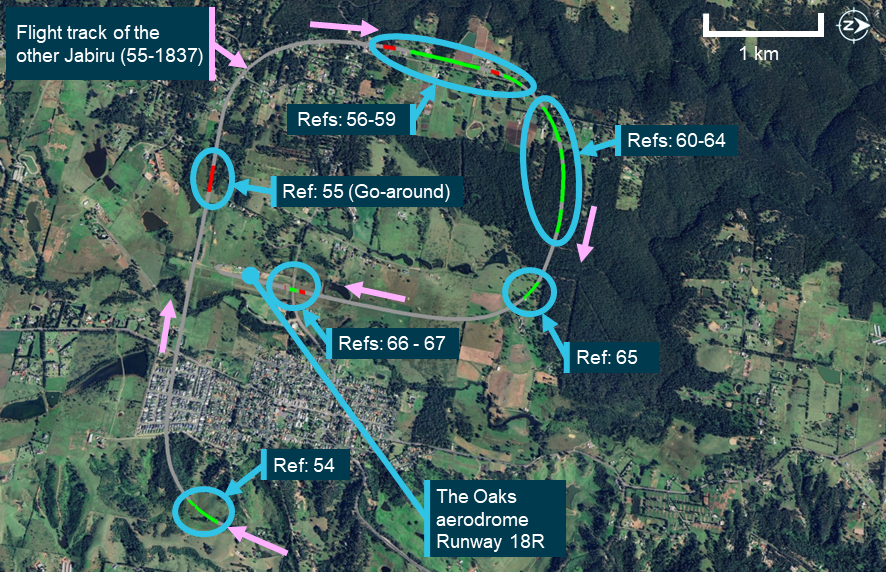
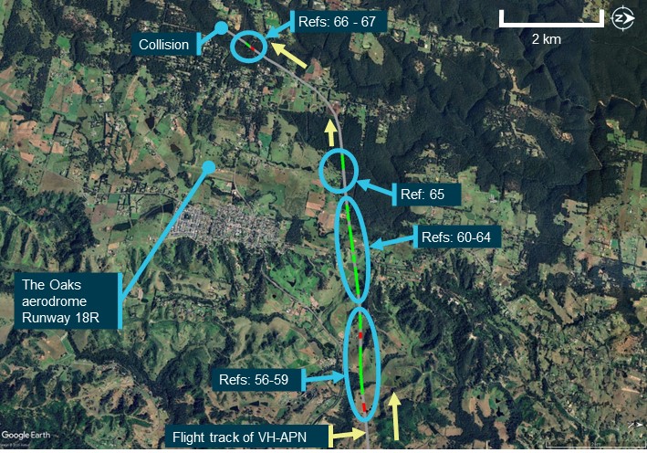
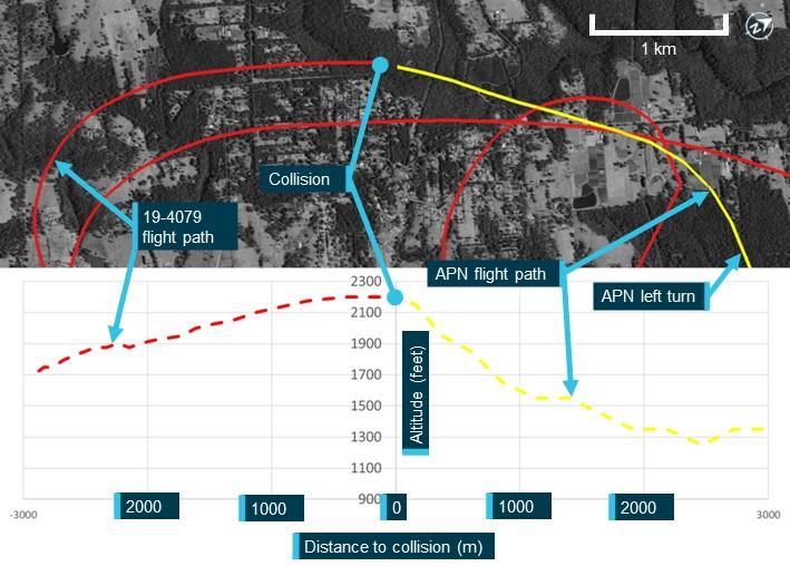
At 1144:47, the tracking data for the other Jabiru showed this aircraft had turned right base, with a spacing of about 1.1 NM (2.0 km) north of the runway 18R threshold. Neither the Sonex or other Jabiru pilot reported hearing any radio transmissions from APN that morning. At 1145:16, the 4079 flight data showed this aircraft in a right climbing turn at about 1,700 ft, and mid-way through an ovalised crosswind leg of the circuit for runway 18L or 18R. Around this time, tracking data for APN indicated that this aircraft was about 1.1 NM (2.0 km) from the runway 18R threshold, continuing to track at 263° at 1,250 ft. At 1145:34, as 4079 continued the right climbing turn, APN tracking data showed that a level left turn was conducted onto a heading of 209°. Shortly after this turn was completed, at 1145:54, APN started a straight, steady climb from 1,350 ft (Figure 2).
At 1146:00, 4079 completed the right turn onto a northerly heading. At 1146:26, the onboard video and tracking data showed 4079 leveling out at 2,200 ft, about 1.5 NM (2.8 km) from runway 18R. After this time, APN and 4079 were on relatively constant flight path trajectories for about 8 seconds, with APN captured by the onboard video of 4079 in the lower right quadrant of the windscreen.
The onboard video and tracking data showed that the aircraft collided at 1146:34 on near reciprocal headings. Following the midair collision, the left wings of both aircraft separated, with closed-circuit television footage from a nearby residence showing both aircraft descending steeply. Both aircraft were destroyed in the subsequent collisions with terrain. All 3 pilots were fatally injured.
Figure 2: Flight paths and vertical profiles of VH-APN and 19-4079 prior to the accident
Source: Google Earth and Geoscience Australia, annotated by the ATSB
Context
Pilot information
CPL candidate
The CPL candidate in APN held a private pilot licence (aeroplane) issued in 2021 and was issued a multi-engine class rating in May 2024. As part of the pilot’s pre‑licence test preparation, the pilot reported having a total of 237 flight hours. The pilot held a class 1 aviation medical certificate, with no restrictions, valid until 19 March 2025.
Flight test examiner
The flight test examiner in APN held an air transport pilot licence (aeroplane) issued in 1997 and a flight examiner rating for the commercial pilot licence (aeroplane). The examiner’s CASA record showed they had conducted a total of 868 flight examinations. Most of the examinations were multi‑engine instrument proficiency checks, with the first of these performed in June 2009. Notably, there were 14 examinations, for the issue of either commercial, private, or recreational flight crew licences. The examiner started conducting these tests in June 2018. Additionally, the examiner held a low-level rating (aeroplane) and low-level (aeroplane) training was included in their flight instructor rating.
On 16 May 2024, as part of their aviation medical examination, the pilot reported having a total of 25,214 flight hours. The pilot held a class 1 aviation medical certificate, with a requirement for reading correction to be available, valid until 16 November 2024.
Pilot of 19-4079
The pilot of 19-4079 held a Recreational Aviation Australia (RAAus) pilot certificate,[8] with a cross‑country endorsement issued in June 2023, which also satisfied the requirements of a biennial flight review. On 4 April 2024, the pilot reported to RAAus having a total of 168 flight hours. The pilot had submitted a medical declaration to RAAus on 19 June 2022.[9]
Aircraft information
VH-APN
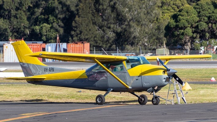
VH-APN (Figure 3) was a Cessna Aircraft Company 182P 4-seat, high‑wing (strut‑braced), single-engine aircraft equipped with a fixed tricycle landing gear. It had a Teledyne Continental Motors O-470 engine and was fitted with a McCauley 2-blade, constant‑speed propeller. APN was manufactured in the United States in 1976. It was placed on the Australian aircraft register that same year with a registration of VH‑RKC. The registration was changed to VH-APN in August 1996 and transferred to the current owner in 2021.
APN was painted in a yellow (wings) and grey (fuselage) livery. The aircraft was fitted with a mode A/C transponder and 2 very high frequency transceiver radios. It was not fitted with ADS-B, nor was this required.
Figure 3: VH-APN
Source: Supplied
19-4079
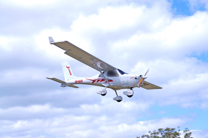
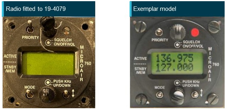
19-4079 (Figure 4) was a Jabiru UL 450 amateur-built high-wing (strut-braced) light aircraft with a fixed tricycle landing gear. It had a Jabiru 2200J, 4-cylinder engine. Construction of 4079 was completed in 2004 and it was placed on the RAAus aircraft register on 23 February 2004. The registration was transferred to the current owner in 2022. 4079 was painted white. The aircraft was fitted with one very high frequency radio and a SkyEcho II portable ADS-B transceiver.[10] It was not fitted with a transponder, nor was this required.
Figure 4: 19-4079
Source: Supplied
Meteorological information
The nearest available Bureau of Meteorology weather forecasts and observations to The Oaks was at Camden Airport.
At 1130, a routine report[11] of weather observations was issued for Camden Airport that reported light winds from a south-westerly direction (218° (magnetic) at 6 kt), with no cloud detected, visibility greater than 10 km, and the temperature was 18°C.
At 1154, following the accident, a special meteorological report[12] was published that showed light winds from the north-west (308° (magnetic) at 5 kt), visibility had reduced to 5 km in haze, no cloud was detected, and the temperature was 19°C.
The reported weather observations, which showed no cloud was detected, were consistent with the onboard video on 4079 (Figure 5). Additionally, at the time of the accident, the video did not show any notable reduction in visibility from any meteorological phenomena such as haze. Further, the Bureau of Meteorology weather observations at 1-minute intervals for Camden Airport showed that the visibility was greater than 10 km until shortly after the accident (at 1147) when it began slowly reducing.
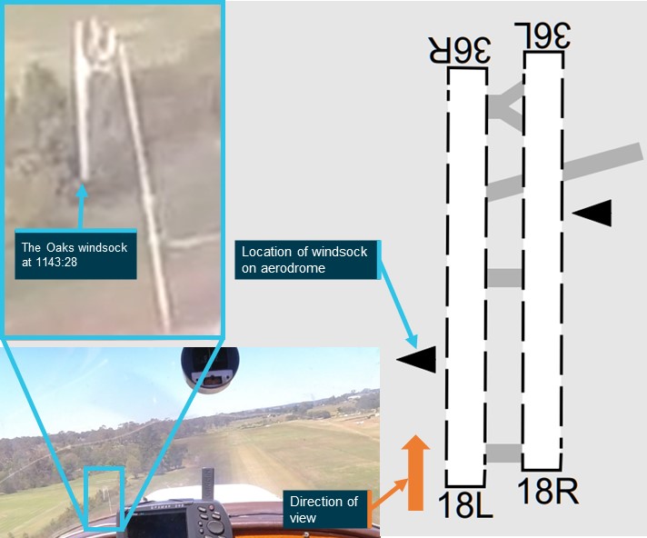
The onboard video from 4079 also showed that, during the go-around on runway 18R at about 1143, the northern airport windsock was facing east indicating that there was minimal wind (Figure 5).
Figure 5: The Oaks windsock at 1143:28
Source: Airservices Australia and ATSB
Aerodrome and airspace information
The Oaks aerodrome
The Oaks aerodrome was a non-controlled aeroplane landing area,[13] located 7 NM (13 km) west‑south-west of Camden Airport. It had an elevation of 880 ft above mean sea level and 2 parallel grass runways aligned in a north-south direction. Runway 18R/36L was 900 m long, while runway 18L/36R was 800 m. All circuits were conducted to the west of the aerodrome to avoid overflying the township of The Oaks. The Oaks utilised the shared CTAF designated radio frequency of 126.7.
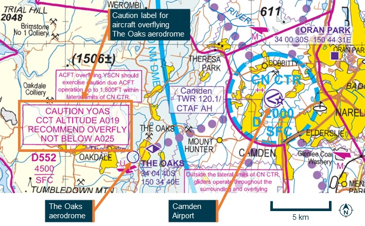
An icon and label for The Oaks aerodrome was published on all visual aeronautical charts. Additionally, a caution label, surrounded by a red box adjacent to The Oaks on the visual terminal chart stated:
CAUTION YOAS CCT ALTITUDE A019 RECOMMEND OVERFLY NOT BELOW A025
The caution label indicated to pilots that the potential circuit altitude for aircraft flying at The Oaks was up to 1,900 ft above mean sea level and recommended that they overfly the aerodrome above 2,500 ft.
Figure 6 is an extract of the visual terminal chart for Sydney showing the relative locations of The Oaks aerodrome and Camden Airport, and the caution placard.
Camden Airport
Camden Airport was a certified aerodrome with an elevation of 230 ft above mean sea level. The main runway, 24/06, was paved. Camden Tower had a part time control tower providing an air traffic control service in the surrounding class D airspace during operating hours. During the accident flight, the tower was active, with communications on the radio frequency 120.1. The class D airspace extended in a 2 NM (3.7 km) radius around the airport, represented by the blue dashed circle on Figure 6.
Figure 6: Extract of Sydney visual terminal chart dated 13 June 2024 showing The Oaks aerodrome and Camden Airport
Source: Airservices Australia, annotated by the ATSB
Airspace information
The accident flights were mostly conducted outside controlled airspace, designated as class G airspace. APN also operated in class D airspace while the aircraft was within 2 NM (3.7 km) of Camden Airport.
Airservices Australia’s Aeronautical Information Publication (AIP) ENR 1.6 – 7.1.4 required civil aircraft flying in class D airspace to set their transponder code to 3000. When operating in class G airspace, the AIP required pilots to set their transponder code to 1200.
The area extending beyond 2 NM (3.7 km) from Camden in the direction of The Oaks aerodrome was class G airspace below 4,500 ft above mean sea level.[14]
After leaving controlled airspace, such as when APN departed Camden class D airspace, pilots need to decide what radio frequencies will be required for future transmissions and what frequencies they should maintain a listening watch on. One of the frequencies in the area between Camden and The Oaks was the Sydney Centre area very high frequency, 124.55. This frequency was used by Airservices Australia to provide air traffic services. Additionally, pilots may broadcast their intentions on this frequency to assist with maintaining traffic separation.
Recorded information
Data sources
Neither aircraft was equipped with a flight data recorder or cockpit voice recorder, nor were they required to be. Broadcasts made on The Oaks CTAF were not recorded. The following data sources have been used for this investigation:
ADS-B data from 4079
ATC audio data for APN
CTAF audio data from Shellharbour Airport for APN
closed-circuit television footage from a nearby residence showing post‑collision dynamics
data transmitted/recorded from devices running electronic flight bag applications for APN, 4079 and 55-1837
transponder data for APN.
Transponder data
Transponder data for APN showed that the code was changed from 1200 to 3000 when the aircraft was approaching the Camden class D control zone. The transponder code continued to transmit on code 3000 until the collision.
19-4079 onboard video camera
4079 was fitted with an onboard video camera that was attached to a roof panel inside the cabin. The ATSB recovered the camera at the accident site, which was downloaded at the ATSB’s technical facility in Canberra. Initial observations from the video included:
the aircraft had no evident technical problems during the flight
the radio was selected to the frequency 126.7 at the time of the accident
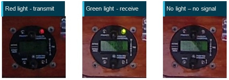
lights on the radio, along with the push-to-talk button on the control yoke, indicated the pilot was transmitting and receiving radio calls during the flight
4079 and APN were both on relatively constant trajectories, with 4079 being straight and level and APN climbing at the time of the collision, with no avoiding action evident by either pilot
the aircraft were travelling on a generally reciprocal heading, impacting on the left side of each aircraft, with the fuselage of 4079 passing underneath the left wing of APN.
Wreckage and impact information
Wreckage location
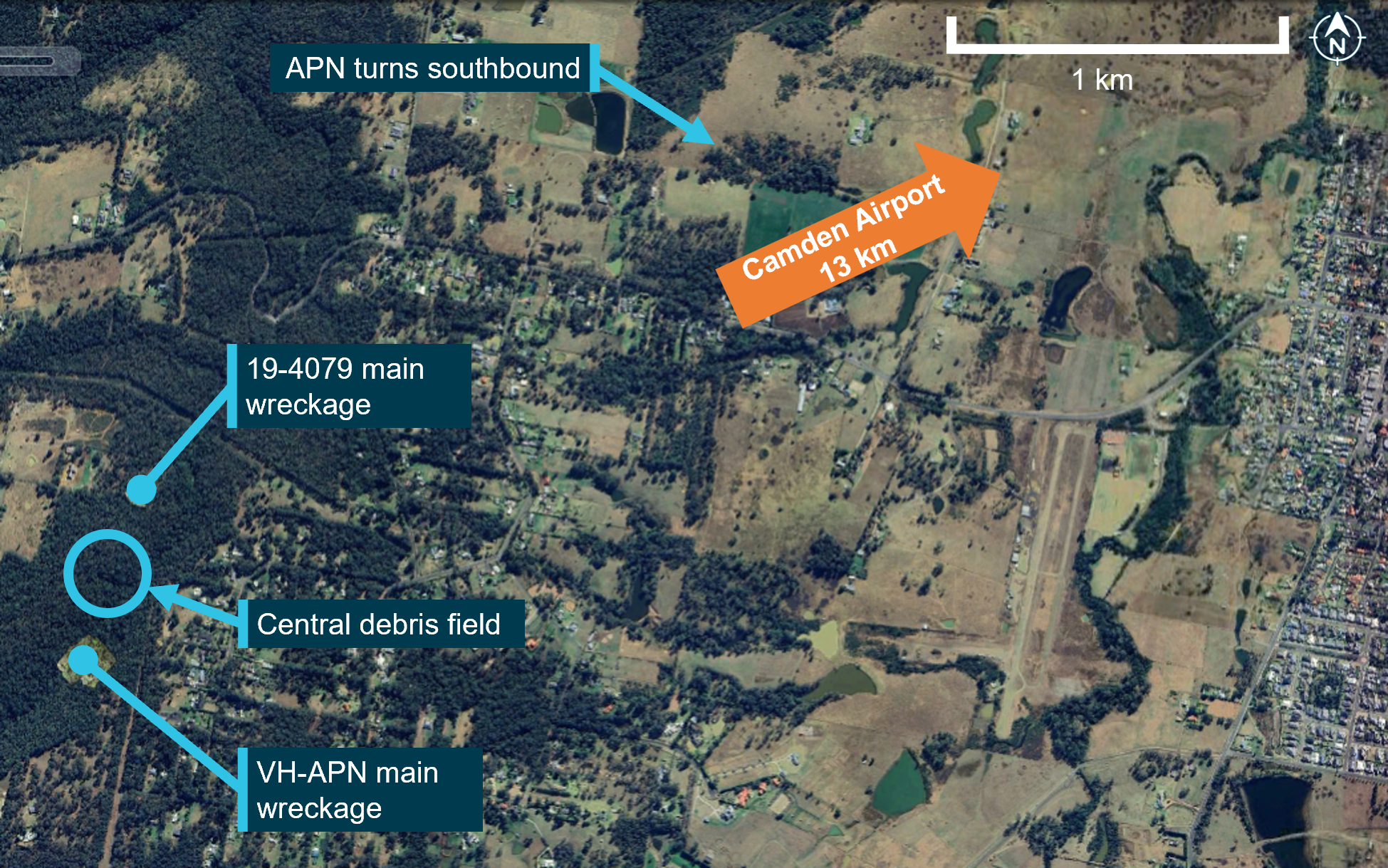
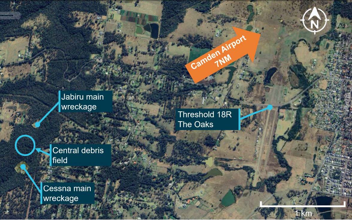
The accident site was located about 2.7 km west of The Oaks aerodrome in heavily treed terrain. The 2 primary wreckage locations were approximately 520 m apart, with 4079 north of APN (018º true) (Figure 7). A debris field was located about halfway between the 2 main wreckage locations. Most wreckage items found in the central area were from the left wing of 4079, with a small number of components from APN. Most of the central wreckage was found within a radius of about 50 m.
Figure 7: Accident site location in relation to The Oaks
Source: Google Earth, annotated by the ATSB
Orientation of 19-4079 and VH-APN during the collision
Yellow paint was found on portions of the left wing and left-wing strut of 4079, consistent with being transferred from APN.These areas of the left wing of 4079 also showed signs of leading‑edge penetration to about halfway through the wing chord, at about the mid‑span position.
The left-wing strut of APN was found near the main wreckage of APN, consistent with being attached to this aircraft at the time of the collision with terrain. White paint was found in 2 places of this strut, with leading edge damage observed in these areas, consistent with being transferred from the left wing and left-wing strut of 4079.
A relatively small dent with light‑coloured paint transfer was located on the leading edge of APN’s left wing, with a longitudinal light-coloured paint transfer on the underside of the wing around this location. The relative orientation of the frontal left wing and left-wing strut damage on 4079 and left-wing strut damage on APN, was consistent with 4079 being upright during the collision. Based on the geometry of 4079, the coloured paint transfer on the underside of the left wing of APN was likely from the upper vertical fin section of 4079. The fin likely separated from the aircraft after being struck by the left wing of APN in the location of the light-coloured paint. The upper vertical fin section of 4079 was not located.
In summary, the paint transfer marks, and damage observed on site was consistent with APN and 4079 colliding on the left sides of each other on near reciprocal headings. The left wing and left-wing strut of 4079 primarily impacted the left strut of APN, and the upper fin of 4079 subsequently striking the left-wing leading edge of APN.
19-4079 wreckage
Examination of the main wreckage site and surrounding broken tree branches for 4079 indicated that the aircraft had impacted the ground at a steep angle, with little forward movement, resulting in a localised wreckage field. The ATSB inspection found no evidence of pre-accident flight control damage.
All of the aircraft was accounted for, excluding a section of the outboard left wing, and the upper vertical fin. An aileron fitting for 4079 was co-located with the left wing of APN.
VH-APN wreckage
Witness marks in surrounding trees showed that APN impacted terrain in a steep nose down attitude. There was a significant post-impact fire at the primary wreckage site, which limited the ATSB’s ability to examine the wreckage. The inspection of the available evidence did not identify any pre-accident flight control damage. The left wing of APN was located about 50 m from the main wreckage, consistent with this wing separating in‑flight during the accident sequence.
Operations around non-controlled aerodromes
See-and-avoid principles
The Oaks was a non-controlled aerodrome, where separation was maintained by ‘alerted see‑and-avoid’ principles guided by CASA advisory circulars AC 91‑10 Operations in the vicinity of non-controlled aerodromesand AC 91-14 Pilots’ responsibility for collision avoidance. These stated that pilots should broadcast position and intention information so that nearby traffic would have an awareness of the aircraft and be able to plan accordingly.
AC 91-14 also highlighted the ineffectiveness of pilots relying solely on visually detecting other aircraft that are on a conflicting flight path, referred to as ‘unalerted see-and-avoid’. It noted increased traffic density as one of the factors increasing the risk of collision, necessitating a pilot using ‘alerted see-and-avoid’ principles. Airspace in the vicinity of non-controlled aerodromes has a higher traffic density. The primary tool of alerted see‑and-avoid is radio communications that enhance pilot situational awareness.
Operations in the vicinity of non-controlled aerodromes
The AIP provided guidance for pilots flying in the vicinity of non-controlled aerodromes. The vicinity of non-controlled aerodromes was defined as a distance of 10 NM (19 km) horizontally and within a height above the aerodrome that could potentially result in conflict. It recommended that aircraft transiting in the vicinity should avoid flying over the aerodrome at an altitude that could result in conflict with operations, including the circuit area and the arrival and departure tracks.
Additionally, the CASA Civil Aviation Advisory Publication (CAAP) 166(3) outlined hazardous zones for operations near non-controlled aerodromes, including:
- The most hazardous area for collisions is within a space bounded by a cylinder of airspace 5 NM [9 km] in diameter and up to 3,000 ft above aerodrome elevation.
- Most collisions occur on downwind or on final approach. There are many distractions during this time, including configuring the aircraft, completing checklists, setting equipment and communicating...
When APN departed Camden controlled airspace, it was approximately 5 NM (9 km) from The Oaks aerodrome, already within the vicinity of the aerodrome and within the recommended 10 NM (19 km) inbound broadcast location.
Circuit pattern
A circuit is an established procedure for arriving and departing aerodromes. They assist pilots with configuring and positioning the aircraft to make a stabilised approach to the runway in use. A circuit when flown in its entirety includes upwind, crosswind, downwind, base, and final legs. When arriving and departing a non-controlled aerodrome, CASA recommended pilots join the circuit area via the methods highlighted in blue in Figure 8.
The key recommended methods to join the circuit depicted (Figure 8):
Overflying the aerodrome more than 500 ft above the circuit height before descending on the side not being used and joining the circuit over the middle of the runway (midfield crosswind).
Joining the circuit at circuit height on the downwind leg (including joining at 45° in the middle of the downwind leg).
CASA did not recommend joining the circuit on base or a 3 NM (5.6 km) straight in approach.
Figure 8: Circuit join methods with recommended circuit joins highlighted in blue
Source: Civil Aviation Safety Authority
Circuit procedures are well established, and pilots learn the circuit terminology during their early training. This allows them to know where to look when they hear a broadcast, which includes a certain leg of the circuit. Pilots should broadcast their position and intentions on the local radio frequency to assist other pilots with alerted searching.[15] Additionally, pilots can use the ‘look, talk, and turn’ strategy, which involves the pilot checking for traffic, making the broadcast and then carrying out the turn (AC 91-10). Other pilots in the area will hear the broadcast, know where to look, and will have an increased chance of visually acquiring the aircraft while it has the most surface area visible during a turn.
The CASA CAAP 166-2 Pilots’ responsibility for collision avoidance in the vicinity of non‑controlled aerodromes noted that variations in the recommended circuit join may increase the risk of collision. Additionally, climbing and descending in the circuit area was not recommended as visual acquisition of traffic could be difficult:
An aircraft (a small one in particular) will often be rendered difficult to see by the patterns in the surface of the earth when viewed from above, and particularly when over urban areas. Conversely, an aircraft when viewed from below can potentially be much more easily seen against a uniformly overcast cloud background or blue sky. All pilots would be aware of the difficulty seeing aircraft that have the sun directly behind them.
Circuit area
The size of a circuit area was not explicitly defined in Australian legislative instruments, procedures or guidance. However, various technical publications refer to distances from and heights above runways in certain operational circumstances. The Airservices Australia AIP stated that aircraft would normally be outside the circuit area when at least 3 NM (5.6 km) from the departure end of the runway, while the United States Federal Aviation Administration’s Airplane Flying Handbook defined the downwind leg of the circuit as a track approximately 1 NM (1.9 km) parallel to the intended landing runway.
Designated airspace in aeronautical charts showed airports with air traffic control towers had airspace reserved (control zones), to be used only by aircraft operating within the circuit. For Camden Airport, the control zone extended 2 NM (3.7 km) from the aerodrome reference point,[16] and is shown by the dashed-blue circle in Figure 6. In many other cases, control zones extended up to 3 NM (5.6 km) from the reference point.
The FAA’s Airplane Flying Handbook stated that, for a typical piston aircraft, a standard final approach would result in a 3° approach angle. Additionally, CASA required aircraft to be established on the final leg, no lower than 500 ft above ground level. To achieve a 3° approach angle, the aircraft would need to be positioned at 500 ft at approximately 1.5 NM (2.8 km) from the runway threshold. However, the AIP stated:
9.2.5 Pilots may vary the size of the circuit depending on:
(a) the performance of the aircraft;
(b) safety reasons; or
(c) in accordance with the Aircraft Flight Manual, Pilot’s Operating Handbook, or company Standard Operating Procedures.
The height at which the circuit legs are flown is dependent on aircraft performance. The AIP section 9.6.1 stated for medium performance aircraft, like APN and 4079, the standard circuit height was 1,000 ft above the aerodrome elevation. At The Oaks, this equated to 1,900 ft above mean sea level. As noted in the section ‘Circuit pattern’ above, aircraft may be joining the circuit at a height at least 500 ft above the circuit height. In this case, at The Oaks up to 2,400 ft above mean sea level. This is also highlighted in the caution label on the visual terminal chart for The Oaks (Figure 6), with a recommended minimum overfly height of 2,500 ft above mean sea level.
Based on this, the area where medium performance aircraft could be expected in The Oaks circuit ranged from overhead to a distance up to 3 NM (5.7 km) from the runway, and up to at least 1,500 ft above the aerodrome or 2,400 ft above mean sea level.
Circuit direction
A circuit is typically conducted to the left side of the runway in use and involves the aircraft making left turns (Figure 8), which assists the pilot who is normally sitting in the left seat to keep the runway in sight. However, some aerodromes such as The Oaks runway 18L and 18R had local procedures that required pilots to fly circuits to the right side of the runway in use and make right turns. Aerodromes where right circuits were required are listed in the En Route Supplement Australia.[17]
At non-controlled aerodromes, the runway in use was determined by pilots using the aerodrome. The runway selected should be the runway that was most closely aligned into wind and was serviceable. Pilots wishing to use a different runway for operational reasons were required to do so without conflicting with other aircraft using the most into wind runway.
At the time of the accident, the windsock at The Oaks was facing east and indicating minimal wind, so the wind direction did not favour any particular runway. Runways 18L and 18R were being used by 4079 and the other Jabiru.
Radio communications
Aircraft operating in the vicinity of a non-controlled aerodrome were required to make broadcasts on the aerodrome frequency whenever reasonably necessary to do so to avoid a collision (AIP 9.1.4). On receiving a broadcast of a potential conflict, a pilot was required to respond by transmitting their own callsign and, as appropriate, aircraft type, position, actual level and intentions. Additionally, when making a standard broadcast pilots should also address the station (location) being called.
While CASA did not require any additional broadcasts, the AIP did recommend pilots make broadcasts as detailed in Table 1.
Table 1: Recommended broadcasts at non-controlled aerodromes
Recommended calls in all circumstances
Situation
Broadcast
The pilot intends to take-off
Immediately before, or during taxi
The pilot is inbound to an aerodrome
10 NM [18.5 km] from the aerodrome or earlier, commensurate with aeroplane performance and pilot workload, with an estimated time of arrival (ETA) for the aerodrome
The pilot intends to fly through the vicinity of, but not land at a non-controlled aerodrome
10 NM [18.5 km] from the aerodrome or earlier, commensurate with aeroplane performance and pilot workload, with an estimated time of arrival
Recommended calls dependant on traffic
The pilot intends to enter a runway
Immediately before entering a runway
The pilot is ready to join the circuit
Immediately before joining the circuit
The pilot indents to make a straight-in approach
On final approach at not less than 3 NM [5.6 km] from the threshold
The pilot intends to join base leg
Prior to joining on base
Proximity between APN and the other Jabiru
APN tracked from Camden in a westerly direction towards The Oaks and entered the circuit area of The Oaks at low level. At the time there were 2 aircraft conducting circuits to land, 4079 and the other Jabiru (55-1837).
At 1143:07, the other Jabiru passed overhead runway 18L, entering the circuit area at about 1,900 ft. At 1145:00, the other Jabiru had completed a right turn onto the base leg for runway 18R and was descending through about 1,800 ft to land, heading in an easterly direction. At the same time, tracking data showed APN at about 1,350 ft and tracking in a westerly direction, on a near-reciprocal heading to the other Jabiru. At 1145:17, tracking data indicated the other Jabiru passed 375 m in front of and about 400 ft above APN. The position of each aircraft at that time is shown in Figure 9.
The pilot of the other Jabiru stated they did not see APN nor were they aware APN was in the area until after the collision with 4079.
Figure 9: Flight tracks of VH-APN and the other Jabiru (55-1837)
Source: Google Earth and ATSB
Radio communications
Radio communications from several sources were evaluated and combined to produce a detailed timeline. These included witness statements, the onboard video recording from 19-4079, flight tracking data, and available CTAF and ATC recordings. This section reviews the recorded data and interview recollections relating to radio communications by the pilots of APN, 4079, the other Jabiru and the Sonex during the accident flights.
The purpose of this section is to provide context about the effectiveness of radio communications between each aircraft involved.
Overview of radio communications during flight of 19-4079
The ATSB evaluated the recollections of the other Jabiru and Sonex pilots who were operating in the vicinity of The Oaks during the flight of 4079. The accounts were largely consistent, although there were some differences in recollection of radio call sequences. For some parts of the flight, each pilot remembered different aspects, which is considered normal. Where there were discrepancies, these were considered in relation to each other and the recorded data to determine the likely order and content of transmissions.
The onboard video showed transmissions being made and received by 4079 throughout the flight on The Oaks radio frequency (CTAF) and the pre-arranged group chatter frequency. Both pilot witnesses reported hearing radio calls from the pilot of 4079 throughout the flight. The method to identify the type, frequency, time and duration of these transmissions is documented in Appendix – Radio transmissions captured by 19‑4079.
The flight track of 4079 was synchronised with the radio transmission data from the onboard video, and this is shown in (Figure 10). The red coloured parts of the track show the position of 4079 when the pilot was transmitting and the green shows the locations of 4079 when receiving radio calls. The grey parts of the track show the locations when no radio transmissions were made or received by 4079. For context, Figure 10 also contains labels for key parts of the flight for 4079 that are cross-referenced in figures for orientation and discussed in the text below.
Figure 10: Flight track showing the position of 19-4079 when no transmission was detected (grey lines), and when radio calls were transmitted (red lines) and received (green lines) by 19-4079 during the accident flight
Source: Google Earth and ATSB
19-4079 departure and return to The Oaks aerodrome
Turn back call
When the decision was made to return to The Oaks, the other Jabiru pilot reported broadcasting this intention on both the CTAF and group chatter frequency. However, neither the other Jabiru or Sonex pilots heard a response, or a similar call from the pilot of 4079. As such, the ATSB evaluated the most plausible reason why both pilot witnesses did not hear the pilot of 4079 respond to the other Jabiru pilot’s decision to turn back.
The evaluation of the video evidence showed the pilot of 4079 receiving a call on the CTAF frequency, which was likely the turn back discussion. After this, the pilot of 4079 broadcast a transmission on the group chatter frequency, which may not have been monitored by the other pilots at that time. The timing of this transmission also aligned with the turn back of 4079, as shown by the recorded data.
Inbound call
The onboard video and tracking data showed that the pilot of 4079 made a transmission when 7 NM (13 km) from The Oaks on the CTAF. This was consistent with the recollection of the other Jabiru pilot who recalled hearing 4079 make an inbound call on The Oaks frequency.
Unintelligible call
When they were about 3–4 NM (5.6–7.4 km) from The Oaks, the other Jabiru pilot reported hearing a ‘really fuzzy’ radio call on CTAF. This transmission was correlated on the video recording with a 10.6 second radio transmission that was received by 4079 on the CTAF. At the same time as this transmission, flight data indicated APN was on the base leg of a touch-and-go at Camden Airport. As APN would have been on the Camden Airport frequency, the fuzzy call on the CTAF was not likely to be APN.
Communications on The Oaks frequency prior to the collision
While the likely content of each transmission was evaluated for the entire flight of 4079, a particular focus was during the period from 4079 joining the circuit for runway 18L or runway 18R on a mid-field crosswind leg until the collision with APN. The results of this evaluation are detailed in Table 2, Figure 11, Figure 12 and Figure 13.
Table 2details the time and duration of all radio transmissions received by 4079 based on the examination of the video, with the reference numbers correlating with reference numbers in Table A2 of the Appendix. The likely information communicated by each pilot on The Oaks frequency were estimated based on the combined analysis of the onboard video, tracking data and accounts from the 2 witness pilots. The results of this evaluation, including the relevant aircraft location are shown in the 2 right-most columns of Table 2.
The tracks of each aircraft in the circuit area of The Oaks with radio transmissions overlaid are shown in Figure 11 for 4079, Figure 12 for the other Jabiru and Figure 13 shows APN in proximity to the other Jabiru. These figures show the same type of information as Table 2, with colours of the tracks corresponding to transmissions by the pilot of 4079 in red, transmissions received in green, and no transmissions on frequency in grey. Transmissions are numbered sequentially in the direction of flight and correspond to rows in Table 2 and Table A2 of Appendix A. All transmissions during this phase of flight were on The Oaks frequency.
Table 2: Timing and duration of radio transmissions longer than 0.1 seconds, sent and received by the radio fitted to 19-4079 from when 19-4079 tracked west for a mid-field crosswind circuit join, combined with the likely content of transmissions
Reference number
Time (local)
(Duration in seconds)
Transmission type
Relevant aircraft location
Likely transmission content
1140:15
19-4079 tracks west for a mid-field crosswind circuit join
4079 tracking west about 1 NM (1.9 km) from The Oaks
4079: Midfield crosswind join
52
1141:16.4
(5.3)
Transmit
Just prior to 4079 turning north
4079: Downwind call
53
1141:57.5
(6.0)
Transmit
Just prior to 4079 starting to turn to the east
4079: Base call
54
1142:21.3
(6.0)
Receive
Other Jabiru turned west 1 NM (1.9 km) from The Oaks
Other Jabiru: Mid-field join
1142:59
VH-APN departs Camden airspace
55
1143:20.5
(4.6)
Transmit
4079 track aligned to runway 18L
4079: Go-around call
56
1144:09.7
(2.3)
Transmit
4079 passed the end of the runway and was climbing
4079 and Sonnex pilots discuss a possible runway change.
The pilot of 4079 called them on the radio, asking if it would be okay to land on runway 36. The Sonex pilot recalled broadcasting that the very light wind would allow 36 to be used, but that others (specifically the other Jabiru pilot) were using runway 18.
57
1144:14.7
(13.3)
Receive
4079 beginning crosswind turn
(other Jabiru on downwind)
58
1144:30.4
(1.8)
Transmit
4079 crosswind
(other Jabiru on downwind)
59
1144:33.1
(4.4)
Receive
Other Jabiru about to turn onto base
Other Jabiru: Base for a full stop landing on runway 18R.
Exchange between the Sonex and other Jabiru pilots: Sonex pilot had both 19-4079 and other Jabiru in sight and that it would be safe for other Jabiru to land.
(See section Evaluation of radio calls after go-around of 4079 for the assessment of calls references 59-64).
60
1144:43.5
(8.0)
Receive
4079 crosswind (Figure 11)
Other Jabiru on base (Figure 12)
Sonex on the ground
APN tracking west between 1-2 NM (1.9-3.7 km) from The Oaks (Figure 13)
61
1144:53.0
(2.2)
Receive
62
1144:56.2
(8.1)
Receive
63
1145:05.9
(2.2)
Receive
64
1145:08.4
(2.4)
Receive
65
1145:22.0
(4.5)
Receive
Other Jabiru turning onto final approach
Other Jabiru: Finals call for runway 18R
66
1146:15.6
(1.5)
Transmit
4079 mid-downwind
Other Jabiru close to runway 18R threshold
4079: Lost sight of the other Jabiru
67
1146:17.8
(1.6)
Receive
Other Jabiru: On short final for runway 18R
1146:34.0
Collision between VH-APN and 19-4079
Figure 11: Flight track showing the position of 19-4079 with no transmission was detected (grey lines), and when radio calls were transmitted (red lines) and received (green lines) by 19-4079 after returning to The Oaks to the collision
Source: Google Earth and ATSB
Figure 12: Flight track of the other Jabiru, showing positions with no transmissions detected (grey lines), and when signals were transmitted (red lines) and received (green lines) by 19-4079 after returning to The Oaks to the collision
Source: Google Earth and ATSB
Figure 13: Flight tracks of VH-APN and the other Jabiru, showing where no transmissions were detected (grey lines), and when signals were transmitted (red lines) and received (green lines) by 19-4079 after returning to The Oaks to the collision
Source: Google Earth and ATSB
Evaluation of radio calls after go-around of 4079
As 4079 was on the upwind and crosswind legs, 3 groups of transmissions occurred, with references 56–59, 60–64 and 65 in Table 2 and Table A2, and aircraft positions circled in Figure 11, Figure 12 and Figure 13. Around this time, the 2 pilot witnesses both recalled 3 communications exchanges, specifically:
an exchange between the pilot of 4079 and the Sonex pilot about changing the runway direction
a base turn call by the pilot of the other Jabiru
an exchange between the Sonex pilot and the other Jabiru pilot about the separation between 4079 and the other Jabiru.
As these communications occurred shortly prior to the collision, each of the 3 recalled communications exchanges, and radio calls until the final transmission by the other Jabiru pilot are discussed below.
Broadcasts about changing the runway
At 1144:04, the 4079 flight data indicated that the aircraft had passed the end of the runway and was climbing following the go-around. Five seconds later, a short 2.3 second radio call was broadcast by the pilot of 4079, followed by a 13.3 second broadcast received and another 1.8 second transmission by the pilot of 4079, with about 2‑second gaps in between transmissions (Figure 11 and Table 2 references 56-58). This was consistent with the Sonex pilot reporting that, as 4079 turned onto the crosswind leg of the circuit for runway 18R, the pilot of 4079 called them on the radio asking if it would be okay to land on runway 36. The Sonex pilot recalled broadcasting that the very light wind would allow runway 36 to be used, but that others (specifically the other Jabiru pilot) were using runway 18. The Sonex pilot noted that this was their last interaction with the pilot of 4079.
Broadcast as the other Jabiru turned onto base
At 1144:33, flight tracking data showed that the other Jabiru had just started to turn onto the base leg for runway 18R. The Sonex pilot recalled that, immediately after the previous radio exchange with the pilot of 4079, the other Jabiru pilot broadcast that they were on base for a full stop landing on runway 18R. This account aligned with the onboard video, which showed a 4.4 second radio call made at this time (Table 2, Table A2 and Figure 12 reference 59),[19] which was about one second after the broadcast by the pilot of 4079, likely regarding a potential runway change (Table 2 reference 58) .
The pilot of the other Jabiru recalled that their call on base was prior to the discussion about changing runway, but noted that they were not ‘really paying attention’ due to them being confident that no conflict existed between them and 4079. However, flight tracking data showed that the other Jabiru was still on the downwind circuit leg during the first 3 calls in this group (references 56–58 in Figure 12). Additionally, the pilot of 4079 made the first transmission in this group (reference 56 in Table 2), very likely about the runway change. Therefore, based on the factors discussed, it was considered more likely that the base call by the other Jabiru pilot occurred after both transmissions from the pilot of 4079.
Broadcasts about separation between 19-4079 and the other Jabiru
At 1144:44, about 5 seconds after a previous transmission, another 5 radio calls were received on The Oaks frequency over the next 30 seconds, with 2 radio calls being about 8 seconds long and 3 under 2.5 seconds (Table 2 references 60-64). During this time, flight tracking data showed that 4079 was on an ovalised crosswind leg (Figure 11 references 60-64), and the other Jabiru was on the base leg (Figure 12 references 60‑64), both for runway 18L or runway 18R.
The flight tracking and radio transmission data was consistent with the account of the Sonex pilot who reported that, after the base call by the other Jabiru pilot, they responded over the radio saying that they still had 4079 in sight and that the other Jabiru pilot would be safe to land. The Sonex pilot recalled the last time they saw 4079 was climbing to the west as 4079 was on the crosswind leg.
The other Jabiru pilot also recalled the Sonex pilot broadcasting that they could see both the other Jabiru and 4079 and that they were well separated. In contrast, the other Jabiru pilot recalled this communication occurring when they were on short final. Based on the available evidence, it was considered more likely that the exchange over the radio between the Sonex pilot and the other Jabiru were communications with reference 60–64 as listed in Table 2. This was as the other Jabiru was on the base leg (Figure 12) and 4079 was still in sight of the Sonex pilot on the crosswind leg (Figure 11).
The other Jabiru turns onto final approach
Although not mentioned explicitly during interview, the other Jabiru pilot stated that at The Oaks, they mainly only make base and final calls, indicating that these calls were normally performed. This was consistent with a transmission received by 4079 as the other Jabiru started to turn onto final (Figure 12 and Table 2 reference 65).
Communication between 4079 and the other Jabiru on short final
The onboard video showed the pilot of 4079 looking outside forward and to the right while transmitting over the flight radio on The Oaks frequency (Table 2 reference 66). The pilot of the other Jabiru recalled that the pilot of 4079 broadcast that they had lost sight of the other Jabiru. Tracking data showed that the other Jabiru was close to the threshold of runway 18 and 4079 was in the mid-downwind position at this time, with the pilot recalling that they responded via radio to say that they were on short final (for runway 18) (Table 2 reference 67). The relative positions of 4079 and the other Jabiru during these radio calls (references 66 and 67) are shown in Figure 10 and Figure 11. Following this exchange, the pilot of 4079 tapped the broadcast button twice (less than 0.1 seconds), consistent with acknowledging the transmission by the other Jabiru pilot. This was the last radio communication captured by the onboard video.
Breaks in transmissions
Broadcasts on The Oaks frequency after APN departed from Camden were arranged in groups of calls when there was less than 3 seconds between transmissions. The purpose was to characterise notable periods without transmissions where there may have been an opportunity for radio calls to be made by other aircraft if they were on the CTAF. The results of this grouping are shown in Table 3.
There were 2 notable periods of more than 40 seconds where there were no recorded transmissions:
Between the transmission coinciding with the go-around of 4079 and the subsequent transmission, starting at 1143:25.1 and shown by the grey track between references 55 and 56 in Figure 11, Figure 12 and Figure 13.
Following a transmission coinciding with the other Jabiru turning onto final approach until the final transmission by 4079 when on mid-downwind (between references 65 and 66 in Figure 11, Figure 12 and Figure 13).
Table 3: Broadcast and non-broadcast periods captured by the onboard video on 4079 radio on The Oaks frequency between APN departing Camden airspace until the collision
Start time (local)
Elapsed time (seconds)
Reference numbers
Transmissions received by 4079
Transmissions sent by 4079
1142:59
21.5
-
No transmissions (APN leaves Camden)
1143:20.5
4.6
55
0
1
1143:25.1
44.6
-
No transmissions
1144:09.7
27.8
56-59
2
2
1144:37.5
6.0
-
No transmissions
1144:43.5
27.3
60-64
5
0
1145:10.8
11.2
-
No transmissions
1145:22.0
4.5
65
1
0
1145:26.5
49.1
-
No transmissions
1146:15.6
3.8
66-67
1
1
1146:19.4
14.6
-
No transmissions until collision
1146:34.0
-
-
Collision
Radio communication information for VH-APN
This section examines recorded radio calls broadcast by APN from the initial contact with Camden Tower through to the collision. A total of 14 calls were recorded on the radio frequency for Camden Tower (120.10). No calls by APN were recorded after the aircraft departed Camden airspace on the Sydney area frequency (124.55), noting that transmissions were not recorded on The Oaks CTAF.
The last recorded transmission for APN occurred at 1138.36 with APN reading back the clearance for a touch-and-go on runway 24 for an upwind departure from Camden Airport.
The ATSB performed a qualitative assessment of the radio transmissions recorded for APN during the accident flight. The assessment was based on the ‘Plain-Language Radio Check Procedure Words’ (prowords) described in ACP 125(G).[20]An ATSB evaluation of the recorded radio transmissions made by APN indicated the signal strength was between good and loud and the signal readability was between readable and clear. This equated to a minimum score of 4 out of 5 on the assessment scales, with every recorded message able to be determined.
The ATSB also assessed the approximate range of APN from ground-based recording stations. The largest distance between APN and a ground-based station was at 1124:42, as APN approached Camden Airport. In the following 30 seconds, APN was transmitting and receiving radio calls to and from Camden Tower. The distance between APN and Camden Tower during this time was between 6 NM (11.1 km) and 7 NM (13.0 km). For these radio calls, the time between APN receiving a message from Camden Tower and responding was less than 1 second, with the readback of all instructions being accurate and correct. Therefore, from the available evidence, the radio fitted to APN was likely to be operational leading up to the accident.
Terrain shielding considerations
The ATSB examined the potential for high terrain to prevent radio signals being transmitted between 4079 and APN. A key time identified was during the go-around, when 4079 was about 100 ft above runway 18L, at a similar height to elevated terrain to the east and toward APN. At that time, there was very likely a direct line of sight between 4079 and APN. At all other times, 4079 was higher, meaning that there was clear line of sight between 4079 and APN until the collision.
The maximum distance between APN and 4079 after APN departed Camden airspace was about 4.5 NM (8.3 km) as APN departed Camden Airspace. This distance remained between 3 NM (5.6 km) and 4 NM (7.4 km) as APN approached The Oaks and 4079 was on the crosswind legs, before reducing to the collision. Therefore, based on the evidence available, it was considered likely that any transmission by APN on The Oaks frequency would have been detected by 4079 and have been visible in the onboard video.
During the same time, the other Jabiru and APN were also within line of sight. The other Jabiru was above the height of the surrounding terrain until on final approach, when APN had started to climb after remaining at about 1,250 ft above mean sea level since departing Camden. The distance between APN and the other Jabiru after transmission 56 by the pilot of 4079 and until the collision was less than 3.5 NM (6.5 km).
The ATSB identified that terrain shielding was possible between the Sonex and APN after APN departed Camden airspace. A notable period for potential shielding was around the time that APN turned left and started to climb, after radio call with reference 65 (Figure 13 and Table 2). The line of sight between the Sonex and APN has not been fully assessed. However, at the time of the radio calls with reference 60–64 (Figure 13 and Table 2), APN was likely in line of sight of the Sonex.
In conclusion, 4079 and the other Jabiru were likely within line of sight and range of APN for the entire period after APN departed Camden.
Safety action
Whether or not the ATSB identifies safety issues in the course of an investigation, relevant organisations may proactively initiate safety action in order to reduce their safety risk. The ATSB has been advised of the following proactive safety action in response to this occurrence.
Safety action by the owner of VH-APN
The owner of VH-APN reported that they have equipped one of their aircraft with an ADS-B transceiver. They also have plans to install 2 further ADS-B out units on 2 of their 3 other aircraft.
Further investigation
To date, the ATSB has:
examined the wreckage
examined aircraft components and other items recovered from the accident site
collected surveillance data from Airservices Australia
collected OzRunways data for relevant aircraft
collected pilot and aircraft records
conducted interviews with relevant parties
conducted detailed analysis of video recordings and radio transmissions
reviewed aircraft, pilot, aerodrome and operator documentation
conducted detailed analysis of the aircraft flight paths
reviewed procedures at non-controlled aerodromes
liaised with the NSW Police Force.
The investigation is continuing and will include, further:
analysis of video recordings
review of similar occurrences
review of previous flight tests conducted by the flight test examiner
review of procedures and practices relating to the conduct of flight tests
review of communication, electronic conspicuity and surveillance equipment, and interviews with relevant parties.
A final report will be released at the conclusion of the investigation. Should a critical safety issue be identified during the course of the investigation, the ATSB will immediately notify relevant parties so appropriate and timely safety action can be taken.
Appendix – Radio transmissions captured by 19‑4079
Overview
The ATSB performed measurements of the timing of radio transmissions sent and received by 19‑4079 during the accident flight. The measurements were performed using the onboard video fitted to 19-4079 that showed the 3 different states, based on a light fitted to the radio, where:
a red light indicated transmissions were being sent by the pilot of 4079
a green light indicated transmissions were being received by 4079
no light indicated that no transmission was being received on the selected frequency.
An example of screen captures from the onboard video for these 3 states is shown in Figure A1.
Figure A1: Screen captures of the radio fitted to 19-4079 during send (red light), receive (green light) and no transmissions (no light)
Source: ATSB
The ATSB also recorded the frequency that was selected against each transmission and the timing of any frequency changes that occurred during the flight. The radio instrument fitted to 4079 is shown in Figure A2, with an exemplar image showing the active (upper) and standby (lower) frequency that can be toggled by the user.
Figure A2: Radio instrument model fitted to 19-4079
Source: ATSB (left) and Microair Avionics Pty Ltd (right)
Methods
Frame measurements
The ‘Syntheyes’ computer program[21] was used to identify the exact frame the light turned on and turned off, which was tabulated. The identified frames were converted to an elapsed time for the associated video using the video frame rate (29.97).
Frequency changes
The times when frequency changes were selected by the pilot were identified. This was achieved through the frequency change dial on the instrument or the frequency flip button on the control yolk. The frequencies identified are shown under the ‘Frequency’ columns of Table A1 and Table A2. Legible frames in these intervals were identified.
Synchronisation of onboard video with UTC[22] time
The onboard video on 4079 also showed a tablet fitted to the left side of the aircraft dashboard. An application being used by the pilot (OzRunways) showed the UTC time to the nearest minute (hh:mm) in the top information panel. Time was corrected to the nearest second using the frames in the video when the minute changes occurred.
The tablet was intermittently visible in the video due to the pilot covering it in frame. However, there were 2 instances where a change in minute occurred on the tablet that was captured between video frames on the onboard video. The elapsed time between these 2 instances was less than 0.2 seconds, indicating that the elapsed time in the onboard video and the tablet were in close agreement. The time recorded by the tablet was synchronised with the flight data at the time of collision. The video creation time was also examined, however, it was not in agreement with the flight data or the time shown on the tablet and was not used for further analysis.
Radio transmissions to and from 19-4079
Results from the measurements of the time and duration of radio calls sent and received by 19-4079 are shown for the accident flight between take-off up to the point where 4079 returned to The Oaks (Table A1), and from the return to the accident (Table A2). Measurements shorter than one-tenth of a second (0.1 seconds) were excluded. The reference number included was used in the main body of this report, with the frequency and transmission type (receive or transmit) recorded for each. The reported time was at the start of each transmission.
Table A1: Timing and duration of radio transmissions longer than 0.1 seconds, sent and received by the radio fitted to 19-4079 during the accident flight, from start of the flight to the return to The Oaks
Table A2: Timing and duration of radio transmissions longer than 0.1 seconds, sent and received by the radio fitted to 19-4079 during the accident flight, after the return to The Oaks to the accident
Reference number
Time (local)
Duration (seconds)
Frequency
Transmission type
40
1134:43.7
4.4
126.70
Receive
41
1134:48.9
6.7
126.70
Receive
42
1134:57.4
6.3
126.70
Receive
43
1135:18.0
3.2
126.70
Receive
44
1135:23.8
6.6
126.70
Transmit
45
1135:31.9
2.0
126.70
Receive
46
1135:34.6
1.7
126.70
Transmit
47
1135:44.5
12.6
126.70
Receive
48
1136:59.9
7.6
126.70
Receive
49
1138:06.0
10.4
126.70
Transmit
50
1139:58.0
10.6
126.70
Receive
1140:15
19-4079 tracks west for mid-field crosswind circuit join
51
1140:22.1
6.9
126.70
Transmit
52
1141:16.4
5.3
126.70
Transmit
53
1141:57.5
6.0
126.70
Transmit
54
1142:21.3
6.0
126.70
Receive
1142:59
VH-APN departs Camden airspace
55
1143:20.5
4.6
126.70
Transmit
56
1144:09.7
2.3
126.70
Transmit
57
1144:14.7
13.3
126.70
Receive
58
1144:30.4
1.8
126.70
Transmit
59
1144:33.1
4.4
126.70
Receive
60
1144:43.5
8.0
126.70
Receive
61
1144:53.0
2.2
126.70
Receive
62
1144:56.2
8.1
126.70
Receive
63
1145:05.9
2.2
126.70
Receive
64
1145:08.4
2.4
126.70
Receive
65
1145:22.0
4.5
126.70
Receive
66
1146:15.6
1.5
126.70
Transmit
67
1146:17.8
1.6
126.70
Receive
1146:34.0
Collision between VH-APN and 19-4079
Purpose of safety investigations
The objective of a safety investigation is to enhance transport safety. This is done through:
identifying safety issues and facilitating safety action to address those issues
providing information about occurrences and their associated safety factors to facilitate learning within the transport industry.
It is not a function of the ATSB to apportion blame or provide a means for determining liability. At the same time, an investigation report must include factual material of sufficient weight to support the analysis and findings. At all times the ATSB endeavours to balance the use of material that could imply adverse comment with the need to properly explain what happened, and why, in a fair and unbiased manner. The ATSB does not investigate for the purpose of taking administrative, regulatory or criminal action.
About ATSB reports
ATSB investigation reports are organised with regard to international standards or instruments, as applicable, and with ATSB procedures and guidelines.
Reports must include factual material of sufficient weight to support the analysis and findings. At all times the ATSB endeavours to balance the use of material that could imply adverse comment with the need to properly explain what happened, and why, in a fair and unbiased manner.
An explanation of terminology used in ATSB investigation reports is available here. This includes terms such as occurrence, contributing factor, other factor that increased risk, and safety issue.
Publishing information
Released in accordance with section 25 of the Transport Safety Investigation Act 2003
Ownership of intellectual property rights in this publication
Unless otherwise noted, copyright (and any other intellectual property rights, if any) in this report publication is owned by the Commonwealth of Australia.
Creative Commons licence
With the exception of the Commonwealth Coat of Arms, ATSB logo, and photos and graphics in which a third party holds copyright, this report is licensed under a Creative Commons Attribution 4.0 International licence.
The CC BY 4.0 licence enables you to distribute, remix, adapt, and build upon our material in any medium or format, so long as attribution is given to the Australian Transport Safety Bureau.
Copyright in material obtained from other agencies, private individuals or organisations, belongs to those agencies, individuals or organisations. Where you wish to use their material, you will need to contact them directly.
[1]A multi-function, computerised, aeronautical information system that allows users, such as pilots, to obtain weather information and submit flight plans into the air traffic system.
[2]A common traffic advisory frequency is a designated frequency on which pilots make positional broadcasts when operating in the vicinity of a non-controlled airport, or within a broadcast area.
[3]An information system for flight crew members which allows storing, updating, delivering, displaying and/or computing digital data to support flight operations or duties.
[4]Above mean sea level (AMSL): all altitudes presented in this report are in AMSL unless otherwise specified.
[5]Lanes of entry are established to permit passage to and from a specific class D control zones without entering adjacent civil or military controlled airspace. The vertical limits of the lane provide separation from overflying control areas and military airspace. Class D zones are the controlled airspace that surrounds general aviation and regional airports equipped with a control tower.
[6]The Oaks aerodrome had 2 parallel runways oriented in a north-south direction, meaning that there were 2 runways available in the direction of take-off, runway 18 right (18R) and runway 18 left (18L).
[7]Automatic dependent surveillance-broadcast is a surveillance technology in which an aircraft determines its position via satellite navigation and periodically broadcasts it, enabling it to be tracked.
[8]An authorisation for individuals to fly RAAus registered recreational aircraft in Australia.
[9]Applicants for an RAAus licence are required to have a health standard equivalent to that required for the issue of a private motor vehicle driver licence in Australia and may self-declare their medical status.
[10]A transceiver is a radio device capable of transmitting and receiving signals, in this case ADS-B in and out.
[11]METAR: is a routine report of meteorological conditions at an aerodrome
[12]SPECI: is a special report of meteorological conditions, issued when one or more elements meet specified criteria significant to aviation. SPECI is also used to identify reports of observations recorded 10 minutes following an improvement (in visibility, weather or cloud) to above SPECI conditions.
[13]An aeroplane landing area is an aerodrome that has not been certified by CASA. These aerodromes are non‑controlled, unregulated facilities. It is the responsibility of pilots and operators to determine whether these aerodromes are suitable for use.
[14]To fly above 4,500 ft, a clearance from Sydney air traffic control was required until approximately 2 NM east of The Oaks, where flights up to 7,500 ft without a clearance was permitted.
[15]Alerted searching: an alerted search is visual scanning when air traffic information has been provided and a pilot knows where to look.
[16]Aerodrome reference point (ARP): the designated geographical location of an aerodrome.
[17]En Route Supplement Australia is an Airservices Australia publication, which provides information on all certified airports in Australia and limited information on some uncertified aerodromes such as The Oaks.
[18]References numbers are a continuation from the tabulation of all radio transmissions shown in Appendix A Table A1 and Table A2.
[19]This was also consistent with the relative position of the other Jabiru with the pilot broadcasting at the start of circuit turns during other radio broadcasts likely by them – Figure 12 reference 54 (crosswind join call) and reference 65 (finals call).
[20]ACP 125(G): Allied Communications Publication 125:Communications Instructions Radio Telephone Procedures, published by the Combined Communications Electronics Board on 28 November 2016.
[21]SynthEyes is a program for 3D camera tracking, also known as match-moving.
[22]Coordinated Universal Time (UTC): the time zone used for aviation. Local time zones around the world can be expressed as positive or negative offsets from UTC.
[23]The frequency for this transmission could not be determined due to the incoming call being received as the frequency dial was being adjusted and the dial and display being covered.
Preliminary report
Report release date: 20/12/2024
This preliminary report details factual information established in the investigation’s early evidence collection phase and has been prepared to provide timely information to the industry and public. Preliminary reports contain no analysis or findings, which will be detailed in the investigation’s final report. The information contained in this preliminary report is released in accordance with section 25 of the Transport Safety Investigation Act 2003.
The occurrence
Overview
On the morning of 26 October 2024, a Commercial Pilot Licence (Aeroplane) (CPL(A)) flight test was being conducted in a Cessna 182 aircraft, registered VH-APN (APN), departing from Shellharbour Airport, New South Wales. On board APN were a pilot under examination (the CPL candidate) and a Civil Aviation Safety Authority (CASA) approved flight test examiner (the examiner).
On the same morning, a private flight was being conducted in a Jabiru UL 450 aircraft, registered 19-4079 (4079), departing from The Oaks aerodrome (The Oaks), New South Wales. Onboard 4079 was a pilot (the pilot of 4079), who was the sole occupant.
Around midday, APN and 4079 collided in flight and both aircraft impacted terrain. All occupants of both aircraft were fatally injured. The following describes the events that led up to the mid-air collision.
VH-APN pre-flight and departure from Shellharbour Airport
Three days earlier, on 23 October 2024, a ‘CPL task’ for the flight test and other instructions were sent by email from the examiner to the CPL candidate. The CPL task was a scenario that included instructions to plan and fly from Shellharbour Airport and land at Warnervale Airport flying via Macquarie Lighthouse for some aerial photography. The task then stipulated an onward flight from Warnervale Airport to land at Cessnock Airport, with a return leg to Shellharbour Airport via the most direct track. A map recovered from the accident site showed a red path drawn upon it, consistent with the CPL task. This map indicated that the Cessnock to Shellharbour leg was planned via an inland route passing over Prospect Reservoir and Campbelltown.
A witness account indicated that on 26 October 2024 the flight examiner and CPL candidate had planned to meet at a local bakery at around 0730 local time, prior to starting the ground component of the CPL flight test at Shellharbour Airport, at around 0800. National Airspace Information Planning System (NAIPS)[1] records indicated that the CPL candidate submitted a flight plan at about 1005. At 1018, a radio broadcast was recorded from APN on the Shellharbour Airport common traffic advisory frequency (CTAF),[2] indicating that APN was taxiing for runway 16 for a crosswind departure.
Flight data transmitted by the CPL candidate’s electronic flight bag (EFB)[3] device (APN flight data) indicated that at 1035, APN departed Shellharbour Airport, climbing to 1,500 ft above mean sea level.[4] At 1036, a radio call recorded on the CTAF stated that APN was departing crosswind and tracking north-east toward the sea cliff bridge, with the flight proceeding in this direction (Figure 1).
VH-APN flight along the coastline and diversion to Camden Airport
APN crossed the coastline near Wollongong beach, and subsequently descended to about 500 ft, following the coast toward Sydney and passing the sea cliff bridge at about 1047. At 1054, APN flight data showed the aircraft starting to track northbound along the visual flight rules route referred to as ‘Victor 1 South’ at about 500 ft (Figure 1). As APN approached Macquarie Lighthouse, flight data indicated that the aircraft tracked slightly further away from the coastline before conducting a large ‘S’ manoeuvre, consistent with the CPL aerial photography task planned prior to the flight. The flight continued tracking as planned until abeam Long Reef at 1106, APN started to track inland, consistent with a diversion from the planned route. The track followed published visual landmarks, intercepting and tracking in a south‑westerly direction toward Prospect Reservoir along the visual ‘lane of entry’ route for Bankstown Airport.
APN continued tracking in a south-westerly direction toward Bringelly township, an inbound reporting point for Camden Airport (Figure 1). At 1124, APN contacted Camden Tower air traffic control (ATC), requesting clearance for a touch-and-go and to conduct some circuits. ATC gave instructions to maintain 1,800 ft, join final for runway 24 and report when APN was 3 NM (5.6 km) from the runway threshold, with the aircraft starting to track toward this position. At 1128, APN reported being 2 NM (3.7 km) from runway 24 at about 1,700 ft, with Camden Tower ATC clearing APN for a visual approach. Shortly after, APN called the tower again requesting to remain at 1,800 ft for a practice glide approach to runway 24, which was approved.
At 1129, the APN flight data indicated that the aircraft had joined the crosswind leg for runway 24 at 1,800 ft, with APN being cleared for a visual approach by ATC about one minute later. APN flight data showed the aircraft descending and tracking consistent with a glide approach, with a clearance for a touch-and-go issued at 1131. The pilots of APN continued in 2-way communication with Camden Tower for another circuit, followed by a request for an upwind departure from runway 24, which was approved by ATC and acknowledged by APN. At 1141, APN touched down on runway 24 for the third time and started to climb to 1,300 ft while maintaining the runway direction. APN tracking data showed that the aircraft continued in this direction and altitude, departing the Camden Airport control zone to the west just after 1143.
Figure 1: Flight paths of VH-APN, 19-4079 and accident location
Source: Google Earth and Geoscience Australia, annotated by the ATSB
19-4079 planned flight and departure from The Oaks aerodrome
On the same morning, the pilot of 4079 was conducting a private flight departing from The Oaks. The purpose of the flight was a social event to travel to Cessnock Airport and meet with other pilots who were also flying from The Oaks. The flight was arranged using a group message that invited pilots to join. The message stated that the planned departure from The Oaks was between 1000 and 1030.
During the evening prior, a message was sent by the pilot of 4079 at 1954 confirming that they intended to join the group of pilots flying to Cessnock. The group consisted of 3 pilots, each with their own aircraft that comprised 2 Jabiru aircraft, 4079 and another which was an LSA variant registered 55-1837 (the other Jabiru), and a Sonex Legacy aircraft (the Sonex). All 3 aircraft travelling to Cessnock in the group were registered with Recreational Aviation Australia. The 2 other pilots flying to Cessnock recalled that prior to the flight, it was decided that the pilot of the Sonex, which was a faster aircraft, would wait about 10 minutes before departing so that all aircraft would arrive at Cessnock at about the same time.
At around the same time that APN approached Camden Airport, video onboard 4079 (the onboard video) showed 4079 rolling for take-off on runway 18 right (18R) from The Oaks. The other Jabiru pilot recalled hearing a ‘rolling’ radio call from the pilot of 4079 around this time. Tracking data from the other Jabiru showed that this aircraft had departed about 30 seconds prior to 4079. At 1125, automatic dependent surveillance broadcast (ADS-B) data from 4079 (4079 flight data) showed 4079 on an initial climb from runway 18 at The Oaks. The flight data showed that the flight path was consistent with 4079 flying a right circuit for runway 18 at The Oaks, and departing the aerodrome on the downwind leg in a northerly direction.
19-4079 return to The Oaks aerodrome
At interview with the ATSB, the pilot of the other Jabiru flying to Cessnock reported that they decided to turn back due to experiencing turbulence. This pilot reported broadcasting that they were turning back to The Oaks on 2 frequencies, one corresponding to The Oaks CTAF (126.70) (The Oaks radio frequency) and another frequency that was pre-arranged for en route chatter. Neither of the other pilots flying to Cessnock recalled hearing a broadcast from the pilot of 4079 in response. At 1133, the 4079 flight data showed that the aircraft started turning back towards The Oaks in a southerly direction. Due to the other Jabiru being further north, 4079 was ahead for the return to The Oaks.
During the return, the other Jabiru pilot recalled hearing the pilot of 4079 make a 7 NM (13.0 km) inbound call on The Oaks radio frequency. While inbound, this pilot also recalled hearing another call from an aircraft that was ‘really fuzzy’ and potentially related to another aerodrome. About 6 minutes after turning back, the flight data for 4079 showed that the aircraft had started a slow turn to the right to the west, and then tracked directly overhead The Oaks at about 1,800 ft. The other Jabiru pilot recalled hearing the pilot of 4079 broadcast that they were joining mid-field crosswind and observed the aircraft in that position. At this time, the other Jabiru pilot estimated that they were about 3 to 4 NM (5.6 to 7.4 km) behind 4079. At 1141, the ADS-B data from 4079 showed the aircraft crossing directly overhead The Oaks at about 1,900 ft before turning right and starting to descend.
The Sonex pilot reported hearing the pilot of 4079 broadcast that they were ‘established downwind for runway 18’. At 1142, the 4079 flight data and onboard video showed that the pilot of the aircraft conducted a descent toward runway 18 left (18L) at The Oaks. Around this time, the pilot of the other Jabiru recalled hearing the pilot of 4079 broadcast that they were on the base leg of the circuit. The track of 4079 was in a generally south-easterly direction toward the threshold of runway 18 left, however, instead of landing, the data showed the aircraft flying along the runway at about 100 ft.
Collision between VH-APN and 19-4079
At about 1143:30, shortly after APN departed the Camden Airport control zone, the onboard video and 4079 flight data indicated that the pilot of 4079 conducted a go-around from runway 18L at The Oaks. The onboard video showed that the pilot of 4079 was transmitting a radio communication on The Oaks radio frequency. The Sonex pilot reported that they heard the pilot of 4079 transmit that they were going around and observed 4079 from their position in the run-up bay for runway 36. Around this time, APN tracking data showed that this aircraft turned slightly right onto a track of 263°T while continuing to maintain about 1,200–1,300 ft (Figure 2).
At 1144:04, the 4079 flight data indicated that the aircraft had passed the end of the runway and was climbing. The Sonex pilot reported that as 4079 turned on to the crosswind leg of the circuit for runway 18, the pilot of 4079 called them on the radio, asking if it would be okay to land on runway 36. The Sonex pilot recalled broadcasting that the very light wind would allow 36 to be used, but that others (specifically the other Jabiru pilot) were using runway 18. The Sonex pilot also recalled that immediately after this radio exchange, the other Jabiru pilot broadcast that they were on base for a full stop landing on runway 18. At 1144:47, the tracking data for the other Jabiru showed this aircraft had turned right base, with a spacing of about 1.1 NM (2.0 km) north of the runway 18 threshold. Neither the Sonex or other Jabiru pilot reported hearing any radio transmissions from APN that morning.
At 1145:16, the 4079 flight data showed this aircraft in a right climbing turn at about 1,700 ft, and mid-way through an ovalised crosswind leg of the circuit for runway 18. Around this time, tracking data for APN indicated that this aircraft was about 1.1 NM (2.0 km) from the runway 18 threshold, continuing to track at 263°T at 1,200 ft. At 1145:34, as 4079 continued the right climbing turn, APN tracking data showed that a level left turn was conducted onto a heading of 209°T. Shortly after this turn was completed, at 1145:54, APN started a straight, steady climb from 1,300 ft.
At 1146:00, 4079 completed the right turn onto a northerly heading. At 1146:26, the onboard video and tracking data for 4079 showed this aircraft leveling out at 2,200 ft, and about 1.5 NM (2.8 km) from runway 18L. Around this time, the onboard video showed the pilot of 4079 looking outside and transmitting over the flight radio on The Oaks frequency. The pilot of the other Jabiru recalled that the pilot of 4079 broadcast that they had lost sight of the other Jabiru. Tracking data for the other Jabiru showed that this aircraft was close to the threshold of runway 18 at about this time, with the pilot recalling that they responded via radio to say that they were on short final (for runway 18).
After this time, APN and 4079 were on relatively constant flight path trajectories for about 8 seconds, with APN captured by the onboard video of 4079 in the lower right quadrant of the windscreen. The onboard video and tracking data showed that the collision between the aircraft occurred at 1146:34 on near reciprocal headings. Following the mid-air collision, the left wings of both aircraft separated, with closed-circuit television footage from a nearby residence showing both aircraft descending steeply. Both aircraft were destroyed in the subsequent collisions with terrain. All 3 pilots were fatally injured.
Figure 2: Flight paths and vertical profiles of VH-APN and 19-4079 prior to the accident
Source: Google Earth and Geoscience Australia, annotated by the ATSB
Context
Pilot information
The CPL candidate in APN held a Private Pilot Licence (Aeroplane). As part of the pilot’s pre‑licence test preparation, the pilot reported having a total of 237 flight hours. The pilot held a Class 1 Aviation Medical Certificate, with no restrictions, valid until 19 March 2025.
The flight test examiner in APN held an Air Transport Pilot Licence (Aeroplane) and a flight examiner rating for the Commercial Pilot Licence (Aeroplane). On 16 May 2024, as part of their aviation medical examination the pilot reported having a total of 25,214 flight hours. The pilot held a Class 1 Aviation Medical Certificate, with a requirement for reading correction to be available, which was valid until 16 November 2024.
The pilot of 19-4079 held a Recreational Aviation Australia (RAAus) pilot certificate,[5] with a cross‑country endorsement. On 4 April 2024, the pilot reported to RAAus having a total of 168 flight hours. The pilot had submitted a medical declaration to RAAus on 19 June 2022.[6]
Aircraft details
VH-APN
The Cessna Aircraft Company 182P is a 4-seat, high‑wing (strut-braced), single-engine aircraft equipped with fixed tricycle landing gear. It has a Teledyne Continental Motors O-470 engine and is fitted with a McCauley 2-blade, constant-speed propeller. APN was manufactured in the United States in 1976. It was placed on the Australian register that same year with a registration of VH‑RKC. The registration was changed to VH-APN in August 1996 and transferred to the current owner in 2021. APN was painted in a yellow (wings) and grey (fuselage) livery. Relevant surveillance and electronic conspicuity equipment:
ADS-B not fitted
mode A/C transponder.
19-4079
The Jabiru UL-450 is an amateur-built high-wing (strut-braced) light aircraft with fixed tricycle landing gear. It has a Jabiru 2200J, 4-cylinder engine. Construction of 4079 was completed in 2004 and it was placed on the RAAus aircraft register on 23 February 2004. The registration was transferred to the current owner in 2022. 4079 was painted white. Relevant surveillance and electronic conspicuity equipment:
portable ADS-B transceiver
transponder not fitted.
Wreckage and impact information
Wreckage location
The accident site was located about 2.7 km west of The Oaks aerodrome in heavily treed terrain. The 2 primary wreckage locations were approximately 520 m apart, with 4079 north of APN (018º True) (Figure 3). A debris field was located about halfway between the 2 main wreckage locations. Most wreckage items found in the central area were from the left wing of 4079, with a small number of components from APN. Most of the central wreckage was found within a radius of about 50 m.
Figure 3: Accident site location in relation to The Oaks
Source: Google Earth, annotated by the ATSB
Orientation of 4079 and APN during the collision
Yellow paint was found on portions of the left wing and left-wing strut of 4079, consistent with being transferred from APN.These areas of the left wing of 4079 also showed signs of leading‑edge penetration to about halfway through the wing chord, at about the mid-span position along the wing.
The left-wing strut of APN was found near the main wreckage of APN, consistent with being attached to this aircraft at the time of the collision with terrain. White paint was found in 2 places of this strut, with leading edge damage observed in these areas, consistent with being transferred from the left wing and left-wing strut of APN.
A relatively small dent with light coloured paint transfer was located on the leading edge of APN left wing, with a longitudinal light coloured paint transfer on the underside of the wing around this location. The upper vertical fin section of 4079 was not located. The relative orientation of the frontal left wing and left-wing strut damage on 4079 and left-wing strut damage on APN, was consistent with 4079 being upright during the collision. Based on the geometry of 4079, the coloured paint transfer on the underside of the left wing of APN was likely from the upper vertical fin section of 4079. This likely separated from the aircraft after being struck by the left wing of APN in the location of the light-coloured paint.
In summary, the paint transfer marks and damage observed onsite was consistent with APN and 4079 colliding on the left sides of each other on reciprocal headings. The left wing and left-wing strut of 4079 primarily impacted the left strut of APN, with the upper fin of 4079 striking the left-wing leading edge of APN.
19-4079 wreckage
Examination of the main wreckage site and surrounding broken tree branches for 4079 indicated that the aircraft had impacted the ground at a steep angle, with little forward movement, resulting in a localised wreckage field. The ATSB inspection found no evidence of pre-accident flight control damage.
All of the aircraft was accounted for, excluding a section of the outboard left wing, and the upper vertical fin. An aileron fitting for 4079 was co-located with the left wing of APN.
VH-APN wreckage
Witness marks in surrounding trees showed that APN impacted terrain in a steep nose down attitude. There was a significant post-impact fire at the primary wreckage site for APN, which limited the ability to examine the wreckage. The ATSB inspection of the available evidence did not identify any pre-accident flight control damage. The left wing of APN was located about 50 m from the main wreckage, consistent with this wing separating in flight.
Recorded data
Neither aircraft was equipped with a flight data recorder or cockpit voice recorder, nor were they required to be.
Transmitted and external data sources
The following recorded data has been gathered for this investigation:
ADS-B data from 4079
ATC audio data for APN
CTAF audio data from Shellharbour Airport for APN
closed-circuit television footage from a nearby residence showing post collision dynamics
data transmitted/recorded from devices running electronic flight bag applications for APN, 4079 and 55-1837
transponder data for APN.
19-4079 onboard camera
4079 was fitted with an onboard video camera that was attached to a roof panel inside the cabin. The ATSB recovered the camera at the accident site, which was downloaded at the ATSB’s technical facility in Canberra. Initial observations from the video include:
4079 had no evident technical problems during the flight
the radio was selected to the frequency 126.7 at the time of the accident
lights on the radio, along with the push-to-talk button indicated the pilot was transmitting and receiving radio calls during the flight
4079 and APN were both on relatively constant trajectories, with 4079 being straight and level and APN climbing at the time of the collision, with no avoiding action evident by either aircraft
the aircraft were travelling on a generally reciprocal heading, impacting on the left side of each aircraft, with the fuselage of 4079 passing underneath the left wing of APN.
Aerodrome information
The Oaks aerodrome
The Oaks aerodrome was an aeroplane landing area,[7] located 7 NM (13.0 km) west-south-west of Camden Airport, New South Wales. It has an elevation of 880 ft above mean sea level and 2 parallel grass runways aligned in a north-south direction. Runway 18R/36L was 900 m long, while runway 18L/36R was 800 m. All circuits were conducted to the west of the aerodrome to avoid overflying the township of The Oaks. The Oaks utilised the shared CTAF designated radio frequency of 126.7.
The Oaks was a non-controlled aerodrome, where separation was maintained by ‘alerted see‑and-avoid’ principles guided by Civil Aviation Safety Authority advisory circulars AC 91‑10 Operations in the vicinity of non-controlled aerodromesand AC 91-14 Pilots’ responsibility for collision avoidance. These stated that pilots should broadcast position and intention information so that nearby traffic would have an awareness of the aircraft and be able to plan accordingly.
An icon and label for The Oaks aerodrome was published on all visual aeronautical charts.
Camden Airport
Camden Airport has an elevation of 230 ft above mean sea level. The main runway, 24/06, is paved. The airspace around Camden Airport was class D during towered hours when all aircraft were provided with an air traffic control service. During the accident flight the tower was active, with the tower communications on the radio frequency 120.1. The class D airspace extends in a 2 NM (3.7 km) radius around the airport.
Further investigation
To date, the ATSB has:
examined the wreckage
collected surveillance data from Airservices Australia
collected OzRunways data for relevant aircraft
collected pilot and aircraft records
conducted interviews with relevant parties
liaised with the NSW Police Force.
The investigation is continuing and will include consideration of the following:
examination of aircraft components and other items recovered from the accident site
further review of aircraft, pilot, aerodrome and operator documentation
further analysis of video recordings and radio transmissions
analysis of aircraft flight paths
a review of similar occurrences
analysis of procedures at non-controlled aerodromes
further review of communication, electronic conspicuity and surveillance equipment, and interviews with relevant parties.
A final report will be released at the conclusion of the investigation. Should a critical safety issue be identified during the course of the investigation, the ATSB will immediately notify relevant parties so appropriate and timely safety action can be taken.
The ATSB SafetyWatch highlights the broad safety concerns that come out of our investigation findings and from the occurrence data reported to us by industry. One of the safety concerns is Reducing the collision risk around non-towered airports | ATSB.
Acknowledgements
The ATSB would like to acknowledge the significant assistance provided during the initial investigation response by the NSW Police Force.
Purpose of safety investigations
The objective of a safety investigation is to enhance transport safety. This is done through:
identifying safety issues and facilitating safety action to address those issues
providing information about occurrences and their associated safety factors to facilitate learning within the transport industry.
It is not a function of the ATSB to apportion blame or provide a means for determining liability. At the same time, an investigation report must include factual material of sufficient weight to support the analysis and findings. At all times the ATSB endeavours to balance the use of material that could imply adverse comment with the need to properly explain what happened, and why, in a fair and unbiased manner. The ATSB does not investigate for the purpose of taking administrative, regulatory or criminal action.
Terminology
An explanation of terminology used in ATSB investigation reports is available here. This includes terms such as occurrence, contributing factor, other factor that increased risk, and safety issue.
Publishing information
Released in accordance with section 25 of the Transport Safety Investigation Act 2003
Ownership of intellectual property rights in this publication
Unless otherwise noted, copyright (and any other intellectual property rights, if any) in this report publication is owned by the Commonwealth of Australia.
Creative Commons licence
With the exception of the Commonwealth Coat of Arms, ATSB logo, and photos and graphics in which a third party holds copyright, this report is licensed under a Creative Commons Attribution 4.0 International licence.
The CC BY 4.0 licence enables you to distribute, remix, adapt, and build upon our material in any medium or format, so long as attribution is given to the Australian Transport Safety Bureau.
Copyright in material obtained from other agencies, private individuals or organisations, belongs to those agencies, individuals or organisations. Where you wish to use their material, you will need to contact them directly.
[1]A multi-function, computerised, aeronautical information system that allows users, such as pilots, to obtain weather information and submit flight plans into the air traffic system.
[2]A common traffic advisory frequency is a designated frequency on which pilots make positional broadcasts when operating in the vicinity of a non-controlled airport, or within a broadcast area.
[3]An information system for flight crew members which allows storing, updating, delivering, displaying and/or computing digital data to support flight operations or duties.
[4]Above mean sea level (AMSL): All altitudes presented in this report are in AMSL unless otherwise specified.
[5]An authorisation for individuals to fly RAAus registered recreational aircraft in Australia.
[6]Applicants for an RAAus licence are required to have a health standard equivalent to that required for the issue of a private motor vehicle driver licence in Australia and may self-declare their medical status.
[7]An aeroplane landing area is an aerodrome that has not been certified by the Civil Aviation Safety Authority. These aerodromes are non-controlled, unregulated facilities. It is the responsibility of pilots and operators to determine whether these aerodromes are suitable for use.
Occurrence summary
Investigation number
AO-2024-054
Occurrence date
26/10/2024
Occurrence time and timezone
11:46 Australian Eastern Daylight Time
Location
2.7 km west of The Oaks
State
New South Wales
Report release date
04/12/2025
Report status
Interim
Anticipated completion
Q3 2026
Investigation level
Defined
Investigation type
Occurrence Investigation
Investigation phase
Examination and analysis
Investigation status
Active
Mode of transport
Aviation
Aviation occurrence category
Collision
Occurrence class
Accident
Highest injury level
Fatal
Aircraft details
Manufacturer
Cessna Aircraft Company
Model
182P
Registration
VH-APN
Serial number
18264798
Sector
Piston
Operation type
Part 91 General operating and flight rules
Activity
General aviation / Recreational-Instructional flying-Instructional flying - dual
Departure point
Shellharbour Airport, New South Wales
Destination
Shellharbour Airport, New South Wales
Injuries
Crew - 1 (fatal)
Damage
Destroyed
Aircraft details
Manufacturer
Jabiru Aircraft Pty Ltd
Model
UL 450
Registration
19-4079
Serial number
572
Sector
Piston
Operation type
Part 103 Sport and recreational aircraft
Activity
General aviation / Recreational-Sport and pleasure flying
On the morning of 28 July 2023, the pilot of a Piper PA-25 Pawnee, registered VH-SPA, was in the circuit to land on runway 06 at Caboolture Airfield, Queensland. Caboolture was a non-controlled aerodrome relying on self-separation by pilots. The Pawnee was a tow aircraft for the local gliding club, and had been towing gliders from runway 06 and had previously landed on the same runway. Several other aircraft had used the intersecting runway 11 during periods where runway 06 was not being used. The windsock indicated a light wind that varied in direction, favouring runway 11 or runway 06 approximately equally.
As the Pawnee was on final approach to land, a Jabiru J430, registered VH-EDJ, commenced a take-off roll on runway 11. Approximately 16 seconds later, just prior to the Pawnee touching down, a Cessna 172, registered VH-EVR, taxied across runway 06 without stopping or making a radio call. Seeing the Cessna, the Pawnee pilot elected to conduct a go-around to avoid a potential collision with it.
While the Jabiru pilot appeared to see the Pawnee late in the sequence and attempted to evade it, the 2 aircraft collided near the runway intersection at approximately 130 ft above ground level. The Jabiru’s right wing was damaged as a result, and the aircraft collided with terrain, fatally injuring the pilot and passenger. The Pawnee was damaged, but it landed safely and its pilot was uninjured.
What the ATSB found
While in the circuit, the Pawnee pilot had made positional radio calls, and a radio call stating their intention to land and hold short of the runway intersection. Based on the Jabiru pilot's apparent unawareness of the Pawnee until just before the collision, and most witnesses not recalling hearing any calls from the Jabiru throughout the event, it is likely that the Jabiru pilot could not transmit or hear radio calls for reasons that could not be determined. Likely unaware of the landing Pawnee’s presence, the Jabiru pilot commenced take-off on runway 11 while the Pawnee was on final approach to runway 06.
A stand of trees between the runways prevented the Pawnee and Jabiru pilots from being able to see one another’s aircraft once the Jabiru had taxied onto the runway heading. Not having heard any radio calls from the Jabiru, and unable to see it when on final approach to land, the Pawnee pilot was not aware that the Jabiru was taking off on runway 11.
The Cessna pilot had previously turned down the aircraft’s radio and not restored the volume prior to crossing runway 06. The pilot was therefore not aware of the Pawnee, and seeing the traffic on runway 11, was not expecting aircraft to be operating on runway 06.
The local gliding club regularly chose to operate on runway 06 for the first flights of the day, due to the runway’s proximity to the glider hangars, and sometimes used runway 06 later in the day when winds were light, including during periods of light traffic on runway 11/29. The use of an intersecting runway increased the collision risk as Caboolture was a non-controlled aerodrome relying on alerted see‑and‑avoid principles, exacerbated by the stand of trees blocking pilots’ sightlines.
Both the Jabiru and Pawnee pilots were familiar with the aerodrome and would have been aware of the line of sight limitations between the intersecting runways due to the stands of trees. However, the ATSB found that the aerodrome operator, the Caboolture Aero Club (CAC), did not effectively manage or inform pilots of the risk presented by trees and buildings around the airfield that prevented pilots from being able to see aircraft on intersecting runways and approach paths.
In this accident, it is likely that all 3 pilots had an understanding that runway 11 was in general use by aircraft, and therefore could be considered an active runway under applicable Civil Aviation Safety Authority (CASA) guidance for pilots using non-controlled aerodromes. However, the Pawnee pilot reasonably considered runway 06 to be an active runway through their own use of it. The ATSB found that the CASA guidance did not clearly define the term ‘active runway’, and the definition could be interpreted in different ways. Further, the guidance did not provide practical advice to pilots using a secondary runway, and in some situations, it was contrary to existing regulations.
What has been done as a result
The CAC amended the Caboolture Airfield operations manual to state that no simultaneous runway operations are permitted under any circumstances. Pilots wanting to operate on a different runway must request this and receive confirmation or acknowledgement from all aircraft taxiing or in the circuit. The manual also now states that rolling (take-off) calls must be made. A submission has been made to include the procedure in Caboolture Airfield’s En Route Supplement Australia (ERSA) entry.
CASA advised that it is in the process of improving guidance material regarding the factors and safety issues which should be considered in determining runway use. To better align with the regulations and avoid confusion, CASA is removing all references of the term 'active' when associated with a runway. CASA will also expand the guidance provided in the Part 91 Acceptable Means of Compliance and Guidance Material to assist in the industry's understanding of this issue.
Safety message
This accident demonstrates that following the existing regulations, rules of the air and associated guidance does not completely overcome the risks inherent in using multiple runways concurrently. Pilots need to carefully consider the choice of runway, not only in context of which runway might be considered ‘active’ or ‘in use’ by others, but in terms of the specific type of risks that arise when any 2 or more aircraft are going to use different runways. These risks can be heightened or alleviated by a range of factors (for example, visual obstructions) that differ widely across operations and aerodromes, and can change over time.
More generally, self-separation using alerted see-and-avoid principles carries some risk in all situations. Pilots can mitigate this to some extent by:
checking radio equipment for functionality prior to taxi
establishing two-way communication with potentially conflicting aircraft as needed
being mindful of the potential for radio communications to be missed or misinterpreted
never assuming a runway or aerodrome is safe to use simply because no other aircraft are visible.
The ATSB SafetyWatch highlights the broad safety concerns that come out of our investigation findings and from the occurrence data reported to us by industry. One of the safety concerns is reducing the collision risk around non-towered airports.
Summary video
The occurrence
Overview
On the morning of 28 July 2023, the pilot of a single-seat Piper PA-25 Pawnee, registered VH‑SPA and operated by the Caboolture Gliding Club, was towing gliders from runway 06[1] at Caboolture Airfield, Queensland. At various times, other aircraft were using the intersecting runway 11 (Figure 1).
Figure 1: Runway configuration at Caboolture Airfield
Source: Google Earth, annotated by the ATSB
As the Pawnee was on final approach to land after returning from the second glider tow, a Jabiru J430, registered VH-EDJ, with a pilot and passenger on board conducting a private flight to Dirranbandi Airport, Queensland, commenced a take-off roll on runway 11. About 16 seconds later, with the Pawnee about 200 m from touchdown, a Cessna 172, registered VH‑EVR, taxied across runway 06 without stopping or making a radio call. Seeing the Cessna, the Pawnee pilot elected to conduct a go‑around. The Pawnee began climbing at almost the same time as the Jabiru lifted off.
The 2 aircraft continued to climb on converging tracks. About 9 seconds later the Jabiru began a steep left turn in an apparent evasive manoeuvre but the 2 aircraft collided near the runway intersection, at about 130 ft above ground level.
The Jabiru’s right wing tip and aileron separated in the impact, and the aircraft collided with terrain, fatally injuring the pilot and passenger on board. The Pawnee was damaged, and the pilot returned to land without further incident.
First glider tow
At 1005 the pilot of the Pawnee took off from runway 06. It was a clear day with a 1–3 kt wind that varied between easterly and north-easterly. This was the Pawnee pilot’s first flight of the day, and the first time runway 06 had been used that day. All previous flights by other aircraft had operated on runway 11, which intersected runway 06.[2]
After the glider was released from aerotow,[3] the Pawnee pilot rejoined the circuit[4] for runway 06, and landed at 1017 without incident. Two radio calls related to this approach were recorded. The aircraft stopped short of the runway intersection, turned around and backtracked to the start of runway 06 – the runway threshold – to collect another glider.
Second glider tow and Pawnee rejoining the circuit
Caboolture Airfield was defined as an aircraft landing area (ALA), and was a non‑controlled aerodrome located within class G (non-controlled) airspace, and had a designated common traffic advisory frequency (CTAF) on which pilots made positional broadcasts when operating within the vicinity of the airport.[5] Calls were not recorded at Caboolture Airfield, but some transmissions from aircraft in flight were recorded at Caloundra Airport, an airport about 32 km to the north that used the same CTAF frequency. The ATSB identified no recordings of radio transmissions from any aircraft on the ground at Caboolture around the time of the accident and some transmissions were only partially recorded (see Recorded data).
At 1022, the Pawnee pilot took off with another glider in tow. There was a radio recording of the Pawnee pilot responding at 1024 to a radio check request from another aircraft (the original call was not recorded). At about 1027, another aircraft took off from runway 11 after making a take-off radio call on CTAF that was heard by the Pawnee pilot, but not recorded.
Meanwhile, the pilot of a Jabiru J430, registered VH‑EDJ, had just commenced taxi towards runway 11. The Jabiru had been taxied directly from the hangars next to runway 06, turning north-west onto the taxiway parallel to the runway (and facing northwest) from 1027:25.[6]
The Pawnee pilot reported that after the glider was released from aerotow, with the tow rope still attached, they made a radio call to indicate they were descending towards Caboolture to the west of the airfield. This call was not recorded.
At the time, the wind was suitable for runway 06 and there was no other traffic in the circuit or on the ground that the Pawnee pilot considered as a potential threat to a safe landing on this runway. The Pawnee pilot then joined the crosswind leg for runway 06 and made the following radio call at 1028:09 (truncated in the recording):
Caboolture traffic sierra papa alpha Pawnee is heading crosswind to runway 06 Caboolture and…
The Pawnee pilot later reported that they also communicated with the aircraft that had just departed to arrange mutual separation. The Pawnee pilot then made the following radio call at 1029:07 on the downwind leg for runway 06:
Caboolture traffic sierra papa alpha is now late downwind runway 06 Caboolture
At 1029:40 the pilot then made a radio call for the base leg, which was truncated in the recording:
Caboolture traffic, sierra papa alpha is turning base runway…
Recorded data recovered from the Jabiru showed that at 1030:02, the pilot stopped at a hold point next to runway 11, facing north-east, perpendicular to the runway. At this time there were 2 other aircraft on the ground in the vicinity of the runway 11 threshold: one ahead of the Jabiru and one in the run-up bay. The Pawnee pilot recalled that while on the base leg, and focused on the potential for other traffic in the same circuit, they saw 2 aircraft in that area but did not identify what type they were and could not recall their exact positions.
The Pawnee pilot turned onto the final leg and made another radio call at 1030:19, truncated in the recording:
Caboolture traffic, sierra papa alpha is…
According to the Pawnee pilot and several witnesses who heard the transmissions, the Pawnee pilot announced that the aircraft would be landing on runway 06 and ‘holding short’, indicating that the aircraft would not be crossing the intersection with runway 11/29 during the landing. The ATSB could not determine whether the pilot made this statement during the base call or the final call.
The Pawnee pilot reported that they intended to hold short because they did not want to cross ‘another active runway’, aware of another aircraft about to use runway 11 as well as one that had just taken off. In this case the pilot was using the term ‘active runway’ to describe a runway that is, or could soon be, in use, and considered both runway 11 and runway 06 to be active (the latter through their own use of it). The Pawnee pilot was expecting the second departing aircraft not to commence take-off until the Pawnee pilot had reported that they stopped short of the runway intersection. In general, the Pawnee pilot reported they made the hold short call to advise other traffic of their intentions. They did not expect pilots to use the intersecting runway on the basis of the hold short call, and only expected pilots to use the intersecting runway after a ‘stopped short’, or ‘clear’ call was made. The pilot reported that they had done this (radioed an intention to land and hold short with other traffic using runway 11) on many other occasions and the other aircraft had always waited until the pilot had radioed that they had stopped short and were clear of all runways.
The aircraft ahead of the Jabiru departed at about 1030:26 following an associated radio call (which was heard by the Pawnee pilot but not recorded).
Pawnee continuing final approach and Jabiru commencing take-off
The subsequent sequence of events is illustrated in Figure 2 and Figure 3.
Figure 2: Approximate tracks of the involved aircraft based on video recordings and recorded track data
Dotted lines indicate aircraft taxiing. Source: Google Earth, annotated by the ATSB
Figure 3: Sequence of events
Source: ATSB
An eyewitness stated that after waiting at the hold point, the Jabiru taxied onto the runway and immediately began the take-off roll. The recorded data was incomplete at this point, but ATSB analysis estimated that the Jabiru likely began to turn onto runway 11 at about 1030:35, establishing the runway heading a few seconds later. Take‑off would have commenced at about 1030:53. Two witnesses reported hearing the Jabiru pilot make a ‘rolling’ (take-off) call on runway 11, while 7 other witnesses, including the Pawnee pilot, stated that they did not remember hearing a rolling call. No witnesses recalled any other calls from the Jabiru.
At about the same time (1030:51), a Cessna 172, registered VH-EVR, had just commenced taxiing from a run-up bay south of the runway intersection. The aircraft was being operated by a solo student pilot who was intending to depart from runway 11. When the Cessna pilot first entered the aircraft, they heard the Pawnee making radio calls in the circuit. However, the Cessna pilot later reported having turned the radio volume down in order to concentrate on engine run-ups and pre-flight checks at the run‑up bay. As a result, the Cessna pilot did not hear the previous transmissions from the Pawnee pilot, and was not aware of it approaching runway 06 for landing. The Cessna pilot reported making a taxi call once checks were complete, and taxied onto the taxiway parallel to runway 11/29, heading towards the threshold of runway 11. At this point, the pilot realised the radio volume had not been restored and turned the volume back up.
At 1031:09, with the Pawnee about 200 m from touchdown on runway 06, the Cessna began to cross runway 06 ahead of the Pawnee. The Cessna pilot did not stop or make a radio call prior to crossing the runway. In interview, the Cessna pilot reported having been trained to stop and ‘clear’ a runway visually prior to crossing. However, the Cessna pilot had just seen an aircraft taking off from runway 11 and another (the Jabiru) lining up. With an understanding that aircraft were currently operating on runway 11, the Cessna pilot reported that they were therefore not expecting aircraft to be operating on runway 06/24, and did not look for any. In addition, due to the limited use of runway 06/24, the Cessna pilot did not always come to a complete stop before crossing.
As the Cessna began to cross the runway, the Pawnee pilot initiated a go-around,[7] unsure of the Cessna pilot’s intentions (for example, whether the Cessna was going to turn onto runway 06) and concerned about the potential for a ground collision. The Pawnee pilot reported making a radio call stating that they were going around, and said something like ‘watch out sunshine’. The order of these statements could not be determined. The radio call was not recorded, but 6 of the 10 witnesses with access to a radio reported hearing both the ‘going around’ and the ‘watch out sunshine’ parts of the call, and were relatively consistent in terms of the specific words used. Another 2 witnesses reported hearing the ‘watch out’ part of the call, but not the ‘going around’ part. At the same time, the Pawnee pilot applied full power, adopted a climb attitude and retracted one stage of flap.
Both aircraft climbing and collision
At 1031:15, the Pawnee began climbing while maintaining the runway 06 heading just as the Jabiru lifted off from runway 11 before the runway intersection. The Pawnee pilot was focusing on their climb rate, concerned about clearance between the trailing tow rope and the Cessna.[8] At about 1031:24, while the 2 aircraft were climbing at similar rates on converging tracks, the Jabiru pilot commenced a steep left turn (Figure 4). Given the steepness of the turn, and the low altitude, this was likely an attempt to avoid a collision. The Pawnee pilot reported not seeing the Jabiru until immediately after the impact, when they momentarily saw something behind the Pawnee’s left wing as they leant over to fully retract the flaps.
Figure 4: CCTV still image at 1031:06, from a camera south of the runway intersection, showing the 2 aircraft converging as the Jabiru turns left
Source: Caboolture Aero Club, annotated by the ATSB
At 1031:30, the 2 aircraft collided on similar tracks above runway 06, just north-east of the 06/11 intersection, at a height of about 130 ft. The leading edge of the Pawnee’s inboard left wing struck the Jabiru’s right wing at the outboard trailing edge, resulting in separation of the Jabiru’s right wing tip and part of the right aileron.
The Jabiru then rolled to the right while rapidly losing altitude. At 1031:38 it collided with terrain in a nose-down, right-wing-down attitude near the end of runway 06. The pilot and passenger were fatally injured.
The Pawnee sustained damage to its left wing in the collision but remained controllable and the pilot was uninjured.
After the collision the Pawnee pilot circled the airfield to direct first responders towards the accident site. The aircraft later landed on runway 11 without further incident.
Context
Pilot information
Jabiru VH-EDJ
The pilot of VH‑EDJ (the Jabiru) held an Air Transport Pilot Licence (aeroplane) and was a grade 2 flight instructor with multiple endorsements and ratings including as a flight instructor and for large passenger jets, having previously been an airline pilot. The pilot’s logbooks and other flight history could not be located. The pilot was reportedly experienced in general aviation and diligent with radio calls. The pilot had regularly flown at Caboolture Airfield, and held a class 2 aviation medical certificate that was valid until 30 October 2024. They were required to wear corrective lenses, but no other medical issues were listed on their licence. It could not be determined whether the pilot was using corrective lenses at the time of the accident. The ATSB could not obtain recent activity or sleep history for the pilot.
A post-mortem examination identified no significant pre-existing medical conditions (there was moderate heart disease that was considered ‘not significant enough to have caused a medical event’). Toxicology testing showed no alcohol, illicit drugs or relevant medications. Both the pilot and passenger had non-elevated levels of carbon monoxide.
Pawnee VH-SPA
The pilot of VH-SPA (the Pawnee) held a Private Pilot Licence (aeroplane) and held endorsements for glider operations and glider towing operations. The pilot was a level 3 instructor[9] with Gliding Australia, as well as a senior instructor and tow pilot examiner for Recreational Aviation Australia. They had operated as a tow pilot at Caboolture for over 20 years, and had performed 2,570 aerotow glider launches with a total flight experience of over 2,000 hours. The pilot held a class 2 aviation medical certificate that was valid until 17 July 2025. There were no relevant medical restrictions on the pilot’s licence, and they reported no medical issues or medications. The pilot also reported being well rested prior to the accident.
Cessna VH-EVR
The pilot of VH-EVR (the Cessna) was a student pilot conducting flying training at Caboolture. The pilot had commenced the process of attaining a Commercial Pilot Licence in January 2023 and did not yet hold a flight crew licence. The pilot had approximately 60 hours of flying experience. They attended Caboolture Airfield for flying training from Monday to Friday. The pilot was preparing to conduct their third solo navigation flight at the time of the occurrence. The pilot reported that runway 06/24 had been closed for approximately half of their training to date, having begun in January 2024.
Aircraft information
Jabiru VH-EDJ
The Jabiru J430 is a high-wing light aircraft. VH-EDJ had a single Jabiru 3300 piston engine and a ground-adjustable fibreglass propeller. It was constructed primarily by the pilot, first registered on 19 February 2019, and had recorded 283.7 hours total time in service at the time of the accident.
The aircraft was fitted with a Dynon SkyView SV-HDX1100 integrated touch screen avionics system, as well as an automatic dependent surveillance broadcast (ADS-B) transponder.[10] This model of transponder was capable of broadcasting the aircraft’s position (ADS-B OUT), but not receiving other positional broadcasts (ADS-B IN).
Pawnee VH-SPA
The Piper PA-25-235 Pawnee B is a low-wing single-engine aircraft. VH-SPA was powered by a Textron Lycoming O-540 piston engine with a fixed-pitch aluminium propeller. The aircraft was manufactured in 1969, and first registered in Australia in 1974. It had 10,181 hours total time in service, and had been operating as a tow aircraft at Caboolture Airfield since January 1997.
The aircraft was fitted with a basic analogue instrument suite. There was no ADS-B transponder fitted.
Wreckage and impact information
Overview
The ATSB conducted an onsite examination of the aircraft wreckage (Figure 5). The collision location and all aircraft components and wreckage were confined within the airfield. The Jabiru main wreckage site was near the threshold of runway 24, with a section of the Jabiru’s right aileron, right wing tip and associated wreckage located near the runway intersection.
Figure 5: Locations of aircraft and wreckage after the Pawnee had landed
Source: Queensland Police Service, annotated by the ATSB
Based on the damage to each aircraft (described below), and the aileron and wing tip found near the runway intersection, the ATSB determined that the Pawnee’s left wing leading edge collided with the Jabiru’s right wing trailing edge. Damage signatures indicated that the relative angle between the 2 aircraft was about 30° in roll (Figure 6). There was no impact with the Pawnee’s propeller.
Figure 6: Approximate collision attitudes
This is a simplified diagram designed to illustrate the approximate difference in height and roll attitudes between the aircraft at the point of collision. The image does not reflect differences in pitch and yaw. Source: ATSB, Piper Aircraft and Jabiru Aircraft
Jabiru VH-EDJ
Accident site information
The Jabiru’s impact point was about 212 m beyond the separated wing tip and aileron (Figure 7). The right wing impacted the ground first, followed by the propeller and engine. The aircraft tumbled across runway 06/24 for about 42 m in a direction almost parallel to runway 11, coming to rest next to the runway threshold.
Figure 7: Jabiru wreckage trail
Source: ATSB
The rudder and elevator control surfaces were almost undamaged. They could be moved by hand after the accident, and the associated cables were continuous with all attaching hardware present. While the wing attachment points were heavily disrupted, damage to the control system appeared consistent with the midair collision and subsequent impact with terrain. Flaps were in the correct position for take-off.
The Jabiru’s engine mounts had fractured in the impact, with the control cables and fluid lines still intact. The wreckage site showed evidence of fuel spill from the wing tanks. Forward bending in the propeller blades indicated that the engine was driving the propellers at the time of impact. This, in conjunction with witness statements and video recordings indicated that the engine was producing power at the time of the accident.
There was no fire. First responders reported that both occupants were wearing shoulder and lap restraints.
Based on measurements of the ground scarring and the chord-wise symmetry of the right wing damage, it is likely that the Jabiru impacted terrain right wing first, in a nose‑down attitude of about 85°.
Based on the steep impact angle, the estimated speed, and disruption of the fuselage, the impact was not considered survivable.
Radio examination
A Microair M760-01 VHF transceiver radio was recovered from the Jabiru’s cockpit following the accident. The unit was heavily damaged and pulled away from the instrument panel, with the associated wiring still connected but damaged. The antenna and radio were still connected via a coaxial cable when the aircraft was inspected onsite, and the cable and antenna appeared undamaged. The ATSB retained the radio and some of the associated hardware (such as push-to-talk buttons) for subsequent testing. The cable and antenna were not retained. The headsets were damaged in the collision with terrain and therefore also not retained.
The radio turned on when power was applied during testing, and was selected on when recovered (a click is heard and felt at the beginning of the knob’s rotation to indicate on/off). The position of the volume knob prior to impact could not be determined as it may have moved during impact, recovery and transit. The radio was selectable between active and standby frequencies using a toggle switch, which was broken when found. The radio frequencies were set to 125.850 MHz (the CTAF frequency; see Radio communications at Caboolture Airfield) and 125.700 MHz (the area frequency). It was not possible to confirm which was selected as the active frequency prior to the collision.
Overall, the extent of damage to the radio and associated components precluded a determination of its probable functionality at the time of the accident.
Pawnee VH-SPA
The Pawnee remained intact after the collision (Figure 8). The tow rope stayed attached. Heavy impact damage occurred on the left wing leading edge, between about 0.25–1.2 metres from the wing-fuselage interface. Other impact damage was identified:
on the wing strut, directly above the damage to the leading edge
on a fuselage cowling panel located above the left wing
on the left wing lower surface, including a small piece of fibre-reinforced plastic, caught between 2 panels, which appeared consistent with the skin of the Jabiru.
Figure 8: Damage to the Pawnee’s left wing
Source: ATSB
During the ATSB examination, the rudder, aileron, and elevator controls all responded appropriately to control inputs with a full range of movement without binding or restriction. All flight control surfaces were inspected for damage, and none was found. A basic visual inspection found no obvious issues with the engine or controls. There was no visible damage to the propeller. Based on the condition of the aircraft and the location of damage, and given that the aircraft landed safely, a detailed examination of the aircraft and engine was not conducted.
The radio and headset were tested by the ATSB and found to be serviceable in both transmit and receive modes. The frequency was set to the Caboolture Airfield CTAF frequency.
Operations at non-controlled aerodromes
Aircraft landing areas
Caboolture Airfield is an aircraft landing area (ALA). ALAs are non-controlled aerodromes that are not certified by CASA. They are unregulated facilities where pilots and operators are responsible for determining whether they are suitable for their use.
In general, CASA had no requirements or regulations that specified how ALAs were to be managed and operated.[11] The regulations and guidance provided to pilots regarding right of way, radio use and rules of the air were applicable at all non-controlled aerodromes, not just ALAs.
See-and-avoid
In non-controlled airspace, pilots rely on the use of the rules of the air and ‘see‑and‑avoid’ principles to maintain separation from other aircraft sharing the airspace.
An ‘alerted’ visual search is one where the pilot is alerted to another aircraft’s presence, typically through radio communications or aircraft-based alerting systems. Broadcasting on the CTAF to any other traffic in the vicinity of a non-controlled aerodrome is known as radio-alerted see-and-avoid and assists by supporting the pilot’s situational awareness and visual lookout for traffic with the expectation of visually acquiring the subject in a particular area.
Conversely, an ‘unalerted’ search is one where reliance is entirely on the pilot searching for, and sighting, another aircraft without prior knowledge of its presence. Unalerted see‑and‑avoid relies entirely on the pilot’s ability to sight other aircraft.
Issues associated with unalerted see-and-avoid have been detailed in the ATSB research report See and Avoid(Hobbs, 1991). The report stated:
See-and-avoid can be considered to involve a number of steps. First, and most obviously, the pilot must look outside the aircraft.
Second, the pilot must search the available visual field and detect objects of interest, most likely in peripheral vision.
Next, the object must be looked at directly to be identified as an aircraft. If the aircraft is identified as a collision threat, the pilot must decide what evasive action to take. Finally, the pilot must make the necessary control movements and allow the aircraft to respond.
Not only does the whole process take valuable time, but human factors at various stages in the process can reduce the chance that a threat aircraft will be seen and successfully evaded. These human factors are not ‘errors’ nor are they signs of ‘poor airmanship’. They are limitations of the human visual and information processing system which are present to various degrees in all pilots.
The United States Federal Aviation Administration (FAA) advisory circular AC 90-48D CHG 1 Pilots’ Role in Collision Avoidance indicated that it takes unalerted pilots around 12.5 seconds to sight an aircraft and react effectively to it (Table 1).
Table 1: Reaction times for airborne collision avoidance
Event
Seconds
See object
0.1
Recognise aircraft
1.0
Become aware of collision course
5.0
Decision to turn left or right
4.0
Muscular reaction
0.4
Aircraft lag time
2.0
TOTAL
12.5
Source: Federal Aviation Administration AC 90-48D CHG 1
The ATSB research report found that an alerted search is likely to be 8 times more effective than an unalerted search, as knowing where to look greatly increases the chances of sighting traffic. Similarly, an FAA research report (Andrews 1977) suggested that unalerted pilots may take 9 times longer to react than alerted pilots.
The ATSB research report Aircraft performance and cockpit visibility study supporting investigation into the midair collision involving VH-AEM and VH-JQF, near Mangalore Airport, Victoria on 19 February 2020 (AS-2022-001) contains more information on the human performance limitations of the see-and-avoid principle.
Standard circuit pattern
A circuit is the specified path to be flown by aircraft operating in the vicinity of an aerodrome (Figure 9). It comprises upwind, crosswind, downwind, base and final approach legs.
Figure 9: Standard left-hand circuit pattern
Source: SKYbrary, modified by the ATSB
Regulations and right of way
Part 91 of the Civil Aviation Safety Regulations 1998 (CASR) consolidates all of the general operating and flight rules for Australian aircraft and contains regulations detailing pilot responsibilities in relation to rules for the prevention of a collision, operating near other aircraft, right of way and operating in non-controlled airspace. These included but were not limited to the following regulations:
91.330: Right of way rules
91.335: Additional right of way rules
91.340: Right of way rules for take-off and landing
91.365: Taxiing or towing on movement area of aerodrome
91.370: Take-off or landing at non-controlled aerodrome—all aircraft
91.375: Operating on manoeuvring area, or in the vicinity, of non-controlled aerodrome—general requirements.
Right of way rules, which applied when there was a risk of collision between 2 aircraft, stated that when an aircraft is landing:
Any other aircraft (whether in flight or operating on the ground or water) must give way to the aircraft that is landing.
Regulations describing take-off and landing procedures stated that a pilot may not commence take-off until certain circumstances are met, including:
…if another aircraft is landing before the subject aircraft and is using a crossing runway—the other aircraft must have crossed, or must have stopped short of, the runway the subject aircraft is taking off from.
Regulation 91.370 prevented a pilot who is preparing to land from continuing an approach to land beyond the runway threshold if another aircraft is taking off on the same runway. These were not intended to take precedence over right of way rules, in the event of a collision risk. There was no specific regulation governing the continuation of a landing when another aircraft is taking off on a crossing runway.
When an aircraft is taxiing at an aerodrome:
the aircraft and any tow vehicle must give way…to an aircraft that is landing or on its final approach to land[12]
Land and hold short operations (LAHSO) are a set of internationally recognised procedures to allow a landing aircraft to land and hold short of a runway intersection while a crossing runway is simultaneously used by another aircraft. LAHSO is subject to stringent safety standards and training requirements, and applies only to controlled aerodromes (where aircraft in the area are directed by an air traffic controller). LAHSO procedures are therefore not applicable at a non-controlled aerodrome such as Caboolture.
In all other circumstances, including at non-controlled aerodromes, aircraft in flight or on the ground must give way to a landing aircraft as stated above.
When 2 aircraft are on converging headings at approximately the same altitude, the aircraft that has the other aircraft on its right must give way to the other aircraft.
Regulation 91.335 required that, when there is a risk of collision between 2 aircraft, the aircraft with right of way must maintain the same heading and speed until there is no longer a risk of collision. However, the regulation also stated that the avoidance of a collision takes precedence over compliance with these rules. Where an aircraft is required to give way to another aircraft, the aircraft must not be flown so that it passes ahead, or directly over, or under the other aircraft so close that there is a collision risk.
Advisory circulars
CASA published plain-language and explanatory guidance on the regulations in the form of advisory circulars (ACs) and other material. The following advisory circulars issued by CASA provided guidance to pilots operating at non-controlled aerodromes, including ALAs:
AC 91-10 - Operations in the vicinity of non-controlled aerodromes
AC 91-14 - Pilots’ responsibility for collision avoidance.
Regarding operations at non-controlled aerodromes, AC 91-14 noted that ‘rules of the air regarding right of way and rules for prevention of collisions must always be respected.’
The advisory circulars also outlined ‘alerted see-and-avoid’ principles and highlighted their importance for maintaining separation at non-controlled aerodromes. AC 91-14 gave guidance on visual searches and stressed the importance of improving a pilot’s situation awareness beyond reacting to what they can see using tools such as radio, ADS-B, and other electronic systems used for traffic avoidance. It stated:
The primary tool of alerted see-and-avoid that is common across aviation—from sport and recreational to air transport—is radio communication.
Carriage of radios
Part 91 of the CASR did not require aircraft to carry a radio when in the vicinity of uncertified aerodromes (such as Caboolture Airfield), but a radio was required in the vicinity of certified aerodromes (CASR 91.400).[13] Some aerodromes, including Caboolture, had a relevant instruction in the En Route Supplement Australia (ERSA) that required the carriage and use of a radio (see En Route Supplement Australia).
Mandatory and recommended radio calls
CASR 91.630 made certain radio calls (listed in the Part 91 Manual of Standards) mandatory for aircraft that are fitted with or carry a radio. The Part 91 Manual of Standards prescribed one type of mandatory broadcast at a non-controlled aerodrome, namely:[14]
When the pilot in command considers it reasonably necessary to broadcast to avoid the risk of a collision with another aircraft.
AC 91-10 reinforced this requirement and also stated:
Whenever pilots determine that there is a potential for traffic conflict, they should make radio broadcasts as necessary to avoid the risk of a collision or an Airprox event.
The Airservices Aeronautical Information Publication[15] stated:
In Class G [uncontrolled] airspace, pilots … should monitor the appropriate [radio] frequency and announce if in potential conflict. Pilots intercepting broadcasts from aircraft which are considered to be in potential conflict must acknowledge by transmitting own callsign and, as appropriate, aircraft type, position, actual level and intentions.
CASA recommended certain other broadcasts at a non-controlled aerodrome or dependent on traffic. AC 91-10 stated:
Pilots are reminded they are required to make all broadcasts necessary to avoid the risk of a collision with another aircraft as prescribed by Section 21.04 [Non-controlled aerodromes — prescribed broadcasts] of the Part 91 MOS. Table 5 [Recommended broadcasts in the vicinity of a non-controlled aerodrome] … contains the recommended broadcasts to achieve this requirement.
The recommended calls for non-controlled aerodromes included when a pilot:
intends to take off
is inbound to an aerodrome.
Calls that were recommended dependent on traffic included when:
a pilot intends to enter a runway, including crossing a runway
a pilot is joining a circuit
theaircraftisclearoftheactiverunway(s).
Limitations of radio communication
Positional broadcasts are a one-way communication, intended to provide a short and concise broadcast to minimise radio channel congestion. They do not imply receipt of information by other parties unless direct radio contact is made between stations to acknowledge the traffic, confirm intentions and, if required, discuss measures to provide deconfliction.
The VHF radio requires line of sight between both stations in order to function effectively. If an aircraft does not have a clear visual path direct to another in the vicinity, then the radio wave signal strength and clarity can be affected by obstacles. In some cases, terrain, vegetation or buildings can create areas that may shield or substantially reduce radio wave propagation and adversely affect broadcast signal strength and clarity.
AC 91-14 also advised:
Pilots should be mindful that transmitting information by radio does not guarantee receipt and complete understanding of that information. Many of the worst aviation accidents in history have their genesis in misunderstanding of radio calls, over-transmissions, or poor language/phraseology which undermined the value of the information being transmitted.
Without understanding and confirming the transmitted information, the potential for alerted see-and-avoid is reduced to the less safe situation of unalerted see-and-avoid.
AC 91-10 stated:
Pilots are reminded that although correct and informative radio calls play a critical role in ensuring collision avoidance in uncontrolled airspace, to ensure the safety of their aircraft they cannot assume that an absence of other radio calls means there are no nearby or conflicting aircraft…Pilots must continually look out for other aircraft, even when their broadcasts have generated no response.…
Pilots should not be hesitant to call and clarify another aircraft’s position and intentions if there is any uncertainty.
It is essential that pilots maintain a diligent lookout because other traffic may not be able to communicate by radio. For example, the other pilot may be tuned to the wrong frequency, selected the wrong radio, have a microphone failure, or have the volume turned down.
Runway use
Determination of ‘active runway’
The concept of an ‘active runway’ for non-controlled aerodromes was not defined in the regulations. The Part 91 Manual of Standards did not explicitly define the term, but referred to it in a paragraph about aircraft lighting (original emphasis):
[white strobe lights must be displayed] if the aircraft, on its way to the runway from which it will take off, or on its way from the runway on which it has landed, crosses any other runway that is in use for take-offs or landings (an active runway) — while the aircraft is crossing the active runway;
The same passage, slightly paraphrased, was also included in the CASR Part 91 Plain English Guide.[16] The following definition was provided as guidance in AC 91-10:
Active runway: The runway most closely aligned into the prevailing wind, or, in nil wind, or when predominantly all crosswind, it is the runway in use.
Landings and take-offs should be made on the active runway or the runway most closely aligned into wind.
Use of multiple runways
The advisory circular AC 91-10 made the following statements regarding ‘active’ and ‘secondary’ runways (each in separate sections):
• Pilots should be vigilant when using a runway that is not the active runway to ensure that they do not create a hazard to aircraft using the active runway.
• Landings and take-offs should be made on the active runway or the runway most closely aligned into wind.
• If a secondary runway is being used (e.g. for crosswind or low-level circuits), pilots using the secondary runway should not impede the flow of traffic using the active runway.
The CASA Visual Flight Rules Guide stated:
If a secondary runway is being used, pilots using this secondary runway should avoid impeding the flow of traffic on the active runway.
Other information on the use of runways at non-controlled aerodromes
Other than as stated above, there were no regulations or guidance applicable to the use of non-controlled aerodromes about:
determination of which runway is ‘active’, ‘secondary’ or ‘in use’ in the context of the relevant guidance
the use of runways that were not the active runway
stopping prior to entering a runway.
Caboolture Airfield information and procedures
Caboolture Airfield
As stated previously, Caboolture Airfield was a non-controlled aerodrome owned by the Queensland State Government and leased to the Caboolture Aero Club (CAC) for the aerodrome’s operation and management. It was an uncertified aerodrome, also known as an ALA. It was located about 3.5 km east of Caboolture, Queensland, with an elevation of 40 ft above mean sea level. Based on interviews with pilots familiar with Caboolture, the airfield sometimes had relatively high traffic volumes for an ALA, with a diverse traffic mix including light sport aircraft, weight shift aircraft, helicopters, gliders and warbirds. Several flight schools conducted both fixed-wing and helicopter flight training at the airfield.
Caboolture Airfield had 2 intersecting runways with magnetic orientations of 114°/294° (runway 11/29), and 065°/245° (runway 06/24). Their lengths were 1,129 m and 820 m respectively. Both runways were unsealed grass, except for a sealed portion at the beginning of runway 11.
Two different stands of evergreen trees were established between the intersecting runways (Figure 10). The stand between the arrival ends of runway 06 and runway 11 was dense and it was not possible to see through it. Site measurements found that at its eastern-most point, the trees were at a height of about 9.5 m, but elsewhere, the trees were approximately 14 m high (the terrain itself is relatively flat). The northern border of the aerodrome was marked by a fence and a line of trees. Hangars, training schools and other administrative buildings stood to the south of the 2 runways. From the perspective of any of the 4 runway thresholds, the trees and buildings around Caboolture Airfield prevented pilots from being able to see either end of the intersecting runway (Figure 11 and Figure 12).
The ATSB estimated that the first 460 m of runway 11, and the first 180 m of runway 06, would not be visible from the other runway’s threshold. Visibility between the runways was significantly more affected if an aircraft was using the 250 m section prior to the runway 06 threshold (which was permitted for take-off only) (Figure 10, Figure 11, and Figure 12).
Figure 10: Obscured parts of the adjacent runway from the thresholds of runways 11 (orange) and 06 (blue) while at ground level
The shaded areas illustrate the areas that would not be visible from the threshold of the other runway. Source: Google Earth, annotated by the ATSB
Figure 11: Perspective from ground level at the threshold of runway 11
Source: ATSB
Figure 12: Perspective from ground level at the threshold of runway 06
Source: ATSB
Operations manual
Though not required to do so by regulation, the CAC maintained and published a Caboolture Airfield operations manual (available to the public on the club’s website), detailing procedures for pilots intending to operate at Caboolture Airfield. The most recent revision was 2.0, issued in March 2023. The manual did not take precedence over the CASR.
The Caboolture Airfield operations manual noted that traffic at the thresholds of runways 11 and 29 would not be visible if taking off before the threshold of runway 06 (pilots were permitted to commence take-off 250 m before the threshold of runway 06). It stated that aircraft towards the departure end of runway 06 might not be visible from before the landing threshold due to a crest in the runway.
The Caboolture Airfield operations manual stated (original emphasis):
Aircraft shall obey the standard Rule of the Air of ‘giving way to aircraft' established on final.
En Route Supplement Australia
Background
Information about controlled and non-controlled aerodromes around Australia was published in the En Route Supplement Australia (ERSA). The ERSA was part of the Airservices Australia AIP and published by Airservices Australia but the details for each aerodrome were provided by the aerodrome operator. CASR 139 required operators of certified aerodromes to ensure there was adequate aerodrome information in the ERSA. The types of information required included telephone numbers, runway specifications, lighting, visual aids, available ground services, local traffic regulations, special procedures and local precautions.
While there was no obligation for an uncertified aerodrome like Caboolture to have an ERSA entry, one had been submitted and maintained by CAC as the aerodrome operator. As a result, the CAC was considered to be an ‘aeronautical data originator’ under the regulations, and was therefore responsible for keeping the ERSA entry up to date.
ERSA information for Caboolture Airfield
The ERSA information for Caboolture Airfield noted the presence of gliding operations. It stated that trees may ‘encroach on Transitional Slopes gradients’; that is, may not meet obstacle clearance criteria that are mandated only for certified aerodromes. The effect of the trees on visibility between runways was not noted. The ERSA information advised visiting pilots to refer to the Caboolture Airfield operations manual synopsis available on the ‘aero club’ (CAC) website. This synopsis referred to a one-page appendix containing a quick reference handout with basic aerodrome and circuit information. This did not mention visibility between runways. However, as discussed in Guidance on the use of runways, the Caboolture Airfield operations manual noted visual obstructions elsewhere.
The ERSA information for Caboolture also stated: ‘Carriage and use of radio is required by the AD OPR [aerodrome operator].’ There was no regulatory requirement for pilots to follow specific aerodrome instructions of this nature that are in the ERSA, except with regard to circuit direction and at controlled aerodromes. However, according to AC 91‑10, such instructions may be considered a condition of use imposed by the aerodrome operator.
Relevant information for other aerodromes
An ATSB review of ERSA information (2024 data) identified 27 entries for non-controlled aerodromes, including 6 entries for uncertified aerodromes[18] that included information about visual obstructions between runways. ERSA entries for 4 uncertified aerodromes noted obstructions between intersecting runways or intersecting runway centrelines (where the runways themselves do not intersect but the approach and departure flight paths do). The other 2 entries were for visibility between both ends of the same runway.
The ATSB examined the relevant guidance associated with the visual obstructions. The entry for Casino required pilots to broadcast their intentions before operating on the runway, Great Lakes Airfield stated that a pilot must confirm that runways are clear prior to take-off or landing (without specifying the means to do so, but likely via radio), and 3 others required a radio to be carried and used (in a similar manner to the ERSA entry for Caboolture). None directly linked these requirements to the visual obstructions.
There were also 19 entries for certified, non-controlled aerodromes that included information about visual obstructions between runways or runway ends.[19] Of these, 9 entries stated that certain radio calls were to be considered mandatory, and all of these linked the requirement to the visual obstructions.
Guidance on the use of runways
Standard left circuits were specified at Caboolture, except for runway 29, which was a right circuit.
With regard to which runway was preferred for use, the Caboolture Airfield operations manual stated:
The active runway is the RWY [runway] most into wind and the runway being used by other aircraft at the time of your departure or inbound radio broadcast. Other runways may be used with radio notification to other traffic and with priority given to other aircraft already established in the circuit of the runway in use (the active runway) and with awareness of the Glider Launch point operations.
Regarding selection of runways by pilots, the manual stated:
The pilot in command of an aircraft has the authority to select the runway most suited to the performance and operational requirements for the safe operation of their aircraft however, with combined operations the active runway is usually the one required by aircraft with the poorest cross wind capability. These factors may be less important to pilots of fast, heavy aircraft who are more interested in the length of runway available for safe operations.
All operators at YCAB [Caboolture Airfield] are advised that any pilot selecting a runway other than the one which is clearly the ‘active’ runway (by virtue of into wind and minimum cross wind component and established circuit traffic), or that has been nominated as the ‘active’ runway by a radio information communication, then such pilot will lose all right of way privileges and shall conduct the landing or take-off procedure such as to give way to, and maintain separation from all other circuit traffic.
The manual also described the gliding operations at Caboolture, and outlined the concept of a ‘launch point’: a base of operations for unpowered aircraft such as gliders, centred around a camping trailer that acted as a mobile administrative office. The manual stated:
The launch point is usually established at a point on the airfield that minimises the time and effort required to retrieve the aircraft after landing and remain clear of the active runway so that the launch crew or parked aircraft do not impede the landing or taxiing aircraft.
The Caboolture Airfield operations manual did not state the gliding club’s general preference to use runway 06 (see Gliding club information).
Based on interviews with pilots at Caboolture, including members of the CAC, in light or variable wind conditions, there was a general preference for runway 11. There were 2 main reasons for this:
Runway 11 was the only runway with a paved section just beyond the threshold. All other runways were unsealed grass.
Although open at the time of the occurrence, runway 06/24 had been closed for resurfacing for a long period of time (see Closure of runway 06/24), so operators had developed a habit of simply not using it.
Radio communications at Caboolture Airfield
The common traffic advisory frequency (CTAF) was 125.85 MHz, which was a frequency shared with Caloundra Airport, 32 km north-north-east of Caboolture.
The Caboolture Airfield operations manual stressed the importance of radio communication at Caboolture, and required that all aircraft – including gliders – carry a VHF radio tuned to 125.85 MHz. Regarding mandatory broadcasts, the manual required pilots to make an inbound call when 10 NM from the aerodrome, or at a known geographical feature. No other mandatory calls were listed, and the manual referred readers to the CASA advisory circular AC 91-10 (see Mandatory and recommended radio calls).
The Cessna pilot stated that they were trained to always make a radio call when crossing a runway, with the exception of runway 06/24 at Caboolture, where they were told not to make a call based on instructions from the CAC. An instructor at the Cessna pilot’s flying school reported telling students to generally avoid making a runway crossing call for runway 06/24 while the runway was closed, which they also recalled was based on a change to CAC procedures. The CAC did not have a record of a directive or change in policy regarding crossing calls. Several Caboolture operators interviewed by the ATSB advised that crossing calls had been a subject of ongoing discussion at the CAC. Some questioned the benefits of making a crossing call when there was no chance of a conflict with other traffic, arguing that such calls only added more crowding on an already congested radio frequency.
Closure of runway 06/24
Runway 06/24 was closed for resurfacing in December 2021, and reopened on 6 April 2023. Because Caboolture was an uncertified aerodrome, there was no regulatory requirement for hold point markings. However, runway hold point markings had been previously present on the taxiway across runway 06/24, but they were removed when the taxiway was repaved as part of the resurfacing (Figure 13). At the time of the occurrence, these lines had not been repainted. Hold point markings were still present on runway 11/29 (Figure 14).
Figure 13: Taxiway across runway 06/24 without hold point markings
Source: ATSB
Figure 14: Hold point markings at the threshold of runway 11
Source: ATSB
Gliding club information
General information
The Caboolture Gliding Club (CGC) was responsible for all unpowered glider operations conducted at Caboolture Airfield. Gliding operations were generally conducted on Fridays, Saturdays and Sundays. The CGC headquarters was situated near the threshold of runway 06. The club also used a camping trailer as a mobile base of operations that could be towed to the launch point during gliding operations. The positioning of the base would depend on which runway the CGC deemed was most appropriate for gliding operations for a given period. All unpowered gliders were towed into the air using the Pawnee.
The process for towing gliders from runway 06 was as follows: a pilot would check for conflicting traffic on runway 11/29 via radio. If clear, the pilot would tow a glider into the air using the Pawnee, then release it from the tow rope after gaining sufficient altitude. The Pawnee pilot would then re‑join the circuit for runway 06 after it released, land while stopping short of the runway intersection, then backtrack to the launch point to pick up any other gliders for aerotow. The tow rope, which can be jettisoned in an emergency, would normally remain attached to the tow aircraft throughout.
Runway selection
Runway selection is important for towed glider take-offs as well as landings. The CGC’s documented standard operating procedures stated:
Before moving any equipment to the flight line the Duty Instructor will consult with the Tug [tow] Pilot to determine the runway to be used.
There was no other information within the procedures regarding runway selection and the procedures did not discuss potential visibility issues between runways. If the winds were favourable or sufficiently light, and traffic on runway 11/29 was light, it was common on the first flights of the day for the gliders to be towed into the air from runway 06. This prevented members from having to hand-tow the gliders long distances from the hangars to other runways. The gliders could then land on whichever runway had been selected for operation by the duty instructor in consultation with the tow pilot. The CGC would sometimes use runway 06 throughout the day, depending on the prevailing winds, including during periods when runway 11/29 was being used by other aircraft. Several members stated that if the traffic volume on the intersecting runway became too high, the tow pilot or the duty instructor would decide to move gliding operations to the runway being used by the rest of the traffic.
The CGC reported that winds, both at ground level and aloft, were an important consideration in runway selection, particularly for glider launches and landings. On the morning of the occurrence, prior to any gliding operation, CCTV footage of the windsock near the runway intersection showed that there was a light (easterly) wind favouring runways 11 and 06 approximately equally. There was enough variability in the wind that at any given time, the windsock could be seen favouring runway 11 or runway 06. The CGC had its own windsock near the end of runway 06. This was not visible on CCTV cameras but would often show a different wind direction to the other windsock. The CGC duty instructor and Pawnee pilot reported observing a north-easterly wind on the morning of the occurrence.
The duty instructor assessed that traffic on 11/29 was light, later estimating one movement every 15 minutes. Based on this, it was decided that the gliders could be safely towed from runway 06 for the first flights. According to the information they used, winds were forecast to increase down runway 06 throughout the day. It was therefore decided that gliding operations would continue on runway 06 while the conditions permitted it.
Regarding runway selection for landing prior to the accident, the Pawnee pilot stated that they selected runway 06 prior to joining the crosswind leg based on the wind conditions at the time (established by their view of the 2 windsocks at the airfield).
After the accident, the ATSB surveyed 18 pilots familiar with Caboolture Airfield (including the Pawnee and Cessna pilots) about a range of topics. The relevant responses were as follows:
When asked about simultaneous intersecting runway operations at Caboolture, most pilots reported that the CGC had used runway 06, particularly for their first flights of the day while other traffic was operating on runway 11.
Their assessment of how often intersecting runways were in use concurrently was roughly evenly distributed between ‘rare’ and ‘often’.
None of the pilots believed it was common to hear tow pilots or others make radio calls to indicate they would be holding short of the runway intersection but some had heard that occur before with tow pilots.
None of the pilots could recall a previous situation where a landing pilot made a hold short call and a second pilot took off while the first aircraft was still in the process of landing.
Recorded data
On-board recording
The Pawnee carried no flight data recording devices, and no automatic dependent surveillance broadcast (ADS-B) transponder. An ADS-B transponder was fitted to the Jabiru but the ATSB did not identify any recorded ADS-B data from the Jabiru during the accident flight.[20]
The Jabiru was fitted with a Dynon SkyView SV-HDX1100 avionics system. The system was capable of recording flight data installed in the cockpit. Flight data from the accident flight was recovered from the damaged device at the ATSB’s engineering facility in Canberra (Figure 15). The unit recorded the latter part of the Jabiru’s taxi towards the hold point for runway 11, turning onto the perpendicular taxiway from about 1029:49–1029:59, and the data terminated at 1030:03 when the Jabiru was at the hold point. This likely coincided with the Jabiru coming to a stop, as reported by a witness, while another aircraft was departing on runway 11. Assuming the Jabiru’s average taxi speed from the hold point to the runway was the same as the recorded segment, the ATSB estimated that the Jabiru would have been stopped for about 2 seconds before commencing taxi to the runway, starting to turn onto the runway heading at about 1030:35.
Figure 15: Flight data recovered from the Dynon SkyView system in the Jabiru
Source: Google Earth, ATSB
The GPS data recording was re-established at 1030:56, as the Jabiru was on the threshold markings of runway 11, rolling on the runway’s heading at 13 kt. Data showed the Jabiru accelerating and taking off, then initiating a left turn before colliding with the Pawnee at a height of approximately 130 ft.
Video recording
Video footage of the accident was recovered from a closed-circuit television (CCTV) at Caboolture Airfield. The system included several cameras on buildings south of the runway intersection, aimed in different directions. Due to the limits of resolution and distance, the CCTV did not capture movement of the Jabiru near the threshold of runway 11. The Cessna crossing runway 06, the Pawnee initiating a go-around, part of the Jabiru’s take-off and the collision itself were all visible on the recordings.
An example of the footage provided by the CCTV system is shown in Figure 16. Timestamps from the CCTV footage were adjusted to align with the times provided by the Jabiru’s recorded GPS data.
Figure 16: Still from a CCTV camera located to the south of the runway intersection
Source: Caboolture Aero Club, annotated by the ATSB
Using the CCTV recordings, the ATSB logged aircraft movements in the hour prior to the accident. From 0930 until the Pawnee took off with the first glider at approximately 1005, there were 15 movements on runway 11. While the Pawnee was airborne on the first flight, an additional aircraft landed on runway 11. The next movement was the Pawnee landing on runway 06, then taking off with the second glider at 1022.
A review of the CCTV recordings found that from 0930 until the occurrence, 9 other aircraft used the same taxiway as the Cessna to cross runway 06. Of these, 8 aircraft, including the Jabiru, did not stop before crossing.
CTAF recording
CTAF broadcasts were not recorded at Caboolture Airfield, nor were they required to be. Recorded broadcasts were recovered from Caloundra Airport, which shared the same CTAF frequency. Due to distance and line of sight limitations, radio calls on or near the ground at Caboolture were generally not recorded, and some calls from within the Caboolture Airfield circuit were only partially recorded. There may have been other radio calls from aircraft in the vicinity that were not recorded.
Recordings of radio calls made by the Pawnee pilot were assessed by the ATSB as being clear and readable. The recordings included some two-way communication, indicating that the Pawnee’s radio was functional for transmitting and receiving at the time. There was no evidence in the recording of the sound associated with simultaneous radio calls interfering with one another (often referred to as heterodyning), and no witnesses recalled hearing any such interference on the morning of the accident. Several pilots who flew at Caboolture stated that heterodyning was relatively common due to frequency congestion.
Aircraft visibility
Using CCTV footage and recorded GPS data from the Jabiru, the ATSB conducted an analysis to determine when the pilots of the Pawnee and Jabiru may have had an opportunity to see one another based on whether there was a line of sight between their relative locations and the location of trees around the airfield, and on the orientations of the 2 aircraft.
While taxiing towards the hold point near the threshold of runway 11 (facing north-east from about 1027:25 to about 1029:58), the Jabiru pilot might have been able to observe the Pawnee in the downwind or base legs of the (runway 06) circuit. Once the Jabiru had turned towards the hold point, the Pawnee was on or turning onto the base leg, putting it almost directly behind the Jabiru. Approximate positions of the Pawnee and Jabiru are shown in Figure 17.
Figure 17: Approximate positions of the Jabiru and Pawnee
Positions of the Pawnee were approximated based on CTAF transmissions, assuming a 1 NM wide circuit. The take-off time was estimated by extrapolating the Pawnee’s position backwards from when recorded data recommenced at 1030:56. Source: Google Earth, annotated by the ATSB
Without flight data for the Pawnee, and given the perspective of the camera, the Pawnee’s position and altitude could not be determined to a high degree of accuracy. For the purposes of estimating the Pawnee’s position, it was assumed that during the final approach the Pawnee maintained the same heading as runway 06, along the centreline, with a constant speed and a 3° angle of descent.
The Pawnee pilot later recalled seeing 2 aircraft near the threshold of runway 06 while the Pawnee was on the base leg of the circuit, one of which was about to take off. At this point, the Jabiru was taxiing towards the hold point near the threshold of runway 11, and a third aircraft was conducting engine run-ups in the nearby run-up bay. It could not be determined which 2 of the 3 aircraft the Pawnee pilot saw.
At the time the Jabiru had commenced its take-off roll, the Pawnee (on final approach) would have descended to about 105 ft and the trees would have obstructed line of sight from this point onwards. This was determined using a trigonometric calculation based on the assumptions described above (Figure 18). The trees would also have obscured line of sight from earlier than this, possibly from when the Pawnee descended below about 220 ft (a more precise estimate could not be made due to uncertainties about the Pawnee’s height and location on the downwind and base legs of the circuit). If the Pawnee’s descent rate had been constant throughout the final descent, it would have likely descended below 220 ft at about 1030:29, when the Jabiru was likely taxiing towards the runway.
Figure 18: Tree line obstruction height calculation when the Jabiru began its take-off roll
Not to scale. This calculation shows that the Jabiru and the Pawnee were not visible to one another when the Jabiru began rolling on runway 11. The Pawnee was estimated to be 105 ft high at this point. Assuming the Jabiru pilot’s view was 2 m above the ground, the 14.1-m trees blocked the Jabiru’s view up to 220 ft. Source: ATSB
By the time the Jabiru had turned onto the runway heading at about 1030, the Pawnee would have been behind the Jabiru and below the tree line from the perspective of the Jabiru pilot.
The trees would have prevented the 2 pilots from observing one another up until they were over their respective runways and had passed the end of the stand of trees, at approximately 1031:15. At this point, the Jabiru had only just lifted off the ground, and the Pawnee was just about to begin climbing, having almost touched down prior to commencing the go-around. The point in time that the line of sight was regained is illustrated in Figure 19. At this time, the Pawnee was about 75° to the right of the Jabiru’s heading, and the Jabiru was about 55° to the left of the Pawnee’s heading.
Figure 19: Sightlines between the 2 aircraft as they climbed from the aerodrome
Source: Google Earth, annotated by the ATSB
At this point, both of the aircraft would have been visible to each other, in the occupants’ peripheral vision if they were looking directly ahead. Objects in a person’s peripheral vision are more difficult to detect due to a number of factors including limitations from visual clutter and reduced visual acuity (Rosenholtz, 2016). During this period until the collision, there would have been very little relative movement of the aircraft in each field of view, making detection difficult.[21] Visual detection of objects is also strongly dependent on a person’s attention, head position and potential sight-blockers from the aircraft itself, such as a passenger, cockpit pillars, aircraft nose, wing struts or wings. The ATSB assessed that it was possible that the Pawnee’s structure blocked the pilot’s potential view of the Jabiru.
Related occurrences
Collisions or near collisions at non-controlled aerodromes
From 2013–2023 in Australia, there were 8 other reported collisions between 2 heavier‑than-air[22] aircraft at non-controlled aerodromes, where at least one of the aircraft involved was either in the aerodrome circuit, taking off, landing or taxiing.[23]
From 2013–2023 there were 118 reported near collisions[24] at non-controlled aerodromes. ATSB analysis indicated that, where relevant information was available, almost all of the incidents had 2 factors in common: a breakdown (or absence) of radio communication, and pilots not seeing each other’s aircraft. The following relevant types of communication issues were seen in the occurrences that were investigated:
pilots misinterpreting radio communications
one or both pilots not carrying a radio
radio equipment not functioning properly
radio transmissions not being heard
interference from other transmissions.
Over the same time period, at non-controlled aerodromes, the ATSB occurrence database was searched for any collisions, near collisions, instances of separation issues[25] or runway incursions where keywords in the occurrence summary indicated that intersecting runways were involved. The search found:
1 collision (excluding this accident)
7 near collisions
19 instances of separation issues
2 runway incursions.
The collision was investigated by the ATSB (AO-2015-023) and involved 2 aircraft landing on different runways that collided at the runway intersection. Both aircraft sustained substantial damage and the pilots were not injured. The ATSB found that although there were no visual obstructions between the 2 runways, the pilots did not see one another. One pilot reported having an awareness of the other aircraft being in the vicinity, but not seeing it due to it blending into the terrain. The other pilot reported not expecting another aircraft to be landing on the other runway. Neither pilot was using their radio.
A more recent example was a near collision in June 2023 at Mildura Airport between a Piper PA‑28 and a Bombardier DHC-8 (Dash 8). An investigation report was published on the ATSB’s website (AO‑2023‑025). Mildura was a certified, non-controlled aerodrome, and both flight crews were preparing for take-off. The Dash 8 crew believed the PA-28 was at a different aerodrome because the PA-28 pilot misidentified a runway in a previous radio call. The PA-28 pilot knew the Dash 8 was at Mildura, but believed it was still taxiing. Airport buildings prevented the PA-28 pilot from seeing the Dash-8. The Dash 8 started its take-off roll on runway 09 as the PA-28 made a rolling call on the intersecting runway 36. The Dash 8 crew did not make a rolling call, believing there to be no traffic at the airport. The Dash 8 crossed ahead of the PA-28 at the runway intersection by about 600 m.
The ATSB investigated a related runway separation occurrence at Mildura, in September 2023 between a Dash 8 and a Lancair Super ES. Both aircraft were preparing to depart, from intersecting runways. Due to communication issues as well as the buildings and topography around the airport, neither of the flight crews were aware of the other aircraft prior to the Dash 8 taking off and the Lancair giving a rolling call. The pilot of a third aircraft (behind the Lancair) heard the Dash 8’s call and advised the Lancair to hold position while the Dash 8 departed, which they did. An investigation report was published on the ATSB’s website (AO‑2023‑050).
Other incidents at Caboolture Airfield
Not including this occurrence, there have been 21 occurrences at Caboolture Airfield involving aircraft separation between 2013 and 2023. Four of these occurrences were classified as near collisions, and the others were separation issues. Three of the occurrences at Caboolture involved intersecting runway operations that were counted in the above list. These occurrences were reported, but not investigated and are summarised below:
In May 2021, the pilot of a Vans RV6 took avoiding action to pass below a Robinson R22 helicopter as both aircraft were departing on intersecting runways. The R22 crew reported not hearing radio calls from the RV6 (Near collision).
In April 2021, while on approach, the pilot of an Aeropro 2k Eurofox reported horizontal separation concerns with a tow aircraft and glider that were climbing from an intersecting runway. The pilot did not hear any radio calls from the tow aircraft or glider. The tow aircraft was not identified (Separation issues).
In May 2016, while landing on runway 30 (now runway 29), the crew of a Cessna 206 initiated a go-around to maintain separation with a Cessna 140 taking off from runway 24 (Separation issues).
Safety analysis
Introduction
While the Pawnee was on final approach to land on runway 06, the Jabiru pilot commenced a take-off on the intersecting runway 11. The Cessna taxied across runway 06 in front of the Pawnee, and the Pawnee pilot initiated a go-around to avoid a potential collision with it. While the Pawnee pilot did not see the Jabiru until immediately after the collision, the Jabiru pilot appeared to notice the Pawnee moments before the collision and turned, likely in an attempt to avoid the Pawnee. The leading edge of the Pawnee’s left wing struck the trailing edge of the Jabiru’s right wing. The Jabiru’s aileron and a section of outer wing separated as a result, and the Jabiru subsequently collided with terrain. This impact was not survivable, and the pilot and passenger were fatally injured. The Pawnee remained controllable and landed safely shortly after.
This analysis will discuss the events and conditions that led to the midair collision and/or increased safety risk.
Pilot awareness
Jabiru pilot’s awareness
The Jabiru pilot’s decision to take off as the Pawnee was on final approach indicated that either the Jabiru pilot was not aware of the Pawnee at all when commencing take-off, or had some awareness but elected to take off anyway.
As established in the Context section of this report (see Aircraft visibility), trees between the intersecting runways meant the Pawnee would not have been visible from the Jabiru for a significant part of the sequence of events, including the period leading up to the commencement of the take-off. The Jabiru pilot may have had an opportunity to see and/or hear the Pawnee during preparation for flight or taxi. However, even if the Jabiru pilot only had a general awareness of the Pawnee’s presence through seeing it earlier (such as when in the circuit), it would have been difficult to accurately project its flight path and predict its position.
The Jabiru pilot’s level of situation awareness was therefore highly dependent on whether they heard any or all of the Pawnee pilot’s radio calls. The Pawnee pilot’s account, statements from various witnesses and common traffic advisory frequency (CTAF) recordings from Caloundra Airport were all consistent (accounting for witness recollection) to determine that the Pawnee pilot made at least 4 radio calls indicating their position in the circuit for runway 06.
Examples of reasons the Jabiru pilot might not have heard and understood the Pawnee pilot’s calls include technical reasons, such as if the radio volume was turned down or other settings were incorrect, or the radio and associated equipment were not functioning correctly. No radio calls from the Jabiru were recorded, but this was as expected given the absence of other recordings from any aircraft on the ground (and the cut-off Pawnee transmissions). From a technical perspective, an examination of the Jabiru’s radio found that the device was probably functional, but it was not possible to determine the radio’s volume or other settings as well as the functionality of other components in the system such as the headset, cables and antenna. It is important to note that a problem with transmission does not necessarily indicate a problem with reception, or vice versa.
Notably, most witnesses including the Pawnee pilot did not hear any calls from the Jabiru. The Jabiru pilot was reportedly diligent in making radio calls. A pilot with their amount of experience would know the recommended calls, including when entering the runway and commencing take-off. Further, the pilot would not have been expecting a reply, so the absence of such responses would not have indicated a radio problem to the pilot. On the other hand, a pilot who sees other aircraft in the circuit area might notice the apparent absence of radio traffic (in which case they may suspect a radio issue and test it and/or discontinue the flight).
The possibility of undetermined human factors affecting the Jabiru pilot’s receipt and interpretation of the radio calls was considered. For example, there may have been some distraction preventing the pilot from hearing or understanding the calls. However, if this were the case it is unlikely that the receipt of all 4 radio calls in the circuit was affected to an extent that the Jabiru pilot was completely unaware of an aircraft in the circuit for runway 06.
Alternatively, if the Jabiru pilot was aware of another aircraft using the intersecting runway, it is possible that they heard and understood the ‘land and hold short’ call from the Pawnee, and therefore determined that it would be safe to take off, expecting the Pawnee to hold short of the intersection, or believing that one of the aircraft would pass the intersection significantly behind the other. However, the pilot had extensive flying experience and was very likely familiar with the rules of the air (which did not permit a take-off before the intersecting runway was clear), and the Pawnee pilot reported never seeing a pilot act on such a call previously.
Another possibility is that the Jabiru pilot misheard or misinterpreted radio calls from the Pawnee, and believed the Pawnee had already stopped short of the intersection (but was not visible due to the trees). This belief could have been reinforced by the other aircraft departing on runway 11 prior to the Jabiru. However, if the Jabiru pilot had been generally aware of another aircraft using the intersecting runway (whether or not the pilot thought it had landed), it is unlikely they did not then hear and react to the go-around call or alter the Jabiru’s flight path unless there were other factors involved. None of the witnesses heard any transmissions from the Jabiru after the Pawnee announced the go‑around, and the Jabiru continued on a fairly straight climbing path.
If the Jabiru pilot had initially not been aware of the Pawnee but did hear its go-around call, they probably would have then been looking out for it from that point onward until the pilot made an apparent avoidance manoeuvre about 6 seconds before the collision. There was also no radio call received by others at this time.
There were 2 occupants of the Jabiru, and the Pawnee was visible for a 9-second period before the apparent evasive manoeuvre began. This is less than, but close to, the 12.5 seconds that the United States Federal Aviation Administration determined it would take from a pilot seeing an object to evasive action beginning, if the pilot is not alerted to the other aircraft’s presence. As suggested by related research (Hobbs 1991, Andrews 1977), an alerted pilot would likely see, recognise, and react to the other aircraft much more quickly. However, visual searches and reaction times are highly variable and, in this case, the Jabiru pilot’s reaction time alone does not clearly indicate whether they would have been aware or unaware of the Pawnee before it became visible.
In summary, although other possibilities could not be completely excluded, the possibility that the Jabiru pilot was not aware of the Pawnee’s presence on runway 06 until immediately before the collision is significantly more consistent with the established evidence and expected pilot behaviour. Therefore, a problem with the Jabiru’s transmission and reception of radio calls is the simplest and most compelling explanation for the absence of radio calls from the Jabiru, the pilot’s apparent unawareness of the Pawnee until just before the collision, and consequently, the pilot’s decision to take off as the Pawnee was landing.
Ultimately, however, the reasons for the Jabiru pilot’s likely non-awareness of the Pawnee could not be established with certainty. In any case, if the Jabiru pilot was not expecting other traffic they would have been less likely to see the Pawnee when it came into view. As established above, the relative movement of the Pawnee would have been slight and the view from the Jabiru cockpit could have been impeded by the aircraft’s structure (such as its high wing, wing strut, and/or cockpit pillars).
Contributing factor
The Jabiru pilot likely unknowingly could not transmit or hear radio calls, and was probably not aware of the Pawnee being on final approach to runway 06 when they decided to commence take-off on runway 11.
The Jabiru’s steep left turn was likely an attempt by the pilot to avoid collision, indicating that they saw or became aware of the Pawnee at that time. Given that this was done immediately before the collision, the pilot’s choice to turn left (rather than right, or to descend) was probably mostly reactive rather than with consideration of factors such as the flight paths or a potential collision with the tow cable.
Pawnee pilot’s awareness
The Pawnee pilot saw aircraft near the threshold of runway 11 while on the base leg of the circuit, although it could not be determined whether the Pawnee pilot saw the Jabiru taxiing towards the hold point, or the other aircraft in the run-up bay. Due to the sightlines being obscured, the Pawnee pilot would not have been able to see the Jabiru for much longer, losing visibility after descending below about 200 ft. At this time, the Jabiru was likely taxiing towards the runway. Accordingly, it would not necessarily have been clear to the Pawnee pilot how soon the Jabiru would be commencing take-off.
At non-certified aerodromes it was recommended, but not mandated, that pilots make a radio call for take-off, and if traffic necessitated it, for entering a runway. However, the Pawnee pilot did not hear the Jabiru pilot make a radio call for entering runway 11 or for commencing the take-off.
Of the other witnesses with access to a radio, 2 reported hearing a rolling (take-off) call from the Jabiru, while 6 did not hear any Jabiru calls. These types of call are very common at busy aerodromes such as Caboolture, and (especially if not relevant to the listener at the time) could be easily misremembered, not noticed, or confused with another aircraft’s call, and people can also inadvertently construct false memories (Foster & Garry 2012).
An examination of the Pawnee’s radio following the accident found it to be functioning normally and set to the correct frequency. The CTAF recordings show that the Pawnee pilot heard and responded to calls from other aircraft, and there were no recordings of any aircraft on the ground at Caboolture Airfield. As discussed above, it is also possible that the Jabiru’s radio was not fully functional, or not set correctly.
Radio transmissions interfering with one another was considered as a possibility in this occurrence. A call from a taxiing aircraft at Caloundra Airport at 1030:32 could have hypothetically been made at the same time as an entering and rolling call from the Jabiru pilot. However, this was determined to be improbable, since none of the witnesses recalled a heterodyning sound and it is unlikely that a transmission 32 km away would be significantly stronger than one at the same aerodrome unless there was a problem with the Jabiru’s radio.
If a take-off call was not transmitted from the Jabiru, it is possible that the 2 witnesses who recalled hearing it might have mistaken the taxi call at Caloundra for a take-off call. Given the conflicting witness accounts, uncertainty over the functionality of the Jabiru’s radio, and the number of plausible scenarios, it could not be determined whether the Jabiru pilot attempted to transmit a take-off call before the Jabiru departed on runway 11.
Regardless of whether a radio call was successfully transmitted by the Jabiru, it was not heard by the Pawnee pilot. This was evidenced by the Pawnee pilot’s statement, the absence of a radio response from the Pawnee pilot, their decision to continue climbing on the runway heading during the go-around, and the absence of any evasive manoeuvres prior to the collision, any of which could be expected if the Pawnee pilot had been aware of the Jabiru taking off.
During the landing the Pawnee pilot was aware of another aircraft about to take off on runway 11, but (reinforced by previous experience) was expecting the other pilot not to commence take-off until the Pawnee pilot had reported that they stopped short of the runway intersection. Having not heard an entering/rolling call, the Pawnee pilot had no indication that the other aircraft (the Jabiru) was actually taking off and no opportunity to see it until about 15 seconds before the collision (as both aircraft were climbing), because the stand of trees between runways blocked line of sight between the 2 aircraft. The ATSB assessed that it was possible that the Pawnee’s structure blocked the pilot’s potential view of the Jabiru.
In addition, there had just been a runway incursion ahead of the Pawnee pilot while in a high-workload phase of flight and they had just commenced a go-around. The Pawnee pilot was also focused on their climb rate, concerned about the clearance between the tow rope and the Cessna. The resulting distraction, surprise, and additional workload probably affected the ability of the Pawnee pilot to visually detect the Jabiru. Finally, the Jabiru would have exhibited very little relative movement in the Pawnee pilot’s field of view, making its detection more difficult.
Contributing factor
The Pawnee pilot did not hear an entering and/or rolling call from the Jabiru pilot, and it was not possible to establish from the available evidence whether a call was broadcast. In combination with the line of sight between them being blocked, the Pawnee pilot was therefore not aware that the Jabiru was taking off on the intersecting runway.
Cessna pilot’s awareness
While the Pawnee was in the circuit for runway 06, the Cessna pilot was conducting engine run-ups and pre-flight checks in the run-up bay adjacent to the runway. The pilot had turned the radio volume down in order to concentrate on the aircraft checks. Once these were completed, the Cessna pilot began taxiing towards the threshold of runway 11, and turned the radio back up. About 18 seconds after commencing taxi, the Cessna crossed runway 06/24. The radio volume being down until taxi restricted the pilot’s opportunity to be aware of any traffic operating at Caboolture, including the Pawnee intending to land on runway 06. Since the radio was not turned up until after the commencement of taxi (1030:51) the Cessna pilot would not have heard the Pawnee’s likely final call at 1030:19.
Most of the Cessna pilot’s flight training had been conducted when runway 06/24 was closed. After it was reopened, most operators at Caboolture preferred to use runway 11 provided wind conditions did not prevent it. Operators using Caboolture reported a general preference for runway 11, apart from the Caboolture Gliding Club (CGC), which preferred runway 06 for first flights. When the CGC was using runway 06, it was sometimes only for the initial glider flights, and the Cessna pilot would only have seen gliders operating on one day (Fridays) out of the 5 the pilot usually used the airfield. Consequently, the Cessna pilot was not used to seeing aircraft using runway 06.
On the morning of the occurrence, when the Cessna pilot first entered the aircraft, they heard the Pawnee pilot making radio calls in the circuit. However, during taxi and immediately prior to crossing runway 06, the Cessna pilot saw an aircraft take off from runway 11, and another aircraft (the Jabiru) lining up behind it. At that time, the Cessna pilot had an understanding that aircraft were currently operating on runway 11. Not expecting any traffic on runway 06/24, the Cessna pilot did not ‘clear’ the runway prior to crossing. The pilot also reported not coming to a complete stop before crossing the runway, and that due to the limited use of runway 06/24, they did not always come to a complete stop before crossing.
Only one of the other 9 aircraft that had taxied across runway 06 previously on that day had stopped. Although entering the runway as the Pawnee was landing contravened general flight rules, there was no obligation for the Cessna pilot to come to a full stop prior to crossing.
Contributing factor
The Cessna pilot did not hear the Pawnee pilot make a landing call, and had limited opportunity to be aware of traffic during taxi, due to having turned the radio volume down during pre-flight checks and not restoring it before taxi.
Contributing factor
Not having heard the Pawnee pilot's landing call and with most traffic using runway 11, the Cessna pilot had no expectation of an aircraft using runway 06, and taxied across the runway without stopping or looking for traffic while the Pawnee was landing. This resulted in the Pawnee commencing a go-around manoeuvre.
Pawnee pilot’s intention to hold short
While in the circuit, the Pawnee pilot was broadcasting the aircraft’s position and intentions in accordance with the alerted see-and-avoid principles used at non-controlled aerodromes. The Pawnee pilot’s radio call stating an intention to hold short of the runway intersection was not a standard call at non-controlled aerodromes, though it did not contravene any Civil Aviation Safety Authority (CASA) regulations or guidance.
Pilots using an intersecting runway would not be permitted to act contrary to the regulations on the basis of such a call because this would effectively be a type of land and hold short operation, which is not permitted at non-controlled aerodromes. In particular, if a pilot were to act upon an anticipatory ‘hold short’ radio call and take off or land on an intersecting runway under the assumption that the landing aircraft was going to hold short of the intersection, then that pilot would likely be contravening the general flight rules described in the Civil Aviation Safety Regulations. These rules require the pilot to wait until the landing aircraft has stopped short of the intersection, or crossed the intersection.
The Pawnee pilot’s aim was to provide information to other traffic at Caboolture airfield about their own intentions. However, a ‘holding short’ radio call could lead to other pilots expecting that the intersecting runway could be safely used when, in fact, there would be no certainty that the landing aircraft would be able to hold short. The possibility of a go‑around or long landing is always present. The potential for this call to have influenced the Jabiru pilot’s decision-making is discussed in Jabiru pilot’s awareness.
In the case of this accident, it was unlikely that the Jabiru pilot heard the Pawnee pilot’s hold short call (see Jabiru pilot’s awareness) so the call was probably not a factor in the Jabiru pilot’s decision to take off.
Other factor that increased risk
During the circuit call for turning onto the base leg, the Pawnee pilot stated that they would hold short of the runway intersection. While the Pawnee pilot did not intend other pilots to rely on it to avoid conflict, this call could have led to other pilots assuming that the intersecting runway could be safely used when there was no certainty that the Pawnee would be able to hold short.
Simultaneous operations at intersecting runways
Visibility between runways
A stand of trees was between the threshold of runway 06 and runway 11. The trees were between about 9 and 14 metres tall, and prevented pilots at one runway threshold from observing aircraft at the other.
The Pawnee and Jabiru pilots would have been able to observe each other’s aircraft for most of the time the Pawnee was in the circuit for runway 06. However, the ATSB analysis shows that the trees would have obstructed both pilots’ vision of each other, likely from about the time the Pawnee was on the final leg and certainly by the time the Jabiru had lined up with runway 11. Consequently, there would have been no opportunity for the Jabiru pilot to see the Pawnee landing on runway 06, or for the Pawnee pilot to see the Jabiru lining up and departing from runway 11.
Based on the analysis, there was no line of sight between the aircraft for about 46 seconds or more, until a point about 15 seconds before the collision, when the Jabiru was just lifting off and the Pawnee began climbing following the pilot’s decision to perform a go-around.
Contributing factor
A stand of trees between the intersecting runways prevented the Jabiru and Pawnee pilots from being able to observe one another, from no later than the time the Jabiru turned onto runway 11 for take-off until both aircraft had begun climbing.
Gliding club use of runway 06
Caboolture Airfield could be busy at times, involving a diverse mix of traffic including light sport aircraft, weight shift aircraft, helicopters, gliders and warbirds. It is an aircraft landing area (ALA), and therefore not subject to the same regulations imposed by CASA on certified aerodromes. However, CASA guidance about operations at non-controlled aerodromes still applied.
According to interviews, pilots using Caboolture generally preferred runway 11 due to its paved section and established habits after the runway 06/24 closure. When weather and traffic conditions permitted it, the CGC preferred to use runway 06 for its first glider launches so that gliders would not need to be hand-towed a long distance before or after a flight. The CGC sometimes used runway 06 later in the day when winds were light, including during periods of light traffic on runway 11/29.
The CGC’s preference for runway 06 even when other traffic was generally using runway 11/29 increased the risk of collision by using a runway that other pilots might not consider to be the ‘active runway’ in accordance with CASA and Caboolture Aero Club (CAC) definitions (as described in Guidance on the use of runways above). Depending on a pilot’s interpretation of the guidance and the circumstances, either runway could be considered the active runway, and operating on both concurrently would increase risk. This is further discussed in Guidance to pilots using intersecting runways.
While CGC procedures did not discuss operations on an intersecting runway, club members took various measures to minimise conflicts. Prior to take-off, tow pilots would check via radio that runway 11/29 was clear, and the CGC would only operate from runway 06 when conditions and traffic volume allowed it.
However, as demonstrated in this occurrence, the amount of traffic on the aerodrome could vary relatively quickly (there was traffic using runway 11 prior to the first glider launch, then almost no traffic on runway 11 until after the second launch). Further, there was no advice to pilots in the En Route Supplement Australia (ERSA) or Caboolture Airfield operations manual about the gliding club’s use of what might (at times) be considered a secondary runway, or in coordinating operations between pilots using different runways.
This risk of intersecting runway operations was exacerbated by the trees obstructing the pilots’ vision of certain sections of the intersecting runways. Aircraft separation was therefore reliant on radio calls being broadcast, heard, and understood by the pilots on intersecting runways. The obstruction caused by the trees was understood by CGC members. However, it was not noted in the club’s procedures. The obstruction caused by the trees was noted in the Caboolture Airfield operations manual, but only for aircraft operating before the threshold of runway 06, when in fact visibility was affected for much of the south-eastern end of the runway.
In this case, the Pawnee pilot reported selecting runway 06 for landing based on wind conditions, rather than as a result of CGC’s earlier decision or common practice.
Other factor that increased risk
The Caboolture Gliding Club had a regular practice of using runway 06 for some flights, including during periods of light traffic on runway 11/29. This increased the risk of collision as Caboolture was a non-controlled aerodrome relying on alerted see‑and‑avoid principles, and there was a stand of trees obstructing pilots' vision of intersecting runways. (Safety issue)
Use of intersecting runways
Based on the traffic being light and a favourable wind forecast, the Pawnee pilot and duty instructor for the gliding club decided to use runway 06 for the first gliding flights of the day.
Given that runway 11 was frequently used by other traffic, this meant that the glider tow aircraft and gliders would likely be using a secondary runway, increasing the risk of conflict. However, this was permissible under the Civil Aviation Safety Regulations (CASR) since Caboolture was a non-controlled aerodrome. The relevant guidance from CASA, the CGC and the CAC is discussed in the Context section of this report (see Runway use, Gliding club information and Guidance on the use of runways, respectively).
Prior to joining the circuit, the Pawnee pilot elected to land on runway 06, although there would have been a reasonable expectation that the 2 aircraft near the threshold would soon be using runway 11. This decision was reportedly based on the position of the 2 windsocks at Caboolture. While there was no way to determine exactly what the Pawnee pilot could see at the time of the decision, the wind would have favoured runways 06 and 11 fairly equally. At the time, there was no other traffic in the circuit or on the ground that the Pawnee pilot considered as a potential threat to a safe landing on 06.
The trees between the 2 runways would have blocked the Pawnee pilot’s view of the runway 11 threshold from any altitude below about 220 ft, as well as the view of the Pawnee by the occupants of the Jabiru, and the ATSB estimated the Pawnee’s height at about 100 ft when the Jabiru commenced the take-off roll.
Without having heard any further take-off calls and no longer able to see the threshold of runway 11 during the latter part of the approach, the Pawnee pilot would not have necessarily been aware that the remaining aircraft were about to take off (discussed in Pawnee pilot’s awareness). Nevertheless, the Pawnee pilot was aware of other aircraft using runway 11 more generally and considered the potential for a conflict. The Pawnee pilot considered runways 06 and 11 to both be active at the time of their approach and attempted landing.
The Pawnee pilot’s intention to stop short might have been a factor in the decision to operate on an intersecting runway, since the pilot did not intend to obstruct runway 11. Nevertheless, the decision to use runway 06 while aware of the potential for other traffic to be using runway 11 increased the risk of conflict.
Contributing factor
Based on the observed wind conditions at the time, and not anticipating any conflicting traffic, the Pawnee pilot elected to land on runway 06 even though all other traffic had been using runway 11.
Aerodrome operator guidance on visibility issues
Trees and buildings at Caboolture Airfield prevented aircraft at a given runway threshold from seeing either threshold of the intersecting runway. While aircraft are allowed to operate on intersecting runways at non-controlled aerodromes, the circumstances at Caboolture resulted in pilots being solely reliant on radio calls being made and correctly heard and interpreted to avoid traffic on intersecting runways.
The aerodrome operator, CAC, published limited information in the Caboolture Airfield operations manual about visibility between runways at Caboolture. This information was only for pilots operating from the displaced threshold of runway 06. The manual did not acknowledge that runway 11 threshold would likely not be visible from airborne aircraft on, or possibly before, the final leg of an approach to runway 06, as well as on the ground up to a point well past the threshold. Likewise, the manual did not mention similar visibility issues due to trees and buildings that pilots would have on any of the other 3 thresholds.
There was also no information in the ERSA to advise pilots of any obstructions to visibility at Caboolture Airfield. The ERSA, not an aerodrome operations manual, is the primary source of information pilots use to familiarise themselves with an aerodrome. While the ERSA entry for Caboolture Airfield included a note for pilots to refer to the aerodrome operations manual, not all pilots will do so, and the relevant information was not present in the operations manual at the time of the accident.
An ATSB review of the ERSA identified 27 aerodromes, 6 of which were uncertified, that had entries relating to visual obstructions between runways. There were 10 such aerodromes, including 1 that was uncertified, that included instructions for pilots to regard radio as calls mandatory (all the certified aerodrome entries stated that this was due to the visibility issues). Another uncertified aerodrome required pilots to confirm runways were clear before take-off or landing.
In this occurrence it is unlikely that mandated radio calls would have prevented a collision, because the Jabiru pilot probably could not transmit and hear radio calls. Additionally, a risk of collision is not eliminated if an aircraft attempting to land hears a rolling call from the intersecting runway; though the landing pilot would now be alerted to another aircraft, going around or rolling through the intersection still risks a collision. Only stopping short of the intersection would guarantee that the 2 aircraft did not collide, and this is not always feasible. If the operations manual and/or the ERSA required pilots to ensure runways are clear before landing, the Pawnee pilot likely would have radioed the 2 aircraft near the runway 11 threshold (including the Jabiru) to confirm they were not taking off. However, there is no certainty that this would have prevented the collision, particularly if the Jabiru had radio issues. A lack of response from the Jabiru could be interpreted to mean that the aircraft was not preparing to depart.
Apart from this accident, since 2016 there have been 3 other reported instances of separation concerns due to intersecting runway operations at Caboolture. The risk of a collision could be mitigated if local and visiting pilots were informed of the visibility hazards, and guidance or procedures were provided for their management.
Other factor that increased risk
The Caboolture Aero Club did not effectively manage or inform pilots of the risk presented by trees and buildings around the airfield that prevented pilots from being able to see aircraft on intersecting runways and approach paths. (Safety issue)
Guidance on intersecting runways at non‑controlled aerodromes
In addition to the regulations and right of way rules applicable at non-controlled aerodromes (including both certified and uncertified aerodromes), CASA provided guidance to pilots at these aerodromes regarding runway selection. This guidance was framed in terms of an ‘active runway’ and a ‘secondary runway’.
The following sections discuss how the concept of an ‘active runway’ is subject to different interpretations by pilots, as well as how the idea of an ‘active’ and ‘secondary’ runway can conflict with CASR regulations. Finally, they discuss the available guidance to pilots regarding runway selection at non-controlled aerodromes, and provide examples of recent occurrences where additional guidance could have provided a substantial improvement to risk controls.
Determination of active runway
CASA provided 4 official publications that described the concept of an ‘active runway’:
part 91 Manual of Standards (MOS)
CASR Part 91 Plain English Guide
advisory circular AC 91-10 - Operations in the vicinity of non-controlled aerodromes
CASA Visual Flight Rules Guide.
Although each definition had different elements and was subject to varying interpretations, they each suggested that a runway is active if it is ‘in use’ and/or one most closely aligned into the prevailing wind. The MOS and associated guide informed pilots to use strobes when their aircraft ‘… crosses any other runway that is in use for take-offs and landings (an active runway)’, implying that more than one runway could be active at a time. The other 2 documents indicated that only one runway could be active. AC 91-10 implied that a runway is always active if it is into wind, even if aircraft are operating on another runway. Further, there was no formal definition or further guidance to describe what makes a runway ‘in use’. There are various possible circumstances that might cause a runway to become ‘in use’, including when an aircraft:
is either on the runway or above it, in the process of landing or taking off
is holding at, or taxiing to a runway with the intention of using it
is on final approach to a runway
has entered the circuit for a runway.
In addition, there was no information about when the ‘in use’ period would end, whether that was a certain time after an aircraft landed/took off, or when the circuit for that runway was empty, or some other criteria.
In the case of this accident, all 3 involved pilots likely considered runway 11 to be an active runway in the sense that it was in general use. However, the Pawnee pilot considered runway 06 to also be active through their own use of it, and also believed that they had right of way as the landing aircraft. By some CASA definitions, this would have made runway 11 the secondary runway from the perspective of the Pawnee pilot.
While this situation had the potential to cause confusion between the pilots, there was insufficient evidence to determine whether it contributed to this accident because it is not clear whether the Jabiru pilot was even aware of the Pawnee, and therefore whether the Jabiru pilot had any reason to consider which runway might be active.
Regardless, there are other potential situations where pilots at non-controlled aerodromes might have conflicting views, particularly when visibility is limited by trees, buildings or terrain or when there are radio communication issues. For example, if an aircraft is in the circuit for a runway, that pilot, having made the appropriate calls, could consider their runway active. Meanwhile, on an intersecting runway, an aircraft has recently taken off and another aircraft is waiting to depart. The waiting pilot has good reason to consider this runway active (an aircraft has just departed and they are about to depart). However, visual obstructions might prevent the 2 pilots from observing one another. If the final approach/take-off calls are not heard, or not made (neither are mandatory), both pilots would be operating on intersecting runways that they believe to be active, with no expectation of crossing traffic.
Implications of an active runway
CASA guidance stated that pilots at non-controlled aerodromes should operate on the active runway, or the runway most closely aligned into wind. However, it also acknowledged that there were situations where a secondary runway could be used. If a secondary runway was in use, CASA guidance stated that pilots on the secondary runway should not create a hazard, and should not impede the flow of traffic on the active runway.
There are 2 issues with this advice: firstly, depending on when a runway is considered ‘active’ (whenever a pilot believes it to be ‘in use’), there could be no way to use a secondary runway without impeding traffic on the active runway. If an aircraft is waiting to depart on the active runway, then an aircraft landing on the secondary runway is impeding the flow of traffic, since the departing aircraft must wait for the landing aircraft to stop, or cross the intersection in accordance with the regulations.
Conversely, if the landing aircraft (using a secondary runway) is not impeding traffic on the intersecting (active) runway because there is no traffic to impede, then that intersecting runway could be considered not active. Based on the ‘in use’ definition for active runways, the landing aircraft is now on an active runway, and the intersecting runway (not currently in use) is secondary.
The second issue with this advice is that telling pilots to not obstruct the active runway on a secondary runway is akin to giving the active runway right of way. In fact, the Caboolture Airfield operations manual states this explicitly. In certain situations, this directly conflicts with existing right of way regulations. For example, a landing aircraft has right of way over an aircraft waiting to take off on an intersecting runway. If all parties agree that the waiting aircraft is on the active runway, then right of way would be with the departing aircraft based on the guidance but with the landing aircraft based on the regulations. Unless an exemption exists, regulations take precedence over guidance material or operations manuals, but the contradiction is unhelpful and avoidable.
Guidance to pilots using intersecting runways
In addition to this accident, there have been numerous near collisions and similar incidents at non-controlled aerodromes involving intersecting runways and visual obstructions. This includes 2 recent examples at Mildura Airport (a certified aerodrome) involving large passenger aircraft operations.
Beyond instructing pilots to not obstruct traffic when using a secondary runway, CASA guidance on intersecting runway operations did not provide pilots with any actionable advice. However, there are various things that pilots operating at non-controlled aerodromes can do to minimise the risk of using an intersecting runway. Some, but not all non-controlled aerodromes with acknowledged visibility issues have provided additional guidance to pilots via the ERSA to help reduce this risk. This includes:
informing pilots of potential visual obstructions between runways
requiring pilots to broadcast their intentions before entering a runway
requiring pilots to confirm other runways are clear (such as via two-way radio communication) prior to landing/taking off.
It is important that pilots using non-controlled aerodromes are equipped with the knowledge and skills necessary to assess and manage the risks associated with the concurrent use of multiple runways. CASA is in a position to provide guidance such as this for all pilots, rather than relying on aerodrome operators to identify and mitigate risk on a case-by-case basis.
Other factor that increased risk
The Civil Aviation Safety Authority guidance for pilots using non-controlled aerodromes did not clearly define the active runway. The guidance did not provide practical advice to pilots using a secondary runway, and in some situations, it was contrary to existing regulations. (Safety issue)
Hold point markings
When runway 06/24 was resurfaced, hold point markings on the taxiways were removed. They had not been restored at the time of the accident. As an uncertified aerodrome, there was no requirement for the runways at Caboolture to have hold point markings in place, and pilots were not required to stop prior to crossing a runway if there was no conflicting traffic. The CAC operations manual did not include any reference to hold point markings.
If hold point markings had been in place at the time of the accident, it is unclear whether they would have affected the Cessna pilot’s decision to taxi across the runway without stopping. The pilot was otherwise aware that they were crossing a runway, but did not stop because they had no expectation that the runway would be in use.
Other factor that increased risk
There were no hold point markings on the taxiway crossing runway 06. Although not required at non-certified aerodromes, hold point markings can help prevent runway incursions.
Findings
ATSB investigation report findings focus on safety factors (that is, events and conditions that increase risk). Safety factors include ‘contributing factors’ and ‘other factors that increased risk’ (that is, factors that did not meet the definition of a contributing factor for this occurrence but were still considered important to include in the report for the purpose of increasing awareness and enhancing safety). In addition ‘other findings’ may be included to provide important information about topics other than safety factors.
Safety issues are highlighted in bold to emphasise their importance. A safety issue is a safety factor that (a) can reasonably be regarded as having the potential to adversely affect the safety of future operations, and (b) is a characteristic of an organisation or a system, rather than a characteristic of a specific individual, or characteristic of an operating environment at a specific point in time.
These findings should not be read as apportioning blame or liability to any particular organisation or individual.
From the evidence available, the following findings are made with respect to the midair collision involving Jabiru J430, VH-EDJ, and Piper PA-25-235, VH-SPA, at Caboolture Airfield, Queensland on 28 July 2023.
Contributing factors
The Jabiru pilot likely unknowingly could not transmit or hear radio calls, and was probably not aware of the Pawnee being on final approach to runway 06 when they decided to commence take-off on runway 11.
The Pawnee pilot did not hear an entering and/or rolling call from the Jabiru pilot, and it was not possible to establish from the available evidence whether a call was broadcast. In combination with the line of sight between them being blocked, the Pawnee pilot was therefore not aware that the Jabiru was taking off on the intersecting runway.
The Cessna pilot did not hear the Pawnee pilot make a landing call, and had limited opportunity to be aware of traffic during taxi, due to having turned the radio volume down during pre-flight checks and not restoring it before taxi.
Not having heard the Pawnee pilot's landing call and with most traffic using runway 11, the Cessna pilot had no expectation of an aircraft using runway 06, and taxied across the runway without stopping or looking for traffic while the Pawnee was landing. This resulted in the Pawnee commencing a go-around manoeuvre.
A stand of trees between the intersecting runways prevented the Jabiru and Pawnee pilots from being able to observe one another from the time the Jabiru turned onto runway 11 for take-off until both aircraft had begun climbing.
Based on the observed wind conditions at the time, and not anticipating any conflicting traffic, the Pawnee pilot elected to land on runway 06 even though all other traffic had been using runway 11.
Other factors that increased risk
The Caboolture Gliding Club had a regular practice of using runway 06 for some flights, including during periods of light traffic on runway 11/29. This increased the risk of collision as Caboolture was a non-controlled aerodrome relying on alerted see-and-avoid principles, and there was a stand of trees obstructing pilots' vision of intersecting runways. (Safety issue)
During the circuit call for turning onto the base leg, the Pawnee pilot stated that they would hold short of the runway intersection. While the Pawnee pilot did not intend other pilots to rely on it to avoid conflict, this call could have led to other pilots assuming that the intersecting runway could be safely used when there was no certainty that the Pawnee would be able to hold short.
The Caboolture Aero Club did not effectively manage or inform pilots of the risk presented by trees and buildings around the airfield that prevented pilots from being able to see aircraft on intersecting runways and approach paths. (Safety issue)
The Civil Aviation Safety Authority guidance for pilots using non-controlled aerodromes did not clearly define the active runway. The guidance did not provide practical advice to pilots using a secondary runway, and in some situations, it was contrary to existing regulations. (Safety issue)
There were no hold point markings on the taxiway crossing runway 06. Although not required at non-certified aerodromes, hold point markings can help prevent runway incursions.
Safety issues and actions
Central to the ATSB’s investigation of transport safety matters is the early identification of safety issues. The ATSB expects relevant organisations will address all safety issues an investigation identifies.
Depending on the level of risk of a safety issue, the extent of corrective action taken by the relevant organisation(s), or the desirability of directing a broad safety message to the Aviation industry, the ATSB may issue a formal safety recommendation or safety advisory notice as part of the final report.
All of the directly involved parties were provided with a draft report and invited to provide submissions. As part of that process, each organisation was asked to communicate what safety actions, if any, they had carried out or were planning to carry out in relation to each safety issue relevant to their organisation.
Descriptions of each safety issue, and any associated safety recommendations, are detailed below. Click the link to read the full safety issue description, including the issue status and any safety action/s taken. Safety issues and actions are updated on this website when safety issue owners provide further information concerning the implementation of safety action.
Safety issue description: The Caboolture Gliding Club had a regular practice of using runway 06 for some flights, including during periods of light traffic on runway 11/29. This increased the risk of collision as Caboolture was a non-controlled aerodrome relying on alerted see-and-avoid principles, and there was a stand of trees obstructing pilots' vision of intersecting runways.
Safety issue description: The Caboolture Aero Club did not effectively manage or inform pilots of the risk presented by trees and buildings around the airfield that prevented pilots from being able to see aircraft on intersecting runways and approach paths.
Guidance on intersecting runways at non‑controlled aerodromes
Safety issue description: The Civil Aviation Safety Authority guidance for pilots using non-controlled aerodromes did not clearly define the active runway. The guidance did not provide practical advice to pilots using a secondary runway, and in some situations, it was contrary to existing regulations.
Safety action not associated with an identified safety issue
Additional safety action taken by the Caboolture Aero Club
The CAC advised that hold point markings have been restored on the taxiway across runway 06/24.
Glossary
AC
Advisory circular
ADS-B
Automatic dependent surveillance broadcast
ALA
Aircraft landing area
CAC
Caboolture Aero Club
CASA
Civil Aviation Safety Authority
CASR
Civil Aviation Safety Regulations
CGC
Caboolture Gliding Club
CTAF
Common traffic advisory frequency
ERSA
En route supplement Australia
GPS
Global positioning system
LAHSO
Land and hold short operations
MOS
Manual of standards
Sources and submissions
Sources of information
The sources of information during the investigation included:
the Pawnee and Cessna pilots
Airwork Aviation
Caboolture Aero Club
Caboolture Gliding Club
Civil Aviation Safety Authority
Queensland Police Service
CTAF recordings from Caloundra Airport
Airservices Australia
Jabiru flight data recorder
accident witnesses
16 other pilots familiar with Caboolture Airfield
video footage of the accident flight and other photographs and videos taken on the day of the accident.
References
Andrews, J. W. (1977). Air-to-air visual acquisition performance with pilot warning instruments (PWI). Massachusetts Institute of Technology, Lincoln Laboratory, FAA Report no. FAA-RD-77-30.
Federal Aviation Administration. (2016). Pilots' Role in Collision Avoidance. Advisory Circular 90-48D.
Foster, J. L., & Garry, M. (2012). Building false memories without suggestions. The American journal of psychology, 125(2), 225-232.
Hobbs, A. (1991). Limitations of the see-and-avoid principle. Canberra: Australian Transport Safety Bureau.
Rosenholtz, R. (2016). Capabilities and Limitations of Peripheral Vision. The Annual Review of Vision Science, 2, 435-457.
Submissions
Under section 26 of the Transport Safety Investigation Act 2003, the ATSB may provide a draft report, on a confidential basis, to any person whom the ATSB considers appropriate. That section allows a person receiving a draft report to make submissions to the ATSB about the draft report.
A draft of this report was provided to the following directly involved parties:
Pawnee and Cessna pilots
Civil Aviation Safety Authority
Caboolture Aero Club
Caboolture Gliding Club
Airwork Aviation.
Submissions were received from the:
Pawnee and Cessna pilots
Civil Aviation Safety Authority
Caboolture Aero Club
Caboolture Gliding Club.
The submissions were reviewed and, where considered appropriate, the text of the report was amended accordingly.
Purpose of safety investigations
The objective of a safety investigation is to enhance transport safety. This is done through:
identifying safety issues and facilitating safety action to address those issues
providing information about occurrences and their associated safety factors to facilitate learning within the transport industry.
It is not a function of the ATSB to apportion blame or provide a means for determining liability. At the same time, an investigation report must include factual material of sufficient weight to support the analysis and findings. At all times the ATSB endeavours to balance the use of material that could imply adverse comment with the need to properly explain what happened, and why, in a fair and unbiased manner. The ATSB does not investigate for the purpose of taking administrative, regulatory or criminal action.
Terminology
An explanation of terminology used in ATSB investigation reports is available here. This includes terms such as occurrence, contributing factor, other factor that increased risk, and safety issue.
Publishing information
Released in accordance with section 25 of the Transport Safety Investigation Act 2003
Ownership of intellectual property rights in this publication
Unless otherwise noted, copyright (and any other intellectual property rights, if any) in this report publication is owned by the Commonwealth of Australia.
Creative Commons licence
With the exception of the Commonwealth Coat of Arms, ATSB logo, and photos and graphics in which a third party holds copyright, this report is licensed under a Creative Commons Attribution 4.0 International licence.
The CC BY 4.0 licence enables you to distribute, remix, adapt, and build upon our material in any medium or format, so long as attribution is given to the Australian Transport Safety Bureau.
Copyright in material obtained from other agencies, private individuals or organisations, belongs to those agencies, individuals or organisations. Where you wish to use their material, you will need to contact them directly.
[1]Runway numbers represent the magnetic heading closest to the runway orientation (e.g. runway 11 is oriented 114° magnetic).
[2]See Video recording for a description of the preceding flights.
[3]Aerotow: the process of a powered aircraft towing a glider into the air.
[5]See Mandatory and recommended radio calls and Radio communications at Caboolture Airfield.
[6]Further details of the Jabiru’s taxi sequence are in On-board recording.
[7]A go-around, also known as a missed approach, is an aborted landing of an aircraft that is on final approach or has already touched down.
[8]The tow rope was about 55 m long and can hang 40 ft or more below the tow aircraft.
[9]Level 3 is the highest instructor rating within Gliding Australia, and certifies instructors to train other instructors as well as glider pilots.
[10]Automatic Dependent Surveillance Broadcast (ADS-B): a means by which aircraft, aerodrome vehicles and other objects can automatically transmit or receive data such as identification, position and additional data, as appropriate, in a broadcast mode via data link.
[11]The only regulation applicable to uncertified aerodromes was regarding radio communication facilities, and the requirement for the aerodrome to carry an Aerodrome Frequency Confirmation System, depending on the frequency of scheduled air transport flights.
[12]For a runway that does not have a marked runway hold position, the aircraft giving way and any tow vehicle must not encroach upon a graded runway strip.
[13]CASR 91.400 had a provision to mandate carriage of a radio at certain designated aerodromes; as of 2025, there were no aerodromes listed as such.
[14]Some non-controlled aerodromes (not Caboolture) were in ‘mandatory broadcast areas’ where radio calls were mandatory.
[15]The Aeronautical Information Publication (AIP), published by Airservices Australia, contained aeronautical maps, charts and other aeronautical information and instructions.
[16]At the time of writing, version 4.2 (2025) was current.
[17]At the time of writing, version 8.1 (2024) was current.
[18]Casino (NSW), Great Lakes Airfield (Vic), Kyneton (Vic), Maryborough (Vic), Murray Bridge (SA), and Waikerie (SA).
[19]Information about visual obstructions between runways was also included for 2 aerodromes that had control towers but were usually only controlled during the day: Broome and Camden. They were excluded from this review.
[20]The transponder used a separate antenna system to the radio. The transponder was not examined for functionality.
[21]Over the 15-second period, Jabiru would have moved from about 45° to 55° to the left of the Pawnee’s nose. The Pawnee would have moved from about 75° to 90° to the right of the Jabiru’s nose.
[22]There were 2 additional collisions between 2 balloons, which are excluded from this data.
[23]This data includes a collision between 2 helicopters using adjacent helipads near Main Beach, Gold Coast, Queensland, on 2 January 2023 (AO-2023-001).
[24]In accordance with the ATSB’s definition, a near collision occurs when an aircraft that is airborne, taking off or landing comes into such close proximity with another aircraft, terrain, person or object where immediate evasive action was required or should have been taken.
[25]Occurrences coded as ‘separation issues’ are those in non-controlled airspace where separation is a concern, but where the definition of near collision is not met.
Preliminary report
Report release date: 08/09/2023
This preliminary report details factual information established in the investigation’s early evidence collection phase and has been prepared to provide timely information to the industry and public. Preliminary reports contain no analysis or findings, which will be detailed in the investigation’s final report. The information contained in this preliminary report is released in accordance with section 25 of the Transport Safety Investigation Act 2003.
The occurrence
On the morning of 28 July 2023, the pilot of a Piper PA-25, registered VH-SPA and operated by Caboolture Gliding Club, took off from runway 06[1] at Caboolture Airfield, Queensland, with a glider in tow. It was a clear day with light winds. This was the pilot’s second flight of the day, having previously completed one prior glider aerotow in VH-SPA. After the glider was released, the pilot of VH-SPA entered the circuit for runway 06, with the intention of landing so that the aircraft could be used to tow a third glider into the air.
Caboolture Airfield was located within class G (non-controlled) airspace, and had a designated common traffic advisory frequency (CTAF) on which pilots made positional broadcasts when operating within the vicinity of the airport. To date no recordings of radio transmissions from any aircraft on the ground at Caboolture around the time of the accident have been identified (see Recorded data). Witness recollections of radio transmissions are being collated and analysed by the ATSB.
Some transmissions from aircraft in flight were recorded. While in the circuit, the pilot of VH-SPA made several radio calls on the CTAF, the last of which was at about 1030:19 and was partially recorded. According to several witnesses who heard the transmission, the pilot announced that VH-SPA was commencing a final approach to runway 06 and stated that the aircraft would be ‘holding short’, indicating that it would not be crossing the intersection with runway 11/29.
At about 1030:44, while VH-SPA was on final approach, the pilot of a Jabiru J430, registered VH‑EDJ, began take-off on runway 11. The pilot and passenger were conducting a private flight to Dirranbandi Airport, Queensland.
Also at that time, a Cessna 172, registered VH-EVR, was being taxied at the airfield by a solo student pilot. The pilot of VH‑EVR later reported having turned the radio volume down to conduct engine run-ups near the intersection of the two runways and had not restored normal volume upon completion. As a result, the pilot of VH-EVR did not hear any transmissions from the pilot of VH‑SPA, and was not aware of the aircraft approaching runway 06.
At 1030:49, just prior to VH-SPA touching down on runway 06, VH-EVR crossed runway 06 ahead of VH-SPA in a north-west direction. The pilot of VH-SPA initiated a go-around, and made an associated radio call (according to several witnesses) which was not recorded.
At 1030:55, VH-SPA began climbing while maintaining a runway 06 heading as VH-EDJ lifted off runway 11 before the runway intersection. About 5–10 seconds later, while the aircraft were climbing on crossing tracks, the pilot of VH-EDJ commenced a left turn, likely in an attempt to avoid a collision.
At 1031:11, the two aircraft collided on similar tracks above runway 06, just north-east of the 06/11 intersection, at a height of about 200–300 feet (Figure 1).
Figure 1: Approximate tracks of VH-EDJ and VH-SPA based on video footage
Source: Google Earth, annotated by the ATSB
The leading edge of the inboard left wing of VH-SPA struck VH-EDJ’s right wing at the outboard trailing edge, resulting in separation of the right wing tip and part of the right aileron. VH-EDJ rolled to the right while rapidly losing altitude. VH-EDJ collided with terrain in a nose-down, right‑wing-down attitude near the end of runway 06. The pilot and passenger were fatally injured.
VH-SPA sustained damage to its left wing in the collision but remained flyable and the pilot was uninjured. The pilot circled the airfield to direct people towards the accident site. The aircraft landed on runway 11 without further incident.
Context
Pilot information
Both pilots involved in the collision were experienced fixed-wing pilots. They were both qualified for their respective roles, and both held valid class 2 aviation medical certificates.
The pilot of VH-EDJ held an Air Transport Pilot Licence (aeroplane) and was a grade 2 flight instructor with various instrument ratings.
The pilot of VH-SPA held a Private Pilot Licence (aeroplane) and held endorsements for glider operations and glider towing operations. The pilot was also an accredited flight instructor/examiner for both gliders and tow aircraft.
The pilot of VH-EVR was a student pilot conducting flying training at Caboolture. The pilot had completed 2 solo navigation flights and was preparing to conduct a third flight at the time of the occurrence.
Aircraft information
VH-EDJ
The Jabiru J430 is an amateur-built high-wing light aircraft. It has a single Jabiru 3300 reciprocating engine and a ground-adjustable fiberglass propeller. VH-EDJ was constructed primarily by the pilot in Australia in 2019, and first registered on 19 February 2019, with 283.7 hours total time in service.
VH-SPA
The Piper PA-25-235 Pawnee B is a low-wing single-engine aircraft. It is powered by a Textron Lycoming O-540 reciprocating engine, with a fixed-pitch aluminium propeller. VH-SPA was manufactured in 1969, and first registered in Australia on 23 August, 1974. It had 10,181 hours total time in service and had been operating as a tow aircraft at Caboolture airfield since January 1997.
Wreckage and impact information
The ATSB conducted an on-site examination of the aircraft wreckage. The right wing of VH-EDJ collided with the ground forward of the threshold marking for runway 24. The nose then struck the ground, and the aircraft tumbled to a stop 45 metres from the initial impact point (Figure 2).
Figure 2: Wreckage and impact point of VH-EDJ
Source: ATSB
VH-EDJ came to rest right-side down, and was later disturbed by first responders attempting to reach the pilot and passenger. First responders reported both the pilot and passenger were wearing seatbelts. The right wing tip and a section of the right aileron was recovered near the intersection of runway 11/06, near the point at which the two aircraft collided.
VH-SPA sustained impact damage to the leading edge of its left wing as a result of the collision (Figure 3).
Figure 3: Damage to VH-SPA following the collision with VH-EDJ
Source: ATSB
Airfield information and procedures
Caboolture Airfield was an aircraft landing area,[2] located about 3.5 km east of Caboolture, Queensland. It had an elevation of 40 ft above mean sea level, and two intersecting runways with magnetic orientations of 114°/294° (runway 11/29), and 065°/245° (runway 06/24). Their lengths were 1,129 m and 820 m respectively. Both runways were unsealed grass, except for a sealed portion at the beginning of runway 11. Trees about 10–14 m high between the intersecting runways obscured parts of adjacent runways (Figure 4).
Figure 4: Obscured parts of the adjacent runway from the thresholds of runways 11 (orange) and 06 (yellow)
Source: Google Earth, annotated by the ATSB
The carriage and use of a radio was required by the aerodrome operator for all aircraft operating at Caboolture Airfield. As a non-controlled aerodrome, separation was maintained by ‘alerted see‑and-avoid’ principles guided by Civil Aviation Safety Authority (CASA) advisory circulars AC 91-10 Operations in the vicinity of non-controlled aerodromesand AC 91-14 Pilots’ responsibility for collision avoidance. These stated that pilots should broadcast position and intention so that nearby traffic would have an awareness of the aircraft and be able to plan accordingly.
Recorded data
VH-SPA carried no flight data recording devices, and no automatic dependent surveillance broadcast (ADS-B) transponder. An ADS-B transmitter was fitted to VH-EDJ but no data on the accident flight was available. Two data recording devices were recovered from VH-EDJ for later examination.
Video footage of the accident was recovered from a closed-circuit television system installed at Caboolture Airfield.
Common traffic advisory frequency (CTAF) broadcasts were not recorded at the airfield. Caloundra Airport, 32 km north-north-east of Caboolture, operated on the same CTAF frequency and recorded all transmissions received there. Due to distance and line-of-sight limitations, radio calls on or near the ground at Caboolture were generally not received, but some calls from within the Caboolture Airfield circuit were received and recorded. Recordings of radio calls made by the pilot of VH-SPA indicated that the aircraft’s radio was functional for transmitting and receiving.
Further investigation
To date, the ATSB has:
examined both aircraft and the accident site
recovered aircraft components, including the radio from VH-EDJ (which was damaged in the accident), and other items for further examination
interviewed relevant parties, including eyewitnesses and witnesses with access to common traffic advisory frequency (CTAF) transmissions
collected aircraft, pilot, aerodrome and operator documentation
analysed video recordings and CTAF transmissions.
The investigation is continuing and will include:
examination of aircraft components and other items recovered from the accident site
further review of aircraft, pilot, aerodrome and operator documentation
further analysis of video recordings and CTAF transmissions
analysis of aircraft flight paths, with particular attention given to potential visibility restrictions
a review of similar occurrences
analysis of procedures at non-controlled aerodromes with intersecting runways
interviews with other pilots familiar with Caboolture Airfield.
Should a critical safety issue be identified during the course of the investigation, the ATSB will immediately notify relevant parties so appropriate and timely safety action can be taken.
A final report will be released at the conclusion of the investigation.
Purpose of safety investigations
The objective of a safety investigation is to enhance transport safety. This is done through:
identifying safety issues and facilitating safety action to address those issues
providing information about occurrences and their associated safety factors to facilitate learning within the transport industry.
It is not a function of the ATSB to apportion blame or provide a means for determining liability. At the same time, an investigation report must include factual material of sufficient weight to support the analysis and findings. At all times the ATSB endeavours to balance the use of material that could imply adverse comment with the need to properly explain what happened, and why, in a fair and unbiased manner. The ATSB does not investigate for the purpose of taking administrative, regulatory or criminal action.
Terminology
An explanation of terminology used in ATSB investigation reports is available here. This includes terms such as occurrence, contributing factor, other factor that increased risk, and safety issue.
Publishing information
Released in accordance with section 25 of the Transport Safety Investigation Act 2003
Ownership of intellectual property rights in this publication
Unless otherwise noted, copyright (and any other intellectual property rights, if any) in this report publication is owned by the Commonwealth of Australia.
Creative Commons licence
With the exception of the Coat of Arms, ATSB logo, and photos and graphics in which a third party holds copyright, this publication is licensed under a Creative Commons Attribution 3.0 Australia licence.
Creative Commons Attribution 3.0 Australia Licence is a standard form licence agreement that allows you to copy, distribute, transmit and adapt this publication provided that you attribute the work.
The ATSB’s preference is that you attribute this publication (and any material sourced from it) using the following wording: Source: Australian Transport Safety Bureau
Copyright in material obtained from other agencies, private individuals or organisations, belongs to those agencies, individuals or organisations. Where you wish to use their material, you will need to contact them directly.
[1] Runway numbers represent the magnetic heading closest to the runway orientation (e.g. runway 11 is oriented 114º magnetic).
[2] An aircraft landing area is an aerodrome that has not been certified by CASA. These aerodromes are non-controlled, unregulated facilities. It is the responsibility of pilots and operators to determine whether these aerodromes are suitable for use.