
Summary
The ATSB is investigating a midair collision involving 2 Van's RV-7 aircraft, registered VH-EWS, and VH-NMG, near Wedderburn Aerodrome, New South Wales, on 30 November 2025.
Four Van’s RV-7 aircraft were in formation and returning to Wedderburn Aerodrome when 2 of the aircraft collided in mid-air. One of the aircraft involved in the collision was able to safely land at the aerodrome. The other aircraft impacted with terrain and the pilot sustained fatal injuries.
The ATSB has commenced the examination and analysis of the initial evidence collected.
To date, the ATSB investigation has:
- examined the wreckage and the other damaged aircraft involved in the collision
- interviewed the pilots from the formation as well as witnesses to the accident
- examined the available closed-circuit television footage
- examined the pilot records
- completed preliminary analysis of the available flight data.
A preliminary report, which detailed factual information established during the evidence collection phase, was released on 30 January 2026 - see below.
The investigation is continuing and will include:
- examination of maintenance records
- examination of pilot records and training
- consideration of formation flying procedures and practices
- further analysis of recorded data.
A final report will be released at the conclusion of the investigation. Should a critical safety issue be identified during the course of the investigation, the ATSB will immediately notify relevant parties so appropriate and timely safety action can be taken.
Preliminary report
Report release date: 30/01/2026
This preliminary report details factual information established in the investigation’s early evidence collection phase, and has been prepared to provide timely information to the industry and public. Preliminary reports contain no analysis or findings, which will be detailed in the investigation’s final report. The information contained in this preliminary report is released in accordance with section 25 of the Transport Safety Investigation Act 2003.
The occurrence
Just before midday on 30 November 2025, a group of 4 aircraft were returning from a private formation flight, which had departed from the Wedderburn aeroplane landing area, New South Wales. The formation used the call sign ‘Acro Formation’ and consisted of 1 Van’s RV‑6A aircraft (registration VH-LMK), 2 Van’s RV-7 (VH‑EWS and VH‑VNZ), and 1 Van’s RV-7A (VH-NMG). Each aircraft’s respective pilots were the sole occupants.
During its return, Acro Formation was in a box formation (as shown in Figure 1). VH-LMK was formation lead in position #1, VH-NMG in position #2, VH-EWS in position #3 and VH‑VNZ was in position #4.[1] At 1205:08, #1 broadcast on the Wedderburn common traffic advisory frequency that the formation was 10 NM (19 km) from Wedderburn. At 1209:14, the pilot of #1 directed #3 and #4 to move their aircraft into the echelon right formation (as shown in Figure 1) and the formation then descended to about 600 ft above ground level (AGL). This was to facilitate the planned stream landing after entering the Wedderburn circuit via an initial and pitch manoeuvre.[2]
Figure 1: Box (left) and echelon right (right) formations
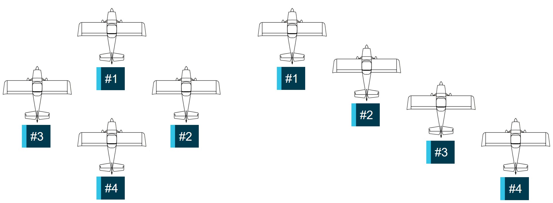
Source: ATSB
At 1209:58, the pilot of #1 broadcast that the formation was joining crosswind for runway 35. Shortly after, the pilot waved at the formation to signal that they were about to turn and leave the formation. The pilot in #1 then commenced a climbing turn to join crosswind and establish the aircraft at the normal circuit height of 1,000 ft AGL. The remaining aircraft would follow, but with a 3 second delay between each aircraft.[3]
According to a nearby eyewitness who was watching the formation from outside a hangar at the aerodrome, each aircraft turned into the circuit after similar time delays. They recalled that #3 continued the turn, tighter than the previous aircraft, which put it onto a converging heading with #2. An overlay of the flight tracks from the available flight data for each aircraft showing the initial and pitch sequence is shown in Figure 2.
Figure 2: Formation initial and pitch sequence (#1 – pink, #2 – yellow, #3 – blue, #4 – green)

A generic low wing aircraft is displayed. Pitch, roll and yaw data was not available to accurately depict aircraft orientation. Source: Cesium and individual aircraft flight tracking data, annotated by the ATSB
At about 1210:09, #3 (VH-EWS) collided with #2 (VH-NMG) at about 1,140 ft AGL (Figure 3), and about 350 m south-east of the northern threshold of runway 35. From the collision, the rear fuselage of #3, just rearward of the baggage compartment, separated from the aircraft. Almost immediately, #3 descended rapidly and impacted terrain in a near vertical trajectory, fatally injuring the pilot. Aircraft #2 remained flyable and the pilot, who was not injured, was able to land the aircraft at the aerodrome and taxi off the runway.
Figure 3: Flight track of the formation showing the collision point between #3 (VH‑EWS, in blue) and #2 (VH-NMG, in yellow) at about 1210:09

A generic low wing aircraft is displayed. Pitch, roll and yaw data was not available to accurately depict aircraft orientation. Source: Cesium and individual aircraft flight tracking data, annotated by the ATSB
Context
Pilot information
VH-EWS
The pilot of VH-EWS held a Private Pilot Licence (Aeroplane), which had been issued in 2010. They held flight activity endorsements, which permitted them to conduct aerobatics above 500 ft AGL, spins, formation flying and formation aerobatics. They also held an instructor rating specifically for teaching spins and formation flying. The pilot held a class 2 aviation medical certificate with a requirement to wear distance vision correction and have reading correction available when flying, which was valid until February 2026.
Their most recent logbook and flying records could not be located after the accident. They were reported as being very experienced in general aviation activities and had held their formation endorsement since 2016. At the time of their most recent medical examination in February 2024, the pilot reported a total of 2,500 flying hours. Their last flight review was in December 2023 and was valid until February 2026.
VH-NMG
The pilot of VH-NMG held a Recreational Pilot Licence (Aeroplane) that was issued in 2022. They held flight activity endorsements, which permitted them to conduct aerobatics above 1,500 ft AGL, spins, formation flying and formation aerobatics. The pilot’s class 2 aviation medical certificate was valid until May 2026, however, it was not valid for night flying.
The pilot reported a total of 509 flying hours of which 331 hours were on Van’s RV-7 aircraft. Their last flight review was in April 2024 and was valid until April 2026.
Aircraft information
VH-EWS
VH-EWS was a Van’s RV-7 amateur-built aircraft with a manufacture date of 2012. It was a piston-engine, 2‑seat aircraft with a low wing, and tailwheel landing gear (Figure 4 left).
VH-NMG
VH-NMG was a Van’s RV-7A amateur-built aircraft with a manufacture date of 2009. It was similar to VH-EWS except that it had a tricycle landing gear (Figure 4 right).
Figure 4: VH-EWS (left) and VH-NMG (right)

Source: Reuben Morison (left) and Clinton J Down Photography (right) via www.Jetphotos.com, modified by the ATSB
Meteorological information
Weather
The other pilots in the formation reported that conditions were good, although there was some turbulence during their flight. They did not express any concerns that the conditions were not suitable for their flight. Closed circuit television footage obtained from a hangar at the aerodrome showed that the sky in the immediate vicinity was clear, with cloud well above the circuit height.
There was no Bureau of Meteorology forecast or observations for the aerodrome, however, the graphical area forecast[4] valid for the time and area of the flight did not indicate any weather phenomena that may have impacted visibility. Moderate turbulence was forecast below 6,000 ft above mean sea level.
The aerodrome had a weather station that recorded numerous parameters including wind speed and direction. At the time of the accident, average winds were below 10 kt and generally westerly. Cloud and visibility data were not recorded parameters.
Daylight
At the time of the accident, Geoscience Australia recorded the sun position at an elevation of 75° 16’ 34’’ and azimuth of 33° 59’ 04”.[5] This was high in the sky towards the north‑north‑east. The 3 remaining pilots reported that the sun position did not present an issue for their visibility.
Aerodrome information
Wedderburn was a non-controlled aeroplane landing area[6] located approximately 3 km south of Wedderburn township and 19 km to the south-east of Camden Airport, New South Wales. It had an elevation of 850 ft with a paved and adjacent grass runway aligned 17/35,[7] which was 980 m long. The aerodrome was privately owned and operated.
Recorded information
None of the aircraft were fitted with, nor were they required to have, a flight data recorder or cockpit voice recorder. However, flight tracking data was obtained for each aircraft, from sources including third party flight tracking providers, electronic flight bag applications and onboard avionics. Generally, this data included latitude, longitude, ground speed, course and altitude, at variable rates between 1 and 5 seconds.
Although the pilots of VH-EWS and VH-NMG had frequently flown with onboard video cameras, neither pilot did so during the accident flight, nor did the other pilots in the formation.
Common traffic advisory frequency recordings for Wedderburn were retrieved, however, the discrete frequency used during their formation flying was not recorded.
Closed circuit television footage from one of the nearby hangars captured VH-EWS descending rapidly just prior to it entering the tree canopy but did not capture the subsequent collision with terrain. Another camera captured the other aircraft in the formation landing at the aerodrome after the accident. The collision between the aircraft was not captured.
Wreckage and impact information
VH-EWS
The main wreckage of VH-EWS was located in dense bush about 250 m west‑south‑west of the collision point. The rear fuselage was in similarly dense bush, 250 m north-east of the main wreckage (Figure 5).
Figure 5: VH-EWS wreckage site locations and its flight track adjacent to the aerodrome
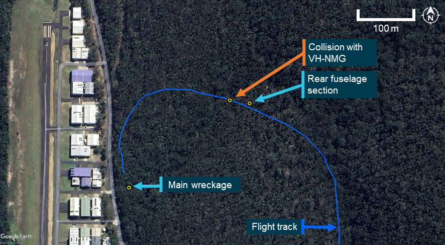
Source: Google Earth, annotated by the ATSB
Observations of the site identified that the aircraft collided with trees prior to impacting terrain in a nose down attitude at an impact angle of about 65°. The main wreckage trail extended for about 5 m from the initial impact point towards the south. The aircraft was significantly disrupted, with the propeller buried into the earth at the point of impact (Figure 6).
Figure 6: VH-EWS main wreckage showing key parts of the aircraft

Source: ATSB
Due to the wreckage disruption a full flight control continuity check was not possible, but examination of the available controls did not identify any pre-collision defects. All aircraft parts were accounted for at the wreckage site. Examination of the propeller indicated that the engine was providing power at the time of impact.
The tail section showed damage consistent with contact with VH-NMG. Specifically, there was compression damage to the upper rudder and vertical stabiliser, and propeller strike marks from right to left at the rear fuselage separation point (Figure 7). The rear fuselage section was complete and there was no evidence of pre-collision defects in the flight controls or structure.
Figure 7: VH-EWS rear fuselage and tail assembly

Source: ATSB
VH-NMG
Examination of VH-NMG identified aircraft impact damage to the lower fuselage, nose wheel fairing, propeller blades and spinner. The lower fuselage damage consisted of skin and rib damage and a large intrusion into the aircraft structure just aft of the wing carry through structure and red paint transfer observed in several locations. The damage was consistent with the upper rudder and vertical stabiliser damage on VH-EWS with the orientation of the intrusion at about 30° left of VH-NMG’s longitudinal axis[8] (Figure 8). A flight control function check showed slight fouling of the ailerons and elevators due to the skin intrusion into the area of the flight controls.
Figure 8: VH-NMG lower fuselage and nose wheel fairing damage

Source: ATSB
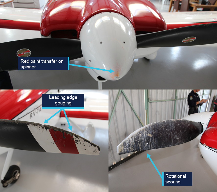
Examination of the propeller and its spinner showed leading edge gouges, rotational scoring, tip bending and red paint transfer that was consistent with VH-NMG striking VH‑EWS several times during the collision sequence (Figure 9).
Figure 9: VH-NMG propeller damage
Source: ATSB
Aircraft to aircraft impact alignment
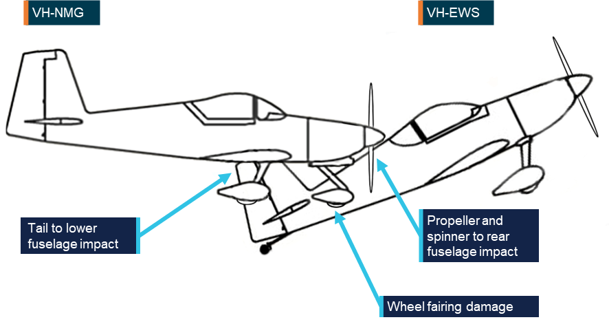
An assessment of the aircraft impact damage identified that VH-EWS collided with VH‑NMG from below and slightly ahead. VH-EWS was likely in a nose up attitude and 30° nose left relative to VH-NMG. The vertical stabiliser from VH-EWS intruded into the lower fuselage of VH-NMG, and the propeller of VH-NMG cut through the rear fuselage of VH-EWS. A depiction of the impact alignment is shown at Figure 10.
Figure 10: Aircraft to aircraft relative impact alignment
Source: ATSB
Further investigation
The investigation is continuing and will include:
- examination of maintenance records
- examination of pilot records and training
- consideration of formation flying procedures and practices
- further analysis of recorded data.
A final report will be released at the conclusion of the investigation. Should a critical safety issue be identified during the course of the investigation, the ATSB will immediately notify relevant parties so appropriate and timely safety action can be taken.
Acknowledgements
The ATSB acknowledges the significant assistance provided by the NSW Police Force during the onsite phase of the investigation.
Purpose of safety investigationsThe objective of a safety investigation is to enhance transport safety. This is done through:
It is not a function of the ATSB to apportion blame or provide a means for determining liability. At the same time, an investigation report must include factual material of sufficient weight to support the analysis and findings. At all times the ATSB endeavours to balance the use of material that could imply adverse comment with the need to properly explain what happened, and why, in a fair and unbiased manner. The ATSB does not investigate for the purpose of taking administrative, regulatory or criminal action. About ATSB reportsATSB investigation reports are organised with regard to international standards or instruments, as applicable, and with ATSB procedures and guidelines. Reports must include factual material of sufficient weight to support the analysis and findings. At all times the ATSB endeavours to balance the use of material that could imply adverse comment with the need to properly explain what happened, and why, in a fair and unbiased manner. An explanation of terminology used in ATSB investigation reports is available here. This includes terms such as occurrence, contributing factor, other factor that increased risk, and safety issue. Publishing informationReleased in accordance with section 25 of the Transport Safety Investigation Act 2003 Published by: Australian Transport Safety Bureau © Commonwealth of Australia 2026 
Ownership of intellectual property rights in this publication Unless otherwise noted, copyright (and any other intellectual property rights, if any) in this report publication is owned by the Commonwealth of Australia. Creative Commons licence With the exception of the Commonwealth Coat of Arms, ATSB logo, and photos and graphics in which a third party holds copyright, this report is licensed under a Creative Commons Attribution 4.0 International licence. The CC BY 4.0 licence enables you to distribute, remix, adapt, and build upon our material in any medium or format, so long as attribution is given to the Australian Transport Safety Bureau. Copyright in material obtained from other agencies, private individuals or organisations, belongs to those agencies, individuals or organisations. Where you wish to use their material, you will need to contact them directly. |
[1] For ease of reference, each aircraft and/or pilot will be referred to by their formation position number.
[2] Initial and pitch: a circuit entry technique for formation flights. This involved flying an upwind leg, aligned with the landing runway, commencing from a predetermined position (initial). At about halfway along the runway, the lead aircraft in the formation will then turn onto the crosswind leg (pitch) with each aircraft following in succession with a set time delay between them. Once complete, there should be sufficient lateral separation between each aircraft as they continue in the circuit to land in succession (stream landing).
[3] The 3 second delay was reported by the surviving pilots as being their standard time delay for a formation initial and pitch manoeuvre.
[4] Graphical area forecast provides information on weather, cloud, visibility, icing, turbulence and freezing level in a graphical layout with supporting text.
[5] The elevation of the sun is the angle between the direction of the sun and the observer's local horizon. The azimuth is the angle between North, measured clockwise around the observer's horizon.
[6] An aeroplane landing area is an aerodrome that has not been certified by the Civil Aviation Safety Authority. These aerodromes are non-controlled, unregulated facilities. It is the responsibility of pilots and operators to determine whether these aerodromes are suitable for use.
[7] Runway number: the number represents the magnetic heading of the runway.
[8] The longitudinal axis of an aircraft runs from its nose to its tail.
Occurrence summary
| Investigation number | AO-2025-071 |
|---|---|
| Occurrence date | 30/11/2025 |
| Occurrence time and timezone | 12:10 Australian Eastern Daylight Time |
| Location | Near Wedderburn aeroplane landing area |
| State | New South Wales |
| Report status | Preliminary |
| Anticipated completion | Q3 2026 |
| Investigation level | Short |
| Investigation type | Occurrence Investigation |
| Investigation phase | Examination and analysis |
| Investigation status | Active |
| Mode of transport | Aviation |
| Aviation occurrence category | Collision |
| Occurrence class | Accident |
| Highest injury level | Fatal |
Aircraft details
| Manufacturer | Amateur Built Aircraft |
|---|---|
| Model | Van's RV-7 |
| Registration | VH-EWS |
| Serial number | 73226 |
| Sector | Piston |
| Operation type | Part 91 General operating and flight rules |
| Activity | General aviation / Recreational-Sport and pleasure flying-Aerobatics |
| Departure point | Wedderburn Aircraft Landing Area, New South Wales |
| Destination | Wedderburn Aircraft Landing Area, New South Wales |
| Injuries | Crew - 1 (fatal) |
| Damage | Destroyed |
Aircraft details
| Manufacturer | Amateur Built Aircraft |
|---|---|
| Model | Van's RV-7A |
| Registration | VH-NMG |
| Serial number | 73232 |
| Sector | Piston |
| Operation type | Part 91 General operating and flight rules |
| Activity | General aviation / Recreational-Sport and pleasure flying-Aerobatics |
| Departure point | Wedderburn Aircraft Landing Area, New South Wales |
| Destination | Wedderburn Aircraft Landing Area, New South Wales |
| Injuries | None |
| Damage | Minor |