The Brisbane terminal area was busy, and both aircraft were required to enter a holding pattern at Maroochydore. VH-EWG was to be the first of the two aircraft to land at Brisbane, but because the pilot had slowed the aircraft enroute, VH-TAY had already entered the holding pattern at a lower level than VH-EWG.
When a preceding aircraft left the holding pattern on descent for landing at Brisbane, the air traffic controller responsible for the holding aircraft descended VH-EWG through the level of VH-TAY without the required lateral separation. At the time both aircraft were heading in the same direction with VH-TAY travelling at a faster speed. The controller realised his mistake and instructed VH-EWG to climb. Separation was reduced to 2.5NM instead of the required 5NM. The controller was relatively inexperienced at the control position he was working and the workload at the time was high.
VH-RMH departed runway 25 and was instructed to maintain runway heading and 3,000 ft before being given a right turn. The aircraft was under the control of Sydney Departures. VH-JRY was being vectored to Bankstown by Sydney Approach South where one controller was undergoing familiarisation while being supervised by a rated officer. Approach was given a 4,000ft altitude restriction by Departures due to runway 25 being used for departing aircraft.
As VH-JRY came into the overhead Bankstown position, the Approach controller descended the aircraft without co-ordinating with Departures. When the Departures controller realised the situation, he gave VH-RMH a further right turn for separation.
Separation standards available to the controller were three nautical miles lateral or 1,000 ft vertical. Analysis of recorded radar data indicated that the closest point between the two aircraft occurred at 1422.48 hours when the vertical distance was zero and the lateral distance was 1.7nm.
The controller undergoing familiarisation qualified as an Approach/Departures controller in 1978, although he had not exercised his rating on a regular basis for nearly four years. He had recently been selected for Check Control duties on Approach/Departures.
It was the controller's first familiarisation shift where runway 25 was in use for departures and runways 25 or 34 for arrivals. He remembers being given the 4,000ft restriction by Departures and writing it on the strip, but he did not underline it (indicating the restriction). When co-ordination was received identifying the position of VH-JRY relative to radio station 2RN, he became momentarily confused as the radio mast referred to had undergone a name change since he had last actively been an Approach/Departures controller. This confusion occupied his mind until he suddenly realised that VH-JRY was in need of descent.
The controller misidentified the VH-JRY radar return as being on the western side of Bankstown, when in fact it was on the eastern side. He then forgot to co-ordinate with departures and descended VH-JRY.
The Departures controller reacted as soon as the situation was realised but not before a breakdown in separation occurred.
Significant Factors
1. The approach controller undergoing familiarisation did not co-ordinate descent for VH-JRY below the previously advised altitude limitation.
2. The rated approach controller did not exercise an adequate level of supervision.
VH-TQR [DHC8] was maintaining Flight Level [FL] 200 on the CRAVEN - Port Macquarie track on a flight from Sydney to Port Macquarie. A clearance was obtained by Sydney Sector 2 from Williamtown Air Traffic Control [ATC] for VH-TQR to transit Restricted Area R594A at and on descent from FL200. The aircraft was authorised to leave control area on descent.
RAAF Air Defence personnel were controlling MAPLE 32 [FA 18] and were instructed by Williamtown ATC to ensure that the aircraft would remain east of the CRAVEN - Port Macquarie track. During vectoring procedures, the Air Defence Controller allowed MAPLE 32 to cross this track and come into conflict with VH-TQR. The Senior Controller observed this situation and initiated appropriate co-ordination to rectify the confliction.
There was approximately two minutes delay before the exact information reached the Air Defence Controller responsible for MAPLE 32 and by the time separation was guaranteed, the aircraft had passed the point of nearest contact.
On observing the potential conflict, Sydney Sector 2 instructed VH-TQR to maintain FL190 in an attempt to provide separation. The controller had observed the altitude read out of MAPLE 32 to be FL186 and knew that VH-TQR had left FL200 on descent. VH-TQR reached FL187 prior to maintaining FL190.
The aircraft came within 6.3nm and 100ft of each other. As the radar separation standard is 5nm, no breakdown in separation occurred.
Significant Factors
1. The Air Defence Controller did not comply with the Air Traffic Control instruction received.
2. The time taken for the Senior Controller to co-ordinate with the Air Defence Controller placed the separation standard in jeopardy.
Occurrence summary
Investigation number
199200045
Occurrence date
24/03/1992
Location
near Sydney
State
New South Wales
Report release date
20/05/1993
Report status
Final
Investigation type
Occurrence Investigation
Investigation status
Completed
Mode of transport
Aviation
Aviation occurrence category
ANSP info/procedural error
Occurrence class
Incident
Aircraft details
Manufacturer
De Havilland Canada/De Havilland Aircraft of Canada
At the time of the incident, both aircraft were operating in visual meteorological conditions under instrument flight rules (IFR) and proceeding on tracks that crossed near Mendooran. Both aircraft were operating at a correct hemispherical level of 9,000 ft in non-controlled airspace managed by the Sydney flight service centre (FSC). The Beech B58 pilot had not reported maintaining his cruising altitude. Prior to the occurrence each pilot had been unaware of the presence of the other aircraft. The pilot of the Cessna C402 sighted the Beech B58 just prior to the crossing of their respective flight paths. The Cessna pilot estimated that there was approximately 500 m horizontal separation as he passed behind the Beech B58. The required traffic information service had not been provided by the responsible flight information sector (FIS), which was FIS 1.
The Sydney FSC is managed by a senior area manager who has two teams, northern and southern, working the various domestic FIS sectors, identified as FIS 1 to 6, and the international sectors, identified as FIS INT 1 and 2. Each team has a team leader responsible for the operation of their respective teams during the shift.
All face-to-face pilot briefing facilities were terminated at midnight on the previous evening, 30 June 1992.
Briefings were then required to be obtained via manual or automated systems consolidated to Brisbane or
Melbourne regional briefing offices (RBOs). Aircrew could obtain operational information and submit flight plans through the relevant RBO.
One important element of the consolidated RBO program, the automated meteorological and Notice to Airmen (NOTAM) facsimile briefing (AVFAX) system, operates only from Brisbane and provides the service for the whole of Australia. On the morning of the incident, two unforeseen technical problems arose that resulted in a disruption to the system. Firstly, a software problem in the AVFAX system resulted in it not being able to cope with the extra demand on its services. Its failure left many pilots without the required pre-flight briefing information. These pilots then resorted to the only apparent avenue left to them, they telephoned the RBOs.
Secondly, contracts had been negotiated to provide an Australia-wide 008 telephone switching network. The switching was intended to divide expected calls between the two RBOs in a predetermined manner. However, the switching network was not completed until approximately midday on the day of the incident. This resulted in the Brisbane RBO having to accept more calls than the system had been designed to accept.
Subsequently, many pilots used the FIS flightwatch service to obtain briefing material that they would normally have obtained via the automated briefing systems. This placed an abnormal demand on the flightwatch service and directly contributed to increased workload for FIS operators.
The published frequency for the FIS flightwatch service in Sydney terminates at the FIS 2 workstation, adjacent to FIS 1. Both operators have shared access to a terminal of the flight information service on request (FISOR) computer system. FISOR is reported to be slow to respond to operator's commands and only one FIS operator can access information at one time. This leads to delays in providing the information to FIS operators and pilots. This incident occurred during such an occasion.
Prior to and at the time of the incident, the northern team leader was actively assisting the FIS 2 operator to process the exceptionally high level of demand on flightwatch. All other sectors were staffed in the normal manner. One FIS-rated officer was having a short break in the adjoining amenities room.
The FIS 1 officer was also under a heavier than normal air traffic workload. This was caused by a combination of factors including numerous aircraft using the FIS 1 frequency for the flightwatch service to obtain and update operational information such as meteorological forecasts and NOTAMs. One particular aircraft had made repeated requests for weather information whilst en route to Lord Howe and Norfolk Islands. The required information was not readily available to the FIS 1 operator and required special handling at a time when FIS 1's traffic and workload were increasing.
Previous pilot complaints had been received regarding slow responses to FIS flightwatch requests. Sydney FSC management had therefore issued a staff memo urging FIS operators to respond to flightwatch requests in a more timely manner. Consequently, on the morning of this incident, the workload was very high, and supervisors were fully occupied assisting all FIS sectors to cope with the operational demands.
The FIS officer concerned was performing only his second shift on the newly consolidated sector and his responsibilities involved airspace with which he was not totally familiar. In addition, he was using communication facilities with unfamiliar coverages and code groups for flight progress strip (FPS) notations. The map to which he needed to frequently refer was cluttered and locations were not easily readable. Because of this he was unable to find the actual geographic locations of many of the position reporting waypoints in the limited scan time available.
Additionally, the Sydney FSC had previously moved from the conventional single stacked FPS display to a new multiple stack, geographic, FPS display.
Standard operating procedures for the geographic FPS display required that the FIS operator check for traffic conflictions before moving any FPSs into a new bay. However, the geographic display was considerably more demanding than the former single-stack display. The stack display presented all active FPSs under one bay designator while the geographic display presented numerous bays of FPSs. The geographic display was laid out with the required bay designators so as to provide a representation of the sectors airspace, with the top of the display representing north and the left-hand side representing west.
The geographic display, while basically sound, requires the FIS operator to visually scan a larger display area than the stacked display. Additional FIS operator estimates for en-route abeam positions, associated FPS entries, as well as inter- and intra-FPS bay movements, were also required. Not all of the operational information which determines the FPS placements within the FPS bays is notated in the same prominent positions on the FPS.
The FIS 1 operator indicated that the FPS notations also served as a memory jogger to assess traffic conflicts, frequency transfers and next actions due. In this incident, the FIS 1 operator should have estimated an abeam Dubbo time for notation of the Cessna C402s FPS. That FPS should then have been placed into the same bay as the Beech B58 i.e. Mendooran. The FIS 1 operator believed that, as he had not calculated and notated the abeam Dubbo information on the Cessna C402 FPS, he must have moved that FPS across two bays and placed it directly into the bay above Mendooran. He had also overlooked the calculation, FPS notation and execution of a frequency transfer for the Cessna C402. These actions may have prompted him to believe that the Cessna C402 FPS was in fact in the wrong bay.
A further prompt that the aircraft were operating at the same altitudes could have been provided had the pilot of the Beech B58 reported maintaining 9,000 ft. This would have occurred prior to the Mendooran waypoint and required the FIS 1 operator to notate that FPS. The FIS 1 operator would probably have then rescanned the geographic display and perhaps detected that the Cessna C402 and Beech B58 were in conflict.
On 25 June 1992, a few days prior to this incident, Sydney FSC had completed a stage of consolidation and resectorisation which incorporated the Dubbo airspace responsibilities into the FIS 1 sector. Additional radio-communication facilities and frequency coverage were terminated at FIS 1.
The FIS 1 operator stated that this was his second shift on the consolidated FIS 1 sector and that he was not totally familiar with the site-specific communications coverage or geography for the new airspace. He also reported that he had found the workstations overhead map display did not readily assist in locating aircraft flight-planned tracks and waypoints during high workload situations.
Prior to Sydney FSC absorbing the Dubbo airspace, training staff from Sydney were sent to Dubbo flight service unit (FSU) to become familiar with the operation of that airspace and construct a training package. However, the training package failed to indicate to FIS operators those locations and/or routes where Dubbo FIS officers had found recurring potential conflictions.
2. ANALYSIS
This occurrence stemmed from a series of events under high workload conditions where the FIS 1 officer commenced load shedding by truncating standard operating procedures. This overload environment led to his failure to detect a basic traffic confliction between two IFR aircraft.
The closing of face-to-face briefing facilities meant that many pilots had not used the new remote briefing facilities for the first time on the morning of 1 July 1992. They then overloaded the RBO facilities either by not fully understanding the method of use or by not organising the extent of information required i.e. they asked the system facilities to provide them with more information than they may have actually needed.
The failure of the automated briefing systems left pilots waiting to depart without sufficient operational information. Many of them departed without briefing and used the FIS flightwatch service to obtain their requirements when airborne.
Flightwatch is primarily designed to provide updates to briefings already received. It was not intended to provide the volume of information that was being requested on the morning of 1 July 1992. Consequently, the Sydney FIS operators were very busy with non-routine requests.
The high workload and diverse spread of next action due information on the relevant FPSs, combined with an unfamiliar geographic display, actively contributed to the loss of situation awareness and the failure to detect the traffic confliction.
The situation was probably further exacerbated by this officer's long experience (approximately 19 years) with the single stack display system before conversion to the new multi-stack geographic display. He had used the multi-stack geographic display for a few months previously, but only for Sydney FIS airspace with which he was more familiar.
On the day of the incident, he was using the geographic display in a totally new airspace environment. He had received approximately 8 hours of simulator training for the consolidated FIS 1 sector. While this may have been appropriate for normal traffic levels and demands, the simulator training could not possibly have anticipated the exposure to the high workload situation encountered on the morning of the incident.
The effects of the FPS geographic display, high workload, cluttered overhead map displays and the responsibility for additional airspace, had to be assimilated by the officer in a short time. This resulted in not being able to maintain the level of traffic and situation awareness needed to perform all the functions required at that time.
Unfamiliarity with the peculiarities of the Dubbo airspace and geography and the new FPS display presentation in such high workload situations, probably contributed to the operator reverting to a previously learnt behaviour and procedures applicable to a stack display. As a result of attempting to 'keep the picture', the relevant FPSs for the Cessna C402 were placed into the incorrect FPS bay without appropriate notations and recognition of the crossing of aircraft flight paths.
3. CONCLUSIONS
3.1 Findings
Numerous aircraft operators were not conversant with the remote briefing arrangements following the closure of face-to-face briefing facilities.
AVFAX failed to handle the increased demand for services imposed on the first operational day following the cessation of face-to-face briefing facilities.
The national 008 phone number automatic switching program had not been completed.
Many pilots departed without being able to obtain adequate briefing information.
Many pilots used the FIS flightwatch service for in-flight briefings because they had been unable to obtain them from the RBOs.
The interrogation and response processes of the FISOR terminal was slow.
The FISOR terminal was shared by two FIS sectors.
Management had issued a memo urging FIS officers to expedite processing of pilot requests for FIS flightwatch service.
The Beech B58 pilot did not report reaching his cruising level.
The FIS 1 operator experienced a substantial increase in workload.
A new FPS geographic display system was in use.
The FIS 1 operator was not totally familiar with working the former Dubbo FIS airspace.
The FIS 1 workstation overhead map display was cluttered and unsuitable for use under the circumstances current at the time of the incident.
The transfer of local operational knowledge from Dubbo FSU to Sydney FSC did not incorporate known areas of potential traffic conflict or potential frequent confliction.
The FIS 1 operator omitted some documented FPS procedures and practices which removed a number of safety net indicators.
3.2 Significant Factors
The FIS flightwatch service was used as a briefing service when AVFAX was unable to handle the load placed upon it.
The FIS 1 operator was exposed to a substantial increase in workload at a time when his experience with the geographic display and his knowledge of the airspace were insufficient to manage that increase.
Some operationally pertinent flight progress strip notations were omitted while others were recorded in less conspicuous and non-sequential areas of the relevant flight progress strips.
The training program for FIS 1 operators did not adequately address known points of frequent confliction.
SAFETY ACTIONS
4.1 As a result of this investigation, the following safety actions were suggested to the local management of the Civil Aviation Authority at the Sydney Flight Service Centre:
whilst being conscious of the industry perceptions of service, remind its local flight service officers of the necessity to give priority to traffic conflicts first and FIS flightwatch second;
provide a standardised and simplified overhead map display at the FIS 1 workstation. The overhead map display should be similar to that provided at the other operational workstations and simulator;
amend the local operating instructions for FIS 1 to include the peculiarities of the Dubbo airspace, geography and known traffic confliction locations; and
amend the manual of Air Traffic Services to ensure that FIS operators estimates of abeam positions and frequency change requirements are recorded in a more prominent and sequential area of the flight progress strip where FIS geographic display systems are in use.
The pilot reported that prior to landing all landing gear system indications were normal, with all legs of the gear indicated down. After touchdown the left wing slowly lowered, and the pilot was unable to prevent the wingtip and propeller from contacting the ground. The aircraft then veered to the left off the runway with the left landing gear collapsed.
Subsequent examination found a torsional overload failure of the left maingear leg torque tube originating from cracks near the fork bolt boss. The torque tube cracking is thought to be caused by repeated overloading of the torque tube assembly due to inadequate lubrication, during routine maintenance, of the retraction linkages. This is a known problem and is addressed in Airworthiness Advisory Circular (AAC) 160-4 of February 1985.
The subject torque tube was of an old design without the later modification introducing the reinforcing gusset.
Section 21 (2) of the Transport Safety Investigation Act 2003 (TSI Act) empowers the Australian Transport Safety Bureau (ATSB) to discontinue an investigation into a transport safety matter at any time. Section 21 (3) of the TSI Act requires the ATSB to publish a statement setting out the reasons for discontinuing an investigation.
_______________
On 6 July 2015 the ATSB commenced an investigation into a reported near collision involving an Aeroprakt 22LS, registered VH-EVQ and a Piper PA28, registered VH-NRZ at Bankstown Airport, New South Wales on 28 June 2015.
As per procedure, the pilot of the PA28 called Bankstown Tower when at Prospect Reservoir, for a clearance to enter the control zone. ATC issued a clearance for the PA28 to join downwind for runway 29 R and maintain 1,500 ft. Shortly after, ATC issued a traffic alert to the pilot of PA28. As the PA28 was tracking in a southerly direction from Prospect, making it in potential conflict with an airborne Aeroprakt 22LS. The Aeroprakt 22LS was climbing after the pilot had been cleared for a departure from runway 29R. The pilot of the Aeroprakt 22LS manoeuvred to the left to increase separation with the PA28.
The ATSB reviewed the recorded air traffic control data. The data indicated that the separation distance between the two aircraft was not as close as first reported, meaning that a near collision did not occur. The ATSB did not identify any systemic issues that contributed to the incident and assessed that no safety issues would be identified by continuing the investigation. On that basis, the ATSB has decided to discontinue the investigation.
On 18 April 2015, a Jabiru J250 aircraft, recreational registration 19-7621, collided with terrain near Gympie, Queensland and on 23 May 2015, a Thunderbolt aircraft, recreational registration 19-8601, collided with terrain near Cessnock, New South Wales.
Recreational Aviation Australia (RA-Aus) is responsible for investigating these two accidents. As part of its investigations, RA-Aus requested technical assistance from the Australian Transport Safety Bureau (ATSB) in the examination of data from two multi-function display units recovered from the respective accident sites. To protect the information supplied by RA-Aus to the ATSB and the ATSB's investigative work to assist RA-Aus, the ATSB initiated an investigation under the Transport Safety Investigation Act 2003.
The ATSB successfully recovered data from the avionics devices and provided the data to RA-Aus on 04 May 2016. This completed the ATSB’s support of the RA-Aus investigation.
Any enquiries relating to the accident investigations should be directed to RA-Aus at: www.raa.asn.au.
______________________
The information contained in this web update is released in accordance with section 25 of the Transport Safety Investigation Act 2003.
On 23 June 2015, at about 0638 Western Standard Time (WST), a Bombardier DHC8, registered VHXFQ, departed from Perth, on a charter flight to Darlot, Western Australia. The first officer was the pilot flying, and the captain was the pilot monitoring.[1]
The aircraft arrived in the Darlot area soon after 0800. As they neared their descent point, the crew could see that a layer of low cloud had formed over the Darlot area. Nonetheless, conditions above the low cloud were clear and the crew expected to be able to land. The crew conducted an RNAV (GNSS)[2] approach to runway 14, but contrary to their earlier expectations, they were unable to establish the required visual references, due to the low cloud. The crew conducted a missed approach accordingly.
Rather than make any further attempts to land at Darlot, the crew commenced a diversion to Leinster. Leinster was their planned alternate aerodrome, located about 30 NM west of Darlot. Advice from the crew of another aircraft on the ground at Leinster, suggested that the weather at Leinster was deteriorating. Despite the deteriorating conditions, it still appeared probable that an approach would be successful.
The crew positioned the aircraft for an RNAV (GNSS) approach to runway 28 at Leinster, which required minimal manoeuvring from their inbound track from Darlot. The approach proceeded normally, but the crew were unable to establish the required visual references due to low cloud, and conducted a missed approach.
Based upon what the crew had been able to see during their approach to Leinster, and advice about the conditions from the other crew on the ground, the crew elected to attempt an approach to the reciprocal runway (runway 10). Although there was substantial cloud over the eastern end of the aerodrome, the conditions over the western end appeared to be more favourable.
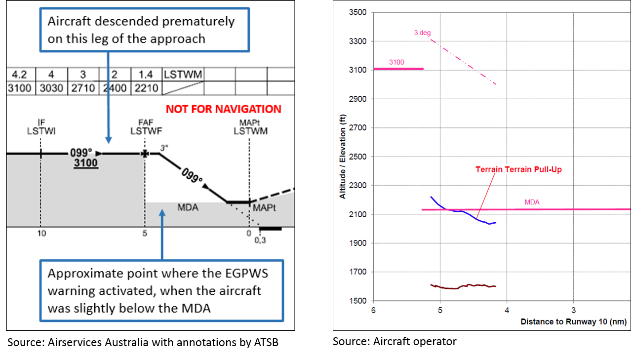
The crew then conducted an RNAV (GNSS) approach to runway 10. During the later stages of that approach, while the aircraft was still clear of cloud, but approaching wispy low cloud ahead, an EGPWS ‘terrain terrain pullup pullup’ warning triggered (see section titled EGPWS warning). The crew believed at the time that the EGPWS warning was spurious, but commenced a missed approach in response to the warning.
Following the missed approach, the captain assessed that low cloud was continuing to move over the area from the south. Given the increasing extent and low base of the cloud, the captain determined that further attempts to land at Leinster were unlikely to be successful.
Based upon the conditions that the crew had encountered since arriving in the Darlot and Leinster area, the captain had continued to monitor Flight Management System time, distance and fuel information, as it related to other diversion options. The conditions to the north appeared to be clear, with no signs of the low cloud that was apparent over Darlot and Leinster. Clear conditions to the north were consistent with the captain’s interpretation of the weather information reviewed as part of the flight planning process. Accordingly, the crew elected to divert to Wiluna, about 78 NM to the north-north-west of Leinster.
Having commenced a diversion to Wiluna, the crew obtained updated weather information from air traffic control to confirm that the conditions at Wiluna were suitable. Other pilots in the vicinity also advised the crew that conditions in the Wiluna area appeared to be clear. The flight proceeded to Wiluna, and landed uneventfully at about 0925.
The aircraft landed with about 600 lbs of fuel remaining, above the operator’s minimum fixed fuel reserve of 450 lbs. The crew added fuel at Wiluna and the aircraft returned to Darlot later that morning, when the weather at Darlot had cleared sufficiently.
Pre-flight planning and forecast weather
About an hour prior to the planned departure time, the captain had reviewed weather information pertinent to the flight, including relevant terminal area forecasts (TAFs).[3] There was no TAF available for Darlot, so the captain was required to nominate an alternate aerodrome, and carry sufficient fuel to safely divert to that aerodrome. The captain reviewed the TAF for Leinster, and was satisfied that Leinster was a suitable alternate aerodrome, so the flight was planned on that basis.
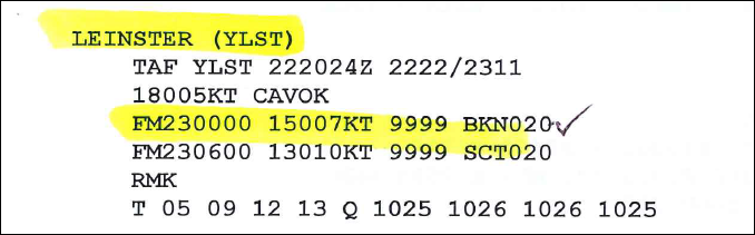
The Leinster TAF (Figure 1) indicated that if the crew diverted there after attempting to land at Darlot, they could expect broken[4] (BKN) cloud to be developing (from 0800), with a base at 2,000 ft above the aerodrome. The visibility was forecast to remain 10 km or more, and the wind was forecast to remain light, from a south to south-easterly direction.
Figure 1: Leinster TAF referred to during pre-flight planning[5]
Source: Aircraft operator
While planning the flight, the captain was mindful that although Leinster was a suitable alternate aerodrome to Darlot, the relatively proximity of the two aerodromes meant that similar conditions could reasonably be expected at both. Accordingly, the captain reviewed the TAFs for other aerodromes in the general area, to provide options in the event that unsuitable weather conditions were encountered at both Darlot and Leinster.
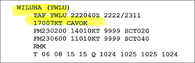
The captain reviewed the TAF for Wiluna (Figure 2), which indicated that Wiluna would be suitable if the crew were unable to land at Darlot or Leinster. The TAF for Wiluna forecast CAVOK[6] conditions, with scattered[7] (SCT) cloud expected to develop from 1000, with a base at 2,000 ft above the aerodrome.
Figure 2: Wiluna TAF referred to during pre-flight planning
Source: Aircraft operator
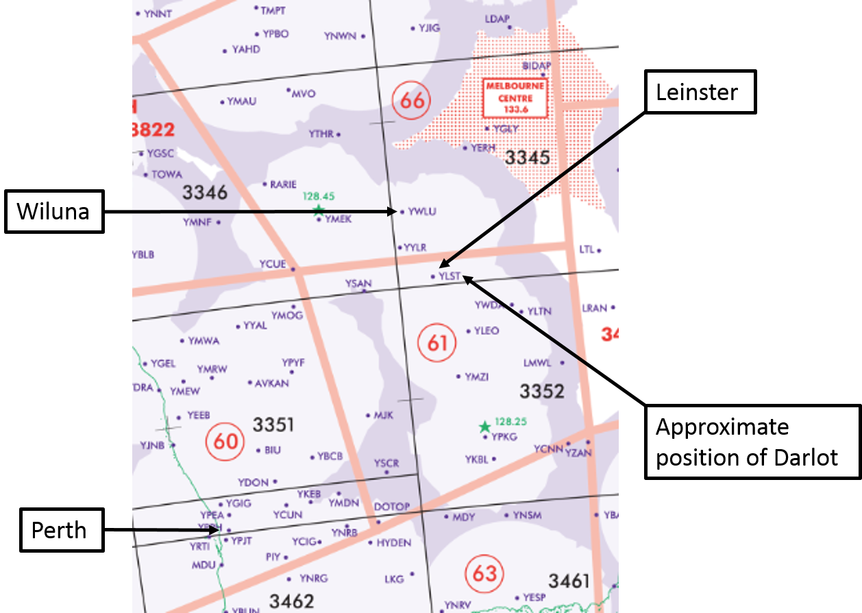
The captain also reviewed relevant area forecasts (ARFOR)[8] in preparation for the flight, in order to build an appreciation of the overall weather picture. This included the ARFORs for areas 61 and 66 (Figure 3). In broad terms, the ARFORs indicated that the crew could expect low cloud and fog in area 61, and the southern part of area 66, until 0900. Beyond 0900, some cloud was still forecast in both areas, but with a higher base and unlikely to have any operational implications for the flight.
Figure 3: Extract from Planning Chart Australia showing relevant locations and ARFOR area boundaries
Source: Airservices Australia, with additions by the ATSB
Fuel planning
Based upon assessment of the weather, the captain elected to load additional fuel, in excess of the minimum regulatory fuel requirements. This was to ensure that options were available if the crew were unable to land at Darlot or Leinster. Although Wiluna did not appear on the flight plan, the captain elected to load sufficient fuel to divert there if necessary. According to the flight plan, the minimum fuel required for the flight was 2,574 lbs, which included reserve requirements and sufficient fuel for a diversion to Leinster. In view of the conditions, the captain elected to increase the fuel load to the maximum amount that could be carried given the expected payload. This amounted to a fuel load of 3,450 lbs.
Actual weather conditions at Leinster
The actual weather conditions encountered by the crew at Leinster were worse than had been forecast on the TAF. Most notably, while the TAF forecast cloud with a base at 2,000 ft above the aerodrome, the crew encountered cloud with a base around 400 to 500 ft above the aerodrome.
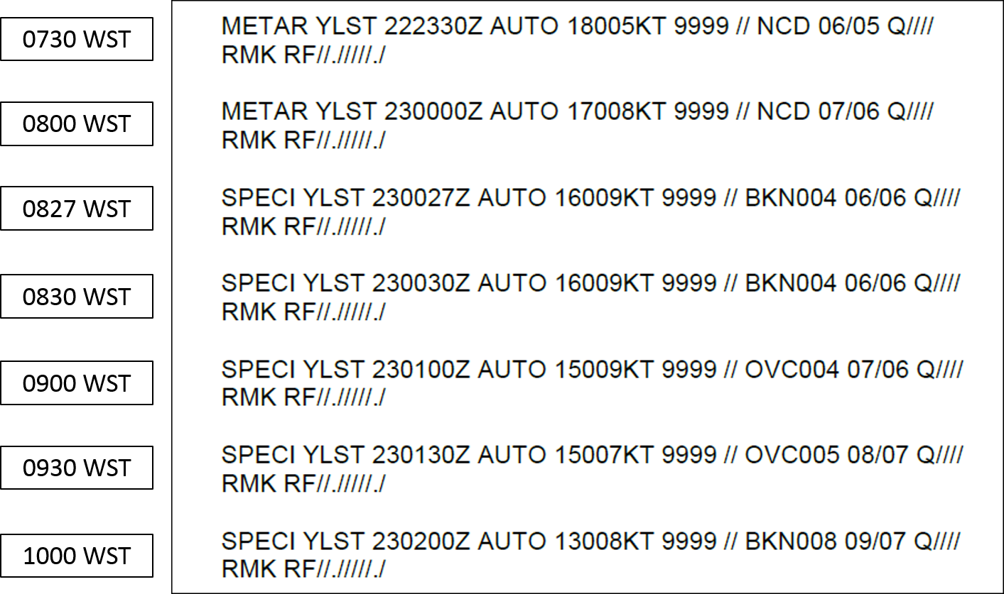
The Leinster aerodrome weather reports reflected the changing conditions that took place during the morning at Leinster (Figure 4). While the 0800 METAR[9] stated no cloud detected (NCD), a SPECI[10] was issued at 0827 indicating that broken cloud had formed, with a base at 400 ft above the aerodrome. This would have been around the time that the aircraft arrived in the Leinster area. The extent of cloud cover had grown by 0900, to become overcast[11] (OVC) with a base at 400 ft above the aerodrome. After 0900, the cloud slowly lifted and cleared. According to the aerodrome weather reports, the visibility remained 10 km or more throughout the morning.
Figure 4: Selected Leinster aerodrome weather reports from morning of the incident flight
Source: Bureau of Meteorology
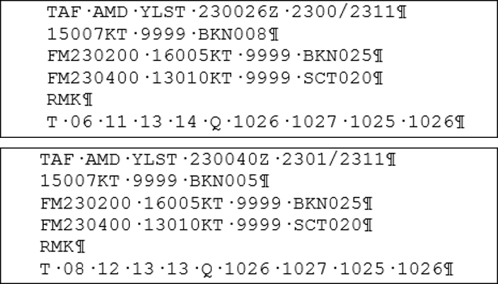
Amended TAFs. The Bureau of Meteorology issued amended TAFs for Leinster, one at 0826, followed by another at 0840 (Figure 5). Those TAFs indicated that low cloud could be expected (from the time the TAFs were issued), with a base at 800 ft and 500 ft above the aerodrome respectively. Both amended TAFs forecast that the cloud base would lift to 2,500 ft above the aerodrome, from 1000.[12]
Figure 5: Amended TAFs for Leinster, issued at 0826 (upper) and 0840 (lower)
Source: Airservices Australia
EGPWS warning
During the RNAV (GNSS) approach to runway 10 at Leinster, the crew received an EGPWS ‘terrain terrain pullup pullup’ warning. They responded to that warning by commencing a missed approach. At the time the crew received the EGPWS warning, they were clear of cloud and could see the ground beneath, but there was wispy low cloud ahead, partially obscuring their view of the runway environment. The crew were assessing the conditions ahead, and the feasibility of safely continuing the approach, when the EGPWS warning activated. The crew elected to make a missed approach with go-around power, rather than conduct a terrain escape manoeuvre,[13] given that the missed-approach flight path of the aircraft was visually clear of terrain and obstacles.
Subsequent analysis of the flight data by the operator revealed that during the RNAV (GNSS) approach to runway 10, the crew descended prematurely to the relevant Minimum Descent Altitude (MDA).[14] In doing so, the crew descended beneath the 3,100 ft altitude constraint between the intermediate fix (LSTWI) and the final approach fix (LSTWF) (Figure 3). The crew overflew LSTWF just above the MDA, and then levelled momentarily at the MDA. Soon after, a brief and shallow descent developed, at which time the EGPWS warning was triggered. At the time the EGPWS warning was triggered, the aircraft was about 4.5 NM from the runway, and the radio altimeter indicated that the aircraft was slightly less than 500 ft above the underlying terrain.
Figure 6: Excerpt from approach chart and vertical profile of the aircraft (in part) showing where EGPWS warning was triggered
Crew comments
The crew commented that a number of factors in combination probably contributed to their descent below the altitude constraint between LSTWI and LSTWF. These factors are broadly summarised as follows:
Workload during positioning for the approach was high, particularly noting that this was a third approach in relatively quick succession. Although the workload was high, the crew commented that all checklist procedures were carried out, the approach was briefed, and all relevant radio broadcasts were made.
The circumstances at the time generated a sense of urgency, given that the extent of cloud cover appeared to be growing rapidly. Furthermore, the crew were keen to descend to the MDA expeditiously in an attempt to establish and maintain visual contact with the runway environment, beneath the intervening wisps of low cloud.
Although the captain remained confident that sufficient fuel was available to divert to Wiluna, suitability of the conditions at Wiluna had not been recently confirmed. An element of doubt about the continuing suitability of Wiluna left the captain feeling slightly uneasy about the circumstances, particularly after encountering unexpected low cloud at Leinster.
Management of the approach profile was probably compromised to some extent by the manner in which the approach was conducted in visual conditions, but with the intent of complying with an instrument procedure. The attention of the crew during the approach was probably substantially drawn to ongoing assessment of how to effectively contend with the low cloud ahead.
ATSB comment
Following a small number of safety occurrences where unforecast weather events have led to unforeseen diversions or holding, the ATSB commenced a research investigation (Reliability of aviation weather forecasts) to examine how often weather events are not forecast in enough time allow pilots to make appropriate decisions (carry additional fuel, make a timely diversion or delay departure). Although the research investigation will focus on weather data for major Australian airports, the results should help operators better understand how much reliance can be given to forecast weather at destination airports at the time of pre-flight planning. This research investigation is linked in part to ATSB investigation AO-2013-100 (Weather related operational event involving B737s VH-YIR and VH-VYK at Mildura Airport, Victoria on 18 June 2013). On that occasion, the two aircraft involved diverted from Adelaide, South Australia, to Mildura, Victoria, due to poor weather in Adelaide. Unforecast weather was encountered when the aircraft subsequently arrived at Mildura.
In another weather-related incident, the ATSB found that the onset of fog at Perth Airport at the estimated time of arrival of a flight, was not forecast until after the aircraft had passed the point when it had insufficient fuel remaining to divert to a suitable alternate aerodrome. Before that point, there had been no requirement for the aircraft to carry fuel to continue to a suitable alternate (see ATSB investigation AO-2012-073Weather-related operational event involving Boeing 717, VHNXO, Perth Airport, Western Australia on 01 June 2012). The safety message attached to that investigation report included ‘…pilots should be alert to the fact that the actual weather conditions can differ significantly from forecasts.’
Pilots are also encouraged to make an Air-Report (AIREP) as soon as possible after encountering meteorological conditions that they believe may affect the safety of other operations. AIREPs contribute to the timely distribution of significant weather information that may assist with the operational decision making of other flight crews. More information about AIREPs is available in the Airservices Australia Aeronautical Information Publication.
Safety message
This incident highlights the importance of lateral thinking during flight planning, particularly where operations to remote areas are planned, and when an alternate aerodrome is close to the planned destination. In this case, the captain assessed the broader weather picture, and added fuel above the minimum requirements on the basis of that assessment. That additional fuel ultimately provided the crew with a safe option, despite encountering unexpected conditions that prevented a landing at the planned alternate aerodrome.
The circumstances leading to the EGPWS warning provide a reminder of the complications that can arise while endeavouring to follow an instrument procedure in visual conditions, particularly where significant attention is focussed on marginal conditions ahead that appear likely to affect the outcome of the approach. The circumstances can be further complicated when surrounded by a sense of urgency, and doubt about the suitability of other diversion options.
Decisions regarding whether to conduct an investigation, and the scope of an investigation, are based on many factors, including the level of safety benefit likely to be obtained from an investigation. For this occurrence, a limited-scope, fact-gathering investigation was conducted in order to produce a short summary report, and allow for greater industry awareness of potential safety issues and possible safety actions.
Publishing information
Released in accordance with section 25 of the Transport Safety Investigation Act 2003
Ownership of intellectual property rights in this publication
Unless otherwise noted, copyright (and any other intellectual property rights, if any) in this report publication is owned by the Commonwealth of Australia.
Creative Commons licence
With the exception of the Coat of Arms, ATSB logo, and photos and graphics in which a third party holds copyright, this publication is licensed under a Creative Commons Attribution 3.0 Australia licence.
Creative Commons Attribution 3.0 Australia Licence is a standard form licence agreement that allows you to copy, distribute, transmit and adapt this publication provided that you attribute the work.
The ATSB’s preference is that you attribute this publication (and any material sourced from it) using the following wording: Source: Australian Transport Safety Bureau
Copyright in material obtained from other agencies, private individuals or organisations, belongs to those agencies, individuals or organisations. Where you wish to use their material, you will need to contact them directly.
On 8 June 2014, a Aeromoragon M-1 aircraft, Spanish registration EC-EI3, departed La Morgal Aerodrome, Asturias, Spain for a private flight in the region. While returning to the aerodrome, the aircraft engine sustained an in-flight failure, requiring the pilot to conduct an emergency landing in an open field. During the landing sequence the aircraft struck a tree, damaging the left wing, tail and fuselage. There were no injuries to the pilot and passenger that were on board.
As the accident occurred in Spain, the Comisión de Investigación de Accidentes e Incidentes de Aviación Civil (CIAIAC) is responsible for investigating this accident. As part of its investigation, the CIAIAC notified the Australian Transport Safety Bureau (ATSB) as the State of Manufacture of the engine. The aircraft was fitted with a Jabiru 2200 engine.
In accordance with clause 5.18 of Annex 13 to the Convention on International Civil Aviation, the ATSB appointed an accredited representative to liaise with the CIAIAC and Jabiru, and initiated an investigation under the Australian Transport Safety Investigation Act 2003.
The ATSB has concluded its support of this investigation. On 2 February 2017 the CIAIAC released the final investigation report into this occurrence and it is available at www.fomento.gob.es.
Any enquiries regarding the investigation and report should, in the first instance, be directed to:
On the evening of 23 June 2015, a home-built Jabiru J430 aircraft, registered F-PFAJ, was being flown on a transfer flight from Aachen, Germany to an airfield near the town of Oehna, France. The aircraft was being operated at night in instrument meteorological conditions. Thunderstorms and heavy precipitation were recorded along the flight path. At around 2200 that evening, local residents identified aircraft wreckage and debris within and surrounding the township of Mühlenberg, Germany. The aircraft had sustained an in-flight break up. Both occupants, a pilot and passenger, were fatally injured.
The German Federal Bureau of Aircraft Accident Investigation (BFU) was primarily responsible for investigating this accident. As part of its investigation, the BFU notified the ATSB as the State of Manufacture of the aircraft. In accordance with clause 5.18 of Annex 13 to the Convention on International Civil Aviation, the ATSB appointed an accredited representative to liaise with the BFU and the Australian aircraft manufacturer. In order to facilitate that liaison, an investigation under the Transport Safety Investigation Act 2003 was initiated.
The BFU completed their investigation and concluded that:
The accident was caused by the pilot flying into instrument meteorological conditions which resulted in an uncontrolled flight attitude, which in turn resulted in structural failure due to overstress.
Contributory factors were the lack of qualification of the pilot to control an aircraft in IMC and the aircraft equipment geared to visual flight rules. In addition, both occupants were under mental pressure to reach the aerodrome of destination on direct course.
Since the trim tabs were not installed on the elevator, it was possible to perform a flare with higher load factors due to a greater deflection of the elevator.
The final report, BFU 15-0764-CX, is available on the BFU website at www.bfu-web.de/reports.
Any enquires relating to the investigation should be directed to the BFU at: www.bfu-web.de.