The Australian Transport Safety Bureau (ATSB) is seeking views from the aviation and marine industry, and other interested stakeholders, on proposed amendments to the Transport Safety Investigation Regulations 2021 (TSI Regulations). The proposed amendments to the TSI Regulations are set out in the Exposure Draft for the Transport Safety Investigation Amendment (2022 Measures No. 1) Regulations 2022 (the Exposure Draft).
The Exposure Draft proposes to make the following changes to the TSI Regulations:
For the purpose of accident and incident notification, aircraft operations are put into four categories (Category A, B, C and D) based on the types of accident and incidents they will have to report. Consistent with the Minister’s Statement of Expectations to the ATSB, the greatest focus is on receiving reports where the information is most likely to be used for the greatest public safety benefit.
Align aircraft operation categories and updating definitions consistent with flight operations rules administered by the Civil Aviation Safety Authority (CASA) which commenced on 2 December 2021.
Align key concepts such as accident, serious aircraft incident and aircraft incident, as well as kinds of examples, with International Civil Aviation Organization (ICAO) equivalents as best as practicable.
Removing prescriptive lists of individual kinds of incidents and defining occurrence concepts more broadly, with guidance material supplementing examples of matters to be reported.
Clarify that certain aircraft incidents are to be reported as serious aircraft incidents, due to their relative importance in identifying safety risks.
Clarify that occurrences during repositioning flights prior to conducting a passenger transport operation or non-passenger commercial operation are reportable as part of the planned operation.
Prescribe additional persons who are responsible for reporting in the aviation industry (aircraft insurers and sport aviation bodies) and marine industry (pilotage service providers and vessel traffic service providers) to increase the ATSB’s safety coverage.
Improve ATSB’s administration of the occurrence reporting framework by making other minor, technical or clarifying changes.
To assist readers, an unofficial compilation of the TSI Regulations incorporating the Exposure Draft amendments – as if it had commenced – is provided for reference at
To provide a holistic view of the proposed changes and how it might be implemented, a draft version of updates to the Aeronautical Information Publication (the AIP) is also enclosed (at
). The AIP is guidance material published by Airservices Australia and the ATSB has responsibility for updating content on occurrence reporting.
In large part, it is not expected that the proposed changes will have significant impact on industry participants, which are already required to report occurrences to the ATSB by telephone and/or by written reporting. For the aviation industry, the alignment of aviation occurrence reporting terminology and concepts with CASA’s flight operations rulesets will provide more, rather than less, clarity on how different kinds of aircraft operations are treated for the purposes of occurrence reporting.
The amendments are proposed to be made by 30 June 2022, which aim to provide 6 months of lead time before commencement on 1 January 2023.
Proposed amendments to TSI Act
There are two complementary proposed policy changes also being consulted which relate to potential future amendments to the Transport Safety Investigation Act 2003 (TSI Act). These two proposals are not included in the Exposure Draft. Subject to decisions of the Parliament, they will be considered as part of future reforms to the TSI Act.
The first of these proposals is to extend the reporting timeframe for written reporting following an immediately reportable matter (IRM) and a routine reportable matter (RRM) from within 72 hours to within 7 days. The genesis of this proposal is upcoming reform (anticipated July 2022) of rail sector reporting requirements in State-based legislation, progressed by the Office of the National Rail Safety Regulator (ONRSR).
The second proposed change to the TSI Act is to clarify that the regulations may prescribe the means by which the written report is submitted. Presently, the TSI Act empowers the regulations to prescribe the particulars of written reports but it is unclear whether the means of their submission might also be prescribed (as is the case with similar provisions in sections 18 and 19 of the TSI Act). The purpose of this clarification to the TSI Act is to eventually enable an update to the regulations to describe how written reports must be submitted. Preferably, in the future, the regulations would prescribed electronically-compatible formats to allow ATSB systems to automatically ingest and process data.
The ATSB thanks readers of this consultation paper, the Exposure Draft and the draft AIP updates for their interest and participation in the legislative-making process.
Public Consultation Paper
Amendment to the Transport Safety investigatoin Regulations 2021 - Exposure Draft and related matters
Non-restricted documents in relation to an aircraft accident involving a Cessna 172M, VH-WTQ near Agnes Waters, Queensland on 10 January 2017 (ATSB investigation number AO-2017-005).
Any expert reports, aircraft maintenance and components reports, pilot information and training records, witness information and statements, meteorological reports, site and wreckage reports, reports on similar accidents involving similar aircraft, and any on-board audio and video analysis from any onboard recording device excluding non-restricted information (ATSB investigation number AE-2018-023).
In relation to the parting of Metro Trains Melbourne passenger train TD 3817 on 9 November 2018:
Copies of all documents relating to complaints, including requests for inspection, maintenance, repairs and works on X’Trapolis Units 959M-1680-960M and 882M- 1641T-881M from 9 October 2017 to 9 October 2019;
Copies of all documents relating to the inspection, maintenance, repairs and works on X’Trapolis Units 959M-1680-960M and 882M-1641T-881M from 9 October 2017 to 9 October 2019;
Copies of all documents, reports, incident reports, investigations, memoranda, letters, emails, correspondence and photographs with respect to the parting of Metro Trains Melbourne passenger train TD 3817 from 9 November 2018 to now;
Copies of all documents, reports, investigations, memoranda, letters, emails, correspondence and photographs with respect to the ATSB Transport Safety Report Rail Occurrence Investigation (RO-2018-019) dated 9 October 2019 from 9 November 2018 to now.
The Australian Transport Safety Bureau is seeking comments from stakeholders on the proposed Transport Safety Investigation Regulations 2021 (TSI Regulations 2021) which will replace the existing Transport Safety Investigation Regulations 2003.
These regulations will clarify requirements for the reporting of transport safety occurrences for certain categories of remotely piloted aircraft, including immediate reports where there is a serious risk of harm to people or significant damage to property.
The proposed regulations include a number of changes to marine terminology and definitions to align with the requirements of the Navigation Act 2012. This includes the adoption of the types of marine incidents that must be reported to the Australian Maritime Safety Authority as immediately reportable matters for the purposes of the TSI Regulations.
Following this consultation period, the ATSB will provide advice to the Minister for Infrastructure, Transport and Regional Development. Consideration will be given to any need to revise the draft of the regulations before finalising them.
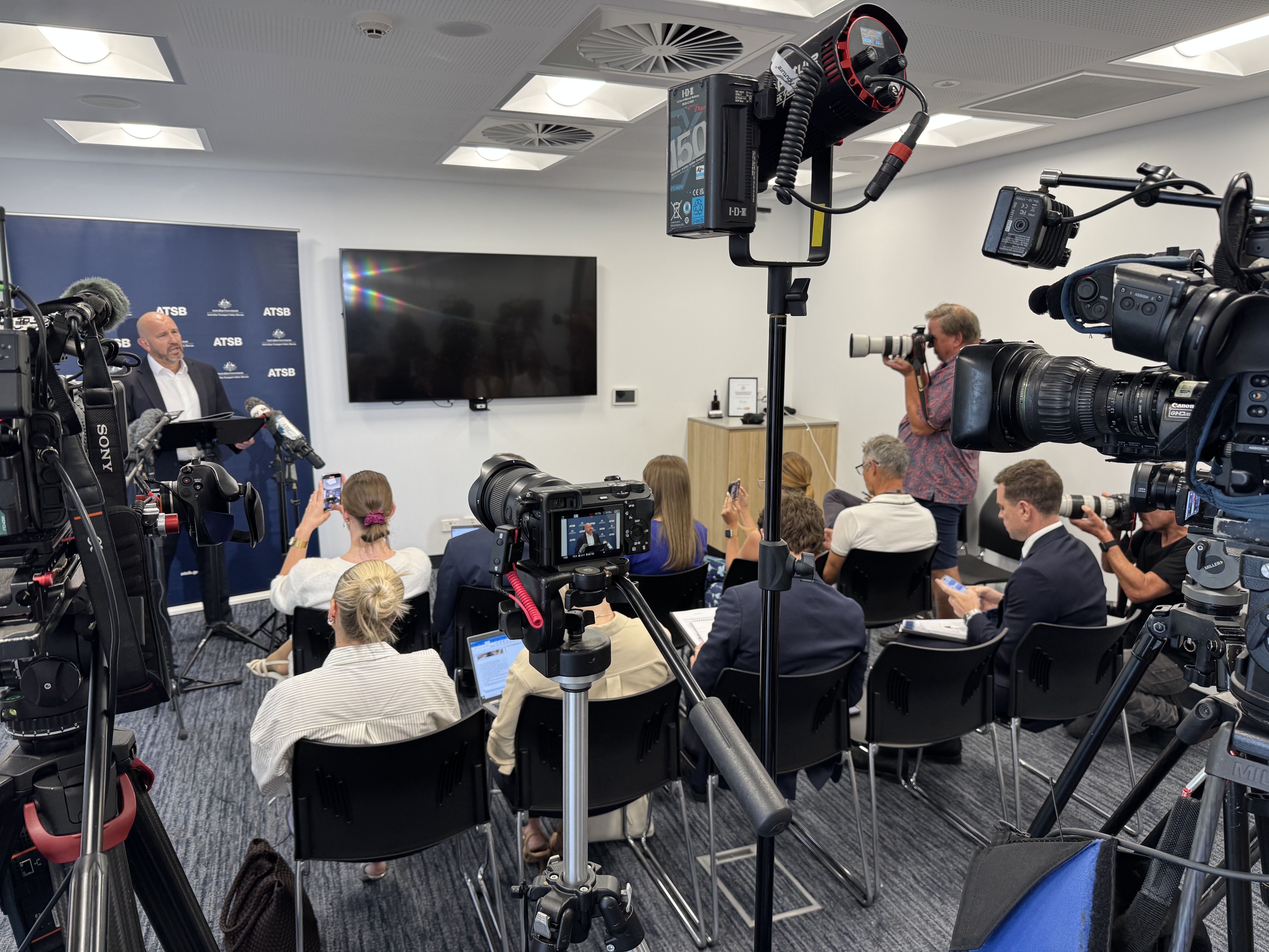
For all media inquiries please contact us via email: media@atsb.gov.au
Alternatively during Canberra business hours call our media line: 1800 020 616 (international callers dial +61 2 6257 2463).
We will promptly respond to all media enquiries during business hours.
Outside of business hours we will respond to media inquiries only where there has been a significant transport accident or incident.
In rare circumstances, such as following a major transport accident, we may temporarily adopt a broadcast-only positioning, and may not be able to immediately reply to individual media inquiries. Please email us to be emailed relevant statements and alerts, which will also be published here, and on our social media channels.
Media statements
Media statements regarding accidents and incidents are published here. Media statements may also be published on our social media channels.
Report release statements & news
ATSB media statements supporting the release of our investigation reports, plus general ATSB news, can be found here.
Media lists
The ATSB does not maintain a single media distribution list, however, media may sign up(Opens in a new tab/window) to our report release subscriber email lists to be advised of new report releases as soon as they are published. If you would like to be kept informed of the progress of a specific investigation, please email us.
High-res images & videos
Please contact us via email to request high-resolution images (where they are available) or broadcast quality versions of our YouTube videos.
Aircraft Communications Addressing and Reporting System.
Acc Rep
Accredited representative. In accordance with Annex 13, the ATSB may assist other overseas agencies in the investigation of accidents and serious incidents that do not involve Australian registered aircraft. In these cases an ATSB investigator would be appointed to the investigation as an accredited representative. On 1 April 2014 the ATSB appointed an accredited representative to the MH370 investigation, at the request of the Malaysian Government.
ADF
Australian Defence Force.
AFP
Australian Federal Police.
Airspace
Any part of the earth's atmosphere that can be used by an aircraft. It is a three-dimensional space where aircraft can operate.
AMSA
Australian Maritime Safety Authority.
Annex 13
Annex 13 of the Convention on International Civil Aviation (Chicago, 1944) provides the international Standards and Recommended Practices for Aircraft Accident Inquiries and was developed by ICAO. These practices are the basis for aviation accident, serious incident and incident investigations, accident prevention and accident and serious incident reporting.
ATC
Air traffic control. ATC is used to manage the safe and orderly flow of aircraft into, out of, and across airspace.
Australian Search and Rescue Region (Zone)
Australia, as signatory to the Convention on International Civil Aviation, 1944; the International Convention for the Safety of Life at Sea, 1974; and the International Convention on Maritime Search and Rescue, 1979, is responsible for search and rescue over a vast area (52.8 million square kilometres) made up of the East Indian, South-west Pacific and Southern oceans. Australia has the same boundaries for aviation and maritime search and rescue.
AUV
An autonomous underwater vehicle (AUV) is a battery-powered self-propelled underwater vehicle that can be launched and retrieved from a search vessel and is pre-programmed with a search mission. The vehicle may be fitted with instruments including sonar and optical imaging systems.
Bathymetry
The study and mapping of sea floor topography. It involves obtaining measurements of the ocean depth and is equivalent to mapping topography on land.
Beaufort Scale
A scale of wind force, developed in 1805 by Admiral Sir Francis Beaufort, which uses observations of the effects of wind on the sea surface to estimate wind speed. Measurements range from 0 (calm) through to 12+ (hurricane).
BFO
Burst frequency offset. BFO is a measure of the difference between the expected frequency of a satellite transmission and the frequency received at the ground station.
BOM
Bureau of Meteorology.
BTO
Burst Timing Offset. BTO is a measure of the time taken for a satellite transmission round trip (ground station to satellite to aircraft and back) and allows a calculation of the distance between the satellite and the aircraft.
Controlled air space
Airspace that is actively monitored and managed by air traffic controllers. To enter controlled airspace, an aircraft must first gain a clearance from an air traffic controller.
CSIRO
Commonwealth Scientific and Industrial Research Organisation.
CVR
Cockpit Voice Recorder. A CVR is a recorder placed in an aircraft for the purpose of facilitating the investigation of an aircraft accident or incident. It records the total audio environment of the cockpit area.
Cyclone
Cyclones are low pressure systems that form over warm tropical waters and have gale force winds (sustained winds of 63 km/h or greater and gusts in excess of 90 km/h) near the centre.
DCA
Department of Civil Aviation, Malaysia.
DEFTECH
DEFTECH is a Malaysian Government defence contractor. It is responsible for the procurement and contract management of chosen operators in the search for MH370, such as Phoenix International.
Depressor
A steel weight that is towed behind a search vessel on a long cable in front of the towfish, to help stabilise it. This allows the towfish to “fly” with less motion above the seafloor, while gathering detailed imagery.
DIRD
Department of Infrastructure and Regional Development.
EOI
Expression of Interest.
FDR
Flight Data Recorder. An FDR is a recorder placed in an aircraft for the purpose of facilitating the investigation of an aircraft accident or incident. It records flight parameters such as indicated airspeed.
Fugro
Fugro Survey Pty Ltd is the Australian owned subsidiary of the Dutch based company, Fugro N.V. It is contracted by the Australian Government to provide vessels, personnel and equipment to conduct a bathymetric survey and underwater search operations for MH370. It operates the vessels Fugro Discovery, Fugro Equator and Fugro Supporter.
GA
Geoscience Australia.
GES
Ground earth station. A satellite ground station sends or receives data from orbiting satellites.
GO Marine
The company, GO Marine, is a subcontractor to Phoenix International. It owns the vessel GO Phoenix used for underwater search operations.
Handshake
Satellite log-on interrogation messages that originate at the ground earth station and are transmitted through the satellite to the aircraft’s satellite communication system.
ICAO
International Civil Aviation Organization.
Inmarsat
A satellite communications company based in the United Kingdom. It owns and operates a global satellite network and is a member of the SSWG.
JACC
Joint Agency Coordination Centre.
Knots
A unit of speed that is equal to one nautical mile (1.852km) per hour.
MBES
Multibeam echo sounder.
MOT
Ministry of Transport, Malaysia.
Nautical mile (NM)
A unit of distance based on the circumference of the earth, used for marine charting and navigating. One nautical mile (NM) is equal to 1.852km.
Phoenix
Phoenix International Holdings Inc. is a company based in the United States. It has been contracted by DEFTECH to supply a vessel, equipment and experts in the search for MH370.
Ping
A pulse of sonar sound.
Primary radar
Primary (or terminal area) radar relies on radio waves reflecting off metallic objects and is effective within a short range from the radar head, which is usually located at an airport.
Priority Search Area
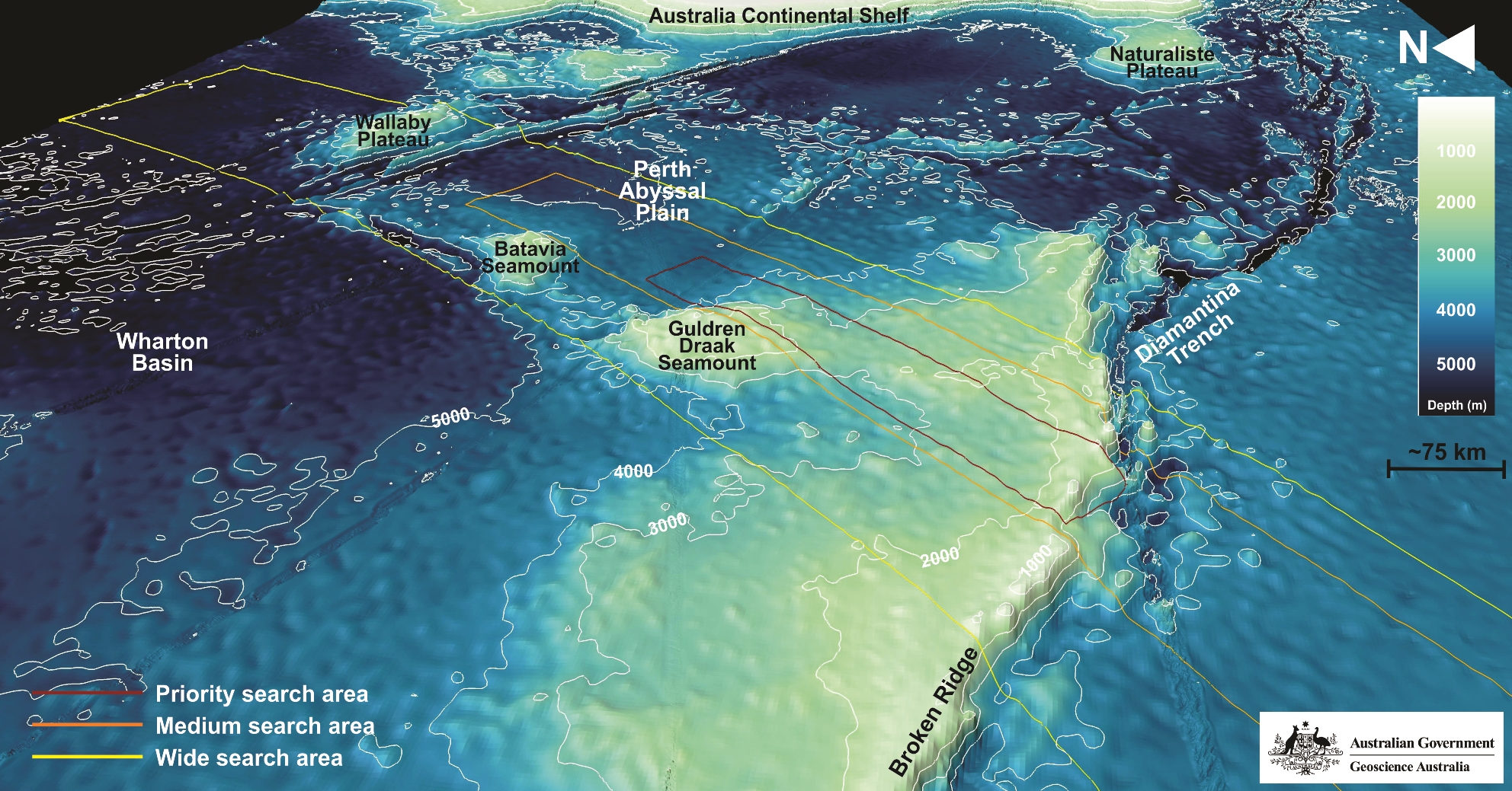
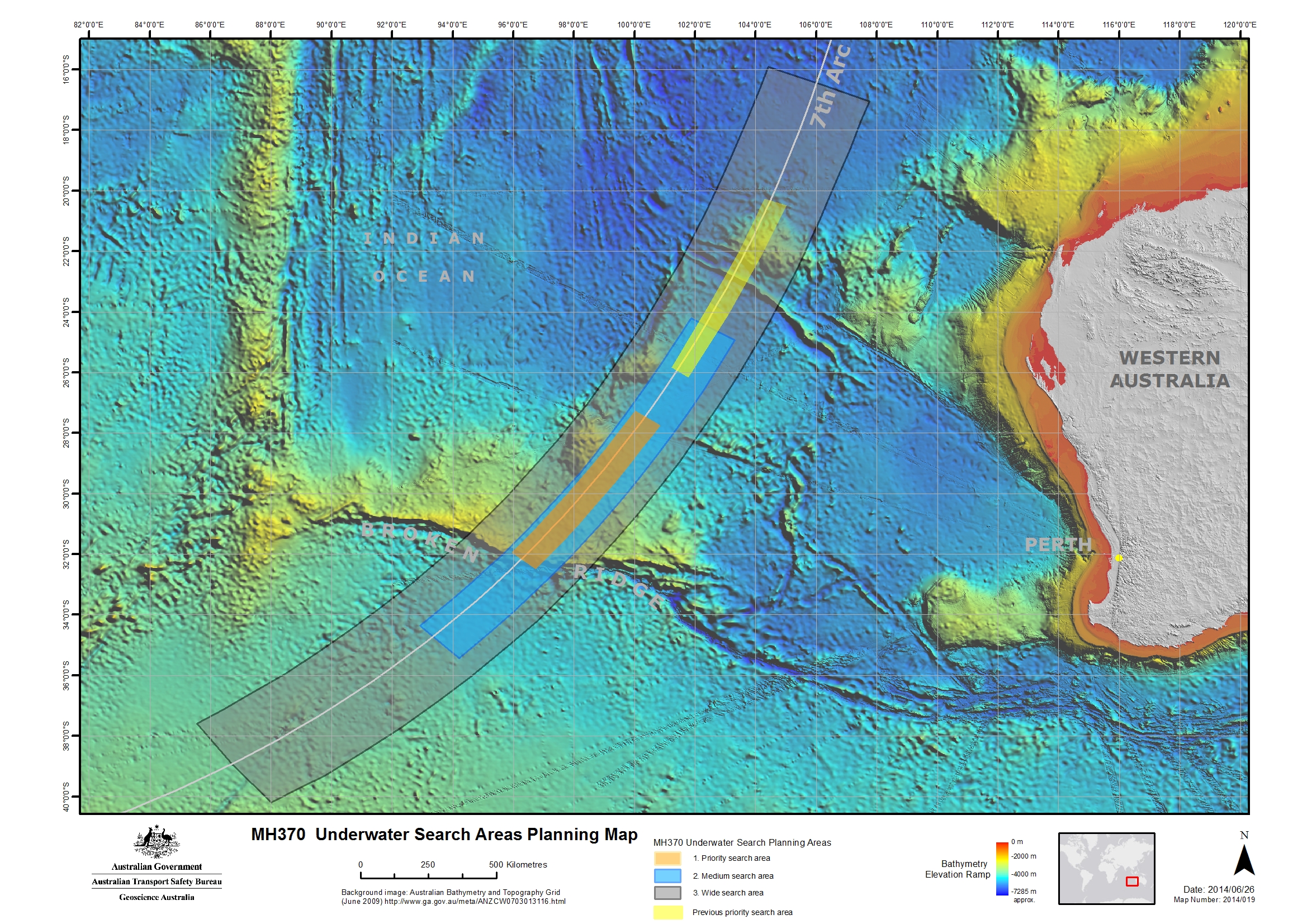
An area, 20 NM to the west or 30 NM to the east of the seventh arc that has been determined as a probable location for MH370, by analysing satellite communications and aircraft performance.
REOI
Request for Expressions of Interest.
RFT
Request for Tender.
RMP
Royal Malaysian Police.
SAS
Synthetic Aperture Sonar. A sonar system which uses sophisticated post-processing of sonar data to combine a number of sonar pings to form an image with higher resolution than conventional sonar.
SATCOM
Satellite communications.
Sea state
A description of sea conditions, recorded using the World Meteorological Organization Sea State Codes. Measurements range from 0 (calm) through to 9 (phenomenal).
Secondary radar
Secondary (or en route) radar returns are dependent on a transponder in the aircraft to reply to an interrogation from a radar ground station.
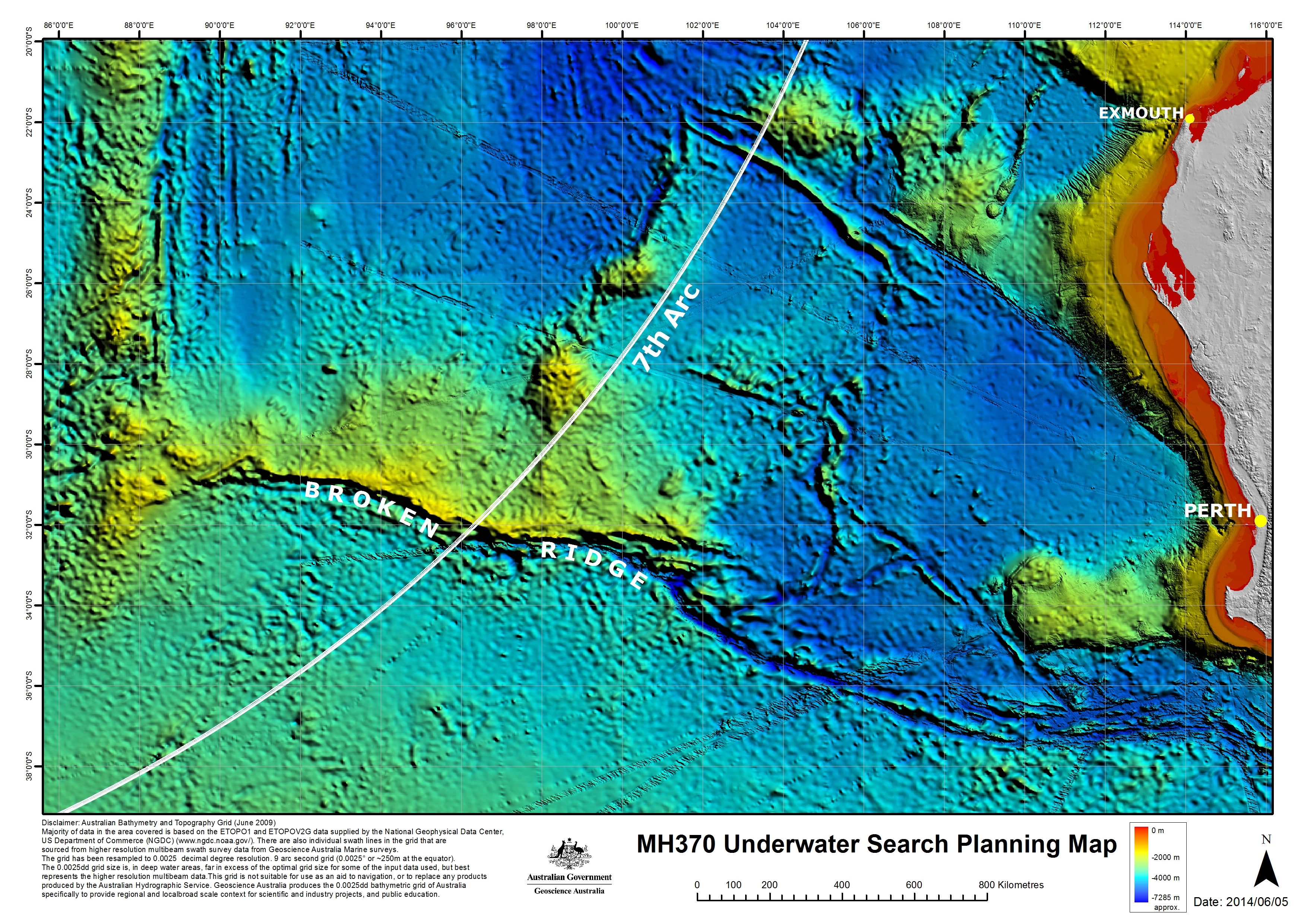
Seventh arc
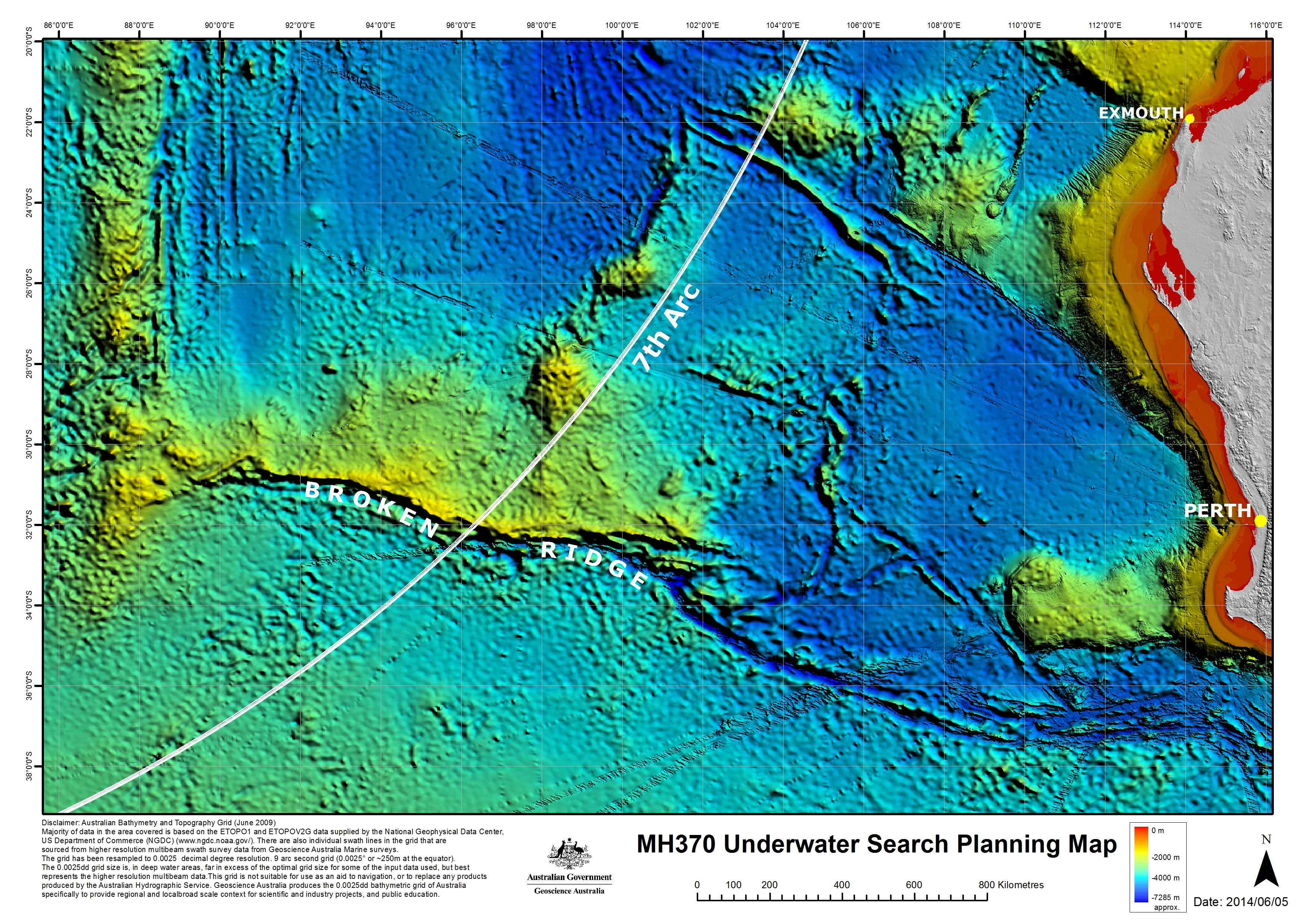
Independent analysis of satellite communications and aircraft performance confirms MH370 will be found in close proximity to the arc labelled as the 7th arc. The arc extends from latitude 20 degrees south to latitude 39 degrees south. At the time MH370 reached this arc the aircraft is considered to have exhausted its fuel and to have been descending.
SL Hydrospheric
SL Hydrospheric (Hydrospheric Solutions) is a subcontractor to Phoenix International. It provides Synthetic Aperture Sonar equipment for MH370 underwater search operations.
Sonar buoy
A floating buoy equipped with an acoustic receiver and a radio transmitter that emits radio signals when it detects underwater sounds.
SSS
Sidescan sonar.
SSWG
Search Strategy Working Group. Coordinated by the ATSB, the group of international satellite and aircraft specialists has been working towards defining the most probable position of MH370, at the time of the last satellite communications.
Surface search
A surface search for MH370 was conducted from 18 March to 28 April 2014. Coordinated by AMSA and the JACC, it was carried out by an international fleet of aircraft and ships along the seventh arc.
Swing
The amount of time it takes a vessel to go from its port of departure, out to sea and return to port.
Towfish
A vehicle which is towed behind a search vessel. The vehicle may be fitted with instruments including sonar and optical imaging systems.
TPL
Towed Pinger Locator. A TPL is a device that is towed behind a vessel for detecting the signals being emitted from an underwater locator beacon fitted to an aircraft’s Flight Data Recorder and Cockpit Voice Recorder.
Transponder
A device that emits an identifying signal in response to an interrogating received signal from a communications satellite or ground station.
Tripartite
Shared by or involving three parties. Tripartite meetings that make decisions with regard to MH370 involve the governments of Australia, Malaysia and the People’s Republic of China.
ULB
Underwater locator beacon. A device attached to aviation flight recorders that when immersed in water emits an acoustic signal, to assist with locating an aircraft’s Flight Data Recorder and Cockpit Voice Recorder.
Uncontrolled air space
Airspace that has no supervision by air traffic control, so no clearance is required.
UTC
Coordinated Universal Time. UTC is the worldwide standard for time and date.
WAPOL
Western Australia Police.
Waypoint
A predetermined geographical position that is defined in terms of latitude and longitude coordinates, used for navigation.
9M—MRO
Missing Malaysia Airlines flight MH370’s aircraft registration number.
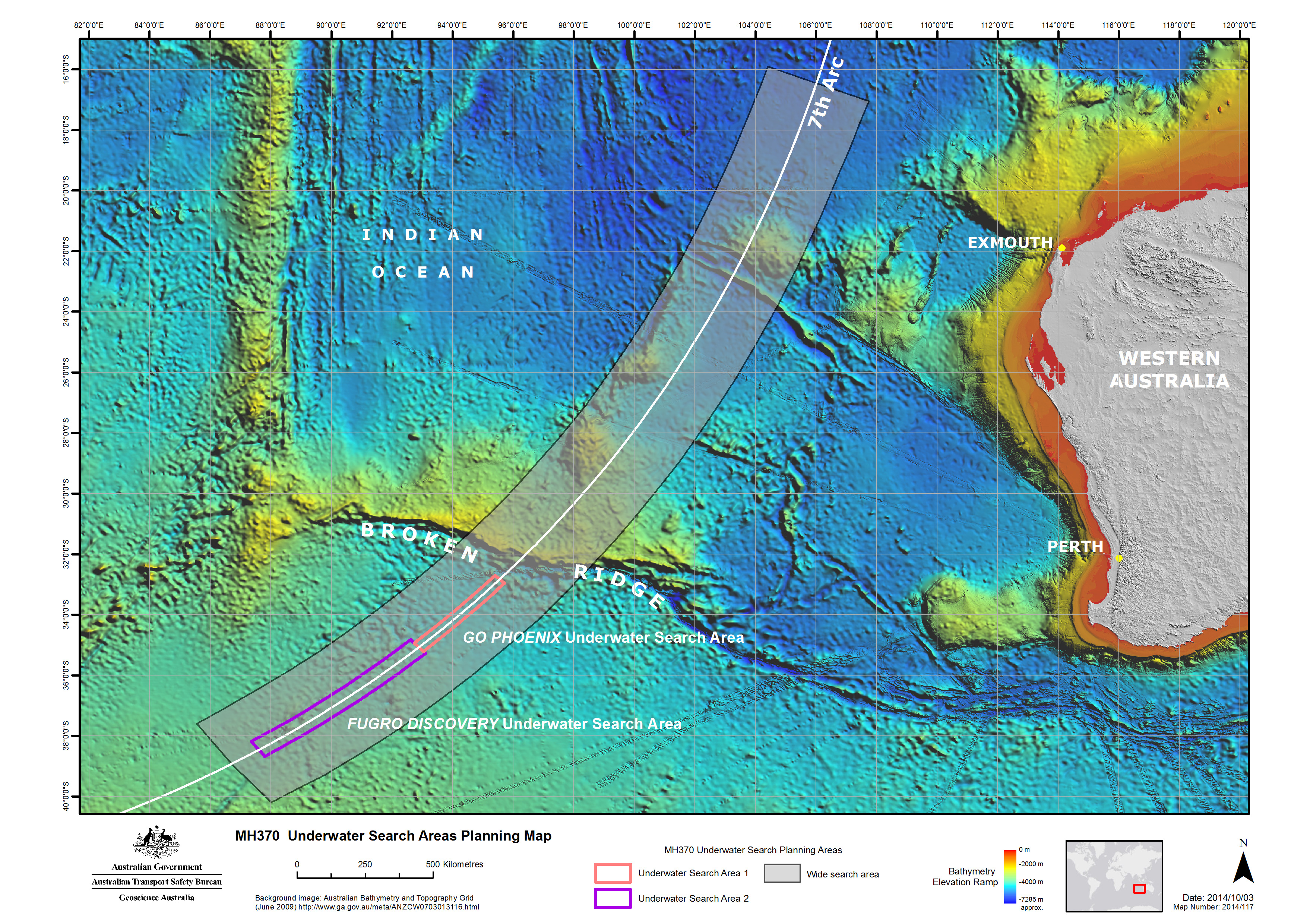
Information and analysis of satellite data and drift modelling identified an area set out in the map and labelled as the 7th arc. At the time MH370 reached this arc, the aircraft is considered to have exhausted its fuel and to have been descending. As a result, the aircraft is unlikely to be more than 27.5 NM (51 km) to the west or 25 NM (46 km) to the east of the arc.
Based on all the independent analysis of satellite communications and aircraft performance, the total extent of the 7th arc reaches from latitude 20 degrees S to 40 degrees S.
Click map to enlarge
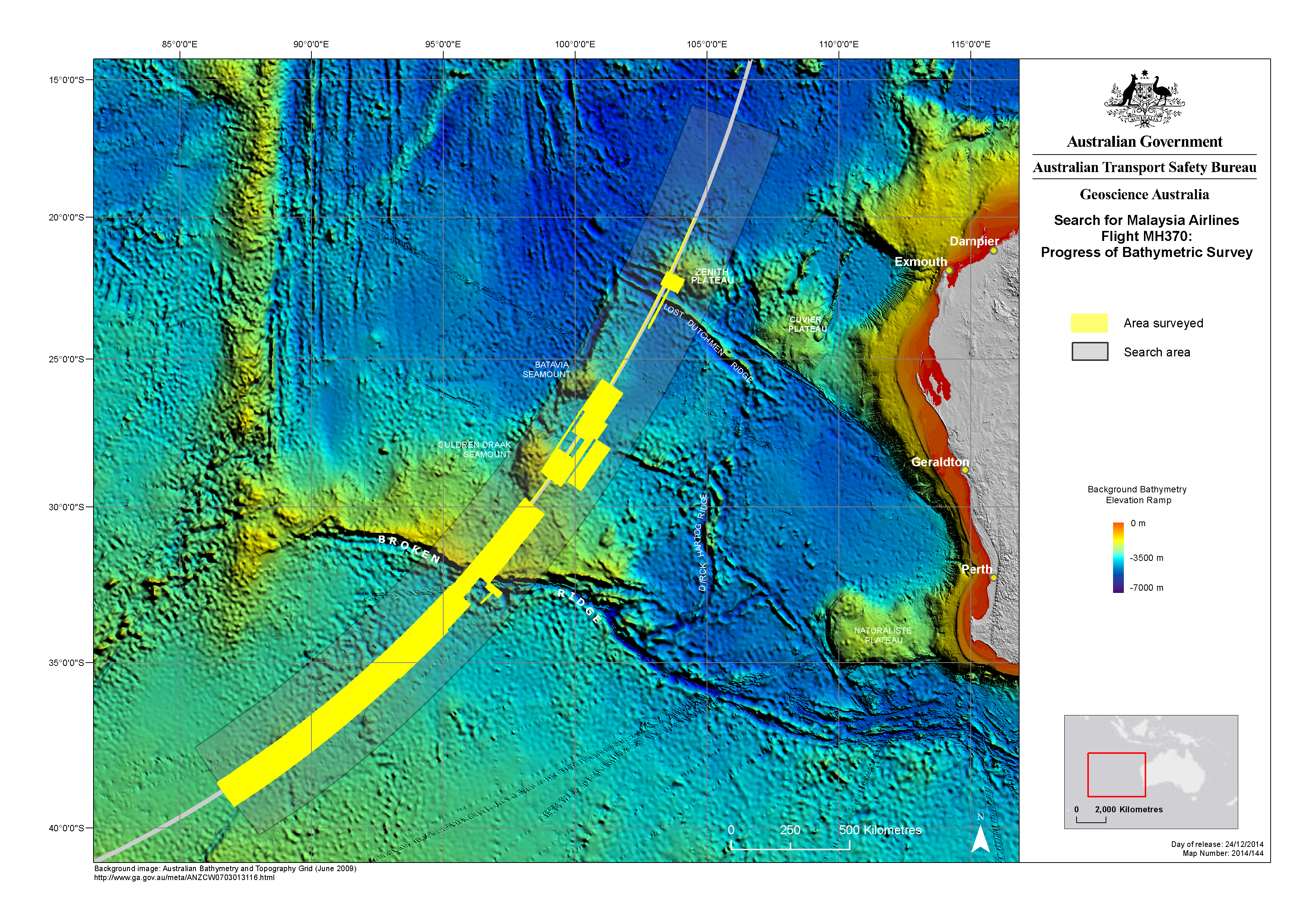
Bathymetric Survey
Before the underwater search for MH370 could begin, it was necessary to accurately map the seafloor to ensure that the search is undertaken safely and effectively. Bathymetric survey vessels spent months at sea, scanning the seafloor with multibeam sonar to gather detailed, high-resolution data. The data has revealed many seabed features for the first time.
Click map to enlarge
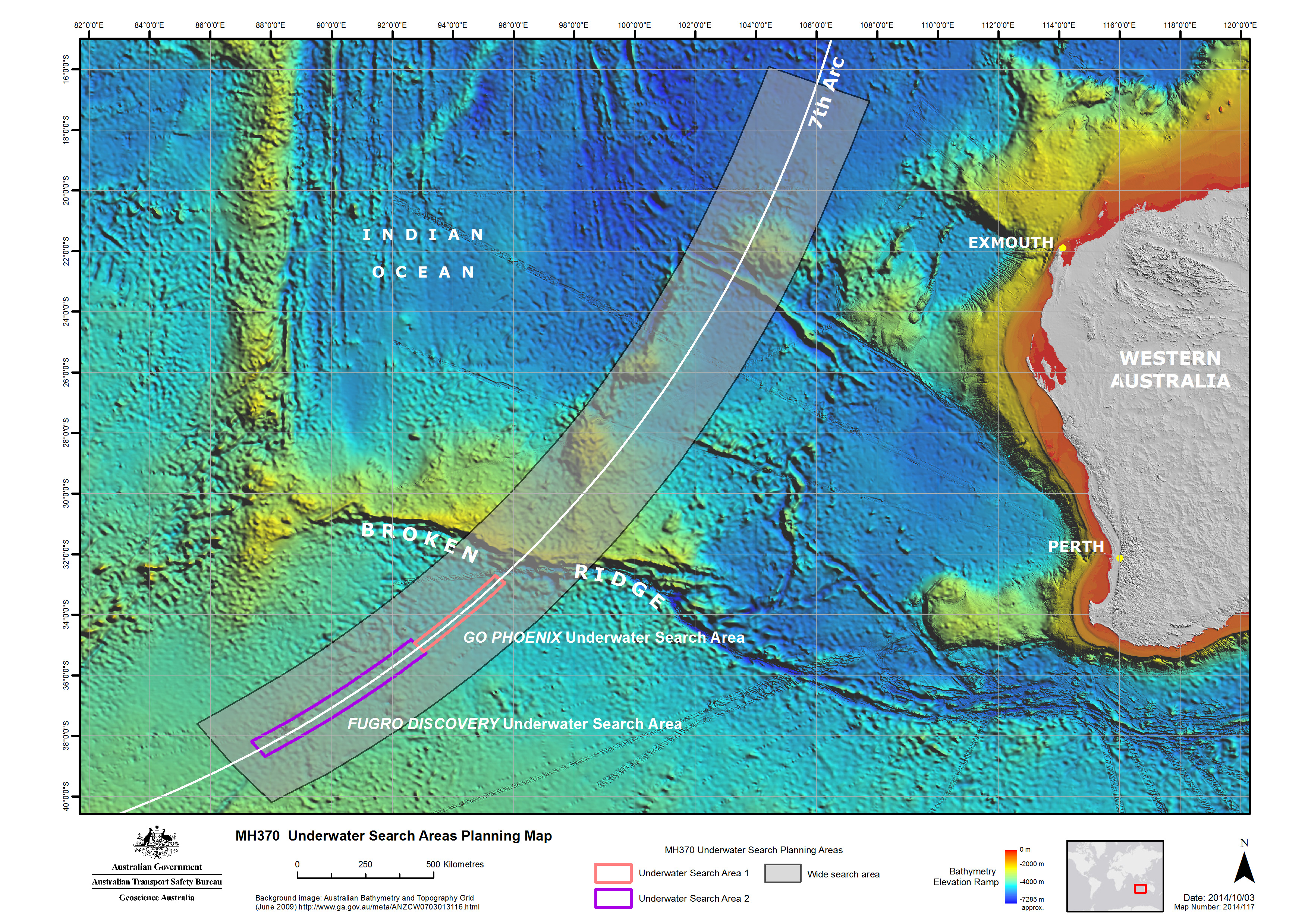
Underwater Search
In addition to locating the aircraft, the underwater search aimed to map the MH370 debris field in order to identify and prioritise the recovery of specific aircraft components, including flight recorders, which will assist with the Malaysian investigation. The ATSB utilised the data from the bathymetric survey work to prepare the initial plan for the underwater search, to be followed and referred to by all parties involved. The plan includes search timings, methods, procedures, safety precautions and the initial search areas for the various vessels.
Additional Maps
Additional maps showing previous search area, the progress of the bathymetric survey and detail of the undersea terrain are available in the gallery at our Images web page.
These videos illustrate different aspects of the search for MH370. You may use this material under a creative commons license(Opens in a new tab/window). That license allows you to copy, distribute, transmit and adapt this publication provided that you attribute the work.
Drift analysis undertaken by the CSIRO. This material supports that the debris from MH370 may be found as far west of the search area as La Réunion Island and is consistent with the currently defined Search area.
Blue, black and red dots simulate items with leeway factors (applied to the 10m wind velocity) of 1.2, 1.5 and 1.8%. The items originated along the black arc (7th arc) on 8 March 2014. White arrows are the winds for the day shown. Magenta symbols are positions of real drifting buoys (with sea-anchors at 12m) on the day. Their movement has been used to estimate the errors of the ocean current component of the total drift velocity.
Source: ATSB, simulation and video by CSIRO.
GO Phoenix experiences rough sea conditions in the southern Indian Ocean. The two blue shipping containers on the deck serve as portable workspaces, in which members of the search team conduct towfish operations and maintenance.
Source: Hydrospheric Solutions Inc., video by Ryan Galloway & Joshua Phillips.
Fugro Discovery encounters rough conditions in the Southern Indian Ocean as the search for MH370 continues through the winter months.
Source: ATSB, video by Mike Williams.
Fugro Discovery encounters rough conditions in the Southern Indian Ocean as the search for MH370 continues through the winter months.
Source: ATSB, video by Mike Williams.
An interview with Kristian Lynch of Fugro. He describes his work as the geophysicist aboard Fugro Discovery, processing the raw data obtained by the 'Dragon Prince' towfish into a usable form and sending to the Fugro offices in Perth. There, the material is reviewed and interpreted by experts.
Source: ATSB, video by ABIS Chris Beerens, RAN.
A short film describing the processes of bathymetric mapping and side scan sonar, used to gather data within the search area for missing Malaysia Airlines flight MH370.
Source: Geoscience Australia
Aboard Fugro Discovery, Dylan Lynch of EdgeTech, describes the sonar systems that are being used to search for MH370 and the way in which they are tested. Mr Lynch is a sonar specialist.
Source: ATSB, video by ABIS Chris Beerens, RAN.
Aboard Fugro Discovery, Andy Sherrell of Sherrell Ocean Services, describes the preparations for the search for MH370 and some of the challenges that the searchers face. Mr Sherrell is the ATSB’s Quality Assurance Manager for the Search for MH370.
Source: ATSB, video by ABIS Chris Beerens, RAN
Footage of ‘Dragon Prince’, the EdgeTech DT-1 towfish that is being used on Fugro Discovery to search the seafloor for MH370. In this film, Dragon Prince is launched for the first time by Fugro crewmembers as they test its capabilities.
Source: ATSB, video by ABIS Chris Beerens, RAN.
Geoscience Australia is providing extensive advice, expertise and support to the Australian Transport Safety Bureau (ATSB). The ATSB is leading a seabed mapping and underwater search for missing Malaysia Airlines flight 370 in the southern Indian Ocean.
Bathymetry is the study and mapping of the sea floor. It involves obtaining measurements of the depth of the ocean and is equivalent to mapping on land. Before the underwater search for MH370 could begin, it was necessary to accurately map the sea floor to ensure that the search is undertaken safely and effectively. Bathymetry survey vessels spent months at sea, scanning the sea floor with multibeam sonar to gather detailed, high-resolution data. The data has revealed many seabed features for the first time. This computer-animated ‘flythrough’ shows a visualisation of some of the sea floor terrain in the search area.
Source: Geoscience Australia
The conditions in the search area are challenging and extremely variable. As well as being quite cold, the surface of the ocean will vary from smooth to very rough with high seas and waves that are many meters high. The wind is also very changeable and unpredictable. In this video taken on board the Fugro Equator, you can experience conditions around a sea state 7.
Source: ATSB, video by Fugro
Footage taken off the stern of the Fugro Equator as it conducts bathymetric survey operations in the southern Indian Ocean. The bathymetric survey will produce a map that charts the contours, depths and composition of the ocean floor, in preparation for the underwater search for missing aircraft MH370.
Source: ATSB, video by Fugro
Bathymetry is the study and mapping of seafloor topography. It involves obtaining measurements of the depth of the ocean and is equivalent to mapping topography on land. The bathymetric survey will produce a map that charts the contours, depths and hardness of the ocean floor. The video above is not the result of the MH370 survey, but demonstrates the type of information and detail that is being gathered.
Creative Commons Attribution 4.0 Australia Licence is a standard form license agreement that allows you to copy, distribute, transmit and adapt this publication provided that you attribute the work.
You should attribute the image using the text in each image’s caption.