Wirestrike

Wirestrike, St Albans, New South Wales, Bell 206B III, VH-JIV

Summary

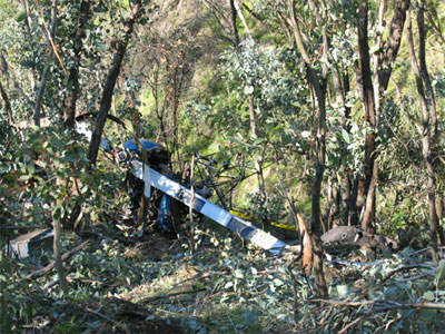
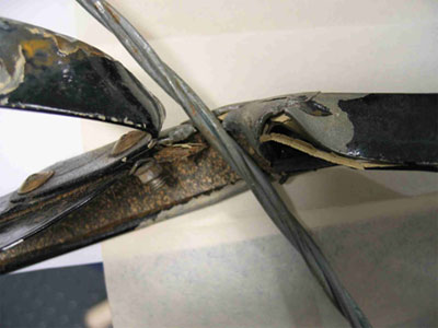
On 4 April 2006 a Bell Helicopter Company 206B III helicopter was being operated on a survey of powerlines in the St Albans area of New South Wales with a pilot, two power supply company personnel and a photographer on board. At about 1000 Eastern Standard Time, the pilot observed a previously unseen single-strand telecommunication cable support wire rubbing against the copilot's door and attempted to manoeuvre the helicopter clear of the wire. The helicopter lost directional control and commenced spinning to the right. However, the pilot cleared the wires and attempted a landing in an adjacent paddock. The helicopter came to rest on its right side and was severely damaged. One of the power supply company personnel received serious head injuries and the remaining occupants received minor injuries.

Safety action undertaken as a result of this accident included:

  • by the power supply company, who acted to:
    • immediately suspend helicopter inspections
    • appoint an internal accident investigation team that would make recommendations for the recommencement of helicopter operations
    • engage an aviation risk management consultant to assess the hazards affecting the company's aerial surveillance operations and to assist the internal investigation team
    • implement a number of safety actions that were recommended by the internal investigation team.
  • the removal by the telephone company of the single-strand telecommunication cable support wire that was struck by the helicopter.

Occurrence summary

Investigation number 200601663
Occurrence date 04/04/2006
Location 7 km south of St Albans
State New South Wales
Report release date 14/12/2006
Report status Final
Investigation type Occurrence Investigation
Investigation status Completed
Mode of transport Aviation
Aviation occurrence category Wirestrike
Occurrence class Accident
Highest injury level Serious

Aircraft details

Manufacturer Bell Helicopter Co
Model 206
Registration VH-JIV
Serial number 2894
Sector Helicopter
Operation type Aerial Work
Departure point Lower Portland, NSW
Destination Lower Portland, NSW
Damage Substantial

Wirestrike, 15km east of Parkes Aerodrome, New South Wales, VH-MFI, Bell 206B (III)

Preliminary report

Preliminary report released 22 March 2006

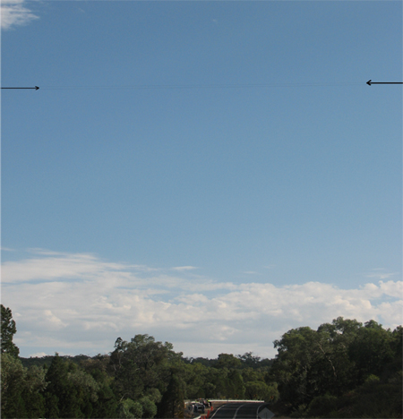
On 2 February 2006, a Bell Helicopter Company 206B (III) aircraft, registered VH-MFI, was being operated in the area east of Parkes, NSW on a noxious weed identification survey at low-level, for a local council. At about 0930 Eastern Daylight-saving Time, the helicopter was observed to strike a powerline about 130 ft above ground level (Figure 1), in a location known as 'The Dungeons', approximately 23 km east of Parkes. All three occupants were fatally injured.

Figure 1: Powerline running between arrow heads

aair200600523_001.jpg

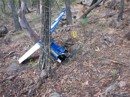
Examination of the wreckage revealed that the helicopter struck the powerline with the left landing gear skid (Figure 2).

Figure 2: Landing skid wire contact marks

aair200600523_002.jpg

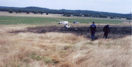
This led to the tail boom and tail rotor assembly being severed from the fuselage by the main rotor (Figure 3), as a result of which the helicopter entered an uncontrolled descent from which recovery was not possible. The helicopter was destroyed by impact forces and post-impact fire.

Figure 3: Severed tail rotor section

aair200600523_003.jpg

A witness reported that the helicopter appeared to be operating normally until it struck the powerline. The pilot was qualified to undertake the flight and the helicopter was being operated within the manufacturer's prescribed weight and centre of gravity limits.

The investigation is continuing and will include examination of:

  • low-level operational planning by the council and the helicopter operator
  • low-level obstacle information databases, and the accessibility of database information to low level operators, aircrew, and contractors.

Summary

On 2 February 2006, a Bell Helicopter Co 206B (III), registered VH-MFI arrived at Parkes Aerodrome from Dubbo, NSW in preparation for an aerial noxious weeds survey, including the requirement for a closer inspection of the eastern border area of the Parkes Shire Council. At an estimated 0923 Eastern Daylight-saving time, the pilot took off for the estimated 7 to 8 minutes flight to the survey area. Also onboard the helicopter were two council weeds control officers.

Witness reports indicated that, at about 0930, the helicopter struck a powerline that crossed the Parkes to Orange road.

The occupants of the helicopter were fatally injured, and the helicopter was destroyed by impact forces and a post-impact, fuel-fed fire. There was no damage to the powerline or associated facilities and structures.

As a result of this investigation, the Civil Aviation Safety Authority (CASA) indicated that it was considering the development of a Civil Aviation Order (CAO) with the effect that anyone carrying out low-level operations would have to satisfy relevant low-level flying standards.

The Australian Transport Safety Bureau (ATSB) issued two recommendations as a result of this investigation, including: the possible enhancement of the content of CASA's Approval to conduct Low-flying Instruments and the possible development of a Civil Aviation Advisory Publication or Advisory Circular for application in the conduct of low-level operations. In addition, the ATSB has commenced initial discussions with a number of agencies and associations in order to examine the feasibility of the establishment of a national database of information on the location of known powerlines and tall structures for access by pilots, operators and managers of aerial campaigns.

Aviation Safety Recommendations

[R20070013] [R20070014]

Occurrence summary

Investigation number AO-2006-155
Occurrence date 02/02/2006
Location 15km E Parkes, Aerodrome
State New South Wales
Report release date 03/08/2007
Report status Final
Investigation level Systemic
Investigation type Occurrence Investigation
Investigation status Completed
Mode of transport Aviation
Aviation occurrence category Wirestrike
Occurrence class Accident
Highest injury level Fatal

Aircraft details

Manufacturer Bell Helicopter Co
Model 206
Registration VH-MFI
Serial number 1060
Sector Helicopter
Operation type Aerial Work
Departure point Parkes, NSW
Destination Parkes, NSW
Damage Destroyed

Collision with powerlines, Brantly B-2B, VH-FBE, Gulgong, New South Wales

Summary

On 22 January 2006, at approximately 1930 Eastern Daylight-saving Time, the pilot of a Brantly International Inc B-2B helicopter, registered VH-FBE departed Mount Dapper property near Gulgong, NSW on a private flight to gain further experience on the helicopter.

After approximately 15 minutes, the helicopter was observed to commence a slow descent. An observer at the property homestead became concerned that the projected flight path may lead the helicopter to collide with the powerlines crossing the property. The observer reported seeing the helicopter contacting the powerlines, tumbling in the air and crashing to the ground. The helicopter was engulfed by fire and destroyed. The pilot, the sole occupant, was fatally injured.

The investigation did not find evidence of any pre-existing condition that would have contributed to the accident. All of the helicopter and its systems were accounted for at the accident site. All damage and the separation of parts of the helicopter were consistent with the onset of excessive loads experienced during impact with the wire and ground.

The observer reported that the powerlines had been on the property for a long time and their location was known by the pilot. The pilot had other power lines on the property marked with red coloured markers and had purchased two similar markers with the intention of having them fitted to the powerlines involved in the accident.

It is likely that the pilot became preoccupied with the operation of the helicopter and either forgot that there were powerlines in the area or did not see the powerlines.

FACTUAL INFORMATION

On 22 January 2006, at approximately 1930 Eastern Daylight-saving Time, the pilot of a Brantly International Inc B-2B helicopter, registered VH-FBE, departed Mount Dapper property near Gulgong, NSW, on a private flight to gain further experience on the helicopter.

After approximately 15 minutes, the helicopter was observed to commence a slow descent. An observer at the property homestead became concerned that the projected flight path may lead the helicopter to collide with the powerlines crossing the property. The observer reported seeing the helicopter contacting the powerlines, tumbling in the air and crashing to the ground. The helicopter was engulfed by fire and destroyed. The pilot, the sole occupant, was fatally injured.

Figure 1: The accident site

aair200600383_001.jpg

Note: The powerlines post is visible at the right corner of the photo. The powerlines extended to the left, almost overhead of the wreckage.

The investigation did not find evidence of any pre-existing condition that would have contributed to the accident. All of the helicopter and its systems were accounted for at the accident site. All damage and the separation of parts of the helicopter were consistent with the onset of excessive loads experienced during impact with the wire and ground.

The helicopter had recorded 170.1 hours in service at the time of the accident. It had flown approximately 65.7 hours since the last periodic inspection completed in November 2005.

The pilot was qualified on the type and approved for low flying. He held a valid medical certificate. At the time of the accident, he had accumulated a total of approximately 184 hours.

It was reported that the sky was clear, temperatures in the high twenties with a light and variable south-easterly breeze.

The observer reported that the powerlines had been on the property for a long time and their location was known by the pilot. The pilot had other power lines on the property marked with red coloured markers and had purchased two similar markers with the intention of having them fitted to the powerlines involved in the accident.

It is likely that the pilot became preoccupied with the operation of the helicopter and either forgot that there were powerlines in the area or did not see the powerlines.

Occurrence summary

Investigation number 200600383
Occurrence date 22/01/2006
Location Gulgong, (ALA)
State New South Wales
Report release date 31/05/2006
Report status Final
Investigation type Occurrence Investigation
Investigation status Completed
Mode of transport Aviation
Aviation occurrence category Wirestrike
Occurrence class Accident
Highest injury level Fatal

Aircraft details

Manufacturer Brantly International Inc
Model B-2
Registration VH-FBE
Serial number 2008
Sector Helicopter
Operation type Private
Departure point Mount Dapper Gulgong, NSW
Destination Mount Dapper Gulgong, NSW
Damage Destroyed

Bell 206B, VH-CSH, on 30 October 2004

Summary

At about 1215 EST on 30 October 2004, the pilot a of Bell Helicopter Company206B helicopter was engaged in aerial work operations in support of a plague locust control campaign. Also on board were two persons who were assisting the pilot in locating and determining the size of the locust infestation.

The helicopter was operating at a low level approximately 10 km south-west of Dunedoo NSW, when it struck powerlines and impacted the ground heavily. The pilot and the rear seat occupant suffered fatal injuries, while the remaining passenger suffered serious injuries.

The investigation found that the occupants of the helicopter were generally aware of the existence and location of the powerline during their operations.

Occurrence summary

Investigation number 200404590
Occurrence date 22/11/2004
Location 12 km SW Dunedoo, (ALA)
State New South Wales
Report release date 02/02/2006
Report status Final
Investigation type Occurrence Investigation
Investigation status Completed
Mode of transport Aviation
Aviation occurrence category Wirestrike
Occurrence class Accident
Highest injury level Fatal

Aircraft details

Manufacturer Bell Helicopter Co
Model 206
Registration VH-CSH
Serial number 358
Sector Helicopter
Operation type Aerial Work
Departure point Dubbo, NSW
Destination Dubbo, NSW
Damage Destroyed

Bell 47G-4A, VH-AHL

Safety Action

The responsible power company has:

  • installed overhead markers to the repaired power cables. Those markers approximate 'truck mudflap size', are bright in colour and include a reflector in the centre of the marker
  • nominated to be included in the Standards Australia committee responsible for the development of the standards affecting the mapping and marking of power cables and their supporting structures
  • indicated its intention to propose the overhead markers used to mark the repaired power cable for inclusion within the relevant Australian Standard.

The Australian Transport Safety Bureau has commenced a research project that will examine the potential influence of contractual structure and organisational interaction on the safety of aviation campaign operations such as invertebrate pest management and airborne fire-fighting activities. That examination will include the responsibilities for the management of the unique risks inherent to those types of campaign and seek to highlight risk mitigation options for consideration by future aviation campaign participants.

Summary

The Australian Transport Safety Bureau did not conduct an on scene investigation of this occurrence. The report presented below was derived from information supplied to the Bureau.

Sequence of events

At about 0900 Eastern Summer Time on 1 November 2004, the pilot of a Bell Helicopter Company 47G-4A, registered VH-AHL, repositioned the helicopter for loading prior to departing from his property airstrip for a locust spraying operation. That involved the pilot air taxiing1 the helicopter around and behind another helicopter that had already been loaded, and was about to depart the designated loading area.

The pilot reported that, as he air taxied abeam the other helicopter, he noted a power pole about 300 m from the helicopter, but had forgotten about the power cables that passed about 50 m from the airstrip. Those power cables were estimated to be at tree top height, which was less than 90 m above the ground. During the repositioning, the helicopter struck the power cables, and the pilot reported 'fighting' the helicopter to the ground. The helicopter was destroyed by the ground impact and post-impact fire. The pilot suffered minor injuries.

The pilot was appropriately qualified for the flight, and reported being medically fit and feeling well. There were no reported environmental or helicopter maintenance factors relevant to the circumstances of the occurrence.

In the pilot's opinion, had the power cables been marked,2 he would have seen and been able to avoid them. The pilot commented that land owners were expected to pay the cost of installing power cable markers, and that the installation costs could be prohibitive.

The requirements for the mapping and marking of power cables and their supporting structures are published in the following Australian Standards:3

  • AS 3891.1 - 1991 Part 1: Permanent marking of overhead cables and their supporting structures. This standard was approved on 18 February 1991 and published on 15 April 1991, and '...specifies the requirements for aircraft warning markers for use on overhead cables and their supporting structures'. In general, there is no requirement for the marking of cables with a height above terrain or obstacles of less than 90 m.
  • AS 3891.2 - 1992 Part 2: Marking of overhead cables for low level flying. This standard was approved on 1 September 1992 and published on 14 December 1992, and '...specifies requirements for permanent and temporary marking of overhead cables and their supporting structures for visual warnings to pilots of aircraft involved in low-level flying operations'. The Standard assumes pilot familiarity with the hazards in the low-level operating area, and that a visual reminder only is required of the exact location of the cables. Pilots are required to '...be satisfied as to the need for and effectiveness of markers prior to commencing low-level operations'. The installation of above ground markers requires the approval of the cable owner.

The responsible power company indicated that the land owner contacted the company after the occurrence regarding the possibility of marking the repaired power cables.

1 Airborne movement of the helicopter at low speed and generally when in ground effect.
2 Identifiable by a marker or markers installed on the power cables or their supporting structures or poles.
3 Prepared by the Standards Australia Committee on Geographic Information Systems in response to growing concern expressed by certain pilot and private and commercial aviation interest groups, the Civil Aviation Safety Authority, Government instrumentalities about the increase in incidents involving aircraft and overhead power cables.

Occurrence summary

Investigation number 200404286
Occurrence date 01/11/2004
Location Mudgee, Aero.
State New South Wales
Report release date 23/12/2004
Report status Final
Investigation type Occurrence Investigation
Investigation status Completed
Mode of transport Aviation
Aviation occurrence category Wirestrike
Occurrence class Accident
Highest injury level Minor

Aircraft details

Manufacturer Bell Helicopter Co
Model 47
Registration VH-AHL
Serial number 7632
Sector Helicopter
Operation type Aerial Work
Departure point Binomea Homestead, NSW
Destination Unknown
Damage Destroyed

Bell 206B, VH-JVW

Safety Action

Operator

The Chief Pilot has amended the company procedures to include the requirement for pilots to restrict the number of persons carried during locust survey operations to two. That was in order to increase the anticipated helicopter power margin, which would decrease the incidence of pilots being constrained to the conduct of heavy, shallow arrivals and departures to/from landing areas.

Civil Aviation Safety Authority

On 31 January 2005, the Civil Aviation Safety Authority (CASA) convened a round table discussion to consider potential safety activities relating to the conduct of aerial work in proximity to power cables. The participants in that discussion included representatives from relevant industry associations and other bodies and affected Government departments and agencies.

CASA has commenced planning to facilitate a conference in September 2005 involving relevant industry associations and other bodies and affected Government departments and agencies to further progress those safety issues confronting aerial work operations that were identified during the 31 January 2005 round table discussions.

Subsequent to the release of this report, the ATSB received advice from CASA on 14 July 2005 that due to funding constraints and minimal financial support from those organisations approached to support the conference, the conference would not go ahead. CASA advised further that the Authority would continue to work with the Aerial Agricultural Association of Australia and other relevant organisations in order to progress the safety issues affecting the potential for wire strikes to occur in the aerial work industry.

Aerial Agricultural Association of Australia Limited

The Aerial Agricultural Association of Australia Limited has nominated to be included in the Standards Australia committee responsible for the development of the standards affecting the mapping and marking of power cables and their supporting structures.

The NSW Department of Primary Industries

The NSW DPI has commenced an iterative approach to the review and amendment of the NSW DPI / RLPB SOP for Locust Control. That has included:

  • involving an operator having extensive experience in the conduct of plague locust campaigns in the re-development of the SOP
  • deleting the requirement for low-level flight along tree lines in order to flush adult locusts up and ahead of the helicopter
  • developing standard Task Profiles for the aerial survey and spotting tasks that include the following operating height limitations:
    - locust survey, not below 500 ft AGL
    - locust spotting, not below 100 ft AGL
  • promulgating minimum personal protective equipment requirements for the conduct of locust survey and spotting tasks
  • promulgating a minimum crew composition for locust survey and spotting tasks of one pilot and one aviation trained observer. That observer is to be provided by the aircraft operator, be appropriately trained and have a minimum of 50 hours aviation experience. The aviation trained observer is responsible for assisting the pilot with:
    - the operation of the aircraft
    - identification of hazards and their avoidance
    - mapping identified locust infestations
  • establishing an observer position, which can include carriage of either RLPB / DPI staff or local farmers in the rear of the survey aircraft. If carried, that observer has responsibility for assisting the pilot with:
    - local knowledge, including property boundaries and owners and environmentally sensitive areas
    - identification and mapping of locusts infestations
  • other than approved observers, prohibiting the carriage of back seat passengers
  • prohibiting flight by RLPB / DPI employees below 100 feet AGL
  • amending the flight following and search and rescue procedures.

RLPB and DPI staff members likely to be involved in locust control helicopter operations have completed the National Parks and Wildlife aircraft operations awareness course.

ATSB

The Australian Transport Safety Bureau has commenced a research project that is examining the potential influence of contractual structure and organisational interaction on the safety of aviation campaign operations such as invertebrate pest management and airborne fire-fighting activities. That examination includes the responsibilities for the management of the unique risks inherent to those types of campaign, and seeks to highlight risk mitigation options for consideration by future aviation campaign participants.

When complete, the research project report will be published on the ATSB website www.atsb.gov.au or be available from the Bureau on request.

Significant Factors

  1. No-one aboard the helicopter identified the spur line overhead the intended touchdown point in sufficient time to allow the pilot to avoid impacting the wire.


Analysis

Risk management options for application during an airborne task include reducing the consequence and/or likelihood of adverse events, such as an aircraft striking a power cable. Those options having the potential to affect the consequence of a wire strike include:

  • the use of helmets and wearing of full-cover clothing by aircraft occupants
  • installation of wire-strike protection systems
  • inclusion of advanced safety harnesses
  • appropriate flight following and search and rescue procedures.

However, in terms of risk, the consequence of an aircraft striking a power cable can generally be expected to be severe to catastrophic. As a result, a large investment is generally made by involved parties in order to decrease the likelihood, and therefore risk of a wire strike. That was the case during the 2004 Plague Locust Control Campaign.

The regulatory requirements affecting aircraft operations below 500 ft above ground level, including in the plague locust aerial support task, were an attempt to reduce the likelihood of an adverse event affecting a pilot during those operations. In addition, the Expression of Interest (EOI) mandated requirements affecting the acceptability of nominated pilots for employment in the locust survey task, indicated an attempt by the NSW Department of Primary Industries (DPI) to further reduce the likelihood of an adverse event during the locust control campaign. Also, the establishment by the operator of specific pilot low-level operations competency requirements defined an additional risk mitigation strategy that was based on the reduction of the likelihood of an adverse event in that environment. Both the DPI and the operator's requirements were in excess of the Civil Aviation Safety Authority regulatory requirements, and were valid risk management options for application in the locust survey task.

It was likely that Rural Lands Protection Boards (RLPBs) relied on the pilot's competence and experiential requirements of the EOI when considering the risks affecting their employees during aerial survey operations. The lack of any local control measure that would have allowed the Forbes or other control centre staffs to ensure that the occurrence and other pilots complied with those requirements meant that the Forbes, and possibly other RLPBs unknowingly placed its employees in a potentially higher risk environment than intended. Similarly, the residual risk inherent in the locust control campaign, including that of a wire strike could have been higher than initially accepted by the State Council in order for the campaign to commence.

The emergency nature of the 2004 locust control infestation resulted in the involvement of DPI and RLPB staff volunteers from throughout NSW in the locust control campaign. In addition, operators and pilots from many backgrounds and experience bases were also involved in that campaign. Those circumstances, together with the 'living' nature of the Standard Operating Procedures (SOP) and, in some instances verbal amendment process minimised the likelihood of the standardisation of airborne techniques and procedures among those operators, pilots and DPI / RLPB staff. That was confirmed in this instance by the recent consideration of whether a survey helicopter needed to land to examine the bands of locusts and the variation in knowledge of the content and application of the SOPs among the DPI / RLPB staff aboard the helicopter.

It was probable that the pilot was unaware of the rear seat occupants' perceived lack of involvement in the identification of power cables or other hazards, or communication equipment difficulties affecting that process. That meant that the identification of any power cables and other hazards effectively rested with the pilot and senior ranger. It was likely that, having drawn the pilot's attention to the wires to the west of the landing area, the senior ranger applied his concentration to the locust band in the paddock once the pilot commenced the final stages of the approach to land. In that case, the identification of the west to east spur line fell to the pilot. Although unable to be quantified, there was the potential that the pilot's workload during the approach to land in the unfamiliar environment adversely impacted on his ability to detect the west to east spur line. The result was that no-one onboard the helicopter detected that spur line.

The abbreviated nature of the pilot's induction meant that the pilot had to integrate relevant aspects of his low flying training and previous experience to the specifics of the locust survey task while carrying out that task. In contrast to the pilot's likely intimate knowledge of the few power cables in the Kununurra area, the density of the power cables in the Forbes area, and the differing environmental and other cues indicating the presence of those cables, suggested that the pilot would have benefited from a practical consolidation of elements of the Chief Pilot's brief. The lack of that practical consolidation had the potential to reduce the reliability of the operator's low-level rating/approval/training requirement as a risk management tool.

Depending on respective pilots' ratings and endorsements, there was a potential difference between survey and spray pilots' knowledge and skills bases affecting the low-level locust control operations. Adherence to the DPI SOP meant that, in the event that a survey pilot did not have an agricultural rating, the pilot may not be able to contribute effectively to the identification and communication of low-level hazards and sensitive areas by an on board ranger or spotter. That could result in the ranger or spotter unwittingly omitting information that was potentially critical to the safe application of relevant chemicals by a spray pilot. Although a spray pilot retained ultimate responsibility for the safety of that application, the investigation concluded that the SOP compounded the risk of an unsafe or environmentally unsound application by a spray pilot.

The SOP requirement for locust survey pilots to fly along creek and tree lines in order to flush up adult locusts could be perceived to represent a form of mustering manoeuvre. Unless included as an individual operator requirement, or an individual pilot held a mustering approval or had completed low-level training, the SOP required pilots to conduct those mustering-like manoeuvres without the benefit of the competency-based mustering risk controls inherent in the requirements of Civil Aviation Order 29.10. In addition, that procedure placed pilots in an environment identified by the Chief Pilot as being particularly dangerous with regard to power cables and other hazards. There was the potential that the SOP manoeuvre requirement could combine with those environmental dangers to increase the likelihood, and therefore risk that a pilot might strike a power cable or other hazard to unacceptable levels.

This investigation identified the potential for the application of relevant risk management strategies to reduce the residual risk affecting a low-level aircraft operation to a level considered acceptable by that operation's stakeholders. The majority of the investment in risk management in that environment was found to be in the reduction of the likelihood of an adverse event. In this occurrence, the lack of a robust application of existing risk controls to the locust survey task resulted in the level of residual risk, including that of a wire strike, being above that intended by the State Council, and considered by respective RLPBs when approving the employment of their staff in airborne operations. The investigation was unable to quantify the contribution of that elevated residual risk to the development of the accident.

Summary

Sequence of events

At about 1215 eastern summer time on 30 October 2004, the pilot of Bell Helicopter Company 206B, registered VH-JVW, was conducting aerial work in support of the Forbes area Plague Locust Control Campaign (campaign) that was being administered by the NSW Department of Primary Industries (DPI). Also on board the helicopter were the local Rural Lands Protection Board (RLPB) senior ranger, who was seated in the left front seat of the helicopter, and one RLPB and one DPI staff member who were seated in the rear cabin of the helicopter.

The senior ranger requested the pilot to land in a paddock in order to examine a previously unidentified band1 of locusts. The pilot reported conducting two orbits of the proposed landing area prior to commencing the approach to land in a north-easterly direction. During those orbits, the pilot asked all the occupants of the helicopter to keep a look out for power cables and other potential hazards in or around the landing area. However, one of the rear seat occupants reported the understanding of not being required to call or report power cables unless it was felt that the pilot had not seen a cable. While neither of the rear seat occupants reported the presence of any power cables to the pilot, the pilot and senior ranger saw a north to south running power cable located on the western boundary of the paddock. They also noted a westerly spur line emanating from a power pole located abeam the intended landing point. That power pole was also supporting the north to south power cable. No-one aboard the helicopter identified a second spur line emanating from that same power pole, and tracking to the east and overhead the intended touchdown point.

The pilot reported that, when at 'low airspeed' and passing through an estimated 25 ft above ground level (AGL) on the final stages of the approach to land, a previously unidentified power cable became caught between the skids and underbelly of the helicopter. The pilot indicated that he attempted to manoeuvre the helicopter free from the cable, but that the helicopter pitched 90 degrees nose down and impacted the ground heavily on its nose before rolling onto its roof. The helicopter came to rest on its right side, facing back along the direction of approach, and was extensively damaged. There was no fire. The senior ranger suffered minor injuries, and the pilot and rear cabin occupants were not injured.

Personnel information

The pilot was appropriately qualified for aerial work operations in the helicopter, and reported being medically fit, feeling well and adequately rested. The pilot was not required to wear or carry any vision correction spectacles, although he reported that he was wearing tinted sunglasses at the time of the accident. He had about 300 hours low flying experience2 at the time he was nominated by the operator for employment in the plague locust survey task. The pilot indicated that he had:

  • most recently been operating in the Kununurra area
  • not previously operated in the Forbes area, or with the operator
  • no experience in plague locust survey or other operations.

The senior ranger indicated that he had flown in a helicopter once prior to the 2004 campaign. However, he had carried out an estimated 15 to 20 plague locust survey flights in helicopters during the 20 to 25 days preceding the accident. He had attended in-class locust control training courses that were administered by the DPI earlier in the year, but had received no experiential training in accordance with the requirements of DPI Standard Operating Procedure (SOP) for Australian Plague Locust Control in NSW number 15.16. Among other requirements, that SOP required that all DPI and RLPB staff assigned to fly in survey aircraft should have appropriate experience in detecting bands and directing spray aircraft. The senior ranger reported that, during the occurrence flight, his responsibilities included managing the survey task and acting as an observer.

One of the rear seat occupants had been involved in two previous survey flights during the campaign, and reported being responsible for spotting and recording locusts during the flight. That spotter had attended two brief, in-class training courses conducted by the DPI shortly before the campaign, but had been given no experiential training in the detection of bands or direction of spray aircraft.

The second rear seat occupant had been airborne in a helicopter once previously during the campaign and had minimal aviation experience. During the flight, that occupant shared responsibility for spotting and recording locust infestations. That spotter reported having attended a DPI workshop prior to participating in the campaign that examined the identification of plague locusts, but that no experiential training in relation to the detection of bands of direction of spray aircraft had been provided.

Aircraft information

Based on the evidence provided to the investigation, the aircraft was certified, equipped and maintained in accordance with the regulations and approved procedures. The windscreen was reported to have been clean, and there was no damage to the windscreen, or any obstruction that might have adversely affected visibility from the cockpit. The aircraft was not fitted with, and neither was there a regulatory requirement for the installation of a wire-strike protection system3 (WSPS). The Chief Pilot indicated that he felt WSPS might not have had any effect in this instance because the helicopter struck the power cable at low speed.

One spotter reported an intermittently operating intercom system, requiring communication with the remainder of the helicopter occupants through the second rear seat occupant. The rear seat belts installation included four-point lap and shoulder harness seatbelts for each occupant.

Meteorological information

No evidence was found to suggest that the weather conditions influenced the circumstances of the occurrence.

Survival aspects

Civil Aviation Order (CAO) 20.11 included the requirement for pilots to orally brief all passengers before each take-off. The pilot reported that, while he had briefed the passengers in accordance with that requirement, the actions in the event of an emergency and a reliable method for reporting power cables, or other hazards by the senior ranger and spotter were not discussed. For example, …wire right 3 o'clock, 300 m, travelling front to rear (of survey helicopter), etc.

The pilot indicated that he had been wearing a helmet at the time of the occurrence, and that the helmet visor was in the raised position. There was no regulated requirement for the senior ranger or rear seat spotters to be similarly equipped, and no stipulated minimum standard of flying or personal clothing for those persons for airborne operations in accordance with DPI or RLPB requirements. Such requirements might typically include full-cover clothing, safety boots, etc.

Administration of the 2004 plague locust infestation

In NSW, the Rural Lands Protection Act 1998 (RLPB Act) and Pest Control Order Number 6 under that Act declared the Australian Plague Locust to be a pest and imposed obligations on the occupiers of controlled land to report locusts on their lands to their local RLPB and to destroy those locusts. Assistance could be provided by the relevant RLPB, DPI or Australian Plague Locust Commission when the destruction of the locusts became beyond the capability of the individual land owner(s). In addition, the RLPB Act established a State Council as a corporate body with responsibility for ensuring implementation by RLPBs of:

  • the general policies for the protection of rural lands
  • operations in accordance with determinations made from time to time at State Conferences or by postal ballot.

The State Emergency and Rescue Management Act 1989 (SERM Act) required the DPI to coordinate the response to agricultural or animal emergencies with the support of relevant participating and supporting organisations. The State Agricultural and Animal Services Supporting Plan Memorandum of Understanding (MOU) established the DPI and State Council responsibilities for the preparedness for, and response to agricultural or animal emergencies. That MOU enabled the DPI to approach the State Council in order to seek technical expertise, personnel support and other assistance from RLPBs in agricultural emergencies.

At the time of the accident, there were 48 RLPBs throughout NSW. Each Board was a statutory authority under the RLP Act and was constituted for each rural lands protection district. Legislated RLPB responsibilities included those functions affecting the protection of rural lands, including the surveying and monitoring of plague locust infestations on pastoral lands. Should an infestation be considered to reach a defined density, the relevant RLPB and DPI determined the appropriate control measure. That was the case in 2004, when the locust infestation reached plague proportions in certain regions of NSW.

In response to the expected magnitude of the locust outbreak in the spring of 2004, the DPI requested through the State Emergency Management Committee (SEMC) that the locust outbreaks should be recognised as an emergency under the SERM Act, with DPI as the lead agency in any emergency response. That was supported by the SEMC and allowed the DPI to access relevant emergency management systems and resources. That included a request for assistance from the State Council to RLPBs from throughout NSW.

In response, RLPBs sought volunteers from among their staff who: were willing to be involved; could be released from their own Boards for the agreed period; and had the requisite skills or experience for the necessary tasks. During the campaign, those volunteer personnel were under the control of the relevant Local (locust) Control Centre, while administratively remaining a responsibility of their respective RLPB.

Aerial control of the 2004 locust infestation was coordinated by the Australian Plague Locust Commission, with responsibility for the area west of the Newell Highway and the DPI, east of that highway. The DPI responsibility included:

  • monitoring locust populations and levels of infestation
  • implementing particular aerial control measures for application in specific areas
  • contracting for the provision of aeroplane and helicopter services in response to aerial spraying and survey requirements
  • the purchase and supply of chemicals for airborne and ground-based application.

Contractual information

In response to the unpredictable nature of the requirement for aerial support to assist in activities related to the control of Australian plague locust and other species, the DPI sought Expressions of Interest (EOI) from aircraft operators to become 'prequalified service providers' of that aerial support. Successfully pre-qualified operators were placed on an approved pre-qualified applicant list, indicating operators' agreement that their aircraft, pilots and crewmembers would assist with locust control activities on a 'call when needed' basis.

The submission of an EOI by an operator indicated the operator's agreement with the Conditions of Contract as set out in section three of the EOI. Those conditions included that:

  • The operator was required to notify the DPI of any variation in respect of aircraft and/or pilot information and obtain DPI approval in writing for that variation.
  • The operator and its employees were suitably trained and able to demonstrate current competency. In that regard, an operator's Chief Pilot was required to certify that each pilot was rated, endorsed and competent to complete plague locust tasking.
  • No pilot may undertake any task for the DPI unless approved in writing. That was reflected in the contract clauses, requiring an operator to obtain that written approval before allowing a pilot to undertake aerial support in connection with locust control services.

In respect of the operator's interaction with the DPI under those conditions:

  • In response to a post-accident request by DPI, the operator provided the pilot's information by facsimile on 17 December 2004. There was no measure in place at the Forbes or other local control centres to allow local staff to check variations in pilot information against a DPI master list of approved pilots prior to a pilot commencing locust control work. That was the case with the occurrence pilot.
  • The Chief Pilot certified the pilot's ratings, endorsements and competence for employment in the plague locust task on 29 October 2004. That certification was not forwarded to DPI until 17 December 2004.
  • There was no control measure in place at local control centres to ensure that written approval was given by the DPI prior to the occurrence, or other pilots undertaking locust survey tasks.

In addition, the EOI allocated responsibility for the training of DPI and RLPB staff, and any other person involved in airborne operations, to the operators of those aircraft. The minimum requirements for applicants for pre-qualification included that 'pilots engaged or to be engaged by the Applicant must have at least 50 hours plague locust spraying and/or survey experience as appropriate' and 'Low Flying approval with at least 500 hours experience'. In the case of aerial spraying of locusts, pilots were required to hold a Grade 1 Agricultural Rating and be Spray Safe-accredited by the Aerial Agricultural Association of Australia (AAAA). In addition to requiring defined flying experience in agricultural operations, that rating included an examination to confirm a pilot's knowledge of the content of the CASA Aerial Agricultural Pilot's Manual, which stressed the importance of an agricultural pilot to carry out his or her own airborne inspection of an area to be sprayed. That was because it was the spray pilot's last critical opportunity to confirm their hazard map and other planning details. In the case of locust survey aircraft:

…the pilot must have a general permit for low flying ("Low Flying approval") in accordance with Regulation 157 of the Civil Aviation Regulations 19884.

During the evaluation of the response to the EOI that was submitted by the operator, DPI staff identified that, of the two company pilots initially nominated for the plague locust survey task, one certified having 18 hours locust survey experience and, the second pilot, no locust survey experience. Notwithstanding, the operator was contracted by the DPI as a Pre-Qualified Service Provider, Locust Control on 13 October 2004.

The Chief Pilot reported having an agreement with an operator located in the north of WA for the cross-hire of helicopters between the companies, and short notice cross-employment of pilots. That was to allow for the movement of those resources in response to seasonal up and downturns in each company's workload. The occurrence pilot commenced plague locust survey support work in the Forbes area while remaining an employee of the WA-based operator.

NSW DPI / RLPB Standard Operating Procedures for Locust Control - Effective 16 July 2004

The NSW DPI / RLPB Standard Operating Procedures (SOPs) for Locust Control established the requirements for aircraft operations involved in the 2004 campaign. Knowledge of the content of the SOPs varied amongst those aboard the helicopter. One DPI / RLPB staff member indicated having read the SOPs, although being unsure of the requirements placed on locust survey aircraft, while another confirmed that there were SOPs, but indicated having not read them comprehensively.

All DPI and RLPB staff assigned to fly in locust survey aircraft were required to '…have SLC [State Locust Controller] approval to fly and appropriate training and experience in detecting bands and directing spray aircraft'. During the investigation a previously unknown error in the SOP was identified by DPI concerning that approval. That error included that approval for DPI and RLPB staff to undertake locust survey flights had always been at the local level. DPI advice was that at the Forbes Control Centre, employees were allocated to locust survey aircraft on a weekly basis, and that allocation was notified to staff on a whiteboard. No written record was available to confirm staff allocation to the occurrence helicopter. Subsequent advice from the DPI included that, due to the nature of the 2004 locust campaign, the SOPs 'were seen as "living" documents which could be changed if required'. In that regard, the change in the approval process for employees to fly in survey helicopters had been conveyed to local control centres verbally, although the text of the SOPs had not been modified.

The SOP included the potential for helicopter survey of widespread and sparsely concentrated young (nymphs) or adult locusts. In the case of nymphs, the initial survey was required to be conducted at about 1,500 feet AGL. The location of significant infestations was marked using Global Positioning System (GPS) equipment and the number and size of the nymphs estimated in order to identify 'blocks' for subsequent aerial control, including aerial spraying of identified infestations to complement the ground spraying campaign.

The SOP included that onboard DPI / RLPB observer(s) 'may require the helicopter to land so that [they can] verify their observations' if the nymphs were not 'banding as normal5', or there was extensive ground cover. It was reported that had been the case during the occurrence flight, when the senior ranger had decided that the pilot should land the helicopter in order to prioritise target bands for spraying the following day. The senior ranger indicated that there had been recent discussion between local and other RLPB / DPI staff regarding the need to land a survey helicopter in order to prioritise bands for subsequent spraying. The senior ranger was unable to confirm the outcome of that consideration.

When conducting searches for adult locusts, and in the expectation that the adult locusts would flush up ahead or around the manoeuvring helicopter, the SOP required pilots to:

…fly along tree and creek lines and in localised areas of green vegetation approximately 12 ft (3 m) above ground level and at 30 knots (60 km/h).

Once a target group of locusts had been identified for aerial spraying, the SOP required the Local Locust Controller (LLC) or ranger aboard the locust survey aircraft to direct the spray aircraft to the target using GPS coordinates. The LLC or ranger was then required to:


  • Relay the boundaries of the target to the pilot of the spray aircraft. That entailed either:
    - the survey pilot flying the boundaries, and the LLC or ranger confirming the spray pilot's understanding of the boundaries via radio communication; or
    - the LLC or ranger verbalising the boundaries via radio communication, then observing the spray pilot flying around those boundaries.
  • Identify and highlight any sensitive areas and hazards to the spray pilot. That included environmental and physical hazards, such as farm dams and power lines.

The Airfield Controller (controller) was responsible for coordinating aircraft operations at an airfield or landing area, compiling and managing Search and Rescue (SAR) logs, etc. That controller complied with the SOP requirement for the completion of a SAR - Aircraft Information Sheet for the occurrence helicopter task. In addition, the SOP required the controller to follow laid down, incremental search procedures should an aircraft fail to make a planned radio broadcast indicating normal aircraft operations or to return to base. The pilot indicated that he had been transmitting scheduled Operations Normal radio broadcasts at regular intervals to indicate normal helicopter operations, and the expected time of the next such transmission by the pilot. The pilot reported that he did not transmit a distress call upon striking the power cable. Notification of the occurrence was via a combination of telephone calls by the pilot and DPI / RLPB staff once clear of the wreckage.

Regulatory framework

In accordance with Civil Aviation Regulations (CAR) 157, flight is authorised below 500 ft when clear of any city, town or populous area and the aircraft is conducting aerial work operations that:

…require low flying, and the owner or operator of the aircraft has received from CASA either a general permit for all flights or a specific permit for the particular flight to be made at a lower height while engaged in such operations;…

The operator held a Low Level Flying Permit that authorised air work operations below a height of 500 ft AGL. Those operations were specified in the company Operations Manual and included aerial spotting and/or counting of wildlife and other similar tasks on behalf of landowners or Government Departments/Agencies/Instrumentalities. In addition, the company Operations Manual included that pilots in command of company aircraft carrying out low-level aerial spotting operations must:

(b) hold an appropriate agricultural rating or mustering approval or have satisfactorily completed the dual training specified for the appropriate kind of aircraft in CAO 29.10, Appendix 1;

CAR 206 lists aerial spotting and agricultural operations as operations conducted for aerial work purposes. Agricultural operations are defined as:

…the broadcasting of chemicals, seeds, fertilizers and other substances from aircraft for agricultural purposes of pest and disease control.

CAO 40.6 defines the requirements of Agricultural Pilot Rating Grades 1 and 2. Those requirements include completion of a period of ground training and a written exam, before carrying out initial and operational flying training. The operational flying training is followed by a period under supervision, before the newly rated agricultural pilot is able to conduct unrestricted agricultural operations. The Grade 1 rating required a helicopter pilot to hold, or have held a Grade 2 rating, and to have logged a minimum of 500 hours experience on helicopter agricultural operations.6

Aerial stock mustering is defined in CAO 29.10 as 'the use of aircraft to locate, direct and concentrate livestock whilst flying below 500 feet above ground level'. The aeronautical experience requirements for a pilot to engage in mustering operations include that the pilot must complete 5 hours low flying training7 and an exam to confirm pilot proficiency, followed by 10 hours operational training. The occurrence pilot completed the low flying training component of that requirement in March 1999.

Pilot induction

The Chief Pilot indicated that the pilot's preparation for the conduct of plague locust survey support included that:

  • On 29 October 2004, the pilot signed as having read the company Operations Manual. That indicated the pilot's agreement to operate the helicopter in accordance with that manual
  • The Chief Pilot conducted a pre-flight brief followed by a 0.3 hour check flight with the pilot on the morning of the accident. The content and duration of that flight was reported to be based on the pilot's recency with the helicopter type, and the high degree of commonality between the Bell 206B helicopters being operated by the company in support of the locust control campaign, and by the pilot's company in the north of WA. The primary differences between the helicopters included the radio installation and associated switches.

The Chief Pilot reported placing heavy emphasis on identification and avoidance of power cables and other hazards during the pre-flight brief, and stressing the particular dangers associated with operating below the tree tops. That was in recognition of the majority of the pilot's experience being in the Kununurra area, where the Chief Pilot felt there were not as many wires compared with the Forbes area. There was no practical application or review in the check flight of means available to a pilot to identify power cables and their orientation, or to demonstrate the difficulties affecting that identification.

In addition, the Chief Pilot indicated that he preferred steeper landing approaches and departures, because that increased the likelihood that any power cables might be seen during the approach or departure. In order to increase the power margin8 available for that steeper landing approach and departure technique, the Chief Pilot's preference was to restrict the number of passengers carried to no more than two. Those considerations were developed by the Chief Pilot during the campaign, and were not passed on to the pilot during the pre-flight brief or check flight.

Risk management

Australian/New Zealand Standard AS/NZS 4360:2004 Risk Management (the Standard) defined risk as:

the chance of something happening that will have an impact upon objectives.
NOTE 1: A risk is often specified in terms of an event or circumstance and the consequences that may flow from it.
NOTE 2: Risk is measured in terms of a combination of the consequences of an event … and their likelihood…
NOTE 3: Risk may have a positive or negative impact.

The Standard described risk management as 'the culture, processes and structures that are directed towards realizing potential opportunities whilst managing adverse [or negative] effects'. Residual risk is that 'risk remaining after implementation of risk treatment'. Options for modifying or treating identified risks with negative outcomes included:

  • influencing the likelihood of a risk, in order to reduce the probability of a negative outcome
  • changing the consequence(s) of an event to minimise the extent of any losses.

RLPBs were required to satisfy themselves that adequate arrangements were in place to manage risks associated with aerial survey operations before allowing their employees to undertake work-related tasks in support of the locust control campaign. There was no evidence of any guidance, such as the Standard having been provided to RLPBs to allow their confirmation of the adequacy of those arrangements. The State Council indicated that, while low-level survey by any aircraft was a high risk activity, the adoption of appropriate risk control measures had the potential to reduce the probability of an adverse incident to acceptable levels. However, the Council recognised that, even with such risk controls in place, there remained the residual risk of a serious incident or accident.

Wire density and the requirement to mark overhead power cables

The pilot stated that there were virtually no power cables in the Kununurra area when compared with his locust survey support experience in the Forbes area. The investigation determined that the density of the known power cables within a 100 km radius of Kununurra, excluding in the townships of Kununurra and Wyndham was one known power cable per 10,476 square kilometres. That represented three power cables that tracked between the two towns, and from Kununurra to the Ord River Dam and on to the site of the Argyle Diamond Mine.

In the Forbes area, that wire density, excluding in any townships was estimated to approach one known power cable per 10 square kilometres. The pilot indicated that the cable struck by the helicopter had not been marked on the World Aeronautical Chart used to navigate to the nominated survey area. He felt that the power cable had been difficult to see because of the extended spacing between the poles supporting that cable when compared with the spacing of the poles supporting the north to south power cable that was identified on the western boundary of the intended landing area.

The requirements for the mapping and marking of power cables and their supporting structures are published in Australian Standards AS 3891.1 1991 Part 1: Permanent marking of overhead cables and their supporting structures, and AS 3891.2 - 1992 Part 2: Marking of overhead cables for low level flying. The general requirements of those standards were discussed in ATSB investigation report BO/200404286 and include that, in general, there is no requirement for the marking of power cables with a height above terrain or obstacles of less than 90 m. The power cable that was struck by the helicopter did not require marking in accordance with either standard.

Technical committees are formed by Standards Australia to develop and review relevant standards, and comprise a balance of interested and affected parties that are nominated by generally national organisations. The aim is that the standards should include consideration of the views of large, common interest groups. Organisations that consider they represent a valid, previously unrepresented interest group are able to nominate for consideration for inclusion in a committee. A number of aviation industry associations and other bodies were involved in the development of the Australian Standards affecting the marking of overhead power cables and their supporting structures. That did not include some of the groups and associations normally associated with a number of agricultural and other low-level operations.

1 A 'band' was described by a ranger to indicate the presence of immature, ground-limited locusts. Bands appear as dark, ribbon-like or patchy marks, somewhat like a tide mark or stain.
2 The pilot indicated that his experience included bird control, some power line work and telecommunication equipment survey and support work in the Kununurra area in the north of WA.
3 Equipment installed on an aircraft to reduce the lethality of an impact with power or other cables.
4 CAR 157 placed a requirement on an operator; it did not directly affect qualifications required to be held by a pilot.
5 One of the rear seat occupants indicated that, on a hotter day, the locusts were more active. In that case, the band would be more dispersed and therefore difficult to interpret from the air in terms of density, size, etc.
6 Experience for the award of an Agricultural Pilot (Aeroplane) Rating Grade 1 included 1,000 hours agricultural flight time, of which 250 hours experience was required on spraying operations.
7 Including: avoidance of obstacles; aerial reconnaissance and operational planning; and the effect of obstacles on operational procedures.
8 The surplus of power between that produced by the helicopter engine compared to the power required by the helicopter and its systems during the approach in the ambient conditions.

Occurrence summary

Investigation number 200404285
Occurrence date 30/10/2004
Location Forbes, (ALA)
State New South Wales
Report release date 02/06/2005
Report status Final
Investigation type Occurrence Investigation
Investigation status Completed
Mode of transport Aviation
Aviation occurrence category Wirestrike
Occurrence class Accident
Highest injury level Minor

Aircraft details

Manufacturer Bell Helicopter Co
Model 206
Registration VH-JVW
Serial number 699
Sector Helicopter
Operation type Aerial Work
Departure point Forbes, NSW
Destination Forbes, NSW
Damage Substantial

Kavanagh Balloons B-400, VH-ROU

Summary

The Australian Transport Safety Bureau did not conduct an on-scene investigation of this occurrence. The report presented below was derived from information supplied to the Bureau.

During an approach to land in a cleared area, the balloon basket contacted a powerline. The line stretched and broke and the balloon subsequently landed uneventfully. The balloon was not damaged, and all occupants evacuated without injury.

The pilot in command reported that he had seen a number of powerlines in the area but had not seen the lines that the balloon contacted. This was partially due to the lines being difficult to see because of background foliage.

The operator reported that training for their pilots in regard to searching for powerlines during an approach is being improved.

Occurrence summary

Investigation number 200402949
Occurrence date 11/08/2004
Location Mareeba
State Queensland
Report release date 27/08/2004
Report status Final
Investigation type Occurrence Investigation
Investigation status Completed
Mode of transport Aviation
Aviation occurrence category Wirestrike
Occurrence class Serious Incident
Highest injury level None

Aircraft details

Manufacturer Kavanagh Balloons
Model B
Registration VH-ROU
Serial number B-400-250
Sector Balloon
Operation type Ballooning
Departure point Mareeba, QLD
Destination Mareeba, QLD
Damage Nil

Bell 47G-3B1, VH-RTK

Safety Action

Previous relevant safety action

As a result of previous wirestrike occurrence BO/200404285, the following relevant safety actions have been implemented:

Civil Aviation Safety Authority

On 31 January 2005, the Civil Aviation Safety Authority (CASA) convened a round table discussion to consider potential safety activities relating to the conduct of aerial work in proximity to power cables. The participants in that discussion included representatives from relevant industry associations and other bodies and affected Government departments and agencies.

CASA had commenced planning to facilitate a conference in September 2005 involving relevant industry associations and other bodies and affected Government departments and agencies to further progress those safety issues confronting aerial work operations that were identified during the 31 January 2005 round table discussions. However, on 14 July 2005, CASA advised the Australian Transport Safety Bureau that due to funding constraints and minimal financial support from those organisations approached to support the conference, the conference would not go ahead. CASA advised further that the Authority would continue to work with the Aerial Agricultural Association of Australia and other relevant organisations in order to progress the safety issues affecting the potential for wire strikes to occur in the aerial work industry.

Aerial Agricultural Association of Australia Limited

The Aerial Agricultural Association of Australia Limited has nominated to be included in the Standards Australia committee responsible for the development of the standards affecting the mapping and marking of power cables and their supporting structures.

Australian Transport Safety Bureau action

As a result of recent helicopter wirestrike accidents, the Australian Transport Safety Bureau has commenced a research project that is examining wire strikes in the Australian aviation industry. The report is expected to be complete before the end October 2005 and will be published on the ATSB website or be available from the Bureau on request.

Significant Factors

  1. The pilot conducted a low-level return transit to the replenishment point that was outside the pre-planned safe transit route.
  2. The pilot did not see the powerline, or did not see the powerline in time to avoid a collision.

Analysis

The damage to the right door frame corroborated the nature and distribution of the damaged perspex windscreen fragments along the wreckage trail and indicated that the helicopter struck the powerlines. The wirestrike was at a position consistent with that at which the property manager estimated he observed ‘glitter’ emanate from the helicopter.

It was likely that following the initial contact with the powerlines, the cockpit windscreen deformed sufficiently to capture the powerlines around the cockpit door hinge area. That would have prevented the powerlines from sliding up the windscreen towards the mast, or down towards the landing gear skids, before severing, and would explain the lack of any powerline damage or markings to the remainder of the helicopter.

The investigation considered whether a helicopter or associated system fault might have been implicated in the circumstances leading to the wirestrike. In that regard, there was no evidence of any technical or other failure of the helicopter or its associated systems prior to the ground impact, and the engine performed normally under test throughout the normal power range. That and the quality and quantity of the fuel remaining onboard the helicopter indicated that it was unlikely that any airframe, engine or system fault had contributed to the accident.

Risk management options for application during an aerial application task include reducing the consequence and/or likelihood of adverse events, such as the helicopter striking a powerline. Those options having the potential to decrease the adverse consequences of a wirestrike include:

  • the use of helmets, as worn by the pilot
  • if appropriate to the helicopter structure, the installation of wire strike protection systems
  • the installation of advanced safety harnesses, such as that in the accident helicopter
  • appropriate flight following and search and rescue procedures, as in this case due to the ongoing interaction between the pilot and loader/driver at the replenishment point.

However, as was the case in this accident, the consequence of a helicopter striking a powerline can generally be expected to be severe to catastrophic. As a result, a large investment is generally made by involved parties in order to decrease the likelihood, and therefore risk of a wirestrike. In this instance, that included adherence by the pilot, company operations manager and property manager to those regulatory and company requirements affecting the operation, and application by that group of the relevant content of the Aerial Application Pilot’s Manual to the task.

However, by electing to return to the replenishment point via a direct track, and not via the safe transit zone, the pilot unwittingly altered the context or parameters on which his pre-spray application risk assessment was based. The result was that none of the risk treatments applied to the spray operation and safe transit route were applied to the pilot’s approach to the replenishment point.

In that case, the pilot’s return transit was via an unsurveyed route. The dull surface of the powerlines, the nature of the vegetation and topographical background, the location of the supporting poles and long span of the powerlines would have reduced the likelihood that the pilot might have visually acquired the powerlines in sufficient time to have allowed him to avoid striking them.

The investigation was unable to quantify the effect that the installation of high visibility devices on the powerlines, which were not mandated in this case, might have had in preventing this accident. Similarly, the investigation was unable to assess the potential risk reduction capability of the possible installation in the helicopter of an advanced technology wire detection system.

While the reason for the pilot returning to the replenishment point via a direct track could not be determined, the investigation considered it most likely that the pilot had sought to optimise the efficiency of his operation. For example, if the pilot had exhausted the chemical supply at a position where he could observe the location of the replenishment point on the onboard global positioning system equipment, it might have been natural to ‘pop up’ the hill and fly direct to the truck, rather than conduct a long right turn and fly back through the valley. Had the pilot followed the pre-planned safe transit route, or included the direct route from the treatment area to the replenishment point in his risk assessment, he may not have collided with the powerlines.

CONCLUSIONS

Findings

  1. The pilot was licensed and qualified for the flight in accordance with existing regulations.
  2. The maintenance records indicated that the helicopter was equipped and maintained in accordance with existing regulations and approved procedures.
  3. There was no evidence that engine or airframe failure or system malfunction influenced the circumstances of the occurrence.
  4. The helicopter’s weight and balance were within prescribed limits.
  5. There was no evidence that meteorological conditions influenced the circumstances of the occurrence.
  6. The location of the powerlines was outside the safe transit zone between the designated spray area and the replenishment point
  7. The powerlines were not marked, nor were they required by the relevant Australian Standards to be marked, with high visibility devices.
  8. The position of the powerlines was not depicted on the relevant aeronautical or topographical charts.
  9. The company Operations Manual and Aerial Application Pilot’s Manual included advice on the pre-flight planning, briefings and survey necessary before commencing aerial agricultural operations.

Factual information

Sequence of events1

On 19 July 2004, the owner-operator pilot of Bell Helicopter Company 47G-3B-1 Soloy2 helicopter, registered VH-RTK, was contracted to spray herbicide on a property near Wodonga, Victoria.

Early in the day, the pilot and the company operations manager met with the property owner to discuss the proposed work. The discussion included the identification of known powerlines, other hazards, and sensitive areas likely to affect the operation. Shortly before the discussion, the operations manager showed the pilot the known primary powerlines in the general area where the spraying and loading was to be conducted.

Later that morning, the loader/driver of the chemical and re-fuelling truck arrived at the proposed replenishment point. The pilot positioned the helicopter at the replenishment point at about midday and commenced the final preparations for the day's spraying operations. The preparations included an aerial survey, in the company of the property manager, of the areas to be sprayed. During that flight, the property manager indicated to the pilot the areas that were free from powerlines, including a valley that he considered a safe transit zone between the replenishment truck and the proposed spray area.

The pilot commenced spraying operations on the occurrence property at about 1458 Eastern Summer Time. Shortly before 1512, the property manager heard the helicopter returning to the replenishment point from an unexpected direction and not from the direction of the identified safe transit zone.

The property manager reported that he observed some 'glitter' emanate from the helicopter, before it then descended and disappeared into heavily timbered terrain. No radio broadcasts were made by the pilot to air traffic services, or to the loader/driver to signify that an emergency had occurred.

The helicopter impacted terrain about 860 m to the south-west of the replenishment point, and was destroyed by impact forces. The pilot, who was the sole occupant, was fatally injured. There was no fire.

The loader/driver notified the company operations manager, then commenced to search for the helicopter. The company operations manager notified emergency services, and they arrived at the accident site about 20 minutes later.

A two-cable electric powerline was found severed at a point approximating that at which the property manager reported seeing 'glitter' come from the helicopter. There was no other property damage.

The powerlines struck by the helicopter during the approach to the replenishment point consisted of two parallel three-strand lightweight high-tensile steel cables, each of 2.75 mm diameter. The powerlines had been erected several years previously, and were located on the north-eastern side of a ridgeline, strung across the direct track from the last treatment area to the replenishment point.

The powerlines were not depicted on the relevant aeronautical or topographical charts. They were not connected to the power supply grid and had developed a dull oxidised finish. No high visibility devices were attached to the powerlines, and nor were they required to be.

Personnel information

The pilot was reported to have been fit, well and adequately rested prior to the flight, and he was appropriately qualified and endorsed for the agricultural operation in the helicopter.

Helicopter information

The investigation found that the helicopter was certified, equipped, and maintained in accordance with existing regulations and approved procedures. It was not, nor could it have been, fitted with a wire-strike protection system, nor was there any regulatory requirement for such a system.

No evidence was found of a defect in the helicopter or its systems that may have influenced the circumstances of the occurrence. The weight and balance of the helicopter were within prescribed limits.

The helicopter's perspex windscreen was clean and there was no pre-existing damage, or any obstruction that might have adversely affected visibility from the cockpit. Based on the available evidence, the aircraft was certified, equipped and maintained in accordance with the regulations and approved procedures.

Meteorological information

No evidence was found to suggest that the weather or environmental conditions influenced the circumstances of the occurrence.

Wreckage and impact information

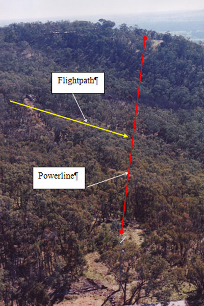
The powerline that was struck lay approximately perpendicular to the helicopter's flightpath from the spray area to the replenishment point (see Figure 1). The powerline was supported by two poles, 669 m apart, which were located on heavily timbered terrain. The point at which the powerline was severed by the helicopter was estimated to be about 34 m above the tree tops, and 54 m above ground level.

Figure 1: Aerial view of powerline and approximate aircraft track

aair200402669_001.jpg

The wreckage distribution and damage to the surrounding trees was consistent with the helicopter impacting the ground with significant vertical, but low forward speed.

A trail of shattered perspex commenced in a position approximately underneath the point at which the powerlines had been severed, and extended for approximately 180 m to the point where the helicopter impacted the ground. The perspex corresponded to that used in the construction of the helicopter windscreen. No other helicopter components were found along the perspex trail.

The ground impact point and wreckage were located on steeply sloping and heavily wooded terrain that was covered with dense vegetation and large rocks (see Figure 2). The area was covered with small to medium sized trees, some approximately 12 to 20 m tall. The ground impact scars indicated that the helicopter was in a relatively level attitude at the time of impact, before it slid approximately 13 to 15 m down the sloping ground and collided with a tree.

Figure 2: Helicopter wreckage

aair200402669_002.jpg

Impact damage to the helicopter was extensive. The helicopter lay on its deformed left side with the cockpit left side panel, the firewall, and the seat assembly compressed in a rearward/inward direction. Damage to the cockpit right side panel was less severe and the panel had retained its shape. A limited amount of the shattered perspex windscreen remained with the main wreckage.

There was severe disruption to the cockpit, and the instrument pedestal had been partially severed from the floor and was pushed towards the pilot's seat. The engine, fuel, hydraulic, and flight control systems' components were dislodged from their installed position and damaged, but remained in their respective locations. The engine was recovered from the accident site and transported to an overhaul facility for technical examination under Australian Transport Safety Bureau (ATSB) supervision. The examination revealed that the engine was capable of normal operation at the time of the accident.

The main rotor blades and mast, main transmission, and the remainder of the helicopter's major components, systems, and controls were also accounted for at the accident site, and in close proximity to the main helicopter wreckage.

Both fuel tanks and their respective firewalls dislodged from their installed position and were damaged. That included impact puncture damage to the fuel tanks. While fuel leakage was evident on the ground around the main wreckage, approximately 20 litres of fuel was recovered from the helicopter's fuel tanks for sampling purposes. A fuel sample was also taken from the re-fuelling truck. The results of independent laboratory tests of both samples were consistent and indicated that the Jet Fuel was bright, free from water and considered suitable for use.

The remains of the tail boom structure was bent slightly upwards, and the tail boom assembly had detached from the rear of the centre fuselage frame about 2 m back from that frame. Sections of the tail boom and the tail rotor drive shaft had separated at impact, but remained oriented in the correct position relative to each other. That was consistent with the helicopter having negligible yaw at impact. A small section of the tail boom structure was located down slope from the main helicopter wreckage.

All major components and extremities of the installed agricultural spray equipment were accounted for with the main helicopter wreckage.

The left and right cockpit door frames were deformed just above the upper door hinge, corresponding to about 15 to 20 cm above the top of the instrument pedestal. That included a deep, circular indentation to the right door frame and a partial tear and bulging of the left door frame. The indentation in the right door frame was 'married' to a length of the severed power cables, and the damage was found to be consistent with the cables having impacted with that door frame (see Figure 3). There were no similar deformations or markings to the instrument pedestal, cyclic or other helicopter controls, or any other part of the helicopter.

Figure 3: The cut into the perspex bubble frame matched with the conductor

aair200402669_003.jpg

Medical and pathological information

Based on the autopsy, toxicology, and medical reports, there was no evidence to indicate that the pilot's performance was degraded by physiological factors.

Survival aspects

A four-point restraint harness, with inertia reel shoulder straps was fitted to the pilot's seat. Video footage of the helicopter departing on the accident flight revealed that the pilot had fastened the harness. Examination of the harness at the accident site revealed that it remained attached to the firewall and that there was no evidence of failure of the locking mechanism.

The pilot was wearing a helmet at the time of the occurrence. That helmet exhibited significant impact damage, but remained intact. The helmet visor was found in the raised position.

Agricultural spray computer disk

The hard disk unit from the on-board agricultural spraying computer was recovered. The unit was assessed by the manufacturer's distributor and an external independent forensic expert. Those examinations confirmed that the damage to the unit precluded extraction of the data.

Organisation

Company Operations Manual

Section A19.5 of the company Operations Manual (manual) contained the en-route procedures affecting low flying operations by company pilots. In part, those procedures included that:

…due consideration shall be given to the dangers of unseen wires, effects of turbulence and other low flying hazards. Prior to the commencement of low level operations, the pilot in command shall carry out an aerial survey of the area to establish an optimum path and aircraft manoeuvring plan for the safe conduct of the operation.

An overview of those procedures affecting the conduct of aerial agricultural operations by company pilots was included at Section D 6.1 of the manual. That included that:

Normal aircraft operating procedures are detailed in the relevant Pilot Operating Handbooks, the Aeronautical Information Publication, as well as CAO 20.21, and the Agricultural Pilots Manual (AAAA [Aerial Agricultural Association of Australia Limited] Pilot and Operations Manual). And these should be followed unless specified otherwise below.

Section D 6.5 of the manual reinforced the regulated requirement for an agricultural pilot to conduct an aerial inspection of a proposed treatment area prior to commencing aerial agricultural as follows:

It is a CASA requirement that prior to commencing agricultural operations the pilot shall carry out an aerial inspection of the proposed treatment area - where practicable, a ground inspection will also be conducted as per sub-section D 6.4.

The manual continued that the pre-treatment aerial inspection was to include the examination of:

…Wires - their location in relation to the boundaries of the area to be treated, height and position of, and distance between poles and guy wires…

Additional information

Previous wirestrike occurrences

A review of the ATSB's accident and incident database revealed that there were six single-fatality agricultural helicopter accidents in Australia during the period 1 January 1995 to 20 June 2005. Those accidents represented 43% of all fatal helicopter wirestrike accidents during the period.

Regulatory framework

Civil Aviation Regulation (CAR) 206 lists agricultural operations as operations conducted for aerial work purposes. Agricultural operations are defined as:

…the broadcasting of chemicals, seeds, fertilizers and other substances from aircraft for agricultural purposes of pest and disease control.

Civil Aviation Order (CAO) 40.6 defines the requirements of the Agricultural Pilot Rating Grades 1 and 2. Those requirements include completion of a period of ground training and a written exam, before carrying out initial and operational flying training. The operational flying training includes operational planning, such as: ground and aerial inspections of the treatment area; assessment of wires; and route selection to and from the treatment area, including the height to fly during such transit flights. That training is to be followed by a period under supervision, before the newly rated agricultural pilot is able to conduct unrestricted agricultural operations.

Aerial Application Pilots Manual3

Chapter 5 of the Aerial Application Pilots Manual contains information pertaining to the identification of powerlines and other low flying hazards with the potential to affect agricultural operations. Chapter 8 of that manual outlines the information specific to helicopter agricultural operations. Those chapters elaborate on the recommended pre-flight planning and inspections that should be carried out by a pilot prior to the conduct of agricultural operations, including that:

If the pilot is obliged to rely on a farmer briefing regarding wire hazards, a thorough interrogation of the farmer is necessary to establish the position of concealed wires…

They are seldom aware that wires outside the treatment area can be hazardous to aircraft approaching for a spraying run. Farmers may forget that they recently connected a shed to the power, ran a new overhead wire to a pump or accidentally hooked a powerline with a farm implement and pulled it over 'a bit'.

Considerable effort is needed to extract vital information from the client. Remember there are some wires that you may strike unless the farmer makes you aware of their location.

In addition, sometimes the background to the wires - trees, hills etc. - provides a poor contrast, while poles may be concealed by intervening obstacles or by being located so far to the periphery of the pilot's visual field that they are not noticed.

During climb and cruise to and from the treatment area the aircraft should track as directly as possible consistent with avoiding nuisance areas and poor terrain.

Don't come below possible powerline height until you are certain all wires have been safely identified.

The property manager reported that he was aware of the powerlines that were struck by the helicopter, but that he had not passed that knowledge on to the pilot because they were located outside both the area to be treated, and the safe transit route between the replenishment truck and the proposed spray area.

Risk management

Australian/New Zealand Standard AS/NZS 4360:2004 Risk Management (the Standard) defined risk as:

the chance of something happening that will have an impact upon objectives.
NOTE 1: A risk is often specified in terms of an event or circumstance and the consequences that may flow from it.
NOTE 2: Risk is measured in terms of a combination of the consequences of an event … and their likelihood…
NOTE 3: Risk may have a positive or negative impact.

The Standard described risk management as 'the culture, processes and structures that are directed towards realizing potential opportunities, while managing adverse [or negative] effects'. The risk management method described by the Standard includes that initially the basic parameters or context affecting the assessment of risk should be identified. That can include 'defining the extent of the project activity or function in terms of time and location'. Residual risk is that 'risk remaining after implementation of risk treatment'. Options for modifying or treating identified risks with negative outcomes included:

  • influencing the likelihood of a risk, in order to reduce the probability of a negative outcome
  • changing the consequence(s) of an event to minimise the extent of any losses.
Detection of powerlines

The requirements for the mapping and marking of power cables and their supporting structures are published in Australian Standards AS 3891.1 1991 Part 1: Permanent marking of overhead cables and their supporting structures, and AS 3891.2 - 1992 Part 2: Marking of overhead cables for low level flying. The general requirements of those standards were discussed in ATSB  investigation report 200404286 and include that, in general, there is no requirement for the marking of power cables with a height above terrain, or obstacles of less than 90 m. The power cable that was struck by the helicopter did not require marking in accordance with either standard.

Technical committees are formed by Standards Australia to develop and review relevant standards, and comprise a balance of interested and affected parties that are nominated by generally national organisations. The aim is that the standards should include consideration of the views of large, common interest groups. Organisations that consider they represent a valid, previously unrepresented interest group are able to nominate for consideration for inclusion in a committee.

A number of aviation industry associations and other bodies were involved in the development of the Australian Standards affecting the marking of overhead power cables and their supporting structures. That did not include some of the groups and associations normally associated with a number of agricultural and other low-level operations.

There are currently a number of engineering solutions available, with the potential to assist pilots identify overhead powerlines. While their suitability or cost-effectiveness may not prove acceptable for all helicopter types or operations, those engineering solutions include, but are not limited to:

  • laser-based systems that alert a pilot of approaching electrified powerlines, or that scan the environment for wires and other obstacles
  • enhanced ground proximity-based warning systems that include relevant software and an onboard powerline database in order to identify approaching powerlines.

1 Only those investigation areas identified by the headings and subheadings were considered to be relevant to the circumstances of the occurrence.
2 The designation 'Soloy' indicates that the helicopter had been modified and fitted with a turboshaft engine.
3 Version 6 prepared by the AAAA. A significant upgrade of the Aerial Application Pilots Manual was sponsored by the Civil Aviation Safety Authority (CASA).

Summary

The Aviation Safety Investigation Report 200402669 on the fatal accident involving a Bell 47G-3-B-1 helicopter registered VH-RTK which occurred 12km west of Wodonga, Vic. on 19 July 2004. The aircraft was on an aerial agriculture mission when it collided with a powerline. There have been related safety actions from CASA, the Aerial Agriculture Association, and the upcoming ATSB research report on wirestrike accidents.

Occurrence summary

Investigation number 200402669
Occurrence date 19/07/2004
Location 12 km W Wodonga
State Victoria
Report release date 12/10/2005
Report status Final
Investigation type Occurrence Investigation
Investigation status Completed
Mode of transport Aviation
Aviation occurrence category Wirestrike
Occurrence class Accident
Highest injury level Fatal

Aircraft details

Manufacturer Bell Helicopter Co
Model 47
Registration VH-RTK
Serial number 6603
Sector Helicopter
Operation type Aerial Work
Departure point Wodonga, VIC
Destination Wodonga, VIC
Damage Destroyed

Piper PA-28R-200, VH-TRZ

Summary

On the morning of 7 February 2004, the pilot of a Piper Aircraft Corporation PA-28R-200 Arrow, VH-TRZ, conducted a private sightseeing flight over Lake Eildon in Victoria with three passengers onboard. At about 1135 ESuT, witnesses observed the aircraft strike a power cable over the lake. The cable was one of a group of six cables that formed a power line linking Kiewa in north-east Victoria to Melbourne. Each cable was 30.8 mm in diameter, and transmitted 220,000 volts of electricity. The power line was depicted on the Melbourne World Aeronautical Chart, and spanned Lake Eildon between Mt Enterprise and Mount Pinniger. The power line was not fitted with marker devices, and nor was it required to be. The span was 2,222 m in length, and the northern and southern support towers were respectively 1,076 ft and 781 ft above the water level of the lake. The aircraft struck the power cable at about the lowest point of the span, which was about 133 ft above the water level of Lake Eildon. The water level of the lake was 266.53 m above Australian Height Datum on the day of the accident. That was equivalent to 875 ft above mean sea level (AMSL).

The aircraft approached the power line in a south-easterly direction, and the sun's position and elevation at the time were unlikely to have caused the pilot difficulty in observing the cables, which lay at right angles to the aircraft's flight path. Witnesses who observed the aircraft before it struck the cable reported the aircraft had appeared to be operating normally. A number of those witnesses reported that their attention had been drawn to the aircraft because of its low height above the surface of the lake.

The force of the wirestrike dislodged the left wing of the aircraft, and the aircraft descended out of control and impacted the water about 165 m beyond and to the southeast of the cable that was struck. The aircraft was substantially destroyed because of the wirestrike and the subsequent impact with the water. The four aircraft occupants were fatally injured by impact forces when the aircraft impacted the water. The body of the pilot was not located.

The aircraft had valid certificates of registration and airworthiness. The pilot held a Private Pilot (Aeroplane) Licence and was endorsed to fly the aircraft type. He held a current Class 2 medical certificate. The pilot required vision correction, and his wife reported that he was wearing contact lenses on the day of the accident. There were no known physiological or psychological factors that may have affected the pilot's performance.

There was no evidence that environmental, mechanical, operational or other factors contributed to the circumstances of the accident.

Civil Aviation Regulations specify that an aircraft, when not flying over a city, town or populous area, must not fly lower than 500 ft above the highest point of the terrain, and any object on it, within a radius of 600 metres. The aircraft therefore should not have been flown at a height of 133 ft over the surface of the lake. The investigation could not determine why the pilot descended the aircraft to an unsafe height.

Occurrence summary

Investigation number 200400437
Occurrence date 07/02/2004
Location Eildon
State Victoria
Report release date 29/09/2004
Report status Final
Investigation type Occurrence Investigation
Investigation status Completed
Mode of transport Aviation
Aviation occurrence category Wirestrike
Occurrence class Accident
Highest injury level Fatal

Aircraft details

Manufacturer Piper Aircraft Corp
Model PA-28
Registration VH-TRZ
Serial number 28R-7335003
Sector Piston
Operation type Private
Departure point Wallan, VIC
Destination Wallan, VIC
Damage Destroyed

Robinson R22 Alpha, VH-UXU

Significant Factors

The pilot was probably not aware of the existence of the powerline hazard.

The helicopter departed from the pad outside the operator's hanger at Mt Isa aerodrome at 1048 EST. The helicopter tracked west through the low ridge before detouring south, then turning north to the stockyards where the pilot landed to board the property manager. It remained on the ground for approximately 3 minutes before departing north east to conduct a search on a north west heading along the North Branch of Spear Creek. From there the helicopter turned left and tracked south east to a position east of the ridge. The helicopter then tracked south for approximately 3 km. It then turned right, onto a reciprocal heading, and tracked north to Spear Creek. It followed the creek north west for a short distance before turning further left to track south west back to the stock yards. The helicopter then manoeuvred around the sockyards before turning and tracking south along the western edge of the low ridges. The helicopter collided with the powerline, 5.5 km southwest of the aerodrome, at 1113.

Analysis

It is possible that the pilot may have intended to initially conduct an inspection flight to locate the missing cattle, however, after locating the cattle the nature of the flight changed to a mustering role and safety precautions normally carried out prior to mustering operations were not taken.

Visual cues, such as power poles, assist in the detection of wires. In this instance, the poles would have been partially obscured to the pilot's view by terrain and trees. Additionally, the angle subtended by the widely spaced poles would have placed them more towards the pilot's peripheral vision where they would have been less likely to be noticed.

The only visual cue to the pilot would have been the single-wire conductor. Even in bright sunlight conditions, a conductor dulled by oxidation would not have been readily discerned. In order for the pilot to have seen and avoided the powerline, he needed to be at the correct focal distance and looking directly at the wire.

Pilots operating at a low height should not rely on being able to see a powerline in time to take avoiding action.

Summary

The pilot and passenger of a Robinson R22 helicopter were conducting an aerial inspection and cattle mustering flight. During the flight, cattle were observed outside the fenced area and the pilot descended the helicopter to direct the cattle back towards the fence. The passenger then directed the pilot to fly the helicopter along the eastern fence to check its security. The passenger reported that the pilot had just commenced to climb higher, at his request, when the helicopter collided with a single-wire powerline. Recorded Global Positioning System data indicated that the helicopter struck the powerline at a speed of 55 kts. The wire did not break and the helicopter pitched nose down. The main rotor severed the tail boom and the helicopter collided with the ground 69 m beyond the powerline. It impacted in an inverted attitude, facing back along its direction of travel and rolled forward onto its left side. There was no evidence of fire in-flight or after the impact.

The main rotor, mast and upper right side of the helicopter cabin took the main impact and the mast was partially driven into the cabin. The pilot, who occupied the right seat, received fatal injuries. The passenger, although seriously injured, walked 200 m to a track and waited almost 2 hours until found by a passing motorist. The passenger reported that injury prevented him from picking up and activating the portable Emergency Locator Transmitter that was ejected from the helicopter cabin.

The powerline supplied electrical power to a nearby property and was aligned approximately east-west at right angles to the helicopter's flight path. It spanned a distance in excess of 500m from a pole in a saddle on a ridge east of the fence, to another pole set among trees in a timbered paddock. Strike marks on the wire indicated that the helicopter had struck the powerline at approximately mid-span. There were no markers on the powerline. Australian Standards (AS 3891.1-1991) specified markers on powerlines where the height of a cable exceeded 90m. The powerline did not exceed that height and at the point of contact was about 20m above ground level (AGL).

The pilot held a current Commercial Pilot Licence (Helicopter) and was appropriately qualified for cattle mustering operations. He held a valid Class 1 medical certificate and did not require any vision correction. An article on the visual aspects of wire detection by Dr Gordon Cable in the Directorate of Flying Safety-Australian Defence Force's special wirestrike edition (1997) of their safety journal "Spotlight" stated that under ideal conditions, the human eye can resolve detail down to an angle of 30 seconds of arc. That equated to being able to see a 5 mm thick wire from a distance of 150 m. However, contrast between the wire and the background against which it is viewed and the medium through which it is viewed, affect detection. The pilot was wearing a helmet with tinted visor. The fragments of perspex from the helicopter's windshield did not show any sign of being scratched or crazed.

The operator's Operations Manual required pilots to familiarise themselves with the area to be mustered, including any obstructions, before commencing mustering operations. Although the passenger had engaged the operator on previous occasions for the same work, no map of the area to be mustered was held on the operator's file. The passenger was aware of the existence of the powerline and stated that on previous occasions some pilots had him draw a "mud map" on the ground to indicate the area to be mustered, including powerline hazards. The pilot had reportedly not asked the passenger about any powerline hazards prior to the flight. There was no evidence that the pilot had previously flown over or inspected the area to determine the presence of hazards.

Occurrence summary

Investigation number 200201723
Occurrence date 25/04/2002
Location 5.5 km SW Mount Isa, Aero.
State Queensland
Report release date 15/11/2002
Report status Final
Investigation type Occurrence Investigation
Investigation status Completed
Mode of transport Aviation
Aviation occurrence category Wirestrike
Occurrence class Accident
Highest injury level Fatal

Aircraft details

Manufacturer Robinson Helicopter Co
Model R22 Alpha
Registration VH-UXU
Serial number 0497
Sector Helicopter
Operation type Aerial Work
Departure point Hazlington Station, QLD
Destination Hazlington Station, QLD
Damage Destroyed