The aircraft departed the base airstrip to fly to the treatment area but did not arrive. The pilot and wreckage were located after first light by search aircraft. The aircraft had collided with trees and crashed into an empty paddock. The pilot has not provided a report. However, information provided by other sources suggests that he inadvertently entered low cloud and during an attempt to turn back collided with the trees.
The inexperienced pilot was on a solo visual flight rules (VFR) navigation exercise from Essendon, tracking via Moorabbin, Kyabram, Calivil, Melton South and returning to Essendon. After passing Kyabram the pilot observed cloud developing to the west and decided to amend his route. Before reaching Bendigo, he turned south and, as there was cloud ahead, the aircraft was climbed to 4,000 ft, on top of cloud. The pilot then established communications with Melbourne Radar Advisory Service (RAS) and requested navigation assistance.
A short time later, RAS advised the pilot that he had just passed Trentham. At about this stage the aircraft was inadvertently flown into cloud. The pilot experienced control difficulties, because of the turbulence in the area, and reported to RAS that he was "descending quite fast", but that he was trying to climb. Another pilot advised the pilot of VH-JAC to "just keep your wings level." Less than a minute later, the pilot of VH-JAC reported he was upside down and going to crash.
The aircraft broke out of cloud, below the cloud and close to the ground, in a steep nose-down attitude. The pilot managed to regain control and avoid trees. Visual flight was then continued, and the aircraft was diverted to Bacchus Marsh where a landing was made.
A number of Instrument Flight Rules (IFR) aircraft, one at Devonport and two others inbound to Devonport, were unable to contact a Visual Flight Rules (VFR) aircraft, VH-CGH, which called seven miles inbound to Devonport. The weather was marginal with the cloud base at 600 feet. After two unsuccessful attempts to land, VH-CGH departed for Wynyard.
The pilot of VH-CGH had recently passed a biennial flight review. He had recently returned to flying after a considerable lapse. At the time of the incident, he was having trouble with selection switches on the VHF radio. He had selected audio to headphones instead of the speaker such that he could transmit but not hear any replies from other aircraft.
There was no known breakdown in separation between aircraft.
Significant Factors
The following factors were considered relevant to the development of the incident:
1. The pilot was unfamiliar with the radio selection switches installed in the aircraft.
2. The pilot operated at Devonport in non-visual meteorological weather conditions.
On the evening of 23 June 2015, a home-built Jabiru J430 aircraft, registered F-PFAJ, was being flown on a transfer flight from Aachen, Germany to an airfield near the town of Oehna, France. The aircraft was being operated at night in instrument meteorological conditions. Thunderstorms and heavy precipitation were recorded along the flight path. At around 2200 that evening, local residents identified aircraft wreckage and debris within and surrounding the township of Mühlenberg, Germany. The aircraft had sustained an in-flight break up. Both occupants, a pilot and passenger, were fatally injured.
The German Federal Bureau of Aircraft Accident Investigation (BFU) was primarily responsible for investigating this accident. As part of its investigation, the BFU notified the ATSB as the State of Manufacture of the aircraft. In accordance with clause 5.18 of Annex 13 to the Convention on International Civil Aviation, the ATSB appointed an accredited representative to liaise with the BFU and the Australian aircraft manufacturer. In order to facilitate that liaison, an investigation under the Transport Safety Investigation Act 2003 was initiated.
The BFU completed their investigation and concluded that:
The accident was caused by the pilot flying into instrument meteorological conditions which resulted in an uncontrolled flight attitude, which in turn resulted in structural failure due to overstress.
Contributory factors were the lack of qualification of the pilot to control an aircraft in IMC and the aircraft equipment geared to visual flight rules. In addition, both occupants were under mental pressure to reach the aerodrome of destination on direct course.
Since the trim tabs were not installed on the elevator, it was possible to perform a flare with higher load factors due to a greater deflection of the elevator.
The final report, BFU 15-0764-CX, is available on the BFU website at www.bfu-web.de/reports.
Any enquires relating to the investigation should be directed to the BFU at: www.bfu-web.de.
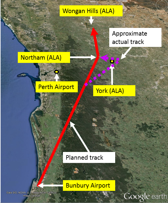
On 19 May 2015, the pilot of a Beech A36 aircraft, registered VH-ANX, conducted pre-flight preparations for a private flight from Bunbury Airport to Wongan Hills aeroplane landing area (ALA), Western Australia (Figure 1). The pilot assessed that based on the weather forecast, they would be able to conduct the flight in visual meteorological conditions (VMC).[1] The pilot submitted a flight plan for the flight under the visual flight rules (VFR).[2] The pilot planned to track via Northam ALA at 3,500 ft above mean sea level (AMSL), in accordance with VFR cruise altitudes. The pilot also planned to remain clear of Perth air traffic control zone. At about 1525 Western Standard Time (WST), the aircraft departed from Bunbury, with full fuel on board.
Figure 1: The pilot’s planned route from Bunbury to Wongan Hills via Northam (red) and the approximate actual track, via York (purple)
Source: Google earth annotated by ATSB
When approaching abeam Perth, the pilot observed significant cloud in the Perth area. The pilot reported seeing cloud to the left and right, but could see a clear path ahead. They then descended to about 3,000 ft to remain clear of cloud, and continued on the planned route.
When about 10 NM south-west of York ALA, the pilot observed the cloud start to close in, and build to the west. The pilot made multiple diversions to the right of the planned track, but the cloud continued to close in. The pilot then commenced turning back, but the cloud had closed in behind the aircraft. The pilot climbed the aircraft to 3,500 ft and elected to enter the cloud and continue towards Northam.
At about 1547 WST, when about 1 NM east of York ALA and at 3,500 ft AMSL, the pilot contacted Perth air traffic control (ATC) and requested assistance. The pilot advised that the flight was operating under a VFR flight plan, had entered cloud, and was instrument rated. The controller identified the aircraft on radar, then at 3,700 ft. The controller asked whether the pilot was able to remain in instrument meteorological conditions (IMC),[3] and the pilot responded in the affirmative. The controller then advised that the lowest safe altitude in the area was 3,300 ft, and asked whether the pilot wanted to continue the flight under the instrument flight rules (IFR),[4] to which the pilot replied ‘I have no choice I am in IMC’.
The controller then allocated the aircraft a unique transponder code, asked how many people were on board and the fuel endurance remaining. The controller also asked whether the pilot wanted to divert to Jandakot Airport and be provided with the radar lowest safe altitude. However, the pilot responded by asking for advice regarding the weather to the north.
As the aircraft was outside the Perth control area, the controller then coordinated[5] with the Melbourne centre controller to hand the aircraft over. The controller also requested an update on the weather be provided to the pilot. The controller then advised the pilot that the aircraft was now indicating an altitude of 2,800 ft and the pilot responded ‘just climbing back up’.
At about 1552 WST, the pilot communicated with the Melbourne centre controller, and advised that they were now visual and would continue tracking to Northam at about 2,400 ft AMSL. The aircraft landed at Wongan Hills ALA at about 1630 WST, without further incident.
Pilot experience
The pilot had about 800 hours total flying time, attained an instrument rating about 2 years prior to the incident, and had completed 82 hours of instrument flight time. The pilot had completed an instrument flight in the simulator three weeks prior to the incident, and was therefore current (and qualified) for flight under the instrument flight rules.
The aircraft was IFR approved and equipped.
Pilot comments
The pilot was not aware it was possible to contact ATC and request change from VFR to IFR flight while airborne. They had not set up any navigation aids prior to entering IMC, and reported that they were navigating primarily by reference to the directional indicator while in cloud.
The pilot could not recall why the aircraft descended below the applicable lowest safe altitude during the flight. They thought it was possibly because they were distracted by responding to ATC’s request for the aircraft’s fuel endurance, or checking the aircraft’s position on their iPad. The pilot assessed their own workload to be moderate, and only slightly increased when the aircraft entered cloud.
Weather forecast
The area forecast (ARFOR)[6] for area 60, current at the time of the incident, for the subdivision south of a line joining Cue and Geraldton, included:
Table 1: Area forecast for area 60
Cloud cover
Cloud type
Cloud base
Cloud tops
Weather
Broken
Stratus
1,000 ft AMSL (2,000 ft inland)
2,000 ft AMSL (3,000 ft inland)
Broken
Cumulus/stratocumulus
2,000 ft AMSL (3,000 ft inland)
8,000 ft AMSL
Showers of rain
The terminal aerodrome forecast (TAF) current for Perth included scattered cloud with base at 3,500 ft above ground level.
ATSB comment
During flight, pilots are able to request ATC amend their flight plan from VFR to IFR, or vice versa. When requesting a change from VFR to IFR while in flight, the aircraft should remain at a VFR level and in VMC, until the IFR clearance is received. The details required by ATC include:
aircraft callsign and type
departure and destination points
current location
number of people on board
fuel endurance.
Safety message
Pilots are encouraged to make conservative decisions when considering how forecast weather may affect their flight. If poor weather is encountered en route, timely and conservative decision making may be critical to a safe outcome. VFR pilots are encouraged to familiarise themselves with VMC criteria detailed in Aeronautical Information Publication (AIP) Australia. Where forecast or actual conditions are such that continued flight in VMC cannot be assured, pilots should assess all available options. Unplanned flight into conditions of limited visibility can rapidly lead to loss of orientation and loss of aircraft control.
If the pilot and aircraft are rated and certified for instrument flight, and weather conditions may not be suitable for flight under the VFR, it may be judicious to be prepared for an IFR flight. During the flight, if the pilot is not assured that VMC conditions can be maintained, the pilot may then request changing to IFR flight. When amending from a VFR to IFR flight en route, it is important to have the necessary details ready and contact ATC for an IFR clearance prior to entering IMC. Ensuring all available navigation aids are set up correctly even for a VFR flight will reduce the pilot’s workload when changing to instrument flight.
Decisions regarding whether to conduct an investigation, and the scope of an investigation, are based on many factors, including the level of safety benefit likely to be obtained from an investigation. For this occurrence, a limited-scope, fact-gathering investigation was conducted in order to produce a short summary report, and allow for greater industry awareness of potential safety issues and possible safety actions.
Publishing information
Released in accordance with section 25 of the Transport Safety Investigation Act 2003
Ownership of intellectual property rights in this publication
Unless otherwise noted, copyright (and any other intellectual property rights, if any) in this report publication is owned by the Commonwealth of Australia.
Creative Commons licence
With the exception of the Coat of Arms, ATSB logo, and photos and graphics in which a third party holds copyright, this publication is licensed under a Creative Commons Attribution 3.0 Australia licence.
Creative Commons Attribution 3.0 Australia Licence is a standard form licence agreement that allows you to copy, distribute, transmit and adapt this publication provided that you attribute the work.
The ATSB’s preference is that you attribute this publication (and any material sourced from it) using the following wording: Source: Australian Transport Safety Bureau
Copyright in material obtained from other agencies, private individuals or organisations, belongs to those agencies, individuals or organisations. Where you wish to use their material, you will need to contact them directly.
Earlier in the day, the pilot had flown his aircraft from Great Keppel Island to Rockhampton to hand-feed his cattle.
While he was completing the task storms moved into the area and rain began to fall. By the time the pilot returned to the airport the conditions were unsuitable for visual flight. He waited at the control tower for about an hour until the storms to the east of the airport cleared. He then departed and tracked via the Fitzroy River with the intention of proceeding up the coast to the island. En route, a weather report was obtained from the island that indicated that the weather there was clear.
When the aircraft was in the Emu Park area the pilot reported that he was unable to see either the island or Yeppoon and as the weather was deteriorating, and the cloud ceiling was about 400 ft, he decided to land at Emu Park. He joined the circuit area but on the downwind leg he was unable to sight the strip markers. The pilot continued the approach and as the aircraft turned onto the base leg it entered rain. On final the pilot had difficulty seeing through the rain covered windscreen, but he stated that he was able to make out the length of the strip. When the aircraft passed over the threshold of the cleared area the pilot closed the throttle, and the aircraft landed. He then realised that the aircraft had landed about 10 metres to the right of the airstrip. Shortly after touchdown the aircraft ran through a depression in the ground and the landing gear and left wing, and engine were torn off. The right wing was bent as the aircraft spun around before coming to rest. The cabin area remained intact, and the pilot was able to evacuate the aircraft uninjured.
The pilot stated after the accident that he had considered going around during the approach but believed that weather conditions were such that he may have had difficulty maintaining flight in visual conditions.
On 9 July 2014, at about 1340 Eastern Standard Time, a Cessna 206, registered VH-NCR, departed from Dubbo, New South Wales on a private flight to Gold Coast and Archerfield, Queensland, under the visual flight rules (VFR), with three passengers on board. When about 15 NM south of Inverell, the pilot observed the weather deteriorating and low cloud about the ranges, and elected to climb and operate VFR on top of the cloud. As the aircraft climbed above 5,000 ft, the pilot observed a widespread frontal mass of cloud with tops around 12,000 ft. He contacted Brisbane Centre air traffic control (ATC) and requested navigation assistance and ATC provided updated weather information.
The pilot initially considered a diversion to Moree, however he was able to descend through a break in the cloud and elected to divert to Inverell. When about 5 NM from Inverell, the pilot was unable to sight the airport and was concerned about the lowering cloud base in the area. He commenced a turn, but passing about 3,800 ft during the turn, the aircraft entered cloud. The pilot immediately applied full power and commenced climbing until the aircraft became clear of cloud at about 5,000 ft.
The pilot diverted to Gunnedah and was able to remain in visual meteorological conditions for the duration of the flight. The aircraft landed in Gunnedah at about 1650.
This incident provides a reminder to pilots to make conservative decisions when considering how forecast weather may affect their flight. If poor weather is encountered en route, timely and conservative decision making may be critical to a safe outcome.
On 21 February 2014, the pilot of a Piper PA-28R aircraft, registered VH-TBB, departed Scone, New South Wales on a private flight to Warwick, Queensland. The flight was planned under the visual flight rules (VFR). The planned route took the aircraft overhead Tamworth and Inverell, then on to Warwick.
The flight proceeded normally until the pilot encountered an increasing amount of cloud and light rain showers while en route between Inverell and Warwick. The pilot initially attempted to pass beneath the cloud, but had difficulty maintaining visual meteorological conditions (VMC). Although the cloud appeared to be relatively light with ill-defined edges, the pilot found that forward visibility was restricted.
The pilot advised air traffic control (ATC) that he was occasionally encountering instrument meteorological conditions (IMC), and with the aircraft intermittently identified on radar, ATC was able to assist the pilot with relevant advice. About 30 NM from Warwick, the pilot reported clear of the weather, and the flight continued without further incident.
The pilot later indicated that during the intermittent encounter with marginal conditions, the aircraft was in cloud for a total time of about one minute. The pilot had undertaken some instrument flight training about 2 years prior to the incident, which provided some confidence with respect to aircraft control during his encounter with marginal conditions.
Pilots are encouraged to make conservative decisions when considering how forecast weather may affect their flight. If poor weather is encountered en-route, timely and conservative decision making may be critical to a safe outcome. VFR pilots are also encouraged to familiarise themselves with the definition of VMC criteria, and carefully consider available options where forecast or actual conditions are such that continued flight in VMC cannot be assured.
The ATSB SafetyWatch highlights the broad safety concerns identified in investigation findings and from safety data reported to the ATSB by industry. One safety concern relates to general aviation pilots who fly into conditions of reduced visibility, without the appropriate training, skills and qualifications. The ATSB research report Avoidable Accidents No 4 – Accidents involving Visual Flight Rules pilots in Instrument Meteorological Conditions provides some key messages with respect to weather-related general aviation accidents.
At about 1107 on 1 October 2012, the pilot-owner of a vintage de Havilland DH-84 Dragon Mk 2, registered VH-UXG, took off on a private flight from Monto to Caboolture, Queensland. On board with the pilot were five passengers, baggage and equipment. The pilot was not qualified, and the aircraft not equipped for instrument flight. The weather on the coast and extending inland included low clouds and rain.
At 1315, the pilot radioed air traffic control (ATC) and requested navigation assistance, advising that the aircraft was in cloud. Over the next 50 minutes ATC provided assistance to the pilot and a search and rescue (SAR) helicopter was dispatched to the area. From the pilot’s radio calls it was apparent that he was unable to navigate clear of the cloud. Radio contact was intermittent and no transmissions from the aircraft were received after 1405.
An extensive search was initiated, and the aircraft wreckage was located on 3 October in high terrain. The aircraft was destroyed and there were no survivors.
What the ATSB found
With no or limited visual references available in and near cloud, it would have been very difficult for the pilot to maintain control of the aircraft. After maintaining control in such conditions for about an hour, and being unable to navigate away from the mountain range, the pilot most likely became spatially disoriented and lost control of the aircraft before it impacted the ground. Due to the limited radio and radar coverage in the area, the ability of ATC and the SAR helicopter to assist was limited. However, the ATSB found that there were areas of potential improvement in the management of in-flight emergencies and coordination between ATC and SAR aircraft.
What's been done as a result
Airservices Australia and the Australian Maritime Safety Authority agreed to conduct a comprehensive review of their existing memorandum of understanding to ensure the effectiveness of collaborative in-flight emergency responses. The review is anticipated to be completed by the first quarter of 2014.
Safety message
Though it remains unclear precisely how the aircraft came to be in instrument conditions, this accident highlights the importance of pre- and in-flight planning and decision-making in limiting exposure to risk. It is important for pilots to incorporate approved weather forecasts, knowledge of the terrain, and diversion options into their flight planning, to plan for contingencies prior to and throughout a flight, and to carry out those plans well before encountering difficulty.
Update
Report release date: 17/04/2013
Updated: 17 April 2013
The investigation is continuing into the collision with terrain involving de Havilland DH‑84 Dragon, registered VH-UXG, which occurred 36 km south-west of Gympie, Queensland on 1 October 2012.
The ATSB has reviewed numerous witness reports and radio recordings, and it appears that the aircraft flew a roughly direct course from Monto before encountering what the pilot described to air traffic control (ATC) as ‘full cloud’ about 2 hours into the flight. The evidence at this stage indicates that the aircraft flew around the Borumba Dam, Imbil, and Kandanga areas for about an hour, probably mostly in or around cloud that would typically be described as instrument meteorological conditions.
Radio and radar coverage in the area was limited. As such, ATC was unable to direct the pilot to an area of known visual conditions because of the extent of the cloud cover and uncertainty over the aircraft’s position.
To date, there are no indications of an aircraft malfunction. However, the ATSB has retained the aircraft wreckage in case of a need for further examination. Several items and components that were retrieved from the accident site have been examined, including some aircraft instruments. Data was successfully downloaded from an aircraft GPS receiver that was found among the aircraft wreckage, but it did not contain information pertinent to the accident flight.
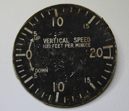
Following a burn-off of the area and a period of heavy rain, three ATSB investigators returned to the accident site to search for another GPS receiver that was known to be installed in the aircraft. This GPS was not found but investigators located the instrument face of the aircraft’s vertical speed indicator (Figure 1), which may provide further evidence.
Figure 1: Face of vertical speed indicator
The investigation is continuing and will include examination of the:
air traffic radar and radio recordings
aircraft wreckage and instruments
aircraft’s maintenance records
emergency response
weather information
witness reports.
A final report is scheduled for release in October 2013.
The information contained in this web update is released in accordance with section 25 of the Transport Safety Investigation Act 2003 and is derived from the initial investigation of the occurrence. Readers are cautioned that new evidence will become available as the investigation progresses that will enhance the ATSB's understanding of the accident as outlined in this web update. As such, no analysis or findings are included in this update.
Preliminary report
Report release date: 08/11/2012
The ATSB has released its preliminary report into the collision with terrain that occurred 36 km south-west of Gympie, Queensland on 1 October 2012. The information contained in the report is derived from the initial investigation of the occurrence. Readers are cautioned that new evidence will become available as the investigation progresses that may alter the circumstances as depicted in the preliminary report. As such, no analysis or findings are included in the report.
At about 1107 Eastern Standard Time on 1 October 2012, a de Havilland Aircraft Pty Ltd DH-84 Dragon, registered VH-UXG, took off from Monto on a private flight to Caboolture, Queensland under the visual flight rules. At 1315, the pilot contacted Brisbane Radar air traffic control (ATC) and advised that the aircraft’s position was about 37 NM (69 km) north of Caboolture and requested navigation assistance. At 1318, the pilot advised ATC that the aircraft was in ‘full cloud’.
For most of the remainder of the flight, the pilot and ATC exchanged communications, at times relayed through a commercial flight and a rescue flight in the area due to the limited ATC radio coverage in the area at low altitude. At 1348, the pilot advised Air Traffic Control that the aircraft had about an hour’s endurance remaining. The pilot’s last recorded transmission was at 1404.
A search for the aircraft was coordinated by Australian Search and Rescue (AusSAR). The aircraft wreckage was located on 3 October 2012, about 87 km north-west of Caboolture.
The aircraft was destroyed by impact forces. There was no fire. The accident was not survivable and the six occupants were fatally injured.
The ATSB's investigation is continuing and will include examination of the:
relevant air traffic radar and radio recordings
weather information pertinent to the flight
witness reports
aircraft’s maintenance records
pilot’s records and history, and
search and rescue records.
It is anticipated that the investigation will be completed by October 2013.
On 4 June 2012, a Cessna Aircraft Company 182Q, registered VH-CWQ, with the pilot the sole person on board took off from Walgett in good weather conditions for a flight to Mudgee, New South Wales (NSW), initially climbing to 5,500 ft. During the flight, the cloud base lowered, and the aircraft was descended until it was flying about 1,000 ft above flat terrain, either close to or in the cloud. The aircraft impacted a rock face in mountainous terrain near Tooraweenah, NSW. The pilot sustained fatal injuries and the aircraft was destroyed.
What the ATSB found
The ATSB found that the risk to flight was increased by deteriorating weather conditions. The risks associated with continuing a flight under these circumstances are highlighted in the ATSB Transport Safety report AR-2011-050, Accidents involving Visual Flight Rules (VFR) pilots in Instrument Meteorological Conditions. Additionally, influences on pilot decision making behaviours are described in the ATSB Research Investigation report B2005/0127, General Aviation Pilot behaviours in the face of Adverse Weather.
Safety message
This accident provides a reminder to pilots of the insidious risks associated with reduced forward visibility when flying in or near the cloud base. The benefits of leaving a Flight Note with a suitable person in terms of ensuring the early commencement of a search for an overdue aircraft are also evident.
Pilots conducting VFR flights should remain aware that once they fly into weather conditions with reducing forward visibility, their ability to manoeuvre around approaching obstacles could be severely limited because obstacles may not be seen until they are too close to avoid. Such collisions are not often survivable.