When about to turn base for runway 31, the crew of VH-TJQ sighted two light aircraft heading in the opposite direction on the active side of the circuit. From prior communication, the crew of TJQ believed the two aircraft were joining the circuit on the dead side. The pilots of the two light aircraft spoke with American accents and were part of a group visiting Australia. Separation was maintained but it appeared to the crew of TJQ that the pilots of the light aircraft were not familiar with local procedures.
The following factors were considered relevant to the development of the occurrence:
Foreign aircrew apparently unfamiliar with local procedures.
On descent into Devonport regular public transport aircraft, VH-WZI, made radio calls on the Flight Service (FS) frequency and on Devonport Mandatory Traffic Advisory Frequency (MTAF) prior to leaving controlled airspace at 10000 ft. There was no response from any other aircraft. When VH-WZI was approximately 18 NM north of Devonport, FS asked Air Traffic Control (ATC)for the position of VH-WZI. A short time later FS advised VH-WZI that ATC had VH-IJM on frequency 17 NM north of Devonport tracking for Hobart at 7500 ft. At this, VH-WZI terminated the descent and initiated a climb to 8000 ft in visual meteorological conditions. VH-IJM was transferred to the FS frequency and separation was effected. The crew of VH-WZI sighted VH-IJM half a mile to the right and below but it was extremely difficult to see VH-IJM due to underlying cloud cover.
The pilot of VH-IJM was flying to visual flight rules. VH-IJM had transferred to the ATC frequency at least 20 NM north of Devonport in order to obtain a clearance into controlled airspace which starts north of Devonport. The pilot was monitoring one radio frequency at a time. He was unaware of VH-WZI until he saw it.
The captain of VH-WZI believes that on routes where there is traffic climbing or descending to locations under controlled airspace, then the design of the airspace should be such that frequency separation is not encouraged; otherwise, procedures should be established to cater for such occurrences.
The manager of FS advised that where an aircraft is single very high frequency (VHF) radio equipped (or a pilot is monitoring only one frequency), with similar circumstances a similar incident could reoccur.
The current procedures for pilots and air traffic personnel, combined with the existing airspace configuration, do not prevent this type of incident from occurring.
Significant Factors
The following factors were considered relevant to the development of the incident:
1. The pilots of both aircraft complied with existing rules and regulations.
2. Air Traffic Services provided more than the required service.
3. The combination of existing rules, procedures and airspace does not prevent this type of occurrence.
Occurrence summary
Investigation number
199301358
Occurrence date
30/04/1993
Location
17 nm north of Devonport
State
Tasmania
Report release date
26/10/1994
Report status
Final
Investigation type
Occurrence Investigation
Investigation status
Completed
Mode of transport
Aviation
Aviation occurrence category
Separation issue
Occurrence class
Incident
Aircraft details
Manufacturer
Beech Aircraft Corp
Model
E95
Registration
VH-IJM
Sector
Piston
Operation type
Charter
Destination
Cambridge TAS
Damage
Nil
Aircraft details
Manufacturer
De Havilland Canada/De Havilland Aircraft of Canada
VH-OXB departed Port Macquarie for Williamtown at 0922 hours and contacted Flight Service (FS) on Area frequency on climb to 8,000 ft.
VH-BIH departed Port Macquarie for Aero Pelican at 0923 hours and was climbing to 6,000 ft. The pilot initially reported on climb to 4,000 ft but this was later clarified.
Each aircraft was given traffic information on the other by FS.
As VH-OXB approached Taree the crew requested from FS an airways clearance to enter Williamtown controlled airspace (CTA) and were advised that they could expect a clearance at 4,000 ft. They consequently elected to descend outside controlled airspace (OCTA) to 4,000 ft and requested traffic information. The flight service officer (FSO) advised that there was no additional instrument flight rules (IFR) traffic.
As VH-OXB passed Taree the crew were instructed to contact Williamtown air traffic control (ATC) for an airways clearance, which they did. Williamtown ATC were unable to issue a clearance immediately due to traffic problems in CTA and instructed VH-OXB to remain OCTA to await clearance. The crew initiated a turn at the CTA boundary (10 NM south of Taree) and commenced a holding pattern that took the aircraft northbound towards Taree. No radio transmission was made to indicate this change of track.
During the northbound leg of the holding pattern, Williamtown ATC advised the crew of VH-OXB that a clearance could now be expected at 5,000 ft and the crew commenced climb to that altitude in preparation for the clearance. No radio transmission was made on Area frequency to indicate this change of level.
VH-BIH also requested an airways clearance from Williamtown ATC via Sydney FS and was also told to expect a clearance at 4,000 ft. The pilot then announced his descent to 4,000 ft and clarified his current 6,000 ft altitude with FS. The FSO advised the pilot that there was no IFR traffic, he believed that the traffic advice given earlier would still be considered current by the pilots of both VH-OXB and VH-BIH.
VH-BIH was now overhead Taree and changed frequency to contact Williamtown ATC and request his airways clearance. As he did so the pilot saw VH-OXB immediately ahead and at the same level. He took evasive action by increasing the rate of descent of his aircraft and passed underneath VH-OXB. VH-BIH was equipped with a single radio only and the pilot was unable to monitor the Williamtown ATC frequency prior to Taree.
The aircraft passed within approximately 100-150 ft.
Significant Factors
1. The Sydney FSO assumed that both pilots would consider that traffic information passed to them on departure Port Macquarie would remain current for the duration of their flight.
2. Williamtown ATC elected to use different altitudes in accordance with the original planned levels, rather than the actual levels at the time.
3. The pilot of VH-BIH had only one radio.
4. The crew of VH-OXB did not make an area frequency transmission advising either their change of track or change of altitude.
Safety Action
As a result of this investigation the RAAF initiated a variation in their instruction of traffic management techniques for controllers operating the Williamtown low level airspace.
VH-UOP was on descent from Broken Hill to Mildura. The pilot of VH-UOP made appropriate radio calls on the Mildura mandatory traffic advisory frequency (MTAF) and took note of traffic. He copied 238 degrees as the outbound track for one of the aircraft from Mildura. VH-SFQ advised VH-UOP that there was another aircraft just ahead. At the same moment the pilot of VH-UOP saw a single engine Cessna within 500 metres diving off to the left in a right hand descending turn. The pilot of VH-UOP took no evasive action. He made a general broadcast directed to any aircraft in the Dareton area. VH-RFB responded. VH-RFB's track ex Mildura was 338 degrees direct for Broken Hill, not 228 degrees as earlier copied by VH-UOP.
Some of the radio transmissions from VH-RFB were muffled, which brought about the misunderstanding.
Significant Factors
The following factors were considered relevant to the development of the incident:
1. Some of the radio transmissions from VH-RFB were hard to understand.
2. The pilot of VH-UOP misunderstood a radio transmission from VH-RFB.
Section 21 (2) of the Transport Safety Investigation Act 2003 (TSI Act) empowers the Australian Transport Safety Bureau (ATSB) to discontinue an investigation into a transport safety matter at any time. Section 21 (3) of the TSI Act requires the ATSB to publish a statement setting out the reasons for discontinuing an investigation.
_______________
On 6 July, 2015 the ATSB commenced an investigation into a reported near collision involving an Aeroprakt 22LS, registered VH-EVQ and a Piper PA28, registered VH-NRZ at Bankstown Airport, New South Wales on 28 June 2015.
As per procedure, the pilot of the PA28 called Bankstown Tower when at Prospect Reservoir, for a clearance to enter the control zone. ATC issued a clearance for the PA28 to join downwind for runway 29 R and maintain 1,500 ft. Shortly after, ATC issued a traffic alert to the pilot of PA28. As the PA28 was tracking in a southerly direction from Prospect, making it in potential conflict with an airborne Aeroprakt 22LS. The Aeroprakt 22LS was climbing after the pilot had been cleared for a departure from runway 29R. The pilot of the Aeroprakt 22LS manoeuvred to the left to increase separation with the PA28.
The ATSB reviewed the recorded air traffic control data. The data indicated that the separation distance between the two aircraft was not as close as first reported, meaning that a near collision did not occur. The ATSB did not identify any systemic issues that contributed to the incident and assessed that no safety issues would be identified by continuing the investigation. On that basis, the ATSB has decided to discontinue the investigation.
Section 21 (2) of the Transport Safety Investigation Act 2003 (TSI Act) empowers the Australian Transport Safety Bureau (ATSB) to discontinue an investigation into a transport safety matter at any time. Section 21 (3) of the TSI Act requires the ATSB to publish a statement setting out the reasons for discontinuing an investigation.
Discontinuation notice of AI-2015-063
Between 2012 and 2017, the ATSB identified Jandakot Airport (Western Australia) as having a disproportionate number and rate per flight of airborne near collisions and other aircraft separation related issues compared with other class-D[1] metropolitan airports.[2] As a result, the ATSB commenced a safety study investigation under the Transport Safety Investigation Act 2003, which aimed to identify the factors that resulted in this apparent increased the collision risk to aircraft operating at Jandakot Airport.
Recent data analysis from July 2017–2019 indicates that this is no longer the case, and this safety study has therefore been discontinued.
The ATSB will continue to monitor issues associated with near collisions and separation issues at Class D metropolitan airports.
Background information
Trends at Jandakot Airport
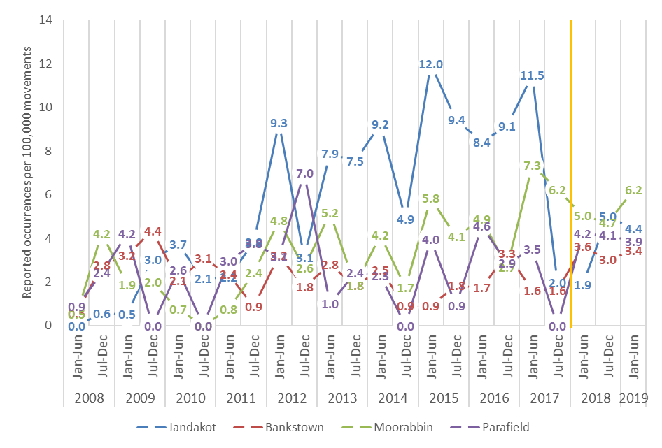
The ATSB initially analysed aircraft separation related occurrences across a 10-year period from 2008 to 2017 in class-D and outside controlled airspace across Australia. Inside the class-D metropolitan airport control zones (3 NM around the aerodrome), all metropolitan airports had a similar rate of separation occurrences in the first years of the study (2008–2012). However, in the second half of the study period (2013–2017), Jandakot Airport had a statistically higher rate of occurrences per 100,000 flights, compared to both the previous five-years (2008–2012) and all other metropolitan airports. However, from July 2017, this higher rate of separation occurrences at Jandakot reduced substantially (Figure 1). Evaluation of occurrences beyond the initial 10-year study range (to the right of the orange line in Figure 1) revealed this lower rate was on par with other metropolitan airports, and has remained so for each six month period since (to June 2019).
Figure 1: Rate of separation occurrences per 100,000 movements within the 3 NM control zone, January 2008 to June 2019
The reduction in the rate of separation related occurrences coincided with a 13 per cent reduction in the average number of flights in each 6-month period from July 2017 to June 2019 compared to flights from the previous five years. The number of separation related occurrences reduced by an average 65 per cent each 6 months from July 2017 to June 2019, five times more than the proportional reduction in flights, compared to the average of the previous five years.
Coinciding with the reduction in the number of flights at Jandakot Airport was the suspension of operations of a flight-training organisation from April 2017 at Jandakot Airport. In the five years prior, 25 of the 197 aircraft (about 13%) involved in separation related occurrences (98 occurrences) in the Jandakot class-D control zone were operated by that organisation; similar to the proportional reduction in the total number of flights described above. This suggests that if this particular flight training operator made up about 13 per cent of flights prior to suspending operations, it has been involved in the same proportion of separation related occurrences relative to the number of aircraft they had airborne. Therefore, during their active years, the organisation does not appear to have an over representation of aircraft directly involved in separation related occurrences at Jandakot.
That is, separation related occurrences reduced by five times more than the number of flights after the suspension of operations by a single flight training organisation, although occurrences directly involving that operator were probably were not disproportionately higher. Therefore, it is expected that other systemic factors existed contributing to the elevated rate at Jandakot between 2013 and 2017. It is possible that, in combination with the operational dynamics at the airport, increases in traffic density (the number of aircraft arriving, departing and in the circuit at the same time), at an already busy airport, had a disproportionate impact on the likelihood of a near collision. Additionally, dynamics in the control zone may have changed, through a different proportional mix of operations and aircraft types, such as ab-initio flight training, private and commercial flying. This in turn may have resulted in a reduction in the near collision risk.
The ATSB did not have information relating to the distribution of the types of operations conducted at Jandakot from 2008 to June 2019. However, the highest number of movements were between 2008 and 2012, and this period coincided with a considerably lower occurrence rate at Jandakot. Therefore, future increases in flight movements alone may not result in a disproportionate increase in separation related occurrences. However, it is possible that an increase in flight movements combined with a similar mix of organisations and operational dynamics to those occurring between 2013 and 2017 may result in the airborne collision risk increasing to previous levels at Jandakot Airport.
Other observations
Based on the reported data, the ATSB also made a number of observations during the analysis.
Pilot awareness of other aircraft
Overall, near collisions where neither pilot was aware of the other aircraft were more likely to involve a closer proximity distance than when at least one pilot was aware of the other aircraft. Consequently, in class-D airspace where air traffic control provide a verbal collision alert to either pilot, the distance between aircraft involved in near collisions were generally further than when no alert was provided.
Near collisions during air traffic control tower operations within the Jandakot Airport control zone were more likely to pass further away than near collisions at Moorabbin (Vic.) and Bankstown (NSW) airports. This was very likely due to a higher proportion of pilots at Jandakot Airport being aware of the other aircraft.
Collisions (class-D and outside controlled airspace)
There were 17 airborne collisions between 2008 and 2017. Almost all occurred at known geographical focal points for the activity conducted. Half involved approach, departure or within the circuit area of an aerodrome, with the other half involved both aircraft conducting the same type of activity (fire bombing, mustering, feral animal culling, gliding). Factors known to mitigate airborne collision risk in these circumstances are maintaining an effective lookout, using flight radio to identify other aircraft and alert other pilots, and implementing formalised strategies to coordinate between aircraft when conducting common operations.
Further steps
The ATSB did not identify any ongoing safety issues with this analysis. However, the ATSB will brief both the Civil Aviation Safety Authority and Airservices Australia on the detailed analysis to help with future airspace planning.
Early in the afternoon on 4 June 2015, a Pacific Aerospace CT/4B, registered VH-YCU (YCU), was conducting an instrument training flight in the training area to the south-west of Tamworth, New South Wales, with an instructor and student on board. At the same time, a Diamond DA 40, registered VH-UNV (UNV), departed Tamworth on a visual navigation student assessment flight, bound for Bankstown, New South Wales, also with an instructor and student on board. Both aircraft were operating under the visual flight rules,[1] and the weather conditions were fine and clear.
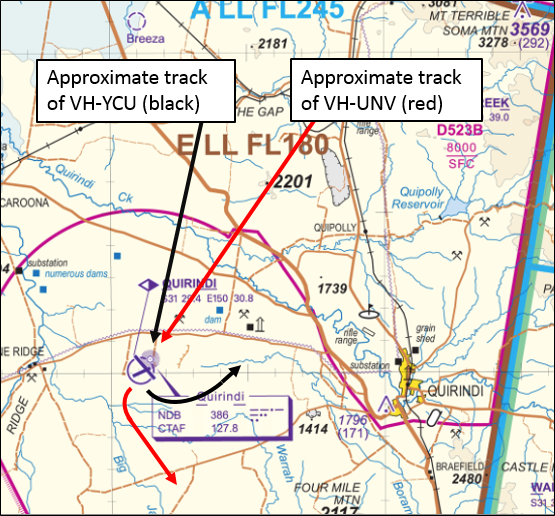
As part of the training sequence, the instructor in YCU directed the student to intercept the 360 degree bearing from the Quirindi non-directional beacon (NDB)[2] The instructor further directed the student to track inbound to the Quirindi NDB at 4,500 ft[3] on that bearing (Figure 1), and carry out a Quirindi NDBA approach.
When about 10 NM north of Quirindi, the student in YCU broadcast their position and intentions on the Quirindi Common Traffic Advisory Frequency (CTAF).[4] The pilot of a recreational aircraft responded to the effect that they were operating in the circuit area at Quirindi. There was no response from any other aircraft. When about 5 NM from Quirindi, the student in YCU made another broadcast on the CTAF, indicating their intention to enter a holding pattern from overhead the NDB, in preparation for the NDBA approach. There was no response from any other aircraft to that broadcast.
At about the same time, UNV was tracking from Gate South (a reporting point south-west of Tamworth) towards Quirindi, also at 4,500 ft (Figure 1). The crew of UNV planned to overfly Quirindi then turn to the south-east and track towards Scone. The crew of UNV were monitoring the area VHF,[5] but not the Quirindi CTAF. As such, the crew of UNV did not hear the CTAF broadcasts made by the student in YCU. Even though the crew of both aircraft were monitoring the area VHF, neither had made any broadcasts on that frequency, so neither crew was aware of the other aircraft. At the time, both were tracking towards Quirindi at the same altitude.
Figure 1: Extract from a visual chart showing the manner in which the tracks of the two aircraft converged as they neared Quirindi, and the general direction of flight of each aircraft after they passed Quirindi (YCU turning to the north-east and UNV turning to the south-east)
Source: Airservices Australia, additions by the ATSB
Just north of Quirindi, the traffic collision avoidance device fitted to YCU alerted the crew to an aircraft in their vicinity, at a distance of 0.4 NM, at the same altitude. The instructor commenced an intensified lookout and soon sighted UNV. At that moment, UNV was in about the 10 o’clock position[6] relative to YCU, at the same altitude, on a slightly converging flight path. The instructor in YCU estimated that at the time UNV was sighted, YCU was in approximately the 4 o’clock position relative to UNV.
Although there was no immediate risk of a collision, the instructor in YCU took control of the aircraft from the student and made a heading adjustment through about 20 degrees to the right. On the new heading, the instructor was satisfied that the flight path of the two aircraft would diverge. In recalling the incident, the instructor in YCU estimated that, at their closest point, the separation between the two aircraft was about 60 m laterally, at the same altitude.
After sighting UNV, the instructor in YCU attempted to establish contact with the crew of UNV on the Quirindi CTAF. The pilot of the recreational aircraft operating at Quirindi responded, but there was no response from the crew of UNV.
Still unaware of the proximity of YCU, the crew of UNV passed over Quirindi then turned to the south-east towards Scone, and commenced a climb to 5,500 ft. As they climbed, the instructor in UNV sighted YCU behind and beneath them, in about their 8 o’clock position. By that time, the crew in YCU had also passed Quirindi, and were now turning towards the north-east for the NDBA holding pattern. Having sighted YCU, the instructor in UNV was satisfied that the two aircraft were on divergent headings and vertical separation was increasing as UNV climbed.
Following the separation issue, the instructor in YCU called air traffic control (Brisbane Centre) on the area VHF in an attempt to establish communications with the crew of UNV. The crew of UNV, who were still monitoring the area VHF, intercepted that call and responded. The crew of UNV then selected the Quirindi CTAF on one of their radios, and they had a brief discussion on that frequency. By the time communications were established on the CTAF, UNV was nearing 5,500 ft on a south-easterly heading towards Scone. The crew of YCU were resuming their planned exercise, entering the Quirindi NDBA holding pattern.
Instructor comments - YCU
The instructor in YCU made a number of comments regarding the incident, including:
Use of radios. YCU was fitted with two VHF radios. During operations in the training area, the crew were monitoring the area VHF on one radio, and company operations on the other. The radio that was being used to monitor the company operations frequency, was switched to the Quirindi CTAF as they prepared for their NDBA approach at Quirindi. As such, the crew were monitoring the area VHF and Quirindi CTAF at the time of the incident.
Instrument flight training hood. The student in YCU was wearing an instrument flight training hood. The hood projected forward from the student’s helmet in a manner that denied the student external visual reference, but allowed the student to scan cockpit instruments (to simulate instrument meteorological conditions). Under these circumstances, the instructor maintained a lookout for other aircraft and hazards, but the position of the student’s helmet and hood was such that the instructor’s visibility to the left of the aircraft was partially obscured. With that in mind, when alerted to other traffic in the vicinity, the instructor targeted a lookout to the left of the aircraft, past the student’s helmet and hood. During this targeted lookout, the instructor sighted UNV. When the instructor sighted UNV, the aircraft was remaining on a constant line of sight relative to YCU, in approximately the 10 o’clock position.
Density of training operations at Quirindi and Gunnedah. The instructor in YCU noted that even though Quirindi and Gunnedah are often used for flight training purposes, there is nothing in the En route Supplement Australia (ERSA) to alert pilots accordingly.
Instructor comments - UNV
The instructor in UNV made a number of comments regarding the incident, including:
Use of radios. UNV was fitted with two VHF radios. The instructor commented that depending on the circumstances, either radio could be used to monitor and broadcast on relevant CTAFs. At the time of this incident, the crew were monitoring the area VHF with one radio, and the company operations frequency on the other.
Monitoring the CTAF. The instructor in UNV was aware that the student in UNV was not monitoring the Quirindi CTAF as they approached from the north, even though it was normal practise to monitor a CTAF under these circumstances (overflying an aerodrome). On this occasion, the instructor elected not to prompt the student to monitor the CTAF in order to reinforce a teaching point to the student regarding frequency management. The instructor was satisfied that a visual lookout would suffice under the circumstances – the conditions were fine and clear, and there were no broadcasts or other transmissions on the area VHF to suggest that there was any potentially conflicting traffic in their area.
ATSB comment
The separation issue in this case may have been avoided if the pilots of the two aircraft involved had been monitoring and broadcasting on the same frequency. Both crews were monitoring the area VHF, but operating under the visual flight rules, there was no specific requirement for the crew of either aircraft to make a broadcast on that frequency. The crew of YCU broadcast their position and intentions on the Quirindi CTAF, but the crew of UNV were not monitoring that frequency.
The requirement to monitor a CTAF is subject to a level of interpretation, particularly with respect to the altitude above an airfield at which the requirement applies. The Aeronautical Information Package (AIP) requires a pilot to broadcast on the CTAF when he/she enters the vicinity of a non-controlled aerodrome. AIP goes on to describe the vicinity of a non-controlled aerodrome as being:
…within 10 nm of the aerodrome and at a height above the aerodrome that could result in conflict with operations at the aerodrome.
Existing forums and processes (managed by CASA and Airservices Australia) allow airspace users to influence the manner in which airspace is managed and propose changes to relevant documents (such as the En Route Supplement Australia). Where changes have the potential to improve safety, operators are encouraged to present proposals for consideration, using those forums and processes. One relevant forum for proposing airspace-related safety improvements is the CASA Regional Airspace and Procedures Advisory Committee.
Safety message
Pilots are encouraged to ‘err on the side of caution’ when considering when to make broadcasts and whether specific frequencies should be monitored, particularly noting the fundamental importance of communication in the effective application of the principles of see-and-avoid. An ATSB report titled Limitations of the See-and-Avoid Principle outlines the major factors that limit the effectiveness of un-alerted see-and avoid.
Insufficient communication between pilots operating in the same area is the most common cause of safety incidents near non-controlled aerodromes.
A search for other traffic is eight times more effective when a radio is used in combination with a visual lookout than when no radio is used.
The CASA booklet titled Operations at non-controlled aerodromes provides guidance with respect to the limitations of the see-and-avoid principle and relevant radio procedures.
The objective of a safety investigation is to enhance transport safety. This is done through:
identifying safety issues and facilitating safety action to address those issues
providing information about occurrences and their associated safety factors to facilitate learning within the transport industry.
It is not a function of the ATSB to apportion blame or provide a means for determining liability. At the same time, an investigation report must include factual material of sufficient weight to support the analysis and findings. At all times the ATSB endeavours to balance the use of material that could imply adverse comment with the need to properly explain what happened, and why, in a fair and unbiased manner. The ATSB does not investigate for the purpose of taking administrative, regulatory or criminal action.
Terminology
An explanation of terminology used in ATSB investigation reports is available here. This includes terms such as occurrence, contributing factor, other factor that increased risk, and safety issue.
Publishing information
Released in accordance with section 25 of the Transport Safety Investigation Act 2003
Ownership of intellectual property rights in this publication
Unless otherwise noted, copyright (and any other intellectual property rights, if any) in this report publication is owned by the Commonwealth of Australia.
Creative Commons licence
With the exception of the Coat of Arms, ATSB logo, and photos and graphics in which a third party holds copyright, this publication is licensed under a Creative Commons Attribution 3.0 Australia licence.
Creative Commons Attribution 3.0 Australia Licence is a standard form licence agreement that allows you to copy, distribute, transmit and adapt this publication provided that you attribute the work.
The ATSB’s preference is that you attribute this publication (and any material sourced from it) using the following wording: Source: Australian Transport Safety Bureau
Copyright in material obtained from other agencies, private individuals or organisations, belongs to those agencies, individuals or organisations. Where you wish to use their material, you will need to contact them directly.
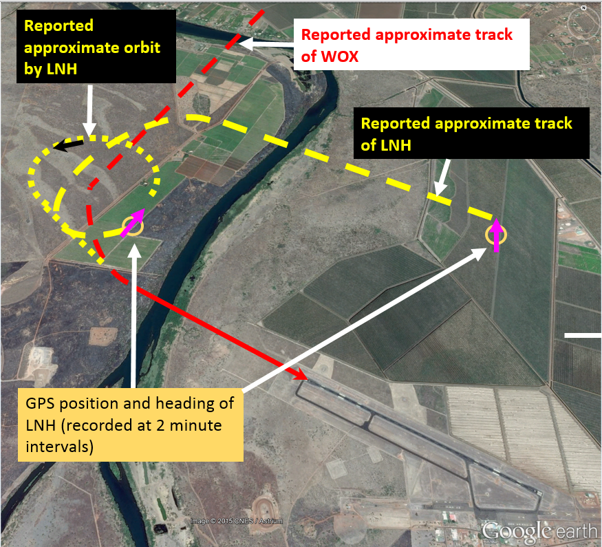
On 15 May 2015, at about 0600 Western Standard Time (WST), a Cessna 207 aircraft, registered VH-WOX (WOX), departed Kununurra Airport, Western Australia, for a local scenic charter flight with a pilot and four passengers on board. A few minutes later, a Cessna 208B (Caravan) aircraft, registered VH-LNH (LNH), also departed Kununurra for a local scenic charter flight, operated by another company, with a pilot and 12 passengers on board. Three other Cessna Caravan aircraft from that company departed at around the same time, with LNH the third of the four Caravans in sequence.
The pilot of WOX reported maintaining visual and listening awareness of the other aircraft throughout the scenic flight. On returning to Kununurra, the company procedure for WOX was to overfly the airfield at 2,000 ft then descend about 5 NM to the north before returning and joining the circuit on base leg for runway 12. The company procedure for LNH was to approach the airfield from the south and join the circuit on the crosswind leg for runway 12. While conducting aerial work to the north of the field, the pilot of WOX heard the pilots of the first two of the Caravans broadcast inbound calls on the common traffic advisory frequency (CTAF).
At about 0812,[1] when about 5 NM from the airfield on an extended base leg, the pilot of WOX broadcast that they had completed airwork and were tracking to join on base for runway 12 (Figure 1). At the time, the first of the Caravans had landed and the pilot of the second Caravan, then ahead of WOX, had broadcast turning base. About 10 seconds later, LNH broadcast joining midfield crosswind. Eight seconds after the broadcast from LNH, the pilot of WOX reported being about 2 NM from the runway, on base leg. The pilot of WOX then broadcast that they had both the aircraft ahead on final approach, and LNH abeam WOX and turning downwind, in sight.
The pilot of LNH reported conducting an oval-shaped circuit pattern, flying a curved base leg with a constant left turn from the downwind leg to the final leg for runway 12. After commencing the turn, the pilot of LNH reported hearing the broadcast from WOX stating they had LNH in sight. The pilot of LNH did not sight WOX and assumed the pilot would sequence to join the circuit behind LNH.
At about 0813, the pilot of WOX turned onto final for runway 12 and broadcast doing so. The Caravan ahead had landed and cleared the runway. LNH did not broadcast turning base and the pilot of WOX assumed that LNH was then still well behind WOX. When about three quarters of the way through the continuous left turn from downwind and approaching the final leg, the pilot of LNH configured the aircraft for landing and selected full flap. At that time, the pilot of LNH reported hearing WOX broadcast turning final. A few seconds later, the pilot of LNH sighted WOX ahead, to the right, slightly above, and in close proximity to LNH. The pilot of LNH then continued a steeper left turn to increase separation with WOX. As the aircraft turned to the north-east, the pilot of LNH sighted a company aircraft on downwind and at about 0815, broadcast conducting a left orbit. The pilot of LNH also asked the pilot of the following aircraft to conduct an orbit to increase separation between those two aircraft.
At that time, WOX was on late final approach to runway 12. The pilot of WOX assumed LNH had conducted the orbit to increase separation and ensure WOX would be clear of the runway. The pilot of WOX was not aware of the separation issue subsequently reported by LNH. Both aircraft landed safely without further incident.
Figure 1: Kununurra aerodrome with the approximate aircraft tracks
Source: Google earth annotated by the ATSB
Pilot comments
Pilot of VH-WOX
The pilot of WOX provided the following comments:
The aircraft that landed ahead of WOX had completed a normal square base leg and the pilot assumed that LNH would therefore do the same.
The aircraft ahead of WOX was closer to WOX than LNH was, when the pilot joined base. The pilot assessed that there was sufficient distance for adequate separation from the aircraft ahead and from LNH, and therefore did not ask the pilot of LNH to confirm they had WOX in sight.
Pilot of VH-LNH
The pilot of LNH provided the following comments:
The pilot had not sighted WOX when the pilot broadcast joining base, and assumed it would join behind LNH.
As the wind was about 15 kt from the south-east, the downwind leg of the circuit was completed in relatively short time.
The pilot of LNH had previously worked for the company that operated WOX. While flying for that company, the pilot joined an offset base leg to intercept the final leg at about 2.5 to 3 NM. The pilot believed that WOX would have conducted a similar joining procedure. From this procedure, the pilot assumed that WOX would therefore sequence behind LNH, which was already in the circuit.
Operator comments
The operator of LNH provided the following comments:
Joining the circuit on base was not a standard procedure. Pilots of aircraft joining the circuit in a non-standard manner were required to give way to aircraft established in the circuit.
There was never a formal nor an informal company procedure to conduct an oblong circuit. The use of a constant turn from downwind to final has subsequently been removed from pilot training and that change communicated to all company pilots.
Safety action
Whether or not the ATSB identifies safety issues in the course of an investigation, relevant organisations may proactively initiate safety action in order to reduce their safety risk. The ATSB has been advised of the following proactive safety action in response to this occurrence.
Operator of VH-LNH
The operator of LNH issued a safety notice to company pilots titled Circuit Operations. The notice included the following:
Pilots were directed to fly a standard rectangular base leg to enable greater visibility of aircraft in the circuit area. The practice of conducting a curved approach was to cease immediately.
Pilots were reminded to complete all cockpit checks early when joining the circuit. This was to maximise the time available for pilots to scan outside the aircraft and to avoid distractions.
Pilots were reminded to make position reports in a timely manner and acknowledge radio calls where required. A double-click of the radio transmitter was not deemed to be an acceptable means of a read-back.
Operator of VH-WOX
As a result of this occurrence, the operator of WOX has advised the ATSB that they are taking the following safety actions:
Company aircraft are to track for a 3 NM final when there is other traffic in the circuit.
Company pilots are to confirm with other aircraft that they have visual confirmation of the location of their aircraft. If they do not, then the pilot is to ensure they maintain separation.
Safety message
As detailed in the booklet A pilot’s guide to staying safe in the vicinity of non-controlled aerodromes, ATSB research found that, between 2003 and 2008, there were 709 airspace-related events at, or in the vicinity of non-towered aerodromes. This included 60 serious incidents and six accidents (mid-air and ground collisions). Most of the 60 serious incidents were near mid-air collisions.
Issues associated with unalerted see-and-avoid have been detailed in the ATSB research report Limitations of the See-and-Avoid Principle. The report highlights that unalerted see-and-avoid relies entirely on the pilot’s ability to sight other aircraft. Broadcasting on the CTAF is known as radio-alerted see-and-avoid, and assists by supporting a pilot’s visual lookout for traffic. An alerted search is more likely to be successful as knowing where to look greatly increases the chances of sighting traffic. The report is available at the ATSB website.
This incident highlights the importance of broadcasting an aircraft’s position and of other pilots in the vicinity then ensuring they have the aircraft sighted following the broadcast.
The objective of a safety investigation is to enhance transport safety. This is done through:
identifying safety issues and facilitating safety action to address those issues
providing information about occurrences and their associated safety factors to facilitate learning within the transport industry.
It is not a function of the ATSB to apportion blame or provide a means for determining liability. At the same time, an investigation report must include factual material of sufficient weight to support the analysis and findings. At all times the ATSB endeavours to balance the use of material that could imply adverse comment with the need to properly explain what happened, and why, in a fair and unbiased manner. The ATSB does not investigate for the purpose of taking administrative, regulatory or criminal action.
Terminology
An explanation of terminology used in ATSB investigation reports is available here. This includes terms such as occurrence, contributing factor, other factor that increased risk, and safety issue.
Publishing information
Released in accordance with section 25 of the Transport Safety Investigation Act 2003
Ownership of intellectual property rights in this publication
Unless otherwise noted, copyright (and any other intellectual property rights, if any) in this report publication is owned by the Commonwealth of Australia.
Creative Commons licence
With the exception of the Coat of Arms, ATSB logo, and photos and graphics in which a third party holds copyright, this publication is licensed under a Creative Commons Attribution 3.0 Australia licence.
Creative Commons Attribution 3.0 Australia Licence is a standard form licence agreement that allows you to copy, distribute, transmit and adapt this publication provided that you attribute the work.
The ATSB’s preference is that you attribute this publication (and any material sourced from it) using the following wording: Source: Australian Transport Safety Bureau
Copyright in material obtained from other agencies, private individuals or organisations, belongs to those agencies, individuals or organisations. Where you wish to use their material, you will need to contact them directly.
On 16 November 2014, a Robinson R44 helicopter, registered VH-YDK (YDK), was approaching Jandakot Airport on a charter flight from Rottnest Island, Western Australia, with a pilot and three passengers on board. At about 1348 Western Standard Time, the pilot of YDK reported downwind for runway 24 on the Jandakot Tower frequency.
At about the same time, the pilot of a Bell 412 helicopter, registered VH-EWA (EWA), prepared to conduct a rescue flight to Bunbury, Western Australia, with a crewman and paramedic on board. As YDK turned onto final, at about 400 ft above ground level (AGL), the pilot of YDK sighted EWA outside its hangar and elected to continue the approach.
At about 1350, the pilot of EWA requested to taxi to the compass swing bay on the Ground frequency. As the pilot commenced taxiing, the crewman sighted YDK at about 150 ft AGL and on an approach towards EWA. He directed the pilot of EWA to go forward.
At about 1350, the pilot of YDK broadcast on the Tower frequency: ‘YDK just out your left hand window’. The pilot of EWA was monitoring the Ground frequency and did not hear that call. YDK then descended and passed behind EWA towards a landing on the middle of the grassed area.
The pilot of EWA continued to taxi towards the compass swing bay, and when approaching the bay, first sighted YDK which was then passing behind EWA and about 30 m away.
The environment and procedures in the helicopter precinct at Jandakot require that pilots make the mandatory radio calls, maintain a good lookout and taxi, depart and approach the area by the most predictable routes to assist others in sighting them.
A DeHavilland Canada DHC-8 (Dash 8) had been cleared to take-off on runway 30, with a request to make an early right turn to track to Point Lookout. The aircraft was rolling when the crew heard traffic information being issued by the aerodrome controller to an inbound formation of three McDonnell Douglas F-18A (Hornet) fighter aircraft. The Dash 8 crew also heard the controller advise the formation pilots that an early "pitch" (a 180 degree turn onto downwind) was available. The Dash 8 crew subsequently commenced a right turn at about 350 ft. At an altitude of about 700 ft they saw a Hornet to their right, passing from left to right about 300 ft higher than them.
The Dash 8 crew arrested their rate of climb as the Hornet passed over them and was lost from view. It was subsequently determined that the Hornet pilots had sighted the Dash 8 prior to entering the circuit at 1,500 ft. The first two aircraft were able to "pitch" early, passing behind the Dash 8. The third Hornet commenced to "pitch" just astern of the Dash 8 but overtook that aircraft during the turn. The Hornet pilot assessed that the Dash 8 was at approximately 700 ft, with a moderate rate of climb, and that adequate vertical separation would be maintained. The aerodrome controller did not use separation assurance techniques to establish separation between the departing Dash 8 and the arriving fighters. As a result, separation became reliant on the judgement of the Hornet pilots, rather than by the use of air traffic control traffic conflict strategies.
Occurrence summary
Investigation number
199802719
Occurrence date
13/07/1998
Location
2 km North-west of Williamtown Non-Directional Beacon
State
New South Wales
Report release date
30/04/1999
Report status
Final
Investigation type
Occurrence Investigation
Investigation status
Completed
Mode of transport
Aviation
Aviation occurrence category
Separation issue
Occurrence class
Incident
Aircraft details
Manufacturer
De Havilland Canada/De Havilland Aircraft of Canada