Runway excursion

Runway excursion involving De Havilland Canada DHC-8, VH-QQB, at Chinchilla Airport, Queensland, on 23 May 2022

Final report

Executive summary

What happened

On 23 May 2022, a De Havilland Canada DHC-8-102, registered VH-QQB and operated by Skytrans, was conducting a scheduled passenger flight from Brisbane to Chinchilla, Queensland. Approaching top of descent, the flight crew were alerted to an engine control unit (ECU) failure on the right engine. The ECU failure meant that reverse thrust would not be available on the right engine to assist in decelerating the aircraft on landing, but they assessed it was safe to continue with the planned approach.

During the landing, the aircraft veered to the left of the runway centreline. Towards the end of the runway, the left main landing gear ran off the runway.

What the ATSB found

The ATSB found that, after experiencing an ECU failure on the right engine, the flight crew opted to continue with the planned flight in accordance with the guidance in the available operator’s procedures.

Upon landing with a tailwind and further down the runway than usual, the flight crew experienced reduced braking effectiveness when the anti-skid system activated after the outboard right main wheel locked up after touchdown for unknown reasons. The system released brake pressure on the outboard wheel on both main landing gears, extending the landing roll.

While assessing the available braking performance, the crew missed a standard call that would have prompted the captain to transition to the tiller to provide directional control as the aircraft decelerated. In an attempt to slow the aircraft, the captain applied reverse thrust on the left engine which produced asymmetric deceleration. The aircraft veered slightly left, and the captain elected to use the emergency brake to slow the aircraft on the relatively short runway. Due to the runway being narrow, the left wheels departed the sealed runway surface in the final stages of the landing roll.

The investigation identified that the procedures permitting the flight crew to continue the flight after the ECU failure did not include consideration of other factors that could increase the required landing distance, including a tailwind and a wet runway, or that a narrow runway increased the risk of a veer off due to asymmetric thrust.

The investigation also found that the acceptable means of compliance guidance material for the Civil Aviation Safety Regulations 1998 relating to required landing performance did not clearly convey the intent of the regulations relating to the discontinuation of an approach to a runway when surface conditions were unexpectedly wet.

What has been done as a result

In response to this incident, the operator updated their procedures for continued flight following an ECU failure to prohibit the use of a narrow runway unless operationally required in an emergency.

Revisions to the operating procedures also prohibited the use of short runways with a tailwind.

The Civil Aviation Safety Authority have also added extra explanatory text to the guidance material to better explain the intention of the regulations around the assurance of landing performance and how these requirements can be met.

Safety message

Pilots and operators should remain mindful that unexpected events can combine to produce undesirable outcomes. Procedures for managing an equipment failure should take into account factors that may influence performance or other operational considerations. These could include tyre lock up, runway surface condition or the presence of a tailwind when landing on a short and narrow runway. Increased safety margins in procedural documentation can help ensure flight crew make appropriate decisions when managing unexpected events.

The investigation

Decisions regarding whether to conduct an investigation, and the scope of an investigation, are based on many factors, including the level of safety benefit likely to be obtained from an investigation. For this occurrence, a limited-scope investigation was conducted in order to produce a short investigation report, and allow for greater industry awareness of findings that affect safety and potential learning opportunities.

The occurrence

On 23 May 2022 at 0720 local time, a De Havilland Canada DHC-8-102 aircraft, registered VH‑QQB and operated by Skytrans, departed Brisbane Airport on a scheduled passenger flight to Chinchilla Airport, Queensland with 3 crew and 26 passengers on board. The captain was pilot flying (PF), and the first officer was pilot monitoring (PM).[1]

At 0740, when approaching the top of descent, the flight crew noticed the engine control unit (ECU) warning light illuminate alerting them to an ECU failure on the right engine. Failure of the ECU meant reverse thrust would not be available on that engine on landing. The flight crew consulted the company procedures for managing an ECU failure, which permitted continuing the flight to Chinchilla. The flight crew checked the weather conditions for landing and elected to conduct a straight-in approach to runway 32,[2] with a tailwind of about 5 kt that was within acceptable limits. They also noted that there were some showers in the area.

The aircraft landed at 0806 and both flight crew reported that the aircraft touched down further along the runway than intended, but still within the company’s permitted touchdown zone.[3] Upon touchdown, the PF reported putting both propellers into beta range[4] and applying the brakes, but little or no braking occurred. The PF announced ‘no brakes’ to the PM, and the flight crew verified the brake hydraulic pressure indicators were indicating within the normal range. The PM also attempted to apply the brakes, but the aircraft was not slowing at the expected rate. In response, the PF moved the left thrust lever to reverse, and the aircraft deviated left of the runway centreline.  

The PF reported the main concern at that point was stopping the aircraft. To avoid locking up the wheels, the PF made 3 applications of the emergency brake,[5]  which was effective at slowing the aircraft. The PM recalled that, as the aircraft decelerated, they did not make the standard 60 kt call that would have prompted the PF to release the control column to the PM and assume directional control using the tiller[6] once the aircraft had slowed to around taxi speed. The PF reported that they did not use the tiller to assist in maintaining directional control because at the time they did not think they were at risk of a runway excursion.

After stopping the aircraft on the turning pad[7] at the end of runway 32, the flight crew taxied the aircraft to the apron via the normal taxiway and the passengers disembarked. The crew were alerted by a cabin crew member that the outer right wheel did not rotate during the landing roll. The PF then conducted an inspection of the aircraft and noticed the outer tyre on the right-side landing gear was deflated, with a flat spot that extended fully through the tyre (Figure 1). There was also mud on the left wheels.

Figure 1: Deflated outer right tyre

Figure 1: Deflated outer right tyre

Source: Skytrans

The PF then walked the length of the runway and saw tyre marks indicating that the aircraft had deviated off the left side of the runway just before the runway turning pad (Figure 2), and that the outer right tyre had ‘dragged’ on the runway from the point of touchdown.

Figure 2: Tyre marks showing runway excursion to the left of runway

Figure 2: Tyre marks showing runway excursion to the left of runway

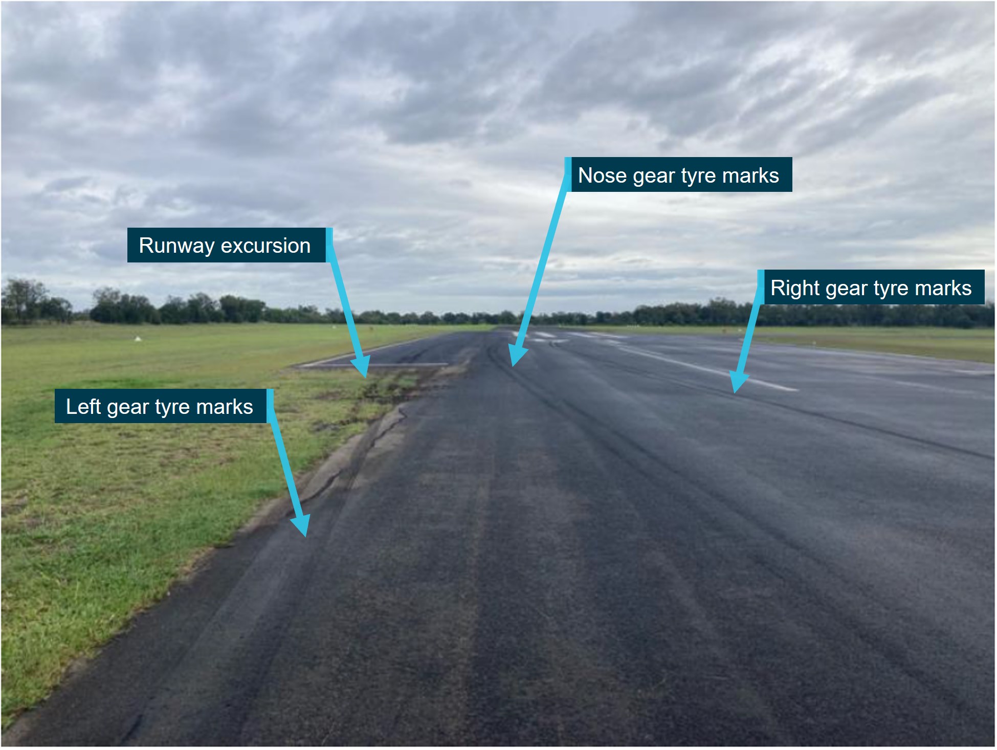
Source: Skytrans, annotated by the ATSB

Context

Flight crew information

The captain had been flying for over 30 years and had about 20,000 hours of aeronautical experience with about 6,500 hours on DHC-8 aircraft. The first officer had been flying for about 20 years and had about 7,500 hours of aeronautical experience, which included experience flying DHC-8 aircraft. Both flight crew had experienced an engine control unit (ECU) failure in flight prior to this incident.

Aircraft information

General

The De Havilland Canada DHC-8-102 aircraft is a high-wing, pressurised airframe powered by 2 turboprop engines, each driving a four-blade constant speed propellor. Skytrans had operated VH‑QQB since 2007.

Engine control unit

Each aircraft engine was fitted with an ECU. The primary function of the ECU is for fuel flow regulation and torque management to optimise performance while protecting the engine from operational hazards such as exceedances of certain engine parameters, including temperature and RPM. The ECU monitors the engine operating condition through various engine and airframe inputs. It also commands the torque motor in the engine hydromechanical unit[8] to optimise fuel flow to the engine and set a reference torque indicator ‘bug’ on the associated engine torque gauge in the cockpit instrumentation.  

In the event of an internal fault, the ECU will drop offline, and engine management will revert to manual control. In manual mode:

  • the pilot assumes fuel control
  • the ECU MANUAL mode light will illuminate on the caution panel
  • there will normally be a difference between the 2 engine power lever positions for the same torque
  • engine response will be slower above 15,000 ft and for torque settings below 50%
  • engine surging is possible above 15,000 ft
  • there are limitations on the use of lower power lever settings, especially after landing, due to the engine under-speed governor, normally controlled by the ECU, being unavailable.

When the ECU is operating in manual mode, reverse thrust is no longer available for that engine/propeller on landing.

Anti-skid braking

Anti-skid systems are designed to minimise aquaplaning and the potential tyre damage that can occur when a wheel is locked or rotating at a speed which does not correspond to the speed of the aircraft. The system compares the speed of the aircraft with the rotational speed of each main wheel. If the speed of a wheel is too slow for the existing aircraft speed, the brake on that wheel is released momentarily to allow the rotational speed to increase and prevent the tyre from skidding. The anti-skid system in the DHC-8-102 is set for heavy airframe loads and when the aircraft is lighter or in slippery conditions, heavy braking may result in a short-term skid.

The system logic is activated by weight on wheels (WOW) proximity switches that close once the weight of the aircraft settles on the main landing gear after touchdown. These switches work in pairs through 2 channels (WOW 1 and WOW 2) to the skid control unit (SCU). There are 2 wheels on each main landing gear strut. The WOW 1 sensors provide input from the proximity switches of the inside wheel on each gear strut to the SCU. The SCU then controls the brakes on the inside wheel of each main gear strut. Similarly, WOW 2 sensors provide a signal to the SCU for the brake of the outside wheel on each of the main landing gear struts.

In addition, there is a ‘spin-up’ protection, ensuring brake pressure is not available to the braking system until the wheels are rolling on the runway surface at 35 kt. If a skid is detected, the skid control valve will provide a 3‑second delay to allow the wheels to spin up before braking is available. If the skid continues for more than 3 seconds, the system response is to release brake pressure on the corresponding wheel of the opposite gear leg through the WOW channels and the SCU, which reduces the braking performance and extends the landing roll.

Once the spin-up protection is no longer required, anti-skid protection is available down to a design limited minimum speed of 12 kt.  Activation of the emergency brake disables the anti-skid system.

Engineering inspection

Engineers visually inspected the right landing gear following the incident and did not identify any defects with the brake pack or axle that would have led to the outer wheel lock up. Both right wheels were subsequently replaced. Significantly, the operator identified that, as the ECU system and the brake system are not connected, the wheel lock up was almost certainly unrelated to the ECU failure.

Managing the ECU failure

The operator used the aircraft flight manual and quick reference handbook procedures to manage an engine with an ECU in manual mode.

The flight crew were alerted to an ECU issue by the illumination of the ‘#2 Eng Manual’ caution light on the caution/warning panel. They then consulted the quick reference handbook for ECU operating in manual mode to determine the required actions. The handbook indicated that the power lever for the affected engine should not be moved below ‘DISC’ on landing, which included to the reverse thrust position.

The flight crew then consulted the Minimum Equipment List in relation to 1 ECU inoperative which stated that:

One [ECU] may be inoperative provided:
a. operations are conducted in compliance with the Airplane Flight Manual (AFM) supplement 10 OPERATION WITH ONE ECU INOPERATIVE; and
b. nose wheel steering and anti-skid brake control system operate normally.

The AFM supplement 10 OPERATION WITH ONE ECU stated (in relation to approach/landing with 1 ECU inoperative):

During approach, a maximum torque difference of 10% may be used to reduce POWER lever asymmetry.

Meteorological information

The aerodrome forecast (TAF),[9] current at the time of the approach, included wind from 120° (true) at 6 kt and scattered cloud at 2,000 ft above the airport, with visibility greater than 10 km. The meteorological aerodrome report (METAR),[10] issued at 0800, indicated that the wind was from 140° (true) at 4 kt with overcast cloud at 10,000 ft. The 1-minute weather data from Chinchilla Airport’s automated weather station recorded a south‑easterly wind at 3–4 kt at 0740 (when the aircraft was at top of descent) and an east‑south‑easterly at 5–6 kt at 0806 (when the aircraft touched down). The maximum wind gust within that period was 6 kt.

Based on the METAR, TAF and recorded observations, the prevailing wind produced an approximate 5 kt tailwind for an approach to runway 32 around the time of landing. The maximum acceptable tailwind stated in the flight crew operating manual was 10 kt. The pilot flying elected to conduct a straight-in approach despite a light tailwind because they assessed it was easier to manage a stabilised approach with the failed ECU. The tailwind component was within the operational limits, and they assessed sufficient runway distance available for a safe landing. 

While no rain was forecast for the scheduled time of arrival, the area forecast indicated the presence of light showers in the area. These showers may not have produced sufficient rainfall to have been recorded with the METAR observations indicating there had been no rainfall in the 24 hours prior to the occurrence. The flight crew advised that at the time of landing, the runway was ‘damp’, and that the aircraft braking would be at or close to normal. Photographs of the runway taken after the occurrence (Figure 2) showed moisture on the runway surface. It was not shiny and there was no visible standing water.

A briefing note from the Flight Safety Foundation, FSF ALAR Briefing Note 8.5 – Wet or Contaminated Runways stated that a runway is considered damp when ‘the surface is not dry, but when the moisture on it does not give it a shiny appearance’.

Runway surface condition definitions

At the time of the occurrence, operators were required to operate in compliance with Civil Aviation Safety Regulations (CASR) Part 121 (Australian air transport operations - larger aeroplanes) performance requirements. During the 6-month transition period from the commencement of Part 121 on 2 December 2021, a deferral provision allowed operators to rely on their existing operations manual, written to comply with Civil Aviation Order (CAO) 20.7.1B Aeroplane weight and performance limitations – specified aeroplanes above 5 700 kg – all operations (turbine and piston-engined), supplemented by annexures to bring their document suite into compliance with the new Part 121.

CASR Part 121 MOS did not recognise ‘damp’ as a runway condition.

The runway surface condition definitions in Part 121 (Australian larger aeroplanes) Manual of Standards included:

dry: a runway is dry if the surface area required for a take-off or landing:
    a) has no visible moisture;
    b) is not contaminated.
wet: a runway is wet if the surface area required for a take-off or landing:
    a) is not dry; and
    b) is not contaminated.
contaminated: a runway is contaminated if more than 25% of the surface area required for a take-off or landing is covered by any of the following:
    a) water or slush more than 3 mm deep
    b) loose snow more than 20 mm deep
    c) compacted snow or ice.

Landing performance

A briefing note from the Flight Safety Foundation, FSF ALAR Briefing note 8.3 - Landing distances stated that actual landing distance is affected by various operational factors, with those relevant to this incident being: 

  • runway condition (dry, wet or contaminated by standing water, slush, snow or ice)
  • wind conditions
  • type of braking (pedal braking or autobrakes, use of thrust reversers)
  • anti-skid system failure
  • system malfunctions (e.g. increasing final approach speed and/or affecting lift-dumping capability and/or braking capability).

Civil Aviation Safety Regulations (CASR) 1998 Part 121 Chapter 9 Division 2 – Landing performance outlined the required factors to be applied to landing performance calculations to account for runway surface conditions. This was based on approved weather reports or forecasts,[11] or a combination of weather reports and forecasts. CASR Part 121 – Dictionary defined what constituted an approved weather report and who could provide one. Licensed pilots were included in the list.

CASR Part 121 – Manual of Standards (MOS) Chapter 9 made the distinction between pre-flight and in-flight requirements when calculating the landing performance. This required the crew to obtain the latest forecast and reports to ascertain the runway surface conditions for the time of arrival. The Civil Aviation Safety Authority's (CASA’s) Acceptable Means of Compliance and Guidance Material for Part 121 of the CASR referenced the United States Federal Aviation Administration’s (FAA’s) Safety Alert For Operators (SAFO 19001) which defined ‘at time of arrival’ as a point in time close enough to the airport to allow the crew to obtain the most current meteorological and runway surface conditions considering pilot workload and traffic surveillance, but no later than the commencement of the approach procedures or visual approach pattern.

CASA advised:

It is not acceptable to do an in-flight landing performance check at top of descent (or earlier) that is based on an expectation that the runway should be dry and then land on a runway that is known to be wet (other than dry) without ensuring (by calculation) that the wet (other than dry) landing performance is assured.

The operator’s manual required landing distance calculations be conducted in-flight. These calculations were to be based on weather reports or observations from an approved source.[12] The procedure to complete the in-flight landing performance check was defined in the Regulated take-off weight manual (RTOW)[13]  for the DHC-8. The RTOW calculation required the use of the latest METAR and ATIS[14] or AWIS[15] information to assure the landing performance. The requirement to conduct this in-flight check complied with Part 121 MOS Chapter 9.13 Landing distance – in-flight requirements.

Recorded flight data

The aircraft had an onboard flight data recorder that had been modified by a previous operator. This resulted in difficulties extracting the FDR data, and inconsistencies found in some of the downloaded parameters brought the reliability of the data into question. Consequently, where suspect values could not be resolved and an alternate reliable source of information was available, the FDR data was not used.

The FDR did not record any parameters for the wind at Chinchilla Airport, however, the GPS data recorded the equivalent of a 12 kt tailwind when the aircraft touched down. This was inconsistent with the recorded weather observations (see the section titled Meteorological information), which indicated a steady 5–6 kt tailwind for a landing on runway 32. While both sets of data indicated that a tailwind was present for the landing, the magnitude of the FDR‑derived value was considered potentially suspect, so the Bureau of Meteorology recorded observations were utilised to determine the likely conditions. From the recorded data available the following key information was determined:

  • the ECU failure occurred at 0740:30
  • the aircraft touched down at 0806:15
  • upon touchdown the indicated airspeed was about 90 kt which was consistent with the target airspeed.

The touchdown point could not be definitively determined however, the weight-on-wheels and squat switch parameters indicated the aircraft touched down approximately halfway down the runway (approximately 510 m beyond the runway 32 threshold). Further analysis of the data showed multiple vertical and longitudinal acceleration spikes along with GPS altitude reaching ground level coinciding with a large pitch rate oscillation approximately 4 seconds before that position. This indicated that touchdown may have occurred about 300 m beyond the runway 32 threshold. This was consistent with photographs of the main wheel skid marks on the runway.

The rotation speed at touchdown and the point that the right outer wheel deflated could not be determined from the recorded parameters.

The manufacturer was provided with a copy of the data from the flight data recorder for their analysis, however they were unable to interpret the data. Given the basic landing parameters that were available, the manufacturer calculated that the crew would have needed all remaining runway to stop from a normal approach if the touchdown point was as indicated by the weight on wheels squat switch parameters. This calculation was based on the flight manual performance data for a dry runway.
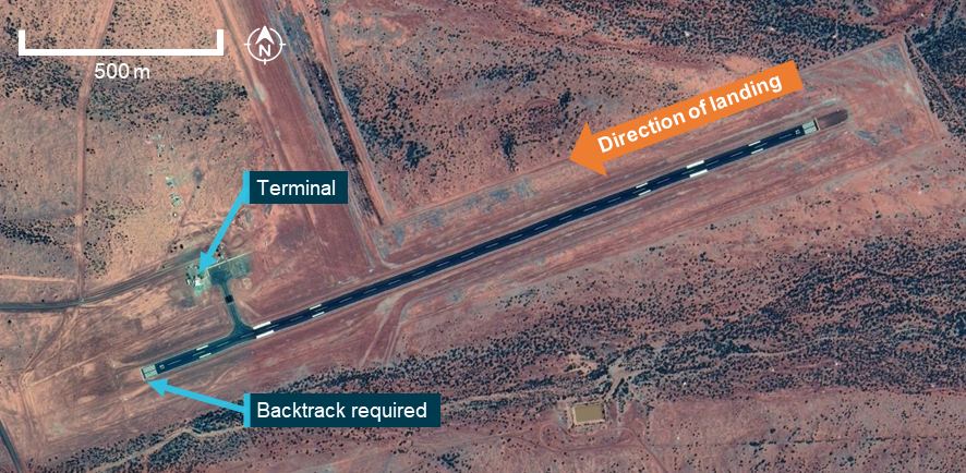
Runway dimensions

Chinchilla Airport is a certified non-controlled aerodrome located in south-eastern Queensland. The airport has 2 runways, one clay runway (runway 03/21) unsuitable for use by a Dash 8 aircraft, and one sealed runway 14/32. This runway was 1,069 m in length and 18 m wide with a turn pad at each end of the runway (Figure 3). Part 139 (Aerodromes) Manual of Standards (MOS) 2019 stated that 18 m was the minimum runway width for aerodrome design.  

Figure 3: Chinchilla runway 14/32 design

Figure 3: Chinchilla runway 14/32 design

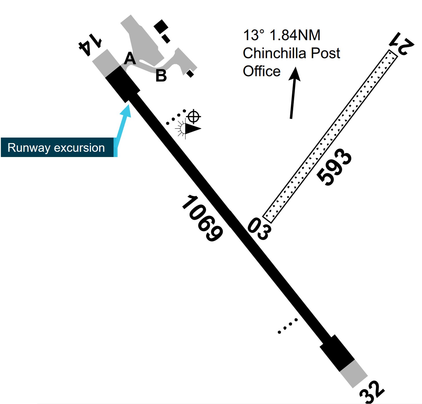
Source: Airservices, annotated by the ATSB

Runway 14/32 had undergone rehabilitation works that included resurfacing in 2015. Technical documentation indicated that a symmetrical crown existed for the first 300 m of runway 32 with a 5 cm drop from the runway centreline to both runway edges. The remaining 769 m possessed a uniform 1.5% downward slope from left to right across the runway. This transverse slope was within the permitted range specified in section 6.08 of the Civil Aviation Safety Regulations - Part 139 (Aerodromes) Manual of Standards (2019), and opposite the direction of the runway excursion.

A technical inspection of the aerodrome was conducted in February 2023 as part of the ongoing certification requirements of the airport. This inspection found that the runway surface contained minor rutting at the north-western end of runway 14/32 but the ruts did not hold water and were not considered a safety issue.

Safety analysis

After experiencing an ECU failure on the right engine during flight, the flight crew consulted the operator procedures and opted to continue with the planned flight based off that guidance. The pilot flying (PF) had also experienced ECU failures before and was comfortable managing the limitations associated with the failure. The flight crew knew they would not have reverse thrust available on the right engine to assist with slowing the aircraft upon landing, however they had a plan for how to manage that limitation.

The aircraft landed longer than the flight crew intended, but probably still within the touchdown zone. However, this reduced the runway length available to stop the aircraft. The tail wind and the wet runway may have also increased the stopping distance required.

Upon landing the outer right tyre locked up, causing the anti-skid system to activate and release brake pressure on both outboard wheels. The reason for the lock up could not be determined, but it resulted in only the inboard wheels providing a braking force. The reduced braking effectiveness was a surprise to the pilots as they were not expecting any issues with braking performance, other than the lack of reverse thrust on the right engine. In response, the main focus of the flight crew became stopping the aircraft before the end of the runway.   

That focussed attention resulted in the flight crew missing a standard call, which would have prompted the captain to transition to the tiller for directional control. As the crew did not assess that the aircraft was at risk of a lateral runway excursion, this missed call was not detected and their focus remained on stopping the aircraft in the remaining runway. However, as they were landing on a narrow runway the margin for error was reduced, and in the final stages of the landing roll the left landing gear departed the sealed runway surface. The flight crew were unaware of the runway excursion until after conducting a walk around of the aircraft and seeing mud on the tyres.

The operator’s procedures for managing an ECU failure that were utilised by the flight crew when assessing whether to continue with the planned flight were ineffective at prompting the crew to consider other unrelated factors that could affect landing distance. For example, there was no consideration of the impact of a tailwind, a wet runway, or the risk of a runway excursion off a narrow runway due to the asymmetric deceleration associated with the ECU failure.

The operator had a procedure that required the crew to calculate landing performance for the reported runway surface conditions. The expectation was that these would be checked in-flight and provide the assurance of landing performance prior to arrival.

Part 121 MOS that replaced the CAO under the regulatory reform, required the crew to perform an in-flight performance calculation based on reports and forecasts valid at the time of arrival. In explanatory documentation produced by CASA,[16] which included reference to FAA SOFO 19001, it was acceptable to conduct an in-flight planning check during the descent, but not after the commencement of the approach procedures or visual approach.

CASA advised that this should be interpreted to mean that where an arrival takes place to a runway that is forecast and reported to be dry, but upon arrival is found to have visible moisture on its surface, then the landing must not be continued until the wet landing performance is known. This may require a missed approach to allow time for the crew to confirm, by calculation, that the wet performance can be assured prior to landing.

However, the explanation in the acceptable means of compliance guidance material did not clearly convey this intention and did not make the requirement to discontinue the approach clear in the event the runway surface was unexpectedly wet.

Findings

ATSB investigation report findings focus on safety factors (that is, events and conditions that increase risk). Safety factors include ‘contributing factors’ and ‘other factors that increased risk’ (that is, factors that did not meet the definition of a contributing factor for this occurrence but were still considered important to include in the report for the purpose of increasing awareness and enhancing safety). In addition ‘other findings’ may be included to provide important information about topics other than safety factors. 

These findings should not be read as apportioning blame or liability to any particular organisation or individual.

From the evidence available, the following findings are made with respect to the runway excursion involving a De Havilland Canada DHC-8, VH-QQB at Chinchilla Airport, Queensland on 23 May 2022.

Contributing factors

Other factors that increased risk

  • The operator’s procedures for managing an ECU failure did not include consideration of other factors that could increase the required landing distance, including a tailwind and a wet runway, or that a narrow runway increased the risk of a veer off due to asymmetric thrust.
  • The acceptable means of compliance guidance material did not clearly convey the intention of the Civil Aviation Safety Regulations 1998 - Part 121 (Australian larger aeroplanes) Manual of Standards 2020 subsections 9.10 – 9.13 that landing performance must be assured at all times.

Safety actions

Whether or not the ATSB identifies safety issues in the course of an investigation, relevant organisations may proactively initiate safety action in order to reduce their safety risk. The ATSB has been advised of the following proactive safety action in response to this occurrence.

Safety action by the operator

In response to this incident, on 25 May 2022, Skytrans issued 2 flight operations notices (FON) which have since been incorporated into the operations manual:

  • FON 2022-11: Short runway operating requirements was issued to all pilots which included not to land on a short runway with a tailwind. A short runway was defined as less than 1,101 m for DHC-8 aircraft.
  • FON 2022-12: Operations to narrow runways with ECU in manual mode was issued to DHC-8 pilots that stated that unless in an emergency, operations to a narrow runway with an ECU in manual mode was prohibited.

Safety action by the Civil Aviation Safety Authority

To clarify the expectation around the calculation of landing performance data, and to provide guidance on how the regulatory requirements can be met, the Civil Aviation Safety Authority has drafted an amendment to the Civil Aviation Safety Regulations 1998 - Part 121 (Australian larger aeroplanes) Acceptable means of compliance and guidance material (AMC/GM) for inclusion in an upcoming revision. This revision includes the following text:

In-flight monitoring of runway surface conditions (dry, wet or contaminated)
Section 9.13 of the Part 121 MOS requires the PIC to ensure, during the flight and before landing, that the landing performance requirements specified in this MOS section are met for the aerodrome of intended landing. An element of these requirements is determining whether the runway to be used is dry, wet or contaminated.
The determination of the runway surface condition is required to be based on any weather report or forecast, or any combination of weather reports and forecasts. For the avoidance of doubt, the words in the MOS “…during the flight and before landing…” do not indicate that a singular determination can be made once during the flight and relied upon for the entire remainder of the flight. To satisfy their obligations regarding ensuring the safety of the flight under regulation 91.215 of CASR, PICs [pilots in command] are expected to check for updated forecasts and reports at regular intervals throughout the flight and base their determination of runway surface condition on these reports and forecasts.
The intent is that landing performance is assured at all times. This can be achieved by the operator evaluating the effect of multiple runway surface conditions for the most limiting aircraft configuration and including appropriate procedures in the exposition. This is particularly recommended where the aircraft landing configuration is restricted due to, abnormal or emergency situations encountered during flight and/or a narrow runway and/or the runway length is minimal.

Sources and submissions

Sources of information

The sources of information during the investigation included the:

  • flight crew
  • aircraft operator
  • aircraft manufacturer
  • Bureau of Meteorology

References

Civil Aviation Safety Authority. (2019). Civil Aviation Safety Regulations 1998 - Part 139 (Aerodromes) Manual of standards 2019. Australian Government.

Civil Aviation Safety Authority. (2020). Civil Aviation Safety Regulations 1998 - Part 121 (Australian larger aeroplanes) Manual of Standards 2020. Australian Government.

Flight Safety Foundation 2000a ‘ALAR briefing note 8.3 – Landing distances’, Flight Safety Digest, August-November 2000

Flight Safety Foundation 2000b ‘ALAR briefing note 8.5 – Wet or contaminated runways’, Flight Safety Digest, August-November 2000

Submissions

Under section 26 of the Transport Safety Investigation Act 2003, the ATSB may provide a draft report, on a confidential basis, to any person whom the ATSB considers appropriate. That section allows a person receiving a draft report to make submissions to the ATSB about the draft report.

An initial draft of this report was provided to the following directly involved parties:

  • the flight crew of VH-QQB
  • Skytrans Pty Ltd
  • Bureau of Meteorology
  • The Transportation Safety Board of Canada
  • DeHavilland Aircraft of Canada Limited
  • Civil Aviation Safety Authority

Submissions on that draft report were received from:

  • the flight crew of VH-QQB
  • Skytrans Pty Ltd
  • DeHavilland Aircraft of Canada Limited
  • Civil Aviation Safety Authority

After changes, a revised draft report was provided to the directly involved parties.

Submissions on that draft report were received from:

  • Skytrans Pty Ltd
  • Civil Aviation Safety Authority

The submissions were reviewed and, where considered appropriate, the text of the report was amended accordingly.

Purpose of safety investigations

The objective of a safety investigation is to enhance transport safety. This is done through:

  • identifying safety issues and facilitating safety action to address those issues
  • providing information about occurrences and their associated safety factors to facilitate learning within the transport industry.

It is not a function of the ATSB to apportion blame or provide a means for determining liability. At the same time, an investigation report must include factual material of sufficient weight to support the analysis and findings. At all times the ATSB endeavours to balance the use of material that could imply adverse comment with the need to properly explain what happened, and why, in a fair and unbiased manner. The ATSB does not investigate for the purpose of taking administrative, regulatory or criminal action.

Terminology

An explanation of terminology used in ATSB investigation reports is available here. This includes terms such as occurrence, contributing factor, other factor that increased risk, and safety issue.

Publishing information 

Released in accordance with section 25 of the Transport Safety Investigation Act 2003

Published by: Australian Transport Safety Bureau

© Commonwealth of Australia 2023

image_5.png

Ownership of intellectual property rights in this publication

Unless otherwise noted, copyright (and any other intellectual property rights, if any) in this report publication is owned by the Commonwealth of Australia.

Creative Commons licence

With the exception of the Coat of Arms, ATSB logo, and photos and graphics in which a third party holds copyright, this publication is licensed under a Creative Commons Attribution 3.0 Australia licence.

Creative Commons Attribution 3.0 Australia Licence is a standard form licence agreement that allows you to copy, distribute, transmit and adapt this publication provided that you attribute the work.

The ATSB’s preference is that you attribute this publication (and any material sourced from it) using the following wording: Source: Australian Transport Safety Bureau

Copyright in material obtained from other agencies, private individuals or organisations, belongs to those agencies, individuals or organisations. Where you wish to use their material, you will need to contact them directly.

[1]     Pilot Flying (PF) and Pilot Monitoring (PM): Procedurally assigned roles with specifically assigned duties at specific stages of a flight. The PF does most of the flying, except in defined circumstances; such as planning for descent, approach and landing. The PM carries out support duties and monitors the PF’s actions and the aircraft’s flight path.

[2]     Runway number: The number represents the magnetic heading of the runway. Runway 32 indicates a heading of 320°.

[3]     Touchdown zone means the portion of a runway, beyond the threshold, where landing aeroplanes are to first contact the runway.

[4]     In beta range, the power lever directly controls propeller blade angle. Beta range of operation consists of power lever positions from flight idle to maximum reverse.

[5]     The emergency brake system provides a means for applying brakes should the normal brake system fail.

[6]     The tiller, located on the left side panel of the left seat, is used for directional control of the aircraft on the ground.

[7]     Turn pad: A defined area on a land aerodrome adjacent to a runway for the purpose of completing a 180-degree turn on a runway.

[8]     Hydromechanical unit: Regulates fuel flow to the fuel nozzles in response to power requirements and flight conditions.

[9]     Terminal Area Forecast (TAF): A TAF is a coded statement of meteorological conditions expected at an aerodrome and within a radius of five nautical miles of the aerodrome reference point.

[10]    Meteorological Aerodrome Report (METAR): A routine report of meteorological conditions at an aerodrome. METAR are normally issued on the hour and half hour.

[11]    Civil Aviation Safety Regulations 1998 Dictionary defines approved weather forecasts as those made by the Bureau of Meteorology (BOM), and approved weather reports as those made by the BOM for aviation purposes, an automatic weather station at an aerodrome approved by the BOM, a pilot or a person appointed by the aerodrome operator to make visibility assessments under CASR Part 139 – Manual of standards.

[12]    The operator’s manual defined approved sources of domestic forecasts and reports as those generated by Air Services Australia or the Bureau of Meteorology.

[13]    Regulated take-off weight (RTOW) manual – Document to determine the maximum weight in which an aircraft can take off from a particular runway under specific conditions (winds, weather, specific aircraft configuration, etc,).

[14]    Automatic terminal information services (ATIS): Operational information required by aircraft for take-off or landing is broadcast on a dedicated frequency and/or on the voice channel of radio navigation aids.

[15]    Aerodrome weather information service (AWIS): actual weather conditions, provided via telephone or radio broadcast, from Bureau of Meteorology (BoM) automatic weather stations, or weather stations approved for that purpose by the BoM.

Occurrence summary

Investigation number AO-2022-031
Occurrence date 23/05/2022
Location Chinchilla Airport
State Queensland
Report release date 11/10/2023
Report status Final
Investigation level Short
Investigation type Occurrence Investigation
Investigation status Completed
Mode of transport Aviation
Aviation occurrence category Runway excursion
Occurrence class Incident
Highest injury level None

Aircraft details

Manufacturer De Havilland Canada/De Havilland Aircraft of Canada
Model DHC-8-102
Registration VH-QQB
Serial number 004
Aircraft operator SKYTRANS PTY LTD
Sector Turboprop
Departure point Brisbane Airport, Queensland
Destination Chinchilla Airport, Queensland
Damage Minor

Runway overrun involving Gippsland Aeronautics GA-8, VH-WSB, East Wallabi Island, Western Australia, on 26 December 2021

Final report

Safety summary

What happened

On the morning of 26 December 2021, the pilot of a Geraldton Air Charter, Gippsland Aeronautics GA-8 Airvan prepared for an air-transport flight from Geraldton, Western Australia to East Wallabi Island. During the preparations, the pilot decided to carry an additional passenger from another flight, which was also scheduled to depart for East Wallabi Island. The pilot later reported that the rearrangement of the passengers resulted in the preparations for the flight being rushed.

Earlier in the day, the pilot had operated a flight in a Cessna 172 with an emergency position indicating radio beacon (EPIRB) positioned on their right hip. The pilot was aware that this would obstruct the flap lever in the Airvan and intended to move the EPIRB to their left hip prior to the East Wallabi flight, but during the rushed preparations, forgot to move it.

As the aircraft approached East Wallabi Island, the pilot attempted to select full flap for the landing, but the EPIRB obstructed the flap lever movement and prevented it from locking into the full flap position. Multiple further attempts to select full flap were unsuccessful, and the approach was continued with only the first stage of flap extended.

During the landing flare, the aircraft floated more than the pilot expected and touched down about midway along the runway (about 350 m from the end of the runway). After touch down the pilot applied normal braking but, as the aircraft approached the end of the runway, they realised an overrun was imminent and applied maximum braking. Despite that, the aircraft did not stop on the runway and overran it by about 15 m. The pilot and passengers were not injured, and the aircraft was substantially damaged in the accident.

What the ATSB found

The ATSB found that an emergency position indicating radio beacon worn by the pilot prevented the selection of full flap. The pilot possibly did not comprehend the effect of the reduced flap setting and continued the approach with the inappropriate flap setting.

During the subsequent landing, the aircraft floated significantly beyond the intended landing point. The pilot did not recognise the risk of a runway overrun and did not conduct a go around or apply sufficient braking to stop the aircraft on the remaining runway.

What has been done as a result

Following the accident, the operator modified their operating procedures to recommend that a process of threat and error management be conducted before all flights.

Safety message

This accident emphasises the need for careful flight preparation. Taking time to confirm that all required actions have been completed prior to departure minimises the chance of in-flight complications. To ensure effective flight preparation, the Civil Aviation Safety Authority publication: Visual Flight Rules Guide advises pilots to ‘give yourself time to review information free from distractions when making pre-flight decisions…avoid flying under time pressure’.

It also underlines the importance of commencing a missed approach early when the approach and landing deviate from the plan and a safe landing cannot be assured.

The Civil Aviation Authority of New Zealand publication: Good Aviation Practice, Mountain Flying recommends that pilots ‘always have a clearly defined decision point where you can go-around if you are not happy that a safe landing is achievable.’ This is especially relevant for operations involving short runways.

The investigation

Decisions regarding whether to conduct an investigation, and the scope of an investigation, are based on many factors, including the level of safety benefit likely to be obtained from an investigation. For this occurrence, a limited-scope investigation was conducted in order to produce a short investigation report, and allow for greater industry awareness of findings that affect safety and potential learning opportunities.

The occurrence

On the morning of 26 December 2021, the pilot of a Geraldton Air Charter, Gippsland Aeronautics GA-8 Airvan prepared for an air-transport[1] flight from Geraldton, Western Australia to East Wallabi Island. The flight was planned to carry 6 passengers.

While preparing for the flight, the pilot decided to carry an additional passenger from another flight, which was also scheduled to depart for East Wallabi Island. The pilot later reported that the rearrangement of the passengers resulted in the preparations for the flight being rushed.

Earlier in the day, the pilot had operated a flight in a Cessna 172 with an emergency position indicating radio beacon (EPIRB) positioned on their right hip. The pilot was aware that this would obstruct the flap lever in the Airvan and intended to move the EPIRB to their left hip prior to the East Wallabi flight, but during the rushed preparations, forgot to move it.

At about 1030 Western Standard Time,[2] the flight departed for East Wallabi Island with the pilot and 7 passengers on board (Figure 1).

As the aircraft approached the Island, the pilot positioned the aircraft to join the right base leg of the circuit for runway 36, extended the first stage of flap and observed the windsock indicating a northerly wind.

Figure 1: Flight overview

Figure 1: Flight overview

Source: Google Earth, annotated by ATSB

The pilot turned onto the final leg of the circuit and attempted to select full flap for the landing, but the EPIRB obstructed the flap lever movement and prevented it from locking into the full flap position. Multiple further attempts to select full flap were unsuccessful, and the approach was continued with only the first stage of flap extended.

Runway 36 was 667 m long with a slight downslope. The pilot aimed to touch down in the turnaround area of the runway (Figure 2). As the aircraft crossed the runway threshold at about 70 knots, the pilot reduced engine power to idle and flared [3] the aircraft. During the flare, the aircraft floated more than the pilot expected and touched down near the parking area about midway along the runway (about 350 m from the end of the runway).

Figure 2: East Wallabi Island airstrip

Figure 2: East Wallabi Island airstrip

Source: Google Earth, annotated by ATSB

After touch down, the pilot followed the operator’s normal practice of retracting the flaps and then applied normal braking. As the aircraft approached the end of the runway, the pilot realised an overrun was imminent, and applied maximum braking. Despite that, the aircraft overran the runway by about 15 m (Figure 3). The pilot and passengers were not injured, however the aircraft was substantially damaged, including detachment of a main landing gear leg.

Figure 3: VH-WSB after the runway excursion

Figure 3: VH-WSB after the runway excursion

Source: Operator

Aircraft wing flaps

The Airvan is fitted with manually operated wing flaps with three, selectable positions: retracted, first stage (14° down) and full (38° down). The position of the flaps is determined by notches engaged by the operating lever positioned on the cabin floor to the right of the pilot’s seat. In the retracted and first stage positions, the lever remained below the level of the pilot’s seat bolster. In the full flap position, the lever protruded above the level of the bolster (Figure 4). The aircraft flight manual stated that ‘landings are normally conducted with full flaps’.

Figure 4: Airvan flap lever

Figure 4: Airvan flap lever

Note: The flap lever rests below the pilot seat bolster and is not visible in the retracted and first stage positions (left). The flap lever protrudes above the bolster in the full flap position (right).

Source: Operator

The Civil Aviation Safety Authority publication Flight Instructor Manual (Aeroplane) provides the following information for a landing conducted without flaps which is also applicable (but to a lesser extent) when landing with a flap setting less than full:

The descent path may be flatter, making judgment more difficult…Due to the absence of drag there may be a longer float period.

Landing information

The aircraft departed Geraldton at a calculated take-off weight of about 1,696 kg.[4] The pilot reported the temperature on East Wallabi Island as 28° C. Using this data and assuming no head or tailwind component, the ATSB calculated that after touching down the aircraft required a landing roll of about 190 m to stop using full flaps (the selected first stage flap position should not have significantly altered that distance).

The United States Federal Aviation Administration publication: Airplane Flying Handbook, Chapter 9 Approaches and Landings provided the following information for pilots who encounter floating during landing:

The recovery from floating is dependent upon the amount of floating and the effect of any crosswind, as well as the amount of runway remaining. Since prolonged floating utilizes considerable runway length, it must be avoided especially on short runways or in strong crosswinds. If a landing cannot be made on the first third of the runway, or the airplane drifts sideways, execute a go-around.

Operator’s investigation

The operator’s internal investigation identified that the pilot did not have a full understanding of aircraft drag, effects of flaps, and ground effect. The investigation also noted that the operator’s normal practice of retracting flaps immediately after touchdown to maximise brake effectiveness may have led to the pilot prioritising flap retraction ahead of immediately applying braking action.

Pilot information

The pilot held a Commercial Pilot Licence (Aeroplane) and had a total flying experience of 1,227.6 hours including 528.3 hours in the Airvan. In the previous 90 days, the pilot had flown 80.6 hours, including 29.7 in the Airvan.

The pilot reported being well rested, but mildly unwell on the day. However, there was no indication that the illness reduced their performance. Similarly, the pilot’s general health, fatigue, or distraction were not considered to have contributed to the accident.

Training

The pilot was employed by the operator in July 2019. From that time until November 2019 and again in May 2020 and July 2021, the pilot underwent operator training and proficiency checks that included:

  • stabilised approaches
  • GA-8 Airvan operations
  • East Wallabi Island operations
  • short runway landings
  • go arounds
  • landings

These operator training and checks did not assess the specifics of aircraft drag, effects of flaps or ground effect as they were considered adequately covered during pilot licence testing.

Safety analysis

As the aircraft approached East Wallabi Island, the EPIRB positioned on the pilot’s right hip obstructed the flap lever and prevented their locking in the full flap position. The pilot did not consider a go around to allow for trouble shooting or repositioning of the EPIRB and continued the approach with just the first stage of flap extended. That configuration increased the required landing distance compared to the use of full flaps, although there was still sufficient runway length available to land safely.

During the landing flare the reduced drag of the first stage flap setting, possibly combined with a higher than normal approach speed, led to a longer float. While a go around should again have been considered after the aircraft floated significantly beyond the intended landing point, from the touchdown point it was possible to stop the aircraft in the remaining runway using maximum braking. However, possibly due to the priority given to retracting the flaps and the pilot not immediately recognising the risk of an overrun, maximum braking was not applied until insufficient runway remained to prevent the overrun.

Findings

ATSB investigation report findings focus on safety factors (that is, events and conditions that increase risk). Safety factors include ‘contributing factors’ and ‘other factors that increased risk’ (that is, factors that did not meet the definition of a contributing factor for this occurrence but were still considered important to include in the report for the purpose of increasing awareness and enhancing safety). In addition ‘other findings’ may be included to provide important information about topics other than safety factors. 

These findings should not be read as apportioning blame or liability to any particular organisation or individual.


From the evidence available, the following findings are made with respect to the runway overrun involving Gippsland Aeronautics GA-8, VH-WSB at East Wallabi Island, Western Australia on 26 December 2021

Contributing factors

  • An emergency position indicating radio beacon worn by the pilot prevented the selection of full flap. The reduced flap setting significantly increased the required landing distance.
  • During the landing, the aircraft floated significantly beyond the intended landing point. The pilot did not recognise the risk of a runway overrun and did not conduct a go around or apply sufficient braking to stop the aircraft on the remaining runway.

Safety actions

Whether or not the ATSB identifies safety issues in the course of an investigation, relevant organisations may proactively initiate safety action in order to reduce their safety risk. All of the directly involved parties are invited to provide submissions to this draft report. As part of that process, each organisation is asked to communicate what safety actions, if any, they have carried out to reduce the risk associated with this type of occurrences in the future. The ATSB has so far been advised of the following proactive safety action in response to this occurrence.

Safety action by Geraldton Air Charter

Following the accident, the operator modified operating procedures to recommend a process of threat and error management be conducted before all flights.

Sources and submissions

Sources of information

The sources of information during the investigation included the:

  • aircraft operator
  • pilot

References

Civil Aviation Safety Authority 2006, Flight Instructor Manual Aeroplane

Civil Aviation Safety Authority 2021, Visual Flight Rules Guide

Civil Aviation Authority of New Zealand 2021, Good Aviation Practice - Mountain Flying

Federal Aviation Administration of The United States 2021, Airplane Flying Handbook

Submissions

Under section 26 of the Transport Safety Investigation Act 2003, the ATSB may provide a draft report, on a confidential basis, to any person whom the ATSB considers appropriate. That section allows a person receiving a draft report to make submissions to the ATSB about the draft report.

A draft of this report was provided to the following directly involved parties:

  • operator
  • pilot

Submissions were received from:

  • operator
  • pilot

The submissions were reviewed and, where considered appropriate, the text of the report was amended accordingly.

Purpose of safety investigations

The objective of a safety investigation is to enhance transport safety. This is done through:

  • identifying safety issues and facilitating safety action to address those issues
  • providing information about occurrences and their associated safety factors to facilitate learning within the transport industry.

It is not a function of the ATSB to apportion blame or provide a means for determining liability. At the same time, an investigation report must include factual material of sufficient weight to support the analysis and findings. At all times the ATSB endeavours to balance the use of material that could imply adverse comment with the need to properly explain what happened, and why, in a fair and unbiased manner. The ATSB does not investigate for the purpose of taking administrative, regulatory or criminal action.

Terminology

An explanation of terminology used in ATSB investigation reports is available here. This includes terms such as occurrence, contributing factor, other factor that increased risk, and safety issue.

Publishing information 

Released in accordance with section 25 of the Transport Safety Investigation Act 2003

Published by: Australian Transport Safety Bureau

© Commonwealth of Australia 2022

image_5.png

Ownership of intellectual property rights in this publication

Unless otherwise noted, copyright (and any other intellectual property rights, if any) in this report publication is owned by the Commonwealth of Australia.

Creative Commons licence

With the exception of the Coat of Arms, ATSB logo, and photos and graphics in which a third party holds copyright, this publication is licensed under a Creative Commons Attribution 3.0 Australia licence.

Creative Commons Attribution 3.0 Australia Licence is a standard form licence agreement that allows you to copy, distribute, transmit and adapt this publication provided that you attribute the work.

The ATSB’s preference is that you attribute this publication (and any material sourced from it) using the following wording: Source: Australian Transport Safety Bureau

Copyright in material obtained from other agencies, private individuals or organisations, belongs to those agencies, individuals or organisations. Where you wish to use their material, you will need to contact them directly.

__________

  1. The flight was operated under Civil Aviation Safety Regulations Part 135 (Air transport operations - smaller aeroplanes).
  2. Western Standard Time (WST): Universal Coordinated Time (UTC) + 8 hours.
  3. Flare: the final nose-up pitch of a landing aeroplane used to reduce the rate of descent to about zero at touchdown.
  4. The maximum take-off weight of the aircraft was 1,814 kg.

Occurrence summary

Investigation number AO-2022-001
Occurrence date 26/12/2021
Location East Wallabi Island
State Western Australia
Report release date 06/05/2022
Report status Final
Investigation level Short
Investigation type Occurrence Investigation
Investigation status Completed
Mode of transport Aviation
Aviation occurrence category Runway excursion
Occurrence class Serious Incident
Highest injury level None

Aircraft details

Manufacturer Gippsland Aeronautics Pty Ltd
Model GA-8
Registration VH-WSB
Serial number GA8-07-125
Aircraft operator GERALDTON AIR CHARTER PTY LTD
Sector Piston
Operation type Air Transport Low Capacity
Departure point Geraldton Aerodrome, Western Australia
Destination East Wallabi Island, Western Australia
Damage Substantial

Runway excursion involving Boeing 777-300ER, A7-BED Brisbane Airport, Queensland, on 30 November 2021

Summary

The ATSB has commenced a transport safety investigation into a runway excursion (veer-off) during landing involving a Boeing 777-300ER aircraft, operated by Qatar Airways, at Brisbane Airport, on the night of 30 November 2021.

The aircraft was being operated on a scheduled passenger flight from Auckland, New Zealand. The captain was the pilot flying, and the flight crew was cleared to land on runway 01R.

The flight crew reported that, during the instrument approach, the aircraft encountered heavy rain and turbulence. At about 300 ft above the ground and still in rain, the flight crew established and maintained clear visual reference to the runway lighting and surrounds. Passing about 200 ft, the first officer announced the aircraft was drifting right of the runway centreline. The captain corrected the deviation. As the aircraft was about to touchdown, under the influence of a variable and gusting crosswind, the aircraft drifted right. The aircraft landed to the right of the runway centreline and, shortly after touchdown, the right main landing gear contacted and destroyed four runway edge lights positioned on the sealed runway strip, before the aircraft returned towards the runway centreline.

After the landing was completed and the aircraft had exited the runway, aircraft systems alerted the flight crew of low pressure in one on the right main landing gear tyres. The flight crew stopped the aircraft on the taxiway and requested an inspection of the aircraft. Damage to four right main landing gear tyres was observed, and the aircraft was towed to the international terminal. There were no injuries to passengers or crew.

A runway inspection observed ground debris and subsequently runway 01R was closed to clean up and replace the destroyed runway edge lights.

As part of the investigation, the ATSB has interviewed the flight crew, and reviewed evidence obtained from the airport operator. The ongoing investigation will review data from the aircraft's flight data recorder, weather information and recorded audio and surveillance data.

 A final report will be released at the conclusion of the investigation. Should a critical safety issue be identified during the course of the investigation, the ATSB will immediately notify relevant parties, so that appropriate safety action can be taken.

Discontinuation

Section 21 (2) of the Transport Safety Investigation Act 2003 (TSI Act) empowers the ATSB to discontinue an investigation into a transport safety matter at any time. Section 21 (3) of the TSI Act requires the ATSB to publish a statement setting out the reasons for discontinuing an investigation. The statement is published as a report in accordance with section 25 of the TSI Act, capturing information from the investigation up to the time of discontinuance.

Overview of the investigation

On 30 November 2021, a Boeing 777-300ER aircraft, registration A7-BED, was being operated by Qatar Airways on a scheduled passenger flight from Auckland, New Zealand, to Brisbane, Queensland. During the landing at Brisbane Airport, the aircraft veered off the runway.

The flight crew were conducting an instrument approach to runway 01R at night and the captain was the pilot flying. During the approach, the aircraft encountered heavy rain and turbulence. The crew reported that, at about 300 ft above the runway level and still in rain, they established and maintained clear visual reference to the runway lighting and surrounds, including the runway centreline and edge lights.

The crew stated that, passing about 200 ft, the first officer announced the aircraft was drifting right of the runway centreline. The captain corrected the deviation. As the aircraft was about to touchdown, under the influence of a variable and gusting crosswind, the aircraft drifted right again and the captain was unable to correct the drift before touchdown.

The aircraft landed to the right of the runway centreline and drifting to the right. Shortly after touchdown, the right main landing gear contacted and destroyed 4 runway edge lights positioned on the sealed runway strip, before the aircraft returned towards the runway centreline.

After the landing was completed and the aircraft had exited the runway, aircraft systems alerted the flight crew of low pressure in one on the right main landing gear tyres. The flight crew stopped the aircraft on the taxiway and requested an external inspection of the aircraft. Damage to 4 right main landing gear tyres was observed, and the aircraft was towed to the international terminal. There were no injuries to passengers or crew.

The ATSB received an initial occurrence report on 1 December 2021 and commenced an investigation on the same date.

As part of the investigation, the ATSB interviewed the flight crew and reviewed:

  • data from the aircraft's flight data recorder and quick access recorder
  • weather information
  • recorded air traffic control audio and surveillance data
  • information provided by the aircraft operator, including flight crew rosters and the fatigue risk management system.

The investigation identified the following:

  • runway 01R is 45-m wide with a grooved surface and runway centreline lighting and runway edge lighting, and there were no problems noted with the runway lighting
  • there were no notable faults with aircraft systems
  • there were no notable concerns regarding the flight crew’s decision-making
  • the flight crew likely maintained sight of the runway centreline and edge lights throughout the landing, and were able to detect the aircraft’s drift before touchdown
  • there was a substantial lateral wind gust that changed direction and intensity when the aircraft was below 100 ft above ground level
  • the captain reported feeling between ‘a little tired’ and ‘moderately tired’ after having less than normal sleep quantity and quality in the 2 nights before the flight
  • the captain was probably experiencing a level of fatigue known to adversely influence performance due to limited sleep obtained in the previous 48 hours
  • the flight crew’s flight and duty times and rest periods met the operator’s fatigue risk management requirements for at least the preceding 28 days and they had significant rest opportunity prior to a flight from Brisbane to Auckland on 29 November and the occurrence flight from Auckland to Brisbane on 30 November.

Reasons for the discontinuation

The ATSB strives to use its limited resources for maximum safety benefit, and considers that in this case it was unlikely that further investigation would identify any systemic safety issues or important safety lessons from this specific occurrence.

Consequently, the ATSB has discontinued this investigation. The evidence collected during this investigation remains available to be used in future investigations or safety studies. The ATSB will also monitor for any similar occurrences that may indicate a need to undertake a further safety investigation.

Occurrence summary

Investigation number AO-2021-051
Occurrence date 30/11/2021
Location Brisbane Airport
State Queensland
Report release date 15/03/2023
Report status Discontinued
Investigation level Short
Investigation type Occurrence Investigation
Investigation phase Final report: Dissemination
Investigation status Discontinued
Mode of transport Aviation
Aviation occurrence category Runway excursion
Occurrence class Serious Incident
Highest injury level None

Aircraft details

Manufacturer The Boeing Company
Model 777-300ER
Registration A7-BED
Serial number 60330
Aircraft operator Qatar Airways
Sector Jet
Operation type Air Transport High Capacity
Departure point Auckland International Airport, New Zealand
Destination Brisbane Airport, Queensland
Damage Minor

Taxiing excursion involving Fokker F100, VH-FKD, Laverton Airport, Western Australia, on 28 September 2021

Final report

Safety summary

What happened

On the afternoon of 28 September 2021, a Fokker F100 aircraft, registered VH-FKD, departed Perth airport for a scheduled passenger flight to Laverton, Western Australia, with two flight crew, three cabin crew, and 75 passengers.

The aircraft landed uneventfully at Laverton, and the captain took control of the aircraft to taxi towards the end of the runway and complete the routine backtrack manoeuvre. The aircraft was positioned on the left-side at the end of the runway consistent with operator guidance, and the captain commenced a right turn by rotating the nose-wheel handwheel (tiller). The captain was unable to achieve full tiller rotation, even when using the force of both hands, and attempted to tighten the turn by applying the right inboard brake, and asymmetric thrust, but this did not have the desired effect. The crew decided to continue the turn, resulting in the aircraft nose-wheel briefly leaving the side of the runway, and onto the runway strip. The aircraft then returned to the runway and taxied to the terminal.

A post-flight inspection identified damaged insulation in the nose-wheel area and a torn universal joint boot on the tiller shaft.

What the ATSB found

The ATSB found that a torn boot on a universal joint probably restricted the operation of the aircraft’s nose-wheel steering system, preventing the aircraft from completing the turn on the runway. The flight crew decided to continue the turn, resulting in the nose-wheel leaving the runway surface, increasing the risk of damage to the aircraft.

What has been done as a result

The operator has commenced a fleet wide inspection of the tiller assembly universal joint boots which is expected to be completed by February 2022.

Safety message

The risk in this incident could have been reduced by availing options such as having airport staff inspecting the runway strip surface before turning onto it. When flight crews encounter such an unexpected event and there is sufficient time to assess available options, they should utilise available resources to determine the safest course of action.

The investigation

Decisions regarding whether to conduct an investigation, and the scope of an investigation, are based on many factors, including the level of safety benefit likely to be obtained from an investigation. For this occurrence, a limited-scope investigation was conducted in order to produce a short investigation report, and allow for greater industry awareness of findings that affect safety and potential learning opportunities.

The occurrence

At 1436 Western Standard Time (WST)[1] on 28 September 2021, a Fokker F100 aircraft, registered VH-FKD (Figure 1), operated by Alliance Airlines, departed Perth Airport for a scheduled passenger flight to Laverton, Western Australia, with 75 passengers on board. The crew comprised the first officer (pilot flying)[2], the captain (pilot monitoring) and three cabin crew.

Figure 1: VH-FKD

picture1-ao-2021-041.png

Source: Supplied

Following an uneventful landing at about 1536, the captain took control of the aircraft to taxi towards the end of the runway and complete the routine backtrack manoeuvre[3] (Figure 2). The aircraft was positioned on the left-side at the end of the runway consistent with operator guidance, and the captain commenced a right turn by rotating the nose-wheel handwheel (tiller). The captain was unable to achieve full tiller rotation, even when using the force of both hands, and attempted to tighten the turn by applying the right inboard brake, and asymmetric thrust, but this did not have the desired effect. During the turn, the aircraft nose-wheel briefly left the side of the runway, and onto the runway strip[4] – the ground area adjacent to the runway – before returning to the runway and taxiing to the terminal (Figure 3).

Figure 2: Laverton Airport

picture2-ao-2021-041.png

Source: Google Earth, annotated by ATSB

Figure 3: Nose-wheel tyre marks

picture3-ao-2021-041.png

Source: Operator, annotated by ATSB

After disembarking, the captain inspected the aircraft and nose-wheel, which appeared undamaged, and requested engineering support be flown into Laverton for a more detailed inspection. There were no injuries to passengers or crew, and subsequent inspection identified no damage to the aircraft.

Context

Captain

The captain held an Air Transport Pilot Licence (Aeroplane), and had 9,248 hours of flying experience, of which over 6,337 hours were on the Fokker F100. The captain made the following comments and observations about the incident.

  • The crew did not notice any nose-wheel steering issue while taxiing at Perth, but no tight turns were required.
  • Halfway through the turn at Laverton, the captain realised the aircraft would not make the turn on the runway but decided to continue for two reasons:
    • The airport had a single runway and no ground support equipment for the aircraft, so stopping on the runway would prohibit other aircraft from landing.
    • The ground next to the runway was compact dirt (based on knowledge of previous runway excursion incidents there).
  • The tiller resistance felt normal up until it could not be turned further, and then felt like pushing against a hard rubber wall. The two left turns (after the backtrack turn) during taxi back to the terminal felt normal.
  • The wind at the time of the runway excursion – south‑south‑east at about 8 kts – did not affect the aircraft’s turning ability as they successfully conducted tight turns in other Fokker F100 aircraft in stronger wind conditions.

Aircraft

The Fokker F100 aircraft was a regional jet produced by the Netherlands-based manufacturer, Fokker, until 1997. The Australian F100 fleet is currently the largest in the world, comprising some 66 aircraft operated by four high capacity or charter operators. The majority of the national fleet service the fly-in fly-out mining and resource industry.

Nose-wheel steering system

The aircraft’s nose-wheel steering system comprised various shafts, pulleys, and cables, which direct hydraulic pressure to turn the nose-wheel when the tiller is rotated, or when the rudder pedals are pushed. The rudder pedals provide a very limited turning angle, so the tiller is used when making most turns, and is located on the left side (captain’s side) of the aircraft cockpit (Figure 4). The tiller is connected to the steering system via a shaft fitted with two universal joints (upper and lower). The universal joints are covered by protective boots.[5]

Figure 4: Fokker 100 cockpit (exemplar)

picture4-ao-2021-041.png

Source: Joel Baverstock, annotated by ATSB

Post-flight repairs

The post-flight examination of the steering system at Laverton identified a correctly secured, but torn insulation blanket, which was contacting the nosewheel cable drum (Figure 5). A torn protective boot on the upper universal joint was also found (Figure 6). The insulation blanket was taped at the torn section and re-secured away from the cable drum, and the torn boot was removed. A taxi test was then successfully carried out before the return flight to Perth.

During subsequent maintenance, the torn blanket and handwheel assembly were replaced. The aircraft operator made the following findings with respect to the incident.

  • Based on torn insulation blanket’s inspection, the reinforcing strands of the blanket covering material were not considered to have sufficient strength to cause the tiller resistance felt by the captain.
  • The torn boot was suspected to have been caught in the joint universal joint, causing the resistance in the right turn and was subsequently freed during the two left turns while taxiing taxi to the terminal.

A fleet wide inspection of the handwheel assembly universal joint is expected to be completed by February 2022.

Figure 5: Torn insulation surrounding cable drum

picture5-ao-2021-041.png

Source: Operator, annotated by ATSB

Figure 6: Torn protective boot

picture6-ao-2021-041.png

Source: Operator, annotated by ATSB

Past maintenance

The nose-wheel area containing the cable drum is located behind access panels and is subject to a general zone inspection every 10,000 flight hours or 10 years, and this includes an inspection of insulation blanket condition. The aircraft last underwent this inspection in 2015. This nose-wheel area is also accessed for various other scheduled component inspections, most of which were completed in 2019. No maintenance findings in relation to insulation blankets in the cable drum area were recorded during those inspections.

The nose-wheel steering system is subject to a functional check every 5,000 flight hours, which includes a test of the torque required to turn the tiller, and steering angle achieved when turning the tiller full left and right. This check was successfully performed on the aircraft in 2019.

Safety analysis

The maintenance findings and the captain’s statement indicate that it’s likely the torn boot reduced the universal joint’s range of motion, restricting the operation of the aircraft’s nose-wheel steering. This restriction reduced the aircraft’s turning ability, preventing it from completing the turn on the runway. It could not be determined how or why the boot was torn.

Although runway strips are designed to reduce the risk of damage, there is no assurance that aircraft can safely manoeuvre on them. While the excursion onto the runway strip in this event did not result in aircraft damage, there was no assurance that the strip was clear of hazardous debris. However, had the aircraft remained on the runway, other aircraft would not have been able to land there safely, including delivery of ground support equipment to manoeuvre the aircraft along the runway. Nevertheless, options such as having the airport staff inspect the runway strip before turning on it were available.

Findings

ATSB investigation report findings focus on safety factors (that is, events and conditions that increase risk). Safety factors include ‘contributing factors’ and ‘other factors that increased risk’ (that is, factors that did not meet the definition of a contributing factor for this occurrence but were still considered important to include in the report for the purpose of increasing awareness and enhancing safety). In addition, ‘other findings’ may be included to provide important information about topics other than safety factors. 

These findings should not be read as apportioning blame or liability to any particular organisation or individual.

From the evidence available, the following findings are made with respect to the taxiing excursion involving Fokker F100, VH-FKD, Laverton Airport, Western Australia, on 28 September 2021.

Contributing factors

  • A torn boot on a universal joint probably restricted the operation of the aircraft’s nose-wheel steering system, preventing the aircraft from completing the turn on the runway.
  • The flight crew decided to continue the turn, resulting in the nose-wheel leaving the runway surface.

Sources and submissions

Sources of information

The sources of information during the investigation included the:

  • the captain
  • Alliance Airlines
  • Bureau of Meteorology.

Submissions

Under section 26 of the Transport Safety Investigation Act 2003, the ATSB may provide a draft report, on a confidential basis, to any person whom the ATSB considers appropriate. That section allows a person receiving a draft report to make submissions to the ATSB about the draft report.

A draft of this report was provided to the following directly involved parties:

  • Alliance Airlines, including the aircraft captain
  • Civil Aviation Safety Authority.

Alliance Airlines provided a submission, which was reviewed and, where considered appropriate, the text of the report was amended accordingly.

Purpose of safety investigations

The objective of a safety investigation is to enhance transport safety. This is done through:

  • identifying safety issues and facilitating safety action to address those issues
  • providing information about occurrences and their associated safety factors to facilitate learning within the transport industry.

It is not a function of the ATSB to apportion blame or provide a means for determining liability. At the same time, an investigation report must include factual material of sufficient weight to support the analysis and findings. At all times the ATSB endeavours to balance the use of material that could imply adverse comment with the need to properly explain what happened, and why, in a fair and unbiased manner. The ATSB does not investigate for the purpose of taking administrative, regulatory or criminal action.

Terminology

An explanation of terminology used in ATSB investigation reports is available here. This includes terms such as occurrence, contributing factor, other factor that increased risk, and safety issue.

Publishing information

Released in accordance with section 25 of the Transport Safety Investigation Act 2003

Published by: Australian Transport Safety Bureau

© Commonwealth of Australia 2022

image_5.png

Ownership of intellectual property rights in this publication

Unless otherwise noted, copyright (and any other intellectual property rights, if any) in this report publication is owned by the Commonwealth of Australia.

Creative Commons licence

With the exception of the Coat of Arms, ATSB logo, and photos and graphics in which a third party holds copyright, this publication is licensed under a Creative Commons Attribution 3.0 Australia licence.

Creative Commons Attribution 3.0 Australia Licence is a standard form licence agreement that allows you to copy, distribute, transmit and adapt this publication provided that you attribute the work.

The ATSB’s preference is that you attribute this publication (and any material sourced from it) using the following wording: Source: Australian Transport Safety Bureau

Copyright in material obtained from other agencies, private individuals or organisations, belongs to those agencies, individuals or organisations. Where you wish to use their material, you will need to contact them directly.

__________

  1. Western Standard Time (WST): Coordinated Universal Time (UTC) + 8 hours.
  2. Pilot Flying (PF) and Pilot Monitoring (PM): procedurally assigned roles with specifically assigned duties at specific stages of a flight. The PF does most of the flying, except in defined circumstances; such as planning for descent, approach and landing. The PM carries out support duties and monitors the PF’s actions and the aircraft’s flight path.
  3. An airport ground procedure which involves the use of any portion of a runway as a taxiway for an aircraft to taxi in the opposite direction from which it will take off or has landed.
  4. The defined area surrounding each side of the runway, and including the runway, intended both to reduce the risk of damage to aircraft inadvertently running off the runway and to protect aircraft flying over it during take-off, landing, or missed approach.
  5. The protective boot is intended to keep contaminants, such as dirt, out of the greased universal joint.

Occurrence summary

Investigation number AO-2021-041
Occurrence date 28/09/2021
Location Laverton Airport
State Western Australia
Report release date 21/01/2022
Report status Final
Investigation level Short
Investigation type Occurrence Investigation
Investigation status Completed
Mode of transport Aviation
Aviation occurrence category Runway excursion
Occurrence class Incident

Aircraft details

Manufacturer Fokker B.V.
Model F28 MK 0100
Registration VH-FKD
Serial number 11357
Aircraft operator ALLIANCE AIRLINES PTY LIMITED
Sector Jet
Operation type Air Transport High Capacity
Departure point Perth Airport, Western Australia
Destination Laverton Airport, Western Australia
Damage Nil

Runway overrun involving Fokker F100, VH-NHY, Newman Airport, Western Australia, on 9 January 2020

Final report

Safety summary

What happened

On the morning of 9 January 2020, a Fokker 100 registered VH-NHY and operated by Network Aviation conducted a regular public transport service from Perth to Newman, Western Australia.

The weather forecast for Newman Airport included heavy rain, moderate to severe turbulence below 5,000 ft and a 25 kt crosswind. At the time the aircraft departed Perth, Newman Airport had received about 88 mm of rain since 0900 the previous morning.

After a stable approach, the aircraft touched down in moderate rain, at or before the touchdown zone, at a speed 16 kt above the reference landing speed for the configuration. The crosswind at the time was recorded as gusting to 35 kt. The flight crew experienced lower than expected braking performance and reported aquaplaning during the landing roll. The pilot flying used the aquaplaning response technique to maintain directional control and subsequently commanded maximum reverse thrust.

The aircraft stopped 70 m beyond the end of the runway inside the runway end safety area. There were no injuries to crew or passengers and an inspection of the aircraft found that the loose gravel had damaged some of the landing gear components

What the ATSB found

The combination of the approach speed required by the prevailing wind conditions and the poor braking effectiveness in the wet conditions resulted in the aircraft overrunning the runway.

The ATSB also found that despite assessing the weather as a threat, the flight crew did not identify the potential effect of the rainfall on the stopping distance. Additionally, neither the operator nor the regulator had guidance to allow the crew to recognise the conditions at the time as a hazard to the operation.

Prior to the occurrence, the runway had been examined and found to be requiring maintenance to ensure an adequate level of surface friction, however no maintenance was performed.  

What has been done as a result

Following the occurrence, the operator circulated additional guidance and procedures to flight crew for identifying runway water contamination and to ensure appropriate speed control on approach and landing.

Since the occurrence, the Civil Aviation Safety Authority has published guidance, reflecting research from the United States Federal Aviation Authority, that found landing on ungrooved runways in moderate rain has the potential to significantly affect braking performance.

Safety message

Active precipitation, particularly moderate to heavy rainfall, is one of many factors that can influence the stopping distance of an aircraft. Water on a runway that is not grooved can significantly reduce the ability of the aircraft to slow down. In wet weather, additional conservatism is encouraged when calculating the required landing distances.

Operators and pilots are encouraged to review the latest guidance and tools available in relation to maintaining safety on runways and the factors that cause runway overruns.

The occurrence

On 9 January 2020, a Fokker 100 registered VH-NHY and operated by Network Aviation (a subsidiary of the Qantas Group), was conducting a regular public transport service from Perth to Newman, Western Australia.

Pre-flight, departure and cruise

The flight crew arrived at the airport at about 0430 Western Standard Time[1] to prepare for the flight. During the pre-flight briefing, the flight crew received the weather forecast for Newman, which included:

  • crosswind gusting to 25 knots
  • moderate to severe turbulence below 5,000 ft
  • visibility of 7,000 m
  • cloud cover[2] broken at 800 ft
  • heavy rain

As a consequence of the significant weather, the captain requested additional fuel to provide for a potential diversion to an approved alternate, Port Hedland Airport. The weather observation from Newman Airport at the time indicated that the cumulative rainfall since 0900 the previous day was 87.6 mm.

The aircraft departed Perth at 0536 with 5 crew and 88 passengers on-board. Due to the unfavourable weather, the captain assumed the role of pilot flying and the first officer (FO) was pilot monitoring.[3]

During the cruise phase, the FO requested the latest Newman meteorological aerodrome report from Melbourne Centre. The controller provided updated observations for the destination, which included:

  • wind 150o at 19 knots, gusting to 30 knots
  • a reduction in visibility (reduced to 2,500 m)
  • cloud covers of scattered at 700 ft, broken at 1,100 ft and broken at 1,600 ft
  • recorded (actual) rain (1.6 mm within preceding 10 minutes, equivalent to 9.6 mm/hour).[4]

The approach

The captain reported that due to the potential for windshear during the final approach segment, a flaps 25 (rather than flaps 42) with speed brake extended approach was selected, resulting in a faster than usual final approach speed (VAPP)[] . The operator’s procedures (see the section titled Operator documentation and guidance) and the Fokker flight manual required an additional 10 knots be added to the usual reference landing speed (VREF[6] + 5 knots) to account for wind, bringing the final approach speed to 153 knots.

The captain reported not calculating the landing field length required on the day as they routinely operated to Newman and knew that the performance of the aircraft would allow for landing at maximum landing weight in dry or wet conditions. At interview, the captain recalled that the required landing field length for flaps 25 and maximum landing weight, the configuration and weight on the day, was about 1,750 m.

Prior to commencing the approach briefing, the flight crew interrogated the Newman aerodrome weather information service (AWIS).[7] The information they received was consistent with the previous weather observations provided by Melbourne Centre, except the wind direction had changed to 130o. Due to the wind direction the crew elected to conduct an approach to runway 05.

As part of the approach brief, the flight crew identified the weather as the primary threat to the operation and discussed a potential diversion to Port Hedland. Their discussions were focussed on the cloud base and the visibility required to conduct the approach, the expectation of windshear, turbulence and the strong crosswind. The rainfall rate and potential for runway contamination or reduced braking effectiveness were not discussed.

At 0655, 17 minutes prior to landing, the flight crew reinterrogated the AWIS. The visibility had reduced to 1,200 m and the rainfall rate had increased to 4.8 mm in 10 minutes (28.8 mm per hour). The captain commented to the FO that the reduced visibility was likely related to a rain shower.

Flight recorder data indicated that the approach was within the operator’s stable approach criteria. Recorded values of airspeed during the final approach and landing showed fluctuations consistent with gusty conditions. At the decision height, coincident with the FO beginning to state ‘no contact’,[8] the captain announced that the runway was in-sight and continued the approach.  

At interview, the FO explained that they[9] were unable to see the runway due primarily to two factors. The FO was not familiar with the approach, which had a 6º offset angle between the approach path and the runway, causing the nose of the aircraft to point right of the centreline. This difference between the approach course and the runway heading was exacerbated by the crosswind from the right of the runway, further pushing the nose of aircraft to the right of the centreline.

At the time that the captain announced that the runway was in sight, the aircraft was 3.4 km from the runway threshold, which was the required visibility for the approach.

The flight crew reported that during the approach the rainfall was of a moderate intensity. The aerodrome reporting officer (ARO) reported observing a slight increase in the rain intensity just prior to the aircraft landing but considered it to be moderate rain.

Landing

At 0712, the time of the landing, a maximum crosswind gust of 35 knots was recorded.[10] This was the highest recorded gust between 0700 and 0730. The crosswind limit for the Fokker 100 is 35 knots. The aircraft touched down at 154 knots airspeed and a groundspeed of 159 knots (Figure 1). The touchdown was positive[11] and at, or slightly before, the touch down zone.

Figure 1: Flight data from the occurrence landing

picture1-ao-2020-002.png

Source: ATSB

Eleven seconds after landing, the captain requested assistance with the brakes[12] from the FO. The recorded deceleration during this part of the landing was medium to low (less than 0.25 G) and reduced further as the landing roll progressed (Figure 1). Throughout the landing, there were directional oscillations about the runway heading as the aircraft weathercocked into the strong crosswind.

The captain reported that the aircraft aquaplaned during the landing. Approximately 20 seconds after touching down, the aquaplaning response technique was conducted. This involved reducing manual braking (brake pressure) with the intent of regaining traction and stowing the thrust reversers to increase directional stability. After completion of the aquaplaning response technique, maximum reverse thrust was applied which provided high deceleration (greater than 0.5 G) just before the aircraft departed the runway.

The aircraft stopped about 70 m beyond the upwind runway threshold, off the runway surface, within the runway end safety area[13] (Figure 2). There were no injuries and the passengers and crew disembarked via the front stairs and were transported to the terminal.

Figure 2: Image taken of the aircraft stopped within the runway end safety area

picture2-ao-2020-002.png

Source: Network Aviation

A visual examination of the tyres identified some deep scratches, likely due to the abrasive surface of the runway end safety area. An inspection of the aircraft found that the loose gravel had damaged some of the landing gear components.

__________

  1. Western Standard Time (WST): Coordinated Universal Time (UTC) + 8 hours.</li
  2. Cloud cover: in aviation, cloud cover is reported using words that denote the extent of the cover – ‘few’ indicates that up to a quarter of the sky is covered, ‘scattered’ indicates that cloud is covering between a quarter and a half of the sky, ‘broken’ indicates that more than half to almost all the sky is covered, and ‘overcast’ indicates that all the sky is covered.</li
  3. Pilot flying (PF) and pilot monitoring (PM): procedurally assigned roles with specifically assigned duties at specific stages of a flight. The PF does most of the flying, except in defined circumstances; such as planning for descent, approach and landing. The PM carries out support duties and monitors the PF’s actions and the aircraft’s flight path
  4. The Bureau of Meteorology definition of heavy rainfall is greater than 6 mm/hr (see the section titled Federal Aviation Administration (FAA) Safety Alert for Flight Operators (SAFO) 19003)
  5. VAPP is the final approach speed. The airspeed to be maintained down to 50 ft over the runway threshold. Usually determined as VREF plus a margin for wind.
  6. VREF is the reference landing speed, defined to provide suitable safety margin during landing. Usually it is 1.3 times the stall speed with full flaps or selected landing flaps.
  7. The AWIS provides actual weather conditions, via telephone or radio broadcast, from Bureau of Meteorology (BoM) automatic weather stations, or weather stations approved for that purpose by the BoM.
  8. A ‘no contact’ call informs the captain that the FO does not have the runway in sight.
  9. The ATSB uses gender neutral pronouns, including using the singular version of ‘they’.
  10. The BoM Automatic Weather Station records highest wind gust for each minute.
  11. A positive touchdown is a firm landing, encouraged when there is a risk of aquaplaning, to ensure good contact between the tyres and the runway surface.
  12. The aircraft was not equipped with auto braking. However, an anti-skid system was fitted.
  13. Runway end safety area is an area at the end of the runway (off the runway), clear of hazards, that limits the consequences when aircraft overrun or undershoot a runway.

Context

Pilot information

At the time of the occurrence, the captain had 5,594.7 hours total flying time with 1,963.4 hours on the Fokker 100. The captain had flown regularly to Newman, the last time being the week prior.

The first officer had 2,920.5 hours total flying time with 182.8 hours on the Fokker 100. It was the first officer’s second time flying into Newman.

Runway information

Newman Airport runway 05/23 was 2,072 m long, 30 m wide and ungrooved (lateral grooving is used to improve braking performance in wet conditions).

The most recent maintenance on the runway surface was a retexturing and excess rubber removal completed in June 2018 after a Civil Aviation Safety Authority (CASA) audit found that severe pavement bleeding and flushing[14] was occurring at the touchdown zones.

On the morning of the occurrence, the aerodrome reporting officer[15] (ARO) at Newman Airport inspected the runway at 0500 and again at 0630, 45 minutes before the aircraft landed. This was in accordance with the ARO’s procedures for the runway to be inspected ‘as soon as practicable prior to the first RPT [regular public transport] flight’. At those times, the ARO recalled a significant amount of standing water on the grass strips on either side of the runway. However, the ARO described that the main runway surface appeared clear of any noticeable standing water and was serviceable throughout the morning.

About a year after the occurrence, an image was taken of the runway showing standing water on the runway after rainfall (Figure 3). 

Figure 3: Image of standing water on the runway at Newman Airport.

picture3-ao-2020-002.png

Source: Qantas

Friction tests

Aerodrome operators were required to ensured that runway friction levels were above minimum limits[16] as detailed in Part 139 (Aerodromes) of the Manual of Standards 2017, version 1.14, which was current at the time. In order to demonstrate compliance, the friction was required to be periodically tested via one of the prescribed methods. The Manual of Standards also specified the ‘maintenance planning level’ for friction, which is the level that if the measured friction falls below the aerodrome operator must initiate appropriate corrective maintenance action to improve the friction and ensure ongoing safety of the runway.

A runway friction test was conducted in March 2019. The test took continuous skid resistance measurements at 3 and 6 m offsets from the centreline at 65 km/h and 95 km/h. These measurements were averaged over 10 m to produce a continuous data plot of the friction. A 100 m rolling average was also included in the friction test report.

The report described the differences between the 65 and the 95 km/h test indicating that the 65 km/h test was affected more by the microtexture of the surface and the 95 km/h test was more affected by the macrotexture. Low friction values for the 65 km/h test indicated that the fine texture may be filled with rubber. The 95 km/h test gave an indication of how fast water was able to escape from the surface. The report also stated that seasonal variation can affect the friction measurements by up to 15 per cent.

The continuous friction measurements for the 95 km/h test recorded numerous measurements below the maintenance planning level and some measurements below the allowable minimum friction levels (Figure 3). However, when averaged over 100 m, the lowest friction measurements were at maintenance planning level. The Manual of Standards had no requirement, nor did it specifically permit the averaging of the friction measurements.

Figure 4: Results from runway friction report

picture4-ao-2020-002.png

These plots show the data from the 95 km/h test at 3 m offset from centreline. The upper image shows 10 m averages considered to the continuous friction measurement, the lower image is the same data using 100 m rolling averages.

Source – Fulton Hogan

The report did not mention the friction values below the minimum design limit and concluded that:

  • there were sections of the runway at maintenance planning level
  • the runway met the surface friction requirements as specified in the Manual of Standards.

Several weeks after the occurrence the runway was re-tested via the same method. The friction values recorded in the 2020 test were generally higher (i.e. better grip). However, there were still areas in the touch down zones that were at maintenance planning level. No rubber removal or surface maintenance had been performed between the 2019 and 2020 tests.

Aquaplaning

The three types of aquaplaning are dynamic, viscous and reverted rubber.

  • Dynamic aquaplaning occurs at high-speed and is the result of water being unable to be forced away from under the tyre. This creates a layer of water underneath the tyre thereby reducing the coefficient of friction.
  • Viscous aquaplaning is a similar phenomenon but can occur at lower speeds and relies on a low coefficient of friction of the runway surface, usually due to rubber build up. The smooth surface enables a small film of water to cause the tyre to slip during braking.
  • Reverted rubber aquaplaning is the breakdown of the tyre material from heat generated as part of the braking or as a result of a skid or lockup. Reverted rubber aquaplaning is the only type of aquaplaning that leaves evidence marks on the tyre surface.

Runway contamination

The Civil Aviation Order (CAO) 20.7.1B defined a contaminated runway as a runway that has more than 25 per cent of the runway surface area within the required length and width being used covered by:

  • water, or slush, more than 3 mm deep; or
  • loose snow more than 20 mm deep; or
  • compacted snow or ice, including wet ice.

Advice from runway subject matter experts indicated that strong crosswinds can increase the chances of the windward side of the runway being contaminated. This is because the wind effectively slows or stops the water from draining along the built-in slope away from the centreline.

Federal Aviation Administration (FAA) Safety Alert for Flight Operators (SAFO) 19003

In response to several landing events where the braking coefficient was found to be less than what was expected for a wet runway, the United States Federal Aviation Administration (FAA) issued Safety Alert for Flight Operators (SAFO) 15009 in August 2015. In 2019, this SAFO was updated with

to align with current guidance.  

While the FAA recognised that landing overruns on wet runways usually involved multiple contributing factors, their analysis of those landing events raised concerns regarding stopping performance assumptions. The cause of the braking underperformance was not fully understood, but the FAA in SAFO 15009 cited possible factors relating to runway conditions including texture, drainage, puddling in wheel tracks and active precipitation. Specifically, the analysis showed that, 30‑40 per cent of additional stopping distance may be required in certain cases where the runway was very wet, but not flooded.

As a result of the above, the FAA suggested that whenever there is likelihood of moderate or greater active rain on a smooth (ungrooved) runway, or heavy rain on a grooved or porous friction course runway, landing distance calculations should be done assuming the surface is contaminated.

There is no standard definition of rainfall intensity across the aviation industry. However, the World Meteorological Organization[17] stated:

While there is no agreed international definition regarding rainfall intensity, some use the following criteria: Heavy rain is defined as rates in excess of 4 mm per hour while heavy showers are defined as rates in excess of 10 mm per hour. Showers are further classified as being violent if the rate exceeds 50 mm per hour, although these are normally considered to be rates typical for tropical regions.

The below table includes the published definition from the FAA and the Australian Bureau of Meteorology (BoM).

Table 1: Comparison of rain intensity definitions between FAA and BOM

Rain intensityFAABoM
Moderate4.5 to 12.5 mm/hr2.2 to 6 mm/hr
Heavy12.5 to 50 mm/hrGreater than 6 mm/hr

Calculation of required landing field length

Civil Aviation Order (CAO) 20.7.1B (Aeroplane weight and performance limitations) specified that landing distance required shall be 1.67 times the distance required to bring the aeroplane to a stop on a dry runway. For wet runways, an additional 15 per cent margin is to be added be added making the landing field length required 1.92 times the distance required to bring the aeroplane to a stop on a dry runway.

The Fokker 100 airplane flight manual (AFM) provided the required landing field length for flaps 25 for the aircraft weight as 1,520 m. In line with the CAO, the manual stated that if forecasts or observations indicate the runway may be wet, the required landing field length was an additional 15 per cent of the distance in dry conditions. This brought the required length to 1,748 m. These lengths were predicated on the aircraft being at the reference landing speed (VREF) at 50 ft above the runway threshold.

Fokker provided advice to the ATSB that they recognised that in normal operation the threshold crossing speed is often higher than VREF. In those cases, the landing distance may be larger than the landing distances determined during the certification flight tests of the aircraft. However, the increase will not be larger than the 1.67 factor used in the AFM graphs for required landing field length for dry conditions.

Operator documentation and guidance

Runway contamination

The weather briefing section of the Flight Administration Manual (FAM) indicated that the possibility of runways being contaminated at the departure and destination airports should be considered during the planning process. Network Aviation policy did not approve operations on contaminated runways. However, limited guidance within the documented material was provided on how to determine if the runway was contaminated, and moderate or heavy rain were not identified as possible runway contaminants.

The Fokker 100 Aircraft Operating Manual (AOM) contained a section for operating on contaminated runways. The section contained the CASA definition of contaminated runways and additional information on possible runway contamination. The section stated that a runway may also be considered contaminated in conditions including:

A runway with a smooth/slippery surface (rubber deposits / oil) or a recently resurfaced runway covered with a thin layer of water (less than 3mm) […] may have a considerably reduced friction (slippery wet runways).

In heavy rain showers even on runways with a good drainage.

The section also stated that:

The magnitude of the effects of runway contamination are determined in general by: […]

- The runway surface condition and texture, grooved or non-grooved runways;

- The weather conditions (cross wind, gust, actual precipitation);

- The aircraft configuration (flaps, reversers, autobrakes, speedbrakes)

Advice was sought from the operator on how flight crew were expected to assess if a runway was contaminated. The operator indicated that the flight crew should check NOTAM’s[18] prior to departure for any published runway unserviceability. During the flight, they should monitor the aerodrome weather information service (AWIS) broadcast, noting that the AWIS broadcast does not include any reference to standing water. There was also an expectation that the ARO strip inspection prior to the arrival would identify if the runway was contaminated and if so, contact the arriving aircraft. There was no guidance relating rainfall intensity to runway contamination.

Aircraft configuration selection

The configuration section of the AOM stated that:

Flaps 42 should be used when landing on contaminated runways or runways with reduced braking action.

The windshear section of the AOM encouraged flight crew to consider using flaps 25 for landing and increasing approach speed if weather conditions were such that a windshear may possibly exist, but a safe approach and landing was thought to be feasible. The manual also stated that considerations should be given to the increased landing distance as a result of the increased approach speed.

Approach briefing

The approach briefing section of the Flight Crew Operating Manual (FCOM) listed inclement weather and adverse runway conditions as elements to brief as required. In accordance with the manual, the approach briefing consisted of five modules; Charts, Terrain, Weather, Operational and Plus. With Plus being the section of the approach brief for the crew to identify any threats not previously discussed.

The ‘runway state’ was a line item within the Operational section of the briefing, however, there was no additional information provided on how to assess the runway state.

Regulator guidance

At the time of the occurrence, there was a Civil Aviation Advisory Publication (CAAP) 235-05 which had advisory information on landing distance. However, this did not reflect the latest FAA guidance on the potential contamination and reduction in braking performance resulting from active moderate or heavy precipitation on an ungrooved runway.

In October 2020, 10 months after the occurrence, CASA published an update to the CAAP 235-05 - New performance provisions for CAO 20.7.1B and CAO 20.7.4. Section 3 of the update, titled Landing Distance, included advice on landing in very wet conditions. Included was the information from, and a reference to, the FAA SAFO 19003 (discussed above) identifying moderate active precipitation and ungrooved runways as being risks to landing performance.

Related occurrences

In 2015, an Australian registered Boeing 737 landing at Christchurch, New Zealand, in wet conditions, did not decelerate as expected and stopped 5 m from the runway end. The ATSB investigation (AO-2015-046) found that the reduced braking effectiveness was likely as a result of water on the runway.

Relevant publications

In 2008, the ATSB published a two-part research report (AR-2008-018) titled Runway Excursions with the objective of analysing international and Australian trends in runway excursions. Part 1 of the report explored the contributing factors associated with runway excursions between 1998 and 2007. Water-affected and contaminated runways was one of the contributing factors identified.

In May 2009, the Flight Safety Foundation published a Runway Safety Initiative that provided practical guidance and tools for operators to lower the risk of runway excursions.

__________

  1. ‘Bleeding and flushing’ of pavement refers to the bituminous substance that holds the asphalt aggregate together seeping up to the surface.
  2. An ARO’s main duties relate to safety and include inspecting runways, reporting hazardous situations and facilitating repairs. These duties include ensuring the safety of runways.
  3. The MOS stated that if the measured friction level fell below the relevant Minimum friction level values, the aerodrome operator must promulgate by NOTAM, that the runway pavement fell below minimum friction level when wet. Additionally, corrective maintenance action must be taken without delay. This requirement applied when friction characteristics for either the entire runway or a portion thereof were below the minimum friction level.
  4. Aviation | Hazards | Precipitation | World Meteorological Organization (wmo.int)
  5. NOTAM or Notice(s) to Airmen give information on the establishment, condition or change in an aeronautical facility, service, procedure, or hazard.

Safety Analysis

After touching down on runway 05 at Newman Airport the aircraft did not decelerate as expected. The captain, sensing the aircraft aquaplane, conducted the aquaplaning response technique and subsequently applied maximum reverse thrust, stopping the aircraft 70 m beyond the upwind runway threshold. This analysis will cover the speed at touchdown, the braking effectiveness, and the environmental conditions at touchdown; as well as the information available to the flight crew to conduct their threat assessment and the condition of the runway.

Landing speed, wind conditions and braking performance

The flight crew selected the approach speed based on the known environmental conditions. The selection was a correct application of the guidance for the forecast turbulence, due to the possibility of windshear conditions. The flaps 25 approach along with the additional mandated speed margins, due to the wind conditions, resulted in a higher approach airspeed than for a flaps 42 approach.

The final approach speed was flown as planned however, the aircraft did not slow after crossing the threshold and entering the flare. During this period, a higher groundspeed than airspeed was recorded indicating a possible unforecast tailwind component, which may have limited the ability to reduce the speed. A higher touchdown speed requires a longer stopping distance due to the additional energy to be dissipated by the deceleration devices. As a general rule, a 10 per cent increase in approach speed results in a 20 per cent increase in the required landing distance.

During the landing roll, after the captain (pilot flying) asked for assistance with applying the brakes, it is highly likely that the maximum manual braking effort was being applied. During this same period, the recorded deceleration was low, indicating that the braking effectiveness was reduced. The captain’s report of aquaplaning is consistent with this low deceleration and the directional oscillations recorded during the landing.

The crosswind conditions combined with the aquaplaning increased the difficulty of maintaining directional control. In accordance with the advice in the Aircraft Operating Manual in relation to aquaplaning response, the crew were limited in the amount of reverse thrust that could be applied as the priority was on maintaining the directional stability and keeping the aircraft on the centreline. Without the crosswind, it is likely that the captain could have engaged maximum reverse thrust much earlier in the landing roll, which would have significantly reduced the landing distance.

Given the magnitude of the runway overrun (70 m), it is highly likely that if either the landing speed had been reduced, the braking effectiveness had been normal or there had been less crosswind, the overrun would not have occurred.

Threat identification

During the approach briefing, the flight crew correctly identified the primary threat as the significant weather. However, their focus was primarily on the wind and the visibility. Despite the forecast for heavy rain obtained before the flight and the aerodrome weather information service providing observations of heavy rain occurring there was no consideration of the effect of the rainfall on the runway state or the braking performance.

The faster flaps 25 approach was selected to address the identified threat of possible windshear. However, this selection (compared to the standard flaps 42 approach) further increased the risks associated with reduced runway braking performance. The crosswind was discussed in relation to the selection of the runway but was not identified as possibly affecting the ability of the aircraft to brake effectively or reducing the drainage of water from the runway surface on the windward side.

The approach briefing procedure provided a prompt to discuss the runway state. However, there was no information available to the crew to enable them to identify the potential for a significant reduction in braking performance posed by the active moderate rainfall. As a result, had the crew identified and discussed the threat, the options for them to manage the threat were limited to their own judgement. Therefore, it is possible that even if the flight crew had identified the threat, they would have continued the approach. There was no information reasonably available to the crew to assist them to identify the runway as potentially water contaminated by the active rainfall.

Operator and regulator documentation

Network Aviation policy did not permit operations on contaminated runway however, flight crews were not provided with adequate information to identify all possible runway contaminated situations. At the time of the occurrence, the only information relevant to the conditions on the day within the operator’s document suite was advisory information in relation to heavy rain being a possible contaminant of the runway. There were no specific procedures to identify the rainfall intensity or relating to conducting approaches during active precipitation.

The United States Federal Aviation Administration (FAA) safety alert for flight operators (SAFO) provided a practical means to assess the potential for runway contaminations based solely on the type of runway surface (grooved or ungrooved) and the rain intensity at landing. Using the FAA document and guidance on rainfall intensity it would have been possible for the crew to determine that there was a potential for poor braking performance and take some mitigating action.

At the time of the occurrence, the lack of Civil Aviation Safety Authority (CASA) advisory information reflecting the FAA alert regarding the potential effect of active moderate or heavy rainfall on braking performance, reduced the likelihood that the operator would have the appropriate guidance for mitigating this hazard.

Runway condition

The flight crew and the aerodrome reporting officer (ARO) reported moderate rain at the time of the landing. The lack of grooving on the runway reduced the ability of water to drain from the runway surface. The FAA SAFO advised that moderate rain on an ungrooved runway can cause a significant reduction in braking performance. The heavy rain prior to the final approach and the ARO’s observations in relation to the water accumulation around the runway meant that drainage of water from the runway may have been slower than usual at the time of landing. The high crosswind at the time of landing would also have slowed the drainage of water on the windward side of the runway.

The runway friction measurements taken in 2019 had values below the recommended maintenance planning levels and some measurements below the minimum friction limits as specified by the Manual of Standards. Although still safe for operations, at the levels recorded, it would generally be expected that maintenance should be performed in the lower friction areas to ensure ongoing safe operation on the runway.

The water pooling observed a year after the occurrence may have been present at the time of the occurrence but would have been hard to identify during active precipitation.

Had there been additional maintenance performed on the runway, there would have been an increase in the overall friction of the runway. However, while an increase in friction may have affected the outcome on the day, it is not possible to conclusively state that the overrun would not have occurred.

Findings

ATSB investigation report findings focus on safety factors (that is, events and conditions that increase risk). Safety factors include ‘contributing factors’ and ‘other factors that increased risk’ (that is, factors that did not meet the definition of a contributing factor for this occurrence but were still considered important to include in the report for the purpose of increasing awareness and enhancing safety). In addition, ‘other findings’ may be included to provide important information about topics other than safety factors. 

Safety issues are highlighted in bold to emphasise their importance. A safety issue is a safety factor that (a) can reasonably be regarded as having the potential to adversely affect the safety of future operations, and (b) is a characteristic of an organisation or a system, rather than a characteristic of a specific individual, or characteristic of an operating environment at a specific point in time.

These findings should not be read as apportioning blame or liability to any particular organisation or individual.

From the evidence available, the following findings are made with respect to the runway overrun involving VH-NHY at Newman Airport on 09 January 2020.

Contributing factors

  • The combination of the approach speed required by the prevailing wind conditions and the poor braking effectiveness in the wet conditions resulted in the aircraft overrunning the runway.

Other factors that increased risk

  • During the flight, the potential for the heavy or moderate rainfall to significantly impact the landing distance was not recognised by the flight crew and therefore not considered as a threat.
  • Despite technical examination of the runway identifying areas requiring maintenance to maintain the surface friction, no corrective action was taken.
  • The operator's documentation required crew to consider contamination of runways at the departure and destination airports. However, the provided definition and guidance did not include the means to identify water contamination from active rainfall. (Safety Issue)
  • CASA advisory publications did not include information regarding the potential for reduction in braking performance resulting from active moderate or heavy rainfall. (Safety Issue)

Safety issues and actions

Central to the ATSB’s investigation of transport safety matters is the early identification of safety issues. The ATSB expects relevant organisations will address all safety issues an investigation identifies.

Depending on the level of risk of a safety issue, the extent of corrective action taken by the relevant organisation(s), or the desirability of directing a broad safety message to the aviation industry, the ATSB may issue a formal safety recommendation or safety advisory notice as part of the final report.

All of the directly involved parties are invited to provide submissions to this draft report. As part of that process, each organisation is asked to communicate what safety actions, if any, they have carried out or are planning to carry out in relation to each safety issue relevant to their organisation.

Descriptions of each safety issue, and any associated safety recommendations, are detailed below. Click the link to read the full safety issue description, including the issue status and any safety action/s taken. Safety issues and actions are updated on this website when safety issue owners provide further information concerning the implementation of safety action.

Operator guidance

Safety issue number: AO-2020-002-SI-01

Safety issue description: The operator's documentation required crew to consider contamination of runways at the departure and destination airports. However, the provided definition and guidance did not include the means to identify water contamination from active rainfall.

Regulator guidance

Safety issue number: AO-2020-002-SI-02

Safety issue description: Civil Aviation Safety Authority (CASA) advisory publications did not include information regarding the potential for reduction in braking performance resulting from active rainfall.

Safety action not associated with an identified safety issue

Whether or not the ATSB identifies safety issues in the course of an investigation, relevant organisations may proactively initiate safety action in order to reduce their safety risk. The ATSB has been advised of the following proactive safety action in response to this occurrence.
Additional safety action by Network Aviation

Network Aviation advised that they have taken the following proactive safety action in response to this occurrence:

  • Flight Crew experienced scenarios of potentially contaminated runway during the 2021 1A/1B cyclic training program.
  • Network Aviation have engaged with the aerodrome reporting officer to confirm reliability of aerodrome weather information service.
  • Runway overrun protection system has commenced implementation and fitment to the A320 fleet.
  • Flight Operations governance amended to provide enhanced and embedded F100/A320 Touchdown Zone scatter plot reporting to monitor runway excursion risk.
  • Implemented pre-cyclic quiz for all pilots - verifying knowledge of runway surface condition requirements
  • Qantas group and other airlines sharing consistent approaches to contaminated runways, ensuring aligned procedures.
  • Benchmarking and sharing Runway Excursion Risk flight data analysis program data across Qantas group to drive continuous improvement.

Sources and submissions

Sources of information

The sources of information during the investigation included:

  • Network Aviation
  • flight recorder data
  • the involved flight crew
  • the duty aerodrome reporting officer and East Pilbara Shire council
  • aerodrome subject matter experts
  • Bureau of Meteorology.

Submissions

Under section 26 of the Transport Safety Investigation Act 2003, the ATSB may provide a draft report, on a confidential basis, to any person whom the ATSB considers appropriate. That section allows a person receiving a draft report to make submissions to the ATSB about the draft report.

A draft of this report was provided to the following directly involved parties:

  • Network Aviation
  • flight crew
  • East Pilbara shire council
  • Civil Aviation Safety Authority
  • Fokker
  • Dutch Safety Board

Submissions were received from:

  • Network Aviation
  • the flight crew
  • East Pilbara shire council
  • Civil Aviation Safety Authority

The submissions were reviewed and, where considered appropriate, the text of the report was amended accordingly.

Glossary

AFM                 Airplane flight manual

AOM                Aircraft operating manual

ARO                Aerodrome reporting officer

AWIS               Aerodrome weather information service

BoM                 Bureau of Meteorology

CAAP              Civil Aviation Advisory Publication

CAO                Civil Aviation Order

CASA              Civil Aviation Safety Authority

FAA                 United States Federal Aviation Administration

FAM                 Flight administration manual

FCOM              Flight crew operations manual

FO                   First officer

ICAO               International Civil Aviation Organization

PF                   Pilot flying

PM                  Pilot monitoring

RPT                 Regular public transport

SAFO              Safety Alert for Flight Operators

VAPP               Final approach speed

VREF               Reference landing speed

WMO              World Meteorological Organization

Purpose of safety investigations & publishing information

Purpose of safety investigations

The objective of a safety investigation is to enhance transport safety. This is done through:

  • identifying safety issues and facilitating safety action to address those issues
  • providing information about occurrences and their associated safety factors to facilitate learning within the transport industry.

It is not a function of the ATSB to apportion blame or provide a means for determining liability. At the same time, an investigation report must include factual material of sufficient weight to support the analysis and findings. At all times the ATSB endeavours to balance the use of material that could imply adverse comment with the need to properly explain what happened, and why, in a fair and unbiased manner. The ATSB does not investigate for the purpose of taking administrative, regulatory or criminal action.

Terminology

An explanation of terminology used in ATSB investigation reports is available here. This includes terms such as occurrence, contributing factor, other factor that increased risk, and safety issue.

Publishing information 

Released in accordance with section 25 of the Transport Safety Investigation Act 2003

Published by: Australian Transport Safety Bureau

© Commonwealth of Australia 2021

image_5.png

Ownership of intellectual property rights in this publication

Unless otherwise noted, copyright (and any other intellectual property rights, if any) in this report publication is owned by the Commonwealth of Australia.

Creative Commons licence

With the exception of the Coat of Arms, ATSB logo, and photos and graphics in which a third party holds copyright, this publication is licensed under a Creative Commons Attribution 3.0 Australia licence.

Creative Commons Attribution 3.0 Australia Licence is a standard form licence agreement that allows you to copy, distribute, transmit and adapt this publication provided that you attribute the work.

The ATSB’s preference is that you attribute this publication (and any material sourced from it) using the following wording: Source: Australian Transport Safety Bureau

Copyright in material obtained from other agencies, private individuals or organisations, belongs to those agencies, individuals or organisations. Where you wish to use their material, you will need to contact them directly.

Occurrence summary

Investigation number AO-2020-002
Occurrence date 09/01/2020
Location Newman Airport
State Western Australia
Report release date 01/09/2021
Report status Final
Investigation level Defined
Investigation type Occurrence Investigation
Investigation status Completed
Mode of transport Aviation
Aviation occurrence category Runway excursion
Occurrence class Incident
Highest injury level None

Aircraft details

Manufacturer Fokker B.V.
Model F28 MK 0100
Registration VH-NHY
Serial number 11467
Aircraft operator Network Aviation
Sector Jet
Operation type Air Transport High Capacity
Departure point Perth Airport, Western Australia
Destination Newman Aerodrome, Western Australia
Damage Nil

Runway overrun involving Gippsland Aeronautics GA8, VH-BNX, Cornwell’s ALA, Fraser Island, Queensland, on 2 January 2020

Final report

Safety summary

What happened

On 2 January 2020, at about 1415 Eastern Standard Time, the pilot of a Gippsland Aeronautics GA8 aircraft, operated by Air Fraser Island and registered VH-BNX, conducted a local scenic flight at Fraser Island, Queensland, with seven passengers on board. After the 13-minute flight, the aircraft returned to land on the same beach landing area it had taken off from.

During the approach, the pilot saw a vehicle moving close to the runway. To remain clear of the perceived vehicle hazard, the pilot opted to land about a third of the way down the marked runway. Shortly after the first touchdown, the aircraft became airborne again. The pilot reported that he had pulled back on the control column to raise the aircraft nose off the ground, in order to minimise the discomfort to passengers as the aircraft passed over holes in the sand.

After passing the holes, the aircraft landed and the pilot attempted to brake. However, the aircraft was still at speed as it approached the end of the runway, beyond which was a washout. As the aircraft overran the runway, the pilot reported raising the nose to lift the aircraft over the washout, concerned that the aircraft would flip if the nose wheel struck the water. Immediately beyond the washout, the aircraft pitched forwards heavily onto the nose landing gear, which collapsed. The propeller struck the sand and the aircraft came to a halt.

The aircraft sustained substantial damage, but there were no injuries to the pilot or passengers.

What the ATSB found

The pilot did not conduct a go-around despite several cues to do so, including sighting a vehicle near the runway and when becoming airborne again after the first touchdown. The aircraft subsequently landed with insufficient runway remaining to prevent a runway overrun. The overrun was onto a section of beach unsuitable for a landing roll due to a washout.

The pilot did not obtain passenger weights or use standard weights to calculate the aircraft weight and balance prior to the flight from which to assess the required landing distance.

Safety message

This accident is a reminder to pilots to be go-around minded. This is of particular importance when operating at a runway in conditions where the full available runway length is required for a safe landing and no obstacle-free overrun area exists.

The Flight Safety Foundation Approach-and-landing accident reduction tool kit Briefing note 6.1 – Being prepared to go around, stated that the importance of being go-around prepared and go-around minded must be emphasised because a go-around is not a frequent occurrence.

The investigation

Decisions regarding whether to conduct an investigation, and the scope of an investigation, are based on many factors, including the level of safety benefit likely to be obtained from an investigation. For this occurrence, a limited-scope, fact-gathering investigation was conducted in order to produce a short summary report, and allow for greater industry awareness of findings that affect safety and possible safety actions.

The occurrence

On 2 January 2020, at about 1415 Eastern Standard Time,[1] the pilot of a Gippsland Aeronautics GA8 aircraft, operated by Air Fraser Island and registered VH-BNX, conducted a local scenic flight at Fraser Island, Queensland, with seven passengers on board. After a 13-minute flight, the aircraft approached Cornwell’s beach aeroplane landing area (ALA), from where it had taken off.

Cornwell’s ALA was located on the east coast of Fraser Island (Figure 1). The runway, which was on the beach, was 500 m long and marked with traffic cones. The wind was 5-10 kt from the east-north-east and the beach was busy, with vehicles on the beach and campers in the sand dunes. There were also vehicles parked on the edge of the clearway, which extended 100 m either end of the runway.

Figure 1: Fraser Island and Cornwell’s aeroplane landing area

Figure 1: Fraser Island and Cornwell’s aeroplane landing area.&#13;Source: Google Earth, annotated by ATSB

Source: Google Earth, annotated by ATSB

As the pilot commenced a straight-in approach from the south, he communicated with ground crew via radio and was advised that all vehicles were stationary. As the aircraft neared the runway, the pilot saw a car moving close to the runway area. A ground crewmember tried to get the driver to stop and the car then changed direction and moved clear of the runway. To ensure the aircraft remained clear of the vehicle hazard, the pilot opted to move his aiming point further along the runway, and the aircraft touched down a third of the way down the marked runway and well beyond the runway threshold markers.

About half way along the runway, there were 10 cm-deep ‘melon holes’[2] in the sand. Video footage taken from inside the aircraft indicated that it touched down briefly, then became airborne again. The pilot reported that approaching the holes, he had extended flap and pulled back on the control column in an attempt to lift and hold the aircraft nose wheel off the ground, to minimise the discomfort to passengers. After passing the holes, the pilot reported that he lowered the nose and attempted to brake. The safety manager later paced out the distance from where the aircraft landed after passing the holes, and reported that approximately 100 m of runway remained.

The aircraft was still at speed as it approached the end of the runway. As the aircraft overran the runway, the pilot raised the nose to get the aircraft over a washout, concerned that it would flip if the nose wheel struck the water. Immediately beyond the washout, the aircraft pitched forwards heavily onto the nose landing gear, which collapsed. The propeller struck the sand and the aircraft came to a halt (Figure 2). The video footage showed that less than 5 seconds elapsed between the landing and when the aircraft stopped.

The aircraft sustained substantial damage. There were no injuries to the pilot or passengers. The pilot and front passenger were wearing four-point harnesses and rear passengers wore over-shoulder harnesses with lap sash seatbelt. The pilot reported he had verified that everyone was wearing their seatbelts and had headsets on so he could communicate with them before commencing engine start.

Figure 2: VH-BNX at the accident site

Figure 2: VH-BNX at the accident site.&#13;Source: Air Fraser Island

Source: Air Fraser Island

Context

Pilot qualifications and experience

The pilot held a commercial pilot licence (aeroplane) issued in July 2018, a single-engine aeroplane class rating, and a valid Class 1 medical certificate. He commenced training in beach operations at Air Fraser Island on 14 January 2019 and was employed as a pilot on 5 March 2019. Since then, he had accrued 300-350 hours in GA8 aircraft conducting beach operations.

Air Fraser Island pilots underwent beach operations flight checks every 90 days in accordance with their operations manual. The pilot’s last beach operations and 6-monthly route check was completed successfully on 18 October 2019. The flight included circuits, soft-field take-offs and landings, and emergency operations.

Aircraft information

The aircraft had 10,844.4 hours total time in service at the start of the accident day. The maintenance release (MR)[3] current on the day was issued on 30 December 2019 following a 100-hourly inspection. The aircraft had subsequently flown 6.7 hours and made 31 landings. No defects were recorded on the MR. The daily inspection certification on the MR had been signed for 2 January.

The chief engineer advised that the operator’s aircraft fleet generally made 200-300 landings every 100 hours and the safety manager stated that on a busy day, pilots would conduct 20 to 30 take-offs and landings. The number of landings per hours flown for VH-BNX was normal for Air Fraser Island’s operations. Nearly all the landings were soft- and short-field landings on beach runways. This high number of landings and salty, sandy environment had resulted in ongoing unscheduled maintenance of aircraft landing gear, particularly brakes.

Brakes

Unscheduled brake maintenance

Air Fraser Island’s chief engineer reported that unscheduled maintenance of the brake system consisted of replacing brake pads, discs, calliper o rings, bearings, master cylinders and undercarriage bushes. They found that when pilots have sand on their shoes and put their feet on the (brake) pedals, the sand drops on top of the master cylinders, eventually works its way down into the cylinders and wears out the o rings.

Sand in the master cylinders wearing the o rings can result in leakage of brake fluid and has the effect of making the brakes feel spongy. Pilots reported that when the brakes felt spongy on landing, they would pump the brake pedals a few times, and the pressure would return and the brakes would stop the aircraft effectively. In response to finding sand in the master cylinders, in November 2019, the aircraft operator commenced a program of replacing all the master cylinder and calliper o rings at every 100-hourly inspection. The chief engineer advised that the master cylinders, calliper o rings and brake pads on VH-BNX had been replaced during the 100-hourly inspection, 3 days before the accident.

Daily inspection

The Air Fraser Island operations manual, stipulated that in the pilots’ daily inspection of aircraft, special attention must be given to brakes. Pilots were required to check the brake disc rotor for cracking and corrosion, brake linings for wear and callipers to look for any signs of brake fluid seepage. The pilot of VH-BNX reported that company pilots checked the brake fluid and topped it up when needed, as part of the daily inspection.

Braking during the occurrence

The pilot reported that he attempted to brake when the aircraft was beyond the melon holes, but that the left brake felt spongy. Before the first flight of the day, he had conducted the daily inspection on the aircraft and had not found any issue with the brakes. He had also checked the brakes when at about 900 ft during the approach, by depressing the pedals, at which stage the brake pressure felt normal.

After the accident, the chief engineer tested the left brake by pushing the pedal with his hand and found that the brake was hard and did not find any defect with the brakes. The safety manager and chief pilot also inspected the tyre tracks in the sand from the accident landing. The left tyre track was different from the right, in which the tyre grooves were distinct. They assessed that the left tyre track was indicative of the left wheel having locked up and skidded across the surface of the sand. The nose wheel track was not very distinct, consistent with the pilot’s attempt at raising the aircraft nose.

Aeroplane landing areas

The company operations manual specified that beach runways were to be established in accordance with the Civil Aviation Safety Authority (CASA)

. The CAAP recommended minimum physical characteristics of landing areas applicable to daytime operation of the GA8.
Runway length

The CAAP stated that ‘a runway length equal to or greater than that specified in the aeroplane’s flight manual or approved performance charts or certificate of airworthiness, for the prevailing conditions is required (increasing the length by an additional 15% is recommended when unfactored data is used).’

The pilots were required to use soft-field landing technique, as described in the company operations manual:

The pilot in command shall use sufficient braking to enable the aircraft to slow to a taxi speed as soon as possible after touchdown. Constant back pressure should be maintained on the control column whilst braking to relieve nose wheel pressure.

The landing technique described in the pilot operating handbook for the GA8 aircraft, was consistent with a short-field technique:

The aircraft approaches with idle power down to the 50 feet height point at the given airspeed appropriate to weight. After touch down maximum wheel braking is used to bring the aircraft to a stop.

From the performance charts in the pilot operating handbook, the take-off distance required was greater than the landing distance. The chief pilot reported that landing distance required was about two thirds of that required for the take-off roll. From the performance charts, the aircraft operator had derived a standard take-off ground roll distance required of 480 m. This was based on 30 ºC temperature, maximum take-off weight, nil wind, a ‘short dry grass or gravel’ runway surface and the recommended increase of 15 per cent as the data was unfactored. From the calculated distance, the ground crew were to mark out 500-metre-long runways where possible. However, the safety manager commented that if a runway length of 350-500 m was all that was available, the pilots could still operate on the runway but would take fewer passengers and/or less fuel.

The operations manual stipulated that pilots ‘must calculate the take-off and landing distance required for a flight considering take-off/landing distance available, aircraft weight, pressure/density height and obstacles.’ Additionally, the pilot must ensure that all passenger (and cargo) weights were calculated prior to loading the aircraft, using standard or actual passenger weights, but not a combination of the two.

The passenger manifest was completed after the accident. Standard weights were not used, but passengers later reported that they did not provide their weights to the ground crew when completing the manifest. The accuracy of the recorded weights was unknown. The aircraft take-off weight on the manifest was 1,767 kg, less than the maximum take-off weight of 1,814 kg.

Based on the power-off landing chart, at 30 °C, the manifest aircraft weight, nil wind and slope, short dry grass or gravel surface and without consideration of 50 ft obstacle clearance, the landing distance required was about 480 m and the landing roll required was 200 m. There was no published data for sand runways.

Runway ends

The CAAP further stated that ‘Both ends of a runway…should have approach and take-off areas clear of objects above a 5% slope for day [operations].’ The CAAP contained no recommendations or guidance regarding the suitability or nature of the ground under the approach and take-off areas similar to the requirement for obstacle-free areas above. The safety manager reported that the highest obstacle they needed to climb above on the beach were 5 m high tour buses. They used a clearway of at least 100 m at the end of the runways, marked with bollards to distinguish the clearway markers from the runway touchdown cones.

The clearways were used to ensure obstacle clearance and their surfaces were not intended to be used for take-off or landing ground roll. The safety manager advised that soft sand, pooling water, washouts and dips were all suitable in the clearway in accordance with the CAAP.

Comparison with certified aerodromes

Certified aerodromes are intended to accommodate aircraft with more than 30 passenger seats conducting air transport operations. As such, the requirements surrounding certified aerodromes are in excess of those for ALAs.

The International Civil Aviation Organization (ICAO) Annex 14: Aerodromes, stated that for non‑instrument runways less than 800 m (code 1 runway), there shall be a runway strip[4] beyond the runway end of a distance of at least 30 m. It also recommended that a runway end safety area[5] of at least 30 m should be provided at each end of the runway strip.

Similarly, the CASA Manual of Standards for Part 139 - Aerodromes indicated that, for certified aerodromes, a runway strip shall extend at least 30 m from the end of the runway. However, the standards did not require a non-instrument code 1 runway to have a runway end safety area. The runway strip requirement was to ensure, in the case of a runway excursion (overrun and veer-off), the aircraft had enough room to stop, reducing the risk of damage to an aircraft and injury to occupants.

Although these standards were not applicable for ALAs, in this occurrence, the pooling water at the end of the runway increased risk of aircraft damage and occupant injury in the event of a runway excursion.

In an investigation into an accident in 2018, where an aircraft overran the runway of an ALA and collided with a watercourse (AO-2018-025), the ATSB identified a safety issue that CAAP 92-1(1) did not have guidance for the inclusion of a safe runway overrun area at ALAs. The ATSB issued a safety recommendation to CASA in October 2019 to include guidance for the inclusion of runway end safety areas at ALAs in CAAP 92-1(1).

Cornwell’s aeroplane landing area

Cornwell’s runway used on the accident flight was 500 m long and 15 m wide, marked with touchdown cones, and 100 m clearways beyond either end, marked by bollards and a sign. It was a ‘high beach’ landing area, set towards the dunes and either side of the runway was hard sand. There was a length of about 50 m with melon holes mid-strip and an ankle-deep freshwater soak, or washout, at the northern end of the runway.

Earlier in the day, ground crew had driven up and down the strip, assessing that the melon holes did not pose undue risk. Other company pilots had also inspected the strip and landed there with no issues. Prior to the accident flight, the pilot had landed VH-BNX on the Cornwell’s runway with no passengers on board. On that landing, the aircraft stopped before the melon holes, using less than half the available runway distance.

The safety manager assessed that on the accident flight, the aircraft landed with less than 100 m runway remaining beyond the melon holes, which was insufficient distance to stop with the aircraft fully loaded, and the conditions on the day.

The pilot subsequently reported that he may have misidentified the end of the runway, mistaking the end-of-clearway bollards beyond the landing strip to be the end-of-runway cones. He further commented that at the time, he had thought there was ample distance remaining to stop, until he saw the washout.

Go-around procedures

The chief pilot and safety manager emphasised that because of the short-field (minimum length) landing areas and dynamic beach conditions, pilots were trained to conduct a go-around if safety could not be assured at any stage during approach or landing. The company operations manual specified both missed approach and go-around procedures (Figure 3). The chief pilot reported that pilots must conduct an orbit (missed approach procedure), if, during the approach, they saw anything that could encroach on the runway. In this case, he advised that the pilot should have conducted a 2-minute orbit and communicated with ground crew via radio to clear vehicles from the area.

The manual stated that the go-around procedure was to be flown ‘if the go-around is initiated during the final approach or landing phase.’

Figure 3: Extract from operations manual depicting missed approach and go-around procedures

Figure 3: Extract from operations manual depicting missed approach and go-around procedures.&#13;Source: AIAC annotated by ATSB

Source: AIAC annotated by ATSB

Safety analysis

Fraser Island beaches posed a very dynamic aircraft operating environment. Potential hazards included vehicles, people, animals and changing tides and sand conditions. To mitigate and manage the hazards, the operator used runway markers, ground crew and reinforced the importance of, and pilot skills in, conducting go-arounds when safe landing could not be assured. Additionally, to enable better control of landing areas, the operator used runways of the minimum safe length for take-off and landing, which necessitated that pilots use short-field and soft-field techniques. This meant that both landing beyond the runway threshold and becoming airborne again during the landing phase, increased the risk of a runway overrun.

Furthermore, because there were few high obstacles on the beaches, going around was less likely to result in a collision than encountering unsuitable surfaces beyond the designated landing area. The pilot was proficient at conducting go-arounds and the reason he omitted to do so in this occurrence, could not be determined.

Although the aircraft was still on the beach during the runway overrun, the area beyond the runway contained a washout unsuitable for a landing roll. The pilot’s action in raising the aircraft nose prior to the washout likely prevented a more serious outcome.

The pilot reported that the left brake was spongy and that this had affected his ability to stop the aircraft. The aircraft operator also reported that there had been a history of brake issues due to the operating environment. However, the maintainer inspected the brakes after the accident and other than accident damage, could not reproduce a fault with the brakes. While the ATSB could not determine whether the brakes had been functioning correctly at the time of the accident, in any event, there was almost certainly insufficient runway remaining to stop given the aircraft weight and conditions.

The pilot subsequently reported that he may have mistaken the clearway bollards for the runway marker cones, thereby assessing that he had more stopping distance than actually remained. However, the bollards were deliberately different from the marker cones to mitigate against this misidentification. Additionally, the pilot had previously overflown the runway, which was the normal length used by the operator, and then landed on it, prior to the accident flight. Whether this misidentification contributed to the accident could not be determined.

The passenger manifest was completed after the accident. However, this was required to be completed prior to flight, as it included passenger weights from which to calculate aircraft take-off weight and assess take-off and landing distances.

Findings

These findings should not be read as apportioning blame or liability to any particular organisation or individual.

  • The pilot did not conduct a go-around including when faced with a vehicle hazard, landing well beyond the runway threshold and becoming airborne again during the landing. This resulted in the aircraft landing with insufficient runway remaining and a runway overrun onto an area of the beach unsuitable for the landing roll.
  • The pilot did not obtain passenger weights or use standard weights to calculate the aircraft weight and balance prior to the flight from which to assess the required landing distance.

Sources and submissions

Sources of information

The sources of information during the investigation included the:

  • pilot
  • ground crew
  • aircraft operator
  • aircraft maintainer
  • Civil Aviation Safety Authority.

Submissions

Under Part 4, Division 2 (Investigation Reports), Section 26 of the Transport Safety Investigation Act 2003 (the Act), the ATSB may provide a draft report, on a confidential basis, to any person whom the ATSB considers appropriate. Section 26 (1) (a) of the Act allows a person receiving a draft report to make submissions to the ATSB about the draft report.

A draft of this report was provided to the pilot, ground crewmember, aircraft operator, aircraft maintainer, aircraft manufacturer and the Civil Aviation Safety Authority.

Submissions were received from the aircraft manufacturer and pilot. The submissions were reviewed and, where considered appropriate, the text of the report was amended accordingly.

Purpose of safety investigations

The objective of a safety investigation is to enhance transport safety. This is done through:

  • identifying safety issues and facilitating safety action to address those issues
  • providing information about occurrences and their associated safety factors to facilitate learning within the transport industry.

It is not a function of the ATSB to apportion blame or provide a means for determining liability. At the same time, an investigation report must include factual material of sufficient weight to support the analysis and findings. At all times the ATSB endeavours to balance the use of material that could imply adverse comment with the need to properly explain what happened, and why, in a fair and unbiased manner. The ATSB does not investigate for the purpose of taking administrative, regulatory or criminal action.

Terminology

An explanation of terminology used in ATSB investigation reports is available here. This includes terms such as occurrence, contributing factor, other factor that increased risk, and safety issue.

Publishing information 

Released in accordance with section 25 of the Transport Safety Investigation Act 2003

Published by: Australian Transport Safety Bureau

© Commonwealth of Australia 2020

image_5.png

Ownership of intellectual property rights in this publication

Unless otherwise noted, copyright (and any other intellectual property rights, if any) in this report publication is owned by the Commonwealth of Australia.

Creative Commons licence

With the exception of the Coat of Arms, ATSB logo, and photos and graphics in which a third party holds copyright, this publication is licensed under a Creative Commons Attribution 3.0 Australia licence.

Creative Commons Attribution 3.0 Australia Licence is a standard form licence agreement that allows you to copy, distribute, transmit and adapt this publication provided that you attribute the work.

The ATSB’s preference is that you attribute this publication (and any material sourced from it) using the following wording: Source: Australian Transport Safety Bureau

Copyright in material obtained from other agencies, private individuals or organisations, belongs to those agencies, individuals or organisations. Where you wish to use their material, you will need to contact them directly.

__________

  1. Eastern Standard Time (EST): Coordinated Universal Time (UTC) + 10 hours.
  2. Melon holes: holes in the sand the size and shape of melons.
  3. Maintenance release: an official document, issued by an authorised person as described in Regulations, which is required to be carried on an aircraft as an ongoing record of its time in service (TIS) and airworthiness status. Subject to conditions, a maintenance release is valid for a set period, nominally 100 hours TIS or 12 months from issue.
  4. Runway strip: A defined area including the runway and stopway, if provided, intended: a) to reduce the risk of damage to aircraft running off a runway; and b) to protect aircraft flying over it during take-off or landing operations.
  5. Runway end safety area: An area symmetrical about the extended runway centre line and adjacent to the end of the strip primarily intended to reduce the risk of damage to an aircraft undershooting or overrunning the runway.

Occurrence summary

Investigation number AO-2020-001
Occurrence date 02/01/2020
Location Cornwell’s ALA, Fraser Island
State Queensland
Report release date 22/06/2020
Report status Final
Investigation level Short
Investigation type Occurrence Investigation
Investigation status Completed
Mode of transport Aviation
Aviation occurrence category Runway excursion
Occurrence class Accident
Highest injury level None

Aircraft details

Manufacturer Gippsland Aeronautics Pty Ltd
Model GA8
Registration VH-BNX
Serial number GA8-03-032
Aircraft operator Air Fraser Island
Sector Piston
Operation type Charter
Departure point Cornwell’s ALA, Fraser Island, Queensland
Destination Cornwell’s ALA, Fraser Island, Queensland
Damage Substantial

Runway overrun involving Gippsland Aeronautics GA-8, VH-MTX, Rurruwuy, Northern Territory, on 29 November 2019

Summary

Discontinuation notice

Section 21 (2) of the Transport Safety Investigation Act 2003 (TSI Act) empowers the ATSB to discontinue an investigation into a transport safety matter at any time. Section 21 (3) of the TSI Act requires the ATSB to publish a statement setting out the reasons for discontinuing an investigation. The statement is published as a report in accordance with section 25 of the TSI Act, capturing information from the investigation up to the time of discontinuance.

Overview of the investigation

On 2 December 2019, the ATSB commenced an investigation into a runway overrun involving a Gippsland Aeronautics GA-8, VH-MTX, at Rurruwuy, Northern Territory.

The aircraft departed Garrthalala for Rurruwuy at 1240 Central Standard Time[1] on a chartered passenger flight, with the pilot and three passengers on board. The pilot described the conditions at Rurruwuy as a ‘turbulent, thermally day’ and she elected to land on Runway 11 based on the windsock direction.

On final approach, the pilot noticed the airspeed was 2 knots above the planned reference landing approach speed. The pilot then assessed she was too high for her aiming point, which was the first tyre marker, and chose to aim for the second. The aircraft touched down beyond the second tyre marker, but then lifted off the runway. When the aircraft touched down again, it was beyond the halfway point of the runway.

The pilot attempted to stop the aircraft, but it overran the end of the runway resulting in substantial damage. There were no injuries to the pilot or passengers. Once the aircraft had stopped, the pilot noted that the windsock had shifted during the approach, favouring a landing on Runway 29.

Due to its relatively short length, Rurruwuy was classified by the operator as a ‘Marginal Airstrip’ for a GA-8, which meant specific pilot training was required. The pilot had completed this training prior to the occurrence.

As a result of the occurrence, the operator organised a pilot training day to discuss stabilised approaches.

As part of its investigation, the ATSB interviewed the pilot, and obtained information such as flight plans, photographs, maintenance information and details of the operator’s training procedures.

ATSB comment

Unexpected events during the approach and landing can exacerbate what is often a high workload period. Following standard operating procedures and correctly monitoring the aircraft and approach parameters provides assurance that an approach can be safely completed. If the criteria for safe continuation of an approach are not met, a go-around should be initiated.

Based on a review of the available evidence, the ATSB considered it was unlikely that further investigation would identify any systemic safety issues. Consequently, the ATSB has discontinued this investigation.

The evidence collected during this investigation remains available to be used in future investigations or safety studies. The ATSB will also monitor for any similar occurrences that may indicate a need to undertake a further safety investigation.

____________
[1]
    Central Standard Time: Coordinated Universal Time (UTC) + 9.5 hours

Occurrence summary

Investigation number AO-2019-068
Occurrence date 29/11/2019
Location Rurruwuy (ALA)
State Northern Territory
Report release date 20/04/2020
Report status Discontinued
Investigation level Short
Investigation type Occurrence Investigation
Investigation status Discontinued
Mode of transport Aviation
Aviation occurrence category Runway excursion
Occurrence class Accident
Highest injury level None

Aircraft details

Manufacturer Gippsland Aeronautics Pty Ltd
Model GA8
Registration VH-MTX
Serial number GA8-06-104
Aircraft operator Arnhem Land Community Airlines
Sector Piston
Operation type Charter
Departure point Garrthalala, Northern Territory
Destination Rurruwuy, Northern Territory
Damage Substantial

Runway excursion involving Cessna 207, VH-MIA, East Wallabi Island, Western Australia, on 16 September 2018

Final report

What happened

At about 0845 Western Standard Time[1] on the 16 September 2018, a Cessna 207, registered VH-MIA (MIA), operated by Kalbarri Scenic Flights, took off to conduct a scenic flight from Kalbarri, West Australia (WA), to East Wallabi Island, WA. A pilot and three passengers were on board the aircraft.

The pilot had conducted a short scenic flight lasting about 45 minutes earlier that morning. She had around 30 minutes between flights to prepare the aircraft for the second flight.

The pilot advised that she briefed the passengers on the safety aspects of the aircraft before taking off. The flight proceeded past the township of Kalbarri and then along the shoreline before heading to East Wallabi Island, part of the Abrolhos Islands, at about 2,500 ft above mean sea level.

The aircraft overflew the island and the pilot reported that she observed the windsock was indicating an easterly wind, which was a crosswind for both runways. She decided to join runway 36 on the mid-crosswind leg of the circuit. The pilot reported that she touched down on the runway abeam the taxiway (see Figure 2), which normally gives her enough runway length to stop the aircraft. However, on this occasion, she could not stop the aircraft and overran the runway end by approximately 1 metre (Figure 1). The aircraft was not damaged and there were no injuries to the pilot or passengers.

Figure 1: VH-MIA after runway excursion

Figure 1: VH-MIA after runway excursion. Source: Sue McAuliffe

Source: Sue McAuliffe

Runway strip

The runway strip on East Wallabi Island is a privately owned unsealed strip. It is 637 m long and 30 m wide. The pilot reported that it slopes down slightly in the middle and has soft sand at one end. The windsock is on the western side of the runway on a slight hill.

Figure 2: East Wallabi Island runway and Kalbarri, North Island and East Wallabi Island

Figure 2: East Wallabi Island runway and Kalbarri, North Island and East Wallabi Island.  Source: Google Earth, annotated by ATSB

Source: Google Earth, annotated by ATSB

Weather at East Wallabi Island

East Wallabi Island does not have a dedicated weather forecasting service, but weather observations from North Island, which is 20 km north-west of East Wallabi Island, indicated that the wind was from the south at approximately 8 knots. This would indicate that the wind was almost all tailwind at the time the aircraft landed.

Pilot comments

The pilot reported she had checked the weather before they had departed on the first flight that morning.

The pilot reported that the approach and landing appeared normal until the aircraft did not slow after the aircraft touched down on the runway. She had slowed the aircraft to 80 kts on the final leg of the approach and touched down at the normal speed. She applied brakes as normal, released and then reapplied the brakes, to ensure the wheels did not lock, as this was a gravel strip.

The pilot reported that she used the position of the taxiway along the runway as her decision point as to whether she was going to conduct a go-around. As everything felt normal at that stage, she did not conduct a go-around.

The pilot reported that she was not fatigued. She had a day off the day before the incident. She had slept normally and had risen at her normal time of around 0530. She had arrived at the airport at around 0700, which gave her plenty of time to prepare for the flights. She was not feeling time pressure and the workload for the flight was normal.

She also advised that she had flown to the island a number of times and knew the strip well.

Operator comments

The operator reported that the aircraft was loaded within the aircraft limits.

The operator has discussed the incident with the pilot. They have stressed the importance of checking the windsock on the final leg of the circuit to ensure there is no downwind component, especially on a short runway. The operator and the pilot have also discussed the importance of using all available weather data, in particular the observations page on the Bureau of Meteorology website before going flying.

Previous occurrences

A review of the ATSB occurrence database for similar occurrences identified that in the last 10 years there were 14 incidents where a tailwind contributed to a runway excursion on landing. Of these, 11 were excursions where the aircraft ran off the end of the runway. Seven of these aircraft sustained substantial damaged.

Safety analysis

While the pilot advised she had checked the wind as they overflew the runway to join the circuit for runway 36, weather information received from the Bureau of Meteorology indicated that there was a southerly wind at the time the aircraft landed. The ATSB could not clarify if the pilot misread the windsock or the wind direction had momentarily changed when they joined the circuit and returned back to the southerly direction before the aircraft landed. The aircraft most likely landed with a tail wind component resulting in a faster ground speed at touchdown and the aircraft overrunning the end of the runway.

The pilot’s decision to land the aircraft adjacent to the taxiway reduced the available stopping distance available. Using the full runway strip, would probably have allowed the pilot to stop the aircraft on the runway.

Findings

These findings should not be read as apportioning blame or liability to any particular organisation or individual.

  • It is likely that the aircraft landed with a tailwind component resulting in the aircraft overrunning the runway.
  • The pilot’s chosen landing position did not use the full runway strip length, reducing the stopping distance available.

Safety message

This incident highlights the importance of, where possible, landing with a headwind. Landing with a tailwind could result in an increase in the required landing distance by 21 per cent for the first 10 kts of tailwind, according to the United States’ Federal Aviation Administration advisory circular no. 91-79A Mitigating the risks of a runway overrun upon landing. They also advise that for some smaller general aviation aircraft (for example a Cessna 152), the landing distance required will increase by 10 per cent for every 2 kts of tailwind. If a pilot is not expecting a tailwind component, there is a significant risk that the aircraft will overrun the runway when operating on a short runway. One way of reducing the chances of landing with a tailwind is to include a check of the windsock during pre-landing checks and to conduct a go-around if a tailwind is detected.

Runway excursions continue to be a safety concern around the world with the Transport Safety Board of Canada recently releasing its Watchlist 2018, which lists runway overruns as one of its two aviation safety concerns for 2018.

Purpose of safety investigations

The objective of a safety investigation is to enhance transport safety. This is done through:

  • identifying safety issues and facilitating safety action to address those issues
  • providing information about occurrences and their associated safety factors to facilitate learning within the transport industry.

It is not a function of the ATSB to apportion blame or provide a means for determining liability. At the same time, an investigation report must include factual material of sufficient weight to support the analysis and findings. At all times the ATSB endeavours to balance the use of material that could imply adverse comment with the need to properly explain what happened, and why, in a fair and unbiased manner. The ATSB does not investigate for the purpose of taking administrative, regulatory or criminal action.

Terminology

An explanation of terminology used in ATSB investigation reports is available here. This includes terms such as occurrence, contributing factor, other factor that increased risk, and safety issue.

Publishing information 

Released in accordance with section 25 of the Transport Safety Investigation Act 2003

Published by: Australian Transport Safety Bureau

© Commonwealth of Australia 2019

image_5.png

Ownership of intellectual property rights in this publication

Unless otherwise noted, copyright (and any other intellectual property rights, if any) in this report publication is owned by the Commonwealth of Australia.

Creative Commons licence

With the exception of the Coat of Arms, ATSB logo, and photos and graphics in which a third party holds copyright, this publication is licensed under a Creative Commons Attribution 3.0 Australia licence.

Creative Commons Attribution 3.0 Australia Licence is a standard form licence agreement that allows you to copy, distribute, transmit and adapt this publication provided that you attribute the work.

The ATSB’s preference is that you attribute this publication (and any material sourced from it) using the following wording: Source: Australian Transport Safety Bureau

Copyright in material obtained from other agencies, private individuals or organisations, belongs to those agencies, individuals or organisations. Where you wish to use their material, you will need to contact them directly.

__________

  1. Western Standard Time (WST): Coordinated Universal Time (UTC) + 8 hours.

Occurrence summary

Investigation number AO-2018-062
Occurrence date 16/09/2018
Location East Wallabi Island, 31 km north Rat Island (ALA)
State Western Australia
Report release date 29/01/2019
Report status Final
Investigation level Short
Investigation type Occurrence Investigation
Investigation status Completed
Mode of transport Aviation
Aviation occurrence category Runway excursion
Occurrence class Incident
Highest injury level None

Aircraft details

Manufacturer Cessna Aircraft Company
Model 207A
Registration VH-MIA
Serial number 20700738
Aircraft operator Kalbarri Scenic Flights
Sector Piston
Operation type Charter
Departure point Kalbarri, WA
Destination East Wallabi Island, WA
Damage Nil

Runway excursion and collision with terrain involving Van's RV-6A, VH-OAJ, Somersby, New South Wales, on 18 March 2018

Preliminary report

Preliminary report released 08 May 2018

This preliminary report details factual information established in the investigation’s early evidence collection phase and has been prepared to provide timely information to the industry and public. Preliminary reports contain no analysis or findings, which will be detailed in the investigation’s final report. The information contained in this preliminary report is released in accordance with section 25 of the Transport Safety Investigation Act 2003.

Sequence of events

On 18 March 2018, at about 0909 Eastern Daylight-saving Time,[1] a Van’s Aircraft Inc. RV-6A, registered VH-OAJ (OAJ), took off from the Somersby aeroplane landing area (ALA), New South Wales, with only the pilot on board for a 20-minute flight to Camden. While at Camden, the pilot assisted with activities at a gliding club located on the airport. At about 1546, OAJ took off from Camden on a return flight to Somersby (Figure 1).

Figure 1: Flight path of VH-OAJ from Camden Airport to the Somersby ALA

Figure 1: Flight path of VH-OAJ from Camden Airport to the Somersby ALA. Image shows OAJ’s flight path in yellow. The approach to the Somersby ALA and landing flight path are inset.&#13;Source: Google earth and OzRunways, annotated by the ATSB

Image shows OAJ’s flight path in yellow. The approach to the Somersby ALA and landing flight path are inset. Source: Google earth and OzRunways, annotated by the ATSB

Approaching the Somersby ALA from the south, the pilot conducted a circuit around the airfield before descending for a landing to the north on runway 35 (Figure 1 insert).[2] A witness located at the ALA, who was very familiar with the airfield and the aircraft, reported that he observed OAJ approaching faster than normal. The touch down point was also further down the runway than would be expected for a landing in that direction. The aircraft was also seen to bounce several times during the landing. The aircraft then ran off the end of the runway before impacting the side of a small watercourse and coming to rest (Figure 2). The witness did not observe OAJ run off the runway end.

As a result of the impact, the pilot was hospitalised with serious injuries. Two days later the pilot died from his injuries.

Figure 2: View of the accident site showing VH-OAJ, looking back along the runway

Figure 2: View of the accident site showing VH-OAJ, looking back along the runway. Source: ATSB

Source: ATSB

Pilot information

The pilot held a Private Pilot (Aeroplane) Licence that was issued on 22 February 1971 and last completed a review on 2 May 2017 in OAJ. The pilot held a valid Class 2 Aviation Medical Certificate and was required to wear distance vision correction and have vision correction available for reading while exercising the privileges of the licence.

Aircraft information

The Van’s Aircraft Inc. (Van’s) RV-6A is a kit-built, two-seat aircraft with a low-wing and fixed undercarriage. Construction of OAJ was completed in 1998 and it was first registered with the Civil Aviation Safety Authority on 3 June 1998. The accident pilot became the registration holder on 7 May 2007. OAJ was fitted with a Textron Lycoming O-320 piston engine.

Wreckage and impact information

The ATSB identified marks on the runway consistent with the wheels on OAJ, at the initial touchdown point described by the witness. Multiple other marks consistent with the left and right wheels skidding were identified near the end of the runway (Figure 3).

Figure 3: Northern end of runway 35. Marks in the surface of the runway consistent with wheel skid and the tail of VH‑OAJ visible in the background

Figure 3: Northern end of runway 35. Marks in the surface of the runway consistent with wheel skid and the tail of VH‑OAJ visible in the background. The white markers indicate the extent of the identified wheel skid marks. Source: ATSB

The white markers indicate the extent of the identified wheel skid marks. Source: ATSB

The on-site examination of OAJ identified that the flaps were in the fully deployed position and all flight controls were functional. The brakes were tested and found to be operational. Damage to the aircraft included:

  • crushing damage to the right wingtip consistent with impact with the watercourse
  • fracture and deformation of the engine mounts
  • crushing of the propeller spinner
  • buckling deformation of the fuselage behind the cockpit
  • the control rod for the right flap was fractured, but consistent with other impact damage
  • the inboard rib of the right wing had cracked, leaking some fuel.

The exact quantity of fuel on board at the time of the accident could not be determined due to leakage of some fuel, but both the left and right tanks were near full when examined.

Ongoing investigation

The investigation is continuing and will include consideration of the following:

  • recorded data
  • witness reports
  • pilot medical information
  • factors that increased the potential for serious injury from the accident.

__________
The information contained in this web update is released in accordance with section 25 of the Transport Safety Investigation Act 2003 and is derived from the initial investigation of the occurrence. Readers are cautioned that new evidence will become available as the investigation progresses that will enhance the ATSB's understanding of the accident as outlined in this web update. As such, no analysis or findings are included in this update.

Purpose of safety investigations

The objective of a safety investigation is to enhance transport safety. This is done through:

  • identifying safety issues and facilitating safety action to address those issues
  • providing information about occurrences and their associated safety factors to facilitate learning within the transport industry.

It is not a function of the ATSB to apportion blame or provide a means for determining liability. At the same time, an investigation report must include factual material of sufficient weight to support the analysis and findings. At all times the ATSB endeavours to balance the use of material that could imply adverse comment with the need to properly explain what happened, and why, in a fair and unbiased manner. The ATSB does not investigate for the purpose of taking administrative, regulatory or criminal action.

Terminology

An explanation of terminology used in ATSB investigation reports is available here. This includes terms such as occurrence, contributing factor, other factor that increased risk, and safety issue.

Publishing information 

Released in accordance with section 25 of the Transport Safety Investigation Act 2003

Published by: Australian Transport Safety Bureau

© Commonwealth of Australia 2018

image_5.png

Ownership of intellectual property rights in this publication

Unless otherwise noted, copyright (and any other intellectual property rights, if any) in this report publication is owned by the Commonwealth of Australia.

Creative Commons licence

With the exception of the Coat of Arms, ATSB logo, and photos and graphics in which a third party holds copyright, this publication is licensed under a Creative Commons Attribution 3.0 Australia licence.

Creative Commons Attribution 3.0 Australia Licence is a standard form licence agreement that allows you to copy, distribute, transmit and adapt this publication provided that you attribute the work.

The ATSB’s preference is that you attribute this publication (and any material sourced from it) using the following wording: Source: Australian Transport Safety Bureau

Copyright in material obtained from other agencies, private individuals or organisations, belongs to those agencies, individuals or organisations. Where you wish to use their material, you will need to contact them directly.

__________

  1. Eastern Daylight-saving Time (EDT): Coordinated Universal Time (UTC) + 11 hours.
  2. The runway number represents the magnetic heading of the runway in tens of degrees rounded to the nearest unit. Thus, runway 35 has a magnetic heading of approximately 350°.

Final report

Safety summary

What happened

On 18 March 2018, the pilot of a Van’s RV-6A aircraft, registered VH-OAJ, was conducting a private flight from Camden to Somersby, New South Wales. During landing, the aircraft initially touched down, then bounced several times, overran the end of the runway, and impacted the side of a watercourse. The aircraft sustained substantial damage. The pilot sustained serious injuries and succumbed to his injuries 2 days later.

What the ATSB found

The ATSB found that the aircraft touched down at a high speed and at a point on the runway that reduced the available stopping distance and there were no indications of an attempt at a go‑around. As a result, the aircraft overran the runway and subsequently collided with terrain.

The ATSB also found that the aeroplane landing area had a watercourse at the end of the runway, which the aircraft subsequently impacted in the overrun. The presence of the watercourse increased the risk of aircraft damage and serious injury to the pilot by stopping the aircraft significantly faster than would be the case if the area were clear of obstacles.

The Civil Aviation Safety Authority’s Civil Aviation Advisory Publication (CAAP 92-1(1)) on aeroplane landing areas provided guidance on obstacles rising above the runway end and adjacent to the runway. However, it did not contain guidance to airfield owners and pilots on safe runway overrun areas and their importance in the event of a runway excursion.

What has been done as a result

The ATSB had issued a safety recommendation to the Civil Aviation Safety Authority to publish guidance for the inclusion of a safe runway overrun area in their regulatory advisory document for Aeroplane Landing Areas.

Safety message

This investigation highlights the importance of pilot preparedness to conduct a go-around if the landing criteria are not met or if there are indications of an unstable landing.

Pilots should take into consideration the obstacles beyond the runway and assess how this may affect their preparedness for landing or conducting a go-around.

Where possible, ALA owners should also consider the inclusion of runway overrun areas. Obstacles in the overrun area at the end of the runway may increase the risk of aircraft damage and injury to persons should a runway excursion occur.

The occurrence

On 18 March 2018, at about 0909 Eastern Daylight-saving Time,[1] a Van’s Aircraft Inc. (Van’s) RV‑6A aircraft, registered VH-OAJ (OAJ), departed from the Somersby aeroplane landing area (ALA), New South Wales. The pilot was the sole occupant on board for a 20 minute flight to Camden Airport. The pilot then conducted glider towing operations at the Camden Gliding Club from about 1100 that morning. Due to windy conditions, gliding operations were cancelled at about 1300.

During a telephone conversation with a friend, the pilot mentioned he had finished towing and was waiting at Camden Airport for the wind to subside around Somersby before returning. The friend recounted that the pilot was checking the weather for Mangrove Mountain ALA, an airfield 12 km north of Somersby that was equipped with a weather station. The most recent weather report indicated the presence of northerly winds at 24 kt. These conditions meant that the preferred runway at Somersby, runway 17,[2] would have a tailwind higher than 10 kt. The pilot commented to his friend that these conditions were higher than what he was comfortable with for landing on runway 17 in the RV-6A. The pilot also discussed the challenges of landing on the alternate runway, runway 35, due to the downward sloping ends of the runway, and trees around the airfield.

At 1543, the pilot filed a flight plan[3] for the return flight to Somersby. Several minutes later OAJ took off from runway 28 at Camden Airport and tracked to Somersby at around 2,000 ft. At 1605, the pilot made a broadcast on the common traffic advisory frequency to nearby traffic that he was 7 NM south of Somersby and estimated being overhead the airfield in 3 minutes. Approaching from the south, the pilot overflew the airfield before descending for a landing to the north on runway 35. At 1609, the pilot made a second broadcast on the frequency when he was downwind (Figure 1).

Figure 1: Flight path of OAJ from Camden Airport to Somersby

Figure 1: Flight path of VH-OAJ from Camden Airport to the Somersby ALA. Image shows OAJ’s flight path in yellow. The approach to the Somersby ALA and landing flight path are inset.&#13;Source: Google earth and OzRunways, annotated by the ATSB

Image shows OAJ’s flight path in yellow. The approach to the Somersby ALA and landing flight path are inset. 
Source:  Google earth and OzRunways, annotated by the ATSB

The ALA owner (the only witness), who was also familiar with the aircraft, reported that he observed OAJ approaching to land on runway 35. He reported the aircraft appeared faster and higher than a normal landing on runway 35 and was airborne until the midpoint of the runway. The ALA owner stated that the aircraft contacted the runway adjacent to a break in the trees at about the midpoint of the runway, bounce and then contact the runway again, adjacent to a stand of trees on the eastern side (Figure 3). He recounted that, in his experience, this was too far down the runway to stop safely. Ground scars from the on-site examination found the aircraft first contacted the runway when 300 m from the runway’s end. The final contact before the landing roll was 125 m from the end. The aircraft ran off the end of the runway before impacting the side of a small watercourse and coming to rest (Figure 2). The ALA owner reported that he was concerned that the pilot did not have enough runway length to stop the aircraft, so had turned to get in his car to assist and did not see the aircraft run off the runway end.

As a result of the impact, the pilot was hospitalised with serious injuries, including a dislocated neck and cardiac arrest. Two days later, the pilot succumbed to his injuries. The aircraft was substantially damaged.

Figure 2: View of the accident site showing OAJ, looking back along the runway

Figure 2: View of the accident site showing VH-OAJ, looking back along the runway. Source: ATSB

Source: ATSB

__________

  1. Eastern Daylight-saving Time (EDT): Coordinated Universal Time (UTC) + 11 hours.
  2. The number represents the magnetic heading of the runway.
  3. Normally a flight plan would not be required, however, on this particular day there was an international summit in Sydney and entering the airspace required clearance.

Context

Pilot information

The pilot held a Private Pilot (Aeroplane) Licence that was issued on 22 February 1971 and last completed a flight review on 2 May 2017 in OAJ, valid until 2 May 2019. At the time of the accident, the pilot had approximately 1,300 hours of aeronautical experience, of which about 194 hours were as pilot in command of OAJ.

The pilot held a valid Class 2 Aviation Medical Certificate and was required to wear distance vision correction and have vision correction available for reading while exercising the privileges of the licence. Around a week prior to the accident, the pilot began the process of renewing his aviation medical certificate. A review of the pilot’s medical records found there was no information that indicated a medical event may have contributed to the accident.

Aircraft information

The Van’s Aircraft Inc. (Van’s) RV-6A is a kit-built, two-seat aircraft with a low-wing and fixed undercarriage. Construction of OAJ was completed in 1998 and it was first registered with the Civil Aviation Safety Authority (CASA) on 3 June 1998. The pilot purchased the aircraft from its builder and became the registration holder on 7 May 2007. The aircraft was hangared at Somersby. OAJ was fitted with a 150 hp Textron Lycoming O-320 piston engine.

A review of the aircraft’s logbook and other related documentation indicated that OAJ was maintained in accordance with an approved CASA maintenance schedule. The last periodic inspection was conducted on 15 December 2017, where the airframe, engine and propeller had a total of 597.6 hours in-service. At the time of the accident, the transponder and cylinder head temperature probes were listed as unserviceable on the maintenance release. Neither of these defects were likely to have contributed to the accident.

Meteorological information

The Bureau of Meteorology provided the ATSB with data recorded by the two automatic weather stations closest to Somersby, Mangrove Mountain (around 12 km north-west) and Gosford (around 9 km south-east). Mangrove Mountain indicated that around the time of the accident (1612), the wind was 10 kt from 330°, gusting to 18 kt and the temperature was 35.6 °C. Gosford indicated that around the time of the accident, the wind was 7 kt from 350°, gusting to 21 kt and the temperature was 38 °C.

For a landing to the north, (350°), it was likely that there was a crosswind component of 3 to 6 kt from the left and a headwind of 9 to 17 kt based on the wind speed and direction obtained from the Bureau of Meteorology.

The ALA owner reported that, at the time of the accident the temperature was 34.8 °C in the shade, with 43 per cent humidity, and the wind was 15 kt from a northerly direction.

Recorded data

The pilot carried an iPad onboard the aircraft, for navigation and flight planning, using the OzRunways system. The OzRunways system stored GPS location and other flight planning data on the device. It also regularly transmitted aircraft data from the device to OzRunways, though at a lower resolution than the storage in the device. The ATSB obtained the recorded location data from both OzRunways and the device itself. That data contained the accident flight, as well as a number of previous flights.

From the data, it was found that the measured ground speed of the aircraft on final approach was 65 kt when entering the landing area. Factoring in the headwind component,[4] the airspeed was between 74 and 82 kt. Figure 3 shows the aircraft’s ground speed and approximate airspeed on approach, and at various points during the landing.

Figure 3: OAJ’s groundspeeds and approximate airspeeds during the landing

ao-2018-025-figure-3_final.jpg

Source: Google earth, annotated by the ATSB based on the on-site examination, analysis of OzRunways data, and Bureau of Meteorology information

Wreckage and impact information

The aircraft wreckage was found in a small watercourse 20 m past the northern end of the runway where it came to rest in a right-wing low, nose-down attitude. The witness, who was also the first responder, reported that the master switch was on and the fuel selector switched to the right tank. He reported that he switched both of them off to ensure the safety of the accident site.

Marks on the runway consistent with the wheels on OAJ, were identified at the initial wheel contact, subsequent contacts, and landing point (as annotated in Figure 3 above) described by the witness. Multiple other marks consistent with the left and right wheels skidding were identified near the end of the runway (Figure 4). Damage to the vegetation between the end of the runway and the accident site were consistent with the propeller rotating as the aircraft passed.

Figure 4: Marks in the surface of the runway consistent with wheel skid

Marks in the surface of the runway consistent with wheel skid

Note gloves placed by ATSB to indicate the start of the skid marks. The tail of OAJ is visible in the image beyond the end of the runway.

Source: ATSB

The on-site examination of the aircraft found that the flaps were in the fully deployed position (around 40o) and all flight controls were functional. The throttle was found in the high power (forward) position, however, it was feasible that it was moved during the impact or during the emergency response. The brakes were tested and found to be operational. Damage to the aircraft consistent with the impact sequence included:

  • crushing damage to the forward portion of the aircraft including nose, landing gear, propeller and engine, and the outboard section of the right wing
  • fracturing of the right-wing flap control rod from overload failure
  • buckling deformation of both sides of the fuselage behind the cockpit
  • fracturing of the right-wing fuel tank, resulting in a fuel leak.

The left-wing fuel cap was found secured in place. However, the right-wing fuel cap could not be located. The exact quantity of fuel on board at the time of the accident could not be determined due to leakage of some fuel, but both the left and right tanks were near full when examined. A fuel sample was taken from both wings. The samples were clear, and consistent in appearance and smell with aviation gasoline, with no signs of water contamination.

The damage to the aircraft was consistent with the engine and propeller operating under low power at the time of the collision (Figure 5). No evidence was identified on-site of any mechanical defect that would have precluded the normal operation of the aircraft.

Figure 5: Damage to OAJ

ao2018025_final-figure-5.jpg

Note that the vegetation and aircraft was moved at time of the photograph.

Source: ATSB

Survivability

The aircraft was fitted with two seats that had seat backs to shoulder height with no head restraint (head rest). Each seat was fitted with a 4-point harness for the waist and shoulders. The witness reported that the pilot was wearing his harness when he arrived at the aircraft.

After the accident, the pilot was admitted to hospital with a dislocated neck. He also went into cardiac arrest shortly after the impact. He succumbed to the injuries 2 days later. The post‑mortem found that the cause of death was high cervical spine trauma.

Research in trauma biomechanics from aviation and road vehicle accidents (Clarke and others. 1971; Schmitt, Niederer, Muser & Walz 2009) has found that many frontal impact collisions result in cervical spine injuries (upper neck). When the torso is restrained (usually by a seatbelt), there will be forward bending (flexion) of the upper spine from forward head movement due to the sudden deceleration of the vehicle. Head restraints in vehicles are provided primarily for protection from injuries from rear-end collisions. In these collisions, the sudden acceleration from the rear means that the head, due to its weight, remains behind the neck, leading to rearward extension of the upper spine.

Based on road trauma research, it was likely the pilot’s neck dislocation was a result of the deceleration forces following the forward impact. As there was limited information available regarding the biodynamics of this accident, it could not be determined if that injury was aggravated from any increased rebounding head movement from a lack of a head restraint.

It was also noted that this aircraft did not have safety features such as airbags and crumple zones that reduce injury in forward collisions, nor was it a requirement.

Aerodrome information

Somersby aeroplane landing area

Physical description

Somersby ALA was an unregistered (and uncertified) airfield[5] with one 690 m gravel and grass runway orientated approximately north to south. The runway was around 15 m wide, with a runway strip of around 15 m on each side. Note that due to the grass on the runway, there was no clear delineation between these areas. Operations from the runway could be conducted in either a southerly or northerly direction, designated as runway 17 (170o) and 35 (350o), respectively. Runway 35 had a downward slope of approximately 2 per cent (1.15 degrees).

The area beyond the northern end of runway 35 was cleared of tall trees for approximately 160 m. The land in this area consisted of low vegetation over a sandy base with some undulation in the terrain. In this area, approximately 20 m beyond the runway end, a small watercourse ran roughly perpendicular to the runway. A depression in the terrain associated with this watercourse increased in depth from the western (left)[6] side to the eastern (right) side. The watercourse consisted of a shallow gully within the depression with vertical sides. This gully was covered by thick low-growing vegetation. The aircraft impacted, and came to rest by the side of the shallow gully (Figure 6). The ALA owner also stated that the 30 to 50 m before the final stopping point of OAJ had been considered clearway area by the operators at Somersby and not used for take-off or landing.

Figure 6: Side view of OAJ in the watercourse

Side view of OAJ in the watercourse

Source: ATSB

A line of trees ran adjacent to most of the western side and a small part of the eastern side of the runway, around 15 m from the edge of the runway (Figure 7). The tall trees were at the beginning of runway 35 over the road that ran perpendicular to the runway.

Figure 7: View of runway 35 from the south

View of runway 35 from the south

Source: ATSB

Operations

Somersby ALA has been operational for over 60 years. The ALA owner stated that most landings were on runway 17, which was uphill and therefore, usually decreased the landing distance required for the aircraft unless a significant tailwind was present. The friend the pilot spoke to while at Camden also reported that the pilot had mentioned that he was comfortable with a maximum of a 10 kt tailwind for a landing on runway 17. Landing downhill on runway 35 would have increased the runway distance required unless encountering a strong headwind component. Consequently, landing on runway 35 was uncommon and only attempted when the weather was unsuitable for runway 17, as described above.

The witness also recalled a previous conversation with the pilot about aiming points on runway 35. The pilot agreed to aim to land at the first group of trees (‘aiming point’ shown in Figure 3) with the intention of being on the ground by the windsock. These aiming points would provide enough time to conduct a go-around.[7]

Operational information

The final approach speed is the airspeed to be maintained until crossing the runway threshold at a height of 50 ft in the landing configuration.[8] This speed is based on the reference landing speed (VREF), which is 1.3 times the stall speed with full landing flaps, plus corrections for operational factors including winds and gusty conditions. If the conditions were gusty and/or turbulent, a correction of one-half the gust factor could be added to the reference landing speed (Federal Aviation Administration 2015). This correction provides an additional margin above the stall for airspeed excursions as a result of these operational factors.

The flight manual for OAJ stated that the maximum permitted speed with wing flaps fully extended (40o) was 81 kt. However, the manual did not specify a stall speed in this configuration. A review of the flight manual for an exemplar RV-6A[9] found that, in a landing configuration with wing flaps fully extended, it had a stall speed of about 43 kt.

For the exemplar aircraft, the reference landing speed would have been about 56 kt. Based on the gusting wind conditions recorded at Mangrove Mountain and Gosford, this would have resulted in a gust factor of 4 kt and 7 kt respectively (refer section titled Meteorological information). Consequently, for another RV-6A aircraft, the estimated final approach speed would have been about 60-63 kt.

Aerodrome standards and guidance

ALA guidelines

The Civil Aviation Advisory Publication (CAAP) 92-1(1): Guidelines for aeroplane landing areas provided advisory information regarding suitability of a place for the landing and taking-off of aeroplanes. It recommended that ALAs are not used by aircraft with a maximum take-off weight greater than 5,700 kg, and only private, aerial work and charter operations could use an ALA. The CAAP also stated that ‘experience has shown, in most cases, that the application of these guidelines will enable a take-off or landing to be completed safely, provided that the pilot in command has sound piloting skills and displays airmanship’.

The CAAP also provided a definition for a lateral transitional slope. This is a ‘desirable area around all landing areas which provides greater lateral clearance in the take-off and landing area and may reduce windshear when the runway is situated near tall objects such as trees and buildings’. The dimensions of a suitable lateral area are as per Figure 8.

Figure 8: Recommended ALA dimensions for lateral clearance

Recommended ALA dimensions for lateral clearance

Source: Civil Aviation Safety Authority

In terms of runway length, the CAAP stated that it should be equal to or greater than that specified in the aeroplane flight manual for the prevailing conditions. The longitudinal slope between the runway ends should not exceed 2 per cent, except that 2.86 per cent is acceptable on part of the runway so long as the change of slope is gradual.

The CAAP defined a fly-over area, which was a portion of ground on each side of the runway strip, which was free of tree stumps, large rocks, or stones, or fencing, wire and any other obstacles above ground but may include ditches or drains below the ground level.

It also defined an obstacle-free area as an area where there should be no wires or any other form of obstacles:

  • above the approach and take-off areas
  • above the runways
  • above the runway strips
  • in flyover areas.

The CAAP recommended that both ends of a runway, not intended solely for agricultural operations, should have approach and take-off areas clear of objects above a 5 per cent slope for day and a 3.3 per cent slope for night operations. Other recommended landing area physical characteristics are shown on the following diagram (Figure 9).

The CAAP contained no recommendations or guidance regarding the suitability or nature of the ground under the approach and take-off areas similar to the requirement for obstacle-free areas above.

Figure 9: Recommended ALA dimensions for take-off and landing areas

Recommended ALA dimensions for take-off and landing areas

Source: Civil Aviation Safety Authority

Certified aerodromes

Certified aerodromes are intended to accommodate aircraft with more than 30 passenger seats conducting air transport operations. As such, the requirements surrounding certified aerodromes are in excess of those for ALAs.

The International Civil Aviation Organization (ICAO) Annex 14: Aerodromes, stated that for non‑instrument runways less than 800 m (code 1 runway), there shall be a runway strip[10] beyond the runway end of a distance of at least 30 m. It also recommended that a runway end safety area[11] of at least 30 m should be provided at each end of the runway strip.

Similarly, the CASA Manual of Standards for Part 139 - Aerodromes indicated that, for certified aerodromes, a runway strip shall extend at least 30 m from the end of the runway. However, the standards did not require a non-instrument code 1 runway to have a runway end safety area. The runway strip requirement was to ensure, in the case of a runway excursion (overrun and veer-off), the aircraft had enough room to stop, reducing the risk of damage to an aircraft and injury to occupants. These standards were not applicable for ALAs.

Runway illusion research

A normal approach has a 3o glide path to a level runway. Research (Hawkins 1987, Wickens and Hollands 2000) into approach and landing phases of flight has found that when flying over flat and level terrain before a down sloping runway, the pilot may interpret the visual scene as indicating that both these surfaces are flat and level. Consequently, the pilot may perceive they are low on approach and may climb to ‘correct’ their perceived height. This leads to a longer landing, or runway overshoot (Figure 10).

Figure 10: Runway illusion for downward sloping runway

Runway illusion for downward sloping runway

Example shows a 2 degrees runway slope. Note the Somersby runway slope was 1.15 degrees.

Source: Hawkins 1987

Similar occurrences

A search of the ATSB’s aviation occurrence database found that, in between 2014 and 2018, there were 99 runway excursion (overruns and veer-offs) occurrences reported at ALAs[12] involving general aviation and charter operations. Of these, 10 occurrences resulted in injury (10 per cent). There were also 250 runway excursion occurrences at certified or registered aerodromes, with eight occurrences resulting in injuries recorded (3 per cent) involving general aviation, charter, and regular public service operations.

The database search also found there were 13 occurrences involving aeroplanes (VH- and RA Aus registered) reported at Somersby since 1970. Three occurrences were runway excursions. Two of the runways excursions happened in the 1970s. One runway excursion occurred in 2012, where an aircraft encountered a wind gust and the pilot lost directional control, exited runway 17 and struck a parked road roller machine off the strip. Due to difficulties in obtaining the number of landings at Somersby, an analysis of the accident rate was not possible.

__________

  1. Maximum anticipated value based upon recorded gusts. Refer to Meteorological Information. The ranges of airspeed information was derived from OzRunways and Bureau of Meteorology data, and are approximate values only.
  2. Somersby ALA is a privately-owned airfield and was not available to be used by the public unless prior permission to land was granted by the owner.
  3. With respect to looking north from the end of runway 35.
  4. Go-around: A standard aircraft manoeuvre which simply discontinues an approach to landing.
  5. Landing distance information for this aircraft was not available in the flight manual.
  6. The stall speed for the exemplar RV-6A aircraft was from ATSB investigation AO-2017-001.
  7. Runway strip: A defined area including the runway and stopway, if provided, intended: a) to reduce the risk of damage to aircraft running off a runway; and b) to protect aircraft flying over it during take-off or landing operations.
  8. Runway end safety area: An area symmetrical about the extended runway centre line and adjacent to the end of the strip primarily intended to reduce the risk of damage to an aircraft undershooting or overrunning the runway.
  9. Landing areas included in the search were either documented as either ALAs or airstrips.

Sources and submissions

Sources of information

The sources of information during the investigation included the:

  • Witnesses and next of kin
  • OzRunways
  • Civil Aviation Safety Authority
  • AvData
  • Airservices Australia
  • Bureau of Meteorology.

References

Civil Aviation Safety Authority 1992, Guidelines for aeroplane landing areas (Civil Aviation Advisory Publication 92-1(2)). Retrieved from https://www.casa.gov.au/rules-and-regulations/standard-page/civil-aviat…

Civil Aviation Safety Authority 2017, Manual of Standards 139 - Aerodromes. CASA: Canberra. Retrieved from https://www.legislation.gov.au/Details/F2017C00087

Federal Aviation Administration 2015, Airplane Flying Handbook, Oklahoma: FAA.

Hawkins, F 1987 Human factors in flight, Aldershot: Ashgate.

International Civil Aviation Organization 2016, Annex 14 to the Convention on International Civil Aviation - Aerodromes: Volume I Aerodrome Design and Operations. ICAO: Montréal.

Schmitt, KU, Niederer, PF, Muser, MH, and Walz F 2009, Trauma biomechanics: accidental injury in traffic and sports (2nd edition). Berlin: Springer.

Wickens CD and Hollands JG 2000, Engineering psychology and human factors, New Jersey: Prentice-Hall, pp. 143.

Submissions

Under Part 4, Division 2 (Investigation Reports), Section 26 of the Transport Safety Investigation Act 2003 (the Act), the Australian Transport Safety Bureau (ATSB) may provide a draft report, on a confidential basis, to any person whom the ATSB considers appropriate. Section 26 (1) (a) of the Act allows a person receiving a draft report to make submissions to the ATSB about the draft report.

A draft of this report was provided to the airfield owner and Civil Aviation Safety Authority.

Submissions were received from the airfield owner and Civil Aviation Safety Authority. The submissions were reviewed and, where considered appropriate, the text of the report was amended accordingly.

Findings

From the evidence available, the following findings are made with respect to the runway excursion and collision with terrain involving a Van’s RV-6A, registered VH-OAJ that occurred at the Somersby aeroplane landing area, New South Wales, on 18 March 2018. These findings should not be read as apportioning blame or liability to any particular organisation or individual.

Safety issues, or system problems, are highlighted in bold to emphasise their importance. A safety issue is an event or condition that increases safety risk and (a) can reasonably be regarded as having the potential to adversely affect the safety of future operations, and (b) is a characteristic of an organisation or a system, rather than a characteristic of a specific individual, or characteristic of an operating environment at a specific point in time.

Contributing factors

  • For reasons that were not conclusively determined, the aircraft landed at a higher than normal airspeed and at a late touchdown point on the runway. No go-around was attempted, and the aircraft overran the runway and impacted the watercourse.
  • Features surrounding the runway, including undulating terrain and a small watercourse immediately at the end and trees at the edge, increased the likelihood and severity of occupant injury in the case of a runway excursion.

Other factors that increased risk

  • The Civil Aviation Advisory Publication for Aeroplane Landing Areas (92-1(1)) did not have guidance for the inclusion of a safe runway overrun area. [Safety issue]

Pilot details

Pilot details

Licence details:Private Pilot (Aeroplane) Licence, issued April 1971
Endorsements:Single-engine aeroplane (SEA), tail wheel undercarriage (TWU), manual pitch propeller control (MPPC), retractable undercarriage (RU).
Ratings:Nil
Medical certificate:Class 2, valid to May 2018
Aeronautical experience:Approximately 1,292.7 hours
Last flight review:2 May 2017

Safety issues and actions

The safety issues identified during this investigation are listed in the Findings and Safety issues and actions sections of this report. The Australian Transport Safety Bureau (ATSB) expects that all safety issues identified by the investigation should be addressed by the relevant organisation(s). In addressing those issues, the ATSB prefers to encourage relevant organisation(s) to proactively initiate safety action, rather than to issue formal safety recommendations or safety advisory notices.

Depending on the level of risk of the safety issue, the extent of corrective action taken by the relevant organisation, or the desirability of directing a broad safety message to the [aviation, marine, rail - as applicable] industry, the ATSB may issue safety recommendations or safety advisory notices as part of the final report.

CASA ALA guidance on runway overrun areas

Safety issue number: AO-2018-025-SI-01

Safety issue description: The Civil Aviation Advisory Publication for Aeroplane Landing Areas (92-1(1)) did not have guidance for the inclusion of a safe runway overrun area.

Response to safety issue: With the impending regulatory change with Part 91 (General operating and flight rules) of the Civil Aviation Safety Regulations (CASR) 1998 and subsequent regulation, CAAP 92-1(1) will require review. The Civil Aviation Advisory Publication (CAAP) was written prior to the introduction of Part 139 of the CASR 1998 and associated Manual of Standards (MOS). It should be noted the cost and impact of requiring the 30 m runway strip end, and potential runway end safety area (RESA), may be difficult for industry.

Safety recommendation description: The ATSB recommends the Civil Aviation Safety Authority include guidance for the inclusion of a safe runway overrun area in their regulatory guidance for Aeroplane Landing Areas.

Safety analysis

Introduction

On 18 March 2018, a Van’s Aircraft Inc. (Van’s) RV-6A, registered VH-OAJ, with one person on board overran the end of runway 35 at Somersby aeroplane landing area (ALA), New South Wales. After departing the end of the runway, the aircraft collided with the side of a small watercourse about 20 m beyond the runway end. The impact resulted in serious injuries to the pilot, to which he succumbed 2 days later. This analysis will examine the factors which resulted in the aircraft overrunning the runway and features of the area beyond the runway which increased the risk of injury to the pilot.

There were no indications of a technical issue with the engine, or aircraft. No mechanical fault was identified, there was enough fuel on board, and the brakes were functioning based on skid marks and on-site testing. The pilot’s family did not report any time pressures for the pilot to land. While the pilot went into cardiac arrest after the impact, his previous radio calls had no indication of distress.

Overrun and collision with terrain

During landing, the aircraft landed long on the runway, at a high approach speed, and without any indications of a go-around. As a result, the aircraft ran off the runway end into a watercourse where the pilot sustained serious injuries, to which he subsequently succumbed.

According to the ALA owner, runway 17 was the preferred runway for landing. There were a number of factors that made landing on runway 35 more difficult. This runway had a downhill slope and there were tall trees before the beginning of the runway. The tall trees resulted in a displaced threshold, thereby reducing the landing distance available. While compensating for the perceived illusion from the runway slope may have also led to a longer landing.

The pilot elected to land on runway 35, likely due to the weather conditions at Somersby, with a prevailing north-westerly wind. While not considered to be the favoured runway for landing at the airfield given the downslope, runway 35 was assessed to be the most appropriate runway given the wind conditions at the time.

Runway slope has an impact on pilot’s perceptions during landing. When approaching for a downhill landing, the slope of the runway can give the illusion that the aircraft is lower than the actual altitude and the pilot may increase the pitch angle, leading to a higher approach. The Somersby ALA had many cues available to the pilot to aim for, many of which were discussed with the witness including the trees and windsock. However, landing on runway 35 was not as common as runway 17 and it was unknown whether the pilot was focusing on the available cues at the time of landing and/or whether he responded to a perceived runway illusion. Alternatively, the pilot may have been focused on clearing the tall trees before the runway.

The aircraft approached the runway fast and did not appear to reduce speed on the final approach, despite the aircraft being in the landing configuration. According to the United States Federal Aviation Administration, ‘An excessive amount of airspeed could result in a touchdown too far from the runway threshold or an after-landing roll that exceeds the available landing area’.

GPS data recorded that the approach speed was at about 65 kt ground speed (between 74 to 82 kt airspeed) when entering the landing area. The aircraft’s maximum airspeed with full flap was 81 kt, indicating that the aircraft was around the maximum flap speed. This indicates the aircraft’s approach speed was high. The aircraft’s stall speed in this configuration was around 43 kt, which indicated that the aircraft could have approached the runway at a slower speed of about 1.3 times the stall speed plus a pilot assessed margin for wind gusts and turbulence. Further to the wind conditions at the time of landing, the direction of the wind may have increased the amount of mechanical turbulence[13] at low level from the tree line on the western side of runway 35. It was also possible that, when close to the ground below the tree line, the wind direction and strength could have varied subject to a wind shadow.[14]

The combination of features around the runway and the weather conditions on the day could have resulted in unstable and unpredictable wind conditions close to the ground, which had the potential to adversely affect landing performance.

By landing beyond the agreed aiming point and the middle of the runway, it reduced the amount of runway available to safely stop the aircraft before the end. After bouncing three times, when the aircraft touched down for the final time, there was only around 125 m of runway left to use. Further, the faster landing speed would have made stopping in the remaining runway further reduced the chance of stopping within the confines of the runway.

The expectation of the pilot and the ALA owner for landing was that if the aircraft was not on the ground by the windsock, then the pilot would conduct a go-around. The fact that the aircraft bounced three times indicates the pilot likely did not attempt to conduct a go-around. Other indications that the pilot did not attempt a go-around include:

  • Braking skid marks were found towards the end of the runway, indicating the intention was to brake, rather than increase power.
  • The engine and propeller were found to be operating at low power prior to the impact.
  • GPS recording of decreasing ground speed until impact.

Overall, there was insufficient evidence to determine why the pilot did not conduct a go-around despite the cues available to indicate the landing was longer than expected.

Somersby ALA safety characteristics

After departing the end of runway 35, the aircraft impacted the side of a small watercourse that was located about 20 m from the end of the runway. The watercourse had resulted in a depression in the undulating terrain that started about 5 m beyond the runway end marker. When the aircraft ran off the end of the runway, still under power, the depression in the ground resulted in the aircraft coming to a sudden stop. Given the proximity of the watercourse and associated depression in the terrain at the end of the runway, the feature directly influenced the rate of deceleration in this accident and would likely be hazardous in any runway excursion from runway 35.

In addition, a tree line ran along most of the western side and a small part of the eastern side of runway 35. The Civil Aviation Safety Authority’s Civil Aviation Advisory Publication (CAAP) 92-1(1): Guidelines for aeroplane landing areas, specified that an ALA has a lateral transitional slope of at least 45 m on the side of the runway. The location of these trees, around 15 m from the runway’s edge could also increase the risk of occupant injury in the case of a collision following an off-centre landing or go-around. Greater lateral transitional slope clearance can reduce mechanical turbulence and windshear[15] associated with crosswind landings, which may increase aircraft stability in critical phases of flight.

Somersby ALA was not a certified aerodrome and it was not required to comply with a documented standard. This ALA was also not available for public use and the owner’s permission was required to use the ALA. However, there was guidance available from Civil Aviation Safety Authority (CASA) to assist ALA owners in providing suitable take-off and landing areas.

Civil Aviation Safety Authority ALA guidance material on overrun areas

Guidelines for Aeroplane Landing Areas 92-1(1) was released in 1992 by Civil Aviation Safety Authority (CASA) and provided guidance for pilots operating at an ALA. It also outlined considerations for ALA owners relating to obstacle clearance in the proximity of the runway surface area. The guidelines included details of obstacle clearance required at angles above the take-off and approach area of the runway. It also included clearance considerations from the adjacent sides of the runway. However, there were no guidelines regarding obstacles beyond the runway end. In this occurrence, the watercourse at the end of the runway increased risk of aircraft damage and occupant injury in the event of a runway excursion.

The international standard for aerodromes from the International Civil Aviation Organization (ICAO) states there should be at least 60 m (30 m runway strip plus 30 m RESA), and must be at least 30 m, clear at the end of the runway in case of an overshoot or undershoot for smaller runways similar to ALAs. For certified aerodromes, CASA’s Manual of standards for aerodromes states that there shall be at least 30 m left clear at the end of the runway. These requirements were designed to reduce the risk of damage and injury involved with runway excursions at certified aerodromes. While they were not mandatory for ALAs, similar measures could help reduce the equivalent risk associated with runway excursions at ALAs. There are over 2,000 ALAs in Australia, compared with around 300 certified or registered aerodromes. Although there were more runway excursions reported to the ATSB at certified aerodromes between 2014 and 2019, there was three-times the chance of an injury during a runway excursion at an ALA. One possible reason for this may be related to the lower requirements for safety areas surrounding runways of ALAs.

Although it is an advisory document, the CAAP provides guidance to ALA owners on the factors that may be used to provide a suitable place for the safe landing and taking-off of aircraft. The CAAP is the main guidance available for owners of ALAs use when building or maintaining an ALA. Without specific guidance about clear and flat runway overrun areas, this key safety feature can easily be overlooked. The omission of this consideration increases the risk of aircraft damage and serious occupant injury in the event of a runway excursion at the ends of the runway.

__________

  1. Mechanical turbulence: Winds blowing around the man-made or natural contours causing airflow to churn from its natural path.
  2. Wind shadow: A phenomenon occurring when the wind air flow encounters an obstacle.
  3. Windshear: A change of wind velocity with distance along an axis at right angles to the wind direction.

Purpose of safety investigations & publishing information

Purpose of safety investigations

The objective of a safety investigation is to enhance transport safety. This is done through: 

  • identifying safety issues and facilitating safety action to address those issues
  • providing information about occurrences and their associated safety factors to facilitate learning within the transport industry.

It is not a function of the ATSB to apportion blame or provide a means for determining liability. At the same time, an investigation report must include factual material of sufficient weight to support the analysis and findings. At all times the ATSB endeavours to balance the use of material that could imply adverse comment with the need to properly explain what happened, and why, in a fair and unbiased manner. The ATSB does not investigate for the purpose of taking administrative, regulatory or criminal action.

Terminology

An explanation of terminology used in ATSB investigation reports is available here. This includes terms such as occurrence, contributing factor, other factor that increased risk, and safety issue.

Publishing information

Released in accordance with section 25 of the Transport Safety Investigation Act 2003

Published by: Australian Transport Safety Bureau

© Commonwealth of Australia 2019

image_5.png

Ownership of intellectual property rights in this publication

Unless otherwise noted, copyright (and any other intellectual property rights, if any) in this report publication is owned by the Commonwealth of Australia.

Creative Commons licence

With the exception of the Coat of Arms, ATSB logo, and photos and graphics in which a third party holds copyright, this publication is licensed under a Creative Commons Attribution 3.0 Australia licence.

Creative Commons Attribution 3.0 Australia Licence is a standard form licence agreement that allows you to copy, distribute, transmit and adapt this publication provided that you attribute the work.

The ATSB’s preference is that you attribute this publication (and any material sourced from it) using the following wording: Source: Australian Transport Safety Bureau

Copyright in material obtained from other agencies, private individuals or organisations, belongs to those agencies, individuals or organisations. Where you wish to use their material, you will need to contact them directly.

Occurrence summary

Investigation number AO-2018-025
Occurrence date 18/03/2018
Location Somersby (ALA)
State New South Wales
Report release date 22/10/2019
Report status Final
Investigation level Defined
Investigation type Occurrence Investigation
Investigation status Completed
Mode of transport Aviation
Aviation occurrence category Runway excursion
Occurrence class Accident
Highest injury level Fatal

Aircraft details

Manufacturer Amateur Built Aircraft
Model Van's RV-6A
Registration VH-OAJ
Serial number Q126
Sector Piston
Operation type Private
Departure point Camden, NSW
Destination Somersby, NSW
Damage Substantial

Runway excursion involving Gippsland Aeronautics GA-8, VH-AZH, 50 km north-west of Hollins Bay ALA (Avoid Island), Queensland, on 23 March 2017

Final report

What happened

On the afternoon of 23 March 2017, the pilot of Gippsland Aeronautics GA-8 Airvan, VH-AZH, prepared for a departure from Avoid Island aeroplane landing area (ALA)[1] (Figure 1), Queensland (Qld) for a passenger charter flight to Mackay, Qld.

The company had elected to split the load of five passengers and cargo between two aircraft, a Cessna 206 and the GA-8.[2] On board the GA-8 were the pilot and three passengers, along with 30 kg of cargo and 92 kg of fuel, resulting in a take-off weight of 1,521 kg.[3]

While preparing for the departure, the pilot observed a 5–10 kt wind from the south-east and elected to use runway 14 for take-off. Runway 14 was a grass runway, 800 m long and included a slight rise in the middle. At the end of the runway was a vertical drop of about 2 meters down to a rocky beach.

Figure 1: Avoid Island ALA

Figure 1: Avoid Island ALA

Source: Google Earth, annotated by ATSB

At about 1555 Eastern Standard Time (EST), the pilot in the GA-8 commenced the take-off run ahead of the Cessna 206. During the take-off run, the pilot maintained slight back pressure on the control column to minimise the weight on the aircraft nose wheel. The rotation[4] speed for the take-off was 58 kt. The pilot elected to use a point about halfway along the runway as the decision point for the continuation of the take-off, this point was located just after the crest in the runway. As the aircraft passed the decision point, the pilot noted that the airspeed was about 40 knots and engine indications were normal. As the aircraft performance was satisfactory, the pilot elected to continue the take-off.

As the aircraft continued on the downhill side of the crest, the aircraft encountered a soft patch of runway surface, resulting in a slight deceleration. As performance quickly returned, the pilot did not consider this to be an issue.

As the aircraft approached the end of the runway, just prior to reaching the rotation speed, the pilot felt a significant deceleration. The pilot identified that insufficient runway remained to stop the aircraft, and in an attempt to avoid the aircraft falling over the vertical drop, elected to continue the take-off.

The aircraft did not take-off before overrunning the runway and became airborne as it passed over the vertical drop at a speed of about 50 kt. While manoeuvring to avoid large rocks and obstacles (Figure 2), the pilot maintained a nose high attitude to minimise the effect of any impact. The aircraft was unable to maintain height and descended over about a further 100 m until the landing gear and underside of the rear fuselage impacted rocks. As the aircraft decelerated, the impact through the rudder pedals forced the pilot’s ankle against the control column.

Figure 2: Accident site

Figure 2: Accident site

Source: Operator, annotated by ATSB

After the aircraft came to rest, the passengers began to evacuate the aircraft. The pilot secured the aircraft and assisted the passengers with the evacuation. After securing the aircraft, the pilot then contacted the pilot of the Cessna 206 and advised them not to attempt to take-off.

The pilot of the Cessna 206 taxied that aircraft to the end of runway 14, contacted emergency services and provided assistance to the occupants of the GA-8.

The pilot of the GA-8 suffered a fractured ankle, the passengers were uninjured in the accident.

Pilot comments

The pilot of VH-AZH provided the following comments:

  • The pilot landed on runway 14 at Avoid Island ALA about 15 minutes prior to the accident flight. After landing, the pilot taxied the full length of the runway before turning around to return to the threshold of runway 14 to meet the passengers. While taxing, the pilot did not detect the soft patches in the runway. The pilot observed that the grass was dense and about 100 mm in length.
  • Performance calculation charts in the GA-8 pilot operating handbook did not provide for a runway with long wet grass and both an uphill and downhill component. Therefore, the pilot had used the ‘worst case’ scenario when calculating the take-off distance required[5] for runway 14 at Avoid Island ALA. The pilot calculated the take-off distance required to be 590 m when assuming a two percent upslope for the entire take-off run and short dry grass.
  • The wind conditions at the time of the take-off were not consistent. A change in wind speed or direction may have contributed to the accident.
  • The company chief pilot operated from Avoid Island ALA three days prior to the accident flight and found the ALA to be in good condition.

Operator comment

The operator of VH-AZH provided the following comments:

  • After the accident, the grass on the runway was mowed and the runway was inspected. The operator found the significant deceleration toward the end of the take-off run was the result of an area of soft runway surface and mud. During the pilot’s taxi after the previous landing, and during the accident take-off run, this area had been concealed by grass.
  • The pilot had received training at Avoid Island ALA and had recently operated to the ALA.

Weather and prior rainfall

The pilot reported 5–10 kt of wind from the south-east, cloud at about 1,500 ft and patches of drizzle in the Avoid Island area at the time of the accident.

Avoid Island did not have recorded weather observation data. Weather stations at nearby locations, Middle Percy Island and St Lawrence (Figure 3), reported the below rainfall totals[6] over the days prior to, and the day of the accident (23 March).

Table 1: Rainfall totals at Middle Percy Island and St Lawrence

DateMiddle Percy IslandSt Lawrence
20 March20.0 mm16.2 mm
21 March81.0 mm70.8 mm
22 March44.6 mm66.4 mm
23 March23.2 mm36.4 mm
24 March3.4 mm46.2 mm
Total172.2 mm236.0 mm

Figure 3: Avoid Island location

Figure 3: Avoid Island location

Source: Google Earth, annotated by ATSB

Safety analysis

The Chief Pilot had visited the island three days prior to the accident flight and found the ALA in good condition, however, rainfall over the intervening period created soft patches in the runway surface.

The operator chose to split the load between two aircraft to provide more margin for the operation and the pilot calculated that sufficient runway was available for the GA-8 take-off. However, the soft patches, along with wet grass, prevented the aircraft from completing the take-off in the runway available.

Findings

  • The soft patches in the runway surface, concealed by grass, very likely degraded aircraft performance during take-off. The location of the soft patches towards the end of the runway prevented the aircraft taking off before the runway end.

Safety action

Whether or not the ATSB identifies safety issues in the course of an investigation, relevant organisations may proactively initiate safety action in order to reduce their safety risk. The ATSB has been advised of the following proactive safety action in response to this occurrence.

Aircraft operator

As a result of this occurrence, the aircraft operator has advised the ATSB that they are taking the following safety action:

Aeroplane landing area management

The operator has taking over management of maintenance of the Avoid Island ALA. This will enable the operator to ensure that the ALA is suitable for proposed operations.

The operator is investigating the feasibility of works to improve drainage on the ALA.

The guidance documents for all regularly used ALAs have been updated and significantly expanded.

More rigorous pilot training of ALA operations will be conducted in future. The operator is investigating the use of an ALA which simulates the conditions of Avoid Island ALA and also has a cross runway to provide for crosswind training and assessment.

Safety message

When operating from an ALA, the pilot must take great care to ensure that the ALA condition is suitable for the proposed operation. ALA operations can present numerous and varied challenges which may affect the safety of flight. In this case, the Chief Pilot had visited the island just three days prior, however, rainfall over those three days had greatly impacted on the serviceability of the ALA. In addition, the dense grass present created difficulties in identifying the soft patches of runway.

The Civil Aviation Safety Authority advisory publication:

provides the following information on the use of ALAs:

The surface of a landing area should be assessed to determine its effect on aeroplane control and performance. For example, soft surfaces or the presence of long grass (over 150 mm) will increase take-off distances while moisture, loose gravel or any material that reduces braking effectiveness will increase landing distance.

Aviation Short Investigations Bulletin Issue 61

Purpose of safety investigations

The objective of a safety investigation is to enhance transport safety. This is done through:

  • identifying safety issues and facilitating safety action to address those issues
  • providing information about occurrences and their associated safety factors to facilitate learning within the transport industry.

It is not a function of the ATSB to apportion blame or provide a means for determining liability. At the same time, an investigation report must include factual material of sufficient weight to support the analysis and findings. At all times the ATSB endeavours to balance the use of material that could imply adverse comment with the need to properly explain what happened, and why, in a fair and unbiased manner. The ATSB does not investigate for the purpose of taking administrative, regulatory or criminal action.

Terminology

An explanation of terminology used in ATSB investigation reports is available here. This includes terms such as occurrence, contributing factor, other factor that increased risk, and safety issue.

Publishing information 

Released in accordance with section 25 of the Transport Safety Investigation Act 2003

Published by: Australian Transport Safety Bureau

© Commonwealth of Australia 2017

image_5.png

Ownership of intellectual property rights in this publication

Unless otherwise noted, copyright (and any other intellectual property rights, if any) in this report publication is owned by the Commonwealth of Australia.

Creative Commons licence

With the exception of the Coat of Arms, ATSB logo, and photos and graphics in which a third party holds copyright, this publication is licensed under a Creative Commons Attribution 3.0 Australia licence.

Creative Commons Attribution 3.0 Australia Licence is a standard form licence agreement that allows you to copy, distribute, transmit and adapt this publication provided that you attribute the work.

The ATSB’s preference is that you attribute this publication (and any material sourced from it) using the following wording: Source: Australian Transport Safety Bureau

Copyright in material obtained from other agencies, private individuals or organisations, belongs to those agencies, individuals or organisations. Where you wish to use their material, you will need to contact them directly.

__________

  1. Aeroplane landing area: An area of ground suitable for the conduct of take-off and landing of aeroplanes.
  2. The Cessna 206 can be fitted with up to five passenger seats, the GA-8 can be fitted with up to seven passenger seats.
  3. The structural maximum take-off weight of VH-AZH was 1,905 kg.
  4. Rotation: the positive, nose-up, movement of an aircraft about the lateral (pitch) axis immediately before becoming airborne.
  5. Take off distance: The horizontal distance required for an aircraft to accelerate from stationary, take-off and climb over a 50 ft (15 m) obstacle. As runway 14 at Avoid Island ends with small bushes, the remaining climb to 50 ft may be calculated to be conducted over the beach and water after clearing this obstacle.
  6. Daily rainfall for the listed day is the 24 hour total rainfall from 0900 on the day prior until 0900 on that day.

Occurrence summary

Investigation number AO-2017-035
Occurrence date 23/03/2017
Location 50 km north-west of Hollins Bay ALA (Avoid Island)
State Queensland
Report release date 27/07/2017
Report status Final
Investigation level Short
Investigation type Occurrence Investigation
Investigation status Completed
Mode of transport Aviation
Aviation occurrence category Runway excursion
Occurrence class Accident
Highest injury level Serious

Aircraft details

Manufacturer Gippsland Aeronautics Pty Ltd
Model GA-8
Registration VH-AZH
Serial number GA8-07-111
Sector Piston
Operation type Charter
Departure point Avoid Island, Qld
Destination Unknown
Damage Substantial