Collision with terrain

Aircraft loss of control, Ballidu, Western Australia, VH-NIT, Air Tractor AT-602

Interim report

History of the flight

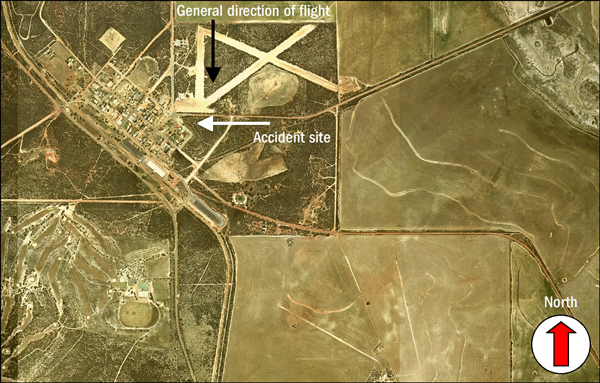
At about 1425 Western Standard Time1 on 22 October 2005, the pilot of an Air Tractor Inc AT-602 (AT-602) aircraft, registered VH-NIT, was fatally injured when his aircraft impacted terrain, approximately 150 m south of the Ballidu airstrip, WA. Figure 1 depicts the township of Ballidu, the airstrip, the approximate flight path of the aircraft and the location of the accident site.

Figure 1: Ballidu townsite, airstrip and accident site2
aair200505236_001.jpg


The pilot had not operated the AT-602 prior to the day of the accident. The series of flights that day were for familiarising the pilot with the aircraft's handling characteristics, and were carried out under the supervision of the company owner/chief pilot.

The chief pilot reported that the aircraft was fully fuelled before the first in the series of flights. That flight had included ground taxying operations, take-offs, landings and general aircraft handling, including simulated spray runs along the strip and practice operating the hopper door. The accident occurred during the second flight of the day.

During those flights, the pilot returned to the operating pad several times, during which the chief pilot asked the pilot how he was progressing and, when necessary, replenished the contents of the hopper. The chief pilot reported that the aircraft was being operated with about 200 L of water in the hopper, which was the minimum quantity to prevent the hopper's seals from drying out. He recalled that he had replenished the hopper several times that day.

A number of witnesses sighted the aircraft flying over the airstrip at low altitude and saw water drop from the underside of the aircraft. The witnesses observed the aircraft gain a small amount of height before the nose of the aircraft suddenly pitched downwards and the aircraft descended steeply towards the ground.

Witnesses

The witnesses that reported either seeing or hearing events associated with different portions of the flight immediately prior to the accident included:

  • Three witnesses that were located at two separate positions, who observed water dropping from the underside of the aircraft and recalled that the nose of the aircraft pitched steeply upwards after completion of that drop, with the aircraft gaining a small amount of height.
  • The chief pilot, who sighted the aircraft climbing out as it flew past his hangar, but recalled that the nose attitude did not appear abnormally high. He did not recall hearing any unusual noises from the aircraft engine or propeller.
  • A witness who sighted the aircraft as it flew abeam her location and recalled that the nose of the aircraft was at a level attitude, before the nose 'dropped'. The sound from the aircraft appeared normal and at a constant level until the witness heard the sound of an impact.
  • A witness who was familiar with dropping operations and was watching the aircraft as it approached the airstrip. From the aircraft's position relative to the airstrip and the location of the runway thresholds, he surmised that the pilot was making a practice water drop. The aircraft disappeared from his view as it descended to what he perceived to be the drop zone before reappearing again, having made what he presumed to be either a water drop or a dummy water drop. The witness recalled that the aircraft was climbing steeply, but that the nose attitude of the aircraft was close to horizontal, before pitching steeply down towards the ground. The witness recalled hearing an unusual noise from the aircraft's engine or propeller as the aircraft started to descend, which he described as being similar to the noise when a pilot reversed the propeller's pitch on landing, or made a significant change to the power setting of the engine.
  • A witness who was adjacent the airstrip and thought that the aircraft's engine sounded as if it was not producing much power as the aircraft started to climb away, when compared to water drops that he witnessed earlier that day.
  • Two residents close to the site of the accident who heard the noise of an aircraft approach and then an increase in engine noise, similar to when a pilot applies power to enter a climb or the noise that the aircraft makes after it lands. A few seconds of silence followed, and the residents recalled thinking that the aircraft must have landed. They then heard the sound of an impact and immediately realised that the aircraft had crashed.

All of the eyewitnesses were consistent in their recollection of the aircraft's final descent towards the ground, recalling that the nose of the aircraft suddenly and violently pitched downwards, and the aircraft descended steeply towards the ground.

Accident site and wreckage examination

The sandy scrub-type terrain in the vicinity of the accident site was flat, with gently upwards sloping terrain on approach to the site. Bushes and small trees, approximately 3 to 5 m high, covered the immediate area and a power line, supported by power poles about 10 m high, ran east to west along a road adjacent the airfield boundary.

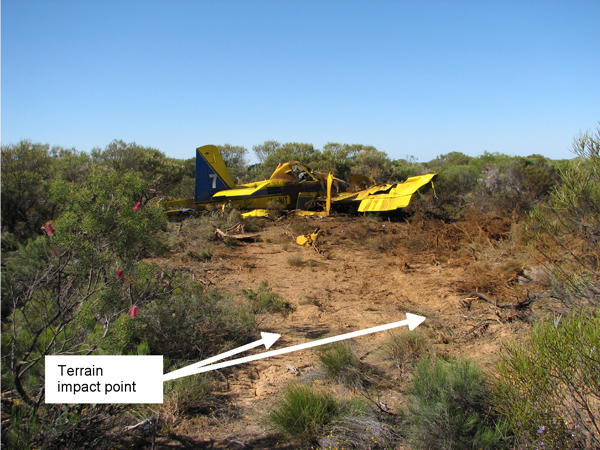
Examination of the wreckage and analysis of impact loads through the structure of the aircraft indicated a slightly right wing low, almost nose-level (zero) pitch attitude on impact with terrain. The characteristics of the impact were consistent with a high rate of vertical descent and low forward speed. Damage to the vegetation in the vicinity of the accident site indicated a steep final flight path towards the ground, with the main wreckage located about 23 m along the wreckage trail from the initial point of impact. Figure 2 shows the initial impact point relative to the main aircraft wreckage.

Figure 2: Terrain impact point and aircraft wreckage
aair200505236_002.jpg

All structural components and flight controls were accounted for at the accident site. The aircraft was intact prior to impact with terrain. The main landing gear collapsed on contact with the ground and the fuel tanks ruptured during the impact sequence. There was evidence that a significant quantity of fuel had spilled from each of the tanks.

There was no evidence of bird strike or collision with other obstacles prior to the initial contact with terrain.

Weather

Witnesses at Ballidu recalled that the weather conditions around the time of the accident were generally fine with light south-westerly winds.

The Bureau of Meteorology reviewed the available weather data for the afternoon of the accident. That review indicated the presence of south-westerly surface winds and little or no cloud in the Ballidu area at the time of the accident.

The closest official meteorological recording station was at Dalwallinu, about 40 NM to the north-west. At the time of the accident, Dalwallinu recorded a south-westerly wind at 8 to 10 kts and a temperature of about 23 degrees C.The Bureau of Meteorology assessed that, under the prevailing conditions, similar weather would have been experienced at Ballidu around the time of the accident.

Aircraft

The AT-602 was manufactured as a single-seat, specialist type aircraft designed for agricultural and fire fighting (water dropping) operations. That aircraft model had been issued an airworthiness certificate by the US Federal Aviation Administration (FAA) as a Restricted Category3 aircraft, for use in special purpose operations. As the airworthiness certificate was issued by a recognised National Airworthiness Authority, that certification was accepted by the Civil Aviation Safety Authority (CASA) for operating that aircraft type on the Australian aircraft register.

The aircraft was manufactured in the US during 2000 and exported to Australia. It was placed on the Australian aircraft register in December of that year. The aircraft was exported from Australia in April 2002 and placed on the aircraft register of New Zealand. In December 2004, the aircraft was re-imported to Australia and placed on the Australian aircraft register as VH-NIT.

An aircraft Maintenance Release was issued on 22 July 2005 following the last period of scheduled maintenance. The maintenance release recorded 58.7 hours operation since that time. During that period, no defects were recorded on the maintenance release. The aircraft had accumulated approximately 1,650 hours since manufacture.

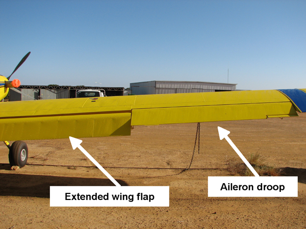
The AT-602 was equipped with an electrically operated Fowler flap system that also incorporated an aileron interconnection, which symmetrically drooped the ailerons as the flaps extended. The motion of the aileron interconnection was non-linear, in that most of the aileron droop occurred during the first 15 degrees of flap extension. Full flap extension for the AT-602 was 30 degrees, with an associated aileron droop of 10 degrees. Figure 3 illustrates the flap extension and aileron droop in an AT-602.

Figure 3: AT-602, showing extended wing flap and aileron droop
aair200505236_003.jpg

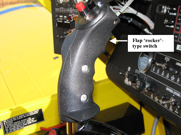
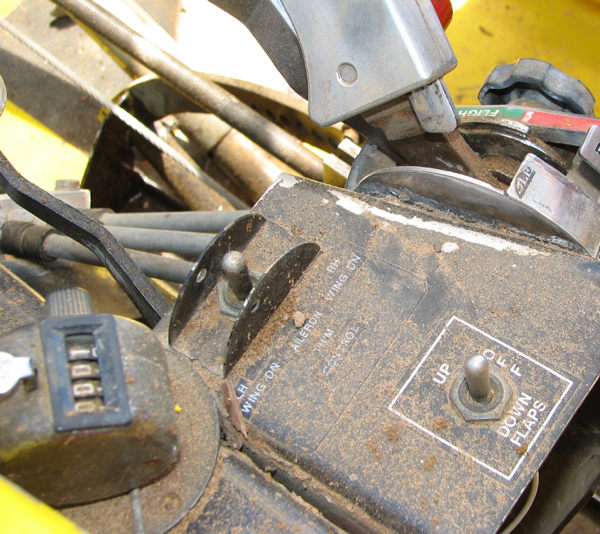
The flaps were actuated by a 'rocker'-type switch4 on the control stick (Figure 4). That switch enabled the pilot to extend the flaps between 0 and 30 degrees. The flaps could also be activated by a control switch mounted adjacent to the engine and propeller control levers on the left side of the cockpit (Figure 5).

Damage to the wing flaps was consistent with their being in an extended position at the time of impact.

Figure 4: Control stick for a similarly-equipped AT-602, showing flap 'rocker' switch
aair200505236_004.jpg

Figure 5: Flap control switch adjacent engine controls
aair200505236_005.jpg

The aircraft was configured for water dropping operations and was equipped with a 630 US Gallon capacity fibreglass hopper (2,385 L). A manually-controlled fire-bomber dump door was fitted to the base of the hopper. Activation of the cockpit drop handle opened the dump door and allowed the hopper contents to drop from the aircraft.

The aircraft manufacturer's FAA-approved Airplane Flight Manual (AFM) recommended using 10 degrees of flap and an airspeed of 109 kts on approach and load release during water dropping operations.

The AFM indicated a wings-level stall speed for the AT-602 at an operating weight of 4,173 kg of 76 kts CAS5 (flaps up) and 61 kts CAS (flaps down). The AFM indicated that the maximum altitude loss from a wings-level stall was 300 ft.

At the time of the accident the aircraft's operating weight was estimated to be approximately 3,500 kg.

Engine

The aircraft was equipped with a Pratt and Whitney Canada PT6A-60AG (PT6A) turboprop engine.

The logbooks and maintenance records indicated that the engine had accumulated approximately 1,650 hours since new.

The engine was shipped to the engine manufacturer for disassembly and examination under the direct supervision of the Canadian Transportation Safety Board. The final report from that examination was not available at the time this interim report was written.

Pilot details

The pilot held a Commercial Pilot (Aeroplane) Licence and a Grade 1 Agricultural Rating, and had previously performed water dropping operations in the operator's reciprocating-engine aircraft. A review of the pilot's logbook indicated approximately 6,736 hours total aeronautical experience, including about 400 hours water dropping operations in the reciprocating-engine PZL "Dromader" D-18 aircraft.

Civil Aviation Regulation 5.22 enables CASA to prescribe the aircraft endorsements that must be held by the holder of a flight crew licence. Civil Aviation Order 40.1.0 requires the holder of a flight crew licence to hold an endorsement to operate certain types of aeroplane and provides for aircraft with similar design features to be grouped into aircraft classes.

The pilot recently completed training for, and was issued with a class endorsement on Ayres Turbo (PT6)-type aircraft. The Ayres Turbo (PT6) aeroplane class endorsement includes the Ayres S2R "Thrush" and Air Tractor AT (400, 401, 402, 502, 602 and 802) aircraft types equipped with a PT6A turbine engine.

Protective equipment/survivability

The pilot was not wearing a protective helmet.

The aircraft was fitted with a metal frame seat with a mesh-fabric seat cover and a four-point restraint harness. Vertical impact forces distorted the base of the seat frame.

Testing and examination of recovered components

The jackscrew for the flap actuator was found along the wreckage trail and had separated from the aircraft during the impact sequence. The jackscrew remained attached to the actuator gearbox, but had fractured in the vicinity of the ACME-threaded nut assembly connecting the jackscrew to the flap actuator arm. The jackscrew and ACME-threaded nut were submitted for technical examination.

Laboratory examination of those components revealed a bending overload failure as a consequence of impact forces. The extension of the jackscrew was consistent with the wing flaps being fully extended at the time of the impact with terrain.

The aircraft was equipped with a cockpit instrument that monitored the quantity of fuel consumed by the aircraft's engine. That instrument contained a non-volatile memory and so was recovered from the aircraft for subsequent examination. That examination revealed a total fuel consumption of 227 L and a quantity of 772 L remaining.

An elevator pushrod had fractured at the eye-end bearing fitting and was recovered from the accident site for analysis. Examination of that component did not reveal any evidence of a pre-existing material anomaly. The fracture surface exhibited characteristics consistent with gross structural overload and component failure during the accident sequence.

A number of cockpit instruments were recovered for laboratory analysis. Examination of the instrument face from the airspeed indicator revealed witness marks from the instrument's indicator needle. Those marks indicated that, at the time the indicator needle contacted the face of the instrument, the needle was indicating between 45 and 55 knots.

Other instruments that were recovered for subsequent laboratory examination included the: engine Ng (gas-generator speed), oil temperature and pressure gauges; and propeller RPM and engine torque gauges. No witness marks were evident on those instruments.

Indicator globes from the aircraft's annunciator panel were recovered and analysed for evidence of any filament stretch that could indicate the illumination of the lights at the time of ground impact. The following indicator globes were examined:

  • Propeller beta - illuminates when propeller blade angle is in the "beta" range6.
  • Fuel filter - illuminates when the fuel filter is partially blocked.
  • Low fuel quantity - illuminates in a low fuel condition.
  • Air filter - illuminates to indicate restricted airflow to the engine's air inlet.
  • Chip detector - indicates metal particles in contact with detector terminals and the possibility of other metal particles in the engine lubricating oil. A brittle fracture was observed in that filament.

There was no evidence in any of the examined indicator globes of filament stretch, or illumination of any of the associated indicator lights at the time of the aircraft's impact with the ground.

The aircraft was equipped with an emergency locator transmitter (ELT), which separated from its mounting bracket during the impact sequence. Although the ELT was armed, it did not automatically activate.
The ELT activated normally when tested after the accident.

Fuel sample testing

A sample of fuel was recovered from one of the ruptured fuel tanks. Testing of that sample indicated a blend of diesel and aviation turbine fuel. Particulate matter within the fuel sample was consistent with contamination of the fuel with bacterial organisms.

Propeller examination

The engine was equipped with a five-bladed Hartzell Propeller Inc., HC-B5MP-3C constant speed propeller that was fully feathering and reversible in pitch.

The propeller was recovered from the accident site and examined under the direct supervision of investigators from the Australian Transport Safety Bureau (ATSB). When reconstructed as a set, all of the propeller blades showed a progressive and marked increase in axial twist and rearward, out-of-plane bending around the sequence of rotation. That damage indicated a steep angle of impact with terrain (ie low horizontal speed, high vertical speed) and a rapid cessation of rotation.

The pitch change mechanism for the propeller blades was damaged during the accident sequence and each of the blades showed evidence of moving independently during the terrain impact sequence. Witness marks on the hub of the propeller blades indicated blade rotation beyond the assembly limit of -11 degrees.

There was no evidence to indicate that the propeller was operating in the beta or reverse blade angle range at the time of the collision with terrain.

Ongoing investigation

The investigation is continuing, including in the following areas:

  • assessment of engine operation at the time of the accident, pending the results of the examination/testing performed under the supervision of investigators from Canadian Transportation Safety Board
  • examination of survivability issues associated with the accident
  • the assessment of aircraft handling characteristics and operational factors associated with the accident flight, including the aircraft's configuration immediately prior to the loss of control.
  1. The 24-hour clock is used in this report to describe the local time of day, Western Standard Time (WST), as particular events occurred. Western Standard Time was Coordinated Universal Time (UTC) + 8 hours.
  2. Aerial photograph reproduced by permission of the Department of Land Information, Perth, Western Australia, Copyright Licence 33/2006 www.dli.wa.gov.au
  3. The Restricted Category certification was on the basis of airworthiness complying with US Federal Aviation Regulation 23, excluding those sections deemed inappropriate for the special purpose use of agricultural spraying, dusting and seeding and for the special purpose use of forest and wildlife conservation (fire fighting).
  4. That switch was installed subsequent to the manufacture of the aircraft and following the aircraft's initial importation to Australia, in accordance with Engineering Order ADG-AT602-EO2125.
  5. CAS is calibrated airspeed and is the indicated airspeed corrected for instrument and position errors. At those speeds, the AFM indicated that the calibrated airspeed is within about 1 knot of the indicated airspeed.
  6. Beta refers to operation of the propeller blade at fine blade angles, during which the propeller blade angle (and consequently thrust) is directly controlled by movement of the power lever. In this operating range, the propeller does not operate at a constant speed and propeller blade angle is coordinated with fuel flow, according to the power lever position. The beta operating range extends from just below flight idle on the power lever, through ground idle and reverse.

Summary

At about 1425 Western Standard Time on 22 October 2005, an Air Tractor AT-602 aircraft, registered VH-NIT, impacted terrain approximately 100 metres south of the perimeter fence of Ballidu aerodrome, WA. The pilot was carrying out a series of familiarisation flights. He was the sole occupant of the aircraft and was fatally injured.

Witnesses recalled that the aircraft had dropped a quantity of water at low level over the aerodrome. Soon after that drop, the nose of the aircraft pitched steeply towards the ground and the aircraft descended into terrain.

The aircraft impacted terrain in a slightly right wing-low, almost nose-level attitude at a high vertical rate of descent, but with low forward speed.

Examination of the wreckage did not identify any anomaly that could have affected the normal operation of the aircraft during the accident flight. Examination of the engine indicated that it was producing power at the time of terrain impact.

Toxicology testing revealed that the pilot had ingested cannabis. Specialist medical advice was that the results of the toxicology testing would be consistent with the pilot using cannabis sometime during the 24 hours prior to the accident.

The physical and witness evidence was consistent with the pilot losing control of the aircraft at low altitude, most probably as the result of an inadvertent aerodynamic stall. There was insufficient altitude to recover the aircraft to level flight.

Occurrence summary

Investigation number 200505236
Occurrence date 22/10/2005
Location Ballidu
State Western Australia
Report release date 03/08/2007
Report status Final
Investigation type Occurrence Investigation
Investigation status Completed
Mode of transport Aviation
Aviation occurrence category Collision with terrain
Occurrence class Accident
Highest injury level Fatal

Aircraft details

Manufacturer Air Tractor Inc
Model AT602
Registration VH-NIT
Serial number 602-0585
Sector Turboprop
Operation type Aerial Work
Departure point Ballidu, WA
Destination Ballidu, WA
Damage Destroyed

Robinson R22 Beta, VH-HUZ, Calindary Station, New South Wales, on 6 October 2005

Significant Factors

  1. The pilot undertook a flight for which he was not qualified, and for which the helicopter was not equipped.
  2. The helicopter was flown at about 30 ft above the ground in dark night conditions.
  3. The pilot became disorientated at a height from which recovery was not possible before the helicopter impacted the ground.

Analysis

The overriding survivor, witness and physical evidence was that the helicopter's engine was operating normally up to and including at the time of ground impact. On that basis, the investigation concluded that the performance of the engine had not contributed to the development of the occurrence.

Application of the requirements of the Aeronautical Information Publication (AIP) to the time of last light at Yalda Downs meant that a pilot in command who did not hold a night Visual Flight Rules (VFR) rating should have planned to arrive at Yalda Downs no later than 1816. In addition, the reported thin layer of cloud in this instance suggested that the planned arrival time should probably have been adjusted to earlier than 1816. The reported time of departure from Border Downs of 1800, and normal time interval for the planned flight to Yalda Downs of 1 hour 15 minutes, meant that the occurrence pilot attempted a flight for which:

  • he was not qualified
  • the equipment standard of the helicopter was not adequate.

Each increased the likelihood, and therefore risk that the pilot might become disoriented in the dark night conditions, resulting in a situation from which he was unable to recover.

The content of the approved flight manual (AFM) meant that the pilot ought to have been aware of the risk of his becoming disoriented when operating the helicopter in dark night conditions. The reported operation of the helicopter at about 30 ft above ground level minimised the time available for the pilot to recover from any disorientation before impacting the ground. In addition, it was likely that the climbing right U-turn eroded the already marginal outside references that the pilot may have gained as a result of identifying the lights and road as he passed north abeam Calindary. As indicated to pilots in the Safety Notices in the AFM, the likely result was that the impact with the ground was almost inevitable.

The action of the pilot to request successive property owners along the planned route to illuminate their homesteads' external lighting could have been interpreted to have had the secondary benefit of acting as a replacement for the flight notification requirements for flight through a Designated Remote Area. However, that was not an approved means of providing flight notification, and was based on the assumption that each of those property owners would be at home and respond to the pilot's radio transmissions.

That lack of a formal flight notification, and the apparent omission by the pilot to carry an Emergency Locator Transmitter meant that, had the accident not been observed by the witnesses at Calindary, the subsequent search and rescue effort could have been delayed. Any delay in locating the survivor had the potential to have:

  • adversely affected the survivor's subsequent recovery from his injuries
  • significantly complicated the survivor's injuries
  • diminished the survivor's chances of survival.

Factual Information

At about 1800 Central Standard Time on 6 October 2005, a Robinson Helicopter Company model R22 Beta helicopter (R22), registered VH-HUZ, departed Border Downs, NSW on a private flight to the pilot's property at Yalda Downs, NSW with the pilot and one passenger on board. The helicopter subsequently crashed near a homestead at Calindary Station (Calindary), fatally injuring the pilot and seriously injuring the passenger.

A hearing witness1 at Border Downs who was also a pilot and endorsed to fly the R22, had previously flown the occurrence helicopter. He reported that the helicopter 'sounded completely normal' during the take-off and departure from Border Downs. He indicated that the normal time interval for the flight to Yalda Downs was about 1 hour 15 minutes.

Witnesses at a number of properties along the route flown by the pilot reported that, as the flight progressed, the pilot requested by radio for each of them to illuminate their external homestead lights. The reason given by the pilot for those requests included, earlier in the flight, for the pilot to 'get his bearings' and, as the helicopter approached Calindary, to assist the pilot to identify two sets of power lines that crossed the main west to east road about 1 and 3 kms west of the property respectively. In response to the pilot's request, the property owners at Calindary reported that they parked their vehicle on top of a sand embankment that was about 100 m south of the main road. The vehicle's spotlights, and a third hand-held spotlight, were illuminated in the direction of the helicopter's anticipated approach.

The pilot advised the property owners by radio that he had sighted their spotlights. The property owners reported that they suggested to the pilot that he should land at Calindary and use one of their vehicles to return to Yalda Downs by road. The pilot declined that suggestion and indicated that, after picking up the road from Calindary to Yalda Downs, he would continue with the flight. The property owner estimated that the helicopter was below 30 ft above ground level (AGL) at that time, and described the helicopter's 'powerful white lights' as being visible 'down amongst the trees'. The survivor indicated that the pilot manoeuvred the helicopter in order for the helicopter's landing lights to criss-cross the road.

One of the witnesses at Calindary, with extensive experience flying aeroplanes, stated that there was nothing abnormal about the sound of the helicopter or its engine as it passed the vehicle's position, or immediately prior to the ground impact.

The survivor stated that, shortly after passing Calindary, the road appeared to merge with the surrounding bush and the pilot turned the helicopter to visually reacquire the road. The property owners at Calindary reported that the helicopter commenced a climbing right U-turn, before returning in a westerly direction and descending at an estimated angle to the horizon of 20 to 30 degrees. The survivor indicated that, during the turn and until the impact with the ground:

  • he heard no abnormal noises from the helicopter
  • he did not observe the illumination of any warning lights in the cockpit
  • there was no apparent apprehension or degree of panic displayed by the pilot.

At about 1921, the helicopter impacted a sand hill a number of times and was destroyed by the impact forces and post-impact fire.

The pilot held a private pilot (helicopter) licence, was endorsed to fly the R22 and was reported to have about 9,000 hours flying experience. The pilot did not hold a night Visual Flight Rules (VFR) rating. The requirements of Civil Aviation Regulation (CAR) 174C(1) included that the pilot was required to have held that rating in order to conduct a flight at night under the VFR.

The pilot last undertook a medical examination in order to renew his Class 2 Medical Certificate in January 2002. There was no evidence that:

  • the pilot finalised the administrative requirements for the renewal of that certificate
  • the pilot held a valid Class 2 Medical Certificate at the time of the occurrence
  • the Civil Aviation Safety Authority (CASA) had given the pilot permission to continue flying without a current medical certificate.

CAR 5.04(1) required that:

Without the permission of CASA, the holder of a flight crew license must not perform a duty authorised by the license if the person does not hold a current medical certificate that is appropriate to the license.

That meant that on the day of the accident, the pilot should not have been performing the duties that were authorised by his license.

The helicopter was first registered in Australia on 3 May 2005 and was reported to have flown about 130 to 140 hours since its delivery flight to Yalda Downs on 1 August 2005. An examination of the helicopter's maintenance records found that the helicopter was certified for day VFR flight and equipped and maintained in accordance with existing regulations and approved procedures. The helicopter was not equipped for flight under the night VFR, nor was it installed with an Emergency Locator Transmitter (ELT)2.

The helicopter's weight and centre of gravity were estimated to have been within the prescribed limits at the time of the occurrence.

It was reported that the pilot would have refuelled the helicopter to capacity from the aviation gasoline fuel source at Yalda Downs prior to departing for Border Downs earlier that day. A witness at Border Downs indicated that the pilot did not refuel the helicopter at that location. It was estimated that at the time of the accident, about 24 L of fuel remained on board the helicopter. That would have been sufficient for the remainder of the planned flight to Yalda Downs.

A Bureau of Meteorology (BoM) examination of the forecast weather and meteorological observations from the Tibooburra Automatic Weather Station3 indicated that there was no significant weather, no low-level cloud, and no reduction in visibility in the region of Tibooburra at the time of the occurrence. The investigation determined that the times of sunset, and of the end of civil twilight for the relevant locations along the planned west to east route included:

LocationSunsetEnd of Civil Twilight
Border Downs18101834
Calindary18041828
Yalda Downs18021826

The pilot was reported to have accessed a private weather source via the internet prior to the departure from Border Downs. The available information from that source included the observed surface wind for a number of locations in the general vicinity of the flight and the weather forecast and times of sunrise and sunset for Broken Hill. Sunset for Broken Hill on the day of the occurrence was published by that source as 1809.

A witness at Border Downs reported the weather as being 'good', with a wind of about 10 to 15 kts from the west-south-west, and a cloud base of above 1,500 ft AGL. The weather at the accident site at the time of the accident was reported by witnesses to include: a light north-westerly wind; a 50% overcast layer of thin cloud, with a high base; good visibility; and no horizon. Witnesses reported that it was 'pretty dark, as in black'.

Examination of the NSW Police and other photographic evidence indicated a low angle of impact with the sand hill at a relatively high speed, which compromised the integrity of the helicopter's cockpit area. That was consistent with the reported 85 m wreckage trail and witness reports of the helicopter's approach towards the ground.

The damage to the helicopter's landing skids and engine mount frame was consistent with a slightly nose-down, right angle of bank at ground impact. One of the main rotor blades separated from the main rotor head at its hinge bolt attachment point, consistent with static overload as a result of the blade's impact with the ground. The damage to that main rotor blade confirmed that the main rotor was rotating at that time. The tail boom appeared to have failed in overload and separated from the main wreckage following the initial impact with the ground. The relatively minor torsional shear indications evident on the tail rotor driveshaft, and the nature of the damage to the tail rotor blades, indicated that the tail rotor had ceased rotating prior to its impact with the ground.

Based on the available information, there was no evidence that material failure or component malfunction had contributed to the development of the occurrence.

At the time of writing this report, the pilot's post mortem report was not available to the investigation team.

There was no report by the witnesses to the occurrence of an in-flight fire. The source of the post-impact fire was from fuel that had spilled from the ruptured helicopter fuel tanks. The ignition source of the fire could not be confirmed, but was most likely from the hot engine exhaust.

CAR 252A specified that a pilot in command of an aircraft that was not an exempted aircraft4 may only begin a flight if the aircraft either:

  • was fitted with an approved and functioning ELT, or
  • carried an approved and readily accessible portable ELT that was in working order.

The helicopter was not an exempted aircraft and it was reported that the pilot normally carried a portable ELT during flight. The survivor indicated that he had not observed a portable ELT in the helicopter prior to or during the occurrence flight, and the item was not identified by the NSW Police amongst the wreckage of the helicopter, or at the site of the accident. AusSAR5 reported that an emergency signal was not identified at or about the time of the accident.

The flight was within the central Australian mainland component of the Designated Remote Area that was promulgated in Appendix III to Civil Aviation Order 20.11. That required the carriage of sufficient survival equipment for sustaining life appropriate to the area being overflown, and either the submission of a SARTIME6 flight notification to Air Traffic Services (ATS) or for a pilot in command to leave a flight note with a responsible person. It was reported that the pilot and passenger carried sufficient clothing in case the decision was made to remain overnight at Border Downs. ATS records indicated that a SARTIME was not submitted to that agency, and a flight note was not left at either Border Downs or Yalda Downs for the occurrence flight. Witnesses at Yalda Downs indicated that the first confirmation that the pilot intended to return that night was via a radio call from the pilot at about 1900 to 1915, indicating that '[he] would be late [arriving at Yalda Downs]'.

The Aeronautical Information Publication (AIP) requires that:

Unless the pilot in command holds a Command Instrument Rating or night VFR (NGT VFR) rating and the aircraft is appropriately equipped for flight at night, a VFR flight must not depart from an aerodrome:

  1. before first light or after last light; and
  2. unless the ETA [Estimated Time of Arrival] is at least 10 minutes before last light after allowing for any required holding.

Last light was interpreted by the AIP to equate to the end of civil twilight 7. In addition, the AIP alerted pilots to the potential for the presence of cloud cover to the west of an aerodrome, and a number of other variables to adversely affect a flight arriving at its destination near the end of daylight. Sunset was highlighted as 'having no relevance when calculating daylight operating times for the VFR pilot.'

The AIP also placed altitude restrictions on the operation of an aircraft under the night VFR. That included that a pilot should not operate an aircraft under those rules at a height lower than the published lowest safe altitude (LSALT) for the route, or a height that was calculated in accordance with the requirements of the AIP, except under certain prescribed circumstances. Depending on the calculation methodology applied by a pilot, the LSALT for the route Border Downs to Yalda Downs was at least 2,020 ft above mean sea level (equivalent to about 1,500 ft AGL at Calindary).

The Approved Flight Manual for the helicopter included a number of Safety Notices that were relevant to the operation of the helicopter at night. Those notices included that:

  • Flying a helicopter in obscured visibility due to fog, snow, low ceiling, or even dark night can be fatal.
  • Loss of the pilot's outside visual references, even for a moment, can result in disorientation, wrong control inputs, and an uncontrolled crash.
  • …[the pilot] loses control of the helicopter when he attempts to turn to regain visibility but is unable to complete the turn without visual references.
  • [pilots should] be sure you NEVER fly at night unless you have clear weather with unlimited or very high ceilings and plenty of celestial or ground lights for reference.
  1. A witness who heard, but did not observe the takeoff.
  2. Crash-activated radio beacon that transmits an emergency signal that includes the position of a crashed aircraft.
  3. The closest station to the site of the accident, being about 49 NM north-north-west of that location.
  4. Exempted aircraft means high capacity regular public transport or charter aircraft, single seat or turbo-jet powered aircraft, or balloons, airships or gliders.
  5. Australian Search and Rescue - in general terms, AusSAR coordinates the response to aviation SAR incidents across Australia.
  6. The time nominated by a pilot for the initiation of Search and Rescue action if a report has not been received by the nominated unit.
  7. Period at sunset when the sun's centre is between 0°50' and 6° below the horizon.

Summary

The helicopter with the pilot and one passenger onboard, was returning to Yalda Downs Station from Border Downs Station after last light. As it overflew Calindary Station homestead, which is approximately 46 km west of the intended destination, the helicopter was observed to gain height and conduct a right turn. The helicopter then descended and impacted the ground about 500 m from the homestead. The helicopter was destroyed by impact forces and the post-impact fire. The pilot was fatally injured and the passenger sustained critical injuries.

Occurrence summary

Investigation number 200504925
Occurrence date 06/10/2005
Location Calindary Station
State New South Wales
Report release date 29/03/2006
Report status Final
Investigation type Occurrence Investigation
Investigation status Completed
Mode of transport Aviation
Aviation occurrence category Collision with terrain
Occurrence class Accident
Highest injury level Fatal

Aircraft details

Manufacturer Robinson Helicopter Co
Model R22
Registration VH-HUZ
Serial number 3817
Sector Helicopter
Operation type Private
Departure point Border Downs, NSW
Destination Yalda Downs, NSW
Damage Destroyed

Impact with terrain, Beech Aircraft Bonanza, VH-BKM, 35 km east of Tenterfield, New South Wales, on 24 September 2005

Significant Factors

The accident is consistent with the pilot becoming incapacitated, the aircraft departing controlled flight and subsequently impacting terrain. The possible nature of, or reasons for, any incapacitation could not be determined by the investigation.

Analysis

Examination of the aircraft wreckage and accident site indicated that the aircraft impacted terrain at a steep angle and at high speed. In addition, the investigation concluded that the engine was producing power at the time of the accident.

The recorded Air Traffic Services (ATS) radar data indicated that the autopilot was engaged prior to the aircraft entering a steep left descending turn. The abruptness of the turn and the high rate of descent indicated that the autopilot was no longer controlling the aircraft. The autopilot could be disconnected by either pressing the electric trim switch or manually overriding the controls. The pilot was familiar with the route being flown and would be unlikely to have deliberately diverted from the intended flightpath. There was no significant weather in the area at the time of the accident, so the pilot would not have had to alter his heading to maintain visual flight.

If the pilot had deliberately disconnected the autopilot and manoeuvred the aircraft, the resultant flight path would probably not have been as abrupt as the recorded ATS radar data indicated. Therefore, the autopilot was probably disconnected by the pilot making an unintentional control input.

The investigation was unable to determine the reason for the sudden control input, but the circumstances are consistent with pilot incapacitation. The pilot was the only occupant of the aircraft who could manipulate the controls with the autopilot disconnected. The passenger, due to the usual seating arrangements, would have been unable to render assistance to the pilot, or assumed control of the aircraft, prior to the accident, if the pilot had become incapacitated.

Factual Information

History of the flight

At about 0855 Eastern Standard Time1 on 24 September 2005, a Raytheon Aircraft Company Beechcraft A-36 Bonanza, registered VH-BKM, took off from Murwillumbah, NSW, on a private flight to Coonabarabran, NSW, with one passenger, who was the pilot's wife, under the visual flight rules. The pilot had not submitted a flight plan or nominated a SARTIME2 and there was no requirement to do so. The pilot and passenger regularly flew return flights from Coonabarabran to Murwillumbah in this aircraft.

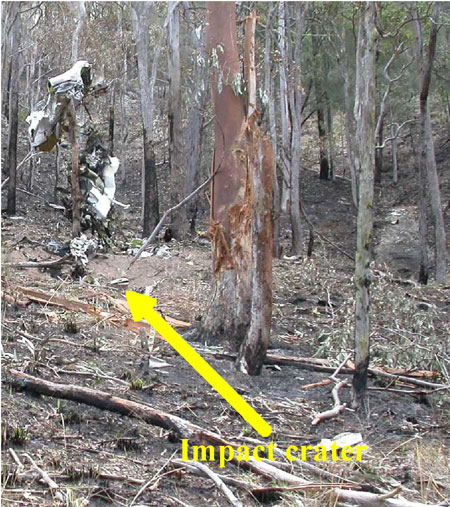
The aircraft was subsequently reported to be missing on 28 September 2005, and a search was commenced. The wreckage of the aircraft was located on 29 September 2005. The aircraft had impacted a heavily timbered hill on a private property 'Millera', located approximately 35 km east of Tenterfield. The aircraft had been destroyed by impact forces and a post-impact fire (Figure 1), and both occupants were fatally injured.

Figure 1: View of impact crater looking north-west

aair200504847_001.jpg

Operational Information

The pilot was 71 years old and held both commercial and private pilot licences for aeroplanes and had a valid Class 2 medical certificate. He held a pilot's licence for over 50 years and had previously owned and operated an aerial agricultural business. He had a total aeronautical experience of approximately 13,000 flying hours.

The aircraft had been owned and operated by the pilot for the previous 14 years. Maintenance records indicated that the aircraft had a valid maintenance release which was issued on 27 January 2005 and was valid for 12 months. The aircraft maintenance release was unable to be located in the wreckage, however the estimated total time in service of the aircraft at the time of the accident was 3,231 hours. The engine had been rebuilt and fitted to the aircraft in April 1992.

The aircraft was fitted with a two-axis autopilot which included separate roll and pitch engagement, altitude hold and automatic and manual electronic pitch-trim. The autopilot could be disconnected by pressing down on an electric pitch-trim switch on the control wheel, or by manually overriding the controls. The aircraft was fitted with a single control wheel.

Prior to the flight to Murwillumbah the aircraft was refuelled at Coonabarabran, from a fuel bowser owned by the pilot. Witnesses reported that the aircraft had been refuelled to its maximum capacity. Fuel records for the fuel supplied to the bowser indicated that the fuel sample in the supply truck was clear and free of sediment. The local aero club had been supplied with 400 L of fuel from the pilot's bowser and had not reported any problems with the fuel.

Performance calculations were used to estimate the fuel burn from Coonabarabran to Murwillumbah and from Murwillumbah to the accident site. These calculations indicated that approximately 140 L of fuel would have been on-board the aircraft at the time of the accident. Discolouration of tree foliage at the accident site and the extent of the post-impact fire confirmed that there was fuel in the aircraft when the accident occurred. Weight and balance calculations showed that the aircraft was within centre of gravity limits for the final flight.

Information provided by the Bureau of Meteorology indicated that a low-pressure trough was present to the west of Tenterfield on the morning of the accident. The weather forecast and actual observations indicated that the flight was conducted under visual meteorological conditions. Witnesses reported clear weather in the vicinity of the accident site.

The pilot had not submitted a flight plan for the flight or contacted air traffic control for an area QNH3 and was not required to do so. The recorded Air Traffic Services (ATS) radar data indicated that the aircraft was operating on a transponder code of 12004.

A review of recorded radar data indicated that the aircraft had been maintaining a stable heading and altitude for most of the flight, which was consistent with the autopilot having been engaged.

The aircraft had then descended from a cruising altitude of about 6,300 ft above mean sea level (AMSL) to a final recorded altitude of about 3,800 ft AMSL at a rate of approximately 5,000 ft/ min. The accident occurred at an approximate elevation of 1,000 ft AMSL.

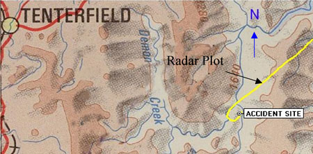
The recorded radar data of the aircraft's flight path was superimposed on a topographical chart that indicated that the aircraft had made a sudden left turn over the area of the accident site (Figure 2).

Figure 2: Radar plot of final segment of flight

aair200504847_002.jpg

There were no recorded radio transmissions from the aircraft prior to departure from Murwillumbah, or during the flight. The aircraft was fitted with a fixed emergency locator transmitter; however, it was destroyed at impact and was not capable of transmitting a distress signal.

Wreckage and impact information

The aircraft wreckage was fragmented and damage to the aircraft structure was consistent with a high-speed impact. There was no evidence of an in-flight breakup, birdstrike or in-flight fire prior to the accident and a technical examination of the engine and propeller indicated that they were producing power at the time of the accident.

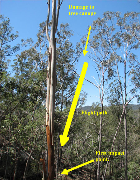
Ground contact marks indicated that the aircraft impacted the ground in a left wing-low, nose-down attitude. Damage to the tree canopy in the vicinity of the impact crater indicated an impact angle of 72 degrees to the horizontal (Figure 3). The aircraft's direction of flight at the time of the accident was estimated to be 290 degrees Magnetic.

Figure 3: Tree canopy damage

aair200504847_003.jpg

Post-mortem medical examination was unable to determine if the pilot had experienced any incapacitation prior to the accident. The pilot's medical records indicated that he was taking regular medication to control blood pressure and that he recently had undergone a minor surgical procedure to remove skin cancers but there was no evidence that either had a bearing on the accident.

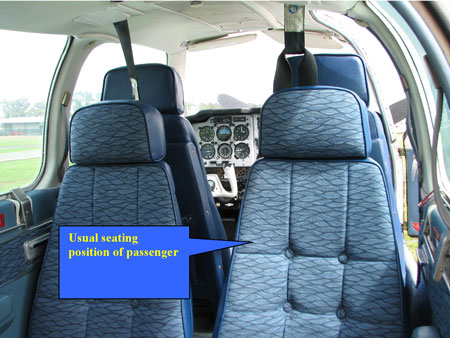
Witnesses reported that the passenger normally travelled in the second row of seats, which faced rearwards. The passenger would occupy the seat diagonally across from the pilot (Figure 4) and only communicate with the pilot occasionally during a flight. There was no evidence of the passenger having any aeronautical experience.

Figure 4: Seating configuration of aircraft

aair200504847_004.jpg
  1. The 24-hour clock is used in this report to describe the local time of day, Eastern Standard Time (EST), as particular events occurred. Eastern Standard Time was Coordinated Universal Time (UTC) + 10 hours.
  2. The time nominated by a pilot for the initiation of search and rescue action if a report has not been received by the nominated time.
  3. QNH is the altimeter subscale barometric pressure setting to provide altimeter indication of altitude relative to mean sea level. Area QNH is representative of the QNH of any location within a particular area.
  4. A transponder is a receiver/transmitter which will generate a reply signal upon proper interrogation of an air traffic control radar signal.

Summary

On the morning of 24 September 2005, a Raytheon Aircraft Company Beechcraft A-36 Bonanza, registered VH-BKM, was being flown by the owner pilot on a private flight from Murwillumbah, NSW, to Coonabarabran, NSW, with one passenger. The pilot had not submitted a flight plan or nominated a SARTIME and there was no requirement to do so.

The aircraft was reported to be missing on 28 September 2005, and a search was then commenced. The wreckage of the aircraft was located on 29 September 2005. The aircraft had impacted a heavily timbered hill on a private property 'Millera', located approximately 35 km east of Tenterfield. The aircraft had been destroyed by impact forces and a post-impact fire and both occupants were fatally injured. Witnesses reported clear weather in the vicinity of the accident site.

The recorded radar data indicated that the aircraft was maintaining a stable heading and altitude which was consistent with the autopilot having been engaged. The aircraft then descended from a cruising altitude of 6,500 ft above mean sea level (AMSL) to a final recorded altitude of 3,800 ft AMSL, at a rate of approximately 5000 ft/min.

The pilot was 71 years old and held both commercial and private pilot licenses for aeroplanes with a valid Class 2 medical. The maintenance records indicated that the aircraft had a valid maintenance release which was issued on 27 January 2005.

Weight and balance calculations showed that the aircraft was within centre of gravity limits for the final flight.  Discolouration of tree foliage at the accident site and the extent of the post-impact fire indicated that fuel was present when the accident occurred.

The accident is consistent with the pilot becoming incapacitated, the aircraft departing controlled flight and subsequently impacting terrain. The possible reasons for any incapacitation could not be determined.

Occurrence summary

Investigation number 200504847
Occurrence date 24/09/2005
Location 35km E Tenterfield
State New South Wales
Report release date 09/08/2006
Report status Final
Investigation type Occurrence Investigation
Investigation status Completed
Mode of transport Aviation
Aviation occurrence category Collision with terrain
Occurrence class Accident
Highest injury level Fatal

Aircraft details

Manufacturer Beech Aircraft Corp
Model 36
Registration VH-BKM
Serial number E-560
Sector Piston
Operation type Private
Departure point Murwillumbah, NSW
Destination Coonabarabran, NSW
Damage Destroyed

Champion Aircraft Corp 7GCAA, VH-TUF

Significant Factors

The pilot performed a manoeuvre that resulted in a loss of control at a height and speed that was insufficient to permit recovery before the aircraft hit the ground.

Analysis

The pilot was reported to have conducted a similar low-level manoeuvre to that which preceded the accident on several previous occasions. On that basis, the investigation team considered that it was unlikely that the passenger was at the controls of the aircraft at the time of the accident. The manoeuvre left little or no margin for error and required sound judgement and skill. Although the pilot may have possessed those skills, no evidence was found of his ever having undertaken the appropriate check to assess those skills and obtain approval to conduct low-level aerobatic manoeuvres.

Repetition of the manoeuvre over a period of time may have led to the pilot gaining a false sense of security and may have led to the pilot becoming complacent about the inherent dangers involved with such manoeuvres. The manoeuvre performed by the pilot earlier that day at another location was commenced from a 'high-speed' flypast. The associated energy would have allowed the aircraft to convert speed to height and climb higher and attain a greater altitude for recovery than the manoeuvre performed during the accident flight. That manoeuvre was commenced from a take-off roll that did not use the full runway length available. When combined with a tailwind component, it was unlikely that the aircraft attained adequate airspeed to safely complete the intended manoeuvre by the end of the strip. It was also possible that the pilot was unaware of the windshear or had not considered its affect on the aircraft's climb performance.

Although the aircraft appeared to have stopped spinning to the right just before impact, the pilot had insufficient height to avoid a collision with the ground. Had the stall warning been operating, it could have provided the pilot with an earlier indication of the stall condition and thus enabled him to initiate a recovery earlier in the development of the manoeuvre.

The affect of the pilot's medical condition on his judgement or decision-making could not be determined. However, some aspects of the pilot's behaviour were not consistent with compliance with rules and regulations or good airmanship. These included conducting low-level aerobatics without approval, ignoring concerns expressed by peers, operating with an unserviceable stall warning indicator and ignoring weight and balance limitations. Furthermore, the pilot flew the aircraft knowing that he was suffering from a medical condition that was being reviewed by the Civil Aviation Safety Authority (CASA) and having been advised by CASA that he was not to fly until the results of the review were known. Disregard for the rules governing the conduct of flight and the operation of the aircraft removed safety defences that were established to prevent this type of accident.

Factual Information

FACTUAL INFORMATION1

Sequence of events

On 15 May 2005 at 1535 Central Standard Time, an American Champion Corporation Citabria 7GCAA aircraft, registered VH-TUF (TUF), took off on a local flight from a private airstrip at Stonefield, SA. On board were the pilot and a passenger, who was also a licensed pilot. Dual controls were installed in the aircraft. The aircraft was observed by witnesses at the airfield to pull up into a steep climb after becoming airborne, before apparently stalling and impacting the ground. Both occupants were fatally injured. The aircraft was destroyed by impact forces and a post-impact fire (see Figure 1).

Figure 1: View of the wreckage looking west

aair200502116_002.jpg

The pilot had been at the Stonefield airstrip during the weekend with other pilots and aviation enthusiasts. On the morning of the accident, the pilot had conducted a short flight in TUF, which included a flypast at a nearby airstrip that was witnessed by two experienced commercial pilots. They described observing the aircraft flying at 'high speed', approximately 20 ft above ground level (AGL) over a taxiway, before pulling up into a vertical climb. The pilot then performed a stall turn and the aircraft was observed to enter a spin or spiral before recovering at a height of about 200 ft and continuing on its original heading.

After returning to Stonefield airstrip, the pilot was required to transport a passenger to Parafield Airport, SA. While at Parafield, the pilot arranged for the aircraft to be refuelled with 62 L of AVGAS. The refueller reported to investigators that that quantity of fuel filled the tanks2. After returning to Stonefield airstrip again, the accident pilot was reported to have undertaken a flight with another pilot in a different aircraft, during which the accident pilot had demonstrated a number of aerobatic manoeuvres to the other pilot. The accident pilot then undertook a further flight in TUF with the same passenger as the previous flight, and demonstrated a number aerobatic manoeuvres again.

After discussion with other people at Stonefield, the accident pilot decided to conduct a further local flight, and the same passenger from the previous two flights was invited as a passenger again. Witnesses observed the passenger in the rear seat and the pilot in the front seat. After engine start-up, the pilot performed a turn on the ground of more than 360 degrees before taxying on the north-east strip without performing an engine run-up. The aircraft engine was heard increasing in RPM prior to the aircraft commencing a downwind take-off into the north-east. After becoming airborne, the aircraft was observed to remain at approximately 10 ft AGL until it reached a fence line to an adjoining property at the end of the strip. At about this point, the aircraft was observed to enter a near vertical climb. At an estimated height of 500 ft AGL, the aircraft appeared to aerodynamically stall in the vertical attitude, before entering a right hand spin. The aircraft completed one and a half turns in the spin, before it appeared to almost recover just before impacting the ground.

Personnel information

The pilot was 63 years old and held both commercial and private pilot licences for aeroplanes. He had successfully completed an Aeroplane Flight Review in August 2004. The pilot had a total of 2,848 hours experience, 2,746 hours of which was as pilot in command in single-engine fixed-wing aircraft. The pilot was an experienced aerobatic pilot in New Zealand. He did not hold a low-level aerobatic approval from the Australian Civil Aviation Safety Authority (CASA).

The pilot had undergone medical treatment for a terminal illness and, at the time of renewal of his Class 1 medical certificate, informed his Designated Aviation Medical Examiner (DAME) of this illness. At the time of that examination, the pilot's Class 1 medical certificate had expired. However, his Class 2 medical certificate was not due to expire until December 2005.

The DAME did not reissue either the Class 1 or Class 2 medical certificate and referred the matter to CASA. An assessment by CASA medical staff confirmed that the pilot's medical condition precluded him from flying as pilot in command. The pilot appealed to CASA regarding that adverse assessment and was advised verbally and in writing by CASA of his obligations under Civil Aviation Safety Regulations 67.2653 and 67.2704 until the outcome of the review of that appeal was known.

Although a review of the assessment was commenced, CASA did not cancel or suspend his Class 2 medical certificate while that review process was being completed. CASA advised the Australian Transport Safety Bureau (ATSB) that it was normal procedure to only cancel or suspend a certificate after all specialist medical information was received and all options to mitigate safety risks to air navigation were considered. During the period his medical condition was under review, the pilot logged more than 20 hours in aircraft as pilot in command.

In addition to the flights made on the day of the accident, the pilot had flown to Stonefield from Parafield during the previous day. Prior to this, the pilot had worked during the days at his own business conducting non-aviation activities and was reported to have been well rested.

Several pilots reported that the pilot had regularly performed a similar low level aerobatic manoeuvre to that which preceded the accident. A chief flying instructor who had known the pilot, reported that he had observed the pilot perform this type of low-level aerobatic manoeuvre several times in the past. During the investigation, he advised investigators that he was concerned about the safety of the manoeuvre and had warned the pilot about the dangers of performing it.

Aircraft information

A 100-hourly maintenance check was completed on the aircraft 3 days prior to the accident, at which time the aircraft had recorded 2,451.14 total time in service (TTIS). The maintenance release was unable to be located and was probably burnt in the wreckage. As a result, the time flown subsequent to that check could not be accurately determined.

Weight and balance calculations made using estimated fuel and occupant weights, determined that the aircraft may have been as much as 20 kg over the maximum all up weight, and that the centre of gravity (CoG) was rearward of the aerobatic limit, but within the normal operating range.

Meteorological information

There was no terminal aerodrome forecast for the private airstrip. However, the area forecast indicated that the wind at 2,000 ft was 150 degrees true at 15 kts. Other pilots who flew into Stonefield that day reported that the ceiling and visibility was acceptable for visual flight and that the wind was a southerly at 8 to 10 kts at ground level. However, at 500 ft AGL, the wind was reported to be a southerly at approximately 30 kts. The temperature was reported to be 19 to 20 degrees Celsius.

Wreckage information

The aircraft struck the ground in a 40-degrees nose-down attitude with the left wing low, and came to rest facing the southwest, 22 m from its initial impact point. Damage to the propeller indicated the propeller was rotating at impact. The aircraft was destroyed by severe impact forces and a post-impact, fuel-fed fire.

Two persons attempted, unsuccessfully, to extinguish the fire with hand-held fire extinguishers. The fire was subsequently contained by local fire fighters. The accident was not survivable.

The engine was removed and examined at an approved engine overhaul facility under supervision of the ATSB. No anomaly or defect was found in the engine and it was determined that the engine was capable of normal operation prior to the accident.

The stall warning system on the aircraft was examined. The wing-mounted air vane switch that actuated a warning horn/light in the cockpit was found to have one of the electrical leads disconnected, rendering the stall warning system inoperative. The lead had been safely secured and appeared to have been deliberately disconnected. Subsequent testing of the stall warning system found that when wired correctly, it was capable of functioning normally. The investigation was unable to determine when, or by whom, the stall warning system was deactivated. The stall warning device gives an indication to the pilot of an impending aerodynamic stall condition.

There was no evidence of any other mechanical defect that could have contributed to the accident.

Medical and pathological

Results of post-mortem and toxicologic testing of the pilot did not reveal any evidence of any sudden incapacitating condition that could have contributed to the accident.

Fuel

A small sample of fuel was taken from the aircraft wreckage, however, this fuel was contaminated by fire fighting agents, and could not be used as a reliable pre-fire indicator of fuel quality. The aircraft had been refuelled at Parafield earlier that day, but the batch from the tanker was unable to be tested, as it had been mixed with a new batch of fuel. The investigation determined that fuel from the batch from which TUF had been refuelled had also been used to refuel more than 12 other aircraft. There were no reports of fuel contamination or fuel related problems from those operators.

Aircraft manufacturer's information

The aircraft manufacturer was asked to comment on aspects of the aircraft's performance and handling. Their test pilot reported that:

flight above gross weight would decrease take-off performance and increase stall speed

In respect to the exceedance of the rearward aerobatic CoG datum, the test pilot reported that:

the CG [centre of gravity] exceeded the aft aerobatic limit… but was within the normal category of 18.2. I do not feel this contributed to the pilot's ability to control or recover the aircraft.

The manufacturer reported that:

the decision to conduct a low altitude aerobatic maneuvre [sic] with insufficient airspeed resulted in the subsequent stall/spin.

  1. Only those investigation areas identified by the headings and subheadings were considered to be relevant to the circumstances of the occurrence.
  2. Full tanks 147 L.
  3. Essentially, this regulation requires a pilot in the accident pilot's circumstances to be cleared by a DAME before exercising the privileges of a licence.
  4. This regulation places the onus on a pilot not to exercise the privileges of a licence if the pilot is aware that he or she has a medically significant condition.

Summary

On 15 May 2005, at 1535 Central Standard Time, an American Champion Corporation Citabria 7GCAA aircraft registered VH-TUF, with a pilot and passenger, took off from Stonefield private airstrip in South Australia for a local private flight. Shortly after becoming airborne, the aircraft crashed. Both occupants were fatally injured. The aircraft was destroyed by impact forces and a post impact fire.

After start up, the pilot performed a turn on the ground of more than 360 degrees before taxying on the north-east strip. The aircraft engine was heard powering up on the strip into the north-east and shortly after became airborne. After becoming airborne, the aircraft was observed to remain approximately 10 feet above the strip, and remained at that height until the end of the strip. At about this point, the aircraft was observed to enter a near vertical climb. At an estimated height of 500 feet above ground level, the aircraft stalled in the vertical position, before entering a right hand spin. The aircraft completed one and a half turns in the spin before it appeared to recover. At the point where the aircraft appeared to have recovered from the spin, it impacted the ground.

The investigation determined that the aircraft on the accident flight was 20kg over maximum all up weight (MAUW). The increased weight would have the effect of increasing the stall speed of the aircraft, thereby reducing its performance. It was also determined that the pilot took off north-east with a quartering down wind component, and attempted a vertical climb with a wind gradient of approximately 30kt and at 500 feet from the south, above ground level. This wind gradient would have significant impact on the aerodynamic performance of the aircraft, and the pilot may not have achieved the height he intended before it stalled.

Occurrence summary

Investigation number 200502116
Occurrence date 15/05/2005
Location Stonefield
State South Australia
Report release date 20/04/2006
Report status Final
Investigation type Occurrence Investigation
Investigation status Completed
Mode of transport Aviation
Aviation occurrence category Collision with terrain
Occurrence class Accident
Highest injury level Fatal

Aircraft details

Manufacturer American Champion Aircraft Corp
Model 7
Registration VH-TUF
Serial number 22270
Sector Piston
Operation type Private
Departure point Stonefield, SA
Destination Stonefield, SA
Damage Destroyed

Cessna 172RG, VH-LCZ

Summary

The Australian Transport Safety Bureau did not conduct an on-scene investigation of this occurrence.

REPORTED INFORMATION

At about 1610 central standard time on 18 April 2005 the pilot of a Cessna Aircraft Company Cutlass, registration VH-LCZ commenced the takeoff at Warooka Aeroplane Landing Area (ALA), SA. The private flight, with one pilot and two passengers, was the last of a number of planned flights that day from Warooka to Wedge Island ALA. The pilot estimated that his aircraft was about 10 kg (22 lbs) below the maximum allowable take-off weight for the aircraft. The aircrafts centre of gravity (c.g.) was not reported.

The pilot elected to take off towards the south, which resulted in a right crosswind that he described as `steady, but with a bit of swing to it. The pilot indicated that the take-off run to the south was `normal, and that he lifted the aircraft off from the runway at 60 kts indicated airspeed (KIAS) with the intent of establishing the climb at the aircraft best angle of climb speed of 67 KIAS. That was in order to avoid a house and powerlines at the southern end of the airstrip.

As the aircraft became airborne the pilot retracted the landing gear, which swings downward approximately 2 ft as it starts retracting. The pilot reported that almost immediately, the aircrafts stall warning unit activated. In response, he `lowered the nose of the aircraft towards the cruise attitude. The aircraft lost height and impacted the ground and subsequently slid to a stop on its belly. The occupants were not injured. The aircraft was substantially damaged.

The aircrafts Information Manual (manual) stated that the wing flaps should be set at zero degrees for normal takeoffs, and that the landing gear should not be retracted unless there was insufficient remaining runway to allow a wheels-down forced landing. In addition, the manual included that the aircrafts stall warning unit provides a continuous warning tone to the pilot at 5 to 10 kts above the aircrafts stall speed. With zero flap, and at zero angle of bank and maximum take-off weight, that speed was 46 KIAS at the most rearward c.g. and 50 KIAS at the most forward c.g.

ATSB COMMENT

Given the reported take-off weight and nature of the load, it was likely that the aircrafts centre of gravity approached the rearward limit. In that case, a takeoff conducted in the normal take-off configuration would have meant that the stall warning unit would most likely have activated in between 51 to 56 kts indicated airspeed (KIAS).

The safety margin between the lift-off speed and the stall speed may have been eroded by the effect of any `swing in the wind during the retraction of the landing gear, and the potential for any increase in drag associated with the retraction of that gear. The relative proximity of the aircraft to the ground when the stall warning unit activated minimised the possibility for the pilot to recover the aircraft before it impacted the ground.

Occurrence summary

Investigation number 200501656
Occurrence date 18/04/2005
Location Warooka, (ALA)
State South Australia
Report release date 26/07/2005
Report status Final
Investigation type Occurrence Investigation
Investigation status Completed
Mode of transport Aviation
Aviation occurrence category Collision with terrain
Occurrence class Accident
Highest injury level None

Aircraft details

Manufacturer Cessna Aircraft Company
Model 172
Registration VH-LCZ
Serial number 172RG0578
Sector Piston
Operation type Private
Departure point Warooka, SA
Destination Wedge Island, SA
Damage Substantial

Gippsland Aero GA-8, VH-FGN, Patek in Aceh Province, Indonesia

Factaul Information

The Australian Transport Safety Bureau did not conduct an on-scene investigation of this occurrence. The report presented below was prepared principally from information supplied to the Bureau.

REPORTED INFORMATION

On 8 March 2005, the Gippsland Aeronautics Pty Ltd GA-8 aircraft, registered VH-FGN, was carrying emergency relief supplies from Muelaboh to Patek in Aceh Province, Indonesia, as part of the Tsunami relief effort. The aircraft occupants comprised the pilot and one passenger.

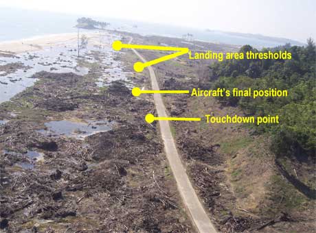
A level, 700 m long and 7 m wide portion of a bitumen-sealed roadway formed the designated landing area for the operator's relief flights into Patek. The landing area was not marked with runway markings.

aair200501287_001.jpg

The operator reported that the pilot misidentified the commencement of the landing area, and that the aircraft touched down about 400 m short of the commencement of that area.

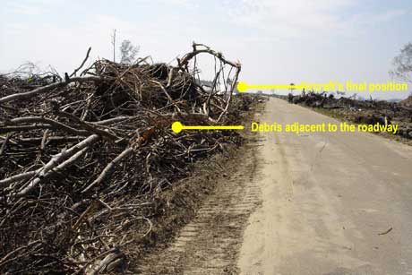
There was debris adjacent to the part of the road where the aircraft landed.

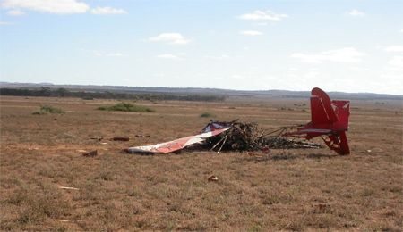
aair200501287_002.jpg

During the landing flare, the aircraft's left wingtip struck some of that debris, and a 1 m portion of the left wingtip was dislodged. The impact yawed the aircraft to the left, and the right wingtip then contacted the ground.

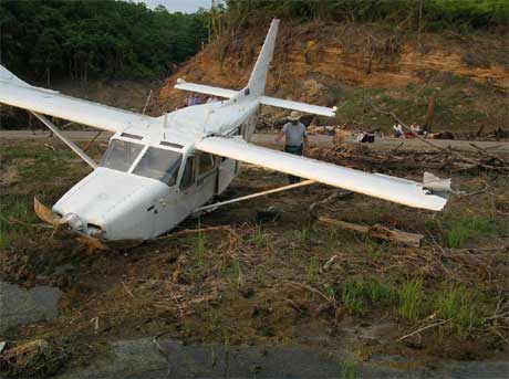
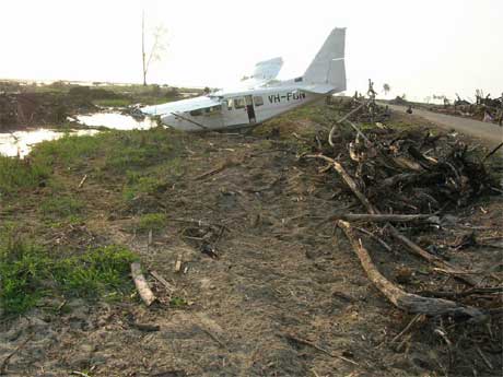
The landing gear collapsed, and the aircraft came to rest to the left of the sealed roadway, about 100 m from where the left wingtip initially struck the debris.

aair200501287_003.jpg

The two occupants were uninjured and were able to exit the aircraft unaided.

aair200501287_004.jpg

The pilot held an Australian Commercial Pilot (Aeroplane) Licence and was endorsed to fly the GA-8 aircraft. The operator provided induction training for the pilot at the commencement of his duties in Aceh Province. The training included one landing at Patek. The accident occurred four days after the pilot commenced duties in Aceh Province. During those four days, the pilot had performed two take-offs from Patek and had landed there twice before the accident flight.

There was no evidence that environmental, mechanical, operational or other factors contributed to the circumstances of the accident.

The operator reported that as a result of the occurrence, it will conduct a risk analysis before the commencement of any new operations such as those conducted at Aceh Province. The operator also reported that it would include a special training module in its Operations Manual for pilots assigned to operations in Aceh, and that procedures for aircraft operating on roads would also be included in its Operations Manual.

Summary

On 8 March 2005, the Gippsland Aeronautics Pty Ltd GA-8 aircraft, registered VH-FGN, was carrying emergency relief supplies from Muelaboh to Patek in Aceh Province, Indonesia, as part of the Tsunami relief effort. The aircraft occupants comprised the pilot and one passenger.

Occurrence summary

Investigation number 200501287
Occurrence date 08/03/2005
Location Patek, (ALA), Indonesia
State International
Report release date 03/08/2005
Report status Final
Investigation type Occurrence Investigation
Investigation status Completed
Mode of transport Aviation
Aviation occurrence category Collision with terrain
Occurrence class Accident
Highest injury level None

Aircraft details

Manufacturer Gippsland Aeronautics Pty Ltd
Model GA8
Registration VH-FGN
Serial number GA8-03-025
Sector Piston
Operation type Charter
Departure point Muelobah, Aceh
Destination Patek, Aceh
Damage Substantial

Loss of control, 7 km west-south-west of Tamworth Airport, New South Wales, VH-FIN

Interim report

At about 1326 Eastern Daylight-saving Time on 7 March 2005, the pilot of a Cessna Aircraft Company 310R, registered VH-FIN, commenced take-off from runway 30 right at Tamworth on a ferry flight to Scone, NSW. Witnesses reported that the pilot initially maintained the runway heading, as cleared by air traffic control (ATC). When the aircraft was between 800 and 1,000 ft above ground level (AGL) and while making a shallow banked turn to the left, the pilot broadcast to ATC that he was experiencing 'control difficulties'. Upon or shortly after reaching an early downwind position the aircraft was observed to enter a steep nose-down descent. While there were some inconsistencies in the available witness reports, it appeared that the aircraft may have rolled about its longitudinal axis at some stage on the final descent. The aircraft impacted the ground in a cleared paddock about 4 NM west-south-west of Tamworth airport, fatally injuring the sole occupant pilot of the aircraft. The aircraft was destroyed by the impact forces and post-impact fire.

The pilot was appropriately licensed and rated, held a valid class 1 medical certificate and was reported as being fit to fly. The results of postmortem examination and toxicology screening found no evidence of any physiological factor that may have impaired the pilot's performance during the occurrence flight.

The aircraft was maintained under a Civil Aviation Safety Authority (CASA) approved maintenance system. The aircraft had been subject to scheduled maintenance by a CASA approved maintenance facility immediately prior to the accident. The aircraft had a current maintenance release and there were no recorded defects at the time of the accident.

The investigation calculated the aircraft's weight and balance based on fuel load records and estimated fuel burn rates for previous operations, including engine runs relating to the maintenance activity completed immediately prior to the occurrence flight. The investigation estimated that at the time of the occurrence, the aircraft was operating below the maximum permitted take-off weight and within the stipulated centre of gravity limits.

The Automatic Terminal Information Service (ATIS) current at the time of the occurrence, reported that the wind was variable at eight knots with occasional crosswind of eight knots, CAVOK1, temperature 27°C and a calculated mean sea level pressure datum (QNH) of 1019 hPa.

The wreckage trail extended over a distance of about 232 m. Ground impact marks and other physical evidence indicated that the aircraft struck the ground in an upright slightly right wing low, 35 to 50 degrees nose-down attitude, and that both engines were developing significant power at the time of impact.

During the on-site examination of the wreckage, investigators located a tool that would normally not be expected to be carried on the aircraft. Metallurgical analysis showed no evidence that the tool had been trapped within or had in any way interfered with the control systems of the aircraft.

The pilot did not specifically transmit a distress call to ATC during the occurrence. The pilot advised that the aircraft was subject to 'control difficulties', that he was 'losing direction of the aircraft' and that the autopilot was 'not on'.

The aircraft was equipped with a Cessna 400B Nav-O-Matic Autopilot System. The autopilot controller recovered from the site showed evidence of thermal damage to a wire within the controller, consistent with current overload (Figure 1). That damage was inconsistent with post-impact fire damage. The ATSB is awaiting data from the manufacturer and other specialist agencies regarding the effect of the damaged wire on autopilot operation.

Figure 1: Damaged wire within the autopilot controller

Figure 1: Damage to autopilot wiring.

The ongoing investigation will include examination of:

  • the aircraft's autopilot and electric pitch trim systems
  • the inspection requirements for wiring to critical systems
  • the degree of autopilot system training provided during aircraft endorsement training.
  1. CAVOK is defined as visibility of 10km or more, no cloud below 5,000 ft or below the highest minimum sector altitude whichever is greater, no cumulonimbus clouds and no precipitation, thunderstorm, shallow fog, low drifting snow or dust devils.

Summary

At about 1326 Eastern Daylight-saving Time on 7 March 2005, the pilot of a Cessna Aircraft Company 310R, registered VH-FIN, took off from runway 30 Right at Tamworth Airport, for Scone, NSW. Approximately 1 minute after becoming airborne, the pilot reported flight control difficulties. At about 1329, the aircraft impacted the ground in a cleared paddock about 7 km west-south-west of the airport. The pilot was fatally injured, and the aircraft was destroyed by the impact forces and post-impact fire.

Examination of the aircraft's mechanical flight control systems, autopilot and electric trim system did not reveal any evidence of pre-impact malfunction. Those results, however, were inconclusive due to the extensive impact and fire damage. A bent hand tool found in the wreckage was not implicated in the development of the accident.

A periodic maintenance inspection carried out in the days before the flight resulted in the rudder trim tab being set at the full right position and possibly aileron and elevator trim tabs being set at non-neutral positions prior to the flight. There were indications that the pilot was rushed and probably overlooked the rudder and aileron trim tab settings prior to take-off. The aircraft flight path reported by witnesses was found to be consistent with the effect of abnormal rudder and/or aileron trim tab settings.

The investigation found that aircraft operating checklists produced by aircraft operators did not always include the autopilot and electric trim procedures located in the supplements of aircraft operating handbooks/flight manuals. At the time of the accident, the training and guidance generally provided to pilots did not emphasise the management of flight control difficulties including autopilot and electric trim related difficulties.

Following the accident, the aircraft operator and the maintenance provider advised that they had reviewed and amended some procedures. The Civil Aviation Safety Authority advised that a Civil Aviation Advisory Publication titled Multi-engine Aeroplane Operations and Training will be issued by July 2007 and that three items have been forwarded to the Safety Promotion Branch for consideration/action.

Occurrence summary

Investigation number 200501000
Occurrence date 07/03/2005
Location 7 km WSW Tamworth, Aero.
State New South Wales
Report release date 21/06/2007
Report status Final
Investigation type Occurrence Investigation
Investigation phase Final report: Dissemination
Investigation status Completed
Mode of transport Aviation
Aviation occurrence category Collision with terrain
Occurrence class Accident
Highest injury level Fatal

Aircraft details

Manufacturer Cessna Aircraft Company
Model 310
Registration VH-FIN
Serial number 310R0903
Sector Piston
Operation type Private
Departure point Tamworth, NSW
Destination Scone, NSW
Damage Destroyed

Collision with terrain, Wynella Station, Queensland, VH-BQN

Summary

On 6 January 2005, the pilot of an Air Tractor AT-802A aircraft, registered VH-BQN, was spraying insecticide on a cotton crop on Wynella Station, 41 km south of Dirranbandi, Qld. The aircraft departed the station airstrip at about 2005 Eastern Standard Time to commence spraying operations and impacted the ground at 2035. The pilot was fatally injured, and the aircraft was destroyed by fire.

There was no evidence that the aircraft was not capable of normal operation at the time of the accident. The pilot had substantial agricultural and general flying experience but had only recently completed night agricultural flight training. The accident occurred after the end of nautical twilight, there was no moon, and there was a band of cloud over Wynella station. There was virtually no ground lighting in the area. Post-mortem examination identified severe atherosclerotic narrowing of all three coronary arteries.

The lack of recorded and witness information, and the destruction of the cockpit by fire, prevented the investigation from conclusively identifying the factors that contributed to the development of the accident. However, the combination of pilot inexperience in night agricultural operations and the dark night conditions increased the risk of an accident.

Occurrence summary

Investigation number 200500004
Occurrence date 06/01/2005
Location 2.7 km ESE Wynella Station
State Queensland
Report release date 26/04/2007
Report status Final
Investigation type Occurrence Investigation
Investigation status Completed
Mode of transport Aviation
Aviation occurrence category Collision with terrain
Occurrence class Accident
Highest injury level Fatal

Aircraft details

Manufacturer Air Tractor Inc
Model AT802
Registration VH-BQN
Serial number 802A-0085
Sector Turboprop
Operation type Aerial Work
Departure point Wynella Station, Qld
Destination Wynella Station, Qld
Damage Destroyed

Collision with terrain, Gyroflug Speed Canard, VH-ZXZ, 20 km south-west of St George, Queensland, on 19 October 2004

Summary

At 0944 Eastern Standard Time on 19 October 2004, the Gyroflug Speed Canard aircraft departed Bundaberg, Qld, on a private flight to Parafield, SA, with a planned refuelling stop at Bourke, NSW. At about 1145, the pilot, who owned the aircraft and was the only occupant, radioed another pilot who was operating in the St George, Qld, area and advised that he was feeling dizzy, faint and disoriented, and was having difficulty lining up the aircraft to land on the St George runway. The aircraft remained airborne in the vicinity of St George for approximately 90 minutes. At about 1335, the aircraft impacted terrain 20 km south-west of St George, and the pilot sustained fatal injuries.

There was no evidence that the aircraft was not capable of normal operation at the time of the accident.

During a routine aviation medical examination in 2003, the pilot was diagnosed with diabetes.

The pilot apparently became incapacitated during flight and was unable to manoeuvre the aircraft to a successful landing.

It could not be established why the pilot became incapacitated, however a diabetes-related condition could not be ruled out.

Occurrence summary

Investigation number 200404085
Occurrence date 19/10/2004
Location 20 km SW Saint George
State Queensland
Report release date 12/01/2007
Report status Final
Investigation type Occurrence Investigation
Investigation status Completed
Mode of transport Aviation
Aviation occurrence category Collision with terrain
Occurrence class Accident
Highest injury level Fatal

Aircraft details

Manufacturer Gyroflug
Model SC01 B-160 Speed Canard
Registration VH-ZXZ
Serial number S 43
Sector Piston
Operation type Private
Damage Destroyed

Robinson R44, VH-JWX

Safety Action

SAFETY ACTION

Manufacturer

On 17 November 2004, the helicopter manufacturer advised that it had contacted the emergency locator transmitter (ELT) manufacturer concerning the ELT antenna coaxial cable connectors. The ELT manufacturer had undertaken to test coaxial cable connectors with a 30 lb. tension load. Connectors held in stock by the helicopter manufacturer would also be tested. The helicopter manufacturer advised that it was converting to the new 406 MHz capable ELTs. The antenna connector for the new installation would be crimped by the helicopter manufacturer. The style of crimping used by the helicopter manufacturer has been tested and could typically withstand in excess of 100 lb tension. The helicopter manufacturer believed that those actions would prevent failures of the type that occurred to the ELT installation in the occurrence helicopter.

ATSB

A summary of this accident report will be included in a future edition of CASA's Flight Safety Australia magazine.

Analysis

ANALYSIS

The investigation found that there was no evidence of a pre-existing defect in the helicopter that may have contributed to the occurrence, nor was there any evidence of a medical condition that could have affected the pilot's ability to control the helicopter. Consequently, the investigation concluded that in the prevailing environmental conditions, the accident was consistent with pilot spatial disorientation. This analysis examines the development of the occurrence and highlights a significant risk associated with night VFR operations.

The pilot departed for Eurella homestead 6 minutes after civil twilight in moonless, overcast, and probably showery conditions that were likely to restrict visibility to less than the required 5 km. Except for the homestead lights, the ground lighting or celestial illumination required by the Aircraft Flight Manual was not available. Although the pilot had flown at night on two recent occasions (23 and 26 August 2004), those flights did not fully satisfy the night VFR recency requirements and were probably over a well lit area. Given the pilot's limited recent and overall helicopter night flying experience, and the forecast weather conditions, it is unlikely that the pilot planned to conduct the return flight at night. The pilot had probably used the helicopter to move cattle and that task may have taken longer than expected. The proximity of the homestead, the local knowledge of his passenger, the night VFR capability of the aircraft and access to GPS information may have influenced the pilot to attempt the return flight.

The track information recovered from the hand-held GPS showed manoeuvring after 1830 that suggests that the pilot, probably using GPS information, made several attempts to track to the homestead, but was unable to do so. It is likely that during the manoeuvring the pilot was at a low altitude, attempting to maintain visual contact with surface features, possibly with the assistance of the landing lights. Such visual contact would have enabled control of the helicopter and clearance from terrain. In the absence of a consistently discernable horizon, any visual contact with the homestead lights would not have enabled the pilot to determine the helicopter's attitude. Prior to the impact, the pilot may have lost visual contact with the surface due to cloud and/or rain and become spatially disorientated.

The pilot may have attempted to control the helicopter by reference to the flight instruments. However, he had not logged any instrument flight time in a helicopter and had not been exposed to significant night-flight away from metropolitan areas. The relative instability of the helicopter and the different operating environment meant that the pilot's considerable aeroplane night and instrument flight experience was not directly transferable to night VFR helicopter operations. Consequently, spatial disorientation could have developed rapidly.

Flying the helicopter at a low altitude at night with cloud and/or showers in an area with little lighting was a very demanding task with little margin for error. However, once the helicopter became airborne after civil twilight, there were few options available to the pilot. The pilot's lack of helicopter instrument flight experience would probably have precluded consideration of climbing to the lowest safe altitude and tracking to an aerodrome with an instrument approach. Given that the adverse weather was widespread, diversion to another location while maintaining external visual reference was also an unlikely option.

A landing at a location other than the homestead was an option. It is possible that the accident occurred when the pilot became spatially disorientated in the adverse conditions while attempting to land the helicopter. However, it is also possible that, unable to communicate with the homestead, the pilot avoided an out-landing due to the consequent difficulty in reaching the homestead without transport.

Illumination of the clutch light as indicated by the stretched filament may have resulted from clutch operation during flight or from disruption during the impact. If the clutch light had illuminated during flight it may have distracted the pilot and contributed to spatial disorientation.

As a result of the separated ELT antenna cable, the search and rescue effort was significantly affected. However, in this case, the nature of the impact and the extent of injury to the occupants indicated that the search and rescue effort would not have influenced their survivability.

The circumstances of this occurrence highlight the risk of spatial disorientation during night VFR operations and reinforce the significance of the cautions included in the helicopter manufacturer's safety notices SN-18 and SN-26.

SIGNIFICANT FACTOR

The pilot departed after civil twilight in conditions where a natural horizon was probably not discernible and consistent visual reference to surface features was not likely.

Factual information

FACTUAL INFORMATION

History of the flight

On 8 September 2004, the owner/pilot of a Robinson Helicopter Company R44 Raven II helicopter, registered VH-JWX, conducted a private flight under the visual flight rules (VFR) from Coffs Harbour, NSW to Eurella Station, Qld. The flight included a landing at Roma, Qld where the pilot refuelled the helicopter with 180 L of Avgas from the bulk underground fuel storage supply.1 The pilot then continued to Eurella Station, located approximately 54 km west of Roma, arriving at 1705 Eastern Standard Time. The pilot shut down the engine and the property owner boarded the helicopter for a pre-arranged local flight. The pilot made several attempts to start the engine, during which it backfired a few times. Once started, the engine seemed to function normally.

The helicopter departed the homestead at 1725 in a northerly direction. A person on an adjoining property about 7 km north of Eurella homestead saw the helicopter operating to the east late in the afternoon. He reported that the helicopter conducted a number of take-offs and landings in what appeared to be the same general area over a period of about 30 minutes. He saw the helicopter depart in a southerly direction at about 1830.

The next reported sighting was by a person at Eurella homestead who, in poor light conditions, saw what appeared to be the helicopter's landing light to the north of the homestead. The light moved toward the west of the homestead. Soon after, that person again saw the light to the west and expected the helicopter to land at the homestead within a few minutes. However, she became concerned when the helicopter did not arrive and telephoned an employee of the property owner to report her concern. The employee contacted the Australian Search and Rescue organisation (AusSAR) and search action was initiated. The helicopter was located the following morning in open, rolling country, 3 km west of Eurella homestead. The two occupants were fatally injured, and the helicopter was destroyed.

Search and rescue

AusSAR reported that it was notified at 1947 that the helicopter was overdue. Weather conditions were unsuitable for an air search, but a surface search was initiated. AusSAR advised that no ELT signal was received on 8 September by satellite or by aircraft at high altitude passing within 130 km of Eurella Station. An ELT signal was detected on two satellite passes early on the morning of 9 September. The signals were identified as originating from separate locations; one approximately 22 km to the south-west, and the other approximately 22 km to the south-east, of Eurella Station. However, those signals were not merged by the satellites as coming from the same source, so they were of little assistance in the search. Local aircraft were tasked to begin a search at daylight on 9 September and the wreckage was located at 0708 by the crew of a search aircraft. Accident site information

The accident site elevation was about 30 m below the ground elevation at the homestead. The homestead was not visible from the accident site.

Figure 1: Aerial view of the accident site

aair200403351_001.jpg

GPS track information

The helicopter was fitted with a fixed global positioning system (GPS) receiver, and also a handheld GPS receiver mounted in a cradle on the instrument panel. The fixed receiver did not contain a non-volatile memory card, but the handheld unit did. Track and ground-speed data for the occurrence flight was retrieved from the non-volatile memory card. Altitude information was not retained in the memory card.

Figure 2 displays the GPS recorded track of the helicopter overlaid in blue on a 1 in 250,000 scale topographical map of the area. The local times that the helicopter was at various locations are depicted.

Figure 2: GPS track overlay, with the landing sites A, B, C and D

aair200403351_002.jpg

The GPS data showed that the helicopter landed five times during the flight. Those positions are depicted on the map and are described as follows:

Position AThe helicopter landed at 1742 and departed at 1745. There was a water tank adjacent to that location.
Position BThe helicopter landed at 1749 and departed at 1752.
Position CThe helicopter landed at 1800 and departed at 1802.
Position DThe helicopter landed at 1805 and departed at 1807.
Position BThe helicopter returned to position B at 1823 and departed at 1827.

The data indicated that, after the helicopter departed position B at 1827, it initially tracked almost directly toward the homestead, but that the track then veered south-west. That track was clear of the high ground indicated by the 400 m contour near Mt Muttaby, as depicted on the chart at Figure 2. There are distinct features in the helicopter's track after 1830, indicating that the pilot turned toward the homestead on four separate occasions between 1830 and 1840, only to turn away each time. The accident occurred on the fifth occasion that the helicopter's recorded track turned in the approximate direction of the homestead.

Subsequent to the occurrence, an employee from Eurella Station found that cattle had been moved from the paddock that included positions A, C, and D, to an adjoining paddock. Those paddocks were linked by a gate adjacent to position B. The employee recalled that the property owner had intended to move the cattle to the adjoining paddock and that the gate adjacent to position B was the gate through which he would have expected the cattle to be moved.

Pilot information

The pilot held an air transport (aeroplane) pilot licence and a command multi-engine instrument rating. He had extensive aeroplane flying experience, including regular public transport turbo-jet aircraft and corporate turbo-jet aircraft operations in Australia and overseas. His aeroplane flying experience exceeded 10,000 hours and included 1,418 hours of night flight and 711 hours of instrument flight.

The pilot obtained a private pilot (helicopter) licence on 23 September 1998 and had about 582 hours helicopter experience. He obtained a night VFR (helicopter) rating on 12 September 2000 and since that date had recorded about 11 hours helicopter night flight. Almost all of the logged flights were in the Sydney metropolitan area. Helicopter night flying recorded by the pilot in the two years prior to the occurrence was 0.4 hours on 23 August 2004 and 0.6 hours on 26 August 2004. That night flying most likely occurred during the latter stages of flights to the Sydney metropolitan area.

There was no record of the pilot having received any specific training in operating helicopters in remote areas or dark night conditions where there was little or no ambient lighting. No helicopter instrument flight time was logged.

The pilot held a valid medical certificate. Post-mortem and toxicology examinations did not reveal any pre-existing condition that might have affected the pilot's ability to safely conduct the flight.

Helicopter information

The pilot purchased the helicopter new in early August 2004. At the time of the occurrence the helicopter had operated for 34.1 hours. The maintenance release was valid and the documentation indicated that all applicable maintenance and regulatory requirements had been met.

The helicopter was equipped and certified for night VFR operations. Instrumentation included an airspeed indicator, artificial horizon, sensitive pressure altimeter, turn coordinator, horizontal situation indicator, global positioning system indicator, and vertical speed indicator.

The helicopter was equipped with twin landing lights in the lower nose section. The lights were fitted with 100 watt spot globes and, according to the Aircraft Flight Manual, were 'set at different angles to increase the pilot's field of vision'. Both lights were activated by the one switch which was mounted on the cyclic control centre post.

A row of eight amber warning lights located at the top of the flight instrument panel included a clutch warning light. A further six warning lights were positioned at the top of the centre pedestal.

The helicopter's engine was coupled to the rotor drive system via four double-stranded vee-belts. After engine start, an electric actuator would tension the belts when the pilot engaged the clutch switch. The actuator sensed belt tension and was automatically energised when the tension was less than required. The clutch warning light would illuminate whenever the clutch actuator circuit was activated. The Aircraft Flight Manual included a note regarding the clutch in Section 3, Emergency Procedures. The note stated that stretching of the belts often resulted in illumination of the clutch warning light for brief periods as the drive actuator readjusted belt tension. The note also included actions that the pilot should take after 7 or 8 seconds of illumination of the clutch light. One of those actions was to pull the clutch circuit breaker.

The helicopter was fitted with a Pointer (TSO-C91A) Model 3000-10 emergency locator transmitter (ELT). The unit was located on the left side of the rear fuselage.

The total flight time from Roma until the time of the occurrence was about 1 hour 35 minutes. Assuming a fuel usage rate of 60 L per hour, approximately 95 L would have been consumed during that time. On that basis, approximately 95 L should have remained at the time of the occurrence.

Wreckage information

opposite to the helicopter's direction of travel at impact. The impact severely crushed most of the cabin area and deformed the fuselage and tail boom structures.
Two distinct main rotor blade impact marks on the ground forward and to the right of the initial nose impact position, and the damage to the main rotor blades, indicated that the rotor blades were being driven by the engine at impact. The tail-rotor system was intact and there was no evidence that the fuselage was yawing at impact. There was no indication that the helicopter had struck any of the trees in the vicinity of the impact site.

The left fuel tank ruptured during the impact sequence and was empty. The right fuel tank was also empty. With the helicopter lying on its left side, the right fuel tank vent line was at the lowest part of the tank and would have allowed fuel to drain out. There was a strong smell of Avgas in the vicinity of the wreckage on the day after the accident.

The hydraulic system switch was found in the ON position.

Instrument panel light globe and instrument examination confirmed that electrical power was available to the instruments. There was no evidence of malfunction of any of the instruments.

The six warning lights at the top of the centre pedestal were destroyed by impact forces, preventing an assessment being made of their status at impact. The eight warning lights at the top of the flight instrument panel were intact. Examination of those light globes revealed stretching of the clutch warning light filament. Stretching indicates that the filament was hot and that electrical power was applied to the globe when it was subject to forces during the impact sequence. It was not possible to determine the length of time that the globe had been illuminated. Filament stretch was not evident in any of the other seven warning light globes from the top of the instrument panel.

Damage to the landing light globes prevented any assessment being made regarding their status at the time of the occurrence. The damage to the landing light switch indicated that it was in the ON position at impact.

The circuit breaker panel was destroyed by impact forces. The clutch actuator fuse was serviceable. The wreckage examination did not reveal any fault in the clutch system. Although the circuit breaker panel was destroyed, the evidence of electrical power to the clutch warning light indicates that the circuit breaker was engaged, and therefore the system was powered at the time.

The coaxial cable from the ELT unit to the external antenna had separated at the connector to the antenna base on the inside of the antenna mounting panel. The separation of the coaxial cable trapped the transmitted signal within the fuselage compartment. That rendered the ELT unit ineffective and prevented satellite detection of the signal. The separation of the cable appeared to have been as a result of impact forces. As a result, the search and rescue effort was significantly affected.

Specialist examination of the ELT revealed that it had activated upon impact and, when connected to a suitable antenna, was capable of transmitting a normal signal.

The engine was test run after removal from the wreckage and operated normally. The hydraulic pump and three hydraulic servos that formed part of the main rotor flight control system were removed from the wreckage for functional testing. The tests were conducted at the helicopter manufacturer's facility in the USA and supervised on behalf of the ATSB by a representative from the US National Transportation Safety Board. The tests confirmed that the hydraulic system components met the specifications for normal operation.

Meteorological information

Documents found in the helicopter included an Area 41 weather forecast valid from 0900 to 2100 on the day of the occurrence and the Roma terminal area forecast (TAF) valid from 1200 to 2400 on the day of the occurrence.

The area forecast indicated that the weather in the vicinity of Eurella Station would include areas of rain with locally moderate falls, scattered showers and isolated thunderstorms. The Roma TAF indicated that between 1500 and 2400 there would be 60 minute periods in which the visibility would be 2 km in heavy rain, with broken cloud2 at 700 ft.

An analysis by the Bureau of Meteorology indicated that during the late afternoon on the day of the occurrence, a surface trough was located from Camooweal to St George, with cold south-west winds to its west and northerlies to its east. The surface trough combined with an upper level trough over the southwest of the state to bring a large cloud band with widespread rain and isolated thunderstorms to the interior. The analysis of satellite imagery and synoptic reports, concluded that there was a high probability of rain in the Eurella Station area around the time of the occurrence, and most likely greater than 5 oktas of cloud cover. However, because the nearest weather radar station was about 200 km distant at Charleville, the amount of cloud cover in the area of the occurrence could not be confirmed.

Persons at and near Eurella Station variously reported that the weather conditions during the day of the accident were windy, with heavy cloud and showers.

Astronomical information

According to information published on the Geoscience Australia website, sunset and twilight times at Eurella Station on the day of the occurrence were:

Sunset 17573
Civil Twilight 18204

Other information on the website indicated that the moon set at 1409 and was 79 degrees 31 seconds below the horizon at 1830 that evening.

Helicopter night VFR

The pilot's night VFR (helicopter) rating authorised him to act as pilot in command of private or aerial work flights at night under the VFR. Once issued, a night VFR rating remained permanently valid. To exercise the privileges of the rating, a pilot needed to complete a 1-hour night flight during the previous 12 months and one take-off and landing at night during the previous 6 months. There was no requirement for the holder of a night VFR rating to have any recent instrument flight time prior to conducting a flight at night.

A pilot operating under the VFR at night was required to operate in visual meteorological conditions that included a minimum of 5 km visibility. The Aircraft Flight Manual, Section 2, Limitations, included the following statements:

VFR operation at night is permitted when landing, instrument, and anti-collision lights are operational. Orientation during night flight must be maintained by visual reference to ground objects illuminated solely by lights on the ground or adequate celestial illumination.

At the time of the occurrence there was a 1,000 watt flood light on each of the northern and western walls of Eurella homestead, as well as lights in other buildings. However, there were many trees in the vicinity of the homestead, some of which were higher than the homestead roof. Depending on the altitude and position of the helicopter, the trees could have prevented those lights being seen from the helicopter (Figure 1). There was no other lighting in the general area, including at the airstrip adjacent to the homestead. The homestead lights, in effect, formed a 'point' source of light.

Spatial Disorientation

Spatial disorientation refers to a situation in flight in which the pilot fails to sense correctly the position, motion or attitude of the aircraft. When the condition is fully developed, the pilot is unable to tell which way is 'up'.

The risks of non-instrument rated pilots flying in conditions in which they are not able to orientate the aircraft by visual reference have been well known for over 50 years. During testing conducted on a group of non-instrument rated pilots, the average time before loss of control of the aeroplane, after visual reference was lost, was 178 seconds.5

US FAA Advisory Circular 60-4A, Pilot's Spatial Disorientation, was published in 1983 and was intended to inform pilots of the hazards associated with disorientation caused by loss of visual reference with the external environment. It included the following information:

Tests conducted with qualified instrument pilots indicate that it can take as much as 35 seconds to establish full control by instruments after the loss of visual reference with the surface.

The helicopter manufacturer issued a safety alert and safety notices (SN) as a result of various occurrences and incidents, and included those notices in the Aircraft Flight Manual Section 10, Safety Tips. Two of the notices related to night flight - SN-18 Loss of Visibility Can Be Fatal, and SN-26 Night Flight Plus Bad Weather Can Be Deadly (see Appendix A). Safety notice SN-18 stated in part:

Helicopters have less inherent stability and much faster roll and pitch rates than airplanes. Loss of the pilot's outside visual references, even for a moment, can result in disorientation, wrong control inputs, and an uncontrolled crash.

Appendix A

aair200403351_003.jpg
aair200403351_004.jpg

1.On the day of the occurrence, other aircraft were refuelled from the Roma bulk fuel storage. The ATSB received no reports of fuel quality related problems involving those aircraft.

2. Forecast cloud was explained as 'few'-1 to 2 oktas (okta - a unit of visible sky area representing one-eighth of the total area visible to the celestial horizon), 'scattered'- 3 to 4 oktas, 'broken'- 5 to 7 oktas and 'overcast'- 8 oktas.

3. Sunset is defined as the instant in the evening under ideal meteorological conditions, with standard refraction of the sun's rays, when the upper edge of the sun's disk is coincident with an ideal horizon.

4. Ending of evening civil twilight is defined as the instant in the evening when the centre of the sun is at a depression angle of six degrees below an ideal horizon. In the absence of moonlight, artificial lighting or adverse atmospheric conditions, the illumination is such that large objects may be seen, but no detail is discernible.

5. Bryan, L.A., Stonecipher, J.W. & Aron, K. 1954. 180-degree turn experiment. University of Illinois Bulletin. 54(11), 1-52.

Summary

On 8 September 2004, the owner/pilot of a Robinson Helicopter Company R44 Raven II helicopter, registered VH-JWX, conducted a private flight under the visual flight rules (VFR) from Coffs Harbour, NSW to Eurella Station, Qld. The flight included a landing at Roma, Qld where the pilot refuelled the helicopter with 180 L of Avgas from the bulk underground fuel storage supply. The pilot then continued to Eurella Station, located approximately 54 km west of Roma, arriving at 1705 Eastern Standard Time. The pilot shut down the engine and the property owner boarded the helicopter for a pre-arranged local flight. The pilot made several attempts to start the engine, during which it backfired a few times. Once started, the engine seemed to function normally.

Occurrence summary

Investigation number 200403351
Occurrence date 08/09/2004
Location 56 km W Roma (NDB)
Report release date 25/01/2006
Report status Final
Investigation type Occurrence Investigation
Investigation status Completed
Mode of transport Aviation
Aviation occurrence category Collision with terrain
Occurrence class Accident
Highest injury level Fatal

Aircraft details

Manufacturer Robinson Helicopter Co
Model R44
Registration VH-JWX
Serial number 10405
Sector Helicopter
Operation type Private
Departure point Eurella Station
Destination Eurella Station
Damage Destroyed