On 5 July 2015, the pilot of a Cessna 182 aircraft, registered VH-AHC, conducted a local flight from a private airstrip about 100 km south-west of Bourke, New South Wales. The aircraft took off towards the west. After a flight of about 15 to 20 minutes, the aircraft returned overhead the airstrip. Based on the indicated wind, the pilot elected to conduct an approach to land towards the south.
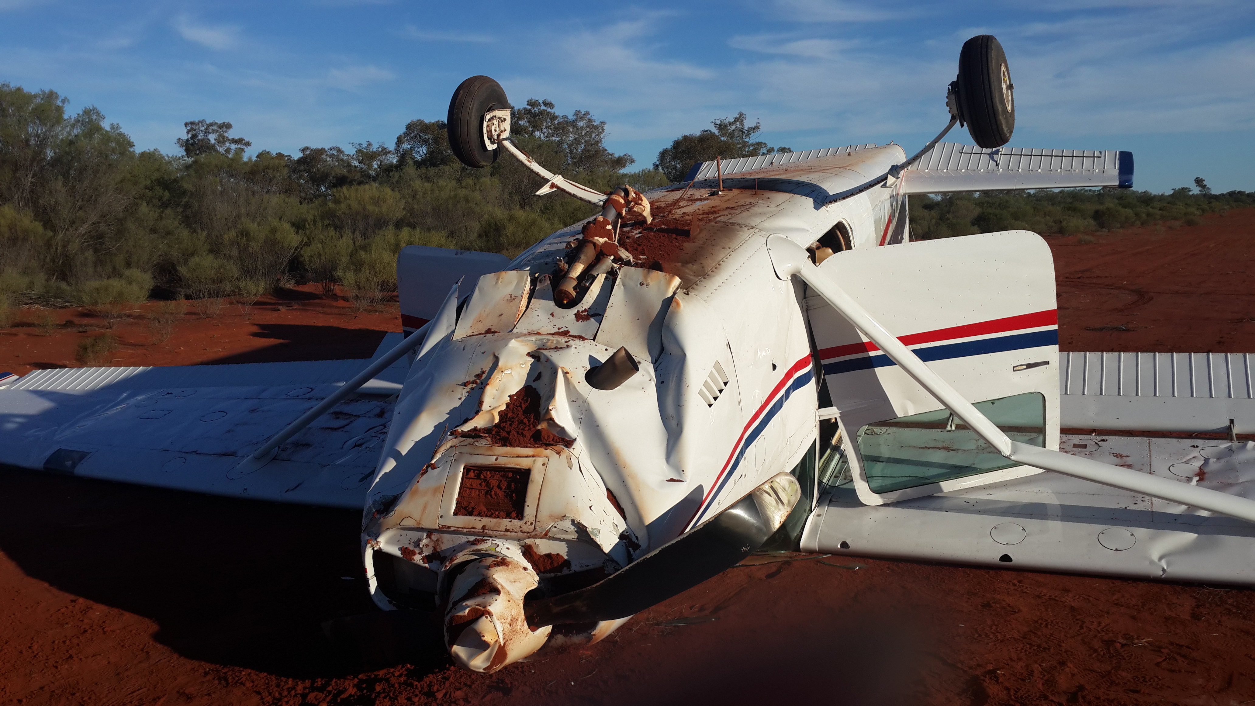
When on final approach to land, at about 5 ft above ground level, the aircraft sank rapidly. The aircraft landed heavily and the nose wheel detached from the aircraft. The aircraft then bounced into the air, touched down for a second time, and dug into soft ground. The aircraft flipped over and came to rest inverted, resulting in substantial damage (Figure 1). The pilot and two passengers sustained minor injuries.
Pilot comments
The pilot reported that the property had received about 100 mm of rain over a period of 2 weeks, which had stopped about 7 days prior to the incident. Cold weather in the intervening period had prevented the soil from drying. Prior to taking off, the pilot had driven over the runway surface and assessed the surface to be suitable for landing. However, below the runway surface, there was a soft layer of earth. This layer extended about 500 mm down and was not evident during the runway inspection.
The pilot was unsure what caused the aircraft to sink faster than usual. The wind was light and variable. The additional sink and high rate of descent combined with the soft surface led to the aircraft landing gear digging in and flipping the aircraft over.
Figure 1: Accident site of Cessna 182, VH-AHC
Source: Aircraft owner
Safety message
This incident highlights the importance of the identification and management of risks associated with unsealed airfields. Potential hazards such as changes in the runway surface following rain can be hard to detect. Changes in the runway surface can adversely affect the outcome of a hard landing.
The ATSB report regarding a similar incident is available on the ATSB website at AO-2015-038.
Decisions regarding whether to conduct an investigation, and the scope of an investigation, are based on many factors, including the level of safety benefit likely to be obtained from an investigation. For this occurrence, a limited-scope, fact-gathering investigation was conducted in order to produce a short summary report, and allow for greater industry awareness of potential safety issues and possible safety actions.
Publishing information
Released in accordance with section 25 of the Transport Safety Investigation Act 2003
Ownership of intellectual property rights in this publication
Unless otherwise noted, copyright (and any other intellectual property rights, if any) in this report publication is owned by the Commonwealth of Australia.
Creative Commons licence
With the exception of the Coat of Arms, ATSB logo, and photos and graphics in which a third party holds copyright, this publication is licensed under a Creative Commons Attribution 3.0 Australia licence.
Creative Commons Attribution 3.0 Australia Licence is a standard form licence agreement that allows you to copy, distribute, transmit and adapt this publication provided that you attribute the work.
The ATSB’s preference is that you attribute this publication (and any material sourced from it) using the following wording: Source: Australian Transport Safety Bureau
Copyright in material obtained from other agencies, private individuals or organisations, belongs to those agencies, individuals or organisations. Where you wish to use their material, you will need to contact them directly.
On 16 August 2014, an Airbus Helicopters AS350B2 Squirrel, registered ZK-HYO, collided with terrain at Mt Alta in the New Zealand Southern Alps. One of the seven occupants of the helicopter was fatally injured and the aircraft destroyed.
The New Zealand Transport Accident Investigation Commission (TAIC) opened an inquiry into the accident on 16 August 2014 (TAIC investigation AO-2014-005). As part of that investigation TAIC recovered the helicopter’s engine for later technical examination. Subsequently, TAIC arranged for the engine examination to be carried out at the engine manufacturer’s facility in Sydney, New South Wales.
On 21 August 2015, TAIC requested the ATSB to appoint an accredited representative in accordance with Annex 13 to the Convention on International Civil Aviation Aircraft Accident and Incident Investigation. The ATSB appointed an accredited representative that day with the task of providing independent oversight of the TAIC engine examination.
To facilitate this support, the ATSB initiated an external investigation under the provisions of the Transport Safety Investigation Act 2003. The ATSB forwarded its report of the engine examination to TAIC on 29 October 2015. This completed the ATSB’s support of the TAIC investigation.
TAIC is responsible for, and will administer the release of the final investigation report into this accident. Any enquiries regarding the TAIC investigation should, in the first instance, be directed to the:
Deputy Chief Investigator of Accidents Transport Accident Investigation Commission Level 16, AXA Center 80 The Terrace PO Box 10-323, Wellington New Zealand
On 6 August 2015, the pilot of a Grumman G164 aircraft, registered VH-LKN, was conducting aerial spreading of superphosphate on a property about 33 km south-west of Tharwa, Australian Capital Territory. The target zone for the spreading was about 7 km to the south-east, and at an elevation about 1,000 ft higher than the airstrip and loading site.
The pilot commenced operations at about 1000 Eastern Standard Time (EST) and completed spreading of six loads of superphosphate. The pilot then had a lunch break and refuelled the aircraft to a total of about 180 L of fuel. The aircraft was also loaded with about 500 kg of superphosphate, which was about half its carrying capacity. The pilot observed a light, westerly wind of about 2 to 5 kt in the vicinity of the airstrip.
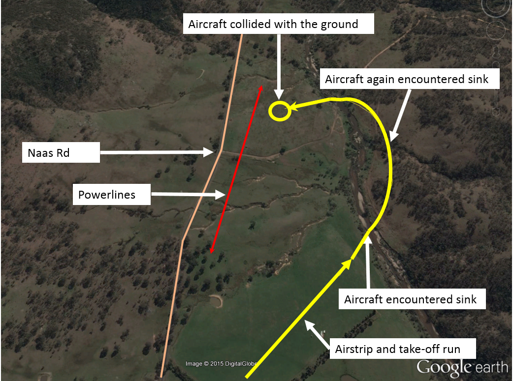
At about 1400, the pilot commenced the take-off run for the seventh load of the day. As the aircraft became airborne, the aircraft started to sink (Figure 1). To stop the aircraft sinking, the pilot applied the dump lever to start dumping the load of superphosphate. The aircraft then started to climb, so the pilot stopped dumping the load. The pilot also commenced a shallow left turn, away from rising terrain. As the aircraft turned, when at about 100 ft above ground level, it started to sink again. As it sank, the pilot felt a shake through the airframe, indicating that the aircraft was close to stalling. The pilot re-applied the dump lever to open the hopper door and try to reduce the aircraft load. Simultaneously, the pilot lowered the aircraft’s nose and rolled the wings level, to try to recover from the incipient stall.
Figure 1: Departure airstrip, aircraft track and accident location
Source: Google earth and pilot recollection – annotated by the ATSB
The pilot sighted powerlines, a road and a row of trees ahead, beyond which the terrain rose steeply. The aircraft continued to descend and the pilot maintained the aircraft in a normal nose attitude for landing. As the aircraft neared the ground, the pilot reduced the throttle to idle and held the aircraft control stick in the full back position. The tailwheel struck the ground first, and then the right main landing gear dug into soft ground. The aircraft flipped over and came to rest inverted.
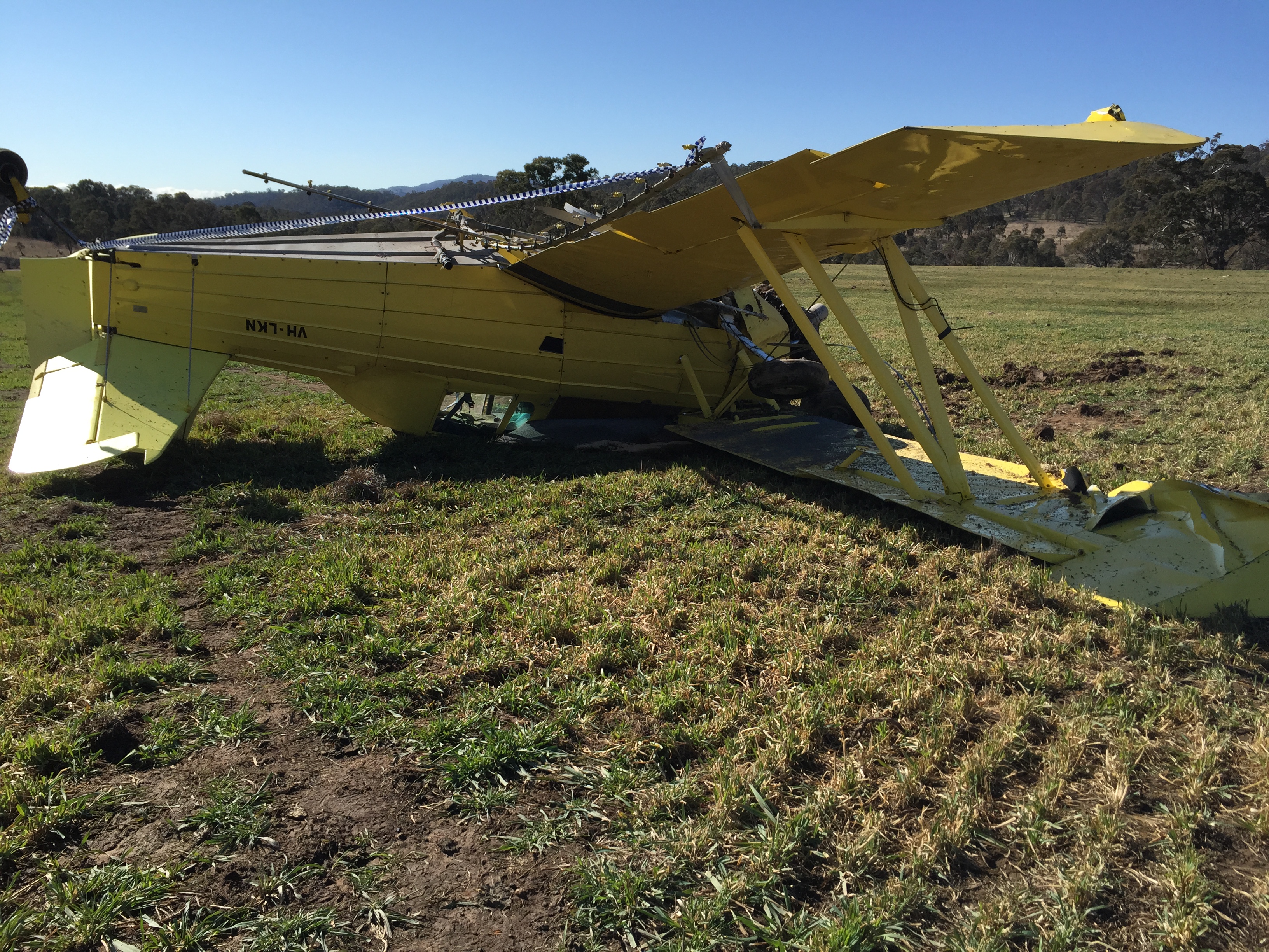
The pilot sustained minor injuries and the aircraft was substantially damaged (Figure 2).
Figure 2: Damage to VH-LKN
Source: Pilot
Pilot comments
The pilot provided the following comments:
The airstrip was at an elevation of about 2,100 ft above mean sea level. The target pasture was about 1,000 ft higher than the airstrip.
The airstrip was about 500 m in length and the fuel and chemical load was relatively light. The aircraft was well within its operational limitations.
The weather forecast had indicated calm conditions, and the temperature was about 14°C.
The sink that the aircraft encountered may have been a downdraft coming off the hill.
If the airstrip had been higher up and closer to the target zone, the pilot would have had more time to dump the load, less distance to climb on each load, and a more accurate assessment of the wind conditions.
Dumping liquid takes a few seconds, but granular substances like superphosphate take minutes for the hopper to empty when dumping the load.
After the accident, the pilot verified that the hopper door was open, and superphosphate was present in the paddock, indicating that it had been dumping at the highest rate. Despite that, about 300 kg of superphosphate remained in the hopper.
Safety message
The pilot stated that the key to avoiding similar incidents was to understand the atmospheric conditions in steep mountainous country. Variations in wind strength and direction due to terrain can have serious consequences on flight safety, particularly when operating at low airspeeds and close to the ground.
ATSB investigated a similar accident involving a Grumman G-164A, in AO-2014-001.
Decisions regarding whether to conduct an investigation, and the scope of an investigation, are based on many factors, including the level of safety benefit likely to be obtained from an investigation. For this occurrence, a limited-scope, fact-gathering investigation was conducted in order to produce a short summary report, and allow for greater industry awareness of potential safety issues and possible safety actions.
Publishing information
Released in accordance with section 25 of the Transport Safety Investigation Act 2003
Ownership of intellectual property rights in this publication
Unless otherwise noted, copyright (and any other intellectual property rights, if any) in this report publication is owned by the Commonwealth of Australia.
Creative Commons licence
With the exception of the Coat of Arms, ATSB logo, and photos and graphics in which a third party holds copyright, this publication is licensed under a Creative Commons Attribution 3.0 Australia licence.
Creative Commons Attribution 3.0 Australia Licence is a standard form licence agreement that allows you to copy, distribute, transmit and adapt this publication provided that you attribute the work.
The ATSB’s preference is that you attribute this publication (and any material sourced from it) using the following wording: Source: Australian Transport Safety Bureau
Copyright in material obtained from other agencies, private individuals or organisations, belongs to those agencies, individuals or organisations. Where you wish to use their material, you will need to contact them directly.
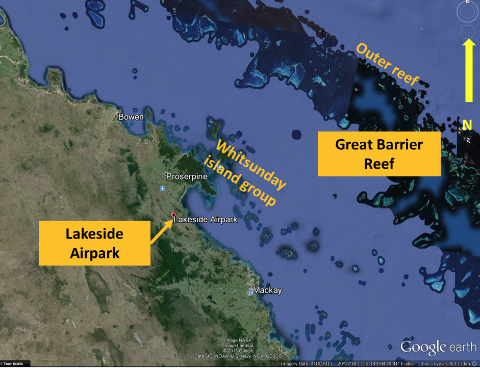
On the afternoon of 26 July 2015, the pilot prepared a PA32-300 (Cherokee Six) aircraft, VH-BDG (BDG), for a private joy flight around the Whitsunday Islands off the Queensland coast, (Figure 1) departing from the Lakeside Airpark. The pilot had arranged for five acquaintances to come on the flight as passengers.
About a week earlier, the pilot, who had an injured right foot at the time, organised another pilot to fly BDG on a re-positioning flight to the Lakeside Airpark. Due to being unable to fly the re-positioning flight, the accident flight became the pilot’s first time operating from the Airpark.
Pilot recollections
The pilot reported that they delivered a safety brief outlining the relevant safety features of the aircraft, just prior to loading the passengers. After loading the four rear passengers, the pilot secured the left rear cargo door, and then entered the cockpit through the front right door, followed by the front seat passenger.
The flight departed at about 1400 Eastern Standard Time (EST), and remained outside controlled airspace. The flight overflew some of the Whitsunday Island group as well as the outer reef area of the Great Barrier Reef, prior to setting a return course to the Airpark about one and half hours later (Figure 1).
Figure 1: A google earth extract showing the general area where the joyflight was conducted
Source: Google earth, annotated by the ATSB
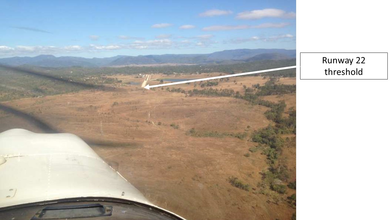
The pilot approached the extended centreline at an oblique angle and conducted a straight in approach to runway 22 (Figures 2 and 3). When about 6 NM from the airfield, at about 2,300 ft above mean sea level, the aircraft was configured for descent. After reducing the airspeed from about 135 to about 100 kt, and with 10° of flap selected, the aircraft descended to about 1,800 ft.
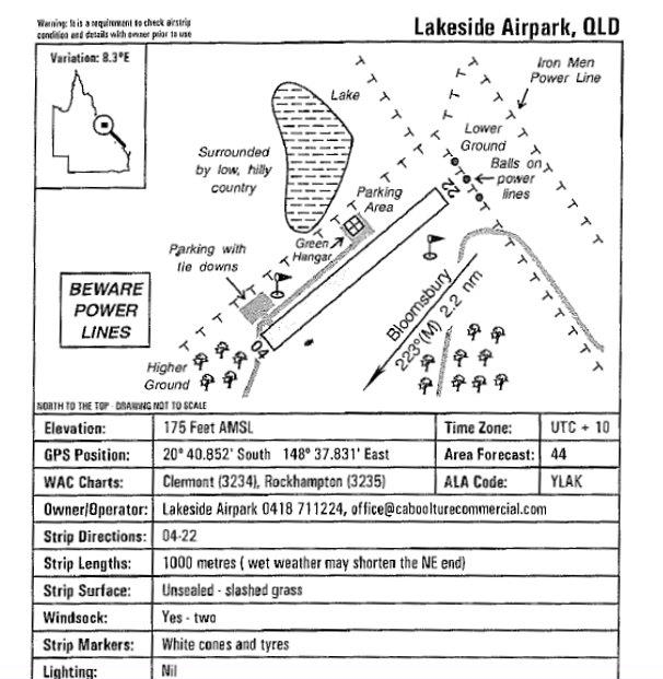
Figure 2: An extract from the Queensland Country Airstrip Guide. Diagrammatic representation of Lakeside Airpark and local hazards
Source: Queensland Country Airstrip Guide, 2012 edition
Figure 3: Approach to runway 22 at Lakeside Airpark. Note the unsealed and sealed portion of the runway. Also, note the difficulty in detecting the power lines on approach. Photo taken about a week prior to the accident
Source: Barry Dionysius
In order to maintain sufficient clearance over the two rows of power lines, and still land near the threshold, well before the sealed section of the runway, the pilot planned a steeper approach than normal. The flap was set to 40° (full flap) and the rate of descent increased to about 500-600 feet per minute.
On short final, the aircraft suddenly began to sink rapidly, and the pilot recalled seeing a tree pass close by the left window. Judging that the aircraft was now too low; the pilot applied full power, held the aircraft nose in a raised position, turned the aircraft left toward lower ground, and initiated a go-around.
However, the aircraft continued to sink throughout this manoeuvre, and the tail struck the runway about 20 m in from the threshold. Throughout this attempt to go-around, the tail continued to drag along the gravelled section of the runway, leaving a mark about 30-35° to the left of the runway direction for about 18m.
Although not yet showing a positive rate of climb, the aircraft seemed to be flying. The pilot reported that the stall warning had not sounded, so assessed there was a choice between removing the power and attempting to land back on the runway, or continuing with the go-around. The pilot elected to continue with the go-around and continued toward the lower ground.
A witness mark made by the right wheel, commenced at about the same spot where the mark made by the tail stopped. The wheel mark continued for about 35m into the grassed area beside the runway.
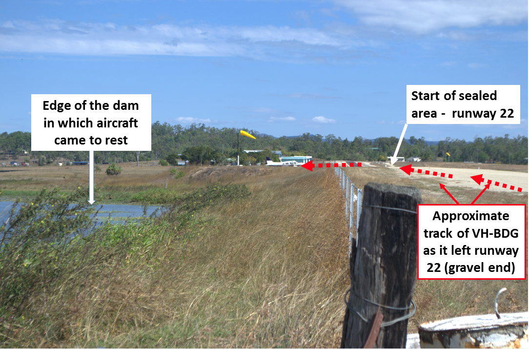
Once into the grassed area, and with the aircraft most probably airborne, it struck a wire fence (Figure 4) then the raised embankment of the dam, which ran perpendicular to the runway. The pilot reported that the left wing tip struck the water and the aircraft spun around and entered the water. At some point throughout this sequence, the main wheels detached from the aircraft. The pilot reported continuing to battle for control of the aircraft, up until it arrived in the water.
Figure 4: Looking along runway 22 taken a few days after the accident
Source: Pilot
Post water impact
When the aircraft settled on the surface of the water, the pilot reported yelling to the passengers to ‘get out’. The pilot then opened the front right door, pushed the passenger occupying the front right seat out, and then exited. The opening of the door resulted in the muddy water gushing inside and rapidly filling the aircraft. The passengers seated in the rear of the aircraft were unable to open the rear door. The water almost filled the entire cabin during this time.
The pilot was eventually able to get the rear door open from outside the aircraft and assisted some of the passengers out. The remaining passengers either made their own way out, or were assisted by other passengers.
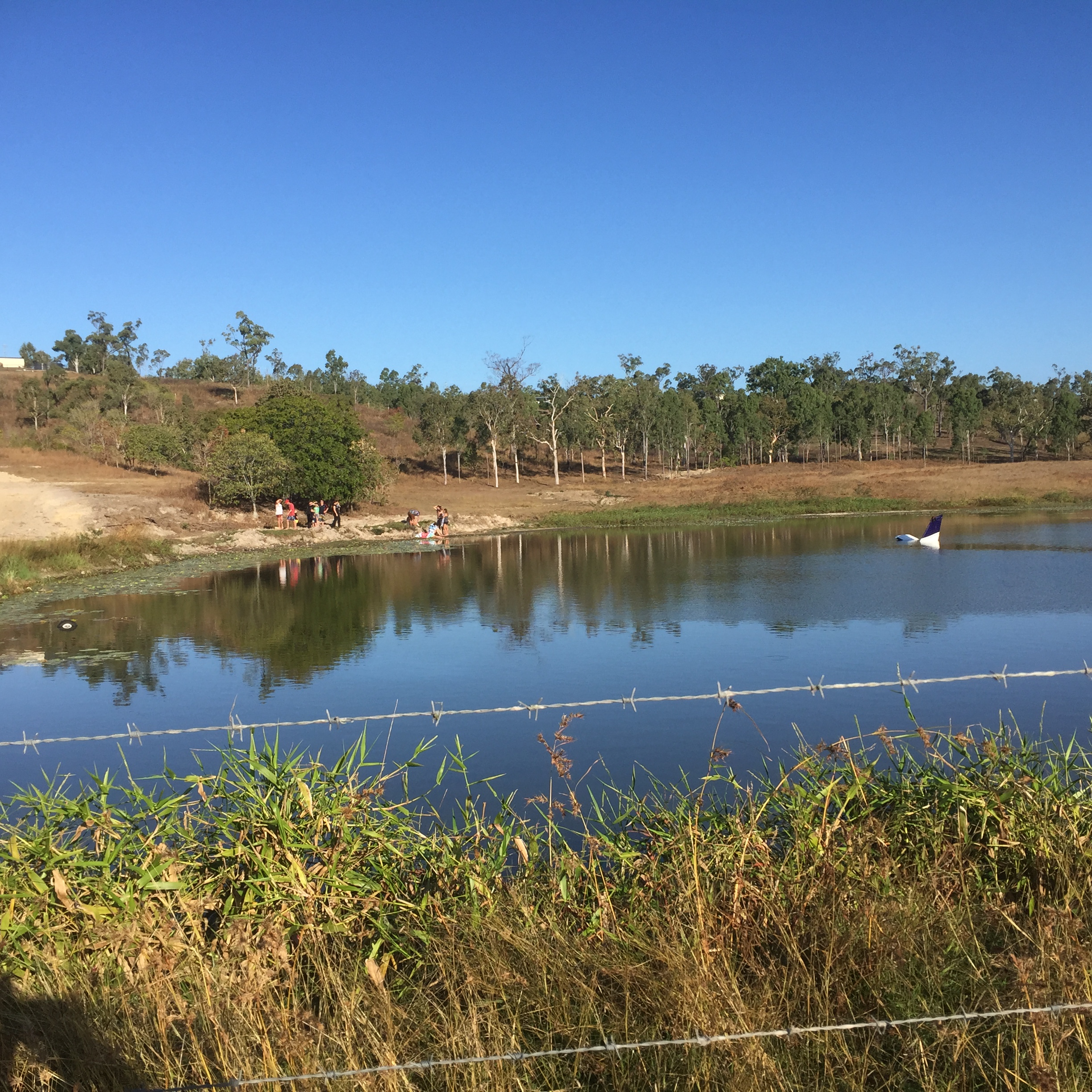
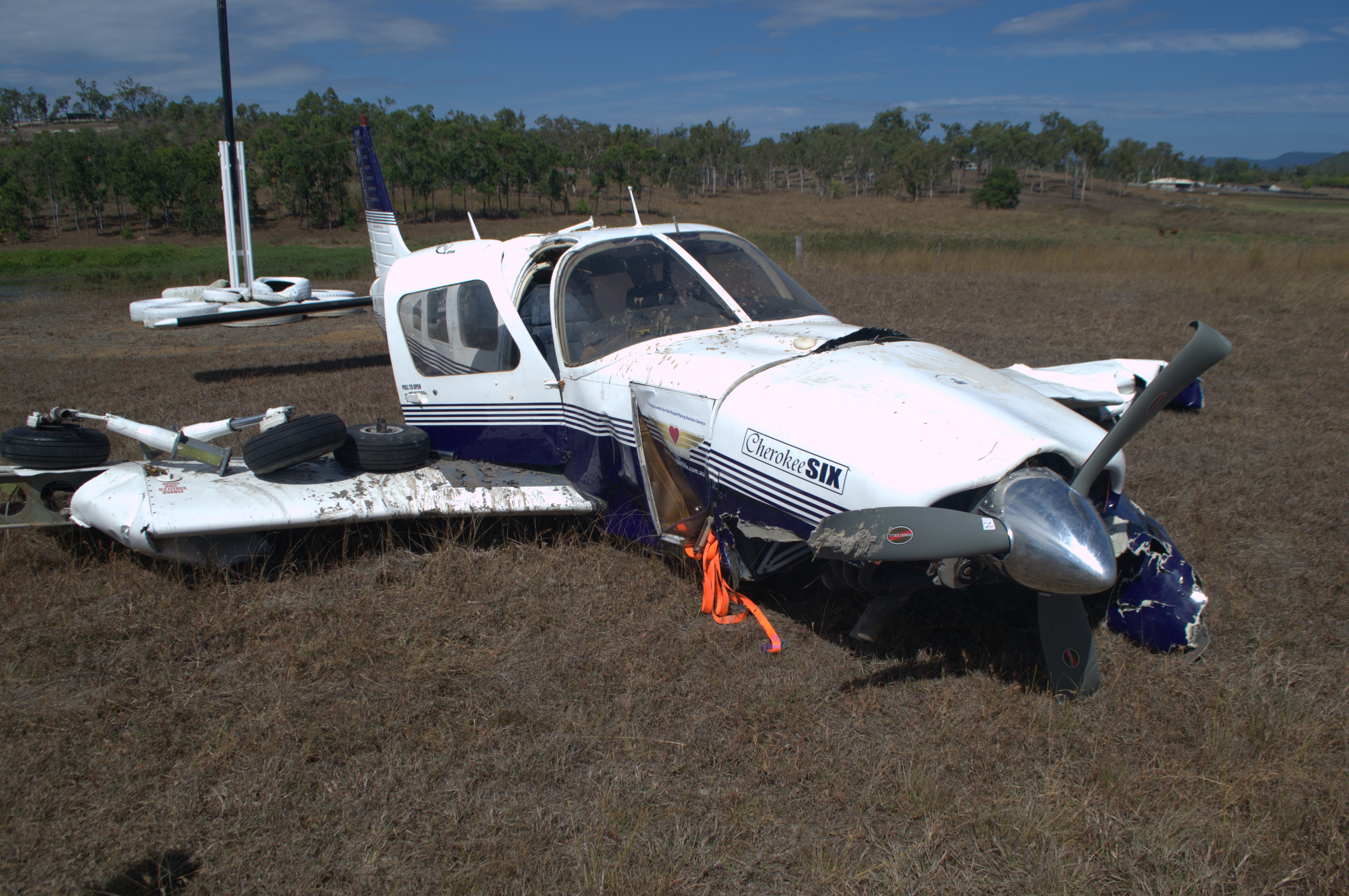
One of the passengers sustained serious injuries, and the pilot and another passenger, minor injuries. The aircraft was almost completely submerged resulting in substantial damage (Figures 5 and 6).
Figure 5: Post accident showing VH-BDG partially submerged in the dam
Source: Airpark operator
Figure 6: VH-BDG after retrieval from the lake. Passenger 2 (below) reported that the left wing crumpled during the ‘cartwheeling’ toward the lake. Note:Significant damage occurred during the retrieval process
Source: Pilot
Pilot experience and comments
The pilot had approximately 581 total flying hours with about 112 of these on Cherokee Six type aircraft. The pilot made the following points:
the hazard briefing conducted by the airpark operator some weeks earlier, included a request to land on the gravel area of the runway, as the seal was recently laid but had proved to be quite soft
both weight and balance, and performance calculations were conducted for the flight, however these documents were damaged when the aircraft became submerged
there may have been some wind shear or a down draft which contributed to the aircraft sinking on the approach
the tail scraping along the gravel and over the fence during the attempted go-around added extra drag, which detracted from the aircraft’s performance
Passenger comments
Three of the five passengers elected to provide their accounts of what happened.
Passenger one recalled:
there was no pre-flight safety briefing; the pilot just indicated where each of them should sit
during the landing approach, this passenger recalled thinking how low they were, when still some distance from touchdown
the tail struck the ground, and recalls power being applied after that
the aircraft flipping over and ‘cartwheeling’ toward the lake
Passenger two recalled:
there was no pre-flight safety briefing
during the approach to land they heard the pilot verbalising that the aircraft needed to slow down, and noted a significant decrease in speed
the aircraft tail dragging along the ground, and the pilot calling out for assistance
the left wing striking the ground and instantly crumpling (Figure 6)
the aircraft then ‘cartwheeled’ ending up in the lake
the water rose quickly in the aircraft when the front door was opened, leaving a very small pocket of air for the rear passengers
they were rescued by the pilot through the rear door
Passenger three recalled:
there was no pre-flight safety briefing
the aircraft struck the ground prior to the runway
the pilot shouted for assistance as the aircraft “went out of control during the approach”
the aircraft ‘cartwheeled’ before arriving in the dam
Meteorological data
The ATSB obtained the Bureau of Meteorology weather report for area 44 covering the time of the accident. Area 44 was in two divisions that day and the southern division, which applied to the area south of Proserpine, including Lakeside Airpark, forecast variable winds of about 10 knots.
Lakeside Airpark landing area
Lakeside Airpark Landing area was identified in Enroute Supplement Australia (ERSA) (28 May 2015 version) as “UNCR” meaning it is both uncertified and unregistered.
As per the requirement for operations at this aerodrome, the pilot sought prior permission to operate there and a briefing on local hazards from the aerodrome operator. This onsite briefing by the aerodrome operator pointed out local hazards such as the powerlines in the vicinity and the preferred protocol of taking-off on runway 04, and landing uphill on runway 22, wind permitting. There was no hazard map available as mentioned in the ERSA.
Advisory material
The Civil Aviation Advisory Publication (CAAP) 89O-1 (2) “Published aerodrome information andreporting changes (November 2000) is available on the CASA website. This publication provides advisory material for publishing aerodrome information and reporting changes in respect of both licenced and unlicensed aerodromes that are included in the (ERSA).
Unlicensed aerodromes:
Unlicensed aerodromes are not required, under the regulations, to provide aerodrome information to [Aeronautical Information Service] (AIS) or the [Civil Aviation Safety Authority] (CASA) and to have their aerodromes included in ERSA.
…unlicensed aerodromes may also be included in ERSA, on request of the aerodrome operators. However, the aerodrome information published will be of limited format, being of a non-operational nature…”
CASA is conducting a post-implementation review of CASR Part 139 – Aerodromes. As part of this project, this CAAP and other Part 139 CAAPs and ACs will be reviewed. Additionally, CASR Part 175, which regulates the publication of aeronautical information, commenced on 5 March 2015 and the contents of CAAP 89O-1 (2) will be reviewed, to be consistent with this new regulation.
ATSB comment
The ATSB did not undertake an onsite investigation into this accident, but were provided with information through telephone interviews, reports, and detailed photographs.
The ATSB was unable to reconcile the differences evident between the recollections of the pilot and those of the three passengers who provided information.
Safety message
This accident highlights the importance of thorough pre-flight planning and preparation to minimise safety critical decisions in flight.
CASA have an online kit ‘CASA Flight Planning Always Thinking Ahead” available from the downloaded from the CASA website.
This tool kit addresses the three levels of flight planning (the straightforward elements, unusual situations and whether to go) and their application over eight stages of flight.
The ATSB research report, Improving the odds: Trends in fatal and non-fatal accident in private flying operations(AR-2008-045) is available from the ATSB website.
This report encourages pilots to make decisions before the flight, continually assess the flight conditions, evaluate the effectiveness of their plans, set personal minimums, assess their fitness to fly, and to seek local knowledge (and if necessary a check flight) on the route and / or destination as part of the pre-flight planning process.
Also on the ATSB website, is a copy of the investigation (199804109) into a fatal accident involving another Cherokee Six aircraft (VH-POW). The pilot attempted to conduct a go-around from a degraded performance configuration with full flap extended and a nose-high attitude. The ATSB found that the aircraft's climb performance would have been substantially degraded with this configuration. The aircraft's nose-high attitude during the climb would have obstructed the pilot's forward vision and he may have been unaware that the aircraft had diverged from the extended centreline of the airstrip.
Decisions regarding whether to conduct an investigation, and the scope of an investigation, are based on many factors, including the level of safety benefit likely to be obtained from an investigation. For this occurrence, a limited-scope, fact-gathering investigation was conducted in order to produce a short summary report, and allow for greater industry awareness of potential safety issues and possible safety actions.
Publishing information
Released in accordance with section 25 of the Transport Safety Investigation Act 2003
Ownership of intellectual property rights in this publication
Unless otherwise noted, copyright (and any other intellectual property rights, if any) in this report publication is owned by the Commonwealth of Australia.
Creative Commons licence
With the exception of the Coat of Arms, ATSB logo, and photos and graphics in which a third party holds copyright, this publication is licensed under a Creative Commons Attribution 3.0 Australia licence.
Creative Commons Attribution 3.0 Australia Licence is a standard form licence agreement that allows you to copy, distribute, transmit and adapt this publication provided that you attribute the work.
The ATSB’s preference is that you attribute this publication (and any material sourced from it) using the following wording: Source: Australian Transport Safety Bureau
Copyright in material obtained from other agencies, private individuals or organisations, belongs to those agencies, individuals or organisations. Where you wish to use their material, you will need to contact them directly.
The pilot joined the circuit on downwind leg for runway 27. The wind was observed on the windsock to be swinging from south through to southwest. It was reported as 180/11 on the ATIS. On short final, full flap was selected and the speed reduced to 65 knots. As the pilot initiated the flare the aircraft encountered a wind gust which displaced it to the right of the sealed runway.
The pilot recovered but then encountered another gust which caused the right wing to drop. He applied full power to go around and got the wings level, but the aircraft then hit the ground hard on all three wheels with full power still applied. The nosewheel dug into the dirt and broke off. The aircraft then nosed over onto its back.
Factors
The following factors were considered relevant to the development of the accident:
1. The aircraft was affected by significant wind gusts at a critical stage during landing.
2. The pilot was unable to recover the aircraft from the effects of the wind gusts.
The aircraft was engaged in spraying cotton crops. At the commencement of the third run, the aircraft contacted the ground with the main landing gear and bounced back into the air. The spray run was completed after which the pilot was advised by his marker that the landing gear appeared to be damaged. This damage was confirmed by the pilot of another company aircraft, which was operating in the near vicinity.
The pilot continued with the treatment of the cotton crop until his load of chemical was exhausted, upon which the aircraft was flown to Narromine where, after a further assessment of the damage by a ground observer, emergency services were called out for the landing. During the subsequent landing on a grass strip, both main landing gear legs collapsed.
The helicopter was being used for yarding cattle, operating in a gusty 20-25 knot wind, when the pilot inadvertently turned downwind. As the helicopter began to sink the pilot made every attempt to correct the situation but was unable to regain control at the low operating height. The helicopter struck the ground with the front of the left hand skid, cartwheeled and came to a stop lying on its right hand side. The main rotor was probably in an over-pitched condition prior to impact. The pilot, who was the only occupant and wearing a flying helmet, was uninjured.
The pilot had calculated he would arrive at his destination five minutes before last light. Ten minutes before last light he realised the light was fading, so decided to land at a property airstrip he could see below. During the landing roll the left wing of the aircraft struck the star pickets of a barbed wire fence. The aircraft yawed to the left and the right main gear collapsed. The pilot had not seen the fence until it was struck by the left wing.
Occurrence summary
Investigation number
199303732
Occurrence date
25/10/1993
Location
Stirling Station
State
Northern Territory
Report release date
14/06/1994
Report status
Final
Investigation type
Occurrence Investigation
Investigation status
Completed
Mode of transport
Aviation
Aviation occurrence category
Collision with terrain, Forced/precautionary landing
The helicopter was being used for feral animal culling with the pilot and a shooter on board. Weather conditions at the time were hot, and the helicopter was operating close to its maximum all up weight. While flying downwind the helicopter began to sink and the pilot overpitched the main rotor system while attempting to recover. The resultant loss of rotor RPM caused the helicopter to descend rapidly and strike a tree. Both occupants escaped with minor injuries, but the helicopter was destroyed.
The pilot was mustering sheep on his property and had handed off two mobs to ground handlers. He was on his fourth pass and was in a 45-degree left turn, descending from 100 to 50 ft at about 70 kts when he realised that he was too close to the sheep and applied left rudder to slip the aircraft away from the sheep. He then attempted to bring the wings level with aileron and arrest the descent without releasing the left rudder pressure. As the aircraft approached 50 ft, the pilot realised he could not recover and closed the throttle. The aircraft struck the ground with the left wing. The propeller then contacted the ground and the aircraft cartwheeled, coming to rest in a distance of about 40 m facing 180 degrees from the direction of flight.