

Final report
Report release date: 15/09/2026
Investigation summary
What happened
On the night of 22 January 2026, a Cessna 172 (172), VH-KOJ, was being operated on a training flight with a flight instructor and student on board. At the same time, a Cirrus SR22, VH-XC5, was undertaking a personal transport flight with a pilot and 3 passengers on board. Both aircraft were operating under the night visual flight rules.
The 172 and the SR22 had both received air traffic control (ATC) clearance to orbit the Melbourne central business district (CBD) at 2,100 ft. The SR22 pilot was instructed to follow the slower preceding 172. During communications with ATC, the SR22 pilot advised they had the 172 sighted and would slow down. However, the SR22’s indicated airspeed remained faster than the 172, resulting in a sustained reduction of lateral separation between the 2 aircraft. As the 172 departed the orbit, the aircrafts’ flight paths converged and the separation between the aircraft reduced to about 46 m laterally and 99 ft vertically.
What the ATSB found
The ATSB found that the SR22 pilot did not maintain adequate spacing to the slower preceding 172 while both aircraft were conducting orbits of the Melbourne CBD. Although the pilot of the SR22 was provided traffic information for the 172 by ATC, and their traffic advisory system, they did not reduce the aircraft’s indicated airspeed sufficiently to maintain adequate spacing. Instead, the pilot of the SR22 elected to widen their orbit, which resulted in the aircraft tracks converging shortly after the 172 departed the orbit.
What has been done as a result
The operator of VH-KOJ advised the ATSB that all company pilots were briefed on the occurrence for awareness, and that a review of procedures for orbits of the Melbourne central business district was conducted. The ATSB was also informed that the organisation was in the process of implementing electronic flight bags to provide automatic dependent surveillance–broadcast traffic information for aircraft that were not equipped with the Garmin traffic alert system.
Safety message
Air traffic control sequencing is critical to the safe separation of aircraft operating within the same airspace, and pilots must accurately interpret and adhere to ATC clearances. Pilots should continuously assess the relative proximity of nearby aircraft using all available sources of information. Where the developing traffic situation no longer matches the anticipated scenario, the timely reassessment and implementation of an alternative course of action is essential to restoring adequate separation and reducing the risk of collision.
The investigation
| The ATSB scopes its investigations based on many factors, including the level of safety benefit likely to be obtained from an investigation and the associated resources required. For this occurrence, the ATSB conducted a limited-scope investigation in order to produce a short investigation report, and allow for greater industry awareness of findings that affect safety and potential learning opportunities. |
The occurrence
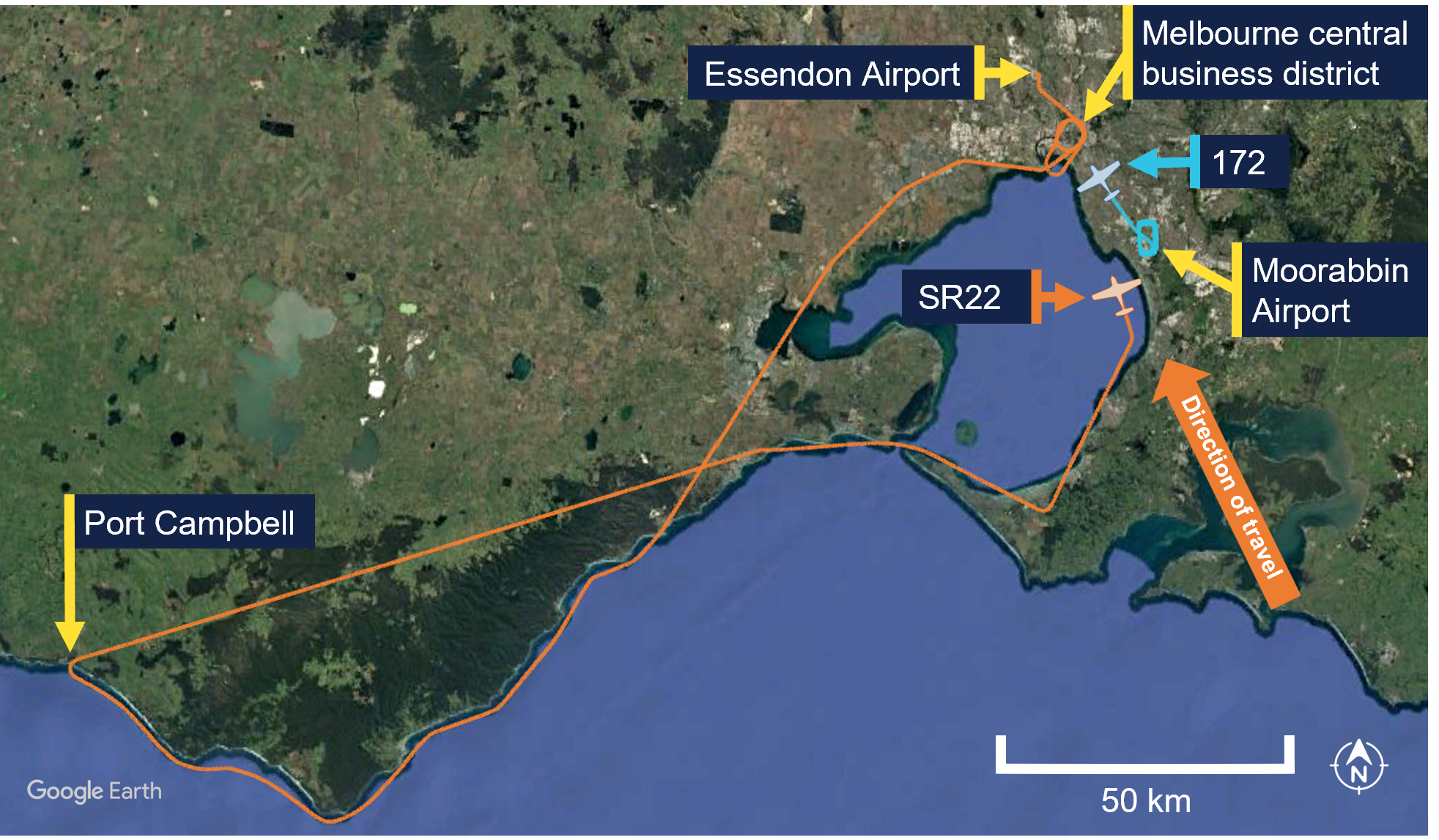
On the night of 22 January 2026, a Cessna 172 (172), registered VH-KOJ, was being operated on a training flight from Moorabbin Airport, Victoria, with a flight instructor and student on board. At the same time, a Cirrus SR22, registered VH-XC5, was returning to Essendon Airport, after undertaking a personal transport flight with a pilot and 3 passengers on board (Figure 1). Both aircraft were maintaining 2,100 ft and were being operated under night visual flight rules.1
Figure 1: Aircraft historical tracks and positions at 2142:19
At 2142:19 local time,2 the student on board the 172, who was the pilot flying, contacted Essendon Tower air traffic control (ATC) and requested approval to conduct one right‑hand orbit of the Melbourne central business district (CBD) (see Airspace information). This request was approved by ATC who issued a clearance for one right‑hand orbit at 2,100 ft.
At 2144:30, the pilot of the SR22 also contacted Essendon Tower ATC and requested approval to conduct 2 right-hand orbits of the CBD. ATC instructed the pilot they would be ‘number 2’3 for the orbits behind the 172 and cleared the SR22 for 2 right-hand orbits at 2,100 ft.
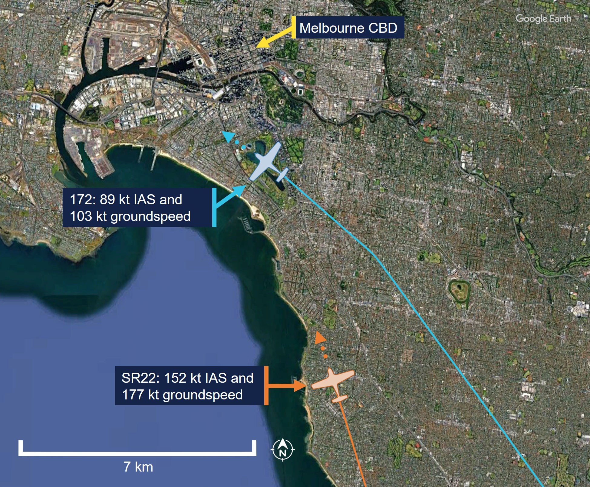
At 2145:02, the pilot of the SR22 advised ATC they had sighted the 172 on their traffic advisory system (TAS) (see Garmin traffic advisory system) and that they would follow the 172 and slow down. The SR22 pilot also had visual contact with the 172 and recalled that they could see the aircraft quite easily. Aviation routine weather report data for Essendon Airport from the Bureau of Meteorology issued at 2130 local time indicated the visibility was greater than 10 km with no cloud detected. At this time, the SR22 had an indicated airspeed (IAS)4 of 152 kt and a groundspeed5 of 177 kt, whereas the 172 had an IAS of 89 kt and a groundspeed of 103 kt. The distance between the 2 aircraft was 7 km (Figure 2). At that time, the SR22 and 172 were subjected to a tailwind component of 17 kt and 14 kt respectively. A short time later, the IAS of the SR22 began to decrease, although it remained faster than the 172 throughout the orbit.
Figure 2: Aircraft position and groundspeed at 2145:02
At 2145:37, ATC advised the student and instructor of the 172 that the SR22 would also be conducting right-hand orbits of the CBD at 2,100 ft and that the SR22 pilot had them in sight. This information was acknowledged by the student in the 172.
At 2145:47, the instructor of the 172 advised ATC they intended to exit the orbit via the south and, a short time later, ATC issued a clearance for the 172 to track to Williamstown from the Melbourne Cricket Ground (MCG) at 2,100 ft. The pilot of the SR22 heard these transmissions.
At 2148:16, ATC cleared the SR22 to proceed to Essendon Airport on completion of their orbits. At that time, the groundspeed of the SR22 was 55 kt faster than the 172 and the distance between the 2 aircraft had reduced to 1.9 km (Figure 3). The pilot of the SR22 recalled the 172 appeared to slow down to the east of the CBD. At that time, the 172 was experiencing a headwind component of 14 kt, while the SR22 was still experiencing a tailwind. In response, the SR22 pilot widened their orbit in an attempt to maintain separation.
Figure 3: Flight paths and lateral separation around the Melbourne CBD
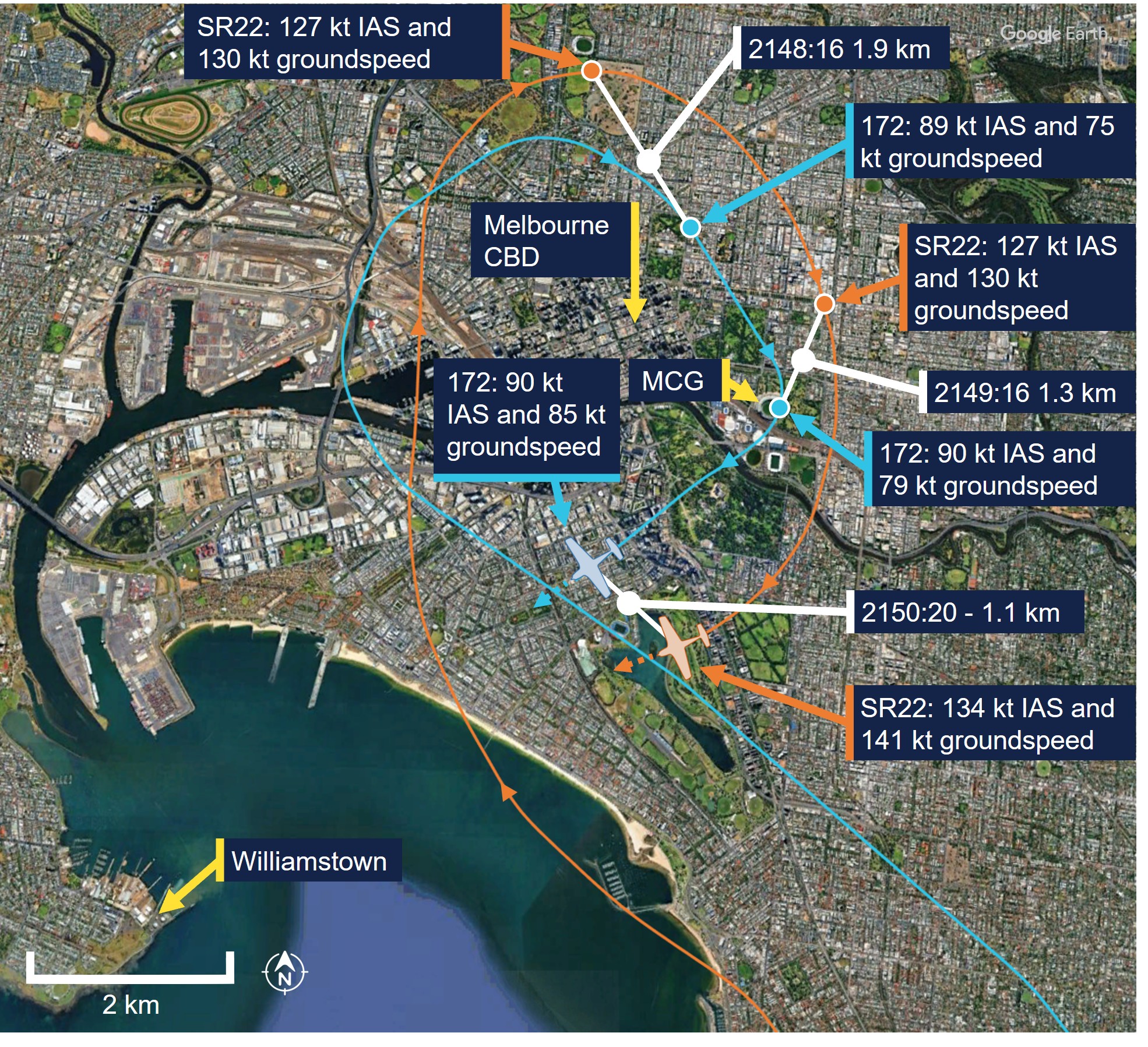
At 2149:16, the 172 overflew the MCG and turned onto a westerly heading towards Williamstown. At this time the distance between the 2 aircraft had reduced to 1.3 km. After the 172 overflew the MCG, the instructor and student observed a traffic advisory (TA) on their TAS. This alerted the pilots to traffic positioned behind the 172 on the left side at the same altitude, which they determined was the SR22 conducting CBD orbits. The instructor reported that they had previously observed TA’s while operating within an aerodrome circuit, which would prompt them to determine if a conflict risk existed.
On this occasion, they assessed that the position of the SR22 was consistent with their clearance and, although they could not see the SR22 behind their aircraft, they determined that no conflict existed. The pilot of the SR22 also recalled observing a TA, however they were focused on visually maintaining separation.
At 2150:20, the SR22 had a tailwind of 7 kt, while the 172 experienced a headwind of 5 kt. At that time, the SR22’s groundspeed was 56 kt faster than the 172 and the distance between the aircraft had reduced to 1.1 km. Around this time, the pilot of the SR22 recalled observing the relative position of the 172 moving to the right of their windshield. Both aircraft were located about 14 km to the south-south-east of Essendon Airport.
At 2150:36, the SR22 continued turning through a westerly heading with a groundspeed of 146 kt and encroached on the 172, which had a groundspeed of 86 kt, from behind the left wing. The student and instructor sighted the SR22 behind the left-wing strut heading directly towards the aircraft. The student recalled their initial reaction was to turn to the right. However, the instructor assumed control of the aircraft and recalled waiting to observe the avoiding action from the pilot of the SR22.
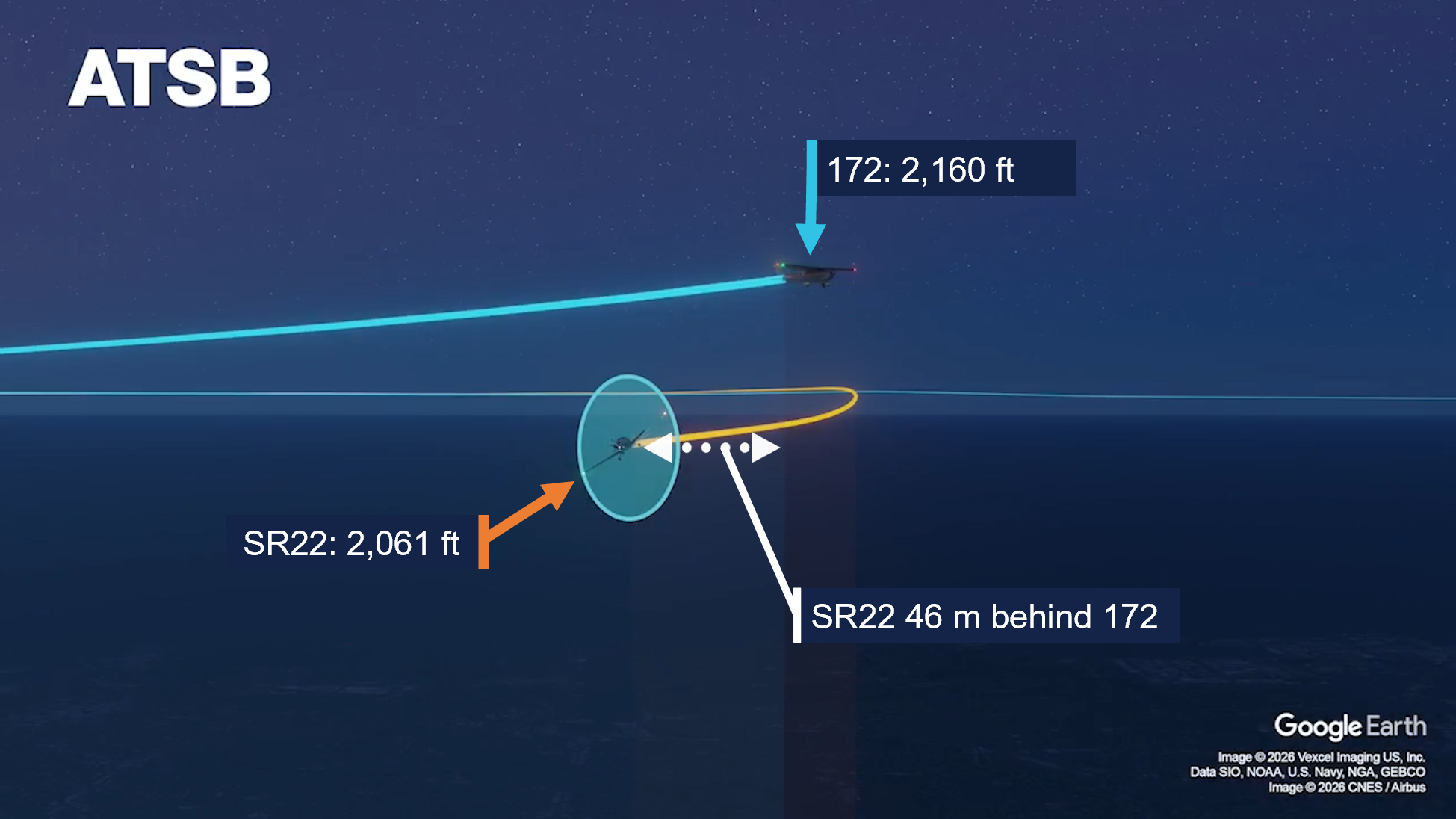
Around this time, the pilot of the SR22 recalled that the 172 became stationary in their windshield and assessed that the aircraft were on a collision course. At 2150:38, they pitched the aircraft down and descended from 2,100 ft shortly after. Having observed the SR22 descend, the instructor of the 172 then initiated a brief climb while maintaining a relatively consistent heading and IAS. At 2150:43, the SR22 passed 46 m behind and 99 ft below the 172 (Animation 1).
Animation 1: 172 and SR22 flight paths intersecting at 2150:43
No radio communication between the 2 aircraft took place following the encounter, nor was the incident advised to ATC, who had no awareness of the near collision at that time (see Essendon Tower). The student and instructor of the 172 and the pilot of the SR22 both assessed there was no further risk of conflict after visually confirming that the respective traffic had passed clear. The student and instructor on board the 172 continued the training flight, while the SR22 pilot elected to return to Essendon Airport after the completion of the first orbit.
Context
Personnel information
The pilot of the Cirrus SR22 held a Private Pilot Licence (Aeroplane) with night visual flight rules (NVFR) rating and a class 2 aviation medical certificate. They had a total of 850 hours of flying experience, of which 820 were on the SR22, and had flown 40 hours in the previous 90 days. They reported obtaining 10 hours of sleep in the preceding 24 hours and had been awake for 9 hours at the time of the occurrence, which occurred about 2 hours after departing Essendon Airport.
The instructor and pilot in command of the Cessna 172 (172) held a Commercial Pilot Licence (Aeroplane) with instrument, instructor and NVFR training ratings and a class 1 aviation medical certificate. They had a total of 685 hours of flying experience, of which 640 were on the 172 and had flown 144 hours in the previous 90 days. They reported obtaining 10 hours of sleep in the preceding 24 hours and had been awake for 10 hours at the time of the occurrence, which occurred 6 hours after they had signed on for duty.
The student in the 172 held a Private Pilot Licence (Aeroplane) with a class 2 aviation medical certificate and was undergoing training to obtain their Commercial Pilot Licence (Aeroplane). They had a total of 85 hours of flying experience, of which 84 were on the 172 and had flown 50 hours in the previous 90 days. They reported obtaining 8 hours and 30 minutes of sleep in the preceding 24 hours and taking a 30‑minute nap about 10 hours prior to the occurrence. The student also reported arriving at Moorabbin Airport about 2 and a half hours prior to the occurrence.
All pilots reported being ‘fully alert’ during the occurrence and the ATSB did not consider that fatigue affected the performance of the pilots at the time of the occurrence.
Aircraft information
The Cirrus SR22 is a low wing, 5-seat, composite (primarily) construction aircraft with fixed landing gear. It is powered by a single piston engine, driving a constant speed propeller and had a normal operating indicated airspeed range of 74–176 kt with the flaps retracted.
The Cessna 172 is a high-wing, 4-seat, all-metal aircraft with fixed landing gear. It is powered by a single piston engine, driving a fixed-pitch propeller and had a normal operating indicated airspeed range6 of 48–129 kt with the flaps retracted.
Both aircraft were equipped with the Garmin G1000 avionics suite and traffic advisory system (TAS) (see Garmin traffic advisory system).
Airspace information
Overview
The airspace over the Melbourne central business district (CBD) was designated as ‘controlled airspace,’ which included the Melbourne control zone (CTR) extending upwards from Tullamarine Airport and the adjacent class C airspace step (Figure 4). Aircraft wishing to enter controlled airspace are required to obtain an airways clearance from air traffic control (ATC).
Figure 4: Melbourne controlled airspace dimensions
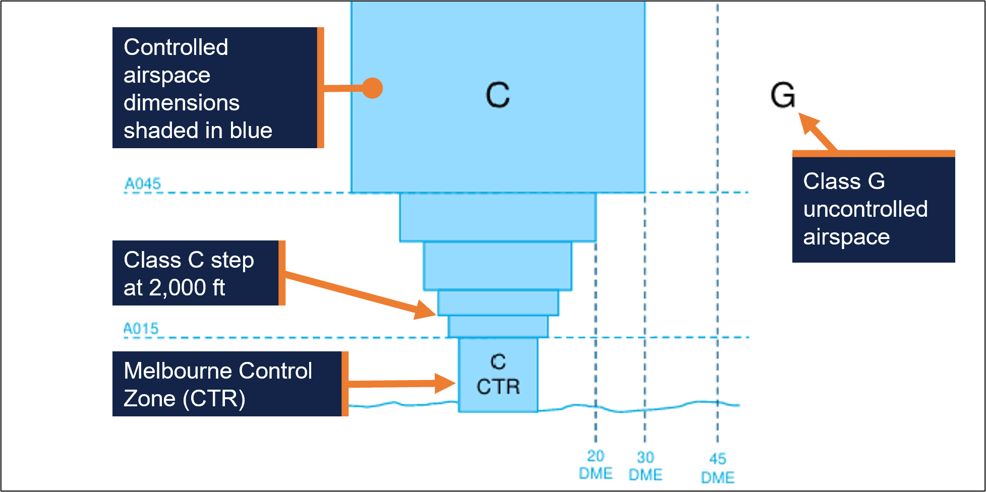
Within the Melbourne CTR and adjacent class C controlled airspace steps, class C procedures and services applied, which included separation between instrument flight rules (IFR) aircraft, and IFR and visual flight rules (VFR) aircraft.
ATC were not required to separate VFR aircraft within controlled airspace. However, VFR aircraft were provided with traffic information on other VFR aircraft and avoidance advice upon request.
Essendon tower
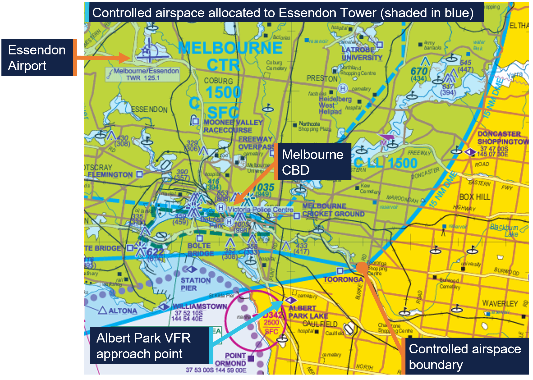
Tower controllers at Essendon Airport, located 11 km to the north-west of the Melbourne CBD, were responsible for managing the south‑eastern quadrant of the Melbourne CTR and the adjacent Class C steps up to and including 2,000 ft during the hours of operation.
All aircraft wishing to operate in this airspace were required to contact Essendon Tower (during the hours of operation) at the appropriate VFR approach point depicted on the Airservices Australia visual terminal chart (Figure 5).
Figure 5: Melbourne visual terminal chart
The controllers at Essendon tower relied primarily on visual observations to provide aerodrome control services within their allocated airspace. The Essendon tower was also fitted with a tower situation awareness display (TSAD), which was approved for the provision of surveillance system separation services and provided aircraft position information to enhance controller awareness.
The Airservices Australia Manual of Air Traffic Services7 stated that the TSAD may be used to assist controllers in meeting their responsibilities for the provision of aerodrome control services, traffic information, traffic sequencing and assistance to aircraft during an emergency. However, the system did not provide controllers with conflict alerting.
Rules of the air
The ‘right of way’ rules under part 91 of the Civil Aviation Safety Regulations (CASRs) (general operating and flight rules) stated that ‘a flight crew member must, during a flight, maintain vigilance, so far as weather conditions permit, to see and avoid other aircraft.’
Once an aircraft had been detected, part 91.330 of the CASRs described various circumstances and the applicable right of way rules which pilots must adhere to. The right of way rules applicable to the occurrence are listed in Table 1:
Table 1: Right of way rules
| Circumstance | Right-of-way rule |
|---|---|
Two aircraft are on converging headings at approximately the same altitude | The aircraft that has the other aircraft on its right must give way to the other aircraft. |
| If there is a collision risk | The aircraft that has the right of way to another aircraft must maintain the same heading and speed until there is no longer a risk of collision[1] |
| |
| Source: Civil Aviation Safety Authority, annotated and tabulated by the ATSB | |
See and avoid
In circumstances where aircraft are not provided with separation from other aircraft, as is the case for VFR aircraft operating in class C airspace, the primary method of separation is ‘see and avoid’ practices. This requires pilots to conduct a visual search to ‘see and avoid’ potentially conflicting traffic. The types of searches used to identify traffic are distinguished as either ‘unalerted’ or ‘alerted.’
An ‘unalerted’ search is one where reliance is entirely on the pilot searching for, and sighting, another aircraft without prior knowledge of its presence. On the other hand, an ‘alerted’ search is one where the pilot is alerted to another aircraft’s presence, typically via radio communications or aircraft based alerting systems. An alerted search is likely to be 8 times more effective than an unalerted search (Hobbs 1991).
While recent technological advances mean pilots can utilise electronic traffic alerting within the cockpit, it is critical that pilots sight other aircraft and maintain visual separation and not rely solely on the depiction of traffic on the device screen for traffic avoidance action (Civil Aviation Safety Authority, 2025).
Operational information
Garmin traffic advisory system
The Garmin traffic advisory system (TAS) fitted to both aircraft displayed traffic information for detected transponder-equipped aircraft to enhance crew situational awareness. Garmin documentation stated that the TAS was intended for ‘advisory use only to aid the pilot in visually acquiring traffic’.
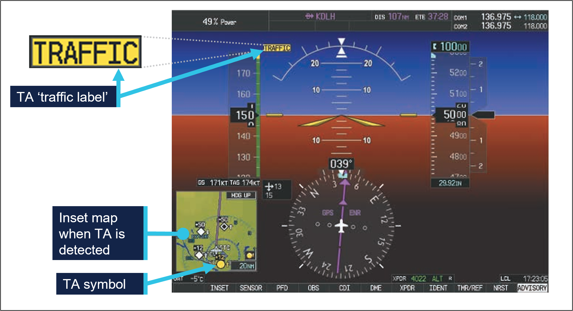
The TAS incorporated audio and visual alerts for detected conflicting traffic. These alerts were provided as a traffic advisory (TA), which may be generated based on range and altitude closure rate (time until collision) or if the intruder aircraft encroaches within a minimum distance.
When a TA is triggered, a single ‘TRAFFIC’ voice alert is generated, which is accompanied by relative bearing expressed as a clock code,8 altitude and distance. Additionally, a traffic annunciation along with a TA symbol (yellow circle) is displayed on the primary flight display (Figure 6). Garmin documentation also stated:
No avoidance manoeuvres should be based solely upon traffic information. It is the responsibility of the pilot in command to see and manoeuvre to avoid traffic.
Figure 6: TA annunciation and symbol on primary flight display
Recorded information
Airservices Australia recorded data
Airservices Australia provided the ATSB with radar and audio recordings for the evening of 22 January 2026. These recordings documented the communication exchange between the pilots of both aircraft and the tower controller at Essendon Airport. The radar recording also documented the flight paths of both aircraft.
Garmin G1000 recorded data
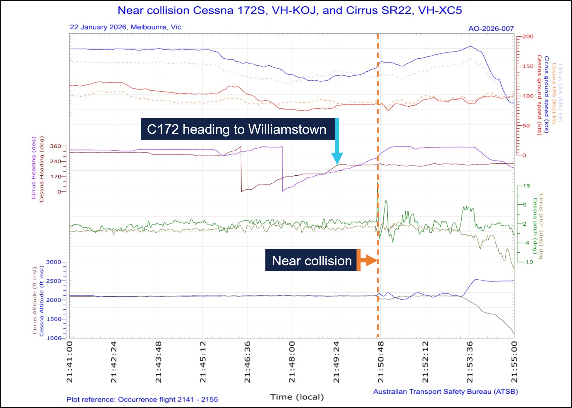
The Garmin avionics suite installed in the SR22 and 172 included a flight data logging feature that automatically stored critical flight and engine data on a removable data card. The ATSB was provided with the flight logs obtained from data cards installed in both aircraft at the time of the occurrence.
The recorded flight data captured parameters such as altitude, indicated airspeed, vertical speed, pitch attitude and bank angle Figure 7). This data enabled a detailed reconstruction of the flight, providing insights into the aircrafts’ flight paths and pilot actions during the occurrence.
Figure 7: Graphical representation of G1000 flight data from VH-KOJ and VH-XC5
Related occurrence
ATSB investigation AO-2025-033
On 12 June 2025, a student pilot conducting a solo navigation flight in a Piper PA‑44 was returning to Jandakot Airport, Western Australia, at the same time a Cessna 172 was approaching the airport from the training area. Air traffic control directed the pilot of the faster PA‑44 to overtake the 172 as they approached the circuit area. However, the PA‑44 did not pass the 172 prior to joining the circuit and, consequently, ATC amended the instruction to the pilot of the PA‑44 to ‘follow the Cessna’ and instructed the 172 pilot to join downwind and land first.
The ATSB found that the PA-44 pilot did not identify the final part of the amended instruction to ‘follow the Cessna’, likely due to receiving an unexpected cockpit traffic alert at the time the approach clearance was issued. Consequently, the PA‑44 pilot passed the 172 as per the original clearance, resulting in reduced separation between the 2 aircraft. The associated safety message highlighted the importance of aircraft sequencing, and the need for flight crew to seek confirmation from controllers if they are unsure of what is required of them or if the traffic scenario does not present as expected.
Safety analysis
Both the Cessna 172 (172) and Cirrus SR22 were operating under night visual flight rules (NVFR) in class C airspace while conducting orbits of the Melbourne central business district (CBD). A clearance from air traffic control (ATC) was required to undertake the orbits, but separation between NVFR traffic remained the responsibility of the pilot in command of each aircraft. While ATC was not responsible for providing separation, they did provide traffic information to both the pilot of the SR22 and the student and instructor on board the 172. Additionally, both aircraft were fitted with a traffic alerting system (TAS), which presented traffic information and further enhanced alerted see and avoid activities.
The pilot of the SR22 received an ATC clearance to orbit the CBD and follow the 172, which they understood. They advised ATC they would slow down to remain behind the 172, which they had on the TAS and visually acquired. However, although the indicated airspeed (IAS) of the SR22 reduced from 152 kt to 121 kt (momentarily) after obtaining the clearance to conduct the orbits, it remained significantly faster than the 172. During that time, the IAS of the 172 remained between 85–97 kt. While the SR22 had a higher normal operating airspeed than the 172, it was able to match the speed of the 172 during the orbit with flaps retracted. As the orbit progressed, both aircraft encountered a headwind and the SR22 pilot became aware that the 172 appeared to slow down relative to their own aircraft. In response, they elected to widen their orbit, however the separation between the 2 aircraft further reduced due to the higher groundspeed of the SR22.
The pilot of the SR22 then recalled hearing ATC issue a clearance to the 172 to track from overhead the Melbourne Cricket Ground (MCG) to Williamstown, which facilitated a southerly exit from the orbit. As the 172 overflew the MCG and turned towards Williamstown, the student and instructor on board the 172 received a traffic alert on their TAS. At that time the distance between the 2 aircraft had reduced to 1.3 km. The instructor determined that the traffic was the SR22, also conducting Melbourne CBD orbits, and assessed that no conflict existed. Given the traffic information for the SR22 provided by ATC, and the instructor’s previous experience with TAS, it was likely reasonable for the instructor to believe the SR22 was following ATC instructions and would remain behind the 172.
The SR22 pilot also received a traffic alert on their TAS, but at that time they had the 172 sighted and were attempting to understand the visual traffic picture. Had the pilot observed the relative position of the aircraft indicated on the TAS, this may have aided their situation awareness and provided an earlier indication of the relative positions of the aircraft and the reducing lateral spacing.
After the 172 began tracking towards Williamstown and the SR22 proceeded with the orbit to the south of the Melbourne CBD, the groundspeed differential between the 2 aircraft increased to 60 kt. This was a result of the relative airspeeds of the aircraft and the SR22 encountering a tailwind, while the 172 was still experiencing a headwind. The wide orbit of the SR22, in combination with the groundspeed differential and departure track of the 172, resulted in the flight paths converging.
Moments before the flight paths intersected, the student and instructor on board the 172 observed the SR22 behind the left-wing strut flying directly towards them. The pilot of the SR22 also observed that the 172 became stationary in their windshield, and they assessed that both aircraft were on a collision course.
In response, the pilot of the SR22 took avoiding action by initiating a descent while they continued turning right toward the north. Having observed the SR22 descending, the instructor in the 172 initiated a climb while maintaining a relatively consistent heading and IAS. In this instance, the 172 had the ‘right of way’, as it was positioned to the right of the SR22 prior to the flight paths intersecting, and the instructor’s actions were consistent with the right of way rules if there was a collision risk. The SR22 subsequently passed behind the 172 with 46 m horizontal and 99 ft vertical separation.
Although the traffic situation display used by Essendon Tower presented the radar positions of both aircraft, the system did not provide collision alerting. Additionally, both aircraft were located about 14 km away from the control tower at Essendon Airport, making it highly unlikely that the tower controller would have been able to visually detect the converging flight paths.
Contributing factor The Cirrus SR22 pilot did not maintain adequate spacing to the slower preceding Cessna 172 while both aircraft were conducting orbits at night over Melbourne, resulting in a near collision when the Cessna 172 departed the orbit and the flight paths intersected. |
Findings
ATSB investigation report findings focus on safety factors (that is, events and conditions that increase risk). Safety factors include ‘contributing factors’ and ‘other factors that increased risk’ (that is, factors that did not meet the definition of a contributing factor for this occurrence but were still considered important to include in the report for the purpose of increasing awareness and enhancing safety). In addition ‘other findings’ may be included to provide important information about topics other than safety factors. These findings should not be read as apportioning blame or liability to any particular organisation or individual. |
From the evidence available, the following findings are made with respect to the near collision involving Cessna 172S, VH-KOJ, and Cirrus SR22, VH-XC5, about 21 km south‑south‑east of Melbourne Airport, Victoria, on 22 January 2026.
Contributing factors
- The Cirrus SR22 pilot did not maintain adequate spacing to the slower preceding Cessna 172 while both aircraft were conducting orbits at night over Melbourne, resulting in a near collision when the Cessna 172 departed the orbit and the flight paths intersected.
Safety action
| Whether or not the ATSB identifies safety issues in the course of an investigation, relevant organisations may proactively initiate safety action in order to reduce their safety risk. The ATSB has been advised of the following proactive safety action in response to this occurrence. |
Safety action by the operator of VH-KOJ
The operator of VH-KOJ advised the ATSB that all company pilots were briefed on the occurrence for awareness, and that a review of procedures for orbits of the Melbourne central business district was conducted. The ATSB was also informed that the organisation was in the process of implementing electronic flight bags to provide automatic dependent surveillance-broadcast traffic information for aircraft that were not equipped with the Garmin traffic alert system.
Sources and submissions
Sources of information
The sources of information during the investigation included:
- the pilots of both aircraft
- the operator of VH-KOJ
- Civil Aviation Safety Authority
- Airservices Australia
- Bureau of Meteorology
- recorded data from the GPS unit on the aircraft.
References
Civil Aviation Safety Authority. (2025). Advisory Circular (AC) 92.3 v2.0 - ADS-B for enhancing situational awareness. Retrieved from https://www.casa.gov.au/ads-b-enhancing-situational-awareness
Federal Aviation Administration. (2016). Pilots’ Role in Collision Avoidance AC90-48D CHG 1. Retrieved from https://www.faa.gov/documentlibrary/media/advisory_circular/ac_90-48d_chg_1.pdf
Hobbs, A. (1991). Limitations of the see-and-avoid principle. Canberra: Australian Transport Safety Bureau. Retrieved from https://www.atsb.gov.au/sites/default/files/media/4050593/see_and_avoid_report_print.pdf
Submissions
Under section 26 of the Transport Safety Investigation Act 2003, the ATSB may provide a draft report, on a confidential basis, to any person whom the ATSB considers appropriate. That section allows a person receiving a draft report to make submissions to the ATSB about the draft report.
A draft of this report was provided to the following directly involved parties:
- the pilots of both aircraft
- the operator of VH-KOJ
- Civil Aviation Safety Authority
- Airservices Australia
- Bureau of Meteorology.
Submissions were received from:
- the pilot of VH-XC5
- the operator of VH-KOJ
- Civil Aviation Safety Authority
- Airservices Australia.
The submissions were reviewed and, where considered appropriate, the text of the report was amended accordingly.
Purpose of safety investigationsThe objective of an ATSB safety investigation is to improve transport safety through:
In accordance with the TSI Act, the ATSB does not investigate for the purpose of taking administrative, regulatory or criminal action, and cannot apportion blame, assist in determining liability, or, as a general rule, assist in court proceedings. About ATSB reportsATSB safety investigation reports are developed in accordance with ATSB procedures and guidelines, and with regard to applicable international standards and instruments. Reports must include factual material of sufficient weight to support the investigation’s analysis and findings. At all times the ATSB endeavours to balance the use of material that could imply adverse comment with the need to properly explain what happened, and why, in a fair and unbiased manner. An explanation of terminology used in ATSB investigation reports is available here. Publishing informationReleased in accordance with section 25 of the Transport Safety Investigation Act 2003 Published by: Australian Transport Safety Bureau © Commonwealth of Australia 2026 Ownership of intellectual property rights in this publication Unless otherwise noted, copyright (and any other intellectual property rights, if any) in this report publication is owned by the Commonwealth of Australia. Creative Commons licence 
With the exception of the Commonwealth Coat of Arms, ATSB logo, and photos and graphics in which a third party holds copyright, this report is licensed under a Creative Commons Attribution 4.0 International licence. The CC BY 4.0 licence enables you to distribute, remix, adapt, and build upon our material in any medium or format, so long as attribution is given to the Australian Transport Safety Bureau. Copyright in material obtained from other agencies, private individuals or organisations, belongs to those agencies, individuals or organisations. Where you wish to use their material, you will need to contact them directly. |
- ^ Visual flight rules (VFR): a set of regulations that permit a pilot to operate an aircraft only in weather conditions generally clear enough to allow the pilot to see where the aircraft is going.
- ^ Local time in Melbourne was Australian Eastern Daylight saving Time (AEDT), which is Coordinated Universal Time (UTC) +11 hours. Times in this report are AEDT unless otherwise noted.
- ^ When appropriate, air traffic control (ATC) will issue a sequencing instruction or sequence number. When issued with a sequencing instruction, a pilot must follow the preceding aircraft and continue to do so unless otherwise directed by ATC.
- ^ Indicated airspeed (IAS): indicated airspeed expressed in knots, used by pilots as a reference for all aircraft manoeuvres
- ^ Groundspeed: speed of the aircraft over the ground. This is the airspeed affected by the wind.
- ^ Lower limit is the maximum weight stall speed at the most forward centre of gravity with flaps retracted. Upper limit is the maximum structural cruising speed.
- ^ The Manual of Air Traffic Services is a joint document of Defence and Airservices and is based on the rules published in Civil Aviation Safety Regulations Part 172 – Manual of Standards and International Civil Aviation Organization standards and recommended practices, combined with rules specified by Airservices and Defence.
- ^ Used to denote the direction of an aircraft or surface feature relative to the current heading of the observer’s aircraft, expressed in terms of position on an analogue clock face. For example, 12 o’clock is ahead while an aircraft observed abeam to the left would be said to be at 9 o’clock.
Occurrence summary
| Investigation number | AO-2026-007 |
|---|---|
| Occurrence date | 22/01/2026 |
| Occurrence time and timezone | 2150 Australian Eastern Daylight saving Time |
| Location | About 21 km south-south-east of Melbourne Airport |
| State | Victoria |
| Report release date | 15/09/2026 |
| Report status | Final |
| Investigation level | Short |
| Investigation type | Occurrence Investigation |
| Investigation phase | Final report: Dissemination |
| Investigation status | Completed |
| Mode of transport | Aviation |
| Aviation occurrence category | Near collision |
| Occurrence class | Serious Incident |
| Highest injury level | None |
Aircraft details
| Manufacturer | Textron Aviation Inc. |
|---|---|
| Model | 172S |
| Registration | VH-KOJ |
| Serial number | 172S12147 |
| Aircraft operator | Oxford Aviation Academy (Australia) |
| Sector | Piston |
| Operation type | Part 141 Recreational, private and commercial pilot flight training |
| Activity | General aviation / Recreational-Instructional flying-Instructional flying - dual |
| Departure point | Moorabbin Airport, Victoria |
| Destination | Moorabbin Airport, Victoria |
| Injuries | None |
| Damage | Nil |
Aircraft details
| Manufacturer | Cirrus Design Corporation |
|---|---|
| Model | SR22 |
| Registration | VH-XC5 |
| Serial number | 9217 |
| Aircraft operator | Reserve Corporation Pty Ltd |
| Sector | Piston |
| Operation type | Part 91 General operating and flight rules |
| Activity | General aviation / Recreational-Sport and pleasure flying-Pleasure and personal transport |
| Departure point | Essendon Airport, Victoria |
| Destination | Essendon Airport, Victoria |
| Injuries | None |
| Damage | Nil |