
Final report
Report release date: 05/12/2025
Investigation summary
What happened
NSW TrainLink passenger service ST21 was running from Sydney, New South Wales, to Melbourne, Victoria, on the ARTC standard gauge interstate network. The service departed Sydney on the evening of 23 May 2022 and was approaching Melbourne the following morning, 24 May.
A temporary speed restriction (TSR) had been applied on the standard gauge track at the Moonee Ponds Creek Bridge, about 24 km from Melbourne. The TSR was an interim safety measure in response to a rough ride report made by the driver of an earlier train. Trains were being warned of the speed restriction by radio call from train control through a procedure known as a condition affecting network (CAN) warning. The CAN issued for the TSR advised of a 40 km/h speed restriction between 24 km and 24.4 km.
On the standard gauge route to Melbourne, track distances between 27 km and 16 km were repeated to accommodate a divergence of the standard gauge and broad gauge routes on the approach to Melbourne. For Melbourne-bound trains on the standard gauge route (such as ST21), track kilometres decreased down to 16 km before stepping back up to 27 km and then again reducing towards Melbourne. Moonee Ponds Creek Bridge was located about 3 km after this step change in track kilometrage.
ST21 received the CAN warning for the TSR. However, the train was slowed at the wrong location and crossed the Moonee Ponds Creek Bridge (the location of the TSR) at about 0703 travelling at between 100 km/h and 110 km/h. Soon after passing over the bridge, the driver recognised they may have slowed at the incorrect location and contacted ARTC train control.
What the ATSB found
The CAN warning issued to the driver of ST21 was ambiguous as it identified only the kilometrage without any further location description. The kilometrage of between 24.0 km and 24.4 km specified in the warning occurred twice on the path of train ST21, about 11 km apart. ST21 was slowed at the first 24.4 km location encountered and subsequently proceeded at high speed through the TSR location at the Moonee Ponds Creek Bridge.
The method of warning trains of a TSR was an administrative control which relied on the effective communication of information between train controllers and drivers, and its correct application. It was found that the administrative processes used by ARTC to warn train crew about temporary speed restrictions were vulnerable to errors in creation and communication. There were opportunities to improve existing processes and to adopt technology-supported solutions to reduce risk associated with the implementation of temporary speed restrictions.
What has been done as a result
ARTC has implemented an electronic system for generating CAN warnings that prompts train controllers to provide 2 types of location identification information. This is now the primary method ARTC uses for generating CAN warnings and should reduce the risks associated with missed information during creation of the warnings. ARTC also plans to upgrade the electronic system to enable digital transmission of CAN warnings to train crew. When implemented, this has the potential to reduce the risks associated with communication of warnings.
In addition, ARTC has undertaken several associated actions including the briefing of network controllers to raise awareness of kilometrage changes and the importance of including location information in CAN warnings. Briefings have been supported by the dissemination of updated information to controllers and other rail safety workers.
Safety message
In the Australian rail context, administrative processes have often been established for long periods of time while technology has improved. Opportunities exist for safety improvement in rail safeworking through the modernisation of administrative controls and adoption of technology-supported solutions.
The occurrence
Prior to the incident
On 23 May 2022, at about 2120 local time, the driver of a V/Line train experienced a rough ride at the Moonee Ponds Creek Bridge in the local government area of Merri-bek[1] in Victoria (Figure 1). This occurred while the train was travelling towards Melbourne on the Australian Rail Track Corporation (ARTC) interstate network.
Figure 1: A NSW TrainLink XPT on the Moonee Ponds Creek Bridge
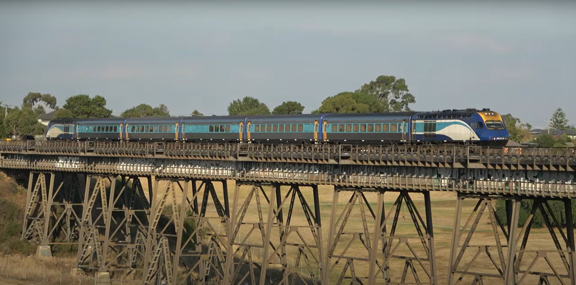
Source: Schony747
The driver reported the rough ride to the ARTC network control officer (NCO) responsible for the section of standard gauge track which included the Moonee Ponds Creek Bridge. This NCO controlled train movements between Somerton which was north of the bridge, and Melbourne to the south.
In response to the report and following discussion with maintenance personnel, the NCO placed a temporary speed restriction (TSR) of 40 km/h on a section of track between 24.0 track km[2] and 24.4 track km covering the Moonee Ponds Creek Bridge. For Melbourne-bound trains, the TSR commenced at 24.4 km and continued until the train passed 24.0 km.
The TSR location was on the standard gauge track about 3 km south of a step change in track kilometres at the Jacana flyover (see Location information). The step change was due to the longer route of the standard gauge line to Melbourne after it diverged from the broad gauge line at the flyover. This step change resulted in there being two 24.4 km locations about 11 km apart, one either side of the change at the flyover (Figure 2).
Figure 2: A schematic of the railway routes around the Jacana flyover
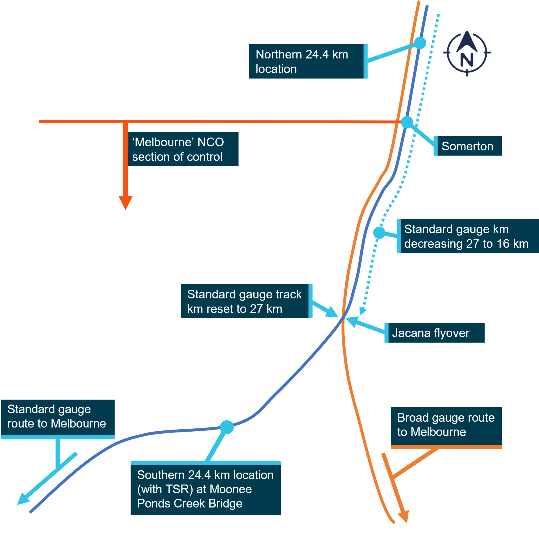
The schematic shows the kilometre change at Jacana flyover, the northern and southern 24.4 km locations and the northern limit of the NCO’s area of control. It is not drawn to scale. Source: Office of the Chief Investigator (OCI)
Journey of passenger train ST21
ST21 was a scheduled XPT passenger train service, operated by NSW Trains trading as NSW TrainLink,[3] from Sydney, New South Wales, to Melbourne in Victoria. It travelled from Sydney to Junee in southern New South Wales without incident, arriving at about 0228 on 24 May. At Junee, there was a driver change and the incoming driver was tasked to complete the journey to Melbourne. ST21 departed Junee soon after and crossed into Victoria about 2 hours later, continuing its journey to Melbourne.
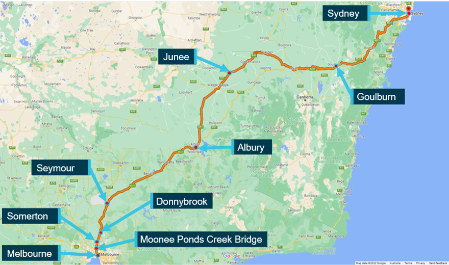
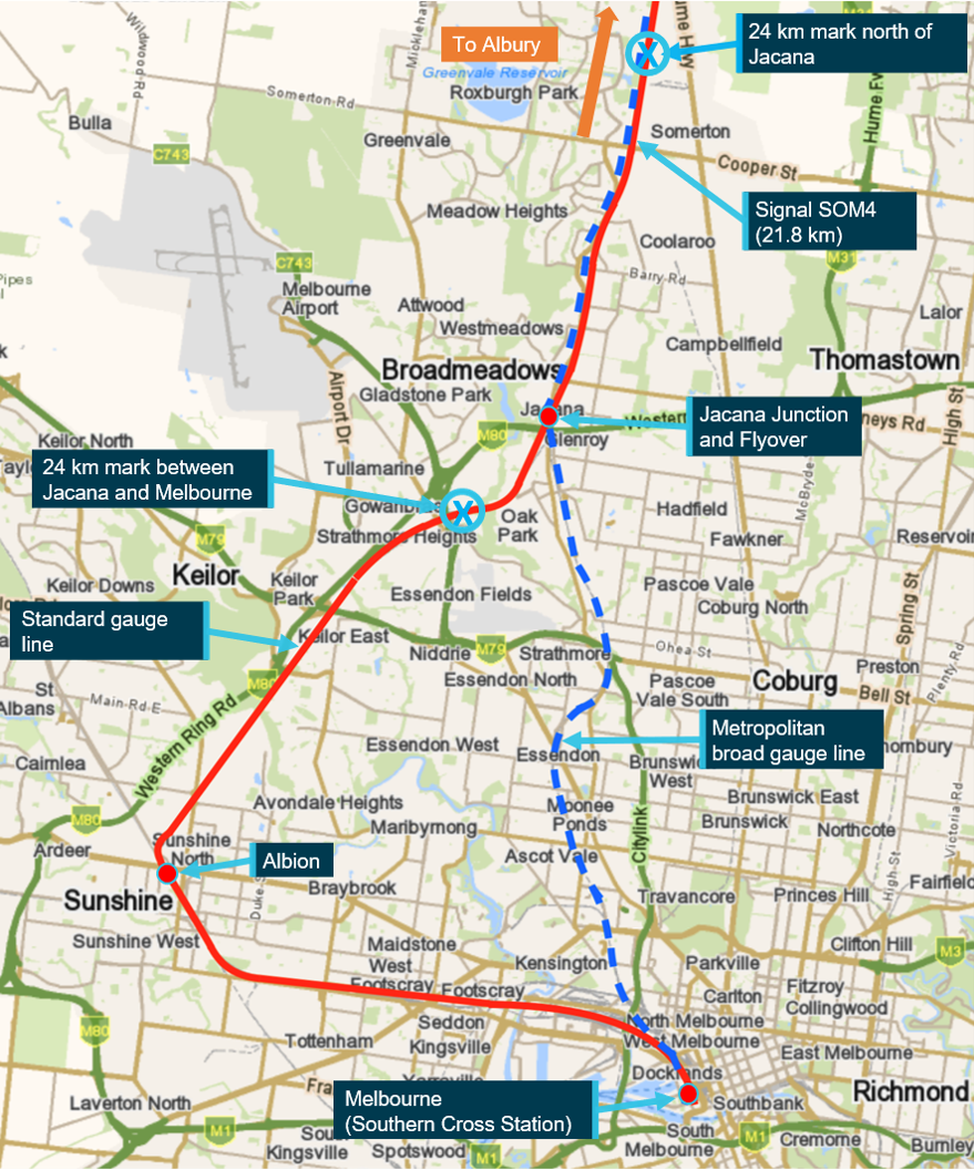
At about 0605, while passing Seymour, the driver of ST21 was contacted on the railway network radio by the NCO responsible for the Somerton to Melbourne section. This was not the same NCO who had initially received the rough ride report as a shift change had occurred. This second NCO advised that they needed to provide the driver with a condition affecting network (CAN) warning for a location between Somerton and Tullamarine.[4] The driver replied that their train was currently a long way away from there and they would contact the NCO when the train was closer (Figure 3).
Figure 3: Map of train ST21’s route
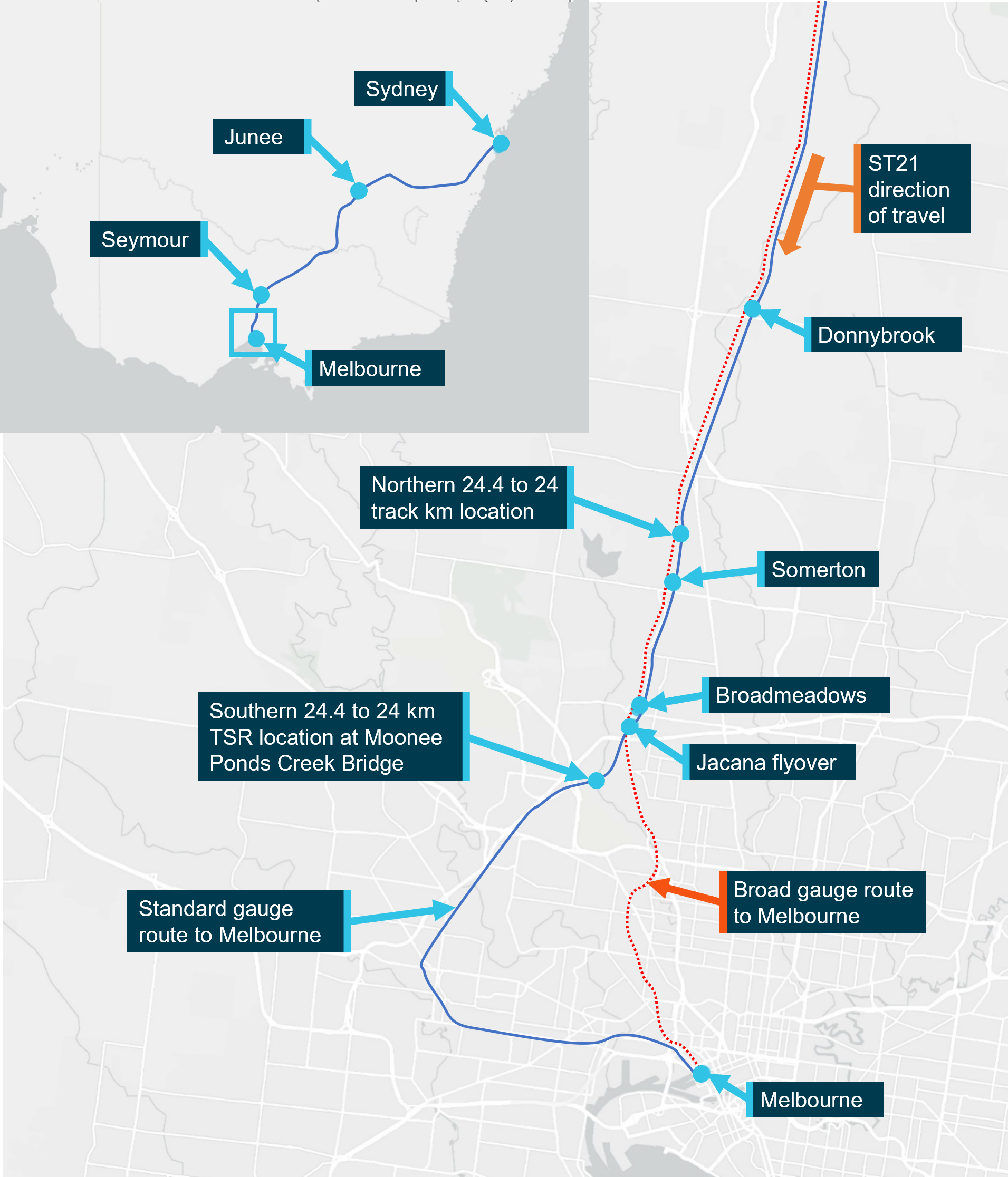
The map shows the Donnybrook to Melbourne section with the full journey from Sydney inset. It is not drawn to scale. Source: Digital Atlas of Australia, annotated by OCI
Subsequently at 0641, the driver stopped ST21 at Donnybrook (at about 38 km) and called the NCO to receive the CAN warning. The NCO issued the CAN warning to the driver, informing them that there was a 40 km/h TSR in place between 24.0 km and 24.4 km. This exchange involved the driver of ST21 transcribing the verbal advice received from the NCO onto their CAN form and reading it back. Descriptive location information, such as the applicable line section, or that the TSR was on a bridge was not discussed during this exchange.
After the radio exchange, ST21 resumed its travel towards Melbourne. The driver recalled that they placed their copy of the CAN warning form onto the driving console and began monitoring the kilometre markings that the train passed, comparing them to the kilometrage for the TSR location on the form. They recalled that they saw the 26 km post and prepared to slow their train.
At about 0653 the driver reduced the train’s speed to just under 40 km/h as ST21 approached the 24.4 km location north of the Jacana flyover. This reduced speed was maintained until, after passing 24.0 km, the speed of the train was increased to resume normal speed running.
ST21 continued its journey, passed Somerton and made a scheduled stop at Broadmeadows. It departed Broadmeadows with about 50 passengers on board and proceeded over the Jacana flyover, where the standard gauge track kilometres changed, resetting to 27 km.
ST21 overspeed
At about 0703, ST21 approached 24.4 km near the Moonee Ponds Creek Bridge (south of the Jacana flyover). The driver recalled seeing 2 track workers as the train approached the bridge. In response the driver sounded the horn to warn them of the train’s approach. The workers acknowledged the horn with an ‘all clear’ hand signal and the train proceeded across the bridge. The train’s speed was not reduced, and it went through the TSR location at between 100 km/h and 110 km/h. The driver recalled the transit felt rougher than usual.
Soon after, the driver sighted the 21 km post.[5] They recalled that this prompted them to consider their location, the rough ride, and the workers at the bridge. They realised that the CAN warning may have been for the section of track across the Moonee Ponds Creek Bridge, rather than the location where they had reduced speed earlier.
At about 0705 the driver called the NCO responsible for the section to clarify where the CAN warning applied and reported that they had reduced speed at the other 24.4 km location. This was a third NCO as another shift change had occurred.
The train continued and arrived at its destination, Southern Cross Station in Melbourne, at 0831. The CAN warning was cancelled at about 0836 by the duty NCO. This was done in response to a track work group reporting that they had found and repaired a track geometry issue associated with the rough ride report. No further trains passed over the location after ST21 while the CAN warning was in effect.
Context
Location information
Overview
The standard gauge route between Sydney and Melbourne is part of the interstate rail network managed by the Australian Rail Track Corporation (ARTC). For much of its length in Victoria, it runs parallel to (and east of) a broad gauge route that is used by both the Melbourne metropolitan network (to Craigieburn) and the Victorian regional network (to Seymour). However, when approaching Melbourne from the north, the standard gauge track took a more circuitous route to the south‑west that was 11 km longer than the broad gauge route (Figure 3).
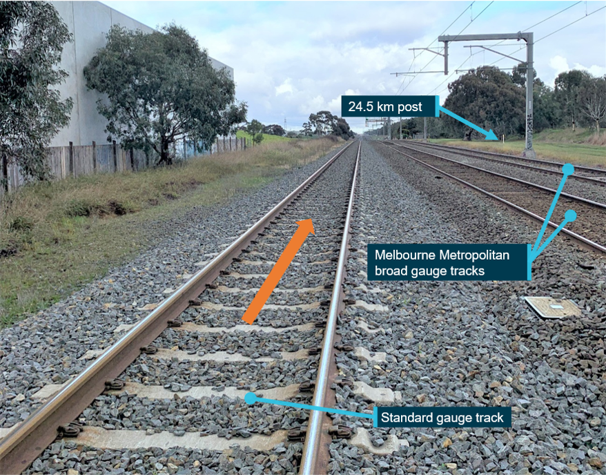
North of the Jacana flyover, the same track kilometrage was used for the parallel broad gauge and standard gauge tracks. The kilometres on these parallel routes were based on the distance to Melbourne travelling on the broad gauge route. An adjustment was required on the standard gauge track to accommodate its longer route to Melbourne. This adjustment was made at the Jacana flyover at which point kilometrage changed from 16 km back up to 27 km in the direction of travel of ST21 towards Melbourne (Figure 4).
Figure 4: Kilometre change notification on the standard gauge track at Jacana flyover
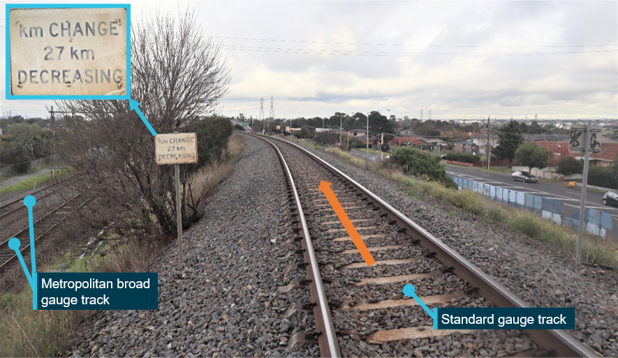
The figure shows the standard gauge track a short distance after it had passed over the broad gauge tracks at the Jacana flyover. The signage indicates a change (from 16 km) to 27 km and then kilometrage decreasing towards Melbourne. Source: OCI
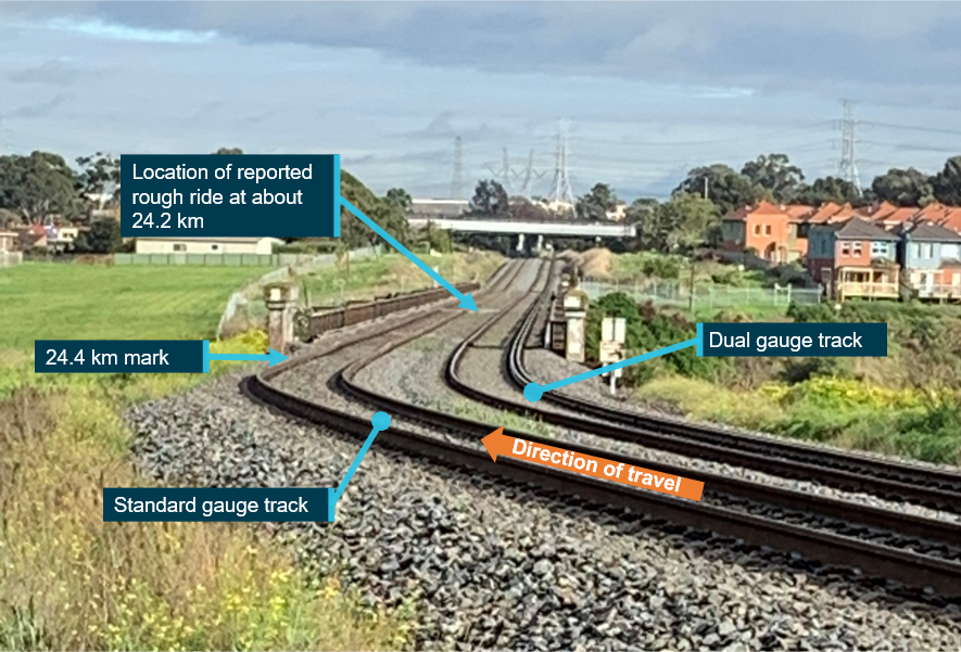
Location of the TSR
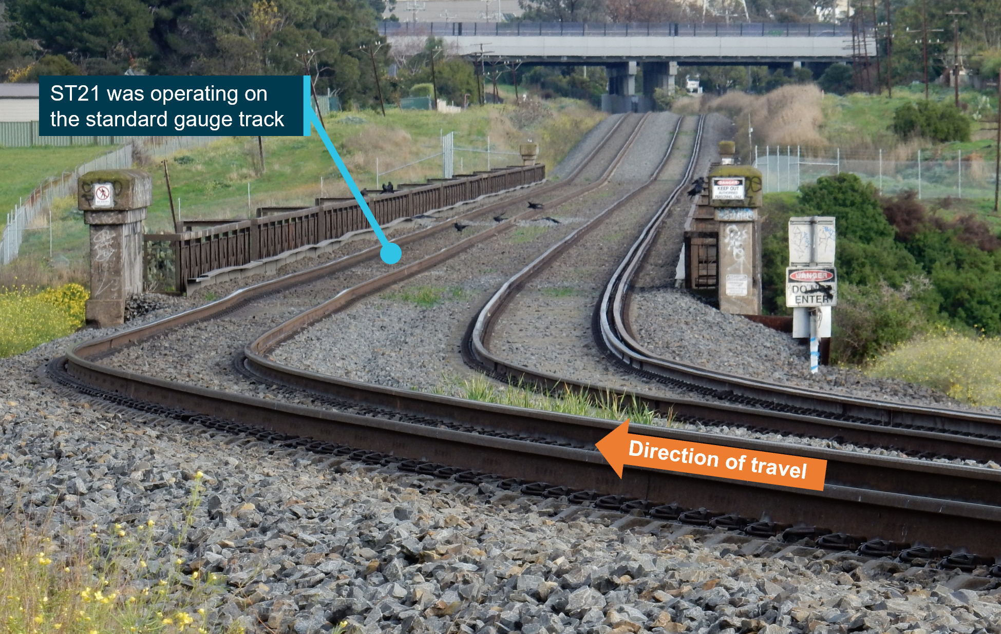
The Moonee Ponds Creek Bridge was a heritage listed steel trestle bridge which was first constructed in the 1920s. It carried a standard gauge track and a dual gauge track which formed part of the Tullamarine crossing loop. The dual gauge track was not used by either the V/Line train that reported the rough ride or ST21.
The 40 km/h temporary speed restriction between 24.0 and 24.4 km encompassed the full length of the bridge (Figure 5). The normal speed for the standard gauge track in this location was 115 km/h. In the direction of travel of ST21, immediately prior to the bridge was a curve with a 95 km/h speed limit.
Figure 5: The location of the TSR at the Moonee Ponds Creek Bridge
Source: OCI
Network control
Sections of control
Train movements on the standard gauge route from Sydney to Melbourne were controlled by ARTC. The route was comprised of several sections with a network control officer (NCO) designated to each section. Within Victoria, there were 2 sections of control:
- The section between Albury (New South Wales) and Somerton (Victoria). This section of control was referred to as ‘Main South C’ and was controlled by NCO located in Junee in New South Wales.
- The section between Somerton and Southern Cross Station (Melbourne). This was grouped with some other related sections that were together referred to as ‘Melbourne’. The group was controlled by NCO based at Mile End in South Australia.
The changeover between these 2 sections of control occurred at Somerton signal SOM 4, about 6 km north of the Jacana flyover.
Safeworking
Rail safeworking describes the system of operating rules and procedures used to provide safe operation of rail traffic and protection of people and property. ARTC operating rules for Victoria were defined in the ARTC Code of Practice for the Victorian main line operations (CoP).[6]
Section 1 of the CoP included rules related to reporting and responding to a condition affecting network (CAN). This included the need for:
- train drivers and track workers to report ‘conditions that can or do affect the safety of rail operations’ to the responsible NCO
- NCO’s to ‘give written warning to rail traffic crews using a CAN form’ in circumstances where ‘temporary speed restrictions have been reported and no signs erected’.
The CoP contained rules and procedures relating to the use of the CAN form and an example of the blank form.
ARTC also published a procedure relating to temporary speed restriction (TSR).[7] The procedure described that when train drivers reported a fault, the NCO was to notify a maintainer. The maintainer was to determine the appropriate response including the speed of any required TSR and the time required for implementing speed warning signs and inspection.
Rough ride report
Train drivers could report a rough ride to the relevant NCO when they considered that the dynamic response of their train to the geometry of the track had been excessive. It was sometimes also described as a ‘rough track’. On the evening prior to the occurrence the driver of a V/Line train had experienced a rough ride. They reported to the NCO that this occurred ‘at the approach to the bridge at 24.2’. The NCO asked for and received clarification from the driver that the location was at the Moonee Ponds Creek Bridge.
In response, the NCO contacted the track inspector for this track section (the maintainer) and informed them of the reported rough ride at the Moonee Ponds Creek Bridge. The track inspector recommended that a 40 km/h TSR be applied between 24.0 km and 24.4 km until the track could be inspected. The NCO recorded the location of the TSR on the train control graph.[8]
Condition affecting network (CAN) warning
The NCO prepared a CAN warning, to be issued to the drivers of trains that would pass through the location while the TSR was in place. The ARTC CoP required the CAN warning, as a TSR had been placed with no other method (such as signage) implemented to warn train drivers of the speed restriction.
The blank CAN warning form[9] included spaces in the relevant section for the NCO to enter the speed and location limits of the TSR. Within the spaces for the location limits was light grey text that read ‘location and km’ (Figure 6). There was no further instruction that described how to fill out this section of the form or supported the need to provide 2 methods of identifying locations (location and kilometres).
Figure 6: Extract from a blank CAN warning form with boxes for specifying TSR limits
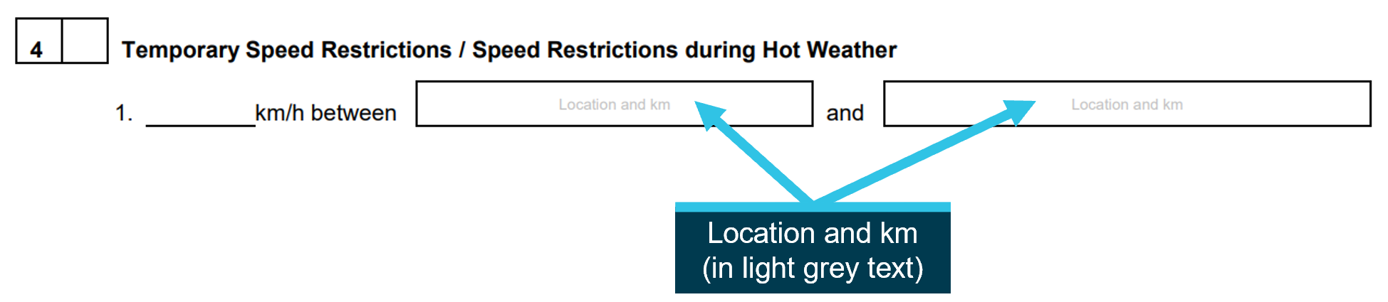
This CAN form extract shows the space provided for specifying TSR limits and some instruction on the required content in light grey text. Source: ARTC, annotated by OCI
The detail recorded by the NCO on the form was ‘40 km/h between km 24.000 and km 24.400’ (Figure 7). No other location information was included. The NCO had noted ‘no signs erected’ in section 5, to identify to drivers receiving the warning that speed warning boards were not present.
Figure 7: Sections 4 and 5 of the CAN warning form, as prepared by the NCO
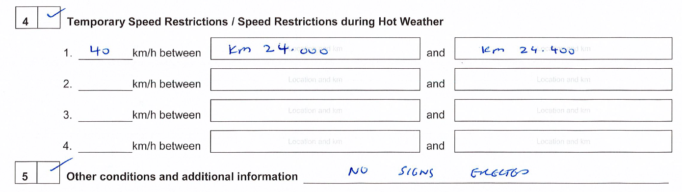
Source: ARTC
Issue of CAN warning
The NCO who prepared the CAN warning form did not issue it to any train drivers as there were no rail movements through the location before the end of their shift. The NCO who replaced them on the following shift issued the CAN warning to 6 train drivers, the last being the driver of train ST21. A third NCO, on the subsequent shift, issued the CAN warning to a single train driver before cancelling the warning following advice from track workers that a track issue related to the rough ride report had been repaired.
In all cases, the CAN warning was issued to train drivers by voice communication over network radio. Recordings of the network radio communication indicated that the NCO who issued the CAN multiple times followed a pattern. On 4 of 6 occasions,[10] including for ST21, they first contacted the train to inform them that a CAN warning was required for ‘Somerton to Tullamarine’. The CAN warning was then issued in a separate radio call. For ST21, the time between radio calls was long, about 36 minutes. However, for the 3 other trains, the time between the first contact and issuing the CAN warning was short, ranging from less than 1 minute to about 6 minutes.
Each time the NCO issued the CAN warning they read the contents of the form to the train driver. The driver transcribed it onto their own copy of the form and read it back to the NCO. The NCO then either confirmed that the readback was correct or appropriate corrections were made. Location information was not discussed during the issue of any of the CAN warnings other than the as written limits ‘between km 24.000 and km 24.400’.
Recorded information
Event recorder
The XPT train used Hasler RT data recorders fitted to the leading and trailing power cars. The tape from the leading power car (XP2003) showed the train speed from when the driver stopped the train to receive the CAN warning, at Donnybrook, until after it passed the location where the TSR was applied (Figure 8).
Figure 8: The tape recording from XP2003 showing train speed
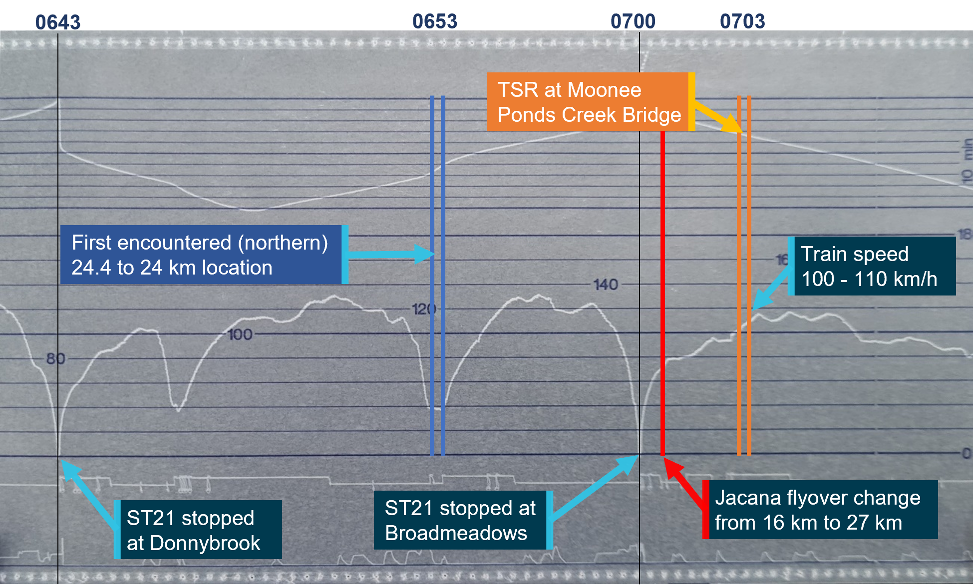
This figure shows the approximate train speed after departing Donnybrook. The location where the train slowed to below 40 km/h (the northern location) is shown in blue, and the location of the TSR (the southern location) is shown in orange. Source: NSW Trains, annotated by OCI
ST21 slowed at the first 24.4 km location encountered (the northern location). After travelling over the Jacana flyover where the kilometrage reset to 27 km, it then passed the southern 24.4 km location, where the TSR started, travelling at between 100 km/h and 110 km/h. This was below the normal 115 km/h speed limit and consistent with ST21 accelerating out of a preceding curve that had a 95 km/h speed limit.
ICE radio GPS speed
All trains operating on the ARTC network were required to be fitted with an In-Cab Communication Equipment (ICE) digital train radio system. ICE was specifically designed for the rail industry and integrates both voice and electronic (data) transmission and a GPS unit. The equipment on board the trains broadcast position and speed information, which was received and recorded by ARTC. Although the GPS recording frequency and precision were low, it provided an estimate of train speed.
Five other trains (all freight) were issued the CAN warning and passed over the rough ride location while the TSR was active and before ST21. The GPS recordings from these trains showed 3 had slowed to below 40 km/h while 2 exceeded this speed by substantial margins (Table 1).
Table 1: Estimated train speed
Train number | Nearest km post | Estimated speed (km/h) | Average speed (km/h) |
2CM7 | 25 24 | 74 78 | 76 |
1BM4 | 25 24 | 56 62 | 59 |
2CM3 | 25 24 | 39 32 | 36 |
2MB9 | 23 25 | 33 28 | 30 |
2SM7 | 25 24 | 35 36 | 35 |
Track geometry
The vertical track geometry at the rough ride location was measured by track workers on the day of the occurrence. They recorded that a 25 mm vertical geometry irregularity was present when measured at the mid-point of a 6 m chord. When compared to ARTC’s defect limits,[11] this irregularity was a defect requiring maintenance. ARTC reported that it was subsequently repaired by hand tamping, a process of lifting the track and packing ballast under the sleeper to support it.
Track geometry was also regularly measured by the track recording vehicle (the AK car). The most recent measurement was on 4 April 2022, about 7 weeks prior to the occurrence. ARTC’s exceedance report for this measurement did not include a geometry defect at or near the rough ride location.
Electronic transmission of TSR
ARTC’s code of practice permitted CAN warnings to be issued ‘using electronic transmission’. However, this was not an implemented method on ARTC track in Victoria at the time of the occurrence. Instead, the NCO provided the warning to the driver of ST21 by dictation and readback of a written CAN warning form using radio voice communication.
The standard radio installed on trains on the ARTC network was the ICE radio which was capable of providing both voice and electronic (data) to train drivers. The electronic transmission capability of the ICE radio system could transmit safeworking information, including notification of TSR locations. If electronic transmission was used, the information could be provided to drivers to read and respond to on an in-cab display. As the system monitored train locations by GPS, it could also provide an alert to drivers when their train was approaching a location with a TSR applied.
At the time of the incident, another Australian railway was using the ICE radio electronic transmission capability as part of its safeworking system (Hjort 2015). The system, as implemented, provided an alert to train drivers when they were approaching a TSR location.
Repeated track kilometres
The ARTC standard gauge network in Victoria contained at least 6 other locations where there was a step change in kilometrage at a fixed location. None occurred for the same reason as the change at Jacana flyover (alignment with a parallel track). However, at least 2 locations (at Pyrenees and Newport) created the realistic possibility of ambiguous location identification. This was because repeated kilometrage was separated by moderate distances.[12]
Some other railways have adopted kilometre identification processes that addressed this type of ambiguity. For example, a freight railway in the Pilbara region of West Australia used a prefix on kilometre markings that avoided duplication (Figure 9).
Figure 9: An example location marked using the ‘C’ prefix on an Australian railway
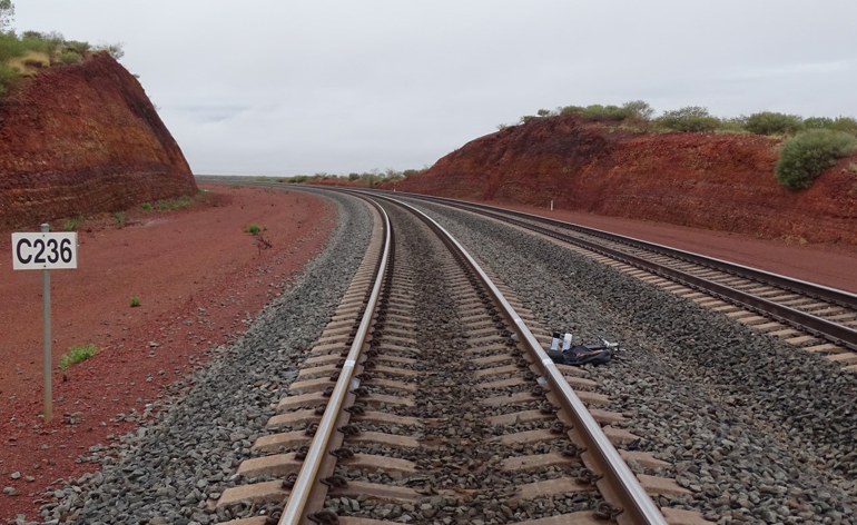
Source: Monash Institute of Railway Technology
On the Pilbara network, 2 parallel tracks deviated from each other and took different routes (with different path lengths) before realigning. There was a step change in track kilometres on the longer route when the tracks realigned that resulted in repeated kilometrage. Ambiguity was avoided as the kilometres on the longer route within the deviation were described with a ‘C’ prefix. The second instance of the same kilometres that occurred after tracks realigned were described without a prefix.
Studies and other occurrences
RAIB Safety digest: South Wales overspeeds
In 2025 the British Rail Accident Investigation Branch (RAIB) published a report into overspeed occurrences during blanket speed restrictions (RAIB Safety digest 03/2025). The report emphasised the importance of robust and effective processes for delivery of safety-critical messages about speed restrictions. Additionally, it encouraged the use of available technology (such as automatic radio broadcasts) to reinforce existing processes.
ATSB Safety study: Safe work on track
In 2017, the ATSB published the results of a safety issue investigation into reported notifiable occurrences while maintenance work was being performed on or near railway tracks (ATSB investigation RI-2014-011).
The study considered occurrences over a 5-year period between July 2009 and June 2014. It found that incorrect identification of worksite location (either position or limits) was one of the highest occurrence categories in terms of risk exposure to track workers. More than 50% of the occurrences in this category were assessed as having increased or high-risk exposure.
Although the study was related to work on track rather than train running, it quantified the risk associated with incorrectly identifying and communicating locations in systems of safeworking.
Relevant occurrences
Wallan derailment February 2020
In February 2020 near Wallan in Victoria, train ST23 proceeded through a turnout with a 15 km/h speed limit at high speed and derailed (ATSB investigation RO-2020-002). The investigation identified that the driver probably expected to remain on the straight track through Wallan (which was not speed restricted), rather than be routed through the loop at a restricted speed. Information on the routing of ST23 through Wallan Loop was provided to the driver in a paper document. The investigation highlighted an over‑reliance on administrative controls and the missed opportunities to use existing and emerging technologies to manage risk associated with human error.
TSR location errors in June 2023
On 8 June 2023, ARTC reported 2 occurrences[13] of incorrect location information being given to train crews on CAN warnings. They occurred in the context of a high workload for the NCO following track geometry measurements which required TSR’s at several locations at short notice.
In the first instance, at about 1100, a TSR was requested between 90.5 km and 90.7 km in the track section between Gheringhap and Inverleigh. However, the NCO recorded the location on the CAN warning form as between 95 km and 97 km. A train driver was issued the CAN warning and their train proceeded through the intended location of the TSR at normal speed before slowing at the location described on the CAN warning.
About one hour later, another TSR was requested, this time between 161 km and 161.7 km, although no additional location description was provided to the NCO. The NCO recorded that this was within the Barwon Park to Wingeel Loop track section on the CAN form, however the kilometrage was not within this section. A train driver was issued the CAN warning and their train proceeded through the location of the geometry defect at normal speed. As the train approached Wingeel Loop the train driver realised that the kilometre and section descriptions given did not match and reported the issue.
Safety analysis
Introduction
On 24 May 2022, the driver of train ST21 travelling from Sydney to Melbourne reported that they had unintentionally travelled over the Moonee Ponds Creek Bridge at high speed while a 40 km/h temporary speed restriction (TSR) was in place.
This analysis discusses:
- the warning for the temporary speed restriction
- train driver response to the warning
- systems used for temporary speed restrictions
- reporting of speed exceedance.
The warning for the temporary speed restriction
The location of the required 40 km/h TSR was at the Moonee Ponds Creek Bridge. The first NCO established that this was the location in communication with the reporting V/Line train driver. The NCO also conveyed this to the track inspector who specified the kilometre limits of the TSR which encompassed the bridge.
A CAN warning was then prepared by the NCO with the limits of the speed restriction described as being between 24.000 km and 24.400 km. This was inconsistent with the CAN form design which indicated that the limits of the TSR should include both km and location information. It was probably not an uncommon practice to include kilometre limits only, and none of the drivers issued with the CAN warning questioned the absence of a location description.
However, the specified limits could apply to 2 locations for rail traffic, due to the step change in kilometrage that occurred at the Jacana flyover. These locations were about 11 km apart and both were on the path of train ST21 from the location where the driver received the warning.
Both the NCO who created the CAN warning and the NCO who issued the warning to ST21 controlled the ‘Melbourne’ area of the ARTC network. This area included the 24.4 km location south of the Jacana flyover. It did not include the other 24.4 km location north of Somerton. This probably contributed to a belief by both NCO’s that the kilometre limits alone adequately described the location.
Contributing factor The warning for the temporary speed restriction identified the location using kilometrage, without a location description. The specified kilometrage occurred twice along the path of train ST21, about 11 km apart. |
Train driver response to the warning
The driver of ST21 described that, after receiving the CAN, they began monitoring the approaching kilometre posts. Around the 26 km post, they commenced slowing in anticipation of arriving at 24.4 km. The train’s event recorder indicated that it slowed to 40 km/h as it approached the first (northern) 24.4 km location.
After observing the 24 km post, ST21 resumed normal speed. The driver believed that the CAN warning had been complied with and no longer actively monitored kilometre markings for the TSR location. Subsequently, they did not slow at the location of the TSR. Instead ST21 accelerated from 100 km/h to 110 km/h through the second (southern) 24.4 km to 24.0 km location.
There was additional information available to the driver of ST21 relating to the location of the TSR. In a conversation about 36 minutes before receiving the CAN warning, the NCO advised the driver of the need to issue a warning for the section ‘Somerton to Tullamarine’. In addition, the communicating NCO was only responsible for the section south of Somerton which did not include the first (northern) 24.4 km location. It is unlikely that the driver considered the earlier conversation with the NCO or the NCO’s area of control when receiving and implementing the CAN warning.
Contributing factor Train ST21 was slowed at the first 24.4 km location encountered and subsequently proceeded at high speed through the second 24.4 km location where the temporary speed restriction applied. |
Systems used for temporary speed restrictions
A CAN warning was the method used by ARTC to immediately slow rail traffic in response to the rough ride report. It was implemented until any potential risk associated with the rough ride report could be assessed and appropriately addressed. It was an administrative control which relied on the effective communication of information between NCOs and drivers, and the correct application of the information.
The hierarchy of controls is a commonly understood concept that describes the relative effectiveness of different types of risk controls. Administrative controls include work methods or procedures that are designed to minimise exposure to a hazard as well as the information, training and instruction needed to ensure workers can work safely (Safe Work Australia 2018). Administrative controls are recognised as having comparatively low effectiveness but are used when higher levels of control such as engineering controls or elimination are not available. They can be vulnerable to unintentional error including in implementation and communication.
The vulnerability of administrative systems to unintentional error has been highlighted in research, other investigations and repeat events. A report into overspeed occurrences in the United Kingdom emphasised the importance of robust and effective processes for the delivery of safety-critical communication of speed restrictions. A further study showed that incorrect identification of location was one of the event categories that commonly exposed track workers to high safety risk. Occurrences on the ARTC network in June 2023 are further examples of the vulnerability of its administrative systems for applying TSR.
In this occurrence, the communicated location information was ambiguous. This was due to the presence of duplicated track kilometres in this area and the omission of other forms of location description. Opportunities to reduce the likelihood of ambiguity using existing controls included:
- the use of prefixes on duplicate kilometre markings to create distinction, as implemented by another Australian railway
- improvement in the CAN warning form design by creating separate fields for km and location, reducing the likelihood of omission
- greater clarity in work instructions to reinforce the requirement to describe location.
There was also opportunity to implement technology-supported solutions with the potential to reduce risk associated with the implementation of temporary speed restrictions. This included solutions utilising ICE radio (as fitted to all trains on the ARTC network). Another local network utilised ICE radio to alert drivers as they approached a TSR location. If well designed, such systems provide opportunities to reduce or eliminate many of the possible location‑related errors that may occur.[14]
Other factor that increased risk The administrative controls used by ARTC to warn train crew about temporary speed restrictions were vulnerable to errors in creation and communication. There were opportunities to improve the effectiveness of existing controls and adopt technology-supported solutions. (Safety issue) |
Reporting of speed exceedance
The driver voluntarily reported the overspeed to train control immediately after becoming aware that it had occurred, as they were concerned that other trains may also overspeed through the TSR location. Their action, and the motivation for it, was representative of a commitment to safety.
Other finding The driver of ST21 self-reported the overspeed to train control, promptly informing others of the risk. |
Findings
ATSB investigation report findings focus on safety factors (that is, events and conditions that increase risk). Safety factors include ‘contributing factors’ and ‘other factors that increased risk’ (that is, factors that did not meet the definition of a contributing factor for this occurrence but were still considered important to include in the report for the purpose of increasing awareness and enhancing safety). In addition, ‘other findings’ may be included to provide important information about topics other than safety factors. Safety issues are highlighted in bold to emphasise their importance. A safety issue is a safety factor that (a) can reasonably be regarded as having the potential to adversely affect the safety of future operations, and (b) is a characteristic of an organisation or a system, rather than a characteristic of a specific individual, or characteristic of an operating environment at a specific point in time. These findings should not be read as apportioning blame or liability to any particular organisation or individual. |
From the evidence available, the following findings are made with respect to the exceedance of temporary speed restriction by XPT ST21 in Merri-bek, Victoria, on 24 May 2022.
Contributing factors
- The warning for the temporary speed restriction identified the location using kilometrage, without a location description. The specified kilometrage occurred twice along the path of train ST21, about 11 km apart.
- Train ST21 was slowed at the first 24.4 km location encountered and subsequently proceeded at high speed through the second 24.4 km location where the temporary speed restriction applied.
Other factors that increased risk
- The administrative controls used by ARTC to warn train crew about temporary speed restrictions were vulnerable to errors in creation and communication. There were opportunities to improve the effectiveness of existing controls and adopt technology-supported solutions. (Safety issue)
Other findings
- The driver of ST21 self-reported the overspeed to train control, promptly informing others of the risk.
Safety issues and actions
Central to the ATSB’s investigation of transport safety matters is the early identification of safety issues. The ATSB expects relevant organisations will address all safety issues an investigation identifies. Depending on the level of risk of a safety issue, the extent of corrective action taken by the relevant organisation(s), or the desirability of directing a broad safety message to the Rail industry, the ATSB may issue a formal safety recommendation or safety advisory notice as part of the final report. All of the directly involved parties were provided with a draft report and invited to provide submissions. As part of that process, each organisation was asked to communicate what safety actions, if any, they had carried out or were planning to carry out in relation to each safety issue relevant to their organisation. Descriptions of each safety issue, and any associated safety recommendations, are detailed below. Click the link to read the full safety issue description, including the issue status and any safety action/s taken. Safety issues and actions are updated on this website when safety issue owners provide further information concerning the implementation of safety action |
Implementing temporary speed restrictions
Safety issue number: RO-2022-005-SI-01
Safety issue description: The administrative controls used by ARTC to warn train crew about temporary speed restrictions were vulnerable to errors in creation and communication. There were opportunities to improve the effectiveness of existing controls and adopt technology‑supported solutions.
Glossary
| ARTC | Australian Rail Track Corporation |
| CAN | Condition affecting network |
| CoP | Code of Practice |
| ICE | In-Cab communications equipment |
| NCO | Network Control Officer |
| TSR | Temporary speed restriction |
Sources and submissions
Sources of information
The sources of information during the investigation included the:
- ARTC
- Driver of ST21
- Network Control Officer
References
Hjort, G., (2015). Implementation of electronic train order working on the NSW country regional network. AusRAIL 2015.
Safe Work Australia, (2018). Code of Practice – How to manage work health and safety risks.
Submissions
Under section 26 of the Transport Safety Investigation Act 2003, the ATSB may provide a draft report, on a confidential basis, to any person whom the ATSB considers appropriate. That section allows a person receiving a draft report to make submissions to the ATSB about the draft report.
A draft of this report was provided to directly involved parties. The submissions were reviewed and, where considered appropriate, the text of the report was amended accordingly.
Rail safety investigations in VictoriaRail safety investigations in Victoria are conducted by the Office of the Chief Investigator (OCI) in accordance with a collaboration agreement with the ATSB. OCI is the operational office of the Chief Investigator, Transport Safety, a statutory position established in the Transport Integration Act 2010 (Vic) to provide independent, no-blame investigation of transport safety matters in Victoria. Under the collaboration agreement with the ATSB, OCI staff exercise powers and perform functions under the Transport Safety Investigation Act 2003 (Cth), and reports are approved for release under the TSI Act by the ATSB Commission. Purpose of safety investigationsThe objective of a safety investigation is to enhance transport safety. This is done through:
Investigations under the TSI Act do not apportion blame or provide a means for determining liability. At the same time, an investigation report must include factual material of sufficient weight to support the analysis and findings. Under the TSI Act investigations endeavour to balance the use of material that could imply adverse comment with the need to properly explain what happened, and why, in a fair and unbiased manner. TSI Act investigations are not for the purpose of taking administrative, regulatory or criminal action. About ATSB reportsATSB investigation reports are organised with regard to international standards or instruments, as applicable, and with ATSB procedures and guidelines. An explanation of terminology used in ATSB investigation reports is available here. This includes terms such as occurrence, contributing factor, other factor that increased risk, and safety issue. Publishing informationReleased in accordance with section 25 of the Transport Safety Investigation Act 2003 Published by: Australian Transport Safety Bureau © Commonwealth of Australia 2025 
Ownership of intellectual property rights in this publication Unless otherwise noted, copyright (and any other intellectual property rights, if any) in this report publication is owned by the Commonwealth of Australia. Creative Commons licence With the exception of the Commonwealth Coat of Arms, ATSB logo, and photos and graphics in which a third party holds copyright, this report is licensed under a Creative Commons Attribution 4.0 International licence. The CC BY 4.0 licence enables you to distribute, remix, adapt, and build upon our material in any medium or format, so long as attribution is given to the Australian Transport Safety Bureau. Copyright in material obtained from other agencies, private individuals or organisations, belongs to those agencies, individuals or organisations. Where you wish to use their material, you will need to contact them directly. |
[1] At the time of the occurrence, the Local Government Area of Moreland had commenced a process to select a new name. It was subsequently renamed Merri-bek in September 2022.
[2] Track kilometre (track km): refers to the distance along a track from a known location. On the Victorian section of the interstate rail network the 0 km reference is Southern Cross Station in Melbourne. References to km in this report are track km.
[3] NSW Trains was an agency of the NSW State Government and within a division of Transport for NSW (TfNSW). It operated regional passenger services throughout New South Wales and interstate to Brisbane, Canberra and Melbourne.
[4] The southern 24.4 km location (with TSR) at Moonee Ponds Creek Bridge was within the Tullamarine passing loop.
[5] Km post: physical posts are placed to one side of the track every kilometre along the ARTC network displaying the track kilometres. In this instance, the driver specifically recalled seeing the post, not the general location.
[6] TA20 – ARTC Code of Practice for the Victorian main line operations, version 3.0
[7] ARTC engineering procedure PP-163: Speed restriction management, version 1.6
[8] A diagram showing operational information on train movements within a control area.
[9] ANRF 004 – Condition affecting the network (CAN), version 2.1
[10] It is likely that this pattern also occurred on the other 2 occasions. However, recordings of the initial conversations on those occasions were not identified.
[11] ARTC, Engineering (Track & Civil), Code of Practice, Section 5, Track Geometry, Version 3.
[12] In the 4 other locations the change was unlikely to create a realistic possibility of ambiguity. One location was a positive change (where the kilometre values in between were not used) that did not create repeated kilometrage. The others did contain locations of common kilometrage. However, they occurred either so close together as to be of no consequence, or so far apart that the extended time and distance involved would likely provide enough defence against misidentification.
[13] Notifiable occurrence: an accident or incident associated with railway operation reported to the regulator (ONRSR), as required by the Rail Safety National Law Regulations 2012.
[14] With any safety‑critical change, appropriate consideration is required to ensure that new error modes are not introduced.
Preliminary report
Report release date: 31/08/2022
| This preliminary report details factual information established in the investigation’s early evidence collection phase and has been prepared to provide timely information to the industry and public. Preliminary reports contain no analysis or findings, which will be detailed in the investigation’s final report. The information contained in this preliminary report is released in accordance with section 25 of the Transport Safety Investigation Act 2003. |
The occurrence
Introduction
On 23 May 2022, the XPT passenger train ST21 departed Central Station in Sydney, New South Wales at about 2039,[1] on a scheduled service to Southern Cross Station in Melbourne, Victoria via Goulburn, Junee and Albury (Figure 1). The train was operating on the interstate standard gauge track[2] between Sydney and Melbourne. On board were the driver, four passenger services crew and 57 passengers.
Figure 1: Standard gauge rail route from Sydney to Melbourne
Source: Google Maps with annotations by the Chief Investigator, Transport Safety
At about 2121 that same evening, the driver of a V/Line train reported rough track at about the 24.2 km[3] location at the Moonee Ponds Creek Bridge, in the Local Government Area of Moreland. The report was made to the Australian Rail Track Corporation (ARTC) Network Control at Mile End,[4] in South Australia. In response, ARTC placed a temporary speed restriction (TSR) over that portion of the track, from 24.0 to 24.4 km.
Passage of XPT passenger train ST21
ST21 travelled from Sydney to Junee without incident, arriving at Junee at about 0228 on 24 May. Following a change of driver, the train departed at 0233. ST21 then made a scheduled stop at Albury at 0407 for about six minutes, before resuming its travel to Melbourne. At about 0605, while passing Seymour in Victoria, the Mile End Network Control Officer (NCO) responsible for the section south of Somerton, that contained the Moonee Ponds Creek Bridge, called the driver by network radio. In this call, they advised the driver of train ST21 that there was a Condition Affecting Network (CAN) warning between Somerton and Tullamarine. The driver replied that they would contact the NCO when the train was closer to that location.
At 0641, ST21 stopped at signal ES376 at Donnybrook and the driver called the responsible Mile End NCO for details of the CAN warning. The driver was informed that there was a TSR in place between the 24.000 km and 24.400 km locations and that there were no signs erected. This exchange involved the driver of ST21 transcribing the verbal advice from the NCO onto their CAN form and reading it back. At 0644 the NCO confirmed that the driver’s read-back was correct and soon after ST21 resumed its travel towards Melbourne. During this radio exchange between the driver and NCO and the issuing of the CAN warning, the line section affected was not discussed.
After departing Donnybrook, ST21 arrived at the 24.4 km location (north of Somerton) at about 0653. The driver reduced the train’s speed to just under 40 km/h and after passing the 24.0 km mark resumed normal speed. In this section, the standard gauge track on which ST21 was travelling was a single bi-directional track that runs parallel to and on the east side of the two Melbourne metropolitan broad gauge tracks (Figure 2).
Figure 2: Looking towards 24.4 to 24.0 km location where ST21 reduced speed.
Source: Chief Investigator, Transport Safety
The train continued its journey and entered the Mile End Network Control territory at 0656 when it passed signal SOM4[5] located at about the 21.8 km mark. At about 0658, ST21 made a scheduled two-minute stop at Broadmeadows station. The train then departed Broadmeadows station with about 50 passengers and travelled towards Jacana Junction.
The train travelled via the Jacana flyover that passed over the broad gauge tracks. On the flyover, kilometrage marking on the standard gauge line changed from 16 km to 27 km, and from this point decreased heading towards Melbourne (Figure 3). [6]
Figure 3: Kilometre change signboard after track passed over the broad gauge lines

The figure shows the standard-gauge track a short distance after it had passed over the broad gauge tracks (at the Jacana Flyover)
Source: Chief Investigator, Transport Safety
After clearing the flyover, the train’s speed was increased and at about 0703 ST21 approached the Moonee Ponds Creek Bridge at about 100 km/h. The train speed was not reduced, and the train passed over the bridge and across the rough track location. The 24.4 km mark was at the east end of the bridge, the rough track was at around the 24.2 km mark, just past midway on the bridge, and the 24.0 km mark was just past the west end of the bridge (Figure 4).[7]
Figure 4: Moonee Ponds Creek Bridge, looking west towards Melbourne
The figure shows the two tracks that crossed the Moonee Ponds Creek Bridge. ST21 was travelling on the standard gauge track.
Source: Chief Investigator, Transport Safety
At about 0705, ST21 approached the 21 km post. The driver noticed this km post and realised that the CAN warning for reduced speed may have referred to the section of track across the Moonee Ponds Creek Bridge, and not to the earlier section where they had reduced speed.
The driver of ST21 called the Mile End Network Control to clarify the correct location of the TSR and reported that they had reduced speed at the 24.4 km mark before Somerton.
The train continued to Southern Cross Station and arrived at 0831.
Context
Track information
The XPT service was operating on the interstate standard gauge track from Sydney to Melbourne. The track was part of the Defined Interstate Rail Network (DIRN) and was managed by the Australian Rail Track Corporation (ARTC).
For trains travelling toward Melbourne, the standard and broad gauge tracks ran parallel approaching Jacana before taking divergent routes. The standard gauge track crossed over the broad gauge at the Jacana Flyover and was routed via western Melbourne, whereas the broad gauge lines continued in a more direct route towards Melbourne (Figure 5). The standard gauge route between Jacana and Melbourne was about 27 km and the broad gauge route about 16 km.
Figure 5: Broad gauge and standard gauge routes to and from Melbourne
Source: Google Maps with annotations by the Chief Investigator, Transport Safety
To accommodate the longer standard gauge distance between Jacana and Melbourne, the standard gauge track included a step change in its kilometrage at the 27 km mark, measured from Southern Cross Station. For standard gauge trains travelling toward Melbourne, the kilometrage changed from 16 km to 27 km. This kilometrage change occurred on the Jacana Flyover and was sign posted (Figure 3).
As a result of this kilometrage change point, standard gauge trains travelling toward Melbourne would encounter the kilometrage marks between 27 and 16 km twice, on either side of the Jacana Flyover kilometrage change point.
Network control
Rail traffic on the ARTC network was managed from ARTC network control centres. Network Control Officers (NCO) located within the centres were responsible for the movement of trains and track vehicles in accordance with ARTC Safe Working Rules and Procedures.
Network control centres were assigned different regions. For the Sydney to Melbourne standard gauge route, the ARTC control centre in Junee managed the movement of trains between Sydney and Somerton signal SOM4, located about 21.8 rail-km from Melbourne. South of this signal, the Mile End control centre in South Australia was responsible for rail traffic. The NCO on the Melbourne Metro Network Control Board at Mile End covered the area from Somerton to Moonee Ponds Creek, Appleton Dock and North Dynon.
Junee Network Control was responsible for the control of signal SOM4, and required clearance from the NCO on the Mile End Melbourne Metro Network Control Board before releasing a train into the region controlled by Mile End Network Control.
The Condition Affecting Network (CAN) warning
In accordance with the ARTC Code of Practice, a Condition Affecting the Network (CAN) form was required to provide written warning to rail traffic when there was a temporary speed restriction and no signs erected.[8] The NCO responsible for the section was required to arrange for train crew to receive the CAN warning before they entered the affected portion of track, and dictate the CAN warning details to the crew. The train crew was required to acknowledge the CAN warning and in the case of a temporary speed restriction, proceed through the affected section at no greater than the specified reduced speed.
In this instance, the Condition Affecting the Network (CAN) warning was initiated following a report of rough track by the driver of a V/Line train, at 2121 the previous evening. ARTC placed a temporary speed restriction of 40 km/h at the location of rough track. The TSR was withdrawn at 0836 on 24 May after completion of works at the location.
Weather and visibility
On this day, civil twilight commenced at 0652 and sunrise was at 0721. There was no rain at the time and the visibility was clear.
Further investigation
To date, the ATSB has:
- inspected the location of the occurrence
- examined train operational information
- examined radio communications between driver and network control
- examined train control records
- interviewed relevant parties
- commenced collection of relevant procedural documentation
The investigation is continuing and will include further review and investigation of:
- the track condition that led to the temporary speed restriction (TSR)
- the operation of the train, including the circumstances that led to ST21 traversing Moonee Ponds Creek Bridge at a speed exceeding the TSR
- the processes and risk controls associated with the establishment of a temporary speed restriction and its communication to drivers
Should a critical safety issue be identified during the course of the investigation, the ATSB will immediately notify relevant parties so appropriate and timely safety action can be taken.
A final report will be released at the conclusion of the investigation.
Australian Transport Safety BureauAbout the ATSBThe ATSB is an independent Commonwealth Government statutory agency. It is governed by a Commission and is entirely separate from transport regulators, policy makers and service providers. The ATSB’s purpose is to improve the safety of, and public confidence in, aviation, rail and marine transport through:
The ATSB is responsible for investigating accidents and other transport safety matters involving civil aviation, marine and rail operations in Australia, as well as participating in overseas investigations involving Australian-registered aircraft and ships. It prioritises investigations that have the potential to deliver the greatest public benefit through improvements to transport safety. The ATSB performs its functions in accordance with the provisions of the Transport Safety Investigation Act 2003 and Regulations and, where applicable, international agreements. Rail safety investigations in VictoriaMost transport safety investigations into rail accidents and incidents in Victoria and New South Wales (NSW) are conducted in accordance with the Collaboration Agreement for Rail Safety Investigations and Other Matters between the Commonwealth Government of Australia, the State Government of Victoria, and the State Government of New South Wales. Under the Collaboration Agreement, rail safety investigations are conducted and resourced in Victoria by the Chief Investigator, Transport Safety (CITS) and in New South Wales by the Office of Transport Safety Investigations (OTSI), on behalf of the ATSB, under the provisions of the Transport Safety Investigation Act 2003. The Chief Investigator, Transport Safety (CITS) is a statutory position established in 2006 to conduct independent, no-blame investigation of transport safety matters in Victoria. CITS has a broad safety remit that includes the investigation of rail (including tram), marine and bus incidents. Purpose of safety investigationsThe objective of a safety investigation is to enhance transport safety. This is done through:
It is not a function of the ATSB to apportion blame or provide a means for determining liability. At the same time, an investigation report must include factual material of sufficient weight to support the analysis and findings. At all times the ATSB endeavours to balance the use of material that could imply adverse comment with the need to properly explain what happened, and why, in a fair and unbiased manner. The ATSB does not investigate for the purpose of taking administrative, regulatory or criminal action. TerminologyAn explanation of terminology used in ATSB investigation reports is available on the ATSB website. This includes terms such as occurrence, contributing factor, other factor that increased risk, and safety issue. |
[1] All times stated are in Australian Eastern Standard Time (AEST). All arrival and departure times at stations are from the NSW Trains Timetable Report.
[2] Referred to as the Defined Interstate Rail Network (DIRN).
[3] Measured from Southern Cross Station, Melbourne.
[4] ARTC Network Control Centre West, Mile End, that was responsible for traffic control south of Somerton. This area included the section containing Moonee Ponds Creek Bridge.
[5] On passing this signal, control for ST21 transferred from the Junee to the Mile End Network Control.
[6] There was a step change in kilometrage at this point in the standard gauge track because its distance to Melbourne was 11 km longer than the broad gauge route. The change occurred on the Jacana Flyover, a short distance beyond the bridge where the standard gauge track passed over the broad gauge.
[7] The Moonee Ponds Creek Bridge was approximately 350 m long and extended from 24.40 km to 24.05 km marks.
[8] TA20 – ARTC Code of Practice for the Victorian Main Line Operations, Section 6d, Warning Rail Traffic
Occurrence summary
| Investigation number | RO-2022-005 |
|---|---|
| Occurrence date | 24/05/2022 |
| Location | Merri-bek |
| State | Victoria |
| Report release date | 05/12/2025 |
| Report status | Final |
| Investigation level | Defined |
| Investigation type | Occurrence Investigation |
| Investigation status | Completed |
| Mode of transport | Rail |
| Rail occurrence category | Safe Working Irregularity/Breach |
| Occurrence class | Incident |
| Highest injury level | None |
Train details
| Train operator | NSW Trains (TrainLink) |
|---|---|
| Train number | ST21 |
| Type of operation | Passenger |
| Rail vehicle sector | Passenger - regional |
| Departure point | Sydney, New South Wales |
| Destination | Melbourne, Victoria |
| Train damage | Nil |