
Interim report
Report release date: 05/06/2026
| This interim report details factual information established in the investigation’s early evidence collection phase and has been prepared to provide timely information to the industry and public. Interim reports contain no analysis or findings, which will be detailed in the investigation’s final report. The information contained in this interim report is released in accordance with section 25 of the Transport Safety Investigation Act 2003. |
The occurrence
On 24 November 2025, hot and humid weather conditions prevailed over South East Queensland. Occurring during most of the month of November, these conditions were conducive to the formation of thunderstorms and had resulted in several significant storms developing across the region. These included storms affecting the Gold Coast and its hinterland, to the south of Brisbane, on 23 November. The Bureau of Meteorology (BoM) marine forecast for Moreton Bay for 24 November, issued at 0300, again warned of a chance of a thunderstorm during the afternoon or evening.
At 0930 the car carrier Viking Passama was inbound to the Port of Brisbane, preparing to embark a pilot at the Mooloolaba pilot boarding ground for its transit of Moreton Bay. It was following the oil tanker Cielo di Cagliari which had embarked a pilot at 0900 (Figure 1). Gas tanker Gaschem Iliad was anchored at ship-to-ship (STS) anchorage 1, waiting to enter the port following Viking Passama’s arrival, destined for an upriver berth.
Figure 1: Moreton Bay shipping routes, berths and anchorages
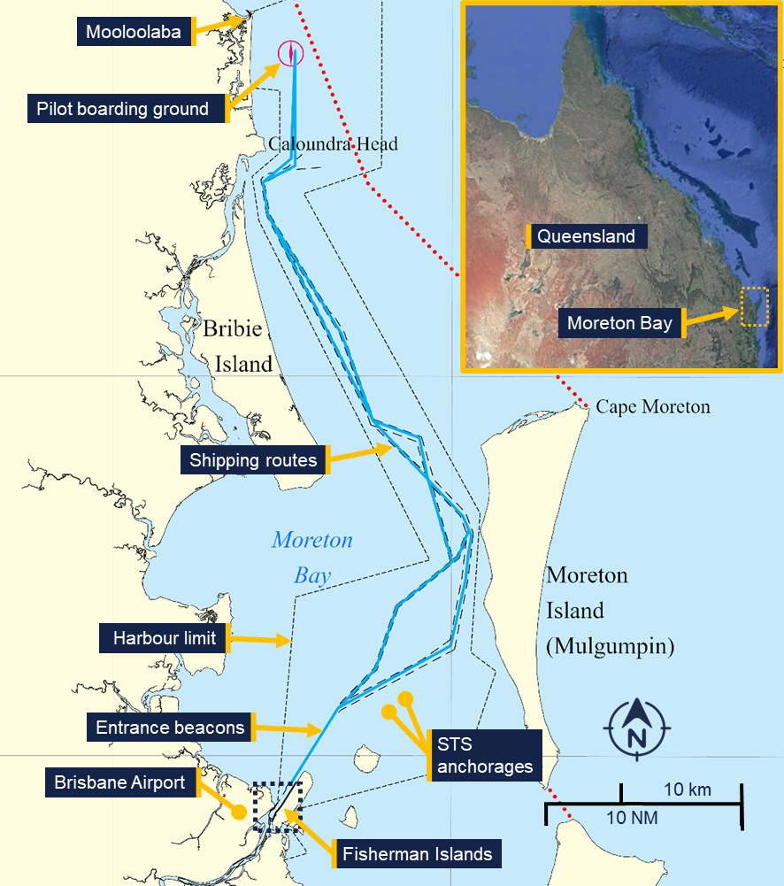
Source: Maritime Safety Queensland and Google Earth, annotated by the ATSB
The container ships MSC Barbara, Medkon Ten, Wide India and Volans had arrived in the Port of Brisbane in the preceding days. The ships were moored at the container berths of Fisherman Islands and were loading and unloading containers. As part of these routine cargo operations, hatch covers from Wide India and MSC Barbara were offloaded onto the berth.
Additionally, the woodchip carrier Crystal was moored at the Fisherman Islands grain and woodchip wharf just south of Fisherman Islands berth 1 (Figure 2).
Figure 2: Mooring locations at Fisherman Islands preceding the storm
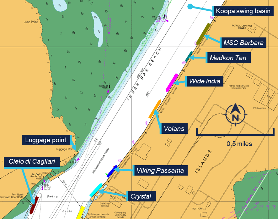
Source: Australian Hydrographic office, annotated by the ATSB
At 0945, the regional harbour master (RHM) for the Brisbane region received a BoM severe weather briefing from the state disaster coordination centre. It warned of ‘Potential isolated “very dangerous” thunderstorms with locally destructive winds and giant hail around South East Queensland during this afternoon and evening’. This was followed at 1022, by a weather update from Brisbane city council disaster operations that indicated the possible formation of storms in the Brisbane area in the late morning and afternoon. It also noted that severe storms were ‘possible to likely’ in the afternoon, and warned that isolated, very dangerous thunderstorm activity could not be ruled out, especially over the city’s western suburbs.
The RHM relayed the warnings to the Brisbane vessel traffic service (VTS) for distribution to port stakeholders and requested that ships moored at the Fisherman Islands container berths lower their outboard anchor and add extra mooring lines where possible. Brisbane VTS subsequently passed on the warnings to the various stakeholders in the port. This included a vessel traffic service operator (VTSO) contacting the operators of the container berths by telephone. The terminal operators then informed the crew on board the ships alongside and reported back to VTS that precautions had been taken as requested.
At 1045, Viking Passama embarked a pilot at the pilot boarding ground, inbound to the vehicle terminal at Fisherman Islands berth 1.
Viking Passama’s pilot had prepared for the pilotage early in the morning using the port’s proprietary planning software. The pilot noted that a weather front with up to 40 knots of wind was forecast to pass the Port of Brisbane at about 1400, coinciding with the expected arrival time of the ship. In response they requested a second tug to assist with berthing, with the understanding that these tugs would likely come to Viking Passama after being released from the preceding Cielo di Cagliari.
At about 1100, after discussing the forecast with the ship’s master during the master-pilot information exchange (MPX), the pilot made VHF radio contact with VTS. Concerned that a late release of the tugs could leave the ship in the narrow channel without assistance, the pilot requested separate tugs for the ship’s arrival at berth 1.
The duty VTSO acknowledged the request, and their colleague contacted the port’s towage provider to check for tug availability. The planner at the towage company informed VTS that only 2 tugs were available for the afternoon, as the crew for the stand‑by tug was on their break and would be available from 1730.
At 1124, the VTSO informed the pilot that no extra tugs were available for the scheduled arrival time. Instead, they requested the that the pilot postpone Viking Passama’s arrival until after Cielo di Cagliari had berthed. In response, the pilot slowed the ship to about 7 knots, adjusting the arrival time to 1500.
At 1243, the first of a series of severe thunderstorm warnings was issued by the BoM. The first warning detailed the development of severe thunderstorms in northern New South Wales, tracking towards the southern part of the Gold Coast in a north-easterly direction.
At 1244, the pilot on board Cielo di Cagliari reported to VTS that the ship was passing the entrance beacons and enquired about the BoM warning they had received on their phone. The duty VTSO replied that the BoM was reporting severe thunderstorms over the New South Wales border ranges, possibly impacting Brisbane later that afternoon.
Updated warnings were issued by the BoM at 1310 and 1337, with observations and short-term forecasts now showing storms in the Gold Coast area tracking north-east (Figure 3). At 1407, an updated warning predicted storms tracking further north, potentially passing close to Brisbane port.
Figure 3: Storm warnings 1337 to 1446
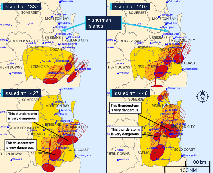
Source: Bureau of Meteorology, annotated by the ATSB
At 1410, Cielo di Cagliari’s pilot contacted the pilot on Viking Passama directly on VHF, reporting that the ship had nearly completed berthing and that the tugs would be released in 5 to 10 minutes. Viking Passama’s pilot confirmed the message. Following this Viking Passama increased speed to 11 knots and at 1412, it passed between the entrance beacons, committing to its approach.
At 1419, the pilot on board the Gaschem Iliad called VTS and reported heaving anchor at the STS anchorage. The pilot also gave 30 minutes’ notice of the ship’s arrival at the entrance beacons in anticipation of its inbound transit, following Viking Passama.
At 1427, a severe thunderstorm warning classified 2 storms as ‘very dangerous’, with the northernmost storm tracking towards Moreton Bay and expected to impact Cleveland (about 20 km to the south-east of the port) at 1520. An updated warning, issued at 1446, showed a large thunderstorm tracking towards the Port of Brisbane, noting (in part):
The Bureau of Meteorology warns that, at 2:40 pm, VERY DANGEROUS THUNDERSTORMS likely to produce large, possibly giant hailstones, damaging, locally destructive winds and heavy rainfall that may lead to flash flooding were detected near Beenleigh, Logan Central, Cleveland and Greenbank. These thunderstorms are moving towards the north to northeast. They are forecast to affect Redbank Plains, Wacol and Archerfield by 3:10 pm and Brisbane CBD, Redcliffe and Point Lookout by 3:40 pm.
The warning was relayed by the duty VTSO via an all-ships safety broadcast,1 on the port VHF working channel at 1448.
In reply, the pilot on board Gaschem Iliad requested a second tug for its berthing manoeuvre. However, at 1451, the pilot informed VTS that they would instead delay the ship’s entry into the port as wind speeds were exceeding 30 knots.
At about the same time, cargo operations on board Wide India, MSC Barbara and Volans were stopped by the respective terminal operators and stevedores disembarked the ships.
Storm arrival
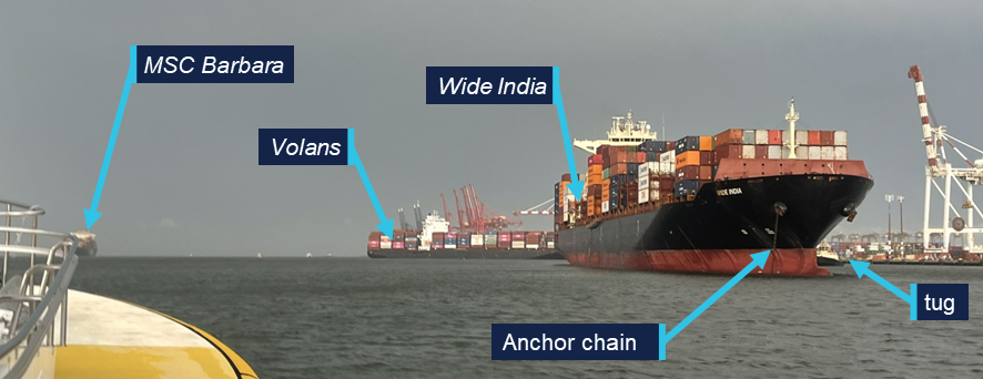
The master of Wide India later reported that they did not receive the 1448 VTS warning broadcast on the port VHF working channel. Instead, the chief officer was warned by the departing stevedores. The master and chief officer reported that at this time, the storm was visibly approaching from the south (Figure 4). The master urgently requested the duty engineer to make the ship’s main engine and bow thruster ready for manoeuvring.2
Figure 4: View of approaching storm from Wide India at 1503
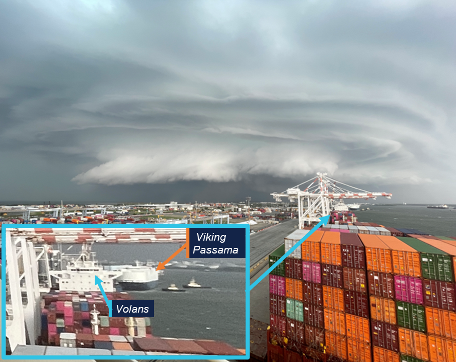
Source: Chief mate of Wide India, modified and annotated by the ATSB
The crew of MSC Barbara could also see the approaching storm and its master reported that they requested the engineers to bring the ship’s bow thruster online to assist in keeping the ship alongside its berth.
At 1500, the assistant regional harbour master, who was the designated duty harbour master for the day, was called to the VTS control centre to support the VTSOs in dealing with the emerging situation.
At the same time, Volans’ master ordered the ship’s engine and bow thruster to be made ready for manoeuvring and the gangway to be lifted to deck level.
Viking Passama
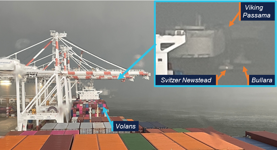
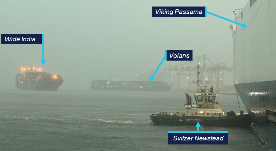
At 1503, the storm was approaching the port while Viking Passama was in the process of being moored at Fisherman Islands berth 1, assisted by the tugs Bullara and Svitzer Newstead. The pilot instructed both tugs to ‘lift’ (pull back on their towlines) slowing the ship’s movement towards the berth caused by the strong northerly wind (Figure 4, inset).
At 1505, wind speeds briefly subsided to calm conditions for about 2 minutes before increasing and abruptly changing direction to the south-east. In response, Viking Passama’s pilot ordered the tugs to push the ship alongside (Figure 5) and at 1510, it came to rest on the shore fenders. The crew passed mooring lines ashore while the rapidly increasing wind was pushing the ship off the berth. The chief mate reported wind speeds of over 60 knots on the bridge anemometer, and the master and pilot had to take shelter against the accompanying rain and large hail stones.
Meanwhile, on the aft mooring station, the second mate reported to the bridge that the ship was moving away from the berth but was advised by the master that the tugs were already pushing at full power. The mooring party noticed the extreme tension on the spring lines and moved to a safe position. At about 1515, both aft spring lines parted, snapping back across the deck. The lines impacted the protective cage around the winch controls and severed the aft winch hydraulic control pipes, disabling the aft mooring winches. At the same time, the pilot called VTS to request an additional (third) tug, as an emergency measure.
At 1516, the pilot again called VTS informing the VTSO that the ship was now being held in a stable position, just off the berth, by the 2 tugs. The VTSO replied that they had requested additional tug assistance and that a windspeed of 60 knots was being recorded at the entrance beacons.
The ship was slowly blown further off from the berth, despite both tugs pushing at full power and, at 1517, the remaining lines parted.
At 1519, the VTSO called the Viking Passama and informed the pilot that the tugs were needed to assist other ships. The pilot replied that they had parted all lines and that the ship would be grounded in minutes if they released the tugs. Eventually, Viking Passama was blown approximately 120 m off its berth before the wind abated sufficiently to enable the tugs to push it back.
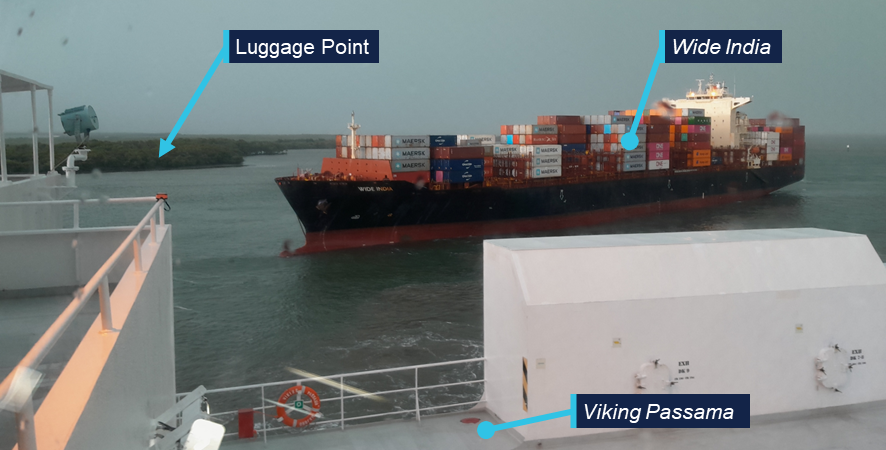
Figure 5: View from Wide India at 1510
Source: Chief mate Wide India, modified and annotated by the ATSB.
Volans
At about 1515, the rapidly increasing wind on Volans’ stern caused its aft mooring lines to part due to the increased strain. The ship’s unsecured stern was pushed off the berth.3 (Figure 6)
Volans’ master subsequently requested tug and pilot assistance from VTS at 1517 and was informed that tugs would be underway to them as soon as possible.
The ship then continued to swing around its bow which was still connected to the berth by 2 headlines and held by its port anchor. Eventually rotating about 135°, with its bow now facing into the wind and its stern impinging into the adjacent channel. The crew lowered the starboard anchor to assist in holding the ship in position but were unsuccessful at deploying additional mooring lines.
Figure 6: Volans’ and Wide India’s movements
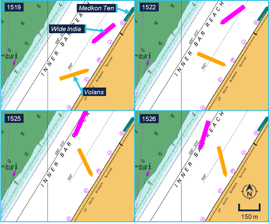
Source: Australian Hydrographic Office, annotated by the ATSB
Wide India
As the storm hit, Wide India’s mooring lines came under increased strain. Its crew attempted tightening the winch brakes to prevent them slipping, before seeking shelter away from the mooring lines, which were parting or paying out violently. By 1519, the ship had broken free of its berth and was drifting across the channel.
The master started the main engine, to prevent the ship from drifting astern into Medkon Ten. The duty VTSO radioed the ship and gave the master permission to use the ship’s engine to manoeuvre. The master replied that they were already underway as all lines had parted, after which the VTSO informed them that tugs were some time away and requested them to ‘manoeuvre and handle your situation the best you see fit’. Wide India moved slowly upriver, maintaining steerageway4 as the master dredged5 the ship’s starboard anchor and used the bow thruster to maintain heading control. At 1526, Wide India passed closely around the stern of Volans (Figure 7).
Figure 7: 1532 view from Bullara
Source: Master Bullara, annotated by the ATSB
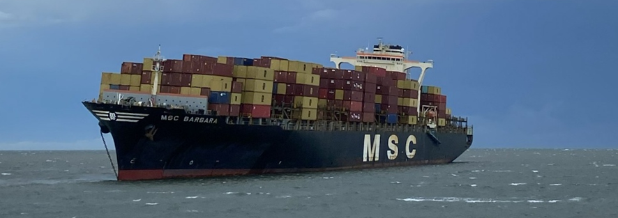
MSC Barbara
At about 1520 the wind force on MSC Barbara moorings caused its winch brakes to render. As the wind pushed the ship further off the berth, its mooring lines eventually ran off the winch drums. The lines were still connected to the shore mooring bollards and streamed across the channel. At 1523, its master requested tug assistance on the port VHF working channel. The VTSO then informed the master that tugs were ‘a short time away’ and that the RHM had given permission to manoeuvre.
However, the ship’s main engine was not ready to manoeuvre, leaving the ship without propulsion. The master utilised the ship’s bow thruster to provide limited heading control, attempting to maintain its heading into the wind. The strong winds pushed the ship in a northerly direction and it ran aground on the opposite side of the channel, on the side batter of the Koopa swing basin (Figure 8).
Six of the ship’s hatch cover pontoons, which had been offloaded ashore as a routine part of cargo operations were left behind on the berth.
Figure 8: MSC Barbara’s movement across the channel
Source: Australian Hydrographic Office, annotated by the ATSB
Other ships
At 1528, Crystal, moored at the grain and woodchip wharf just south of Viking Passama, reported to VTS that it was coming off the berth and requested tug assistance. The VTSO replied that no tugs were available and that the crew could use their engine and thrusters if needed. Though affected by the storm, its moorings held and the crew successfully returned the ship alongside using its winches.
The 148 m container feeder Medcon Ten was moored at Fisherman Island berth 8, between Wide India and MSC Barbara, its crew did not report any damage and the ship stayed alongside during the storm.
Recovery
As the impact of the storm became clear, VTS personnel started activating emergency response procedures. This included contacting the RHM and communicating with the pilotage provider, harbour tug operators, terminal operators, ship’s agents and internally within Maritime Safety Queensland to coordinate a response.
Several pilots, along with launch and towage crew, made their way to the port to assist – either after being called out, or after reporting in while off-duty. Their response was initially hampered by the weather conditions, as road traffic en route to Brisbane port was severely affected by falling debris, poor visibility and large hail.
At 1512 and 1514, a VTSO phoned both towage operators in the port, requesting they start mobilising crews to provide emergency assistance. Additional tugs became available between 1640 and 1752, as crewmembers made their way to the tug bases.
At 1604, the first pilot arrived near Fisherman Islands on board a police boat. They had requested assistance at the Lytton water police station, after being unable to cross the river to reach the pilot base at Pinkenba. This pilot boarded Wide India, which was assessed as the highest priority by the RHM.
At about 1600, a pilot launch departed from its Pinkenba berth with 3 pilots on board. One pilot boarded Volans at about 1620, while the other 2 made their way to the grounded MSC Barbara and boarded at about 1625.
The port launch Moggill was mobilised to assist in recovering ropes from the water and relocating a buoy away from MSC Barbara’s rudder.
Viking Passama
As the storm cleared the area and wind speeds subsided, Viking Passama was pushed back by its assisting tugs and, at 1543, was again alongside. Once the forward lines had been secured, the forward tug (Svitzer Newstead) was released at 1559.
However, the aft lines could not immediately be deployed due to the damage to the winch controls. This meant the aft tug (Bullara) had to be kept pushing up on the stern, while the ship’s engineering crew made emergency repairs to the aft winches (Figure 9). On completing the repairs, Bullara was released at 1644 for tasking to another ship.
Figure 9: Viking Passama winch control emergency repair
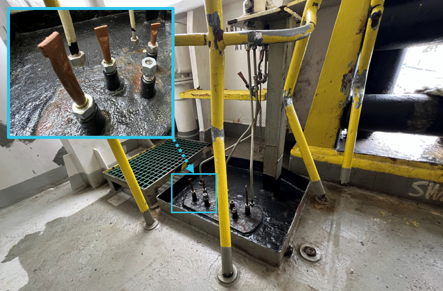
Source: ATSB
Wide India
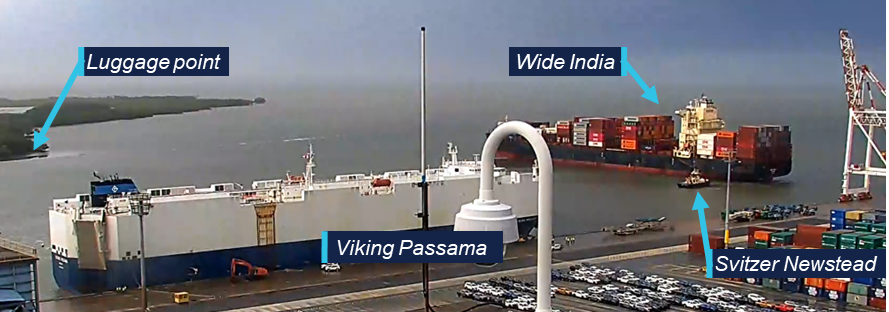
Meanwhile, Wide India had slowly made its way upriver to the end of the Fisherman Islands berths, approaching Viking Passama (Figure 10) before coming to a stop and backing away. As Wide India could not turn unassisted in the narrow channel its master kept it underway at slow speed, against the south-easterly wind and ebb current, to maintain steerage until a tug was available.
Figure 10: 1554 Wide India approaching Viking Passama
Source: Master Viking Passama, annotated by the ATSB
At 1600, the tug Svitzer Newstead approached and its master formally offered assistance, informing Wide India’s master that the tug’s ‘owner reserved the right to negotiate the terms of engagement’. Wide India’s master did not directly answer the request, and VTS then informed the tug’s master to standby, awaiting the pilot, who was en route on a police boat.
The pilot boarded Wide India, arriving on the bridge at 1614. The pilot then coordinated with Svitzer Newstead to secure a tow line and assisted the ship turning in the channel (Figure 11).
Figure 11: 1614 Wide India and Volans
Source: Pilot MSC Barbara
At about 1635, the ship had swung around to starboard and was heading down river (Figure 12). At 1703, the pilot reported passing the entrance beacons outbound, heading for the STS anchorage where it anchored at 1757. After inspection of the ship’s mooring equipment and respooling its mooring lines at the anchorage, Wide India returned to its berth on 25 November to complete cargo operations and recover its hatch covers.
Figure 12: 1628 Wide India swinging in fairway
Source: Port of Brisbane CCTV, annotated by the ATSB.
Volans
Once the storm cleared, Volans was secured to the berth with its 2 remaining headlines, with additional support from both its anchors. Its exact position was determined by the wind and current, with its stern protruding into the channel. Lines from both Volans and Wide India were in the water around the ship, causing a possible navigational hazard to assisting tugs (Figure 13).
Figure 13: 1618 Volans secured with 2 headlines
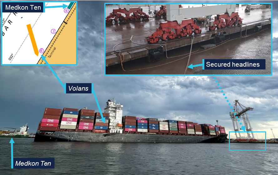
Source: Pilot MSC Barbara, insert Australian Hydrographic Office, insert crew Volans, annotated by the ATSB
At 1620, a pilot boarded from the pilot launch, followed at 1645 by the arrival of the tug Svitzer Olivia. Though the ship had originally been moored on its starboard side, the pilot and master decided to use the tug to push the ship alongside on the port side first – clearing the channel for other traffic until a second tug was available to swing the ship. Meanwhile, the port tender Moggill assisted with recovery of the mooring lines from the water.
At 1720, with the additional assistance of SL Fitzroy, Volans was swung in the channel and returned to its original berth, where it was alongside by about 1755. However, mooring operations were slow, as the recovered lines had to be passed from the quayside and resecured onto the ship’s winches. Volans was finally safely moored at 1854.
MSC Barbara
After embarking the pilot on Volans, the launch proceeded to MSC Barbara, which was grounded on the bank of the Koopa swing basin (Figure 14).
Figure 14: MSC Barbara aground
Source: Master Svitzer Newstead, modified by the ATSB
The 2 assigned pilots first assessed the situation before boarding. They observed MSC Barbara heeled over slightly to port on the falling tide and at close distance from the no 17 special mark buoy (Figure 15). The ship’s starboard anchor was run out to port, with the chain leading over the bulbous bow. The pilots agreed on the division of their roles, with one pilot conning the ship and controlling the tugs and the other handling communication, both on board and with parties ashore.
Figure 15: MSC Barabara’s stern and no 17 special mark
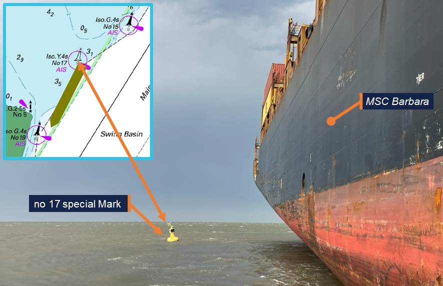
Source: Pilot MSC Barbara
The pilots boarded MSC Barbara at 1624 and conducted the MPX with the master, which was also attended by an on-board company superintendent. The MPX was interrupted several times by calls from the ship’s manager, MSC, but the pilots and master agreed on a strategy to refloat the ship using the tugs assisted by heaving of the anchor. At 1645, the tug Svitzer Newstead arrived, followed at 1654, by Bullara and SL Murrimbidgee. Additionally, port tender Moggill moved the no 17 buoy away to avoid it fouling the ship’s hull or propeller. Under the direction of the conning pilot, the tugs then proceeded to refloat the ship. The main engine was not used due to concerns about possible damage to the propeller.
At 1713, the pilot reported to VTS that they were starting to move and, at 1716, the ship was afloat. It was then moved into the channel by the 3 tugs where its engine was tested and the anchor cable heaved in. It was found that the anchor had fouled the bulbous bow, which took some time to clear.
MSC Barbara’s master, on request of the ship’s manager, insisted on bringing the ship back alongside the berth. Several phone calls between the master, the managers, the ship’s agent and the RHM were made to discuss the situation.
Eventually, the RHM issued a formal direction to the ship to depart, first at 1750 and then again at 1810. At 1815, the ship started its transit to the STS anchorage to assess damage to the hull and mooring systems. It was safely anchored in the STS-1 anchorage at 2024. After assessment of the damage and respooling of the mooring lines at the anchorage, MSC Barbara returned to the terminal on 28 November, where it completed its scheduled cargo operations and recovered its hatch covers.
Context
Port of Brisbane
The Port of Brisbane is located at the mouth of the Brisbane River and is Queensland's largest general cargo port with 30 berths. Port throughput in 2024–25 exceeded 34 million tonnes. The Brisbane port limits encompass a significant area of Moreton Bay and extend to the northern end of the bay, with about 45 miles from the pilot boarding ground to the river entrance beacons.
The port was privatised in 2010 and was managed and developed by the Port of Brisbane Pty Ltd (PBPL) under a 99-year lease with the Queensland Government. Maritime Safety Queensland retained responsibility for certain aspects of port management.
Maritime Safety Queensland
Queensland’s maritime legislation was administered by Maritime Safety Queensland (MSQ), a state government agency within the Department of Transport and Main Roads. As such, MSQ was responsible for safety oversight of pilotage, pollution protection services, vessel traffic services (VTS) and the administration of all aspects of ship registration and marine safety in the state of Queensland.
The day-to-day management of shipping activities and port safety were subject to the directions of a regional harbour master (RHM). The Brisbane RHM’s area of responsibility extended beyond the port limits to include areas of other commercial and recreational activities, including Moreton Bay, the Brisbane River upstream of the port and the coastal sea area to about 45 miles further north of the port limits.
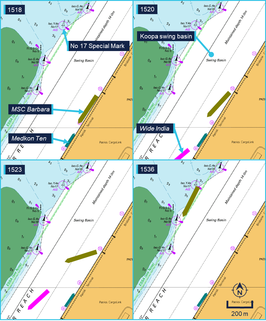
As part of its role in maritime safety MSQ was also responsible for the management of maritime emergencies, including those caused by extreme weather events. MSQ procedures stated that in the event of an emergency the duty harbour master would take the role of incident controller (IC), with VTS noted as one of the main triggers for identifying emergencies and activating the response. On 24 November the assigned duty harbour master was the assistant RHM (ARHM) – who arrived at the VTS control centre at 1500, within a minute of being called by the duty VTSO.
For larger emergencies the IC was supported by the maritime emergency management team (MEM), consisting of senior MSQ managers. On this occasion, the MEM was activated at 1530, and its members arrived at the VTS control centre at 1645.
Under section 86 of the Queensland Transport Operations (Marine Safety) Act 1994, the RHM or the duty harbour master as their delegate, could issue ‘general’ directions applicable to all ships, or ‘particular’ to an individual ship. For example, a general direction closing and reopening the port or a direction for a ship to proceed to anchorage.
Vessel traffic service
A vessel traffic service (VTS) was provided by MSQ for the Port of Brisbane and the waters of Moreton Bay in accordance with the Australian Maritime Safety Authority’s Marine Order 64.6 The VTS monitored and communicated with ships in its area of responsibility to improve navigational safety. It also coordinated the allocation of tugs and pilots.
A vessel traffic management system (VTMS) was used by the vessel traffic service officers (VTSO) to maintain a traffic image of vessels moving through the area. This data was then used by the VTSOs to provide traffic information, maritime safety information and navigational support to individual vessels.
The location, heading and speed of ships displayed on the VTMS could be derived from radar and automatic identification system (AIS) information. Radar data was not dependent on ships’ equipment or transmissions but was subject to coverage limitations. During the storm the radar was unreliable due to rain clutter caused by the strong precipitation. While AIS data was available throughout the storm, position update frequency was limited by the transmission interval. The ships that had broken away from their moorings at the container berths had their AIS status set to ‘moored’. This meant that as long as their speed was below 3 knots, positions were only updated every 3 minutes.
Under normal circumstances, the VTS was crewed by 3 VTSOs working 12-hour shifts. Two VTSOs managed traffic and operated the radio, while the third VTSO handled scheduling of pilots, tugs and coordination with the terminals.
The VTS control centre was located on the ground floor of MSQ’s Pinkenba building, which did not provide the VTSOs with an outside view over the river. Instead, they had access to several CCTV cameras around the port to improve their situational awareness.
Pilotage
For the Port of Brisbane pilotage was compulsory for ships with an overall length of more than 50 metres. The pilotage area covered most of Moreton Bay, with pilots boarding inbound ships by launch, at the pilot boarding ground, 2.5 miles south-east of Point Cartwright, Mooloolaba.
Ships with an overall length of more than 300 metres were considered ‘oversize’ and procedures required them to be piloted by 2 pilots, which in this incident applied to MSC Barbara.
Pilotage was provided on behalf of MSQ by Poseidon Sea Pilots (PSP) which operated a base and several launches both in Pinkenba, on the Brisbane River, and in Mooloolaba at the northern end of Moreton Bay.
Fisherman Islands terminals
Several terminals operated on Fisherman Islands transhipping various commodities, including containers and vehicles as well as liquid and dry bulk goods. The terminal operators leased their terminals from PBPL, that in turn managed maintenance of both quayside infrastructure and waterways. Both PBPL and the individual terminals operated CCTV cameras around the port. Video recordings from these cameras were provided to the ATSB for analysis.
The Fisherman Islands berths consisted of a concrete deck supported by pillars bordering a rock wall abutment. Vertical rubber fenders were fitted at regular intervals to the wharf face and crane tracks ran on either side of the deck supporting several gantry cranes.
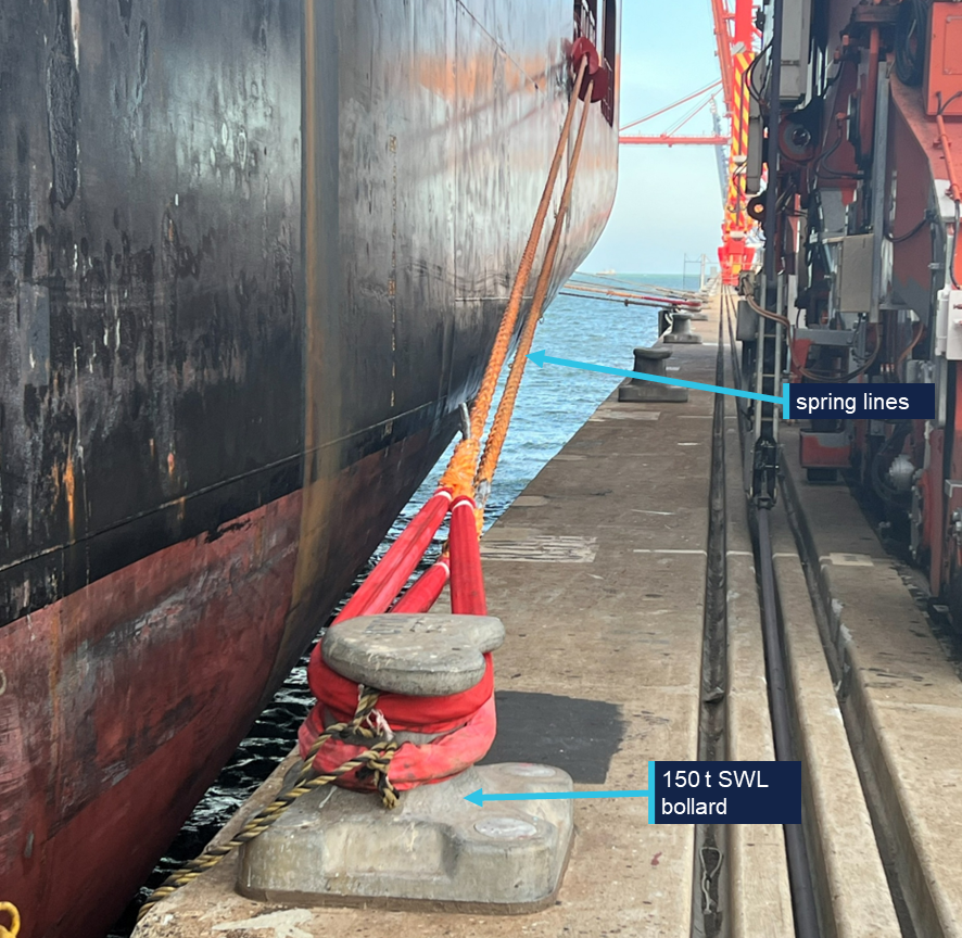
Vehicle berth 1, used by Viking Passama, was operated by Australian Amalgamated Terminal (AAT). Its mooring arrangements comprised 100 t safe working load (SWL) mooring bollards at intervals of 16 metres along the edge of the quay. Additionally, a limited number of 200 t SWL recessed storm bollards were located about 29 metres from the wharf face (Figure 16).
Figure 16: Berth 1 mooring arrangements
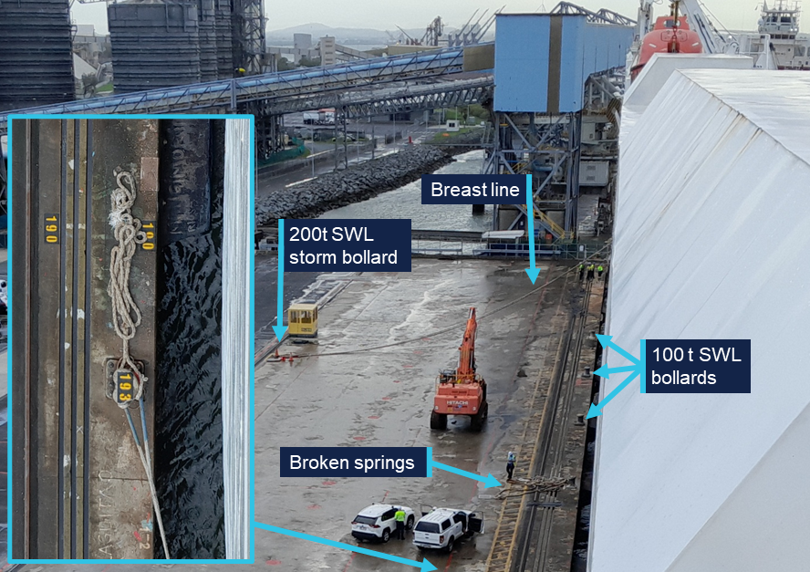
Source: Master of Viking Passama, annotated by the ATSB
The container berths 4 to 7, used by Volans and Wide India, were operated by DP World Brisbane. MSC Barbara was moored at berths 9 and 10, operated by Patrick Terminals. These berths were fitted with upgraded 150 t bollards, 18 metres apart (Figure 17). Although 200 t SWL storm bollards on the far side of the quay deck were included in the original design of the berth, these were either not installed or not accessible.
Figure 17: Mooring arrangements at Fisherman Islands berths 4 to 11
Source: ATSB
Harbour towage
Two companies provided harbour towage services in the Port of Brisbane. The largest operator was Svitzer towage, which operated 5 tugs. Of these tugs, 2 were crewed by alternating 12‑hour day and night shifts and available for use at any time. An additional secondary crew was kept on stand-by at 90 minutes’ notice and was available subject to work and rest hour restrictions.
At the time of the occurrence, Svitzer Newstead and Bullara were crewed by the day shift, with the secondary shift crewing SL Murrumbidgee. The secondary crew had reached their work hour limit earlier in the day and was not available for routine operations. However, they were mobilised on an emergency basis after a request for emergency assistance by VTS at 1514 and departed the tug base at 1650.
Two crews, who were scheduled as primary crew for the night shift, were called out to start their shift early. They departed, at 1732 and 1752, on board the tugs Beltana and Svitzer Colmslie. They took over the duties from the day shift crews on Bullara and Svitzer Newstead, who had reached the end of their shifts.
Additionally, Boluda towage, formerly Smit Lamnalco, also operated 2 harbour tugs in the port: SL Fitzroy and Svitzer Olivia. These tugs were operated on a single shift of 12 hours per day and were not crewed during the incident. They were mobilised on an emergency basis after a phone call by VTS at 1512, with Svitzer Olivia departing at 1622, followed by SL Fitzroy at 1648.
Ships
Viking Passama
Viking Passama was a Marshall Islands registered car carrier, built in 2012 at Yangfan Shipyard, Zhoushan, China, and classed with Det Norske Veritas (DNV).
The 47,053 gross ton ship had a capacity of 5000 RT,7 an overall length of 183 metres and a summer draught of 9.1 metres. It was propelled by a single MAN 9S50MC-C7 2‑stroke main engine, producing 14,220 kW and driving a fixed pitch propeller. To assist manoeuvring, it was equipped with a 1,100 kW bow thruster.
The ship was equipped with an Intershalt G4e voyage data recorder (VDR). The VDR recorded bridge audio, ECDIS and radar display information as well as navigation and engineering parameters. The VDR data relevant to the investigation was downloaded on board the ship by the ATSB.
At the time of the incident, Viking Passama was owned by Gram Car Carriers and managed by Reederei F.Laeiz of Hamburg, Germany. It had a crew of 22 Russian, Estonian and Filipino nationals.
The ship was equipped with 2 loading ramps for the loading and discharging of its vehicle cargo. One ramp was mounted on the starboard quarter and the other in the starboard side shell. In line with these asymmetric cargo arrangements, its mooring arrangements were primarily designed to moor the ship starboard side alongside.
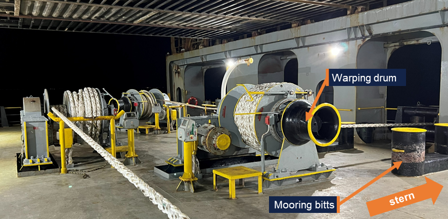
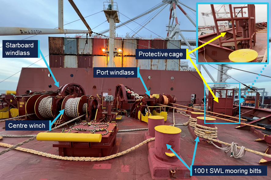
Its forward mooring arrangements consisted of 2 windlasses, each driving 2 mooring drums and a warping drum. A single drum winch was fitted between the windlasses in the central position. Additionally, several mooring bitts with an SWL of 335 kN (34 t) were fitted.
The aft mooring station was equipped with one double drum mooring winch on its port side and a single drum centre winch, that were normally used to deploy stern lines. A double drum winch fitted on its starboard side, forward of the stern-ramp recess, was normally used to deploy the aft springs (Figure 18). Additional 335 kN (34 t) mooring bitts were also fitted and typically used to set breast lines on storm bollards.
During the incident, 2 aft- and one fore-spring had been secured ashore, while the aft mooring crew were in the process of running the stern lines. The mooring plan also included 2 breast lines to be secured to the storm bollard on the quay, that were to be run from the fixed bitts on the aft mooring station.
Figure 18: Starboard-aft mooring station on board Viking Passama
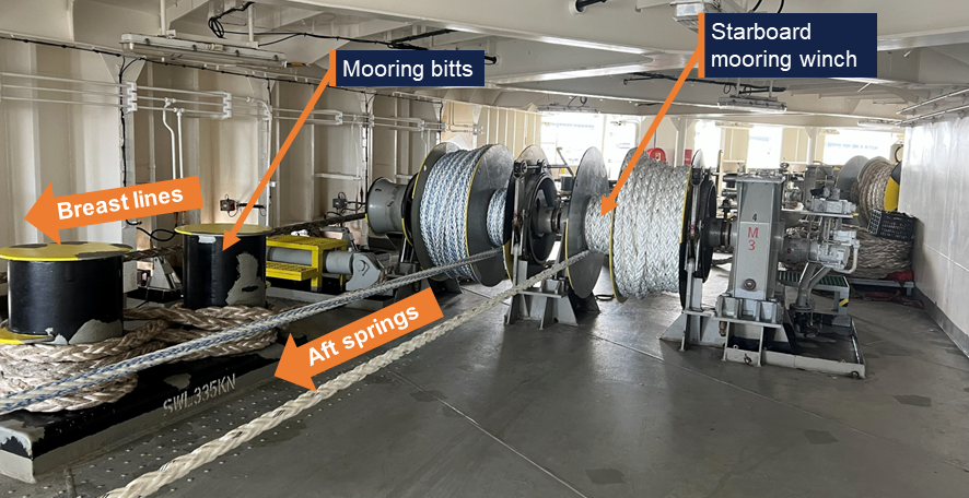
Viking Passama’s aft mooring station seen from the location of the starboard winch control (Figure 9). Source: ATSB
MSC Barbara
MSC Barbara was a Panamanian registered cellular container ship, built in 2002 at Ulsan, Korea, and classed with DNV.
The 73,819 GT ship had a capacity of 6,720 TEU8 and an overall length of 304 metres. It was propelled by a single MAN-B&W Hyundai 10K98MC‑C 2‑stroke engine producing 57,700 kW and driving a fixed pitch propellor at maximum 80 RPM. To assist with manoeuvring, it was equipped with a 2,500 kW bow thruster.
The ship was equipped with a Danelec DM200 simplified voyage data recorder9 (S‑VDR). The S-VDR recorded bridge audio, radar display information and limited navigation parameters. S-VDR data relevant to the investigation was downloaded on board the ship by the ATSB.
At the time of the incident, MSC Barabara was owned by Compania Naviera Dunrobin and managed by MSC Shipmanagement in Cyprus. It operated on a fixed route between Australian and Asian ports for the Mediterranean Shipping Company and had a crew of 25 Ukrainian, Romanian, Filipino, Moldovan and Indian nationals. During the incident the ship also carried a company superintendent, who was not signed on as crew.
The ship’s forward mooring station was equipped with 2 windlasses, used for anchoring and each driving a single mooring drum and warping drum. Four additional single drum winches and 4 sets of 100 t SWL mooring bitts were also installed. The ship’s aft mooring station was equipped with 6 winches, each equipped with a single mooring drum and a warping drum (Figure 19) and 4 sets of 100 tonne SWL mooring bitts.
Figure 19: MSC Barbara aft mooring station, looking to starboard
Source: ATSB
On arrival, the ship was initially moored using 4 headlines, 4 stern lines and 2 forward and 2 aft springs, all on the winch drums. After receiving the weather warning from VTS via the terminal safety officer, the crew rigged an extra fore spring and headline as well as an aft spring and stern line, secured on the bitts.
Volans
Volans was a Liberian registered cellular container ship, built in 2010 at the Zhejiang Shipbuilding yard in Ningbo, China, and classed with DNV.
The 41,225 GT ship had a capacity of 4,254 TEU and an overall length of 265 metres. It was propelled by a single MAN 8K90MC-C 2-stroke main engine producing 36,560 kW and driving a fixed pitch propeller. It was additionally equipped with a 1,600 kW bow thruster for manoeuvring.
The ship was equipped with a Furuno VDR. The VDR recorded bridge audio, ECDIS and radar display information as well as navigation and engineering parameters. VDR data relevant to the investigation was downloaded by the crew and was obtained by the ATSB.
At the time of the incident, Volans was managed by Oltmann Schiffarhtgesellschaft, Germany. It operated on a fixed route between Asian, Australian and New Zealand ports.
The ship’s forward mooring arrangements consisted of 2 windlasses and one centre mooring winch, fitted with 2 mooring drums each. Its aft mooring station was equipped with 3 double drum mooring winches. Both mooring stations were further equipped with several mooring bitts with an SWL of 60 t that could be used to secure additional lines.
On arrival at Brisbane, the ship was moored using 4 headlines and 2 springs forward and 4 stern lines and 2 springs aft. After receiving the warning in the morning, the crew lowered the starboard anchor and secured an additional stern line aft and an additional headline and spring forward. After the storm passed the ship remained secured to the berth by 2 headlines from the port windlass mooring drums. (Figure 20)
Figure 20: 1640 Volans forecastle looking aft
Source: Crew Volans
Wide India
Wide India was a Marshall Islands registered cellular container ship built in 2015 at Hanjin Heavy Industries in Subic Bay, Philippines, and classed with DNV.
The ship measured 51,872 GT, had a capacity of 5,466 TEU and an overall length of 255 metres. It was propelled by a single MAN-B&W 6G80ME-C producing 24,680 kW and driving a fixed pitch propellor. It was additionally equipped with an 1,800 kW bow thruster to assist in manoeuvring.
The ship was equipped with a Furuno VDR which recorded 12 hours of bridge audio, ECDIS and radar display information as well as navigation and engineering parameters. The data on the VDR was not secured and subsequently overwritten before the ATSB could attend.
At the time of the incident, Wide India was managed by Danaos Shipping, Greece. It operated on a route between Tanjung Pelepas, Singapore, Brisbane and Sydney for Hapag Lloyd. The ship had a crew of 21 Ukrainian, Russian, Ghanese and Tanzanian nationals, as well as 3 Korean supernumerary service engineers. During the incident the ship also carried a company superintendent, who was not signed on as part of the crew.
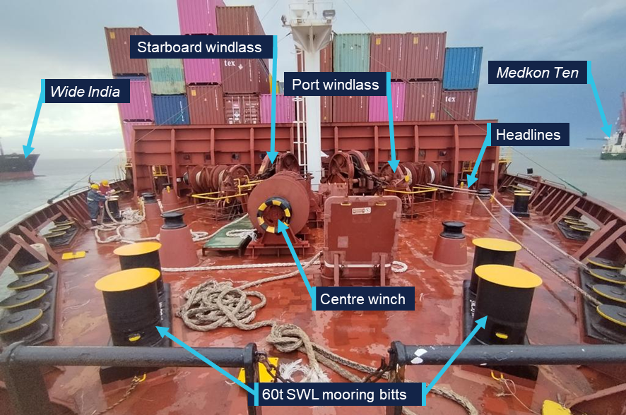
The ship’s forward mooring arrangements consisted of 2 windlasses and one centre mooring winch, fitted with 2 mooring drums each. Its aft mooring station was equipped with 3 double drum mooring winches. Both forward and aft stations were equipped with 6 sets of mooring bitts with an SWL of 100 t (Figure 21). On arrival at Brisbane, it was moored using 4 headlines and 2 springs forward and 4 stern lines and 2 springs aft. After receiving the warning from the terminal, the crew lowered the starboard anchor but did not deploy extra lines.
Figure 21: Wide India forecastle looking aft
Source: ATSB
Meteorology
South East Queensland is particularly susceptible to severe thunderstorms, especially during the summer months. Such storms have a much smaller footprint than tropical storms and are generally short-lived. However, they move fast and may contain severe gusts as well as large, damaging hail. Accurate predictions in the hours preceding impact are often limited by the complex and chaotic atmospheric environment.
In the past 4 decades, multiple high-impact storms have affected the greater Brisbane area, with major damage occurring in 1985, 2008 and 2014. The highest recorded wind gust, of 184 km/h, was recorded at Brisbane Airport during the 1985 event.10
November 2025 had been warmer and wetter than usual in South East Queensland, with multiple severe thunderstorm events. The marine weather forecasts for the 3 days leading up to 24 November indicated a chance of thunderstorm development on each day.
The 24 November storm caused widespread damage to buildings and infrastructure, including widespread electrical power outages. The maximum windspeed observed at Brisbane airport during the storm was 96 km/h. At the Port of Brisbane entrance beacons, a maximum gust strength of 132 km/h was recorded.11
Bureau of Meteorology
The Bureau of Meteorology (BoM) provides several relevant products to assist seafarers, government organisations and the public to assess and prepare for thunderstorms and general weather hazards. These included:
- meteorological warnings and forecasts through METAREA X, as part of the Global Maritime Distress and Safety System (GMDSS)
- coastal waters forecast for Moreton Bay
- severe weather briefing for Queensland
- general area forecasts available through the BoM website and app
- weather radar information including precipitation density and doppler windspeed to and from the radar (Figure 22).
Figure 22: Mount Stapleton weather radar at 1514 on 24 November
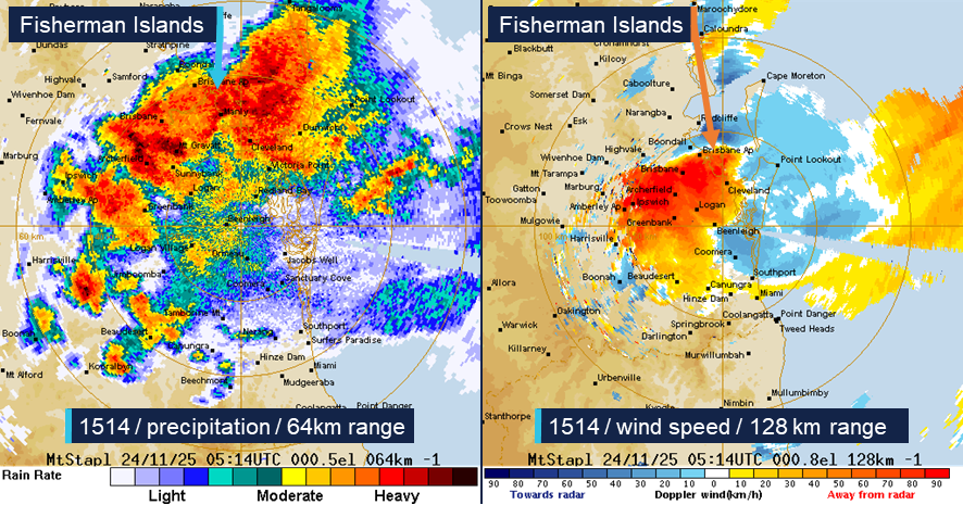
Source: Bureau of Meteorology, annotated by the ATSB
Proprietary weather information
A version of the Nonlinear Channel Optimisation Simulator (NCOS) was operated by PBPL. This software provided a near real-time, 7-day forecast of environmental conditions and a ship’s under keel clearance (UKC) through a web interface, accessible to the port’s stakeholders to aid ship scheduling. Though it was primarily designed as a tool for managing UKC, it also included weather prediction data, which was available to the pilots.
Maritime Safety Queensland also operated an online weather dashboard, called ‘PortWeather’. This provided live weather, tidal and current observations for ports around Queensland. It was available to VTS, pilots and other local stakeholders for different locations in the port and its approaches. The system’s meteorological instrumentation located on the port channel entrance beacon (BC1) recorded a maximum gust speed of 71 knots during the incident (Figure 23).
Figure 23: MSQ port weather dashboard data from beacon BC1 (1400 to 1600)
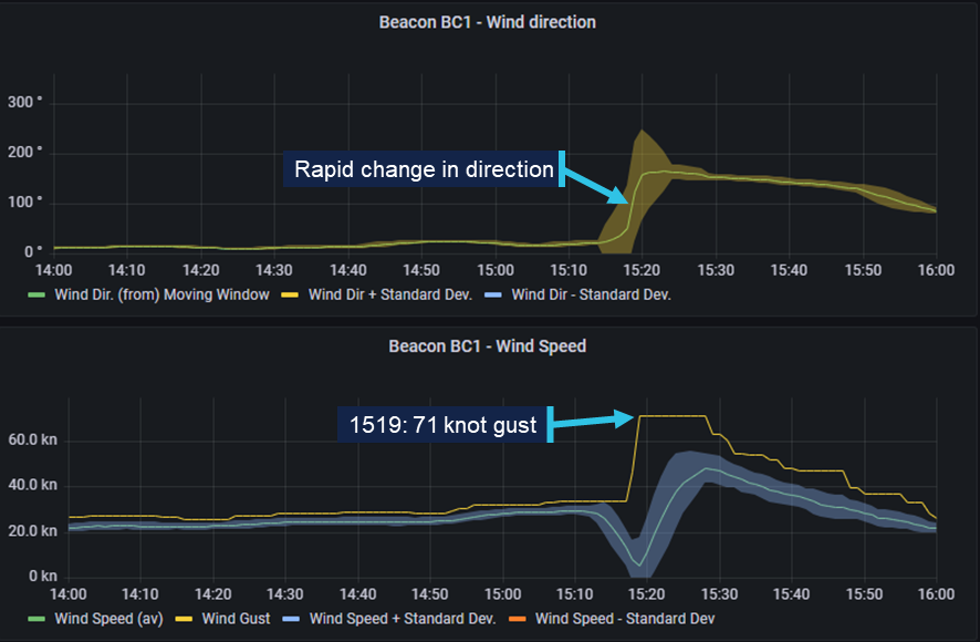
Source: MSQ, modified and annotated by the ATSB
Further investigation
The ATSB attended Wide India and MSC Barbara in Brisbane, and Viking Passama in Melbourne, to collect relevant evidence and interview the masters and relevant crew.
VDR data was received from Volans and recovered by the ATSB from Viking Passama and MSC Barbara.
The ATSB attended the Port of Brisbane to collect relevant evidence and interview directly involved individuals. Additionally, meteorological information was provided by the Bureau of Meteorology.
The investigation is continuing and will include analysis of:
- meteorological and climatological data
- shipboard and shore-side mooring arrangements
- harbour towage
- emergency arrangements on board and ashore
- effectiveness of the port procedures and operational guidance.
A final report will be released at the conclusion of the investigation. Should a critical safety issue be identified during the course of the investigation, the ATSB will immediately notify relevant parties so appropriate and timely safety action can be taken.
Purpose of safety investigationsThe objective of a safety investigation is to enhance transport safety. This is done through:
It is not a function of the ATSB to apportion blame or provide a means for determining liability. At the same time, an investigation report must include factual material of sufficient weight to support the analysis and findings. At all times the ATSB endeavours to balance the use of material that could imply adverse comment with the need to properly explain what happened, and why, in a fair and unbiased manner. The ATSB does not investigate for the purpose of taking administrative, regulatory or criminal action. About ATSB reportsATSB investigation reports are organised with regard to international standards or instruments, as applicable, and with ATSB procedures and guidelines. Reports must include factual material of sufficient weight to support the analysis and findings. At all times the ATSB endeavours to balance the use of material that could imply adverse comment with the need to properly explain what happened, and why, in a fair and unbiased manner. An explanation of terminology used in ATSB investigation reports is available here. This includes terms such as occurrence, contributing factor, other factor that increased risk, and safety issue. Publishing informationReleased in accordance with section 25 of the Transport Safety Investigation Act 2003 Published by: Australian Transport Safety Bureau © Commonwealth of Australia 2026 
Ownership of intellectual property rights in this publication Unless otherwise noted, copyright (and any other intellectual property rights, if any) in this report publication is owned by the Commonwealth of Australia. Creative Commons licence With the exception of the Commonwealth Coat of Arms, ATSB logo, and photos and graphics in which a third party holds copyright, this report is licensed under a Creative Commons Attribution 4.0 International licence. The CC BY 4.0 licence enables you to distribute, remix, adapt, and build upon our material in any medium or format, so long as attribution is given to the Australian Transport Safety Bureau. Copyright in material obtained from other agencies, private individuals or organisations, belongs to those agencies, individuals or organisations. Where you wish to use their material, you will need to contact them directly. |
- ^ The prefix ‘securite’ is used for navigation or meteorological safety broadcasts.
- ^ Wide India, Volans, MSC Barbara and Viking Passama were each fitted with reversible two-stroke engines. As these engines are directly connected to a fixed pitch propellor, they cannot run idle and are only started when thrust is needed. However, several auxiliary systems, e.g. auxiliary blowers, cooling, lubrication oil and fuel oil systems had to be brought online for the engine to be ready (or ‘stand-by’) for immediate use.
- ^ Movement and location information has been obtained from voyage data recorder for Volans, and from Automatic Identification System (AIS) data for Wide India. The AIS transceiver on board Wide India was set to ‘moored’ which meant their position was only transmitted every 3 minutes as long as its ground speed was below 3 knots.
- ^ Steerageway: the minimum required speed through water to permit a ship to be manoeuvred.
- ^ Dredging anchor: the towing of an anchor at a short stay to assist in heading and speed control during a manoeuvre.
- ^ Australian Maritime Safety Agency, 2022, Marine Order 64 (Vessel traffic services), AMSA, Canberra. Available at https://www.amsa.gov.au
- ^ The nominal size of car carriers is expressed in RT, or the number of 1966 RT43 Toyota Coronas that it can carry.
- ^ Twenty-foot Equivalent Unit, a standard shipping container. The nominal size of a ship in TEU refers to the number of standard containers that it can carry.
- ^ The voyage data recorder for a cargo ship larger than 3,000 gross tons, constructed before July 2002 may be an S‑VDR.
- ^ Soderholm, J.S. Turner, K.I. Brook, J.P. Wedd, T. & Callaghan, J. (2019). High-impact thunderstorms of the Brisbane metropolitan area. JSHESS 69(1), 239-251. Available at Journal of Southern Hemisphere Earth Systems Science.
- ^ The higher speeds observed on board the ships and by sensors operated by PBPL cannot be directly compared to BoM data. BoM measurements are normalised to indicate windspeeds at 10 metres above ground level.
Occurrence summary
| Investigation number | MO-2025-012 |
|---|---|
| Occurrence date | 24/11/2025 |
| Occurrence time and timezone | 15:00 Australian Eastern Standard Time |
| Location | Port of Brisbane |
| State | Queensland |
| Report release date | 05/06/2026 |
| Report status | Interim |
| Anticipated completion | Q3 2026 |
| Investigation level | Defined |
| Investigation type | Occurrence Investigation |
| Investigation phase | Examination and analysis |
| Investigation status | Active |
| Mode of transport | Marine |
| Marine occurrence category | Grounding |
| Occurrence class | Serious Incident |
| Highest injury level | None |
Ship details
| Name | Viking Passama |
|---|---|
| IMO number | 9491874 |
| Ship type | Car Carrier |
| Flag | Marshall Islands |
| Classification society | DNV |
| Owner | Gram Car Carriers Shipowning |
| Manager | Rederei F. Laeisz |
| Departure point | Ulsan, Korea |
| Destination | Brisbane, Australia |
| Injuries | None |
| Damage | Minor |
Ship details
| Name | MSC Barbara |
|---|---|
| IMO number | 9226932 |
| Ship type | Cellular container ship |
| Flag | Panama |
| Classification society | DNV |
| Owner | Compania Naviera Dunrobin |
| Manager | Compania Naviera Dunrobin |
| Departure point | Yantai, China |
| Destination | Melbourne, Australia |
| Injuries | None |
| Damage | Minor |
Ship details
| Name | Wide India |
|---|---|
| IMO number | 9698252 |
| Ship type | Cellular container ship |
| Flag | Marshall Islands |
| Classification society | DNV |
| Owner | Oceancarrier (no.8) corp |
| Manager | Danaos Shipping Company |
| Departure point | Sydney, Australia |
| Destination | Tanjung Pelepas, Malaysia |
| Injuries | None |
| Damage | Nil |
Ship details
| Name | Volans |
|---|---|
| IMO number | 9430777 |
| Ship type | Cellular container ship |
| Flag | Liberia |
| Classification society | DNV |
| Owner | Bails Shipping Co |
| Manager | Oltmann Schiffarhtgesellschaft |
| Departure point | Brisbane, Australia |
| Destination | Auckland, New Zealand |
| Injuries | None |
| Damage | Nil |