Loss of separation

de Havilland Canada Dash 8, VH-TNX, Boeing 737-800, VH-VOJ

Safety Action

On 7 November 2005, Airservices Australia issued national instruction NI 12/2005 to clarify the requirements for level assignment below LSALT in the en-route environment. The national instruction included information relating to the need for level assignment to take into account terrain clearance and the standards and requirements for assigning levels below the LSALT as detailed in the Manual of Air Traffic Services.

Analysis

While prior information relating to the radar outage was available to the crew of the 737, they did not become aware of the outage until informed by air traffic control during a high workload phase of the inbound flight, when there was little time to assess the information correctly. During the pre-flight departure briefing, the 737 crew did not reconsider or challenge their misunderstanding of the change to the CTA base with each other or the air traffic controller, which lead them to climb the aircraft into CTA without an airways clearance.

The non-availability of radar services below 8,000 ft, together with the forecast weather conditions, low level of CTA base and aircraft performance characteristics warranted greater diligence by the controller to implement tactical separation assurance. The controller relied on the crew of the 737 remaining outside controlled airspace, clear of weather and below the LSALT, as an initial separation strategy with the Dash 8.

While the onus is on a pilot to ensure adequate terrain clearance, the clearance issued to the crew by the controller did not comply with the provisions of MATS. The potential existed for the 737 crew to not meet their responsibilities under CAR 157 and 178 for minimum terrain clearance.

Summary

On 6 April 2005, at 1253 Eastern Standard Time, a de Havilland Canada DHC-8-102 (Dash 8) aircraft departed Mackay for Townsville, Qld. The aircraft was being operated under the instrument flight rules (IFR) and was climbing to flight level (FL) 160. At 1254, a Boeing Company 737-800 (737) aircraft departed Proserpine for Brisbane, Qld. The aircraft, with two pilots and a company approved observer, was being operated under the IFR. The crew's intention was to climb the aircraft to 8,000 ft above mean sea level (AMSL) pending a clearance from air traffic control (ATC) to enter controlled airspace (CTA) on climb to the planned FL410.

The airspace in the Proserpine area was classified as class G (non-controlled) airspace from ground level to 4,500 ft and class C (controlled) airspace from 4,500 ft to FL180.

Within class C airspace, air traffic controllers are required to separate IFR aircraft from other IFR aircraft.

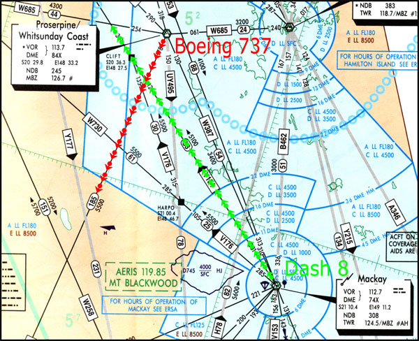
Figure 1: Extract from Mackay Terminal Area Chart

aair200501392_001.jpg

At 1256, the sector controller issued the crew of the 737 with a clearance to enter CTA on climb to 5,000 ft to establish the minimum vertical separation standard of 1,000 ft with the Dash 8, prior to conducting a step climb1. The 737 crew reported they were approaching 6,000 ft and commenced a descent to 5,000 ft.

Recorded data later showed that the 737 reached a maximum altitude of 6,400 ft with a minimum vertical spacing between the two aircraft of 430 ft and it was calculated that the aircraft were approximately 45 NM apart laterally. At 1257, the vertical separation standard of 1,000 ft was established and, at 1300 when the two aircraft were radar identified, they were about 25 NM apart laterally.

At the time of the incident, the radar that normally provided low-level coverage within the area had been temporarily removed from service, restricting coverage to above 8,000 ft. A notice to airmen (NOTAM) had been issued, which detailed the planned outage, the restricted radar coverage, and possible delays in CTA.

The crew of the 737 later reported that they had obtained and read briefing material, including NOTAMs, but did not recall any information relating to the radar outage. They first became aware of the outage at about 9,000 ft during the previous flight on the inbound descent to Proserpine, when they were instructed by the controller that the radar was off and radar services were terminated. At that point, they mistakenly confused the termination of radar services with a change in the base of CTA to 9,000 ft. Prior to departure from Proserpine, the crew briefed and set 8,000 ft as an initial level for climb, believing this level to be outside CTA.

The published minimum sector altitude (MSA)2 around Proserpine was 4,500 ft within 10 NM and 5,100 ft within 25 NM. The lowest safe altitude (LSALT) for the departure track of the 737 was 5,500 ft. As a result, the cleared level of 5,000 ft was below the LSALT for the aircraft.

The forecast cloud at Proserpine was scattered at 2,000 ft and broken at 4,000 ft and the 737 crew later reported entering instrument meteorological conditions (IMC) when passing about 2,500 ft on the departure climb.

The Manual of Air Traffic Services (MATS) section 6.1.2.1 specified that clearances issued shall enable the pilot to comply with Civil Aviation Regulations (CAR) 157, relating to minimum heights for aircraft operations. CAR 178 specified that a pilot must not fly an aircraft at a height lower than the published lowest safe altitude, 'and on departure this means the time during which an aircraft is climbing after take-off at a rate that is reasonable under the circumstances'. MATS 6.1.2.5 specified level assignment shall take into account terrain clearance and MATS 6.1.7.1 specified that a pilot may [only] be assigned a level below the LSALT provided that the pilot has reported 'visual' and 'visual' is appended to the clearance.

The air traffic controller later stated that he understood that the responsibility for terrain clearance on departure was a pilot responsibility and there was a published LSALT on the departure track for pilot reference. As he did not expect the aircraft to have to maintain 5,000 ft in the step climb, he did not issue a 'visual' instruction with the level assignment.

MATS 4.1.1.4 provided guidance to controllers relating to tactical separation assurance, which:

'places greater emphasis on traffic planning and conflict avoidance rather than conflict resolution. This is achieved through the proactive application of separation standards to avoid rather than resolve conflicts; planning traffic to guarantee rather than achieve separation; executing the plan so as to guarantee separation; and monitoring the situation to ensure that plan and execution are effective.'

  1. Step climb is a procedure used to simultaneously climb aircraft to vertically separated levels.
  2. Minimum sector altitude (MSA) and lowest safe altitude (LSALT) are calculated to provide 1000 ft obstacle clearance for IFR flights, and are published on aeronautical charts and in the Aeronautical Information Publication (AIP) for pilot and controller reference.

Occurrence summary

Investigation number 200501392
Occurrence date 06/04/2005
Location 37km S Proserpine, VOR
State Queensland
Report release date 23/12/2005
Report status Final
Investigation type Occurrence Investigation
Investigation status Completed
Mode of transport Aviation
Aviation occurrence category Loss of separation
Occurrence class Incident
Highest injury level None

Aircraft details

Manufacturer De Havilland Canada/De Havilland Aircraft of Canada
Model Dash 8
Registration VH-TNX
Serial number 033
Sector Turboprop
Operation type Air Transport Low Capacity
Departure point Mackay, QLD
Destination Townsville, QLD
Damage Nil

Aircraft details

Manufacturer The Boeing Company
Model 737-800
Registration VH-VOJ
Serial number 30787
Sector Jet
Operation type Air Transport High Capacity
Departure point Proserpine, Qld
Destination Brisbane, Qld
Damage Nil

Infringement of separation standards, Williamtown Airport, VH-SDA

Safety Action

SAFETY ACTION

Safety Advisory Notice 20060014

The Australian Transport Safety Bureau suggests that the Department of Defence distributes this report widely among controllers so that supervisors are aware that intervention in separation and sequencing at the tactical level has the potential to adversely affect the situational awareness of the controllers under their supervision. Further, they must be prepared to take control of a situation if necessary, until the controller is able to safely resume responsibility for separation.

Safety Advisory Notice 20060015

The Australian Transport Safety Bureau suggests that the Department of Defence ensures that controllers are aware of the importance of the separation assurance provisions of MATS 4.1.1.4.

Conclusions

CONCLUSIONS

Significant factors

  1. The approach controller did not assign an altitude to the second formation that provided a vertical separation standard between the second formation and the Dash 8.
  2. The tower supervisor advised the tower controller to cancel the instruction to the Dash 8 pilots to orbit on the downwind leg of the circuit at 2,500 ft, and to continue on the downwind leg of the circuit.
  3. The tower controller was not aware that the second formation was inbound to the circuit.
  4. The tower controller did not notify the approach controller that the Dash 8 was extending towards the lateral boundary of the ATZ.
  5. The pilots of the Westwind did not join the circuit via the upwind leg as instructed by the tower controller.

Contributing factors

  1. The code/flight plan association on the ADATS data block of the second formation terminated.
  2. The approach controller removed the second formation's flight progress strip from the flight progress board.
  3. The approach controller did not provide the tower controller with voice coordination on the second formation once the code/flight plan association terminated.
  4. The pilots of the Westwind incorrectly notified the tower controller that their aircraft was 'minimum fuel' when the aircraft was on left base.
  5. The tower controller and the tower supervisor were relatively inexperienced, and each had responsibility for a controller-under-training.

Analysis

ANALYSIS

Introduction

The tower controller and the approach controller were unable to continue to apply a separation standard between the second formation of Hornets and the Dash 8. This analysis examines the development of the occurrence and highlights the safety issues that became evident as a result of the investigation.

Air traffic control separation standards and procedures

The approach controller's assignment of 3,000 ft to the pilots of second formation of Hornets when they had about 32 NM to fly to land, did not provide either a vertical separation standard or separation assurance between the second formation and the Dash 8. That action precipitated the sequence of events that followed. While a radar separation standard existed initially between the Dash 8 and the second formation, it relied on continuous monitoring by the approach controller. The allocation, by the approach controller, of an altitude to the second formation that would have provided the 1,000 ft vertical separation standard with the Dash 8 would have assured that a separation standard continued to exist. It would also have given the tower controller the option to assign further descent to the pilots of the second formation once a visual separation standard between the second formation and other aircraft joining the circuit could be applied.

The approach controller was required to establish a separation standard between the second formation and the Dash 8, and to have that standard in place before transferring the responsibility for separation to the tower controller. In not providing separation assurance between the second formation and the Dash 8, the approach controller did not demonstrate 'the proactive application of separation standards to avoid rather than resolve conflicts' as stated in the Manual of Air Traffic Services (MATS).

It was likely that the limited data block format displayed on the second formation adversely affected the situational awareness of both the tower controller and the tower supervisor at the time the tower controller advised the pilots of the Dash 8 that they could turn base 'when ready'. The tower controller did not provide traffic information about the location of the second formation to the pilots of the Dash 8 until after the pilots of the Dash 8 advised that they were on a traffic alert and collision avoidance system descent. At the time the tower controller instructed the pilots of the Dash 8 to turn base the second time, the relative locations of the second formation and the Dash 8 placed the aircraft in potential conflict. That would have been apparent to both the tower controller and the tower supervisor had either of them been aware of the location and intentions of the second formation at that time.

The traffic situation in the circuit area became quite complex in a very short period of time. The relative inexperience of the tower controllers may have limited their ability to realise the potential for a relatively simple inbound sequence to develop into an infringement of separation standards.

Communication between the tower controller and the tower supervisor may have been difficult due to the complexity of communication between trainees and their training officers, and between controllers in the various control positions in the tower. Had the Dash 8 remained at 2,500 ft conducting orbits in the downwind position as initially instructed until the tower controller could fit that aircraft into the landing sequence, there may have been more time for the tower controller to:

  • liaise with the tower supervisor
  • regulate the flow of traffic
  • identify the second formation on the situation data display (SDD)
  • assess options that may have ensured that separation continued to exist
  • evaluate the impact of the late declaration of 'minimum fuel' by the pilots of the Westwind
  • provide traffic information where appropriate
  • issue alternative instructions.

Once the tower controller notified the approach controller that the Dash 8 had been assigned a visual approach, the approach controller removed the flight progress strip from the flight progress board. After that, there was nothing to prompt the approach controller to critically re-evaluate the information on which the original evaluation, that the aircraft would not come into close proximity, was made, even though there remained a possible confliction between the inbound second formation and the Dash 8.

Although the decision by the tower supervisor to instruct the pilots of the Dash 8 to continue on the downwind leg of the circuit and not conduct the left orbit in the downwind position may have been appropriate, it unnecessarily increased the complexity of the traffic scenario, especially given the training workload in the tower at that time. It also reduced the options available to the tower controller once the Westwind joined the circuit on the left base leg rather than via the initial point, or the upwind leg of the circuit as instructed. The instruction issued to the pilots of the Westwind by the tower controller to enter the circuit via the upwind leg would have provided the Westwind with adequate priority and would not have compromised the safety of the flight. That may also have created an opportunity for the tower controller to locate the second formation on the SDD and therefore reduce the likelihood of an infringement of separation standards.

Tower supervisors have the authority to become involved with tactical air traffic control decisions and may assume control responsibility for sequencing or separation, without formally taking over from the tower controller. Tower supervisors must consider how an instruction to the tower controller might affect the situational awareness of that controller. A supervisor must be prepared to take control of the situation, in which they have intervened at a tactical level, until the tower controller can resume responsibility for separation. Otherwise tower controllers may inherit a scenario from the tower supervisor that they may not entirely understand, with little time to react.

Although the extended downwind of the Dash 8 resulted from the Westwind not complying with a control instruction, the tower controller was required to notify the approach controller that the aircraft was extending and may track beyond the lateral boundary of the Aerodrome Traffic Zone (ATZ). The tower controller did not notify the approach controller that the Dash 8 was extending downwind. Therefore, the approach controller was unaware that the Dash 8 was tracking towards the right initial point, in potential conflict with the second formation.

Minimum Fuel

Military air traffic controllers are familiar with pilots declaring 'minimum fuel' and with their responses in such circumstances. However, the disposition of the Westwind relative to base and final, the relatively complex nature of the traffic pattern at the time of the broadcast, and the training environment that existed in the control tower at the time of the occurrence, all reduced the time available for the controller to consider the impact of the 'minimum fuel' broadcast on the traffic pattern.

By the time the tower controller had an opportunity to assess the impact that that transmission may have on the landing sequence, and to determine what priority could have been provided to the pilots of the Westwind, the Westwind was already on the final approach leg. The pilots of the Westwind did not comply with the instruction by the tower controller to join the circuit on the upwind leg, even though that would have been acceptable in such circumstances. The declaration of 'minimum fuel' in such close proximity to the landing threshold may have distracted the controllers in the tower and reduced the effectiveness of their scans of the tower environment, including the SDD, and added to the complexity of the situation.

Australian Defence Air Traffic System (ADATS)

The approach controller did not provide the tower controller with information on the second formation after the code/flight plan association for that formation terminated. Although the approach controller reported that the termination occurred close to the boundary of tower airspace, the tower controller appeared to be unaware of the proximity of the second formation. Had the approach controller provided the tower controller with coordination on the second formation, in accordance with local procedures, the tower controller's attention would have been drawn to the location of that formation on the SDD. That may have given the tower controller an opportunity to ensure that the Dash 8 remained clear of the inbound path of the second formation.

Factual Information

Sequence of Event1

On 31 January 2005, a de-Havilland Canada Dash 8-202 (Dash 8) aircraft that was inbound to Williamtown Airport, NSW, on a scheduled passenger service from Brisbane, Queensland, passed within 1 NM laterally and 300 ft vertically of the second of two formations of two McDonnell Douglas Corporation F/A-18 (Hornet) aircraft that were inbound to Williamtown Airport after a training exercise. As the Dash 8 turned onto the base leg, the second formation was about 6 NM north-west of Williamtown Airport, at 2,900 ft above mean sea level. The pilots of the Dash 8 descended in response to a traffic alert and collision avoidance system (TCAS) resolution advisory (RA) they received on that formation. The approach controller did not provide the required separation standard of 1,000 ft vertically or 3 NM laterally between the Dash 8 and the second formation. The tower controller2 had not established a visual separation standard between the aircraft at the time the Dash 8 pilots received the RA. There was an infringement of separation standards.
At about 1539:353,4 Eastern Daylight-saving Time, the pilots of an Israel Aircraft Industries Limited 1124A Westwind (Westwind) aircraft, that had been participating in a military training exercise, contacted the tower controller and advised that they were 7 NM to the north of Williamtown Airport, tracking to join the circuit on a left base leg for runway 12. At that time, the first formation of Hornet aircraft had passed the initial point5 (Figure 1) for runway 12, and the Dash 8 was in an early right downwind position.
At 1540:10, the tower controller advised the pilots of the Dash 8 to conduct orbits to the south-west of the airfield at 2,500 ft. However, the tower supervisor assessed that the Dash 8 could continue on the downwind leg and advised the tower controller to cancel the orbit instruction. At 1540:20, the tower controller complied and instructed the pilots of the Dash 8 to continue on the downwind leg. The tower supervisor had intended to position the Dash 8 behind the first formation in the landing sequence.

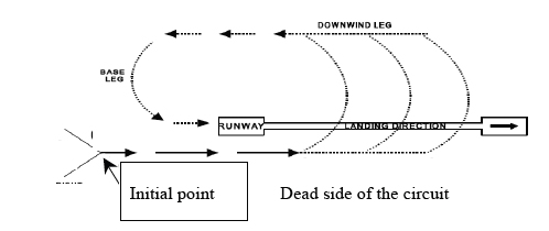
Figure 1: Generic depiction of a military stream landing circuit showing the location of the initial point (left circuit depicted)

aair20050355_001.jpg

(adapted from the Manual of Air Traffic Services Pt 3 s3, effective 10 June 2004)

At 1541:10, the tower controller instructed the pilots of the Dash 8 to make a visual approach and to track for right base. At 1541:20, the tower controller instructed the pilots of the Westwind to join the circuit via the upwind leg. In response to that instruction, the pilots of the Westwind advised the tower controller that the aircraft was 'minimum fuel'6. The tower controller did not respond immediately to that broadcast and the Westwind continued the approach via left base. At about 1541:30, the radar data showed that the Dash 8 had already commenced the turn onto the right base leg of the circuit. At that time, the Westwind was established on left base. The Westwind pilots had positioned their aircraft behind the first formation in the landing sequence. In order to separate the Dash 8 and the Westwind, the tower controller instructed the pilots of the Dash 8 to continue on the downwind leg and that they were now to follow the Westwind.

At 1542, the tower controller advised the pilots of the Dash 8 that they could turn onto the base leg, when ready. At that time the aircraft was close to the airspace boundary separating tower and approach areas of responsibility, about 6.9 NM north-west of the airport.

At 1542:20, the approach controller provided traffic information, on the Dash 8, to the pilots of the second formation. A review of the recorded radar data showed that, at that time, the second formation was about 3 NM behind the Dash 8. Although the investigation was unable to accurately determine the vertical distance between the aircraft, from that radar data, it appeared that there was about 100 ft between the second formation and the Dash 8 when the approach controller provided traffic information to the pilots of the second formation. The pilot of the lead aircraft in the second formation advised the approach controller that he could see the Dash 8.

The recorded radar data also showed that the altitude of the Dash 8 increased from 2,500 ft on late downwind, to 2,900 ft as the aircraft commenced the base turn, before descending in response to the TCAS RA. The Dash 8 subsequently continued to descend for a landing. At 1542:50, the second formation passed abeam the Dash 8, when the Dash 8 was about to commence the turn onto the final approach leg. At that time, there was 0.6 NM laterally between the aircraft, and the Dash 8 was 300 ft vertically below the second formation. The pilots of the Dash 8 advised the tower controller that they had received an RA and that they were on a 'TCAS descent'.

At 1543, the pilots of the second formation called the tower controller and advised that they were at the right initial7 position. The tower controller then realised that the second formation was inbound and provided the pilots of the Dash 8 with traffic information on that formation.

Minimum fuel

In accordance with the Royal Australian Air Force (RAAF) Williamtown Standing Instructions, the Westwind was considered to be a military aircraft while participating in military exercises.

The copilot of the Westwind notified the tower controller that the aircraft was 'minimum fuel' when the aircraft was on a left base position for runway 12. The pilot in command of the Westwind later reported that the aircraft was not 'minimum fuel', and that the copilot had mistakenly made the 'minimum fuel' radio broadcast. The operator of the Westwind advised that the declaration of minimum fuel in that aircraft meant there was '…900 [pounds] or less total fuel remaining at the Base Turn Point when in the circuit, at an airport where a landing is assured'.

Air traffic control separation standards and procedures

Control of aircraft in the Williamtown Airport terminal area was provided by a tower controller using visual procedures and vertical separation, and by an approach controller using radar and procedural separation standards, in accordance with the Manual of Air Traffic Services8 (MATS) and local procedures. Coordination of control responsibilities was required between the approach controller and the tower controller in accordance with local procedures.

The required minimum vertical separation standard between the Dash 8 and other aircraft operating in the Williamtown airspace was 1,000 ft.

In relation to the provision of aircraft separation, the MATS 4.1.1.4 stated that:

Tactical Separation Assurance places greater emphasis on traffic planning and conflict avoidance rather than conflict resolution. This is achieved through:

  1. the proactive application of separation standards to avoid rather than resolve conflicts;
  2. planning traffic to guarantee rather than achieve separation;
  3. executing the plan so as to guarantee separation; and
  4. monitoring the situation to ensure that plan and execution are effective.

The tower controller cleared the pilot of the Dash 8 for further descent on a visual approach when the aircraft was in a late downwind position. A visual approach authorised the pilots to continue descent visually for a landing. A review of the recorded radar data showed that the Dash 8 maintained 2,600 ft for about 1.5 minutes on the downwind leg of the circuit. It reached a minimum altitude of 2,500 ft, on descent, when the aircraft was on a late downwind position, and climbed to 2,900 ft as it turned onto the base leg.

The Aeronautical Information Publication (AIP) advised pilots that they must report to ATC 'when the aircraft has left a level at which level flight has been conducted in the course of climb, cruise or descent'. The pilot in command of the Dash 8 did not recall climbing the aircraft from 2,500 ft on the downwind leg to 2,900 ft on the base leg of the circuit.

Approach control

At Williamtown Airport, the approach controller was responsible for providing an air traffic control service between instrument flight rules (IFR) category aircraft in accordance with the MATS and local procedures. That included ensuring that a separation standard existed between arriving IFR aircraft, and providing an orderly flow of arriving aircraft.

There was an approach controller and a supervisor rostered in the Williamtown approach control unit at the time of the occurrence. Both positions were staffed by an appropriately rated military air traffic controller (ATC). The approach controller had about 6 years experience as an ATC, and had been rated in the approach radar position at Williamtown Airport for 6 months. The approach supervisor was responsible for the supervision of the approach control unit at Williamtown Airport. He had considerable experience as an ATC, and had held a rating in approach control at Williamtown Airport for about 18 months.

A review of the recorded radar data showed that, at the time the approach controller cleared the pilots of the second formation to descend to 3,000 ft, the second formation was approximately 27 NM from the airport, with about 32 NM to fly to land. Had the pilots of the Dash 8 not been instructed to extend the downwind leg, the Dash 8 would have had about 6 to 8 NM to fly to touch down. The assignment of 3,000 ft to the pilots of the second formation did not provide either a vertical separation standard, or separation assurance, between the second formation and the Dash 8 in the circuit. The approach controller was not concerned about the separation between the Dash 8 on the downwind leg, and the second formation on descent to 3,000 ft, because of the distance the second formation was from the airfield at the time the approach controller issued the descent clearance.

The normal circuit direction at Williamtown Airport, on runway 12, was right. Military aircraft would track from the initial point along the dead side9 of the circuit and turn right, into the circuit, once the pilot saw the other traffic operating in the circuit (see Figure 1). The approach controller cleared the Westwind to enter the circuit via a non-standard left base leg and to descend on a visual approach.

The tower controller was required, by local procedures, to advise the approach controller when the Dash 8 pilots were cleared to descend on a visual approach.

On receipt of that advice, the approach controller removed the Dash 8's flight progress strip10 from the flight progress board11. Although the aircraft was still visible to the approach controller on the situation data display (SDD)12, the potential for an infringement of separation standards was no longer presented to the approach controller on the flight progress board. The approach controller later reported that the flight progress strip was removed from the board because there was an expectation that the second formation would remain clear of the Dash 8 in the circuit.

Tower control

The tower cabin was equipped with an SDD that provided the tower controller with the same display of air traffic that was provided to the approach controller. The MATS addressed the use of tower radar in an aerodrome control service. It stated that the tower radar display was available for the determination of the altitude, position or tracking of an aircraft to establish or monitor separation. However, the MATS also stated that:

…the use of the tower radar should not impinge upon an aerodrome controller's primary function of maintaining a visual observation of operations on and in the vicinity of the aerodrome.

There were three operational control positions established in the control tower; a supervisor position, a tower control position and a surface movement control position. Each position was staffed by an appropriately rated military ATC. The supervisor and the tower controller each had 18 months tower control experience. The control tower was also a training environment at the time of the occurrence. There was a controller-under-training in each of the three control positions. Each rated military controller, in each of the positions, was also a qualified training officer.

The supervisor was responsible for airspace management and operations on the airport. The supervisor had the authority to assess and amend the decisions of the tower controller and the surface movement controller if required. Unless the tower controller considered that such intervention compromised safety, the tower controller was obliged to comply with the decisions of the supervisor.

The first formation joined the circuit on a right crosswind leg on descent from 1,500 ft. Once the tower controller was able to apply a visual separation standard between the Dash 8 and that formation, the tower controller instructed the pilots of the Dash 8 to descend on a visual approach.

The tower controller was also required to notify the approach controller of any aircraft that were extending towards the aerodrome traffic zone (ATZ) lateral boundary which was the lateral boundary of tower airspace13. Neither the tower controller nor the supervisor advised the approach controller that the Dash 8 was extending downwind, and would be turning onto the base leg in the vicinity of the lateral boundary of the ATZ. The approach controller was not expecting to see the Dash 8 in that position. The approach controller observed, on the SDD, the Dash 8 turning onto the base leg of the circuit in the vicinity of the lateral boundary of the ATZ, and in the vicinity of the second formation.

The approach controller immediately provided traffic information to the pilots of the second formation about the Dash 8, but could not provide traffic information to the Dash 8 pilots as they were operating on the tower frequency.

The tower controller later reported that he originally intended to instruct the pilots of the Dash 8 to remain in the downwind position at 2,500 ft because it enabled him to better regulate the circuit traffic, especially given that he was instructing a controller-under-training at the time.

Instructing pilots to maintain 2,500 ft on the downwind leg was a common practice at Williamtown Airport. The AIP En Route Supplement Australia (ERSA) advised that all civil aircraft operating at Williamtown Airport were required to carry 30 minutes holding fuel. The tower controller later reported that that holding fuel enabled Williamtown air traffic control the flexibility to hold civil aircraft for up to 30 minutes, if necessary, for sequencing with arriving military aircraft.

Australian Defence Air Traffic System (ADATS)

Air traffic controllers at Williamtown Airport used the Australian Defence Air Traffic System (ADATS) to control aircraft operating within the Williamtown airspace. The ADATS associated a flight plan to an allocated transponder code14 and displayed that information to the controller as a data block, attached to the aircraft track symbol, on the SDD.

The data block could either be a full or limited data block. The full data block was white and included the call sign, altitude and radar derived ground speed, of airborne aircraft equipped with a serviceable transponder. It could also include other control information entered by a controller. A code and flight plan remained associated for a predetermined period of time depending on the nature of the flight. Once that time expired, the code/flight plan association terminated and the data block presented to the controller became a limited data block. The limited data block format did not display the call sign, and the colour of the data block changed from white to green. The limited data block format displayed an aircraft's allocated transponder code, altitude and radar derived ground speed.

The colours allocated to the track symbol and data block indicated the relevance of that aircraft to controllers. A green data block normally indicated that the aircraft was no longer of concern to the controller, as the flight plan was no longer active. The data block and track symbol colours assisted controllers with situational awareness.

The information displayed to the approach controller was also displayed to the tower controllers on the tower SDD. All information on relevant inbound, locally-based, military aircraft was displayed in the aircraft data block, including sequencing and tracking information. In accordance with local procedures, while a flight plan was associated with a specific transponder code, there was no requirement for the approach controller to provide voice coordination to the tower controller.

That applied to locally-based, military aircraft, as that information was available on the tower SDD. The tower controller was required to scan the SDD to determine the sequence and tracking details of arriving locally-based military aircraft. Tower controllers relied on the accuracy of the information presented in the data block, including the colour and sequencing instructions, to assist them in determining an estimated time of arrival, the arrival sequence and the inbound route of each aircraft.

Controllers reported that occasionally the code/flight plan association terminated while aircraft were still airborne. In those circumstances, in accordance with local procedures, the approach controller was required to use voice coordination to advise the tower controller about relevant inbound aircraft. The tower controller would not necessarily detect an inbound aircraft on the SDD if the code/flight plan association had terminated, unless voice coordination was received from the approach controller.

The code/flight plan association for the second formation terminated as the formation tracked to the circuit area and the data label changed colour from white to green. The approach controller reported that, as the termination occurred close to the circuit area, the tower controller would already have been aware that the formation was inbound. As a result, no voice coordination was provided to the tower controller.

Meteorological information

The weather was reported as fine and clear and was not considered to have been a factor in the occurrence.

  1. Only those investigation areas identified by the headings and subheadings were considered to be relevant to the circumstances of the occurrence.
  2. A tower controller employed by the Department of Defence provides a similar air traffic control service as a civil aerodrome controller.
  3. The 24-hour clock is used in this report to describe the local time of day, Eastern Daylight-saving Time, as particular events occurred. Eastern Daylight-saving Time was Coordinated Universal Time (UTC)+ 11 hours.
  4. Due to the limitations with the audio recording, all times are accurate to within about +/- 5 seconds.
  5. The initial point for runway 12 at Williamtown Airport was located about 4 NM from the threshold of runway 12 along the extended centreline of taxiway Alpha, at 1,500 feet above mean sea level.
  6. This phrase is used to advise air traffic control that the pilot requires priority for landing based on the amount of fuel remaining, calculated at a particular stage of flight (Manual of Air Traffic Services, pt 10, effective 9 June 2004).
  7. The left, right and straight initial positions are 30 seconds prior to the initial point with wings level.
  8. The Manual of Air Traffic Service is a joint civil/military publication used by Department of Defence and Airservices Australia air traffic controllers.
  9. The dead side of the circuit is the side of the airfield or active runway, opposite to that of the circuit pattern in use, and from which arriving aircraft joining the circuit.
  10. A flight progress strip is a thin cardboard strip used to record flight data relating to control of an aircraft.
  11. A flight progress board is a piece of equipment used to display flight progress strips. Controllers use the information on the flight progress board to assist in managing the traffic situation.
  12. The situation data display was an electronic display of radar derived information that depicted the positions and movements of aircraft.
  13. The ATZ is that airspace within 5 NM of the tactical air navigation equipment ground based navigation aid, over land, from ground level to 1,500 ft above mean sea level. At Williamtown Airport, the stream landing circuit pattern (see Figure 1) is contained entirely within the ATZ.
  14. A transponder is a receiver/transmitter which will generate a reply signal upon proper interrogation, in this case, of a signal generated by a ground based transmitter/receiver.

Summary

On 31 January 2005, a de-Havilland Canada Dash 8-202 (Dash 8) aircraft that was inbound to Williamtown Airport, NSW, on a scheduled passenger service from Brisbane, Queensland, passed 0.6 NM laterally and 300 ft vertically by the second of two formations of two McDonnell Douglas Corporation F/A-18 (Hornet) aircraft that were inbound to Williamtown Airport after a training exercise. As the Dash 8 turned onto the base leg, the second formation was about 6 NM north-west of Williamtown Airport, at 2,900 ft above mean sea level. The pilots of the Dash 8 descended in response to a traffic alert and collision avoidance system resolution advisory (RA) they received on that formation. The approach controller did not provide the required separation standard of 1,000 ft vertically or 3 NM laterally between the Dash 8 and the second formation. The tower controller had not established a visual separation standard between the aircraft at the time the Dash 8 pilots received the RA. There was an infringement of separation standards.

The investigation found that the factors that contributed to the occurrence included:

  • The approach controller did not assign an altitude to the second formation that provided a vertical separation standard between the second formation and the Dash 8
  • The tower supervisor advised the tower controller to cancel an instruction to the Dash 8 pilots to orbit on the downwind leg of the circuit at 2,500 ft, and to continue on the downwind leg of the circuit
  • The tower controller did not notify the approach controller that the Dash 8 was extending towards the lateral boundary of tower airspace
  • The pilots of a Westwind incorrectly notified the tower that their aircraft was 'minimum fuel' and did not join the circuit via the upwind leg as instructed by the tower controller.

Occurrence summary

Investigation number 200500355
Occurrence date 31/01/2005
Location Williamtown, Aero.
State New South Wales
Report release date 26/06/2006
Report status Final
Investigation type Occurrence Investigation
Investigation status Completed
Mode of transport Aviation
Aviation occurrence category Loss of separation
Occurrence class Incident
Highest injury level None

Aircraft details

Manufacturer De Havilland Canada/De Havilland Aircraft of Canada
Model DHC-8
Registration VH-SDA
Serial number 482
Sector Turboprop
Operation type Air Transport Low Capacity
Departure point Brisbane, QLD
Destination Williamtown, NSW
Damage Nil

Aircraft details

Manufacturer McDonnell Douglas Corp.
Model F/A-18
Registration Unknown
Sector Jet
Operation type Military
Departure point Williamtown, NSW
Destination Williamtown, NSW
Damage Nil

Aircraft details

Manufacturer McDonnell Douglas Corp.
Model F/A-18
Registration Unknown
Sector Jet
Operation type Military
Departure point Williamtown, NSW
Destination Williamtown, NSW
Damage Nil

Boeing 747-400, HS-TGJ

Safety Action

Safety Action

As a result of this occurrence, Airservices Australia has advised the Australian Transport Safety Bureau that it is reviewing the following issues in order to strengthen the operational risk controls for prevention and recovery from, similar occurrences:

  • The Australian Advanced Air Traffic System’s (TAAATS) existing human machine interface for effectiveness and efficiency and to ensure standardisation
  • Airspace, for division both laterally and vertically, to reduce airspace complexity and facilitate an improved ASD
  • Route structure, to remove unnecessary waypoints to assist controller interaction with data input
  • Coordination requirements, both domestically and internationally, to reduce complexity and controller workload, through increased automation
  • Supervision available, by either increasing the hours of operation of operations supervisors to 24 hour coverage, together with additional training, or by the provision of additional training for systems supervisors, for night time operation
  • The location of workstation positions at night, for improved peer support and situational awareness
  • Refresher training, to ensure all staff have completed required training in active listening, scanning, separation assurance, and recovery from an unusual situation such as a breakdown of separation. Additionally ensuring that this training adequately covers compromised separation in the non-radar environment.

In addition, The TAAATS Alerts Review and Enhancement Project is currently reviewing the processing and display of CLAM and other alerts for controllers. Software is currently being developed to allow a flight plan conflict function display for procedural tracks, including ADS tracks, for delivery late in 2006.

Analysis

Analysis

While it was not possible to determine the controller’s level of fatigue, it is likely that the significant level of workload and the controller’s acknowledged diminished level of mental alertness and the time of day, together contributed to the incident.

The routine display of CLAM alerts for expected events, such as the issue of discretionary climb, did little to enhance the controller’s situational awareness in regard to QF31s cleared level status.

Summary

On 28 November 2004, a Boeing Company 747-438 aircraft was en route from Sydney to Singapore at flight level (FL) 360. Another Boeing Company 747-400 aircraft was en route from Bangkok to Sydney at FL350. At 1509, the crew of the 747-438 had been issued with a clearance to climb to FL380 with a requirement to reach that level by 1550 and the crew planned to leave FL360 at 1544. At 1521, the crew of the 747-400 requested a clearance to climb to FL370 and were issued a clearance to reach FL370 by 1528. This resulted in an infringement of separation standards.

At 1538, approximately 150 NM north-west of waypoint NIKOM, the crew of the 747-438 observed an aircraft pass overhead. They informed the controller, and confirmed that they had a clearance to climb to F380. The controller acknowledged the crew, but took no further action to resolve the infringement of separation standards.

The controller reported that when he issued the climb instruction to the crew of the 747-400, his mental picture was that the 747-438 was maintaining FL360, and this was reinforced by a simultaneous separation problem with another aircraft. He also reported that it was possible that he may also have mixed up the displayed levels for the 747-438.

The controller indicated that his sleep pattern had been disrupted, and while he had assessed himself as fit for duty, and felt competent to acquit the required task, he felt ‘a bit more fatigued than normal’.

Occurrence summary

Investigation number 200404707
Occurrence date 28/11/2004
Location 278 km NW NIKOM, (IFR)
State International
Report release date 14/11/2005
Report status Final
Investigation type Occurrence Investigation
Investigation status Completed
Mode of transport Aviation
Aviation occurrence category Loss of separation
Occurrence class Incident
Highest injury level None

Aircraft details

Manufacturer The Boeing Company
Model 747
Registration HS-TGJ
Serial number NA
Sector Jet
Operation type Air Transport High Capacity
Departure point Bangkok Thailand
Destination Sydney NSW
Damage Nil

Aircraft details

Manufacturer The Boeing Company
Model 747
Registration VH-OJM
Serial number 25245
Sector Jet
Operation type Air Transport High Capacity
Departure point Sydney NSW
Destination Singapore
Damage Nil

Boeing 767-336, VH-ZXC

Summary

Sequence of events

On 1 November 2004, a Boeing Company B767-336 (767) aircraft, registered VH-ZXC, was cleared for departure via the Sydney RWY 34R MARUB THREE standard instrument departure (SID) with a clearance limit of 5,000 ft. A military Lockheed Georgia Company C-130J (C130) aircraft was inbound to Richmond, NSW, from Nadi, Fiji, and had been cleared to descend to 6,000 ft and was tracking overhead Sydney for Richmond. As the aircraft approached each other about 5 NM east of Sydney, an infringement of the separation standard occurred.

The copilot of the 767 was the handling pilot for the sector and was manually flying the aircraft while tracking via the SID. After take-off, and when passing 1,500 ft, the copilot called for climb thrust to be set, and for the vertical navigation mode to be selected on the Mode Control Panel (MCP) of the aircraft's Autopilot Flight Director System. The pilot in command said that he selected climb thrust on the MCP, but did not recall seeing climb thrust annunciated. The copilot then called for the lateral navigation mode to be selected on the MCP and at 3,000 ft the aircraft began to reduce the rate of climb.

Passing through 4,000 ft, with the flaps fully retracted, the copilot noticed that climb thrust was not annunciated and advised the pilot in command that the Command Airspeed Bug was not in the correct position. The pilot in command reached over and reselected climb thrust and noted correct climb thrust annunciation. As the aircraft was passing through 4,600 ft and climbing at about 3,500 ft/min, the copilot engaged the autopilot. The pilot in command told the copilot to "nose it over" but the aircraft climbed to 5,350 ft before descending back to the assigned level of 5,000 ft.

The 767's traffic alert and collision avoidance system (TCAS) activated a resolution advisory (RA) for the crew to "monitor vertical speed". The pilot in command of the 767 saw the C130 during the period of the TCAS activation.

The crew of the C130 were alerted to the proximity of the 767 by the aircraft's TCAS display, when it was at 4 NM in the 10 o'clock position indicating 700 ft below their level of 6,000 ft. They then saw the 767 and their TCAS activated a RA advising them to climb, which they acted upon. At 6,400 ft, the TCAS RA instructed the crew of the C130 to maintain altitude. After the 767 was observed to pass below the C130, the crew said that they notified air traffic control of the infringement of separation standards. The air traffic controller then advised the crew to descend back to 6,000 ft because the aircraft were no longer in conflict.

Recorded radar data indicated that lateral separation between the aircraft reduced to 2.6 NM with a vertical separation of 600 ft. The required radar separation standard was 3 NM laterally or 1,000 ft vertically.

Occurrence summary

Investigation number 200404287
Occurrence date 01/11/2004
Location 9 km ENE Sydney, Aero.
State New South Wales
Report release date 09/09/2005
Report status Final
Investigation type Occurrence Investigation
Investigation status Completed
Mode of transport Aviation
Aviation occurrence category Loss of separation
Occurrence class Incident
Highest injury level None

Aircraft details

Manufacturer The Boeing Company
Model 767
Registration VH-ZXC
Serial number 24339
Sector Jet
Operation type Air Transport High Capacity
Departure point Sydney, NSW
Destination Melbourne, VIC
Damage Nil

Aircraft details

Manufacturer Lockheed Aircraft Corp
Model C-130
Registration A97J
Sector Turboprop
Operation type Military
Departure point Nadi, Fiji
Destination Richmond, NSW
Damage Nil

Boeing 737-838, VH-VXM

Summary

The Australian Transport Safety Bureau did not conduct an on-scene investigation of this occurrence. The information presented below was obtained from information supplied to the Bureau.

On 6 October 2004, at 1301 central standard time, a Lockheed Georgia Company C-130H (C130) operated by the Royal Australian Air Force (RAAF) departed Darwin Airport for Edinburgh, tracking via air route A461. The pilot of the C130 was cleared to climb to flight level (FL) 250. Eleven minutes after the C130 departed, a Boeing Company 737-838 (737), registered VH-VXM, departed Darwin Airport for Adelaide, also tracking via A461.

The sector controller located in the Brisbane Centre recognised that the faster following 737 could potentially conflict with the C130 during its climb and contacted RAAF Darwin Approach. The controllers agreed that the Darwin approach controller would establish a method to resolve the conflict and accept responsibility for separation. The Darwin controller issued a requirement to the crew of the 737 to reach FL260 by 90 DME (a measure in nautical miles after application of navigation aid and other tolerances using Distance Measuring Equipment) from Darwin. This requirement did not provide separation assurance with the C130. This error was not detected by either controller.

At 1319, a radar handoff of the 737 was completed between the two controllers and the climb requirement was reiterated to the crew of the 737 by the Darwin approach controller. At 1321, when the crew of the 737 made their initial call on the sector controller's frequency, that controller realised that there was a problem with the separation method being applied. At that time, the 737 was passing FL212 and the C130 was passing FL220, and the distance between the two aircraft was reducing. The controller immediately instructed the 737 crew to climb to FL370 and to expedite their climb through FL230. At 1322, the radar system's short term conflict alert activated. The C130 crew was instructed to descend their aircraft to FL220. The distance between the aircraft reduced to 3.9 NM, which was less than the required 5 NM radar separation standard, before the 1,000 ft vertical separation standard was re-established. There was an infringement of separation standards.

The RAAF and Airservices Australia investigated the occurrence. Those investigations found that:

  • the Darwin approach controller did not apply an appropriate requirement to the crew of the 737 to ensure separation was maintained
  • the sector controller's monitoring of the situation was inadequate.

Occurrence summary

Investigation number 200403800
Occurrence date 06/10/2004
Location 93 km SE Darwin, (VOR)
Report release date 21/02/2005
Report status Final
Investigation type Occurrence Investigation
Investigation status Completed
Mode of transport Aviation
Aviation occurrence category Loss of separation
Occurrence class Incident
Highest injury level None

Aircraft details

Manufacturer The Boeing Company
Model 737
Registration VH-VXM
Serial number 33483
Sector Jet
Operation type Air Transport High Capacity
Departure point Darwin, NT
Destination Adelaide, SA
Damage Nil

Aircraft details

Manufacturer Lockheed Aircraft Corp
Model C-130
Registration AUSY796
Sector Turboprop
Operation type Military
Departure point Darwin, NT
Destination Edinburgh, SA
Damage Nil

Beechcraft 200, VH-ITH, 7 km E Essendon, (NDB), Vic, 24 August 2004

Summary

Preliminary investigation was undertaken into a category 4 occurrence involving a TCAS alert on a de Havilland Dash 8 aircraft about a Beechcraft King Air aircraft near Essendon Airport. The ATSB has terminated the investigation based on information from the pilot of the King Air that he diverted his attention during the climb and did not adequately monitor the aircraft's altitude following the departure. There was relatively little safety benefit to be gained from continuing the investigation compared with other priorities.

Status: Downgraded the occurrence to category 5 and investigation discontinued.

Occurrence summary

Investigation number 200403106
Occurrence date 24/08/2004
Location 7 km E Essendon, (NDB)
Report release date 24/06/2004
Report status Discontinued
Investigation type Occurrence Investigation
Investigation status Discontinued
Mode of transport Aviation
Aviation occurrence category Loss of separation
Occurrence class Incident
Highest injury level None

Aircraft details

Manufacturer Beech Aircraft Corp
Model 200
Registration VH-ITH
Operation type Charter
Damage Nil

Aircraft details

Manufacturer De Havilland Canada/De Havilland Aircraft of Canada
Model DHC-8
Registration VH-TQX
Operation type Air Transport Low Capacity
Damage Nil

Infringement of separation standards at Darwin airport

Safety Action

Royal Australian Air Force safety action

Since this occurrence the RAAF has removed Wickham Point from the local procedure to reduce the risk of a conflict between a departing helicopter and other aircraft.

Factual information

The Australian Transport Safety Bureau did not conduct an investigation into this occurrence. The report produced below is derived from an investigation conducted by the Department of Defence-Royal Australian Air Force (RAAF)1.

Reported information

On 20 July 2004, at approximately 1514 central standard time, a de Havilland Dash 8-200 (Dash 8) was on a visual approach for a landing on runway 36 at Darwin and was operating under the instrument flight rules (IFR). At the same time, an Australian Army Bell 206B-1 (Kiowa) helicopter was departing Darwin and was operating under the visual flight rules (VFR). The helicopter crew had been cleared to depart the Darwin control zone via Wickham Point. Wickham Point was a visual fix located approximately 3.5 NM south of the threshold of runway 36. According to the RAAF report, the two aircraft came within 2.6 NM of each other when there was 500 ft vertically between them. There was an infringement of separation standards.

The RAAF, as the airspace administering authority, was responsible for the provision of air traffic control services at Darwin. Local 'low level helicopter release procedures' authorised the aerodrome controller (ADC) to depart VFR helicopters not above 1,000 ft, tracking direct to one of six visual fixes around the Darwin control zone, whilst separating the VFR helicopter from all traffic operating under the IFR.

According to those procedures the approach controller became aware of a departing helicopter once the aircraft taxied and the surface movement controller entered the aircraft details into the automated air traffic control system in use at Darwin. The approach controller would again be alerted to the departing helicopter when the radar detected the departing aircraft and the aircraft's track symbol appeared on the radar display. The approach controller was also required to advise the ADC of any inbound aircraft so that the ADC could separate a departing helicopter with other relevant aircraft.

The RAAF report found that:

  • the team of controllers that were operating in the control tower at the time of the occurrence had been controlling for 2.5 hours, in high density and complex traffic levels, and may have been fatigued
  • the controllers in both the tower and in approach had difficulties coordinating with each other due to the high traffic levels
  • the approach controller did not receive notification that the Kiowa was taxying
  • the approach controller coordinated the inbound Dash 8 with the ADC when that aircraft had left 2,000 ft on descent and the helicopter was level at 1,000 ft
  • the approach controller became aware of the helicopter when that aircraft's track symbol appeared on his radar display.

1 For further information on the RAAF report contact The Directorate of Flying Safety - Australian Defence Force (FS5), Campbell Park Offices, Canberra ACT 2600.

Occurrence summary

Investigation number 200402703
Occurrence date 20/07/2004
Location Darwin, Aero.
State Northern Territory
Report release date 03/02/2005
Report status Final
Investigation type Occurrence Investigation
Investigation status Completed
Mode of transport Aviation
Aviation occurrence category Loss of separation
Occurrence class Incident
Highest injury level None

Aircraft details

Manufacturer Bell Helicopter Co
Model 206A
Sector Helicopter
Operation type Military
Departure point Darwin, NT
Damage Nil

Aircraft details

Manufacturer De Havilland Canada/De Havilland Aircraft of Canada
Model DHC-8
Registration VH-ZZI
Serial number 550
Sector Turboprop
Operation type Aerial Work
Destination Darwin, NT
Damage Nil

Cessna 404, VH-ANM

Safety Action

Royal Australian Air Force safety action

To ensure that separation responsibility in these circumstances is clearly defined, the RAAF at Darwin amended its auto-release procedures so that when more than one preceding aircraft have already been assigned the same auto release heading, a following aircraft operating under the IFR shall be assigned a different auto release heading.

Summary

The Australian Transport Safety Bureau did not conduct an investigation into this occurrence. The report produced below is derived from an investigation report produced by the Department of Defence-Royal Australian Air Force (RAAF)1 which was the administering authority for the Darwin Control Zone.

Reported information

On 21 July 2004, at 0955 central standard time, a Cessna Aircraft Company 206 (C206) departed Darwin for Croker Island, NT. The aircraft was being operated under the visual flight rules (VFR). Another aircraft, a Cessna Aircraft Company 210 (C210) departed Darwin at 0956 for Snake Bay, NT, and was also being operated under the VFR. A third aircraft, a Cessna Aircraft Company 404 (C404) departed Darwin at 0958 for Croker Island. That aircraft was being operated under the instrument flight rules (IFR). All three aircraft were instructed by the aerodrome controller (ADC) to fly a heading of 060 degrees after take off.

The RAAF investigation report found that the pilot of the C404 had been instructed to sight and maintain visual separation with the C210. However, the C404 also caught up with and eventually overtook, the C206. Neither the pilot of the C206 nor the pilot of the C404 received traffic information on the other aircraft, and neither pilot was assigned the responsibility for separation with the other aircraft. According to the RAAF investigation report, the C404 passed within 0.2 NM of the C206 while both aircraft were at the same altitude. There was an infringement of separation standards.

The Manual of Air Traffic Services (MATS) section 4.5.1.4 authorised the assignment of responsibility for separation to the pilot of one aircraft if that pilot reported 'sighting the other aircraft and is instructed to maintain visual separation with, or to follow that aircraft'. The MATS Section 4.5.1.2 also stated that, when applying visual separation, 'controllers shall consider aircraft performance characteristics, particularly in relation to faster following aircraft'.

Darwin was operating on auto-release procedures at the time of the occurrence. The MATS Part 10, section 1 defined auto release as a procedure whereby the ADC must ensure that the spacing between successive departing aircraft is sufficient to enable the Departures controller to establish and maintain the required separation minima. In this occurrence, the responsibility for establishing and maintaining the required separation minima between the C210 and the C404 had been assigned to the pilot of the C404. The ADC did not ensure that the departures controller could establish and maintain separation between the C206 and the C404, and the responsibility for establishing and maintaining separation had not been assigned to either pilot.

1 For further information on the RAAF report contact The Directorate of Flying Safety - Australian Defence Force (FS5), Campbell Park Offices, Canberra ACT 2600.

Occurrence summary

Investigation number 200402705
Occurrence date 21/07/2004
Location 37 km NE Darwin, Aero.
State Northern Territory
Report release date 02/02/2005
Report status Final
Investigation type Occurrence Investigation
Investigation status Completed
Mode of transport Aviation
Aviation occurrence category Loss of separation
Occurrence class Incident
Highest injury level None

Aircraft details

Manufacturer Cessna Aircraft Company
Model 404
Registration VH-ANM
Serial number 4040010
Sector Piston
Operation type Charter
Departure point Darwin, NT
Destination Croker Island, NT
Damage Nil

Aircraft details

Manufacturer Cessna Aircraft Company
Model 206
Registration VH-HPA
Serial number U20605002
Sector Piston
Operation type Charter
Departure point Darwin, NT
Destination Croker Island, NT
Damage Nil

Aircraft details

Manufacturer Cessna Aircraft Company
Model 210
Registration VH-OKJ
Serial number 21061602
Sector Piston
Operation type Unknown
Departure point Darwin, NT
Destination Snake Bay, NT
Damage Nil

Boeing 737-476, VH-TJH

Safety Action

SAFETY ACTION

Airservices Australia advised that the safety actions in place following the incident or planned for implementation include:

  • The Group Tower Manager responsible for Hamilton Island has reinforced the need, through the Tower Manager, to ensure that the automatic terminal information system (ATIS) strip matches the actual ATIS broadcast
  • A review of the requirements of the visual separation requirements in the Manual of Air Traffic Services (MATS) was conducted to assure that all pertinent limitations were referenced and determined that no changes to MATS were required
  • A performance check will be completed every month for the first 3 months after an air traffic controller gets an initial rating, then at 6 months and then the checking regime will be in accordance with the requirements in the Civil Air Traffic Services Operations Administration Manual (target date for implementation is 30 June 2005).

Safety action update from Airservices Australia (dated 6 March 2008)

Following the ATSB investigation of this occurrence, Airservices advised of three safety actions in place or planned for implementation. All those actions were completed within the advised time frame. Airservices subsequently completed a review of the following action in respect of its application and benefit to the Air Traffic System.

A performance check will be completed every month for the first 3 months after an air traffic controller gets an initial rating, then at 6 months and then the checking regime will be in accordance with the requirements in the Civil Air Traffic Services Operations Administration Manual (target date for implementation is 30 June 2005).

This correspondence is to advise that Airservices has removed the prescriptive requirement to undertake these performance assessments and replaced it with a more generic requirement 'the assessor is encouraged to perform such additional performance assessment(s) as is/rare) thought appropriate to the individual circumstance in the early stages of the controller's consolidation in such a new Endorsement. This may for instance mean that a controller is formally re-assessed prior to the expiry of the normal currency period of 6 months'.

A follow up review indicated that additional guidance should be added such that 'particular consideration with regard to additional or more frequent assessments should be given to newly endorsed controllers who are not subject to regular supervision'. This guidance will be incorporated into the documents by end of May 2008.

APPENDIX A

Air Traffic Control Automatic Voice Recording - Hamilton Island ADC

Legend:

717 - Boeing 717 aircraft (`C/S 717' designates where the callsign of the aircraft is used in radio transmissions)
ADC - Aerodrome controller
737 - Boeing 737 aircraft (`C/S 737' designates where the callsign of the aircraft is used in radio transmissions)
SC - Brisbane sector controller
[…]- Unintelligible transmission

Only radio transmissions pertinent to the occurrence are included.

Time (EST)FromToRemarks
1613:04717ADCHamilton tower C/S 717 requesting taxi with Quebec
1613:09ADC717C/S 717 taxi enter backtrack and line up runway one four the time is one three
1613:14717ADCEnter backtrack line up runway one four C/S 717
1613:33SCADCSwampy
 ADCSCTaxies C/S 717 Sydney cleared via Mackay flight planned route flight level three one zero
1613:39SCADCThree one zero C/S 717
1614:10737ADCHamilton tower good afternoon C/S 737 is on descent to six thousand three zero dme
1614:16ADC737C/S 737 good afternoon Hamilton tower descend to five thousand report approaching with dme distance
1614:23737ADCC/S 737
1614:57ADCSCNext in one is C/S 717 via Mackay
 SCADCC/S 717 unrestricted
 ADCSCUnrestricted C/S 717
1615:15ADC737C/S 737 about to roll runway 14 is C/S 717 outbound direct to Mackay I have him maintaining three thousand and you down to four thousand until we get a sighting
1615:30737ADCC/S 737
1616:55717ADCAnd C/S 717 is ready
 ADC717/737C/S 717 break C/S 737 your current dme distance hammo
1617:03737ADCC/S 737 is one six and we've just left six thousand
1617:10ADC737C/S 737 roger descend to four thousand visual
1617:12737ADCFour thousand visual C/S 737
1617:16ADC717C/S 717 maintain three thousand expect no delay at that level clear for take off make right turn
1617:22717ADCThree thousand clear for take off make right turn C/S 717
1617:30ADC737C/S 737 report sighting a seven one seven about to roll runway […]
1617:36737ADCEleven seventy four
1618:05737ADCC/S 737 is approaching four are we cleared to left downwind
1618:16ADC737C/S 737 roger track now for a left downwind runway one […]
1618:24737ADCRoger and we have the seven one seven in sight
1618:28ADC737C/S 737 roger cleared a visual approach report turning left base
1618:34737ADCC/S 737 roger
1618:39737ADCThat will be a right base sorry
1618:41ADC737Okay make that a right circuit and report on right base
1618:45737ADCC/S 737
1618:52ADC717C/S 717 climb to flight level three one zero the other aircraft has you in sight
1619:00717ADCC/S 717 say again
1619:03ADC717C/S 717 climb to flight level three one zero the other aircraft has you in sight
1619:07717ADCFlight level three one zero C/S 717
1619:10ADC737C/S 737 just confirm you will be passing behind the seven one seven
1619:14737ADCRoger aah that's affirmative
 ADC737Thank you
1619:20  Ah […]
1619:33ADC737C/S 737 tower um […] that aircraft in sight and were going to pass behind
1619:42737ADCAnd yeah and then he started to turn and we did not have any choice but turn left
1619:45ADC737Understood

Significant Factors

SIGNIFICANT FACTORS

  1. The ADC did not communicate to the crew of the 737 the requirement to pass behind the 717.
  2. The crew of the 737 did not perceive the potential threat presented by the 717 until the crew of that aircraft acted to ensure that their flight path did not place them in a near collision situation.

Analysis

ANALYSIS

The Hamilton Island Aerodrome Controller (ADC) had a plan to separate the aircraft, but did not clearly communicate the plan to the pilots and consequently it was not executed correctly. Having the 737 pass behind the 717 was going to present some difficulties due to the intended tracks of the aircraft, and required the ADC to advise the crew of the 737 as early as possible of that tracking requirement. While traffic information about the 717 was provided to the crew of the 737, the ADC did not communicate an important aspect; that is, that after reporting seeing the 717 they would have to pass behind it. Had that been the case, the crew of the 737 probably would have been able to turn right in sufficient time to safely pass behind the 717. Alternatively, they may have requested another means of separation as the position of the aircraft may have prevented them from passing behind it.

The use of visual separation, either by controllers or pilots, increases the likelihood of an apparent traffic alert and collision avoidance system (TCAS) alert between aircraft. Apparent alerts result from aircraft being within the TCAS alert parameters while complying with an air traffic control (ATC) clearance. In this occurrence, if the 717 crew had not turned away, it is possible that one or both of the aircraft's systems would have issued a traffic alert (TA) or a resolution advisory (RA) In the case of the latter, the pilots would have had to comply. That would have increased crew workload, particularly for the departing 717 crew, when the aircraft was in a critical stage of flight. As it was, the crew of the 717 had to descend to avoid the 737.

The limitations in using visual separation, highlighted in the Manual of Air Traffic Services, applied similarly to the ADC and both crews. The fact that the aircraft were tracking on almost reciprocal tracks, with little or no divergence when viewed by the ADC or the crews, made it difficult for those involved to obtain adequate cues about the situation. However, the crew of the 717 was able to appreciate the potential for conflict by using available visual and system information.

Despite the regulations stating that in a situation where aircraft are approaching head on a pilot shall alter the aircraft's heading to the right, the actions by the crew of the 717, in turning left, could be seen to be reasonable in the circumstances. A turn to the right may have increased the risk of collision. Similarly, if the crew of the 737 had turned their aircraft to the right in accordance with procedures, as the 717 turned left, the risk of a collision may have increased.

Once the ADC was under the impression that responsibility for separation had been transferred to the crew of the 737 and had issued instructions to the crews to climb/descend, the protection afforded by the vertical separation standard was lost. From that point on, the only defences available to the crews to prevent them being in close proximity were their awareness of the other aircraft and the use of TCAS. As they could clearly see the 717, the crew of the 737 did not perceive that there was a problem. The crew of the 717 were concerned at the developing situation and turned away from the 737. That action ensured that sufficient spacing was maintained between the two aircraft and probably prevented a subsequent TCAS RA.

Had the ADC maintained the 1,000 ft vertical separation standard between the aircraft until they had definitely passed, or else confirmed that one of the crews could maintain separation with the other aircraft, it is likely that the occurrence would have been prevented. The use of vertical or lateral separation standards instead of a visual standard would have also limited the possibility of a TCAS alert.

The occurrence highlighted the importance of using unambiguous radiotelephony phraseology to avoid misunderstandings and the need for pilots and controllers to remain vigilant at all times, especially when the dynamics of a situation require action to be implemented early to ensure that the safety of aircraft is not compromised.

Factual information

FACTUAL INFORMATION

On 17 July 2004, at about 1619 eastern standard time, a Boeing Company 737-476 (737), registered VH-TJH, was inbound to Hamilton Island from the south-east for a landing on runway 14. The Hamilton Island Aerodrome Controller (ADC) instructed the crew to descend to 4,000 ft above mean sea level (AMSL) due to the pending departure of a Boeing Company 717-200 (717), registered VH-VQB, from runway 14. The crew of the 737 requested and were approved by the ADC to track for a left downwind to runway 14. The ADC instructed the crew of the 717 to maintain 3,000 ft AMSL, to make a right turn to track to Mackay and that they were clear for takeoff. The weather was visual meteorological conditions (VMC) and the crew of the 737 reported to the ADC that they could see the 717. The ADC instructed the crew of the 737 to make a visual approach to left base that was amended to a right base after the crew requested that change. Shortly after intercepting the outbound track at about 2,000 ft, the crew of the 717 received a traffic alert and collision avoidance system (TCAS) traffic advisory (TA) and saw the 737 crossing from left to right on descent. The 717 crew's perception was that the expected track of the aircraft would place them on, or close to a collision course so they turned left and descended to avoid the 737 by passing behind it.

Analysis of air traffic control recorded radar data and aircraft flight data revealed that at 1619:15, after the 717 had turned left, the lateral and vertical distance between the aircraft was 1,112 m and 700 ft (737 above the 717). Both aircraft were fitted with a traffic alert and collision avoidance system (TCAS). The flight data recorder (FDR) in the 717 was only capable of recording TCAS resolution advisory (RA) parameters while the 737 FDR did not record any TCAS parameters. Data from the 717 revealed that there was no TCAS RA. The crew of the 717 changed the aircraft's heading by about 35 degrees and descended to 1,500 ft during the manoeuvre, before returning to their assigned track and climbing to 3,000 ft.

Hamilton Island Air Traffic Control

The ADC was responsible for providing air traffic control services in Class D airspace from ground level to 4,500 ft AMSL. In Class D airspace, air traffic control (ATC) is required to separate aircraft operating under the instrument flight rules (IFR) from other aircraft operating under the IFR or special visual flight rules (VFR). In addition, ATC is required to provide the crews of aircraft operating under the IFR with traffic information about aircraft operating under the VFR. The 737 and 717 were both operating under the IFR.

The circumstances were not related to any national airspace changes as both aircraft were IFR and in airspace being managed by ATC.

Clearances and separation

The pilot of the 737 had been issued with a clearance by the Brisbane Centre controller to track inbound to Hamilton Island via the 143 radial of the Hamilton Island VOR1. The ADC issued a clearance to the pilot of the 717 to track via the 157 radial of the Hamilton Island VOR to Mackay and then the planned route to Sydney. The Aeronautical Information Publication En Route Supplement, Hamilton Island special procedures, nominated a right circuit for operations to runway 14. The use of runway 14 and the issued clearances would result in the aircraft tracks intersecting at some stage (see Figure 1).

Figure 1: Hamilton Visual Terminal Chart with aircraft tracks and times.

aair200402648_001.jpg

The ADC was aware of this and assigned altitudes to the crews that provided the 1,000 ft vertical separation standard required between two aircraft operating under the IFR. The application of that standard was necessary until an alternative separation standard was in place.

When a pilot of an arriving aircraft has been approved by ATC to make a visual approach, they are required to track in accordance with the assigned track clearance until within 5 NM of the aerodrome. From 5 NM, the pilot can diverge from the inbound track to join the circuit as directed by ATC for an approach to the nominated runway.

Air traffic control (ATC) visual separation standards and procedures

The Manual of Air Traffic Services (MATS) details the standards and procedures to be used by controllers to separate aircraft. Part 4, Section 1, Separation Standards stated that in the provision of separation, controllers shall place greater emphasis on traffic planning and conflict avoidance than on individual conflict resolution being achieved. This is to enable separation assurance to be achieved through planning traffic to ensure separation, executing the plan to achieve separation and monitoring the situation to ensure that the plan and the execution are effective. Section 5, Visual Separation stated that visual separation could be achieved by the use of visual procedures (by controllers) or by assigning visual separation responsibility to a pilot. Controllers are to consider aircraft performance characteristics when applying visual separation.

The application of visual separation by the ADC or either crew would have been an appropriate alternative to the vertical separation standard. When aircraft are operating at or below flight level (FL) 1252 and will continue to do so during the application of visual separation by a pilot, the pilot of one aircraft is required to report sighting the other aircraft and has to be instructed by a controller to maintain visual separation with, or to follow, that aircraft. Also, if a pilot has been instructed to maintain separation from, but not to follow an IFR category aircraft, then the controller is required to provide traffic information to the pilot of the IFR category aircraft. That information should contain as much detail as possible including the aircraft type, altitude or flight level, position and intentions or direction of flight. If there is any doubt about a pilot's ability to either keep another aircraft in sight or to maintain separation, a controller shall issue alternative instructions to provide separation.

The ADC's reported expectation was that the aircraft tracks would cross such that the 737 would pass behind the 717. At 1615:15, when the 717 was lining up on the runway, the ADC advised the crew of the 737 that the 717 was due to depart direct to Mackay on climb to 3,000 ft and that they could expect to maintain 4,000 ft until the 717 was sighted [by the 737 crew]. The ADC did not advise either crew of the intention, after the 717 was seen by the crew of the 737, to assign separation responsibility to that crew and have them pass behind the 717 (see Appendix A.

While the 717 was taking off, the crew of the 737 reported approaching 4,000 ft and requested a clearance to track for left downwind. The ADC instructed the crew to track for left downwind. At 1618:26, the crew reported to the ADC that they could see the 717. The ADC issued a clearance for the crew to make a visual approach and to report turning a left base. The crew acknowledged the instruction and requested to track to a right base for the runway. The ADC instructed the crew to track for and to report on right base. At 1619:00, the ADC instructed the crew of the 717 to climb to FL310. A pilot approved to make a visual approach can descend as required to establish an aircraft on base or final to the assigned runway. The ADC's instruction to the crew of the 737 to make a visual approach and the instruction to the crew of the 717 to climb, cancelled the separation assurance provided by the application of the vertical separation standard.

Controllers can separate aircraft by visual observation of aircraft position and projected flight paths. The MATS advised that in providing visual separation, controllers should rely primarily on azimuth and if visual separation by judgement of relative distances or altitude is used, then it should be with such wide margins that there is no possibility of the aircraft being in close proximity. The MATS notes that 'experience has shown that a controller's visual determination of the relative distance of aircraft in close proximity can be in error, even to the extent of an apparent reversal of the positions of the two aircraft.' The convergence of the aircraft's respective tracks meant that the lateral spacing and the distance between them, from the ADC's perspective, was reducing.

At 1619:10, approximately 5 seconds before the crew of the 717 elected to turn to avoid the 737, the ADC queried the crew of the 737, 'just confirm that you will be passing behind the 717'. That query was the first time the ADC had mentioned to them that they were required to pass behind the 717. As they replied that they could pass behind, the pilot rolled the 737 right to a maximum bank angle of 26 degrees and 2 seconds later reversed the roll to the left to a maximum bank angle of 15 degrees in conjunction with a left turn when they saw that the 717 was turning away.

At the time of the occurrence, the ADC was managing the two jets and two other light aircraft operating remote from the Hamilton Island Airport area.

Rules of the air

The Civil Aviation Safety Authority Regulation 161 - Right of Way, states that 'an aircraft that is required by the rules in this Division to keep out of the way of another aircraft shall avoid passing over or under the other, or crossing ahead of it, unless passing well clear' and that 'the pilot in command of an aircraft that has the right of way must maintain its heading and speed, but nothing in the rules in this Division shall relieve the pilot in command of an aircraft from the responsibility of taking such action as will best avert collision'.

Regulation 162 - Rules for Prevention of Collision, states that 'when 2 aircraft are on converging headings at approximately the same height, the aircraft that has the other on its right shall give way' and 'when two aircraft are approaching head-on or approximately so and there is danger of collision, each shall alter its heading to the right'.

717 flight crew

The copilot was the pilot flying (PF) and the pilot in command (PIC) was the pilot not flying (PNF). They reported that they were both aware of the inbound 737 and understood the ADC's application of the vertical separation standard. The crew thought that the 737 was probably inbound from Brisbane. Prior to departure, the crew set both cockpit navigation displays3 to 10 NM range in accordance with company procedures.

After take-off, the crew saw on the 717's TCAS display that the 737 was presented as other traffic at about the 11 o'clock position4 at approximately 7 NM At that stage they could not see the 737. Shortly after retracting the aircraft's flaps from the take-off position of 18 degrees, they saw the 737 as proximate traffic, slightly above them, on the TCAS. They then saw the 737. The crew became concerned because:

  • the 737 was stationary in their windscreen
  • the vertical distance between the aircraft was reducing
  • the track of the 737 did not appear to be changing
  • the 737 was unlikely to be able to pass behind them.

They were also not sure of what action, if any, the crew of the 737 was taking. The copilot had previously reduced the rate of climb because he thought the rate of closure between the aircraft may cause a TCAS alert. The level of concern was such that the PIC instructed the copilot to turn left immediately, and he complied. During the turn the copilot descended the 717 and during that phase the crew received a slats 'overspeed exceedance warning'. The crew reported that the exceedance was 8 kts.

The time between the crew being issued with a clearance to take off and turning left from their outbound track was about 2 minutes.

737 flight crew

The PIC was the PF and the copilot was the PNF. They reported that they understood the effect of the ADC's altitude limits. They saw the 717 back track along the runway and line up as the visibility was 'quite clear.' The crew were initially unconcerned with the departure of the 717 as it was in plain view.

The copilot requested a clearance to track for left downwind in error and 25 seconds later amended it to a request to track for a right base. As the aircraft turned left to track for right base, the 717 was almost stationary in their windscreen where previously, while they were established on the 142 radial, it had appeared to be moving slowly from right to left. They later reported that they eventually realised the potential for conflict after the 717 turned left as they attempted to comply with the ADC's instruction to pass behind it. They received a TCAS TA after the 717 had turned away.

During the period that the crew was requesting approval to track for downwind, the aircraft's flight data indicated that its airspeed was 250 kts and that it had turned left 10 degrees. At that time, it was 9 NM from the aerodrome.

Radiotelephony procedures

Pilots are required to notify receipt of the current terminal information on first contact with ATC, either when taxiing for departure or when inbound for landing. If that advice is not provided, a controller is required to either confirm receipt of the information by the pilot or else provide the current terminal information. Part of the information normally provided is the local altimeter setting. That setting is required by a pilot to enable an aircraft's altimeter to provide the height above mean sea level. It is also needed to ensure the correct application of vertical separation standards between two aircraft. The crew of the 737 did not report receipt of the Hamilton Island terminal information. The ADC did not confirm with the crew that it had been received, nor did the ADC provide the information.

When a pilot is assigned and required to maintain separation with a sighted aircraft, a controller is required to instruct that pilot to, 'maintain separation with (or pass behind or follow) and include details of the aircraft type or identification and any restrictions'5. The ADC did not instruct the crew of the 737 to maintain separation or to pass behind the 717 after they reported that they could see that aircraft.

Pilots are required to read back some clearances and/or instructions issued by a controller. Readback items include any altitude or level assignments. If a required readback is not provided by a pilot, a controller is required to challenge the pilot to read back the necessary item. Following the initial inbound report by the crew of the 737, the ADC instructed the crew to descend to 5,000 ft. The crew did not read back that altitude and the ADC did not challenge the lack of a readback. The crew also did not read back the subsequent clearance to make a visual approach. The ADC did not challenge the lack of that readback.

Studies conducted by the US National Transportation Safety Board found that controllers have a tendency to relax their level of alertness in a low workload environment, which makes them vulnerable to operational errors and omissions. Similarly, pilots have been known to relax attentiveness and vigilance when under ATC control.6

Traffic alert and collision avoidance system

The Honeywell Incorporated, TCAS II Pilot's Handbook7 describes TCAS as:

...an independent on onboard collision avoidance system. It is designed as a backup to the ATC system and the "see-and-avoid" concept8. The [TCAS] system is designed to provide safe separation between aircraft predicted to be on collision trajectories while minimising ATC clearance deviation or excursions.

The TCAS does not replace the ATC system. TCAS II continually calculates and tracks the projected positions of air traffic control radar beacon system transponder equipped aircraft within 20 NM and within altitudes 10,000 ft of the aircraft's altitude. The system then generates Resolution Advisories (RA) and Traffic Advisories (TA) against intruder aircraft with ATC transponders.

The level of traffic information displayed is subject to the limits of TCAS, the aircraft's cockpit display and pilot display selections.

A TA is generated for aircraft which are predicted to be within 20 to 48 seconds of the aircraft's collision area9, while an RA is generated for an aircraft that is predicted to be within 15 to 35 seconds of the collision area. The timing for an alert is subject to sensitivity levels and altitude layers set in the system. These layers and levels prevent the system from initiating a descent RA when below 1,100 ft above ground level (AGL). For the altitudes of the aircraft at the time of the occurrence, a TA would be generated 25 seconds before the collision area and an RA would be generated 15 seconds before the collision area.

During an RA event TCAS should provide between 300 ft and 800 ft of vertical spacing between the aircraft involved.

1 VOR - VHF omnidirectional radio range navigation aid.
2 12,500 ft.
3 The displays include details of navigation aids, TCAS and the route to be flown.
4 The numbers on a clock are commonly used by a pilot to refer to the relative position of another aircraft. For example, an aircraft observed abeam to the left would be said to be at 9 o'clock.
5 Manual of Air Traffic Services, Annex 6-12 Radiotelephony Phrases.
6 Shari Stamford Krouse, PhD Aircraft Safety, 1996, ISBN 0-07-036026-X.
7 Honeywell Inc, TCAS II Pilot's Handbook, 1.2 Introduction.
8 See the ATSB website for further information on see-and-avoid.
9 A volume of three dimensional airspace surrounding a TCAS equipped aircraft that varies in size depending upon the rate of closure of a conflicting aircraft.

Summary

On 17 July 2004, at about 1619 eastern standard time, a Boeing Company 737-476 (737), registered VH-TJH, was inbound to Hamilton Island from the south-east for a landing on runway 14. The Hamilton Island Aerodrome Controller (ADC) instructed the crew to descend to 4,000 ft above mean sea level (AMSL) due to the pending departure of a Boeing Company 717-200 (717), registered VH-VQB, from runway 14. The crew of the 737 requested and were approved by the ADC to track for a left downwind to runway 14. The ADC instructed the crew of the 717 to maintain 3,000 ft AMSL, to make a right turn to track to Mackay and that they were clear for takeoff. The weather was visual meteorological conditions (VMC) and the crew of the 737 reported to the ADC that they could see the 717. The ADC instructed the crew of the 737 to make a visual approach to left base that was amended to a right base after the crew requested that change. Shortly after intercepting the outbound track at about 2,000 ft, the crew of the 717 received a traffic alert and collision avoidance system (TCAS) traffic advisory (TA) and saw the 737 crossing from left to right on descent. The 717 crew's perception was that the expected track of the aircraft would place them on, or close to a collision course so they turned left and descended to avoid the 737 by passing behind it.

Occurrence summary

Investigation number 200402648
Occurrence date 17/07/2004
Location Hamilton Island, Aero.
State Queensland
Report release date 20/06/2005
Report status Final
Investigation type Occurrence Investigation
Investigation status Completed
Mode of transport Aviation
Aviation occurrence category Loss of separation
Occurrence class Incident
Highest injury level None

Aircraft details

Manufacturer The Boeing Company
Model 737
Registration VH-TJH
Serial number 24433
Sector Jet
Operation type Air Transport High Capacity
Departure point Brisbane, QLD
Destination Hamilton Island, QLD
Damage Nil

Aircraft details

Manufacturer The Boeing Company
Model 717
Registration VH-VQB
Serial number 55002
Sector Jet
Operation type Air Transport High Capacity
Departure point Hamilton Island, QLD
Destination Sydney, NSW
Damage Nil

Boeing 767-338ER, VH-OGP

Safety Action

The operator has implemented the following procedures to be followed when its aircraft are operating in the Ujung Pandang FIR:

  • Depart with an operative Traffic Alert and Collision Avoidance System (TCAS)
  • Cruise at standard levels
  • Logo lights ON at night (excluding A330 aircraft)
  • TCAS on for en route climb or descent, or for the entire climb and descent into Indonesian airports
  • If TCAS becomes unserviceable en route, flight crew must not request or accept en route climb or descent.

Summary

Sequence of events

On 19 June 2004, at about 1908 Coordinated Universal Time (UTC), two Australian registered Boeing Company 767-338ER aircraft were involved in a serious incident in the Ujung Pandang Flight Information Region (FIR) on air route B473, approximately 60 NM northwest of waypoint SAMGE (latitude 02o21/10//N, longitude 129 o39/00//E).

Flight number QF 83, registered VH-OGP was northbound and flight number QF 98, registered VH-OGQ was southbound on the same air route. The crew of QF 83 reported at SAMGE at 1901 UTC. The crew stated that Ujung Control cleared the crew to `Descend flight level (FL) 350, cross SADAN at FL350 and report leaving FL360'. At about 1906, while continuing to maintain FL360, the crew observed an aircraft (QF 98) on the reciprocal track. The crew of QF 98 were cruising at their cleared level of FL350. This aircraft passed 1,000 ft below QF 83 at about 1908. The crew of QF 98 asked Ujung Control to confirm their clearance. The controller then replied `Maintain FL360, report at time 1917'. If the crew of QF 83 had descended their aircraft from FL360 to FL350 there would have been an infringement of separation standards and an increased risk of collision, with QF 98.

The Australian Transport Safety Bureau (ATSB) was advised of the incident and commenced an investigation. The crews of both aircraft were interviewed and data from each aircraft's quick access recorder was analysed. A review of that data subsequently revealed that the incident occurred inside Indonesian territory. Accordingly, the Indonesian National Transportation Safety Committee (NTSC) had the responsibility to conduct an investigation in accordance with Annex 13 to the Convention on International Civil Aviation.

On 8 July 2004, the NTSC informed the ATSB that they had commenced an investigation into the incident and the ATSB appointed an accredited representative to that investigation. The NTSC, being the investigation agency of the country in which the incident occurred, will be preparing the report and has control over the public release of any investigation findings.

The ATSB will publish the NTSC report on its website www.atsb.gov.au when released by the NTSC.

Occurrence summary

Investigation number 200402411
Occurrence date 19/06/2004
Location Samge, (IFR)
State International
Report release date 15/02/2005
Report status Final
Investigation type Occurrence Investigation
Investigation status Completed
Mode of transport Aviation
Aviation occurrence category Loss of separation
Occurrence class Serious Incident
Highest injury level None

Aircraft details

Manufacturer The Boeing Company
Model 767
Registration VH-OGP
Serial number 28153
Sector Jet
Operation type Air Transport High Capacity
Departure point Melbourne, VIC
Destination Hong Kong
Damage Nil

Aircraft details

Manufacturer The Boeing Company
Model 767
Registration VH-OGQ
Serial number 28154
Sector Jet
Operation type Air Transport High Capacity
Departure point Hong Kong
Destination Brisbane, QLD
Damage Nil