
Final report
Report release date: 11/06/2026
Investigation summary
What happened
On the morning of 20 January 2026, SCT Logistics freight train 6PM9 was travelling east on the standard gauge Australian Rail Track Corporation (ARTC) line through Cressy in Victoria, towards Melbourne. The train was approaching the Reddies Road level crossing from the west at about 1013, as a road vehicle approached the crossing from the north along the unsealed road.
Witness reports indicated that the road vehicle was travelling at a typical road speed along Reddies Road before slowing and then pausing a short distance from the track. The vehicle then proceeded forward onto the crossing and reportedly came to a halt. Moments later, the train collided with the road vehicle. The two occupants of the vehicle sustained fatal injuries. The train crew was uninjured.
What the ATSB found
The circumstances of the collision are primarily based on train crew and other witness sources. They provide a degree of confidence in the probable movements of the road vehicle in the lead‑up to the collision. It was found that the road vehicle paused prior to the crossing suggesting the driver was aware of the level crossing and the possibility of trains.
The road vehicle then proceeded onto the crossing and did not clear the track. Several scenarios were considered as were possible factors associated with the road vehicle not clearing the crossing. However, there was insufficient evidence to conclude contributing factors with any level of confidence, and suggesting possible scenarios would be speculative.
It was found that the train approached the crossing travelling at about 70 km/h which was below the permitted line speed of 115 km/h. An emergency brake application was made moments before the train reached the crossing, however there was insufficient distance for the freight train to commence slowing before the collision.
In an assessment of the road vehicle driver’s sighting to the train, it was found that the view of the rail line to the west (towards the train’s approach) was unimpeded and consistent with the relevant standard for level crossing protection. The driver had an opportunity to observe the approaching train.
In reviewing the level crossing arrangements more broadly, it was identified that the view from the road vehicle to the east was restricted by vegetation and a rail infrastructure hut. This compromised the easterly view for vehicles approaching the crossing along Reddies Road from the north. This meant the use of give way signage at the level crossing was inconsistent with signage recommended in the national level crossing standard.
What has been done as a result
In recognition of sighting restrictions from Reddies Road towards the east, ARTC advised that the vegetation in the north‑east quadrant had been cleared. They further advised that, following contact with the Colac Otway Shire Council, a change to the signage at the Reddies Road level crossing from ‘give way’ to ‘stop’ is being progressed.
Safety message
Passive level crossing traffic controls rely on road driver vigilance including scanning for, and observation of, approaching trains and using this information to take appropriate precautionary actions.
Although the compromised sighting caused by vegetation was in the opposite direction to the train’s approach, this incident serves as a reminder for all rail infrastructure managers to remain vigilant when reviewing risks associated with passive level crossings.
The investigation
| The scope of an investigation is based on many factors, including the level of safety benefit likely to be obtained from an investigation and the associated resources required. For this occurrence, a limited-scope investigation was conducted to produce a short investigation report and allow for greater industry awareness of findings that affect safety and potential learning opportunities. |
The occurrence
SCT Logistics freight train 6PM9 departed Perth, Western Australia, to travel to Melbourne, Victoria. On 20 January 2026 at about 0605 it departed Horsham, Victoria, for the last leg of its journey to Melbourne. The train was crewed by 2 drivers who had boarded the train at Horsham to drive it through to Melbourne. The drivers alternated control of the train.
The incident occurred in Cressy, west of Melbourne. On the day of the incident, the weather at Cressy was sunny, dry and clear. At about 1013, the train approached the level crossing at Reddies Road from the west travelling at about 70 km/h. The train had just negotiated a left-hand curve before the rail track straightened about 770 m from the crossing. Both members of the train crew stated that the train’s horn was sounded at the whistle board1 about 400 m from the crossing.2
Both the driver in control of the train at the time and the other crew member recalled observing the road vehicle drive towards the level crossing from the north at normal road speed, and slow down or slow to a stop3 at or about the give way sign. They recalled that the road vehicle then drove onto the crossing and came to a halt. Another witness working in a field nearby also recalled observing the road vehicle approach the level crossing from the north, slow until it had stopped before the crossing and then drive onto and come to a halt on the crossing.
On observing the vehicle drive onto the crossing, the train driver sounded the train’s horn and then applied the brake. Moments later a collision occurred between the train and the side of the road vehicle resulting in its tray separating from the chassis. Under its emergency braking, the train came to a halt about 515 m past the crossing.
The 2 occupants in the road vehicle sustained fatal injuries. Neither train driver was physically injured. The train sustained minor damage and did not derail.
The train drivers immediately contacted SCT operations and ARTC network control. Victoria Police, the ambulance service and State Emergency Services attended the scene.
Context
Location
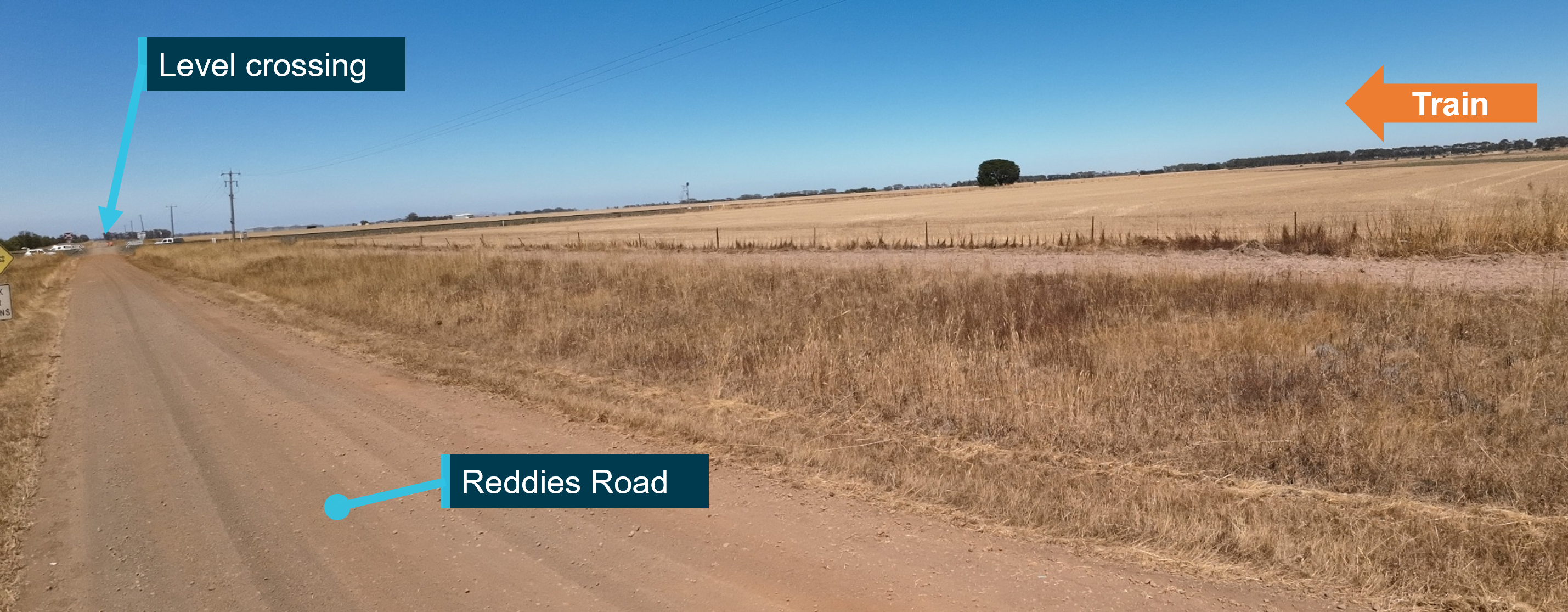
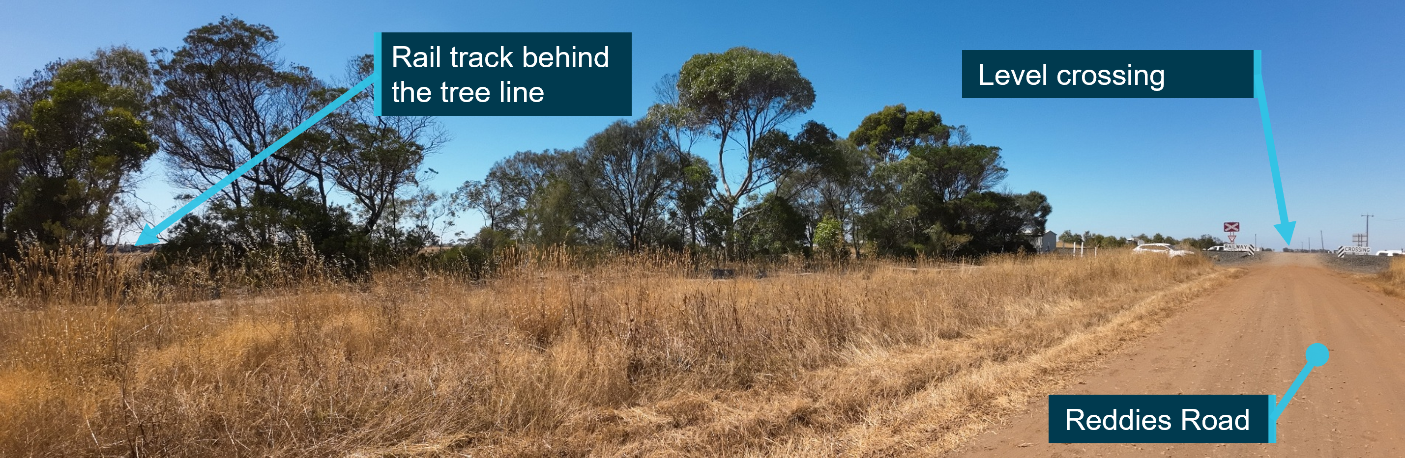
The collision occurred at the Reddies Road level crossing near the township of Cressy within the Colac Otway Shire about 136 track-km from Melbourne (Figure 1).4 The road crossed a single bi-directional rail track which was part of the Australian Rail Track Corporation (ARTC) interstate network. This section of the network was used by freight trains and overland passenger services between Melbourne, Victoria, and Adelaide, South Australia.
Figure 1: Location of Reddies Road level crossing
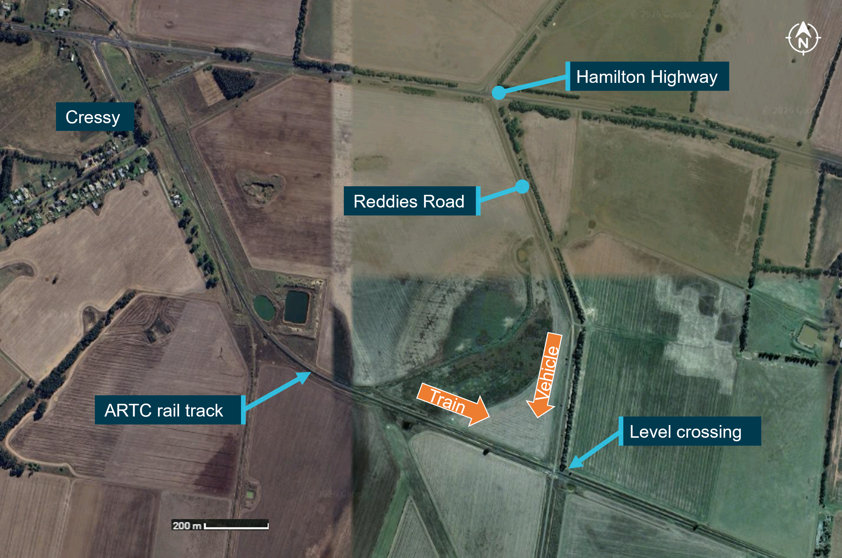
Source: Nearmap, annotated by the Office of the Chief Investigator (OCI)
Reddies Road was unsealed and managed by the Colac Otway Shire. The crossing was on a section of road between the Hamilton Highway, located about 1200 m to the north of the crossing, and the Colac–Ballarat Road to the south of the crossing. At the time of the incident, there were no road traffic speed signs erected on Reddies Road between Hamilton Highway and the level crossing. A maximum permitted road speed of 100 km/h would therefore normally apply. However, the nature of the gravel road and the approaching level crossing made it highly unlikely that a road vehicle would achieve this speed. As the exact approach speed was not known, a maximum of 80km/h was used for further assessments.
In the track section crossing Reddies Road, the permitted line speed was 115 km/h.
Reddies Road level crossing
Construction
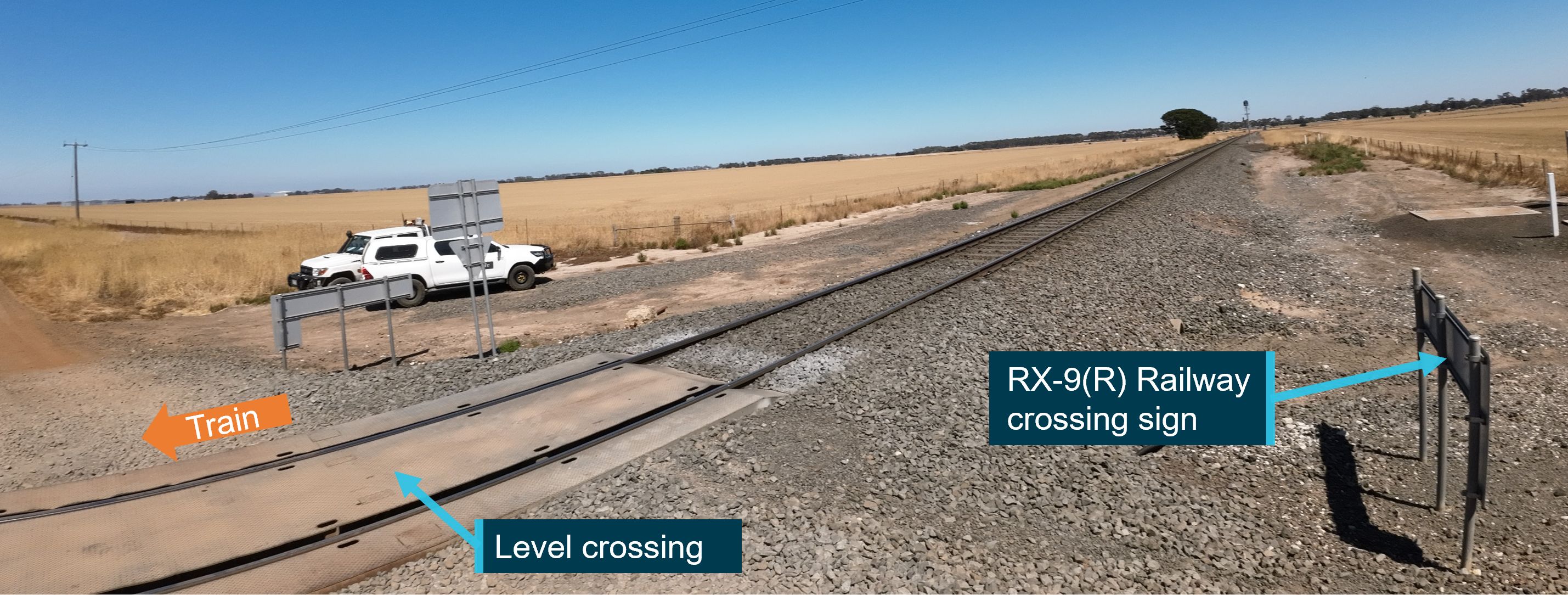
To accommodate the track interface with an unsealed road, a steel deck had been installed to align the road crossing surface with the top of the rail heads (Figure 2). The purpose of the deck was to avoid rails protruding above the road surface (which can occur as unsealed roads wear) and therefore minimise the risk of vehicles catching on the rails. Post-incident inspection identified reasonable alignment of the unsealed road surface with the entry and exits of the steel deck although in places, the road surface was about 50 mm below the deck surface. During the post-site inspections, vehicles could transit the steel plated surface without difficulty.
Figure 2: Steel deck installed to align the road surface with the top of the rail heads
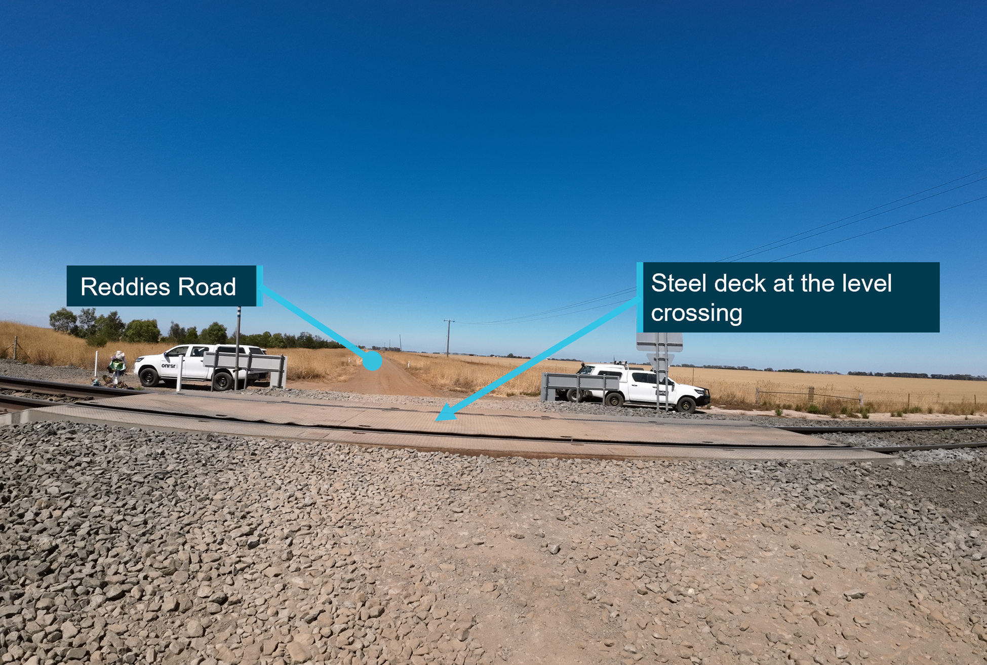
Source: OCI
On the approach to the level crossing from the north, the gradient over a distance of 10 m from the closest rail head was measured to be about 7%5 (Figure 3).
Figure 3: The gradient on approach to the level crossing from the north
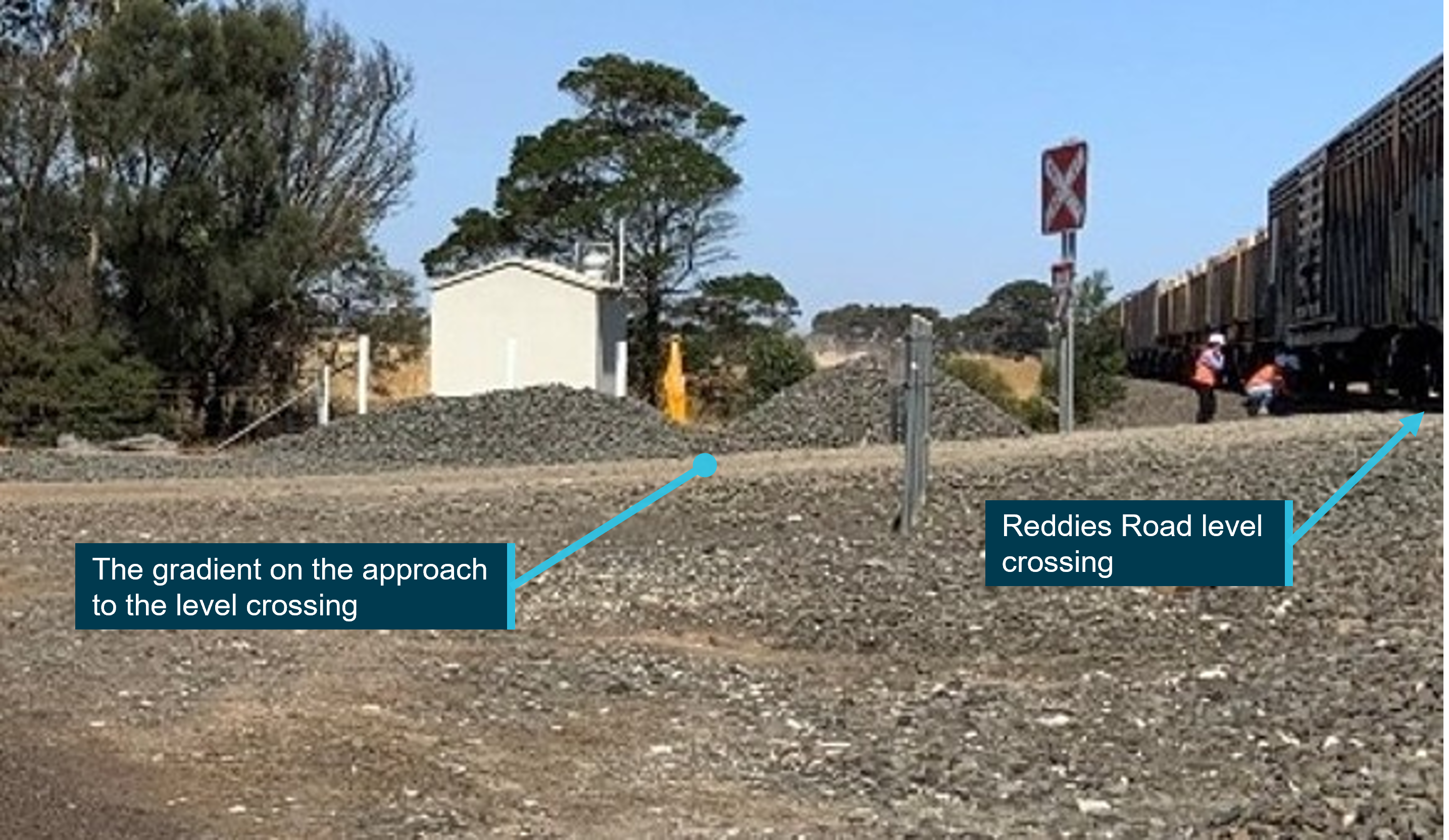
Source: OCI
Level crossing protection standard
Australian Standard AS 1742.7:2016, Manual of uniform traffic control devices, Part 7: Railway crossings (AS 1742), specified the signage requirements for level crossings with passive controls. Although the standard described its application as being for new or substantially changed level crossings, it also provided guidance for existing older crossings and was used as a reference for this investigation.
Road signage on approach to level crossing
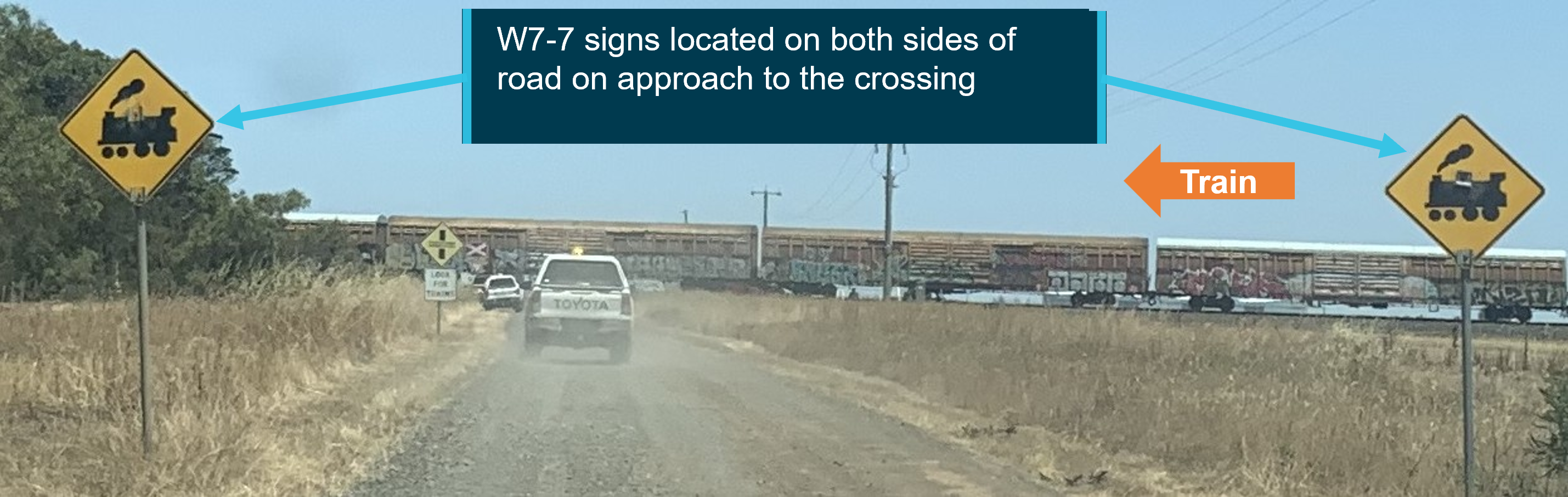
For road traffic coming from the north, the direction the vehicle approached the crossing, several signs warning of the approaching crossing were located along Reddies Road. A train warning sign W7-7 was located on each side of Reddies Road about 207 m from the northern rail head (Figure 4).
Figure 4: W7-7 signs on each side of the road about 207 m from the crossing
Source: OCI
Closer to the crossing, a ‘Look for trains’ sign (RX-3-1) was located about 148 m from the northern rail head (Figure 5).6
Figure 5: RX-3-1 sign about 148 m from the crossing
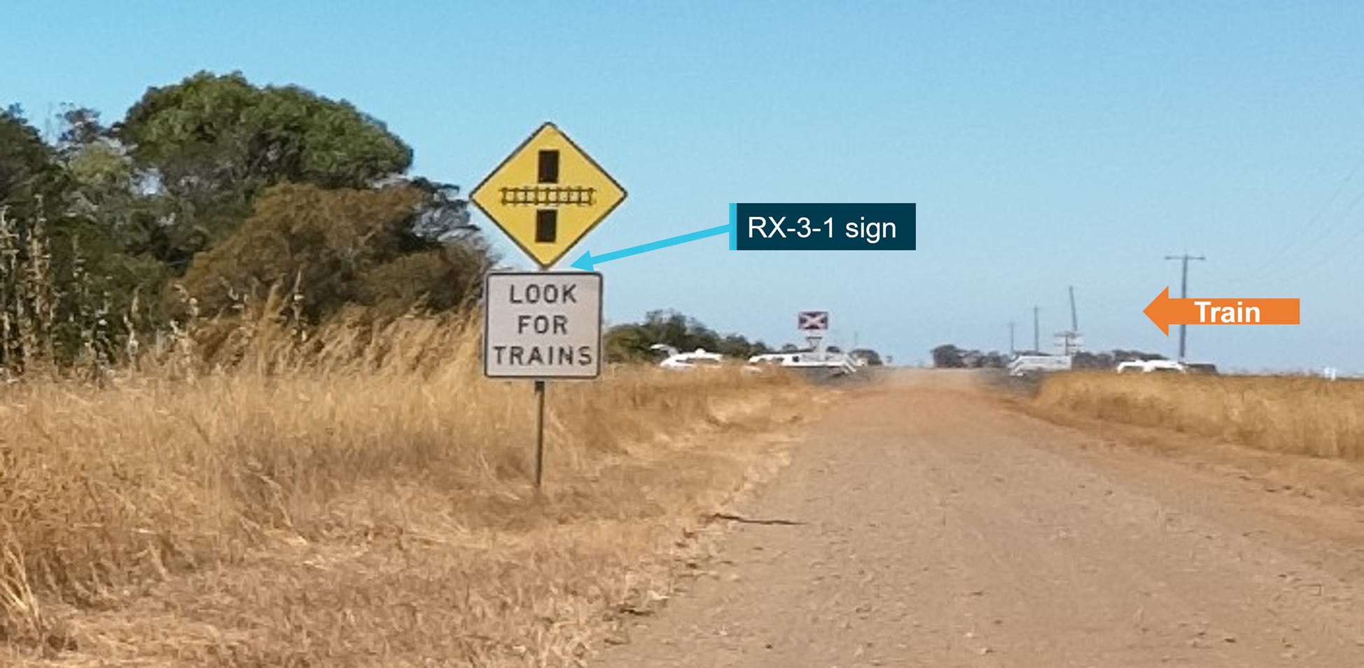
Source: OCI
The road intersected the rail line at an angle of about 80 degrees in the north‑west (and south‑east) quadrant. This slightly acute angle geometry on a driver’s right side (approaching the crossing from either the north or south) did not adversely affect sighting from any combination of road or rail approaches.
Level crossing protection
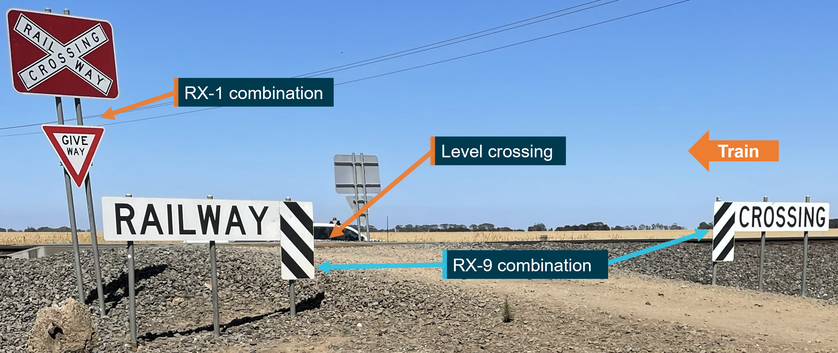
Protection at the level crossing included railway crossing identification and give way signs (Figure 6). A railway crossing sign combined with a give way sign (RX-1 combination) was located about 3.8 m from the northern rail head.
Figure 6: Signage at the level crossing when approaching from the north
Source: OCI
Signs stating ‘Railway’ on the left and ‘Crossing’ on the right (RX-9 combination) were located on the sides of the road about 5.4 m from the northern rail head (Figure 6).
Reddies Road was an unsealed road. There were no road markings as is typical for unsealed roads.
Post-incident site observations
Overview
An assessment against the sighting requirements of AS 17427 for a vehicle approaching a give way sign at Reddies Road level crossing was carried out by the OCI.
Figure 7: Approach sighting at give way passive control level crossing
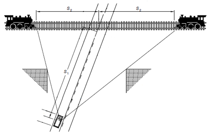
Source: Australian Standard, Manual of uniform traffic control devices, Part 7: Railway crossings, amended by OCI
Observations were made from the S18 positions for vehicles travelling at 40, 60 and 80 km/h and at 2 eye levels, 1.05 m and 2.40 m9 and the corresponding S210 positions were determined (Figure 7).
Sighting to the west
On approach to the level crossing from the north on Reddies Road (the direction the road vehicle was travelling) visibility of the rail track to the west, (the direction the train approached) at all S1 positions and at both eye levels, was unimpeded (Figure 8) and adhered to the standard.
Figure 8: Sighting to the west on approach to the level crossing from the north
Source: OCI
Sighting to the east
On approach to the level crossing from the north, at all S1 positions and at both eye levels, visibility of the rail track to the east of Reddies Road, was impeded by vegetation. The S2 target point was hidden behind the row of trees to the east of Reddies Road (Figure 9).
This compromised easterly view for vehicles approaching the crossing along Reddies Road from the north, meant the use of give way signage at the level crossing was inconsistent with signage recommended in the AS 1742 standard.
Figure 9: Sighting to the east on approach to the level crossing from the north
Source: OCI
Sighting closer to the level crossing
Sighting from a vehicle closer to the rail track was also assessed, as evidence suggested that the road vehicle stopped, or almost stopped, at or about the give way sign. Sighting along the rail track to the west from about the give way sign on the north side of the crossing provided the driver with a clear view along the rail track to the west (Figure 10).
Figure 10: Sighting to the west along the rail from about the give way sign at the level crossing
Source: OCI
Visibility to the east from the middle of the give way line was impeded by a small self‑seeding tree and a rail infrastructure hut on the northern side of the rail about 50 m along the track.
ALCAM level crossing assessment
The Australian Level Crossing Assessment Model (ALCAM)11 is an assessment tool used to identify potential risks at level crossings. It assists in the prioritisation of crossings for upgrades and supports the decision‑making process when determining the most cost‑effective treatments at a level crossing. ALCAM surveys are undertaken against the version of AS 1742.7 current at the time of the assessment.
In Victoria, the ALCAM survey program is funded and coordinated by the Victorian Railway Crossing Safety Steering Committee and advises the Minister on railway level crossing safety policy, standards, and management.
The most recent (prior to the collision) full ALCAM survey at the Reddies Road level crossing was conducted in February 2024.12 The results of the survey were provided to ARTC on 15 March 2024.
Consistent with the post-incident site observations, the ALCAM survey identified that for a road vehicle approaching the crossing from the north, sighting to the west (the direction the train approached from) was consistent with AS 1742 whereas sighting to the east was compromised by vegetation.
The survey also noted that the crossing panels (the steel deck) adjacent to the rails were in poor condition due to low infill. This finding was addressed in September of 2024 when the material at the level crossing was replenished to ensure that the road surface and level crossing surfaces were flush.
The road vehicle
The motor vehicle involved in the incident was a 1997 Holden Rodeo 4x4 single cab chassis utility vehicle with a manual transmission. The vehicle was significantly damaged in the incident.
Train and crew information
Freight train 6PM9 was being operated by SCT Logistics. The consist was about 1530 m long and comprised 2 locomotives hauling a third locomotive and 23 wagons. The train had originated in Perth, Western Australia, and was travelling to Melbourne, Victoria. The train was crewed by 2 drivers who had boarded in Horsham. Both were qualified, assessed as competent and medically fit.
The event recorder on the lead locomotive SCT015, recorded data when an event occurred on board the train.13 Events that triggered a recording included changes in inputs such as the movement of the throttle or brake controls and activation of the horn.14 The system also logged the speed the train was travelling throughout the journey.
Data from the event recorder indicated that the train was being operated below the track speed limit at the time of the incident. At about 10:12:34 the train entered the straight section of track towards the level crossing at a speed of about 70 km/h. The train horn was sounded continuously for 2 seconds, about 6 seconds before the collision and an emergency brake application was made just before the collision. The train collided with the road vehicle at about 10:13:25 and came to a stand about 515 m past the level crossing.
Safety analysis
Introduction
On the morning of 20 January 2026, a collision between a road vehicle and freight train 6PM9 occurred at the Reddies Road level crossing in Cressy, Victoria. The 2 persons travelling in the road vehicle were fatally injured. This analysis discusses:
- the operation of the road vehicle
- the operation of the train
- sighting and signage at the level crossing.
The road vehicle
Corroborated witness accounts indicated that the road vehicle slowed as it approached the level crossing and paused a few metres before the crossing. This suggests that the driver was aware of the level crossing and probably the possibility of trains. Site inspection found that on the road vehicle’s approach and from the paused position near the crossing, there was an opportunity for the driver to observe the train, which was approaching from the west, the driver’s right side. However, the scanning and observations by the driver are not known.
After this short pause, the vehicle then drove onto the level crossing and reportedly came to a halt on the crossing. There were several possible hypotheses that might explain why the vehicle did not then clear the crossing. However, there was insufficient evidence to conclude contributing factors with any level of confidence, and suggesting possible scenarios would be speculative.
The train
Evidence indicated that 6PM9 was being operated at about 70 km/h as it approached the level crossing, substantially below the permitted line speed of 115 km/h. Evidence also indicated that the road vehicle entered the level crossing at the last moment which provided little time for the train driver to react. The sounding of the horn and application of emergency braking was consistent with expected actions.
The drivers reported sounding the horn at the whistle board, however, this was not recorded by the event recorder. This is not uncommon for short duration horn applications due to the nature of the recording system. A witness also recalled hearing a horn application before the collision.
Sighting and signage at the crossing
Sighting to the west and train 6PM9
The Reddies Road level crossing was protected by passive controls utilising give way signs. Post-incident site observations confirmed that available sighting distances from the road vehicle to the rail line to the west (towards the approaching train) was unimpeded for this combination of train and road approach. The installed signage was consistent with the relevant standard for level crossing protection. The driver of the road vehicle had the opportunity to observe the approaching train.
Sighting to the east
Post-incident site observations identified that for a road vehicle approaching along Reddies Road from the north, the sighting of the track to the east was restricted due to vegetation and a small infrastructure hut. Although not impacting the potential to sight train 6PM9, this restriction meant that the use of give way signage at this level crossing was inconsistent with AS 1742.7, the national standard for level crossing protection.
These post-incident site observations were consistent with findings of a survey of the level crossing undertaken about 23 months before this incident. An ALCAM survey in February 2024 noted that, when approaching from the north, vegetation to the east of Reddies Road restricted a road driver’s view towards the rail line until just before the give way sign.
Findings
ATSB investigation report findings focus on safety factors (that is, events and conditions that increase risk). Safety factors include ‘contributing factors’ and ‘other factors that increased risk’ (that is, factors that did not meet the definition of a contributing factor for this occurrence but were still considered important to include in the report for the purpose of increasing awareness and enhancing safety). In addition, ‘other findings’ may be included to provide important information about topics other than safety factors. These findings should not be read as apportioning blame or liability to any particular organisation or individual. |
From the evidence available, the following findings are made with respect to the collision between a road vehicle and train 6PM9, at Reddies Road level crossing, Cressy, Victoria, on 20 January 2026.
Contributing factors
- The road vehicle entered the Reddies Road level crossing and did not clear the crossing prior to the arrival of train 6PM9. The factors contributing to the vehicle not clearing the crossing were not determined.
Other factors that increased risk
- Although not impacting the potential to sight train 6PM9 approaching from the west, sighting the track to the east was restricted by vegetation. The restricted sighting meant that the use of give way signage at this level crossing was inconsistent with the national standard for level crossing protection.
Other findings
- Sighting the approaching train 6PM9 from the road was unimpeded when the road vehicle was travelling along Reddies Road toward the level crossing and when the vehicle paused a few metres before the crossing.
- The handling of the train did not contribute to the collision. The train was travelling at 70 km/h, well below the 115 km/h maximum track speed.
Safety actions
| Whether or not the ATSB identifies safety issues in the course of an investigation, relevant organisations may proactively initiate safety action in order to reduce their safety risk. The ATSB has been advised of the following proactive safety action in response to this occurrence. |
Safety actions taken by ARTC
The ATSB has been advised of the following proactive safety actions taken by ARTC in response to this occurrence:
- The vegetation lining the east side of Reddies Road north of the crossing has been removed.
- ARTC has been in contact with the Colac Otway Shire Council to progress the change to the signage at the Reddies Road level crossing from ‘give way’ to ‘stop’.
Safety actions taken by the Colac Otway Shire Council
The ATSB has been advised of the following proactive safety actions taken by the Colac Otway Shire Council in response to this occurrence:
- The Colac Otway Shire Council has been in contact with ARTC to progress the change to the signage at the level crossing.
Sources and submissions
Sources of information
The sources of information during the investigation included:
- the witnesses
- Australian Rail Track Corporation
- Department of Transport and Planning, Victoria
- Victoria Police
- recorded data from the event recorder on the train
- SCT Logistics.
References
- Australian Standard AS 1742.7:2016 Manual of uniform traffic control devices, Part 7: Railway crossings.
Submissions
Under section 26 of the Transport Safety Investigation Act 2003, the ATSB may provide a draft report, on a confidential basis, to any person whom the ATSB considers appropriate. That section allows a person receiving a draft report to make submissions to the ATSB about the draft report.
A draft of this report was provided to directly involved parties. Submissions from those parties were reviewed and, where considered appropriate, the text of the draft report was amended accordingly.
Rail safety investigations in VictoriaRail safety investigations in Victoria are conducted by the Office of the Chief Investigator (OCI) in accordance with a collaboration agreement with the ATSB. OCI is the operational office of the Chief Investigator, Transport Safety, a statutory position established in the Transport Integration Act 2010 (Vic) to provide independent, no-blame investigation of transport safety matters in Victoria. Under the collaboration agreement with the ATSB, OCI staff exercise powers and perform functions under the Transport Safety Investigation Act 2003 (Cth), and reports are approved for release under the TSI Act by the ATSB Commission. Purpose of safety investigationsThe objective of a safety investigation is to enhance transport safety. This is done through:
Investigations under the TSI Act do not apportion blame or provide a means for determining liability. At the same time, an investigation report must include factual material of sufficient weight to support the analysis and findings. Under the TSI Act investigations endeavour to balance the use of material that could imply adverse comment with the need to properly explain what happened, and why, in a fair and unbiased manner. TSI Act investigations are not for the purpose of taking administrative, regulatory or criminal action. About ATSB reportsATSB investigation reports are organised with regard to international standards or instruments, as applicable, and with ATSB procedures and guidelines. Reports must include factual material of sufficient weight to support the analysis and findings. At all times the ATSB endeavours to balance the use of material that could imply adverse comment with the need to properly explain what happened, and why, in a fair and unbiased manner. An explanation of terminology used in ATSB investigation reports is available here. This includes terms such as occurrence, contributing factor, other factor that increased risk, and safety issue. Publishing informationReleased in accordance with section 25 of the Transport Safety Investigation Act 2003 Published by: Australian Transport Safety Bureau © Commonwealth of Australia 2026 
Ownership of intellectual property rights in this publication Unless otherwise noted, copyright (and any other intellectual property rights, if any) in this report publication is owned by the Commonwealth of Australia. Creative Commons licence With the exception of the Commonwealth Coat of Arms, ATSB logo, and photos and graphics in which a third party holds copyright, this report is licensed under a Creative Commons Attribution 4.0 International licence. The CC BY 4.0 licence enables you to distribute, remix, adapt, and build upon our material in any medium or format, so long as attribution is given to the Australian Transport Safety Bureau. Copyright in material obtained from other agencies, private individuals or organisations, belongs to those agencies, individuals or organisations. Where you wish to use their material, you will need to contact them directly. |
- ^ The whistle board is a sign by the side of the rail track which marks the location where a train driver was required to sound the train’s the horn or whistle. In Victoria, a whistle board was typically located 400 m before a level crossing.
- ^ A horn application 400 m before the crossing was not recorded on the train’s event recorder. It was not unusual for a short horn application not to be recorded due to the polling frequency of locomotive event recorders.
- ^ One of the drivers recalled that the vehicle stopped before driving onto the crossing. The other said the vehicle came to a stop or almost to a stop before driving onto the crossing.
- ^ This distance is measured from Southern Cross Station in Melbourne.
- ^ A rise of 700 mm over 10 metres from the closest rail.
- ^ The RX-3-1 sign was a combination of the W7-8 and the G9-48 signs.
- ^ Australian Standard, Manual of uniform traffic control devices, Part 7: Railway crossings (AS 1742.7 – 2016).
- ^ The S1 position is defined as the ‘minimum distance of an approaching road vehicle from the nearest rail when the driver must be able to see an approaching train in time to stop, if necessary, before reaching the crossing’. S1 is measured along the road from the nearest rail head. The S1 position differs depending on the speed of the vehicle.
- ^ 1.05 m is the approximate eye level for a driver of motor car, 2.40 m is the approximate eye level for the driver of a heavy vehicle, i.e., a semi-trailer.
- ^ The S2 sighting position is defined as ‘the minimum distance of a train from the crossing at which a road vehicle driver at distance S1 from the crossing can proceed at speed and safely clear the crossing ahead of that train’. S2 is measured along the rail track from the middle of the level crossing.
- ^ The National ALCAM Committee is the custodian of ALCAM. Australian Rail Industry Standards Organisation (ARISO) formerly known as Rail Industry Safety Standards Board (RISSB) helps to support the system.
- ^ ALCAM survey, Reddies Rd, RX1514, February 2024.
- ^ The system recorded the train speed in whole km/h and recorded timings to the second only.
- ^ The drivers stated that the train’s headlight was switched on at the time of the incident. However, the event recorder was not programmed to register the activation of the train’s headlight.
Occurrence summary
| Investigation number | RO-2026-001 |
|---|---|
| Occurrence date | 20/01/2026 |
| Occurrence time and timezone | 1013 Australian Eastern Standard Time |
| Location | Reddies Road level crossing, Cressy |
| State | Victoria |
| Report release date | 11/06/2026 |
| Report status | Final |
| Investigation level | Short |
| Investigation type | Occurrence Investigation |
| Investigation phase | Final report: Dissemination |
| Investigation status | Completed |
| Mode of transport | Rail |
| Rail occurrence category | Collision |
| Occurrence class | Accident |
| Highest injury level | Fatal |
Train details
| Train operator | SCT Logistics |
|---|---|
| Train number | 6PM9 |
| Track operator | Australian Rail Track Corporation |
| Type of operation | Freight |
| Rail vehicle sector | Freight |
| Consist | Two locomotives hauling a third locomotive and 23 wagons |
| Departure point | Perth, Western Australia |
| Destination | Melbourne, Victoria |
| Persons on board | Crew – 2 |
| Injuries | None |
| Train damage | Minor |