
Final report
Report release date: 24/11/2025
Investigation summary
What happened
On 24 July 2025, a Cessna 206G, VH-ARS, taxied for departure shortly before last light for a flight from Archerfield Airport, Queensland, to Rockhampton with a flight instructor and pilot under training on board. The pilot was a qualified private pilot conducting training for a private instrument rating.
The flight was planned under the instrument flight rules, but the pilot informed air traffic control that they would conduct a visual flight rules departure. Air traffic control informed the pilot of the last light time and requested they confirm their departure would be before last light, which they did. However, shortly after departure, air traffic control issued them with a terrain alert and requested they expedite their climb. The pilot acknowledged and complied, and the flight continued without further incident.
What the ATSB found
The ATSB found that flight instructor elected to conduct a visual departure just prior to last light, which resulted in the aircraft operating below the minimum altitude after last light and the issuing of a terrain alert by air traffic control.
Safety message
The importance of planning, particularly around times when rules change, such as the transition from day to night, was previously promoted by the ATSB in the safety message for AO-2022-061. In this case the aircraft departed later than planned on a visual departure, rather than climbing within the circling area to the required safety height, which resulted in the terrain alert after last light.
Additionally, during the investigation the ATSB became aware of a potential conflict point overhead Archerfield Airport for instrument flight rules departures from Archerfield with arrivals to Brisbane Airport runway 01 right, currently being managed by ATC. This was known by the involved parties, with a project underway to develop a procedural instrument departure from Archerfield Airport.
The ATSB encourages the parties involved in this project to implement it as soon as reasonably practicable in order to provide improved traffic deconfliction.
The investigation
The occurrence
On 24 July 2025, at 1732 local time, a Cessna 206G, registered VH-ARS, taxied for departure from Archerfield Airport, Queensland, bound for Rockhampton with a flight instructor and pilot under training on board. The pilot was a qualified private pilot conducting training for a private instrument rating and was making all the radio calls. A flight plan had been submitted for the flight under the instrument flight rules[1] (IFR) with a departure time of 1730. The Archerfield air traffic control (ATC) tower had closed at 1700 and common traffic advisory frequency (CTAF) procedures applied.
The pilot requested their aircraft transponder code for the flight from Brisbane Centre (Centre) at 1732:57, to which Centre initially responded with their allocated code and other IFR traffic, and then queried if they would depart before 1739, which was last light. The pilot confirmed they would depart before 1739 and were ‘happy’ to do a visual flight rules[2] (VFR) departure to the north (see the section titled Departure from Archerfield – En route Supplement Australia), which Centre acknowledged. The instructor reported at interview that they were aware that last light was at 1739.
At 1736:01, the pilot reported on the CTAF that they were entering and rolling runway 28 right for departure to the north not above 1,000 ft. At 1736:50, Centre attempted to contact the aircraft to request they report at the runway holding point so that they could be transferred to Brisbane Departures (Departures) before take-off. However, noting that the aircraft had become airborne, they ceased their transmission.
The pilot made a departure call on CTAF and, at 1737:15, they reported to Centre that they were airborne in a right turn towards the Walter Taylor Bridge. Centre acknowledged their airborne report and instructed them to verify their altitude and remain clear of controlled airspace, to which the pilot reported they were passing 400 ft and climbing to 1,000 ft. At 1737:56, Centre instructed them to contact Departures for their clearance to enter controlled airspace.
The pilot contacted Departures, and at 1738:39 received an initial clearance to climb to 3,000 ft on their flight planned route, which was then followed by a clearance to climb to 4,000 ft. At 1739:06, a minimum safe altitude warning (MSAW) activated for the aircraft on the ATC radar display. At 1739:35, the ATC radar indicated the aircraft was at 1,200 ft and Departures issued the pilot with a terrain alert due to the aircraft operating below the minimum altitude in their area (2,900 ft) after last light and requested they expedite their climb to ‘at least 3,000 ft’, which the pilot acknowledged and complied with. The flight continued without further incident and the departure flight path and key events are depicted in Figure 1.
Figure 1: Departure flight path from Archerfield with key events
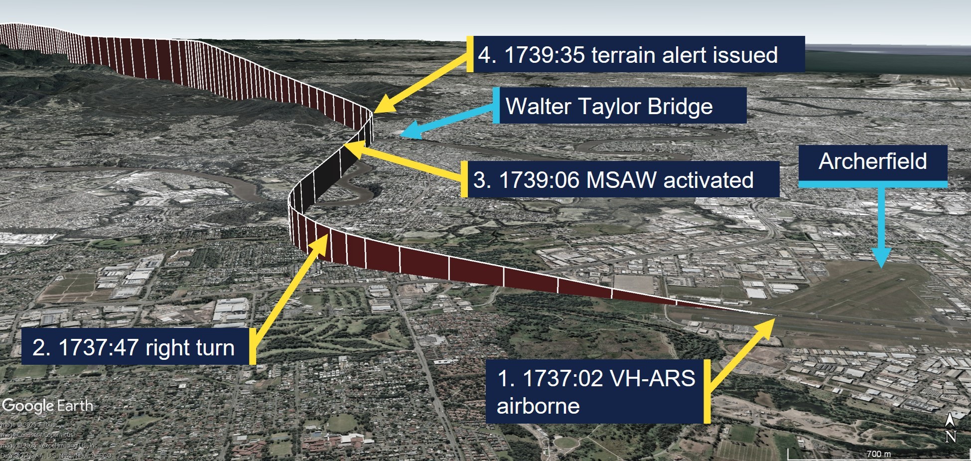
Source: ADS-B Exchange and Google Earth, annotated by the ATSB
Context
Flight crew information
Flight instructor
The flight instructor held an air transport pilot licence (aeroplane) with multi-engine and single-engine class ratings, and a Grade 1 instructor rating with endorsements for instrument rating and night VFR training. The instructor’s last flight review was an instructor proficiency check on 25 March 2025, and they held a Class 1 aviation medical certificate, valid until 14 December 2025.
Pilot under training
According to the flight instructor, the pilot under training, who was also the aircraft owner, held a commercial pilot licence (helicopter) and a private pilot licence (aeroplane). They were studying for their private instrument rating, command instrument rating and night VFR rating exams at the time of the incident.
Meteorological information
The Archerfield Airport METAR[3] reports for 1700, 1730 and 1800 recorded light wind conditions, greater than 10 km visibility and no cloud detected. The aerodrome forecast was for CAVOK[4] conditions. The forecast and recorded conditions were consistent with the instructor’s report of clear sky conditions and they surmised that the good visual conditions might have influenced their decision to proceed with a VFR departure.
Recorded data
The ATC radar data indicated the aircraft was at 1,100 ft when the MSAW activated at 1739:06 and it had reached 1,200 ft when Departures issued them with their terrain alert. Recorded data, retrieved from ADS-B (automatic dependent surveillance-broadcast) Exchange indicated that the aircraft’s speed initially reduced from 125 kt to 120 kt after the clearance from Brisbane Departures to climb to 3,000 ft. The speed then reduced to 80 kt after the terrain alert was issued until the aircraft reached 3,000 ft, and then the speed trend reversed and recovered to about 100 kt as the aircraft reached 4,000 ft. The aircraft took about 5 minutes to reach 3,000 ft after take-off.
Departures from Archerfield
En Route Supplement Australia
The En Route Supplement Australia entry for Archerfield Airport included the following flight procedures and notes:
IFR ACFT [aircraft] departing YBAF [Archerfield Airport] directly into Brisbane Class C airspace [controlled airspace] may EXP [expect] delays due terminal area traffic density. VFR ACFT DEP [departure] after last light may also EXP delays.
Pilots electing to commence or terminate an IFR flight under the VFR should communicate such intention at the earliest possible time to ensure their arrival or departure is processed efficiently.
Departure from the Archerfield CTR [control zone] shall be 1,000 ft.
For a planned DEP [departure] track BTN [between] 310 and 019 DEG MAG [degrees magnetic]: - Depart via “Northern DEP” – track via Walter Taylor (Indooroopilly) Bridge [about 8 km north-north-west of Archerfield];
By day VFR ACFT (and IFR ACFT conducting a VFR DEP) are to depart via the following procedures:
- Advise intended DEP procedure (Northern, Southern, Eastern or Western) on TAX [taxi].
- IFR ACFT conducting a VFR DEP will receive a directed FREQ [frequency] transfer from AF TWR [Archerfield Tower – Brisbane Centre outside tower hours].
The instructor reported that they were aware of a history of delays for IFR departures from Archerfield and that they believed ATC preferred them to depart VFR and then request a change to IFR. They reported that they were in visual conditions and could see obstacles on the ground along their flight path when Brisbane Departures provided their clearance to resume their flight planned track and climb to 3,000 ft.
Standard instrument departure
For an IFR departure from Archerfield there were 2 options, which were the Archerfield standard instrument departure (SID – radar) or a climb within the circling area[5] to the required safety height for the departure track. The instructor reported that a clearance from ATC would be required to climb above 1,500 ft and that a SID would have been their preferred option for an IFR departure, which they believed that they could have done.
The Archerfield SID instructions for runway 28 right were to maintain the runway track until at or above 900 ft, then turn to the ATC assigned heading, and to maintain a minimum climb gradient of 4.3% to 1,900 ft. The SID indicated the 10 NM minimum sector altitude was 2,900 ft.
Airservices Australia procedures
Following external review of the report, Airservices Australia provided the following procedural information:
- Its manual of air traffic services prohibits vectoring aircraft outside controlled airspace except when warranted by an emergency.
- Consistent with the above, the Brisbane local procedures prohibit use of the Archerfield radar SID outside of tower hours. However, Airservices Australia is developing a procedural SID for Archerfield that will be available all hours. The project for the Archerfield procedural SID commenced in 2019 to facilitate improved deconfliction of IFR departures from Archerfield with IFR arrivals to Brisbane runway 01 right.
- IFR arrivals to Brisbane runway 01 right pass overhead Archerfield at 3,000 ft (4,000 ft for runway 01 left), which is the same altitude ATC need IFR departures from Archerfield to climb to in the circling area before departing, which creates a potential traffic conflict point for ATC to manage. In addition, there is a wake turbulence hazard for light aircraft departing overhead Archerfield between jet aircraft arrivals at Brisbane. Furthermore, the known delays for IFR departures from Archerfield may pressure pilots to depart VFR in marginal weather conditions.
- The reason for the attempt to transfer the incident aircraft to Brisbane Departures before take-off was to provide a clearance to become airborne and climb in the circling area to above the radar lowest safe altitude while ensuring separation of the IFR departure from Archerfield with traffic arriving and/or departing from Brisbane Airport.
Safety analysis
The flight from Archerfield to Rockhampton was planned as an IFR training flight with a flight instructor and pilot-under-training on board. Despite the IFR plan, the instructor elected to conduct the VFR Northern departure instead of conducting an IFR departure because they believed it was the preferred method for Brisbane ATC traffic management. While it was feasible that the aircraft would reach the required minimum altitude before last light based on their flight plan departure time of 1730, take-off actually occurred 7 minutes later than what was flight planned.
While the aircraft was taxiing for departure, ATC queried the pilot, who was making the radio calls, as to whether they would depart before last light. This query from ATC provided a prompt for the instructor and pilot to reconsider their plan. However, they elected to continue with the VFR Northern departure at 1,000 ft, which took the aircraft out of the circling area and into the 10 NM minimum sector altitude of 2,900 ft. Lift‑off occurred 2 minutes prior to last light and consequently they were below the 10 NM minimum altitude after last light and outside the circling area, which triggered a terrain alert from ATC.
Findings
ATSB investigation report findings focus on safety factors (that is, events and conditions that increase risk). Safety factors include ‘contributing factors’ and ‘other factors that increased risk’ (that is, factors that did not meet the definition of a contributing factor for this occurrence but were still considered important to include in the report for the purpose of increasing awareness and enhancing safety). In addition, ‘other findings’ may be included to provide important information about topics other than safety factors. These findings should not be read as apportioning blame or liability to any particular organisation or individual. |
From the evidence available, the following findings are made with respect to the flight below minimum altitude involving Cessna 206G, VH-ARS, 6 km north-west of Archerfield Airport, Queensland, on 24 July 2025.
Contributing factors
- The flight instructor elected to conduct a visual departure just prior to last light, which resulted in the aircraft operating below the minimum altitude after last light and the issuing of a terrain alert by air traffic control.
Sources and submissions
Sources of information
The sources of information during the investigation included:
- ADS-B Exchange
- Airservices Australia
- Bureau of Meteorology
- Civil Aviation Safety Authority
- the flight instructor of the incident flight.
Submissions
Under section 26 of the Transport Safety Investigation Act 2003, the ATSB may provide a draft report, on a confidential basis, to any person whom the ATSB considers appropriate. That section allows a person receiving a draft report to make submissions to the ATSB about the draft report.
A draft of this report was provided to the following directly involved parties:
- Airservices Australia
- Civil Aviation Safety Authority
- the flight instructor.
A submission was received from:
- Airservices Australia
The submission was reviewed and, where considered appropriate, the text of the report was amended accordingly.
Purpose of safety investigationsThe objective of a safety investigation is to enhance transport safety. This is done through:
It is not a function of the ATSB to apportion blame or provide a means for determining liability. At the same time, an investigation report must include factual material of sufficient weight to support the analysis and findings. At all times the ATSB endeavours to balance the use of material that could imply adverse comment with the need to properly explain what happened, and why, in a fair and unbiased manner. The ATSB does not investigate for the purpose of taking administrative, regulatory or criminal action. About ATSB reportsATSB investigation reports are organised with regard to international standards or instruments, as applicable, and with ATSB procedures and guidelines. Reports must include factual material of sufficient weight to support the analysis and findings. At all times the ATSB endeavours to balance the use of material that could imply adverse comment with the need to properly explain what happened, and why, in a fair and unbiased manner. An explanation of terminology used in ATSB investigation reports is available here. This includes terms such as occurrence, contributing factor, other factor that increased risk, and safety issue. Publishing informationReleased in accordance with section 25 of the Transport Safety Investigation Act 2003 Published by: Australian Transport Safety Bureau © Commonwealth of Australia 2025 
Ownership of intellectual property rights in this publication Unless otherwise noted, copyright (and any other intellectual property rights, if any) in this report publication is owned by the Commonwealth of Australia. Creative Commons licence With the exception of the Commonwealth Coat of Arms, ATSB logo, and photos and graphics in which a third party holds copyright, this report is licensed under a Creative Commons Attribution 4.0 International licence. The CC BY 4.0 licence enables you to distribute, remix, adapt, and build upon our material in any medium or format, so long as attribution is given to the Australian Transport Safety Bureau. Copyright in material obtained from other agencies, private individuals or organisations, belongs to those agencies, individuals or organisations. Where you wish to use their material, you will need to contact them directly. |
[1] Instrument flight rules (IFR): a set of regulations that permit the pilot to operate an aircraft in instrument meteorological conditions (IMC), which have much lower weather minimums than visual flight rules (VFR). Procedures and training are significantly more complex as a pilot must demonstrate competency in IMC conditions while controlling the aircraft solely by reference to instruments. IFR-capable aircraft have greater equipment and maintenance requirements.
[2] Visual flight rules (VFR): a set of regulations that permit a pilot to operate an aircraft only in weather conditions generally clear enough to allow the pilot to see where the aircraft is going.
[3] METAR: a routine report of meteorological conditions at an aerodrome. METAR are normally issued on the hour and half hour.
[4] Ceiling and visibility okay (CAVOK): visibility, cloud and present weather are better than prescribed conditions. For an aerodrome weather report, those conditions are visibility 10 km or more, no significant cloud below 5,000 ft, no cumulonimbus cloud and no other significant weather.
[5] The circling area is determined by drawing an arc centred on the threshold of each usable runway and joining these arcs by tangents. For Archerfield Airport, the radius for each arc was 2.59 NM (4.8 km) and the circling altitude was 1,010 ft.
Occurrence summary
| Investigation number | AO-2025-045 |
|---|---|
| Occurrence date | 24/07/2025 |
| Location | 6 km north-west of Archerfield Airport |
| State | Queensland |
| Report release date | 24/11/2025 |
| Report status | Final |
| Investigation level | Short |
| Investigation type | Occurrence Investigation |
| Investigation status | Completed |
| Mode of transport | Aviation |
| Aviation occurrence category | Flight below minimum altitude |
| Occurrence class | Serious Incident |
| Highest injury level | None |
Aircraft details
| Manufacturer | Cessna Aircraft Company |
|---|---|
| Model | U206G |
| Registration | VH-ARS |
| Serial number | U20606898 |
| Aircraft operator | Peace Aviation Rockhampton |
| Sector | Piston |
| Operation type | Part 141 Recreational, private and commercial pilot flight training |
| Departure point | Archerfield Airport, Queensland |
| Destination | Rockhampton Airport, Queensland |
| Damage | Nil |