
Summary
The ATSB is investigating the grounding of RSV Nuyina, off Heard Island, on 13 October 2025.
While operating off the coast of Heard Island in the Indian Ocean, RSV Nuyina contacted the seabed, resulting in damage to the ship’s retractable drop keel. The drop keel was retracted successfully and the ship relocated to safe water. The investigation is continuing.
The ATSB has commenced the examination and analysis of the initial evidence collected.
To date, the ATSB investigation has included:
- interviewing the involved crew
- examining available closed-circuit television (CCTV) of the occurrence
- analysis of the voyage data recorder and received AIS data
- examination of safety management system procedures
- analysis of recorded survey data
- analysis of local hydrographic data.
A review of the evidence collected to date has resulted in the investigation's scope being upgraded to the Defined level (the ATSB's different levels of investigation are detailed here).
The ATSB released a preliminary report, which details factual information established in the investigation’s early evidence collection phase, on 17 March 2026. See below.
A final report will be released at the conclusion of the investigation. Should a critical safety issue be identified during the course of the investigation, the ATSB will immediately notify relevant parties, so that appropriate safety action can be taken.
Preliminary report
Report release date: 17/03/2026
This preliminary report details factual information established in the investigation’s early evidence collection phase, and has been prepared to provide timely information to the industry and public. Preliminary reports contain no analysis or findings, which will be detailed in the investigation’s final report. The information contained in this preliminary report is released in accordance with section 25 of the Transport Safety Investigation Act 2003.
The occurrence
Early on the morning of 12 October 2025, the research and supply vessel (RSV) Nuyina arrived off Heard Island (Figure 1) with 37 marine crew and 85 expeditioners on board, following a voyage from Casey station, Antarctica. The purpose of the visit was to support field science operations on the island as part of the Australian Antarctic Program’s (AAP) first voyage of the 2025–2026 Antarctic season, which also included visits to Casey and Davis stations in Antarctica.
During that first day, the crew carried out drills practising watercraft operations and conducted scientific operations using remotely piloted aircraft (RPA) on the north-west side of the island. After completion of these activities, Nuyina moved away from the coast and conducted planned bathymetric mapping operations overnight in an area to the east of Spit Bay (Figure 1). These survey operations were conducted using scientific acoustic instruments, including a high resolution multi‑beam echo sounder (MBES) mounted on one of the ship’s drop keels.[1]
Figure 1: Heard Island, seen from the east with Spit Bay to the right
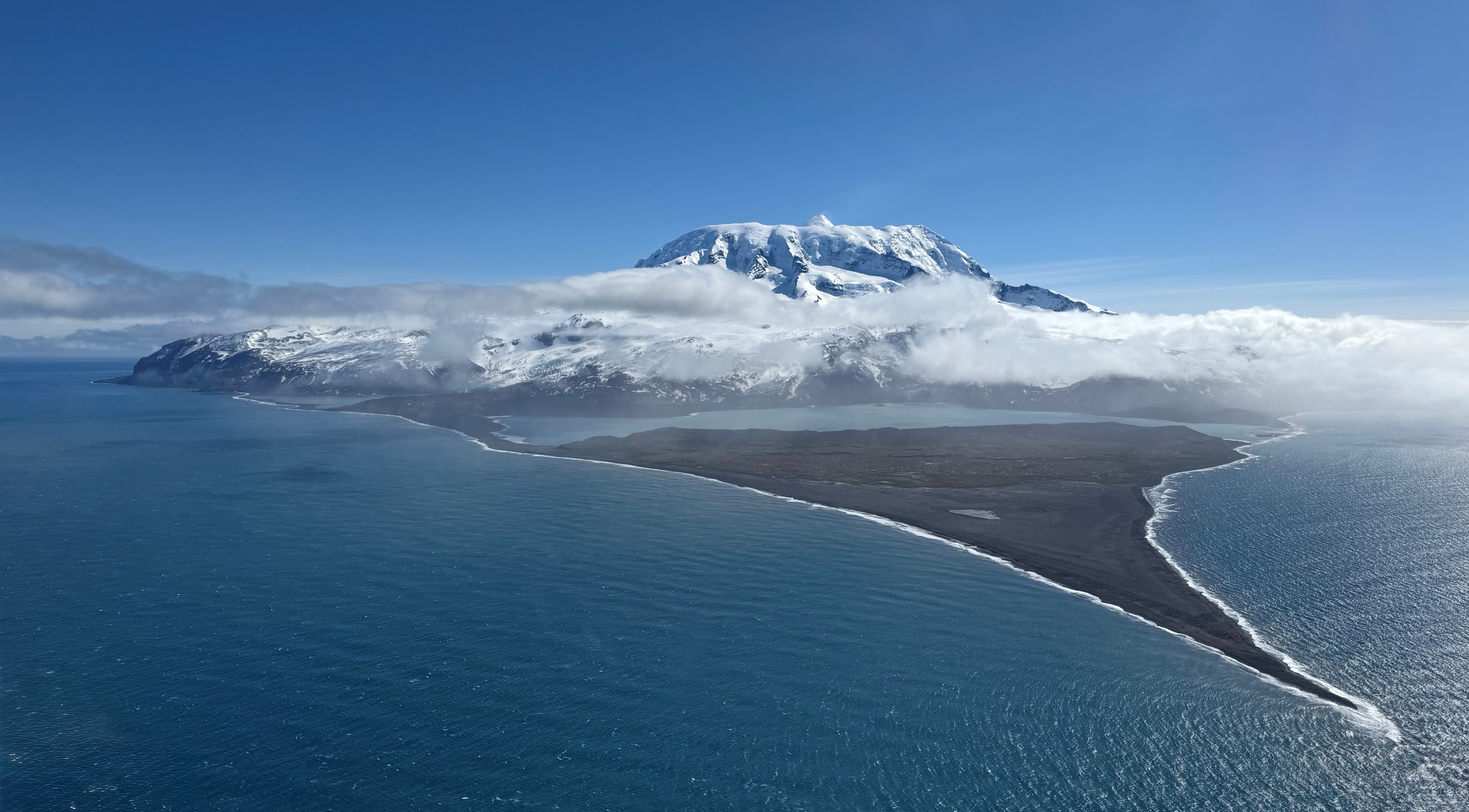
Source: Dave Lomas, Helicopter Resources/AAD
Depth information from the MBES was received and processed by the ship’s scientific systems, with a dedicated display on the bridge also showing this information. This depth information could not be displayed on the electronic chart display and information system (ECDIS) or be used to generate navigational alarms.
The ship’s navigational echo sounders, which were the normal source of water depth information for the bridge crew, were switched off to prevent interference with the ship’s scientific acoustic instruments such as the MBES.
The plan for daytime operations for the following day included landing personnel ashore by helicopter, bathymetric surveys in nearshore waters using inflatable rubber boats[2] and aerial surveys using RPA.
RPA operations
After completing overnight survey operations, Nuyina arrived at a holding position 5 miles[3] north of Dovers Moraine (Figure 2) at 0600 local time on 13 October. The bridge team engaged the ship’s dynamic positioning (DP) system[4] in auto-DP mode to maintain position while waiting for the weather to improve.
At about this time, the planned near-shore boat surveys and helicopter personnel-landing operations ashore were cancelled due to a change in the volcanic risk assessment.[5] The voyage management team then decided to focus on the scheduled RPA flights instead.
By about 0800, the weather had improved and Nuyina was moved closer inshore to a position in Spit Bay (Figure 1), in water depths of about 30 m (Figure 2). The position was close enough to shore to allow for effective RPA operations while remaining clear of the ‘unsurveyed’ area marked on the chart.
While at this location, the drop keel was retracted from its lowest working position (3 m below the keel) to its highest working position, which left it protruding 750 mm below the keel. The MBES was left switched on and continued to provide depth information.
Figure 2: Section of navigation chart AUS 605 showing operations on 13 October 2025
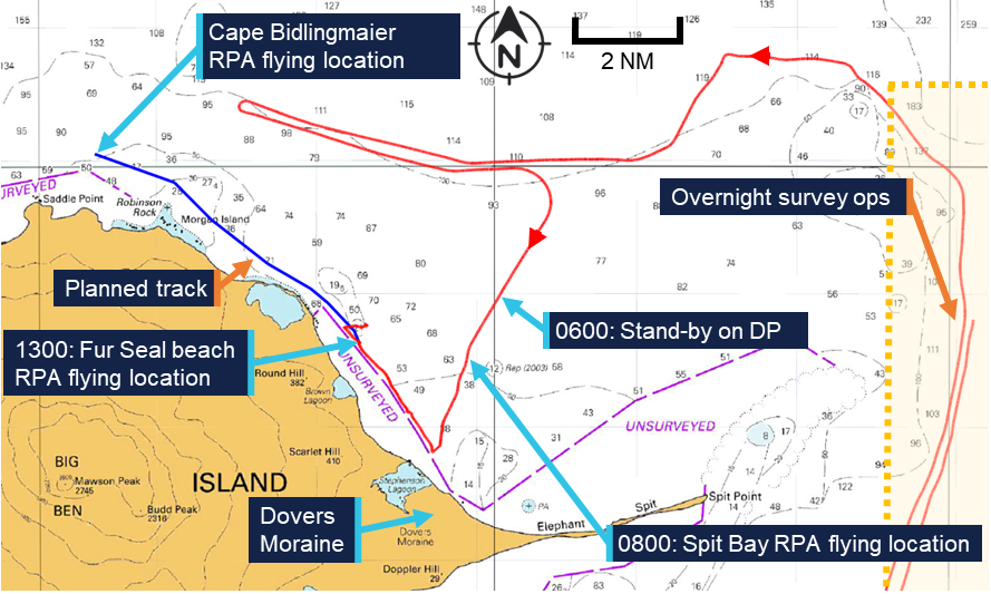
Source: Australian Hydrographic Office chart 605, annotated by the ATSB
At that time, the master was on the bridge and coordinated with the science team, while the officer of the watch – the third officer – manoeuvred the vessel from the DP console. Between 0800 and 1030, the ship was holding position, with small moves made to allow for a better line of sight of the RPA. At 1030, the third officer switched the DP system to joystick mode[6] and moved in a north-westerly direction, using an electronic bearing line (EBL) bearing 321° on the ECDIS as a guide (Figure 3). At 1100, the third officer switched back to auto-DP mode, with the ship still moving slowly in the direction of the EBL.
At about 1200, the second officer took over the watch while the third officer left the bridge. The master also left the bridge but returned shortly after.
The second officer continued to move the ship to the north-west, parallel to, and outside of, the unsurveyed area using the EBL as a guide. From about 1300 onwards, the ship was stopped off Fur Seal beach and held in position for further RPA flights with the ship’s heading kept into the prevailing south-westerly wind to reduce load on the thrusters.
Grounding
At about 1430, the voyage leader (VL) requested the master move the ship from its location off Fur Seal beach to a location north of Cape Bidlingmaier (around 5 miles to the north-west along the coast). The master understood that a track close to shore would be beneficial for continued RPA flights although the VL stressed that the RPAs could be retrieved if a route further away from the coast was required. The VL, master and second officer then discussed the new location while referencing the ECDIS screen. At the time, the chief officer and deck cadet were also on the bridge conducting other tasks but were not part of the bridge team.
Subsequently, the master informed the acoustics team by phone of their planned move and confirmed that the drop‑keel was still at a 750 mm extension below the ship’s nominal 9 m draft. The acoustics operator then prepared to start logging bathymetric data as the ship moved to the new location.
The master and second officer then discussed the route to the new location in more detail, after which the master constructed the route at the ECDIS planning station (located in the aft area of the bridge). The master then verified the route using the ECDIS checking functionality. After completing the route check, the master activated it for monitoring in the system.
At 1450, on request of the master, the second officer started a turn to starboard, while remaining in DP mode, from a heading of 200° toward 321° in preparation for the intended move to the new location. During this heading change, the increasing lateral and yawing forces as the wind moved from ahead to abeam and then to the port quarter resulted in an increased load on the ship’s thrusters. At 1456, the master instructed the second mate to disengage DP mode and start the transit on manual control. They briefly discussed the transit speed, with the master requesting a speed of 5 knots.
The second officer switched over to manual control and moved from the DP console to the helm controls forward. However, the planned route was not visible on the forward ECDIS. The master tried to correct this, while the second officer continued to track along the EBL which was still displayed on the ECDIS from the earlier manoeuvring and was set in a similar direction to the planned route. This track took the ship between the unsurveyed area to the west and a charted bank with an indicated depth of 21 m to the east (Figure 3).
Figure 3: ECDIS image showing planned track, EBL and grounding
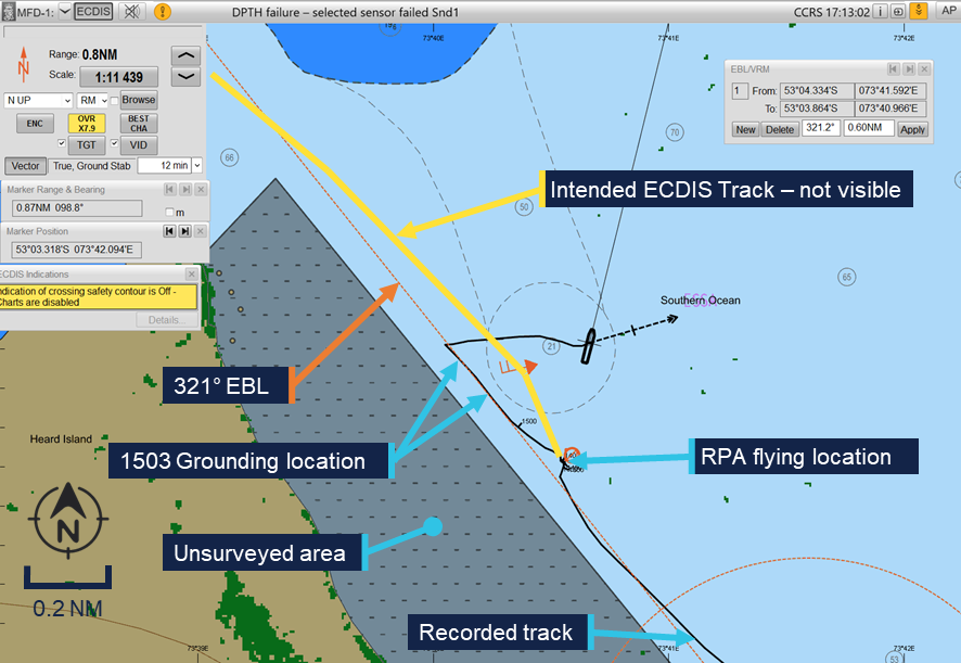
Source: Serco, annotated by the ATSB
At 1500, the acoustics operator contacted the bridge by phone to confirm that the bridge MBES displays were showing the correct information. The master discussed the setup of the screens and asked for some changes. At that stage, the MBES display was showing a depth[7] of 15 m. At 1502, the master ended the call and ordered the engines dead slow ahead, immediately followed by ‘stop’, which was acknowledged and executed by the second officer. This was followed at 1503 by the order to go ‘dead slow astern’.
At about the same time, the acoustics operator noted the water depth was now indicating 13 m and that this only left 3.25 m between the MBES transducer in the deployed drop keel and the seabed. The operator called the bridge to warn of shallow water and this was acknowledged by the master who stated they were already ‘going astern’.
Nuyina then briefly grounded with the retractable drop keel initially impacting the seabed, followed by the ship’s hull.
Emergency response
Nuyina subsequently cleared the shallow water and started drifting towards the north‑east on the south‑westerly wind. The crew stopped the ship’s movement and held position in auto‑DP, assessing damage using the relevant emergency checklists.
The drop keel was retracted to its maintenance position for inspection while tanks and void spaces were sounded in accordance with the checklists.
No flooding was detected in any of the tanks or void spaces, but the drop keel was found to be substantially damaged, with mounted instruments damaged or missing. An inspection of the hull using a remotely operated vehicle (ROV) showed that damage to the hull was limited to scratches and paint damage, which was later confirmed by diving inspection after return to Hobart.
After reporting the grounding and consulting with relevant authorities and experts ashore, including the Australian Maritime Safety Authority and the ship’s classification society,[8] Lloyds Register, it was concluded that the ship could continue its operations at Heard Island as well as the scheduled resupply operations at Davis station in Antarctica before returning to Hobart, Tasmania (approximately 3,800 miles total).
Context
Nuyina
Nuyina was built by Damen Shipyards in Romania and the Netherlands as the primary research and supply vessel for the Australian Antarctic Division (AAD). The ship was owned by the AAD and managed by DMS Maritime (Serco). Nuyina was classed with Lloyd’s Register and built to the polar class 3 (PC3) standard.
As the ships manager, Serco was responsible for the day-to-day management of Nuyina. It employed the ship’s marine crew, provided technical management and was responsible for regulatory compliance.
Propulsion system
Nuyina was equipped with twin controllable pitch propellers (CPP) each driven by a MAN 16V32 main diesel engine of 9,600 kW. Alternatively, each propeller could be driven by an electric drive for a service speed up to 12 kt or by combining electrical drive and diesel engines for additional capability when engaged in icebreaking operations. When using the electric drives for transits or in DP mode, power was supplied by the ship’s diesel generators, and the main engines could be shut down.
In addition to its propellers, Nuyina was equipped with 3 tunnel thrusters at the bow and 3 at the stern which provided lateral thrust when operating in DP mode and when manoeuvring at slow speed.
On the day of the occurrence, Nuyina was operated with the CPPs engaged in electric drive mode, both during transits and while in DP.
Bridge equipment
Nuyina was fitted with navigational equipment required by the International Convention for the Safety of Life at Sea (SOLAS)[9] for a ship of its size and operations. Navigation equipment included a Kongsberg K-Bridge integrated bridge system which combined the input of various sensors and incorporated the functions of the Electronic Chart Display Information System (ECDIS), radar and autopilot using multi-function displays. To satisfy SOLAS requirements for the carriage of navigational charts, Nuyina was equipped with a dual ECDIS displaying approved electronic navigational charts.
Nuyina was equipped with a Consilium MK2 voyage data recorder (VDR). The VDR recorded bridge audio, screenshots of the ECDIS and radar displays as well as navigation and engineering parameters. VDR data relevant to the investigation was obtained by the ATSB.
Nuyina was equipped with a Kongsberg KPOS-21 DP system, which uses a combination of position and heading reference systems to provide station and track keeping capabilities using the ship’s main propulsion and rudders as well as the 6 tunnel thrusters. The DP system was class certified as DP 2, which – in certain defined configurations – guaranteed a level of redundancy, allowing the ship to stay under DP control in case of the complete failure of any single active component.
Safety management system
Serco had implemented a safety management system (SMS) as required under the ISM code.[10] This SMS consisted of policies, procedures and manuals covering different aspects of the ship’s operation and included a:
- safety management manual
- Nuyina operating manual
- navigation manual
- science operations manual.
The science operations manual provided information for the master and crew about the scientific equipment on board Nuyina. It included procedures for the operation and maintenance of scientific equipment, introduced relevant supporting checklists and outlined how Serco expected research operations to be carried out.
Acoustic equipment
As part of its navigational equipment, Nuyina was fitted with 2 class-approved dual‑frequency echo sounders, which also incorporated doppler speed logs. The Nuyina operating manual stated that: ‘An echo sounder must be always running …’.
To support science operations, Nuyina was fitted with a suite of acoustic subsea sensors including 2 MBES, operating on various frequencies. The echo sounders included in the suite of science instruments were not intended or approved for navigation use, though a dedicated display was provided on the bridge as an additional source of information.
To prevent interference when using multiple instruments simultaneously, a synchronisation trigger system was fitted to optimise and deconflict acoustic sensor use. However, the navigational echo sounders were not included in this system, and the science operations manual noted that:
The navigation echosounders must be turned off while the science echosounders conduct measurements.
Crew
Nuyina had 37 marine crew and 85 expeditioners on board at the time of the occurrence.
The 85 expeditioners included staff bound to or from Antarctic research stations, voyage management staff and science and logistics personnel. They were considered ‘special personnel’[11]under the Navigation Act 2012.
The 37 marine crew reported to the master through their respective department heads while the expeditioners reported to the AAD ‘voyage leader’ (VL). The master had the final authority over matters of safety on board the ship.
All marine crew had joined the ship during its port call in Hobart, Tasmania, between 17 and 19 September 2025.
Master
Nuyina’s master held a valid Australian master’s certificate of competency, with about 35 years of experience at sea, of which approximately 25 years involved working in polar waters. They had served as master on board Nuyina’s predecessor Aurora Australis for 3 years and had been master of Nuyina since the ship’s delivery in 2021.
Second officer
The second officer held a valid Australian certificate of competency as officer in charge of a navigational watch. They had about 14 years of experience at sea, working as second and third officer for a total of 10 years. They had first joined Nuyina as third officer during the ship’s construction in 2020.
Australian Antarctic Program
The Australian Antarctic Program (AAP) was established in 1947 as the Australian National Antarctic Research Expeditions. The program comprised a range of activities, interests and capabilities, including scientific research, logistics, transport and administration of the Australian Antarctic Territory.
The Australian Antarctic Division (AAD) is a division of the Australian Government’s Department of Climate Change, Energy, the Environment and Water, based in Kingston, Tasmania, and it leads, coordinates and delivers the AAP.
Australia maintains 3 year-round research stations in Antarctica – Casey, Davis and Mawson – and one sub‑Antarctic station on Macquarie Island. The population at each station varies between 40 and 100 expeditioners over summer, and between 15 and 20 over the winter months. The AAD utilises air and sea transport to get expeditioners to and from the research stations.
Flights carrying passengers and cargo operate from Hobart, Tasmania, to Wilkins Aerodrome, near Casey station, each summer and smaller fixed wing aircraft and helicopters enable travel within the continent. However, shipping is the primary means by which personnel, equipment, fuel and supplies are transported to and from Antarctica. In addition, ships are used as platforms to conduct scientific research as well as coastal and sub-sea surveys.
2025 Voyage 1
RSV Nuyina was conducting the AAP’s first voyage of the 2025–2026 Antarctic season (Figure 4), with a planned itinerary including helicopter operations at Casey station, a scientific field campaign on and around Heard Island followed by over-ice supply operations at Davis station.
The Heard Island campaign was the AAP’s first dedicated environmental management visit to Heard Island in more than 20 years. It included planned landings by scientists, using helicopters and small craft to check on the state of the island’s unique flora and fauna as well as small scale ROV operations and mapping the bathymetry around the island.
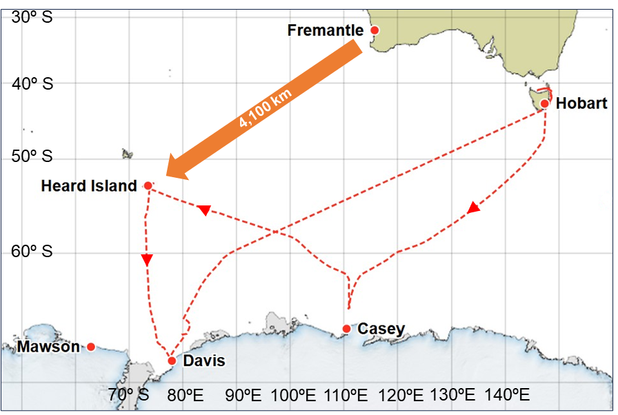
Source: AAD, modified by the ATSB
Heard Island
Heard Island (Figure 5) is part of the Australian external territory of Heard Island and McDonald Islands. Located in the Southern Ocean about 4,100 km south-west of Fremantle, Western Australia, it is home to Australia’s only active volcano, as well as 12 major glaciers. It is uninhabited by humans. The island is home to penguin and seal colonies dotting the coastline, as well as an important breeding location for Southern Ocean seabirds. The island’s location at a latitude of 53° south exposes it to persistent strong westerly winds with precipitation and poor visibility common year-round.
Due to the island’s remote location and low volumes of shipping traffic, the waters around Heard Island have not been systematically surveyed. Instead, charts are based on limited data available from passage soundings, mostly obtained by earlier expeditions by the AAP and its predecessors. The charted soundings for the area around Spit Bay were based on data from passage soundings obtained in 1948 and 1990 as well as from a more comprehensive 1999 survey.
In electronic navigational charts, information to evaluate the relative accuracy of the chart data is provided by assigning a ‘category of zone of confidence in data’ (CATZOC). Areas of the chart are assigned to one of 6 categories and allocated a CATZOC value (A1, A2, B, C, D and U). The area around Heard Island (including the location of the ship’s grounding) was assessed in the lowest assessed category (CATZOC D), indicating poor seafloor coverage and accuracy where large depth anomalies may be expected. Additionally, extensive coastal areas were marked as ‘unsurveyed’ with no depth information presented.
Figure 5: Section of navigation chart AUS 605 showing Heard Island
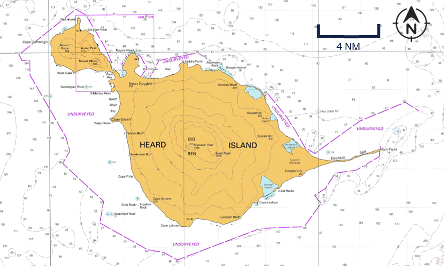
Source: Australian Hydrographic Office, modified by the ATSB
Safety actions
Following the incident Serco and the AAD implemented several safety actions:
- New measures addressing the hazards of operations in low CATZOC areas were introduced including the development of a detailed risk assessment, revision of the master’s standing orders to prioritise use of the navigational echo sounders and the use of the science tender to support mapping operations.
- A review of passage planning processes in the SMS, including the navigation manual, procedures and supporting forms. This also included instructions on ECDIS management and troubleshooting as a specific procedure.
- The development of a Heard and McDonald Islands navigation decision support guide and the acquisition of sufficient multi beam data to identify safe transit corridors around Heard Island.
Further investigation
- interviewed key personnel
- recovered and examined recorded data
- recovered and reviewed CCTV footage
- obtained operational documentation
- obtained historic and recorded bathymetric data.
The investigation is continuing and will include further review and examination of:
- operator procedures
- recorded data
- bathymetric data.
A final report will be released at the conclusion of the investigation. Should a critical safety issue be identified during the course of the investigation, the ATSB will immediately notify relevant parties so appropriate and timely safety action can be taken.
Purpose of safety investigationsThe objective of a safety investigation is to enhance transport safety. This is done through:
It is not a function of the ATSB to apportion blame or provide a means for determining liability. At the same time, an investigation report must include factual material of sufficient weight to support the analysis and findings. At all times the ATSB endeavours to balance the use of material that could imply adverse comment with the need to properly explain what happened, and why, in a fair and unbiased manner. The ATSB does not investigate for the purpose of taking administrative, regulatory or criminal action. About ATSB reportsATSB investigation reports are organised with regard to international standards or instruments, as applicable, and with ATSB procedures and guidelines. Reports must include factual material of sufficient weight to support the analysis and findings. At all times the ATSB endeavours to balance the use of material that could imply adverse comment with the need to properly explain what happened, and why, in a fair and unbiased manner. An explanation of terminology used in ATSB investigation reports is available here. This includes terms such as occurrence, contributing factor, other factor that increased risk, and safety issue. Publishing informationReleased in accordance with section 25 of the Transport Safety Investigation Act 2003 Published by: Australian Transport Safety Bureau © Commonwealth of Australia 2026 
Ownership of intellectual property rights in this publication Unless otherwise noted, copyright (and any other intellectual property rights, if any) in this report publication is owned by the Commonwealth of Australia. Creative Commons licence With the exception of the Commonwealth Coat of Arms, ATSB logo, and photos and graphics in which a third party holds copyright, this report is licensed under a Creative Commons Attribution 4.0 International licence. The CC BY 4.0 licence enables you to distribute, remix, adapt, and build upon our material in any medium or format, so long as attribution is given to the Australian Transport Safety Bureau. Copyright in material obtained from other agencies, private individuals or organisations, belongs to those agencies, individuals or organisations. Where you wish to use their material, you will need to contact them directly. |
[1] Nuyina was equipped with 2 retractable drop keels, which allowed scientific instruments to be lowered up to 3 m below the keel to reduce hull interference, be retracted to avoid damage in ice and be recovered on board for servicing.
[2] Nuyina could also carry a dedicated science tender; however, this was not embarked for this voyage.
[3] A nautical mile of 1,852 m.
[4] Dynamic positioning is a vessel capability where a set heading and position can be maintained by an automated system controlling the vessel’s rudders, propellers and thrusters.
[5] Heard Island is home to Australia’s only active volcano. The volcanic risks to aircraft and landing parties were assessed by geologists in Kingston, Tasmania, where the Australian Antarctic Division is headquartered, based on observations from the ship.
[6] In joystick mode the operator could manually control heading and/or selected longitudinal or transverse axis of motion using a joystick integrated in the DP system.
[7] The displayed MBES data was shown as total water depth and to obtain the under-keel clearance the draft of the ship had to be deducted.
[8] Classification societies are recognised organisations which are authorised to issue statutory certification on behalf of the flag State.
[9] International Maritime Organization, 2024, The International Convention for the Safety of Life at Sea (SOLAS) 1974, as amended, IMO, London.
[10] International Maritime Organization, 2018, International Management Code for the Safe Operation of ships and for Pollution Prevention (ISM Code) as amended, IMO, London.
[11] As defined in the Navigation Act 2012: ‘Special personnel’, in relation to a special purpose vessel means a person who is carried on board the vessel in connection with the special purpose of the vessel. They are not passengers or part of the ship’s crew.
Occurrence summary
| Investigation number | MO-2025-011 |
|---|---|
| Occurrence date | 13/10/2025 |
| Occurrence time and timezone | 09:02 UTC |
| Location | off Heard Island, Territory of Heard Island and McDonald Islands |
| State | External Territory |
| Report release date | 17/03/2026 |
| Report status | Preliminary |
| Anticipated completion | Q4 2026 |
| Investigation level | Defined |
| Investigation type | Occurrence Investigation |
| Investigation phase | Examination and analysis |
| Investigation status | Active |
| Mode of transport | Marine |
| Marine occurrence category | Grounding |
| Occurrence class | Serious Incident |
| Highest injury level | None |
Ship details
| Name | RSV Nuyina |
|---|---|
| IMO number | 9797060 |
| Ship type | Special-purpose vessel |
| Flag | Australia |
| Classification society | Lloyd's Register |
| Manager | DMS Maritime |
| Departure point | Casey Station, Australian Antarctic Territory |
| Destination | Heard Island, Territory of Heard Island and McDonald Islands |
| Injuries | None |
| Damage | Minor |